coastal processes chapter 14—planet earth (291-298) ...
TRANSCRIPT

Coastal Processes
Chapter 14—Planet Earth (291-298)
http://highered.mcgraw-hill.com/sites/0072402466/student_view0/chapter14/flashcards.html#

Some Background informationCoastal landscapes are quite unique when compared with other
distinctive landscapes:• All climates and bedrocksInteraction between lithosphere and
hydrosphere.• It extends a short distance inland and out into the ocean/sea/lake.
(meaning that the interaction between the two spheres occurs over a short distanceCoastline interact with wave forces)

How do waves and currents form? • Differences in heating and thus pressure from
one location to another (wind).• The resulting winds transfer some of their
energy on the surface of the water to form waves and currents.
http://www.classzone.com/books/earth_science/terc/content/visualizations/es1604/es1604page01.cfm?chapter_no=visualization
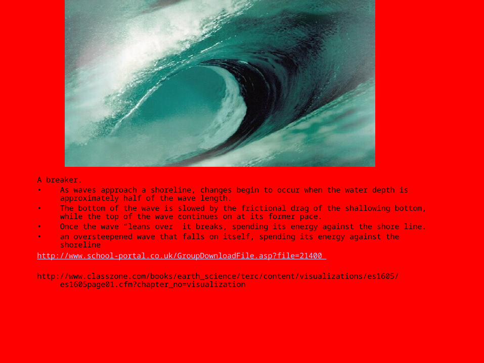
A breaker.• As waves approach a shoreline, changes begin to occur when the water depth is
approximately half of the wave length.• The bottom of the wave is slowed by the frictional drag of the shallowing bottom,
while the top of the wave continues on at its former pace.• Once the wave “leans over” it breaks, spending its energy against the shore line.• an oversteepened wave that falls on itself, spending its energy against the shorelinehttp://www.school-portal.co.uk/GroupDownloadFile.asp?file=21400
http://www.classzone.com/books/earth_science/terc/content/visualizations/es1605/es1605page01.cfm?chapter_no=visualization
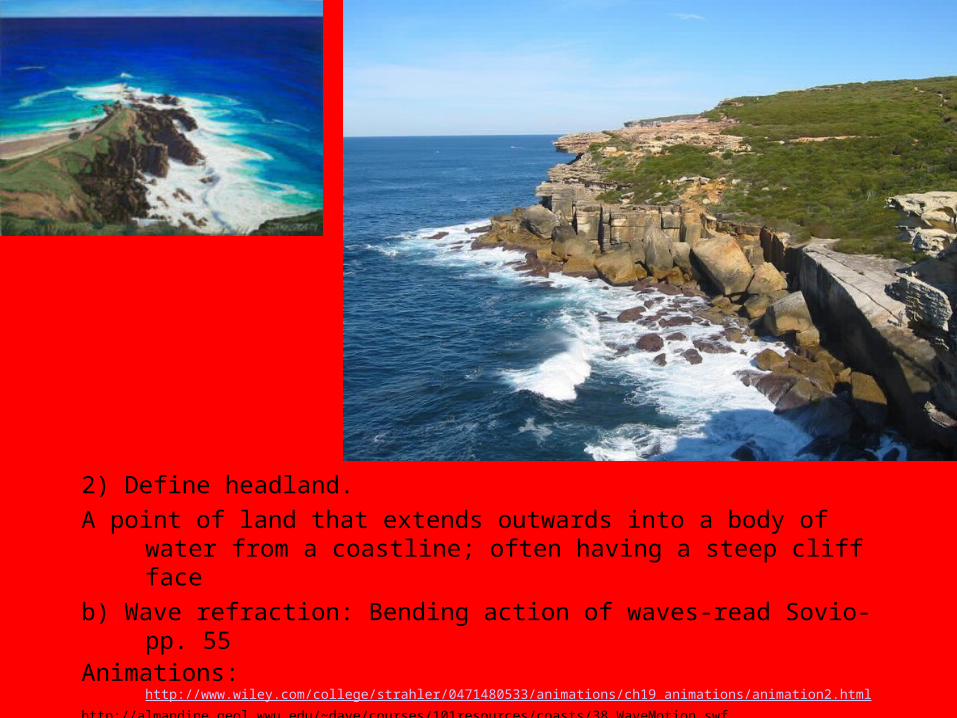
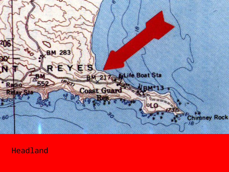
2) Define headland.A point of land that extends outwards into a body of water from a
coastline; often having a steep cliff face b) Wave refraction: Bending action of waves-read Sovio-pp. 55 Animations:http://www.wiley.com/college/strahler/0471480533/animations/ch19_animations/animation2.html
http://almandine.geol.wwu.edu/~dave/courses/101resources/coasts/38_WaveMotion.swf

Major Processes of Erosion by Waves
6a) Abrasion, also known as corrasion, occurs as waves hurl bits of rock and sand against cliffs and headlands.
b) Describe hydraulic pressure.As water enters cracks…

c) Attrition occurs when rock fragments broken away from the rock surfaces hit against each other and erode into smaller fragments.
I couldn’t find a better image!

d) Describe corrosion (aka solution).Soluble minerals dissolved by water.
(limestone headlands)

5)Write an explanation of the sequence of events associated with the erosion of the headland shown in figure 14.16.
A) Wave energy is concentrated on a headland as a result of wave refraction. Zones of weakness, such as joints, faults, and nonresistent beds, erode faster, so sea caves develop in those areas.
B)Sea caves enlarge to form a sea archC)Eventually, the arch collapses, leaving a sea stack. A
new arch can develop from the remaining headland.http://www.uky.edu/AS/Geology/howell/goodies/elearning/module14swf.swf
http://faculty.palomar.edu/lyon/Animations/WaveMotion.swf
http://highered.mcgraw-hill.com/sites/0072402466/student_view0/chapter14/animations_and_movies.html#
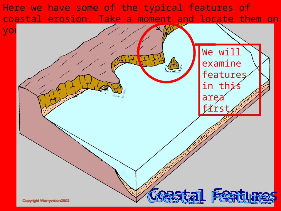
Here we have some of the typical features of coastal erosion. Take a moment and locate them on your sheet.
We will examine features in this area first.

Sea cliffs: retreat mostly as a consequence of hydraulic action and abrasion at their bases.
As a sea cliff is undercut by erosion, the upper part is left unsupported and susceptible to mass wasting processes. Thus, they retreat little by little.
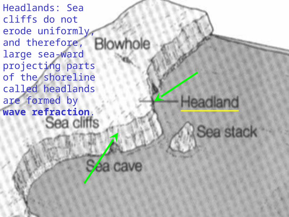
Headlands: Sea cliffs do not erode uniformly, and therefore, large sea-ward projecting parts of the shoreline called headlands are formed by wave refraction.

Sea Caves: when wave refraction causes erosion on a headland, a sea cave may form.
When two sea caves meet through a headland, and the roof collapses, a Sea stack is formed.

Blow holes are caused when the roof of a sea-ward facing sea cave cracks or collapses. Waves entering the sea cave are then forced through the hole and spray out like a fountain.

Wave Cut Platform:The gently sloping surface that is left underwater, as sea cliffs retreat.
As the sea cliff is eroded, remnants of the cliff material will form a sea-ward facing beach.

Sea Arches: are formed when two sea caves meet. This is the transitional phase between cave and stack.


6) Describe the formation of a wave-cut platform.
• b) Insert an image of a wave-cut platform from the internet.
http://emvc.geol.ucsb.edu/animations/quicktime/TerCut5.mov

Continued erosion enlarges the notch and causes its roof to collapse, and a cliff is formed.
Further undercutting at the base of the cliff results in an overhanging cliff which eventually collapses.
.
The waves erode along lines of weakness in the rock face to form a notch.
Destructive waves at an exposed coast erode a steep coastal slope through processes like hydraulic action and abrasion.
As the steep cliff retreats landwards, a flat terrace at the foot of the cliff is exposed --- wave-cut platform
The eroded materials which are transported away may be deposited in the sea to form an offshore terrace.
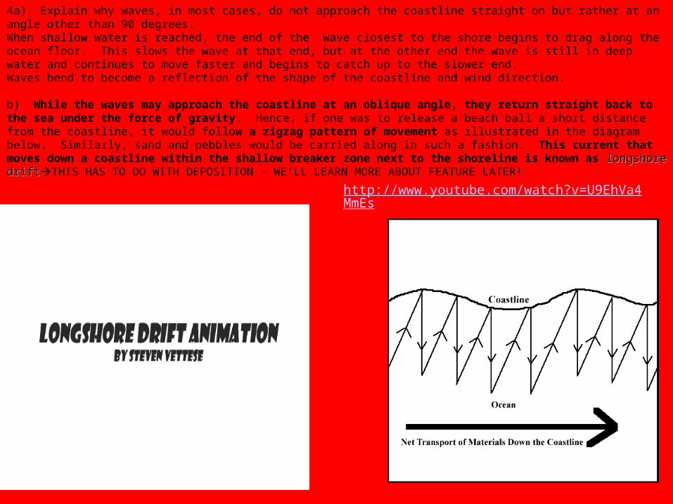
4a) Explain why waves, in most cases, do not approach the coastline straight on but rather at an angle other than 90 degrees.When shallow water is reached, the end of the wave closest to the shore begins to drag along the ocean floor. This slows the wave at that end, but at the other end the wave is still in deep water and continues to move faster and begins to catch up to the slower end. Waves bend to become a reflection of the shape of the coastline and wind direction. b) While the waves may approach the coastline at an oblique angle, they return straight back to the sea under the force of gravity. Hence, if one was to release a beach ball a short distance from the coastline, it would follow a zigzag pattern of movement as illustrated in the diagram below. Similarly, sand and pebbles would be carried along in such a fashion. This current that moves down a coastline within the shallow breaker zone next to the shoreline is known as longshorelongshore driftdriftTHIS HAS TO DO WITH DEPOSITION - WE’LL LEARN MORE ABOUT FEATURE LATER!
http://www.youtube.com/watch?v=U9EhVa4MmEs
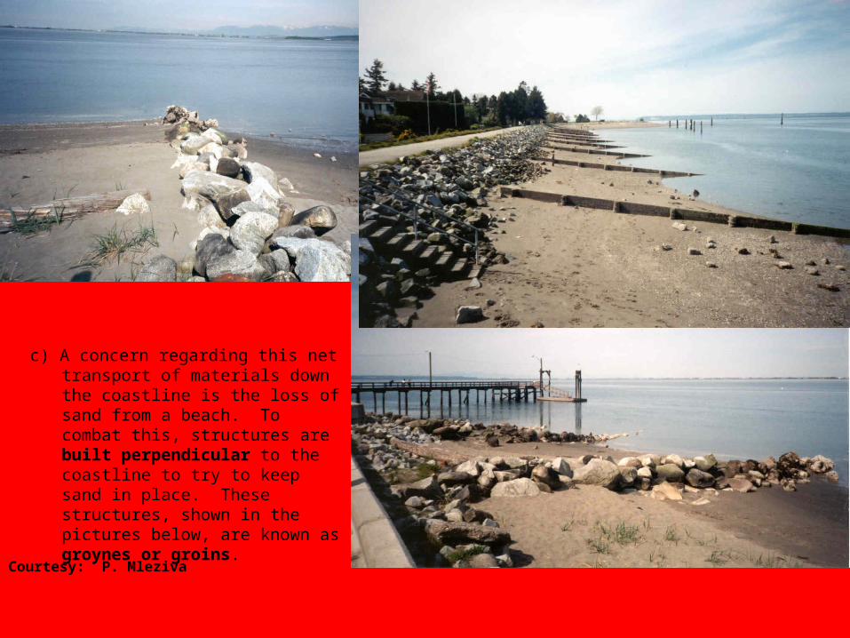
c) A concern regarding this net transport of materials down the coastline is the loss of sand from a beach. To combat this, structures are built perpendicular to the coastline to try to keep sand in place. These structures, shown in the pictures below, are known as groynes or groins.
Courtesy: P. Mleziva

9) To prevent erosion of the coastline or to shelter boats from strong waves, breakwaters are built. These can be large piles of rocks or other objects placed parallel to the coastline to help break the force of the incoming waves.
http://www.uky.edu/AS/Geology/howell/goodies/elearning/module14swf.swfhttp://faculty.palomar.edu/lyon/Animations/BreakWater.swf

10) Define the following terms and look at figures 14.18 and 14.19 carefully.Insert an image for three of the following items from the internet. ALL DEPOSITIONAL FEATURES!
a) bayhead beach: An extensive deposit of sand and/or gravel in the form of a beach at the back of a bay.
b) spit: A long and narrow accumulation of sand and/or gravel that projects into a body of
ocean water. These features form as the result of the deposition of sediments by longshore drift.
c) baymouth sand bar: A narrow deposit of sand and/or gravel found across the mouth of a bay.
d) tombolo: A coastal feature that forms when a belt sand and/or gravel is deposited between an island and the mainland. This feature is above sea-level for most of the time.
e) barrier island or offshore bar Long, narrow islands of sand and/or gravel that are usually aligned parallel to the shore of some coasts.
http://www.school-portal.co.uk/GroupRenderCustomPage.asp?GroupID=12426&ResourceId=61278

Bayhead beach:An extensive deposit of sand and/or gravel in the form of a beach at the back of a bay.
http://www.uky.edu/AS/Geology/howell/goodies/elearning/module14swf.swf
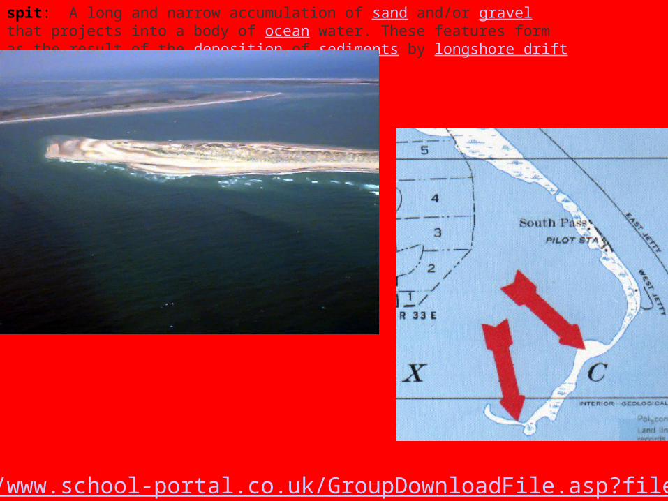
spit: A long and narrow accumulation of sand and/or gravel that projects into a body of ocean water. These features form as the result of the deposition of sediments by longshore drift.
http://www.school-portal.co.uk/GroupDownloadFile.asp?file=21605

c) baymouth sand bar: A narrow deposit of sand and/or gravel found across the mouth of a bay.
http://highered.mcgraw-hill.com/sites/0072402466/student_view0/chapter14/animations_and_movies.html

e) barrier island or offshore bar Long, narrow islands of sand and/or gravel that are usually aligned parallel to the shore of some coasts
http://geography.cst.cmich.edu/Franc1M/Animations/animation_list_posted.htm

tombolo: A coastal feature that forms when a belt sand and/or gravel is deposited between an island and the mainland. This feature is above sea-level for most of the time.

f) lagoon: the coastal water body separating a barrier island or offshore bar from the mainland or the water trapped behind a baymouth sand bar.

Depositional LandformsHooked Spit dueto northward current and flow into bay
Common Depositional Landforms
Longshore Processes and Depositional Coastlines

Classifications of Coastlines 13a) Recall from the Glacier Unit that U shaped valleys leading down to the sea that have been drowned as a result of a rise in sea level are known as fjords. British Columbia has this type of coastline.http://www.geocities.com/Yosemite/Rapids/4233/klikfjord.htm

b) V shaped valleys leading to the sea that have been drowned as a result of a rise in sea level are known as rias.

c) A longitudinal coastline involves folded mountains and valleys that are parallel to the coastline.

A fjord coastline consists of U shaped, formerly glaciated valleys, leading down to the coastline that have become flooded due to sea level rise since the end of the last ice age. They are generally quite broad and deep and act as natural harbours. The illustration that best shows this is A.B shows a longitudinal coastline where the flooded valleys parallel the coastline. C shows an estuarine delta.D shows a ria coastline with drowned V shaped, non-glaciated valleys.

Coral Reefs 14) Coral reefs occur in warm tropical waters where soft-bodied creatures, known as corals, produce a skeleton of calcium carbonate;
when these creatures die, their skeletons form a foundation upon which new corals can grow resulting in the continual growth of the coral reef.
An atoll is a Pacific circular reef enclosing a lagoon. http://www.classzone.com/books/earth_science/terc/content/visualizations/es2303/es2303page01.cfm?chapter_no=visualizationMore about reefs: http://oceanworld.tamu.edu/students/coral/index.htmlhttp://en.wikipedia.org/wiki/Coral_reef
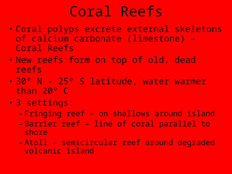
Coral Reefs• Coral polyps excrete external skeletons
of calcium carbonate (limestone) – Coral Reefs
• New reefs form on top of old, dead reefs• 30º N - 25º S latitude, water warmer
than 20º C• 3 settings:
– Fringing reef – on shallows around island– Barrier reef – line of coral parallel to shore– Atoll – semicircular reef around degraded
volcanic island

Development of Atoll
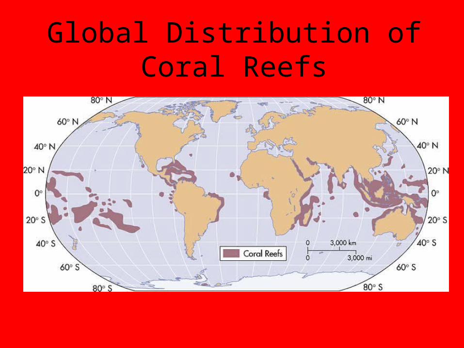
Global Distribution of Coral Reefs

Emerged versus Submerged Shorelines 15) Emerged Shorelines: the land has risen; the water has become
shallower. Significance to Humans
Pros: newly emerged coastal plain potentially offers an area of land for
agricultural settlement; beaches and / or lagoons develop into resort areas. Cons: difficult for commercial shipping because of offshore bars and few
deep water ports 16) Submerged Shorelines: land has sunk and / or the water has risen.Significance to Humans
Pros: Irregular coastlines offer sheltered, deepwater harbours which are excellent for ports
Cons: Irregular coastlines hinder land transportation along the coast and
rough terrain hinders human settlement Which one of the following features would not be associated with a
submerged coastline? a) rias b) fiords c) spit d) offshore bar e) baymouth bar
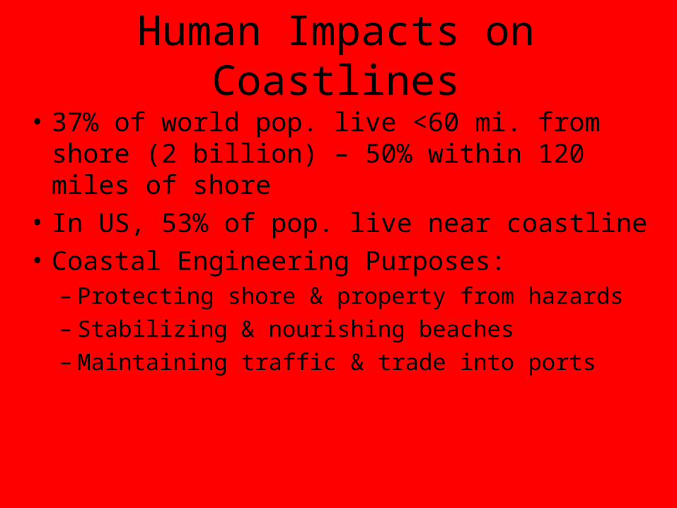
Human Impacts on Coastlines
• 37% of world pop. live <60 mi. from shore (2 billion) – 50% within 120 miles of shore
• In US, 53% of pop. live near coastline• Coastal Engineering Purposes:
– Protecting shore & property from hazards– Stabilizing & nourishing beaches– Maintaining traffic & trade into ports

Mitigating Coastal Hazards• Raise buildings on stilts so waves roll
underneath
• Sea wall – vertical, concrete wall to absorb energy of waves
• Revetment – slope covered with large rocks (rip-rap) to absorb energy of waves
• These work locally, but they aggravate erosion up and down shore from wall due to wave refraction
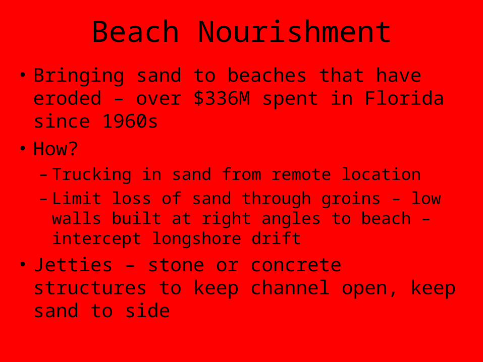
Beach Nourishment• Bringing sand to beaches that have
eroded – over $336M spent in Florida since 1960s
• How?– Trucking in sand from remote location– Limit loss of sand through groins – low
walls built at right angles to beach – intercept longshore drift
• Jetties – stone or concrete structures to keep channel open, keep sand to side

Groins and Jetties
Groins Jetties

Impact of Global Climate Change
on Coastlines• Melting ice sheets will lead to sea level rise –
estimates of 5-35 inches – areas <5 ft elevation at greatest risk
• Pacific Islands & low-lying coastal areas will suffer greater erosion & flooding potential
• Coral bleaching by unusually warm water has also become a problem – ultimately kills coral

Warming Threat on North Carolina Coast

Baymouth Bar
Headland
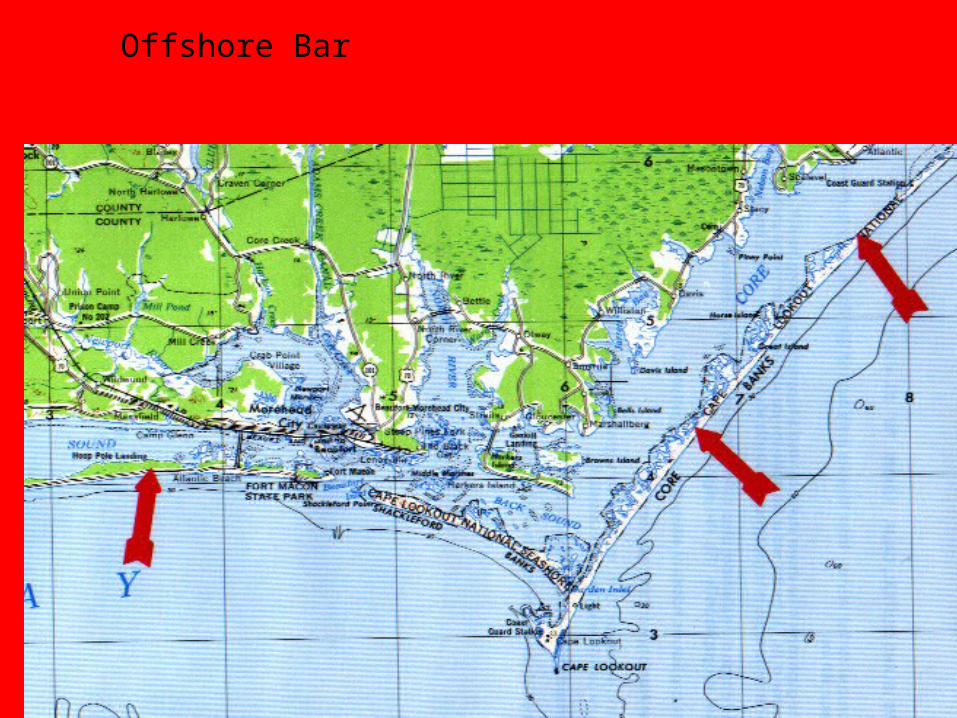
Offshore Bar
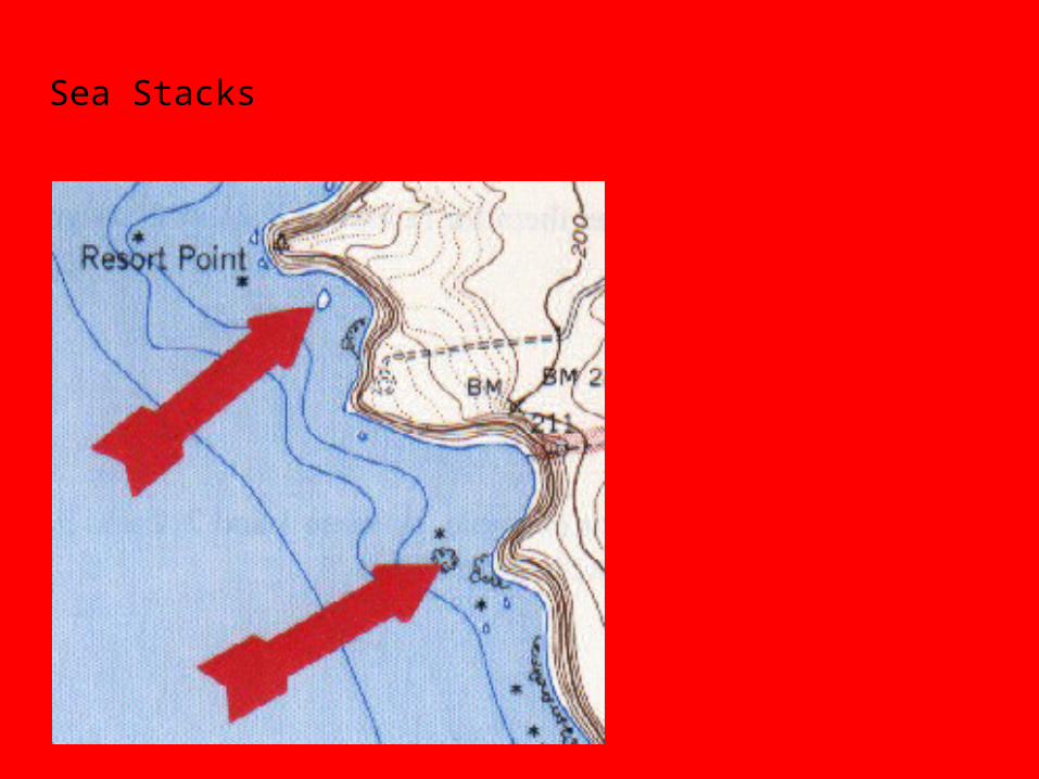
Sea Stacks

Spit

Tombolo

Water Cut Terrace