cochise stronghold hazardous fuel...
TRANSCRIPT

United States Department of Agriculture
Cochise Stronghold Hazardous Fuel Reduction
Draft Environmental Assessment
Forest Service Coronado National Forest Douglas Ranger District September 2017

For More Information Contact:
Travis Thompson Assistant Fire Management Officer
Douglas Ranger District 1192 West Saddle View Road
Douglas, Arizona 85607 520-388-8457
In accordance with Federal civil rights law and U.S. Department of Agriculture (USDA) civil rights regulations and policies, the USDA, its
Agencies, offices, and employees, and institutions participating in or administering USDA programs are prohibited from discriminating
based on race, color, national origin, religion, sex, gender identity (including gender expression), sexual orientation, disability, age, marital
status, family/parental status, income derived from a public assistance program, political beliefs, or reprisal or retaliation for prior civil
rights activity, in any program or activity conducted or funded by USDA (not all bases apply to all programs). Remedies and complaint
filing deadlines vary by program or incident.
Persons with disabilities who require alternative means of communication for program information (e.g., Braille, large print, audiotape,
American Sign Language, etc.) should contact the responsible Agency or USDA’s TARGET Center at (202) 720-2600 (voice and TTY) or
contact USDA through the Federal Relay Service at (800) 877-8339. Additionally, program information may be made available in
languages other than English.
To file a program discrimination complaint, complete the USDA Program Discrimination Complaint Form, AD-3027, found online at
http://www.ascr.usda.gov/complaint_filing_cust.html and at any USDA office or write a letter addressed to USDA and provide in the letter
all of the information requested in the form. To request a copy of the complaint form, call (866) 632-9992. Submit your completed form or
letter to USDA by: (1) mail: U.S. Department of Agriculture, Office of the Assistant Secretary for Civil Rights, 1400 Independence
Avenue, SW, Washington, D.C. 20250-9410; (2) fax: (202) 690-7442; or (3) email: [email protected].
USDA is an equal opportunity provider, employer and lender.
Draft Environmental Assessment
i
Contents
Introduction ...................................................................................................................................................1 Background ...............................................................................................................................................1 Location of the Proposed Project Area .....................................................................................................1
Need for the Proposal ....................................................................................................................................4 Agencies and Persons Consulted ...................................................................................................................5
Public Involvement and Scoping ..............................................................................................................5 Issues .........................................................................................................................................................6
Proposed Action and Alternatives .................................................................................................................6 No Action ..................................................................................................................................................6 Proposed Action ........................................................................................................................................7
Treatment Descriptions .........................................................................................................................9 Treatment Phases ...................................................................................................................................9 Design Features .....................................................................................................................................9 Project Monitoring...............................................................................................................................13
Environmental Impacts of the Proposed Action and Alternatives...............................................................14 Past, Present and Reasonably Foreseeable Actions ................................................................................14 Fire and Fuels ..........................................................................................................................................15 Range ......................................................................................................................................................17 Recreation ...............................................................................................................................................18 Cultural Resources ..................................................................................................................................19 Water Resources .....................................................................................................................................21 Vegetation ...............................................................................................................................................22 Threatened, Endangered, and Sensitive Species .....................................................................................23
List of Tables
Table 1. Potential treated acres by treatment unit .........................................................................................7 Table 2. Acres of proposed treatments by phase ...........................................................................................9 Table 3. Project monitoring .........................................................................................................................14 Table 4. Past, present and reasonably foreseeable actions ..........................................................................15 Table 5. Summary of determinations for threatened and endangered species ............................................24 Table 6. Summary of effects to sensitive species ........................................................................................28 Table 7. Management indicator species selected for analysis by group ......................................................30
List of Figures
Figure 1. Vicinity Map ..................................................................................................................................2 Figure 2. Vegetation Condition Class ...........................................................................................................3 Figure 3. Treatment Units..............................................................................................................................8


Draft Environmental Assessment
1
Introduction The Forest Service is proposing to thin, pile, and burn approximately 3,069 acres of woodlands in strategic, defensible locations directly adjacent to private land. These actions are proposed to be implemented on the Douglas Ranger District of the Coronado National Forest.
This environmental assessment (EA) was prepared to determine whether implementation of
thinning woodlands on the Douglas Ranger District may significantly affect the quality of the
human environment and thereby require the preparation of an environmental impact statement.
The preparation of this EA fulfills agency policy and direction to comply with the National
Environmental Policy Act (NEPA). For more details of the proposed action, see the Proposed
Action and Alternatives section of this document.
Background Fire has played an important ecological role in the history of the grassland and woodland
ecosystems of southeastern Arizona and the Coronado National Forest (Forest). Regular intervals
of naturally-occurring fire restrict the growth of shrubs in grasslands, thin forests of fire-intolerant
trees, increase stream flows, and renew wildlife habitat. Since the beginning of the early 20th
century, the frequency of natural fire has decreased dramatically through a concerted effort of fire
suppression. This decrease corresponded with an increased demand for wildland fire suppression
to protect life and property and the reduction of fine fuels by livestock grazing.
The private communities in and around the Dragoon Mountains consist of various residences and
infrastructure. Due to decades of fire exclusion, forest fuels surrounding these inholdings have
reached climax conditions and consist of overgrown dead, mature chaparral and grass. This is
represented by VCC (Vegetation Condition Class), a metric that can be spatially displayed to
show this departure from the reference succession class distribution. The Dragoon Mountains are
in Vegetation Condition Class’s 2 and 3, or moderately and highly departed from the reference
succession class distribution. Previous extreme wildfires in the area (Monument, Horseshoe, and
Horseshoe 2 Fires) have exhibited high rates of spread and have burned private residences that
border the Forest. There is a need to reduce wildfire hazard, while also improving the vegetative
condition and wildlife habitat within the analysis area and its effect on overall forest health.
Location of the Proposed Project Area The project area lies within the Dragoon Mountains which span elevations from 4,600 feet to
7,519 feet on Mount Glenn. The Forest manages 54,000 acres (most of the range) that are
surrounded by blocks of private and state land. The rugged and rocky Dragoons offer a diversity
of recreation uses, including premiere rock climbing opportunities. Livestock grazing occurs in
the lower elevations of the mountain range. The communities of Sunsites, Pearce, Dragoon, St.
David, and Tombstone surround the Dragoons, and development in the wildland-urban interface
(WUI) is becoming a fire management consideration in these areas.

Cochise Stronghold Hazardous Fuel Reduction
2
Figure 1. Vicinity Map

Draft Environmental Assessment
3
Figure 2. Vegetation Condition Class

Cochise Stronghold Hazardous Fuel Reduction
4
Need for the Proposal The purpose of this project is to reduce the risk of uncharacteristic wildfire to the wildland-urban
interface and to begin the reestablishment of a fire-adapted, resilient, and diverse forest
ecosystem. The needs are to (1) reduce fuel loadings and crown fire potential in the vegetation
around the WUI communities in the Dragoon Mountains; (2) reduce the buildup of natural fuels
to reduce the threat of uncharacteristically severe stand-replacing fire and post-fire sedimentation
and flooding; and (3) shift the vegetation condition class from high and moderate departure to
dominantly low departure for historical conditions.
The Coronado National Forest Land and Resource Management Plan, or “forest plan” (USDA
Forest Service 1986, as amended) establishes standards and guidelines for fire and fuels
management, and the restoration, maintenance and protection of a variety of ecosystem
components. In 2005, the forest plan was amended to incorporate the policies of the 2001 Federal
Wildland Fire Management Policy and Review. The forest plan, as amended, calls for an
appropriate management response to wildland fires. This includes an appropriate suppression
response and the ability to allow natural fire ignitions to play their natural ecological role as
nearly as possible forestwide (USDA Forest Service 1986, p. 45).
The following forest plan direction (pp. 9-11, 45) provides guidance for the Cochise Stronghold
Hazardous Fuel Reduction project:
Firefighter and public safety shall be the first priority in all fire management activities.
All human-caused fires shall be suppressed using appropriate suppression response
strategies.
Wildland fire suppression responses shall minimize costs of suppression, resource
impacts, and risks to life and property.
The appropriate management response for each natural ignition will vary across the
Forest but will include the full spectrum of options, from aggressive initial attack to
management to achieve resource objectives.
For all management areas, management of lightning-caused fires should be considered to
restore fire’s natural role in maintaining a healthy, diverse, and resilient ecosystem
resistant to natural disturbances.
Reduce the costs, resource damage, and threats to public and firefighter safety from
future wildland fires.
Create and maintain fuel conditions for low risk of extreme fire behavior and high-
intensity wildland fires.
Cooperate with other Federal, State and local regulatory agencies to protect air quality as
required by the Clean Air Act.
Provide for ecosystem diversity by at least maintaining viable populations of all native
and desirable nonnative wildlife, fish, and plant species through improved habitat
management.

Draft Environmental Assessment
5
Continue a program that enhances other resource values, and that effectively utilizes the
wood fiber produced. Carry out silvicultural practices to improve stand health when such
practices are consistent with other resource objectives.
Provide a favorable water flow in quantity and quality for off-Forest users by improving
or maintaining all watersheds to a satisfactory or higher level.
Unplanned ignitions managed for resource objectives shall follow direction specific to
the Coronado’s Fire Management Plan. Use the established protocols identified in the
Fire Management Plan for minimizing resource impacts.
It should be noted that the Coronado National Forest is currently revising this forest plan1. The
current draft revised forest plan includes management direction similar to the 2005 amendment
for management response to wildfires and for management of fire-adapted landscapes.
Agencies and Persons Consulted The Forest Service consulted the following individuals, Federal, State, tribal, and local agencies
during the development of this environmental assessment:
Federal, State, and Local Agencies
US Fish and Wildlife Service, USDA Forest Service, National Park Service, Arizona State Lands
Department, Arizona Game and Fish Department, Arizona Department of Agriculture, Cochise
County, Hidalgo County, Graham County, Pinal County, Santa Cruz County, Pima County
Tribes
Tribal consultation, as directed by 36 CFR 800 and the Programmatic Agreement, was conducted
by the Coronado National Forest. The Coronado National Forest normally consults with 12
Native American tribes who have ancestral ties to lands currently managed by the Coronado
National Forest. These tribes include the Ak-Chin Indian Community, Ft. Sill Apache Tribe, Gila
River Indian Community, Hopi Tribe, Mescalero Apache Tribe, Pasqua Yaqui Tribe, Salt River
Pima-Maricopa Indian Community, San Carlos Apache Tribe, Tohono O’odham Nation, White
Mountain Apache Tribe, Yavapai-Apache Nation, and Pueblo of Zuni. The original scoping letter
for the Cochise Stronghold Hazardous Fuel Reduction was sent to the tribes on March 15, 2017.
Others
The Forest Service provided information on this project to approximately 79 individuals who are
identified on the project mailing list, located in the project administrative record. This list
includes Dragoon Mountains recreation user groups, outfitters, guides, range permittees,
environmental groups, and other interested parties.
Public Involvement and Scoping Scoping is a process for gathering comments about a site-specific proposed federal action to
determine the scope of issues to be addressed and for identifying issues related to the proposed
action (40 CFR 1501.7). The Forest Service uses public involvement and an interdisciplinary (ID)
1 Current information about the Coronado National Forest plan revision is available at the following
website: http://www.fs.usda.gov/detail/coronado/landmanagement/planning/?cid=fswdev7_018702.

Cochise Stronghold Hazardous Fuel Reduction
6
team of resource specialists to identify issues and develop possible solutions. Opportunities for
comments enable concerned citizens, resource specialists from other agencies, and local
governments to express their ideas and views. The Forest Service consulted individuals, tribal
entities, and Federal, State, and local agencies during the development of this EA.
This proposal was first listed on the Coronado National Forest’s Schedule of Proposed Actions
(SOPA) in October of 2016. The proposal has been listed on every SOPA since this date. This
schedule is available electronically at https://www.fs.fed.us/sopa/forest-level.php?110305. The
project information packet and maps were posted on the Forest website for public viewing in
March 2017. The project information is available on the Forest website at
https://www.fs.usda.gov/project/?project=48906.
On March 15 and 17, 2017, a legal notice announcing the start of the 30-day scoping period was
published in the Douglas Dispatch, The Tombstone News and San Pedro Valley News-Sun
Arizona Range News. On March 20, 2017, a letter announcing the official scoping period for this
project was sent to approximately 79 individuals and organizations, including State and local land
management agencies, Tribal leaders, range permittees, and other interested parties.
The Forest Service received one comment letter, from the White Mountain Apache Tribe Office
of Historic Preservation, during the scoping period. The comments received did not describe any
unresolved conflicts to refine the proposal described in the scoping letter.
Issues Issues are points of discussion, debate, or dispute about environmental effects of the proposed
action. Issue are defined as those directly or indirectly caused by implementing the proposed
action and because of their extent, duration, or intensity of effects makes them important in
deciding the best course of action to address the purpose and need. The Council on
Environmental Quality (CEQ) NEPA regulations require this delineation in Sec. 1501.7,
“…identify and eliminate from detailed study the issues which are not significant or which have
been covered by prior environmental review (Sec. 1506.3).”
There were no public comments received that raised concern for the project or led the ID team to
develop additional alternatives.
Proposed Action and Alternatives Two alternatives were analyzed in detail: the No Action (Alternative 1) and the Proposed Action
(Alternative 2). The proposed action was developed to maximize attainment of the purpose and
need. Alternative 1 was analyzed to provide a baseline of the environmental condition if no
agency action is taken. The site-specific maps apply to the proposed action. For Alternative 1, no
activities would occur in the areas shown on the maps. These alternatives are described in more
detail below.
No Action No action, which is the option of not treating vegetation and fuels in the Cochise Stronghold
Hazardous Fuel Reduction project area, is included as an alternative in this analysis to provide an
environmental baseline against which the effects of the proposed action may be compared. For
the proposed project, taking no action implies that:

Draft Environmental Assessment
7
1. The status of the ecological components in the proposed treatment areas would remain
the same over the timeframe planned for implementation of the proposed action, with the
exception of changes resulting from natural phenomena (such as wildfire, earthquakes,
landslides, growth, and decay);
2. If other non-Forest Service fuel and fire management projects or agreements are proposed
over the timeframe of the proposed action, their environmental effects would be
evaluated on a case-by-case basis by each agency.
Proposed Action The Douglas Ranger District is proposing to thin, pile, and burn 3,069 acres of woodlands in
strategic, defensible locations directly adjacent to private land. The homeowners have taken the
initiative to utilize Firewise2 procedures on their private land and have requested that the Forest
Service do the same on adjacent National Forest System lands to increase the effectiveness of
their treatments. Treatment areas have been broken down into four locations with slightly
differing activities (see Figure 3):
Table 1. Potential treated acres by treatment unit
Treatment Unit Treatment Type Approximate Potential
Treatment Acres
Cochise Stronghold Fuelbreak Thin, pile, broadcast burn 191
Middle March Road Fuelbreak Thin, pile, broadcast burn 304
Cobre Mine Prescribed Burn (RX) Broadcast burn 630
China Peak Prescribed Burn (RX) Broadcast burn 1944
2 The Firewise Communities approach emphasizes community responsibility for planning in the design of a
safe community as well as effective emergency response, and individual responsibility for safer home
construction and design, landscaping and maintenance. The Firewise Communities/USA Recognition
Program was designed as a tool that forestry and fire service professionals can use to work with residents to
obtain voluntary compliance with existing wildfire safety rules, as well as to motivate community action
toward wildfire safety in the absence of strict ordinances or laws. The Recognition Program encourages and
acknowledges citizen involvement in reducing community wildfire risk. Source: Firewise Communities - A
User Guide to the Firewise Communities/USA Recognition Program, www.firewise.org.

Cochise Stronghold Hazardous Fuel Reduction
8
Figure 3. Treatment Units

Draft Environmental Assessment
9
Treatment Descriptions
Treatments fall under two categories: thinning and piling, and prescribed burning. Approximately
3,069 acres are identified as treatment units, with 2,574 of those acres as prescribed burning alone
and 495 acres of thinning, piling, and prescribed burning. Prescribed burning may take place
whenever conditions (e.g., weather, wind, fuel moisture) are present that would meet project
objectives. Design features described below will further protect resources during project
implementation.
If monitoring indicates that project objectives are not being met, the treatments will be evaluated
to determine the need to modify or cease treatments.
Thinning and Piling
This treatment would be done by hand using chainsaws. Brush and chaparral species will be cut
and piled by hand as well as trees less than 5 inches diameter at breast height (DBH). Trees
larger than 5 inches in diameter will be limbed up to 4.5 feet high to remove ladder fuels, the
resulting branches will be hand piled. As best practicable, the brush piles will be around 6 feet in
diameter, with a height of 6 feet. Approximately 495 acres are initially planned to be treated using
this technique.
Prescribed Burning
This treatment involves using backing, strip, and head firing to allow fire to move across the
landscape in a controlled manner to reduce fuels. Existing roads and trails will be used in addition
to constructing hand lines to hold fire spread in the project area. Approximately 3,069 acres are
planned to be treated, to include burning piles as a result of thinning in the fuel breaks.
Treatment Phases
Project activities may be implemented in phases over a period of approximately 1–5 years. The
phases represent the District’s best approximation for project implementation. Phases may be
combined or treatments applied in a different order if monitoring or experience indicates that such
a change would be beneficial to meeting project objectives.
Table 2. Acres of proposed treatments by phase3
Phase 1, FY2018 Phase 2, FY2019 Phase 3, FY2020 Phase 4, FY2021 Phase 5, FY2022
100 acres thinning Cochise Stronghold, 2574 acres broadcast burn China Peak and Cobre Mine RX
91 acres thinning Cochise Stronghold, 100 acres pile burn (prior year thinning)
152 acres thinning Middle March Road, 91 acres pile burn (prior year thinning)
152 acres thinning Middle March Road, 152 acres pile burn (prior year thinning)
2574 acres broadcast burn – final treatment China Peak and Cobre Mine RX
Design Features
The design features listed below provide resource protection measures to mitigation potential
impacts of implementing the project. These features were developed in accordance with
3 Treatment area acreages may vary on the ground to facilitate project implementation. Phases may be
combined and implemented in a single year if conditions allow.

Cochise Stronghold Hazardous Fuel Reduction
10
applicable Forest Plan standards and guidelines, Forest Service Manual and Handbook direction,
as well as law and regulation. These design features may be modified or changed, or new
measures may be added in response to public comments and the environmental analysis process.
Fire and Fuels
1. Prescribed burn plans will be developed according to agency standards and approved
prior to initiating any burning operation. Activities will incorporate prescription elements
into the prescribed fire plan including such factors as weather, slope, aspect, soils, fuel
type and amount, and fuel moisture in order to minimize high soil negative impacts to
soils.
2. Prescribed burns will be implemented and tactically executed to protect identified values
at risk and hold fire spread within the identified project area.
3. All burning would be coordinated daily with the Arizona Department of Environmental
Quality (ADEQ). Burning would not take place on any portion of the project without
prior approval from ADEQ.
4. Prescribed fire would only be implemented between October 1 and March 31 to avoid
disturbing lesser long-nosed bat populations in the area.
5. Piles generated from thinning will be constructed in locations without an overstory
canopy to mitigate damage to larger trees’ crowns.
6. No permanent or temporary road construction would be allowed. Any off-road vehicle
trails resulting from proposed activities would be obliterated and restored. Established
National Forest System roads will be utilized for access to the treatment units. Off-road
vehicle activity during fire activities would be kept to a minimum.
Soil and Water
7. Erosion control structures would be constructed in fire lines as needed, especially on
steep hillsides.
8. Sufficient groundcover would be retained to prevent erosion of the burned site.
9. Intense prescribed fire should be avoided on sensitive soils, to prevent water repellency,
nutrient leach and erosion.
Riparian and Aquatic Areas
10. Important aquatic habitat, including seeps, springs, streams, ponds, stock tanks and
washes, and drainages will be evaluated by resource specialists (i.e., biologists and
hydrologists), to determine the best way(s) to mitigate the effects of the treatment and
preserve the functionality and integrity of the aquatic system.
11. Prescribed fire control action in riparian areas should apply minimum impact suppression
tactics to minimize damage to stands of native vegetation and soils from prescribed fire
operations. When possible, use existing features and natural barriers to manage
prescribed fire in riparian areas.

Draft Environmental Assessment
11
12. Placement of prescribed fire support sites (e.g., staging areas and refueling sites) would
be located outside riparian areas or river/stream corridors and will utilize spill
containment systems to minimize impacts.
13. If water is drafted from a stock tank or other body of water for prescribed fire activities, it
shall not be refilled with water from another tank, lake or other water source that may
support non-native fishes, bullfrogs, crayfish or salamanders. Only water drawn from a
municipal water supply or well water shall be used to refill stock tanks. Use of
containment systems for portable pumps to avoid fuel spills in riparian or aquatic systems
would be required.
14. Retain all age classes of riparian species (defined in FSM 2526, Riparian Watershed
Management) and madrone (Arbutus arizonica).
15. To the extent possible, large, downed woody materials and snags that are not a hazard to
firefighters would be retained. Large logs (>12 inches) diameter and greater and >8 feet
long should not be cut into sections.
16. In riparian areas, only use existing features and natural barriers to manage prescribed fire.
17. Crossings for motorized vehicles across a perennial stream would not be permitted unless
an established road already exists or where dry, intermittent sections occur.
18. Avoid use of heavy mechanical equipment in wet riparian drainages or on wet upland
soils if rutting greater than 3 inches (8 cm) is occurring.
19. For priority fire/fuels management areas (e.g., WUI areas) with federally listed species or
designated critical habitat downstream, a biologist and other resource specialists, as
appropriate, would determine: (1) The number of acres and the number of projects or
phases of projects to occur within the watershed per year; and (2) An appropriately sized
buffer adjacent to perennial streams and ponds (e.g., lowest discernable bench above the
stream but outside the high-water mark) in order to minimize soils and ash from entering
the aquatic system.
Range
20. Livestock grazing deferment, when used to protect revegetation of treated areas, will be
determined on a case-by-case basis.
21. The rangeland management specialist will coordinate with permittees to achieve
management objectives within grazing allotments.
22. Range improvements will be protected during project activities. If a fence segment that
has been maintained to standard by the permittee is damaged or removed during
management activities, the Forest Service will replace or repair it as necessary.
Recreation
23. Recreation improvements, including the Cochise Stronghold Campground, will be
protected during project activities and repaired as necessary.

Cochise Stronghold Hazardous Fuel Reduction
12
24. Inform forest visitors about activities within the project area and make them aware of
potential impacts when visiting this part of the Forest. Provide information about
implementation activities on the Forest website.
25. Issue news release(s) as appropriate when forest restoration activities are scheduled to
occur and describe how it may affect forest visitation.
26. If it is necessary to close National Forest System roads or areas of the Forest during
burning or harvesting operations, notices and signs would be posted at key locations
adjacent to and within the project area to inform the public of these closures.
Cultural Resources
27. Prior to implementation of any treatments, the treatment area will be cleared through
Section 106 of the National Historic Preservation Act with State Historic Preservation
Office (SHPO) concurrence.
28. Prior to implementation, District personnel will consult with the District heritage staff
regarding protective measures for significant sites. No wheeled or tracked vehicles will
be allowed in significant sites. Prescribed fire may be allowed after consultation with
District heritage staff.
29. The District heritage staff will re-examine significant cultural resource sites following
prescribed fire activities. Results will be forwarded to SHPO.
Caves and Abandoned Mines
30. Design criteria for caves and mines will be determined on a site-by-site basis. Caves and
abandoned mines will be surveyed prior to project implementation to determine use by
wildlife. Efforts will be made to preserve vegetation around cave entrances and maintain
the integrity of the site.
Wildlife, Fish and Plants4
31. Resource specialists would be consulted regarding all treatment activities. They would
also be responsible for coordination with the agencies on federally listed endangered and
threatened species. They would monitor fire and vegetation management activities to
ensure the protective measures are implemented.
32. Resource specialists should coordinate site-specific burn and implementation plans with
U.S. Fish and Wildlife Service (USFWS) and Arizona Game and Fish Department
(AGFD) to identify site-specific measures to identify site-specific measures to protect
federally listed and sensitive species, and species of concern.
33. Implementation activities in habitats of threatened, endangered, sensitive species, and/or
species of concern will include oversight or coordination with wildlife staff. Prior to the
start of any treatment activities, coordination will occur with the district biologist to
4 A list of project design features specific to individual wildlife species can be found in the biological
assessment, available from the project administrative record.

Draft Environmental Assessment
13
minimize potential impacts to wildlife and fish species and sensitive areas including
breeding and roosting locations.
34. Retention of cavity bearing live trees, snags and or decadent trees will be part of the burn
prescription based on input from the resource specialists.
35. Retention areas will emphasize hiding, escape, bedding and thermal cover around feeding
and watering areas, in drainages, and along roads.
36. Minimize mechanical disturbance of soils to reduce the impact of habitat manipulation on
small mammal and reptile communities.
37. Within a calendar year, consider the spatial scale of treatments relative to distribution of
individual species of concern (e.g., the proportion of habitat treated) in the planning area
when implementing project(s).
38. The spatial distribution and contiguous size of planned burn/treatment areas would be
considered in order to reduce the effects of peak flow change on stream channels.
39. Post treatment monitoring of occupied stock tanks shall occur to determine the need for
sediment filters to avoid ash loading into the tank.
40. Areas of increased human activity during prescribed fire activities, such as equipment
staging areas, shall not be located on or adjacent to sites known to be occupied by
threatened or endangered species.
41. To minimize adverse effects to lesser long-nosed bat forage plants and roosts, any dense
stands of agave will be flagged and avoided by the treatment activity. In agave stands,
personnel would avoid driving off-road and over plants, piling slash on top of plants, and
burning on or near plants. Staging areas for fire crews or helicopters would be located in
previously disturbed sites, if possible.
42. Treatment activities should avoid any known sensitive plant populations. Construct slash
piles at least 10 to 20 feet away from known populations of sensitive plants to the extent
practicable.
43. No treatments will be conducted within a 200-foot buffer area around known lesser long-
nosed bat roost sites.
44. Utilize weed washes as applicable (e.g., resources coming in from areas known to contain
invasive species) to help minimize the spread of invasive exotic plant species.
Project Monitoring
Implementation monitoring is planned for this project. Implementation monitoring evaluates
whether treatments are being applied as described in the project Decision Notice.
Treatment areas may require periodic maintenance to remain effective for enhanced habitat and
range conditions and fire behavior modification. Monitoring would contribute to assessing
changes in habitat characteristics and fuel loads in the treatment areas, and maintenance may be
initiated when project objectives are no longer met. Maintenance treatments would be the same as
treatment options described in the Proposed Action.
Cochise Stronghold Hazardous Fuel Reduction
14
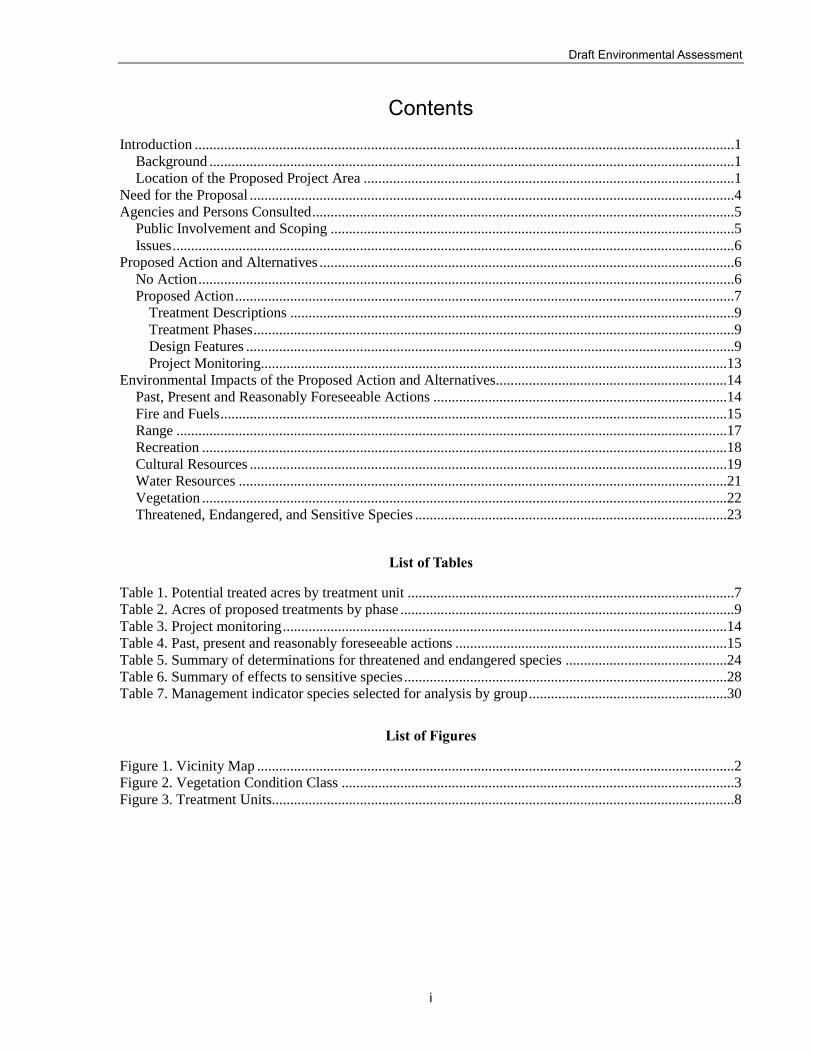
Table 3. Project monitoring
Item to be Monitored Monitoring Method(s) Responsibility Frequency
Implementation of design features, Forest Plan standards and guidelines
Site visits Forest Service District Fire Staff
Throughout implementation
Occurrence(s) of invasive plant species
Site visits Forest Service District Range, Wildlife, Fire Staff
Throughout implementation
Livestock and forage utilization levels
Site visits Forest Service District Range Staff
Throughout implementation
Environmental Impacts of the Proposed Action and Alternatives This section summarizes the potential impacts of the proposed action and the no action alternative
as analyzed by an interdisciplinary team of District resource specialists. The analysis tiers to the
Forest Plan and its Final Environmental Impact Statement (FEIS) and Record of Decision. Many
of the larger-scale effects were addressed in the Forest Plan FEIS, allowing us to narrow the focus
of this analysis to the site-specific effects of implementing the Cochise Stronghold Hazardous
Fuel Reduction project.
This section focuses on the issues raised during the formal scoping period. Analyses beyond those
documented here were completed to support the Responsible Official’s decisions and to ensure
compliance with laws and regulations such as the Endangered Species Act, the National Historic
Preservation Act, the Clean Water Act, and the National Forest Management Act. Those analyses
and associated references are part of the project administrative record and available for public
review at the Douglas Ranger District office or by request to the ID Team Leader.
Analyses are based on a variety of information sources including field surveys, topographic maps,
forest geographic information system data, forest resource information databases, relevant
available scientific literature, and professional judgment. Analyses assume that all treatments and
design features will be implemented as described.
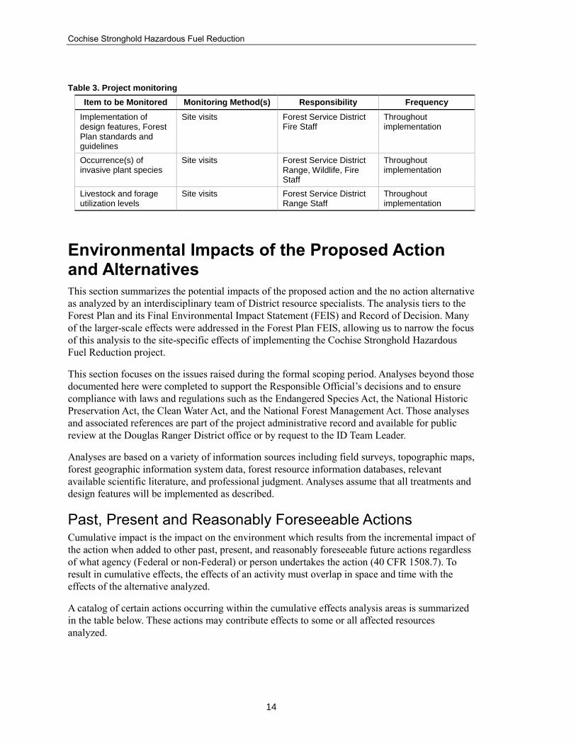
Past, Present and Reasonably Foreseeable Actions Cumulative impact is the impact on the environment which results from the incremental impact of
the action when added to other past, present, and reasonably foreseeable future actions regardless
of what agency (Federal or non-Federal) or person undertakes the action (40 CFR 1508.7). To
result in cumulative effects, the effects of an activity must overlap in space and time with the
effects of the alternative analyzed.
A catalog of certain actions occurring within the cumulative effects analysis areas is summarized
in the table below. These actions may contribute effects to some or all affected resources
analyzed.
Draft Environmental Assessment
15
Table 4. Past, present and reasonably foreseeable actions
Resource Area Proposed/Implemented Activities
Range Livestock grazing
Range improvement, construction and maintenance
Fire and Fuels Lizard Fire (June 2017)
Permitted wood cutting
Minerals Mining and mineral exploration
Recreation Administrative operations and visitor use of developed campgrounds
Administrative maintenance and visitor use of National Forest System Trails
Dispersed recreation (e.g. rock climbing, OHV and equestrian use)
Cabin rental program
Special Uses Permitted special use activities (e.g. equestrian and bike events)
Roads Administrative maintenance and visitor use of National Forest System Roads
Non-FS Actions Homeland security and Border Patrol activities
Illegal wood cutting
Fire and Fuels
Alternative 1 – No Action
The effects of no action on vegetation communities would be a continuation of the same trends
that have resulted in the current conditions described in the Fire and Fuels Report, located in the
project administrative record. Overall, it is expected that shrub lands and woodlands would
continue to expand resulting in further loss of grasslands. This trend would be slower than in the
past due to the conversions that have already occurred. Likewise, we would expect tree densities
in the woodland to continue to increase to some degree.
Direct and Indirect Effects
There would be no direct effect to fuels under this alternative. The no action alternative would not
alter the fuel profile to reduce fire behavior and would not meet the purpose and need of this
project. Potential fire behavior characteristics would be similar to those described under the
existing condition summarized in the Fire and Fuels Report.
In the absence of human-caused or natural disturbance such as vegetation treatment activities and
wildfire, there may be an increased accumulation of surface and ladder fuels due to insect and
disease activity, fire and the progression of forest succession. Increased fuel loading levels would
continue to pose a threat to communities, property and ecosystems as fire suppression becomes
more difficult. The no action alternative may indirectly lead to increased surface, ladder and
crown fuels that affect flame length, contribute to the torching of trees, and make crown fire more
likely (Peterson et al. 2005, Graham 2004). Increases in fuel loading will make over story trees
more susceptible to damage from wildfire. Wildfires that escape initial attack may impact
adjacent private lands and other resource values. It is probable that a large wildfire may threaten
adjacent private lands just as the Lizard Fire of 2017 did. Direct suppression tactics by
firefighting forces would not be as effective in the analysis area under the no action alternative.

Cochise Stronghold Hazardous Fuel Reduction
16
The no action alternative would restrict local fire managers from utilizing fire for meeting various
land management objectives and would not be consistent with agency direction. It would not
contribute to the desired condition, address the purpose and need of the project, or respond to the
National Fire Plan goals.
Alternative 2 – Proposed Action
Direct and Indirect Effects
The proposed treatments would reduce surface, ladder and crown fuels and change the fuel model
profile. Raising canopy base heights and reducing tree density in thinning units would reduce
ladder fuels and potential for crown fire initiation. It is expected the fire behavior potential would
be substantially reduced with the proposed treatments and the risk of wildfire impacts to adjacent
private lands and other resource values would be reduced. The prescribed burn treatments would
reduce fuels and break up contiguous vegetation to create a heterogeneous fuels landscape so that
areas with high fire behavior potential are interspersed with areas of mixed and low fire behavior
potential, thereby limiting the potential for high-intensity fire to spread towards the wildland-
urban interface. Forest restoration and fuel management activities aid in the reduction of wildfire
and also help to reestablish the natural fire regimes.
In low-intensity prescribed burns there would likely be mortality in many of the smaller diameter
understory trees in forested areas. It is anticipated this would create areas that are more open and
still contain a multi-storied canopy. Mixed-severity prescribed burns are expected to create a
mosaic of vegetation with open and closed single-story, multi-story, and early seral
grass/forb/shrub openings. The effects of all treatments would last for many decades. Eventually,
forested stands would become more closed, and as regeneration occurs the understory would fill
in. Treatments would help fire managers introduce more low-intensity prescribed fire in the
future. National Forest System land and adjacent private land would be positively affected from
the reduction of hazardous fuels and subsequent modification of potential fire behavior. The
existing condition has been influenced by fire exclusion. The proposed action combined with
other fuels reduction activities would modify fire behavior by contributing to the overall
reduction of surface, ladder, and crown fuels, thereby reducing fire intensity and crown fire
potential within the analysis area.
Cumulative Effects
Cumulative impacts may result from a combination of the proposed action with other past,
current, and foreseeable activities. The cumulative effects analysis area was determined to be the
Dragoon Mountains and the temporal boundary is 5 years. Current, past and future activities that
are occurring, have occurred and would occur include, but are not limited to, use and maintenance
of: trails, developed campgrounds, picnic areas, interpretive sites, administrative facilities,
parking areas and roads, managed grazing, range water improvements, range fencing, mining and
mine exploration, rural and urban development, prescribed burning, fuelwood cutting, mechanical
thinning, and wildfires.
For analyzing cumulative impacts to fire and fuels management, only those activities including
wildfires and fuels reduction activities will be discussed in more detail. Impacts from the other
listed activities typically occur in small, localized areas, in relation to the large size of the analysis
area, and therefore the impact is relatively small. There has been some small scale thinning and
weed eating in the East Stronghold area. This work was implemented to reduce hazardous fuels.
Fuelwood cutting and utilization has also been implemented at small scale. Past wildfires (within

Draft Environmental Assessment
17
last 5 years) include the 2014 Middlemarch Fire (19 acres), 2015 Lemarch Fire (290 acres) and
the 2017 Lizard Fire (15,230 acres).
These activities combined with the action alternatives would reduce surface, ladder and crown
fuels throughout the analysis area. Cumulatively, these activities result in reductions in flame
length (fire line intensity) and crown fire. Because some areas may be impacted by more than
one activity, there would be greater reductions in fire line intensity and potential crown fire in
those areas. All of the activities discussed would cumulatively break up fuel continuity on the
landscape. These combined activities would greatly facilitate restoring and sustaining ecological
processes in fire-dependent ecosystems and move vegetation and fuel conditions toward their
historic succession class distribution (VCC 1). It would also help fire management to manage
naturally occurring fires in fire-dependent ecosystems.
The effects of future wildland fire starts in the analysis area were not analyzed in detail because it
is impossible to predict when and where a wildfire may occur in the future, or the subsequent
effects of that fire.
Range
Alternative 1 – No Action
Direct and Indirect Effects
Under Alternative 1, there would be no direct effects as proposed activities would not occur.
Current conditions and processes would continue. There would be little if any change in forage
conditions that would benefit the range resource. However, there could be indirect effects if a
wildfire were to occur. Because wildfire events are unplanned and unexpected in regards to
location, intensity, and extent, and because they often resist control, they present a much greater
potential to negatively affect forage resources, threaten livestock, destroy or damage structural
range improvements, disrupt allotment management efforts, and have greater negative economic
effect on the local ranching economy.
Cumulative Effects
If no treatments occurred, the only cumulative effects that could occur would result if there were
a high-intensity, large-scale wildfire. In combination with other actions or events, a wildfire
would prevent or defer grazing on allotments, and likely lead to an overall reduction in available
forage.
Alternative 2 – Proposed Action
Direct and Indirect Effects
The proposed action allows for treatments best suited for bringing the rangeland resource closer
to the desired condition (explained in the forest plan) with the least negative effects. While fire
often presents an immediate danger to livestock and may cause damage to critical livestock
resources, the benefits of its prescribed use can exceed its negative effects. The Middlemarch
allotment in particular would benefit from the proposed action simply because it has experienced
a lack of fire for several decades. The Granite Springs allotment has also been without
widespread fire for many years, but the benefits that could be realized from the proposed action
are localized to portions of three pastures, which do not make up the majority of the capable
grazing acreage of the allotment. Both the Granite Springs and Middlemarch allotments will gain

Cochise Stronghold Hazardous Fuel Reduction
18
greater flexibility through increased capable acreage. Once these areas are recovered and
available for grazing, flexibility will be enhanced and the potential need to limit permitted
livestock numbers because of disturbances like wildfires should be reduced.
Cumulative Effects
From the range management standpoint, cumulative effects would mainly be realized on an
allotment-by-allotment basis. The primary exception to this will be community economics.
Actions similar to the proposed action have been occurring on the district for many years. Recent
treatments or incidents similar to the proposed action include several wildfires in the Chiricahua
and Peloncillo Mountains, including the Horseshoe and Horseshoe 2 Fires, the Hog Fire, the
Pasco Fire, the Guadalupe Fire and the Baker 2 Prescribed Fire. All of these fires have reduced
canopy cover and encouraged herbaceous species growth to varying extents. It should be noted,
however, that increased livestock distribution has occurred on all of the allotments that were
affected by these fires.
Recreation
Alternative 1 – No Action
Direct and Indirect Effects
Under the no action alternative, there would be minimal to no change to current visitor recreation
experiences and opportunities in the Dragoon Mountains. Encroaching fuels may reduce access to
trails, developed sites and facilities. In the absence of treatments, future catastrophic wildfires
may occur and result in closures and/or damage to recreation sites and trails. Closures may occur
both during wildfire suppression efforts and after wildfire events due to flooding, erosion and tree
mortality. This action would have a negative effect on the recreation users’ experience by
reducing opportunities for recreation activity.
Cumulative Effects
Under the no action alternative, future catastrophic wildfires may occur and result in both
recreation site and trail closures. These closures may extend post-wildfires due to safety concerns
with flooding, erosion and hazard trees present in recreation areas. The no action alternative
would have a negative effect on the recreation users’ experience by reducing long-term
opportunities for recreation activity. A recent example of the potential negative effects associated
with a no action approach can be seen at Cave Creek and Rustler Park recreation sites. A wildfire
caused extensive damage to these recreation areas because minimal vegetation maintenance
occurred.
In the long term (over 5 years), the accumulation of fuels and dense overgrown vegetation
increases the probability of extreme wildfire. Without the Cochise Stronghold Hazardous Fuel
Reduction, forest health would continue to decline and risks of severe wildfire would grow.
Additional negative impacts from major wildfires would be expected as these incidents trigger
future suppression efforts that may further impact recreation areas. Long-term economic impacts
to the project area may also occur under the no action alternative, as recreation conditions
continue to deteriorate and create a disinterest from the public.
Alternative 2 – Proposed Action

Draft Environmental Assessment
19
Direct and Indirect Effects
The proposed action would have a short-term, negative effect on recreation activities as
developed recreation sites are temporarily closed for public safety during and immediately after
implementation. For the extent of the closures, recreation opportunities would decrease at sites
within the project area. Disturbances associated with burning and cutting activity, such as
equipment noise and dust from falling and moving vegetation, may affect recreation use and
experiences, depending on the locations of the operations in relation to the recreation users. As a
result, a short-term reduction in use is expected within the project area during the proposed
activities.
Recreational use would continue for the long term in the project area after implementation. The
proposed action would allow for at least five years of maintained brush control, resulting in a
safer and more enjoyable recreation experience in the long term. The risk of potentially severe
wildfire damage would be reduced for at least five years following project implementation. The
creation of defensible space in the wildland-urban interface would provide increased protections
for recreation sites and facilities during future unplanned ignitions. Long-term benefits would
result as natural vegetation types are restored and the sustainability of the vegetation and wildlife
habitat are improved, thus creating enhanced recreation opportunities.
Cumulative Effects
Actions similar to the proposed action have been occurring on the Coronado National Forest for
many years and have proven to provide examples of successful defensible space for the wildland-
urban interface, and have created a more inviting, enjoyable outdoor experience.
Past and present trends in the project area include continued population growth of the
communities surrounding the project area and increasing use of National Forest System lands as a
result. Various past and present land uses have impacted the recreation resources in the project
area. Some activities, such as managed grazing, have little impact on recreational use. Other land
uses that affect recreation uses include fuelwood harvesting and vegetation management. Natural
disturbances that affect recreation include wildfires (e.g., Lizard Fire) and resulting flooding and
erosion.
The proposed action would result in additional burned areas which, when combined with past
wildfires, would result in short-term cumulative effects due to similar effects such as burned and
blackened vegetation. As more treatments are implemented, the frequency of suppression efforts
would likely diminish over time as fire begins to play a more natural role and overall forest health
improves. Therefore, no long-term cumulative effects are expected.
Actions that occur in the same time and space as this project have limited extents and mostly
short-term impacts. Because past, present, and future actions, when combined with treatments
proposed under the Cochise Stronghold Hazardous Fuel Reduction, would not alter recreation
resources in the Dragoon Mountains in the long term, no cumulative effects from this project are
expected.
Cultural Resources
Alternative 1 – No Action

Cochise Stronghold Hazardous Fuel Reduction
20
Direct and Indirect Effects
The no action alternative would not cause direct effects to cultural resources or traditional cultural
properties because no activities likely to affect such resources would be undertaken. Indirect
effects may occur under the no action alternative because cultural resources within the area could
be affected by future unplanned wildfire.
Cumulative Effects
Under this alternative, surface fuel loading is expected to increase over time, and the chance of a
severe wildfire occurring would remain high. Wildland fire and suppression activities are
potential sources of impacts to cultural resources. Cultural resources would be more susceptible
to damage from these activities without the protections that could be achieved by the proposed
action.
Alternative 2 – Proposed Action
Direct and Indirect Effects
With respect to this project, direct effects are those that will occur during project implementation.
Any activity that has the potential to disturb the ground has the potential to directly affect cultural
resources. Specific activities in the proposed action that have the potential to directly affect
cultural resources include construction of hand and mechanical fire line, staging areas, water bars
and other erosion control features.
Cultural resource sites that contain combustible materials would be prepared prior to project
implementation by removing heavy fuels within the site and excluding the site from prescribed
burning operations by establishing a black line, hand line, or wet line around the site periphery.
There would be no ignition points or staging of personnel and/or equipment within the boundaries
of these sites.
The Forest Archaeologist found that the proposed action would have no adverse effects upon
cultural resources provided the recommended mitigation and/or avoidance measures are adhered
to.
Cumulative Effects
Cumulative effects may result from a combination of the proposed action with other past, current,
and foreseeable activities. Reasonably foreseeable actions that could potentially affect cultural
resources include a host of land-use practices. Although these activities could affect cultural
resources and their contexts in a variety of direct and indirect ways, those actions must comply
with Section 106 of the National Historic Preservation Act (NHPA) and are planned and managed
whenever possible to minimize their effects through the use of design measures that mitigate
potential disturbance.
Managed grazing does not have an adverse effect on cultural resources when the grazing strategy
is designed to match herd size with capacity and distribute livestock as evenly as possible across
the allotment. Based on anticipated improvements in range condition and trend, no long-term
cumulative effects to cultural resources are expected.
Wildland fire and suppression activities are potential sources of impacts to cultural resources. In
the past, historic properties have been damaged by wildfires. Properties could be adversely
affected by high intensity wildfire and by suppression efforts. Under the proposed action

Draft Environmental Assessment
21
alternative, fewer historic properties would likely be damaged by wildfire and/or suppression
activities due to the removal of hazardous fuels. Known cultural resource sites would receive
protection from project activities, either through avoidance or controlled, low intensity burning to
reduce fuel loads within site boundaries. There could be beneficial cumulative effects from the
proposed project through the reduced potential for high intensity wildfires.
Water Resources
Alternative 1 – No Action
Direct and Indirect Effects
As a result of the no action alternative, the existing vegetation would remain in its current
condition and would continue with the trend of increasing tree/shrub encroachment and density if
other management actions are not taken to prevent it. In the short term, it can be expected that
water quality would not be impacted over existing impacts. However, as tree/shrub density and
encroachment increases, it can be expected that herbaceous cover would continue to decrease
with time. As a result, there will be less ground cover over the soil, increasing the opportunity for
soil erosion and sediment introduction into streams.
Cumulative Effects
There are plans including range allotment management plans, wildlife habitat improvement
projects, and fuels management projects in place that document potential effects of past, present
and reasonably foreseeable future projects to water quantity and water quality. None of these
actions in themselves or in combination with effects of the no action alternative discussed above
would have a significant effect to water resources.
Alternative 2 – Proposed Action
Direct and Indirect Effects
Thinning and prescribed burning would expose more soil to erosion in the short term. However,
thinning and prescribed burning would allow more herbaceous vegetation to establish and
proliferate over time in areas that are currently dominated by shrubs. Increases in herbaceous
vegetation would result in more ground cover, reducing soil erosion over time, therefore
decreasing sediment transport to streams in the long term. Some delays in vegetation
establishment may be expected in areas with increased fire severity, but these areas are expected
to be much more limited in extent than with wildfire due to planning and management for less
damaging fire conditions.
Fires can have detrimental effects on soil. Although some of these negative effects can occur
with prescribed burns, they would be expected to occur over a smaller area and be of a lesser
magnitude than unplanned ignitions. Since low intensity prescribed fires have reduced negative
effects to soils, watersheds and vegetation can recover more quickly.
After a fire, a substantial rainfall event can move sediment and ash into downslope drainages,
possibly overwhelming the capacity of the drainages to hold the flow. These effects would be
expected to be less with a prescribed burn than with a catastrophic wildfire. Prescribed burns
would be implemented and tactically executed to hold fire spread within the identified project
area, as opposed to catastrophic wildfire, which can burn over a much larger area and until
contained. Also, prescribed burning would be managed to occur when burning intensity would be

Cochise Stronghold Hazardous Fuel Reduction
22
minimized due to factors such as weather, wind, and vegetation moisture. Lastly, thinning and
other management is done as needed prior to the prescribed burn to ensure that the vegetation
structure available for the burn does not result in more damaging and intense fires. As such, it is
expected that prescribed burning would result in fewer areas where burning intensity results in
severe impacts to soil resources. Increases in erosion and flood flows can be expected for
prescribed burn areas in the short term until vegetation establishes and the watershed recovers,
however, it would be projected to be much less than if a catastrophic wildfire were to occur. The
magnitude of flood flows would be expected to decrease over time as soil condition improves,
vegetation re-establishes to hold the soil in place, and watershed conditions stabilize.
There may be short term negative effects to air quality through the implementation of the
proposed action due to smoke and wind erosion. However, these effects will be minimized
through planning the prescribed burns for good to excellent smoke dispersal days and for good
site conditions. This planning is in contrast to wildfires, which can occur whenever ignition and
conditions allow.
Cumulative Effects
Past, present and foreseeable future projects or actions that have affected or would affect the
project area include grazing, fuelwood harvest, prescribed and natural fires, wildfire suppression,
road maintenance, trail maintenance, developed recreation areas, administrative facilities, fuels
management, and water developments. There are plans including range allotment management
plans, wildlife habitat improvement projects, and fuels management projects in place that
document potential effects of past, present and reasonably foreseeable future projects to water
quantity and water quality. None of these actions by themselves or in combination with effects of
the proposed action discussed above would be considered to have a significant effect to water
resources.
Projects, activities, and circumstances occurring in the past are not included in this cumulative
effects analysis since they can reasonably be expected to affect the current environment, which
has already been assessed through the Affected Environment and No Action Alternative sections
of the Watershed Resource Report, available in the project administrative record.
Vegetation
Alternative 1 – No Action
Direct and Indirect Effects
As a result of the no action alternative, open areas would continue to be invaded by species like
mesquite, madrone, and manzanita. These brush species may occupy space that could be used for
tree species and/or grasses. Fuel levels from course woody debris would continue to accumulate,
increasing the probability of severe fire behavior. As the area becomes more congested with
woody plants, the recreational value would decrease as the locations for activities such as
camping and observing wildlife decrease.
Cumulative Effects
The potential impact of severe, uncharacteristic wildfires is the primary cumulative impact on the
plant communities within the project area. Reduction of this impact is also the primary purpose of
the project. Increasingly drier and warmer conditions will likely result in more severe fires in the
future. Fire seasons will lengthen and fire behavior will become more intense, creating challenges

Draft Environmental Assessment
23
for managers (Stephens et al. 2013). These conditions would not be mitigated under the no action
alternative.
Alternative 2 – Proposed Action
Direct and Indirect Effects
As a result of the proposed action, the probability of a stand replacement fire would be reduced.
Some regeneration may be lost, particularly Mexican pinyon pine. However, the temporary
reduction in ground cover may allow for the regeneration of some species. Meanwhile, reduced
competition from woody, brush species would spur the growth of grasses and forbs. Visual
quality would improve by removing some of the standing dead trees and down woody debris.
Reduced competition for resources would spur growth.
Cumulative Effects
The potential impact of severe, uncharacteristic wildfires is the primary cumulative impact on the
plant communities within the project area. Reduction of this impact is also the primary purpose of
the project. It is likely that fires with severe impacts will continue to occur before, during and
after completion of the project but we expect that these impacts will be substantially lessened as a
result of the treatments. Increasingly drier and warmer conditions will result in more severe fire
conditions and also lengthen the fire season. These conditions will likely result in a higher
occurrence of severe fire behavior and impacts, creating challenges for managers. The proposed
action would help mitigate these future negative impacts.
Threatened, Endangered, and Sensitive Species The project biologist prepared a biological assessment, biological evaluation, and a report on
management indicator species to analyze the potential impacts of the proposed action on special-
status wildlife, fish and plant species and their habitat in the project area. Included are species
listed by the U.S. Fish and Wildlife Service as threatened, endangered, or proposed for listing
under the Endangered Species Act; designated critical habitat for species listed under the Act;
species designated as sensitive by the Southwestern Region of the Forest Service (USDA Forest
Service 2007); and management-indicator species on the Coronado National Forest (forest plan
1986, as amended). Only the key findings and determinations from the biological assessment,
evaluation and management indicator species report are summarized in this section. The full
reports are available in the project administrative record.
Consultation with the U.S. Fish and Wildlife Service regarding this proposed action and federally
listed species was completed. The U.S. Fish and Wildlife Service issued a biological opinion that
is consistent with the analysis presented in this environmental assessment.
Alternative 1 – No Action
Effects of No Action on Threatened and Endangered Species
Under the no action alternative, there would be no direct effects to species or their habitat from
treatment activities. In the absence of any kind of human-caused or natural disturbance, indirect
effects would occur from the natural succession of vegetative growth and change. Fire risk in the
project analysis area would likely increase and contribute to stand-replacing wildfires. It is likely
that wildfires would continue to occur at recent levels or increase in frequency and severity.
When evaluating potential wildfires, the effects are especially difficult to assess because of the

Cochise Stronghold Hazardous Fuel Reduction
24
many and great uncertainties related to management of such fires. The timing, location, extent,
and severity cannot be accurately predicted. However, wildfires could result in a reduction of
important habitat features such as travel corridors, nesting or foraging habitat, and hiding cover.
Effects of No Action on Sensitive Species
Under the no action alternative, there would be no direct effects to sensitive species. However,
indirect effects could occur if stand-replacing wildfires continue to occur at recent levels. This
would result in a reduction of important habitats or loss of individuals. Intense crown fires have
the potential to affect those species that depend on forest canopies for nesting and foraging.
Alternative 2 – Proposed Action
Effects of the Proposed Action on Threatened and Endangered Species
The following table lists the species analyzed in the biological assessment and what the effects
determination is for each species and its habitat. The information following the table summarizes
the effects analysis and provides a rationale for the effects determinations for each listed species
analyzed. The complete analysis and rationale is available in the biological assessment; effects
are expected to be insignificant and/or discountable.
Table 5. Summary of determinations for threatened and endangered species
Common name Scientific name Listing Status Critical Habitat in Project Area
Effects Determination5
Chiricahua leopard frog
Lithibates chiricahuensis
Threatened Yes MANLAA
Lesser long-nosed bat
Leptonycteris curasoae
Endangered No MANLAA
Yellow-billed cuckoo (Western
U.S. distinct population segment)
Coccyzus americanus
Threatened NA MANLAA
Mexican spotted owl and critical
habitat
Strix occidentalis lucida
Threatened No MANLAA
Jaguar Panthera onca Endangered No MANLAA
Ocelot Leopardus pardalis Endangered NA MANLAA
Chiricahua Leopard Frog
Determination of Effects
No direct effects are anticipated to Chiricahua leopard frogs because of the conservation measures
being implemented and buffer protection zones at the Middlemarch Mine breeding site and
dispersal corridors in designated Critical Habitat. However, implementation will occur at the start
5 May affect, not likely to adversely affect (MANLAA) - the effects on listed species are expected to be
discountable or insignificant. Insignificant effects relate to the size of the impact and should never reach the
scale where take occurs. Discountable effects are those extremely unlikely to occur. Based on best
judgment, a person would not: (1) be able to meaningfully measure, detect, or evaluate insignificant effects;
or (2) expect discountable effects to occur.

Draft Environmental Assessment
25
of CLF breeding season in March, so it is possible that the proposed action could indirectly result
in death or injury if individual frogs are dispersing or utilizing upland habitats. The proposed
action could also cause increased runoff of floodwaters, deposition of debris and sediment, which
has the potential to degrade CLF habitat. However, we believe that our conservation measures
and buffer zones render the likelihood of these possible effects insignificant. Due to indirect
effects from mechanical treatment and prescribed burning within the action area, the proposed
action may affect, but is not likely to adversely affect the Chiricahua leopard frog.
Rationale
Treatments will not occur in Designated Critical Habitat, or any known breeding sites, of
Chiricahua leopard frog.
Numerous Conservation Measures and Best Management Practices will be implemented
to avoid and/or mitigate potential effects of the proposed action on aquatic systems.
The interdisciplinary team (IDT) will consult and provide implementation guidance to
ensure that all potential resource concerns are being addressed and the appropriate design
criteria are used. If appropriate, the IDT will coordinate implementation plans with the
USFWS to address any additional concerns regarding federally listed species and their
designated critical habitat.
Lesser Long-nosed Bat
Determination of Effects
Lesser long-nosed bat may be indirectly affected by proposed activities if food sources are
damaged or destroyed, thus, the cumulative treatment of suitable foraging habitat could result in a
slight change in bat numbers or distribution. During mastication treatments, dense stands of agave
would be flagged during the planning process and avoided by the masticator to protect foraging
habitat. Ladder fuels around patches of agaves and other nectar plants will be removed to lessen
the impact of fire on individual plants. Removal of ladder fuels around agaves will help prevent
torching of individual plants during broadcast burns. The proposed project incorporates these
conservation measures among others to minimize effects to bat roosts and foraging habitat, the
proposed treatments are not likely to change the species distribution. Therefore, it is the
determination that the proposed project may affect, but is not likely to adversely affect the
lesser long-nosed bat.
Rationale
Treatments are expected to take place during the timeframe of October 1st – March 31st
and will not occur from May 1st – September 30th when lesser long-nosed bat are present
within the action area.
Known post-maternity roosts will be avoided for treatments near known roosts, and
Conservation Measures listed in Section VI of the Biological Assessment will be
implemented to protect the integrity of the roost.
Prescribed burns will be designed to be low to moderate severity to minimize adverse
effects to agave plants.

Cochise Stronghold Hazardous Fuel Reduction
26
Dense stands of agaves (Agave palmeri) will be flagged and avoided by the treatment
actions.
Treatments would be phased to minimize adverse effects to lesser long-nosed bat forage
plants.
Treatments will reduce the potential for high intensity wildfire in lesser long-nosed bat
foraging and roosting habitat.
Yellow-billed Cuckoo
Determination of Effects
Yellow-billed cuckoos are one of the latest neotropical migrants to arrive on the Coronado
National Forest (late May-early June). Because project implementation occurs when yellow-
billed cuckoo are not present on the Coronado National Forest, there will be no direct effects to
the species. However, treatments will target areas adjacent to drainages and riparian areas and
will remove some woody species in order to promote the desired condition of the Madrean
encinal woodland vegetation community. Because yellow-billed cuckoo have been found utilizing
habitats that do not necessarily require drainages with flowing water, they may utilize portions of
these upland woodland areas targeted for treatment. Changes to the vegetation structure that result
from the proposed action may cause shifts in habitat use. Due to indirect effects from mechanical
treatment and prescribed burning within the action area, the proposed action may affect, but is
not likely to adversely affect the yellow-billed cuckoo.
Rationale
Treatments will not occur within or adjacent to, occupied habitat during the breeding
season.
Treatments will avoid all riparian areas and high-gradient streams, and are located outside
drainages.
Treatments will be designed to reduce the likelihood of a high-intensity wildfire
occurring within riparian areas and drainages.
The planning and implementation of the proposed action will take into account the
distribution and size of treatments within a watershed. Because the application of the
action will occur at multiple scales (i.e., planning block, watershed and the entire action
area), effects to marginal yellow-billed cuckoo habitat are expected to be insignificant.
Mexican Spotted Owl
Determination of Effects
Due to indirect effects from mechanical treatment and prescribed burning within the action area,
the proposed action may affect, but is not likely to adversely affect the Mexican spotted owl
and its critical habitat.
Rationale
There is no Mexican spotted owl designated critical habitat or protected activity centers
located within or in the vicinity of the project area.

Draft Environmental Assessment
27
Treatments would only overlap with the first month (March) of the breeding season
(March 1st – August 31st).
Treatments may affect wintering Mexican spotted owl through auditory or visual
disturbance.
Prescribed burning or thinning activities may indirectly affect the Mexican spotted owl
by changing the vegetation structure.
Changes to vegetation successional communities might have a beneficial influence on the
availability of MSO prey.
The main objective of the proposed action is to reduce the likelihood of stand-replacing
fire while maintaining suitable owl habitat.
Site-specific treatments will adhere to the guidelines of the Mexican spotted owl
Recovery Plan.
Jaguar
Determination of Effects
Due to indirect effects from mechanical treatment and prescribed burning within the action area,
the proposed action may affect, but is not likely to adversely affect the jaguar.
Rationale
Negative effects are expected to be temporary and not result in long-term habitat
degradation.
The proposed action is designed to reduce the risk of stand-replacing wildlife that could
provide beneficial effects on the quality and quantity of jaguar habitat in the project area.
There have not been any historical or recent jaguar observations in the Dragoon
Mountains.
Changes to vegetation successional communities might have a beneficial influence on the
availability of jaguar prey.
Ocelot
Determination of Effects
Due to indirect effects from mechanical treatment and prescribed burning within the action area,
the proposed action may affect, but is not likely to adversely affect the ocelot.
Rationale
Negative effects are expected to be temporary and not result in long-term habitat
degradation.
The proposed action is designed to reduce the risk of stand-replacing wildfire that could
provide beneficial effects on the quality and quantity of ocelot habitat in the project area.
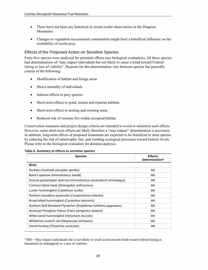
Cochise Stronghold Hazardous Fuel Reduction
28
There have not been any historical or recent ocelot observations in the Dragoon
Mountains.
Changes to vegetation successional communities might have a beneficial influence on the
availability of ocelot prey.
Effects of the Proposed Action on Sensitive Species
Forty-five species were analyzed for potential effects (see biological evaluation). All these species
had determinations of “may impact individuals but not likely to cause a trend toward Federal
listing or loss of viability”. Reasons for this determination vary between species but generally
consist of the following:
Modification of habitat and forage areas
Direct mortality of individuals
Indirect effects to prey species
Short-term effects to pond, stream and riparian habitats
Short-term effects to nesting and roosting areas
Reduced risk of extreme fire within occupied habitat
Conservation measures and project design criteria are intended to avoid or minimize such effects.
However, some short-term effects are likely therefore a “may impact” determination is necessary.
In addition, long-term effects of proposed treatments are expected to be beneficial to most species
by reducing the risk of catastrophic fire, and trending ecological processes toward historic levels.
Please refer to the biological evaluation for detailed analyses.
Table 6. Summary of effects to sensitive species
Species Effects Determination6
Birds
Northern Goshawk (Accipiter gentilis) MII
Baird’s sparrow (Ammodramus bairdii) MII
Arizona grasshopper sparrow (Ammodramus savannarum ammolegus) MII
Common black-hawk (Buteogallus anthracinus) MII
Lucifer hummingbird (Calothorax lucifer) MII
Northern beardless-tyrannulet (Camptostoma imberbe) MII
Broad-billed hummingbird (Cynanthus latirostris) MII
Northern Buff-Breasted Flycatcher (Empidonax fulvifrons pygmaeus) MII
American Peregrine Falcon (Falco peregrinus anatum) MII
White-eared hummingbird (Hylocharis leucotis) MII
Whiskered screech owl (Megascops trichopsis) MII
Varied bunting (Passerina versicolor) MII
6 MII = May impact individuals but is not likely to result in downward trend toward federal listing as
threatened or endangered or a loss of viability.

Draft Environmental Assessment
29
Species Effects Determination6
Abert’s towhee (Pipilo aberti) MII
Mammals
Northern pygmy mouse (Baiomys taylori ater) MII
Mexican Long-Tongued Bat (Choeronycteris mexicana) MII
Pale Townsend’s big-eared bat (Corynorhinus townsendii pallescens) MII
Greater western mastiff bat (Eumops perotis californicus) MII
Allen’s lappet-browed bat (Idionycteris phyllotis) MII
Western red bat (Lasiurus blossevillii) MII
Western yellow bat (Lasiurus xanthinus) MII
California leaf-nosed bat (Macrotus californicus) MII
Hooded skunk (Mephitis macroura milleri) MII
White-nosed coati (Nasua narica) MII
Cockrum’s desert shrew (Notiosorex cockrumi) MII
Pocket free-tailed bat (Nyctinomops femorosaccus) MII
Reptiles
Giant Spotted Whiptail (Aspidoscelis burti stictogrammus) MII
Reticulate Gila monster (Heloderma suspectum suspectum) MII
Slevins bunchgrass lizard (Sceloporus slevini) MII
Green ratsnake (Senticolis triaspis) MII
Yaqui black-headed snake (Tantilla yaquia) MII
Plants
Lemmon milkweed (Asclepias lemmonii) MII
Maguire’s (coppermine) milkvetch (Astragalus cobrensis var. maguirei) MII
Chihuahuan sedge (Carex chihuahuensis) MII
Cochise sedge (Carex ultra) MII
Trans-pecos Indian paintbrush (Castilleja nervata) MII
Arid throne fleabane (Erigeron arisolius) MII
Wislizeni Gentian (Gentianella wislizeni) MII
Arizona alum root (Heuchera glomerulata) MII
Arizona coralroot (Hexalectris spicata var. arizonica) MII
Lemmon’s lupine (Lupinus lemmonii) MII
Catalina beardtongue (Penstemon discolor) MII
Hinckley’s polemonium (Polemonium pauciflorum ssp. hinckleyi) MII
Huachuca groundsel (Senecio multidentatus var. huachucanus) MII
Nodding blue-eyed grass (Sisyrinchium cernuum) MII
Shade Violet (Viola umbraticola) MII
Management Indicator Species
National Forest Management Act implementing regulations (36 CFR 219.19) and Forest Service
Manual (FSM) 2600 guidance require that forest plans identify certain vertebrate and/or

Cochise Stronghold Hazardous Fuel Reduction
30
invertebrate species as management indicator species, and that these species be monitored “in
order to assess the effects of management activities on their populations and the populations of
other species with similar habitat needs which they may represent (FSM 2620.5).” Thirty-three
management indicator species and one group (primary and secondary cavity nesters) in eight
indicator groups are identified in appendix G of the Coronado forest plan (USDA Forest Service
1986, pages 128-129).
Of the 33 management indicator species, at least one from each group is known to occur within
the project area, except for species needing dense canopy. Northern beardless-tyrannulet has been
used as a representative species, but has never been documented in the project area. These species
and the indicator groups that they represent are displayed in the table below. Several species
occur in more than one group and/or are also classified threatened, endangered, or sensitive
species so analysis is not repeated here. More detailed analysis for these species can be found in
appendix A to the biological evaluation.
Table 7. Management indicator species selected for analysis by group
Management Indicator Group Species
Group 1 - Cavity Nesters Copper tailed “elegant” trogon
Sulphur-bellied flycatcher
Group 2 - Riparian Species Black Bear
Blue-throated hummingbird
Northern beardless-tyrannulet
Sulphur-bellied flycatcher
Copper tailed “elegant” trogon
Group 3 - Species Needing Diversity White-tailed deer
Buff-breasted flycatcher
Sulphur-bellied flycatcher
Copper tailed “elegant” trogon
Group 4 - Species Needing Herbaceous Cover White-tailed deer
Mearn’s quail
Baird’s Sparrow
Group 5 - Species Needing Dense Canopy Northern beardless-tyrannulet
Group 6 - Game Species White-tailed deer
Black bear
Mearn’s quail
Group 7 - Special Interest Species Mearn’s quail
Blue-throated hummingbird
Buff- breasted flycatcher
Sulphur-bellied flycatcher
Copper tailed “elegant” trogon
Group 8 - Threatened and Endangered Species See Biological Assessment
Cumulative Effects
ESA cumulative effects are those of future State or private activities, not involving Federal
activities, that are reasonably certain to occur within the action area of the Federal action subject
to consultation [50 CFR §402.02]. Federal agencies manage the majority of lands that are
important wildlife habitat within the action area. Activities on federal land that could affect
wildlife are not considered in this section because they require separate consultation pursuant to

Draft Environmental Assessment
31
section 7 of the Act. Examples of these kinds of actions include: management of Forest Service
grazing permits, travel management and mineral activities.
Activities in the vicinity of the action area that are reasonably certain to occur in important
wildlife habitat but are not subject to section 7 analysis include illegal activities and action on
private lands. Examples of illegal activities that may affect wildlife include: inappropriate use of
off-highway vehicles, illegal woodcutting, the distribution of restricted live wildlife (especially
aquatic invasives), and poaching. Illegal activities are difficult to predict and are assumed to
occur indefinitely and uniformly throughout the vicinity of the action area and are not expected to
significantly contribute to the adverse impacts from the proposed action.
Activities occurring on private lands may include residential development, farming/ranching,
road construction and maintenance, and mineral exploration. These activities could potentially
affect wildlife through habitat destruction or degradation and harassment of individuals. Many of
the private lands near or within the action area have already been developed, and no new major
developments of private lands are expected to occur; therefore, future activities on private lands
are not expected to significantly contribute to adverse impacts to wildlife from the proposed
action.