coking-coal deposits of the western united states · coking-coal deposits of the western united...
TRANSCRIPT

Coking-Coal Depositsof theWestern United States
; By PAUL AVERITT
CONTRIBUTIONS TO ECONOMIC GEOLOGY
GEOLOGICAL SURVEY BULLETIN 1222-G
A short summary of the geology ' and occurrence of coal in 21 \ localities in 8 Western States
UNITED STATES GOVERNMENT PRINTING OFFICE, WASHINGTON : 1966

UNITED STATES DEPARTMENT OF THE INTERIOR
STEWART L. UDALL, Secretary
GEOLOGICAL SURVEY
William T. Pecora, Director
For sale by the Superintendent of Documents, U.S. Government Printing Office Washington, D.C. 20402 - Price 25 cents (paper cover)

\ CONTENTS
1 Page.
Abstract___-_-_-________________-___-_-_-_-____-_-____-_-___.__ Gl* Introduction. __________-_-_-_----_--______-____-______-_-___-_____ 1
Acknowledgments _________________________________________________ 3Origin, classification, and distribution of coal__________________________ 3
! Properties of coking coal_-_-__-_-----_--__-_-_--__-_-___---_______- 5Uses and properties of coke-__--____________--_--___________________ 6
Blast-furnace coke__---_------------------------_-_---_-------- 6Foundry coke--___----_-_---_-------------------_-------_---_- 7
* Coking-coal deposits___^__-__-___---__---__-----____-__--______--_- 7Washington_________________________________________________ 10
Wilkeson-Carbonado field and Fairfax-Montezuma area, PierceCounty, Wash_________.__________________ 10
Roslyn field, Kittitas County, Wash._____________________ 12i Montana.____________________________________________________ 14
Livingston field, Park and Gallatin Counties, Mont__________ 14Electric field, Park County, Mont.__________________________ 16Great Falls field, Cascade and Judith Basin Counties, Mont____ 17
Wyoming__ _________________________________________________ 18Kemmerer-Willow Creek field, Lincoln County, Wyo_________ 19Rock Springs field, Sweetwater County, Wyo _________________ 21
; Cambria field, Weston County, Wyo_________________________ 22^ Utah__________-.________________________ 23
Sunnyside-Castlegate field, Carbon County, Utah _____________ 23Mount Pleasant field, Sanpete County, Utah_______________ 25Kolob field, Iron, Washington, and Kane Counties, Utah_______ 26
Colorado. _._______.____..___________^____.__ 27; Somerset-Crested Butte-Carbondale region, Delta, Gunnison, and
Pitkin Counties, Colo_______-__________________._____ 27Somerset field, Coal Creek district_______________________ 28
, Crested Butte field. __ __________________ ___ 29Carbondaie field__________________________ 29
v San Juan River field, Montrose, San Miguel, Dolores, and Monte-zuma Counties, Colo____________________________.________ 30
y. Durango field, La Plata County, Colo______________________ 30Raton Mesa region, Huerfano and Las Animas Counties, Colo.,
\ and Colfax County, N. Mex____________________ 32New Mexico______-__________________-___.____________________ 33
] Monero field, Rio Arriba County, N. Mex____________________ 34Cerrillos field, Santa Fe County, N. Mex.____________________ 35
* Carthage field, Socorro County, N. Mex__________________ 35^ Oklahoma and Arkansas______________________________________ 36
Henryetta district, Okmulgee County, Okla_________________ 36Southern part of the Oklahoma field, Coal, Pittsburg, Atoka,
Latimer, and LeFlore Counties..__________________________ 38Western Arkansas field, Sebastian, Crawford, Franklin, Logan,
Scott, Johnson, Pope, and Yell Counties_________________ 41" * Conclusion__ ______________________________________'_____________ 42
Selected bibliography______________________________________________ 43\
m

IV CONTENTS
ILLUSTKATION
Page FIGURE 1. Map of coal fields of the conterminous United States west of
the Mississippi River showing coking-coal localities _________ G2
TABLE
Page
TABLE 1. Classification of coals by rank__ _____ ____ G4 /

CONTRIBUTIONS TO ECONOMIC GEOLOGY
COKING-COAL DEPOSITS OF THE WESTERN UNITED STATES
By PAUL AVERITT
ABSTRACT
Twenty-one areas in eight Western States yield coal of varying degree of util ity in the manufacture of coke. The geology and coal resources of each of these areas is summarized briefly. Three of these areas the Raton Mesa region, Colorado and New Mexico, the Carbondale field, Colorado, and the Sunnyside- Castlegate field, Utah are important sources of metallurgical coke used by the growing western steel industry. Some of this western-made metallurgical coke is upgraded by the addition of small amounts of low-volatile bituminous coal from the southeastern Oklahoma and Arkansas fields.
Several other fields, notably the Wilkeson-Carbonado-Fairfax and the Roslyn fields, Washington, and the Kemmerer-Willow Creek field, Wyoming, contain ade quate resources of coal that by washing and blending can be made to yield coke approaching in quality that made from coal obtained in the producing fields.
Other areas yield coal suitable for the manufacture of lower grade coke, formerly used in nonferrous smelting, and used at present in the recovery of elemental phosphorus and in the refining of sugar. Other areas are undeveloped.
INTRODUCTION
The U.S. Geological Survey and various State agencies have mapped the geology and studied the coal resources of the United States for many years. The U.S. Bureau of Mines and other agencies have been engaged in sampling, analysis, and technologic studies of coals, which complement the geologic and resource studies. Of the great bulk of accumulated data, the part applicable to coking coals in the Western United States is widely scattered in the geologic and technologic litera ture, and many older reports of great value are out of print.
This report is, therefore, intended to consolidate and to summarize very briefly information pertinent to coal in 21 localities in the Western United States (see fig. 1) where the coal has coking properties and to provide a selected list of publications describing the coal in these locali-
Gi

G2 CONTRIBUTIONS TO ECONOMIC GEOLOGY
ties. Although emphasis is placed on the geology and resources of coal, publications concerned with the technologic aspects of coking coal are cited to complete the summary.
Anthracite and semianthracite
Medium- and high-volatile Subbituminous coal bituminous coal
Lignite
1. Wilkeson-Carbonado field and Fairfax-Mohtezuma area.
2. Roslyn field.3. Livingston field.4. Electric field,5. Great Falls field.6. Kemmerer-Willow Creek field.7. Rock Springs field.8. Cambria field.9. Sunnyside-Castlegate field.
10. Mount Pleasant field.11. Kolob field.
12. Somerset-Crested Butte-Car- bondale region.
13. San Juan River field.14. Durango field.15. Baton Mesa region.16. Monero field.17. Cerrillos field.18. Carthage field.19. Henryetta district.20. Southern part of the Okla
homa field.21. Western Arkansas field.
FIGURE 1. Coal fields of the conterminous United States west of the Mississippi River showing coking-coal localities.

COKING-COAL DEPOSITS, WESTERN UNITED STATES G3
ACKNOWLEDGMENTS
This report is a revision of an earlier report by L. R Berryhill and Paul Averitt (1951) and incorporates much information used in that report. Paragraphs on specific areas and fields have been reviewed, updated, or rewritten by individuals familiar with those areas. These contributors include H. M. Beikman and H. D. Gower (Washington),' A. E. Roberts (Livingston field, Montana), G. D. Fraser (Electric field, Montana), R. B,. Johnson (New Mexico and Raton Mesa field, Colorado), J. R Donnell (Carbondale field, Colorado), W. J. Mapel (Cambria field, Wyoming), and B. R. Haley (Oklahoma and Arkansas).
ORIGIN, CLASSIFICATION, AND DISTRIBUTIONOF COAL
Coal is composed of ancient plants and plant fragments that ac cumulated in former marshes and swamps. As this material increased in quantity year after year in the swampy environment, the lower layers were compacted under the weight of the upper layers and, in time, became peat, the initial stage in the formation of coal. Later, the swamps were flooded by the sea and buried under vast accumula tions of sand and silt washed in by streams flowing from nearby lands. The layers of peat thus became further compressed under the weight of these sediments. Pressure and heat from movements of the earth's crust aided locally in the process of compaction and coalification, which has been going on slowly and continuously for a long period of geo logic time.
During the process of compaction and coalification, the beds of coal undergo a series of physical and chemical changes that, in general, result in a reduction in moisture and volatile matter and a correspond ing increase in fixed carbon, and heat value. The change a coal has undergone, as measured by variations in these components, is the basis for the established classification of coal by rank. The terms "lignite," "subbituminous coal," "bituminous coal," and "anthracite" thus describe stages in the coal-forming process. Each of these major ranks of coal is further subdivided on the basis of chemical properties. Table 1 shows the classification used in the United States.
More than half of the coal used in the manufacture of coke is of high-volatile A bituminous rank, followed, in order of use, by coal of low-volatile and medium-volatile bituminous ranks.
Coal-bearing rocks are widely distributed west of the Mississippi River, as shown in figure 1. On a simple tonnage basis, this area contains 70 percent of the total coal resources of the United States.

TA
BL
E 1
. C
lass
ific
ati
on
of
coal
s b
y ra
nk
1 [A
dapt
ed f
rom
Am
eric
an S
ocie
ty fo
r T
estin
g M
ater
ials
, 196
41
o
Cla
ss
III.
Sub
bitu
min
ous_
___
Gro
up
1. M
eta-
anth
raci
te _
__
1. L
ow- v
olat
ile
bitu
min
ous
coal
. 2.
Med
ium
-vol
atil
e bit
u
min
ous
coal
. 3.
Hig
h-vo
lati
le A
bit
u
min
ous
coal
. 4.
Hig
h-vo
lati
le B
bit
u
min
ous
coal
. 5.
Hig
h-vo
lati
le C
bit
u
min
ous
coal
.
2. L
igni
te B
_
__._
__._
_
Lim
its
of fi
xed
carb
on,
dry,
min
eral
-mat
ter-
fr
ee b
asis
(pe
rcen
t)
Equ
al o
r gr
eate
r th
an
98
92
86
78 69
Les
s th
an 98
92
86 78
69
Lim
its o
f vol
atile
m
atte
r, d
ry, m
iner
al-
mat
ter-
free
bas
is
(per
cent
)
Equ
al o
r gr
eate
r th
an
2 8 14 22
31
Les
s th
an
2 8 14
22 31
Lim
its
of c
alor
ific
val
ue,
moi
st,2
min
eral
-mat
ter-
fr
ee b
asis
(B
tu p
er
poun
d)
Equ
al o
r gr
eate
r th
an
4 14,0
00
4 13
,000
f 11,
500
\1
0, 5
00
10,
500
9, 5
00
8,30
0 6,
300
Les
s th
an
14,
000
13,
000
11,
500
11,
500
10,
500
9,50
0 8,
300
6,
300
Agg
lom
erat
ing
char
acte
r
Non
aggl
omer
atin
g.3
^Com
mon
ly
aggl
omer
atin
g.5
Agg
lom
erat
ing.
N
onag
glom
erat
ing.
o
o g HH O o C F
O
O
1 T
his
clas
sifi
catio
n do
es n
ot i
nclu
de a
few
coa
ls,
prin
cipa
lly n
onba
nded
var
ietie
s,
whi
ch h
ave
unus
ual p
hysi
cal a
nd c
hem
ical
pro
pert
ies
and
whi
ch c
ome
wit
hin
the
limits
of
fix
ed c
arbo
n or
cal
orifi
c va
lue
of t
he h
igh-
vola
tile
bitu
min
ous
and
subb
itum
inou
s ra
nks.
A
ll of
thes
e co
als
eith
er c
onta
in le
ss t
han
48 p
erce
nt d
ry,
min
eral
-mat
ter-
free
fix
ed c
arbo
n or
hav
e m
ore
than
15,
500
moi
st, m
iner
al-m
atte
r-fr
ee B
tu p
er p
ound
.2
"Moi
st"
refe
rs to
coa
l con
tain
ing
its n
atur
al in
here
nt m
oist
ure
but n
ot in
clud
ing
vis
ib
le w
ater
on
the
surf
ace
of th
e co
al.
3 If a
gglo
mer
atin
g, c
lass
ify in
low
-vol
atile
gro
up o
f the
bitu
min
ous
clas
s.4
Coa
ls h
avin
g 69
per
cent
or
mor
e fix
ed c
arbo
n on
the
dry
, min
eral
-mat
ter-
free
bas
is
shal
l be
clas
sifie
d ac
cord
ing
to fi
xed
carb
on, r
egar
dles
s of
cal
orifi
c va
lue.
6 It i
s rec
ogni
zed
that
ther
e m
ay b
e no
nagg
lom
erat
ing
vari
etie
s in
thes
e gr
oups
of t
he
bitu
min
ous
clas
s, an
d th
ere
are
nota
ble
exce
ptio
ns in
hig
h-vo
latil
e C
bitu
min
ous g
roup
.

COKING-COAL DEPOSITS, WESTERN UNITED STATES G5
Most of the western coals are of lignitic, subbituminous, and high- volatile C and B bituminous ranks and 'are generally unsuitable for the manufacture of coke. By contrast, the area east of the Missis sippi River contains 30 percent of the total United States resources, all of which is of bituminous or anthracitic rank, and much of which can be used in the manufacture of coke. This geographic distribution of high- and low-rank coal is due in part to differences in age. Coal east of the Mississippi Eiver, and in Iowa, Kansas, Missouri, Okla homa, Arkansas, and parts of Texas, is of Pennsylvanian age, whereas coal in the Rocky Mountain and Pacific coast regions is of Cretaceous or Tertiary age. The younger coal in the West has reached bituminous or higher rank only in areas of mountain building and igneous activity, as locally in Montana, Wyoming, Colorado, New Mexico, Utah, and Washington.
The best metallurgical coke is made from high-volatile A or medium- volatile bituminous coal or from blends of high- and low-volatile bi tuminous coal. Although the West possesses comparatively small re sources of coal of these ranks suitable for manufacturing coke, 21 localities contain coal that will coke to some degree. Several of these localities produce most of the coal used in the western steel industry. The growing industrialization of the West and the accompanying in crease in energy consumption thus emphasize the desirability of more knowledge of western coking-coal resources.
PROPERTIES OF COKING COAL
Coke is a hard cellular mass of carbon and inert ingredients pre pared from certain kinds of coal that fuse or become semiliquid during destructive distillation. Once formed, coke is infusible, rather friable, and porous and has a metallic gray luster. Many bituminous coals will coke or fuse when heated in a closed furnace, but only those that pro duce coke within the specific range of chemical and physical proper ties suitable for metallurgical and other industrial uses can be con sidered coking coals.
Standards have not yet been devised for the identification of a good coking coal by its chemical composition or physical properties. Rank is not the only criterion, for many coals of suitable rank have poor coking qualities. It must be concluded, therefore, that the original composition of the bed is an important factor in determining coking properties. Certain ingredients of coal influence coking properties. Most bituminous coals, for example, contain bright, vitreous bands known as vitrain, which represents the coalified trunks and limbs of plants. The most strongly coking ingredients occur within the vitrain bands, which are abundant in good coking coals. Fusain, the ingre-
799-641 66 2
Go CONTRIBUTIONS TO ECONOMIC GEOLOGY
dient making up the dull, porous, and friable bands in coal, will not coke and, if present in large quantities, renders a coal useless for the manufacture of coke.
Other factors being equal, coal having an oxygen content of less than about 10 percent will coke, and coal having more than 10 percent will not coke. Excessive hydrogen also has been shown to decrease the coke yield.
A good coking coal, when subjected to a gradually increasing temper ature, fuses or softens generally between 572° and 752° F. Gases of decomposition that form at the fusing temperature, or slightly higher, cause the mass to become cellular and swollen. Viscosity increases with increased temperature until the mass becomes practically rigid as the temperature of 842° F is approached. Changes in structure continue, because of devolatilization, even after the coke has reached red heat, and the evolution of gases continues long after the mass has become rigid (Rose, 1927, p. 601-602). Noncoking coals will not fuse or be come pasty when heated. The fused cellular structure is a unique characteristic of coke that distinguishes it from charcoal and from chars formed from infusible or noncoking coals. The coking qualities of most coals can be improved by washing to remove ash and sulfur, or by processing to remove noncoking components. An excellent coke may sometimes be obtained by blending two coals having somewhat different properties, although neither of the coals alone would produce a satisfactory coke. Similarly, blends employing a poorly coking coal as the base stock may include small amounts of noncoking ingredients, such as anthracite fines, petroleum coke, or low-temperature char, which greatly improve the qualities of the resulting coke. Natural coke may be produced under favorable geologic circumstances in coal beds penetrated or affected by igneous intrusions.
USES AND PROPERTIES OF COKE
Coke is used primarily in blast furnaces for the reduction of iron ore and in foundries as a source of heat to melt metal. Other minor uses include the production of elemental phosphorus by the electric-furnace method, the refining of sugar, space heating, and the manufacture of water gas. (See Sheridan and De Carlo, 1965, p. 27.) Specifications for coke vary, therefore, according to the intended use. In general, physical characteristics and included impurities, such as ash, sulfur, and phosphorus, are the most important factors.
BLAST-FURNACE COKE
Specifications are most rigid for coke that is used in the blast fur nace, where it must have strength adequate to support the charge and

COKING-COAL DEPOSITS, WESTERN UNITED STATES G7
must supply carbon monoxide for reducing the ore, as well as heat to melt the metal. Most blast-furnace coke is used in iron smelting, and for this purpose the requirements are as follows (Eose, 1927, p. 631- 636;Davis,1942,p.2-7):
Maximum percentages
Ash (less than 10 percent desirable) _ 8-16Sulfur ____________________________________ 1.3Phosphorus (for acid Bessemer iron)._____________________ .01
In addition, the coke should be of medium density, and the individual pieces should range from 2 to 4 inches in diameter.
Standards of strength and ash content are lower for coke used in nonferrous smelting in a blast furnace. A large and increasing pro portion of nonferrous ore, however, comes to the smelter as finely ground concentrate that is more easily handled in a reverberatory fur nace, which requires no coke. Since 1910 the blast furnace has been largely replaced by the reverberatory furnace in copper smelting.
FOUNDRY COKE
Foundry coke provides only heat to melt metal, and for this purpose the chief requirements are purity, large size, good strength, and a minimum reactivity with carbon dioxide gas. :
Other users of coke have specifications that generally can be met only by use of certain coals or blends of coal in the coke manufacturing process. Experience in wartime and in areas with limited coal re sources has shown, however, that by blending coals, chars, and other ingredients and by adopting special metallurgical processes, coal of inferior quality can be used in the manufacture of coke that will be satisfactory for many purposes, including the production of iron and steel. The selection of a coal for coking is, therefore, determined in part by economic considerations. In the Western United States, the cost of shipping eastern coal is weighed against the cost of cleaning, blending, and using local coal.
COKING-COAL, DEPOSITS
The expansion of manufacturing and industry in the West during and after World War II has increased the need for local coal that will serve for coking and allied purposes. At several localities the western high-volatile bituminous coal will form a coke that is satisfactory for use in blast furnaces and foundries. It is, however, inferior in porosity, size, and strength to the coke produced from eastern coal. At other localities in the West the potential of the coal in the manufacture of coke depends in part upon improvements in processing and coking

G8 CONTRIBUTIONS TO ECONOMIC GEOLOGY
practices, or on special adaptions of metallurgical processes. A few other areas contain coal with coking properties, but these areas are considered to be of minor economic importance because of impurity of the coal, difficult mining conditions, or limited resources.
The important coking-coal localities in the West are the Raton Mesa region in Colorado-New Mexico, the Sunnyside-Castlegate field in Utah, the Somerset-Crested Butte-Carbondale region in Colorado, and the coal fields in southeastern Oklahoma and western Arkansas. The highest quality western coke, satisfactory for all metallurgical pur poses, is made from coal from the Eaton Mesa region blended with small amounts of low-volatile coal. Coal from this field serves the coke plant and steel mills of the Colorado Fuel and Iron Corp. at Pueblo, Colo., but it is relatively remote from other centers of western iron and steel production and consumption, and more general use of the coal is restricted by transportation costs.
The coal from the Sunnyside-Castlegate field, Utah, is notable be cause it produces a borderline coke that is used successfully in blast furnaces for the smelting of iron though the coke is brittle and con tains too high a percentage of small sizes. As a result, it has become the minimal standard by which the coking properties of high-volatile western coal are judged. The Sunnyside-Castlegate field supplies most of the industrial coking-coal needs of Utah, and because of its location west of the Rocky Mountains, it is the source of much of the coke used on the west coast.
The coal in the Carbondale field, Pitkin County, Colo., has long been known for its excellent coking properties. Since 1953 it has been mined for shipment to the Geneva plant of the United States Steel Corp., near Provo, Utah.
Most of the other deposits of coking coal in the West are no longer mined as sources of metallurgical coke though, in the past, coal from many of these areas was coked in beehive ovens and used in nonferrous smelters and refineries. With more restrictive specifications and im provements in transportation, however, the superior cokes made from eastern coal and from the coal produced in the Raton Mesa region, the Sunnyside-Castlegate field, and the Somerset-Crested Butte-Carbon dale region in the West were able to compete directly with the local products.
The growing western iron and steel industry would be greatly bene fited, if coal from some of the more advantageously located coking- coal deposits, of which the Washington coal deposits are an excellent example, could be utilized for metallurgical purposes. Such use might entail both cleaning and blending of the local coal with a low-volatile char, but even with the added processing costs the utilization of the

COKING-COAL DEPOSITS, WESTERN UNITED STATES G9
local coal might eventually prove to be more economical than ship ping and processing coal from distant sources.
Another avenue of investigation that deserves and has received much attention is the development of practical methods of producing low- volatile char and coke from lower rank coal. During the period 1961- 63, the Food Machinery & Chemical Corp. and the United States Steel Corp. operated an experimental plant at Kemmerer, Wyo., designed to produce metallurgical coke from subbituminous coal. Several thou sand tons of coke briquettes were produced annually during the period and were tested in iron blast furnaces and in electric furnaces for the recovery of elemental phosphorus. The tests were reported to be suc cessful. The plant was placed on a standby basis in July 1963 (U.S. Bur. Mines, 1964a, p. 1212). Other similar experiments have been re- ported by the U.S. Bureau of Mines (1964c) and by Berg (1962).
Because many economic and technologic factors are involved in the specification for a coking coal, no simple field or laboratory test will measure the coking quality of a coal in absolute terms. On the basis of available information, therefore, it is difficult to delimit adequately the areas of coking coal in the Western States or to make completely satisfactory estimates of resources of coking coal. Figure 1, however, shows 21 localities in the West where coal having coking properties has been obtained. In paragraphs following, the available information regarding the occurrence of coal at each locality, the properties of the coke produced, and the resources of coal are sum marized very briefly.
In discussion of resources of coal, the terms "measured," "indicated," and "inferred" are used to distinguish three classes of coal according to the abundance and reliability of the data on which the estimates are based. Measured resources are based on observations about one-half mile apart, or which lie within one-half mile of a well-defined con tinuous outcrop. Indicated resources are based on observations about 1-1 y2 miles apart, or which lie no more than 2 miles from a well- defined continuous outcrop. Inferred resources are based on broad knowledge of the geologic character of the coal beds and may be sup- ported by few observations. In general, coal classed as inferred lies more than 2 miles from the outcrop.
In reporting tonnages of coal resources, the term "original resources" refers to resources in the ground before mining began. "Remaining resources" are unmined resources in the ground as of the date of the appraisal. Where this term is used, past production and losses have been subtracted from the estimated original resources, but no allow ance has been made for future losses. Where allowance has been made for past production and losses and for future losses, the term "recover able resources" is used.

GlO CONTRIBUTIONS TO ECONOMIC GEOLOGY
WASHINGTON
The important deposits of coking coal in Washington are in the Wilkeson-Carbonado field and the Fairf ax-Montezuma area in Pierce County, on the western slope of the Cascade Range, and in the Roslyn field in Kittitas County, on the eastern slope of the Cascade Eange. Other deposits of coal that may be of coking quality, but that have not yet been adequately tested, extend along the western slope of the Cascade Range from eastern Lewis County, through the Ashford urea in southern Pierce County, and into King, Skagit, and Whatcom Counties, nearly to the northern boundary of the State (Warren and others, 1945; Vine, 1962; Gower and Wanek, 1963; Jenkins, 1923, 1924).
Much information on coking properties of coal in Washington is contained in reports by Daniels (1941), Davis and others (1942), Marshall and Bird (1931), Reynolds and others (1946), and Yancey and others (1939, 1943). A summary of the history of coke produc tion, the rank and quality of the coking coal, and brief descriptions of coking-coal areas are included in a report on the coal reserves of the State (Beikman and others, 1961).
The coking properties of the coal in Washington, except for coal in the Roslyn field, are related primarily to an increase in rank caused by the close folding of the sedimentary rocks containing the coal beds. Other factors that may affect the rank and hence the coking properties of coal are age and depth of burial. The stratigraphically lower coals those that are older and have been more deeply buried have a higher rank in places.
In the Roslyn field, coal suitable for coking occurs only in the northwestern part of the field, although the amount of structural deformation is about the same everywhere. The coking properties are therefore attributed to differences in composition of the original coal-forming materials and to a local increase in rank that is due possibly to the heat of a nearby igneous intrusive.
WILKESON-CARBONADO FIELD AND FAIRF AX-MONTEZUMA AREA, PIERCE COUNTY, WASH.
Most of the coking coal produced on the Pacific coast has been ob tained from the Wilkeson-Carbonado field and from the Fairf ax- Montezuma area in Pierce County, Wash. (fig. 1, loc. 1; Daniels, 1914). Many coal beds of varied extent and thickness are present in these areas. In the Wilkeson-Carbonado field, there are nine beds more than 2!/£ feet thick, and in the Fairf ax-Montezuma area there are six beds more than 2!/£ feet thick (Beikman and others, 1961). Addi tional beds may be present in both areas. The coal beds are confined to a north-south trending belt 3-6 miles wide near the center of the
COKING-COAL DEPOSITS, WESTERN UNITED STATES Gil
county. On both, the east and west sides of the belt, the coal-bearing rocks dip beneath volcanic rocks of Tertiary age.
The coal beds in Pierce County are in the Puget Group of Eocene age, a sequence of interbedded sandstone and shale 10,000-15,000 feet thick. The Puget Group in this area is divided into three formations, the oldest of which, the Carbonado Formation, contains most of the important coal beds. The Wilkeson Formation, a sequence made up dominantly of sandstone overlying the Carbonado, is barren. The still younger Burnett Formation includes only a few beds of commer cial value, which yield coal of lower quality than the coal from the Carbonado Formation.
The principal structural features of the Wikeson-Carbonado field and the Fairfax-Montezuma area are tightly folded anticlines and synclines, the limbs of which commonly dip more than 60°. The strata involved in these folds have been broken by many normal and high-angle reverse faults. Displacements on these faults range from a few feet to more than 1,500 feet. The structure of the coal field is further complicated by intrusive igneous rock, the heat from which has altered the adjoining sedimentary rocks and coal beds.
The coal ranges widely in rank according to the amount of defor mation or alteration it has undergone, and analyses on the as-received basis range in general as follows (Daniels, 1941, p. 16):
Range in composition(percent)
Moisture_________ 4. 0- 2. 0 Volatile matter_____ 33. 0-20. 0 Fixed carbon______ 51. 0-63. 0
Range in composition(percent)
Ash________________ 12. 0-15. 0 Sulfur______________ .6- .8 Phosphorus__________ .05- .1
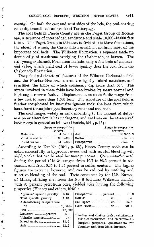
According to Daniels (1941, p. 62), Pierce County coals can be coked successfully in byproduct ovens and with careful blending will yield a coke that can be used for most purposes. Coke manufactured during the period 1915-34 ranged from 12.7 to 26.6 percent in ash content and from 0.25 to 1.65 percent in sulfur content. The higher figures are extreme, however, and can be reduced by washing and selective blending of the coal. Tests conducted by the U.S. Bureau of Mines, utilizing coal from the No. 2 bed near Wilkeson blended with 25 percent petroleum coke, yielded coke having the following properties (Yancey and others, 1943) :
Phosphorus____percent__ 0.69Sulfur _________do__ .5Cell space ______do__ 55.2Coke yield_______do__ 72.1
Apparent specific gravity- 0.87 True specific gravity___ 1.94 Ash-softening temperature
°F ____________ 2, 800+ Btu _____________ 12,620 Moisture _____percent_ 1. 0 Volatile matter__do__ . 8 Fixed carbon___do__ 87.0 Ash _______do__ 11.2
Tumbler and shatter tests: satisfactory for electrochemical and electrometal- lurgical purposes, questionable for foundry and iron blast furnace.

G12 CONTRIBUTIONS TO ECONOMIC GEOLOGY
The estimated remaining resources of coal in the Wilkeson-Car- bonado field, in beds 14 inches or more thick and less than 3,000 feet below the surface, total 222 million tons. Of this total, 78 million tons is in beds 42 inches or more thick and less than 1,000 feet below the surface (Beikman and others, 1961, p. 81-82). The estimated re sources in the Fairfax-Montezuma area, calculated on the same basis, total 21 million tons, of which most is in thinner beds (Beikman and others, 1961, p. 84-85). Much of the tonnage in these two areas is coking coal; however, the coking properties of all coal beds have not been adequately tested.
In the nearby Spiketon, Melmont, and Ashford areas, which are structurally separated from each other and from the Wilkeson-Car bonado and Fairfax-Montezuma areas, the combined estimated re sources in beds 14 inches or more thick and less than 3,000 feet below the surface total 119 million tons. Of this total, 26 million tons is in beds 42 inches or more thick and less than 1,000 feet below the surface (Beikman and others, 1961, p. 82, 83, 85). Part of this total is also coking coal.
ROSLYN FIEHJ>, KITTITAS COUNTY, WASH.
The Koslyn field in Kittitas County, Wash. (fig. 1, loc. 2), which has been described by Saunders (1914) and by Beikman and others (1961), covers an area of about 30 square miles on the east slope of the Cascade Range, approximately 75 miles east of Tacoma. The Roslyn field, though small, has produced more coal than any other area in the State. The coal beds are confined to the upper 1,560 feet of the Roslyn Formation, a 6,500-foot-thick sequence of sandstone and shale of Eocene age. This upper zone includes eight major coal beds ranging in thickness from less than 2 feet to 21 feet. Of these eight coal beds, five have been mined, but the Roslyn (No. 5) and Big Dirty (No. 1) are the most important.
The Roslyn (No. 5) coal bed, which has been mined most exten sively, ranges in thickness from about 4.5 to 7 feet and contains an average of 4.4 feet of clean coal. The bed is relatively uniform in thickness and has been mined throughout the entire area of the field. The Big Dirty (No. 1) coal bed, so named because it is 15-19 feet thick and high in ash, is the uppermost bed in the field and second in economic importance. Only the lower part of the Big Dirty, which contains an average of 4.6 feet of coal, is sufficiently clean to be min- able. Much less is known about the remaining three coal beds that have been mined. The Plant (No. 6) bed is about 2.9 feet thick and about 410 feet below the Roslyn bed; the Green (No. 7) bed is about 1.8 feet thick and about 90 feet below the Plant bed; and the Wright

COKING-COAL DEPOSITS, WESTERN UNITED STATES G13
(No. 8) bed, the lowest in the stratigraphic sequence, is 3.0 feet thick and 150 feet below the Green bed.
The coal-bearing sedimentary rocks in the Roslyn field dip toward the center of a gentle southeastward-plunging syncline at angles of 10°-30°. In general, the structure is simple and presents no obstacle to mining. The structure along the southwest margin of the field is more complex and consists of a series of anticlines that trend parallel to the major syncline. Local variations in the dip and thickness of the beds, known as "faults" by the miners, are actually rolls or warp- ings that have thickened or thinned the coal. For the most part these do not interfere seriously with mining. The Roslyn Formation is un derlain by the Eocene Teanaway Basalt and overlain by the Miocene and Pliocene Yakima Basalt.
Coal suitable for coking occurs only in the northwestern part of the Roslyn field. The increase in coking properties of the coal in the Roslyn bed, from the southeast to the northwest, is related to dif ferences in composition and a change in rank. Differences in compo sition are indicated by a gradual increase to the northwest in the ag glutinating value of the coal and by a decrease in the ash content. The rank and Btu value of coal in the Roslyn bed also increase gradually to the northwest. Changes similar to these observed in the Roslyn bed may occur in other coal beds in the field, but this cannot be sub stantiated because available analyses of the other beds are confined to samples from the northwestern end of the field.
The change in rank of the Roslyn coal bed may have been caused in part by heat from a nearby intrusive body. This possibility is sug gested by the presence of a granodiorite exposure 6 miles northeast of the Roslyn field.
The coal from the Roslyn field is of high-volatile A bituminous rank. An analysis, on the as-received basis, of a composite sample of coal from the Roslyn bed taken from three locations within the Roslyn No. 3 mine at Ronald, Kittitas County, is as follows (U.S. Bur. Mines, 1941, p. 42-43):
PercentMoisture __________ 3.5 Volatile matter_______ 37. 8 Fixed carbon_________ 46. 7 Ash ______________ 12.0 Sulfur ____________ . 3
Percent Air-drying loss__________ 1. 6
Btu_________________ 12, 630Average phosphorus content of four
samples of coal from the Roslyn bed 0.66 percent (Yancey and others, 1943, P. 8).
Tests by the U.S. Bureau of Mines (Yancey and others, 1943), in dicated that coke made from 100 percent Roslyn coal is somewhat
799-641 '66-

G14 CONTRIBUTIONS TO ECONOMIC GEOLOGY
fingery as compared with coke manufactured from coal produced in Pierce County or with coke manufactured from blends of Eoslyn and Pierce County coal and petroleum coke. Furthermore, it tends to be weak in shatter and tumbler tests and to have a high phosphorus con tent. Koslyn coal forms excellent coke for domestic use, however, and is satisfactory for use in coking-coal blends.
The estimated remaining resources of coal in the Koslyn field, based on exploration and mapping as of January 1, 1960, total 241 million tons. Only part of this total lies in the more favorable northwestern part of the field. The Roslyn bed contains 54 million tons, of which 28 million tons is in a part of the bed 42 inches or more thick and less than 1,000 feet below the surface (Beikman and others, 1961, p. 32-33). The Roslyn bed is the only bed in the field known to have coking properties, although other coal beds as yet untested may have similar properties.
MONTANA
Although Montana has large resources of coal, only three areas in the central part of the State contain coal with coking properties. In the Livingston field, Gallatin and Park Counties, and in the Electric field, southern Park County, the sedimentary rocks have been tightly folded and faulted and, as a result, part of the coal has coking prop erties. In the Great Falls field, Cascade and Judith Basin Counties, the rocks are nearly horizontal and no alteration of the coal by earth movements or igneous activity has taken place.
Coal from these three Montana fields was formerly used in the production of coke for local copper smelters. With the introduction of the reverberatory furnace and the basic copper converter in the early 1900's, coke was no longer needed in quantity. Because coke made from Montana coal is not of sufficiently high quality for use in other metallurgical processes without the adoption of special methods, the local coke manufacturing industry closed down about 1912. No coke has been manufactured in Montana since that date. Informa tion on the past production of coke in Montana is contained in "Min eral Resources of the United States" (U.S. Geol. Survey, 1883-1916), in annual reports of the Montana Inspector of Mines (1890-1912), and in a report by Roberts (1966).
LIVINGSTON FIELD, PARK AND GALLATIN COUNTIES, MONT.
The Livingston coal field is a narrow, Y-shaped belt of deformed rocks covering an area of about 35 square miles between Bozeman and Livingston, Mont. (fig. 1, loc. 3). The area has been mapped in de tail by Roberts (1957, 1964a-h). The coal beds in the Livingston field are concentrated in two well-defined and persistent carbonaceous
COKING-COAL DEPOSITS, WESTERN UNITED STATES G15
zones in the Eagle Sandstone of Late Cretaceous age. In each zone the coal beds range in thickness from a few inches to more than 10 feet but average 3-4 feet. The variations in thickness are due in part to differences in the nature of the original carbonaceous deposits and in part to later tectonic movements. The individual beds typically contain several partings of shale, clay, or impure coal.
The coal-bearing rocks have been compressed into three major en- echelon folds, which are partly overturned and overthrust, and are further disturbed by subordinate thrust faults, normal faults, and tension cracks. Erosion of these folds has left the coal-bearing rocks in narrow belts along the flanks of anticlines and in the intervening synclines. The coal beds generally dip 40°-50°, and in several locali ties they are overturned.
The coal in the Livingston field is of high-volatile A, B, and C bituminous ranks. The localities that yielded the best coking coal are along the flanks of anticlines. Coal in synclines and in the plunging ends of anticlines either made poor coke or would not coke. The synclines are more tightly compressed than the anticlines, and the plunging ends of anticlines are much more faulted than the flanks. Thus, coal with the strongest coking properties is found in areas of apparently less tectonic disturbance.
An analysis, on the as-received basis, of coking coal from a selected 37-inch part of the Cokedale bed at the Hodson mine is as follows (Calvert, 1912a, p. 402):
Percent Moisture ________ 5. 8Volatile matter_______ 33.1Fixed carbon- _ 50. 5 Ash ______________ 10. 57
PercentSulfur ________.______ 0.50 Air-drying loss_ .._____ 3. 8
Btu _________ ____. ______ 12, 280
Coal from the Livingston field was used to manufacture coke be tween the early 1880's and 1896 and again in the early 1900's. During the period of maximum coke production in the 1890's, about 115 beehive ovens were in operation at Cokedale. Nearby, at the town of Storrs, there were 100 finished and 100 unfinished ovens, but these were used only for experimental tests (Eowe, 1906, p. 77).
Most of past mining in the field has been concentrated in the Cokedale bed, which has the strongest coking properties. According to Roberts (1966), the remaining resources in the Cokedale bed in parts of the bed 28 inches or more thick and less than 1,000 feet below the surface totaled 21 million tons as of January 1,1965. The distribution of resources in other parts of the Cokedale bed, and in other beds in the field, is presented in the Roberts report by townships, beds, thickness of coal, amount of overburden, and other resource categories.
G16 CONTRIBUTIONS TO ECONOMIC GEOLOGY
BjLiECTKIC FIEU>, PARK COUNTY, MONT.
Coal has been mined for the production of coke in three structurally separated parts of the Electric field (fig. 1, loc. 4), which together compose an area of less than 3 square miles. Mining and coke manu facturing were carried out in this area between 1894 and about 1912, but the mines have been closed and the ovens abandoned since that time. The coal is in the Eagle Sandstone of Late Cretaceous age in a 300-foot sequence of shale and sandstone overlying the Virgelle Sandstone Member, which in this area is the conspicuous basal member of the Eagle. Of the three coal beds noted by Calvert (1912b) only the upper or No. 1 coal, about 300 feet above the Virgelle, has been mined extensively. The No. 1 coal occurs as local lenses within a thicker carbonaceous sequence; hence stratigraphic position, thickness, and purity of the coal are highly variable. At most localities, how ever, the coal is l%-5 feet thick, including clay and sandstone partings, and it averages about 3 feet. The No. 2 and 3 coals, approximately 100 feet and 50 feet, respectively, above the Virgelle, though locally as thick as the No. 1, were not mined when the field was active, ap parently because they were generally too thin, deep, discontinuous, or impure, or did not coke well enough.
Mining in the Electric field is difficult because of the complex struc ture. The coal-bearing rocks occur in a synclinal area within a fault block that has been downdropped several thousand feet. Coal-bearing rocks on the northeast side of the fault block are sheared and over turned and are in contact with Precambrian crystalline rocks. The fault block itself has been cut by many subordinate faults, the larger of which separate the field into the three component parts. The coal- bearing rocks dip steeply in most parts of the field and locally are over turned ; in places, however, they are nearly horizontal. Because of the faults and steep dips only a small part of the coal can be considered minable by present standards.
The deformation of the coal-bearing rocks is responsible for the rela tively high and variable rank of the coal. Most of the coal ranges in rank between high-volatile C and medium-volatile bituminous, but lo cally in fault zones it is semianthracite. An analysis, on the as-received basis, of a sample of coal from the Aldridge mine at Aldridge, Park County, is as follows (U.S. Bur. Mines, 1932, p. 54-55) :
Moisture ___ _ . .Volatile matter- _. .Fixed carbon _ . _Ash ___ ___ __._.
Percent _ _ 4.0_ 22. 5
59.3___ 14. 2
Sulfur ______Air-drying loss__ _ _
Btu __ _ __
Percent . _ __ 0.6._ _ __ 2.7
- _ 12. 760

COKING-COAL DEPOSITS, WESTERN UNITED STATES G17
This sample is from one of the more highly deformed areas and probably contains higher fixed carbon and lower volatile matter than most coal in the field. (See Calvert, 1912b, p. 421.)
Of the three coal beds in the Electric field, the No. 1 has the strong est coking properties. Locally, however, coal from the two lower beds is also suitable for coking. Practically all coal mined in the past was used to manufacture coke. During the early 1900's when coke produc tion was at a peak, 125 beehive ovens were in operation in the area. Most of the coke was shipped to copper smelters at Anaconda and Butte. The coke was of good quality, although the operators were un able to meet the requirements of those smelters for coke with an ash content of less than 18 percent (Calvert, 1912b, p. 419).
Combo and others (1949, p. 18) estimated that the inferred original resources of coal in the field in beds 3 feet or more thick and less than 1,000 feet below the surface totaled about 20 million tons. This esti mate was based on assumed continuity of three beds throughout the total productive area of the field and is, therefore, the maximum poten tially present. The inferred original resources in the No. 1 bed are roughly one-third this amount, or about 7 million tons. When this figure is reduced to allow for past production and losses in mining and for estimated future losses in mining, the estimated recoverable re sources in the No. 1 bed are about 3 million tons.
GREAT FALLS FIELD, CASCADE AND JUDITH BASIN COUNTIES, MONT.
The Great Falls coal field, in Cascade and Judith Basin Counties, Mont. (fig. 1, loc. 5), includes three adjacent basins of minable coal, which have given rise to the three mining districts, from west to east, the Sand Coulee, Otter Creek, and Sage Creek districts. The three districts compose an area of at least 334 square miles (Fisher, 1909). The coal is about 60 feet above the base of the Kootenai Formation, which consists of interbedded massive sandstone and shale of Early Cretaceous age. Local variations in the thickness of the coal are char acteristic, but at least one bed, ranging from 2% to 14 feet in thick ness, including partings, is present throughout the field. Near Belt in the Sand Coulee district, where the coal has been mined extensively, the bed ranges typically from 4 to 9 feet in thickness and is separated into two or three benches by partings of shale and impure coal, which must be removed. The individual shale partings range in thickness from a fraction of an inch to 1 foot, and usually they are easily separated from the coal above and below.
Throughout the Great Falls field the coal-bearing rocks dip gently 3°-5° NE., but they may steepen locally. In some places, steeper dips present difficulties in mine haulage. Faults having displacements of

G18 CONTRIBUTIONS TO ECONOMIC GEOLOGY
5-20 feet and igneous rocks, principally basalt dikes, break the con tinuity of the coal-bearing rocks locally, but neither of these disrup tions causes unusual mining problems. There is no report of coal having been altered or changed in rank by contact with the igneous rocks.
The coal in the Great Falls field is of high-volatile B and C bitu minous rank. An analysis, on the as-received basis, of a sample of coal from the Deep Creek mine in Cascade County, 22 miles southwest of the town of Great Falls, is as follows (U.S. Bur. Mines, 1932, p. 42-43):
Volatile matter__ _Fixed carbon. _ _Ash _ __ _ _
Percent __ _ 5.9___ 32. 8__ 49. 3
_ 12.0
Sulfur _ _
Btu ____ __ __
Percent ... __ - 4.0. __ __ _ 2.4
._ _ __ _ _ 11.470
The sulfur content is due primarily to the presence of pyrite nodules, which range in diameter from that of a pinhead to a maximum of about 4 inches, the average being 1 inch. The nodules and much of the ash can be removed by washing.
Only certain benches of the coal have coking properties. The coke ovens formerly operated at Belt, Mont., by the Anaconda Mining Co. were abandoned, in part because of the difficulty and expense of sepa rating coking from noncoking coal and in part because of the decline in importance of the blast furnace in nonferrous smelting.
In the Great Falls field the estimated original resources of coal classed as measured and indicated, according to the definitions on page G9, total 309 million tons. This coal is in several beds, each at least 24 inches thick, beneath no more than 500 feet of overburden. Some of this coal has been mined, and the amount remaining that is of coking quality can be ascertained only by actual tests. The re maining resources are, however, believed to be sufficient to supply a moderate industrial demand for coke of lower quality. Additional information about the resources of coal in the Great Falls field and other fields in Montana is contained in reports by Combo and others (1949, 1950).
WYOMING
The coal beds in Wyoming are of Cretaceous and Tertiary age and are preserved chiefly in broad synclinal basins lying between the moun tain ranges. Around the edges of these basins the coal-bearing rocks may dip steeply as a result of later uplift of the surrounding moun tains, but in the central parts of the basins the rocks are virtually flat-lying. Many of the coal beds have been subjected to little or no deformation. Consequently, Wyoming, which has large resources of
COKING-COAL DEPOSITS, WESTERN UNITED STATES G19
coal, contains mostly subbituminous coal and low-rank bituminous coal. Coal having coking properties occurs only in three small areas.
The Willow Creek (No. 5) coal bed of Late Cretaceous age in the Kemmerer-Willow Creek field, Lincoln County, has coking proper ties probably as a result of the rather close folding of the rocks. In the Rock Springs field, Sweetwater County, where the coal-bearing formations have been affected by the Rock Springs uplift, the lower- most coal bed, of Late Cretaceous age, has coking properties but yields a product that is poor in quality. The Cambria field, on the western flank of the Black Hills, contains a coal bed of Early Cretaceous age that was mined formerly as a coking coal.
The carbonizing properties of coal from the Kemmerer-Willow Creek and Rock Springs fields have been discussed by Landers and others (1961).
KEMMEREK-WILLOW CHEEK FIEU>, LINCOLN COUNTY, WYO.
.The coal field near Kemmerer, in southwestern Wyoming (fig. 1, loc. 6), which has been described by Schultz (1914), comprises several areas of coal-bearing rocks in a long, narrow synclinal belt that extends northwestward into Idaho. A part of this belt, 12 miles long and about 12 miles north ;of Kemmerer, has been studied by Andrews (1944) and by Toenges and others (1945).
Coal having coking properties in the Kemmerer-Willow Creek area occurs in the Willow Creek and Kemmerer coal zones in the Frontier Formation of Late Cretaceous age. Higher in the section, coal gen erally unsuitable for making coke occurs in the Adaville Formation, also of Late Cretaceous age. Both the Willow Creek and the Kem merer zones contain several closely spaced coal beds. The most im portant of these is near the center of the Willow Creek zone and is known as the Middle Main bed or the Willow Creek (No. 5) bed. Henceforth, it will be termed the "Middle Main [Willow Creek (No. 5)] bed." The thickness and character of this bed have been proved by drilling and sampling for a distance of 41/£ miles along the outcrop on the east side of the synclinal belt, and with the exception of two small areas of thin coal, the bed ranges in thickness from 4 feet 3 inches to 4 feet 10 inches. Two clay partings, each 1-2 inches thick, generally occur 7-14 inches below the top of the bed. These partings can be removed by washing but only with the loss of some coal. The bed is overlain in the proved area by a 2-foot clay zone, which in turn is overlain by a thin coal, generally 15-25 inches thick.
On the eastern limb of the syncline, the rocks dip 28°-33° W. The regularity of dip, together with an absence of faults, makes this loca tion favorable for mining. The rocks on the western limb, on the other hand, dip at least 45° and locally may be vertical or overturned.

G20 CONTRIBUTIONS TO ECONOMIC GEOLOGY
Mining would be difficult on the western limb of the syncline, but the Middle Main [Willow Creek (No. 5)] bed in this area ranges from 3 feet 2 inches to 6 feet 5 inches in thickness and has no partings.
The coal in the Middle Main [Willow Creek (No. 5) ] bed is of high- volatile A bituminous rank. An analysis, on the as-received basis, of a sample of coal from a drill hole at the NE. cor. sec. 12, T. 23 N., E. 116 W., sixth principal meridian, is as follows (Toenges and others, 1945, p. 44-45):
PercentMoisture ___________ 2. 8 Volatile matter_______ 36.9 Fixed carbon_______ 51.4
Ash __Sulfur
Percent8.9.6
Btu _________________ 12, 780
Coke manufactured from coal from this bed alone is unsuitable for use in the blast furnace. With the addition of 50-60 percent of coal from the Sunnyside region, Utah, however, it will provide a coke nearly comparable to that made from 100 percent Sunnyside coal. The percentage of Sunnyside coal needed in the blend can probably be reduced by washing the coal from the Middle Main [Willow Creek (No. 5) ] bed to remove impurities. The physical and chemical prop erties of cokes derived during tests of various blends of the Middle Main [Willow Creek (No. 5) ] coal and other coals are described in the report by Toenges and others (1945, p. 14-25).
In the area proved by drilling, which includes 1,710 acres, or nearly 3 square miles, the estimated original resources of coking coal in the Middle Main [Willow Creek (No. 5)] bed are 15 million tons. As suming minimum mining losses, the recoverable coal totals 11 million tons (Toenges and others, 1945, p. 10-11). Making generous addi tional allowances for losses incurred in eliminating the impurities con tained in the two clay partings, the recoverable clean marketable coal in the area proved by drilling totals at least 8 million tons (Andrews, 1944).
South of the area of drilling, the coal in the Middle Main [Willow Creek (No. 5)] bed presumably has the same coking properties as the coal just described. In the five townships where the Middle Main [Willow Creek (No. 5)] bed is 28-42 inches thick, the original meas ured resources of coal under less than 2,000 feet of overburden total 38 million tons, and the original indicated resources total 59 million tons. Additional measured resources of 9 million tons of coal and indicated resources of 39 million tons of coal lie at depths between 2,000 and 3,000 feet.
Additional information about the coal resources of the Kemmerer- Willow Creek field and other fields in Wyoming is contained in reports by H. L. Berryhill, Jr., and others (1950,1951).

COKING-COAL DEPOSITS, WESTERN UNITED STATES G21
ROCK SPRINGS FIELD> SWEETWATER COUNTY, WYO.
The coal in the Rock Springs field (fig. 1, loc. 7) occurs in the Rock Springs and Almond Formations of the Mesaverde Group (Upper Cretaceous), in the Lance Formation (Upper Cretaceous), the Fort Union (Paleocene) Formation, and in the Wasatch Formation (Eocene). As described by Schultz (1909, 1910), the thickest and best coal in the field is in the Rock Springs Formation, which is 600- 1,400 feet thick. This formation contains at least 12 coal beds individ ually 2-10 feet thick and many other beds less than 2 feet thick. Part ings of shale, impure coal, and sandstone, ranging in thickness from a fraction of an inch to as much as 1 foot, occur in most of the beds.
The coal crops out on the flanks of the Rock Springs uplift, a low dome about 90 miles long and 40 miles wide. The beds on the west flank of the uplift dip 15°-30° W.; those on the east flank dip 5°-10° E. Normal faults break the continuity of the beds on the flanks of the uplift, and in areas where these faults are concentrated they may in crease the difficulty and expense of mining. Intrusions and extru sions of igneous rock crop out in the northern half of the uplift, but no alteration of the coal by igneous activity has been observed.
The coal in the Rock Springs Formation is of high-volatile C bitu minous rank. An analysis, on the as-received basis, of a sample of coal from the Rock Springs No. 7 bed from the Superior A mine, three- quarters of a mile southeast of Superior, Sweet\vater County, is as follows (U.S. Bur. Mines, 1931a, p. 74-75):
Volatile matter.. _ .Fixed carbon _.Ash__ ____ _._ .
Percent. _____ 12. 7. __ 32.8._ _ 50. 0. __ 4.5
SulfurAir-drviDfir loss°
Btu _ ___ _.
Percent. _ __ 0.8. ______ 5.6
. _ ___ 11.720
Coal from some of the beds in the Rock Springs Formation, partic ularly the No. 7 bed, will yield a poor grade of coke that is unsuitable for metallurgical purposes but that has potential use by industries with less stringent specifications. In 1963, the Gunn-Quealy Coal Co. began construction near Rock Springs of a plant designed to manufacture coke from local coal. The coke is intended for use by industries in Idaho producing elemental phosphorus by the electric furnace method (U.'S. Bur. Mines, 1964b, p. 1212).
According to H. L. Berryhill, Jr., and others (1950, p. 29), the esti mated original resources of the No. 7 bed, where it is 28 inches or more thick and loss than 2,000 feet below the surface, total 899 million tons, of which 335 million tons is classified as measured, 393 million tons as indicated, and 172 million tons as inferred. At depths between 2,000 and 3,000 feet below the surface the No. 7 bed contains additional indi cated resources of 38 million tons and inferred resources of 206 million
799-641 66 4
G22 CONTRIBUTIONS TO ECONOMIC GEOLOGY
tons. Approximately 108 million tons of coal from the No. 7 bed was mined or lost in mining to January 1, 1950. All mining has been in parts of the bed included in the measured original coal resources.
CAMBRIA FIELD, WESTON COUNTY, WYO.
The coal in the Cambria field (fig. 1, loc. 8) is in a single bed that occurs sporadically in the lower part of the Lakota Sandstone of Early Cretaceous age (Darton, 1904, 1905; Stone, 1912). Abrupt changes in composition and thickness of the bed are common, but generally the bed ranges between 3 and 10 feet in thickness. Near the town of Cambria, where most of the past mining has been carried on, the coal is typically 7 feet thick and of good quality. The structure of the Cambria field is monoclinal and the coal-bearing rocks dip gently to the southwest. Coal mining began at Cambria in 1889 and ceased in 1928. The total production during this period was a little more than 12 million tons (Connolly and O'Harra, 1929, p. 382).
The coal in the Cambria field is of high-volatile C bituminous rank. An analysis, on the as-received basis, of a composite sample of coal taken from three locations within the Antelope No. 4 mine at Cambria is as follows (U.S. Bur. Mines, 1931a, p. 76-77) :
Moisture _ . _ ____Volatile matter ____Fixed carbon _ __Ash _ _
Percent _ _ 10.8
39. 1___ 35. 1
_ _ 15. 0
Sulfur __ _ __ _
Btu_ _ _ ________
Percent 4.9
_ _ 8. 1
10, 340
Certain parts of this bed, presumably of greater purity than the remainder, have good coking qualities, and in the past these parts were employed for manufacturing coke to supply smelters and refineries in the Black Hills.
The coal used for making coke was chiefly the slack produced in mining operations, and no effort was made to clean or wash it before coking (Connolly and O'Harra, 1929, p. 384). Coke was produced principally during the years 1891-1900; during this 10-year period, 107,000 short tons of coke was made from 225,000 short tons of coal.
According to H. L. Berryhill, Jr., and others (1950, p. 34, 36, 38), the Cambria field contained estimated original resources of 22 million tons of coal at least 28 niches thick and covered by no more than 1,000 feet of overburden. The coal that was measured or indicated by geologic evidence constituted 19 million tons of the total resources, and an additional 3 million tons was inferred to be present from general geologic knowledge of the area. Accumulated past production totals 12 million tons, and these resources have consequently been almost entirely mined or lost in mining. Certainly the readily accessible

COKING-COAL DEPOSITS, WESTERN UNITED STATES G23
resources of coking coal, which represented only a small percentage of the total, are now depleted.
UTAH
The Sunny side-Castlegate field, Carbon County, is the only area in Utah containing coal with the qualities necessary for the production of satisfactory metallurgical coke. Two other areas, the Mount Pleasant field, Sanpete County, and the Kolob field, Iron County, con tain coal that will form weaker and less desirable cokes.
SUNNYSIDE-OASTLEGATE FIELD, CARBON COUNTY, UTAH
The Sunnyside-Castlegate field (fig. 1, loc. 9), which is a strip about 40 miles long at the western end of the large Book Cliffs field of Colorado and Utah, is the most important source of coking coal in the West. In 1963, coal production in Carbon County, Utah, which embraces the 'Sunnyside-Castlegate field, totaled nearly 3% million tons, or about 80 percent of the total production in Utah (U.S. Bur. Mines, 1964a, p. 140). Of this 3% million tons, about 2 million tons was used for the production of coke. Half of this, or about 1 million tons, was shipped to southern California for use in the Fontana plant of the Kaiser Steel Corp., and half was used in Utah (U.S. Bur. Mines, 1964b, table 1, p. 1-19). The coal has been mined extensively for cok ing at Sunnyside, Columbia, and Horse Canyon.
As described by Clark (1928), the coal in the Sunnyside-Castlegate field is in a zone about 500 feet thick near the base of the Mesaverde Group of Late Cretaceous age. This sequence consists of massive beds of sandstone, which crop out conspicuously in the Book Cliffs, and alternating beds of shale and coal. As many as nine coal beds occur locally in the coal-bearing zone, and a minimum of two occur at any one locality. The coal beds are generally lenticular.
The Lower Sunnyside bed, which is mined extensively near Sunny- side for use in the manufacture of coke, crops out for a distance of about 25 miles. It ranges in thickness from 5 to 11 feet in the area of active mining but thins both to the northwest and to the south. Although partings are uncommon in this field, the bed is separated locally into two benches by a parting of sandy shale 1-2 feet thick.
The Sunnyside-Castlegate coal field is on the north and northeast flanks of the San Rafael Swell. At the town of Sunnyside, where mining has been most extensive, the coal beds dip about 12° NE., under the Book Cliffs. Northwest and southeast of Sunnyside, however, the dip of the rocks decreases to 2°-4°. Except for a few minor faults concentrated mostly at the south end of the field, there are no struc tural complications. Mining in the field is, however, handicapped by infrequent coal-mine bumps in which pillars of coal collapse with

G24 CONTRIBUTIONS TO ECONOMIC GEOLOGY
explosive violence as a result of accumulated stress in the roof rock. Recent studies by Osterwald (1961, 1962) have done much to show the cause of, and methods of preventing, bumps.
The coal in the Sunnyside-Castlegate field is of high-volatile A and B bituminous ranks. An analysis on the as-received basis of a sample of coal from the Lower Sunnysicle bed at Sunnyside is as follows (Reynolds and others, 1946, p. 12-13) :
PercentMoisture _ _. _ 4. 5 Volatile matter..______ 38. 5 Fixed carbon_.__ 51. 2 Ash_______________ 5. 8
Sulfur___. Air-drying loss.
Percent 1.3 2.2
Btu (moist, mineral-matterfree) _______________ 14, 020
The Lower Sunnyside coal is a conspicuous example of a high- volatile bituminous coal used successfully in byproduct ovens for the production of satisfactory metallurgical coke. A typical analysis of coke produced from Lower Sunnyside coal from the Columbia mine shows the following physical and chemical properties (Reynolds, 1946, p. 44-48):
Apparent specific gravity___ 0.78True specific gravity______ 1. 89Btu________________ 12, 790Volatile matter_,__percent_ 1.7Fixed carbon___________do 87.4
Ajsh___________percent 10. 9 Sulfur___________do__ . 9 Cell space_ ______do 58.7 Tumbler and shatter tests: satisfactory
for all purposes.
Coke produced from Sunnyside coal yields only about two-thirds of its weight in furnace-size pieces, which contain many lateral and transverse fractures, but otherwise the coke is hard and holds up well in the blast furnace.
At the town of Sunnyside, more than 800 beehive ovens have been constructed over the years. Many of these were in use on an emer gency basis during World War II. Nearby at Columbia there are additional beehive ovens. Today most of the coal is processed in modern byproduct coke plants. Coke made from Sunnyside coal is used in the Columbia Steel plant at Iroriton, Utah, the Geneva Steel plant near Provo, Utah, the Fontana plant of the Kaiser Steel Corp. in southern California, and in local sugar refineries.
The coking qualities of the coal decrease northwestward from the Sunnyside area to Castlegate where the coal is no longer used for coking purposes, though prior to 1903 it was the main source of supply for the State. Similarly, the coal in the Huntington Canyon area south of Castlegate has coking properties, but coke made from this coal is inferior to that produced at Sunnyside.
The total resources of coking coal in the Lower Sunnyside bed are large enough to supply anticipated demands. Detailed calculations

COKING-COAL DEPOSITS, WESTERN UNITED STATES G25
of the resources in the Sunnyside-Castlegate field as measured along the outcrops and indicated by the continuity of the beds have been tabulated by township and by individual bed by Clark (1928, p. 101- 102,161). These figures show that the Lower Sunnyside bed contains estimated original resources ranging from 5 to 9 million tons per square mile in a belt about 10 miles long and averaging about 2 miles in width northwest of the town of Sunnyside. This coal lies under less than 2,000 feet of overburden. Because commercial mining in the Lower Sunnyside bed is restricted for the most part to an area southeast of this belt, the entire tonnage, less normal expectable losses in mining, is available for future needs. Additional resources are in the Lower Sunnyside bed in the area of active mining, which extends from about 1 mile northwest of Sunnyside southeastward to several miles south of Horse Canyon.
MOUNT PLEASANT FIELD, SANPETE COUNTY, UTAH
The Mount Pleasant coal field (fig. 1, loc. 10), on the west side of the Wasatch Plateau, is favorably located with respect to the western steel industry and has been carefully investigated as a source of coking coal. The area was mapped by the U.S. Geological Survey in 1942 (Duncan, 1944), and an exploratory hole was drilled by the U.S. Bureau of Mines to obtain samples for analysis (Toenges and Turn- bull, 1943).
The six coal beds penetrated in the drilling are in the lower 200 feet of the Blackhawk Formation of Late Cretaceous age and range in thickness from 18 inches to 5 feet 8 inches. On the western margin of the Wasatch Plateau, the rocks are broken by many faults, and west of the fault zone the coal beds have been downdropped. In this area the coal beds lie more than 2,000 feet below the present surface, beyond the present practical depth of mining. On the east side of the fault zone, however, the coal beds were found in the test hole at depths of only 955 to 1,151 feet below the surface.
An analysis, on the as-received basis, of a core sample of coal from one of the thicker beds in the Mount Pleasant field is as follows (Toenges and Turnbull, 1943, p. 14, sample D):
PercentSulfur ________________ 0.6 Air-drying loss ________ 1. 4
PercentMoisture___________ 3.2 Volatile matter._______ 42. 9 Fixed carbon__.______ 45. 3 Ash______________ 8. 6 Btu _________________ 12,890
Coking tests made on samples from the five thicker beds, all of which are of high-volatile A and B bituminous ranks, as is the coal from the Lower Sunnyside bed, showed that the resulting coke was softer, considerably weaker, and more fingery than coke manufactured

G26 CONTRIBUTIONS TO ECONOMIC GEOLOGY
from Sunnyside coal. It was concluded, therefore, that coal from the Mount Pleasant area is not suitable for the production of blast-furnace coke to be used in smelting iron ore.
KOLOB FIRLI>, IRON, WASHINGTON, ANI> KANB COUNTIES^ UTAH
The western part of the Kolob field (fig. 1, loc. 11) has been de scribed by Averitt (1962) and the eastern part by Cashion (1961). The coal beds in this field crop out in cliffs bordering the Kolob Ter race or in canyons eroded in the margins of the terrace. The coal beds occur in the Tropic Shale and in the overlying Straight Cliffs Sandstone, both of Late Cretaceous age. In the western part of the field near Cedar City, Utah, the single important coal bed occurs in a 10- to 14-foot carbonaceous sequence, termed the "Upper Culver coal zone," at the top of the Tropic Shale. This bed, including impure layers at the top and several partings, is 6-8 feet thick. It is mined extensively, primarily to supply fuel for the production of electric power.
The coal in the western part of the field has heat values ranging in general from 10,350 to 11,430 Btu on the as-received basis, ash con tents ranging from 4.7 to 12.2 percent, sulfur contents from 5.6 to 6.7 percent, and moisture contents from 6.1 to 13.5 percent. An analysis, on the as-received basis, of a composite sample of coal from the Webster-Nelson mine in Right Hand Canyon, a few miles east of Cedar City, is as follows (Averitt, 1962, p. 55) :
PercentMoisture____.______ 6.0 Volatile matter_______ 41.1 Fixed carbon_._____ 40.9 Ash _____________ 12.0
This coal is near the borderline between subbituminous A and high- volatile bituminous C ranks and is lower in rank than most coals used in the manufacture of coke. The coke produced from this coal is high in sulfur and tends to be too friable for metallurgical use. In the early iron-making experiments of Utah pioneers, this coke proved to be unsatisfactory and was replaced by charcoal.
Most of the accessible coal in the western part of the Kolob field is in the Cedar Mountain quadrangle. In this quadrangle, measured and indicated resources remaining as of January 1, 1956, in the im portant coal in the Upper Culver coal zone totaled about 200 million tons, of which about half is recoverable. These resources are in a bed 6 feet thick and generally less than 1,000 feet below the surface (Ave ritt, 1962, p. 61-62). Additional resources are present north and east of the Cedar Mountain quadrangle, and much larger resources of
Sulfur ______________Air-drying loss _____
Btu ____ _ _ _ -
Percent ____ 6.5
_ __ 2. 6
_ __ 11.260

COKING-COAL DEPOSITS, WESTERN UNITED STATES G27
comparable coal are present in the eastern part of the Kolob field, which has been described by Cashion (1961).
COLORADO
Four areas in Colorado yield coal used at present or in the past for the manufacture of metallurgical coke. Two of these areas, the Somerset-Crested Butte-Carbondale region and the Eaton Mesa region of Colorado and New Mexico, are important centers of western coking coal production. The Durango and San Juan Eiver fields in south western Colorado contain coal used in the past for the manufacture of coke to supply local nonferrous smelters. Information about coal in these and other fields in Colorado has been summarized by Landis (1959).
SOMERSET-CRESTED BUTTE-CARBONDALE REGION, DELTA, GUNNI- SON, AND PITKIN COUNTIES, COLO.
The Somerset-Crested Butte-Carbondale region (fig. 1, loc. 12) is a major source of coking coal in the west, comparable in area and resources to the Eaton Mesa region in Colorado and New Mexico and to the Sunnyside field, Utah. The general geology of the region has been described by Emmons and others (1894) and by Lee (1912), and the detailed geology of specific parts of the region is described in more recent reports cited below.
The Somerset-Crested Butte-Carbondale "region is on the south eastern rim of the Uinta Basin, a large structural basin that extends into Utah. Igneous intrusions and deformation associated with the uplift of the Eocky Mountains have, however, so disturbed the rocks in the region that the relations of the structure to the Uinta Basin are not clearly defined.
The coal beds are in the Bowie Shale Member and the overlying Paonia Shale Member of the Mesaverde Formation of Late Cretaceous age. Several coal beds of minable thickness occur in each of the two members, and a total of eight beds have been observed at one locality. Correlation of the coal beds and accurate measurements of their thick ness are difficult because of deformation, but, in general, the thicker beds are 4-12 feet thick.
As a result of the deformation and the intrusions, the coal ranges in rank from bituminous to anthracite. In general, the coal in the Bowie Shale Member is slightly higher in rank than the coal in the Paonia Shale Member, but this difference is nonexistent where the coals have been altered. The variation in rank in the region is so great that no single analysis or group of analyses is adequate to show the character of the coal, but for the most part, the ash content is moderate and the sulfur content low.

G28 CONTRIBUTIONS TO ECONOMIC GEOLOGY \
Coal having coking properties occurs at many places in the region, ^ but because of the range in rank and quality of the coal, the coke pro duced shows a comparable range in quality.
Because of its diversity, the region is best discussed in three parts: the Coal Creek district of the Somerset field, the Crested Butte field proper, and the Carbondale field.
! SOMERSET FIELD, COAL CREEK DISTRICT 4
The Coal Creek district is in T. 13 S., R. 89 W., Gunnison County, in the easternmost part of the Somerset or Paonia field. In the Coal \ Creek district the Mesaverde Formation is divided from bottom to top into the Eollins Sandstone Member, the lower coal member (in general equivalent to the Bowie Shale Member), the upper coal member (in general equivalent to the Paonia Shale Member), and the barren member. Exploration in the Coal Creek district by V. H. Johnson (1948) and by Toenges and others (1952) has shown that the lower coal member contains two principal beds. The lower bed, known as the Snowshoe, is 9-15 feet thick in the central part of the district, but it thins and splits into two benches to the north and west, each bench ranging in thickness from 1 to 7 feet. The upper or Bear bed, although locally minable, is less than 3 feet thick throughout most of the Coal Creek district. The coal in the upper coal member of the Mesaverde is of no economic importance.
To test the coking properties of coal from the Coal Creek district, a selected area of about 6 square miles near the center of T. 13 S., E. i, 89 W., was core drilled by the U.S. Bureau of Mines (Toenges and ' others, 1952). Analyses and carbonization tests showed that coal ^ from the lower bench of the Snowshoe bed, termed the "lower bed," and from the Bear bed, termed the "upper bed," yields a stronger coke than does coal from the Sunnyside bed in Utah. The coal from 4 the upper bench of the Snowshoe bed, termed the "middle bed," yields a coke slightly inferior to coke made from Sunnyside coal. All three cokes are satisfactory in chemical composition, having sulfur x contents of 0.4MX9 percent and ash contents of 6.3-10.9 percent.
In the area proved by drilling, the measured original reserves of coal total 121 million tons, of which 108 million tons will yield coke of ;. metallurgical quality (Toenges and others, 1952, p. 13). Assuming » a 50 percent recovery in mining, recoverable reserves of metallurgical j coking coal are about 54 million tons. All this coal lies under moderate *r to heavy overburden. At the confluence of Anthracite and Coal Creeks, for example, the upper bed was penetrated in a drill hole at a depth of 658 feet and the lower bed at 695 feet. East and northeast of this point the thickness of the overburden increases rapidly, and most of the coking coal lies 1,000-2,000 feet beneath the surface.

COKING-COAL DEPOSITS, WESTERN UNITED STATES G29
Extrapolation of the data reported by Toenges and others (1952, p. 13) suggests that coal in the east half of T. 13 S., E. 89 W., is more strongly coking than coal in the west half and should be suitable for the manufacture of metallurgical coke. About 7 miles to the south west in the Minnesota Creek area the coal is also less strongly coking than coal in the east half of T. 13 S., E. 89 W. (Toenges and others, 1949, p.20-29).
These few facts suggest that coal suitable for the manufacture of metallurgical coke lies, in general, in the east half of T. 13 S., E. 89 W. Such coal probably also occurs in townships to the east, north east, and southeast toward a cluster of small masses of igneous rock associated with the Crested Butte intrusives. In these townships the coal is largely below drainage, and the amounts available, although presumably large, can be ascertained only by exploratory drilling.
CRESTED BUTTE FIELD
The Crested Butte field is in central Gunnison County in an area of much greater structural complexity than that of the Coal Creek district described above. In the Crested Butte field the coal-bearing rocks have been folded, faulted, and intruded by igneous rocks, and as a result the coal ranges locally in rank from subbituminous A to an thracite. The field has been mapped by Emmons and others (1894) and by Lee (1912), and the metamorphism of the coal has been studied by Dapples (1939).
The coal in this field is in the lower part of the Paonia Shale Member of the Mesaverde Formation. As many as five beds crop out near the former mining towns of Crested Butte and Anthracite, but only one bed is present at Floresta, about 10 miles west of Crested Butte.
Landis (1959, p. 147) estimated original coal resources totaling 244 million tons in an area of 35 square miles near the outcrops of coal- bearing rocks in this field. Of this tonnage, about 15 percent is an thracite and semianthracite, and the remainder is bituminous coal that has coking properties. Additional resources should be present in unexplored areas downdip from the outcrops.
CARBONDALE FIELD
The Carbondale field extends northward from the Crested Butte field through northern Gunnison, Pitkin, and Garfield Counties. In this field, the coal is in four zones in the Mesaverde Formation, of which two or more are present at most localities. Most of the coal in the Carbondale field dips 10°-45° W. under the Piceance Creek lobe of the Uinta Basin, except near intrusives of Elk Mountain where the beds are locally overturned.

G30 CONTRIBUTIONS TO ECONOMIC GEOLOGY
The coal ranges in rank from anthracite near Crested Butte to high-volatile B bituminous in Garfield County. Coal with the strong est coking properties is centered in Pitkin County. In this part of the field there are 10 coal beds that individually exceed 42 inches in thickness. As estimated by Donnell (1962), these beds contain about 150 million tons of coal that has less than 1,000 feet of overburden and an additional 150 million tons that has 1,000-2,000 feet of over burden. Larger amounts of coal are in thinner beds and at greater depths.
In the early part of the 20th century, the Carbondale field was an importance source of coking coal, and mining was carried on actively around the towns of Placita, Gulch, and Coal Basin. The cumulative production from these areas prior to 1919 totaled several million tons. After World War I, production declined markedly because of the postwar decline in industrial activity, the decrease in use of coke for nonferrous smelting, and the competition from coal in the Eaton Mesa region and the Sunnyside-Castlegate field. Between 1919 and 1953, production from the field was less than 50,000 tons annually. In 1953, however, mines were opened in the Thompson Creek area to supply coking coal to the Geneva, Utah, plant of the United States Steel Corp., and in 1956 the Dutch Creek mine was opened in the Coal Basin area. In 1964 the output of these mines was more than 600,000 tons. The coal is moved by truck to the railhead at Carbondale, then by train to Provo, Utah.
SAN JUAN RIVER FIELD, MONTROSE, SAN MIGUEL, DOLORES, AND MONTEZUMA COUNTIES, COLO.
In the San Juan River field (fig. 1, loc. 13) several thin discontin uous beds of coal occur in the Cretaceous Dakota Sandstone, which is virtually flat lying. These coal beds locally are as much as 5 feet thick, and at many places they are more than 3 feet thick. They have been mined only on a very small scale for local use. In the past, low-grade coke was made from coal mined near Norwood, in Montrose and San Miguel Counties, and near Rico, in Dolores County. The coal mined at Rico was 20 inches thick, and the coke produced was used at a nearby smelter (Hills, 1893, p. 359) until a railroad connection at Durango gave access to the superior coal in the Durango field. In general, the San Juan River field is no longer considered as a source of coal for the production of industrial coke.
DURANGO FIELD, LA PLATA COUNTY, COLO.
The Durango field (fig. 1, loc. 14), which lies on the northern side of the San Juan coal basin of Colorado and New Mexico, has been described by Taff (1907) and Zapp (1949). Coal in this field occurs in the Fruitland Formation and in the older Menef ee Formation, both
COKING-COAL DEPOSITS, WESTERN UNITED STATES G31
of the Mesaverde Group of Late Cretaceous age. The Fruitland con tains subbituminous coal that is not suitable for coking. The Mene- f ee, which consists of interbedded sandstone and shale, contains near the middle three and in some places four minable beds of coal that have coking properties. At least two of these beds have been mined extensively near Durango.
The minable coal beds in the Menef ee Formation range in thickness from 2 to 7 feet, but partings of shale and impure coal, each several inches thick, generally divide the beds into benches containing 1-6 feet of coal.
All the coal-bearing rocks dip to the south or southeast at angles ranging from 6° near Hesperus, 8 miles west of Durango, to 40° in the area 6 miles northeast of Durango. A few faults of small dis placement are present in the field, but they do not interfere with mining operations.
Most of the coal in the Menefee Formation is of high-volatile A bituminous rank. An analysis, on the as-received basis, of a sample of coal from the Hesperus mine is as follows (U.S. Bur. Mines, 1937, p. 88-89):
Moisture _____ _Volatile matter- _____Fixed carbon _ _____Ash _______ _____
Percent __ _ 5.6__ 36. 2__ 52. 5
5.7
Sulfur ______ __Air-drying loss _ _____
Btu __ __ ___ _
Percent . _______ 0.5________ 2.3
_ ____ 13.120
Beehive ovens formerly in operation at Durango and Porter pro- ;< duced coke used for smelting purposes. Tests by the Bureau of Mines
of the agglutinating, swelling, and plastic properties of 19 samples of coal from this area indicated that most of the samples had good coking qualities and that many were suitable for use in byproduct ovens (Fieldner and others, 1945, p. 58). Although there are local varia tions in the coking quality of the coal in the Durango area, some of the coal in the Menefee Formation probably could be treated by
> modern cleaning and processing methods and used to manufacture metallurgical coke.
The measured original resources of thicker accessible coal in the Durango field, as estimated by Zapp (1949), total 67 million tons. This coal is in beds more than 42 inches thick at depths of less than 1,000 feet below the surface. The remaining measured resources
"> as of January 1, 1949, total 64 million tons, of which 32 million tons can be classified as recoverable resources, assuming 50 percent re covery of the coal. Only a small amount of coal has been mined
-* since the 1949 estimate. Larger indicated and inferred resources { of coal are in the field at depths from 1,000 to 3,000 feet below the
surface.

G32 CONTRIBUTIONS TO ECONOMIC GEOLOGY
RATON MKSA REGION, HUERFANO AND LAS ANIMAS COUNTIES, COLO., AND COLFAX COUNTY, N. MEX.
The Eaton Mesa region (fig. 1, loc. 15) covers an area of about 2,000 square miles in south-central Colorado and northeastern New Mexico. Coal from this region, when blended with small amounts of low-volatile coal, yields the highest quality coke in the West. This coke is used by steel mills of the Colorado Fuel and Iron Corp. at Pueblo, Colo., and by the steel mills of the Kaiser Steel Corp. at Fontana, Calif. The region is the second largest producer of coking coal in the West, being exceeded only by the Sunny side-Castle- gate field in Utah.
The geology and coal resources of most of the Colorado part of the region, termed the "Trinidad field," have been described by Har bour and Dixon (1959), R. B. Johnson (1958, 1959), Johnson and Stephens (1954a, b), Wood, Johnson, and Dixon (1956, 1957"), and Wood, Johnson, Eargle, and others (1951). E. B. Johnson (1961) has summarized the geology and coal resources of the Colorado part, on the basis of these and older reports. The New Mexico part of the region, termed the "Eaton field," has been described by Lee (1922) and Wanek (1963). The carbonizing properties of coal in the Eaton Mesa region have been discussed by Eeynolds and others (1946, p. 75-76).
The coal in the Eaton Mesa region is in the Vermejo Formation of Late Cretaceous age and in the Eaton Formation of Late Cretaceous and Paleocene age. The coal beds are generally lenticular and dis continuous, and only a few are persistent over wide areas. The coal in the northern part of the coal region is nonagglomerating and of high- volatile C bituminous rank and in the southern part is agglomerating and of high-volatile A and B bituminous ranks. On an as-received basis, the heating value of the coal ranges from about 11,000 to about 14,000 Btu. Workable coal beds occur at all localities where the Vermejo and Eaton Formations are exposed, and as many as 10 beds of minable thickness have been found at one locality.
Coal beds are thicker, more numerous, and more extensive in the Vermejo Formation than in the Eaton Formation. Thick coal beds in the Eaton Formation are generally local in extent and are mainly in the lower part of the formation. The Vermejo contains 3-14 coal beds more than 14 inches thick. Many of these have been mined ex- tensively along the southern, eastern, and northern margins of the region. The Eaton Formation locally contains many coal beds more than 14 inches thick, but only four are sufficiently thick and extensive to be of economic importance.
The principal structural feature of the Eaton Mesa coal region is

COKING-COAL DEPOSITS, WESTERN UNITED STATES G33
the Eaton basin, a broad asymmetric structural trough, the axis of which trends generally northward from near Ute Park, N. Mex., into Huerfano Park, Colo. The eastern limb of the trough dips gently westward over a broad area, whereas the western limb dips steeply eastward and is overturned in places. Smaller folds of varying orien tations and structural relief are present throughout the coal region, but faults are rare. The coal-bearing rocks have been intruded by many dikes and sills and by a few laccoliths emanating from the stocks and plugs of the Spanish Peaks group of intrusives. The sills, in par ticular, have metamorphosed the coal at many localities and have destroyed many square miles of coal beds in the eastern part of the region and in the drainage of the Purgatoire Eiver west of Trinidad, Colo.
Only by the examination of a large number of analyses can the range in rank of the coal in the Eaton Mesa region be determined (U.S. Bur. Mines, 1936, p. 44-51; 1937, p. 76-84, 92-101). Where the coal is suitable for coking purposes, as at Stonewall in western Las Animas County, it is mined extensively to supply byproduct ovens of the Colorado Fuel and Iron Corp. at Pueblo, Colo. This coal is generally washed to remove some of the impurities and then blended with a small amount of low-volatile coal or char obtained by devolatilizing available low-rank coal. The resulting coke is superior to any other commercial metallurgical coke produced from western coal. Coking coal mined in, Colfax County, N. Mex., is shipped for processing to the Fontana, Calif., steel mills of the Kaiser Steel Corp.
Johnson (1961, p. 159, 169) estimated that the original measured, indicated, and inferred coal resources of the .Colorado part of the region, in beds more than 42 inches thick and less than 1,000 feet below the surface, totaled 1,103 million tons. This figure is based on mapping and exploration near outcrops of coal beds. Additional quantities of coal should be present in untested areas remote from outcrops. About 90 percent of the total is of coking quality.
In the Eaton field, Colfax County, N. Mex., which constitutes the New Mexico part of the Eaton Mesa region, Eead and others (1950, p. 15-17, 21) estimated that the original measured, indicated, and inferred resources, in beds more than 42 inches thick and less than 3,000 feet below the surface, totaled 1,324 million tons. Wanek (1963) has provided a more detailed analysis of coal resources in the southern half of the Eaton field. Most of the coal in the Eaton field is of cokingquality.
NEW MEXICO
The most important source of coking coal in New Mexico is the Eaton field, the southern part of the Eaton Mesa coal region, which

G34 CONTRIBUTIONS TO ECONOMIC GEOLOGY
has already been described with the Trinidad field of Colorado. The Monero field, southeast of Durango, Colo., in Rio Arriba County, N. Mex., is on the northeastern side of the San Juan Basin, and some of the coal beds, as at Durango, have coking properties. In the Cerrillos field, Santa Fe County, where the coal-bearing rocks have been intruded and upturned by igneous rocks, some coal has coking properties, but the resources of such coal are small. Similarly, only a small amount of coking coal remains.in the Carthage field where the geologic structure is very complex. In this field the coking properties of the coal are due to alteration accompanying the close folding and faulting of the sedimentary rocks.
MONERO PIBIJO, RIO ARRIBA COUNTY, N. MEX.
The Moriero coal field (fig. 1, loc. 16) has been described briefly by Gardner (1909), and the stratigraphy and structure of the area have been mapped in greater detail by Dane (1948). The coal field lies on the northeast side of the San Juan Basin, just south of the New Mexico-Colorado line. The coal having coking properties is in the Gibson Coal Member of the Crevasse Canyon Formation of the Mesa- verde Group of Late Cretaceous age. Three minable beds, which range individually in thickness from 3 feet 7 inches to 4 feet, are pres ent. Partings of sandstone and shale from 7 to 9 inches thick split the beds into benches of coal that are 1 foot 4 inches to 3 feet 4 inches thick.
In the vicinity of Monero and Lumberton, where most of past min ing in this area was carried on, the rocks are broken by several normal faults, and about 2 miles west of Monero they are arched into a low dome. As a result, the beds dip at moderate angles to the southwest and northwest and locally to the southeast.
The coal in this area is commonly of high-volatile A bituminous rank. An analysis, on the as-received basis, of a sample of coal from the Kutz mine, 1 mile south of Lumberton, Rio Arriba County, is as follows (U.S. Bur. Mines, 1936, p. 56-57):
PercentMoisture-___. _ 2. 4 Volatile matter_______ 38.0 Fixed carbon __ 52.3 Ash____________ 7.3
PercentSulfur__________.____ 1. 5 Air-drying loss _ 1.2
Btu__________________ 13, 600
According to Read and others (1950, p. 15-17), the original re sources of bituminous coal in Rio Arriba County in beds 28 inches or more thick and less than 1,000 feet below the surface total about 17 million tons. Larger quantities are in thinner beds and at greater depth. All the coal mined in the Monero field was used for railroads and domestic purposes. Certain coal beds, however, are known to

COKING-COAL DEPOSITS, WESTERN UNITED STATES G35
have coking qualities in parts of the field, although the resources of such coal have not been determined.
CEBBILLOS FIELD, SANTA FE COUNTY, N. MEX.
The Cerrillos field (fig. 1, loc. 17), one of the oldest coal-producing areas in the West, lies 25 miles south of Santa Fe, near the town of Los Cerrillos on the main line of the Atchison, Topeka, and Santa Fe Railway. As described by Lee (1913, p. 285-312), the coal in the Cer rillos field is in the Mesaverde Group of Late Cretaceous age, which consists of a massive basal sandstone overlain by a sequence of inter- bedded coal-bearing sandstone and shale. Three zones of coal beds, known in ascending order as the Miller Gulch, Cook and White, and White Ash coal zones, are present. The upper two zones have been extensively mined. The main bed of the White Ash coal zone ranges from 33 to 66 inches in thickness, and the main bed of the Cook and White zone averages 52 inches in thickness. There has been little development of the Miller Gulch zone, but the main bed is known to be approximately 40 inches thick.
The coal-bearing rocks occupy the center of a small structural basin and dip gently toward the center on the east and west sides, but on the north and south they have been steeply upturned by large igneous intrusions. Igneous rocks in dikes and sills have intruded the sedi- mentary rocks in the basin and locally have altered the coal so that it ranges in rank from bituminous to anthracite. Certain beds in the Cook and White and Miller Gulch coal zones contain coal that can be coked and used satisfactorily in blast furnaces, but most of the minable coal has been too highly metamorphosed to have coking qualities. The U.S. Geological Survey and the U.S. Bureau of Mines have examined areas where, on the basis of the distribution of the igneous rocks in relation to the coal beds, coking coal might be expected to occur. The results of this study showed that the resources of coking coal were too small to warrant further iexploration (Toenges, Turnbull, and Mould, 1943; Turnbull and others, 1951).
CARTHAGE FIELD, SOCOBBO COUNTY, N. MEX.
The Carthage field, Socorro County, N. Mex. (fig. 1, loc. 18), is about 12 miles southeast of San Antonio. As described by Gardner (1910), the minable coal in the field is in the Carthage bed which lies just above the basal sandstone of the Mesaverde Group of Late Cretaceous age and which averages about 5 feet in thickness. Partings of clay, shale, and impure coal ranging in thickness from 2 to 15 inches split the coal so that the principal bench is 2-4 feet thick. A second unnamed coal bed 30-40 feet above the Carthage bed is locally as much as 7 feet thick but is very impure.

G36 CONTRIBUTIONS TO ECONOMIC GEOLOGY
The Carthage field is on an uplifted fault block, which has been broken by a system of north-trending normal faults. Because of the faulting and many changes in dip, mining operations are hampered.
The coal in the Carthage field is of high-volatile A bituminous rank. An analysis, on the as-received, basis, of a sample of coal from the Government mine at Carthage is as follows (U.S. Bur. Mines, 1936, p. 62-63):
TVTni dfiTpp
Ash __________
Percent _____ 3. 7_ _ 39.7___ 46. 7___ 9.9
Sulfur ______ _____
Btu _ _ ____________
Percent _______ 1. 0
2 2
____ 12,860
The field was opened in 1861 and was mined almost continuously for a long period. Prior to 1894 a few beehive coke ovens were op erated at San Antonio, 12 miles west of the field. Tests of the car bonizing properties of the coal by Eeynolds and others (1946) showed that the coal yielded a fair coke but inferior in quality to that produced at Sunnyside, Utah. Most of the coal in the Carthage field has been mined out, or is unrecoverable, and the known areal extent of the coal bed at minable depth is no more than 2 square miles.
OKLAHOMA AND ARKANSAS
The coal fields in eastern Oklahoma and west-central Arkansas form a continuous area of coal-bearing rocks of Pennsylvanian age that have been folded into generally eastward-trending anticlines and syn- clines. Eastward-trending thrust faults are present along the crests of some of the larger anticlines in the southern part of the coal field. Normal faults are common in the northern part of the coal field. As a result of regional differences in the amount of folding and faulting, the coal increases markedly in rank from west to east. In the south western part of the Oklahoma field where the rocks are only moder ately folded, the coal is of high-volatile bituminous rank. In eastern Oklahoma and in west-central Arkansas, where the deformation was greater, the coal is of low-volatile bituminous rank. At the east end of the Arkansas field, where deformation was even greater, the coal is semianthracite. Some of the coal from the Oklahoma-Arkansas field can be used directly for coke making, and the remainder, particu larly the low-volatile bituminous coal, is useful for blending with lower rank coal.
The geology and occurrence of coal in Oklahoma and Arkansas have been summarized by Trumbull (1957) and Haley (1960), respectively.
HENRYETTA DISTRICT, OKMULGEE COUNTY, OKLA.
The Henryetta district in Okmulgee County (fig 1, loc. 19), only 10 square miles in size, is one of the most extensively mined areas in the
COKING-COAL DEPOSITS, WESTERN UNITED STATES G37
Oklahoma coal field. According to Dunham and Trumbull (1955), most of past production has been from the Henryetta bed, in the Senora Formation of Pennsylvanian age. This bed ranges in thick ness from 25 to 41i/£ inches, but it is about 36 inches thick over a large area. Throughout most of the mined area a parting of impure or bony coal 2-4 inches thick occurs in the middle of the bed. A second coal the Morris coal which lies 125 feet below the Henryetta bed, has been mined locally on a small scale. The coal-bearing rocks in the Henry etta district dip gently to the west. The structure and the roof rock are favorable for mining, and the thinness of the coal bed is only a minor disadvantage.
Generally the coal in the Henryetta bed is of high-volatile B bituminous rank. An analysis, on the as-received basis, of a sample of coal from this bed from the Whitehead No. 2 mine at Henryetta is as follows (U.S. Bur. Mines, 1928a, p. 21):
Volatile matter . .Fixed carbon __ .___.Ash ________ __.
Percent _____ 7. 6
._ _ _ 34.7___ 52. 7
5.0
Sulfur _________ .Air-drying loss ___ -._
Btu ____________ .
Percent . ____ 0. 7.... ___ 3. 8
.... ___ 12,880
The U.S. Bureau of Mines in cooperation with the Oklahoma Geological Survey has conducted experiments to determine the coking properties of Henryetta coal when used alone and when blended with Lower Hartshorne coal from Sebastian County, Ark. Two analyses on a dry basis of 900°C cokes that were produced are as follows (Davis and Eeynolds, 1941, table 3):
Volatile matter- Fixed carbon. _.
Sulfur.
100 percent Henryetta
coal (percent)
1.490.08.61.8
80 percent Henryetta coal
and SO percent
Lower Hart shorne coal (percent)
1.889.78.51.8
Btu---_._ __________________________.___. 13,180 13,230
Henryetta coal does not form a coke so strong as that obtained from the eastern coal customarily used, but it is probably suitable for mak ing blast-furnace coke. A blend containing 20 percent low-volatile coal from the Lower Hartshorne bed, however, produces a coke that has greatly improved strength. The low softening temperature of the ash makes the coke unsuitable for uses where clinker is a detriment, but it is not disadvantageous for use in the blast furnace.
On the basis of mapping and exploration as of January 1,1952, the remaining resources in the Henryetta bed as determined by Dunham and Trumbull (1955, p. 209) totaled 271 million tons, all of which is

G38 CONTRIBUTIONS TO ECONOMIC GEOLOGY
less than 1,000 feet below the surface. Of this total, 206 million tons is in parts of the bed 28-42 inches thick. About half of the total is readily recoverable. Dunham and Trumbull (1955, p. 211) also discussed several small areas where the Henryetta and Morris beds are suitable for strip mining.
SOUTHERN PART OP THE OKLAHOMA FIEU>, COAl^, PITTSBURG, ATOKA, LATIMER, AN1> LEFLORE COUNTIES
Coal of coking quality occurs in the southern part of the Oklahoma field (fig. 1, loc. 20) in an east-west belt extending through Coal, Pitts- burg, Atoka, Latimer, Haskell, Le Flore, and Sequoyah Counties (Thorn and Rose, 1935; Hendricks, 1937,1939; Dane and others, 1938; Oakes and Knechtel, 1948; Knechtel, 1937, 1949). The coal-bearing rocks in the southern part of the Oklahoma field are of Pennsylvanian age and locally contain at least seven workable coal beds, of which the most important are the Lower and Upper Hartshorne and the Mc- Alester beds. Many other beds are present, but each is generally less than 12 inches thick.
The Lower Hartshorne coal lies near the middle of the Hartshorne Sandstone, which includes interbedded shale and is 50-500 feet thick. The coal bed ranges in thickness from 2^ to 6 feet and averages 4 feet where mined. The coal bed is free of partings in some places and contains as many as four partings in other places. Generally these partings are composed of pyrite or mineral charcoal and individually are seldom more than a fraction of an inch thick.
The Upper Hartshorne coal lies just above the base of the McAlester Shale, which overlies the Hartshorne Sandstone. The McAlester Shale is composed predominantly of dark shale, 1,200 to 2,800 feet thick. The Upper Hartshorne coal ranges in thickness from 1 foot 8 inches to 5 feet 7 inches and averages about 3 feet. The bed generally contains no partings, but locally one to three partings, each a fraction of an inch thick, may be present.
The McAlester coal occurs just above the middle of the McAlester Shale. It ranges in thickness from 1 foot 8 inches to 4 feet and, where mined, averages 3% feet. Prospecting has shown, however, that the McAlester bed is less than 2i£ feet thick throughout much of the area. As many as seven partings may be present in the bed, but most of them are very thin bands of pyrite that can be easily removed by washing.
East and south of Vian and south and southeast of Sallisaw, Sequo yah County, are several large strip mines that produce low-volatile bituminous coal. Trumbull (1957, p. 348) referred to the coal south
COKING-COAL DEPOSITS, WESTERN UNITED STATES G39
and southeast of Sallisaw as the Stigler coal, and suggested that it may be correlative with the McAlester coal.
The structure of the southern part of the Oklahoma coal field con sists principally of a series of eastward- and northeastward-trending folds. The synclines are broad and flat, but the anticlines are tightly folded, and the dip of the rocks, which ranges from 5° to 90°, has to a great extent determined the areas where mining has taken place. Where the dips are less than 20°, mining operations'have been exten sive, but the more steeply dipping coal beds have been worked only locally.
Thrust faults having displacements that range from a few feet to more than 1,000 feet also trend generally eastward or northeastward across the coal field, and some can be traced for several miles. Normal faults, some of which have large displacements, are common in the eastern part of the coal field near the Arkansas State line.
The coal in the southern part of the Oklahoma field increases in rank from high-volatile C bituminous in the southwesternmost counties to low-volatile bituminous in the easternmost counties near the Arkan sas line. Because of this regional gradation and because differences in rank within a single bed may be greater than differences in rank of two separate beds, the composition of the coal can be shown only by many analyses (U.S. Bur. Mines, 1928a, p. 13-29).
Between 1880 and 1908, coke was manufactured in the McAlester district, in the western part of the southern Oklahoma field, from high-volatile bituminous coal produced from the McAlester and Harts horne beds. Only washed slack coal, however, could be used satisfac torily. An analysis of coke produced from the washed coal is as follows (Hendricks and others, 1939, pt.l, p. 81):
PercentVolatile matter_______ 2. 59 Carbon ____________ 85. 33 Ash ______________ 11.12
PercentPhosphorus ____________ 0.04 Sulfur _______________ 1.75
At Howe, in the eastern part of the field, 40 ovens were used from 1900 to 1905 for the manufacture of coke from low-volatile coal pro duced from the Lower Hartshorne bed. The quality of the coke is said to have been good, and the lack of an adequate market is given as the principal reason for abandonment of the ovens. Low-volatile Lower Hartshorne coal cannot be coked alone at the present time, however, because it tends to expand and will ruin the walls of a mod ern byproduct oven.
Coking experiments on samples of McAlester coal from Pittsburg, County and Lower Hartshorne coal from Le Flore County, Okla.,

G40
yielded 900 °C coke having compositions as follows, calculated on a dry basis (Davis and Keynolds, 1942, table 4):
100 percent McAlester
coat0.761.90
13, 480 2. 2
90.87.0.4
70 percent McAlester coal and
SO percent Lower
Hartshorne coal
0.821. 93
13, 4401.8
91. 17.1.8
Apparent specific gravity.--.-- ________________True specific gravity____________________________Btu_____________________________ Volatile matter.______________________.percent..Fixed carbon...._________________________do.___Ash_.___ ________-_--_-._--_____ .do _Sulfur. __._____________________do.
The high-volatile McAlester coal alone yields a very weak coke, but blends incorporating 30 percent low-volatile Lower Hartshorne coal yield a coke with increased specific gravity, size, and stability. The sulfur content is thereby increased, because of the high sulfur content of the Lower Hartshorne coal, but it is still below the maximum limit set for blast-furnace coke. The low softening temperature of the ash contributed by both coals renders the coke unsuitable for some uses, but will not affect its performance in a blast furnace.
Low-volatile coal from eastern Oklahoma has been used in coke ovens at Provo, Utah, Fontana, Calif., and Daingerfield, Tex., for blending with high-volatile coals to improve the physical properties of the coke produced.
As estimated by Trumbull (1957, p. 309), the remaining resources of coal in Oklahoma, based on exploration and mapping as of Jan uary 1,1953, totaled 3,245 million tons, which includes beds 14 inches or more thick and less than 3,000 feet below the surface. This tonnage is subdivided by rank as follows:
Millions of Rank short tons
High-volatile bituminous __ _ _ ______________ 2,114Medium-volatile bituminous_________________________________ 430Low-volatile bituminous____________________________ 701
(Total_______ 3,245
All the strongly coking low- and medium-volatile bituminous coal is directly useful in the manufacture of coke and in the preparation of coking-coal blends. Much of the high-volatile bituminous coal is use ful as base stock in the preparation of coking-coal blends. The Trum bull report includes a detailed classification of the resources by town ships, beds, thickness of beds, rank, and other resource categories.

COKING-COAL DEPOSITS, WESTERN UNITED STATES G41
WESTERN ARKANSAS FIELD, SEBASTIAN, CRAWFORI>, FRANKLIN, IA)GAN, SCOTT, JOHNSON, POPE, AND YELL, COUNTIES
The western Arkansas coal field (fig. 1, loc. 21) is an eastward exten sion of the eastern Oklahoma field and is underlain by rocks of the same age. These rocks are subdivided into named units, which are equivalent, with a few minor exceptions, to units of the same names in Oklahoma. The geology of the field has been described by Collier (1907) and by Hendricks and Parks (1937), and the occurrence and distribution of coal by Haley (1960).
Three coal beds the Lower Hartshorne, the Charleston, and the Paris are of commercial importance in the Arkansas field, and many other beds, each less than 18 inches thick, are present. The Lower Hartshorne bed, which is in the lower part of the McAlester Shale, is generally correlated with the Lower Hartshorne bed in Oklahoma. This bed is 2-7 feet thick and is the most important coal in Arkansas. Partings are typically 1-6 inches thick but locally increase to as much as 3 feet thick. In some places only one bench of coal is mined.
In the extreme southwest part of the Arkansas coal field, a local coal bed correlated with the Upper Hartshorne of Oklahoma lies 40- 90 feet above the Lower Hartshorne bed, but it is a thin bony coal and has little or no commercial value.
The Savanna Sandstone, overlying the McAlester Shale, consists of alternating beds of sandstone and shale and contains the other two workable coal beds in the Arkansas field. The lower bed, the Charles ton, is generally 14-20 inches thick, and the upper bed, the Paris, is 18 inches thick, increasing locally to 34 inches.
The Arkansas coal field trends east-west and lies between the Boston Mountains on the north and the Ouachita Mountains on the south. The two mountain areas were formed by different types of earth movement, and these differences are reflected in the structure on the north and south sides of the coal field. In the Boston Mountains the rocks dip gently southward and are broken by high-angle normal faults. The coal-bearing rocks on the north side of the coal field conform to this pattern. In general they dip less than 10° S. and are broken by high-angle normal faults. South-dipping normal faults, which are common in this part of the coal field, have displacements of as much as 2,500 feet. North-dipping normal faults, which are less common, have displacements of as much as 500 feet. In the Ouachita Mountains the rocks have been deformed by thrust faults and by folds with steeply dipping and locally overturned, limbs. On the south side of the Arkansas coal field, therefore, the coal-bearing rocks are folded and locally thrust faulted.
The coal in the Arkansas field increases in rank from low-volatile bituminous in the western part of the field near the Oklahoma State

G42 CONTRIBUTIONS TO ECONOMIC GEOLOGY
line to semianthracite in the eastern part of the field. The approx imate range in composition of the coal as shown by many as-received analyses is as follows:
Range incomposition
(percent)Moisture___________ 2-4 Volatile matter_______ 12-20 Fixed carbon________ 70-80
Range incomposition
(percent)Ash_________________ 3-10 Sulfur_______________ . 7-2.6
Low-volatile coal from the Arkansas field, when blended with high- volatile coal, produces a coke with improved physical properties, par ticularly increased strength. This coal is shipped to California, Utah, and Colorado for use in blends with western high-volatile coals.
As estimated by Haley (1960, p. T95), the original resources of coal in western Arkansas in beds 14 inches or more thick and less than 3,000 feet below the surface totaled 2,272 million tons. The original resources include 1,816 million tons of low-volatile bituminous coal and 456 million tons of semianthracite. The strongly coking low- volatile bituminous coal is used in blends with lower rank coal as the base stock to improve the quality of the coke produced, and small amounts of semianthracite may be used in the same way. The Haley report includes a detailed classification of resources by counties, beds, thickness of beds, thickness of overburden, rank, and other resource categories.
CONCLUSION
Although the 21 localities in the West, described above, collectively contain large resources of coal having coking properties, only a few localities contain adequate resources of the better quality coal necessary for the production of metallurgical coke. The Sunnyside-Castlegate field, Utah, the Eaton Mesa region, Colorado-New Mexico, the Somer set-Crested Butte-Carbondale field, Colorado, and the southeast Okla homa and Arkansas fields contain most of the resources of the better quality coal and account for most of the western production of coking coal. Several other fields, notably the Wilkeson-Carbonado-Fairfax and Eoslyn fields, Washington, and the Kemmerer-Willow Creek field, Wyoming, contain adequate resources of coal that, by washing and blending, can be made to yield coke approaching in quality that made from coal obtained in the main producing fields listed above. The remaining fields, for the most part, yield coal with weak coking properties, or they contain small resources. These fields, however, may be advantageously located for consumers whose requirements could be served by the quality and quantity of coal available.
The practice of washing and blending coal to improve the quality of the resulting coke is employed at most coke-producing centers in

COKING-COAL DEPOSITS, WESTERN UNITED STATES G43
, the West. Materials typically added to the western coals to improve ( the quality of the blends include low-volatile bituminous coal, petro
leum coke, and a char made by the low-temperature distillation of local coal. Of them, the low-volatile bituminous coal is most desirable. Unfortunately, the West contains insignificant resources of suitable low-volatile bituminous coal, and the most convenient assured supply is from the large resources of southeastern Oklahoma and western Arkansas fields. Coke produced from blends of western coals does not equal the best eastern coke in quality, but with a growing market
' for industrial products in the West, blends utilizing the better quality western coal as base stock continue to offer the best opportunity for reducing transportation and other costs below those required for east ern coke.
The development of the large resources of western coking coal for use in iron and steel manufacturing is largely dependent, therefore, upon technological advances in washing, blending, and coke manu facturing procedures, and in the design and operation of blast furnaces to utilize the available product effectively.
SELECTED BIBLIOGRAPHYy
American Society for Testing Materials, 1964, Tentative specifications for classi fication of coals by rank: ASTM D 388-T, p. 73-78.
Andrews, D. A., 1944, The Willow Creek coal area, Lincoln County, Wyoming:iU.S. Geol. Survey Prelim. Map.
Averitt, Paul, 1962, Geology and coal resources of the Cedar Mountain quad-irangle, Iron County, Utah, : U.S. Geol. Survey Prof. Paper 389,72 p.
./ Beikman, H. M., Gower, H. D., and Dana, T. A. M., 1961, Coal reserves ofWashington: Washington Dept. Conserv., Div. Mines and Geology Bull.47, 115 p.
Berg, L., 1962, Synthetic coke 'briquets from non-coking coal: Blast Furnaceand Steel Plant, v. 50, no. 6, p. 558-559.
Berryhill, H. L., Jr., Brown, D. M., Brown, Andrew, and Taylor, D. A., 1950,iCoal resources of Wyoming.: U.S. Geol. Survey Circ. 81, 78 p.
Berryhill, H. L., Jr., Brown, D. M., Burns, R. N., and Combo, J. X., 1951,,Coal resources map of Wyoming: U.S. Geol. Survey Coal Inv. Map C-6.
^ Berryhill, L. R., and Averitt, Paul, 1951, Coking-coal deposits of the West-(ern United States: U/S. Geol. Survey Circ. 90, 20 p. [Superseded by
, present report.]Calvert, W. R., 1912a, The Livingston and Trail Creek coal fields, Park, Gal-
latin, and Sweetgrass Counties, Montana: U.S. Geol. Survey Bull. 471-E,p. 384-405.
* 1912b, The Electric coal field, Park County, Montana: U.S. Geol. SurveyBull. 471-E, p. 406-^22.
Cashion, W. B., 1961, Geology and fuels resources of the Orderville-Glen-;dale area, Kane County, Utah: U.S. Geol. Survey Coal Inv. Map C-49.
Clark, F. R., 1928, Economic geology of the Castlegate, Wellington, and Sun-nyside quadrangles, Carbon County, Utah: U.S. Geol. Survey BulL 793.165 p.

G44 CONTRIBUTIONS TO ECONOMIC GEOLOGY
Collier, A. J., 1907, The Arkansas coal field: U.S. Geol. Survey Bull. 326,/158 p. .
Combo, J. X., Brown, D. M., Pulver, H. F., and Taylor, D. A., 1949, Coal re-isources of Montana : U.S. Geol. Survey Circ. 53,28 p.
Combo, J. X., Holmes, C. N., and Christner, H. R., 1950, Map showing coalresources of Montana: U.S. Geol. Survey Coal Inv. Map C-2.
Connolly, J. P., and O'Harra, C.C., 1929, The mineral wealth of the Black.Hills : South Dakota School Mines Bull. 16, 418 p.
Dane, C. H., 1948, Geologic map of part of eastern San Juan Basin, RioArriba County, New Mexico: U.S. Geol. Survey Oil and Gas Inv. Prelim.,Map 78.
Dane, C. H., Rothrock, H. E., and Williams, J. S., 1938, Geology and fuelresources of the southern part of the Oklahoma coal field, Part 3, TheQuinton-Scipio district, Pittsburg, Haskell, and La-timer Counties: U.S.
iGeol. Survey Bull. 874-C, p. 151-253. Daniels, Joseph, 1914, The coal fieldsi of Pierce County: Washington Dept.
Conserv., Geol. Survey Bull. 10,146 p. 1941, Beehive and byproduct coking in Washington: U.S. Bur. Mines Rept.
Jnv. 3551, 77 p. Daniels, Joseph, and others, 1958, Analyses of Washington coals, supplement
.to Tech. Papers 491 and 618: U.S. Bur. Mines Bull. 572, 92 p. Dapples, E. C., 1939, Coal metamorphism in the Anthracite-Crested Butte
quadrangles, Colorado: Econ. Geology, v. 34, no. 4, p. 369-398. (See alsoa correction, v. 35, no. 1, p. 109.)
Darton, N. H., 1904, Description of the Newcastle quadrangle [Wyoming-SouthDakota]: U.S. Geol. Survey Geol. Atlas, Folio 107,9 p.
1905, Description of the Sundance quadrangle [Wyoming-South Dakota]: U.S. Geol. Survey Geol. Atlas, Folio 127,12 p.
Davis, J. D., 1942, Selection of coals for coke making: U.S. Bur. Mines Rept. ,Inv. 3601, 29 p.
Davis, J. D., and Reynolds, D. A., 1941, Carbonizing properties of Henry- ietta bed coal from Atlas No. 2 mine, Henryetta, Okmulgee County, Okla homa : Oklahoma Geol. Survey Mineral Rept. 12, 4 p.
1942, Carbonizing properties of McAlester toed coal from Dow No. 10 mine, Dow, Pittsburgh County, Oklahoma: Oklahoma Geol. Survey Mineral Rept. 15,10 p.
Davis, J. D., and others, 1942, Carbonizing properties and petrographic com- iposition of No. 2-bed coal from Bartoy mine and No. 5-bed coal from Wilkeson-Miller mine, Wilkeson, Pierce County, Washington: U.'S. Bur. Mines Tech. Paper 649, 46 p.
1944, Carbonizing properties of western region Interior Province coals and certain blends of these coals: U.S. Bur. Mines Tech. Paper 667, ,138 p.
Donnell, J. R., 1962, Geology and coal resources of the Carbondale area, XJarfield, Pitkin, and Gunnison Counties, Colorado: U.S. Geol. Survey open- file report.
Duncan, D.C., 1944, Mount Pleasant coal field, Sanpete County, Utah: U.S. Geol. Survey Prelim. Map.
Dunham, R. J., and Trumball, J. V. A., 1955, Geology and coal resources of the Henryetta mining district, Okmulgee County, Oklahoma: U.S. Geol. Survey Bull. 1015-F, p. 183-225.
Emmons, S. F., and others, 1894, Description of the Anthracite and Crested Butte quadrangles [Colorado]: U.S. Geol. Survey Geol. Atlas, Folio 9, 10 p.

COKING-COAL DEPOSITS, WESTERN UNITED STATES G45
Field ner, A. C., and others, 1945, Annual report of research and technologic work on coal, fiscal year 1944: U.S. Bur. Mines Inf. Circ. 7322, 79 p.
Fisher, C. A., 1909, Geology of the Great Falls coal field, Montana: U.S. Geol. Survey Bull. 356, 85 p.
Gardner, J. H., 1909, The coal field between Durango, Colorado, and Monero, New Mexico: U.S. Geol. Survey Bull, 341-C, p. 352-363.
1910, The Carthage coal field, New Mexico: U.S. Geol. Survey Bull, 381-C, p. 452-460.
Govver, H. D., and Wanek, A. A., 1963, Preliminary geologic map of the Cumber land quadrangle, King County, Washington: Washington Dept. Conserv., Div.Mines and Geology, Geol. Map GM-2.
Haley, B. R., 1960, Coal resources of Arkansas: U.S. Geol. Survey Bull. 1072-P, p. 795-831.
Harbour, R. L., and Dixon, G. H., 1959, Geology of the Trinidad-Aguilar area,Las Animas and Huerfano Counties, Colorado: U.S. Geol. Survey Bull.1072-G, p. 445-489.
Hendricks, T. A., 1937, Geology and fuel resources of the southern part of theOklahoma coal field, Part 1, The McAlester district, Pittsburg, Atoka andLatimer Counties: U.S. Geol. Survey Bull. 874-A, p. 1-90.
1939, Geology and fuel resources of the southern part of the Oklahoma coalfield, Part 4, The Howe-Wilburton district, Latimer and LeFlore Counties:U.S. Geol. Survey Bull. 874-D, p. 255-298.
Hendricks, T.A., and Parks, Bryan, 1937, Geology and mineral resources of thewestern part of the Arkansas coal field: U.S. Geol. Survey Bull. 847-E, p.189-224.
Hills, R. C., 1893, Coal fields of Colorado, in Mineral resources of the UnitedStates, 1892: U.S. Geol. Survey, p. 319-365.
1899, Description of the Elmoro quadrangle [Colorado]: U.S. Geol. Survey Geol. Atlas, Folio 58, 5 p.
1900, Description of the Walsenburg quadrangle [Colorado] : U.S. Geol. Survey Geol. Atlas, Folio 68, 6 p.
1901, Description of the Spanish Peaks quadrangle [Colorado] : U.S. Geol.Survey Geol. Atlas, Folio 71, 7 p.
Jenkins, O. P., 1923, Geological investigation of the coal fields of western Whatcom County, Washington: Washington Dept. Conserv., Div. Geology, Bull. 28, 135 p.
1924, Geological investigation of the coal fields of Skagit County, Washington: Washington Dept. Conserv., Div. Geology, Bull. 29, 63 p.
Johnson, R. B., 1958, Geology and coal resources of the Walsenburg area, Huerfano County, Colorado: U.S. Geol. Survey Bull. 1042-O, p. 557-583.
1959, Geology of the Huerfano Park area, Huerfano and Custer Counties, Colorado: U.S. Geol. Survey Bull. 1071-D, p. 87-119.
1961, Coal resources of the Trinidad coal field in Huerfano and LasAnimas Counties, Colorado: U.S. Geol. Survey Bull. 1112-E, p. 129-180.
Johnson, R. B., and Stephens, J. G., 1954a, Coal resources of the La Veta area,Huerfano County, Colorado: U.S. Geol. Survey Coal Inv. Map C-20.
1954b, Geology of the La Veta area, Huerfano County, Colorado: U.S.Geol. Survey Oil and Gas Inv. Map OM-146.
Johnson, V. H., 1948, Geology of the Paonia coal field, Delta and GunnisonCounties, Colorado: U.S. Geol. Survey Prelim. Coal Map.
Knechtel, M. M., 1937, Geology and.fuel resources of the southern part of theOklahoma coal field, Part 2, The Lehigh district, Coal, Atoka, and PittsburgCounties: U.S. Geol. Survey Bull. 874-B, p. 91-149.

G46 CONTRIBUTIONS TO ECONOMIC GEOLOGY
Knechtel, M. M., 1949, Geology and coal and natural gas resources of northern Le More County, Oklahoma: Oklahoma Geol. Survey Bull. 68, 76 p.
Landers, W. S., and others, 1961, Carbonizing properties of Wyoming coals: U.S. Bur. Mines Kept. Inv. 5731, 74 p.
Landis, E. R., 1959, Coal resources of Colorado: U.S. Geol. Survey Bull. 1072- O, p. 131-232.
Lee, W. T., 1912, Coal fields of Grand Mesa and the West Elk Mountains, Colo rado : U.S. Geol. Survey Bull. 510, 237 p.
1913, The Cerrillos coal field, Santa Fe County, New Mexico: U.S. Geol. Survey Bull. 531-J, p. 285-312.
1922, Description of the Raton, Brilliant, and Koehler quadrangles [NewMexico-Colorado]: U.S. Geol. Survey Geol. Atlas, Folio 214, 17 p.
Lee, W. T., and Knowlton, F. H., 1917, Geology and paleontology of the RatonMesa and other regions in Colorado and New Mexico: U.S. Geol. SurveyProf. Paper 101,450 p.
Marshall, S. M., and Bird, B. M., 1931, Agglutinating, coking, and byproduct testsof coals from Pierce County, Washington: U.S. Bur. Mines Bull. 336, 31 p.
Montana Inspector of Mines, 1890-1912, Annual reports of the Inspector of Minesof the State of Montana for the years indicated.
Oakes, M. C., and Knechtel, M. M., 1948, Geology and mineral resources of HaskellCounty, Oklahoma: Oklahoma Geol. Survey Bull. 67, 134 p.
Osterwald, F. W., 1961, Deformation and stress distribution around coal mineworkings in Sunnyside No. 1 mine, Utah, in Short papers in the geologicand hydrologic sciences: U.S. Geol. Survey Prof. Paper 424-C, p. C349-C353.
1962, Preliminary lithologic and structural map of Sunnyside No. 1 minearea, Carbon County, Utah: U.S. Geol. Survey Coal Inv. Map C-50.
Read, C. B., Duffner, R. T., Wood, G. H., and Zapp, A. D., 1950, Coal resourcesof New Mexico: U.S. Geol. Survey Circ. 89,24 p.
Reynolds, D. A., and others, 1946, Carbonizing properties of western coals: U.S.Bur. Mines Tech. Paper 692, 79 p.
Richardson, G. B., 1910, The Trinidad coal field, Colorado: U.S. Geol. SurveyBull. 381, p. 379-446.
Roberts, A. E., 1957, Coal-bearing rocks and mines at Cokedale, Park County,Montana, in Billings Geol. Soc. Guidebook 8th Ann. Field Conf., Sept. 1957:p. 39^8.
1964a, Geology of the Brisbin quadrangle, Montana: U.S. Geol. Survey Geol. Quad. Map GQ-256.
1964b, Geology of the Chimney Rock quadrangle, Montana: U.S. Geol. Survey Geol. Quad. Map GQ-257.
1964c, Geology of the Hoppers quadrangle, Montana: U.S. Geol. Survey Geol. Quad. Map GQ-258.
1964d, Geology of the Livingston quadrangle, Montana: U.S. Geol. Survey Geol. Quad. Map GQ-259.
1964e, Geologic map of the Maxey Ridge quadrangle, Montana: U.S. Geol. Survey Misc. Geol. Inv. Map 1-396.
1964f, Geologic map of the Fort Ellis quadrangle, Montana: U.S. Geol. Survey Misc. Geol. Inv. Map 1-397.
1964g, Geologic map of the Mystic Lake quadrangle, Montana: U.S. Geol. Survey Misc. Geol. Inv. Map 1-398.
1964h, Geologic map of the Bozeman Pass quadrangle, Montana: U.S.Geol. Survey Misc. Geol. Inv. Map 1-399.

COKING-COAL DEPOSITS, WESTERN UNITED STATES G47
Roberts, A. E., 1966, Geology and coal resources of the Livingston coal field, Gallatin and Park Counties, Montana: U.S. Geol. Survey Prof. Paper, 526-A. (Inpress.) .
Rose, H. J., 1927, Selection of coals for the manufacture of coke: Am. Inst. Mining Metall. Engineers Trans., v. 74, p. 600-639.
Rowe, J. P., 1906, Montana coal and lignite deposits: Montana Univ. Bull. 37, Geol. Ser. 2, 82 p.
Saunders, E. J., 1914, The coal fields of Kittitas County: Washington Geol. Sur vey Bull. 9,204 p.
Schultz, A. R., 1909, The northern part of the Rock Springs coal field, Sweetwater County, Wyoming: U.S. Geol. Survey Bull. 341-B, p. 256-282.
1910, The southern part of the Rock Springs coal field, Sweetwater County, Wyoming: U.S. Geol. Survey Bull. 381-B, p. 214-281.
1914, Geology and geography of a portion of Lincoln County, Wyoming:U.S. Geol. Survey Bull. 543,141 p.
Sheridan, E. T., and DeCarlo, J. A., 1965, Coal carbonization in the United States, 1900-1962: U.S. Bur. Mines Inf. Circ. 8251, 83 p.
Stone, R. W., 1912, Coal near the Black Hills, Wyoming-South Dakota: U.S. Geol. Survey Bull. 499, 66 p.
Taff, J. A., 1907, The Durango coal district, Colorado: U.S. Geol. Survey Bull. 316-E, p. 321-337.
Thorn, W. T., and Rose, Pat, 1935, Stigler-Poteau district, Pittsburg, Haskell, and LeFlore Counties [Oklahoma]: U.S. Geol. Survey Prelim. Map.
Toenges, A. L., and Turnbull, L. A., 1943, Bed characteristics and coking proper ties of coal from six beds at the Mount Pleasant project, Sanpete County, Utah: U.S. Bur. Mines War Minerals Rept. 151, 28 p.
Toenges, A. L., Turnbull, L. A., and Mould, E. H., 1943, Bed characteristics and coking properties of coal from Cook and White and Miller Gulch beds, Santa Fe County, New Mexico: U.S. Bur. Mines War Minerals Rept. 100, 24 p.
Toenges, A. L., and others, 1945, Reserves, bed characteristics, and coking proper ties of the Willow Creek coal bed, Kemmerer district, Lincoln County, Wyoming: U.S. Bur. Mines Tech. Paper 673, 48 p.
: 1949, Reserves, petrographic and chemical characteristics, and carboniz ing properties of coal occurring south of Dry Fork of Minnesota Creek, Gunnison County, near Paonia, Colorado, and the geology of the area: U.S. Bur. Mines Tech. Paper 721, 48 p.
1952, Coal deposit, Coal Creek district, Gunnison County, Colorado: U.S.Bur. Mines Bull. 501, 83 p.
Trumbull, J. V. A., 1957, Coal resources of Oklahoma: U.S. Geol. Survey Bull.1042-J, p. 307-382.
Turnbull, L. A., and others, 1951, Miller Gulch and Cook and White coal bedsnear Cerrillos, Santa Fe County, New Mexico: U.S. Bur. Mines Rept. Inv.4814, 29 p.
U.S. Bureau of Mines, 1925, Analyses of Utah coals: U.S. Bur. mines Tech. Paper345, 90 p.
1928a, Analyses of Oklahoma coals: U.S. Bur. Mines Tech. Paper 411, 62 p. 1928b, Analyses of Arkansas coals: U.S. Bur. Mines Tech. Paper 416, 26 p. 1931a, Analyses of Wyoming coals: U.S. Bur. Mines Tech. Paper 484,159 p. 1931b, Analyses of Washington coals: U.S. Bur. Mines Tech Paper 491,
203 p. 1932, Analyses of Montana coals: U.S. Bur. Mines Tech. Paper 529,119 p.

G48 CONTRIBUTIONS TO ECONOMIC GEOLOGY
U. S. Bureau of Mines, 1936, Analyses of New Mexico coals: U.S. Bur. Mines Tech. Paper 569,112 p.
1937, Analyses of Colorado coals: U.S. Bur. Mines Tech. Paper 574, 327 p.
1941, Analyses of Washington coals: U.S. Bur. Mines Tech. Paper 618 (Supplement to Tech. Paper 491), 81 p.
1964a, Minerals Yearbook, 1963; v. 2, Fuels, 553 p.; v. 3, Area reports: Domestic, 1235 p.
1964b, Bituminous coal and lignite distribution, calendar year 1963: Bituminous coal and lignite distribution quarterly, 19 p.
1964c, Bureau of Mines research and technologic work on coal, 1963: U.S.Bur. Mines Inf. Circ. 8237, p. 79-81.
U.S. Geological Survey, 1883-1916, Mineral Resources of the United States,annual volumes for the years indicated.
Utah Conservation and Research Foundation, Low-temperature carbonizationof Utah coals: Utah Conserv. and Research Found., Report to the Governorand Legislature, May 1939.
Vine, J. D., 1962, Preliminary geologic map of the Hobart and Maple Valleyquadrangles, King County, Washington: Washington Dept. Conserv., Div.Mines and Geology, Geol. Map GM-1.
Wanek, A. A., 1963, Geology and fuel resources of the southwestern part of theRaton coal field, Colfax County, New Mexico: U.S. Geol. Survey Coal Inv.Map C-45.
Warren, W. C., Norbisrath, H., Grivetti, R. M., and Brown, S. P., 1945, Coal fieldsof King County, Washington: U.S. Geol. Survey Prelim. Coal Map.
Wood, G. H., Jr., Johnson, R. B., and Dixon, G. H., 1956, Geology and coal re sources of the Gulnare, Cuchara Pass, and Stonewall area, Huerfano andLas Animas Counties, Colorado: U.S. Geol. Survey Coal Inv. Map C-26.
1957, Geology and coal resources of the Starkville-Weston area, LasAnimas County, Colorado: U.S. Geol. Survey Bull. 1051, 68 p.
Wood, G. H., Johnson, R. B., Eargle, D. H., Duffner, R. T., and Major, Harold,1951, Geology and coal resources of the Stonewall-Tercio area, Las AnimasCounty, Colorado: U.S. Geol. Survey Coal Inv. Map C-4.
Yancey, H. F., Zane, R. E., Fatzinger, R. W., and Key, J. A., 1939, Physicaland chemical properties of cokes made or used in Washington: U.S. Bur.Mines Tech. Paper 597, 44 p.
Yancey, H .F., and others, 1943, Byproduct coke-oven tests of Washington coals:U.S. Bur. Mines Rept. Inv. 3717, 46 p.
Zapp, A. D., 1949, Geology and coal resources of the Durango area, La Plata andMontezuma Counties, Colorado: U.S. Geol. Survey Oil and Gas Inv. Prelim.Map 109.
O