cold water fish refuges: epa’s columbia river cold water ... · epa’s columbia river cold water...
TRANSCRIPT

Issue #164 October 15, 2017
In This Issue:
Cold Water Refugia ...1
PrecipitationForecasting ................ 9
AddressingClimate Change ........ 15
Water Briefs ............... 24
Calendar ..................... 30
Upcoming Stories:
Water Law &The 14th Amendment
Infrastucture &Public-PrivatePartnerships
& More!
Cold Water Fish reFugesepa’s columbia river cold water refuges project
by John Palmer, US Environmental Protection Agency Region 10 (Seattle, Washington)
Introduction Each year, approximately two to three million adult salmon and steelhead return from the ocean and migrate up the Columbia River. Those fish that migrate during the summer months are exposed to warm Columbia River water temperatures that can cause disease, stress, decreased spawning success, and lethality. To minimize their exposure to excessively warm temperatures in the Columbia River, salmon and steelhead will temporarily move into small areas of cooler water, referred to as “cold water refuges.” In the Lower Columbia River, these cold water refuges are primarily where cooler tributary rivers flow into the Columbia River. This article summarizes US Environmental Protection Agency’s (EPA’s) preliminary findings as part of its Columbia River Cold Water Refuges Project (Project). The Project is focused on the Lower Columbia River between the mouth and river mile 309 (Oregon-Washington boarder), near where the Snake River joins the Columbia River (Figure 1).
Figure 1 – Lower Columbia River August Mean Water TemperaturesAdapted from USFS NorWeST website:
www.fs.fed.us/rm/boise/AWAE/projects/NorWeST.html

Issue #164
Copyright© 2017 Envirotech Publications; Reproduction without permission strictly prohibited.2
The Water Report
The Water Report(ISSN 1946-116X)
is published monthly by Envirotech Publications, Inc.
260 North Polk Street, Eugene, OR 97402
Editors: David Light David Moon
Phone: 541/ 343-8504 Cellular: 541/ 517-5608
Fax: 541/ 683-8279 email:
[email protected] website:
www.TheWaterReport.com
Subscription Rates: $299 per year
Multiple subscription rates available.
Postmaster: Please send address corrections to
The Water Report, 260 North Polk Street,
Eugene, OR 97402
Copyright© 2017 Envirotech Publications, Incorporated
Cold WaterRefugia
Objectives
TemperatureStandards
EPA Approval
RefugiaNarrative
The primary objectives of the Project are to:1) map areas of cold water refuge and characterize how salmon and steelhead use these areas; 2) assess whether there is a sufficient amount of cold water refuges to support healthy salmon and
steelhead populations; and 3) identify actions to protect and restore areas of cold water refuge.
This article is focused primarily on the first objective.
Regulatory Background Both the States of Oregon and Washington have established temperature water quality standards for the Lower Columbia River to protect migrating salmon and steelhead, which include a 20° Celcius (C) (68° Fahrenheit (F)) numeric criterion for limiting the maximum water temperatures. The State of Oregon also includes a narrative temperature standard that stipulates that the Lower Columbia River “must have coldwater refugia that’s sufficiently distributed so as to allow salmon and steelhead migration without significant adverse effects from higher water temperatures elsewhere in the water body.” Oregon standards define coldwater refugia as “those portions of a water body where, or times during the diel temperature cycle when, the water temperature is at least 2 degrees Celcius colder than the daily maximum temperature of the adjacent well mixed flow of the water body.” Under the federal Clean Water Act, the EPA must approve (or disapprove) state water quality standards. In 2004, the EPA approved the State of Oregon’s temperature water quality standards for the Lower Columbia River, including the 20°C maximum numeric criterion and the cold water refugia narrative provision noted above. As part of the approval process, the EPA must consult with the National Marine Fisheries Service (NMFS) per the requirements of the federal Endangered Species Act (ESA). The EPA consulted with NMFS in 2004, but that consultation was invalidated by the United States District Court of Oregon in 2013 and the Court ordered the ESA consultation to be redone. The updated ESA consultation on the Oregon Columbia River temperature standards (among other standards) per the Court Order was completed in November 2015 with the issuance of NMFS’ Biological Opinion. In that Opinion, NMFS concluded that Oregon’s Columbia River temperature standards are likely to jeoparize the survival and recovery of ESA listed salmon and steelhead because evidence in the record indicated that the cold water refugia narrarative standard was not being implemented and therefore may not be a functional standard and that the cold water refugia narrative standard is a critical supplement to the 20°C numeric criterion. To avoid jeopardizing ESA listed salmon and steelhead, the NMFS 2015 Opinion included a reasonable and prudent alternative for the EPA to develop a Columbia River Cold Water Refuges Plan by 2018.
Figure 2 – Salmon and Steelhead Bonneville Dam Passage and TemperatureColumbia River Data Access in Real Time (Columbia River DART)

October 15, 2017
Copyright© 2017 Envirotech Publications; Reproduction without permission strictly prohibited. �
The Water Report
Cold WaterRefugia
At RiskSpecies
Radiotelemetry
Refuge Use
Salmon and Steelhead Migration Timing & Cold Water Refuge Use The run timing of salmon and steelhead that migrate up the Columbia River in the summer and the associated daily average temperatures are displayed in Figure 2. On average, temperatures in the Columbia River at Bonneville Dam exceed 20°C from about mid-July through mid-September and reach peak temperatures of about 22°C in mid-August. The bulk and peak of the summer steelhead run passing Bonneville Dam occurs during the two-month period of warm Columbia River temperatures that exceed 20°C. The first half of the fall Chinook run pass Bonneville Dam when temperatures exceed 20°C (fall Chinook are defined as Chinook passing Bonneville Dam after August 1st). Accordingly, steelhead and fall Chinook are the species that most often encounter warm Columbia River temperatures and, as discussed below, are the species that use cold water refuges the most to escape the warm Columbia River temperatures. Most of the sockeye and summer Chinook generally pass Bonneville Dam and swim through the Lower Columbia River in June and early July prior to the onset of warm temperatures (summer Chinook are defined as Chinook passing Bonneville Dam between June 1 and July 31). Accordingly, these species are less likely to use cold water refuges and typically swim continously through the Lower Columbia River. In the early 2000’s, the Univerity of Idaho’s Department of Fish and Wildlife Sciences conducted a series of radiotelemetry studies funded by the US Army Corps of Engineers (Army Corps). These studies characterized salmon and steelhead use of cold water refuges in the Columbia River Gorge. The study results have been summarized in several scientific journals (High et. al. 2006, Goniea et. al. 2006, Keefer et. al. 2009) and in the Army Corps’ 2013 Report titled Location and Use of Adult Salmon Thermal Refugia in the Lower Columbia and Snake River. Figures 3 and 4 are figures presented in the Army Corps 2013 report and scientic journals that show the relationship between Columbia River water temperature and cold water refuge use for steelhead and fall Chinook salmon. As shown in Figure 3, steelhead begin to use cold water refuges when temperatures reach 19°C and when temperatures are 20°C or higher approximately 60-80% of the steelhead use cold water refuges. As shown in Figure 4, fall Chinook initiate use of cold water refuges at slightly warmer temperatures (20-21°C) and about 40% use cold water refuges when tempeturare are 21-22°C.
Figure 3Steelhead Use of CWR(Keefer et. al. 2009)
Figure 4Fall Chinook Use of CWR(Goniea et. al. 2006)

Issue #164
Copyright© 2017 Envirotech Publications; Reproduction without permission strictly prohibited.4
The Water Report
Cold WaterRefugia
Tributaries
RefugeAvailable
Primary Areas
Other RefugesLimited
Field Studies
Existing Areas of Cold Water Refuge The US Forest Service’s NorWeST database has assembled stream temperature data collected across the Pacific Northwest. NorWeST includes a modeling function to estimate stream temperatures for all streams. As shown in Figure 5, 191 tributaries enter the Lower Columbia River (National Hydrography Database). Using NorWeST, EPA compared the August mean temperature difference between each of the 191 tributaries to the August mean temperature of the Columbia River. Of the 191 tributaries, 26 tributaries listed in Table 1 were identified as tributaries that currently provide cold water refuge for salmon and steelhead based on: 1) the tributary’s August mean temperature is 2°C colder than the Columbia River; 2) the tributary’s August mean flow is greater than 10 cubic feet per second (cfs); and 3) the tributary confluence area is accessible to migrating salmon and steelhead. In addition, the Umatilla River, which is 2°C colder than the Columbia River in late August/September, and three very cold tributaries with August mean flow slightly less than 10 cfs were included.Figure 5 – Tributaries Entering the Lower Columbia River
Table 1 includes a rough estimate of the amount of cold water refuge that is available in each of the 26 tributaries. This information provides a general sense of the relative importance and likely degree of use for each of the tributaries. Salmon and steelhead can access water cooler than the Columbia River in the tributary confluence area (plume) and in the lower portion of the tributary itself. EPA used a combination of monitoring and modeling techniques to estimate the volume in cubic meters (m3) of cold water refuge in the plume and in the lower portion of the tributary. As part of estimating the volume of cold water refuge in the lower portion of the tributary, EPA estimated how far upstream salmon or steelhead may go in a tributary when using it as a cold water refuge based on PIT Tag (fish-inserted Passive Integrated Transponder) and radio tag information, discussions with field biologists, stream depth measurements, Google Earth maps, and field observations. Of the 26 tributaries in Table 1, the 13 tributaries highlighted in bold text are the primary cold water refuge areas based on river flow, cold water refuge volume, and temperature. The other 13 tributaries in Table 1 in italics are generally small with a limited amount of cold water available or are marginal because the tributaries are only occasionally 2°C colder than the Columbia River. Salmon and steelhead can also find cold water refuge in the deeper portion of a river due to temperature stratification, during the night time due to diurnal cooling, and where cool groundwater (including hyporheic flow) enters the river. [Editors’ Note: Hyporheic flow is the transport of surface water through sediments in flow paths that return to surface water.] However, the Lower Columbia River, including the reservoirs behind the dams, has very limited vertical stratification, diurnal variation and documented groundwater inflow of notable significance. Thus, cold water refuges in the Lower Columbia appear to be limited to the tributaries. It should be noted that only the cold water refuge tributaries upstream of Bonneville Dam and Tanner Creek have well documented field studies or observations that salmon and steelhead are using these areas as cold water refuges. Those tributaries in Table 1 downstream of Tanner Creek are suspected to be used for this purpose but have not been confirmed with field studies.

October 15, 2017
Copyright© 2017 Envirotech Publications; Reproduction without permission strictly prohibited. �
The Water Report
Cold WaterRefugia
RefugeEstimates
UpstreamMigration Delay
MaximumAccumulation
Steelhead Use of Cold Water Refuges in the Bonneville Reservoir Reach A comparison of the steelhead passage at Bonneville Dam versus The Dalles Dam, as shown in Figure 6, shows that as temperatures reach 20°C in late July, many steelhead that pass Bonneville Dam in late July and August wait until September to pass The Dalles Dam. Those steelhead that are delaying their upstream migration during this period are doing so in cold water refuge areas between Bonneville Dam and The Dalles Dam. As shown in Table 1, there are eight cold water refuge tributaries in this part of the Columbia River. EPA estimates that during a typical year, approximately 80,000 steelhead accumulate in the Bonneville reservoir reach during this period, of which approximately 70,000 (85-90%) are within cold water refuges. EPA further estimates that the number of steelhead in Bonneville reservoir cold water refuges ranges from 150,000 (during large steelhead run years with warm temperatures) to 20,000 (during small steelhead run years with cool temperatures). The time of maximum accumulation in the Bonneville reservoir cold water refuges is typically the end of August after Columbia River temperatures have peaked and begin to decline and the steelhead passage counts at The Dalles Dam begin to increase and exceed those passing Bonneville Dam. EPA estimated the number of accumulated steelhead by summing the daily count of steelhead passing Bonneville Dam minus the daily count passing The Dalles Dam, and subtracting the percentage of steelhead not expected to pass The Dalles Dam due to fishing harvest, straying, and those returning to spawn in Bonneville reservoir tributaries. The percentage of accumulated steelhead that are in the reservoir versus in cold water refuges was based on an analysis of radio tagged steelhead.

Issue #164
Copyright© 2017 Envirotech Publications; Reproduction without permission strictly prohibited.6
The Water Report
Cold WaterRefugia
BonnevilleReservoirRefuges
Figure 6 – Steelhead Passage at Bonneville and The Dalles Dams (Columbia River DART)
The cold water refuge volumes for the eight Bonneville reservoir tributaries listed in Table 1 is an approximate indicator of the distribution of steelhead residing in these refuges. For example, over half of the steelhead (40,000) are expected to be in the Little White Salmon (Drano Lake) cold water refuge during a typical year toward the end of August. The cold water from the Little White Salmon flows into Drano Lake, which was formed by the infill for the highway (see Figure 7). Other Bonneville reservoir cold water refuge tributaries with extensive steelhead use include Herman Creek, White Salmon River, Wind River, and the Klickitat River.
Figure 7 – Little White Salmon River and Drano Lake CWR
October 15, 2017
Copyright© 2017 Envirotech Publications; Reproduction without permission strictly prohibited. �
The Water Report
Cold WaterRefugia
MigrationPattern
RefugiaDistribution
Benefits
Climate Change
Fish Run Size
Modeling
Costs/Harvest
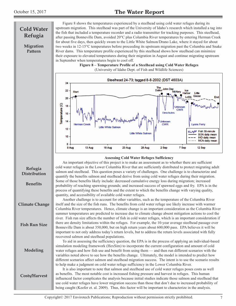
Figure 8 shows the temperatures experienced by a steelhead using cold water refuges during its upstream migration. This steelhead was part of the University of Idaho’s research which installed a tag into the fish that included a temperature recorder and a radio transmitter for tracking purposes. This steelhead, after passing Bonneville Dam, avoided 20°C plus Columbia River temperatures by entering Herman Creek for about five days, then quickly swam to the Little White Salmon/Drano Lake, where it stayed for about two weeks in 12-15°C temperatures before proceeding its upstream migration past the Columbia and Snake River dams. This temperature profile experienced by this steelhead shows how steelhead can minimize their exposure to elevated temperatures during their migration in August and continue migrating upstream in September when temperatures begin to cool off.
Figure 8 – Temperature Profile of a Steelhead using Cold Water Refuges(University of Idaho Dept. of Fish and Wildlife Sciences)
Assessing Cold Water Refuges Sufficiency An important objective of this project is to make an assessment as to whether there are sufficient cold water refuges in the Lower Columbia River that are sufficiently distributed to protect migrating adult salmon and steelhead. This question poses a variety of challenges. One challenge is to characterize and quantify the benefits salmon and steelhead derive from using cold water refuges during their migration. Some of those benefits likely include: decreased cumulative energy loss during migration; increased probability of reaching spawning grounds; and increased success of spawned eggs and fry. EPA is in the process of quantifying these benefits and the extent to which the benefits change with varying quality, quantity, and accessibility of available cold water refuges. Another challenge is to account for other variables, such as the temperature of the Columbia River itself and the size of the fish runs. The benefits from cold water refuge use likely increase with warmer Columbia River temperatures. Hence, climate change is an important consideration as the Columbia River summer temperatures are predicted to increase due to climate change absent mitigation actions to cool the river. Fish run size affects the number of fish in cold water refuges, which is an important consideration if there are density limitations within the refuges. For example, the 10-year average steelhead passage over Bonneville Dam is about 350,000, but on high return years about 600,000 pass. EPA believes it will be important to not only address today’s return levels, but to address the return levels associated with fully recovered salmon and steelhead populations. To aid in assessing the sufficiency question, the EPA is in the process of applying an individual-based simulation modeling framework (HexSim) to incorporate the current configuration and amount of cold water refuges and how fish use and benefit from using them — and then run different scenarios with the variables noted above to see how the benefits change. Ultimately, the model is intended to predict how different scenarios affect salmon and steelhead migration success. The intent is to use the scenario results to help make a judgment on cold water refuge sufficiency in the Lower Columbia River. It is also important to note that salmon and steelhead use of cold water refuges poses costs as well as benefits. The most notable cost is increased fishing pressure and harvest in refuges. This human influenced factor complicates the analysis because initial studies indicate those salmon and steelhead that use cold water refuges have lower migration success than those that don’t due to increased probability of being caught (Keefer et. al. 2009). Thus, this factor will be important to characterize in the analysis.

Issue #164
Copyright© 2017 Envirotech Publications; Reproduction without permission strictly prohibited.8
The Water Report
Cold WaterRefugia
Restoration
Core Habitat
CoolingTributaries
Protect&
Restore
Protecting, Enhancing, and Restoring Cold Water Refugia Given that cold water refuges in the Lower Columbia appear to serve an important role to adult salmon and steelhead migration during peak water temperatures, an objective of the project is to identify actions to protect, enhance, and restore cold water refuges. As depicted in Table 1, most the 26 tributaries providing cold water refuge have temperatures that are significantly colder than the Columbia River. EPA believes it will be important to protect these tributaries from human actions that may warm them in the future. Further, some of the 26 and other tributaries to the Lower Columbia River may have the potential to be cooled via restoration actions. EPA is in the process of evaluating the watersheds of these tributaries to characterize the risk of future warming and the potential for future cooling. EPA’s initial focus is on the 13 “primary” cold water refuge tributaries in Table 1 consistent with the conservation principle to protect and improve core habitat currently used by salmon and steelhead. In addition, EPA plans to identify and prioritize a few tributaries in the Lower Columbia that currently only are marginally colder than the Columbia River, but could be colder and serve as cold water refuge if appropriate restoration actions were implemented. In these watershed reviews, EPA plans to identify potential actions to cool tributaries, such as:
• restored riparian shade to reduce solar heating; • restored flow to make the tributary less susceptible to warming; and • the potential to release cooler water from upstream dams.
In addition to assessing the tributary watersheds, EPA will look into project concepts in the tributary confluence areas that could enhance the cold water refuges. For instance, it may be feasible to install engineered features (e.g., logjams) immediately upstream of small tributary confluence areas to enhance the amount of cooler water for fish to access. Also, many of the “primary” cold water refuges have significant amounts of sedimentation in the confluence area that could diminish the volume of cool water over time (e.g., Herman Creek, Wind River, White Salmon River, and Klickitat). Ecologically-based restoration actions in these confluence areas may be beneficial to maintain the extent of these cold water refuges.
Conclusion Adult salmon and steelhead use cold water refuges during their upstream migration to avoid warm water temperatures in the Lower Columbia River. Protecting and restoring these cold water refuges is likely to be important for the recovery of salmon and steelhead populations in the Columbia River Basin. The importance of protecting and restoring these cold water refuges may take on more significance due to climate change, which is expected to increase the water temperatures in both the tributaries and the Columbia River. The EPA Columbia River Cold Water Refuges Plan is intended in part to serve as a guide to protect and restore cold water refuges to support salmon and steelhead.
for additional information: John Palmer, EPA Region 10, 206/ 553-6521 or [email protected]
Columbia River Cold Water Refuges Project website: www.epa.gov/columbiariver/columbia-river-cold-water-refuges
referencesGoniea, T.M., M.L. Keefer, T.C. Bjornn, C.A. Peery, D.H. Bennett, and L.C. Stuehrenberg, 2006. Behavioral thermoregulation and slowed migration by adult fall Chinook salmon in response to high
Columbia River water temperatures. Transactions of the American Fisheries Society 135: 408-419.High, B., C.A. Peery, and D.H. Bennett. 2006. Temporary staging of Columbia River summer steelhead in
coolwater areas and its effect on migration rates. Transactions of the American Fisheries Society 135: 519-528.
Keefer, M.L., C.A. Peery, and B. High. 2009 Behavioral thermoregulation and associated mortality trade-offs in migrating adult steelhead (Oncorhynchus nrykiss): variability among sympatric populations. Canadian Jounral of Fisheries and Aquatic Sciences 66: 1734-1747.
John Palmer is a Senior Policy Advisor for EPA Region 10 Office of Water and Watersheds in Seattle where he leads and assists projects related to water temperature, stormwater, and the Endangered Species Act. He has been serving in this capacity since 2000. John is co-lead of the Columbia River Cold Water Refuges Project and is part of the EPA team that includes: Dru Keenan, Joe Ebersole, Marcia Snyder, Jenny Wu, Peter Leinenbach, Gretchen Hayslip, Ben Cope, Rochelle Labiosa, Randy Comeleo, Mary Lou Soscia, Miranda Hodgkiss, Lindsay Guzzo, Keyyana Blount, Dylan Laird, and Martin Merz.

October 15, 2017
Copyright© 2017 Envirotech Publications; Reproduction without permission strictly prohibited. �
The Water Report
PrecipitationForecasting
Climate ChangeChallenge
AtmosphericRivers
PreCiPitation ForeCastingsan francisco precipitation forecasting to be greatly improved
by Carl Morrison, President, Morrison & Associates, Inc. (San Francisco, CA)
Introduction Climate change is resulting in weather and water extremes that are presenting new challenges to forecasters across the American West. In the San Francisco Bay Area, a continuing challenge has been the accurate forecasting of precipitation and flooding events that impact over seven million people and one of the most prosperous economies in the United States. These impacts range from water quality in the Bay to flooded roadways and buildings during storms. Until recently, it was not possible to accurately predict the storm events that significantly impact the area. The AQPI Project discussed in this article was designed to obtain precise precipitation information to improve the management of water supplies, protect infrastructure, and deal with major flooding potential.
Rain Origins Rain events along the West Coast of the US generally come from storms originating out over the Pacific Ocean. These storms, called extratropical cyclones by meteorologists, are replete with water vapor, often in long narrow corridors known as Atmospheric Rivers (ARs). Many people on the West Coast are familiar with the term “Pineapple Express.” A Pineapple Express is a strong atmospheric river that is capable of bringing moisture from the tropics near Hawaii over to the US West Coast. Atmospheric Rivers can set up a good news / bad news situation for Californians. Just a few AR events can deliver half of a year’s precipitation. Heavy rains can be a relief for anxious water managers in a drought-prone region. However, that much water — arriving like a firehose from the sky — can cause major flooding, endangering both lives and property. As discussed further below, ARs can also move inland from the coast, causing floods and replenishing water supplies in various interior areas of the West.

Issue #164
Copyright© 2017 Envirotech Publications; Reproduction without permission strictly prohibited.10
The Water Report
PrecipitationForecasting
Flooding
ExistingInfrastructure
Limits
Radar Limits
Wastewater&
StormwaterImpacts
The San Francisco Bay Area (Bay Area) is particularly prone to significant flooding and resulting damages from ARs. In Sonoma County, just north of San Francisco, the outlay of State funds for repetitive flood damages is greater than the other eight Bay Area counties combined and accounts for 34% of total State expenditures on flooding. In the South Bay, excessive rainfall in the Coyote Creek drainage this past February caused over $70 million in flood damages to San Jose and environs. Research has shown there were 42 ARs that impacted California during the winters from 1997 to 2006. The resulting seven floods that occurred on the Russian River watershed northwest of San Francisco during this period were all associated with AR conditions.
Atmospheric Rivers Impact to the Bay Area Existing forecasting infrastructure — satellites, off-shore observations, and NEXRAD radar — have enabled weather forecasters to provide notice of rain events, and even ascertain their severity, much of the time. The forecasts, though, have not always provided specificity sufficient enough to guide actions that could be taken to offset damaging impacts. Precipitation often forms in very low levels of the atmosphere, below the level at which existing NEXRAD Doppler radar can see it well. The Bay Area also has scanning radar coverage available from commercial TV stations. The California Department of Water Resources and the US Department of Energy have invested in a “picket fence” along the West Coast to monitor water vapor concentration, onshore moisture flux, freezing elevation, and soil moisture. These Atmospheric River Observatories (AROs), built by the National Oceanic and Atmospheric Administration (NOAA), are very useful for forecasts. The system enables water resources managers to gauge the intensity of an AR event at the location of the ARO. They do not, however, scan like a typical weather radar. Rather, AROs view the atmosphere directly above them in fine detail. Scanning radar is needed to fill in the gaps between AROs to detect variations in storms across different watersheds. Similar to many other areas in the western United States, a significant problem arises due to the rugged terrain in California. NEXRAD radar was developed to detect thunderstorms in the relative flat Midwest. It intentionally aims at a high level because the clouds containing moisture are usually found at relatively high altitudes. The radars often miss a portion, and some cases all, of the moisture contained in the low-level ARs. Additionally, the signals from some of the radars in the Bay Area are blocked by coastal mountains that “hide” the ARs on the western side of the range.
Advanced Quantitative Precipitation Information (AQPI) Project In 2010, NOAA’s Earth Sciences Research Laboratory (ESRL, in Boulder, Colorado) was approached by the San Francisco Public Utilities Commission (SFPUC) to see if it were possible to obtain much more precise precipitation information. SFPUC wanted better information to help improve management of its combined sewer system which collects and treats both wastewater and stormwater in the same network of pipes.ESRL responded with a proposed project consisting of:
• a state-of-the-art C-band radar at Bodega Bay, up the coast from San Francisco• an X-band radar unit on the ridge of mountains above the City• an ARO• additional rain gauges• sophisticated forecast modeling to assimilate the radar observations into the model and improve short-
term prediction.

October 15, 2017
Copyright© 2017 Envirotech Publications; Reproduction without permission strictly prohibited. 11
The Water Report
PrecipitationForecasting
Applicability
Anticipation
Funding
Flooding&
Water Quality
The project was named the Advanced Quantitative Precipitation Information (AQPI) System, for it was more “advanced” than the “quantitative precipitation information” systems already being used. Although SFPUC is the only Bay Area agency with a combined sewer system, it wasn’t long before other Bay Area agencies heard of the project and saw great applicability to their own principal function — be that water management, wastewater management, or flood protection. While AQPI does not give a sufficiently long-range forecast for large reservoir operations, it would help managers of smaller reservoirs time appropriate discharges before and during heavy rain events in order to maintain water supplies and not exacerbate flood damage downstream. Wastewater treatment plant operators around the Bay would be able to take remedial actions when these events include a significant storm surge. The United States Geological Survey (USGS) is leading this aspect of the AQPI project. Another benefit is that flood protection agency managers would be able to better anticipate flooding events and thus more effectively deploy their assets to deal with them. Almost all of these water resources agencies participated in the Bay Area Integrated Regional Water Management Plan. The plan itself, and then projects developed during the planning process, were funded by grants administered by the California Department of Water Resources (CDWR). The grants were a result of water bonds passed by California voters in 2002 and 2006. The 2006 measure, Proposition 84, after several rounds of grants still contained sufficient funding that proponents of what had become a Bay Area-wide AQPI project could apply for a $19 million grant in 2016. Work already completed by the already participating federal and local agencies easily made up the required 25% matching funds. That same year a grant was awarded to the Sonoma County Water Agency to be the grant recipient and administrator. In August of 2017, that agency approved contracts with ESRL, the Cooperative Institute for Research in the Atmosphere at Colorado State University (CSU), and Morrison & Associates, Inc. to implement the project. Contracts soon will be approved for USGS and the Center for Western Weather and Water Extremes at Scripps Institution of Oceanography. The AQPI project consists of both new and existing physical equipment and improved modeling using existing and new forecasting tools. Once in place the project will give flood and water agencies in the nine-county San Francisco Bay area better warning about potential flooding and water quality impacts from heavy rainfall events. AQPI will provide improved risk-based information on the intensity and extent of extreme precipitation from atmospheric rivers and the likelihood of AR extreme precipitation impacting the Bay Area. The goal is not just predicting how much water will be falling. It is also forecasting what happens when that water hits the ground and runs off into the Bay. The system will be based on a new array of lower-elevation, X-band radar units that provide highly detailed information. This data is then fed into state-of-the-art weather, river and coastal forecasting models resulting in more precise rainfall, runoff and flood forecasting in and around the Bay Area. Versions of the system may be run by local water and flood agencies depending on their needs.
In September 2016, the first X-band radar was installed in in San Jose at the same location where a prototype had been tested.

Issue #164
Copyright© 2017 Envirotech Publications; Reproduction without permission strictly prohibited.12
The Water Report
PrecipitationForecasting
RadarCoverage
Purposes
Existing S-band and C-band radar will be supplemented with what was the SFPCU C-band radar unit on the hills above Bodega Bay and four low-level, shorter-range, latest-technology X-band units (designed and constructed at CSU) in the four subregions of the Bay Area: North Bay, East Bay, South Bay, and Peninsula. The latter is what was the SFPUC X-band on Montara Peak above San Francisco.
The C-band radar will scan 100-plus kilometers out into the ocean, detecting storms from all western directions and providing several hours advanced notice of storms coming on-shore. The X-band units have a range of 40 kilometers and are designed to provide very accurate estimates of precipitation amount, intensity, and duration. The new radar units alone, however, do not comprise the AQPI project. Inputs into the “AQPI System” also will come from many other sources. These include a variety of weather monitoring such as existing government and commercial radar, vertical atmospheric river observation radar, satellite tracking, rain gauge networks and moisture probes. Existing forecast models also will be used. These include models from various NOAA and National Weather Service sources, including the nearby California-Nevada River Forecast Center, USGS for storm surge, and the Center for Western Weather and Water Extremes.

October 15, 2017
Copyright© 2017 Envirotech Publications; Reproduction without permission strictly prohibited. 1�
The Water Report
PrecipitationForecasting
SystemComponents
End Usesof Data
All this information will be fed into supercomputers at ESRL to give information that will be specifically developed for the end user in the Bay Area. Again, these users include water supply managers, wastewater treatment plant operators, and flood protection agency officials. In addition, the information will be provided in a user-specific and useful format for emergency responders, transportation officials of all sorts, and sent back to weather forecasters who can inform the general public. An “app” that will inform the public of imminent road closures and other danger warnings is under consideration.
Project Cost-Benefit A requirement for any capital project is for the benefits to justify the costs. This was certainly the case before CDWR would consider granting funds for the AQPI project. While not specifically prepared for such justification, about the time the application was to be submitted a paper was prepared, and eventually published, that enumerated in detail the financial benefits to the Bay Area of the AQPI project (NOAA Technical Memorandum OAR PSD - 315). The project applicants, therefore, were able to show that — at minimum —AQPI would have a benefit-cost ratio of 2:1. The “best estimate” was 5:1. It was also shown that in the most severe of storms resulting from atmospheric rivers the benefit-cost ratio could be 13:1. The better the benefit-cost ratio, the more points for CDWR scoring of the project.
The benefit-cost analysis was comprehensive. Of course, the traditional costs of flood damage were addressed. More specific savings were also addressed. For example, homeowners with a warning that their neighborhood might be flooded with several feet of water could move their computer off the floor onto the desk and thus save hundreds of dollars in a claim for damage or their own expense. A general forecast for heavy rain in the Bay Area may
AQPIBenefits
byCategory

Issue #164
Copyright© 2017 Envirotech Publications; Reproduction without permission strictly prohibited.14
The Water Report
PrecipitationForecasting
West Coast
InlandApplications
deter shoppers in the entire region from venturing out to make a variety of purchases. This could result in a loss of significant sales tax revenues. The AQPI project will not only show where it will rain but also where it will not. Thus, many will be able to find out that they can venture out as usual. The analysis also considered those who would avoid visiting public and private recreational facilities, again resulting in a drop in an assortment of revenues. Ridership on public transportation may be light where it need not be because of the fear of heavy rain. Tolls collected on bridges and expressways would be impacted as well. It need not take much imagination to envision the avoided costs of flood damage and economic activity with more accurate precipitation forecasting that would be available from the AQPI project.
Project Applicability Elsewhere Atmospheric rivers are responsible for major flooding all along the West Coast. In fact, the farther north one moves the more the adverse impacts of Atmospheric Rivers are felt. Consequently, urban areas such as Portland and Seattle could greatly benefit from a similar AQPI project. Even to the south in Los Angeles and San Diego, atmospheric rivers were responsible for the heavy rains in the winter of 2016-2017. Moreover, atmospheric rivers don’t always stop at the coast. Lower-level storms can move inland through valleys and riverways. Such is the case in the Bay Area, where ARs can move through the Carquinez Strait between Contra Costa and Solano counties into the northern portion of the Central Valley. Higher-level ARs can move inland hundreds of miles, reaching the Rocky Mountains. An AQPI project, therefore, can be helpful in more precisely forecasting precipitation events and thus provide a myriad of benefits in many parts of the country — and throughout the world for that matter. For the 2016 Super Bowl played at Levi’s Stadium in Santa Clara, California, emergency responders and the National Weather Service requested that an X-band radar unit be installed at a nearby appropriate location so there would be improved notice of rains that could have impacted travel to the game — especially Highway 101 from San Francisco, which frequently floods during major storms. As it turned out, it was a picture-perfect day for the Denver Broncos to beat the Carolina Panthers 24-10. Radar images in the graphic below — of when it did rain — shows the improved indication of precipitation over by the newly installed X-band radar unit (left image) as opposed to radar coverage from the existing NEXRAD radar (right image). Note that this is just the X-band radar coverage, not the complete picture and other vital information the AQPI project will deliver when all the other observations and modeling are included.
Conclusion As climate change results in more extreme weather events and we learn more about the science of atmospheric rivers, improved forecasting is a necessity. Better forecasting means that water supplies can be better managed, public-service infrastructure can be more protected, and the public and their property can be spared the impacts of major flooding. Thanks to scientists and engineers at many research and academic institutions, the AQPI project will help address the increasing weather challenges in the Bay Area.
for additional information: Carl morrison, Morrison & Associates, Inc., 760/ 724-9580 or [email protected] References and Resources:
www.noaa.gov/news/rain-when-good-thing-becomes-too-much-of-good-thingwww.noaa.gov/stories/what-are-atmospheric-riverswww.esrl.noaa.gov/psd/news/2016/072716.htmlhttps://docs.lib.noaa.gov/noaa_documents/OAR/PSD/TM_OAR_PSD_315.pdf
Carl Morrison is the President of Morrison & Associates, Inc., a public and government relations company founded in 1987, with offices in the San Francisco Bay Area and San Diego County (see www.morrisonassociates.com. A retired Marine Corps officer, Carl is a graduate of Brigham Young University (BA), Loyola University of Chicago (MA), DePaul University College of Law (JD), and The George Washington University Law School (LLM).

October 15, 2017
Copyright© 2017 Envirotech Publications; Reproduction without permission strictly prohibited. 1�
The Water Report
ClimateAssessment
Tribal Region
ESA Listings
Land Use
Water Quality
Glaciers&
Climate Change
HabitatRestoration
ComplexHydrology
addressing CliMate Changethe nooksack indian tribe climate change project
by Oliver Grah & Jezra BeaulieuNooksack Indian Tribe Natural Resources Department (Deming, WA)
Introduction The Nooksack Indian Tribe (Tribe) inhabits the area around Deming, Washington, in the northwest corner of the state, 15 miles south of the US-Canadian border. The Nooksack River watershed encompasses much of the Nooksack ancestral territory, which extended from British Columbia to the north, to Skagit County to the south, and from the Salish Sea to the west to Mount Baker to the east. The Tribe is dependent on various species of Pacific salmonids that inhabit the Nooksack River for ceremonial, commercial, and subsistence purposes. Three of these species are listed as threatened under the federal Endangered Species Act (ESA): Chinook salmon, steelhead, and bull trout. Adequate streamflows and cool stream temperatures are required for salmon survival and reproduction. Since European arrival, the numbers of fish that return to spawn have greatly diminished because of substantial loss of habitat primarily due to human-caused alteration of the watershed and trends of a warmer environment since the late 1800’s (as indicated by climatic data at the Clearbrook, WA, meteorological station). Further, land uses within the watershed have contributed to degraded conditions due to: loss of protective buffering on the river and tributaries; landslides due to forest roads; agriculture; flood control; development; and transportation facilities. Segments of the river currently do not meet federal and state water quality standards for stream temperature and sediment. Although direct counts are not available, it is estimated that native salmonid runs are less than 10% of the runs in the late 1800’s (Lackey 2000). In addition, climate change has caused, and will continue to cause: an increase in winter flows; earlier snowmelt; decrease in summer baseflows; and an increase in water temperatures that exceed the tolerance levels (in some cases lethal levels) of several Pacific salmonid species. The headwaters of the Nooksack River originate from glaciers on Mount Baker that have experienced significant changes over the last century due to climate change. Melt from the glaciers is a major source of runoff during the low-flow critical summer season, and climate change will have a direct effect on the magnitude and timing of stream flow in the Nooksack River. Understanding these changes is necessary to protect the Pacific salmonid species from the harmful effects of climate change (Grah and Beaulieu 2013). All nine salmonid species that inhabit the Nooksack River will be adversely affected by reduced summer flows, increased temperatures, and increased sediment loading. These climate impacts in combination with existing legacy impacts create significant cumulative impacts and threats to salmon in the river. The most important task ahead is the planning for, and implementation of, habitat restoration as well as comprehensive watershed conservation planning prior to climate change becoming more threatening to the survival of these important fish species. The Tribe has been collaboratively working with government agencies and scientists on the effects of climate change on the hydrology of the Nooksack River. The extinction of salmonids from the Nooksack River is unacceptable to the Tribe since it is dependent on these species. The Tribe is place-based and cannot relocate to areas where salmon will survive in the future in the face of climate change.
Nooksack River Hydrology The Nooksack River watershed is comprised of three forks, South Fork Nooksack River, Middle Fork Nooksack River, and North Fork Nooksack River. The watershed has a complex hydrology driven by:
• Rainfall at lower elevations; • Snow accumulation and rain-on-snow at middle elevations (transitional hydrology); • Snowmelt at higher elevations; and • Glacier melt at the highest elevations.

Issue #164
Copyright© 2017 Envirotech Publications; Reproduction without permission strictly prohibited.16
The Water Report
ClimateAssessment
Glacier Impacts
CommercialForestry
Climate ChangeAssessment
SalmonDeclines
Peak flows in the South Fork Nooksack River occur in the mid-November through March period when heavy rains fall on accumulated snow at low to mid-elevations. Peak flows occur in mid- to late May in the Middle and North Fork Nooksack rivers in response to snowmelt from higher elevations. Glacier melt in these rivers significantly contributes to late summer flows with modulating cool temperatures. The South Fork Nooksack River has an insignificant area of glaciers and is at a lower elevation such that flows diminish quicker and stream temperatures increase more rapidly than in the Middle Fork and North Fork Nooksack rivers. The South Fork Nooksack River, in contrast to the North Fork and Middle Fork Nooksack rivers, provides an effective illustration of the difference between non-glacier fed and glacier-fed watersheds in the Pacific Northwest.
Land Use The Nooksack Indian Tribe reservation is at the base of the North Cascade Mountains foothills, approximately three miles downstream from the confluence of the North Fork, Middle Fork, and South Fork Nooksack rivers. The Nooksack River watershed above the reservation is very steep rendering the area extremely susceptible to the impacts of land management. A large portion of the watershed is subject to commercial forestry where even-age harvest (clear cutting) dominates. Forestry, combined with other land uses such as agriculture, development, flood control, and transportation, has caused impacts to stream flow timing, temperatures, and sediment transport. The long history of these land uses has caused legacy impacts in the streams and rivers that have adversely affected salmon habitat and survival. Climate change has been occurring since the late-1800’s, which has caused shifts in watershed hydrology and stream temperatures. Climate projections suggest more rapid changes in watershed behavior, including higher peak flows, lower low flows, and increased sediment. Legacy impacts combined with past and continued future climate change impacts will cumulatively impact the watershed and the ability of salmon to perpetuate into the future. Understanding this cumulative impact prompted the Tribe in 2011 to develop and implement a comprehensive climate change impact assessment, vulnerability assessment, and adaptation planning program aimed at promoting salmon protection and recovery in the watershed.
Quality of Water and Salmon Habitat Salmon populations have declined from historical levels throughout western Washington. As mentioned above, although direct counts are not available, it is estimated that native salmonid runs are less than ten percent of the runs in the late 1800’s. Similarly, salmon populations have been drastically reduced in the Nooksack River watershed, and most severely in the South Fork Nooksack River watershed.
Although most of the watershed is covered by coniferous forest, extensive modification of the forest cover has altered the hydrology of the watershed. Riparian vegetation has been removed, wetlands drained, land leveled, channels straightened, banks armored, and tributaries piped through culverts for farming in the lowlands. These actions increased peak flows in the winter, decreased low flows, increased stream temperatures in the late summer, and increased sedimentation in the rivers. These impacts to fish and habitat are a major cause of salmon population declines. Today, however, federal, state, local governments, Non-Governmental Organizations (NGOs), and citizen groups have begun to focus on these conditions. These legacy impacts continue today, even though environmental regulations and conservation measures are supposed to address such impacts from past activities. Streamflow conditions in late summer are particularly critical to salmon. Flow rates are the lowest and stream temperatures are the highest at this time. The snowpack has for the most part melted away and baseflows from groundwater inputs are the dominant source of streamflows — except for glacier fed streams such as the Middle Fork Nooksack River and the North Fork Nooksack River. Glacier melt sustains flow and moderates stream temperatures during these times. However, except for
October 15, 2017
Copyright© 2017 Envirotech Publications; Reproduction without permission strictly prohibited. 1�
The Water Report
ClimateAssessment
Temperatures
Land UseImpacts
Climate ChangeImpacts
Focus
CumulativeImpacts
streams served by glacier melt, legacy impacts of past land management have exacerbated these streamflow conditions. Removal of protective forest cover for forestry and agriculture, flood control measures, and transportation infrastructure have caused streamflows to diminish and stream temperatures to increase to lethal levels for salmon in the late summer. As an example, high temperatures are generally associated with degraded riparian conditions: only 21 percent of riparian areas in the Nooksack River watershed (including tributaries) provide sufficient shade to maintain natural temperature regimes (Coe 2001), including three percent, 33 percent, 28 percent, and 26 percent of the riparian areas in the mainstem Nooksack River, North Fork, Middle Fork, and South Fork Nooksack rivers subbasins; respectively. Further, land uses — particularly forestry — have increased sediment loading of the streams and rivers, causing further impacts on streamflow and temperatures. These impacts have also negatively impacted groundwater inflow to the streams and rivers further reducing streamflow and increasing temperatures in the summer. Various portions of the Nooksack River are on the Clean Water Act 303(d) list of impaired waters for excessive temperature and fine sediment as well as low dissolved oxygen content. Excessive stream temperature during the late summer is the most challenging water quality issue to fish as the water quality standards are based on salmonid survival and reproduction as the primary beneficial or designated use of the river. Water quality standards for stream temperature vary from 12o C to 16o C depending on species, life stage, season, and location in the watershed. The South Fork Nooksack River frequently exceeds the water quality numeric criteria and approaches temperatures that are lethal to salmon. These conditions have greatly contributed to the decline in suitable habitat for salmon in the Nooksack River. Continued climate change will cumulatively add to these impacts that are adversely affecting Pacific salmon survival and their ability to reproduce. The Tribe is keenly focused on these conditions and the impact of continued climate change in the future.Continued Climate Change Could result in the following imPaCts:
• Reduction in the area and depth of snow accumulation and snowmelt runoff• Altered streamflow timing• Increased high flows in winter, decreased low flows in summer• Increased flooding• Shorter runoff period• Longer baseflow period• Increased summer temperatures• Increased sediment loads• Channel degradation and aggradation• Decreased quality and quantity of salmon habitat• Further reduction in salmon populations• Reduced harvest levels for subsistence, ceremonial, and commercial uses
The focus of the Tribe’s climate change project is to: ameliorate the adverse effects of legacy impacts; develop and implement adaptation strategies; and to promote resiliency in the aquatic system in the face of continued climate change.
Collaborative Efforts to Address Climate Change and Legacy Impacts Washington State’s Water Resource Inventory Area #1 (WRIA 1) is comprised of the Nooksack River watershed and associated marine tributaries. The Tribe has been an active participant in both the 2005 WRIA 1 Watershed Management Project (2005 Watershed Management Plan) and the 2005 WRIA 1 Salmon Recovery Project (2005 Salmon Recovery Plan). Through these WRIA 1 projects, the Nooksack Indian Tribe has been working with citizens, local governments, and state and federal agencies to address
many of the water quality and habitat issues mentioned above. Although legacy impacts are addressed in these projects, the cumulative effects of climate change and legacy impacts are not addressed. The Tribe has taken the initiative to lead the effort to incorporate climate change impacts into updates of both the 2005 Watershed Management Plan and the 2005 Salmon Recovery Plan (both of which address water availability, water quality, fish habitat, and salmon recovery). The Tribe has developed a collaborative team of independent entities to effectively address the problems of cumulative impacts from both legacy and climate impacts.
Issue #164
Copyright© 2017 Envirotech Publications; Reproduction without permission strictly prohibited.18
The Water Report
ClimateAssessment
Collaboration
Climate ChangeProject Elements
Legacy Impacts
MonitoringProgram
Glacier Melt
the Collaborative team inCludes:• US Environmental Protection Agency Region 10 (US EPA Region 10)• US EPA Office of Research and Development• US Geological Survey (USGS)• US Bureau of Indian Affairs (BIA)• US Fish & Wildlife Service (USFWS)• National Oceanic and Atmospheric Administration Fisheries (NOAA Fisheries)• Washington State Department of Ecology (Ecology)• Whatcom County• Western Washington University• University of Washington• Nichols College• Stillaguamish Indian Tribe• Lummi Nation• Whatcom Land Trust• Evergreen Land Trust• Washington Water Trust• Several private sector contractors
the tribe’s overall Climate Change ProJeCt inCludes: • Glacier behavior monitoring• Sediment and turbidity monitoring• Streamflow monitoring• Oxygen isotope analysis• Hydrologic modeling for climate impacts• Stream temperature modeling• Sediment modeling• Salmon habitat vulnerability assessment• Salmon habitat adaptation planning• Watershed conservation planning
The Tribe has implemented a comprehensive public outreach and stakeholder engagement process in the development of a South Fork Nooksack watershed conservation plan (NIT 2017a) and the formation of a watershed forum.
Establish a Baseline for Measuring Legacy and Climate Change Impacts The Tribe has observed changes in stream flows, stream temperature, and fish habitat conditions in the Nooksack River watershed for a long time as these variables have bearing on the survival and recovery of Pacific salmon in Tribal waters. Having an understanding of how land use and legacy impacts in the watershed may have contributed to degraded habitat conditions has been a primary objective of the Tribe’s Natural Resources Department over the last 25 years. Further, the Tribe has recognized that effective efforts toward salmon recovery and habitat restoration must address the cumulative impacts of legacy impacts and climate change impacts together. The Tribe designed and implemented a comprehensive monitoring program to establish a baseline of conditions against which to evaluate change from existing conditions due to natural background variability, continued land use, restoration effectiveness, and climate change. The Tribe monitors: streamflow at ten stations; sediment and turbidity at 20 stations; stream temperature at 66 sites; oxygen isotope composition at 12 sites; lapse rate (temperature decrease at higher elevations) at 12 sites; and general water quality at 34 sites throughout the watershed. Data are analyzed for variability, trends, and correlations, and the data is shared with other partners, including contractors who use the data to model climate in the watershed.
Glacier Field Studies There are approximately 148 glaciers and glacierets in the Nooksack River watershed covering approximately 15.8 square miles. Of this total, 12.0, 3.3, and 0.5 square miles occur in the North Fork, Middle Fork, and South Fork Nooksack River watersheds, respectively. Glacier melt provides for beneficial streamflows and stream temperatures during the most stressful times for salmon in the late summer. As an example, glacier melt contribution to the North Fork Nooksack River during dry hot spells in August 2015 comprised 60 to 90 percent of river flows (Pelto 2016, NIT 2017c).

October 15, 2017
Copyright© 2017 Envirotech Publications; Reproduction without permission strictly prohibited. 1�
The Water Report
ClimateAssessment
Sholes GlacierStudy
SedimentDischarge
SourceComposition
GlacierRecession
Vulnerability&
Adaptation
Because of the importance of glacier melt, the Tribe initiated a study in 2012 to evaluate and characterize the conditions and behavior of the Sholes Glacier on Mount Baker in conjunction with Dr. Mauri Pelto of Nichols College. Dr. Pelto has been studying glacier behavior in the North Cascades for over 30 years. The Sholes Glacier was selected as the study glacier because of ease of access and the relatively safe conditions of travel on the glacier. Field work involves establishing a stream gage and weather station at the outflow stream at the toe of the Sholes Glacier where data on streamflow, turbidity, stream temperature, air temperature, solar radiation, and precipitation are recorded. In addition, five snow and ice ablation stakes are used to measure snow depth and rates of melt. This rate-of-melt data is related back to stream flows recorded at the stream gage and to determine the annual mass balance of the glacier from year-to-year. Average daily ablation (net glacial loss) rate was found to be 2.7 inches/day resulting in over 10 feet of snow and ice melt (depth of liquid water equivalent) over the melt season. Water samples are analyzed for suspended sediment concentrations (SSC). This data is correlated with flow rates and turbidity to generate statistical models for predicting sediment discharge. SSC from Sholes Glacier has a strong correlation with streamflow, with a correlation coefficient of 0.78 and an even stronger correlation with turbidity, with a correlation coefficient of 0.9. Total suspended sediment loads were 500, 6550, and 360 tons in 2014, 2015, and 2016, respectively (NIT 2017c). All of this data and analysis is used to establish baseline conditions against which climate impacts can be discerned. Oxygen isotope analysis of water samples at the base of the glacier over the melt season allows for an estimation of the shift in relative composition of rainfall, groundwater, snowmelt, and ice melt contributions to stream flow. Similar analysis of oxygen isotope concentrations in water samples taken along a transect in the watershed also allows for an indication of the relative contributions river flows from rainfall, groundwater, snowmelt, and ice melt. By late summer when snow has melted off, sources with the lowest oxygen 18 isotope concentration indicate an older source of water (i.e., glacier melt) and a higher oxygen 18 isotope concentration indicates a younger source of water (i.e., rainfall, snowmelt, and/or groundwater) (NIT 2017c). This relationship can be used to evaluate the relative contributions of glacier melt to streams and in the watershed. Since 2012, the Sholes Glacier has receded approximately 200 feet and its volume has similarly diminished. Using a time series of aerial photos and inferring the margins of glaciers on Mount Baker associated with the trim lines at the end of the Little Ice Age (~1890), approximate lengths of recession of glaciers in the Nooksack River watershed have been determined, as shown in the following table.
Watershed Modeling for Climate Change The Tribe has collaborated with Western Washington University, University of Washington (UW), and the UW Climate Impacts Group to model streamflow, stream temperature, and sediment dynamics in the Nooksack River watershed using the recently modernized Distributed Hydrology Soils Vegetation Model (DHSVM). This version of the model includes a dynamic glacier component that more realistically represents glacier behavior. The DHSVM is calibrated and verified using two different existing historic data sets and then applied to project changes in modeled parameters for various climate change scenarios. Projected changes in streamflow, stream temperature, and sediment dynamics are used to develop a vulnerability assessment and adaptation plan primarily focused on salmon survival and recovery as well as facilitating watershed resilience in the face of climate change through a watershed conservation planning effort.

Issue #164
Copyright© 2017 Envirotech Publications; Reproduction without permission strictly prohibited.20
The Water Report
ClimateAssessment
Glacier Retreat
Temperature
Sediment
TMDLs
Water Quality
Climate ChangeRisk
results of Climate Change modeling (Murphy et al. 2016) inClude:• Historic Glacier Retreat of 40 % has occurred from 1958-2007• Glacier Retreat Will Be Significant with smaller glaciers disappearing and residual glaciers receding to
high elevations with significantly less mass, 88 % less, 90% recession by 2100• Increased Ice Melt ~ 150-185% will partially compensate for decreased streamflow due to reduced
snowpack and earlier snow melt through mid-century, but then glacier melt contribution will decline• Streamflow Impacts: In the North Fork Nooksack River (glacier served) by 2075 streamflows could
increase by 153% in January and decrease 75% in July due to becoming mostly rain-dominated and transitional hydrology
Other results suggest:• Temperature Impacts: Stream temperatures in the South Fork Nooksack River could increase to 23o C
by 2080 (Butcher et al. 2016, EPA 2016). In contrast, stream temperatures approaching 22o C are lethal to Pacific salmon in the Nooksack River. As indicated previously, water quality standards in the upper Nooksack River range from 12o C to 16o C. Thus, temperature exceedances will occur more frequently over longer durations into the future with climate change.
• Sediment Loading could increase four to six times from current levels with climate change (Hamlet and Grossman in review).
Addressing Temperature Standards and Evaluating Effectiveness of Riparian Buffer Shading The South Fork Nooksack River is on the Clean Water Act 303(d) list of impaired waters for excessive temperature and fine sediment. A Total Maximum Daily Load (TMDL) analysis is required for impaired waterbodies on the 303(d) list. A TMDL establishes a limit on the level of pollutants that can enter the waterbody while still achieving water quality standards. A TMDL is required to determine how best to reduce temperature and sediment levels to bring the river into compliance with water quality standards. In 2011, the Tribe was engaged by EPA Region 10 and Ecology to participate in the TMDL (Ecology unpublished) project for the South Fork Nooksack River. The Tribe’s interest was in effectively addressing water quality issues in the river that relate to fish survival and habitat. Because the TMDL is meant to be an effective tool that addresses water quality issues, the Tribe recommended that a reasonable attempt be made to include legacy impacts, climate change, and reasonable natural conditions in the project. Including climate change in a TMDL project was novel. The EPA’s Office of Research and Development simultaneously developed a climate change pilot research project with the objective to identify and prioritize climate change adaptation strategies and recovery actions for the river that include climate change as a risk.

October 15, 2017
Copyright© 2017 Envirotech Publications; Reproduction without permission strictly prohibited. 21
The Water Report
ClimateAssessment
RiparianShading
InadequateBuffers
AddressingClimate Impacts
Watershed Plans
PossibleSolutions
ConservationPlan
ePa’s Climate Change risk Pilot ProJeCt inCluded:1) Quantitative Assessment that focused on modeling stream flow and temperature responses to projected
climate (Butcher et al. 2016); and2) Qualitative Assessment that focused on the cumulative impacts of legacy and climate impacts on
fish and fish habitat and how to address continued climate change through prioritized habitat restoration and watershed planning (EPA 2016).
Through this effort, the tribe facilitated the development and support of a collaborative team, including the Stillaguamish Indian Tribe and the Lummi Nation, as well as other federal, state, and local agencies, NGOs, and private contractors. The project focused on evaluating the effectiveness of riparian shading on stream temperature under natural conditions, under today’s conditions, and under several future climate projections. A primary objective of the qualitative assessment focused on identifying which restoration strategies and actions were needed and where those actions should be applied, thus altering and reprioritizing the original WRIA 1 objectives. In order to effectively address climate change impacts on salmon, the qualitative assessment made recommendations on how salmon habitat restoration actions should be prioritized and identified additional strategies needed to address the cumulative impacts of legacy and climate change impacts. The analysis showed that standard riparian buffers under the State’s Growth Management Act and Shoreline Management Act and the federal government’s NOAA fisheries buffers were not effective in providing the same degree of shade effectiveness as natural conditions. Wider and taller shade buffers would be required to attain water quality standards.further neCessary aCtions to address Continued Climate imPaCts inClude:
• Floodplain Reconnection• Wetlands Restoration• Protective Measures on Agricultural Lands• Buffer Maintenance and Expansion in Commercial Forestry Areas• Abandonment and Restoration of Forest Road Stream Crossings• Modification of Transportation Facilities • Modification of Flood Control Structures• Removal and Replacement of Hard Channel Bank Armoring
Because implementation of these restoration activities are watershed-wide and involve numerous sectors of the watershed community, a watershed forum was initiated to ensure community values and interests were fully addressed in the development of a watershed conservation plan (NIT 2017a). The findings from the qualitative assessment aim to inform: the development of the CWA South Fork temperature TMDL Implementation Plan; updates to the ESA WRIA 1 Salmonid Recovery Plan; and other land use and restoration planning efforts (EPA 2016). The methods used in the Quantitative and Qualitative Assessment and the resulting comprehensive watershed plans and models are being used by EPA as a pilot to build new methods for other watersheds nationwide. The Tribe has been awarded Bureau of Indian Affairs Tribal Resilience Program and other funding to share with other Tribes and communities through annual workshops and conferences.
South Fork Nooksack River Watershed Conservation Planning Through Nooksack Tribal leadership, the South Fork Nooksack Community Watershed Project coalition was able to build from the qualitative assessment to successfully identify possible solutions, which include: longitudinal connectivity; floodplain reconnection; restoring stream flow regimes; and instream rehabilitation. The team crafted a 2017 South Fork Nooksack River Watershed Conservation Plan that more effectively identified and addressed their priority concerns related to climate change impacts in the South Fork of the Nooksack Watershed. As mentioned above, the Tribe implemented an aggressive public outreach and stakeholder engagement process to support a South Fork Nooksack River watershed conservation planning effort. Incorporating community values was identified as a critical component of South Fork Nooksack River watershed conservation plan (NIT 2017a) development early in the process. An initial planning team was formed in 2014 to conceptualize South Fork Nooksack River watershed planning. The team is comprised of interested and informed individuals of government staff, non-governmental organizations, and interested informed publics. The planning team developed a conceptual project framework and developed a plan for public outreach and stakeholder engagement. The Tribe obtained grant seed money for the planning effort from: BIA; EPA; Ecology; Affiliated Tribes of Northwest Indians; Northwest Indian Fisheries Commission; and North Pacific Landscape Conservation Cooperative — among other grantors. A comprehensive public outreach and stakeholder engagement program was implemented beginning in 2015. The hope was that

Issue #164
Copyright© 2017 Envirotech Publications; Reproduction without permission strictly prohibited.22
The Water Report
ClimateAssessment
CommunityEngagement
WatershedGroup
Site-SpecificPlan
Legacy Impacts
Temperature&
Sediments
BaselineConditions
RestorationAnalysis
any planning efforts in the watershed would be well-informed about the interests of the people who care about this place. The approach to community engagement was based on an innovative method called “Strategic Systems Mapping.” The method is based on two concepts: 1) creating a common understanding of the facts; and 2) building relationships. Information was made widely available through an interactive website (see: www.sfnooksack.com/). The first part of the process was to gather together interest groups with people who had common issues, so that they could talk among themselves about issues, concerns, and opportunities. The initial planning team brought together by the Tribe identified seven different interest groups: Agency and Tribal; Fish; Agriculture; Transportation and Utilities; Large Forest Landowners; Small Forest Landowners; and Recreation-Small Businesses. Following the interest group meetings, a community meeting was held and a community survey was conducted. Forty-four residents and landowner representatives signed up to participate in the Watershed Group or forum. An additional 353 people asked to be kept informed of the process and received regular updates. In addition to learning about the issues facing the watershed, the Watershed Group also worked to identify long-term goals and principles that could serve as a foundation for the group moving forward, and to inform any agencies or other entities engaged in planning in the South Fork Nooksack River watershed. The group used a consensus-seeking process to identify Long-Term Community Goals and Planning Principles, which were addressed in the draft watershed conservation plan. Acting on the recommendations of the temperature TMDL (Ecology unpublished), EPA climate change pilot research project (EPA 2016), WRIA 1 watershed management plan (WRIA 1 2005), and the watershed conservation plan (NIT 2017a), the Tribe received funding from Ecology through the National Estuary Program to develop a site-specific reach-scale conservation plan (NIT 2017b) along the South Fork Nooksack River. The objectives of the grant include developing specific plans and implementing those plans for riparian protection and restoration on agricultural lands. A detailed reach-scale plan (NIT 2017b) was developed that evaluated: all land parcels on the floodplain of the river for condition; ecological lift potential through restoration; riparian protection potential; and landowner willingness. Fourteen high priority parcels were identified where landowners expressed interest and willingness to participate in riparian protection through easements and restoration by establishing an effective protective buffer in agricultural lands along the river. The project is currently developing site-specific protection and restoration plans on these parcels and allocating funding for their implementation.
Conclusion Legacy impacts from land management since the late 1800’s have adversely impacted the Tribe’s treaty resources. These impacts include: impairments of water quality; reduction in suitable habitat for salmon; reduction in salmon spawning populations; and the ability of Tribal members to harvest salmon for cultural subsistence and commercial uses. There has been a trend of climate warming since weather records were initiated in the late 1800’s. The warming climate has translated into warming stream temperatures. Significant reduction of riparian shading and increased sediment loading due to land use have contributed to increased stream temperatures that frequently exceed lethal levels for salmon in the Nooksack River. Projected climate change will continue to cause increasing stream temperatures and sediment loading such that habitat conditions will continue to diminish, which will challenge the survival and recovery of salmon in the Nooksack River. The Tribe is keenly aware of these potential impacts and, along with existing legacy impacts, their cumulative effects on their ability to harvest salmon. The Tribe initiated a comprehensive climate change project in 2012 to evaluate and characterize baseline conditions against which changes in climate and environmental conditions can be discerned. This includes an extensive network of monitoring sites throughout the upper watershed, including glacier monitoring. In addition, the Tribe contracted Western Washington University and the University of Washington to model projected climate change impacts on the hydrology, stream temperature, and sediment dynamics in the Nooksack River. With this information, the Tribe worked with federal, state, and local agencies, NGOs, and contractors to evaluate the effectiveness of existing salmon habitat restoration actions in the face of climate change, prioritize such actions based on effectiveness and opportunity, identify new actions and strategies, and update existing watershed and salmon recovery plans. The analysis indicated that current restoration activities should continue but with more and larger projects being constructed at an increased rate. In addition, restoration and management strategies and activities in other areas of the watershed that have experienced impacts from land use and that have bearing on water flows and water quality in the river and tributaries should be developed and implemented.

October 15, 2017
Copyright© 2017 Envirotech Publications; Reproduction without permission strictly prohibited. 2�
The Water Report
ClimateAssessment
CommunityDriven
The Tribe has initiated a watershed conservation planning process that includes public outreach and stakeholder engagement to develop a watershed conservation plan that is community driven and owned. Through this effort, the Tribe hopes that conditions in the watershed and along the river and tributaries will improve and will remain resilient in the face of climate change. This result will facilitate the survival of salmon and recovery of fish populations so that the Tribe can continue to harvest salmon for cultural, subsistence, and commercial uses into the future.
for additional information:oliver grah, Nooksack Indian Tribe Natural Resources, 360/ 592-5176 or [email protected]
South Fork Nooksack River Community Watershed Project website: www.sfnooksack.com
ReferencesButcher, J.B., M. Faizullabhoy, H. Nicholas, P. Cada, and J.T. Kennedy. 2016. Quantitative Assessment of Temperature
Sensitivity of the South Fork Nooksack River under Future Climates using QUAL2Kw. EPA/600/R-14/233. Western Ecology Division, National Health and Environmental Effects Research Laboratory, Corvallis, OR.
Coe, T. 2001. Nooksack River Watershed Riparian Function Assessment. Natural Resources Department, Nooksack Indian Tribe, Deming, Washington.
Environmental Protection Agency (EPA). 2016. Qualitative Assessment: Evaluating the Impacts of Climate Change on Endangered Species Act Recovery Actions for the South Fork Nooksack River, WA. EPA/600/R-16/153. Western Ecology Division, National Health and Environmental Effects Research Laboratory, Corvallis, OR.
Grah, O. and J. Beaulieu. 2013. The Effect of Climate Change on Glacier Ablation and Baseflow Support in the Nooksack River Basin and Implications on Pacific Salmonid Species Protection and Recovery. Journal Climatic Change, DOI 10.1007/s10584-013-0747-y.
Hamlet and Grossman, in review, cited from Grossman, E. 2013. Sediment Budgets, Routing, and Marsh Accretion to Achieve Puget Sound Estuary Restoration. Presentation to the Salmon Recovery Funding Board 2013 Salmon Recovery Conference.
Lackey, R. (2000) Restoring Wild Salmon to the Pacific Northwest: Chasing an Illusion? In: Koss P, KatzM(eds) In: What We Don’t Know about Pacific Northwest Fish Runs — An Inquiry into Decision-Making. Portland State University, Portland, pp 91–143, www.epa.gov/wed/pages/staff/lackey/pubs/illusion.htm.
Nooksack Indian Tribe (NIT). 2017a. South Fork Nooksack River Watershed Conservation Plan. Report prepared by the Nooksack Indian Tribe Natural Resources Department and others.
Nooksack Indian Tribe (NIT). 2017b. Reach-Scale Plan: South Fork Nooksack River. Report prepared by the Nooksack Indian Tribe Natural Resources Department and others.
Nooksack Indian Tribe (NIT). 2017c. WY2016 Nooksack River Watershed Glacier Monitoring Summary Report. Report prepared by J. Beaulieu and O. Grah for Nooksack Indian Tribe Natural Resources Department.
Pelto, M. 2016. 2016 Research in the North Fork Nooksack Basin: North Cascade Glacier Climate Project. Report prepared for the Nooksack Natural Resources Department, Nooksack Indian Tribe.
Washington Department of Ecology. Unpublished. South Fork Nooksack River Temperature Total Maximum Daily Load Water Quality Improvement Report and Implementation Plan.
Water Resource Inventory Area (WRIA) 1 Salmon Recovery Board. 2005. WRIA 1 Salmonid Recovery Plan. October 11, 2005 Bellingham, WA. 323pp. plus appendices. http://salmon.wrail.org.
Water Resource Inventory Area (WRIA) 1. 2005. Watershed Management Plan – Phase 1 March 25, 2005. Planning document prepared for the WRIA 1 Joint Board by the Initiating Governments (Nooksack Indian Tribe, Lummi Nation, Whatcom County, City of Bellingham, Whatcom County Public Utility District #1; and consultants). Accessed March 2015. http://wria1project.whatcomcounty.org/Resource-Library/Guiding-Documents-And-Plans/64.aspx.
oliver grah, Water Resources Program Manager, Nooksack Indian Tribe: Oliver holds a Bachelor’s degree in botany and geology (1977, CA State Chico), and an MS in watershed science (1983, Utah State University). He has been actively engaged in the field of environmental and natural resources management for over 40 years. He has worked as a private environmental consultant for over 30 years, in the public sector for four years and Tribal organizations for six years. Oliver has served as senior scientist and manager of over 600 projects involving the natural environment. He has evaluated the following resource areas: surface water hydrology, groundwater hydrology, water quality, soil science and erosion and sediment control, wetlands science, endangered species studies, and physical wildlife and fish habitat as well as numerous environmental impact statements and assessments pursuant to NEPA. His geographic scope of professional work includes the western US, mid-west, and the northeast. He has worked in numerous geologic landscapes, hydrologic regimes, and vegetation community types ranging from the Sonoran Desert, to coastal shorelines, and to alpine tundra.
Jezra Beaulieu, Water Resources Specialist, Nooksack Indian Tribe: Jezra holds a MS in geology from Western Washington University (2012). Her thesis focused on the thermal and hydrological contributions of rock glaciers in the Sierra Nevada. Jezra has eight years of professional experience in these fields. She coordinates water quantity and quality field studies in the Nooksack River watershed to establish baseline conditions, provide data for modeling the hydrologic system, and project future climate change impacts. Jezra investigates the glacier melt contribution (baseflow and temperature) to streamflow and sediment dynamics in the Nooksack watershed and subsequent implications for salmon habitat with continued climate change.
Issue #164
Copyright© 2017 Envirotech Publications; Reproduction without permission strictly prohibited.24
The Water ReportWATeR BRIeFS
The Water Report
“TAkINGS” DENIED OR/CAsenior tribal rights
On September 29, US Court of Claims (Court) Judge Marian Blank Horn resoundingly re-affirmed the superiority of the senior water rights of the Klamath Tribes and downriver Klamath Basin tribes over other junior water interests in the Klamath Basin, denying “takings” claims filed by farmers in the basin. Klamath Reclamation Project (Project) irrigators, a consolidated class of farmers in southern Oregon and northern California, sought nearly $30 million in compensation from the US government because of the Bureau of Reclamation’s curtailment of Project water deliveries during a severe drought in 2001. The irrigators argued that the government’s actions constituted a “taking” of their property under the Fifth Amendment to the United States’ Constitution, by depriving them of their alleged rights to use Klamath Project water, and also alleged an impairment of their rights under the Klamath River Basin Compact. In 2001, a massive drought struck California and Oregon’s Klamath River Basin. During the drought, the US government followed federal and Oregon law, which required that water levels be maintained to protect imperiled coho salmon in the Klamath River and two species of sucker fish in the Upper Klamath Lake. The sucker fish, known in the Klamath language as c’waam (Lost River suckers) and qapdo (shortnose suckers), are important to the cultural, economic, and spiritual well-being of the Klamath Tribes. Salmon, historically an important treaty resource for the Klamath Tribes, have been blocked by dams from reaching the Upper Klamath Basin since the early 1900s. Acting through the Bureau of Reclamation, the federal government “temporarily terminated water deliveries to the plaintiffs in order to meet the requirements of the Endangered Species Act…and its tribal trust obligations to several Native American tribes.” Slip Op. at 2. Following “multiple opinions issued by earlier assigned judges, and, following appeal of one of those earlier decision to the United States Court of Appeals for the Federal Circuit” (id.) the case was remanded to the Court and a trial was held. This led to the 75-page decision in Lonny Baley, et al. v. United States, Case 1:01-cv-00591-MBH, U.S. Court of Federal Claims (Sept. 29, 2017). The Court denied the irrigators’ claims, ruling the irrigators were not legally entitled to receive any Project water in 2001. Some plaintiffs’ claims were barred due to limiting clauses in their contracts for water, while other plaintiffs were barred because the water was needed to fulfill the senior water rights of the tribes. The “Warren Act contracts” contained “language immunizing the government from liability resulting from water shortages caused ‘[o]n account of drought, inaccuracy in distribution, or other cause’ and for those class members who received water based on lease agreements to lease lands in the National Wildlife Refuges within the boundaries of the Klamath Project, the interests of such class members have been altered by contract in such a way that plaintiffs are barred from seeking compensation from the United States based on either a taking or impairment of such a claim.” Id. at 75. The plaintiffs that weren’t limited by contract terms nevertheless fared no better before the Court. “Based on the superior water rights held by the Klamath, Yurok, and Hoopa Valley Tribes, however, the remaining class members were not entitled to receive water in 2001. The government’s actions in 2001, did not, therefore, constitute a taking of these plaintiffs’ property under the Fifth Amendment to the United States Constitution or effect an impairment of their rights under the Klamath Compact.” Id. Native American Rights Fund (NARF) Staff Attorney Sue Noe noted, “The Project irrigators took the position that the tribal water rights were irrelevant to their claims. Thankfully, the Court has made clear that the days of junior water users ignoring the senior tribal rights is over.” Noe was counsel of record for the Klamath Tribes, who appeared as an amicus party in the case. The impact of tribal water rights on the decision cannot be overstated — the Court devoted pages 60 to 74 to its discussion of the “Effect of Tribal Rights” on the issue of “Were Plaintiffs’ Interests Taken or Impaired.” Id. at 48, 60-74. A NARF press release dated October 4th, explained the importance of the decision to the Klamath Tribe: “The Klamath Tribes have resided in the Klamath Basin for millennia, sustaining themselves upon the Basin’s fish and other water-dependent resources. In an 1864 treaty with the United States, the Klamath Tribes relinquished millions of acres of their aboriginal homeland but retained, among other things, a guarantee of their right to take fish in the Klamath Indian Reservation’s streams and lakes. The Klamath Tribes’ water rights have been previously confirmed to hold a ‘time immemorial’ priority date, which makes them senior to all other water rights in the Basin. The seniority of these tribal water rights has been repeatedly and consistently recognized by the courts and, more recently, this seniority was again recognized by the State of Oregon in its Klamath Basin Adjudication. Judge Horn’s decision confirmed yet again the seniority of the rights and their superiority under the Western water law doctrine of prior appropriation in which water users with junior rights are not entitled to receive any water until all senior rights have been fully satisfied — first in time, first in right.” The plaintiffs also raised arguments based on the fact that the case involved a Bureau of Reclamation project. “Plaintiffs further argue that, in managing Klamath Project water, the Bureau of Reclamation was not free to favor the Tribes over the plaintiffs” quoting “language from the Supreme Court’s opinion in Nevada v. United States holding that, in managing reclamation projects, the United States must balance its fiduciary obligations to both Native American tribes and other water users. See Nevada v. United States, 463 U.S. at 128… .” Slip Op. at 73. Ultimately, though, the seniority of the tribal water rights made the difference.
The court…holds that, because the Tribes held water rights to Klamath Project water that were senior to those held by all remaining plaintiff class members, and because the Tribes water rights were at least co-extensive to the amount of water that was required by defendant to satisfy its obligations under the Endangered Species Act concerning the Lost River and shortnose suckers and the coho salmon in 2001, plaintiffs had no entitlement to receive any water before the government had satisfied what it determined to be its obligations under the Endangered Species Act and its Tribal Trust responsibilities. Although the court recognizes that many plaintiffs,

October 15, 2017
Copyright© 2017 Envirotech Publications; Reproduction without permission strictly prohibited. 2�
The Water ReportWATeR BRIeFS
The Water Report
including those who testified before the court, were severely and negatively impacted by the government’s actions, the government’s decision in 2001 to withhold water from plaintiffs in order to satisfy its Endangered Species Act and Tribal Trust obligations did not constitute an improper taking of plaintiffs’ water rights or an impairment of plaintiffs’ water rights because plaintiffs junior water rights did not entitle them to receive any Klamath Project water in 2001. For the same reason, the government’s actions did not improperly impair plaintiffs’ right to Klamath Project water in violation of the Klamath Compact.
Id. at 74.For info: Decision available at Court of Claims website: www.uscfc.uscourts.gov/aggregator/sources/8?page=1
SCARCITy PACT MExICO / UScolorado river sharing
On September 27, officials with the International Boundary and Water Commission (United States and Mexico) announced the conclusion of a new Colorado River Agreement, Minute 323, “Extension of Cooperative Measures and Adoption of a Binational Water Scarcity Contingency Plan in the Colorado River Basin.” The binational agreement gives certainty to the two countries’ use of the water and allows Mexico to plan its management of the water from the Colorado River as per the 1944 Water Treaty between the two countries. The agreement is an extension of Minute 319, which is set to expire in December, 2017. Minute 323 is an implementing agreement for the 1944 United States-Mexico Treaty on Utilization of Waters of the Colorado and Tijuana Rivers and of the Rio Grande. Decisions of the International Boundary and Water Commission (IBWC) are recorded in the form of Minutes. Minutes are considered implementing agreements of the treaty and are not treaty amendments. IBWC negotiated the agreement with the participation of federal and state officials from both countries, taking into account the recommendations of the working groups comprised of water users, scientists, academics and non-governmental organizations. The agreement demonstrates the commitment of both countries to strengthen their cooperation in efficiently managing their shared resources and water supply, in developing the region, and in environmental conservation. The IBWC Commissioners stated in the Background of Minute 323 that “greater uncertainty in the outlook for basin conditions” since 2012 and the requirement for “the governments and stakeholders to seek mechanisms to avoid reaching critically low reservoir elevations” in Lake Powell and Lake Mead led to the minute. “Recognizing these changed conditions, the Commissioners expressed a clear need for continued and additional actions due to the impacts on Colorado River storage resulting from various factors, including meeting system demands, the effects of hydrologic conditions, and increased temperatures.” Minute 323 at 1-2. More than 36 million people rely on the Colorado River in Mexico and the US, plus 5.5 million acres of agricultural land in seven states in the US and two states in Mexico utilize its water. The agreement establishes a program of joint cooperative actions to improve Colorado River water management through 2026. Minute 323, like Minute 319, provides for the US and Mexico to share proportionately in Lower Basin shortage and surplus, and allows Mexico to create water savings and store water in the Colorado River System in the US. The updated agreement opens up opportunities for US water users to fund conservation programs in Mexico, which in turn create “Intentionally Created Surplus” (ICS) in Lake Mead, benefitting all of Lake Mead’s 35-million-plus water users in the Southwest. Minute 323’s important features, many of which carry over from Minute 319, include:• Allowing Mexico to defer delivery of a portion of its Colorado River allotment in the event of potential emergencies — such as
earthquakes — or as a result of water conservation projects in Mexico. This gives Mexico greater flexibility in how it manages its Colorado River allotment while also boosting Lake Mead elevation to the benefit of all users. This deferred water will become part of “Mexico’s Water Reserve,” composed of Mexico’s deferred delivery of a portion of its allotment of Colorado River water under the 1944 Water Treaty; a “Revolving Account” for Mexican waters in storage in the US (up to a volume of 366,136 acre-feet); and “Intentionally Created Mexican Allocation” (ICMA) from deferred delivery of “water volumes through adjustments to its annual delivery schedule resulting from water conservation projects or new water sources projects.” (Minute 323 at 8-11)
• Providing additional Colorado River water to Mexico during certain high elevation reservoir conditions at Lake Mead when additional water is available to users in the US (Minute 323 at 2)
• Addressing the distribution of flows under low reservoir conditions (Minute 323 at 3)• Establishing a Binational Water Scarcity Contingency Plan so that, should a Lower Basin Drought Contingency Plan be put into
effect in the US, Mexico will also undertake water savings in parity with US savings. Minute 323 stipulates that the savings will be recoverable when reservoir conditions improve (Minute 323 at 6)
• Providing for US investment in water infrastructure and environmental projects in Mexico — investments that provide initial water benefits to the US agencies while generating water efficiencies for Mexico in the long term (Minute 323 at 18). US water managers are to invest $31.5 Million in water conservation projects in Mexico that will result in savings of more than 200,000 acre-feet of water (Minute 323 at 18; see 18-19 for details regarding allocation of water conserved)
New features unique to Minute 323 include the extension to 2026; creation of the Binational Water Scarcity Contingency Plan; measures addressing salinity and daily flow variability; and providing water for the environment and funding for environmental monitoring and habitat restoration. Tom Buschatzke, Director of the Arizona Department of Water Resources, lauded the establishment of a Binational Desalination Work Group, which will investigate new water sources projects, “including the development of a study of desalination opportunities in the Sea of Cortez, as proposed by the Arizona-Mexico Commission.” See Minute 323 at 20. For info: Minute 323 available at: www.ibwc.gov/Treaties_Minutes/Minutes.html

Issue #164
Copyright© 2017 Envirotech Publications; Reproduction without permission strictly prohibited.26
The Water ReportWATeR BRIeFS
The Water Report
FLOODPLAIN MANAGEMENT USEdited excerpts from Congressional Research (CRS) “Insight” September 6, 2017 (IN10768)
Floodplain Management and Flood Resilience: Current Policy and Considerations for Congress An issue for Congress is how federal floodplain policy shapes implementation of federal projects and programs. Federal floodplain policy has particular relevance for federal disaster recovery assistance and infrastructure support. President Trump and, earlier, Presidents Obama and Carter have provided direction on federal floodplain policy. This Insight describes presidential direction to federal agencies on floodplain management and flood resilience and presents considerations for Congress. Presidential Direction and Current Policy Three executive orders (EOs) are relevant to current federal floodplain policy:
• EO 13807 (Trump, 2017) Establishing Discipline and Accountability in the Environmental Review and Permitting Process for Infrastructure Projects;
• EO 13690 (Obama, 2015) Establishing a Federal Flood Risk Management Standard and a Process for Further Soliciting and Considering Stakeholder Input; and
• EO 11988 (Carter, 1977) Floodplain Management. On August 15, 2017, President Trump signed EO 13807 in an effort to streamline federal infrastructure approval. Among other actions, EO 13807 revoked EO 13690. EO 13690 modified federal policy by amending EO 11988. A principal action of EO 13690 was to establish a Federal Flood Risk Management Standard (FFRMS). By revoking EO 13690, EO 13807 appears to have eliminated the FFRMS and returned federal floodplain policy to the original text of EO 11988. EO 11988 requires that:
• federal actions are to avoid, if alternatives are available, supporting development in the 100-year floodplain (also referred to as the 1% annual-chance floodplain or the floodplain for the Base Flood Elevation (BFE)), and
• federal agencies responsible for real property and facilities are to design and construct structures and facilities consistent with National Flood Insurance Program (NFIP) regulations, which are largely based on the BFE.
Under implementation guidance for EO 11988, critical actions (e.g., construction of prisons and emergency services) are to avoid the 500-year floodplain if alternatives are available. Provisions of the Revoked EO 13690: The aim of EO 13690 was to improve the flood resilience of communities. Federal agencies were to apply the FFRMS as a minimum flood-resilience standard for federally funded projects, which the FFRMS defined as actions where federal funds were used for new construction, substantial improvement, or to address substantial damage to structures and facilities. EO 13690 modified the requirements of EO 11988 largely by redefining which floodplain was to be the foundation for federal floodplain management policy. Rather than relying on the BFE floodplain, EO 13690 provided that the floodplain be determined by 2 feet above BFE (BFE+2); 500-year floodplain; or climate-informed science. EO 13690 required that:
• federal actions avoid supporting development in an EO 13690 floodplain; • federally funded projects were to be flood resilient (through elevation or other means) if located within the EO 13690
floodplain; and • agencies were to use natural systems, ecosystem processes, or nature-based approaches, where possible, when developing
project alternatives. Public comments indicated that some stakeholders (e.g., state floodplain managers, environmental advocates) supported EO 13690 and the FFRMS, believing that enhanced floodplain management and a resilience standard would reduce impacts from floods and protect floodplains’ natural systems. Other stakeholders (e.g., some county representatives, homebuilders, waterway industry interests) raised concerns. Some questioned the cost implications and implementation challenges and expressed concerns that compliance would hinder economic development in coastal and riverine communities. Others criticized the process for developing the EO and FFRMS. For FY2017, Congress allowed for agency-level implementation to proceed, with a few exceptions. Section 748 of Division E of P.L. 115-31 prohibited the implementation and enforcement of EO 13690 on non-grant components of the NFIP and any changes in the floodplain considered for US Army Corps of Engineers regulatory activities. In accordance with these provisions, individual agencies were developing or updating their regulations to reflect EO 13690 and the FFRMS when President Trump signed EO 13807. Considerations for Congress Should floodplain management be predominantly a state and local responsibility, or is there justification for a federal role? Some communities in Texas have adopted building standards such as BFE+1, BFE+2, and BFE+3. Estimates are that 13 states require BFE+1 and four states (Indiana, Montana, New York, and Wisconsin) have BFE+2 requirements. The Hurricane Sandy Rebuilding Task Force chose to require that many Hurricane Sandy-related federally funded projects be built to BFE+1. The Federal Emergency Management Agency (FEMA) found net benefits of elevating at the time of construction some (but not all) structures in coastal areas in a 2016 draft report; for example, the additional costs of elevating new hospitals, police stations, and elementary schools to BFE+3 were exceeded by the benefits of additional flood resilience. Are there changes to how federal programs are implemented that could result in long-term net benefits in terms of avoided federal assistance, lives lost, and economic disruption from disasters? Do federal policies and programs promote or deter state and local efforts to increase flood resilience and prepare for frequent flood events, as well as low-probability, high-consequence events? For info: September 6, 2017 Insight report at: https://fas.org/sgp/crs/homesec/IN10768.pdf

October 15, 2017
Copyright© 2017 Envirotech Publications; Reproduction without permission strictly prohibited. 2�
The Water ReportWATeR BRIeFS
The Water Report
WATER REUSE COdenver area “wise” program Starting last August, people in parts of Denver’s south metro area began getting some of their water through the Water Infrastructure and Supply Efficiency partnership, known as WISE. The partnership is a regional project between Denver Water, Aurora Water, and 10 members of the South Metro Water Supply Authority which serve water to communities in Arapahoe and Douglas counties including Castle Rock, Highlands Ranch, and Parker. The WISE project shares water, pipelines and treatment facilities in a way that benefits two million people in the metro area. The WISE partnership works by recapturing water after it’s used by Denver and Aurora Water customers, treating it and sharing supplies, when available, with South Metro WISE partners. South Metro recipients benefit by getting an additional source of water so utilities don’t have to rely heavily on water from an underground aquifer. The south metro area has relied on nonrenewable groundwater for decades, but with rapid growth in the region, water in the underground aquifer is drying up. Under the agreement, Denver Water and Aurora Water agree to provide a minimum of 72,250 acre-feet (or 23.5 billion gallons) of treated water to South Metro WISE members every 10 years — enough water to meet the needs of 289,000 homes over a decade.
The backbone of the WISE agreement is the Prairie Waters treatment system, owned by Aurora Water and running since 2010. “After customers use water in their homes, Prairie Waters lets us recapture it and treat it over and over again,” said Joe Stibrich, water resources policy manager at Aurora Water. Prairie Waters uses natural filtering processes, a 34-mile pipeline, and state-of-the-art technology to capture, pump and purify water from the lower South Platte River near Brighton and send it back to customers. Aurora Water built the Prairie Waters system in response to the 2002 drought and to supplement its mountain supplies to meet water demand for the city’s growing population. By selling water to South Metro WISE members, Aurora Water receives additional revenue to stabilize rates and offset Prairie Waters’ construction and operating expenses. Denver Water will be able to connect to WISE and Prairie Waters infrastructure by 2020 to reuse water for its own customers if needed. Reusing water means Front Range communities can meet their demand without diverting more water from mountain rivers and streams. As a result of the Colorado River Cooperative Agreement, a surcharge on WISE water sales also goes to the Colorado River District to support river enhancement programs on the West Slope. Full implementation of the WISE water deliveries to all 10 South Metro partners will be phased in over the coming weeks and months. The project is a permanent agreement
between the three organizations and also helps address water supply shortages identified in Colorado’s Water Plan.For info: Denver Water website: https://denverwatertap.org/2017/08/14/a-new-wise-way-to-use-water/
CLIMATE / COAL Wyblm leasing disapproved On September 15, the Tenth Circuit US Court of Appeals ruled that the US Bureau of Land Management (BLM) violated federal law in ignoring the climate implications of approving massive new coal mining in the Powder River Basin of northeastern Wyoming. In its ruling, the Court of Appeals found that BLM failed to properly account for the climate impacts of more coal mining, holding the agency violated federal law. The court ordered the agency to go back and conduct new scrutiny and directed the US District Court for the District of Wyoming to consider putting a halt to new mining. WildEarth Guardians and the Sierra Club filed suit over BLM’s approval of four new coal leases in the Powder River Basin. The leases were intended to expand the Black Thunder and North Antelope-Rochelle strip mines, the two largest coal mines in the world, which are also owned by two of the world’s largest coal companies — Arch Coal (Black Thunder) and Peabody Energy (North Antelope Rochelle). These two mines collectively produce more than 25% of all coal burned in the US. The Powder River Basin of northeastern Wyoming already produces 42% of the nation’s coal, making it the largest coal producing region in the nation. Coal from the region is burned in hundreds of power plants in the U.S. and increasingly, is exported abroad to be burned in Asia and Europe. In total, the leases contained two billion tons of coal. When burned, more than 3.3 billion metric tons of carbon would be released, equal to the emissions of nearly 1,000 coal-fired power plants. “What this ruling says is that climate change matters and the federal government can’t turn its back on the problem,” according to Jeremy Nichols, WildEarth Guardians. “It means that President Trump and his cronies in the coal industry can no longer force Americans to shoulder the costs of global warming.”

Issue #164
Copyright© 2017 Envirotech Publications; Reproduction without permission strictly prohibited.28
The Water ReportThe Water ReportWATeR BRIeFS
The ruling comes as President Trump and his Interior Secretary, Ryan Zinke, have ordered more federal coal leasing to proceed, notwithstanding the climate implications of unleashing more carbon pollution. WildEarth Guardians expects the decision will have a dramatic impact on how BLM and the US Department of the Interior assess future land leases for fossil fuels.For info: Jeremy Nichols, WildEarth Guardians, 303/ 437-7663 or [email protected]; Opinion at: www.ca10.uscourts.gov/opinions/15/15-8109.pdf
ENFORCEMENT HEARINGS CAadministrative law judges
On the last day of the California legislative session, a bill received final approval which requires that unbiased administrative law judges conduct water rights enforcement hearings, instead of the State Water Resources Control Board. Assemblyman Adam Gray (D-Merced) announced the passage of the bill, referring to it as “landmark passage of water rights fairness legislation” and a “rare victory for water rights holders.” AB 313 establishes a new water rights management structure, creating a new Water Rights Division in the Office of Administrative Hearings to handle all water rights matters. The shift is intended to remove conflicts of interest and built-in biases in the current system. Assemblyman Gray pushed the legislation to change the current enforcement system, where “[T]he State Water Board has the power to write regulations, initiate enforcement actions, and conduct hearings in its own courtroom in which Board staff act as the prosecution and Board members act as judge and jury.” Gray Press Release, September 16, 2017. The bill now heads to Governor Brown for his signature.For info: Assemblyman Gray’s website: https://a21.asmdc.org/ or 916/ 319-2021
BAy-DELTA PLAN CAwater board posts materials The California State Water Resources Control Board has posted several documents on its website related to the
Phase II update of the Water Quality Control Plan for the San Francisco Bay/Sacramento-San Joaquin Delta Estuary (Bay-Delta Plan). Phase II addresses requirements for flows and cold water habitat in the Sacramento River, its tributaries, and tributaries to the Delta (including the Mokelumne, Cosumnes and Calaveras rivers); Delta outflows; and water project operations in the interior Delta. The documents that were posted include:• a Fact Sheet on the current status of
the Phase II process, including a description of the proposed changes to the Bay-Delta Plan’s water quality objectives and implementation approach;
• a notice informing interested persons how to stay updated on the Phase II process (this notice was also mailed to water users and others);
• a series of questions for public input to help inform potential Phase II implementation measures in the Bay-Delta Plan,
• the final Scientific Basis Report supporting potential Phase II changes to the Bay-Delta Plan and information on peer review of the report, including responses to peer review comments; and
• hydrologic modeling information (the Sacramento Water Allocation Model or SacWAM) in support of Phase II, including an updated model and model output and responses to peer review comments on the model.
For info: State Water Board’s Bay-Delta Program webpage: www.waterboards.ca.gov/waterrights/water_issues/programs/bay_delta/.
WASTEWATER REPORT UScrs infrastructure overview
On September 22nd, the Congressional Research Service (CRS) released “Wastewater Infrastructure: Overview, Funding, and Legislative Developments,” written by Jonathan L. Ramseur, Specialist in Environmental Policy. The following are excerpts from report’s Summary. The collection and treatment of wastewater remains among the most important public health interventions
in human history and has contributed to a significant decrease in waterborne diseases during the past century. Nevertheless, waste discharges from municipal sewage treatment plants into rivers and streams, lakes, and estuaries and coastal waters remain a significant source of water quality problems throughout the country. The Clean Water Act (CWA) establishes performance levels to be attained by municipal sewage treatment plants in order to prevent the discharge of harmful wastes into surface waters. The act also provides financial assistance so that communities can construct treatment facilities and related equipment to comply with the law. According to the most recent estimate by the Environmental Protection Agency and the states, the nation’s wastewater treatment facilities will need $271 billion over the next 20 years to meet the CWA’s water quality objectives. In 1987, Congress amended the CWA and created the State Water Pollution Control Revolving Fund (SRF) program. This program represented a major shift in how the nation finances wastewater treatment needs. In contrast to the [earlier] Title II construction grants program, which provided grants directly to localities, SRFs are loan programs. States use their SRFs to provide several types of loan assistance to communities, including project construction loans made at or below market interest rates, refinancing of local debt obligations, providing loan guarantees, and purchasing insurance. In 2014, Congress revised the SRF program by providing additional loan subsidies (including forgiveness of principal and negative interest loans) in certain instances. The law identifies a number of types of projects as eligible for SRF assistance, including wastewater treatment plant construction, stormwater treatment and management, energy-efficiency improvements at treatment works, reuse and recycling of wastewater or stormwater, and security improvements at treatment works. In both FY2016 and FY2017, Congress provided $1.394 billion for the clean water SRF program. President
October 15, 2017
Copyright© 2017 Envirotech Publications; Reproduction without permission strictly prohibited. 2�
The Water ReportWATeR BRIeFS
The Water Report
Trump’s FY2018 budget proposal requests the same amount as provided for the previous two fiscal years. Although appropriation levels have remained consistent in recent years (in nominal dollars), policymakers have continued to propose changes to the funding program. Issues debated in connection with these proposals include extending SRF assistance to help states and cities meet the estimated funding needs, modifying the program to assist small and economically disadvantaged communities, and enhancing the SRF program to address a number of water quality priorities beyond traditional treatment plant construction — particularly the management of wet weather pollutant runoff from numerous sources, which is the leading cause of stream and lake impairment nationally.For info: Jonathan L. Ramseur, CRS, [email protected]; Report available at: https://fas.org/sgp/misc/R44963.pdf
DRIED-UP WELLS WESTdrought impacts researched
In a new study— Dry Groundwater Wells in the Western United States — published on September 28th in the open access journal Environmental Research Letters, researchers analyzed millions of well depth records in 17 western states and found that during 2013 to 2015, about 1 in 30 wells were dry. Further, dry wells tended to be concentrated in rural communities. In some rural areas, the research suggests that as many as 1 in 5 wells were dry at certain times. From 2013 to 2015, many western states saw high temperatures and severe drought conditions. California in particular experienced the driest four-year period in history from 2012 to 2016. As the drought worsened, communities and agricultural producers began pumping more groundwater to compensate for the lack of rain, ultimately lowering the water table and leaving wells vulnerable to going dry. In California’s Central Valley, groundwater wells for domestic use tend to be tens of meters shallower than wells for agricultural use, which puts homeowners more at risk of their wells going dry on average. This is not the
case everywhere. For example, near Denver, Colorado, depths for domestic wells were significantly deeper, and in parts of the High Plains, depths for domestic and agricultural wells were similar. These results suggest that declining groundwater levels can impact both drinking water reliability and agricultural productivity, depending on location. Complications in record keeping at the state level make it challenging to paint an accurate picture for demand-side planning for water managers. The researchers hope this and other studies provide more information for strategic planning and aquifer recharge projects designed to combat groundwater depletion. “Well construction information is collected at the state or sub-state level, making it difficult to stitch together information across groundwater boundaries,” said author Debra Perrone. “Our analysis is the first characterization of groundwater infrastructure in nearly 30 years and highlights data gaps that could hinder groundwater management within and across state boundaries.” Debra Perrone is a postdoctoral scholar for Water in the West and the Department of Civil & Environmental Engineering at Stanford University. Co-author Scott Jasechko is an assistant professor in Geography at the University of Calgary.For info: Debra Perrone, Stanford University, 587/ 284-6624 or [email protected]; Scott Jasechko, University of Calgary, 403/ 220-5596 or [email protected]; Study available at: http://iopscience.iop.org/article/10.1088/1748-9326/aa8ac0/pdf
AAMODT SETTLEMENT NMadjudication act
On September 15, Secretary of the Interior Ryan Zinke announced in the Federal Register that all conditions of the Aamodt Litigation Settlement Act have been met. This adjudication determines both ground and surface water rights of the four Pojoaque Basin pueblos and all non-pueblo residents. The Settlement Act was enacted to resolve water rights claims of the Pueblos of Pojoaque, Nambe´, Tesuque,
and San Ildefonso (Pueblos) in the Pojoaque River Basin — including the Rio Nambe´, Rio Pojoaque, and Rio Tesuque stream systems and interrelated groundwater systems — in New Mexico, subject to an adjudication in the U.S. District Court (Court). State of New Mexico ex rel. State Engineer v. Aamodt, No. 6:66–CV–6639 (D.N.M. filed 1966). The Settlement Parties include the four Pueblos; the County of Santa Fe; the City of Santa Fe; various individuals and entities; the State of New Mexico; and the US (Settlement Parties). The Settlement Act and underlying agreements quantify and define the Pueblos’ water rights, including surface and groundwater within the Pojoaque River Basin as well as additional water to be supplied via contract from the Bureau of Reclamation’s San Juan-Chama Project. It also recognizes certain non-Pueblo water entitlements and allocations, including for local governments and water districts. The Settlement Act and underlying agreements provide additional significant benefits to the Pueblos and local communities, including federal funding to help construct the Pojoaque Basin Regional Water System and federal funding to establish the Aamodt Pueblos Settlement Fund. The nonfederal Settlement Parties submitted a signed Settlement Agreement to Congress prior to enactment of the Settlement Act, which has been revised and signed by the Settlement Parties pursuant to the terms of the Settlement Act. In order for the Settlement Agreement to remain enforceable, nine conditions precedent outlined in section 623 of the Settlement Act were to be fulfilled by September 15, 2017.For info: Federal Register, Vol. 82, No. 178 (Friday, September 15, 2017), Page 43400
EDWARDS AQUIFER Txpollution protection
The Texas Commission on Environmental Quality (TCEQ) will conduct public hearings to receive comments from the public on actions TCEQ should take to protect the Edwards Aquifer from pollution, as

Issue #164
Copyright© 2017 Envirotech Publications; Reproduction without permission strictly prohibited.30
The Water ReportThe Water ReportWATeR BRIeFS
required under Texas Water Code, §26.046. Annual public hearings are held on the Edwards Aquifer Protection Program and the TCEQ rules, found at 30 Texas Administrative Code Chapter 213, which regulate development over the delineated contributing, recharge and transition zones of the Edwards Aquifer. These annual public hearings assist the commission in its shared responsibility with local governments such as cities and groundwater conservation districts to protect the water quality of the aquifer. The hearings will be held at the following times and locations: October 23, at 2:00 p.m. at the Tesoro Building, Alamo Area Council of Governments, Al J. Notzon III Board Room, 8700 Tesoro Drive, San Antonio, Texas; and Friday, October 27, at 10:00 a.m. at the TCEQ Park 35 Office Complex, 12100 Park 35 Circle, Building E, Room 201S, Austin, Texas. These hearings will be structured for the receipt of oral or written comments by interested persons. Individuals may present oral statements when called upon. There will be no open discussion during the hearings; however, agency staff members will be available to answer questions 30 minutes prior to and 30 minutes after the conclusion of the hearing. Registration begins 30 minutes prior to the hearing. Written comments should reference the Edwards Aquifer Protection Program and may be sent to Ms. Macy Beauchamp, TCEQ, Program Support Section, MC 174, P.O. Box 13087, Austin, Texas 78711-3087, faxed to 512/ 239-2249, or emailed to [email protected]. Comments must be received by 5:00 p.m., October 27, 2017.For info: Macy Beauchamp, TCEQ, 512/ 239-0437 or www.tceq.texas.gov/field/eapp/history.html
PESTICIDES ORDER USepa withheld documents
On September 28, a federal judge ruled that the Environmental Protection Agency failed to justify withholding more than 140 documents on the harm to protected wildlife from the highly toxic pesticide Enlist Duo. The ruling
came in response to a lawsuit filed by the Center for Biological Diversity (Center). The case involved the EPA’s controversial decision to approve use of Enlist Duo in 16 states even though the agency found the herbicide likely puts dozens of endangered and threatened species at risk. See Center for Biological Diversity v. EPA, Civil Action No. 16-175 (Sept. 28, 2017). Enlist Duo’s maker, Dow Chemical, pushed the EPA to approve the pesticide to combat the superweed epidemic fueled by overuse of glyphosate, the active ingredient in Roundup. The EPA has now expanded approval of Enlist Duo’s use to 34 states. The ruling indicated the EPA must be much more forthcoming in revealing the science that underpins its decisions on pesticides’ harms to endangered plants and animals. Calling the EPA’s reasons for withholding the documents on Enlist Duo “jumbled and disorganized,” the judge wrote that the agency inspired “little confidence” that it has “adequately kept track of each withheld document or fully considered, let alone explained, the basis for withholdings.” Slip Op. at 25-26. During research on Enlist Duo, a Center scientist discovered that Dow’s patent applications regarding the pesticide’s two components — 2,4-D and glyphosate — showed synergy, or heightened toxicity, between the two ingredients in 99 out of 99 experimental conditions. Yet after reviewing four Enlist Duo studies provided by Dow to the EPA the agency concluded there is no synergy between glyphosate and 2,4-D. When the Center requested but failed to receive records of the EPA’s analysis, it was forced to sue the agency for failing to comply with the Freedom of Information Act. Judge Beryl Howell of the District Court for the District of Columbia ordered EPA to “conduct a supplemental search of all custodians likely to have responsive documents in accordance with this Memorandum Opinion” and better justify why it is shielding the documents from public view or turn over the documents to the Center and the public within 30 days. Id. at 45. The judge rebuked the EPA for withholding
what appear to be scientific, factual records as privileged and for failing to provide documents revealing the agency’s communications with industry and states. “That a document was shared with or by an attorney does not magically render a communication privileged. EPA must, at the very least, (1) describe with sufficient particularity the nature of the legal issue or issues for which advice was sought; (2) explain whether the communications sought legal advice, conveyed legal advice, or both; and (3) provide evidence that the communications were confidential.” (citations omitted) Id. at 40.For info: Decision available at: www.biologicaldiversity.org/news/press_releases/2017/pesticides-09-29-2017.php
WATER STRATEGy UTutah water strategy recommendations
In 2013, Utah Governor Gary Herbert tasked a “State Water Strategy Advisory Team” with providing recommendations for a 50-year water strategy for the State of Utah. The Team traveled the state, held regional meetings, and incorporated public input regarding planning for future water needs. Recently, the Team published its 200+ page Recommended State Water Strategy, containing many recommendations and ideas regarding how Utah should manage its water resources into the future. Topics covered include:
Water conservation and efficiencyDevelopment of water suppliesWater for agricultural lands and food
productionPreservation of natural water systemsWater qualityMaintenance and replacement of
existing water infrastructureImpacts of climate change on water
suppliesUtah water law and policyRole of policymakersScience, technology, and innovation
For info: Recommended State Water Strategy, online at: www.envisionutah.org
October 15, 2017
Copyright© 2017 Envirotech Publications; Reproduction without permission strictly prohibited. �1
The Water ReportCALendAR
The Water Report
October 16-17 TXFederal Wildlife Law: ESA, MBTA, BGEPA & More Conference, Austin. Omni Hotel at Southpark. For info: CLE Int’l, 800/ 873-7130 or www.cle.com
October 16-17 dCEnvironmental Trials Seminar, Washington. Arnold & Porter Kaye Scholer LLP Conference Center. For info: Law Seminars Int’l, 206/ 567-4490 or www.lawseminars.com
October 18 dC2017 Corporate Forum: Corporate Role in the Environmental Protection Enterprise, Washington. Omni Shoreham Hotel, 2500 Calvert Street, NW. 2-3:30 pm EST; Free but Registration Requested. For info: www.eli.org/award-dinner/corporate-role-environmental-protection-enterprise-2017-corporate-forum
October 18 dC2017 ELI-Miriam Hamilton Keare Policy Forum: The New Federalism & Environmental Goverance, Washington. Omni Shoreham Hotel, 2500 Calvert Street, NW, 3:30-5:30 pm EST. Free But Must Register by Oct. 16. For info: www.eli.org/award-dinner/new-federalism-environmental-governance-2017-eli-miriam-hamilton-keare-policy-forum
October 18 nMWestern States Water Council / WestFAST Workshop on Federal Non-Tribal Water Claims: Continuing State-Federal Relationships Through the Implementation Phase of Decreed & Adjudicated Water Rights, Albuquerque. Marriott Pyramid North. 8 am - 11:30 am. For info: www.westernstateswater.org
October 18-20 nMWestern States Water Council Meeting - Fall 2017 (185th), Albuquerque. Marriott Pyramid North. For info: www.westernstateswater.org
October 18-21 Md25th Fall Conference of the Section of Environment, Energy & Resources (ABA), Baltimore. Baltimore Waterfront Marriott. Presented by ABA SEER. For info: http://www.americanbar.org/groups/environment_energy_resources/events_cle.html
October 20-23 CANational Bioneers Conference 2017: Uprising, San Rafael. Marin Center. For info: http://conference.bioneers.org/
October 23 TXEdwards Aquifer Protection Program / TCEQ Rules Hearing, San Antonio. Tesoro Building, Alamo Area Council of Governments, 8700 Tesoro Drive, 2:00 pm. For info: www.tceq.texas.gov/field/eapp/history.html
October 24-25 CAWater & Long-Term Value Conference, San Francisco. Fort Mason Center. Presented by Skytop Strategies. For info: https://skytopstrategies.com/water-long-term-value-2/
October 24-27 CAUSCID Conference - 10th International Conference on Irrigation & Drainage, Sacramento. Lions Gate Hotel. For info: http://www.uscid.org/17caconf.html
October 26-27 CA & WebTribal Water Law in California Conference, Valley Center. Harrah’s Resort Southern California. For info: Law Seminars Int’l, 206/ 567-4490 or www.lawseminars.com
October 26-27 neAnnual Nebraska Water Symposium, Lincoln. Nebraska Innovation Campus. For info: https://watercenter.unl.edu/2017-water-symposium
October 27 TXEdwards Aquifer Protection Program / TCEQ Rules Hearing, Austin. TCEQ Park 35 Office Complex, 12100 Park 35 Circle, Building E, Room 201S, 10 am. For info: www.tceq.texas.gov/field/eapp/history.html
October 31 ORSediments Conference: Contamination, Remediation, Dredging & Disposal, Portland. World Trade Center Two, 121 SW Salmon Street. For info: Environmental Law Education Center, www.elecenter.com/
October 30-nov. 3 netherlandsAmsterdam International Water Week, Amsterdam. RAI Amsterdam Convention Centre. For info: http://internationalwaterweek.com/
november 1-3 dC26th Annual ELI Eastern Boot Camp on Environmental Law, Washington. Arnold Porter Kaye Scholer LLP, 601 Massachusetts Avenue, NW. Presented by Environmental Law Institute; Must Register by 10/13/17. For info: www.eli.org/boot-camp/eastern-bootcamp-environmental-law
november 2-3 OR26th Annual Oregon Water Law Conference, Portland. Embassy Suites Downtown. For info: The Seminar Group, 800/ 574-4852, [email protected] or www.theseminargroup.net
november 2-3 COThe National Environmental Policy Act Institute, Denver. Grand Hyatt Hotel. Presented by the Rocky Mountain Mineral Law Foundation. For info: www.rmmlf.org/
november 4 OR14th Annual Celebration of Oregon Rivers, Portland. Tiffany Center. Presented by WaterWatch of Oregon. For info: www.waterwatch.org
november 5-9 ORAmerican Water Resources Association (AWRA) Annual Conference, Portland. Red Lion Inn at Jantzen Beach. Addressing Infrastructure, Climate Change, Drinking Water Quality, Environmental Alteration, Endangered Species, Water Conflicts and More. For info: www.awra.org/meetings/Portland2017/index.html
november 7-9 ILFirst Annual Storm Water Solutions Conference & Exhibition: Stormwater & Erosion Control, Chicago. Tinley Park Convention Center. For info: http://swsconferenceexpo.com/
november 8-9 WA10th Annual Water Rights Transfers Seminar, Seattle. Courtyard Marriott Downtown/Pioneer Square. For info: The Seminar Group, 800/ 574-4852, [email protected] or www.theseminargroup.net
november 8-9 KSGovernor’s Conference on the Future of Water in Kansas, Manhattan. Hilton Garden Inn & Conference Center. For info: www.kwo.org/Projects/Governors-Conference.html
november 9 FLConserving the Coasts: The State of Marine Ecosystems & Coastal Compensatory Mitigation - Fifth Annual ELI-Stetson Wetlands Workshop, Gulfport. Stetson University Institute for Biodiversity Law & Policy, 9am-5:15pm EST. For info: Environmental Law Institute, www.eli.org/events-calendar
november 9-10 IdIWUA 34th Annual Water Law Seminar, Boise. Riverside Hotel. Presented by Idaho Water Users Assoc. For info: IWUA, 208/ 344-6690 or www.iwua.org/
november 11-17 Md9th US Symposium on Harmful Algae, Baltimore. Sheraton Inner Harbor Hotel. For info: www.9thushab.com
november 13-14 CA & WebLocal Climate Change Planning Conference: Strategies for Developing Plans & Adapting to Major 2017 Legislative Actions, Sacramento. For info: Law Seminars Int’l, 206/ 567-4490 or www.lawseminars.com
november 13-14 CACalifornia Water Law Conference, San Francisco. BASF Conference Center. For info: CLE Int’l, 800/ 873-7130 or www.cle.com

november 14 WYWyoming Water Forum: James Fuller, Discovering History & Heritage - “History of the 1985 Cheyenne Flood,” Cheyenne. Herschler Bldg., Room #1699, 122 W. 25th Street. Presented by Wyoming State Engineer’s Office. For info: http://seo.wyo.gov/interstate-streams/water-forum
november 15-17 AZNWRA Annual Conference, Tucson. Loews Ventana Canyon Resort. Presented by National Water Resources Assoc. For info: www.nwra.org/upcoming-conferences-workshops.html
november 17 CAFloodplain Development & Management in Northern California Conference, Napa. Hampton Inn & Suites Napa. For info: The Seminar Group, 800/ 574-4852, [email protected] or www.theseminargroup.net
november 28-dec. 1 OROregon Water Resources Congress Annual Meeting, Hood River. Hood River Inn. For info: http://owrc.org/event/owrc-2017-annual-conference
november 29-30 dCP3 Federal Conference: Solving Infrrasturcture Challenges Through Partnerships, Washington. Marriott Marquis Hotel. Presented by P3 Federal Conference. For info: www.p3federalconference.com
november 30 ORNatural Resources Damages: Assessment & Restoration Conference, Portland. World Trade Center Two, 3825 SW Salmon Street. For info: Environmental Law Education Center, www.elecenter.com/
december 3-5 CA & WebNorth American Water Loss Conference, San Diego. Paradise Point Resort. Hosted by California-Nevada Section, American Water Works Assoc. For info: http://www.northamericanwaterloss.org/
december 4-5 dCClean Water Act: Law & Regulation 2017 Conference, Washington. Hunton & Williams LLP, 2200 Pennsylvania Avenue, NW. Presented by American Law Institute and the Environmental Law Institute. For info: www.ali-cle.org/index.cfm?fuseaction=courses.course&course_code=CZ010
december 6 WANorthwest Conference on Climate Change: Strategies to Reduce Carbon Emissions, Seattle. Washington State Convention Ctr. 800 Convention Place. For info: Environmental Law Education Center, www.elecenter.com/
december 8 WANavigating Floodplains & Flood Risk in the Northwest Conference, Seattle. Washington Athletic Club, 1325 6th Avenue. For info: The Seminar Group, 800/ 574-4852, [email protected] or www.theseminargroup.net
december 12 WYWyoming Water Forum: Brad Carr, WyCEHG. “Groundwater Investigations on the Brule Formation”, Cheyenne. Herschler Bldg., Room #1699, 122 W. 25th Street. Presented by Wyoming State Engineer’s Office. For info: http://seo.wyo.gov/interstate-streams/water-forum
december 14-15 CACEQA - A Review of 2017 - 12th Annual Conference, San Francisco. Mariott Marquis. For info: CLE Int’l, 800/ 873-7130 or www.cle.com