coliseum area specific plan - oakland, california€¦ · commission unanimously recommended the...
TRANSCRIPT
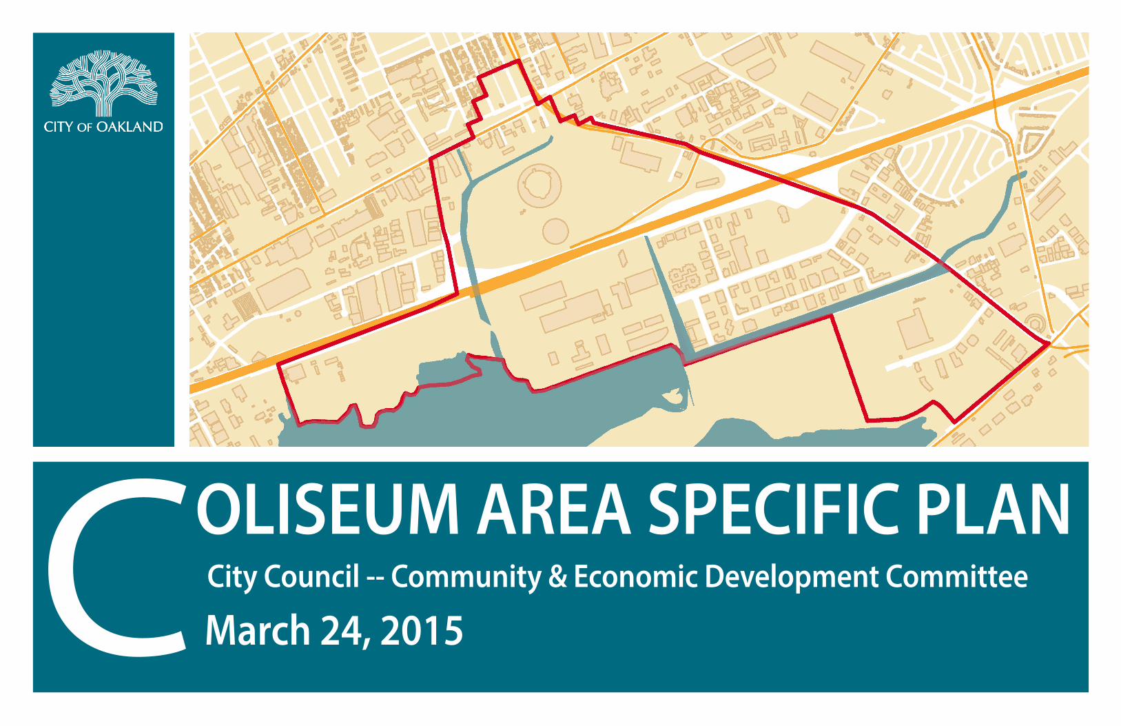
City Council -- Community & Economic Development Committee
March 24, 2015
OLISEUM AREA SPECIFIC PLANC
COLISEUM AREA SPECIFIC PLAN
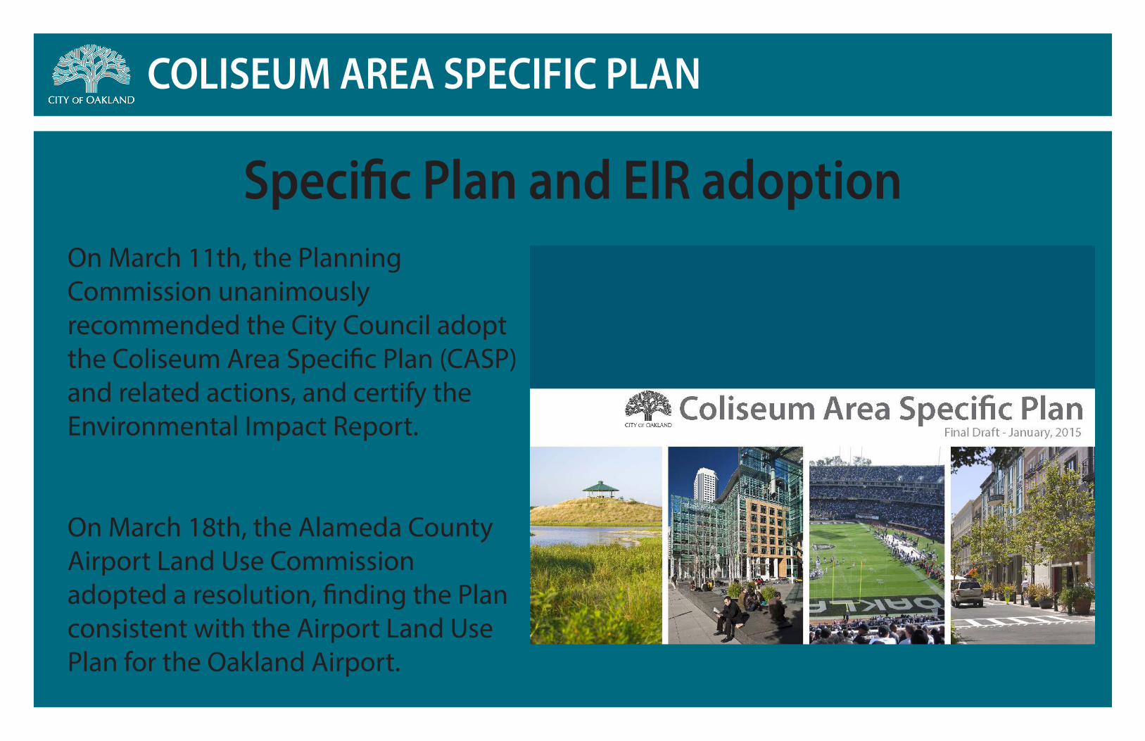
On March 11th, the Planning Commission unanimously recommended the City Council adopt the Coliseum Area Specific Plan (CASP) and related actions, and certify the Environmental Impact Report.
On March 18th, the Alameda County Airport Land Use Commission adopted a resolution, finding the Plan consistent with the Airport Land Use Plan for the Oakland Airport.
Specific Plan and EIR adoption

COLISEUM AREA SPECIFIC PLAN
Scenario #1 & 2New Stadium and Ballpark + Renovated Arena
LAND USE Chapter 3
48
Figure 3.5: New Stadium and Ballpark + Existing Arena (Coliseum City Master Plan Concept)
MLB NFL
Figure 3.4: New Stadium, Ballpark, and Arena (Coliseum City Master Plan Concept)
PLA
N V
IEW
BIRD
’S E
YE V
IEW
SCENARIO #1: NEW STADIUM, BALLPARK AND ARENA
SCENARIO #2: NEW STADIUM AND BALLPARK AND EXISTING ARENA
MLB NFL
NBA

COLISEUM AREA SPECIFIC PLAN
New Stadium, New Ballpark & Renovated Arena
C i t y o f O a k l a n d J R D V U r b a n I n t e r n a t i o n a l O c t o b e r 2 0 1 4
View of Spor ts Distr ict
COLISEUM AREA SPECIFIC PLAN
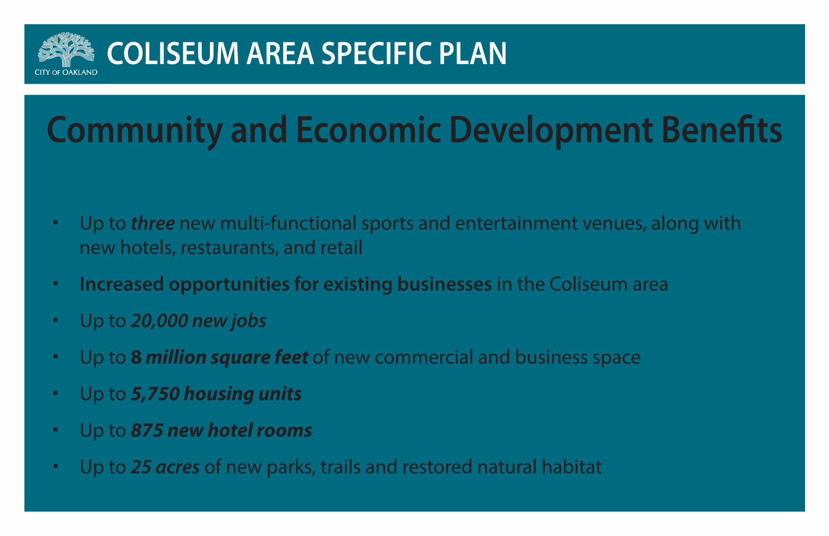
Up to three new multi-functional sports and entertainment venues, along with new hotels, restaurants, and retail
Increased opportunities for existing businesses in the Coliseum area
Up to 20,000 new jobs
Up to 8 million square feet of new commercial and business space
Up to 5,750 housing units
Up to 875 new hotel rooms
Up to 25 acres of new parks, trails and restored natural habitat
Community and Economic Development Benefits

COLISEUM AREA SPECIFIC PLAN
Development with the Plan includes:
20,000 new permanent jobs , across a wide-range of industries
• 50% of the new permanent jobs estimated to be entry-level, mid-level and blue-collar occupations not requiring higher education
• Plan focuses on retaining existing businesses, and increasing traditional employment sectors
• Local hiring and job-training policies
24,000 temporary construction jobs are estimated to be created
2,300 current jobs could be lost if all three sports teams leave
Jobs and Employment
COLISEUM AREA SPECIFIC PLAN
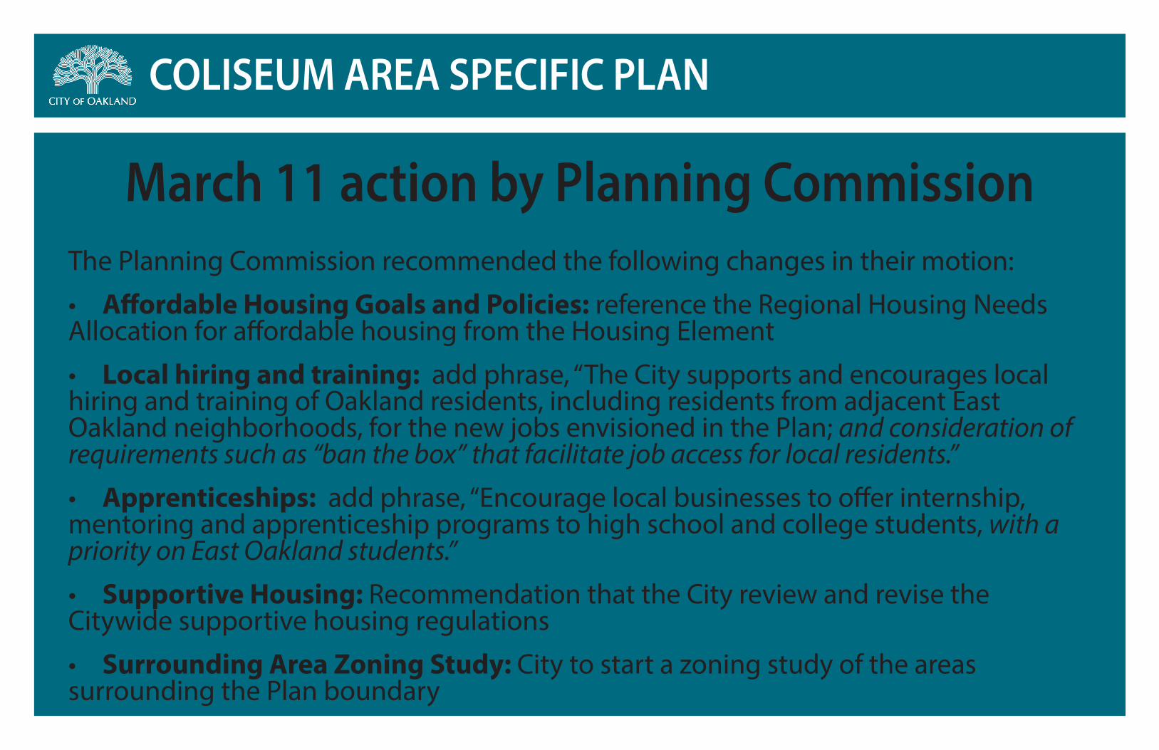
The Planning Commission recommended the following changes in their motion:
• Affordable Housing Goals and Policies: reference the Regional Housing Needs Allocation for affordable housing from the Housing Element
• Local hiring and training: add phrase, “The City supports and encourages local hiring and training of Oakland residents, including residents from adjacent East Oakland neighborhoods, for the new jobs envisioned in the Plan; and consideration of requirements such as “ban the box” that facilitate job access for local residents.”
• Apprenticeships: add phrase, “Encourage local businesses to offer internship, mentoring and apprenticeship programs to high school and college students, with a priority on East Oakland students.”
• Supportive Housing: Recommendation that the City review and revise the Citywide supportive housing regulations
• Surrounding Area Zoning Study: City to start a zoning study of the areas surrounding the Plan boundary
March 11 action by Planning Commission
COLISEUM AREA SPECIFIC PLAN
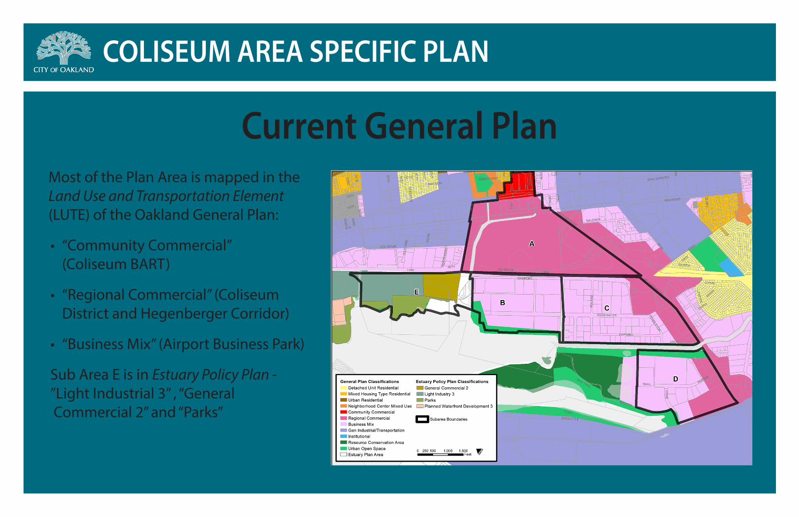
Most of the Plan Area is mapped in the Land Use and Transportation Element (LUTE) of the Oakland General Plan:
• “Community Commercial” (Coliseum BART)
• “Regional Commercial” (Coliseum District and Hegenberger Corridor)
• “Business Mix” (Airport Business Park)
Sub Area E is in Estuary Policy Plan - ”Light Industrial 3” , “General Commercial 2” and “Parks”
Current General Plan
COLISEUM AREA SPECIFIC PLAN
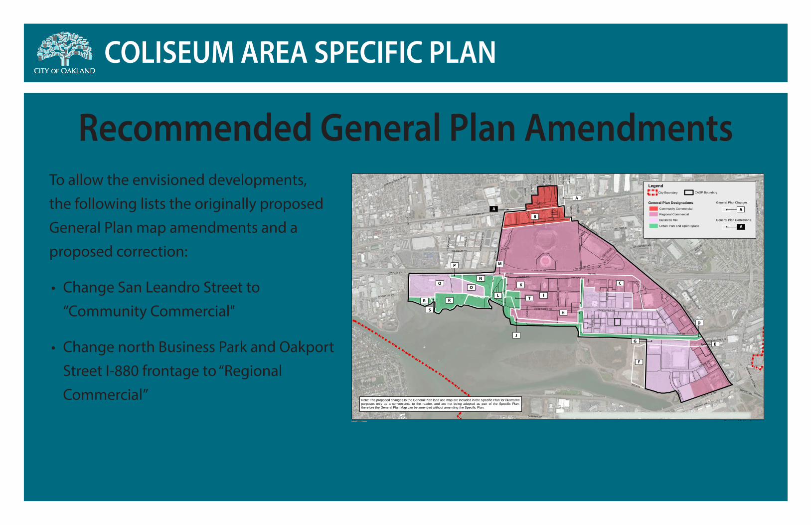
To allow the envisioned developments, the following lists the originally proposed General Plan map amendments and a proposed correction:
• Change San Leandro Street to “Community Commercial"
• Change north Business Park and Oakport Street I-880 frontage to “Regional Commercial”
Recommended General Plan Amendments
SAN LEANDRO ST
DOOLITTLE DR
WALTER
92N
D
100TH
PIPPIN
NE
VAD
A
PRU
NE
LOU
ISIANA
SB I880 NB I880
SAN LEANDRO ST
EDES AV
HEGENBERG
ER RD
85TH AV
OAKPORT ST
COLISEUM WY
ACCESS
RAILROAD AV
EDGEWATER DR
EARHART DR
PARDEE DR
57TH AV
69TH AV
CAPWELL DR
S COLISEUM WY
SWAN
WY
BALDWIN ST
75TH AV
SNELL ST
RO
LAN
D W
Y
71ST AV70TH
AV
LEET DR
INTERNATIONAL BLVD
ZHONE WY
TIDEWATER AV
HAWLEY ST
66TH
AV
AIRPORT DR
TYLE
R S
T
HA
SS
LER
WY
EARHART RD
PAR
DE
E L
N
MADDUX DR
ENTERPRISE WYKE
VIN
CT
DO
UG
LAS
AV
S E
LMH
UR
ST AV
AIRPO
RT AC
CESS R
D
JULI
E A
NN
WY
72ND
AV
COLLINS D
R
73RD
AV
76TH AV
PENDLETON W
Y
HEGENBERG
ER LOO
P
IND
EP
EN
DE
NT
RD
CARY CT
HEGENBERGER PL
LYNDHURST ST
DR
IVE
WAY
COLISEUM WY
76TH AV
CLA
RA S
T
HEGENBERGER RD
OAKPORT ST
66TH
AV
EDGEWATER DR
54TH AV
77TH AV
ACCESS
AIRPORT DR
73RD
AV
Source: Esri, DigitalGlobe, GeoEye, i-cubed, USDA, USGS, AEX, Getmapping, Aerogrid, IGN, IGP, swisstopo, and the GIS User Community
Figure 4.9-6: Proposed General Plan Amendments
Planning and Building DepartmentMarch 20150 ¼ ½
Mile °
Legend
General Plan DesignationsCommunity Commercial
Regional Commercial
Business Mix
Urban Park and Open Space
General Plan Changes
General Plan Corrections
CASP BoundaryCity Boundary
COLISEUM AREA SPECIFIC PLAN
Note: The proposed changes to the General Plan land use map are included in the Specific Plan for illustrativepurposes only as a convenience to the reader, and are not being adopted as part of the Specific Plan,therefore the General Plan Map can be amended without amending the Specific Plan.
ADMINISTRATIVE DRAFT NOT FOR PUBLIC REVIEW
A
A
A
B
N
P
S
RL
M
H
J
F
GE
D
C
I
QO
A
K
R T
COLISEUM AREA SPECIFIC PLAN
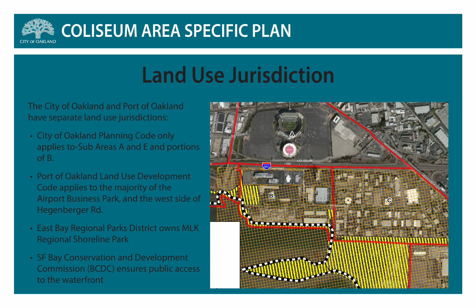
Land Use JurisdictionThe City of Oakland and Port of Oakland have separate land use jurisdictions:
• City of Oakland Planning Code only applies to-Sub Areas A and E and portions of B.
• Port of Oakland Land Use Development Code applies to the majority of the Airport Business Park, and the west side of Hegenberger Rd.
• East Bay Regional Parks District owns MLK Regional Shoreline Park
• SF Bay Conservation and Development Commission (BCDC) ensures public access to the waterfront
§̈¦
98TH
I 880
EDES
SAN LEANDRO
DOOLITTLE
85TH
66TH
OAKPORT
HEGENBERGER
EDGEWATER
COLISEUM
RAILROAD
SWA
N
PARDEE
LEET
SNELL
BALDWIN
WALTER
92N
D
TYLER
CA
SW
ELL
HA
SSL
ER
100TH
MADDUX
ASH
TON
ELMH
UR
ST
PIPPIN
NE
VAD
A
ENTERPRISE
86TH
BUR
LWO
OD
PRU
NE
COLLINS
KITTY
LOU
ISIAN
A
IND
EP
END
ENT
CARY
ENTRANCE
MC
CLAR
Y
PAR
DEE
HEGENBERGER
66TH
I 880
98THCOLISEUM
CLAR
A
A
C
D
B
E
880
Source: Esri, DigitalGlobe, GeoEye, i-cubed, USDA, USGS, AEX, Getmapping, Aerogrid, IGN, IGP,swisstopo, and the GIS User Community
COLISEUM AREA SPECIFIC PLANCity of Oakland, Department of Planning and Building
January 2014
Agency Jurisdictions
0 500 1,000 1,500Feet ²
BCDC Jurisdiction
East Bay Regional Parks
Port of Oakland jurisdiction
Subarea Boundaries
ALUC Airport Influence Area

COLISEUM AREA SPECIFIC PLAN
• City of Oakland Planning Code only applies to Sub Areas A & E and portions of B
• Proposing the creation of new “D-CO” zones 1-6
• Zoning map changes to allow major sports facilities and new residential and commercial uses; and conditionally permit residential and hotels on a portion of the San Leandro Bay waterfront
• Open Space (OS) map changes clean up industrial zoning at waterfront from 1960’s; map Edgewater Seasonal Wetland as Open Space
Recommended Zoning Amendments
OS
OS
OS
OSD-CO-3
D-CO-5OS
D-CO-2
D-CO-1
D-CO-6
D-CO-3
D-CO-3
D-CO-5
DOOLITTLE DR
D-CO-4
100TH
PIPPIN
NE
VAD
A
PRU
NE
SB I880 NB I880
SAN LEANDRO ST
HEGENBERG
ER RD
85TH AV
OAKPORT ST
COLISEUM WY
ACCESS
EDGEWATER DR
EARHART DR
PARDEE DR
57TH AV
69TH AV
CAPWELL DR
S COLISEUM WY
SWAN
WY
BALDWIN ST
75TH AV
SNELL ST
RO
LAN
D W
Y
71ST AV70TH
AV
LEET DR
INTERNATIONAL BLVD
ZHONE WY
TIDEWATER AV
HAWLEY ST
66TH
AV
AIRPORT DR
TYLE
R S
T
HA
SS
LER
WY
EARHART RD
PAR
DE
E L
N
MADDUX DR
ENTERPRISE WYKE
VIN
CT
DO
UG
LAS
AV
AIRPO
RT AC
CESS R
D
JULI
E A
NN
WY
72ND
AV
COLLINS D
R
73RD
AV
76TH AV
PENDLETON W
Y
HEGENBERG
ER LOO
P
IND
EP
EN
DE
NT
RD
CARY CT
HEGENBERGER PL
LYNDHURST ST
DR
IVE
WAY
COLISEUM WY
76TH AV
HEGENBERGER RD
OAKPORT ST
66TH
AV
EDGEWATER DR
54TH AV
77TH AV
ACCESS
AIRPORT DR
73RD
AV
Source: Esri, DigitalGlobe, GeoEye, i-cubed, USDA, USGS, AEX, Getmapping, Aerogrid, IGN, IGP, swisstopo, and the GIS User Community
Figure 4.9-7: Proposed Zoning Code Amendments
Planning and Building DepartmentMarch 20150 ¼ ½
Mile °
COLISEUM SPECIFIC AREA PLAN
Note: The proposed changes to the Zoning Map are included in the Specific Plan for illustrative purposesonly as a convenience to the reader, and are not being adopted as part of the Specific Plan, therefore theZoning Map can be amended without amending the Specific Plan.
ADMINISTRATIVE DRAFT NOT FOR PUBLIC REVIEW
New Zoning
Legend
Zoning Changes
CASP Boundary
City Boundary
D-CO-6
D-CO-5
D-CO-4
D-CO-3
D-CO-2
D-CO-1
OS
6
4
5
1
7
8
10
9
11
12
13
15
16
18
2122
23
24
2726
3
28
19
25
1
14
17
2
20
COLISEUM AREA SPECIFIC PLAN
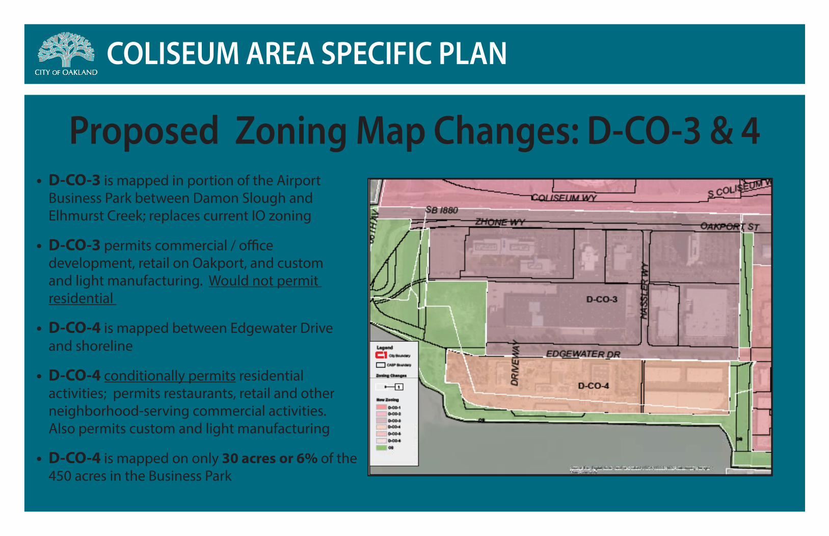
• D-CO-3 is mapped in portion of the Airport Business Park between Damon Slough and Elhmurst Creek; replaces current IO zoning
• D-CO-3 permits commercial / office development, retail on Oakport, and custom and light manufacturing. Would not permit residential
• D-CO-4 is mapped between Edgewater Drive and shoreline
• D-CO-4 conditionally permits residential activities; permits restaurants, retail and other neighborhood-serving commercial activities. Also permits custom and light manufacturing
• D-CO-4 is mapped on only 30 acres or 6% of the 450 acres in the Business Park
Proposed Zoning Map Changes: D-CO-3 & 4
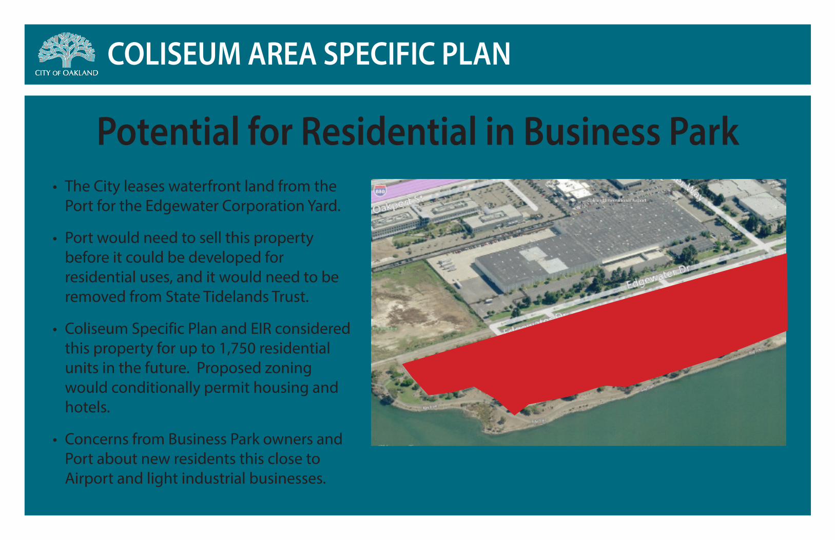
COLISEUM AREA SPECIFIC PLAN
• The City leases waterfront land from the Port for the Edgewater Corporation Yard.
• Port would need to sell this property before it could be developed for residential uses, and it would need to be removed from State Tidelands Trust.
• Coliseum Specific Plan and EIR considered this property for up to 1,750 residential units in the future. Proposed zoning would conditionally permit housing and hotels.
• Concerns from Business Park owners and Port about new residents this close to Airport and light industrial businesses.
Potential for Residential in Business Park

COLISEUM AREA SPECIFIC PLAN
Next StepsUpcoming Public Hearings and Meetings to consider adopting Final Plan and EIR:
•City Council hearings:
•March 31st (Full Council: First Reading of Zoning; Adoption of Specific Plan; Adoption of General Plan Amendments and Certification of EIR)
•April 21st (Full Council: Second Reading of Zoning)