colonias investment areas: working toward a better
TRANSCRIPT
© 2020 Fannie Mae 12.14.20 Page 1 of 44
Colonias Investment Areas:
Working Toward a Better
Understanding of Colonia
Communities for Mortgage
Access and Finance
Housing Assistance Council
November 2020

© 2020 Fannie Mae 12.14.20 Page 2 of 44
The Housing Assistance Council
November 2020
1025 Vermont Avenue, NW
Suite 606
Washington, DC 20005
202-842-8600
ruralhome.org
This report was prepared by the Housing Assistance Council (HAC). Keith Wiley and Lance George are the principal
researchers and authors of this report. Isabella Green, Stevenson Center Fellow, contributed to the analysis and research.
Kelly Cooney of HAC provided editorial assistance and review. The work that provided the basis for this document was
delivered through a Statement of Work with Fannie Mae. Sam Lipshutz served as Fannie Mae’s Program Lead. Additional
support was provided by Kellie Coffey. HAC appreciates their support and assistance. HAC is solely responsible for the
accuracy of the statements and interpretations contained in this document, and such interpretations do not necessarily
reflect the views of Fannie Mae.
The Housing Assistance Council (HAC) is grateful to the many people who contributed to this report. The preparation of this report
spanned multiple years, thousands of miles traveling across rural America, numerous interviews and telephone calls, and untold
of hours of data analysis. While it is not possible to properly acknowledge everyone who offered their assistance, the following
people are among those who assisted this project: Thomas A. Ricks, III, Director of Environmental Services — RCAP Communities
Unlimited, Inc.; Steve Whitney, GIS Manager, Pima County Arizona Information Technology, GIS Dept.; Peter Gardner, Planner,
Cochise County Arizona Planning Dept.; Celso Montes, GIS Manager, Graham County Arizona Information Technology, GIS Dept.;
Suzan Reagan, Senior Program Manager, University of New Mexico Bureau of Business and Economic Research; and Kyle Gavit,
Public Information Coordinator’s Office, Office of the Attorney General of Texas.
The Housing Assistance Council (HAC) is a national nonprofit corporation that helps build homes and communities across rural
America. For nearly 50 years, HAC has supported local efforts to improve rural housing conditions.
HAC is an equal opportunity employer and housing provider.
Resources
2020 Colonias Investment Areas Data File
Colonias Investment Areas Visualization Tool and Map
Executive Summary

© 2020 Fannie Mae 12.14.20 Page 3 of 44
Colonias Investment Areas
Abstract
In the United States, the term “colonias” has been applied generally to unincorporated communities along the U.S.-Mexico border
in California, Arizona, New Mexico, and Texas that are characterized by high poverty rates and substandard living conditions. In
practical terms, colonias are defined primarily by what they lack — potable drinking water, water and wastewater systems, paved
streets, and standard mortgage financing.
To address the poverty and lack of infrastructure present in communities along the border and to target funding to these areas,
several federal agencies and policymakers have developed geography-based definitions of colonias over time. These
governmental definitions vary, and the criteria of what exactly constitutes a colonia continue to be challenging.
The Housing Assistance Council developed the concept of “Colonias Investment Areas” to improve comprehensive understanding
and definition of colonias for the purpose of home mortgage finance. The ultimate goal of this research was to create a usable and
programmatic definition of colonias so that mortgage and finance resources may be more efficiently directed to these often
overlooked and long-struggling communities.
Colonias Investment Areas
Executive Summary
The Housing Assistance Council developed the concept of “Colonias Investment Areas” to better inform a comprehensive
understanding and definition of colonias specifically related to the provision of home mortgage finance in this region. The goal
of this research is to develop a comprehensive, usable, and uniform definition of colonias to inform the targeting of mortgage
and finance resources so they can be more efficiently directed to these often overlooked and long-struggling communities.
• Colonias are not monolithic. Despite being categorized together, colonias vary extensively within the border region,
from small clusters of homes located near agricultural employment opportunities to established communities in and
near urban centers. Most importantly, this study reinforces important structural differences on how colonias were
originally defined and comprised in each of the four border states of Texas, New Mexico, Arizona, and California. An
important element of the Colonias Investment Area development included analysis and attention at the individual
state level.
• Colonias Investment Areas were constructed through a data-driven process that focused on unique elements of
these communities. The approach to develop Colonias Investment Areas and determine which census tracts contain
colonias involved six basic processes, including: 1) Identification of publicly recognized colonias; 2) Geolocating
colonias for mapping and geospatial analysis; 3) Aggregation of an individual colonia into Colonias Investment Areas;
4) Compilation of state-level data into a comprehensive and enhanced database; 5) Exploration of social, economic,
housing, and mortgage finance characteristics for Colonias Investment Areas; and 6) Expert and stakeholder feedback
on the concept of Colonias Investment Areas.
• Census tracts are the building blocks for Colonias Investment Areas. The Colonias Investment Areas concept
primarily relies on the U.S. Census Bureau’s census tract designation as its geographic unit of analysis. While there are
pros and cons with any unit of geography, the research relies on census tracts because sub-county units of geography are
often more precise and uniform indicators of rurality than counties. In addition, tracts align with already established Duty
to Serve criteria as a unit of measurement, and the use of tracts allows for market analysis as well as future assessment of
mortgage lending activity.
© 2020 Fannie Mae 12.14.20 Page 4 of 44
• There are 446 distinct Colonias Investment Areas. The identified Colonias Investment Areas comprise approximately
6 percent of the U.S.-Mexico border region’s census tracts. Overall, Colonias Investment Areas contain approximately
2.5 million people across four states.
• Colonias Investment Areas are in rural and urban communities. Approximately half of Colonias Investment Areas
are in rural census tracts,* yet a substantial number of Colonias Investment Areas are in what would be considered
suburban or even urban tracts — especially in Texas.
• Rural Colonias Investment Areas have the greatest needs. While economic, housing, and mortgage access deficits
are generally present in any colonia regardless of location, these conditions are consistently more acute in rural
Colonias Investment Areas, especially in elements of current mortgage activity and investment.
• Colonias Investment Areas are most common in Texas. Texas is home to 61 percent of all Colonias Investment
Areas. While 33 different counties in Texas have at least one colonia, these communities are largely concentrated in a
few areas — notably the lower Rio Grande Valley. Still, each of the four border states contain a substantial number of
Colonias Investment Areas. The relatively broad coverage of these communities, despite different demographic and
housing characteristics, indicates that colonias are not solely in Texas.
• Colonias Investment Areas are some of the most impoverished markets in the nation. Incomes are low across the
border region. Wages are depressed as a result of the proximity to low-wage workers in border areas of Mexico. The
U.S. poverty rate is an estimated 15 percent, while the aggregate Colonias Investment Area poverty rate is nearly twice
that national rate at 27 percent. The research findings overwhelmingly indicate that Colonias Investment Areas
experience some of the greatest challenges and needs in the region, as well as the nation, and are therefore
appropriately targeted as an indicator of an underserved market.
• Housing conditions play a central role in the recognition and designation of colonias. In many colonias, the
substandard conditions are largely the result of an old, deteriorating housing stock, while the newer colonias contain
homes lacking basic infrastructure. Households living in Colonias Investment Areas are primarily homeowners.
• Nonconventional financing dynamics lead to an asymmetric financing system in Colonias Investment Areas.
Many border residents use informal or nonconventional financing mechanisms to obtain homeownership. This is an
indication of the gap in traditional financing available to low-income and immigrant populations. In some cases, there
may be few conventional financial institutions in remote rural areas. Another likely contributor is the large immigrant
population, which may be unfamiliar with services offered by banks or who are simply unsure of such arrangements.
• There is a dearth of mortgage lending activity in Colonias Investment Areas. Colonias Investment Areas have
substantially lower rates of conventional mortgage lending compared to nearly any market in the border region or
nationwide. To make lending activity comparisons, the analysis explored lending activity as the number of loan
originations per thousand owner-occupied homes. The amount of lending in Colonias Investment Areas — using
owner-occupied units to standardize the measure — is half the rate of the larger U.S.-Mexico border region. Loan
activity is nearly three times lower in rural Colonias Investment Areas compared to the larger border region, according
to Home Mortgage Disclosure Act (HMDA) data.
* Rural by the Federal Housing Finance Authority (FHFA) definition for Duty to Serve program:
www.fhfa.gov/DataTools/Downloads/Pages/Duty-to-Serve-Data.aspx.

© 2020 Fannie Mae 12.14.20 Page 5 of 44
• Manufactured home lending is highly prevalent in Colonias Investment Areas. Manufactured homes are an
important part of housing in both the border region as a whole and Colonias Investment Areas in particular. A review of
HMDA data finds that loans involving manufactured homes represent a relatively large share of lending in rural areas in
general and are even more prevalent in Colonias Investment Areas. Approximately 15 percent of all home loan
originations in rural Colonias Investment Areas involved a manufactured home, which is more than twice the
percentage for rural areas in general.
• High-cost lending is common in Colonias Investment Areas. For each border state, high-cost (or high interest rate)
lending was more common in Colonias Investment Areas than in non-Colonias Investment Areas. These levels of high
interest rate lending are yet another indicator of extreme deficiency in access to conventional mortgage finance. It is
important to note that, per HAC’s analysis of HMDA data, while homeownership is generally high in these markets, a
portion of these households may have home or land financing elements that charge high fees or include usury terms
and fees.
• Colonias Investment Areas originate fewer conventional loans and rely more on government-backed mortgage
resources. Colonias Investment Areas have a much smaller share of conventional loans. In the U.S. and larger border
region, about three-quarters of originations were conventional loans, but for Colonias Investment Areas, it was slightly
more than 50 percent. The difference was made up by higher shares of FHA-, VA-, and USDA-guaranteed loans.
• Colonias Investment Areas are intended to inform and enhance access to conventional mortgage finance in
colonias communities and the border region. While no geographic designation is perfect, extensive research,
analysis, testing, and stakeholder feedback reinforce the concept and elements of Colonias Investment Areas as a
reliable mechanism to inform and provide more targeted and efficient delivery of home mortgage resources and
finance access to long-overlooked border colonia communities.
© 2020 Fannie Mae 12.14.20 Page 6 of 44
Background on Colonias
In the United States, the term “colonias” has been applied generally to unincorporated communities located in California,
Arizona, New Mexico, and Texas along the U.S.-Mexico border that are characterized by high poverty rates and substandard
living conditions. In practical terms, colonias are defined primarily by what they lack, such as potable drinking water, water
and wastewater systems, paved streets, and conventional mortgage financing.
Despite being categorized together, colonias vary extensively within the border region, from small clusters of homes located near
agricultural employment opportunities to established communities whose residents commute to nearby urban centers.1 Colonias
have varied histories. Some emerged in the last 50 years, but others have been in existence since the 19th century. The unmet need
for affordable housing was a key factor driving the demand for homes in colonia developments in both recent and historic
colonias.2 Various other factors led colonia development within each border state. The increased visibility of colonias in Texas,
however, tends to guide common perceptions and even government policy based on the situations of colonias found there.3
Colonias largely resulted from lax land regulations, particularly over the last few decades.4 For much of the 20th century, county
governments lacked the power to regulate the subdivision of land that lies outside the jurisdiction of city governments. Without
these controls in place, landowners were able to subdivide and sell their property through a range of methods without the
necessary infrastructure.5
Also impacting the proliferation of colonias, particularly in Texas, was the contract for deed system. Through a contract for
deed, the buyer makes payments directly to the developer while the land title remains with the developer until the amount is
paid in full. These arrangements often involve high interest rates, and many are not recorded with the county clerk.6 If even one
payment is missed, the developer may foreclose on a property and the buyer loses his or her entire investment.7
A variety of settlements have been designated colonias in Arizona, California, and New Mexico, including those on Native
American lands, in old mining towns, and in retirement communities. Colonias in Arizona, California, and New Mexico are
generally older than those found in Texas.8 In Arizona, “wildcat” subdivisions emerged in the 1950s and differ in several ways
from patterns for Texas’ colonias. Many New Mexico colonias have been in existence since the mid-1800s, and all California
colonias were developed prior to 1929, when subdivision laws went into effect in that state.9 Additionally, New Mexico’s historic
settlements are experiencing new fringe growth in the form of illegal subdivisions similar to those created in Texas under
contract for deed arrangements.10
Defining “Colonias” — Previous and Existing Efforts
Beginning in the late 1980s and early 1990s, federal and local governments sought to address the problems associated with
existing unregulated and substandard developments and stop the creation of additional ones. Local and state governments
acted to improve the living conditions in these settlements by designating communities as colonias, making them eligible for
certain types of federal assistance. In some cases, these identification efforts included state governments and federal agencies
mapping colonia locations and linking various data sources together to better manage assistance efforts.
Much of the work identifying colonias communities was initiated by federal government agencies and state governments.11
When federal government funds started being dedicated to addressing living conditions in border colonias (Cranston-Gonzalez
National Affordable Housing Act of 1990), government entities worked to better understand where colonias communities were
located and the type and level of need required to help them. Researchers also credit the debate over passage of the North
American Free Trade Agreement (NAFTA) in the early 1990s with putting a national spotlight on the border colonias region and,
as a result, stimulating efforts to improve living conditions in the colonias that led to increased government involvement.12
Prior to the late 1980s, the issue of identifying border colonias received little to no attention.

© 2020 Fannie Mae 12.14.20 Page 7 of 44
Cranston-Gonzalez National Affordable Housing Act definition of colonias
The Cranston-Gonzalez National Affordable Housing Act, one of the most recent large-scale pieces of affordable housing
legislation, also served as a primary benchmark for defining colonias in the United States. Under the Act, colonias are defined:
“[A]s an identifiable community that (A) is in the State of Arizona, California, New Mexico, or Texas; (B) is in
the area of the United States within 150 miles of the U.S.-Mexico border (not including any standard MSA with
a population exceeding 1 million), or is in the United States-Mexico border region (the applicable criterion
depends on the particular housing program); (C) is determined to be a colonia on the basis of objective
criteria, including lack of potable water supply, lack of adequate sewage systems, and lack of decent, safe,
and sanitary housing; and (D) was in existence as a colonia before November 28, 1990.”
With this seminal entry into the issue of housing in colonias, the federal law and its corresponding language have been used as
underpinning (or replicated) for many definitions and classifications regarding the U.S. Mexico border and colonias communities
in research, policy, and governmental programs and efforts.

© 2020 Fannie Mae 12.14.20 Page 8 of 44
U.S. Department of Housing and Urban Development (HUD) list of designated colonias
While there is no agreed upon definition of colonias, different states and agencies have their own definitions.13 HUD’s approach
(which relies on the Cranston-Gonzalez Act language) is the most often cited:
“Colonias are rural communities [outside of metropolitan area of 1 million people or more] and
neighborhoods located within 150 miles of the U.S.-Mexican border that lack adequate sewer, water, and/or
housing. These areas also typically lack other basic services like electricity, garbage service, water drainage,
schools, and community facilities.”14
The “border colonias region” then refers to the area within 150 miles of the border, excluding the large metropolitan areas.
This geographic distinction is important given that research suggests similar types of development may occur in other areas,
but they would not be considered colonias.15
A key component of these policymaker efforts are requirements that local governments identify communities as colonias to be
eligible to receive certain federal funding. Specifically, HUD requires the four U.S.-Mexico border states use 10 percent of their
Community Development Block Grant (CDBG) monies on border colonias. HUD makes publicly available a list of designated
colonias for Arizona, California, and New Mexico.16 The HUD colonia list for Texas redirects the user to the Texas Secretary of
State webpage link for their information. These lists represent all recognized colonias that fit within the HUD definition.
There are a few important considerations regarding HUD-designated colonias listings. The state lists may not always precisely
capture colonias. For example, the city of Douglas, Arizona, is listed as a colonia in its entirety, but a U.S. Geological Survey (USGS)
effort at mapping colonias in this town identifies specific neighborhoods, not the entire community.17 The state lists, particularly
when they refer to unincorporated areas, are not easily identified. For example, one unincorporated California colonia is listed as
simply “Subdivision.” While incorporated colonias might be relatively easy to link to census geographies (census tracts, block
groups, etc.), additional work would be needed to identify and link the unincorporated areas with census geographies.
Stemming from the Consolidated Farm and Rural Development Act, USDA’s Rural Utility Service defines colonias as:
“Any identifiable community designated in writing by the State or county in which it is located;
determined to be a colonia on the basis of objective criteria, including lack of potable water supply,
lack of adequate sewage systems, and lack of decent, safe, and sanitary housing, inadequate roads
and drainage; and existed and was generally recognizes as a colonia before October 1, 1989.”

© 2020 Fannie Mae 12.14.20 Page 9 of 44
Why reinvestigate colonias definitions now?
The border colonias region has traditionally been overlooked not only in terms of investment, but also in research and
discourse. Like several other predominantly rural regions of the nation, the border colonias can be considered forgotten
America. Among the financial policies developed in response to the Great Recession, Congress enacted legislation in 2008 that
established a “Duty to Serve” requirement. The Housing and Economic Recovery Act of 2008 mandates that Fannie Mae and
Freddie Mac have a “Duty to Serve” three traditionally underserved markets of: rural housing, manufactured housing, and
affordable housing preservation. Fannie Mae and Freddie Mac are tasked with increasing liquidity and investment capital in
these markets. The final Duty to Serve rule18 promulgated by the Federal Housing Finance Agency (FHFA) provides guidance on
how to define rural areas and high-needs rural regions in order to increase government-sponsored enterprise (GSE — Fannie
Mae and Freddie Mac) Duty to Serve-eligible activities. Throughout this report, tables and figures relying on the term “rural”
shall be using the definition of “rural area” as defined in the final Duty to Serve rule:
Section 1282.1 of the final rule defines “rural area” as: (1) A census tract outside of a me tropolitan statistical
area (MSA) as designated by the Office of Management and Budget (OMB); or (2) a census tract in an MSA but
outside of the MSA’s Urbanized Areas as designated by the U.S. Department of Agriculture’s (USDA) Rural -
Urban Commuting Area (RUCA) Code #1,19 and outside of tracts with a housing density of more than 64
housing units per square mile in USDA's RUCA Code #2.20
For some of the high-needs rural regions and populations identified in the regulation, including Middle Appalachia, the Lower
Mississippi Delta, Native American lands, farmworkers, and persistent poverty areas, FHFA provided relatively detailed definitions
for targeting and assessment under the rule. Guidance for the colonias definition, on the other hand, did not include detailed lists
of colonia communities.
After considering the comments and the varying definitions of ‘‘colonia,’’ FHFA determined that broadening the proposed
definition of ‘‘colonia’’ could encourage Enterprise support for colonias, as defined by federal, state, tribal, or local programs.
Therefore, FHFA set forth Section 1282.1 of the final Duty to Serve rule defining a ‘‘colonia’’ as:
“[A]n identifiable community that meets the definition of a colonia under a federal, state, tribal, or local program.”
In its 2016 Duty to Serve Final Rule,21 FHFA specifically discusses the limitations with some of the more common colonia-
focused government program definitions that are not operationalized similarly. As such, one definition or approach might
include a community as a colonia, while another definition would not. FHFA noted it would be unable to provide a data file
that lists all census tracts that are eligible under the final rule’s definition of “colonia,” as it did for the other high -needs rural
regions. To address the data challenges that exist in specifically identifying the census tracts that contain colonias, FHFA
encouraged the Enterprises to collect and share granular data with researchers, lenders, and housing providers regarding
GSE purchases of loans that are made under any HUD or USDA programs that serve a colonia, are eligible for Duty to Serve
credit under this Regulatory Activity (provided they are located in a “rural area” as defined in the final rule), and are for very
low-, low-, or moderate-income households as defined under the Duty to Serve rule. This study uses these FHFA Final Rule
comments to guide our efforts at identifying Colonias Investment Areas. T he Colonias Investment Areas definition is not the
definition of colonias that FHFA is currently using to determine eligibility for GSE Duty to Serve credit, which also requires a
colonia to be in a rural area as defined in the DTS regulation.

© 2020 Fannie Mae 12.14.20 Page 10 of 44
Identifying and Classifying Colonias Investment Areas
The approach to developing Colonias Investment Areas and determining which census tracts contain colonias involved six
basic processes:
1. Identification: Create a universal list of officially recognized colonias from existing lists of colonias established by
federal, state, tribal, or local governments.
2. Location: Geolocate the recognized colonias records on a map.
3. Aggregation: Identify census tracts containing recognized colonia(s).
4. Compilation: Consolidate disparate data into one uniform Colonias Investment Area database.
5. Exploration: Preliminary analyses to better understand basic social, economic, housing, and mortgage finance
elements of the constructed Colonias Investment Areas and compare them to larger regional and national dynamics.
6. Feedback: Expert and stakeholder feedback on the concept of Colonias Investment Areas.
1. Identifying individual colonias
FHFA’s Final Duty to Serve Rule notes that a colonia needs to meet “the definition of a colonia under a federal, state, tribal, or
local program.”22 Using a similar approach, this research only considers as colonia(s) communities those that a federal, state, or
local government has identified as a colonia (researchers did not identify tribally designated colonias programs as part of its
substantial industry engagement and qualitative research). Classification as a colonia by a government entity often indicates
the community qualifies for a program or resource specifically targeting colonias. Throughout this report, the term “recognized
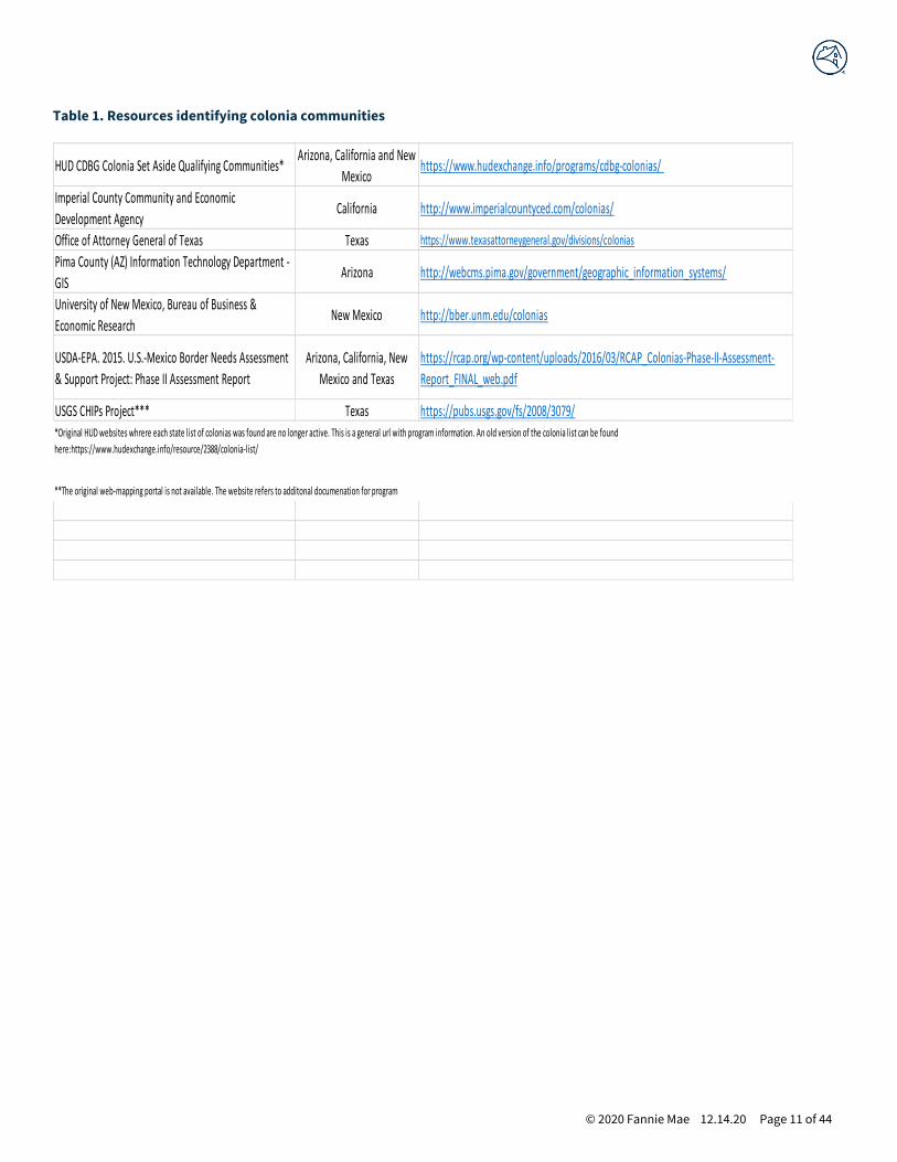
colonia” refers to these government-identified colonia. Table 1 below enumerates the various colonia communities identified
by federal, state, or local governments. For the most current updates, revisions, and information about this source data, refer to
the source websites listed below. For this research, HAC utilized the most current data available as of 2018.
There is no universal list of recognized colonias. The research created a separate list for each U.S.-Mexico border state by
compiling disparate federal, state, and local government lists of colonias. As an example, creating the Arizona list required a
consolidation of information on recognized colonias from HUD, USDA-EPA, Arizona Department of Housing, Cochise County,
Graham County, and Pima County.23 The process of identifying colonias involved collecting and categorizing all unique cases of
communities identified by multiple resources, with no preference made for one resource over another. Through this process,
the study identified 2,459 unique colonias records in the four states along the U.S.–Mexico border.24
© 2020 Fannie Mae 12.14.20 Page 11 of 44
Table 1. Resources identifying colonia communities
HUD CDBG Colonia Set Aside Qualifying Communities*Arizona, California and New
Mexicohttps://www.hudexchange.info/programs/cdbg-colonias/
Imperial County Community and Economic
Development AgencyCalifornia http://www.imperialcountyced.com/colonias/
Office of Attorney General of Texas Texas https://www.texasattorneygeneral.gov/divisions/colonias
Pima County (AZ) Information Technology Department -
GISArizona http://webcms.pima.gov/government/geographic_information_systems/
University of New Mexico, Bureau of Business &
Economic ResearchNew Mexico http://bber.unm.edu/colonias
USDA-EPA. 2015. U.S.-Mexico Border Needs Assessment
& Support Project: Phase II Assessment Report
Arizona, California, New
Mexico and Texas
https://rcap.org/wp-content/uploads/2016/03/RCAP_Colonias-Phase-II-Assessment-
Report_FINAL_web.pdf
USGS CHIPs Project*** Texas https://pubs.usgs.gov/fs/2008/3079/*Original HUD websites whrere each state list of colonias was found are no longer active. This is a general url with program information. An old version of the colonia list can be found
here:https://www.hudexchange.info/resource/2388/colonia-list/
**The original web-mapping portal is not available. The website refers to additonal documenation for program

© 2020 Fannie Mae 12.14.20 Page 12 of 44
2. Geographically locating colonias communities
In many cases, the information used to compile the list of recognized colonias also included their geographic location data.
Location data frequently came in the form of GIS “shape files.” The shape files included two major classifications of data: 1)
Point data — A geographic reference that does not include boundaries, but rather centroid point or “dot” location; and 2)
Polygon data — Boundary information in the geographic presentation. Maps 2A and 2B provide visual examples of the
difference between point and polygon formats.25
Table 2. Identified colonias by method located
New Mexico1 Arizona California Texas
Total colonias 145 114 34 2,166
Colonias located 142 100 32 2,166
Colonia points 24 66 23 0
Colonia polygons 118 34 9 2,166
1 Source: HAC Tabulations of public colonia data.
University of New Mexico Bureau of Business and Economic Research. The research identified census blocks that contain colonias:
bber.unm.edu/nm-colonia-maps.
Individual colonia communities were then linked to their census blocks. Census blocks are the lowest level of standard census
geography for which the Census Bureau collects and tabulates census information. If 5 percent or more of a census block’s land
area contained a colonia, it was classified as a colonia census block.26 If a colonia was represented by a point, the census block
containing the point was identified as a colonia census block.27 A final visual inspection checked and confirmed the results and
identified any errors or misclassifications.**
** In general, this study’s approach has similarities to the one taken by a 2010 University of New Mexico Bureau of Business and
Economic Research (UNMBBER) study, which involved identifying New Mexico census blocks containing colonias. The
UNMBBER study used visual inspection of maps/imagery to identify colonia census blocks. The UNMBBER effort, however, did
not go beyond identifying census blocks.

© 2020 Fannie Mae 12.14.20 Page 13 of 44
3. Aggregation into Colonias Investment Areas
Census blocks nest within census tracts, making it possible to aggregate the individual colonias to the census tract level.
Aggregating these data resulted in a count of colonia census blocks for each census tract. Finally, the study classified all census
tracts containing at least one colonia census block as “Colonias Investment Areas.” Map 3 provides an example of this process
for Graham County, Arizona. Table 3 below provides a tabulation of the resulting Colonias Investment Areas by state.
Source: HAC Tabulations of public colonia data.

© 2020 Fannie Mae 12.14.20 Page 14 of 44
Census tracts as a basis for Colonias Investment Areas
The Colonias Investment Areas concept primarily relies on the U.S. Census Bureau’s census tract
designation as the geographic unit of analysis. Census tracts are small, relatively permanent statistical subdivisions of a county or equivalent entity. Census tracts generally have a population
size between 1,200 and 8,000 people, with an optimum size of 4,000 people. A census tract usually
covers a contiguous area; however, the spatial size of census tracts varies widely, depending on
the density of settlement.
While there are pros and cons with any unit of geography, the research ultimately sided with the
use of census tracts for several reasons:
A right-sized sub-county option. The county is a commonly used unit of geography from which to
classify rural or other areas outside of MSAs. In many rural areas, the county is often identified
within political, social, and economic contexts. However, county-based designations are not the optimum criteria on which to base a rural definition. Large counties — particularly in the western
United States, where colonias are located — may dilute or mask rural populations given their
geographic size and influence. Narrowing the analysis to counties that contain a colonia is
extremely imprecise given that 12 counties with recognized colonias have a land area larger than
the state of Connecticut. Sub-county units of geography, such as census tracts, are often more
precise and uniform indicators of rurality than counties. However, census tracts are also not so
small that they are too limiting in the way that other geographies, such as place-level data or
census blocks, are.
Consistent with Duty to Serve geography. Census tracts align with most of FHFA’s Duty to Serve
geographies and use of tracts under the rural and other underserved markets. Additionally, the
colonias section of the Rule explicitly mentions census tracts in providing guidance “to address the
data challenges that exist in specifically identifying the census tracts that contain ‘colonias.’”
Targeting and assessment. Census tracts are the smallest geography for which mortgage loan
data is publicly available (Home Mortgage Disclosure Act — HMDA). Using census tracts provides the
ability to more adequately understand mortgage markets as well as assess progress and activity.

© 2020 Fannie Mae 12.14.20 Page 15 of 44
4. Compilation
As a final step in creating the database, Colonias Investment Areas (census tracts) from each state were
compiled together and normalized to provide a consistent database of all Colonias Investment Areas
across the four border states.
5. Exploration
An additional element of constructing Colonias Investment Areas involved a preliminary and descriptive analysis and comparison of geographic, demographic, housing, and mortgage finance characteristics of
these areas. The analysis (presented in more detail in Section 3) generally compares social, economic,
housing, and mortgage finance characteristics of these markets, including Colonias Investment Areas and
non-Colonias Investment Areas in border states and within 150 miles of the U.S.-Mexico border.
6. Stakeholder and expert input
To provide context for the geographic methods and analyses and qualitative information for Colonias Investment Areas, the research convened several outreach engagements and discussions with
stakeholders and experts on colonias communities. Additionally, experts from academic, policy, and
practitioner communities were sent drafts of the Colonias Investment Area report and concept to review and comment upon. Results from the multifaceted review are highlighted in the “Stakeholder and Expert
Input” section of this report on page 46.
© 2020 Fannie Mae 12.14.20 Page 16 of 44
The Geography of Colonias Investment Areas
Geography and spatial analysis are at the core of Colonias Investment Areas. First and foremost, the concept defines
geographic areas that contain actual colonia communities and can benefit from meaningful mortgage investment and access
to home finance resources. The following section details basic geographic elements and components of Colonias Investment
Areas along with specific considerations, such as underlying spatial metrics, geographical differences by region and state, and
residential patterns within Colonias Investment Areas.
The U.S.-Mexico border region that contains colonias is vast and expansive
When defined as the land area within 150 miles of the U.S.-Mexico border, the border region covers more than 254,420 square
miles, which is larger than the area of New England and the Mid-Atlantic states combined.28 The U.S.-Mexico border region
includes parts of 109 counties and five major urban areas, Phoenix, Los Angeles, Riverside, San Diego, and San Antonio and
contains more than 33 million people.
Colonias Investment Areas — A more focused approach
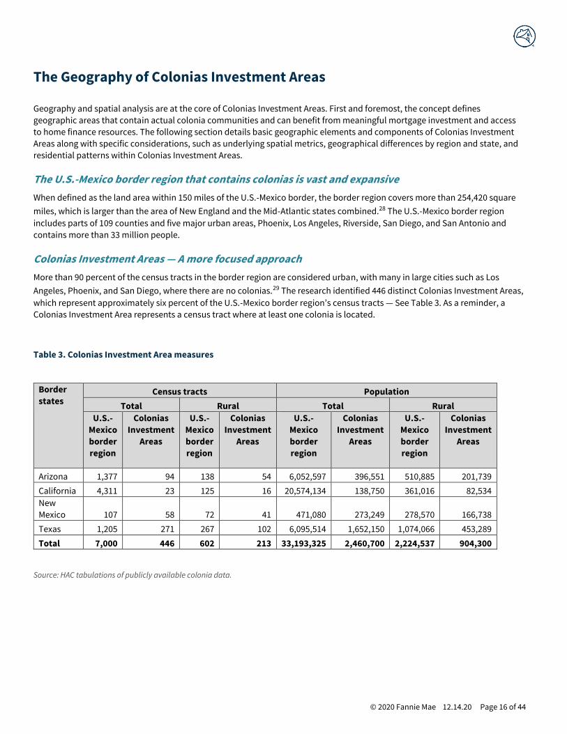
More than 90 percent of the census tracts in the border region are considered urban, with many in large cities such as Los
Angeles, Phoenix, and San Diego, where there are no colonias.29 The research identified 446 distinct Colonias Investment Areas,
which represent approximately six percent of the U.S.-Mexico border region’s census tracts — See Table 3. As a reminder, a
Colonias Investment Area represents a census tract where at least one colonia is located.
Table 3. Colonias Investment Area measures
Border
states Census tracts Population
Total Rural Total Rural
U.S.-
Mexico
border
region
Colonias
Investment
Areas
U.S.-
Mexico
border
region
Colonias
Investment
Areas
U.S.-
Mexico
border
region
Colonias
Investment
Areas
U.S.-
Mexico
border
region
Colonias
Investment
Areas
Arizona 1,377 94 138 54 6,052,597 396,551 510,885 201,739
California 4,311 23 125 16 20,574,134 138,750 361,016 82,534
New
Mexico 107 58 72 41 471,080 273,249 278,570 166,738
Texas 1,205 271 267 102 6,095,514 1,652,150 1,074,066 453,289
Total 7,000 446 602 213 33,193,325 2,460,700 2,224,537 904,300
Source: HAC tabulations of publicly available colonia data.

© 2020 Fannie Mae 12.14.20 Page 17 of 44
Considering only the border region’s rural census tracts, approximately one-third are Colonias Investment Areas. This finding
varies by state. For example, over half of New Mexico’s rural border tracts are Colonias Investment Areas. Many rural Colonias
Investment Areas are large (in land area) and, together, they contain slightly more than half of the U.S.-Mexico border region’s
land area. The relatively sparse population in many of these areas, in turn, explains why Colonias Investment Areas contain just
7 percent of the U.S.-Mexico border region’s total population — yet Colonias Investment Areas still contain approximately 2.5
million people.
Colonias Investment Areas are most common in Texas
Texas is home to 61 percent of all Colonias Investment Areas. While 33 different counties in Texas have at least one colonia,
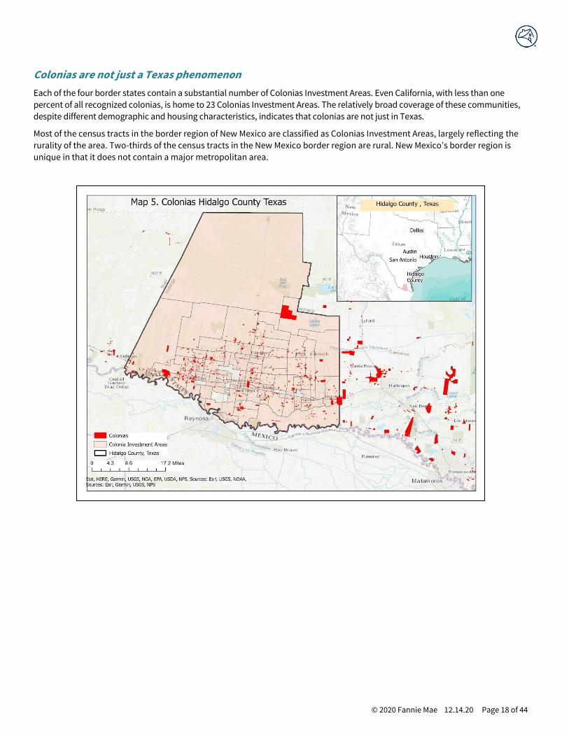
these communities are largely concentrated in a few areas, notably the Lower Rio Grande Valley. For example, Hidalgo County,
TX, (Map 5) is home to approximately 41 percent of all of Texas’ recognized colonias (over 900) and more than three times the
colonia communities found in Arizona, California, and New Mexico combined. This level of concentration, along with the fact
that colonias have a relatively small land size in Texas compared to other border states, results in a much higher average
number of colonias per Texas Colonias Investment Area. The average number of colonias per Colonias Investment Area in Texas
is 8.4, compared to just 1.5, 1.4, and 2.9 for Arizona, California, and New Mexico, respectively.
However, there is no standardization across states or public entities for determining colonia communities. For example,
colonias in Texas tend to be an identified street or block, whereas in other states, like California, an entire town might be
defined as a colonia. This could indicate that a relatively small area in Texas might have multiple colonia, where another state
might consider it one large community.
© 2020 Fannie Mae 12.14.20 Page 18 of 44
Colonias are not just a Texas phenomenon
Each of the four border states contain a substantial number of Colonias Investment Areas. Even California, with less than one
percent of all recognized colonias, is home to 23 Colonias Investment Areas. The relatively broad coverage of these communities,
despite different demographic and housing characteristics, indicates that colonias are not just in Texas.
Most of the census tracts in the border region of New Mexico are classified as Colonias Investment Areas, largely reflecting the
rurality of the area. Two-thirds of the census tracts in the New Mexico border region are rural. New Mexico’s border region is
unique in that it does not contain a major metropolitan area.

© 2020 Fannie Mae 12.14.20 Page 19 of 44
Development patterns
Colonias are most often associated with rural or ex-urban fringe areas, where the subdivision/development and sale of
unincorporated land that lacks access to basic infrastructure (roads, water, sewer, etc.) is most likely to occur. Overall, 48
percent of Colonias Investment Areas are classified as “rural” census tracts as defined by FHFA’s Duty to Serve criteria. The
overall rurality patterns vary by state, however, and 70 percent of California and New Mexico’s Colonias Investment Areas and
57 percent of Arizona’s Colonias Investment Areas are “rural” as defined by FHFA’s Duty to Serve definition.
Texas bucks the pattern
A review of Texas’ development patterns explains why less than half of all Colonias Investment Areas are rural. The vast
majority of colonias communities are in Texas, and some areas in South Texas have experienced dramatic urbanization since
the 1960s. For example, Hidalgo County’s population in 1970 was 181,535, which more than quadrupled to 865,939 by 2018. The
original rural/ex-urban fringe areas where many colonias developments originated are now considered urban. If Hidalgo
County Colonias Investment Areas were not included, most Texas Colonias Investment Areas (57 percent) as well as a majority
of all Colonias Investment Areas (60 percent) would be considered rural.
Source: HAC tabulations of publicly available colonia data.

© 2020 Fannie Mae 12.14.20 Page 20 of 44
© 2020 Fannie Mae 12.14.20 Page 21 of 44
People and Economies of Colonias Investment Areas
To better understand and help test the concept of Colonias Investment Areas in practice, a preliminary and descriptive analysis
of key characteristics was conducted for these areas. The analysis generally compares selected social, economic, housing, and
mortgage finance characteristics of markets (Colonias Investment Areas and non-Colonias Investment Areas) in border states
and within 150 miles of the U.S.-Mexico border. The Census Bureau’s American Community Survey (ACS) 2012 – 2016 data were
used for demographic and housing characteristics and HMDA 2015 – 2017 data provided information on mortgage lending
markets.
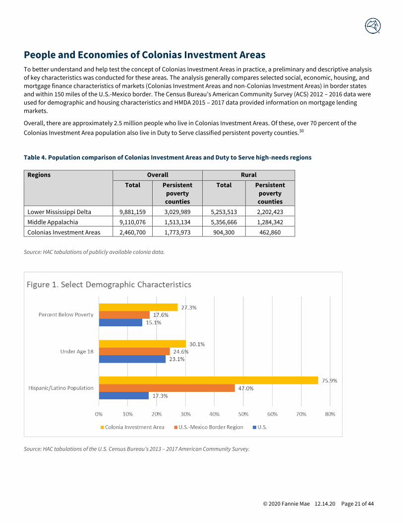
Overall, there are approximately 2.5 million people who live in Colonias Investment Areas. Of these, over 70 percent of the
Colonias Investment Area population also live in Duty to Serve classified persistent poverty counties.30
Table 4. Population comparison of Colonias Investment Areas and Duty to Serve high-needs regions
Regions Overall Rural
Total Persistent
poverty
counties
Total Persistent
poverty
counties
Lower Mississippi Delta 9,881,159 3,029,989 5,253,513 2,202,423
Middle Appalachia 9,110,076 1,513,134 5,356,666 1,284,342
Colonias Investment Areas 2,460,700 1,773,973 904,300 462,860
Source: HAC tabulations of publicly available colonia data.
Source: HAC tabulations of the U.S. Census Bureau’s 2013 – 2017 American Community Survey.
© 2020 Fannie Mae 12.14.20 Page 22 of 44
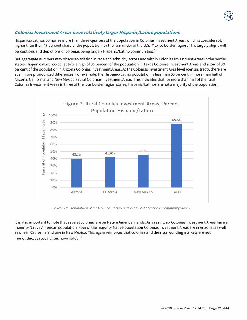
Colonias Investment Areas have relatively larger Hispanic/Latino populations
Hispanics/Latinos comprise more than three-quarters of the population in Colonias Investment Areas, which is considerably
higher than their 47 percent share of the population for the remainder of the U.S.-Mexico border region. This largely aligns with
perceptions and depictions of colonias being largely Hispanic/Latino communities.31
But aggregate numbers may obscure variation in race and ethnicity across and within Colonias Investment Areas in the border
states. Hispanics/Latinos constitute a high of 88 percent of the population in Texas Colonias Investment Areas and a low of 39
percent of the population in Arizona Colonias Investment Areas. At the Colonias Investment Area level (census tract), there are
even more pronounced differences. For example, the Hispanic/Latino population is less than 50 percent in more than half of
Arizona, California, and New Mexico’s rural Colonias Investment Areas. This indicates that for more than half of the rural
Colonias Investment Areas in three of the four border region states, Hispanic/Latinos are not a majority of the population.
Source: HAC tabulations of the U.S. Census Bureau’s 2013 – 2017 American Community Survey.
It is also important to note that several colonias are on Native American lands. As a result, six Colonias Investment Areas have a
majority Native American population. Four of the majority Native population Colonias Investment Areas are in Arizona, as well
as one in California and one in New Mexico. This again reinforces that colonias and their surrounding markets are not
monolithic, as researchers have noted.32
© 2020 Fannie Mae 12.14.20 Page 23 of 44
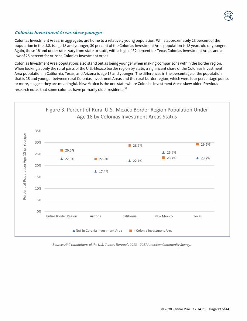
Colonias Investment Areas skew younger
Colonias Investment Areas, in aggregate, are home to a relatively young population. While approximately 23 percent of the
population in the U.S. is age 18 and younger, 30 percent of the Colonias Investment Area population is 18 years old or younger.
Again, these 18 and under rates vary from state to state, with a high of 32 percent for Texas Colonias Investment Areas and a
low of 25 percent for Arizona Colonias Investment Areas.
Colonias Investment Area populations also stand out as being younger when making comparisons within the border region.
When looking at only the rural parts of the U.S.-Mexico border region by state, a significant share of the Colonias Investment
Area population in California, Texas, and Arizona is age 18 and younger. The differences in the percentage of the population
that is 18 and younger between rural Colonias Investment Areas and the rural border region, which were four percentage points
or more, suggest they are meaningful. New Mexico is the one state where Colonias Investment Areas skew older. Previous
research notes that some colonias have primarily older residents.33
Source: HAC tabulations of the U.S. Census Bureau’s 2013 – 2017 American Community Survey.
22.9%
17.4%
22.1%
25.7%
23.2%
26.6%
22.8%
28.7%
23.4%
29.2%
0%
5%
10%
15%
20%
25%
30%
35%
Entire Border Region Arizona California New Mexico Texas
Per
cen
t o
f P
op
ula
tio
n A
ge 1
8 o
r Yo
un
ger
Figure 3. Percent of Rural U.S.-Mexico Border Region Population Under Age 18 by Colonias Investment Areas Status
Not In Colonia Investment Area In Colonia Investment Area

© 2020 Fannie Mae 12.14.20 Page 24 of 44
Colonias Investment Areas are some of the most impoverished markets in the nation
High rates of poverty, a defining factor of colonia developments, are visible throughout the region. The U.S. poverty rate is an
estimated 15 percent, while the aggregate Colonias Investment Area poverty rate is nearly twice the national level at 27
percent. The poverty rate for Colonias Investment Areas in California and New Mexico exceeded 20 percent and reached 19
percent in Arizona. Texas’ Colonias Investment Area poverty rate is exceedingly high at 30 percent. Poverty in many of these
markets is a chronic condition. Sixty-three percent of all Colonias Investment Areas were also in persistent poverty counties.
The magnitude of the poverty rates is clear when comparing the rural portions of the U.S.-Mexico border region — see Figure 4.
A majority of rural Colonias Investment Areas (census tracts) exceed 20 percent poverty rates in every state. In contrast, poverty
rates in most rural U.S.-Mexico border region census tracts without colonias were below 20 percent.
Source: HAC tabulations of the U.S. Census Bureau’s 2013 – 2017 American Community Survey.
15.4%
17.9%
14.5%
19.9%
13.4%
21.5% 21.5%20.7% 20.2%
23.8%
0%
5%
10%
15%
20%
25%
Entire Border Region Arizona California New Mexico Texas
Per
cen
t P
ove
rty
Rat
es
Figure 4.Poverty Rates, U.S.-Mexico Border Region for Rural Census Tract by State and Colonias Investment Area Status
Not in Colonia Colonia Investment Area

© 2020 Fannie Mae 12.14.20 Page 25 of 44
Housing characteristics and patterns in Colonias Investment Areas
Poor housing conditions play a central role in the recognition and designation of colonias, where the housing stock includes
conventional stick-built houses, manufactured homes, and adobe structures.34 In older colonias, the substandard conditions
are largely the result of an old, deteriorating housing stock, while the newer colonias contain units that are not up to code.35

© 2020 Fannie Mae 12.14.20 Page 26 of 44
Homeownership is predominant in Colonias Investment Areas
Households living in Colonias Investment Areas are primarily homeowners. It is important to note that while homeownership is
generally high in colonias, a portion of these households may have home or land financing elements that charge high fees or
include usury terms and fees.36 An initial review of the aggregate data in the Colonias Investment Areas indicate higher
homeownership rates in Colonias Investment Areas than in the remainder of the U.S.-Mexico border region for each of the four
border region states. Rural homeownership rates are essentially the same with one exception, regardless of whether a census
tract contains colonias.
New Mexico stands out because the homeownership rates are consistently higher in Colonias Investment Areas than non-
Colonias Investment Areas in the U.S.-Mexico border region.
Source: HAC tabulations of the U.S. Census Bureau’s 2013 – 2017 American Community Survey.
© 2020 Fannie Mae 12.14.20 Page 27 of 44
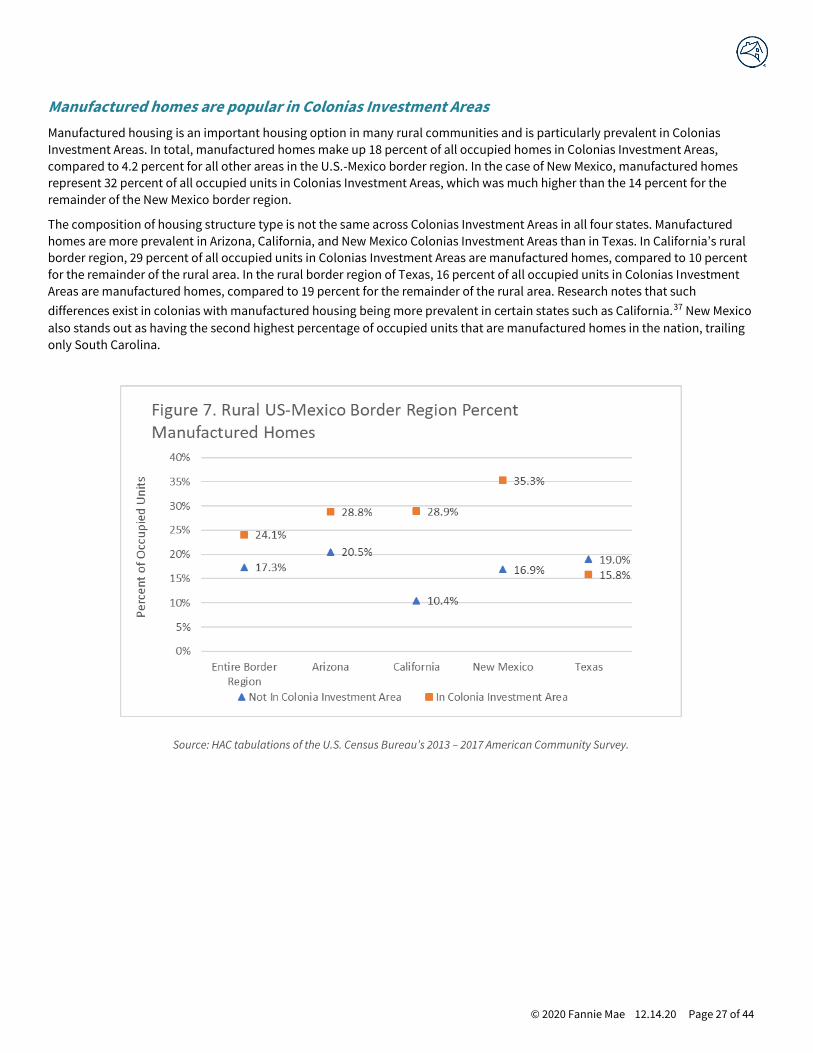
Manufactured homes are popular in Colonias Investment Areas
Manufactured housing is an important housing option in many rural communities and is particularly prevalent in Colonias
Investment Areas. In total, manufactured homes make up 18 percent of all occupied homes in Colonias Investment Areas,
compared to 4.2 percent for all other areas in the U.S.-Mexico border region. In the case of New Mexico, manufactured homes
represent 32 percent of all occupied units in Colonias Investment Areas, which was much higher than the 14 percent for the
remainder of the New Mexico border region.
The composition of housing structure type is not the same across Colonias Investment Areas in all four states. Manufactured
homes are more prevalent in Arizona, California, and New Mexico Colonias Investment Areas than in Texas. In California’s rural
border region, 29 percent of all occupied units in Colonias Investment Areas are manufactured homes, compared to 10 percent
for the remainder of the rural area. In the rural border region of Texas, 16 percent of all occupied units in Colonias Investment
Areas are manufactured homes, compared to 19 percent for the remainder of the rural area. Research notes that such
differences exist in colonias with manufactured housing being more prevalent in certain states such as California.37 New Mexico
also stands out as having the second highest percentage of occupied units that are manufactured homes in the nation, trailing
only South Carolina.
Source: HAC tabulations of the U.S. Census Bureau’s 2013 – 2017 American Community Survey.

© 2020 Fannie Mae 12.14.20 Page 28 of 44
Substandard plumbing is a visible reminder of colonias needs
A defining element of colonias communities is the absence or insufficiency of plumbing. The percentage of units lacking
complete plumbing is high for Colonias Investment Areas — 1.2 percent for Colonias Investment Areas compared to 0.4 percent
for non-Colonias Investment Areas nationally, which points to elevated levels of substandard housing. In whole numbers, an
estimated 9,160 occupied units lack complete plumbing. The differences are relatively consistent for all four border states.
Source: HAC tabulations of the U.S. Census Bureau’s 2013 – 2017 American Community Survey.

© 2020 Fannie Mae 12.14.20 Page 29 of 44
Colonias Investment Areas have low-value homes
A proxy measure for lower quality housing is extremely low home value. A relatively large share of owner-occupied units (3
percent) in Colonias Investment Areas are valued at less than $10,000. The difference exists for all border region states and can
clearly be seen when looking only at rural areas. In California’s portion of the U.S.-Mexico border region, the rate of homes
valued at less than $10,000 is 0.6 percent for rural areas in non-Colonias Investment Areas and 3.8 percent for rural areas in
Colonias Investment Areas. It is important to note that the states with the highest share of homes valued at less than $10,000
also had a high share of manufactured homes.
Source: HAC tabulations of the U.S. Census Bureau’s 2013 – 2017 American Community Survey.

© 2020 Fannie Mae 12.14.20 Page 30 of 44
Mortgage Lending and Finance Access in Colonias Investment Areas
The use of informal or non-conventional financing mechanisms to obtain homeownership is an indication of the gap in
traditional financing available to low-income and immigrant populations. In some cases, this may be due to a dearth of
financial institutions in remote rural areas. Another likely contributor is the large immigrant population, which may be
unfamiliar with the services offered by banks or who are simply unsure of such arrangements.
Dearth of colonia mortgage lending activity
Colonias Investment Areas have substantially lower rates of mortgage lending compared to nearly any market nationally.
To make lending comparisons, the analysis explored lending activity as the number of loan originations per thousand
owner-occupied homes. The originations total represents the annual average number of Home Mortgage Disclosure Act
(HMDA) reported loans (home purchase, refinance, and home improvement) originated for the 2015 – 2017 period. An
average of three years of lending activity was incorporated to minimize fluctuations and volatility.38
The analysis of HMDA data finds an extremely low volume of mortgage lending in Colonias Investment Areas. The U.S. -
Mexico border region at large has a relatively high volume of lending, but this includ es fast-growing urban and suburban
areas associated with major cities, like San Diego and Phoenix. Analyses indicate a dearth in lending activity in Colonias
Investment Areas and is most pronounced in rural Colonias Investment Areas. The amount of lending, using owner-occupied
units to standardize the measure, is more than twice as large for the U.S.-Mexico border region as a whole than for Colonias
Investment Areas and nearly three times as large as the amount of lending that occurs in rural Colonias Inves tment Areas.
Source: HAC tabulations of the U.S. Census Bureau’s 2013 – 2017 American Community Survey and FFIEC’s 2017 Home Mortgage Disclosure Act
(HMDA) data.
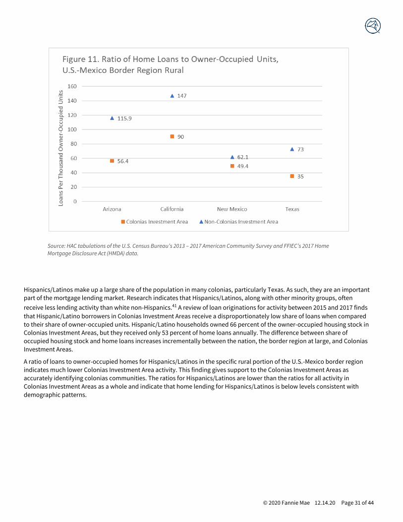
A closer look at the data reveals that the limited volume of lending in Colonias Investment Areas is particularly noticeable even
when looking at rural communities. Using the Texas U.S.-Mexico border region as an example, there were 35 loans per
thousand owner-occupied units in rural Colonias Investment Areas, compared to 73 loans per thousand for rural areas not in
Colonias Investment Areas. This difference exists for all four border region states. The findings reinforce recent research that
indicates that there is limited conventional lending activity in colonias.39 Past research noted that lower-income colonia
residents lack access to the formal credit markets, which is predominately the loan activity that HMDA data captures.40
100.8
129.9
61.5
47.5
0
20
40
60
80
100
120
140
US Total US-Mexico Border Region Colonia Investment Areas Colonia Investment Areas RuralLoan
s P
er 1
,00
0 O
wn
er O
ccu
pie
d U
nit
s
Figure 10. Ratio of Home Loans to Owner-Occupied Units
© 2020 Fannie Mae 12.14.20 Page 31 of 44
Source: HAC tabulations of the U.S. Census Bureau’s 2013 – 2017 American Community Survey and FFIEC’s 2017 Home
Mortgage Disclosure Act (HMDA) data.
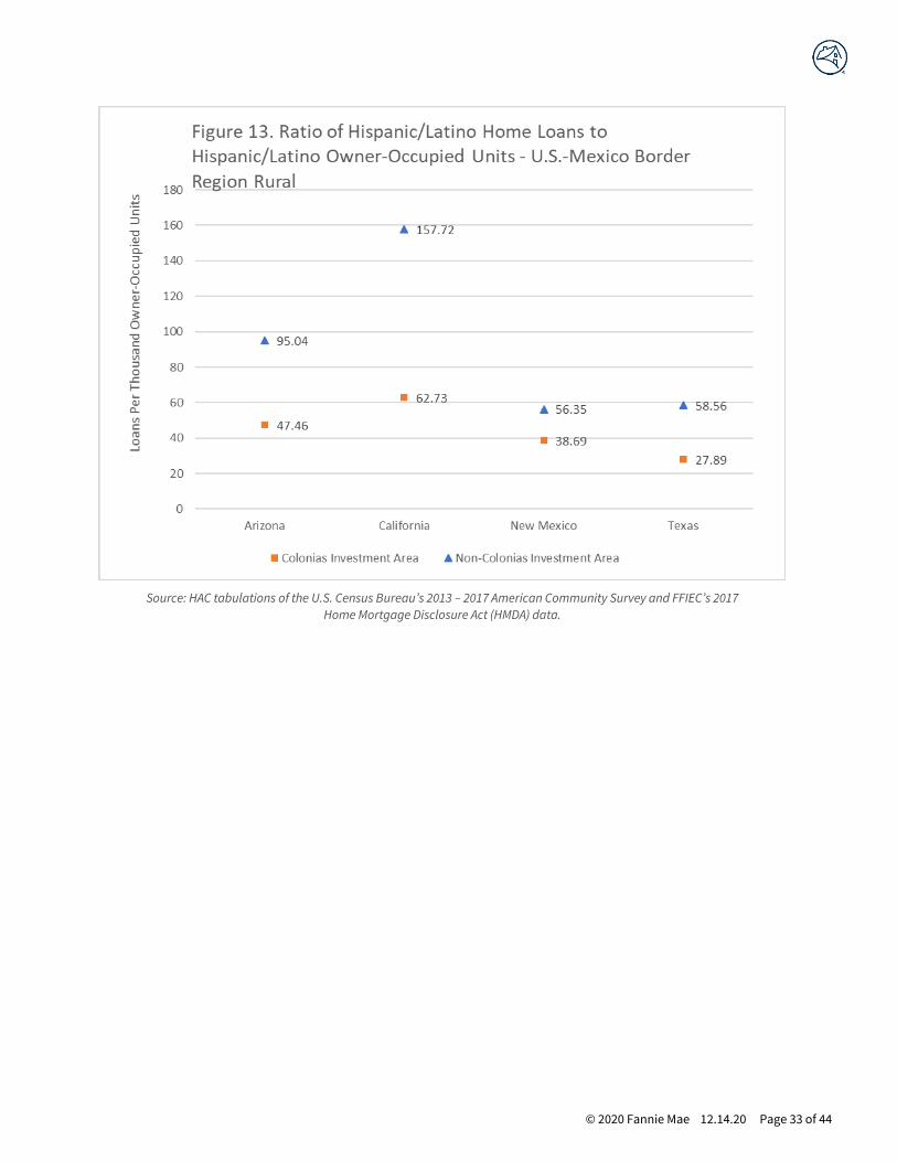
Hispanics/Latinos make up a large share of the population in many colonias, particularly Texas. As such, they are an important
part of the mortgage lending market. Research indicates that Hispanics/Latinos, along with other minority groups, often
receive less lending activity than white non-Hispanics.41 A review of loan originations for activity between 2015 and 2017 finds
that Hispanic/Latino borrowers in Colonias Investment Areas receive a disproportionately low share of loans when compared
to their share of owner-occupied units. Hispanic/Latino households owned 66 percent of the owner-occupied housing stock in
Colonias Investment Areas, but they received only 53 percent of home loans annually. The difference between share of
occupied housing stock and home loans increases incrementally between the nation, the border region at large, and Colonias
Investment Areas.
A ratio of loans to owner-occupied homes for Hispanics/Latinos in the specific rural portion of the U.S.-Mexico border region
indicates much lower Colonias Investment Area activity. This finding gives support to the Colonias Investment Areas as
accurately identifying colonias communities. The ratios for Hispanics/Latinos are lower than the ratios for all activity in
Colonias Investment Areas as a whole and indicate that home lending for Hispanics/Latinos is below levels consistent with
demographic patterns.

© 2020 Fannie Mae 12.14.20 Page 32 of 44
Source: HAC tabulations of the U.S. Census Bureau’s 2013 – 2017 American Community Survey and FFIEC’s
2017 Home Mortgage Disclosure Act (HMDA) data.
© 2020 Fannie Mae 12.14.20 Page 33 of 44
Source: HAC tabulations of the U.S. Census Bureau’s 2013 – 2017 American Community Survey and FFIEC’s 2017
Home Mortgage Disclosure Act (HMDA) data.
© 2020 Fannie Mae 12.14.20 Page 34 of 44
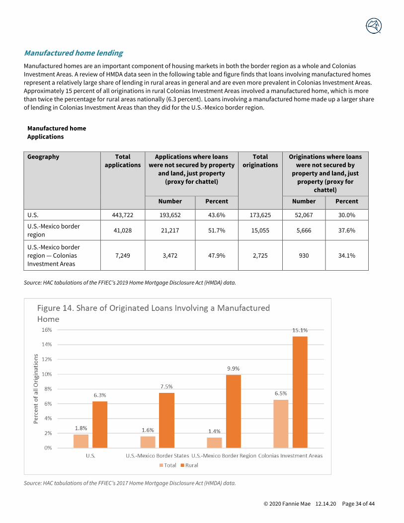
Manufactured home lending
Manufactured homes are an important component of housing markets in both the border region as a whole and Colonias
Investment Areas. A review of HMDA data seen in the following table and figure finds that loans involving manufactured homes
represent a relatively large share of lending in rural areas in general and are even more prevalent in Colonias Investment Areas.
Approximately 15 percent of all originations in rural Colonias Investment Areas involved a manufactured home, which is more
than twice the percentage for rural areas nationally (6.3 percent). Loans involving a manufactured home made up a larger share
of lending in Colonias Investment Areas than they did for the U.S.-Mexico border region.
Manufactured home
Applications
Geography Total
applications
Applications where loans
were not secured by property
and land, just property
(proxy for chattel)
Total
originations
Originations where loans
were not secured by
property and land, just
property (proxy for
chattel)
Number Percent Number Percent
U.S. 443,722 193,652 43.6% 173,625 52,067 30.0%
U.S.-Mexico border
region 41,028 21,217 51.7% 15,055 5,666 37.6%
U.S.-Mexico border
region — Colonias
Investment Areas
7,249 3,472 47.9% 2,725 930 34.1%
Source: HAC tabulations of the FFIEC’s 2019 Home Mortgage Disclosure Act (HMDA) data.
Source: HAC tabulations of the FFIEC’s 2017 Home Mortgage Disclosure Act (HMDA) data.

© 2020 Fannie Mae 12.14.20 Page 35 of 44
The share of mortgage loans that involved manufactured homes is a direct reflection of the prevalence of this housing in the
Colonias Investment Areas.
Source: HAC tabulations of the U.S. Census Bureau’s 2013 — 2017 American Community Survey.

© 2020 Fannie Mae 12.14.20 Page 36 of 44
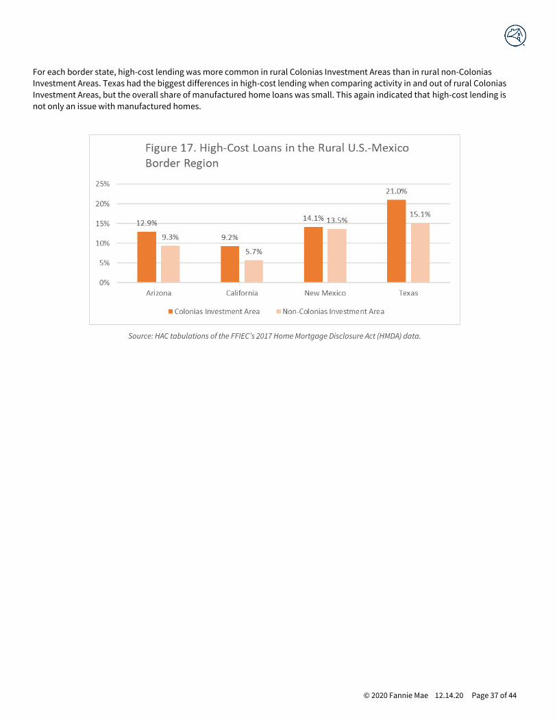
High-cost lending
High-cost loans signal mortgage loans where the interest rate charged exceeds that of the interest rate that would be charged
on a similar loan to a qualified borrower. When the difference meets a certain threshold (1.5 percentage points for first lien
loans), it is classified as high-cost.42 High-cost lending is particularly prevalent in the manufactured housing marketplace,
where many loans are secured by personal property, commonly referred to as chattel loans. High-cost loans are more common
in Colonias Investment Areas than both the nation as a whole and the U.S.-Mexico border region.
Source: HAC tabulations of the FFIEC’s 2017 Home Mortgage Disclosure Act (HMDA) data.
© 2020 Fannie Mae 12.14.20 Page 37 of 44
For each border state, high-cost lending was more common in rural Colonias Investment Areas than in rural non-Colonias
Investment Areas. Texas had the biggest differences in high-cost lending when comparing activity in and out of rural Colonias
Investment Areas, but the overall share of manufactured home loans was small. This again indicated that high-cost lending is
not only an issue with manufactured homes.
Source: HAC tabulations of the FFIEC’s 2017 Home Mortgage Disclosure Act (HMDA) data.

© 2020 Fannie Mae 12.14.20 Page 38 of 44
Loan types
Colonias Investment Areas receive fewer conventional loans and rely more on government-backed mortgage resources (loans
through FHA, VA, and USDA). A simple distribution of loans between 2015 and 2017 indicates that Colonias Investment Areas
have a much smaller share of conventional loans. For the U.S. or for the border region, about three-quarters of originations
were conventional, but for Colonias Investment Areas it was slightly more than 50 percent. The difference was made up by
higher shares of FHA, VA, and USDA-guaranteed loans.
Source: HAC tabulations of the FFIEC’s 2015 – 2017 Home Mortgage Disclosure Act (HMDA) data.
The larger share of government-backed lending reflects the overall dearth of activity, not a higher rate of government-backed
lending, particularly in rural Colonias Investment Areas. A review of ratios of loans to owner-occupied units, by loan type,
indicates that Colonias Investment Areas have less than half the volume of conventional lending that occurs in the U.S.-Mexico
border region and about the same level of FHA lending — Table 5. This lack of conventional lending makes the share of FHA
loans high. A further comparison of loans to owner-occupied units for rural and non-rural Colonias Investment Areas highlight
how limited rural activity is.
Table 5. Ratio of annual average loans to owner-occupied units in thousands
Loan type U.S. — total Border
region
Colonias
Investment Area
Colonias Investment
Area not rural
Colonias Investment
Area rural
Conventional 73.7 94.3 33.5 37.3 27.7
FHA 16.3 21.7 16.8 21.0 10.4
VA 9.2 13.5 10.0 11.4 7.9
USDA 1.6 0.4 1.2 1.0 1.5
Total 100.8 129.9 61.5 70.7 47.5
Source: HAC tabulations of the FFIEC’s 2017 Home Mortgage Disclosure Act (HMDA) data.
© 2020 Fannie Mae 12.14.20 Page 39 of 44
Expert and Stakeholder Feedback
There is a vibrant and robust community of practitioners, experts, and other stakeholders with vast expertise in the border
region and colonias communities. To provide context for the geographic methods and analyses and additional information
about quantitative elements of Colonias Investment Areas, the research convened four outreach engagements, including:
• Rural Housing: High Needs Regions and Vulnerable Populations — 2019 MAFO National Farmworker Conference and
Convention on May 7, 2019, in San Antonio, TX.
• Colonias Investment Areas — New Mexico webinar on July 17, 2019.
• Colonias Investment Areas — Arizona webinar on August 7, 2019.
• Colonias Investment Areas — Texas webinar on September 26, 2019.
Over 61 participants at these sessions represented a spectrum of local and regional community-based nonprofit organizations,
local government agencies, academics and universities, the New Mexico Mortgage Finance Authority, the Texas Department of
Housing and Community Affairs, the USDA, and more. The sessions solicited feedback on the Colonias Investment Area
approach and its efficacy. This research incorporated participant questions and thoughts where relevant.
Participant organizations in the stakeholder sessions included:
AYUDA, Inc. Housing Works
New Mexico Mortgage Finance Authority Project Bravo
Tierra del Sol Housing Corporation Proyecto Azteca
U.S. Department of Agriculture South Texas Collaborative for Housing Development
White Sands Habitat for Humanity South Texas Development Council
Chicanos Por La Causa Texas Department of Housing and Community Affairs
Pima County, Arizona MAFO, Inc.
Dona Ana County, New Mexico California Rural Legal Assistance, Inc.
El Paso Community Action Program, Project BRAVO
Additionally, experts from academic, policy, and practitioner communities were sent drafts of the final Colonias Investment
Areas report and concept to review and comment upon. The reviewers were asked to respond to key elements of the scale,
methods, and approach and findings of the Colonias Investment Areas concept and research.
The external peer review included feedback from 13 policy and subject matter experts on colonias, representing a range of
sectors, including community-based development organizations and nonprofits, universities and academics, and regional,
state, and local government officials from the border colonias region.
The expert reviewers provided thoughtful, informed comments, and the results were largely positive regarding the concept of
Colonias Investment Areas. Both collectively and on each of the review questions, the respondents expressed support and
offered further recommendations for the scope, methodology, and significance of the research.
The majority of reviewers agreed that the criteria and methodology adequately informed the construction of Colonias
Investment Areas. Similar support was noted on the social, economic, housing, and mortgage finance characteristics that this
report used to define Colonias Investment Areas. There was a majority agreement that these were sufficient criteria for forming
the definition.
Commenters offered several recommendations for improving the construct and methodology. A representative from a border-
region university argued that the Colonias Investment Area definition may be too narrow and advised toward including newer,
“model subdivision” colonias or “colonias-like” neighborhoods that share similar infrastructure and housing needs but may not
be included in the construct. Other respondents warned about the reliability of state and federal colonias data, arguing that
© 2020 Fannie Mae 12.14.20 Page 40 of 44
current counts of colonias are outdated. It must be noted that reliance on state and federal data is the best existing colonia
community data available.
When asked about the geographic unit of measure, the vast majority of reviewers thought that census tracts are an appropriate
unit of geography from which to base the Colonias Investment Areas construct. Of the reviewers who disagreed, one took issue
with the reliability of census data, referencing recent findings that 2019 census data undercounted 17,000 colonias homes. It
must be noted that while the researchers agree of a likelihood of Census Bureau survey undercounts in these communities, this
undercount issue is only marginally related to the construct of census geographies.
When asked to comment on residential patterns of Colonias Investment Areas, the majority of reviewers agreed that suburban
and urban tracts that meet the criteria for Colonias Investment Areas should be included in the concept. Among these
respondents were representatives of colonias organizations who brought up colonias near El Paso, Pima County in New Mexico,
and the Lower Rio Grande Region that are considered urban neighborhoods but share many of the same infrastructure and
housing challenges as rural colonias.
A smaller number of reviewers disagreed on the inclusion of suburban and urban colonias in the concept. The argument against
inclusion often noted that urban colonias often have greater access to infrastructure and services than rural colonias and that
rural colonias should be the focus of Colonias Investment Areas. Such focus would ensure that home mortgage financing goes
to the areas with the greatest need. Another respondent suggested a compromise: suburban and urban colonias that meet the
criteria are included in Colonias Investment Areas, but their applications for mortgage financing are given less weight than
those of rural colonia.
Most of the reviewers agreed that “the construct and supporting research achieve the goal of better informing potential
mortgage access and delivery in Colonias Investment areas.” Several of the reviewers commented on the utility and the
significance of the report as a much-needed guide for allocating mortgage assistance to high-needs border regions, specifically
the colonias.
Finally, reviewers suggested further consideration on a range of topics, including loan product options and terms for Colonias
Investment Areas, the impact of modern land sale practices in the border region, how home pricing and inspections would work
for the large number of colonia homes built by the homeowner, and the drainage and flood insurance protocols for the large
number of colonia homes located in floodplains.
© 2020 Fannie Mae 12.14.20 Page 41 of 44
Updating Colonias Investment Areas
Despite being categorized generally, colonias communities vary extensively, and change is constant.43 Colonias have varied
histories. Some emerged in the last 50 years, but others have been in existence since the 19th century. Various factors
contributed to colonia development, and a range of considerations continue to influence these developments and their
classification as publicly recognized colonias under various federal, state, tribal, and local programs. While all scenarios cannot
be accounted for, below are a few general actions or occurrences that could impact classification of colonias and should be
monitored and considered.
Development of new colonias
Various interdictions and efforts have slowed the number of colonias settlements over the last few years — at least the formal
designation of colonias. An extremely large geographic expanse in the border region combined with dynamic economies
resulting in new growth and development could lead to additional colonias.
Community loses colonia designation
While generally considered a positive development — if the designation removal is based on improvement in infrastructure and
quality, etc. — the reduction in colonias designated communities is likely to be a more prevalent occurrence in the coming
decades. This report does not seek to identify or define colonias as determined by federal, state, tribal, or local governments —
only to identify census tracts that contain colonias. Colonias designations are made at the discretion of the governmental body
that administers a program, resource, or research endeavor targeting colonias. Colonias source data (see Table 1 above) is
updated at varying intervals at the discretion of the respective government. For instance, data from the University of New
Mexico Bureau of Business and Economic Research, was last updated in 2012. Data from the Arizona Department of Housing
was last updated in 2018. Data from the USGS CHIPs Project was last updated in 2008. The colonias database from the Office of
Attorney General of Texas indicates that the data is in a constant state of revision. HAC developed the Colonias Investment
Areas based on the most recently available data as of 2018.
Colonia community encounters a technical change
The most common example of an occurrence in this category is a change to a colonia’s boundaries or if the colonia
merges/splits geographically. For example, the decennial Census will invariably impact underlying census tract geographies
because new census tracts will be developed when the population of a permanent statistical subdivision within a county grows
beyond 4,000 residents — a tract split. A tract merge could also occur when the population of a subdivision falls below 1,200.
Both situations will occur across the country as a result of the decennial Census. Intercensal changes related to annexation or
simply geographic classification are also a possibility in the technical realm. For instance, in 2013 the Census Bureau made
technical corrections to seven tract records in Pima County, Arizona (FIPS county code 019), and a tract boundary and
numbering in Los Angeles County was corrected. These changes affected the 2020 census tract designations going forward.
Additionally, some municipalities in Imperial County, California, annexed adjacent colonia communities over a period of years.
With these circumstances, a periodic review of the primary Colonias Investment Area database is necessary from time to time.
Updating all or a segment of the Colonias Investment Areas using GIS mapping software is possible. The time to complete the
analysis depends on the scope of the update (one state versus all four states; which colonias data sources are being consumed).
A determination of the frequency of updates should consider the likelihood and impact of inaccurate source data and the
nature of Colonias Investment Areas stakeholders and usage.
HAC suggests a thorough review and update of the database every two or three years. HAC further suggests interim
modification if information is ascertained on significant development or change (e.g., a new database is developed by a public
entity, a major study is released, or decennial Census results are released), or if a targeted usage of Colonias Investment Areas is
planned for which program stakeholders require more current information (e.g., a new investment initiative).
© 2020 Fannie Mae 12.14.20 Page 42 of 44
Discussion and Considerations
The border colonias region is often considered part of forgotten America, where struggling communities and their residents
are often far from view of the mainstream economy and policy structures. But this region is home to mo re than 2.5 million
people in countless communities across 250,000 square miles of our southern border. These communities and their
residents need investment.
To help inform strategies and policies that could extend greater mortgage investment to the colonias border region, the
Housing Assistance Council developed the concept of “Colonias Investment Areas.” The goal of this research was to develop a
comprehensive, usable, and uniform definition of colonias to inform the targeting of mortgage and finance resources so that
assistance can be more efficiently directed to these communities. The recent launch of the “Duty to Serve” efforts as a part of
the 2008 Housing and Economic Recovery Act also provides additional impetus and resources for investment. At the same time,
a clearly delineated and defined definition of colonias communities may help inform general colonias resource efforts as well.
HAC undertook a detailed six-part process to identify 446 Colonias Investment Areas in the states of Texas, New Mexico,
Arizona, and California. While no geographic definition is perfect and all have pros and cons, the Colonias Investment Area
concept is an advancement in the often-understudied realm of the Border-Colonias region. Some specific advantages of this
colonias area typology include the use of census tracts as a base geography. More granular and precise than counties, census
tracts are also richer in content and standardization than smaller or less defined units of geography. Colonias Investment Areas
represent a pragmatic middle ground between some expansive definitions — created decades ago — that may dilute needs and
resource allocation, and small undefinable settlements without consistent or meaningful parameters.
Colonias Investment Areas are consistent with the aforementioned Duty to Serve geography, as well. The census tract basis of
these investment areas aligns with most of FHFA’s Duty to Serve geographies under the rural and other underserved markets.
FHFA regulations explicitly mention census tracts in providing guidance “to address the data challenges that exist in specifically
identifying the census tracts that contain ‘colonias.’”
In addition to being identified in FHFA’s 2016 Final Rule, there are also non-technical issues that influence and advantage the
use of Colonias Investment Areas. Standard mortgage investment generally has restrictions on purchasing loans that involve
properties on parcels that lack basic infrastructure (water, sewer, etc.), which may exclude many colonias communities. As
such, Colonias Investment Areas delineation and data could inform and complement Duty to Serve efforts that will likely occur
in areas in the vicinity of colonias that a census tract geography will include, but a smaller geography may not.
Additionally, Colonias Investment Areas allow for targeting and assessment of resources and activities. Colonias Investment
Areas were designed to help facilitate and advance mortgage lending and financial access in the border colonias region. Census
tracts are the smallest geography for which mortgage loan data is publicly available from which to assess market conditions.
Using census tracts provides the ability to more adequately understand mortgage markets as well as to assess progress and
activity. Relying on lower levels of geography generally precludes any meaningful analyses for both planning and needs as well
as assessment and impact.
It is important to remember that the Colonias Investment Area concept was developed for the primary purpose of informing
mortgage investment. While this concept has practical applications on a wide array of social, economic, and housing issues and
resources, the provision and planning for other commodities, such as basic infrastructure (water and wastewater systems) or
health and education, may benefit from other definitions or geographic constructs to inform the delivery of those resources.
To help measure and test the geographic concept, the research also incorporated an analysis of fundamental social, economic,
housing, and mortgage finance characteristics of these identified markets in relation to the larger region and nation. The
preliminary research findings overwhelmingly indicate that Colonias Investment Areas experience some of the greatest
challenges and needs in the region, as well as the nation, and are therefore appropriately targeted as an indicator of an
underserved market.
The analysis also revealed that Colonias Investment Areas are not just a rural phenomenon. Slightly more than half of Colonias
Investment Areas are in suburban or even urban communities — especially in Texas. At the same time, rural Colonias
Investment Areas have the greatest needs. While economic, housing, and mortgage access deficits are generally present in any
colonia regardless of location, these conditions are consistently more acute in rural Colonias Investment Areas.

© 2020 Fannie Mae 12.14.20 Page 43 of 44
Ultimately, Colonias Investment Areas are intended to inform and enhance access to mortgage finance in colonias
communities and the border region. While no geographic designation is perfect, extensive research, analysis, testing, and
stakeholder feedback reinforce the concept and elements of Colonias Investment Areas as a reliable mechanism to inform
and provide more targeted and efficient delivery of home mortgage resources and finance access to long overlooked border
colonia communities.
References
1 Guillermina Núñez-Mchiri, “The Political Ecology of the Colonias on the U.S.-Mexico Border: Human-Environmental Challenges and Community
Responses in Southern New Mexico,” Southern Rural Sociology, vol. 24.1. (2009), p. 70.
2 Federal Reserve Bank of Dallas, Texas Colonias: A Thumbnail Sketch of the Conditions, Issues, Challenges and Opportunities (Dallas: Federal Reserve
Bank of Dallas), accessed June 1, 2011, dallasfed.org/assets/documents/cd/pubs/colonias.pdf.
3 Vinit Mukhija and Paavo Monkkonen, “Federal Colonias Policy in California: Too Broad and Too Narrow,” Housing Policy Debate, vol. 17.4 (2006), p.
756, accessed November 2, 2010, knowledgeplex.org/showdoc.html?id=254228.
4 Angela Donelson and Esperanza Holguin, “Homestead Subdivision/Colonias and Land Market Dynamics in Arizona and New Mexico,” Memoria of a
Research Workshop: Irregular Settlement and Self-Help Housing in the United States (Cambridge, MA: Lincoln Institute of Land Policy, 2001), pp. 39 – 41.
5 Jean Parcher and Delbert Humberson, “CHIPS: A New Way to Monitor Colonias Along the United States-Mexico Border,” U.S. Geological Survey Open-
File Report 2007 – 1230, pubs.usgs.gov/of/2007/1230/pdf/OFR2007-1230.pdf.
6 Federal Reserve Bank of Dallas, Texas Colonias.
7 Parcher and Humberson, “CHIPS.”
8 Donelson and Holguin, “Homestead Subdivision,” pp. 39 – 41; Mukhija and Monkkonen, “Federal Colonias Policy in California,” p. 757.
9 Núñez-Mchiri, “Political Ecology,” p. 70; Mukhija and Monkkonen, “Federal Colonias Policy in California,” p. 766.
10 Donelson and Holguin, “Homestead Subdivision,” pp. 39 – 41.
11 While state government efforts focused both on ending the spread of these unincorporated developments and trying to address infrastructure
needs, federal government efforts focused on improving living conditions primarily.
12 Jean W. Parcher and Delbert G. Humberson, “Using GIS to Assess Priorities of Infrastructure and Health Needs of Colonias along the United States-
Mexico Border,” Journal of Latin American Geography, vol. 8.1 (2009), p. 132. Alejandra C. Salinas, “Cleaning Up the Colonias: Municipal Annexation
and the Texas Fracking Boom,” Boston College Environmental Affairs Law Review, vol. 42.1 (2015), pp. 170 – 171.
13 Housing Assistance Council, Housing in the Border Colonias, Rural Research Report (2013), accessed December 18, 2017,
ruralhome.org/storage/documents/rpts_pubs/ts10_border_colonias.pdf.
14 U.S. Department of Housing and Urban Development (HUD), “Common Questions” accessed December 18, 2017,
hud.gov/states/shared/working/groups/frmwrkcoln/commonquestions.
15 Peter M. Ward and Paul A. Peters, “Self-Help Housing and Informal Homesteading in Peri-Urban America: Settlement Identification Using Digital
Imagery and GIS,” Habitat International, vol. 31 (2007), pp. 205 – 218.
16 The HUD websites for state lists can be found here: files.hudexchange.info/resources/documents/Colonia-List.pdf.
17 Laura M. Norman, Angela J. Donelson, Edwin L. Pfiefer, Alven H. Lam, and Kenneth J. Osborn, Monitoring Colonias Development Along the United
States-Mexico Border: A Process Application Using GIS and Remote Sensing in Douglas, Arizona and Agua Prieta, Sonora, United State Geological Survey
Open-File Report 2004-1212 (2004), pubs.er.usgs.gov/publication/ofr20041212.
18 The Federal Register Notice with the FHFA’s Duty to Serve Final Rule, as of October 11, 2019, can be found here:
federalregister.gov/documents/2016/12/29/2016-30284/enterprise-duty-to-serve-underserved-markets.
19 RUCA Code #1 is a tract that is in an urbanized area within a metropolitan area (a town with over 50,000 people).
20 RUCA Code #2 describes a tract where 30 percent or more of the population commutes to a town with 50,000 people or more.
21 The Federal Register Notice with the FHFA’s Duty to Serve Final Rule, as of October 11, 2019, can be found here:
federalregister.gov/documents/2016/12/29/2016-30284/enterprise-duty-to-serve-underserved-markets.

© 2020 Fannie Mae 12.14.20 Page 44 of 44
22 Quote from p. 135 of FHFA’s Duty to Serve Final Rule (version they have on their website not Federal Registry Notice copy, so page numbers are
different). As of October 10, 2019, found here:
www.fhfa.gov/SupervisionRegulation/Rules/RuleDocuments/2016%20Duty%20to%20Serve%20Final%20Rule_For%20Web.pdf.
23 See Appendix Table 1 for the specifics about these resources and the others used to compile the state lists of identified colonias.
24 USDA-EPA 2015 study; information included 50 communities for which the source listed RCAP staff, not a government agency. This meant the case
was identified by the people completing the USDA-EPA study but had not been recognized by a government entity. These cases were not included in
this analysis. These were the only cases not included.
25 The University of New Mexico Bureau of Business and Economic Research (UNMBBER) already identified the underlying census blocks for 118 of New
Mexico’s colonias.
26 The 5 percent colonia threshold is to ensure that colonia-census block overlap is real and not the result of digitization errors. Digitization errors refer
to slight inaccuracies that can occur when community boundaries are drawn that could result in overlap between geographies (colonias and census
blocks) when one does not actually exist. The threshold is meant to remove such cases.
27 Only the census block containing the colonia point file are classified as such. We have no way to estimate if other census blocks are involved with
the colonia.
28 New England includes Maine, New Hampshire, Vermont, Massachusetts, Rhode Island, and Connecticut. Middle Atlantic includes New York,
Pennsylvania, New Jersey, Delaware, Maryland, Washington, D.C., Virginia, and West Virginia. Land area (square miles) data accessed October 10,
2019, from the following URL: censusreporter.org/profiles/04000US51-virginia.
29 There are few colonias in counties with a major city, like Maricopa County, Arizona, which is home to Phoenix, but this is rare.
30 Persistent Poverty as defined by the FHFA’s Duty to Serve regulation means a county experienced a poverty rate of 20 percent or higher for three
consecutive decades (2010, 2000, and 1990)
31 The following story is an example of the type of newspaper story that often appears on colonia and focuses on Texas: Maria Esquinca and Andrea
Jaramillo, “Colonias on the border struggle with decades-old water issues,” The Texas Tribune (August 22, 2017),
texastribune.org/2017/08/22/colonias-border-struggle-decades-old-water-issues. In addition, Mukhija and Monkkonen discuss how most colonias are
in Texas and how it shapes federal policy in Mukhija and Monkkonen, “Federal Colonias Policy in California.”
32 Mukhija and Monkkonen, “Federal Colonias Policy in California.” Ward and Peters, “Self-Help Housing.”
33 Mukhija and Monkkonen, “Federal Colonias Policy in California.” Ward and Peters, “Self-Help Housing.”
34 Núñez-Mchiri, “Political Ecology,” p. 76.
35 Mona Koerner, “Colonias in New Mexico: Rethinking Policy Approaches to Substandard Housing Problems,” Urban Issues Colloquium: Constructing
Urban Space (2002), p. 15.
36 Olmedo Carlos and Peter M. Ward, “Model Subdivisions: The New Face of Developer Lot Sales for Low-Income Colonia-Type Housing in Texas,” Land
Use Policy, vol. 52 (2016), pp. 181 – 194.
37 Mukhija and Monkkonen, “Federal Colonias Policy in California.”
38 This analysis averaged the data for the 2015 – 2017 period to hopefully smooth out fluctuations that can occur. The idea is to use more than one year
to create a more accurate picture of lending activity.
39 Noah J. Durst and Peter M. Ward, “Colonia Housing Conditions in Model Subdivisions: A Déjà Vu for Policy Makers,” Housing Policy Debate (2015), pp.
1 – 18. The following report describes how colonia residents get financing and why they cannot access the formal system: New Mexico Center on Law
and Poverty, Legal Issues in New Mexico’s Colonia Communities, A Report (2010), p. 4, accessed October 10, 2019, nmpovertylaw.org/wp-
content/uploads/2015/04/Report-Legal-Issues-in-NM-Colonias-FINAL-DRAFT-2010-7-2.pdf.
40 Durst and Ward, “Colonia Housing Conditions.”
41 The research on disparities in lending is large. We just refer to two recent examples: Robert Bartlett, Adair Morse, Richard Stanton, and Nancy
Wallace, “Consumer-Lending Discrimination in the FinTech Era,” NBER Working Paper No. 25943 (2019), accessed October 15, 2019,
faculty.haas.berkeley.edu/morse/research/papers/discrim.pdf. Christopher Niedt and Marc Silver, “An Uneven Road to Recovery: Place, Race, and
Mortgage Lending on Long Island,” Hofstra University, National Center for Suburban Studies (2014), accessed October 15, 2019,
hofstra.edu/pdf/academics/css/ncss-report-uneven-road.pdf.
42 As of October 15, 2019, see the following Consumer Financial Protection Bureau (CFPB) website for a description on high cost loans and the
thresholds for determining when a loan becomes high cost: consumerfinance.gov/ask-cfpb/what-is-a-higher-priced-mortgage-loan-en-1797.
43 Núñez-Mchiri, “Political Ecology,” p. 70.