clctrust.org€¦ · columbia county natural resources inventory 198 b. abbott, j.c. 2006-2018....
TRANSCRIPT

Columbia County Natural Resources Inventory
198
bAbbott, J.C. 2006-2018. OdonataCentral: An online resource for the distribution and identification of
Odonata. https://www.odonatacentral.org.
Adams, C.I.M., J.E. Baker, and B.V. Kjellerup. 2016. Toxicological effects of polychlorinated biphenyls (PCBs) on freshwater turtles in the United States. Chemosphere 154:148-154.
AFPB. 2013. Columbia County agriculture and farmland protection plan. Columbia County Agriculture and Farmland Protection Board, Hudson, NY.
Anderson, M.G., M. Clark, and A. Olivero Sheldon. 2012. Resilient sites for terrestrial conservation in the Northeast and Mid-Atlantic Region. The Nature Conservancy, Eastern Conservation Science. 168 p.
Anderson M.G. and C. Ferree. 2010. Conserving the stage: Climate change and the geophysical underpin-nings of species diversity. PLoS ONE 5(7):E11554. doi:10.1371/journal.pone.0011554
Andrle, R.F. and J.R. Carroll, eds. 1988. The atlas of breeding birds in New York State. University Press, Ithaca, NY. 551 p.
Ansley, J.E. 2000. The teacher-friendly guide to the geology of the northeastern U.S. Paleontological Research Institution, Ithaca, NY.
Atwood, J., J. Collins, L. Kidd, M. Servison, and J. Walsh. 2017. Best management practices for nesting grassland birds. Mass Audubon, Lincoln, MA. 10 p.
Austin, J.M., C. Alexander, E. Marshall, F. Hammond, J. Shoippee, E. Thompson, and Vermont League of Cities and Towns. 2013. Conserving Vermont’s natural heritage. Second edition. Vermont Fish and Wildlife Department and Agency of Natural Resources, Montpelier. 136 p.
AWEA. 2017. New York wind energy factsheet. American Wind Energy Association. https://www.awea.org/state-fact-sheets
Bal, T., A. Storer, and M. Jurgensen. 2017. Evidence of damage from exotic invasive earthworm activ-ity was highly correlated to sugar maple dieback in the Upper Great Lakes Region. Biological Invasions (doi.org/10.1007/s10530-017-1523-0).
Barbour, S. 1999a. Plant communities. P. 3-1 – 3-31 in G. Stevens (ed), Natural Resource/Human Use Inventory of Various Hudson River Estuary Lands. Report to the New York State Department of Environmental Conservation. Hudsonia Ltd., Annandale, NY.
Barbour, S. 1999b. Rare plants and rare natural communities. P. 4-1 – 4-16 in G. Stevens (ed), Natural Resource/Human Use Inventory of Various Hudson River Estuary Lands. Report to the New York State Department of Environmental Conservation. Hudsonia Ltd., Annandale, NY.
references cIted
199
References Cited
Barbour, S. and E. Kiviat. 2001. Cerulean warbler survey of the southern portion of Southern Schodack Island and Houghtaling Island, Hudson River. Report to Barry A. Vittor & Associates, Kingston, NY and Army Corps of Engineers, New York District. 13 p.
Barbour, M.S. and J.A. Litvaitis. 1993. Niche dimensions of New England cottontails in relation to habitat patch size. Oecologia 95:321-327.
Beck, L.C. 1842. Mineralogy of New York. White and Visscher, Albany. 536 p. + plates.
Blossey, B. and D.L. Gorchov. 2017. Introduction to the special issue: Ungulates and invasive species: Quantifying impacts and understanding interactions. AoB PLANTS 9: plx063; doi:10.1093/aobpla/plx063.
Bohlen, P.J., S. Scheu, C.M. Hale, M.A.McLean, S.Migge, P.M. Groffman, and D. Parkinson. 2004. Non-native invasive earthworms as agents of change in northern temperate forest. Frontiers in Ecology and the Environment 2(8):427-435.
Bormann, F.H., G.E. Likens, and J.S. Eaton. 1969. Biotic regulation of particulate and solution losses from a forest ecosystem. BioScience 19:600-610.
Bormann, F.H., G.E. Likens, T.G. Siccama, R.S. Pierce, and J.S. Eaton. 1974. The export of nutrients and recovery of stable conditions following deforestation at Hubbard Brook. Ecological Monographs 44(3):255-277.
Brigham-Gette, J. 1988. Field trip guidebook, AMQUA 1988. Contribution No. 63, Department of Geology and Geography, University of Massachusetts, Amherst. 244 p.
Brownstein, J.S., T.R. Holford and D. Fish. 2005. Effect of climate change on Lyme disease risk in North America. Ecohealth 2:38-46. (Original not seen; cited in Kinney et al. 2011)
Budnik, R.T., J.R. Walker, and K. Menking. 2010. Geology and topography of Dutchess County, NY. Chapter 3 in Cornell Cooperative Extension Dutchess County et al., Natural Resource Inventory of Dutchess County, New York.
Byrne, K.A., G. Lanigan, R. Creamer, and F. Renou-Wilson. 2018. Soils and carbon storage. P. 245-256 in R. Creamer and L. O’Sullivan (eds), The Soils of Ireland. Springer Nature, London.
Cadwell, D.H, G.G. Connally, R.J. Dineen, P.J. Fleisher, M.L. Fuller, L. Sirkin, and G.C. Wiles. 1986. Surficial geologic map of New York (Hudson Mohawk sheet and Lower Hudson sheet). Map and Chart Series 40, 1:250,000, 100 ft. contour. New York State Museum, Albany.
Carlson, D.M., R.A. Daniels, and J.J. Wright. 2016. Atlas of inland fishes of New York. New York State Museum Record 7. New York State Department of Education, Albany. 362 p.
Case, R. 1989. Soil survey of Columbia County, New York. US Department of Agriculture, Soil Conservation Service, Washington, DC. 266 p. + maps.
Cech, R. and G. Tudor. 2005. Butterflies of the East Coast: An observer’s guide. Princeton University Press, Princeton, NJ.
Chatham Agricultural Partnership. 2009. Town of Chatham agricultural protection plan. Town of Chatham, NY. 77 p.
Columbia County Natural Resources Inventory
200
Cheng, C.S., M. Campbell, Q. Li, G. Li, H. Auld, N. Day, E. Pengelly, S. Gingrich, J. Klaassen, D. MacIver, N. Comer, Y. Mao, W. Thompson, and J.H. Lin. 2008. Differential and combined impacts of winter and summer weather and air pollution due to global warming on human mortality in south-central Canada: Part 2. Air Quality, Atmosphere & Health 1(4):223-235.
Cink, C.L., P. Pyle, and M.A. Patter. 2017. Eastern whip-poor-will (Anstrostomus vociferous), version 3.0. In P.G. Rodewald (ed), The Birds of North America, Cornell Lab of Ornithology, Ithaca, NY. (https://birdsna.org/Species-Account/bna/species/whip-p1)
Conard, W., K. Dettloff, A. Fusaro, and R. Sturtevant. 2017. Orconectes rusticus (Girard, 1852). US Geological Survey, Nonindigenous Aquatic Species Database, Gainesville, FL. (https://nas.er.usgs.gov/queries/FactSheet.aspx?speciesID=214. Revision Date 14 May 2015.)
Cox, D.T. and K.J. Gaston. 2018. Human-nature interactions and the consequences and drivers of provisioning wildlife. Philosophical Transactions of the Royal Society B 373:20170092.
Coyne, M. 2016. Just how much cargo is shipped on the Hudson? 7 Aug 2016. (http://www.lohud.com/story/tech/science/environment/2016/08/07/hudson-river-cargo/88032470/)
Crews, D., J.M Bergeron, and J.A. McLachlan. 1995. The role of estrogen in turtle sex determination and the effect of PCBs. Environmental Health Perspectives 103(7):73-77.
Cunningham, M.A., C.M. O-Reilly, K.M. Menking, D.P. Gillikin, K.C. Smith, C.M. Foley, S.L. Belli, A.M. Pregnall, M.A. Schlessman, and P. Batur. 2009. The suburban stream syndrome: Evaluating land use and stream impairments in the suburbs. Physical Geography 30(3):1-16.
DeJong-Hughes, J., F. Moncrief, W. B. Voorhees, and J. B. Swan. 2001. Soil compaction: Causes, effects and control. University of Minnesota Extension, St. Paul.
Diefenbach, D.R., W.L. Palmer, and W.K. Shope. 1997. Attitudes of Pennsylvania sportsmen towards managing white-tailed deer to protect the ecological integrity of forests. Wildlife Society Bulletin 25:244-251.
Dineen, R.J., D.J. DeSimone, and E.L. Hanson. 1988. Glacial Lake Albany and its successors in the Hudson Lowlands. P. 1-59 in J. Brigham-Gette (ed), Field Trip Guidebook AMQUA, Contribution No. 63, Department of Geology and Geography, University of Massachusetts, Amherst.
Driscoll, C.T., G.B. Lawrence, A.J. Bulger, T.J. Butler, C.S. Cronan, C. Eagar, K.F. Lambert, G.E. Likens, J.L. Stoddard, and K.C. Weathers. 2001. Acidic deposition in the northeastern United States: Sources and inputs, ecosystem effects, and management strategies. BioScience 51 (3): 180-198.
DWEA. 2016. SMART wind roadmap: A consensus-based, shared-vision sustainable manufacturing, advanced research and technology action plan for distributed wind. Distributed Wind Energy Associ-ation, Durango, Colorado. (http://distributedwind.org/wp-content/uploads/2016/05/SMART-Wind-Roadmap.pdf)
Edinger, G. J., D. J. Evans, S. Gebauer, T. G. Howard, D. M. Hunt, and A. M. Olivero (eds). 2014. Ecological Communities of New York State. Second Edition. A revised and expanded edition of Carol Reschke’s Ecological Communities of New York State. New York Natural Heritage Program, New York State Department of Environmental Conservation, Albany, NY. 160 p.

201
References Cited
Ellis, F. 1878. Lebanon Springs, New Lebanon, Columbia County, New York. Verts and Ensign, Philadel-phia. 648 p. (www.usgennet.org/usa/ny/county/columbia/newleb/leb_springs.htm)
Ellwood, E.R., S.A. Temple, R.B. Primack, N.L. Bradley, and C.C. Davis. 2013. Record-breaking early flower-ing in the eastern United States. PLoS ONE 8(1):e53788. doi:10.1371/journal.pone.0053788
Epstein, P. 2000. Is global warming harmful to health? Scientific American. August: 50-57. (Original not seen; cited in Quarles 2017.)
Epstein, P. 2001. Climate change and emerging infectious diseases. Microbes and Infection 3:747-754. (Original not seen; cited in Quarles 2017.)
Eschtruth, A.K. and J.J. Battles. 2009. Acceleration of exotic plant invasion in a forested ecosystem by a generalist herbivore. Conservation Biology 23:388-399.
Fisher, D.W. 2006. The rise and fall of the Taconic Mountains: A geological history of eastern New York. Black Dome, Hensonville, NY. 184 p.
Fisher, D.W., Y.W. Isachsen, and L.V. Rickard. 1970. Geologic map of New York 1970. Map and Chart Series 15, Hudson-Mohawk sheet, 1:250,000, 100 ft contour. New York State Museum and Science Service, Albany.
Fry, J., G. Xian, S. Jin, J. Dewitz, C. Homer, L. Yang, C. Barnes, N. Herold, and J. Wickham. 2011. Completion of the 2006 National Land Cover Database for the conterminous United States. Photogrammetric Engineering and Remote Sensing 77(9):858-864.
Fuller, S. and A. Tur. 2012. Conservation strategy for the New England cottontail (Sylvilagus transitionalis). New England Cottontail Technical Committee. 143 p.
Gibbs, J.P., A.R. Breisch, P.K. Ducey, G. Johnson, J.L. Behler, and R.C. Bothner. 2007. The amphibians and reptiles of New York State: Identification, natural history, and conservation. Oxford University Press, New York. 422 p.
Gremaud, P. 1977. The ecology of the invertebrates of three Hudson Valley brooklets. Senior project, Bard College, Annandale, NY. 61 p.
Griggs, P.H. and J.T. Lang. 2009. Economic geology of the central Hudson Valley, New York. New York State Geological Association.
Haig, S.M., J. D’Elia, C. Eagles-Smith, J.M. Fair, J. Gervais, G. Herring, J.W. Rivers, and J.H. Schultz. 2014. The persistent problem of lead poisoning in birds from ammunition and fishing tackle. Condor 116:408-428.
Haight, D. and D. Held. 2011. Planning for agriculture in New York: A toolkit for towns and counties. American Farmland Trust, Saratoga Springs, NY. 80 p.
Hand, M.M., S. Baldwin, E. DeMeo, J.M. Reilly, T. Mai, D. Arent, G. Porro, M. Meshek, and D. Sandor (eds). 2012. Renewable electricity futures study. 4 vols. NREL/TP-6A20-52409. National Renewable Energy Laboratory, Golden, CO. (http://www.nrel.gov/analysis/re_futures/)
Hannah, L., G. Midgley, G. Hughes, and B. Bomhard. 2005. The view from the Cape: Extinction risk, protected areas, and climate change. BioScience 55(3):231-2424.

Columbia County Natural Resources Inventory
202
Harvell, C.D., C.E. Mitchell, J.R. Ward, S. Altizer, A. Dobson, R.S. Ostfeld, and M.D. Samuel. 2002. Climate warming and disease risks for terrestrial and marine biota. Science 296:2158-2162.
Hatfield, R., S. Jepsen, E. Mader, S. Hoffman Black, and M. Shepherd. 2012. Conserving bumble bees: Guidelines for creating and managing habitat for America’s declining pollinators. (http://www.xerces.org/bumblebees/guidelines/)
Hobba, W.A., Jr., D.W. Fisher, F.J. Pearson, Jr., and J.C. Chemerys. 1979. Hydrology and geochemistry of thermal springs of the Appalachians. Geological Survey Professional Paper 1044-E. US Geological Survey, United States Department of the Interior, Washington, DC. 36 p.
Holdrege, M. 2009. Native bees on Columbia County farms and floodplains. Hawthorne Valley School, Ghent, NY. 36 p.
Holmes, R.R. Jr., and K. Dinicola. 2010. 100-year flood—It’s all about chance. General Information Product 106. US Geological Survey, Washington, DC. (https://pubs.usgs.gov/gip/106/pdf/100-year-flood_041210web.pdf)
Horton, R., D. Bader, L. Tryhorn, A. DeGaetano, and C. Rosenzweig. 2011. Climate risks. Chapter 1 in Rosenzweig et al. (eds) 2011. Responding to Climate Change in New York State. NYSERDA Report 11-18. New York State Energy Research and Development Authority, Albany. (http://www.nyserda.ny.gov/climaid)
Hotopp, K.P., T.A. Pearce, D.C. Dourson, J.C. Nekola, M. Paustian, J. Slapcinsky, M. Winslow, G. Kimber, and B. Watson. 2018. Land snails and slugs of the Mid-Atlantic and Northeastern United States. Carnegie Museum of Natural History, Pittsburgh, PA, USA. Online Resource. Draft Revision 4/4/2018.
Hubbard, J.P. 1977. Importance of riparian ecosystems: Biotic considerations. In R.R. Johnson and D.A. Jones, (eds), Importance, Preservation and Management of Riparian Habitat: A Symposium. USDA Forest Service General Technical Report RM-43.
IPBES. 2016. The assessment report of the Intergovernmental Science-Policy Platform on Biodiversity and Ecosystem Services on pollinators, pollination and food production. S.G. Potts, V. L. Imperatriz-Fonseca, and H. T. Ngo, (eds). Secretariat of the Intergovernmental Science-Policy Platform on Biodiversity and Ecosystem Services, Bonn, Germany. 552 pages.
Isachsen, Y.W., E. Landing, J.M. Lauber, L.V Rickard and W.B. Rogers. 1991. Geology of New York: A simplified account. New York State Museum/Geological Survey Educational Leaflet No. 28, Albany.
Jirinec, V., D.A. Cristol, and M. Leu. 2017. Songbird community varies with deer use in a fragmented landscape. Landscape and Urban Planning 161:1-9.
Johnson, D.W. 1992. Effects of forest management on soil carbon storage. Water, Air, and Soil Pollution 64(1-2):83-120.
Johnson, P. D. 2009. Sustaining America’s aquatic biodiversity: Freshwater snail biodiversity and conser-vation. Publication 420-530. Virginia Cooperative Extension, Virginia Technological University and Virginia State University.

203
References Cited
Kareiva, P. and M. Ruckelshaus. 2013. Impacts of climate change on ecosystem services. Chapter 4 (p. 4-1 – 4-41) in M.D. Staudinger et al. (eds) Impacts of Climate Change on Biodiversity, Ecosystems, and Ecosystem Services: Technical Input to the 2013 National Climate Assessment. Cooperative Report to the 2013 National Climate Assessment.
Kelly, W. 2011. Mineral industry of the State of New York 2007–2010. New York State Museum Record 3. New York State Education Department, Albany. 86 p.
King, D.I. (no date) Shrubland birds in Massachusetts. (http://massland.org/files/kingearlyseral.pdf)
Kinney, P., P. Sheffield, R.S. Ostfeld, J. Carr, R. Leichenko, and P. Vancura. 2011. Public health. Chapter 11 in Rosenzweig et al. (eds), Responding to Climate Change in New York State: The ClimAID Integrated Assessment for Effective Climate Change Adaptation in New York State. New York State Energy Research and Development Authority, Albany.
Kiviat, E. and G. Stevens. 2001. Biodiversity assessment manual for the Hudson River Estuary Corridor. New York State Department of Environmental Conservation, Albany. 508 p.
Klinedinst, P.L., D.A. Wilhite, G.L. Hahn, and K.G. Hubbard. 1993. The potential effects of climate change on summer season dairy cattle milk production and reproduction. Climate Change 23:21-36.
Knab-Vispo, C. and C. Vispo. 2010. Floodplain forests of Columbia and Dutchess counties, NY: Distribu-tion, biodiversity, classification, and conservation. Hawthorne Valley Farmscape Ecology Program, Ghent, NY. 67 p. + appendices.
Kusler. J. 2001. The SWANCC decision and state regulation of wetlands. Association of State Wetland Managers, Inc., Berne, NY. 16 p.
Leff, D.K. 2016. Charcoal mystery. (http://davidkleff.typepad.com/home/2016/11/charcoal-mystery.html)
Leighton, P.A., J.K. Koffi, Y. Pelcat, L.R. Lindsay, and N.H. Ogden. 2012. Predicting the speed of tick invasion: An empirical model of range expansion for the Lyme disease vector Ixodes scapularis in Canada. Journal of Applied Ecology, March 2012 (https://doi.org/10.1111/j.1365-2664.2012.02112.x)
Levi, T., F. Keesing, K. Oggenfus, and R.S. Ostfeld. 2015. Accelerated phenology of blacklegged ticks under climate warming. Philosophical Transactions of the Royal Society B. 370:20130556.
Likens, G.E., F.H. Bormann, N.M. Johnson, D.W. Fisher, and R.S. Pierce. 1970. Effects of forest cutting and herbicide treatment on nutrient budgets in the Hubbard Brook watershed-ecosystem. Ecological Monographs 40(1):23-47.
Litvaitis, J.A. 2001. Importance of early successional habitats to mammals in eastern forests. Wildlife Society Bulletin 29:466-473.
Longcore, T. and C. Rich. 2004. Ecological light pollution. Frontiers in Ecology and the Environment 2:191-198.
Lowe, W.H. and G.E. Likens. 2005. Moving headwater streams to the head of the class. BioScience 55(3):196-197.
Lundgren, M.R., C.J. Small, and G.D. Dreyer. 2004. Influence of land use and site characteristics on invasive plant abundance in the Quinebaug Highlands of southern New England. Northeastern Naturalist 11:313-332.

Columbia County Natural Resources Inventory
204
Mader, E., M. Shepherd, M. Vaughan, S. Hoffman Black, and G. LeBuhn. 2011. Attracting native pollinators: Protecting North America’s bees and butterflies. Storey Publishing, North Adams, MA. 370 p.
Marion, J.L., Y.-F. Leung, H. Eagleston, and K. Burroughs. 2015. A review and synthesis of recreation ecology research findings on visitor impacts to wilderness and protected natural areas. Journal of Forestry 114:352-362.
Mather, W.W. 1843. Geology of New York, Part 1, comprising the first geological district. Carroll and Cook, Albany. 653 p.
May, R.M. 1988. How many species are there on Earth? Science 241(4872):1441–1449.
McCormick, J.F. 1978. An initiative for preservation and management of wetland habitat. Office of Biological Services, US Fish and Wildlife Service, Washington, DC. 25 p.
McGowan, K.J. and K. Corwin (eds). 2008. The second atlas of breeding birds in New York State. Cornell University Press, Ithaca. 688 p.
McCay, T.S., R.A. Pinder, E. Alvarado, and W.C. Hanson. 2017. Distribution and habitat of the endemic earthworm Eisenoides lonnbergi (Michaelsen) in the northeastern United States. Northeastern Naturalist 24(3):239-248.
McLusky, D.S. and M. Elliott. 2006. The estuarine ecosystem: Ecology, threats, and management. Third edition. Oxford University Press, London. 213 p.
McVaugh, R. 1947. Establishment of vegetation on sand flats along the Hudson River, New York. Ecology 28(2):189-193.
McVaugh, R. 1959. Flora of the Columbia County area, New York. Bulletin No. 360. New York State Museum and Science Service, Albany. 400 p.
Medler, M.D. 2008. Whip-poor-will, Caprimulgus vociferus. P. 310-311 in K.J. McGowan and K. Corwin (eds), The Second Atlas of Breeding Birds in New York State. Cornell University Press, Ithaca, NY.
Meyer, J.L., D.L. Strayer, J.B. Wallace, S.L. Eggert, G.S. Helfman, and N.E. Leonard. 2007. The contribu-tion of headwater streams to biodiversity in river networks. Journal of the American Water Resources Association 43(1):86-103.
Mihocko, G. 1999. Birds. P. 6-1 – 6-27 in G. Stevens (ed), Natural Resource/Human Use Inventory of Various Hudson River Estuary Lands. Report to the New York State Department of Environmental Conservation. Hudsonia Ltd., Annandale, NY.
Miller, S.G. 1998. Environmental impacts: The dark side of outdoor recreation? Outdoor Recreation: Promise and Peril in the New West (Summer Conference, June 8-10). (http://scholar.law.colorado.edu/outdoor-recreation-promise-and-peril-in-new-west/4)
Mitsch, W.J. 2016. Wetlands and climate change. National Wetlands Newsletter Jan-Feb 2016: 5-11.
Morley, T.R. and A.J.K. Calhoun. 2009. Vegetation characteristics of forested hillside seeps in eastern Maine, USA. Journal of the Torrey Botanical Society 136:520-531.
Munoz, S.E., D.J. Mladenoff, S. Schroeder, and J.W. Williams. 2014. Defining the spatial patterns of histori-cal land use associated with the indigenous societies of eastern North America. Journal of Biogeog-raphy 41:2195-2210.

205
References Cited
Natural Resources Canada. 2015. Pear thrips. Fact Sheet. Natural Resources Canada, Ottawa. (https://tidcf.nrcan.gc.ca/en/insects/factsheet/12378)
NCDC. 2018. Data tool: 1981-2010 normals. NOAA National Centers for Environmental Information. (https://www.ncdc.noaa.gov/cdo-web/datatools/normals)
NCDC. No date. Climate of New York - National Climatic Data Center. (https://www.ncdc.noaa.gov/climatenormals/clim60/states/Clim_NY_01.pdf)
NRCS. No date. National soil survey handbook. Title 430-VI. USDA Natural Resources Conser-vation Service, Washington, DC. (http://www.nrcs.usda.gov/wps/portal/nrcs/detail/soils/ref/?cid=nrcs142p2_054242)
NRCS. 2010. Management considerations for grassland birds in northeastern haylands and pasturelands. Wildlife Insight, Conservation Effects Assessment Project, USDA Natural Resources Conservation Service, Washington, DC. 7 p.
NRCS. 2012. Conservation practices benefit shrubland birds in New England. Conservation Effects Assessment Project. USDA Natural Resources Conservation Service, Washington, DC. 7 p.
Nyman. S. 1999. Amphibians and reptiles. P. 5-1 – 5.23 in G. Stevens (ed), Natural Resource/Human Use Inventory of Various Hudson River Estuary Lands. Report to the New York State Department of Environmental Conservation. Hudsonia Ltd., Annandale, NY.
NYS Assembly. 1838. Documents of the Assembly of the State of New York, 61st Session, 1838, Vol. IV. Assembly No. 200. E. Croswell, Printers to the State.
NYSDEC. 2008. The Lower Hudson River Basin waterbody inventory and priority waterbodies list. Bureau of Watershed Assessment and Management, Division of Water, NYS Department of Environmental Conservation, Albany, NY. 485 p. + appendices. (http://www.dec.ny.gov/docs/water_pdf/pwllhu-d08rev.pdf)
NYSDEC. 2011. Management plan for white-tailed deer in New York State, 2012-2016. Bureau of Wildlife, Division of Fish, Wildlife and Marine Resources, New York State Department of Environmental Conservation. (http://www.dec.ny.gov/docs/wildlife_pdf/deerplan2012.pdf)
NYSDEC. 2015. New York State wildlife action plan. New York State Department of Environmental Conservation, Albany. 102 p.
NYSDEC. 2018. New York State forestry best management practices for water quality (draft). BMP Field Guide, 2018 edition. New York State Department of Environmental Conservation. 113 p. (https://www.nycwatershed.org/wp-content/uploads/2018/02/2018_Field_Guide_DRAFT.pdf)
NYSDOS. 2009. Watershed plans guidebook: Protecting and restoring water quality. New York State Department of State, Office of Coastal, Local Government and Community Sustainability, Albany, NY. (https://www.dos.ny.gov/opd/programs/pdfs/Guidebooks/watershed/WatershedPlansGuide-book%20wo%20secretary.pdf)
NYSERDA. 2014. Energy efficiency and renewable energy potential study of New York State. Volume 3: Renewable energy methodology and detailed results. NYSERDA Report 14-19. New York State Energy Research and Development Authority, Albany. (https://www.nyserda.ny.gov/About/Publications/EA-Reports-and-Studies/EERE-Potential-Studies)

Columbia County Natural Resources Inventory
206
Ogden, N.H., M. Bigras-Poulin, C.J. O’Callaghan, I.K. Barker, L.R. Lindsay, A. Maarouf, et al. 2005. A dynamic population model to investigate effects of climate on geographic range and seasonality of the tick Ixodes scapularis. International Journal for Parasitology 35(4):375-389. (Original not seen; cited in Kinney et al. 2011)
Orwig, D.A., D.R. Foster, and D.L. Mausel. 2002. Landscape patterns of hemlock decline in New England due to introduced hemlock woolly adelgid. Journal of Biogeography 29:1475–1487.
Penhollow, M.E., P.G. Jensen, and L.A. Zucker. 2006. Hudson River estuary wildlife and habitat conservation framework: An approach for conserving biodiversity in the Hudson River estuary corridor. New York Cooperative Fish and Wildlife Research Unit, Cornell University and New York State Department of Environmental Conservation, Hudson River Estuary Program, Ithaca, NY. 139 p.
Quarles, W. 2017. Global warming means more pathogens. The IPM Practitioner 35(7/8):1-7.
Raver, A. 2007. The dark side of a good friend to the soil. In the Garden. New York Times, 15 March 2007. p. F8
Ray, J.C. 2000. Mesocarnivores of northeastern North America: Status and conservation. WCS Working Papers No. 15. (http://www.wcs.org/science)
Rawinski, T. 2008. Impacts of white-tailed deer overabundance in forest ecosystems: An overview. Northeast Area State and Private Forestry. Forest Service, USDA. Newtown Square, PA. (https://www.fs.usda.gov/naspf/search/node/impacts%20of%20white-tailed%20deer)
Reynolds, R.J. 1999. Hydrogeology of the Schodack-Kinderhook Area, Rensselaer and Columbia Counties, New York. USGS Open-File Report 97-639. US Geology Survey, US Department of Agriculture, Washington, DC.
Rodenhouse, N.L., L.M. Christenson, D. Parry, and L.E. Green. 2009. Climate change effects on native fauna of northeastern forests. Canadian Journal of Forest Research 39:249–263. (Original not seen; cited in Wolfe et al. 2011.)
Rodewald, A.D., L.J. Kearns, and D.P. Shustack. 2011. Anthropogenic resource subsidies decouple predator-prey relationships. Ecological Applications 21:936-943.
Rosenzweig, C., W. Solecki, A. DeGaetano, M. O’Grady, S. Hassol, P. Grabhorn (eds). 2011. Responding to climate change in New York State: The ClimAID integrated assessment for effective climate change adaptation. NYSERDA Report 11-18. New York State Energy Research and Development Authority, Albany. (http://www.nyserda.ny.gov/climaid)
Russell, M.B., C.W. Woodall, K.M. Potter, B.F. Walters, and G.M. Domke. 2017. Interactions between white-tailed deer density and the composition of forest understories in the northern United States. Forest Ecology and Management 384:26-33.
Schlossberg, S. and D.I. King. 2008. Are shrubland birds edge specialists? Ecological Applications 18(6):1325-1330.
Schmidt, M. 2013. American shad fishing on the Hudson River. Welcome to the Hudson Valley: A Guide-book of Topics in Local Environmental History. Envi-291, Vassar College, Poughkeepsie, NY. (http://pages.vassar.edu/hudsonvalleyguidebook/ 2013/06/03/american-shad-fishing-on-the-hudson-river/)

207
References Cited
Shannon, G., M.F. McKenna, L.M. Angeloni, K.R. Crooks, K.M. Fristrup, E. Brown, K.A. Warner, M.D. Nelson, C. White, J. Briggs, S. McFarland, and G. Wittemyer. 2016. A synthesis of two decades of research documenting the effects of noise on wildlife. Biological Reviews 91:982-1005.
Shaw, S., R. Schneider, A. McDonald, S. Riha, L. Tryhorn, R. Leichenko, P. Vancura, A. Frei, and B. Montz. 2011. Water resources. Chapter 4 in Rosenzweig, C., W. Solecki, A. DeGaetano, M. O’Grady, S. Hassol, and P. Grabhorn (eds). 2011. Responding to climate change in New York State: The ClimAID integrat-ed assessment for effective climate change adaptation in New York State. Prepared for the NYS Energy and Research Development Authority, Albany. 149 p.
Shepherd, M., S.L. Buchmann, M. Vaughan, and S.H. Black. 2003. Pollinator conservation handbook. The Xerces Society, Portland, OR. 145 p.
Shirer, R. and C. Zimmerman. 2010. Forest regeneration in New York State. The Nature Conservancy. (https://www.nature.org/ourinitiatives/regions/northamerica/unitedstates/newyork/lands-forests/final-nys-regen-091410-2.pdf)
Smith, C.L. 1985. The inland fishes of New York State. New York State Department of Environmental Conservation, Albany. 522 p.
Smith, M.P., R. Schiff, A. Olivero, and J. MacBroom. 2008. The active river area: A conservation framework for protection of rivers and streams. The Nature Conservancy, Boston, MA. 59 p.
Soil Survey Division Staff. 1993. Soil survey manual. US Department of Agriculture Handbook 18. Soil Conservation Service. US Department of Agriculture, Washington, DC.
Stott, P.H. 2007. Looking for work: Industrial archeology in Columbia County, New York. Columbia County Historical Society, Kinderhook, NY. 359 p.
Strayer, D. 1987. Ecology and zoogeography of the freshwater mollusks of the Hudson River basin. Malacological Review 20: 1-68.
Tabak, N., M. Laba, and S. Spector. 2016. Simulating the effects of sea level rise on the resilience and migration of tidal wetlands along the Hudson River. PLoS ONE 11(4): e0152437. doi:10.1371/journal.pone.015243.
Taylor, A.R. and R.L. Knight. 2003. Wildlife responses to recreation and associated visitor perceptions. Ecological Applications 13(4):951-963.
Townes, J. 2018. Spreading solar by the share: Community-sponsored energy project is first for Columbia County. Hill Country Observer February-March 2018:13-15.
Thompson, J. E. and T. J. Sarro. 2008. Forest change in the Mohonk Preserve: A resurvey of two vegetation studies. Prepared for the Shawangunk Ridge Biodiversity Partnership. Mohonk Preserve, New Paltz, NY. 29 p.
Town of Ancram. 2011. Agriculture and farmland protection plan. Town of Ancram, NY. 114 p.
Travis, K.B. 2013. Farm management for biodiversity and profit, Part 1: Pastures and hayfields. News from Hudsonia 27(1):1-3, 9.
Travis, K.B. 2014. Farm management for biodiversity and profit. Part II: Water conservation and wild borders. News from Hudsonia 28(1):1-3, 8, 9.

Columbia County Natural Resources Inventory
208
Travis, K.B. 2017. Backyard management of invasive plants: A biology-based, practical, low-impact approach. News from Hudsonia 31(1):1-3,8-10.
Travis, K.B. and E. Kiviat. 2016. Best management practices for priority invasive plants in the lower Hudson Valley. Prepared for the Lower Hudson Partnership for Regional Invasive Species Management. Hudsonia Ltd., Annandale, NY. 70 p.
Twardek, W.M., K.S. Peiman, A.J. Gallagher, and S.J. Cooke. 2017. Fido, Fluffy, and wildlife conservation: The environmental consequences of domesticated animals. Environmental Review 25:381-395.
Union of Concerned Scientists. 2006. The changing Northeast climate: Our choices, our legacy. Summary article based on NECIA, 2006: Climate Change in the US Northeast, a report of the Northeast Climate Impacts Assessment. Union of Concerned Scientists, Cambridge, MA. 8 p.
USDA. 2012. Census of agriculture, Volume 1. Geographic Area Series. US Department of Agriculture, Washington, DC.
USDOI, NOAA, and NYSDEC. 2001. Injuries to Hudson River fishery resources: Fishery closures and consumption restrictions. Hudson River Natural Resource Damage Assessment, Final Report. US Department of the Interior, National Oceanographic and Atmospheric Administration, and New York State Department of Environmental Conservation. 31 p.
USFWS. 2015. New England cottontail (Sylvilagus transitionalis). US Fish and Wildlife Service. (https://www.fws.gov/northeast/newenglandcottontail/pdf/NEcottontail2015.pdf)
Venohr, M., S.D. Langhans, O. Peters, F. Hölker, R. Arlinghaus, L. Mitchell, and C. Wolter. 2018. The under-estimated dynamics and impacts of water-based recreational activities on freshwater ecosystems. Environmental Review (early online version). (https://doi.org/10.1139/er-2017-0024)
Vercauteren, K.C., C.W. Anderson, T.R. Van Deelen, D. Drake, W.D. Walter, S.M. Vantassel, and S.E. Hygnstrom. 2011. Regulated commercial harvest to manage overabundant white-tailed deer: An idea to consider? Wildlife Society Bulletin 35:185-194.
Vink, J. 2017. Columbia County profile 2017: A collection of recent demographic, social and economic data. Cornell Program on Applied Demographics, Cornell University, Ithaca, NY. 31 p.
Vispo, C. 2014. The nature of the place: A history of living with the land in Columbia County, NY. Adonis Press, Hillsdale, NY. 361 p.
Vispo, C. and C. Knab-Vispo. 2007. Ponds of Columbia County: Patterns in their biodiversity, thoughts on their management. Hawthorne Valley Farmscape Ecology Program, Ghent, NY. 64 p.
Vispo, C. et al. (in prep). Ecological and cultural field guide to habitats of Columbia County. Black Dome Press, Delmar, NY.
Vispo, V.O. 2017. Dragonflies and damselflies of Columbia County. Poster. Hawthorne Valley Farmscape Ecology Program, Ghent, NY. 2 panels.
Vos, J.G. 1972. Toxicology of PCBs for mammals and for birds. Environmental Health Perspectives, April, p. 105-117.
Waller, D.M. and W.S. Alverson. 1997. The white-tailed deer: A keystone herbivore. Wildlife Society Bulletin 25:217-226.

209
References Cited
Weldy, T., D. Werier, and A. Nelson. 2018. New York flora atlas. (Original application development by S.M. Landry and K.N. Campbell USF Water Institute, University of South Florida.) New York Flora Association, Albany New York. (http://newyork.plantatlas.usf.edu/Results.aspx)
Wenger, S. 1999. A review of the scientific literature on riparian buffer width, extent, and vegetation. Publication of the Office of Public Service and Outreach, Institute of Ecology, University of Georgia. 58p.
Whitaker, J. O. (in prep). Mammals of New York. Cornell University Press, Ithaca.
White, E.L., J.D. Corser, and M.D. Schlesinger. 2010. Distribution and status of the odonates of New York. New York Natural Heritage Program, Albany. 21 p.
Wilcove, D.S. 1985. Nest predation in forest tracts and the decline of migratory songbirds. Ecology 66(4):1211–1214.
Wilder, A. and E. Kiviat. 2008. The functions and importance of forests, with applications to the Croton and Catskill/Delaware watersheds of New York. Report to the Croton Watershed Clean Water Coalition. Hudsonia Ltd., Annandale, NY. 17 p.
Wilson, E.O. 1987. The little things that run the world (The importance of conservation of invertebrates). Conservation Biology 1(4):344-346.
Winkley, S. 2009. Groundwater resources study and protection plan for the Town of Hillsdale, Columbia County, New York. New York Rural Water Association. Claverack, NY. 49 p. + plates.
Wolfe, D.W., J. Comstock, H. Menninger, D. Weinstein, K. Sullivan, C. Kraft, B. Chabot, P. Curtis, R. Leichenko, and P. Vancura. 2011. Ecosystems. Chapter 6 in Rosenzweig et al. (eds) 2011, Responding to Climate Change in New York State. NYSERDA Report 11-18. New York State Energy Research and Development Authority, Albany.
Wood, T.J. and D. Goulson. 2017. The environmental risks of neonicotinoid pesticides: A review of the evidence post 2013. Environmental Science and Pollution Research 24(21):17285-17325.
Xerces Society. 2014. Ecology and conservation of dragonflies and damselflies. The Xerces Society. (http://www.xerces.org/ecology-and-conservation-of-dragonflies-and-damselflies/)
Zalik, N.J. and N.G. Perlut. 2008. Simultaneous incubation by two females and nestling provisioning by four adults at a Savannah sparrow nest. Wilson Journal of Ornithology 120(3):628–630.
Zemaitis, L. 2017. Working toward climate resilience: Climate information prepared for Columbia County. Hudson River Estuary Program, New York State Department of Environmental Conservation, Albany. 14 p.
Zimmerman, J.K.H. and B. Vondracek. 2007. Brown trout and food web interactions in a Minnesota stream. Freshwater Biology 52(1):123-136.
Ziska, L.H., D.E. Gebhard, D.A. Frenz, S. Faulkner, B.D. Singer, and J.G. Straka. 2003. Cities as harbingers of climate change: Common ragweed, urbanization, and public health. Journal of Allergy and Clinical Immunology 111(2):290–5. (Original not seen; cited in Kinney et al. 2011.)
Ziska, L.H. and G.B. Runion. 2006. Future weed, pest, and disease problems for plants. In P. Newton, A. Carran, G. Edwards, and P. Niklaus (eds), Agroecosystems in a Changing Climate. CRC Press, New York.


211
Appendices
aAPPendIces
Appendix A: Glossary ...........................................................................................................212
Appendix B: Data sheets for Columbia County impaired waterbodies ........................219
Appendix C: Plants and animals of Columbia County ....................................................233
Table C-1 Common and scientific names of vascular plants mentioned in the NRI ..........................................................................................................233
Table C-2 Vascular plants of statewide conservation concern ......................................................240
Table C-3 Prominent non-native invasive plants ............................................................................. 246
Table C-4 Dragonflies and damselflies ................................................................................................ 251
Table C-5 Butterflies ...............................................................................................................................257
Table C-6 Mollusks ................................................................................................................................ 266
Table C-7 Fishes ..................................................................................................................................... 276
Table C-8 Amphibians and reptiles .....................................................................................................280
Table C-9 Birds ....................................................................................................................................... 282
Table C-10 Mammals ............................................................................................................................... 286
Appendix D: Explanation of rarity ranks .........................................................................289

Columbia County Natural Resources Inventory
212
Appendix A: Glossary
Active River Area The area along a stream that is dynamically involved with the physical and ecological processes that drive and sustain the stream (Smith et al. 2008).
agroecology The study and application of ecological principles to agricultural systems and practices.
alluvium Material, such as sand, silt, clay, and gravel, deposited on land by moving water.
anadromous Migrating from the ocean to spawn in freshwater.
“ancient forest” Forest areas that may never have been cleared for agriculture and other purposes, even though they may have been grazed or selectively cut for firewood or timber. These are not equivalent to “old growth” forests.
argillite A fine-grained compact rock derived from mudstone or shale.
aquifer A water-bearing formation, e.g., in bedrock fractures or solution cavities, or in unconsolidated surficial material such as sands and gravels.
area-sensitive wildlife Wildlife species that require large contiguous habitat areas to meet their life history needs and maintain local populations. Some of these species have large home ranges; some require a complex of habitats distributed over the landscape; some are especially sensitive to human disturbance or are vulnerable to predators or nest parasites that frequent habitat edges.
asl Above sea level.
base flow (of a stream) The sustained flow of a stream in the absence of direct precipitation or surface runoff. Natural base flow is sustained largely by groundwater discharges (https://water.usgs.gov/edu/dictionary.html).
bedrock The solid rock either exposed or underlying soil, rock fragments, or other unconsolidated materials.
biodiversity All the variety of plants, animals, and other living things. The term encompasses diversity at all scales, including landscapes, ecosystems, ecological communities, species, and their genes. From a conservation standpoint, ecologists are mainly concerned about native biodiversity—the biota that have established and developed in the region over millennia, but not the recent introduc-tions since European settlement.
bog A wetland with permanently saturated soils, and that receives most of its water from precipitation instead of groundwater, and that accumulates a deep layer of peat.
calcareous Calcium-rich; containing high concentrations of calcium salts. The term is generally applied to water, soils, and bedrock. The source of calcium in this region is usually calcium carbonate (e.g., limestone), and thus calcareous environments are generally circumneutral or alkaline.
calcicole A plant species that does best in calcium-rich environments (i.e., calcareous rock, soil, or water).
carbon sequestration Capture and long-term storage of atmospheric carbon dioxide or other forms of carbon. Carbon sequestration, whether occurring artificially or by natural biological, chemical,

213
Appendix A: Glossary
and physical processes (such as the growth of a tree, or the accumulation of peat in a wetland), is a means of mitigating or deferring global warming.
catadromous Migrating from freshwater streams to the ocean to spawn.
circumneutral Having a pH at or near 7.0 (approximately 6.6–7.3).
conifer forest A forest dominated by conifer trees; i.e., where conifer tree species constitute >75% of the forest canopy. Conifers are cone-bearing trees such as white pine, eastern hemlock, tamarack, and eastern red cedar. The native conifers in this region have needle-like or scale-like leaves and are evergreen—that is, they maintain their leaves year-round. An exception is tamarack, which sheds its leaves in the fall. See “deciduous forest” for comparison.
conservation easement A voluntary legal agreement drawn up by a landowner and a qualified public or private agency (such as a land trust) that ensures permanent protection of the land. The landowner retains ownership with many of its rights and responsibilities (including property taxes), and can live on, use, or sell the land or pass it on to heirs, but the conservation easement remains attached to the land in perpetuity. The easement is designed to serve the conservation goals of the landowner and easement holder (e.g., the land trust), and describes permissible and impermissible land uses and land management.
Critical Environmental Area A geographical area with exceptional character with respect to a benefit or threat to human health; a natural setting; agricultural, social, cultural, historic, archaeological, recreational, or educational values; or inherent ecological, geological or hydrological sensitivity that may be adversely affected by any change in land use. A CEA must be formally delineated, mapped, described, and adopted by the municipal legislative body, and registered with the NYS Department of Environmental Conservation (http://www.dec.ny.gov/permits/45500.html). The purpose of estab-lishing a CEA is to raise awareness of the unusual resource values (or hazards) that deserve special attention during environmental reviews and land use decisions. The municipality must ensure that the important attributes of the CEA are considered in the siting and design of land development projects in those areas.
deciduous forest (Also called a “hardwood forest.”) A forest dominated by deciduous trees; i.e., where deciduous tree species constitute >75% of the forest canopy. Deciduous trees are those that shed their leaves annually. In this region, deciduous trees include oaks, maples, ashes, cherries, beech, and many others. See “conifer forest” for comparison. (Tamarack is the unusual case of a deciduous conifer.)
distributed wind Small turbines for residential, farm, school, or community that offset some or all grid power usage near the point of end use.
dolomite The mineral calcium magnesium carbonate (CaMg[CO3]2).
dolostone A durable sedimentary rock composed primarily of dolomite (calcium magnesium carbonate); similar to limestone in appearance, hardness, solubility, and human uses.
dredge spoil Sediment material dredged from a waterbody.

Columbia County Natural Resources Inventory
214
ecosystem services The resources and services provided by the natural environment that benefit the human community, such as purification of water and air, cycling of nutrients, mitigation of floods, dispersal of seeds, pollination of agricultural crops, control of agricultural pests and human disease organisms, production of timber, fish, wild game, and other wild foods.
edge effects The influences of habitat edges on interior habitats and species. These may include the effects of noise, light (natural or artificial), wandering pets, accessibility to predators and nest parasites, and pollution introduced from human activities at the habitat edges. Certain edge effects occur at the edges between natural habitats as well as those between natural habitats and human-disturbed areas.
enduring features The hills, valleys, bedrock, and other parts of the landscape that resist change; these are the foundational features that are substantially unaffected by human land uses, wildfires, droughts, floods, hurricanes, climate change, and other significant events that alter the land surface.
Farmland Soils of Statewide Importance A designation of the Natural Resource Conservation Service for soils that are nearly as productive as “prime farmland soils” and that produce high yields of crops when properly managed.
fen (As used in this NRI) an open, herb- and low shrub-dominated wetland fed by calcareous groundwa-ter seepage. This habitat has a distinctive plant community that, in this region, often includes such species as shrubby cinquefoil (Dasiphora fruticosa), grass-of-parnassus (Parnassia glauca), bog goldenrod (Solidago uliginosa), and woolly-fruit sedge (Carex lasiocarpa).
flood attenuation The effects of storing and retaining floodwater and slowly releasing it to the ground-water, a stream, or other water body, thereby reducing the peak downstream flows.
floodplain The area bordering a stream that is subject to frequent or infrequent flooding.
forb A broad-leaved herbaceous (non-woody) plant. (Compare to “graminoid.”)
habitat fragmentation Dividing (by roads, driveways, utility corridors, other developed features) large, continuous habitat areas into smaller, more isolated remnants.
gabion A wire-mesh container filled with rocks, broken concrete, or other coarse material used to fortify retaining walls and other structures.
glacial outwash Mineral material (gravel, sand, and silt) deposited by the melting ice of a glacier.
glacial till Mixed mineral material (clay, silt, sand, rocks) transported and deposited by glacial ice, or by streams flowing from a melting glacier.
lacustrine deposits Sand, silt, and clay particles that settled on the bottom of an ancient lake.
gradient (As used in this NRI) slope, or degree of slope (e.g., a steep or gentle gradient).
graminoid A grass-like plant. Graminoids includes grasses (Poaceae), sedges (Cyperaceae), and rushes (Juncaceae).
graywacke An impure gray sandstone.
green infrastructure An approach to water management that incorporates natural systems (and mimicry of natural systems), sometimes in combination with engineered systems to protect, restore,

215
Appendix A: Glossary
or maintain water resources and ecosystem functions. Some examples are protection or restoration of floodplains, wetlands, or forests, or use of urban rain gardens, permeable pavement, green roofs, rainwater barrels, graywater retrieval systems, and vegetated swales.
groundwater The water that resides beneath the soil surface in spaces between sediment particles and in rock fissures and seams.
groundwater recharge The process by which water flows or percolates from the ground surface to an aquifer—an underground water-bearing formation in bedrock or loose material such as sand or gravel.
habitat The place or environment where an organism normally spends all or part of its life. A habitat is defined by both the biological (e.g., plants and animals) and the non-biological (soil, bedrock, water, sunlight, temperatures, etc.) components.
habitat assessment As used in this NRI, an appraisal conducted by means of map analysis and field observations to identify and describe the character and condition of habitats and water features on a site, and the implications for land uses and conservation. A habitat assessment should be carried out by biologists familiar with habitats and biota of the region, and the life history needs of species of conservation concern.
habitat edge The boundary between two different kinds of habitats or biological communities or between other different landscape elements.
headwaters The upper reaches of a stream, near the stream’s origin.
herbaceous Non-woody. Herbaceous plants include, for example, forbs, graminoids, mosses, and liver-worts.
hydric soils Soils formed under conditions of saturation for long enough during the growing season to develop anaerobic (oxygen-free) conditions near the ground surface. The presence of hydric soils is one of the three features necessary (along with wetland hydrology and hydrophytic vegetation) for identifying an area as wetland.
hydroperiod The seasonal pattern of inundation or soil saturation.
impervious surface Surfaces such as roofs, pavement, or compacted soils that impedes or prevents the local infiltration of water to the soils or underlying substrate.
intermittent stream A stream that typically flows for only part of the year.
intermittent woodland pool A vernal pool (see below) in a forested setting.
invertebrate An animal that lacks a spinal column. Invertebrates include insects, mollusks, crustaceans, nematodes, spiders, centipedes, protozoans, and a host of other macroscopic and microscopic organisms.
kame An irregular hill or short ridge composed of mineral material deposited by a glacier.
kettle A depression in the ground surface formed by the melting of a stranded block of glacial ice that was buried or partially buried by outwash drift.
landform A natural feature on the Earth’s surface such as a hill, valley, plain, or ravine.

Columbia County Natural Resources Inventory
216
LiDAR Light Detection and Ranging—a method of remote sensing that uses pulsed laser to measure variable distances between the instrument (on an aircraft) and the Earth. Images produced by LiDAR depict details of the ground surface that are obscured by vegetation in aerial photographs.
limestone A fine-grained sedimentary rock composed of calcium carbonate.
liverwort A non-vascular plant, closely related to mosses but differing in leaf characteristics and repro-ductive structures.
marble A medium-grained metamorphic rock of interlocking calcite crystals derived from limestone.
marl A mud or mudstone rich in calcium carbonate but also containing admixtures of clay and silt. It is chemically similar to limestone, and may occur as rock or in semi-liquid form. Marl forms from decay-ing plant and animal material in certain kinds of wetlands.
marsh A wetland that typically has standing water for a prolonged period during the growing season, and is dominated by herbaceous (non-woody) vegetation with species such as cattail, bur-reed, pond-lily, and arrowhead.
mesopredator A mid-ranking predator in a food web. Some examples in our habitats are foxes, raccoon, skunk, bobcat, and snakes.
microclimate The climate of a very localized area; for example the hot, dry conditions on a rocky barren in summer, or the cool, moist conditions beneath a rotting log on the forest floor.
microhabitat A very localized habitat with characteristics distinct from those of the larger surrounding habitat; for example, a tree cavity within a deciduous forest, or a woody hummock within a swamp.
native species A plant or animal species that is indigenous to the region; that is, a species that arrived here by natural dispersal processes and not by human agency.
NGO Non-governmental organization.
non-native species A plant or animal introduced to the region by human agency, intentionally or unintentionally. (See “native species” for comparison.)
non-point source pollution Pollution emanating from a diffuse source such as unchannelized runoff from a paved parking lot or an agricultural field. (See point-source pollution.)
NYNHP New York Natural Heritage Program, an agency that serves as a repository and clearinghouse for information on the occurrence, distribution, and status of plants, animals, and natural communi-ties in the state.
NYSDEC New York State Department of Environmental Conservation.
old growth forest A forest ecosystem that has attained great age (e.g., 150+ years) without significant disturbance from human activities such as cutting, soil disturbance, or intentional burning. These systems are variable in appearance, structure, and development history, but are often distinguished by old trees, diverse vertical and horizontal vegetation structure, and accumulations of large standing snags and downwood.
organic duff The accumulation of organic matter on the forest floor, usually in many stages of decay.
parasitoids An insect whose larvae live as parasites and eventually kill their hosts.

217
peat Partially decomposed organic matter that accumulates under conditions of prolonged water saturation.
perennial stream A stream that typically flows year-round.
phyllite A fine-grained metamorphic rock intermediate in grade between slate and schist (Fisher 2006).
pioneering plant species Plant species that are the first to colonize areas of stripped, disturbed, or damaged soils or other substrate.
point source pollution Pollution emanating from a single point, such as an industrial chimney or discharge pipe from a sewage treatment plant. (See non-point source pollution.)
potamodromous Migrating to and from spawning grounds within freshwater systems; for example, migrating from the freshwater reach of the Hudson into tributary streams to spawn.
Prime Farmland Soils A designation of the Natural Resources Conservation Service for soils that have the best combination of physical and chemical characteristics for producing crops.
quartzite A hard and durable medium-grained metamorphic rock derived from sandstone.
reach (as in “stream reach”) A segment of stream or river defined by geographic markers, such as river miles, natural features, or political boundaries.
remote sensing Detecting the physical characteristics of an area from a distance. Typically the term refers to interpretation of satellite or aerial photo imagery and map data to analyze the landscape.
resiliency As used in this document, the capacity to withstand, recover from, and adapt to stresses such as those imposed by floods, climate change, or other catastrophic events.
riparian Within or adjacent to a stream or river.
riprap Layer of rock placed along a streambank or shoreline to prevent erosion.
sandstone A sedimentary rock composed of sand-size grains of cemented mineral and rock particles.
SAV Submergent aquatic vegetation (see below).
schist A medium-grained, layered metamorphic rock derived from shale.
seep Diffuse groundwater discharge to the ground surface. (Compare with “spring.”)
SGCN Species of Greatest Conservation Need: a list drawn up by the NYSDEC that includes 1) species on the federal list of endangered or threatened species that occur in New York; 2) species listed as NYS endangered, threatened, or special concern; 3) species with 20 or fewer elemental occurrences in the New York Natural Heritage Program database, and 4) other species deemed by the NYSDEC to be of greatest conservation need due to their status, distribution, and vulnerability.
shale A fine-grained thinly layered sedimentary rock derived from silt and clay.
slate A fine-grained metamorphic rock derived from shale.
snag A standing dead tree.
soil Organic or unconsolidated mineral material that has been acted on by weathering and organic processes.
Appendix A: Glossary

Columbia County Natural Resources Inventory
218
spring Concentrated groundwater discharge to the ground surface. (Compare with “seep.”)
spring ephemeral wildflower A perennial wildflower of forests that blooms in the spring before decidu-ous trees have developed leaves.
sub-basin The watershed of a tributary to a larger stream.
submergent aquatic vegetation Plants that grow beneath the surface in shallow water areas, but do not emerge above the water surface; “SAV.”
surficial deposits Loose material transported and deposited over bedrock. Material may be transported by glaciers (e.g., glacial till, glacial outwash) or by moving water (alluvium).
swamp A wetland dominated by woody vegetation (trees or shrubs).
talus Loose rock debris that accumulates below an exposed bedrock ledge.
thatch Undecomposed, dead plant material that accumulates on the soil surface of a meadow or lawn.
tributary A stream that flows into a larger stream, river, or lake.
unconsolidated aquifer Groundwater stored in saturated sand and gravel deposits.
upland In this document, “upland” is equivalent to “non-wetland.” The term implies nothing about eleva-tion; upland areas can be at any elevation, low or high or anywhere in between.
vegetation structure The arrangement of vertical layers and horizontal spacing of vegetation.
vernal pool A wetland—usually small—that is isolated from other wetlands or streams, and that typically holds water in winter and spring, but dries up at some time during the growing season. (See “intermit-tent woodland pool.”)
viewshed The entire area visible from a specified location and, conversely, the entire area from which that location is visible.
watershed The entire land area that drains to a particular place such as a stream, wetland, or pond.
wetland “[An area that is] inundated or saturated by surface or ground water at a frequency and duration sufficient to support, and that under normal circumstances [does] support, a prevalence of vegetation typically adapted for life in saturated soil conditions. Wetlands generally include swamps, marshes, bogs, and similar areas” (definition of wetlands regulated under the federal Clean Water Act: at 33 CFR 328.3[c][4]).
wet meadow A wetland that typically has little or no standing water for most of the growing season, and is dominated by herbaceous (non-woody) vegetation.
wind farm A utility site with multiple large wind turbines that connect to the grid via high-voltage transmission lines.

219
Appendix B: Data sheets for Columbia County Impaired Waterbodies
Kinderhook Creek, Lower, and minor tribs ( 1310-0021) MinorImpacts
Waterbody Location Information Revised: 06/03/2008
Water Index No: H-204- 2 Drain Basin: Lower Hudson River Hydro Unit Code: Str Class: CWaterbody Type: River Reg/County: 4/Columbia Co. (11)Waterbody Size: 41.0 Miles Quad Map: STOTTVILLE (L-26-4)Seg Description: stream and select tribs, from mouth near Valatie
Water Quality Problem/Issue Information (CAPS indicate MAJOR Use Impacts/Pollutants/Sources)
Use(s) Impacted Severity Problem Documentation
Aquatic Life Stressed Suspected Recreation Stressed Suspected Habitat/Hydrology Stressed Possible
Type of Pollutant(s)
Known: - - - Suspected: NUTRIENTS, THERMAL CHANGES Possible: Metals (lead)
Source(s) of Pollutant(s)
Known: - - - Suspected: AGRICULTURE, HABITAT MODIFICATION Possible: Tox/Contam. Sediment
Resolution/Management Information
Resolution Potential: Medium Issue Resolvability: 1 (Needs Verification/Study (see STATUS))Verification Status: 4 (Source Identified, Strategy Needed)Lead Agency/Office: ext/WQCC TMDL/303d Status: n/a
Further Details
Overview
Aquatic life support and recreational uses in this portion of Kinderhook Creek are thought to experience minor impacts due to nutrient loadings from agricultural and other nonpoint sources. Aquatic habitat in the stream may also be affected by elevated temperatures and the removal of riparian vegetation.
Appendix B: Data sheets for Columbia County Impaired Waterbodies

Columbia County Natural Resources Inventory
220
Water Quality Sampling
NYSDEC Rotating Intensive Basin Studies (RIBS) Intensive Network monitoring of Kinderhook Creek in Rossman, Columbia County, (at Rossman Hill Road) was conducted in 2003. Intensive Network sampling typically includes macroinvertebrate community analysis, water column chemistry, sediment and inver-tebrate tissues analysis and toxicity evaluation. During this sampling the biological (macroinvertebrate) sampling results indicated slightly impacted water quality conditions. Nutrient enrichment was the most likely factor in this assessment. Water column sampling revealed iron, aluminum and water temperature to be parameters of concern. However, these substances may be considered to be naturally occurring and not a significant source of water quality impacts. Bottom sediment sampling results revealed lead to be exceeding the Threshold Effects level - levels at which adverse impacts occasionally occur. Toxicity testing of the water column showed no significant mortality or reproductive impacts. Based on the consensus of these established assessment methods, overall water quality at this site has minor impacts, but is gener-ally supportive of the water’s aquatic life support and recreational use. (DEC/DOW, BWAM/RIBS, January 2005)
A biological (macroinvertebrate) assessment of Kinderhook Creek was also conducted in 2002 during the Biological Screening effort in the basin. Sampling results at that time indicated non-impacted water quality conditions. (DEC/DOW, BWAM/RIBS, January 2005)
These results are consistent with findings of a survey of Kinderhook Creek conducted at multiple sites between Rossman and Garfield in 2000. Sampling results presented in the Kinderhook Creek Biological Stream assessment Report (Bode, et al., May 2001) indicated non-impacted water quality conditions at all but the most upstream and downstream sites; however two of the three sites within this downstream reach (at Rossman and Stuyvesant Falls) were found to be slightly impacted. In spite of these minor impacts nutri-ent biotic indices indicate aquatic life support is fully supported in the stream. (DEC/DOW, BWAM/SBU, June 2005)
Other Issues/Threats
Aquatic life support in this portion of the Kinderhook Creek may be affected by occasional high tempera-tures. While somewhat higher water temperatures during the summer months are to be expected, the removal of riparian buffer and canopy vegetation along the creek may be exacerbating the problem. Kinderhook Creek is a popular trout water and has been designated a “priority” watershed by the Columbia County WQCC. The county has raised concerns about potential threats from agricultural activity runoff, streambank erosion, subdivision construction/development and road salting/sanding that may also affect aquatic life including the fishery. The county has received funding to conduct Agricultural Environmental Management (AEM) assessments in the watershed and is pursuing funding to form a watershed advisory committee. (Columbia County WQCC, June 1998)
Fishery Assessment
Below Valatie the stream is designated as and considered a warmwater fishery and is not generally support-ive of trout populations. (DEC/DFWMR, Region 4, November 1999)
Segment Description
This segment includes the portion of the stream and selected/smaller tribs from the mouth to Klein Kill (-9) near Valatie. The waters of this portion of the stream are Class C. Tribs to this reach/segment, including Brophy Creek (-8), are Class C,C(T). Valatie Kill (-7), Klein Kill (-9) and Middle/Upper Kinderhook Creek are listed separately.

221
Appendix B: Data sheets for Columbia County Impaired Waterbodies
Valatie Kill, Middle, and tribs ( 1310-0003) Impaired Seg
Waterbody Location Information Revised: 05/29/2008
Water Index No: H-204- 2- 7 Drain Basin: Lower Hudson River Middle Hudson River
Hydro Unit Code: 02020006/120 Str Class: C(T) Waterbody Type: River Reg/County: 4/Rensselaer Co. (42)Waterbody Size: 38.8 Miles Quad Map: KINDERHOOK (L-26-1)Seg Description: stream and tribs, from Kinderhook Lake to Rosecrans Pk
Water Quality Problem/Issue Information (CAPS indicate MAJOR Use Impacts/Pollutants/Sources)
Use(s) Impacted Severity Problem Documentation
FISH CONSUMPTION Impaired KnownRECREATION Impaired Known
Type of Pollutant(s)
Known: PRIORITY ORGANICS (PCBs)Suspected: - - -Possible: - - -
Source(s) of Pollutant(s)
Known: LANDFILL/LAND DISP. (Dewey Loeffel)Suspected: Tox/Contam. SedimentPossible: - - -
Resolution/Management Information
Resolution Potential: MediumIssue Resolvability: 3 (Strategy Being Implemented)Verification Status: 5 (Management Strategy has been Developed)Lead Agency/Office: DEC/DER TMDL/303d Status: 2b (Multiple Segment/Categorical Water, Fish Consumption)
Further Details
Overview
Fish consumption and recreational uses in this portion of Valatie Kill are considered to be impaired due to PCB contamination from past hazardous waste land disposal.
Fish Consumption Advisories
Fish consumption in this portion of Valatie Kill is impaired due to a NYSDOH health advisory that recom-mends eating no more than one meal per month of American eel, bluegill and redbreasted sunfish because of elevated PCB levels. The source of contamination has been identified as the Dewey Loeffel hazardous

Columbia County Natural Resources Inventory
222
waste disposal site. This advisory applies to the entire segment from Kinderhook Lake to Nassau Lake. The advisory was first issued prior to 1998-99. (2007-08 NYSDOH Health Advisories and DEC/DFWMR, Habitat, December 2007)
Hazardous Waste Site Impacts
The Dewey Loeffel inactive hazardous waste disposal site (Site No. 4-42-006) has been identified as a source of both surface and groundwater contamination in the Nassau Lake watershed. This industrial waste site was used to dispose of industrial solvents, PCB contaminated oils, paints and other chemicals until it was closed in 1970. Construction of source containment measures were completed in 1984; howev-er PCB contamination in off-site drainage and elevated PCBs in fish from Nassau Lake were subsequent-ly identified. Elevated levels of trichloroethene, methyl chloride and benzene were also reported in the groundwater near the site in 1993. Numerous investigations have been completed to date. These include an engineering evaluation followed by design and construction of a slurry wall and containment cell cap to address contaminant source controls within the landfill; RI/FS documents and Record of Decision (ROD) dated January 2001 addressing groundwater contamination and enhanced source controls; and RI/FS documents and ROD dated January 2002 addressing surface water PCB-contamination that has impacted water, sediment and biota in the Nassau Lake drainage basin. Construction of a replacement Nassau Lake dam and pumping from the off-site groundwater plume began in early 2008. Currently, the design to address the groundwater contamination (OU2) is underway and is expected to be completed in 2008. Locations with elevated PCB-contamination in the drainage basin has been mitigated. Long term site management continues and includes continued pump out and off-site disposal of leachate collected from the containment cell, groundwater monitoring to assess containment cell integrity and tracking of the off-site groundwater plume and surface water drainage basin monitoring. Fish sampling continue to show elevated levels of PCBs, resulting in the NYSDOH advisory. However, levels of PCB in sediment are low and recreational use of the lake is not restricted. (DEC/DER, Environmental Site Remediation Database, 2008)
Section 303(d) Listing
This portion of Valatie Kill is included on the NYS 2008 Section 303(d) List of Impaired Waters. The lake is included on Part 2b of the List as a Fish Consumption Water. This waterbody was first listed prior to the 2002 Section 303(d) List. (DEC/DOW, BWAM, May 2008)
Segment Description
This segment includes the portion of the stream and all tribs from Kinderhook Lake (P24) to Nassau Lake (P34) in Rosecrans Park. The waters of this portion of the stream are Class C(T). Tribs to this reach/segment are Class C. Lower/Upper Valatie Kill are listed separately.

223
Appendix B: Data sheets for Columbia County Impaired Waterbodies
Kinderhook Lake ( 1310-0002) Impaired Seg
Waterbody Location Information Revised: 05/01/2008
Water Index No: H-204- 2- 7-P24 Drain Basin: Lower Hudson River Middle Hudson River
Hydro Unit Code: 02020006/120 Str Class: BWaterbody Type: Lake Reg/County: 4/Columbia Co. (11)Waterbody Size: 344.6 Acres Quad Map: KINDERHOOK (L-26-1)Seg Description: entire lake
Water Quality Problem/Issue Information
(CAPS indicate MAJOR Use Impacts/Pollutants/Sources)
Use(s) Impacted Severity Problem Documentation
FISH CONSUMPTION Impaired KnownAquatic Life Stressed PossibleRECREATION Impaired KnownAesthetics Stressed Suspected
Type of Pollutant(s)
Known: ALGAL/WEED GROWTH (vegetation), NUTRIENTS (phosphorus), PRIORITY ORGANICS (PCBs)
Suspected: - - -Possible: D.O./Oxygen Demand
Source(s) of Pollutant(s)
Known: - - -Suspected: ONSITE/SEPTIC SYST, TOX/CONTAM. SEDIMENT, Agriculture, Landfill/Land Disp.
(Dewey Loeffel), Urban/Storm RunoffPossible: - - -
Resolution/Management Information
Resolution Potential: MediumIssue Resolvability: 1 (Needs Verification/Study (see STATUS))Verification Status: 4 (Source Identified, Strategy Needed)Lead Agency/Office: DEC/DERTMDL/303d Status: 1,2b (Individual Waterbody Impairment Requiring a TMDL, more)
Further Details
Overview
Fish consumption and recreational uses in Kinderhook Lake are considered to be impaired due to PCB contamination and aquatic weed and algal growth and low water transparency. A fish consumption adviso-

Columbia County Natural Resources Inventory
224
ry has been issued for the lake due to impacts from past land disposal. Elevated nutrient (phosphorus) loads attributed to nonpoint sources are considered the primary contributors to the recreational and aesthetic impacts. Previous assessments noted that failing and/or inadequate onsite septic systems serving lake shore homes as well as agricultural nonpoint sources may be contributing to the water quality problems.
Fish Consumption Advisories
Fish consumption in Kinderhook Lake is impaired due to a NYSDOH health advisory that recommends eating no more than one meal per month of American eel because of elevated PCB levels. This advisory was first issued prior to 1998-99. (2006-07 NYSDOH Health Advisories and DEC/DFWMR, Habitat, Decem-ber 2006)
Hazardous Waste Site Impacts
The Dewey Loeffel Inactive Hazardous Waste Disposal site (Site No. 4-42-006) located along Nassau Lake just upstream has been identified as the source of PCB contamination in Kinderhook Lake. This industrial waste site was used to dispose of industrial solvents, PCB contaminated oils, paints and other chemicals until it was closed in 1970. Construction of source containment measures were completed in 1984; howev-er PCB contamination in off-site drainage and elevated PCBs in fish from Nassau Lake were subsequently identified. Fish sampling continue to show elevated levels of PCBs, resulting in the NYSDOH advisory. However, levels of PCB in sediment are low and recreational use of the lake is not restricted. See also the listing for Nassau Lake. (DEC/DER, Environmental Site Remediation Database, 2008)
Water Quality Sampling
Kinderhook Lake has been sampled as part of the NYSDEC Citizen Statewide Lake Assessment Program (CSLAP) from 1996 through 2001. An Interpretive Summary report of the findings of this sampling was published in 2002. These data indicate that the lake continues to be best characterized as eutrophic, or highly productive, based on low water transparency, and high nutrient (primarily phosphorus) and algae levels. Phosphorus levels in the lake consistently exceed (and often significantly exceed) the state phosphorus guidance value indicating impacted/stressed recreational uses. Corresponding transparency measurements regularly fail to meet what is recommended for swimming beaches. Measurements of pH typically fall within the state water quality range of 6.5 to 8.5; occasionally high pH does not appear to impact aquatic life. (DEC/DOW, BWAM/CSLAP, November 2002)
Recreational Assessment
Public perception of the lake and its uses is also evaluated as part of the CSLAP program. This most recent assessment indicates recreational suitability of the lake to be fairly favorable. The recreational suitability of the lake is described most frequently as “excellent” or “slightly” impacted for most recreational uses, and the assessment is inconsistent with measured water quality conditions and suggesting the reduced water quality is perceived as normal. The lake itself is most often described as having “definite algae greenness.” Assessments have noted that aquatic plants occasionally grow to the lake surface and are not thought to significantly impact recreation. (DEC/DOW, BWAM/CSLAP, November 2002)
Lake Uses
This lake waterbody is designated class B, suitable for use as a public bathing beach, for general recre-ation and aquatic life support, but not as public water supply. Water quality monitoring by NYSDEC focuses primarily on support of general recreation and aquatic life. Samples to evaluate the bacteriological condi-

225
Appendix B: Data sheets for Columbia County Impaired Waterbodies
tion and bathing use of the lake or to evaluate contamination from organic compounds, metals or other inorganic pollutants have not been collected as part of the CSLAP monitoring program. Monitoring to assess public bathing use is generally the responsibility of state and/or local health departments.
Section 303(d) Listing
Kinderhook Lake is currently included on the NYS 2008 Section 303(d) List of Impaired Waters; it is includ-ed on Part 1 of the List as a waterbody with Impairment Requiring TMDL Development due to phosphorus and on Part 2b of the List as a Fish Consumption Water. (DEC/DOW, BWAM/WQAS, May 2008)

Columbia County Natural Resources Inventory
226
Smith Pond ( 1310-0009) Need Verific
Waterbody Location Information Revised: 07/11/2008
Water Index No: H-204- 2- 9- 1-P42 Drain Basin: Lower Hudson River Middle Hudson River
Hydro Unit Code: 02020006/120 Str Class: CWaterbody Type: Lake Reg/County: 4/Columbia Co. (11)Waterbody Size: 26.9 Acres Quad Map: CHATHAM (L-26-3)Seg Description: entire lake
Water Quality Problem/Issue Information (CAPS indicate MAJOR Use Impacts/Pollutants/Sources)
Use(s) Impacted Severity Problem Documentation
Recreation Stressed Possible
Type of Pollutant(s)
Known: - - -Suspected: ALGAL/WEED GROWTHPossible: Nutrients, Salts, Silt/Sediment
Source(s) of Pollutant(s)
Known: - - -Suspected: URBAN/STORM RUNOFFPossible: Onsite/Septic Syst
Resolution/Management Information
Resolution Potential: MediumIssue Resolvability: 1 (Needs Verification/Study (see STATUS))Verification Status: 1 (Waterbody Nominated, Problem Not Verified)Lead Agency/Office: DOW/BWAM TMDL/303d Status: n/a
Further Details
Overview
Recreational uses in Smith Pond may experience minor impacts/threats due to excessive aquatic vegeta-tion and/or algal growth. This assessment is based on previously reported concerns and conditions in the lake need to be verified.
Previous Assessment
Aesthetics in the lake were reported as being affected by excessive aquatic weed growth and odors. Storm sewers in the Village of Chatham that contributing floatables, silt/sediment, nutrients and various other pollutants to the pond were cited as the suspected source. (Columbia County SWCD, 1996)

227
Appendix B: Data sheets for Columbia County Impaired Waterbodies
Taghkanic Creek, Lower, and tribs ( 1310-0015) Threatened
Waterbody Location Information Revised: 11/06/2007
Water Index No: H-204- 3- 8 Drain Basin: Lower Hudson River Middle Hudson River
Hydro Unit Code: 02020006/110 Str Class: C(T) Waterbody Type: River Reg/County: 4/Columbia Co. (11)Waterbody Size: 123.1 Miles Quad Map: CLAVERACK (M-26-1)Seg Description: stream and tribs, from mouth to New Forge
Water Quality Problem/Issue Information (CAPS indicate MAJOR Use Impacts/Pollutants/Sources)
Use(s) Impacted Severity Problem Documentation
Habitat/Hydrology Threatened Known
Type of Pollutant(s)
Known: - - -Suspected: WATER LEVEL/FLOW, THERMAL CHANGESPossible: - - -
Source(s) of Pollutant(s)
Known: - - -Suspected: HYDRO MODIFICATIONPossible: - - -
Resolution/Management Information
Resolution Potential: MediumIssue Resolvability: 1 (Needs Verification/Study (see STATUS))Verification Status: 4 (Source Identified, Strategy Needed)Lead Agency/Office: ext/WQCC TMDL/303d Status: n/a
Further Details
Overview
Hydrologic/habitat uses in Taghkanic Creek are thought to be impacted by drinking water withdrawals upstream by the City of Hudson. These withdrawals reduce flow in the creek and result in thermal stresses on the fishery during the summer. Under adequate flow conditions Fisheries staff indicates that this is a productive trout stream and should be protected. (DEC\FWMR, Region 4, 1996)
Water Quality Sampling
A biological (macroinvertebrate) assessment of Taghkanic Creek in Linlithgo (at Water Road) was conduct-ed in 2002. Sampling results indicated non-impacted water quality conditions. The fauna was diverse and

Columbia County Natural Resources Inventory
228
all screening criteria for waters having no known impacts were met. (DEC/DOW, BWAM/SBU, June 2005)
Segment Description
This segment includes the portion of the stream and all tribs from the mouth near Claverack to/including Suydam Creek (-21) in New Forge. The waters of this portion of the stream are Class C(T). Tribs to this reach/segment, including Loomis Creek (-2), Mud Creek (-4) and Suydam Creek (-21) are Class C,C(T),C(TS). Middle/Upper Taghkanic Creek are listed separately.
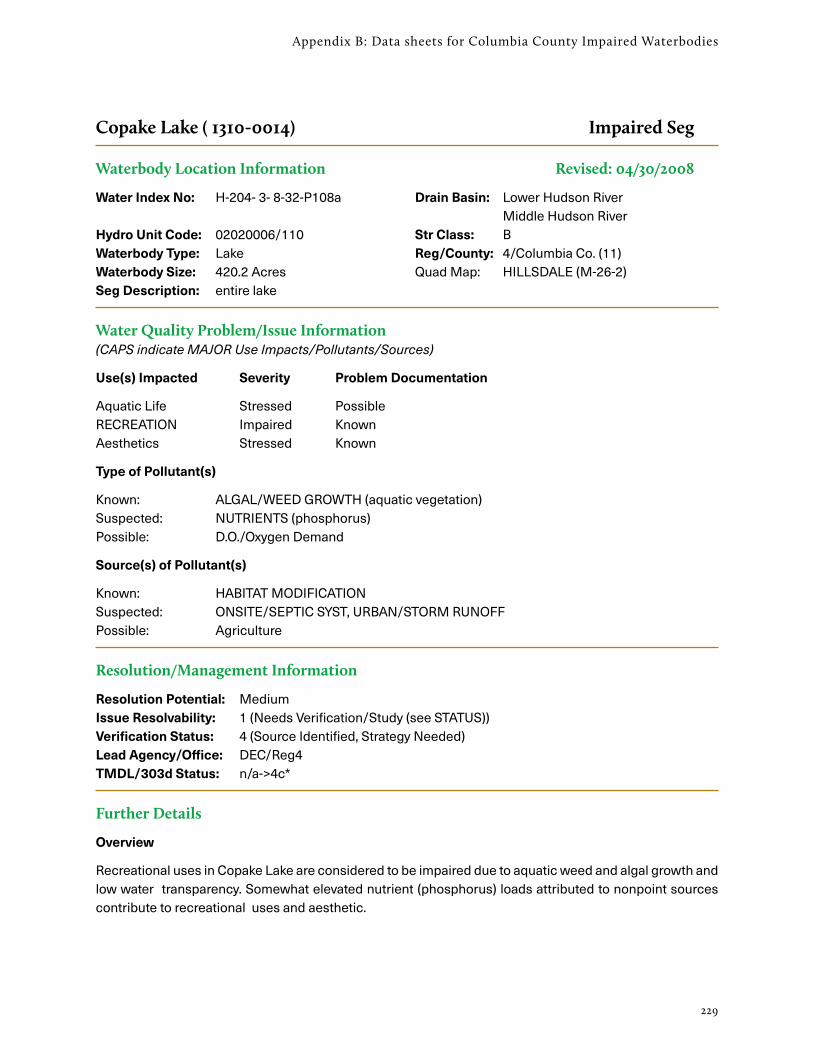
229
Appendix B: Data sheets for Columbia County Impaired Waterbodies
Copake Lake ( 1310-0014) Impaired Seg
Waterbody Location Information Revised: 04/30/2008
Water Index No: H-204- 3- 8-32-P108a Drain Basin: Lower Hudson River Middle Hudson River
Hydro Unit Code: 02020006/110 Str Class: BWaterbody Type: Lake Reg/County: 4/Columbia Co. (11)Waterbody Size: 420.2 Acres Quad Map: HILLSDALE (M-26-2)Seg Description: entire lake
Water Quality Problem/Issue Information (CAPS indicate MAJOR Use Impacts/Pollutants/Sources)
Use(s) Impacted Severity Problem Documentation
Aquatic Life Stressed PossibleRECREATION Impaired KnownAesthetics Stressed Known
Type of Pollutant(s)
Known: ALGAL/WEED GROWTH (aquatic vegetation)Suspected: NUTRIENTS (phosphorus)Possible: D.O./Oxygen Demand
Source(s) of Pollutant(s)
Known: HABITAT MODIFICATIONSuspected: ONSITE/SEPTIC SYST, URBAN/STORM RUNOFFPossible: Agriculture
Resolution/Management Information
Resolution Potential: MediumIssue Resolvability: 1 (Needs Verification/Study (see STATUS))Verification Status: 4 (Source Identified, Strategy Needed)Lead Agency/Office: DEC/Reg4 TMDL/303d Status: n/a->4c*
Further Details
Overview
Recreational uses in Copake Lake are considered to be impaired due to aquatic weed and algal growth and low water transparency. Somewhat elevated nutrient (phosphorus) loads attributed to nonpoint sources contribute to recreational uses and aesthetic.

Columbia County Natural Resources Inventory
230
Water Quality Sampling
Copake Lake has been sampled as part of the NYSDEC Citizen Statewide Lake Assessment Program (CSLAP) from 1996 through 2000. An Interpretive Summary report of the findings of this sampling was published in 2001. These data indicate that the lake continues to be best characterized as eutrophic, or highly productive, based on low water transparency, and elevated nutrient (primarily phosphorus) and algae levels. Phosphorus levels in the lake consistently exceed the state phosphorus guidance value indicating impacted/stressed recreational uses. Corresponding transparency measurements occasionally fail to meet what is recommended for swimming beaches. Eutrophication indicators showed some improv-ing in the most recent sampling years. Measurements of pH typically fall within the state water quality range of 6.5 to 8.5; occasionally high pH does not appear to impact aquatic life. The lake water color does not appear to influence transparency. (DEC/DOW, BWAM/CSLAP, June 2001)
Recreational Assessment
Public perception of the lake and its uses is also evaluated as part of the CSLAP program. This most recent assessment (2005) indicates recreational suitability of the lake to be only somewhat favorable. The recre-ational suitability of the lake is described most frequently as “slightly” impacted for most recreational uses. The lake itself is most often described as having “definite algae greenness,” an assessment that is somewhat lower than indicated by measured water quality characteristics. Assessments have noted that aquatic plants typically grow to the lake surface, and are reported as being dense. Rooted aquatic growth appears to be driving the recreational assessment. (DEC/DOW, BWAM/CSLAP, June 2001)
Lake Uses
This lake waterbody is designated class B, suitable for use as a public bathing beach, for general recreation and aquatic life support, but not as public water supply. Water quality monitoring by NYSDEC focuses primarily on support of general recreation and aquatic life. Samples to evaluate the bacteriological condi-tion and bathing use of the lake or to evaluate contamination from organic compounds, metals or other inorganic pollutants have not been collected as part of the CSLAP monitoring program. Monitoring to assess potable water supply and public bathing use is generally the responsibility of state and/or local health departments.
Previous Assessment
Residential development along the lake shore has increased the concern regarding lawn runoff, and inade-quate onsite septic systems as potential sources. (A few homes that previously discharged raw sewage to the lake now discharge to a holding tank.) Nutrient and fertilizer runoff from a nearby golf course may also contribute to water quality problems. (Columbia County WQCC, 1996)
Section 303(d) Listing
Copake Lake is not currently included on the NYS 2008 Section 303(d) List of Impaired Waters. While this updated assessment suggests it is appropriate to consider the lake to be impaired due to aquatic weed growth, more recent sampling to verify nutrient levels in the lake is recommended before listing the water-body for phosphorus. (DEC/DOW, BWAM/WQAS, May 2008)

231
Appendix B: Data sheets for Columbia County Impaired Waterbodies
Mill Creek and tribs ( 1301-0093) MinorImpacts
Waterbody Location Information Revised: 10/05/1999
Water Index No: H-209 Drain Basin: Lower Hudson River Middle Hudson River
Hydro Unit Code: 02020006/080 Str Class: CWaterbody Type: River Reg/County: 4/Columbia Co. (11)Waterbody Size: 22.8 Miles Quad Map: HUDSON NORTH (L-25-3)Seg Description: entire stream and tribs
Water Quality Problem/Issue Information (CAPS indicate MAJOR Use Impacts/Pollutants/Sources)
Use(s) Impacted Severity Problem Documentation
Aquatic Life Stressed SuspectedAesthetics Stressed Known
Type of Pollutant(s)
Known: NUTRIENTS, Aesthetics, Silt/SedimentSuspected: D.O./Oxygen Demand, Pathogens
Possible: - - -
Source(s) of Pollutant(s)
Known: AGRICULTURESuspected: - - -Possible: - - -
Resolution/Management Information
Resolution Potential: n/aIssue Resolvability: ()Verification Status: (Not Applicable for Selected RESOLVABILITY)Lead Agency/Office: ext/SWCD TMDL/303d Status: n/a
Further Details
Overview
The fishery as well as aesthetics of Mill Creek are thought to be affected by agricultural runoff in the watershed. Visual impairment of the creek has been reported by regional staff. The “J and J” dairy farm in Stuyvesant has been identified through the NYS Ag & Markets and the Statewide Soil and Water Conserva-tion Committee’s AEM program as needing implementation of agricultural BMPs to protect water quality. (DEC\DOW, Region 4, June 1998)

Columbia County Natural Resources Inventory
232
Segment Description
This segment includes the entire stream and all tribs. The waters of the stream are Class C,C(T). Tribs to this reach/segment, including Stuyvesant Brook (-1), are also Class C. Lower tidal portions of these tribs are included with the Hudson Main Stem.

233
Appendix C: Plants and Animals
Table C-1. Common and scientific names of vascular plants mentioned in the Natural Resources Inventory. Scientific nomenclature follows Weldy et al. (2018).
Common Name Scientific Name
alder Alnus
alfalfa Medicago sativa
apple Malus
arrow-arum Peltandra virginica
arrowhead, broad-leaved Sagittaria latifolia
arrowhead, grass-leaved Sagittaria graminea ssp. graminea
arrowhead, spongy Sagittaria montevidensis ssp. spongiosa
arrowhead, stiff Sagittaria rigida
arrowhead, strapleaf Sagittaria subulata
arrowwood, northern Viburnum dentatum var. lucidum
ash Fraxinus
ash, black Fraxinus nigra
ash, green Fraxinus pennsylvanica
ash, white Fraxinus americana
aspen, quaking Populus tremuloides
aster Symphyotrichum
aster, flat-topped white Doellingeria umbellata var. umbellata
autumn-olive Elaeagnus umbellata
azalea, swamp Rhododendron viscosum
baneberry Actaea
baneberry, red Actaea rubra
barberry, Japanese Berberis thunbergii
basswood Tilia americana var. americana
bearberry Arctostaphylos uva-ursi
beardtongue, foxglove Penstemon digitalis
beech, American Fagus grandifolia
beggarticks, estuary Bidens bidentoides
birch Betula
Appendix C: Plants and Animals of Columbia County

Columbia County Natural Resources Inventory
234
Common Name Scientific Name
birch, gray Betula populifolia
birch, swamp Betula pumila
birch, yellow Betula alleghaniensis
bittercress, Pennsylvania Cardamine pensylvanica
bittersweet, oriental Celastrus orbiculatus
bladdernut Staphylea trifolia
blueberry Vaccinium
blueberry, highbush Vaccinium corymbosum
bluestem, little Schizachyrium scoparium var. scoparium
boxelder Acer negundo var. negundo
bracken Pteridium aquilinum ssp. latiusculum
buckthorn, alder-leaf Rhamnus alnifolia
buckthorn, common Rhamnus cathartica
bulrush, dark-green Scirpus atrovirens
bulrush, river Bolboschoenus fluviatilis
bur-reed Sparganium
bur-reed, large Sparganium eurycarpum
butternut Juglans cinerea
buttonbush Cephalanthus occidentalis
canary-grass, reed Phalaris arundinacea
cancer-root, one-flowered Orobanche uniflora
cattail Typha
cedar, eastern red Juniperus virginiana var. virginiana
cherry, black Prunus serotina var. serotina
cherry/plum Prunus
chokeberry, black Aronia melanocarpa
cinquefoil, shrubby Dasiphora fruticosa
cinquefoil, three-toothed Sibbaldia tridentata
cliffbrake, purple Pellaea atropurpurea
cliffbrake, smooth Pellaea glabella ssp. glabella
clover Trifolium
Table C-1. Common and scientific names of vascular plants, cont.

235
Appendix C: Plants and Animals
Common Name Scientific Name
columbine, wild Aquilegia canadensis
coontail, common Ceratophyllum demersum
corydalis, pale Capnoides sempervirens
cottonwood, eastern Populus deltoides ssp. deltoides
goldenrod Solidago
cranberry Vaccinium
cranberry, large Vaccinium macrocarpon
cranberry, small Vaccinium oxycoccos
creeper, Virginia Parthenocissus quinquefolia
cress, rock Arabis/Arabidopsis/Borodinia
cutgrass, rice Leersia oryzoides
deerberry Vaccinium stamineum
dewberry, northern Rubus flagellaris
dodder, buttonbush Cuscuta cephalanthi
dodder, field Cuscuta campestris
dogwood, gray Cornus racemosa
dogwood, red-osier Cornus sericea
dogwood, silky Cornus amomum ssp. amomum
dragon, green Arisaema dracontium
duckweed Lemna or Spirodela
elder, red-berried Sambucus racemosa
elm Ulmus
elm, American Ulmus americana
elm, slippery Ulmus rubra
false-indigo Amorpha fruticosa
fern, cinnamon Osmundastrum cinnamomeum var. cinnamomeum
fern, crested Dryopteris cristata
fern, fragile Cystopteris fragilis
fern, maidenhair Adiantum pedatum
fern, marsh Thelypteris palustris var. pubescens
fern, ostrich Matteuccia struthiopteris var. pensylvanica
Table C-1. Common and scientific names of vascular plants, cont.

Columbia County Natural Resources Inventory
236
Common Name Scientific Name
fern, royal Osmunda regalis var. spectabilis
fern, sensitive Onoclea sensibilis
fern, walking Asplenium rhizophyllum
figworts Scrophularia
flatsedge, Schweinitz’s Cyperus schweinitzii
garlic-mustard Alliaria petiolata
gentian, fringed Gentianopsis crinita
goldenclub Orontium aquaticum
goldenrod, bog Solidago uliginosa
goldenrod, rough-leaf Solidago patula
goldenrod, smooth Solidago gigantea
goldenseal Hydrastis canadensis
gooseberry/currant Ribes
grape, river Vitis riparia
grass, deer-tongue Dichanthelium clandestinum
grass, panic Dichanthelium/Panicum
grass, poverty Danthonia spicata
grass-of-Parnassus Parnassia glauca
hackberry Celtis occidentalis
hairgrass, common Avenella flexuosa
hawthorn Crataegus
hemlock, eastern Tsuga canadensis
hepatica Hepatica
hickory Carya
hickory, shagbark Carya ovata var. ovata
hobblebush Viburnum lantanoides
holly, winterberry Ilex verticillata
honeysuckle, Bell’s Lonicera x bella
hornbeam, American Carpinus caroliniana ssp. virginiana
horsetail, field Equisetum arvense
horsetail, variegated Equisetum variegatum ssp. variegatum
Table C-1. Common and scientific names of vascular plants, cont.

237
Appendix C: Plants and Animals
Common Name Scientific Name
horseweed Erigeron canadensis
huckleberry, black Gaylussacia baccata
indigo, wild Baptisia tinctoria
iris, yellow Iris pseudacorus
jewelweed, common Impatiens capensis
knapweed, spotted Centaurea stoebe ssp. micranthos
knotweed, Japanese Reynoutria japonica var. japonica
knotweed, slender Polygonum tenue
lady’s-slipper, pink Cypripedium acaule
larch, American Larix laricina
oak, chestnut Quercus montana
oak, pin Quercus palustris
oak, red Quercus rubra
oak, scarlet Quercus coccinea
oak, scrub Quercus ilicifolia
oak, swamp white Quercus bicolor
oak, white Quercus alba
orchid, purple-fringed Platanthera psycodes
parsley/carrot/related plants Apiaceae
pear Pyrus
pickerelweed Pontederia cordata
pine Pinus
pine, eastern white Pinus strobus
pine, pitch Pinus rigida
pine, red Pinus resinosa
pine, Scotch Pinus sylvestris
pinweed, slender Lechea tenuifolia
pipevine Endodeca/Isotrema
pitcher-plant Sarracenia purpurea
plantain Plantago
plantain, English Plantago lanceolata
Table C-1. Common and scientific names of vascular plants, cont.

Columbia County Natural Resources Inventory
238
Common Name Scientific Name
plantain, heartleaf Plantago cordata
pod-grass Scheuchzeria palustris
poison-ivy Toxicodendron radicans
polypody, rock Polypodium virginianum
pond-lily, fragrant Nymphaea odorata ssp. odorata
pond-lily, yellow Nuphar variegata
pondweed, perfoliate Potamogeton perfoliatus
prickly-ash, American Zanthoxylum americanum
primroses Oenothera
purslane Portulaca oleracea
quarters, lamb’s Chenopodium album
raspberry Rubus
rattlebox Crotalaria sagittalis
spleenwort, ebony Asplenium platyneuron
spleenwort, maidenhair Asplenium trichomanes
spruce, black Picea mariana
spruce, Norway Picea abies
stargrass, water Heteranthera dubia
stiltgrass, Japanese Microstegium vimineum
sundew, round-leaved Drosera rotundifolia
sunflower Helianthus
swallow-wort, black Vincetoxicum nigrum
sweetfern Comptonia peregrina
sweetflag Acorus
switchgrass Panicum virgatum
sycamore, eastern Platanus occidentalis
tea, New Jersey Ceanothus americanus
tearthumb, arrow-leaved Persicaria sagittata
tearthumb, halberd-leaved Persicaria arifolia
three-square Schoenoplectus pungens var. pungens
Table C-1. Common and scientific names of vascular plants, cont.

239
Appendix C: Plants and Animals
Common Name Scientific Name
thyme Thymus pulegioides
timothy Phleum pratense ssp. pratense
toothworts Cardamine
top, purple Tridens flavus var. flavus
tree-of-heaven Ailanthus altissima
trefoil, tick Desmodium
tulip-tree Liriodendron tulipifera
turtlehead, white Chelone glabra
vervain, blue Verbena hastata
vetches Vicia
viburnum, maple-leaf Viburnum acerifolium
violet Viola
violet, northern blue Viola septentrionalis
wall-rue Asplenium ruta-muraria
water-celery Vallisneria americana
water-chestnut Trapa natans
water-hemp Amaranthus tuberculatus
watermilfoil, Eurasian Myriophyllum spicatum
water-plantain Alisma
watershield Brasenia schreberi
waterweed, Nuttall’s Elodea nuttallii
water-willow Decodon verticillatus
waterwort, American Elatine americana
weed, spotted Joe-Pye Eutrochium maculatum var. maculatum
wild-raisin, northern Viburnum nudum var. cassinoides
willow Salix
willow, autumn Salix serissima
willow, sage-leaved Salix candida
witch-hazel Hamamelis virginiana
yew, American Taxus canadensis
Table C-1. Common and scientific names of vascular plants, cont.

Columbia County Natural Resources Inventory
240
Common Name1 Scientific NameNYS
Rank2
NYNHP Rank3
Habitat
agalinis, small-flowered
Agalinis paupercula R S3 calcareous marsh
agrimony, small-flowered
Agrimonia parviflora R S3 pasture, thicket
angelica, hairy Angelica venenosa R S1 dry forest
arrowhead, strapleaf Sagittaria subulata R S3 tidal mudflat
arrowhead, spongy-leaved
Sagittaria montevi-densis ssp. spongi-osa
T S2 tidal mudflat
avens, cream~ Geum virginianum T S2 wettish forest
beggar-ticks, Eaton’s Bidens eatonii S1 tidal mudflat
beggar-ticks, estuary Bidens bidentoides R S3 tidal mudflat
beggar-ticks, smooth Bidens laevis T S2 tidal freshwater marsh
bellflower, American Campanula americana
E S1 forest, thicket, disturbed area
birch, bog Betula pumila T S2 calcareous marsh
birch, river Betula nigra R S3 riverbank, low wet area
bittersweet, American Celastrus scandens R S3 dry forest, hedgerow
bladderwort, hiddenfruit
Utricularia geminiscapa
R S3 open swamp, pond, marsh
bladderwort, lesser~ Utricularia minor R S3 calcareous bog
bulrush, Georgia~ Scirpus georgianus E S1S2 marsh, wet meadow
bulrush, Torrey’s~ Schoenoplectus torreyi
S2? wet meadow, pond edge
bur-reed, branched Sparganium androcladum
S3S4 shallow water, muddy shore
bur-reed, narrowleaf Sparganium angustifolium
S3S4 deep or shallow water
bush-clover, bushy~ Lespedeza frutescens
R S3 dry forest, edge of forest, rocky summit
buttercup, small-flowered~
Ranunculus micranthus
R S3 wet forested rock outcrop, ledge
Table C-2. Vascular plants of statewide conservation concern in Columbia County.
From observations of the Farmscape Ecology Program, Hudsonia, and Rogers McVaugh (1959).

241
Appendix C: Plants and Animals
Common Name1 Scientific NameNYS
Rank2
NYNHP Rank3
Habitat
chervil, spreading Chaerophyllum procumbens
E S1 floodplain
cliffbrake, smooth~ Pellaea glabella ssp. glabella
T S2 limestone cliff
coontail, spiny-fruited Ceratophyllum echinatum
R S3 pond, lake, slow moving stream
Culver’s-root Veronicastrum virginicum
T S2 wet meadow, streambank
elm, rock Ulmus thomasii T S2S3 dry soils over calcareous bedrock
fairywand~ Chamaelirium luteum E S1S2 wet forest, bog
flatsedge, fragrant Cyperus odoratus R S3 sandy soil near tidal Hudson River
flatsedge, red-rooted Cyperus erythrorhizos
R S3 dredge spoils
flatsedge, Schweinitz’s~
Cyperus schweinitzii R S3 sandy soil
flax, grooved yellow~ Linum sulcatum T S2 dry, sandy, or stony soil
goldenclub Orontium aquaticum T S2 tidal mudflat
goldenrod, Ohio flat-topped~
Solidago ohioensis T S2 rich fen, shaded ledge
goldenrod, stiff flat-topped
Solidago rigida var. rigida
T S2 dry shaly slope
goldenseal~ Hydrastis canadensis T S2 rich soil at base of calcareous slopes
grama, side oats~ Bouteloua curtipen-dula var. curtipendula
E S2 dry shaly slope
grape, frost~ Vitis vulpina E S1 forest, thicket
grass, northern reed Calamagrostis stricta ssp. inexpansa
T S2 rocky (schist) slope
grass, pod~ Scheuchzeria palustris
R S3 bog
Table C-2. Vascular plants of statewide conservation concern in Columbia County, cont.

Columbia County Natural Resources Inventory
242
Common Name1 Scientific NameNYS
Rank2
NYNHP Rank3
Habitat
grass, prairie wedge~ Sphenopholis obtusata
E S1 dry soil
hyssop, yellow giant Agastache nepetoides
T S2S3 open forest
knotweed, pleated leaved
Polygonum tenue R S3 dry, shaly, sandy hill & knoll
lady’s-slipper, greater yellow
Cypripedium parviflo-rum var. pubescens
S3 rich, often calcareous forest
lady’s-slipper, showy~ Cypripedium reginae S3 rich swamp
lousewort, marsh Pedicularis lanceolata
T S2S3 tidal swamp, supratidal wetland edge, rich wetland
lupine, wild~ Lupinus perennis ssp. perennis
R S3 dry, sandy, or shaly soil
mercury, Virginia three-seeded~
Acalypha virginica E S1 forest, field, roadside
milkweed, green Asclepias viridiflora T S2 dry shaly slope
milkweed, whorled Asclepias verticillata R S3 dry shaly slope
monkey-flower, sharp-winged
Mimulus alatus R S3 wet area along stream, wetland, pond
mouth, dragon’s~ Arethusa bulbosa T S2 Sphagnum bog
mudwort, Atlantic Limosella australis R S3 tidal mudflat
nymph, Muenscher’s water
Najas muenscheri E S2 tidal mudflat
orchid, Hooker’s~ Platanthera hookeri E S1 steep rocky acidic slope
pennyroyal, false~ Trichostema brachiatum
R S3 dry, sandy or gravelly soil
pinedrops, woodland~ Pterospora andromedea
E S1 conifer forest
pink, wild Silene caroliniana ssp. pensylvanica
T S2 dry forest on shaly or schistose rock
pitcher-plant, purple Sarracenia purpurea S3S4? Sphagnum bog, calcareous wetland
plantain, heart-leaved Plantago cordata R S3 rocky intertidal shore
Table C-2. Vascular plants of statewide conservation concern in Columbia County, cont.

243
Appendix C: Plants and Animals
Common Name1 Scientific NameNYS
Rank2
NYNHP Rank3
Habitat
plantain, kidneyleaf mud~
Heteranthera reniformis
R S3 tidal mudflat
plum, American Prunus americana S3S4? disturbed soils, forest edge
pondweed, Hill’s Potamogeton hillii T S2 clear, cold calcareous water
pondweed, Ogden’s Potamogeton x ogdenii
E S1 alkaline water
pondweed, spotted~ Potamogeton pulcher T S2 shallow acidic water, muddy shore
pondweed, straight-leaved~
Potamogeton strictifolius
E S1 alkaline pond, stream
pondweed, Tuckerman’s~
Potamogeton confervoides
R S3 shallow, acidic water
quillwort, lake~ Isoetes lacustris R S3 gravel in cold pond, lake, stream
quillwort, shore Isoetes septentrio-nalis
E S1 tidal mudflat
rattlebox, common~ Crotalaria sagittalis E S1 sandy or waste ground
rush, forked Juncus dichotomus S3? sandy soils, marsh, shore of river or lake
sedge, ambiguous~ Carex amphibola E S3 forest, forested slope, floodplain of small creek
sedge, Bicknell’s Carex bicknellii R S3 dry shaly bank
sedge, blue~ Carex glaucodea T S2 hardwood forest, disturbed area, meadow
sedge, Bush’s Carex bushii R S3 rich meadowland
sedge, Buxbaum’s~ Carex buxbaumii T S2 swamp
sedge, cattail~ Carex typhina E S2 wet forest, marsh
sedge, Davis’ Carex davisii T S2 alluvial forest, calcareous
sedge, false hop Carex lupuliformis T S2 floodplain forest, marsh, shoreline, intermittent woodland pool
sedge, Fernald’s Carex merritt-fernaldii
T S2S3 gravel pit, dry roadside, dredge spoil
Table C-2. Vascular plants of statewide conservation concern in Columbia County, cont.

Columbia County Natural Resources Inventory
244
Common Name1 Scientific NameNYS
Rank2
NYNHP Rank3
Habitat
sedge, handsome~ Carex formosa T S2 calcareous forest, thicket
sedge, reflexed Carex retroflexa T S2S3 calcareous forest, rocky slope, meadow
sedge, Schweinitz’s~ Carex schweinitzii T S2S3 swamp, springy bank
sedge, small yellow Carex cryptolepis R S3 calcareous marsh, wet meadow
sedge, troublesome~ Carex molesta T S2S3 swamp
sedge, wheat~ Carex atherodes R S3 pond
sedge, Willdenow’s Carex willdenowii R S2S3 dry acidic forest
sorrel, violet wood Oxalis violacea T S2S3 dry upland forest
speedwell, chained (water)~
Veronica catenata S3S5 calcareous wetland
speedwell, glandular Veronica peregrina ssp. xalapensis
R S3 wet area, often disturbed, meadow
spleenwort, mountain~ Asplenium montanum
T S2S3 dry, acidic rock
spikerush, Engelmann’s~
Eleocharis engelmannii
E S1 marsh, wet area
spikerush, ovate Eleocharis ovata E S1S2 tidal mudflat
St. Johnswort, great Hypericum ascyron ssp. pyramidatum
R S3 alluvial or rocky soil near large stream
St. Johnswort, shrubby Hypericum prolificum T S2 forest, cliff, swamp-margin, oldfield
tick-trefoil, hairy small-leaf
Desmodium ciliare T S2S3 open habitat with dry soils
tree, Kentucky coffee~ Gymnocladus dioicus E S1 rich bottomland, thicket, forest edge
trillium, nodding Trillium cernuum S3 moist forests
valerian, marsh Valeriana uliginosa E S1S2 calcareous marsh
vervain Verbena x engelmannii
S1? forest, marsh, meadow
violet, green~ Hybanthus concolor S3S4? cool wet forest
Table C-2. Vascular plants of statewide conservation concern in Columbia County, cont.

245
Appendix C: Plants and Animals
Common Name1 Scientific NameNYS
Rank2
NYNHP Rank3
Habitat
water-marigold, Beck’s Bidens beckii S3 shallow water at pond or lake edge
waterwort, American~ Elatine americana E S1 tidal mudflat
1 ~ = plant species reported by McVaugh but not seen by recent observers. 2 NY State ranks: E = Endangered / T = Threatened / R = Rare 3 New York Natural Heritage Program ranks are explained in Appendix D.
Table C-2. Vascular plants of statewide conservation concern in Columbia County, cont.

Columbia County Natural Resources Inventory
246
Table C-3. Prominent non-native invasive plants of Columbia County and the region, listed and ranked for management priority (tiers) by the Capital-Mohawk Partnership for Invasive Species Management (PRISM).
Updated lists of invasive species are at http://www.capitalmohawkprism.org/uploads/8/1/4/0/81407728/capmo_is_tiersystem.pdf.
A. Non-native invasive plant species known to occur in Columbia County.
Common Name (Scientific Name)
Tier 21
Tier 31
Tier 41
Tier 51
Habitat
alder, black (Alnus glutinosa) X wetland, shoreline
autumn-olive (Elaeagnus umbellata)
X forest edge, meadow
barberry, European (Berberis vulgaris)
X forest, meadow
barberry, Japanese (Berberis thunbergii)
X forest, shrubland, meadow, floodplain
bittercress, narrowleaf (Cardamine impatiens)
X forest
bittersweet, Asian (Celastrus orbiculatus)
X forest, shrubland, waste ground
bower, Japanese virgin’s (Clematis terniflora)
X forest, shrubland, meadow
buckthorn, common (Rhamnus cathartica)
X forest, shrubland, meadow
buckthorn, glossy (Frangula alnus)
X forest, shrubland, meadow, swamp
bush, burning (Euonymus alatus) X forest, shrubland
canary-grass, reed (Phalaris arundinacea)
X wetland, shoreline, meadow
celandine, lesser (Ficaria verna) X forest, floodplain, shoreline
chervil, wild (Anthriscus sylvestris)
X forest edge, meadow
crabapple, Toringo (Malus toringo)
X forest, shrubland
didymo (Didymosphenia geminata)
X stream
elm, Siberian (Ulmus pumila) X forest edge, meadow, shoreline

247
Appendix C: Plants and Animals
Common Name (Scientific Name)
Tier 21
Tier 31
Tier 41
Tier 51
Habitat
floating-heart, yellow (Nymphoides peltata)
X lake, pond, stream
garlic-mustard (Alliaria petiolata) X forest, floodplain
helmet, policeman’s (Impatiens glandulifera)
X meadow
honeysuckle, Amur (Lonicera maackii)
X forest, shrubland
honeysuckle, Bell’s (Lonicera x bella)
X forest, shrubland, meadow
honeysuckle, Japanese (Lonicera japonica)
X forest, shrubland, meadow
honeysuckle, Morrow’s (Lonicera morrowii)
X forest, shrubland
honeysuckle, Tartarian (Lonicera tatarica)
X forest, shrubland, meadow
hops, Japanese (Humulus japonicus)
X meadow, waste ground
iris, yellow (Iris pseudacorus) X wetland, shoreline
ivy, English (Hedera helix) X forest
knapweed, spotted (Centaurea stoebe ssp. micranthos)
X meadow
knotweed, Japanese (Reynoutria japonica var. japonica)
X forest, shoreline, floodplain, waste ground
lilac, Japanese tree (Syringa reticulata)
X forest, meadow
locust, black (Robinia pseudoacacia)
X forest, floodplain, meadow
loosestrife, purple (Lythrum salicaria)
X wetland, shoreline, meadow
maple, Norway (Acer platanoides)
X forest
maple, sycamore (Acer pseudoplatanus)
X forest, floodplain
Table C-3.A. Non-native invasive plant species known to occur in Columbia County, cont.

Columbia County Natural Resources Inventory
248
Common Name (Scientific Name)
Tier 21
Tier 31
Tier 41
Tier 51
Habitat
mugwort (Artemisia vulgaris var. vulgaris)
X forest, meadow, waste ground
mulberry, white (Morus alba) X forest edge, meadow
naiad, brittle (Najas minor) X lake, pond, stream, river
parsnip, wild (Pastinaca sativa) X meadow
periwinkle (Vinca minor) X forest, meadow
pondweed, curly leaf (Potamogeton crispus)
X lake, pond, stream, river
privet, border (Ligustrum obtusifolium)
X forest, shrubland, meadow
reed, common (Phragmites australis)
X wetland, shoreline
rose, multiflora (Rosa multiflora)
X forest, shrubland, meadow, shoreline
spurge, cypress (Euphorbia cyparissias)
X meadow
spurge, leafy (Euphorbia virgata)
X forest edge, meadow, waste ground
stiltgrass, Japanese (Microstegium vimineum)
X forest, meadow, shoreline, floodplain
swallow-wort, black (Vincetoxicum nigrum)
X forest, meadow, shoreline
teasel, cut-leaf (Dipsacus laciniatus)
X meadow, waste ground
thistle, bull (Cirsium vulgare) X meadow
thistle, Canada (Cirsium arvense) X meadow
tree, wayfaring (Viburnum lantana)
X forest, meadow
tree-of-heaven (Ailanthus altissima)
X forest, shrubland, waste ground
viburnum, European cranberry (Viburnum opulus var. opulus)
X meadow, wetland, shoreline
water-chestnut (Trapa natans) X lake, pond, stream, river
Table C-3.A. Non-native invasive plant species known to occur in Columbia County, cont.

249
Appendix C: Plants and Animals
Common Name (Scientific Name)
Tier 21
Tier 31
Tier 41
Tier 51
Habitat
watermilfoil, Eurasian (Myriophyllum spicatum)
X lake, pond, stream
wineberry (Rubus phoenicolasius)
X forest, meadow, rocky slope
Table C-3.B. Non-native invasive plant species not yet known to occur in Columbia County, but occurring elsewhere in the region.
Common Name (Scientific Name)
Tier 21
Tier 31
Tier 41
Tier 51
Habitat
aralia, five-leaf (Eleutherococcus sieboldianus)
X swamp
berry, porcelain (Ampelopsis glandulosa)
X forest, meadow
carpetgrass, small (Arthraxon hispidus)
X forest, floodplain, swamp
cup-plant (Silphium perfoliatum var. perfoliatum)
X shrubland
elodea, Brazilian (Egeria densa) X lake, pond, stream
frogbit, European (Hydrocharis morsus-ranae)
X lake, pond, stream
goutweed, bishops (Aegopodium podagraria)
X forest, floodplain, meadow
grass, Chinese silver (Miscanthus sinensis)
X meadow
jetbead, black (Rhodotypos scandens)
X forest edge
Johnsongrass (Sorghum halepense)
X meadow
knotweed, bohemian (Reynoutria x bohemica)
X shoreline, floodplain, waste ground
knotweed, giant (Reynoutria sachalinensis)
X meadow, shoreline, waste ground
loosestrife, yellow garden (Lysimachia vulgaris)
X meadow
Table C-3.A. Non-native invasive plant species known to occur in Columbia County, cont.

Columbia County Natural Resources Inventory
250
Common Name (Scientific Name)
Tier 21
Tier 31
Tier 41
Tier 51
Habitat
maple, Japanese (Acer palmatum)
X forest, meadow
hogweed, giant (Heracleum mantegazzianum)
X road bank, forest, oldfield
swallow-wort, pale (Vincetoxicum rossicum)
X forest, meadow, shoreline
thistle, Carline (Carlina vulgaris) X meadow
rush, flowering (Butomus umbellatus)
X shoreline, marsh
vine, China fleece (Fallopia baldschuanica)
X forest edge
vine, mile-a-minute (Persicaria perfoliata)
X forest, meadow
waterwheel (Aldrovanda vesiculosa)
X lake, pond
willow, rusty (Salix cinerea ssp. oleifolia)
X forest edge, meadow, shoreline
wisteria (Wisteria spp.) X forest
1Tier 2: Eradication is recommended. High and very high impact species with low enough abundance to make eradication feasible within the Mohawk-Hudson PRISM region. Highest level of response efforts.
Tier 3: Containment is recommended. High and very high impact species that are likely too widespread for eradication, but low enough abundance to think about regional containment. Target strategic management to slow the spread since many surrounding regions could be at risk if left unattended.
Tier 4: Local control is recommended. Well-established species with high and very high impacts. Eradication efforts not feasible; only localized management over time to contain, exclude, or suppress, if justified to meet local management goals.
Tier 5: More research is needed. Species in or surrounding the PRISM region that need more research, mapping, and monitoring to understand invasiveness and impacts.
Table C-3.B. Non-native invasive plant species not yet known to occur in Columbia County, but occurring elsewhere in the region, cont.

251
Appendix C: Plants and Animals
Table C-4. Dragonflies and damselflies of Columbia County.
Data are from the NYSDEC 2005-2009 statewide survey (White et al. 2010) and from Farmscape Ecology Program (FEP) observations 2003-2017. Habitats are from Vispo (2017) and Abbott (2006-2018).
Common Name Scientific Name HabitatStatewide
Status2
AESHNIDAE
darner,1 black-tipped Aeshna tuberculifera over fields & along edge of water
darner, Canada Aeshna canadensis over fields & along shores of slow-moving water
darner,1 comet Anax longipes around ponds or over fields S2S3
darner, common green Anax junius over small ponds, skimming lake edges, or over fields
darner,1 fawn Boyeria vinosa in forested swamps & over shaded streams
darner,1 green-striped Aeshna verticalis over fields
darner,1 harlequin Gomphaeschna furcillata
edges of forests
darner, lance-tipped Aeshna constricta over fields & ponds
darner, shadow Aeshna umbrosa along forest edges, shaded areas
darner,1 swamp Epiaeschna heros wooded ponds & streams (incl. ephemeral pools & ponds)
S3
CALOPTERYGIDAE
jewelwing, ebony Calopteryx maculata in shaded areas & along small streams
jewelwing,1 river Calopteryx aequabilis around all types of rivers & streams
jewelwing,1 superb Calopteryx amata by the sides of small, shaded streams
S3
rubyspot,1 American Hetaerina americana streams, rivers S3
COENAGRIONIDAE
bluet, azure Enallagma aspersum near most slow-moving water
bluet, big Enallagma durum around swampy ponds or slow-moving rivers
S3
bluet, double-striped Enallagma basidens around edges of still water where vegetation present
S3
bluet, familiar Enallagma civile around large, slow-moving water bodies

Columbia County Natural Resources Inventory
252
Common Name Scientific Name HabitatStatewide
Status2
bluet, Hagen’s Enallagma hageni along edges of ponds
bluet,1 marsh Enallagma ebrium around wetlands & open swamps
bluet,1 northern Enallagma annexum around still water & nearby vegetation
bluet, orange Enallagma signatum near all types of still water
bluet, skimming Enallagma geminatum around edges of most types of water
bluet, stream Enallagma exsulans along sides of streams & lakes
bluet,1 tule Enallagma caruncula-tum
slow-moving streams & rivers, occasionally lakes or ponds
bluet,1 turquoise Enallagma divagans slow-moving streams, lakes S3
bluet,1 vesper Enallagma vesperum around ponds & lakes S4
damsel, aurora Chromagrion conditum near most water; esp. slow-moving or stagnant ponds
damselfly,1 eastern red Amphiagrion saucium around ponds or other stationary water
dancer, blue-fronted Argia apicalis rivers, large streams, esp. deep & muddy
S3
dancer,1 powdered Argia moesta around medium to large rivers, ponds, & lakes
dancer, variable Argia fumipennis violacea
around edges of most slow or still water
forktail, eastern Ischnura verticalis wide variety incl. ponds, edges of slow-moving rivers, & fields
forktail, fragile Ischnura posita wide variety incl. pond edges, forested swamps, streams, & fields
sprite, sedge Nehalennia irene in wet, grassy, mostly open areas
sprite,1 sphagnum Nehalennia gracilis sphagnum bogs, fens
CORDULEGASTRIDAE
spiketail,1 delta-spotted
Cordulegaster diastatops
unshaded seeps, small streams
spiketail,1 twin-spotted
Cordulegaster maculata around rocky, shaded streams & along field edges
Table C-4. Dragonflies and damselflies, cont.

253
Appendix C: Plants and Animals
Common Name Scientific Name HabitatStatewide
Status2
CORDULIIDAE
baskettail,1 beaverpond
Epitheca canis bog ponds, slow-moving streams, & marshy lakes
baskettail, common Epitheca cynosura around ponds & nearby fields
baskettail,1 prince Epicordulia princeps tree-tops
emerald, American Cordulia shurtleffii near still ponds, bogs, fens, marsh-es, small lakes, & over meadows
emerald,1 brush-tipped Somatochlora walshii slow-moving clear streams through bogs, fens, & marshes
S3
emerald,1 clamp-tipped
Somatochlora tenebrosa
edge of fields & along shady tree lines
emerald,1 Kennedy Somatochlora kennedyi bogs SNA
emerald,1 mocha Somatochlora linearis forested streams S1
emerald,1 racket-tailed Dorocordulia libera over ponds & bogs & along edges of forests
shadowdragon,1 umber
Neurocordulia obsoleta small lakes S1
GOMPHIDAE
clubtail,1 arrow Stylurus spiniceps over sandy streams or on the banks S3
clubtail,1 ashy Gomphus lividus moderately fast-moving streams & sheltered inlets of lakes
clubtail,1 dusky Gomphus spicatus over slow-moving or still water
clubtail,1 harpoon Gomphus descriptus fast-moving streams with sandy bottoms
S3
clubtail, lancet Gomphus exilis over fields, roads, & on rocks near water
clubtail, least Stylogomphus albistylus
around rocky streams
clubtail,1 lilypad Arigomphus furcifer around still water & slow-moving streams
clubtail,1 mustached Gomphus adelphus near riffles in clear streams, or along lakeshore
S2S3
Table C-4. Dragonflies and damselflies, cont.

Columbia County Natural Resources Inventory
254
Common Name Scientific Name HabitatStatewide
Status2
clubtail,1 northern pygmy
Lanthus parvulus over small shaded streams S3
clubtail,1 southern pygmy
Lanthus vernalis clear streams. forested S1, SPCN
clubtail,1 russet-tipped Stylurus plagiatus rivers S1
clubtail,1 spine-crowned
Gomphus abbreviatus rivers, lakes S1
clubtail,1 unicorn Arigomphus villosipes around ponds & lakes
clubtail,1 zebra Stylurus scudderi near streams & small rivers S3
dragonhunter1 Hagenius brevistylus along streams, esp. shaded ones
snaketail,1 boreal Ophiogomphus colubrinus
fast-moving streams with gravel or sand bottoms, shaded
S1
snaketail, brook Ophiogomphus aspersus
over clean running water, open sunny streams
S3
snaketail,1 riffle Ophiogomphus carolus
near swift streams & small rivers S2S3
snaketail,1 rusty Ophiogomphus rupinsulensis
near rivers & on nearby rocks
spinyleg,1 black-shouldered
Dromogomphus spinosus
around clear rocky streams
LESTIDAE
spreadwing, amber-winged
Lestes eurinus near still water; esp. boggy or temporary ponds
S3S4
spreadwing,1 common Lestes disjunctus slow-moving streams with emergent veg, marshes, swamps, & bogs
spreadwing,1 elegant Lestes inaequalis near still water & in shaded environments
spreadwing, slender Lestes rectangularis around forested pools & small clearings
spreadwing,1 southern Lestes australis still or slow-moving water, perm. or intermit. ponds, marshes, & lakes
S2S3, SPCN
spreadwing, spotted Lestes congener around still, marshy water
spreadwing, swamp Lestes vigilax near still, swampy bodies of water
Table C-4. Dragonflies and damselflies, cont.

255
Appendix C: Plants and Animals
Common Name Scientific Name HabitatStatewide
Status2
spreadwing, sweetflag Lestes forcipatus around still, swampy water
LIBELLULIDAE
amberwing, eastern Perithemis tenera around ponds & other still water, or in nearby fields
corporal, chalk-fronted Ladona julia near ponds & small lakes
dasher, blue Pachydiplax longipennis over still ponds
glider,1 spot-winged Pantala hymenaea open temp. ponds, pools (incl. artificial)
glider, wandering Pantala flavescens over fields & wide open areas
meadowhawk, band-winged
Sympetrum semicinctum
in meadows & fields
meadowhawk,1 cherry-faced
Sympetrum internum around small ponds & nearby fields
meadowhawk, ruby Sympetrum rubicundulum
around swamps, wet meadows, & wetlands
S3
meadowhawk,1 white-faced
Sympetrum obtrusum in swamps & wet vegetated areas, or fields
meadowhawk,1 yellow-legged
Sympetrum vicinum near still water or fields
pennant,1 banded Celithemis fasciata marshy ponds S3
pennant, calico Celithemis elisa around ponds or in nearby fields
pennant, Halloween Celithemis eponina in fields & around ponds
pondhawk, eastern Erythemis simplicicollis around ponds or (for females esp.) in fields
saddlebags, black Tramea lacerata over fields & meadows
skimmer,1 four-spotted Libellula quadrimaculata
around ponds, swamps, & marshy streams
skimmer, painted Libellula semifasciata marshy forested seeps, ponds, & slow-moving streams
skimmer, slaty Libellula incesta around edges of ponds & lakes
skimmer, spangled Libellula cyanea around ponds & streams
skimmer, twelve-spotted
Libellula pulchella near bodies of water & over fields
Table C-4. Dragonflies and damselflies, cont.

Columbia County Natural Resources Inventory
256
Common Name Scientific Name HabitatStatewide
Status2
skimmer, widow Libellula luctuosa near ponds & lakes & in wide variety of fields
whiteface, dot-tailed Leucorrhinia intacta around ponds or other small stagnant bodies of water
whiteface,1 frosted Leucorrhinia frigida mud-bottomed lakes & ponds with emergent veg, pools in fens, bogs
whiteface,1 red-waisted
Leucorrhinia proxima bogs, fens, acidic ponds
whitetail, common Plathemis lydia all types of water (except fast-moving) & in fields
MACROMIIDAE
cruiser, Illinois River Macromia illinoiensis over shaded rivers or more open areas
cruiser,1 stream Didymops transversa medium to large streams & rivers
1 Species known from five or fewer locations in the county. 2 New York Natural Heritage Program ranks (S1, S2, S3, SNA) are explained in Appendix D. SPCN = NYS Species of Potential Conservation Need (https://www.dec.ny.gov/docs/wildlife_pdf/spnc2015list.pdf)
Table C-4. Dragonflies and damselflies, cont.

257
Appendix C: Plants and Animals
Table C-5. Butterflies of Columbia County, New York.
Compiled by the Hawthorne Valley Farmscape Ecology Program (FEP) with input from Harry Zirlin and others. Flight time and foods from Cech and Tudor (2005); habitats from Cech and Tudor and FEP observations.
Common Name
State-wide
Status1,2
Apparent Status in County
Flight Time Caterpillar Food Habitat
HESPERIIDAE
broken-dash, northern
rare early June-mid Aug
panic grasses oldfield
cloudywing, northern
occasional late May-early July
clovers & other legumes
“scrubby field”
cloudywing,3 southern
rare early June-mid July
legumes open habitats
dash, black occasional late April-early June
sedges sedgy wetlands
dash, long occasional early June-early July; Aug
grasses open grassy meadow, often moist
duskywing, columbine
unseen but possible
May-June, July columbine calcareous ledge
duskywing,3 dreamy
rare mid May-June willows, aspen, black locust
open forest & edges
duskywing,3 Horace’s
rare May, June, Sept oaks dry, open oak woods
duskywing, Juvenal’s
common late April-early June
oaks open upland habitats, usually not disturbed
duskywing,3 mottled
S1, SGCNHP
rare May-June, July-August
New Jersey tea open, dry forest
duskywing, sleepy
unseen but possible
May scrub oak balds, barrens
duskywing, wild indigo
occasional May-Aug wild indigo, vetches in or near alfalfa fields
edge,3 hoary rare June-July legumes, e.g., tick trefoil
oldfield & field edges

Columbia County Natural Resources Inventory
258
Common Name
State-wide
Status1,2
Apparent Status in County
Flight Time Caterpillar Food Habitat
glassywing, little
occasional late June-July purple top & other grasses
oldfield & pasture
sachem rare vagrant; observed once in Sept
grasses in & near disturbed grassy areas
skipper, arctic rare late May to mid June
grasses grasses near forest
skipper, broadwing
S3 occasional mid July-Aug reeds, sedges, wild rice
wet areas with Phragmites
skipper, cobweb
rare May-June bluestems dry fields
skipper, common checkered
occasional mid May-Sept mallows short, sparse meadows & lawns
skipper, crossline
occasional late June-early Aug
grasses dry and moist fields
skipper, Delaware
rare mainly July little bluestem, switchgrass, other grasses
open habitats, dry to wet
skipper, Dion rare July sedges wetlands
skipper, dun occasional July-Aug sedges, maybe grasses
oldfield
skipper, dusted
S2S3 unseen but possible
May - June bluestems dry open habitats
skipper, European
common June-July timothy & other introduced grasses
meadow
skipper, fiery rare Sept-Oct grasses open uplands
skipper, Hobomok
common late May-early July
grasses oldfield
skipper, Indian
rare May-June grasses, e.g., bluestem
dry, often shrubby, meadows
skipper, least common June-Oct grasses wet meadow, grassy marsh
Table C-5. Butterflies, cont.

259
Appendix C: Plants and Animals
Common Name
State-wide
Status1,2
Apparent Status in County
Flight Time Caterpillar Food Habitat
skipper, Leonard’s
rare end of Aug-early Sept
native grasses, e.g., little bluestem
dry upland grassland near wet area
skipper, Ocola
rare migrant
Sept-Oct rice cutgrass? around flowers
skipper, Peck’s
common late May-Sept grasses meadow
skipper, pepper & salt
rare May-June grasses forest openings
skipper,3 roadside
rare late May-mid June
grasses forest openings
skipper, silver-spotted
common June-Aug black locust shrubby fields
skipper, tawny-edged
common late May-mid July; early Aug-Sept
grasses grassy, often moist
skipper, two spotted
unseen but possible
late June-July sedges, especially hairy-fruited sedge
wetlands
skipper, Zabulon
rare late May-mid June; mid Aug-mid Sept
grasses shrubby fields, roadside
sootywing, common
common mid May-mid June; late July-Aug
lamb’s quarters & others
open habitats
wing, mulberry
rare mid July-early Aug
sedges sedgy wetlands
LYCAENIDAE
azure, spring-summer
common April-Sept (various) mainly meadows
blue, eastern tailed
common May-Sept legumes open, disturbed, low growth
blue, silvery rare April-June legumes openings in moist forest
Table C-5. Butterflies, cont.

Columbia County Natural Resources Inventory
260
Common Name
State-wide
Status1,2
Apparent Status in County
Flight Time Caterpillar Food Habitat
copper, American
common May-Sept Rumex (docks) drier meadows
copper, bog unseen but possible
late June-July cranberries acidic wet meadows
copper, bronze
occasional mid June-mid July; early Aug-mid Sept
Rumex (docks) wetlands around ponds or streams
elfin, brown rare May heaths barrens, dry forest
elfin, eastern pine
rare May-June pines near pine woods
hairstreak, Acadian
unseen but possible
July willows shrubby wet meadows & swamps
hairstreak, banded
occasional May-Aug oaks, hickories edges, open habitats
hairstreak, coral
rare June cherries, plums oldfield, second growth
hairstreak, early
unseen but possible
May-June, July-August
beechnuts beech forest
hairstreak, Edward’s
S3S4 unseen but possible
July scrub oak scrub oak forest, rocky barren
hairstreak, grey
occasional early May-mid June
various meadow & shrubland plants
open, weedy, disturbed
hairstreak, hickory
occasional late June-early Aug
hardwood trees edges of rich, deciduous forests
hairstreak, juniper
rare mid May-June; Aug
eastern red cedar open uplands with red cedar
hairstreak, northern oak
S2S4, SGCNHP
unseen but possible
June-July oaks oak forest
Table C-5. Butterflies, cont.

261
Appendix C: Plants and Animals
Common Name
State-wide
Status1,2
Apparent Status in County
Flight Time Caterpillar Food Habitat
hairstreak, red-banded
rare May-June; Aug-Sept
rotting leaves open habitats
hairstreak, striped
rare late June-mid July
roses, cherries, hawthorns, heaths, American hornbeam
forest openings & edges
hairstreak, white M
SU rare May, Sept oaks oak forest
harvester rare May-Sept alder aphids alder swamp
NYMPHALIDAE
admiral, red occasional May-Oct nettles moist forest & meadow, esp. floodplain forests
admiral, white
rare mid June-early Aug; mid Aug-mid Sept
cherries forests, edges, shrubland
brown, Appalachian
occasional late June-Aug sedges forested wet areas, near sedges
brown, eyed rare late June-early Aug
sedges sedgy habitats
buckeye, common
occasional migrant
July-Sept plantains, figworts, vervains
open habitats with some bare ground
checkerspot, Baltimore
common mid June-mid July
turtlehead, English plantain
meadow
checkerspot,3 Harris’
rare June-July flat-topped white aster
wet, open habitats
checkerspot, silvery
unseen but possible
July sunflowers edges, stream banks
cloak, mourning
common year around; most common in summer
willows, other trees wanders among many habitats
Table C-5. Butterflies, cont.

Columbia County Natural Resources Inventory
262
Common Name
State-wide
Status1,2
Apparent Status in County
Flight Time Caterpillar Food Habitat
comma, eastern
common 3 flights, April-Sept?
gooseberries, currants
woods, especially floodplain forests
comma, green
unseen but possible
3 flights, April-Sept?
gooseberries, currants, elm
“boreal woodlands”
comma, gray rare 3 flights, April-Sept
gooseberries, currants, elm
forest clearings
crescent, pearl
common mid May-early Sept
asters meadow
crescent, tawny
SH, SC regionally extinct?
June-July certain asters rocky, scrubby areas
emperor, hackberry
rare July-Aug hackberry floodplains with hackberry
emperor, tawny
S2S4 unseen but possible
July-Aug hackberry hackberry habitats
fritillary, Aphrodite
rare late June-early Sept
violets upland habitats on acidic soils, moist grasslands
fritillary,3 Atlantis
rare mid June-mid Sept
northern blue violet forest openings
fritillary, great spangled
common late June-early Sept
violets forest edges
fritillary, meadow
common May-Sept violets moist fields
fritillary,3 regal
regionally extinct?
late June-mid Sept
violets extensive open areas with some wetness
fritillary,3 silver-bordered
rare June-Sept wetland violets overgrowing wet habitats, marshes, bogs
fritillary, variegated
rare July-Oct violets, thyme, plantains, purslane
open habitats
Table C-5. Butterflies, cont.
Appendix C: Plants and Animals

263
Appendix C: Plants and Animals
Appendix C: Plants and Animals
Common Name
State-wide
Status1,2
Apparent Status in County
Flight Time Caterpillar Food Habitat
lady, American
occasional mid May-late Oct
composites (asters, goldenrods, etc.)
(various)
lady, painted common May-Oct various meadow plants
open habitats
mark, question
occasional late June-Oct elms forests and edges
monarch SPCN common mid June-Sept milkweeds oldfield, edges
nymph, common wood
common July-early Sept grasses meadow with shrubs or other tall vegetation
pearly-eye, northern
common late June-early Aug
grasses forest, often near water
purple, red-spotted
occasional mid June-early Aug; mid Aug-mid Sept
cherries near deciduous, often moist forest
ringlet, common
common late May-early July; late July-Aug
grasses oldfields
satyr, little wood
common late May-early Aug
grasses edges, forest openings
snout, Ameri-can
rare migrant
late June-mid Oct
hackberry forested stream edges
tortoiseshell, Compton
occasional March-fall birches, willows forest openings and edges
tortoiseshell, Milbert’s
occasional mid June-Oct? nettles wet or moist habitats near forest
viceroy common late May-early Oct
willow moist, shrubby habitats
PAPILIONIDAE
swallowtail, black
common May-Sept parsley, carrot, & related plants
mainly open meadows
Table C-5. Butterflies, cont.

Columbia County Natural Resources Inventory
264
Common Name
State-wide
Status1,2
Apparent Status in County
Flight Time Caterpillar Food Habitat
swallowtail, Canada
unseen but possible
May-early June? birches, aspens, cherries
near deciduous trees
swallowtail, eastern tiger
common late May-Oct black cherry, tulip tree, ashes
near deciduous trees
swallowtail, giant
rare May-Sept Rutaceae, esp. prickly-ash
various habitats, often semi-open
swallowtail, pipevine
rare June-early Oct pipevine gardens, rocky forested uplands
swallowtail, spicebush
occasional May-Aug spicebush various open habitats, usually near forest
PIERIDAE
sulphur, clouded
common May-mid Oct legumes open habitats
orange-tip, falcate
unseen but possible
May mustards, rock cresses, two-leaved toothwort
“trap rock hills”
sulphur, cloudless
unseen but possible
Aug-Oct migrant
legumes open habitats
sulphur, orange
common mid May-early Oct
alfalfa and other legumes
open habitats, weedy, alfalfa meadows
white, cabbage
common May-Oct mustards pastures or culti-vated fields
white, checkered
S1, SC unseen but possible
late Aug-Sept mustards weedy, open habitats
white, mustard
unseen but possible
as early as late April-Aug
mustards, e.g., Dentaria, Arabis, Cardamine
edges, streamside habitats, oldfields
white, West Virginia
S3 rare early April-late May
mainly Dentaria & Cardamine diphylla
rich moist woods
Table C-5. Butterflies, cont.

265
Appendix C: Plants and Animals
Common Name
State-wide
Status1,2
Apparent Status in County
Flight Time Caterpillar Food Habitat
yellow, little rare mid Aug-early Sept
legumes meadows and waste areas
RIONIDAE
metalmark, northern
S1 unseen but possible
July round-leaved ragwort
limestone outcrops
1 New York Natural Heritage Program ranks (S1, S2, SH, etc.) are explained in Appendix D.
2 NY State Ranks: SC = special concern (Environmental Conservation Law 6NYCRR Part 182.[g]) SGCN = Species of Greatest Conservation Need SGCNHP = Highest Priority Species of Greatest Conservation Need (http://www.dec.ny.gov/animals/9406.html) SPCN = Species of Potential Conservation Need
3 Indicates those that are listed at the Butterflies and Moths of North America website (http://www.butterfliesandmoths.org) as recorded from Columbia County, but have not been observed by FEP and colleagues. All other butterflies listed here have been observed by FEP or their collaborators, except for those marked as “unseen but possible” or “regionally extinct” or “rare.”
Table C-5. Butterflies, cont.

Columbia County Natural Resources Inventory
266
Table C-6. Mollusks of Columbia County
Occurrence and habitat data for aquatic mollusks are from Strayer (1987), reviewed and updated by David Strayer in 2018. Occurrence and habitat data for land snails from Hotopp et al. (2018), compiled by Kathleen A. Schmidt.
A. Aquatic Mollusks
Scientific Name HabitatNative (Y/N)
Statewide Status1,2
ANCYLIDAE
Ferrissia fragilis3 quiet waters Y
Ferrissia rivularis quiet waters, flowing streams & rivers, freshwater tidal Hudson River
Y
Laevapex fuscus impoundments, rivers, freshwater tidal Hudson River, & lakes
Y
BITHYNIIDAE
Bithynia tentaculata freshwater tidal Hudson River N
HYDROBIIDAE
Amnicola limosa streams, rivers, freshwater tidal Hudson River, lakes, ponds
Y
Birgella subglobosa rivers & freshwater tidal Hudson River N S3
Probythinella lacustris3 freshwater tidal Hudson River Y
LYMNAEIDAE
Fossaria humilis brooks, streams, rivers, freshwater tidal Hudson River, lakes, ponds & temporary pools
Y
Radix auricularia ponds N
Stagnicola catascopium rivers, intertidal zone of Hudson River, & lakes Y
Stagnicola elodes ponds (incl. temporary), canals, & marshes Y
PHYSIDAE
Aplexa elongata ponds (incl. temporary) & ditches Y S2, SPCN
Physa gyrina streams, rivers, occasionally freshwater tidal Hudson River, lakes, & ponds
Y
Physa acuta rivers, lakes, & ponds N
PLANORBIDAAE
Gyraulus circumstriatus3
temporary waters Y
Gyraulus deflectus freshwater tidal Hudson River, lakes, & ponds Y

267
Appendix C: Plants and Animals
Scientific Name HabitatNative (Y/N)
Statewide Status1,2
Gyraulus parvus streams, rivers, freshwater tidal Hudson River, lakes, & ponds
Y
Helisoma anceps streams, rivers, freshwater tidal Hudson River, lakes, & ponds
Y
Menetus dilatatus3 streams, freshwater tidal Hudson River Y
Planorbella campanulata
lakes & ponds Y
Planorbella trivolvis rivers, freshwater tidal Hudson River, & ponds Y
Planorbula armigera3 temporary waters, marshes, ponds Y
Promenetus exacuous freshwater tidal Hudson River, marshes, & ponds Y
PLEUROCERIDAE
Pleurocera livescens streams, large rivers, & freshwater tidal Hudson River
N
Pleurocera virginica freshwater tidal Hudson River Y S3
Pleurocera acuta large rivers & freshwater tidal Hudson River N S3
SPHAERIIDAE
Musculium lacustre lakes & ponds (incl. temporary) Y
Musculium partumeium slow-moving streams, swamps, & ponds (incl. temporary)
Y
Musculium securis lakes & ponds (incl. temporary) Y
Pisidium spp.3 variety of habitats
Sphaerium occidentale3 temporary ponds Y
Sphaerium rhomboideum
creeks & rivers Y
Sphaerium simile3 streams Y
Sphaerium striatinum3 streams Y
UNIONIDAE
Anodonta implicata freshwater tidal Hudson River Y S1S2, SGCNHP
Anodontoides ferussacianus
streams & rivers Y
Table C-6.A. Mollusks: aquatic, cont.

Columbia County Natural Resources Inventory
268
Scientific Name HabitatNative (Y/N)
Statewide Status1,2
Elliptio complanata streams, rivers, freshwater tidal Hudson River & lakes
Y
Lampsilis radiata streams, rivers, freshwater tidal Hudson river, & lakes
Y
Lasmigona compressa small streams Y S3S4
Leptodea ochracea3 tidal Hudson River Y S1
Ligumia nasuta freshwater tidal Hudson River, Lake Taghkanic Y S2S3, SGCN
Pyganodon cataracta streams, rivers, freshwater tidal Hudson River, lakes, & ponds
Y
Strophitus undulatus3 creeks, small rivers Y
VALVATIDAE
Valvata sincera freshwater tidal Hudson River Y S1, SC, SPCN
Valvata tricarinata streams, rivers, freshwater tidal Hudson River, lakes, & ponds
Y
VIVIPARIDAE
Campeloma decisum streams, rivers, freshwater tidal Hudson River, lakes, & ponds
Y
Cipangopaludina chinensis3
quiet waters N
Lioplax subcarinata freshwater tidal Hudson River Y
Viviparus georgianus3 rivers, permanent ponds, and lakes N
1 New York Natural Heritage Program ranks (S1, S2, SH, etc.) are explained in Appendix D.
2 NY State Ranks: SC = special concern (Environmental Conservation Law 6NYCRR Part 182.[g] ) SGCN = Species of Greatest Conservation Need SGCNHP = Highest Priority Species of Greatest Conservation Need (http://www.dec.ny.gov/animals/9406.html) SPCN = Species of Potential Conservation Need
3 Documented nearby and almost surely occurring in Columbia County (David Strayer, pers. comm.)
Table C-6.A. Mollusks: aquatic, cont.

269
Appendix C: Plants and Animals
Species Name Common Name HabitatNative (Y/N)
AGRIOLIMACIDAE
Deroceras laeve1 meadow slug open & developed areas, yards, fields, shrubs, young woods
Y
Deroceras reticulatum1 gray fieldslug gardens & fields, a pest of crops N
ARIONIDAE
Arion circumscriptus1 brown-banded arion leaf litter; lowland deciduous forests N
Arion fasciatus1 orange-banded arion near human habitation, gardens, fields, dumps, cemeteries, etc.
N
Arion hortensis1 garden arion nurseries & farmland N
Arion intermedius1 hedgehog arion disturbed & developed habitats, yards, farms, woods, wetlands
N
CIONELLIDAE
Cochlicopa lubrica glossy pillar open habitats, wetlands, grasslands, roadsides
Y
Cochlicopa lubricella1 thin pillar colonies on developed sites, lawns, driveways
N
Cochlicopa morseana1 Appalachian pillar deep leaf litter; cool mature forests Y
DISCIDAE
Anguispira alternata flamed disk leaf litter around logs, bark, rocks; hardwood or mixed forests
Y
Discus catskillensis angular disk among logs, stumps, rock talus, dead leaves; forests or old fields,
Y
Discus patulus1 domed disk stumps, logs, or in deep layers of moist leaves; mature forests
Y
Discus rotundatus rotund disk among herbaceous veg, leaf litter, rocks; damp habitats, woods
N
Discus whitneyi1 forest disk moist habitats, near springs, wetlands, low-lying meadows, roadsides
Y
ELLOBIIDAE
Carychium exiguum1 obese thorn damp calcium-rich environments Y
Carychium exile1 ice thorn leaf piles & fallen tree pits on wooded slopes & talus
Y
Table C-6. Mollusks, cont.
B. Land Snails

Columbia County Natural Resources Inventory
270
Species Name Common Name HabitatNative (Y/N)
Carychium nannodes1,2 file thorn leaf piles & fallen tree pits on wooded slopes & talus
Y
EUCONULIDAE
Euconulus chersinus wild hive moist leaf litter on wooded hillsides & steep valleys
Y
Euconulus dentatus1 toothed hive dry leaf litter & around logs Y
Euconulus fulvus egena1 brown hive moist leaf litter Y
Euconulus polygyratus fat hive leaf litter Y
GASTRODONTIDAE
Gastrodonta interna1,2 brown bellytooth deep piles of wet leaf litter & rotting wood debris in damp woods
Y
Striatura exigua1 ribbed striate leaf litter in mesic forests Y
Striatura ferrea1 black striate leaf litter in hardwood forests Y
Striatura milium1 fine-ribbed striate leaf litter; mesic upland woods, acidic wooded wetlands, fens
Y
Ventridens intertextus1 pyramid dome leaf litter in acidic woods Y
Ventridens ligera1 globose dome richer soils; open weedy forest, flood-plains, meadows, roadsides
Y
Zonitoides arboreus1 quick gloss common & widespread; forest leaf litter & on logs & snags
Y
Zonitoides nitidus black gloss floodplains, streamsides, & wetlands Y
HAPLOTREMATIDAE
Haplotrema concavum1 gray-foot lancetooth forest leaf litter Y
HELICIDAE
Cepaea nemoralis1 grovesnail early successional habitats; roadsides, urban forests, floodplains
N
HELICODISCIDAE
Helicodiscus parallelus compound coil decaying wood, leaf matter; flood-plains, uplands, grassland, roadsides
Y
Helicodiscus shimeki1 temperate coil leaf litter in upland woods; acidic environments
Y
Table C-6.B. Mollusks: land snails, cont.

271
Appendix C: Plants and Animals
Species Name Common Name HabitatNative (Y/N)
Lucilla singleyana1 smooth coil urban terrain, open land, dry grass-lands, bare rock & talus, roadsides
Y
HYGROMIIDAE
Trochulus hispidus1 hairy helicellid snail damp, shady, weedy places N
LIMACIDAE
Limax flavus yellow gardenslug under logs & waste piles; disturbed habitats, gardens
N
Limax maximus1 giant gardenslug wooded areas near houses, gardens, yards, sidewalks
N
OXYCHILIDAE
Oxychilus alliarius1 garlic glass-snail disturbed areas, yards, gardens, roadsides, abandoned lots
Y
Oxychilus cellarius1 cellar glass-snail anthropogenic shaded habitats, forests, gardens, brushpiles, caves
N
Oxychilus draparnaudi1 dark-bodied glass-snail
moist shaded habitats in yards, gardens, woods
N
PHILOMYCIDAE
Megapallifera mutabilis1 changeable mantleslug
upland forest, human habitations; moist areas around trees, under bark
Y
Pallifera dorsalis1 pale mantleslug leaf litter; old growth & secondary upland forests
Y
Philomycus carolinianus1 Carolina mantleslug wooded floodplains Y
Philomycus flexuolaris1 winding mantleslug on logs, snags, tree trunks; upland hardwood forests
Y
POLYGYRIDAE
Euchemotrema fraternum
upland pillsnail leaf litter & logs in woods, sometimes climbing on beech & maple trunks
Y
Euchemotrema leai lowland pillsnail lowlands, marshes, swamps, flood-plains, grassy meadows
Y
Inflectarius inflectus1 shagreen leaf litter & under logs, rocks, & trash; wooded areas
Y
Mesodon thyroidus white-lip globe rich soil; lowlands, limestone ledges, oak & maple woods, gardens
Y
Table C-6.B. Mollusks: land snails, cont.
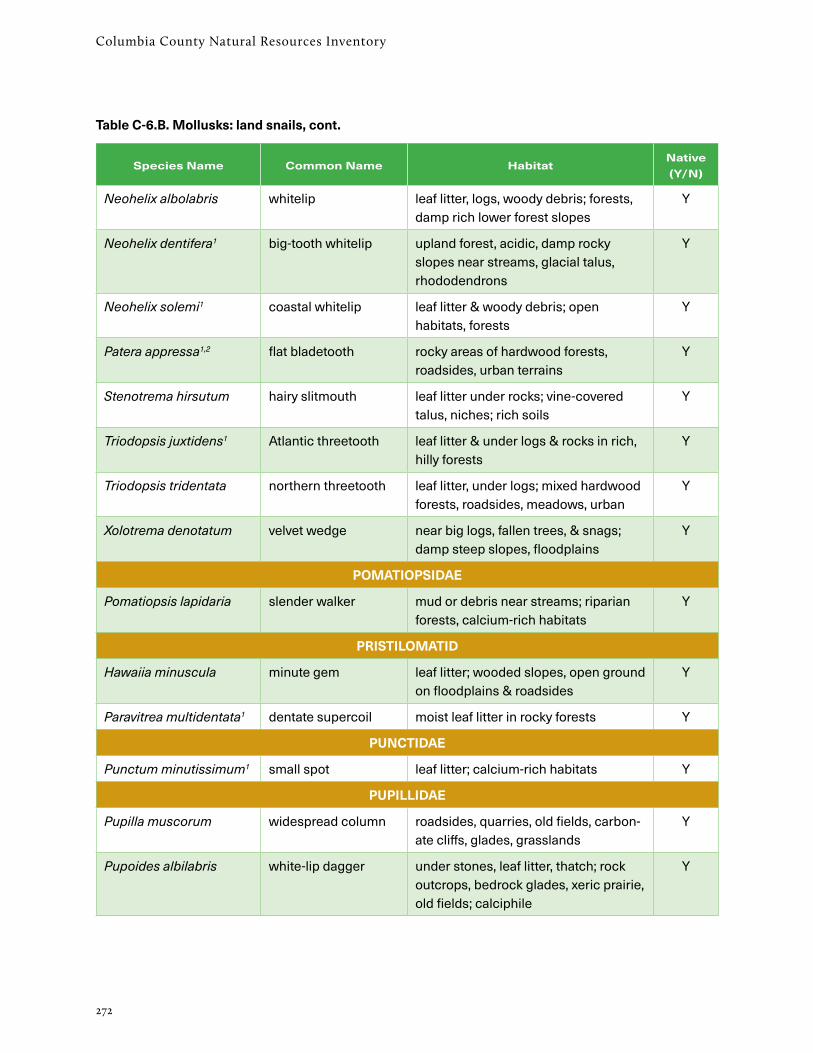
Columbia County Natural Resources Inventory
272
Species Name Common Name HabitatNative (Y/N)
Neohelix albolabris whitelip leaf litter, logs, woody debris; forests, damp rich lower forest slopes
Y
Neohelix dentifera1 big-tooth whitelip upland forest, acidic, damp rocky slopes near streams, glacial talus, rhododendrons
Y
Neohelix solemi1 coastal whitelip leaf litter & woody debris; open habitats, forests
Y
Patera appressa1,2 flat bladetooth rocky areas of hardwood forests, roadsides, urban terrains
Y
Stenotrema hirsutum hairy slitmouth leaf litter under rocks; vine-covered talus, niches; rich soils
Y
Triodopsis juxtidens1 Atlantic threetooth leaf litter & under logs & rocks in rich, hilly forests
Y
Triodopsis tridentata northern threetooth leaf litter, under logs; mixed hardwood forests, roadsides, meadows, urban
Y
Xolotrema denotatum velvet wedge near big logs, fallen trees, & snags; damp steep slopes, floodplains
Y
POMATIOPSIDAE
Pomatiopsis lapidaria slender walker mud or debris near streams; riparian forests, calcium-rich habitats
Y
PRISTILOMATID
Hawaiia minuscula minute gem leaf litter; wooded slopes, open ground on floodplains & roadsides
Y
Paravitrea multidentata1 dentate supercoil moist leaf litter in rocky forests Y
PUNCTIDAE
Punctum minutissimum1 small spot leaf litter; calcium-rich habitats Y
PUPILLIDAE
Pupilla muscorum widespread column roadsides, quarries, old fields, carbon-ate cliffs, glades, grasslands
Y
Pupoides albilabris white-lip dagger under stones, leaf litter, thatch; rock outcrops, bedrock glades, xeric prairie, old fields; calciphile
Y
Table C-6.B. Mollusks: land snails, cont.

273
Appendix C: Plants and Animals
Species Name Common Name HabitatNative (Y/N)
STROBILOPSIDAE
Strobilops aeneus1 bronze pinecone in old logs & leaf litter Y
Strobilops affinis1 eightfold pinecone on logs & in leaf litter; mixed hardwood forests
Y
Strobilops labyrinthicus1 maze pinecone leaf litter, on old logs, & at the base of trees
Y
SUCCINEIDAE
Catinella vermeta1 suboval ambersnail around lowland streams & wetlands Y
Novisuccinea ovalis oval ambersnail among herbaceous veg.; ditches, along streams, rivers, hillside woods
Y
Oxyloma retusum1 blunt ambersnail on plants; damp fields, shoreline habitats
Y
Succinea putris1 European ambersnail common around ponds, swamps, wet meadows, streams
N
VALLONIIDAE
Planogyra asteriscus1 eastern flat-whorl wetlands & occasionally upland woods Y
Vallonia costata costate vallonia calcium-rich habitats; forest gaps, dry open places
Y
Vallonia excentrica Iroquois vallonia grassy places, roadsides, lawns N?
Vallonia perspectiva1 thin-lip vallonia talus slopes in woods, broken rock areas, railroad tracks; calciphile
Y
Vallonia pulchella lovely vallonia grassy places, meadows, roadsides, lawns
Y
VERTIGINIDAE
Columella simplex high-spire column leaf litter, on leaves; various habitats, forests, open, acidic, calcareous
Y
Gastrocopta armifera armed snaggletooth leaf litter; bedrock glades, limestone ledges, limestone outcrop base; calci-phile
Y
Gastrocopta contracta bottlenose snaggle-tooth
leaf litter, under logs; varied habitats; wet, dry, forests, open
Y
Gastrocopta corticaria bark snaggletooth wooded calcareous ledges; in soil under e. red cedar; in wetlands
Y
Table C-6.B. Mollusks: land snails, cont.
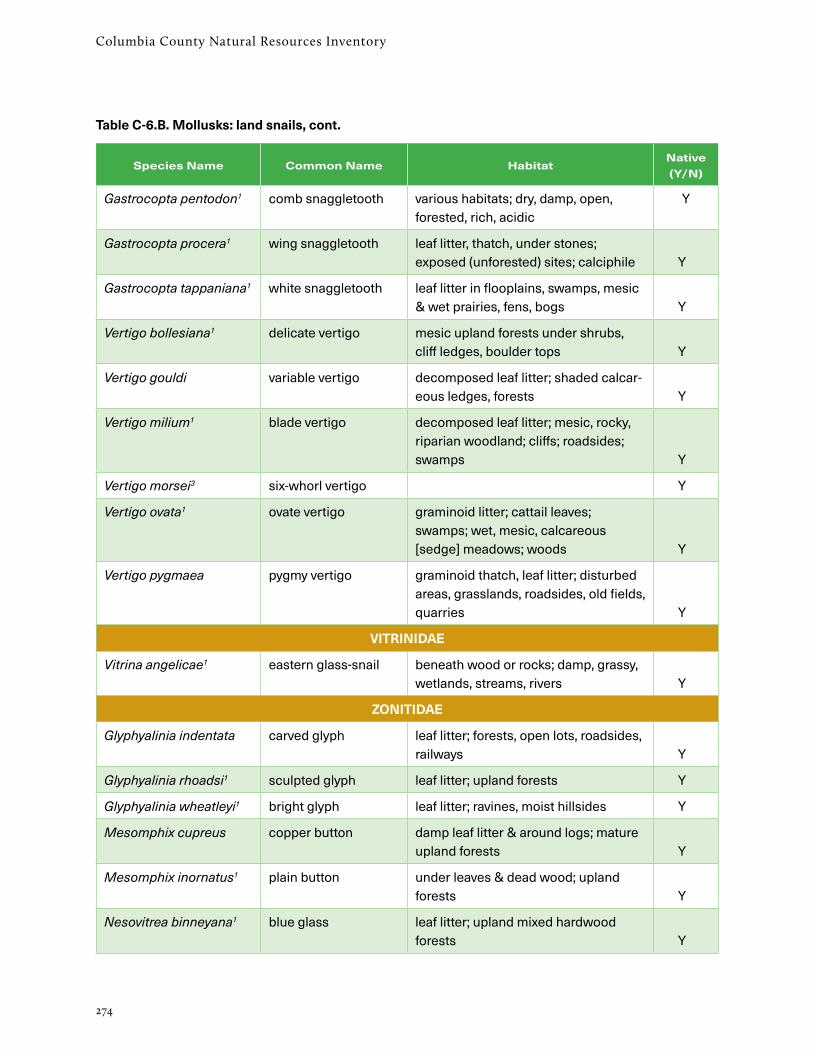
Columbia County Natural Resources Inventory
274
Species Name Common Name HabitatNative (Y/N)
Gastrocopta pentodon1 comb snaggletooth various habitats; dry, damp, open, forested, rich, acidic
Y
Gastrocopta procera1 wing snaggletooth leaf litter, thatch, under stones; exposed (unforested) sites; calciphile Y
Gastrocopta tappaniana1 white snaggletooth leaf litter in flooplains, swamps, mesic & wet prairies, fens, bogs Y
Vertigo bollesiana1 delicate vertigo mesic upland forests under shrubs, cliff ledges, boulder tops Y
Vertigo gouldi variable vertigo decomposed leaf litter; shaded calcar-eous ledges, forests Y
Vertigo milium1 blade vertigo decomposed leaf litter; mesic, rocky, riparian woodland; cliffs; roadsides; swamps Y
Vertigo morsei3 six-whorl vertigo Y
Vertigo ovata1 ovate vertigo graminoid litter; cattail leaves; swamps; wet, mesic, calcareous [sedge] meadows; woods Y
Vertigo pygmaea pygmy vertigo graminoid thatch, leaf litter; disturbed areas, grasslands, roadsides, old fields, quarries Y
VITRINIDAE
Vitrina angelicae1 eastern glass-snail beneath wood or rocks; damp, grassy, wetlands, streams, rivers Y
ZONITIDAE
Glyphyalinia indentata carved glyph leaf litter; forests, open lots, roadsides, railways Y
Glyphyalinia rhoadsi1 sculpted glyph leaf litter; upland forests Y
Glyphyalinia wheatleyi1 bright glyph leaf litter; ravines, moist hillsides Y
Mesomphix cupreus copper button damp leaf litter & around logs; mature upland forests Y
Mesomphix inornatus1 plain button under leaves & dead wood; upland forests Y
Nesovitrea binneyana1 blue glass leaf litter; upland mixed hardwood forests Y
Table C-6.B. Mollusks: land snails, cont.

275
Appendix C: Plants and Animals
Species Name Common Name HabitatNative (Y/N)
Nesovitrea electrina amber glass wet habitats, lake margins, freshwater marshes, wet prairies, forests Y
1 Documented nearby and almost surely occurring in Columbia County (Kathy Schmidt, pers. comm.)
2 Unlikely in Columbia County
3 Provisional in Columbia County
Table C-6.B. Mollusks: land snails, cont.

Columbia County Natural Resources Inventory
276
Table C-7. Fishes of Columbia County, New York.
Data mainly from the New York State Fish Atlas, 1934-2011, reviewed and updated by Robert E. Schmidt. Hudson River fishes are listed only if they inhabit the Columbia/Greene County reach of the river.
Common Name1 Scientific NameNative (Yes/No)
CC Status2
Hudson River
Other Streams
Ponds/ Lakes
alewife (SGCN) Alosa pseudoharengus Y U x x x
American eel (S2S3, SGCNHP)
Anguilla rostrata Y C x x x
American shad (SGCNHP)
Alosa sapidissima Y U x
Atlantic sturgeon (E, S1, SGCNHP)
Acipenser oxyrinchus Y R x
Atlantic tomcod (SGCNHP)
Microgadus tomcod Y R x
banded killifish Fundulus diaphanus Y U x x x
black crappie Pomoxis nigromaculatus
N U x x x
blueback herring Alosa aestivalis Y U x
bluegill Lepomis macrochirus N U x x x
bluntnose minnow Pimephales notatus Y U x x
brassy minnow Hybognathus hankinsoni
Y R x
bridle shiner (S2?, SGCN)
Notropis bifrenatus Y E x x
brook silverside Labidesthes sicculus N R x x
brook trout (SGCN) Salvelinus fontinalis Y U x x x
brown bullhead Ameiurus nebulosus Y U x x x
brown trout Salmo trutta N C x x x
central mudminnow Umbra limi N R x x
chain pickerel Esox niger Y U x x x
channel catfish Ictalurus punctatus N U x x
cisco (SGCN) Coregonus artedi N R x
comely shiner (S2?, SGCNHP)
Notropis amoenus N R x

277
Appendix C: Plants and Animals
Common Name1 Scientific NameNative (Yes/No)
CC Status2
Hudson River
Other Streams
Ponds/ Lakes
common carp Cyprinus carpio N U x x x
common shiner Luxilus cornutus Y C x x
creek chub Semotilus atromaculatus
Y C x x
cutlip minnow Exoglossum maxillingua
Y U x
eastern blacknose dace
Rhinichthys atratulus Y C x x
eastern creek chubsucker
Erimyzon oblongus Y R x x
eastern silvery minnow
Hybognathus regius Y R x x
emerald shiner Notropis atherinoides N R x x x
fallfish Semotilus corporalis Y C x x x
fathead minnow Pimephales promelas N U x x
fourspine stickle-back (SGCNHP)
Apeltes quadracus Y U x x x
gizzard shad Dorosoma cepedianum N U x x
golden shiner Notemigonus crysoleucas
Y C x x x
goldfish Carassius auratus N U x x x
grass carp Ctenopharyngodon idella
N U x
green sunfish Lepomis cyanellus N U x x
largemouth bass Micropterus salmoides N U x x x
logperch Percina caprodes Y R x
longnose dace Rhinichthys cataractae Y U x
longnose sucker (SGCN)
Catostomus catostomus
Y R x
margined madtom Noturus insignis Y R x
mummichog (SGCN)
Fundulus heteroclitus Y C x x x
Table C-7. Fishes, cont.

Columbia County Natural Resources Inventory
278
Common Name1 Scientific NameNative (Yes/No)
CC Status2
Hudson River
Other Streams
Ponds/ Lakes
northern hog sucker
Hypentelium nigricans Y U x x
northern pike Esox lucius N R x x x
pumpkinseed Lepomis gibbosus Y U x x x
rainbow trout Oncorhynchus mykiss N R x x x
redbreast sunfish Lepomis auritus Y C x x x
redfin pickerel Esox americanus americanus
Y U x x
rock bass Ambloplites rupestris N U x x x
rudd Scardinius erythrophthalmus
N R x x x
satinfin shiner Cyprinella analostana Y R x x
sea lamprey Petromyzon marinus Y R x x
shortnose sturgeon (E, S1, SGCN)
Acipenser brevirostrum Y R x
slimy sculpin Cottus cognatus Y R x
smallmouth bass Micropterus dolomieu N C x x x
splake Salvelinus fontinalis x namaycush
N C x
spotfin shiner Cyprinella spiloptera Y U x x x
spottail shiner Notropis hudsonius Y C x x
striped bass Morone saxatilis Y U x
tadpole madtom Noturus gyrinus Y E x
tessellated darter Etheostoma olmstedi Y C x x x
tiger musky Esox lucius x masquinongy
N C x
walleye Sander vitreus N R x x x
white catfish Ameiurus catus Y R x x
white crappie Pomoxis annularis N R x x
white perch Morone americana Y U x x x
Table C-7. Fishes, cont.

279
Appendix C: Plants and Animals
Common Name1 Scientific NameNative (Yes/No)
CC Status2
Hudson River
Other Streams
Ponds/ Lakes
white sucker Catostomus commersonii
Y C x x x
yellow bullhead Ameiurus natalis Y C x x
yellow perch Perca flavescens Y U x x x
1 New York Natural Heritage Program ranks (S1, S2, SH, etc.) are explained in Appendix D. NY State ranks: E = endangered; T = threatened (Environmental Conservation Law 6NYCRR Part 182.[g]) SGCN = Species of Greatest Conservation Need SGCNHP = Highest Priority Species of Greatest Conservation Need (http://www.dec.ny.gov/animals/9406.html) (The SGCN rank also applies to all species ranked as E, T, or SC)
2 Columbia County (CC) status: C = common; U = uncommon; R = rare; E = extirpated.
Table C-7. Fishes, cont.

Columbia County Natural Resources Inventory
280
Table C-8. Amphibians and reptiles of Columbia County, New York.
Occurrence data are from the New York State Reptile and Amphibian Atlas.
Common Name Scientific Name HabitatState-wide
Status1
SALAMANDERS
Allegheny mountain dusky salamander
Desmognathus ochrophaeus cool stream
blue-spotted salamander
Ambystoma laterale swamp, vernal pool, upland forest
SC
eastern newt Notophthalmus viridescens perennial pond, other wetland, upland forest
eastern red-backed salamander
Plethodon cinereus upland forest
four-toed salamander Hemidactylium scutatum swamp, upland forest SGCNHP
Jefferson salamander Ambystoma jeffersonianum vernal pool, upland forest SC
marbled salamander Ambystoma opacum vernal pool, upland forest SC
mudpuppy Necturus maculosus perennial stream SC
northern dusky salamander
Desmognathus fuscus cool stream
northern slimy salamander
Plethodon glutinosus talus, upland forest
northern two-lined salamander
Eurycea bislineata small forested stream
spotted salamander Ambystoma maculatum vernal pool, upland forest
spring salamander Gyrinophilus porphyriticus rocky stream, forested seep
TOADS & FROGS
American toad Bufo americanus everywhere
bullfrog Rana catesbeiana pond, marsh
Fowler’s toad Bufo fowleri sandy or rocky forest SGCN
gray treefrog Hyla versicolor shallow pool, upland forest
green frog Rana clamitans pond, marsh
northern leopard frog Rana pipiens pond, marsh, meadow
pickerel frog Rana palustris meadow, forest, wetland
spring peeper Pseudacris crucifer upland forest, wetland
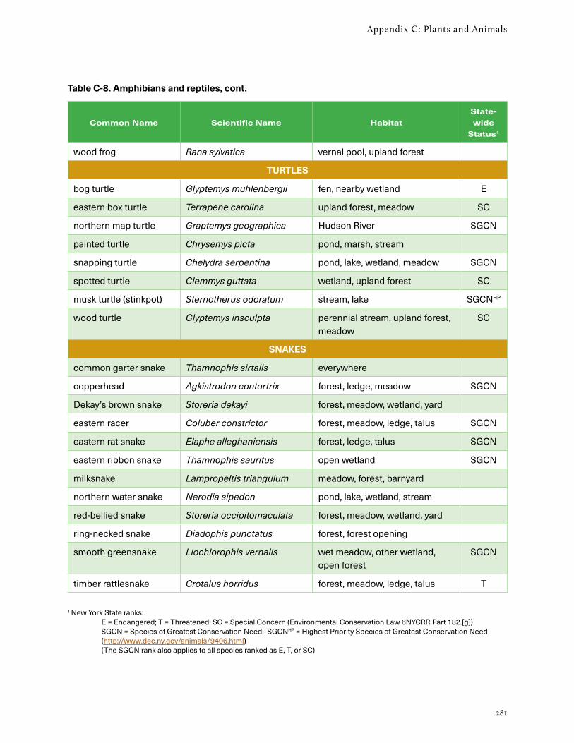
281
Appendix C: Plants and Animals
Common Name Scientific Name HabitatState-wide
Status1
wood frog Rana sylvatica vernal pool, upland forest
TURTLES
bog turtle Glyptemys muhlenbergii fen, nearby wetland E
eastern box turtle Terrapene carolina upland forest, meadow SC
northern map turtle Graptemys geographica Hudson River SGCN
painted turtle Chrysemys picta pond, marsh, stream
snapping turtle Chelydra serpentina pond, lake, wetland, meadow SGCN
spotted turtle Clemmys guttata wetland, upland forest SC
musk turtle (stinkpot) Sternotherus odoratum stream, lake SGCNHP
wood turtle Glyptemys insculpta perennial stream, upland forest, meadow
SC
SNAKES
common garter snake Thamnophis sirtalis everywhere
copperhead Agkistrodon contortrix forest, ledge, meadow SGCN
Dekay’s brown snake Storeria dekayi forest, meadow, wetland, yard
eastern racer Coluber constrictor forest, meadow, ledge, talus SGCN
eastern rat snake Elaphe alleghaniensis forest, ledge, talus SGCN
eastern ribbon snake Thamnophis sauritus open wetland SGCN
milksnake Lampropeltis triangulum meadow, forest, barnyard
northern water snake Nerodia sipedon pond, lake, wetland, stream
red-bellied snake Storeria occipitomaculata forest, meadow, wetland, yard
ring-necked snake Diadophis punctatus forest, forest opening
smooth greensnake Liochlorophis vernalis wet meadow, other wetland, open forest
SGCN
timber rattlesnake Crotalus horridus forest, meadow, ledge, talus T
1 New York State ranks: E = Endangered; T = Threatened; SC = Special Concern (Environmental Conservation Law 6NYCRR Part 182.[g]) SGCN = Species of Greatest Conservation Need; SGCNHP = Highest Priority Species of Greatest Conservation Need (http://www.dec.ny.gov/animals/9406.html) (The SGCN rank also applies to all species ranked as E, T, or SC)
Table C-8. Amphibians and reptiles, cont.

Columbia County Natural Resources Inventory
282
Table C-9. Columbia County birds of conservation concern: A. Breeding birds, B. Winter birds
Data are from the NYS Breeding Bird Atlas (BBA) (Andrle and Carroll 1988, McGowan and Corwin 2008).
A. Breeding birds of conservation concern
SpeciesGeneral Habitat Type
for Nesting
NYNHP rank1
NYS rank2
BBA 1980-853
BBA 2000-053
Trend
GREBES
pied-billed grebe pond, marsh S3B, S1N
T y y i
HERONS
American bittern marsh SC y y s
least bittern marsh S3B, S1N
T y y s
WATERFOWL
blue-winged teal marsh SGCN y n d
American black duck marsh S3B SGCNHP y y d
RAPTORS
bald eagle forest (near water) S2S3B, S2N
T n y i
northern harrier meadow S3B, S3N
T y y s
sharp-shinned hawk forest SC y y i
Cooper’s hawk forest SC y y i
northern goshawk forest S3S4B, S3N
SC n y d
red-shouldered hawk forest SC n y i
American kestrel meadow SGCN y y d
peregrine falcon cliff, high bridge, tall building (near open habitat)
S3B E n y i
GALLINACEOUS BIRDS
northern bobwhite meadow SGCNHP y y d
ruffed grouse forest SGCN y y d

283
Appendix C: Plants and Animals
SpeciesGeneral Habitat Type
for Nesting
NYNHP rank1
NYS rank2
BBA 1980-853
BBA 2000-053
Trend
SHOREBIRDS
American woodcock shrubland, forest SGCN y y d
CUCKOOS
black-billed cuckoo forest SGCN y y d
OWLS
barn owl (near) meadow S1S2 SGCNHP y n d
NIGHTJARS
common nighthawk meadow, ledge, rooftop S2S3B SC y n d
whip-poor-will forest S3B SC y y d
WOODPECKERS
red-headed woodpecker
forest (& various other) S2?B SC n y d
PERCHING BIRDS
horned lark meadow S3S4B SC y n d
wood thrush forest SGCN y y d
brown thrasher shrubland SGCNHP y y d
vesper sparrow meadow SC y y d
grasshopper sparrow meadow SC y y d
bobolink meadow SGCNHP y y s
eastern meadowlark meadow SGCNHP y y d
worm-eating warbler forest SGCN y y d
Louisiana waterthrush streamside SGCN y y d
golden-winged warbler
shrubland SC y y d
blue-winged warbler shrubland SGCN y y i
cerulean warbler forest SC y y d
black-throated blue warbler
forest SGCN y y s
prairie warbler meadow SGCN y y s
Table C-9.A. Birds: Breeding birds of conservation concern, cont.
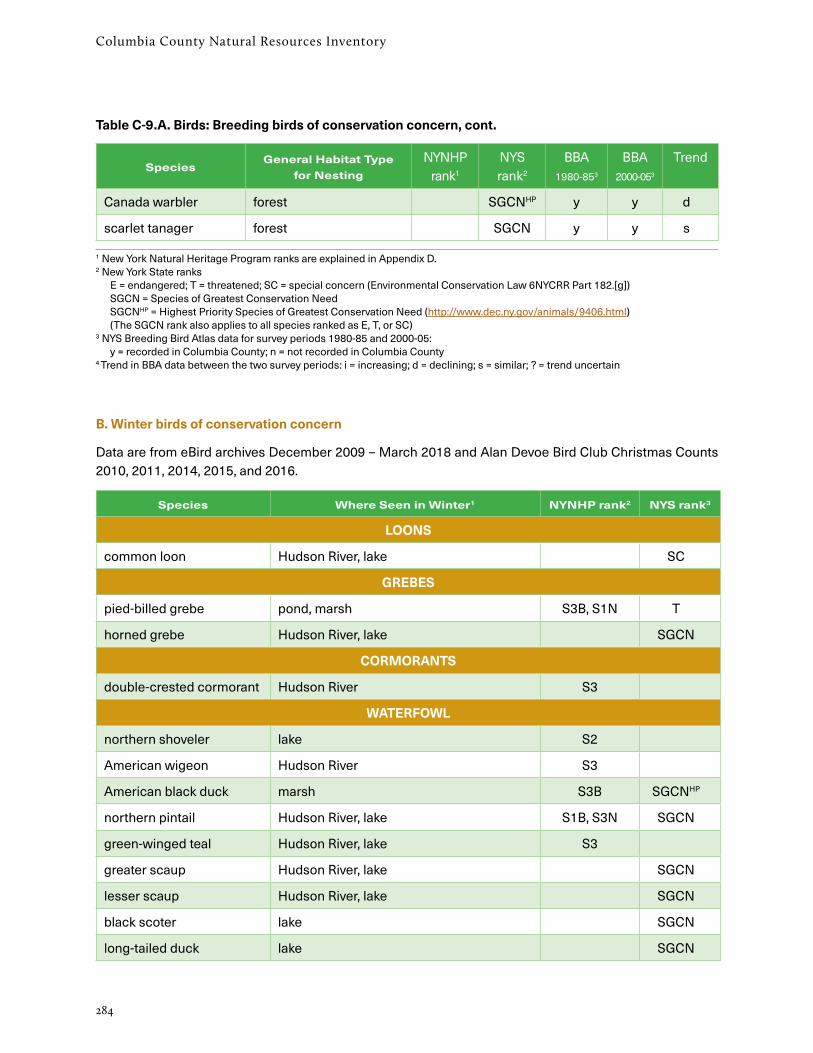
Columbia County Natural Resources Inventory
284
SpeciesGeneral Habitat Type
for Nesting
NYNHP rank1
NYS rank2
BBA 1980-853
BBA 2000-053
Trend
Canada warbler forest SGCNHP y y d
scarlet tanager forest SGCN y y s
1 New York Natural Heritage Program ranks are explained in Appendix D. 2 New York State ranks E = endangered; T = threatened; SC = special concern (Environmental Conservation Law 6NYCRR Part 182.[g]) SGCN = Species of Greatest Conservation Need SGCNHP = Highest Priority Species of Greatest Conservation Need (http://www.dec.ny.gov/animals/9406.html) (The SGCN rank also applies to all species ranked as E, T, or SC) 3 NYS Breeding Bird Atlas data for survey periods 1980-85 and 2000-05: y = recorded in Columbia County; n = not recorded in Columbia County 4 Trend in BBA data between the two survey periods: i = increasing; d = declining; s = similar; ? = trend uncertain
B. Winter birds of conservation concern
Data are from eBird archives December 2009 – March 2018 and Alan Devoe Bird Club Christmas Counts 2010, 2011, 2014, 2015, and 2016.
Species Where Seen in Winter1 NYNHP rank2 NYS rank3
LOONS
common loon Hudson River, lake SC
GREBES
pied-billed grebe pond, marsh S3B, S1N T
horned grebe Hudson River, lake SGCN
CORMORANTS
double-crested cormorant Hudson River S3
WATERFOWL
northern shoveler lake S2
American wigeon Hudson River S3
American black duck marsh S3B SGCNHP
northern pintail Hudson River, lake S1B, S3N SGCN
green-winged teal Hudson River, lake S3
greater scaup Hudson River, lake SGCN
lesser scaup Hudson River, lake SGCN
black scoter lake SGCN
long-tailed duck lake SGCN
Table C-9.A. Birds: Breeding birds of conservation concern, cont.

285
Appendix C: Plants and Animals
Species Where Seen in Winter1 NYNHP rank2 NYS rank3
common goldeneye Hudson River, lake S3 SGCN
red-breasted merganser Hudson River S3
ruddy duck lake S1 SGCN
RAPTORS
bald eagle forest (near water) S2S3B, S2N T
golden eagle ? SHB, S1N E
northern harrier meadow S3B, S3N T
sharp-shinned hawk ? SC
Cooper’s hawk various SC
northern goshawk forest S3S4B,S3N SC
red-shouldered hawk forest SC
American kestrel meadow SGCN
merlin lake and ? S3?B
peregrine falcon cliff, high bridge, tall building (near open habitat)
S3B E
RAILS
American coot lake S3
GALLINACEOUS BIRDS
ruffed grouse forest SGCN
OWLS
short-eared owl ? S2 E
northern saw-whet owl ? S3
PERCHING BIRDS
horned lark meadow S3S4B SC
scarlet tanager forest SGCN
rusty blackbird ? S2B SGCNHP
1 Winter habitats are given only as reported in eBird or by other observers. Christmas bird count data are not reported by habitat. 2 New York Natural Heritage Program ranks are explained in Appendix D. 3 New York State ranks E = endangered; T = threatened; SC = special concern (Environmental Conservation Law 6NYCRR Part 182.[g]) SGCN = Species of Greatest Conservation Need SGCNHP = Highest Priority Species of Greatest Conservation Need (http://www.dec.ny.gov/animals/9406.html) (The SGCN rank also applies to all species ranked as E, T, or SC)
Table C-9.B. Birds: Winter birds of conservation concern, cont.

Columbia County Natural Resources Inventory
286
Table C-10. Mammals of Columbia County, New York.
Occurrence data from Whitaker (in prep), Farmscape Ecology Program, and Hudsonia Ltd.
Common Name Scientific NameStatewide
Status1
MARSUPIALS
Virginia opossum Didelphis virginiana
INSECT-EATERS
masked shrew Sorex cinereus
northern short-tailed shrew Blarina brevicauda
smoky shrew Sorex fumeus
water shrew2 Sorex palustris
eastern mole Scalopus aquaticus
hairy-tailed mole Parascalops breweri
star-nosed mole Condylura cristata
BATS
big brown bat Eptesicus fuscus
eastern red bat Lasiurus borealis SGCN
eastern small-footed bat2 Myotis leibii SC
hoary bat Lasiurus cinereus SGCN
Indiana bat1 Myotis sodalis E
little brown bat Myotis lucifugus
northern long-eared bat Myotis septentrionalis T
silver-haired bat Lasionycteris noctivagans SGCN
tri-colored bat Perimyotis subflavus SGCN
CARNIVORES
black bear Ursus americanus
raccoon Procyon lotor
ermine Mustela erminea
fisher Martes pennanti
long-tailed weasel Mustela frenata
mink Mustela vison
river otter Lutra canadensis

287
Appendix C: Plants and Animalsv
Common Name Scientific NameStatewide
Status1
striped skunk Mephitis mephitis
gray wolf/eastern wolf4 Canis lupus/Canis lycaon
eastern coyote Canis latrans
gray fox Urocyon cinereoargenteus
red fox Vulpes vulpes
eastern cougar4 Felix concolor E
bobcat Lynx rufus
RODENTS
woodchuck Marmota monax
northern flying squirrel2 Glaucomys sabrinus
southern flying squirrel Glaucomys volans
eastern gray squirrel Sciurus carolinensis
red squirrel Tamiasciurus hudsonicus
eastern chipmunk Tamias striatus
American beaver Castor canadensis
deer mouse Peromyscus maniculatus gracilis
white-footed mouse Peromyscus leucopus
southern bog lemming2 Synaptomys cooperi
meadow vole Microtus pennsylvanicus
southern red-backed vole Clethrionomys gapperi
woodland vole Microtus pinetorum
muskrat Ondatra zibethicus
Norway rat Rattus norvegicus
black rat Rattus rattus
house mouse Mus musculus
meadow jumping mouse Zapus hudsonius
woodland jumping mouse Napaeozapus insignis
common porcupine Erethizon dorsatum
Table C-10. Mammals, cont.
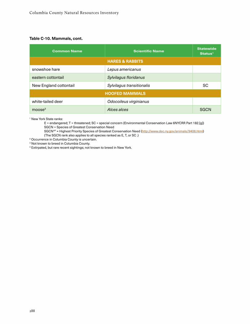
Columbia County Natural Resources Inventory
288
Common Name Scientific NameStatewide
Status1
HARES & RABBITS
snowshoe hare Lepus americanus
eastern cottontail Sylvilagus floridanus
New England cottontail Sylvilagus transitionalis SC
HOOFED MAMMALS
white-tailed deer Odocoileus virginianus
moose3 Alces alces SGCN
1 New York State ranks: E = endangered; T = threatened; SC = special concern (Environmental Conservation Law 6NYCRR Part 182.[g]) SGCN = Species of Greatest Conservation Need SGCNHP = Highest Priority Species of Greatest Conservation Need (http://www.dec.ny.gov/animals/9406.html) (The SGCN rank also applies to all species ranked as E, T, or SC .) 2 Occurrence in Columbia County is uncertain. 3 Not known to breed in Columbia County. 4 Extirpated, but rare recent sightings; not known to breed in New York.
Table C-10. Mammals, cont.

289
Appendix D: Explanation of Rarity Ranks
A subset of the animal species listed under New York state law is also recognized under federal law. These species are so seriously imperiled across their entire range that they face the very real prospect of extinction. Species are listed as feder-ally endangered or threatened by the U.S. Fish & Wildlife Service in consultation with state agencies and other experts, and the Service works closely with NYDEC on the protection of federally listed species in New York.
Ultimately, protection of New York’s biodiversity lies with landowners and land managers regardless of state or federal listings. How private and public landowners manage their properties will determine what species and natural communities persist into the future. This situation is both a great opportunity and a serious challenge.
State legal listings are identified with the following codes:
E endangered T threatened SC special concern
Federal legal listings are identified with the following codes:
E listed endangered T listed threatened C candidate
NY Natural Heritage tracks all species listed as endangered and threatened. While we track many of the species listed as being of special concern, a subset of special concern species are currently not rare or imperiled enough to merit tracking at our precise scale. In addition, we track many species that are biologically rare and imperiled, but that have not gone through the review process neces-sary for state listing.
Animals
The explanation below is from the New York Natural Heritage Program Rare Animal Status List (Schlesinger 2017). Explanation of all NYNHP ranks are given here, but the NRI lists none of the global (G) ranks, and considers only species in the S1, S2, and S3 categories to be of current conservation concern.
State & Federal Listings
NY Natural Heritage tracks a selected subset of New York’s animals. The species we track are chosen based on their degree of rarity or imperil-ment within the state, and as new information comes in, new species are sometimes added while others are discontinued. Information on the species and communities tracked by NY Natural Heritage are used for conservation, research, and regulatory purposes.
Many of the species tracked by NY Natural Heritage are listed as “endangered” or “threatened” under the state Environmental Conservation Law (E.C.L.). Listing is a legal process that is conducted by the state agency with authority over the species in question, and for animals confers important protec-tion requirements. See http://www.dec.ny.gov/animals/7494.html for all state-listed animals.
The NYDEC Division of Fish, Wildlife, and Marine Resources has jurisdiction over rare animal species listed as “endangered,” “threatened,” or “special concern” under E.C.L. §11-0535. Animals listed as endangered or threatened receive notable legal protection, as it is illegal to take or possess any of these species or their parts without a permit from NYDEC. Species of special concern warrant atten-tion and consideration but current information does not justify listing them as either endangered or threatened.
Appendix D: Explanation of Rarity Ranks

290
Columbia County Natural Resources Inventory
For the most part, global and state ranks follow a straightforward scale of 1 (rarest/most imperiled) to 5 (common/secure). The Columbia County NRI refers only to the three ranks—S1, S2, S3—that indicate rarity or limited occurrence in the state, as follows:
S1 Critically imperiled because of rarity (5 or fewer occurrences, or few remaining acres or miles of stream) or factors making it especially vulnerable to extinction rangewide (global) or in New York (state)
S2 Imperiled because of rarity (6-20 occurrences, or few remaining acres or miles of stream) or factors demonstrably making it very vulnerable to extinc-tion (global) or extirpation from New York (state)
S3 Either uncommon or local, typically with 21 to 100 occurrences, limited acreage, or miles of stream rangewide (global) or in New York (state)
Additional species lists and codes are at https://www.acris.nynhp.org/.
Codes sometimes have qualifiers attached:
T1, T2, etc. These ranks, which like global and state ranks run from 1 (rarest/most imperiled) to 5 (common/secure), are attached to global ranks to indicate the status of a subspecies or variety
Q Indicates that the species, subspecies, or variety is in taxonomic dispute
? Indicates that the state or global rank is uncertain and more information is needed
N Indicates the migratory status of a migratory species when it is not breeding in NY (for example, populations that are overwintering in the state)
B Indicates the state status of a migratory species when it has breeding populations in NY
Active Inventory and Watch List
The NY Natural Heritage Program keeps two lists of rare animal species: the Active Inventory List and the Watch List. Species on the Active Inventory List are ones we currently track in our database; for the most part these are the most rare or most imper-iled species in the state. Species on the Watch List are those that could become imperiled enough in the future to warrant being actively inventoried, or are ones for which we do not have enough data to determine whether they should be actively inven-toried. Species are moved between lists, or off the lists entirely, as available information warrants.
Global and State Status Ranks
NY Natural Heritage’s statewide inventory efforts revolve around lists of rare species and all types of natural communities known to occur, or to have historically occurred, in the state. These lists are based on a variety of sources including museum collections, scientific literature, information from state and local government agencies, regional and local experts, and data from neighboring states.
Each rare species is assigned a rank based on its rarity, population trends, and threats. Like those in all state Natural Heritage Programs, NY Natural Heritage’s ranking system assesses rarity at two geographic scales: global and state. The global rank (G-rank) reflects the status of a species or commu-nity throughout its range, whereas the state rank (S-rank) indicates its status within New York. Global ranks are maintained and updated by NatureServe, which coordinates the network of Natural Heritage programs. Both global and state ranks are usually based on the range of the species or community, the number of occurrences, the viability of the occurrences, and the vulnerability of the species or community around the globe or across the state. As new data become available, the ranks may be revised to reflect the most current information. Subspecific taxa are also assigned a taxon rank which indicates the subspecies’ rarity rank through-out its range.

291
Appendix D: Explanation of Rarity Ranks
A “?” indicates that an identification question exists about known occurrences. It also indicates the rank presumably corresponds to actual occurrenc-es even though the information has not yet been documented in heritage files or historical records. It serves to flag species that need more field studies or specimen identification.
Species of Greatest Conservation Need
The list of Species of Greatest Conservation Need was developed for the New York State Wildlife Action Plan (NYSDEC 2015).
High-Priority Species of Greatest Conservation Need
The status of these species is known, and conserva-tion action is needed in the next ten years. These species are experiencing a population decline, or have identified threats that may put them in jeopar-dy, and are in need of timely management interven-tion, or they are likely to reach critical population levels in New York.
Species of Greatest Conservation Need
The status of these species is known and conserva-tion action is needed. These species are experienc-ing some level of population decline, have identified threats that may put them in jeopardy, and need conservation actions to maintain stable population levels or sustain recovery.
Species of Potential Conservation Need
The list of Species of Potential Conservation Need was developed for the New York State Wildlife Action Plan (NYSDEC 2015).
A species whose status is poorly known, but there is an identified threat to the species or features of its life history that make it particularly vulnerable to threats. The species may be declining or begin to experience declines within the next ten years, and studies are needed to determine their actual status.
Plants
The explanation below is from the New York Natural Heritage Program Rare Plant Status Lists (Young 2017).
The Columbia County NRI refers only to the three ranks —S1, S2, S3—that indicate rarity or limited occurrence in the state, as follows:
S1 = Critically imperiled in New York State because of extreme rarity (5 or fewer sites or very few remain-ing individuals) or extremely vulnerable to extirpa-tion from New York State due to biological or human factors.
S2 = Imperiled in New York State because of rarity (6 - 20 sites or few remaining individuals) or highly vulnerable to extirpation from New York State due to biological or human factors.
S3 = Vulnerable in New York State. At moderate risk of extinction or elimination due to very restricted range, very few populations (usually 21 - 35 extant sites), steep declines, or other factors.
Taxon Rank
The T-ranks are defined in the same way as the Global ranks, but the T-rank only refers to the rarity of the subspecific taxon, not the rarity of the species as a whole. If a species has a subspecific name that is the same as the species name it means there is also another subspecies of that species which we do not consider rare in New York or it does not occur in New York.
Double Ranks (i.e., S1S2, S2S3, S1S3)
The first rank indicates rarity based upon current documentation. The second rank indicates the probable rarity after all historical records and likely habitat have been checked. Double ranks denote species that need additional field surveys.
A “Q” indicates a question exists whether or not the taxon is a good taxonomic entity.


