columbia valley priority conservation actions summary...
TRANSCRIPT
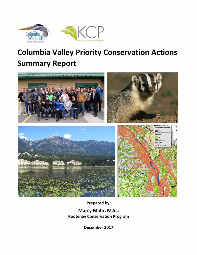
Columbia Valley Priority Conservation Actions Summary Report
Prepared by:
Marcy Mahr, M.Sc. Kootenay Conservation Program
December 2017

i | P a g e
TABLE OF CONTENTS ACKNOWLEDGEMENTS ....................................................................................................................ii
Executive Summary ......................................................................................................................... 1
I. Overview ..................................................................................................................................... 4
Honouring KCP’s Roots in the Columbia Valley .......................................................................... 5
Desired Outcomes of the Forum ................................................................................................. 6
II. Taking a Conservation Neighbourhood Approach ..................................................................... 8
III. Capturing Conservation Values and Threats........................................................................... 10
IV. Developing Conservation Priorities ......................................................................................... 13
Themes Guiding Small Group Discussions ................................................................................ 13
Conservation Priorities .............................................................................................................. 14
V. Columbia Valley Forum Action Plans ....................................................................................... 16
Outcomes from Group Round Tables ....................................................................................... 17
ACTION #1: Conserve and Restore Montane Valley-Bottom Processes and Habitats that Benefit a Suite of Species of Interest and Conservation Concern ........................................ 17
ACTION #2: Document Species Diversity, Relative Abundance and Location of Bats .......... 18
ACTION #3: Identify and Protect Existing High Quality Habitats .......................................... 19
ACTION #4: Conserve and Restore Riparian and Wetland Habitats ..................................... 21
ACTION #5: Protect, Monitor and Mitigate Decreases in Hydrologic Inflows into Columbia River and Wetlands ............................................................................................................... 23
ACTION #6: Identify and Enhance Connectivity and Corridors ............................................ 25
Four Corridor Mini Action Plans............................................................................................ 26
ACTION #7: Develop a Statutory Recreational Access Plan for Columbia Valley ................. 30
ACTION #8: Take Aggressive Local Action to Reduce Emissions for Climate Change .......... 32
VI. Conclusions ............................................................................................................................. 33
VII. Moving Forward ..................................................................................................................... 35
Appendix A: Columbia Valley Forum Participants ........................................................................ 36
Appendix B: All Forum Invitees ..................................................................................................... 38

ii | P a g e
Appendix C: Forum Agenda .......................................................................................................... 41
Appendix D: Guidelines for Science Presentations ....................................................................... 44
Guidelines for Speed Presentations .......................................................................................... 44
Science Presenters and Topics .................................................................................................. 45
Appendix E: Definition of Acronyms ............................................................................................. 46
Appendix F: Catalogue of “Top Recommendations That Will Make a Difference” ...................... 47
Theme #1: Conserve Populations of Species of Concern .......................................................... 47
Theme #2: Prevent and Control Invasive Species ..................................................................... 49
Theme #3: Protect Existing High Quality Habitats .................................................................... 50
Theme #4: Enhance Connectivity and Corridors ....................................................................... 51
Theme #5: Reduce Recreational Pressure ................................................................................ 52
Theme #6: Advance Climate Change Resilience ....................................................................... 53
COLUMBIA RIVER. (PHOTO COURTESY OF GRAHAM OSBORNE)

iii | P a g e
ACKNOWLEDGEMENTS
The Columbia Valley Conservation Action Planning Forum was the result of collaborative efforts of many people. We are extremely grateful to the Steering Committee for helping organize this event: Dr. Suzanne Bayley, Paul Galbraith, Rick Hoar, Richard Klafki, Dave White, Gerry Wilkie and Dave Zehnder. We appreciate funding from Columbia Basin Trust, Habitat Conservation Trust Foundation, Fish and Wildlife Compensation Program, Environment and Climate Change Canada, Sitka Foundation, and Lush Foundation. We wish to extend our appreciation to everyone who attended the Forum, shared bold ideas and a collaborative spirit, and helped set the stage for greater conservation of the Columbia Valley’s extraordinary biological diversity.

1 | P a g e
EXECUTIVE SUMMARY
On December 6, 2017, the Kootenay Conservation Program (KCP) and Columbia Wetlands Stewardship Partners (CWSP) co-hosted the Columbia Valley Conservation Action Planning Forum in Invermere, B.C. During this full-day workshop, 36 participants representing diverse perspectives as scientists, resource managers, conservationists, rod and gun clubs, keepers of indigenous knowledge, and ranchers worked together to identify priority actions that would contribute to maintaining healthy fish and wildlife populations and ecological functions in the Columbia Valley over the next five years.
The Columbia Valley Conservation Action Planning Forum built upon integrating scientific knowledge, analyzing values and threats, and prioritizing actions to inform conservation action plans and inspire collaborations.
The Forum began with scientists providing four-minute speed presentations of their research findings and sharing their “top three recommendations that would make the biggest difference” in keeping the Columbia Valley ecologically healthy and functioning. These contributions were submitted to KCP staff in advance of the Forum so the information and recommendations could provide a starting place for: a) group discussion of key conservation values and threats; and b) small group review of the catalogue of scientists’ recommendations for actions based on six conservation themes:
1. Conserve populations of species of concern 2. Prevent and control invasive species 3. Protect existing high quality habitats 4. Enhance connectivity and corridors
5. Reduce recreational pressure 6. Advance climate change resilience
Participants working in small groups based on the six themes narrowed down the lists of recommendations to select the top actions they thought would make the most difference in the Columbia Valley over the next 1-3 years. This process resulted in a list of the top 15 possible actions. Of these top actions, eight “priority actions” were selected by participants and developed into action plans.

2 | P a g e
The Columbia Valley Forum resulted in eight Priority Action Plans (not ranked):
1. Conserve and Restore Montane Valley-Bottom Processes and Habitats that Benefit a Suite of Species of Interest and Conservation Concern 2. Document Species Diversity, Relative Abundance and Location of Bats 3. Identify and Protect Existing High Quality Habitats 4. Conserve and Restore Riparian and Wetland Habitats 5. Protect, Monitor and Mitigate Decreases in Hydrologic Inflows into the Columbia River and Wetlands 6. Identify and Enhance Connectivity and Corridors 7. Develop a Statutory Recreational Access Plan for the Columbia Valley 8. Take Aggressive Local Action to Reduce Emissions for Climate Change
The priority actions were collectively generated and incorporated policies, objectives and activities that align with participants’ programmatic interests. All participants, as well as those people who were invited but could not attend the Columbia Valley Forum, will be provided with the Forum’s findings and will be encouraged to pursue actions as they are able. Moving forward, the Columbia Valley Conservation Action Planning Forum (and the previous Slocan Lake Science & Conservation Action Forum) has provided the Kootenay Conservation Program with a new way to approach conservation by working in the local context of a “conservation neighbourhood” to assist KCP partners in identifying common priorities and objectives for on-the-ground conservation and stewardship activities. This approach supports KCP’s partners in developing collaborative action plans that identify conservation targets and propose solutions to mitigating threats in their local neighbourhood. KCP will remain engaged in supporting the Columbia Valley process and implementation of priority actions. The Forum’s process and outcomes will also help KCP guide collaborative neighbourhood conservation action planning in other regions of the Kootenays where partners want to work together to protect local biodiversity. The Columbia Valley Forum provided valuable information for the Columbia Wetland Stewardship Partners’ upcoming strategic planning process by identifying ecological values and threats both to the Columbia Wetlands and the surrounding, contributing landscape1. The Forum provided CWSP with the expertise of technical experts and local stakeholders, and 1 Although the boundaries of the KCP “conservation neighbourhood” do not strictly align with those of the Columbia Wetlands, the research studies presented at the Forum, and the ecological values and threats identified by participants are relevant to the wetlands system and the adjacent contributing landscape with which CWSP is interested.

3 | P a g e
helped prioritize conservation actions that partner organizations of the CWSP can now start to implement. How CWSP will support or deliver on the Forum’s priority actions will be articulated in the new strategic plan for their partnership. One of CWSP’s highest priorities has been to seek funding for a program to protect, monitor and mitigate changes in Hydrologic Inflows into Columbia River and Wetlands (Priority #5 above). In 2018, CWSP will initiate this project, draft their Columbia Wetlands Strategic Plan, and seek local stakeholder approval of the plan. CWSP will also use information obtained during the Forum to guide their work with the Ministry of Forests, Lands, Natural Resource Operations and Rural Development during the revision of the Columbia Wetlands Wildlife Management Area Plan.
COLUMBIA VALLEY CONSERVATION ACTION PLANNING FORUM PARTICIPANTS. (PHOTO COURTESY OF NICOLE TRIGG)

4 | P a g e
I. OVERVIEW The Columbia Valley Conservation Action Planning Forum took place on December 6, 2017, in Invermere, B.C. The purpose of the Forum was to bring together a broad range of perspectives, including scientific experts on ecological topics, to identify priority actions for enhancing and maintaining the ecological health and functioning of the portion of the Rocky Mountain Trench that extends from Canal Flats north to Spillimacheen. This region encompasses ecological treasures such as the source of the Columbia and Kootenay rivers, Columbia Lake, Lake Windermere, Columbia Wetlands National Wildlife Management Area (a Ramsar site), East Kootenay Wildlife Management Area, the Hoodoos, Qat muk (Mount Jumbo), Steamboat Mountain, Bugaboo Spire, and Kootenay National Park. As we prepare for a changing climate, the Columbia River and Wetlands have been identified as an important regional hydrologic system that would help buffer severe impacts of both drought and flooding during extreme weather events.
The Columbia Valley Conservation Action Planning Forum was based on a model developed by the Slocan Lake Stewardship Society in collaboration with the Kootenay Conservation Program (KCP) in February 20172. This Forum was co-hosted by KCP and the Columbia Wetlands Stewardship Partners (CWSP). Both organizations are partnerships with a common interest in exploring collaborative strategies to conserve the native biodiversity and ecological processes of the Columbia Valley. KCP is a partnership program comprised of over 80 organizations that are involved in conservation and stewardship in the East and West Kootenays3. KCP’s mandate is to facilitate and coordinate efforts on private land and to generate the resources and support to maintain this effort. The CWSP is a partner of KCP and also its own umbrella partnership of 31 local organizations representing agricultural interests, rod and gun clubs, conservation and water quality monitoring. The CWSP also includes representatives from all levels of government, two First Nations, and businesses. These local organizations and residents take responsibility for stewarding the Columbia Wetlands as a single system irrespective of ownership or jurisdiction; and take a positive, community and science-based approach to issues related to the wetlands4.
2 Mahr, M. 2017. Slocan Lake Watershed Priority Conservation Actions Summary Report: Step #2 for an Ecosystem-based Conservation Action Framework for Slocan Lake. Report to Slocan Lake Stewardship Society. 30pp. 3 www.kootenayconservation.ca 4 www.cwsp.ca

5 | P a g e
CWSP’s vision statement captures the aspirations of the Columbia Valley Forum:
The Upper Columbia River and the adjacent Columbia Wetlands will continue to function as a healthy floodplain ecosystem with a complex biological community governed by natural fluvial and ecological processes. Human communities will continue to benefit socially, environmentally and economically from this naturally functioning ecosystem and, in turn, the wetlands will contribute to the health and vitality of the communities in the upper Columbia River Basin. Residents in these communities will become engaged and motivated to adopt a stewardship ethic and will work collectively to demonstrate the benefits of a shared stewardship model for this important resource.
HONOURING KCP’S ROOTS IN THE COLUMBIA VALLEY
“It was here in the Columbia Valley that the Kootenay Conservation Program was born in 2002, and called the East Kootenay Conservation Program. Back then, just like today, diverse organizations were inspired to come together to create a collective understanding of the conservation values of this very special place, and wrestle with threats like industrial development and sprawling subdivisions that were impacting the valley-bottoms and wildlife corridors. Many of you at this Forum started the East Kootenay Conservation Program and have contributed to our incredible achievements over the years including the conservation of over 250,000 hectares of private land, establishment of the first Local Conservation Fund in Canada’s history, and a diverse array of stewardship projects that help conserve private working lands not held within parks or protected areas.
The values identified a decade ago for the Columbia Valley during the development of the Local Conservation Fund were quality of life, habitat for fish and wildlife, watersheds, and open space and farmland – the same values that bring us together today. This gathering is a powerful configuration of people. We are here in this room to explore how best to collectively conserve the natural landscape and ecology of the Columbia Valley. Some of the questions we are asking are: What’s here and how healthy is it? What needs to be protected or restored? Where do we put our limited energy? How can we work better together? Some of the answers to these questions are scientific answers; some are about governance; others are about relationships. We believe that good information coupled with personal connections can foster innovative collaborations, and that relationship is a central ingredient for any of the actions that will result from today's work together.”
Opening remarks from Juliet Craig, KCP Program Manager, December 6, 2017

6 | P a g e
During this full-day workshop, 36 participants (Appendix A) representing diverse perspectives as scientists, resource managers, conservationists, rod and gun clubs, keepers of indigenous knowledge, and ranchers worked together to identify priority actions that would contribute to maintaining healthy fish and wildlife populations and ecological functions in the Columbia Valley over the next five years. (Refer to Appendix B for a list of all invitees.)
The goal of the Forum was not to create another plan because most agencies and organizations already have plans. Rather, the Forum was designed to help participants collectively and collaboratively go beyond their habitual thinking to set priorities and develop collaborative solutions for this Valley. The starting point was science: sharing what we know about how the ecosystems, species and habitats of this area interconnect, and identifying the ecological values that make this landscape so exceptional.
The Forum agenda (Appendix C) was structured to address these questions:
• What is the current knowledge regarding species of concern, critical habitats and processes in the Columbia Valley? What more do we need to know?
• Based on scientific findings, what actions will make the most difference in preventing/ controlling invasive species, protecting critical habitats, enhancing connectivity, reducing recreational pressure and promoting climate change resilience?
• Where do you see opportunities in your organization’s or agency’s plans, policies, programs, budgets and communications for realizing these actions?
• What kind of alignment do we need to foster between scientists, non-profit organizations, First Nations, and local and provincial government to effectively collaborate and make a significant, positive impact while also meeting organizational mandates?
DESIRED OUTCOMES OF THE FORUM
• Science-based recommendations set the foundation for priority-setting of actions. • Natural resource managers and representatives of local non-profit organizations will
have the information they need to identify how they can contribute to collaborative approaches and actions.
• The group clearly identifies at least four conservation actions and the partnerships/ teams required to achieve positive results.

7 | P a g e
• The Columbia Wetlands Stewardship Partners and other partners of Kootenay Conservation Program have clear direction for how they can support the proposed conservation actions in the Columbia Valley.
The Columbia Valley Forum included scientific presentations (Appendix D) with accompanying recommendations that set the foundation for small group strategy sessions. Within the small groups, participants discussed conservation opportunities and challenges, and identified priority actions that would benefit fish and wildlife; protect and restore high quality habitats; and help this large ecosystem be more resilient to major changes such as large-scale recreational tourism and climate change. The results reported in the following sections highlight actions that participants considered feasible within the next 1-3 years (Figure 1).
Figure 1. The Columbia Valley Conservation Action Planning Forum built upon integrating scientific knowledge, recommendations for action, values and threats analysis, priority actions that informed conservation action plans and inspired collaborative.
*Note: Please refer to Appendix A for Forum Participants; Appendix B for a List of All Invitees; Appendix C for the Forum Agenda; Appendix D for Guidelines and Topics of the Scientists’ Presentations; Appendix E for a Glossary of Acronyms; and Appendix F for a Catalogue of Recommendations.
Science Findings Recommendations
Values & Threats Anaysis
Priority Actions Action Plans &
Inspired Collaborations

8 | P a g e
II. TAKING A CONSERVATION NEIGHBOURHOOD APPROACH
Over the past two years, the Kootenay Conservation Program has engaged its partners in landscapes through the East and West Kootenays to develop an approach to framing conservation and stewardship objectives in terms of ecological benefits to local landscapes. KCP’s Conservation Action Planning Initiative has worked with partners to identify 14 “Conservation Neighbourhoods” in the region (Figure 2). These areas are informed by watershed and ecosystem boundaries yet also capture what KCP partners deem “local” by encompassing areas that have a common conservation culture.
In May 2017, KCP organized an initial meeting with partners in the Columbia Valley to begin framing an approach to identify biodiversity hotspots and improve collaboration and conservation outcomes in this portion of the Rocky Mountain Trench. Participants at that meeting defined a conservation neighbourhood that made sense from an ecological and cultural point of view. They proposed that the Columbia Valley Conservation Neighbourhood extend from north of Canal Flats to Spillimacheen to include the northern extent of the wetlands within the Regional District of East Kootenay, and include east-west from the height of land in the Rocky Mountains to the Purcells in the west in order to capture entire drainages along the mountain divides.
At the time it was acknowledged that the Columbia Wetlands extend north to Donald in the Columbia Shuswap Regional District and that a larger area of interest was important to some groups, including the Columbia Wetlands Stewardship Partners. However, until relationships can be developed in the Golden area and with the Columbia Shuswap Regional District, the proposed Canal Flats-Spillimacheen landscape would constitute the initial conservation planning region.
At the May meeting, partners concluded it was necessary to have a more scientifically based selection of high conservation value areas and analysis of threats (such as, invasive species, habitat fragmentation due to subdivision, recreational pressure, loss of natural hydrological processes, forest encroachment, and climate change). They identified a role for KCP and CWSP to collaboratively develop a conservation planning process which led to this Columbia Valley Forum.

9 | P a g e
Figure 2. Map of KCP’s proposed 14 Conservation Planning Neighbourhoods in the East and West Kootenays. The Columbia Valley Conservation Neighbourhood is outlined in black.

10 | P a g e
III. CAPTURING CONSERVATION VALUES AND THREATS
Prior to the Forum, KCP prepared an initial list of conservation values and ecological threats for the Columbia Valley. This list was sent to the participating scientists for their review and early input, and then summarized by KCP for further consideration at the Forum. The group discussion resulted in lists of values and threats presented in Tables 1 and 2 below.
Conservation values were defined as species, habitat types, wildlife habitat features, special landscape elements, and ecological processes that are targets for protective action. The values listed in Table 1 represent the biological diversity and unique habitats of the Columbia Valley ecosystem which sustain its ecological integrity and healthy functioning. Although listed independently, conservation values are interconnected and may nest under each other hierarchically, for example, habitat features may be embedded in particular habitat types or may be the result of certain ecological processes.
Threats were defined as negative impacts which may significantly stress or impair conservation values and directly impact species viability, habitat quality, or ecological functioning. These impacts listed in Table 2 are activities or processes that are causing or may cause the destruction, degradation and/or impairment of one or more of the identified conservation values. Many, and likely all, of the conservation targets in Table 1 will face combined stresses. Cumulative impacts are difficult to quantify and even more difficult to predict. Therefore, a precautionary approach to management and further development was identified as important in order to minimize the non-climate stressors on conservation values.
Given that a changing climate adds a new dimension of threats, participants agreed that conservation actions must take into account changing temperature and precipitation that will disrupt habitats, move home ranges, bring diseases, and change hydrologic patterns. Thus it was acknowledged we have to respond to existing impacts as well as plan for the anticipated threats from climate change.

11 | P a g e
Table 1. Conservation Targets for the Columbia Valley Ecosystem.
Species of interest and conservation concern
• American Badger • Wolverine • Grizzly Bear • Wolf • Mountain Caribou • Rocky Mountain Bighorn
Sheep • Mountain Goat • Moose • Mule Deer • Muskrat • Rocky Mountain Elk • American Beaver
• Little Brown Myotis • Yuma Myotis • Northern Myotis • Big Brown Bat • Townsend’s Long-eared Bat • Silver-haired Bat • Lewis’s Woodpecker • American Bittern • Sandhill Crane • Great Blue Heron • Bobolink • Common Nighthawk • Long-billed Curlew
• Swallows (all) • Clark’s Nutcracker • Flammulated Owl • Sharp-tailed Grouse
(reintroduction) • Western Painted Turtles • Rubber Boa • Northern Leopard Frogs • Native bees • Bull Trout • Burbot • Kokanee • Chinook Salmon
• Westslope Cutthroat • Sculpin • Dace • Freshwater mussels • Limber Pine • Whitebark Pine • Milkweed • Rare plants (e.g.,
Hooker’s townsendia) • Traditionally important
plants (bitterroot, balsamroot, highbush cranberry, wapato)
Important habitat types
• Grassland / Open forest • Wetland • Riparian area • Mature cottonwood forest
• Alpine • Low elevation old growth
Douglas-fir forest
• Alluvial fans / creek mouths • Lake foreshore • Ponds and Lakes
• Groundwater-surface water interface (warm water spring; cold water source)
Special habitat features
• Fish spawning bed • Mainstem spawning habitat • Fish feeding / rearing areas • Nesting and/or roosting site • Burrows or denning area
• Migratory stopover site • Bat hibernaculum (old mines,
rock caves, surrounding forest) • Abandoned buildings • Steep-sided slopes / Clay banks
• Mineral Lick • Wildlife tree • Climax grassland • Huckleberry patches • Calcareous rock / soils
• Perched ponds5 • Ice field / glacier • Wildlife corridors • Rocky outcrops • Rock cave
Ecological processes • Hydrologic functions (filtering, recharge, flooding, storage)
• Nutrient dynamics
• Wildlife movement & migration
• Predator-prey dynamics • Natural fire regime
• Breeding & nesting • Fish spawning and rearing • Fish over-wintering
• Geomorphological processes (erosion, sedimentation, large woody debris, gravel)
5 Ponds in the floodplain that do not always receive floodwaters every year but retain standing water overwinter (also called naturally impounded ponds). In contrast to ponds that drain overwinter but flood every June during the flood pulse.

12 | P a g e
Table 2. Ecological Threats for the Columbia Valley Ecosystem.
Direct loss or impairment of habitats and species
• major commercial or residential development/urban sprawl • conifer encroachment on native grassland • extensive logging & road building • barriers to wildlife corridors • transportation corridors and hydro lines • wildlife collisions on transportation corridors (highways/railways/
transmission lines) • fire and fire suppression • mining and gravel extraction • erosion and sedimentation • loss of large woody debris and gravel and rocks and sediment due to climate
change and human activity • agricultural expansion and/or intensification • over-grazing or poor range management • unsustainable harvesting of native species and poaching (e.g., aquatic
vegetation, fish and wildlife, native plants) • harvesting and falling of wildlife trees • natural system modification (water diversion, dams and water management,
groynes, docks) • declining water quality • persecution and extermination of wildlife • mine closures (providing bat hibernacula) • use of Bacillus thuringiensis subspecies israelensis (BTI) for mosquito control • herbicide/pesticide run-off
Invasive species
• zebra & quagga mussels • invasive plants (e.g., leafy spurge, black henbane, perennial pepperweed,
purple loosestrife) • American bullfrog • chytrid fungus • non-native fish (e.g., largemouth bass, yellow perch) • fungus causing white-nose syndrome • white pine blister rust • domestic sheep diseases (infecting native Bighorn Sheep) • creation of linear corridors (increases spread)
Recreational pressure
• increased trail and off-trail usage (e.g., multi-use and non-motorized use) • increased new and unauthorized trail building • motorized watercraft on lakes • increased access to backcountry & high alpine areas • increased human activity in the wetlands • increased presence of planes, drones, helicopters • snow-making

13 | P a g e
Uncertainty of climate change impacts
• vegetational changes / habitat shifting • changing species distributions • catastrophic fire • hydrological changes (causing floods or extreme drought) • mudslides / landslides • loss of snowpack / loss of cold water creeks • forest pest spread (e.g. mountain pine beetle and other insects) • wildlife disease spread • water impoundments and other water storage may affect hydrology
Cumulative effects • impact of the combinations of multiple threats
IV. DEVELOPING CONSERVATION PRIORITIES
THEMES GUIDING SMALL GROUP DISCUSSIONS
The Forum began with scientists providing four-minute speed presentations of their research findings (Appendix D) and sharing their “top three recommendations that would make the biggest difference” in keeping the Columbia Valley ecologically healthy and functioning (Appendix F). These contributions were submitted to KCP staff in advance of the Forum so the information and recommendations could provide a starting place for: a) group discussion of key conservation values and threats; and b) small group review of the catalogue of scientists’ recommendations for actions based on six conservation themes:
1. Conserve populations of species of concern 2. Prevent and control invasive species 3. Protect existing high quality habitats 4. Enhance connectivity and corridors
5. Reduce recreational pressure
6. Advance climate change resilience
During the Forum, small working groups formed around five of the above themes. The theme of “preventing and controlling invasive species” was not considered separately but incorporated into “protecting existing high quality habitats.” The groups narrowed down their lists of recommendations to select the top three actions they thought would make the most difference in the Columbia Valley over the next 1-3 years. This process resulted in the top 15 actions discussed in the next section.

14 | P a g e
CONSERVATION PRIORITIES
The 15 top conservation actions chosen by the five working groups were further reviewed to select one or two of the actions, called “priority actions,” to pursue further. The resulting eight priority actions captured during the small group working session are indicated in bold below and form the basis for action plans discussed in Section V.
Conserve Populations of Species of Concern
1. Bats – Track trends to measure species diversity and relative abundance, conduct bat counts, report and monitor bats.
2. Burbot recovery – Raise awareness of imperiled population and develop burbot recovery plan that includes researching genetics of burbot; conducting basic inventory and documenting life history; locating and assessing habitat including sediment processes and spawning gravel.
3. Suite of montane species – Badger, limber pine, Hooker’s townsendia, bighorn sheep, mule deer, elk, Lewis’s woodpecker, flammulated owl, western screech-owl. Determine which need active recovery vs. more passive conservation measures. Identify which are habitat-dependent (i.e., need to protect their habitat) vs. require species level intervention.
Protect Existing High Quality Habitats
1. Convene a working group or steering committee to guide the development and completion of a landscape scale/ecosystem baseline inventory, including sensitive habitats, existing habitat restoration work, and water quality and quantity measuring and monitoring.
2. Cumulative effects analysis – need to manage the gamut of development pressures; map land uses and develop indices or some way to measure and monitor and influence land use decisions.
3. Riparian protection, including conservation opportunities for private land along Columbia Wetlands.
Enhance Connectivity and Corridors
1. Three Steps
a. Identify hotspot corridors (east/west and north/south) – compile existing mapping information in GIS, consider a broad range of species and landscapes

15 | P a g e
(e.g., grizzly, mountain goats, bighorn sheep, badger) – put into a larger landscape of the East Kootenay Trench.
b. Prioritize which corridors are most under threat and/or have most opportunities. Potentially make subunits.
c. Bring together and engage all levels of government, First Nations, researchers and conservation organizations at a Corridor Workshop and identify management regimes and use all possible conservation tools (e.g., land purchase, covenants, stewardship agreements, WHAs, OCPs, etc.).
Reduce Recreational Pressure
1. Reduce recreational pressures through road reclamation and decommissioning – include forest licensees, industry, MFLNRORD, First Nations, engineers and habitat biologists working on connectivity to identify priority areas for decommissioning.
2. Develop a coordinated approach to recreational land use planning that includes a public input process and incorporates Best Management Practices (BMPs) for motorized and non-motorized use. It should address access and use in both terrestrial and aquatic landscapes.
Advance Climate Change Resilience
1. Apply a climate change lens to all conservation actions, e.g., all resource management, species recovery and habitat restoration plans.
2. Protect hydrological inflows into the Columbia River & Wetlands by expanding water monitoring and implementing adaptive measures for ecosystem health.
3. Implement a regional conservation plan at a large scale to facilitate the shifts necessary for resilient ecosystems to adapt to climate change and creates/maintains connectivity that allows for range changes by individual species. Use existing plans and begin influencing soon to be released plans to incorporate potential climate change projections and scenarios for the land base, water resources and communities in the Columbia Valley region.
4. Take aggressive local action to reduce emissions (e.g., transportation, energy, organic waste).

16 | P a g e
V. COLUMBIA VALLEY FORUM ACTION PLANS
The eight Priority Actions, identified above in bold within the overall list of 15 actions, are those which participants considered the most important and feasible to begin moving forward on given current opportunities within their organization’s or agency’s plans, policies, programs, budgets and communication tools.
The combination of small group work and networking open space – in which people could join different conversations and take advantage of being face-to-face – facilitated the creation of action plans for each of the eight Priority Actions. The action plans addressed:
1. Clear statement of the recommendation 2. Activities 3. Resources 4. Potential partners/collaborators 5. Timeframe
The Columbia Valley Forum resulted in eight Priority Action Plans (not ranked):
1. Conserve and Restore Montane Valley-Bottom Processes and Habitats that Benefit a Suite of Species of Interest and Conservation Concern
2. Document Species Diversity, Relative Abundance and Location of Bats 3. Identify and Protect Existing High Quality Habitats 4. Conserve and Restore Riparian and Wetland Habitats 5. Protect, Monitor and Mitigate Decreases in Hydrologic Inflows into the Columbia
River and Wetlands 6. Identify and Enhance Connectivity and Corridors 7. Develop a Statutory Recreational Access Plan for the Columbia Valley 8. Take Aggressive Local Action to Reduce Emissions for Climate Change

17 | P a g e
OUTCOMES FROM GROUP ROUND TABLES
This section contains notes from each of the small groups working on action plans.
ACTION #1: CONSERVE AND RESTORE MONTANE VALLEY-BOTTOM PROCESSES AND
HABITATS THAT BENEFIT A SUITE OF SPECIES OF INTEREST AND CONSERVATION CONCERN
Team: Ian Adams, Jim Clarricoates, Paul Galbraith, Mike Keefer, Richard Klafki, Randy Moody, Gerry Oliver
Focus on treed grasslands from mountain slopes to valley bottom that support suite of montane valley bottom species, such as badger, limber pine, Hooker’s townsendia, bighorn sheep, mule deer, elk, Lewis’s woodpecker, flammulated owl, western screech-owl. Determine which need active recovery vs. more passive conservation measures. Identify which are habitat-dependent (i.e., need to protect their habitat) vs. require species-level intervention.
Activities
• develop prescriptions and identify a restoration / enhancement project • organize a plant BioBlitz6 to inventory data-deficient species • identify & map fire interface areas • identify restorations areas that benefit multi-species • identify individual species-specific actions • investigate zoning issues through RDEK and ALR
ο no net loss policies ο higher prices real estate ο tax incentives, e.g., ecological services
• outreach to a range of groups ο develop a sweeping and compelling benefits statement that appeals to a broad
group - not just species at risk but other wildlife that people may care about
Resources
• Communications specialist • Appropriate contractor(s) for field work
6 An intense period of biological surveying in an attempt to record all the living species within a designated area. Groups of scientists and naturalists conduct an intensive field study over a continuous time period of hours or days.

18 | P a g e
• Consultants for GIS, rare species, fire specialists • Multi-year funding • RDEK FTE – to handle permits, authorization, OCP
Potential funding sources: Real Estate Foundation, Columbia Basin Trust, Forest Enhancement Society, Fish & Wildlife Compensation Program, Habitat Conservation Trust Foundation, Habitat Stewardship Program, Aboriginal Fund for Species at Risk.
Potential partners/collaborators: Regional District of East Kootenay, Agricultural Land Commission (Agricultural Land Reserve), Ministry of Forests, Lands, Natural Resource Operations and Rural Development, Whitebark Pine Ecosystem Foundation, Kootenay Conservation Society, Wild Sheep Society, First Nations, Columbia Wetlands Stewardship Partners, Parks Canada, BC Parks, Farmland Advantage, Canadian Wildlife Service, Fish & Wildlife Compensation Program, Habitat Conservation Trust Foundation, Rocky Mountain Trench Society, professional environmental consultants, Windermere District Farmers Institute, Lake Windermere District Rod & Gun Club, Nature Conservancy of Canada, The Nature Trust of BC, Wildsight, private landowners, Canfor, BC Timber Sales, local Chambers of Commerce.
Timeframe: 2018
• Conduct BioBlitz(es) • Write a Public Benefit Statement
ACTION #2: DOCUMENT SPECIES DIVERSITY, RELATIVE ABUNDANCE AND LOCATION OF BATS
Team: Jim Clarricoates, Leigh Anne Isaac, John Zehnder
Activities
• Research what work has been done on bats already (existing reports, mapping, etc.) • Identify bat hot spots that currently occur through Kootenay Community Bat Project
database and grey literature • Launch North American Bat Montioring (NABat) in bat hotspots • Collaborate with Kootenay National Park, Ktunaxa Nation Council, Shuswap, Farmer’s
Institute, Lake Windermere Rod and Gun Club for potential grid cells • Analyse information from acoustic bat detectors • Focus follow-up work on NABat grid cells – target 3 grid cells
19 | P a g e
Resources • funding for equipment • education kits – take to RDEK to explain mosquito control implications • build agency interest and collaboration
Potential partners/collaborators: Kootenay Community Bat Project, Wildlife Conservation Society Canada, Ktunaxa Nation Council Guardianship (?aknusti) Program, Shuswap Band, Columbia Wetlands Stewardship Partners, Rachel Darvill – Waterbird Survey, Kootenay National Park (Parks Canada), Wildsight, Nature Conservancy of Canada, The Nature Trust of BC, Ducks Unlimited, Canadian Wildlife Service, Windermere District Farmers Institute, Lake Windermere District Rod & Gun Club, Ministry of Forests, Lands, Natural Resource Operations and Rural Development. Timeframe: 2018 to establish 3 grid cells
ACTION #3: IDENTIFY AND PROTECT EXISTING HIGH QUALITY HABITATS
Team: Chris Bosman, Tom Dance, Rick Hoar, Todd Larsen, Gerry Oliver, Sherri McPherson, Thea Rodgers, Maggie Romuld, Amanda Weber-Roy
Action: Identify habitat restoration activities and lands for acquisition and protection
Activities
• convene a working group or steering committee to guide the development and completion of a landscape scale / ecosystem baseline inventory, including sensitive habitats and habitats for restoration. This includes consideration of water quality and quantity. The purpose of the inventory is to establish the location of high quality habitat, its condition, and current and potential pressures
• analyse quality, quantity and suitability of existing data • develop a baseline inventory using both existing mapping and databases – take
advantage of existing mapping tools and layer available including Terrestrial Ecosystem Mapping, Predictive Ecosystem Mapping, Biogeoclimatic Classification Mapping, etc.
• analyse quality, quantity and suitability of existing data • identify key data gaps • evaluate areas for conservation, e.g., private lands for acquisition for habitat protection
as well as new designations for Wildlife habitat Areas, Wildlife Management Areas. Also
20 | P a g e
identify private lands where the landowner is open to partnerships with stewardship organizations that operate like Farmland Advantage to incentivize conservation for non-agricultural private landowners
• assess habitat enhancement needs to reflect what is being used by year-round residents (ungulates, grouse, beaver, fish, etc.) and what is depended upon for seasonal species (mostly birds); note cross over habitat needs and determine if the habitat is functioning/working well for resident species that seasonals will be okay, i.e., when they arrive there will be a functioning environment to fit into
• promote use of current regulatory tools to prevent further degradation and ensure habitat protection
• research what information is being used by the provincial Cumulative Effects Program • identify need for future monitoring • develop a feasibility study for generating new / updating existing baseline mapping
Resources
• Funding ο by donations ο grants from Columbia Basin Trust, Forest Enhancement Society, Fish & Wildlife
Compensation Program, Habitat Conservation Trust Foundation, Forest Enhancement Society
ο in-kind and Memorandum of Understandings (MOUs) with provincial government for data / assistance
ο needs sources who will fund a feasibility study ο Columbia Valley Local Conservation Fund through Regional District of East
Kootenay can fund habitat analyses that informs protection ο Commercial recreation / ecotourism businesses that might be interested in
supporting conservation work (many have backcountry or wildlife codes of ethics)
• Sources of Data
ο provincial government ο industry (e.g., Canfor) ο Regional commercial recreation businesses or associations (they are on the
land/water daily – some might have data/info)
21 | P a g e
ο environmental consultants ο non-profit conservation groups (e.g., Wildsight/Greg Utzig’s climate change
mapping) ο Nature Conservation of Canada and The Nature Trust of BC map layers ο Ducks Unlimited ο Canadian Wildlife Service
Potential partners/collaborators: Rocky Mountain Trench Society, Rocky Mountain Trench Ecological Restoration Program, Columbia Wetlands Stewardship Society, Columbia Lake Stewardship Society, Lake Windermere Ambassadors, Ktunaxa and Secwepemc Nations, professional environmental consultants, Habitat Conservation Trust Foundation, Columbia Basin Trust, Forest Enhancement Society, Regional District of East Kootenay, Wildsight, Nature Conservancy of Canada, The Nature Trust of BC, Ducks Unlimited, Canadian Wildlife Service, Windermere District Farmers Institute, Lake Windermere District Rod & Gun Club, Ministry of Forests, Lands, Natural Resource Operations and Rural Development. Timeframe Year 1 (2018): scope out project purpose and application of maps, existing information, feasibility, partnerships, funding, begin data searches Year 2 (2019): finish data collection, start mapping, begin analysis of landscape units Year 3 (2020): identify gaps and emerging opportunities, tools, objectives and activities, report out to funders Year 4 (2021): go for big funding to implement by identifying:
ο habitat restoration priorities o lands for potential acquisition for habitat protection o need for future monitoring o approaches to promote use of current regulatory tools
ACTION #4: CONSERVE AND RESTORE RIPARIAN AND WETLAND HABITATS Team: Katrina Caley, Rachel Darvill, Dave Zehnder
Activities
• inventory riparian habitat within the region and assess its ecological health status • rank riparian habitat for its ability to produce ecosystem services

22 | P a g e
• put in place a combination of voluntary stewardship agreements, Payment for Ecosystem Services agreements, covenants, and purchases to conserve private land riparian
• establish special management designations on Crown riparian areas • develop educational materials specific to the Upper Columbia for private landowners
including information such as, Environmental Farm Planning and Best Management Practices
• target outreach to private landowners living along the Columbia wetlands and riparian areas, e.g., to promote bird-friendly agricultural practices on agricultural land
• identify priority areas for conservation and restoration through partnerships and use GIS analysis – look at acquisition of lands with important riparian habitat
• organize a workshop or focus groups with First Nations to identify cultural values and traditional knowledge associated with riparian areas and specific areas of concern
• ensure Columbia Wetlands Stewardship Partners’ Strategic Plan links with Columbia Wetlands Management Area Management Plan to implement habitat recommendations
• develop specific recommendation for species at risk dependent on wetlands and riparian habitats
• identify important areas for riparian restoration projects • work with local government and OCPs to influence development pressure along
wetlands and riparian habitat Resources
• First Nations knowledge holders • GIS layers from Ministry of Forests, Lands, Natural Resource Operations and Rural
Development • Environmental Farm Plan Program for farmers and ranchers • Farmland Advantage support and incentives for ecosystem services • Kootenay & Boundary Farm Advisors • public support through citizen science initiatives like the Waterbird Monitoring Survey
and involvement with Lake Windermere Rod & Gun Club projects. Potential partners/collaborators: Ktunaxa and Secwepemc Nations, Columbia Wetlands Stewardship Partners, Ministry of Forests, Lands, Natural Resource Operations and Rural Development, Columbia Lake Stewardship Society, Wildsight-Golden’s Waterbird Monitoring Survey, Farmland Advantage, Kootenay & Boundary Farm Advisors, Lake Windermere Rod & Gun Club, Kootenay Conservation Program, professional environmental consultants.

23 | P a g e
Timeframe:
• Columbia Wetlands Stewardship Partners Strategic Plan in 2018 • Revision of the Columbia Wetlands Wildlife Management Area Plan in 2018 by
MFLNRORD • Other actions over 3 years (2018-2021)
ACTION #5: PROTECT, MONITOR AND MITIGATE DECREASES IN HYDROLOGIC INFLOWS INTO
COLUMBIA RIVER AND WETLANDS
Protect hydrological inflows into the Columbia River & Wetlands by expanding water monitoring and implementing adaptive measures for ecosystem health to ensure that protecting inflows is based upon a comprehensive water budget.
Team: Suzanne Bayley, Kat Hartwig, Todd Larsen, Allana Oestreich
Activities
• Monitor water flows and make recommendations for adaptive feedback • Need a strategic program of where to monitor – what are high priority sites • Understand water allocation and budget
o Need to be working with Farmer’s District for more efficient irrigation to identify and conserve water
o Need to have wetland vegetation/habitat maps to understand what wetland types are most vulnerable to changes in the flood pulse (extreme drought or floods)
o Need to input into the Columbia Wetlands Wildlife Management Area revised plan – there are already 84 management plans in area. Don’t need another plan.
• work with CBT’s new Ecosystem Enhancement Program to prioritize the Columbia Wetlands as a project area
• develop groundwater monitoring program with Living Lakes Canada • identify structural hydrologic monitoring and recommendations through Columbia
Wetlands Stewardship Partners with expertise from Martin Carver, Suzanne Bayley and MFLNRORD
• document water allocation (water budget) for the Columbia Wetland’s hydrologic system based on water meters and measuring efficiency of irrigation practices

24 | P a g e
• develop maps for different wetland community types and assess their hydrologic vulnerability (LIDAR7 could be used)
• create and implement management plans specific for hydrology (e.g., Columbia Wetlands Stewardship Partners strategic plan)
Resources
• Funding agencies, e.g., FLNRO and different departments • Quality GIS and remote sensing expertise • Multi-phased funding
Potential partners/collaborators: Columbia Wetlands Stewardship Partners, Living Lakes Canada, Dr. Martin Carver, Ministry of Forests, Lands, Natural Resource Operations and Rural Development, Ministry of Environment, CBT’s Ecosystem Enhancement Program, Regional District of East Kootenay, Environment Canada, Columbia Basin Watershed Network, BC Hydro (Spillimacheen Dam), Windermere District Farmers Institute, First Nations. Timeframe: Begin immediately for 2018-2020
COLUMBIA WETLANDS AT RADIUM. (PHOTO COURTESY OF SUZANNE BAYLEY)
7 Light Detecting and Ranging remote sensing method.

25 | P a g e
ACTION #6: IDENTIFY AND ENHANCE CONNECTIVITY AND CORRIDORS
Team: John Bergenske, Juliet Craig, Alan Dibb, Richard Klafki, Derek Petersen, Michael Proctor, Dave White
First priority, identify and describe key wildlife corridors and fish passage that depend on the valley-bottom of the Columbia Valley. For example,
1. Furthest south: South end of Columbia Lake WHA corridor (the Great Sheep Marsh) 2. Dutch Creek – Columbia Lake corridor (north end of Columbia Lake) 3. Sinclair – Kindersley corridor (i.e., just north of Radium and Baptiste Lake, Macaulay
and Geddes Creek area) 4. Furthest north: Luxor – Pinnacle corridor (i.e., the drainages above Luxor Creek
watershed to Luxor Pass and Diana Lake and extending into Fraling Creek)
Second priority, identify and describe key wildlife corridors and fish passage that occur in the backcountry and depend on access to high elevations, e.g., Fairmont Corridor.
Activities (for all corridors):
• Produce maps and summary document that Kootenay Conservation Program and all collaborators can use to promote key corridors within the Columbia Valley Conservation Neighbourhood.
• Regular communication with local governments to influence of municipal planning and legislation in conservation planning. The Upper Columbia Valley is a hodgepodge of jurisdictions and all address wildlife habitat and connectivity to varying degrees; maintaining clear, open and regular communication among these jurisdictions is essential, especially for wide-ranging species such as, grizzly, badger, wolverine, etc.
• Ensure corridors align across OCP boundaries. • Obtain GIS and other information to address threats such as:
ο Exclusion fences – MFLNRO has database ο Development / subdivisions ο RV lots and campground development ο Recreational trails and access - incorporate access management as an important
tool in maintaining corridors (road density, and dealing with specific access issues and crossings).
ο Presence of ‘incompatible domestic livestock’ for corridors adjacent to or within bighorn sheep range.

26 | P a g e
Potential partners/collaborators: Michael Proctor- Transborder Grizzly Bear Project (grizzly bears), Alan Dibb (sheep), Richard Klafki (badgers), Allana Oestrich (habitat), Greg Utzig (climate change refugia), GIS professional, First Nations, Fish & Wildlife Compensation Program, local rod & gun clubs, guide outfitters, agriculture community, all levels of government (local, federal, provincial), Kootenay Conservation Program, Nature Conservancy of Canada, The Nature Trust of BC, Columbia Wetlands Stewardship Partners, Wildsight, CBT’s Ecosystem Enhancement Program.
FOUR CORRIDOR MINI ACTION PLANS Identified four key corridors plus values, threats and activities for each corridor:
1) South end of Columbia Lake 2) Dutch Creek – Columbia Lake 3) Sinclair Canyon – Kindersley Corridor 4) Luxor – Pinnacle Corridor
1. COLUMBIA LAKE SOUTH CORRIDOR Values
• biodiversity hotspot wetland • important bighorn sheep habitat • primary east-west corridor without fencing • movement corridor for grizzly bears, cougars • includes Columbia Lake Wildlife Management Area
Threats
• seasonal housing development • incompatible domestic livestock adjacent to or within bighorn sheep range • recreational use/pressure/access • increasing road density
Activities
• Stop further subdivision in this corridor • Purchase or work with landowners on conservation covenants, stewardship agreements • Prevent re-zoning • Lobby province, Ministry of Agriculture (re keeping ranches intact)
27 | P a g e
• Refer to map on page 33 in Habitat Linkage for Species at Risk Report Interfor-Columbia Wetlands Stewardship Partners
Potential partners/collaborators: Local champion is Dave White with Canal Flats Wilderness Club and Canal Flats Village Council, Michael Proctor, Wildsight (John Bergenske), Nature Conservancy of Canada, The Nature Trust of BC, Kootenay Conservation Program, Columbia Lake Stewardship Society, Ministry of Forests, Lands, Natural Resource Operations and Rural Development.
Timeframe: Immediate tasks
• Michael Proctor and Dave White will address Canal Flats Village Council • Michael Proctor will provide data to Dave White
2. DUTCH CREEK – COLUMBIA LAKE CORRIDOR Values
• important wetland/estuary • outflow of Columbia Lake • partly in Columbia Lake Wildlife Management Area • connectivity corridor for mule deer, badger, grizzly bear • big ranches
Threats
• wildlife exclusion fencing • incompatible domestic livestock adjacent to or within bighorn sheep range • recreational use/pressure/access • increasing road density • subdivision • RV park • gas station
Activities
• maintain big ranches; explore using conservation covenants • prevent further subdivision • identify local champion(s)

28 | P a g e
• currently under OCP review – so get involved!
Potential partners/collaborators: Dave White will identify a local champion, Nature Conservancy of Canada, The Nature Trust of BC, private landowner and ranchers.
Timeframe: Immediate tasks
• Dave White to identify local person/champion • Dave White to call RDEK about OCP process
3. SINCLAIR CANYON – KINDERSLEY CORRIDOR Values
• connectivity for bighorn sheep, badger, grizzly bear • close to Kootenay National Park with only a narrow band of private land
Threats
• high priority for development issues and pressure • many ranches are currently for sale • increasing road density/access • incompatible domestic livestock adjacent to or within bighorn sheep range
Activities
• encourage stewardship of private lands; explore stewardship agreements • get involved in Jubilee Mountain OCP process • identify local champion(s)
Potential partners/collaborators: local champion(s), Nature Conservancy of Canada, The Nature Trust of BC, Parks Canada.
Timeframe: Yet to be determined.
4. LUXOR – PINNACLE LINKAGE Values
• kokanee • bull trout • carnivore connectivity for badger, grizzly bear, wolf, cougar, wolverine

29 | P a g e
• mule deer • only low elevation forested area • full elevation gradient from mountain headwaters to valley bottom wetlands • low human population density/settlement • intact landscape
Threats
• recreational development • recreational use/pressure/access • increasing road density • housing/subdivision • forestry incompatible practices • incompatible domestic livestock adjacent to or within bighorn sheep range • highway crossing mortality
Activities
• Access management adjacent to conservation properties (NCC) – bring into Recreation Access Management Process
• landscape level ecosystem restoration – bring priority to CBT for Ecosystem Program • identify local champion(s), possibly Doug Goodwin, Steve Scott • great location for a highway crossing structure
Potential partners/collaborators: local champion(s), Parks Canada, Nature Conservancy of Canada, Ministry of Forests, Lands, Natural Resource Operations and Rural Development, Canfor, Wildsight, private landowners, CBT’s Ecosystem Enhancement Program, Fish & Wildlife Compensation Program, Habitat Conservation Trust Fund.
Timeframe: 3 years to accomplish

30 | P a g e
LUXOR LINKAGE AREA. (PHOTO COURTESY OF RICHARD KLAFKI)
ACTION #7: DEVELOP A STATUTORY RECREATIONAL ACCESS PLAN FOR COLUMBIA VALLEY Reduce Recreational Pressure by developing a statutory Recreational Access Management Plan for the Columbia Valley that includes aquatic and terrestrial landscapes, addresses all forms of recreational use, and is informed by similar plans in the East Kootenay (e.g., Elk Valley, Golden, Cranbrook).
Team: Rachel Darvill, Alan Dibb, Allana Oestriech, Thea Rodgers, Gerry Wilkie, Nancy Wilson
Activities
• Map recreation-based information ο identify existing recreational trails ο road networks ο waterways ο terrain sensitivity ο designated access areas versus known user-created access areas
• Identify user groups (organized and non-organized) • Identify all uses (ice fishing to mountain biking) • Identify corridors, key habitat, ungulate winter ranges to help maintain pristine valleys • Support enforcement of existing regulations • Increase education to build public awareness of the impacts of recreation on the area

31 | P a g e
• Partner with the Columbia Valley Recreational Access Committee • Refer to other plans in the East Kootenay, e.g., Elk Valley, Golden, Cranbrook • Encourage government to develop a public consultation process • Create a conservation framework that informs government • Participants from this Forum develop recommendations to government • Encourage government to prioritize building a plan for recreational use and developing
statutes for such use.
Resources
• Need ecosystem-based mapping to inform conservation recommendations on recreational access and BMPs, include:
ο corridors ο key habitat ο Wildlife Habitat Areas such as ungulate winter range and bird nesting areas ο recreational trails ο road networks ο waterways ο designated access areas versus known user-created access areas
Potential partners/collaborators: Regional District of East Kootenay, local municipalities, Ministry of Forests, Lands, Natural Resource Operations and Rural Development, Forest Licensees, Canfor, First Nations, Columbia Lake Stewardship Society, Lake Windermere Ambassadors, Columbia Wetlands Stewardship Partners, local rod & gun clubs (e.g., Lake Windermere Rod & Gun Club, EK Wildlife Association, Canal Flats Wilderness Club), Kootenay Conservation Program, Nature Conservancy of Canada, The Nature Trust of BC, professional habitat biologists (e.g., Michael Proctor, Transborder Grizzly Bear Project), cycling clubs, trail user groups, private landowners, agricultural community and Windermere District Farmers Institute.
Timeframe
Begin immediately to address population growth and tourism promotion
• 2018: Encourage government to develop a public consultation process - start lobbying and working towards it
• 2018-2019: Create conservation framework to inform government of ecological values, sensitive species and habitats, key wildlife corridors

32 | P a g e
• 2019-2020: Develop conservation recommendations that inform the planning process and limitations on recreational use and access; and increase public awareness and support
ACTION #8: TAKE AGGRESSIVE LOCAL ACTION TO REDUCE EMISSIONS FOR CLIMATE CHANGE
Team: Robyn Duncan, Cam Gilles, Penny Ohanjanian
Activities
• transportation: ο electric bike share ο electric car share ο public transportation ο tax incentive for Electric Vehicle (EV) ownership (property) ο better pathways within and between communities
• reduce emissions from recreational vehicles (e.g., boats) • implement organic waste diversion/composting through RDEK • develop methane recapture at landfill • increase alternative/renewable power generation (e.g., solar) • encourage support for high performance building – work with inspectors, contractors • conserve carbon in soil (e.g., maintain native grasslands) • promote local food production • develop local options like fleets and energy sources that engage local leadership, e.g., in
government and school district
Potential partners / collaborators: municipalities, Regional District of East Kootenay, First Nations, School District 6, local businesses, church groups, builders/contractors, Groundswell, Wildsight, Accelerate Kootenays, Solar Now, Kootenay Car Share, Farmland Advantage.
Resources
• Look for opportunities in the District of Invermere’s Sustainability Plan • Look to successful examples elsewhere
Timeframe: Begin immediately for 2018
• Municipal/RDEK action on composting – possibly now or soon to be decided

33 | P a g e
• Increasing ridership on public transit – begin now to develop opportunities, incentives, measures
• Electric bike share – possibly 2018 • Electric car share – possibly 2018
VI. CONCLUSIONS
During the Forum, scientific recommendations led to identifying conservation values and threats and provided a foundation for setting conservation priorities. Eight of these priorities were developed into action plans that proposed positive solutions and activities to address species of concern, important habitats, landscape connectivity, recreational pressure and climate change in the Columbia Valley ecosystem.
According to participant evaluations, 75% of participants rated the Forum “very helpful” to “super helpful.” Participants reported that they acquired new information, discovered new collaborators, and saw their role in the ecosystem within a bigger context.
Evaluations included the following benefits:
• Lots of good information from science presentations • Seeing results from other researchers • New information about fisheries and connectivity • Realizing water conservation priorities • Learning all about bats • Learning about key wildlife corridors and maintaining connectivity for species • Learning about the breadth of issues in the Columbia Valley • Thinking big and acting on a defined landscape scale like the Columbia Valley • Having all of the ecological information synthesized into a package • Focused discussions and process that moved into identifying actions • Collaborative thinking and spirit • Networking with people involved in local issues • Showing how we can support MFLNRORD and them us • Having First Nations representatives who were fully engaged in today’s process • Bringing together such a diverse set of biologists, managers, conservationists, First
Nations and government • Connecting with the larger Kootenay Conservation Program partnership
34 | P a g e
The amount of learning and relationship-building was reflected by many comments, such as:
These comments speak to the value of the Forum for sharing the extent of research and conservation activities being accomplished in this region. The opportunity for participants to work face-to-face and “group think” underscored the importance of scientists, resource managers and conservationists working together to address current and emerging issues in the Columbia Valley.
“I was glad to be in the room with so many like-minded people.”
“Many of the espresso shot science presentations were very interesting and valuable to me.”
“As a science presenter, I liked how we had to do our homework in advance providing recommendations and assessing values and threats. This got the meeting off to a running start!”
“I appreciated that this was a very efficient process. What took us 7 hours to accomplish, has in my experience taken up to 7 months and even 7 years to do!”
“The process to identify key areas was excellent and very effective.”
“Nice how the process partitioned groups into interests and expertise and relied upon this expertise for input.”
“Having these conversations helps us change the view that we cannot take local action on climate change.”
“I think we need to help change public opinion that these kinds of exercises tend to be preaching to the converted.”
“I enjoyed communicating with others who have the knowledge.”
“I appreciated the level of interest in water-based conservation. I was in the strong minority here; and it’s nice to see other areas of interest and passion.”
“The Ecological Restoration program used to host a round table each year to hear restoration prescriptions and identify partnerships to increase efficiencies. This roundtable was very useful and made things easy. Thanks for today.”

35 | P a g e
VII. MOVING FORWARD
All Forum participants, as well as those people who were invited but could not attend, will be provided the Forum’s findings and will be encouraged to pursue actions as they are able. The priority actions were collectively generated and incorporated policies, objectives and activities that align with participants’ programmatic interests. The Columbia Valley Conservation Action Planning Forum (and the previous Slocan Lake Science and Conservation Action Forum) has provided the Kootenay Conservation Program with a new way to approach conservation by working in the local context of a “conservation neighbourhood” to assist KCP partners in identifying common priorities and objectives for on-the-ground conservation and stewardship activities. This approach supports KCP’s partners in developing collaborative action plans that identify conservation targets and propose solutions to mitigating threats in their local neighbourhood. KCP will remain engaged in supporting the Columbia Valley process and implementation of priority actions. The Forum’s process and outcomes will also help KCP guide collaborative neighbourhood conservation action planning in other regions of the Kootenays where partners want to work together to protect local biodiversity. For the Columbia Wetlands Stewardship Partners, the Columbia Valley Conservation Action Planning Forum fulfilled an important step in their strategic planning process to identify ecological values and threats both to the Columbia Wetlands and the surrounding, contributing landscape. CWSP began developing the framework for its strategic plan in 2016. Over 1400 environmental reports were collected for a database on the Columbia Valley, and a report summarized both the information available and knowledge gaps in the database. CWSP also recently produced a report documenting all of the existing management plans, recovery plans, and local Official Community Plans that apply to the Columbia Valley, and is working closely with FLNRORD in their revision of the Columbia Wetlands Wildlife Management Area Plan. The Columbia Valley Forum has provided CWSP with the expertise of technical experts and local stakeholders to prioritize conservation actions that CWSP can now start to implement with the help of their partner organizations. How CWSP will support or deliver on the Forum’s priority actions will be articulated in the new strategic plan for their partnership. One of CWSP’s highest priorities has been to seek funding for a program to protect, monitor and mitigate changes in Hydrologic Inflows into Columbia River and Wetlands. In 2018, CWSP will initiate this project, draft their Columbia Wetlands Strategic Plan, and seek local stakeholder approval of the plan.

36 | P a g e
APPENDIX A: COLUMBIA VALLEY FORUM PARTICIPANTS
Research Scientists Ian Adams Ecologist; Outreach & Communications Coordinator, Rocky Mountain
Trench Ecosystem Restoration Program Dr. Suzanne Bayley Emeritus Professor of Ecology, University of Alberta; President,
Columbia Wetlands Stewardship Partners Rachel Darvill Research Biologist, Goldeneye Ecological Services
Dr. Cam Gilles Ornithologist, Eagle-Eye Tours
Dr. Leigh Anne Isaac Senior Wildlife Biologist, Vast Resource Solutions
Michael Keefer Ecologist, Keefer Ecological Services
Richard Klafki Program Director, Canadian Rocky Mountains, Nature Conservancy of Canada
Randy Moody Ecologist, Keefer Ecological Services
Sherri McPherson Senior Aquatic Biologist, Lotic Environmental
Penny Ohanjanian Research Biologist
Gerry Oliver Senior Fisheries Biologist, Vast Resource Solutions
Dr. Michael Proctor Research Biologist, Trans Border Grizzly Bear Project & Birchdale Ecological
Resource Managers & Conservation Stakeholders John Bergenske Conservation Director, Wildsight
Chris Bosman Kootenay Conservation Land Manager, The Nature Trust of BC
Katrina Caley Canadian Columbia River Inter-Tribal Fisheries Commission, Ktunaxa Nation Council
Jim Clarricoates Canadian Columbia River Inter-Tribal Fisheries Commission, Ktunaxa Nation Council
Tom Dance Board Director, Columbia Lake Stewardship Society
Alan Dibb Wildlife Specialist (retired), Parks Canada - Yoho, Kootenay and Banff National Parks
Robyn Duncan Executive Director, Wildsight
Tim Eugene Shuswap Band
Kat Hartwig Executive Director, Living Lakes Canada; Columbia Wetlands Stewardship Partners
Todd Larsen Executive Director, East Kootenay Invasive Species Council
Allana Oestriech Senior Ecosystems Biologist, Kootenay Boundary Region, Ministry of Forests, Lands, Natural Resource Operations, and Rural Development
37 | P a g e
Derek Petersen Ecological Integrity Monitoring Coordinator, Parks Canada
Thea Rodgers Program Coordinator, Lake Windermere Ambassadors
Maggie Romuld Consultant, Columbia Wetlands Stewardship Partners
Amanda Weber-Roy Kootenay Conservation Specialist, BC Parks
Nancy Wilson Board Director, Columbia Lake Stewardship Society
John Zehnder Windermere District Farmer's Institute Steering Committee Dr. Suzanne Bayley Emeritus Professor of Ecology, University of Alberta; President,
Columbia Wetlands Stewardship Partners Paul Galbraith Windermere District Farmer’s Institute & Columbia Wetland
Stewardship Partners Rick Hoar East Kootenay Wildlife Association; Lake Windermere Rod & Gun Club;
Columbia Wetlands Stewardship Partners Richard Klafki Program Director, Canadian Rocky Mountains, Nature Conservancy of
Canada Dave White Canal Flats Wilderness Club
Gerry Wilkie RDEK Area G Director; Columbia Wetlands Stewardship Partners Dave Zehnder Farmland Advantage; Windermere District Farmer's Institute
Facilitators Juliet Craig Program Manager, Kootenay Conservation Program
Marcy Mahr Stewardship Coordinator, Kootenay Conservation Program
38 | P a g e
APPENDIX B: ALL FORUM INVITEES
Research Scientists Ian Adams Ecologist; Outreach & Communications Coordinator, Rocky Mountain
Trench Ecosystem Restoration Program Dr. Suzanne Bayley Emeritus Professor of Ecology, University of Alberta; President,
Columbia Wetlands Stewardship Partners Rachel Darvill Research Biologist, Goldeneye Ecological Services
Dr. Cam Gilles Ornithologist, Eagle-Eye Tours
Randy Harris Forest Ecologist (retired)
Dr. Leigh Anne Isaac Senior Wildlife Biologist, Vast Resource Solutions
Michael Keefer Ecologist, Keefer Ecological Trevor Kinley Environmental Assessment Scientist, Highway Engineering Services,
Parks Canada Richard Klafki Program Director, Canadian Rocky Mountains, Nature Conservancy of
Canada Randy Moody Ecologist, Keefer Ecological
Sherri McPherson Senior Aquatic Biologist, Lotic Environmental
Penny Ohanjanian Research Biologist
Gerry Oliver Senior Fisheries Biologist, Vast Resource Solutions, Inc.
Dr. Michael Proctor Research Biologist, Trans Border Grizzly Bear Project & Birchdale Ecological
Mike Robinson Senior Aquatic Ecologist, Lotic Environmental
Dr. Kari Stuart-Smith Senior Forest Scientist, Canfor
Tara Szkoupa Senior Wildlife Biologist, Kootenay Cranbrook, Ministry of Forests, Lands, Natural Resource Operations, and Rural Development
Irene Teske Wildlife Biologist, Kootenay Boundary Region, Ministry of Forests, Lands, Natural Resource Operations, and Rural Development
Greg Utzig Research Ecologist, Kutenai Nature Investigations Ltd.
Shelagh Wrazej Resource Management Officer, Parks Canada - Yoho, Kootenay and Banff National Parks

39 | P a g e
Resource Managers, Stewards & Conservationists John Bergenske Conservation Director, Wildsight
Chris Bosman Kootenay Conservation Land Manager, The Nature Trust of BC
Katrina Caley Canadian Columbia River Inter-Tribal Fisheries Commission
Jim Clarricoates Canadian Columbia River Inter-Tribal Fisheries Commission, Ktunaxa Cathy Conroy Lands and Resource Sector, Ktunaxa Nation Council
Alan Dibb Wildlife Specialist (retired), Parks Canada - Yoho, Kootenay and Banff National Parks
Robyn Duncan Executive Director, Wildsight
Tim Eugene Shuswap Band
Tracy Flynn Columbia Lake Stewardship Society
Gerald Forsyth Windermere & District Rod & Gun Club
Kerri Garner Ktunaxa
Larry Halverson Naturalist, Parks Canada (retired) Kat Hartwig Executive Director, Living Lakes Canada; Columbia Wetlands
Stewardship Partners Tim Hicks Senior Manager, Delivery of Benefits, Columbia Basin Trust
Larry Ingham Wildlife Biologist, Ministry of Forests, Lands, Natural Resource Operations, and Rural Development-FWCP Section
Bob Jamieson Consultant
Crystal Klym Columbia Region Manager, Fish & Wildlife Compensation Program-Columbia Basin
John Krebs Director, Resource Management-Kootenay Boundary Region, Ministry of Forests, Lands, Natural Resource Operations, and Rural Development
Todd Larsen East Kootenay Invasive Species Council
Carol Luttmer Columbia Wetlands Stewardship Partners Ariana McKay Habitat Biologist, Kootenay Boundary Region, Ministry of Forests, Lands,
Natural Resource Operations, and Rural Development Dan Murphy Coordinator, Rocky Mountain Trench Ecosystem Restoration Program

40 | P a g e
Allana Oestriech Senior Ecosystems Biologist, Kootenay Boundary Region, Ministry of Forests, Lands, Natural Resource Operations, and Rural Development
Lisa Pavelich Ecosystems Program Coordinator, Columbia Basin Trust
Derek Petersen Ecological Integrity Monitoring Coordinator, Parks Canada
Thea Rodgers Program Coordinator, Lake Windermere Ambassadors
Maggie Romuld Columbia Wetlands Stewardship Partners
Ray Warden Ktunaxa Amanda Weber-Roy Kootenay Conservation Specialist, BC Parks
Nancy Wilson Columbia Lake Stewardship Society
John Zehnder Windermere District Farmer's Institute
Steering Committee Dr. Suzanne Bayley Emeritus Professor of Ecology, University of Alberta; President,
Columbia Wetlands Stewardship Partners Paul Galbraith Windermere District Farmer’s Institute & Columbia Wetland
Stewardship Partners Rick Hoar East Kootenay Wildlife Association; Windermere Rod & Gun Club;
Columbia Wetlands Stewardship Partners Richard Klafki Program Director, Canadian Rocky Mountains, Nature Conservancy of
Canada Dave White Canal Flats Wilderness Club
Gerry Wilkie RDEK Area G Director; Columbia Wetlands Stewardship Partners Dave Zehnder Farmland Advantage; Windermere District Farmer's Institute Facilitators Juliet Craig Program Manager, Kootenay Conservation Program
Marcy Mahr Stewardship Coordinator, Kootenay Conservation Program

41 | P a g e
APPENDIX C: FORUM AGENDA
Columbia Valley Conservation Action Planning Forum Common Values, Threats & Actions
Wednesday, December 6, 2017 9:00 am – 4:00 pm MT
Columbia Valley Chamber of Commerce Hall Junction of Highway 93/95 Invermere
Purpose: to identify priority actions that will contribute to maintaining healthy fish and wildlife populations and ecological functions in the Columbia Valley over the next 5 years.
Guiding questions:
• What is the current knowledge regarding species of concern, critical habitats and processes in the Columbia Valley? What more do we need to know?
• Based on scientific findings, what actions will make the most difference in preventing/ controlling invasive species, protecting critical habitats, enhancing connectivity, reducing recreational pressure and promoting climate change resilience?
• Where do you see opportunities in your organization’s or agency’s plans, policies, programs, budgets and communications for realizing these actions?
• What kind of alignment do we need to foster between scientists, non-profit organizations, First Nations, and local and provincial government to effectively collaborate and make a significant, positive impact while also meeting organizational mandates?

42 | P a g e
Desired outcomes: • Science recommendations set the foundation for priority-setting of actions. • Natural resource managers and representatives of local non-profit organizations will
have the information they need to identify how they can contribute to collaborative approaches and actions.
• The group clearly identifies at least 4 conservation actions and the partnerships/teams required to achieve positive results.
• The Columbia Wetlands Stewardship Partners and other partners of Kootenay Conservation Program have clear direction for how they can support the proposed conservation actions in the Columbia Valley.
MORNING
8:30 Display Set-up, Registration & Refreshments
9:00 Welcome - Marcy Mahr, Forum Facilitator and KCP Stewardship Coordinator; Juliet Craig, KCP Program Manager; Suzanne Bayley, President, Columbia Wetlands Stewardship Partners
9:20 Agenda Overview
9:25 Round Table of Introductions: 1 minute each
Name, title/position, organization, and brief description of your connection to the Columbia Valley.
10:10 Scientists’ speed presentations – 4 minute “espresso shots” of what we know, what it means and recommendations for what we need to do.
11:15 Bio break 11:25 Checking in on Conservation Targets and Threats – have the draft tables adequately captured the values and threats for the region? 11:50 Preview of Conservation Action Themes 12:00 LUNCH

43 | P a g e
AFTERNOON
12:45 Action Identification – Small Groups with Table Hosts
Based on scientific findings, what actions will make the most difference in, for example, preventing / controlling invasive species, protecting critical habitat, enhancing connectivity, reducing recreational pressure and promoting climate change resilience?
1:30 Report out on Top 3 actions we could start working on in the next 1-3 years
2:00 Action Planning & Networking – Small Groups with Table Hosts
Based on the priority actions identified, where do you see opportunities in your organization’s or agency’s plans, policies, programs, budgets and communications for realizing these actions?
3:00 Action planning components: Activities, Resources, Who’s Involved, Timeframe
Networking open space with the goal of developing mini action plans for each of the priority actions.
What other conversations do you need to have in order to move forward on the identified priority actions? Would you like to invite someone to your table and take advantage of being face-to-face? Do you see another action that you would like to contribute to?
3:30 What’s Next? Round Table Check-in
3:45 Evaluation
3:50 Closing Remarks
4:00 Departure

44 | P a g e
APPENDIX D: GUIDELINES FOR SCIENCE PRESENTATIONS
GUIDELINES FOR SPEED PRESENTATIONS Hello Researchers! Here are guidelines for your 4-minute Speed Presentation. We are anticipating that all researchers attending the Forum will follow this format. The objective is to be short, to the point, and clear about priority actions that you recommend for your chosen focal species, habitat or ecological system in the 1-3 years. We are calling these pithy presentations “espresso shots” because they are opportunities to share your best points in a succinct, rich and interesting way … in just 4 minutes! Any questions, please email [email protected] or call 250-805-1500.
1. Review the Forum Participant List so you know your audience.
2. Address these six points in your presentation:
a) Who you are and what (species, habitat type or ecological system) is your topic. b) Where in the Columbia Valley is your study area; or indicate if this area is a subset of
a larger regional study. c) How the subject species, habitat or ecological function or system fits into the
Columbia Valley’s overall ecology, why it is ecologically important, and why we should care.
d) What you have learned - your key findings/results. e) What your results mean - translate into common language the key take-home
message(s) for Forum participants. f) Your top 3-4 recommendations of what we need to do (or stop doing) to make the
largest conservation impact in the next 1-3 years. *Note: Please put your 3-4 “Top Recommendations that Will Make a Difference” in bullet form in a Word document and email to [email protected] by November 30th.
Thank you for the time and care you put into your presentation and recommendations. It’s a great opportunity to showcase your work and contribute to setting the scientific foundation of the Forum.
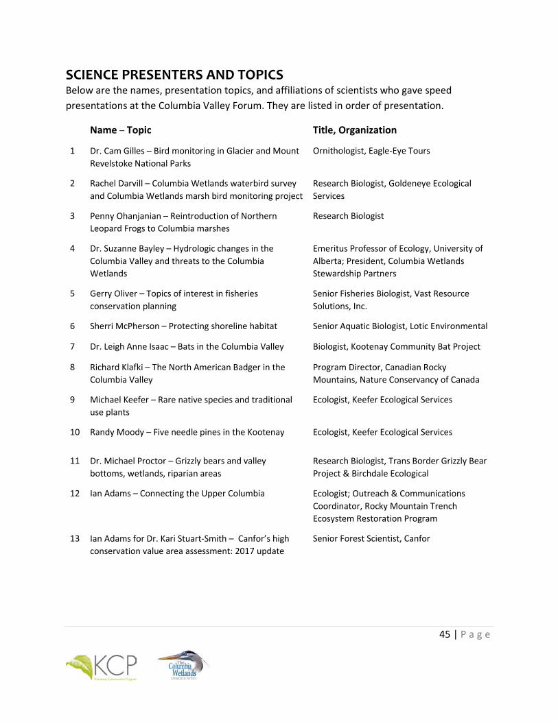
45 | P a g e
SCIENCE PRESENTERS AND TOPICS Below are the names, presentation topics, and affiliations of scientists who gave speed presentations at the Columbia Valley Forum. They are listed in order of presentation.
Name – Topic Title, Organization
1 Dr. Cam Gilles – Bird monitoring in Glacier and Mount Revelstoke National Parks
Ornithologist, Eagle-Eye Tours
2 Rachel Darvill – Columbia Wetlands waterbird survey and Columbia Wetlands marsh bird monitoring project
Research Biologist, Goldeneye Ecological Services
3 Penny Ohanjanian – Reintroduction of Northern Leopard Frogs to Columbia marshes
Research Biologist
4 Dr. Suzanne Bayley – Hydrologic changes in the Columbia Valley and threats to the Columbia Wetlands
Emeritus Professor of Ecology, University of Alberta; President, Columbia Wetlands Stewardship Partners
5 Gerry Oliver – Topics of interest in fisheries conservation planning
Senior Fisheries Biologist, Vast Resource Solutions, Inc.
6 Sherri McPherson – Protecting shoreline habitat Senior Aquatic Biologist, Lotic Environmental
7 Dr. Leigh Anne Isaac – Bats in the Columbia Valley Biologist, Kootenay Community Bat Project
8 Richard Klafki – The North American Badger in the Columbia Valley
Program Director, Canadian Rocky Mountains, Nature Conservancy of Canada
9 Michael Keefer – Rare native species and traditional use plants
Ecologist, Keefer Ecological Services
10 Randy Moody – Five needle pines in the Kootenay Ecologist, Keefer Ecological Services
11 Dr. Michael Proctor – Grizzly bears and valley bottoms, wetlands, riparian areas
Research Biologist, Trans Border Grizzly Bear Project & Birchdale Ecological
12
Ian Adams – Connecting the Upper Columbia Ecologist; Outreach & Communications Coordinator, Rocky Mountain Trench Ecosystem Restoration Program
13 Ian Adams for Dr. Kari Stuart-Smith – Canfor’s high conservation value area assessment: 2017 update
Senior Forest Scientist, Canfor
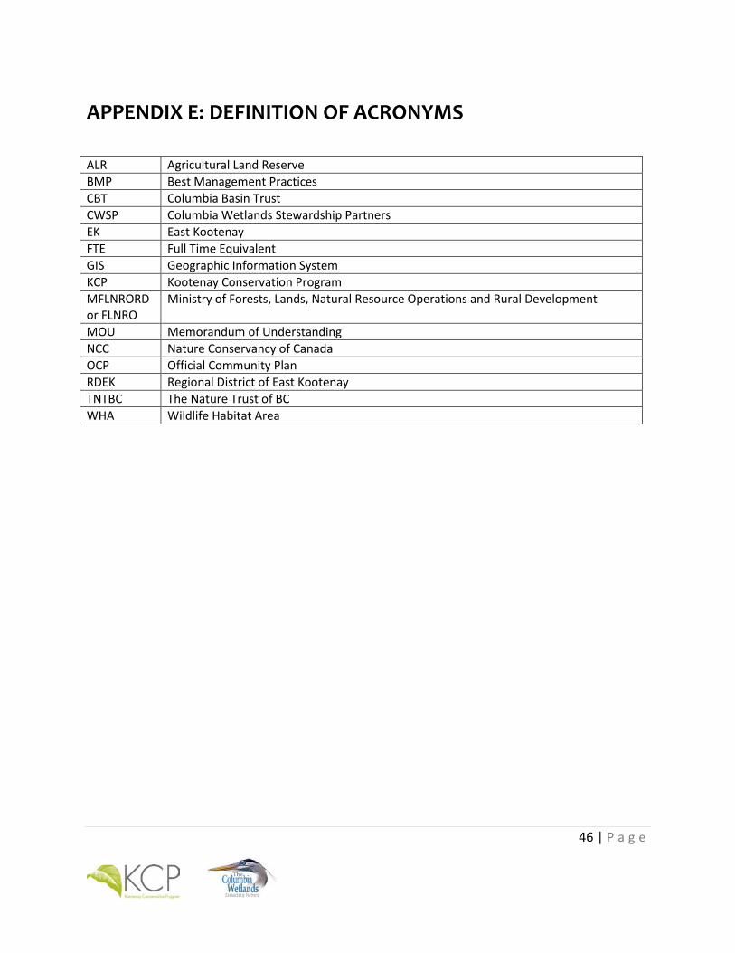
46 | P a g e
APPENDIX E: DEFINITION OF ACRONYMS
ALR Agricultural Land Reserve BMP Best Management Practices CBT Columbia Basin Trust CWSP Columbia Wetlands Stewardship Partners EK East Kootenay FTE Full Time Equivalent GIS Geographic Information System KCP Kootenay Conservation Program MFLNRORD or FLNRO
Ministry of Forests, Lands, Natural Resource Operations and Rural Development
MOU Memorandum of Understanding NCC Nature Conservancy of Canada OCP Official Community Plan RDEK Regional District of East Kootenay TNTBC The Nature Trust of BC WHA Wildlife Habitat Area
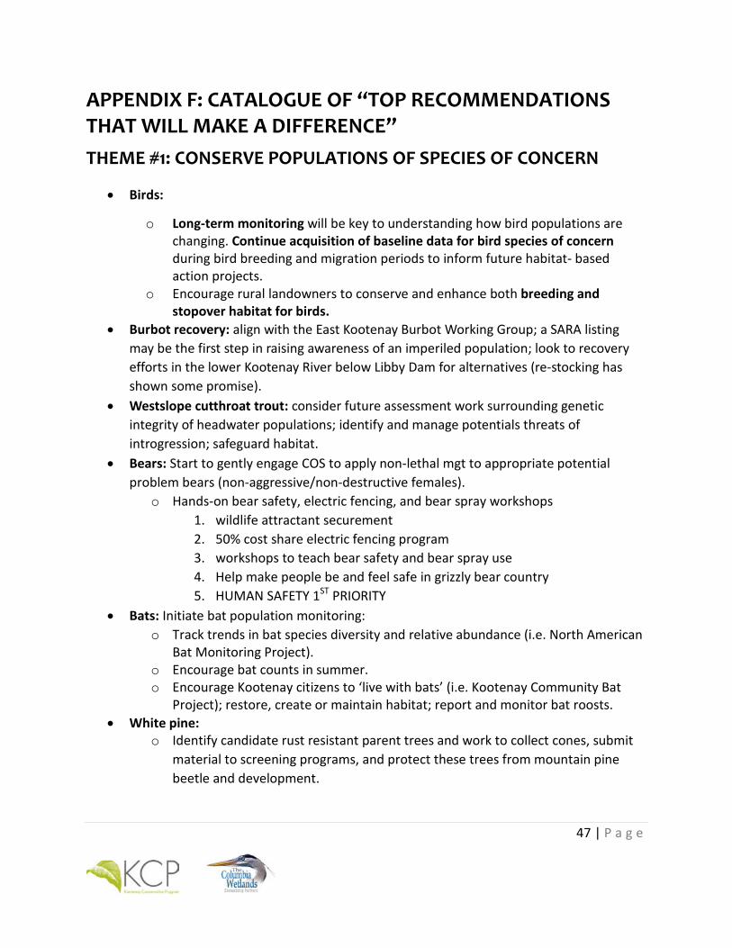
47 | P a g e
APPENDIX F: CATALOGUE OF “TOP RECOMMENDATIONS THAT WILL MAKE A DIFFERENCE” THEME #1: CONSERVE POPULATIONS OF SPECIES OF CONCERN
• Birds:
ο Long-term monitoring will be key to understanding how bird populations are changing. Continue acquisition of baseline data for bird species of concern during bird breeding and migration periods to inform future habitat- based action projects. ο Encourage rural landowners to conserve and enhance both breeding and stopover habitat for birds.
• Burbot recovery: align with the East Kootenay Burbot Working Group; a SARA listing may be the first step in raising awareness of an imperiled population; look to recovery efforts in the lower Kootenay River below Libby Dam for alternatives (re-stocking has shown some promise).
• Westslope cutthroat trout: consider future assessment work surrounding genetic integrity of headwater populations; identify and manage potentials threats of introgression; safeguard habitat.
• Bears: Start to gently engage COS to apply non-lethal mgt to appropriate potential problem bears (non-aggressive/non-destructive females).
o Hands-on bear safety, electric fencing, and bear spray workshops 1. wildlife attractant securement 2. 50% cost share electric fencing program 3. workshops to teach bear safety and bear spray use 4. Help make people be and feel safe in grizzly bear country 5. HUMAN SAFETY 1ST PRIORITY
• Bats: Initiate bat population monitoring: o Track trends in bat species diversity and relative abundance (i.e. North American
Bat Monitoring Project). o Encourage bat counts in summer. o Encourage Kootenay citizens to ‘live with bats’ (i.e. Kootenay Community Bat
Project); restore, create or maintain habitat; report and monitor bat roosts. • White pine:
o Identify candidate rust resistant parent trees and work to collect cones, submit material to screening programs, and protect these trees from mountain pine beetle and development.
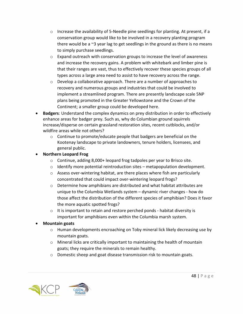
48 | P a g e
o Increase the availability of 5-Needle pine seedlings for planting. At present, if a conservation group would like to be involved in a recovery planting program there would be a ~3 year lag to get seedlings in the ground as there is no means to simply purchase seedlings.
o Expand outreach with conservation groups to increase the level of awareness and increase the recovery gains. A problem with whitebark and limber pine is that their ranges are vast, thus to effectively recover these species groups of all types across a large area need to assist to have recovery across the range.
o Develop a collaborative approach. There are a number of approaches to recovery and numerous groups and industries that could be involved to implement a streamlined program. There are presently landscape scale 5NP plans being promoted in the Greater Yellowstone and the Crown of the Continent; a smaller group could be developed here.
• Badgers: Understand the complex dynamics on prey distribution in order to effectively enhance areas for badger prey. Such as, why do Columbian ground squirrels increase/disperse on certain grassland restoration sites, recent cutblocks, and/or wildfire areas while not others?
o Continue to promote/educate people that badgers are beneficial on the Kootenay landscape to private landowners, tenure holders, licensees, and general public.
• Northern Leopard Frog o Continue, adding 8,000+ leopard frog tadpoles per year to Brisco site. o Identify more potential reintroduction sites – metapopulation development. o Assess over-wintering habitat, are there places where fish are particularly
concentrated that could impact over-wintering leopard frogs? o Determine how amphibians are distributed and what habitat attributes are
unique to the Columbia Wetlands system – dynamic river changes - how do those affect the distribution of the different species of amphibian? Does it favor the more aquatic spotted frogs?
o It is important to retain and restore perched ponds - habitat diversity is important for amphibians even within the Columbia marsh system.
• Mountain goats o Human developments encroaching on Toby mineral lick likely decreasing use by
mountain goats. o Mineral licks are critically important to maintaining the health of mountain
goats; they require the minerals to remain healthy. o Domestic sheep and goat disease transmission risk to mountain goats.
49 | P a g e
• Bighorn sheep: o Highway mortality on Mile Hill and in Radium area still relatively high. o Domestic sheep and goat disease transmission risk to bighorn sheep. o Concentrated use of Radium village by bighorn sheep could be a potential health
risk to bighorn sheep. o Potential loss of migratory bighorn sheep behaviour would be problematic;
having lambs in town not preferred. o Work cooperatively with Kootenay National Park on ecosystem restoration and
wildlife health projects.
THEME #2: PREVENT AND CONTROL INVASIVE SPECIES
• Invasive species management: EK is the most invasive-free place in southern BC and Upper Columbia Valley is the best place in EK so let’s keep them out.
• Address invasive fish species issue through public education. • Address invasive fish species issue by increasing daily catch limits for Large Mouth Bass
and Yellow Perch (currently bass daily quota is 8 in Windermere Lake, elsewhere bass and perch are closed to fishing).
• Reduce risk of White Nose Syndrome spread: Educate and provide stations for cavers/climbers to disinfect gear (i.e., BatCaver); and educate recreationalists on accidental transport of bats.
• Participate in WNS disease surveillance: Collect guano in spring; Submit dead bats in winter.
• Continue sampling programs for high priority aquatic and terrestrial invasive species For example, zebra and quagga mussels in Columbia Lake and Lake Windermere.
• Continue education and outreach to keep high priority invasive species out of Slocan Lake through education and behaviour change messaging, including PlantWise, Clean, Drain, Dry, and PlayCleanGo.
• Manage high priority species as per the EKISC priority lists. • Maintain the degree of invasive plant invasion low.

50 | P a g e
THEME #3: PROTECT EXISTING HIGH QUALITY HABITATS
• Habitat conservation for bird populations.
• Recognize the importance of kokanee in ecosystem structure and function and direct efforts at protecting critical spawning environments in the upper basin that may be affected by development.
• Habitat restoration: treatment size matters.
• Managing development pressures - identify corridor / habitat areas that are connected across jurisdictions, both N-S along the Trench and key E-W corridors.
• Cumulative effects - development (residential and industrial / retail), recreation, industrial activities (logging, mining, etc), highways, railway, quad/mountain bike/snowmobile, etc. all impacting on a relatively small area, especially Trench bottom which is quite narrow in the Upper Columbia Valley.
• Protect the hydrologic and geomorphic processes that maintain the Columbia Wetlands habitat and its levees.
• Restore the inflow of sediment, gravel and rocks (CPR and MoT) to maintain levees. • Restore the inflow of large woody debris (MoT) to maintain the levees and biodiversity
of habitats. • A shift in revegetation from agronomic to native species following industrial and other
disturbances.
• Changes to silvicultural practices to encourage longer term huckleberry productivity following logging in key highly productive areas for huckleberries.
• Consider efforts to minimize motorized access in heavily roaded areas around important huckleberry patches and high quality habitat used by grizzly bears (circled on map). The area has a good dose of protected areas.
• Rocky Mountain Trench ungulate winter range and grassland ecosystems throughout the valley.
• Riparian protection, including conservation opportunities for private lands. • Columbia Wetlands: continued emphasis on programs that provide information and
guidance to maintain ecosystem function. • Promote bird friendly agricultural practices on agricultural land.
• Secure/enhance high quality badger habitat where female badgers can raise young as far as from major highways as possible.
51 | P a g e
• Educate landowners and developers on Shoreline Management Guidelines for Fish and Wildlife Habitats available for Windermere and Columbia Lakes (e.g., shore segment colour zones and respective activity risks).
• Increase enforcement to ensure shoreline development is conducted in accordance with the Shoreline Management Guidelines for Fish and Wildlife, and that Fisheries and Oceans Canada and BC Water Sustainability Act notifications/approvals are obtained prior to work proceeding.
• Complete Sensitive Habitat Inventory and Mapping and preparing Shoreline Management Guidelines for other areas of the Columbia River under potential development pressure.
• Winter habitat for bats: o Stop mine closures, or use bat-friendly gates for closures o Complete inventory of mines used by bats as hibernacula
• Ecosystem restoration within areas with low invasive plants.
THEME #4: ENHANCE CONNECTIVITY AND CORRIDORS
• Strategic land purchases or conservation easements in identified linkage areas such as Luxor/Brisco and across the south end of Columbia Lake.
• Stewardship arrangements on private land within corridors. • Connectivity corridors include:
o Qat muk complex: includes Jumbo, Farnham, upper Horsethief and Stockdale o Bugaboo Pass and upper Bugaboo drainage o Upper Luxor and Fraling Creeks o Between Luxor-Brisco-Spillimacheen o Areas including passes between Kootenay and Columbia: Bear-Pedley-Mary Ann
complex o Canal Flats o Hwy 95
• Identify management regimes for each corridor – what needs to be done + who needs to do it.
• Identify property owners within corridors. • Collect and compare existing corridor maps from various organizations and experts at
different scales. • Corridors must align across OCP boundaries.
52 | P a g e
• Identify and assess areas that currently lack connectivity, but could be restored? • Evaluate how OCP Corridors link up to landscape level scale. • Engage all levels of government and First Nations and jurisdictions on corridors and
landownership and Ag Land Commission. • Land use planning by regional district and municipalities to minimize development in
identified linkage areas (not necessarily zero development, but appropriate and minimized).
• Regular communication with local governments to influence of municipal planning / legislation in conservation planning. The Upper Columbia Valley is a hodgepodge of jurisdictions and all address wildlife habitat and connectivity to varying degrees; maintaining clear, open and regular communication among these jurisdictions is essential, especially for wide-ranging species like grizzly, badger, wolverine, etc.
• Consider the upper Columbia system in its entirety since populations operate over large spatial scales (think laterally and longitudinally).
• Reduce road & railroad mortality – can be through both increased education/awareness and physical road works, such as installing wildlife crossing structures and/or fencing to direct badgers to underpasses.
THEME #5: REDUCE RECREATIONAL PRESSURE
• Access management - recognition of all recreational impacts - motorized (summer & winter), non-motorized trail construction and mountain bike riding.
• Effective regulations and enforcement for off-road vehicles to deter destruction. • Develop BMPs for non-motorized recreationists in the Columbia Wetlands to avoid
human disturbance during sensitive periods. • High levels of recreational activity (motorized and non-motorized) has the potential to
cause disturbance and displacement of mountain goats. • High levels of recreational activity (motorized and non-motorized) has the potential to
cause disturbance and displacement of bighorn sheep. • Develop speed zones for sensitive zones on Lake Windermere and Columbia Lake. • Access management on lakes, e.g., reducing docks, launches, buoys. • Monitor transport / introduction of aquatic invasive species. • Strengthen hunting regulations in the East Kootenay Management Area. • Assessing limits of use and carrying capacity.

53 | P a g e
• Need coordinated approach to recreational land use planning to include public consultation in Upper Columbia Valley Recreational Access Management Plan.
• Upper Columbia Valley Recreational Access Management Plan needs to include Best Management Practices (BMPs) for motorized and non-motorized in both aquatic and terrestrial ecosystems in the valley.
• More signage, education and enforcement is needed. • Increase involvement of First Nations in government to government planning to
address recreational impacts. • Prioritize more road reclamation / decommissioning to help stop access into so many
places.
THEME #6: ADVANCE CLIMATE CHANGE RESILIENCE
• Stop emitting greenhouse gases (carbon) since mitigation is far more effective than adaptation.
• Implement a regional conservation plan that facilitate the shifts necessary for resilient ecosystems that can adapt to climate change and creates/maintains connectivity that allows for range changes by individual species. Immediately start planning for climate change for the land base, water resources and communities in the Columbia Valley region.
• Monitor the watersheds of the Columbia Valley to determine the hydrologic response to climate change and then ensure that mitigations and adaptations to climate change do not negatively impact ecological processes in the Columbia wetlands. (e.g., impoundments, land clearing, increased irrigation, disruption of sediment transport).
• Monitor and maintain the water flows in tributaries, streams and small creeks entering the wetlands by working with local landowners to keep peak runoff flows.
• Determine how the different wetland habitats respond to flooding (its variability, peak & low flows, and drought) by monitoring the wetland hydroperiod and mapping the types of wetland habitat.
• Determine which types of wetland habitat are most vulnerable to changing hydrology and recommend options to maintain them (e.g. protecting beaver, small dams on perched basins, vegetation management).
• Address wildfire fuel loads particularly near communities and to reduce the likelihood of landscape-scale fires. Decrease vulnerability to fire risk by reducing fuel loads to significantly increase the size of interface areas. Treat low elevation and mid-elevation areas on south aspects areas to reduce fire risk and promote ecosystem

54 | P a g e
restoration/adaptation. At lower elevations maintain fire resistant trees species of dry forest types such as ponderosa pine, Douglas fir and western larch and reduce fuels around them so they are more likely to survive intense fire.
• Adjust forestry practices to accommodate extreme climate and flooding events to reduce likelihood of landsliding and waterborne erosion – i.e., avoid activities on or above unstable slopes, reduce watershed road density, and limit equivalent clearcut area.
• Modify private-land practices to prepare for extreme hydrologic events - i.e., water conservation, culvert sizing, road surfacing, etc.
• Expand water monitoring with a focus on scale granularity, complementing regional networks and building on existing community-based monitoring. Monitor water levels and temperature throughout sub-watersheds to build a robust dataset over time. Approach mitigating climate change by understanding what’s going on during low flow periods when mountains no longer store enough water for downstream needs. Identify and protect water recharge sources to learn which streams are fed by recharge from sub-surface sources and which are not. How will creeks, aquifers and wetlands react when water levels change? Where are the sources of water recharge?
• Protect wetlands and riparian areas, including smaller and higher-elevation sites. Build long-term data sets for small wetlands. Especially concentrate on maintaining and/or enhancing water sources for wetlands and ponds.
• Maintain cold stream temperatures through inventory, monitoring and, if necessary, targeted treatments.
• Identify and manage potential climate change cool refugia – both terrestrial and aquatic
• Be able to influence leadership (federal/provincial government) – influence government “followship” of initiatives coming from non-governmental leadership.