combining the potential for archaeological sites for each
TRANSCRIPT

16
Combining the potential for archaeological sites for each of the alternatives, Alt-1, Alt-2 and Alt-3 all have a higher potential for the presence of archaeological sites based upon standard settlement models than the chosen alternative.
Received by VMRC September 2, 2020 /blh

17
References Cited
Trout, William E., III 1994 The Slate And Willis's Rivers Atlas. VA Canals and Navigations Society
Publication.
Received by VMRC September 2, 2020 /blh

APPENDIX 2: VIEWSHED ANALYSIS
Green RidgePhase I Cultural Resources Investigation
139
Received by VMRC September 2, 2020 /blh
2206 South Main Street • Blacksburg, VA • 24060 • 540.552.0444 • www.daa.com
Charlottesville • Manassas • Newport News • Richmond • Virginia Beach
Fayetteville • Raleigh
P:\2018\1802\0100\18020117\18020117-030102\REPORTS\Part A Permit Application\12 - Att XVII - Landfill Impact Statement\VIEWSHED ANALYSIS - MODIFIED\20 0212 submittal\MEM -
20 0212 - Viewshed analysis.docx
Memorandum
To: Browning and Associates
From: Lynn Klappich, Program Manager
Date: February 12, 2020
Project Name: Green Ridge Recycling and Disposal Facility – Cumberland County, VA
Project Number: 18020117-030102
Subject: Viewshed analysis – Modified analysis – Appendix 2 – Phase I report
cc: Mike Futrell
On February 10, 2020, Draper Aden Associates GIS personnel completed a revised viewshed analysis for
the above referenced facility. The revision was required as the initial analysis had assumed two disposal
units and a consistent height above existing ground as a design was not available. At this time a
conceptual design has been completed for the western fill area and this design was utilized in the
modified analysis.
Below is a description of our methodology and findings for the viewshed analysis.
Methodology – A viewshed analysis was performed for the area surrounding the proposed Green
Ridge landfill to determine if the completed landfill would be visible from archaeological sites and
standing structures that are either on the National Register of Historic Places (NRHP) or eligible for
inclusion on the NRHP.
Lidar data from 2016 for all areas within 5 miles of the proposed landfill property were acquired from
the Virginia Geographic Information Network (VGIN) lidar download FTP site. The data set is formally
referred to as the “USGS Chesapeake Bay VA QL2 LiDAR Project”. We acquired the raw point cloud in
LAS format. The same data set can also be downloaded from the USGS website:
https://viewer.nationalmap.gov/basic/
The viewshed analysis is a common tool in GIS analysis of topography. Historically the challenges have
been data resolution and approaches to taking forest cover into account. A ‘bare earth’ model, or a
digital elevation model (DEM) was often all that was available. If a land use or forest cover layer existed
for a study site the model could be augmented by adding elevation to the forested areas in order to
approximate the tree canopy. With the availability of lidar it is possible to accurately model features
Received by VMRC September 2, 2020 /blh
Page 2 of 2
sitting upon the earth surface. This is typically referred to as a digital surface model (DSM) and
represents the upper surfaces such as tree canopy and building roofs. Using this surface makes
viewshed analysis much more representative of reality.
Our first step was to convert the lidar point cloud into a DSM raster layer. We chose a grid or cell size of
10-feet as a reasonable generalization of tree canopy and more than sufficient for bare ground
representation. Using ArcGIS lidar tools, ‘LAS Dataset to Raster’, we calculated the DSM using a
MAXIMUM cell assignment type. Basically, this assigned the DSM cell elevation as the highest point
falling in the cell.
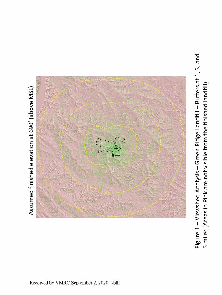
The current proposed finished landfill includes one waste management area and has a distinct peak at
an elevation of 690 MSL. For a conservative measure we set a viewpoint above the peak at an elevation
of 695 MSL. We then used the ArcGIS Viewshed Tool Set, ‘Viewshed’ to generate the standard
visible/not-visible derivative layer based upon the DSM. This layer is typically shown as green/red,
though often made partially transparent for evaluation of individual locations, so often it will be shown
as a lime/pink overlay.
The majority of visible features are tree canopy, especially beyond the first mile. The forest cover
effectively blocks a sight line to other features. Each of the sites were then manually reviewed with aerial
imagery and terrain models to determine if the viewshed analysis made sense and corresponded with
the aerial imagery. This provided a secondary and different review of whether the mound of the
proposed Green Ridge landfill would be visible or not. Again, the review showed that the line of sight to
the proposed landfill is typically blocked by trees that are in relative near proximity to the sites.
The resulting viewshed analysis is shown in Figure 2. Areas shaded in pink will not have a direct line of
sight to the finished waste management area. Based on this analysis, the landfill will be potentially
visible from only one resource currently listed or eligible for inclusion on the National Register of
Historic Places (DHR ID 024-5082 - Pine Grove School) depending on viewer position and status of the
tree line across the road.
Attachment 1 – Figure 1 - Viewshed Analysis
Received by VMRC September 2, 2020 /blh
ATTACHMENT 1
Received by VMRC September 2, 2020 /blh
Figu
re 1
–V
iew
shed
An
alys
is –
Gre
en
Rid
ge L
and
fill
–B
uff
ers
at 1
, 3, a
nd
5
mile
s (A
reas
in P
ink
are
no
t vi
sib
le f
rom
th
e fi
nis
hed
lan
dfi
ll)
Ass
um
ed f
inis
he
d e
leva
tio
n a
t 6
90
’ (ab
ove
MSL
)
Received by VMRC September 2, 2020 /blh

APPENDIX 3: ARTIFACT INVENTORY
Green RidgePhase I Cultural Resources Investigation
144
Received by VMRC September 2, 2020 /blh
Area 3
44CM0136STP 114, Fill 1Glass1 white milk glass canning jar lid liner fragment
STP 115, Fill 1Miscellaneous4 brick fragments (61g)
STP 118, Fill 1Ceramics2 stoneware sherds, white, undecorated, refined, flatware
Glass1 clear unidentified fragment4 windowpane fragments, lime soda (1864-present)2 windowpane fragments, lime soda (1864-present)3 light aqua bottle/jar fragments
Metal2 cut nail(s), machine headed (1805-present)1 cut nail(s) fragment, machine headed (1805-present)
Miscellaneous1 brick fragment (18g) (discarded in lab)
STP 119, Fill 1Glass1 windowpane fragment, lime soda (1864-present)
Metal1 button flat, round, copper alloy button, 18mm in diameter, missing shank, embossed lettering on back
LONDON1 unidentified nail(s) fragment
Miscellaneous5 brick fragments (52g) (discarded in lab)
STP 122, Fill 1Glass1 windowpane fragment, lime soda (1864-present)1 windowpane fragment, lime soda (1864-present)1 olive green bottle/jar fragment1 dark olive green bottle/jar fragment
Metal3 unidentified nail(s) fragments
STP 123, Fill 1Glass1 windowpane fragment, lime soda (1864-present)5 windowpane fragments, lime soda burned (1864-present)1 clear unidentified fragment thin 1 clear bottle/jar fragment, automatic bottle machine (ABM) possible rim or lip (1912-present)7 windowpane fragments, lime soda (1864-present)
Received by VMRC September 2, 2020 /blh

2 windowpane fragments, lime soda one burned/deformed (1864-present)Metal2 fragments thin, corroded 1 cut nail(s) fragment (1805-present)1 chain link corroded, possible spring snap link
STP 124, ApCeramics1 stoneware sherd, brown, undecorated, utilitarianGlass1 windowpane fragment, lime soda (1864-present)1 clear bottle/jar fragment, automatic bottle machine (ABM) (1912-present)Metal1 unidentified nail(s) fragment1 wire nail(s), roofing (1901-present)3 wire nail(s) (1890s-present)
STP 125, Fill 1Metal1 wire nail(s) fragment (1890s-present)
STP 128, ApbGlass1 windowpane fragment, lime soda (1864-present)
STP 132, ApbGlass1 cobalt unidentified fragment
STP 133, Fill 1Glass1 pale green bottle/jar fragment2 clear bottle/jar fragments, automatic bottle machine (ABM) (1912-present)Metal4 fragments4 unidentified nail(s) fragments3 wire nail(s) (1890s-present)
STP 134, Fill 1Ceramics1 unidentified earthenware sherd, no glaze, flatware spalled Glass1 windowpane fragment, lime soda (1864-present)
STP 137, Fill 1Glass1 clear cylindrical bottle/jar fragment, automatic bottle machine (ABM) (1912-present)
STP 145, ApCeramics1 pearlware sherd, undecorated, refined (1779-1830)
Green RidgePhase I Cultural Resources Investigation
146
Received by VMRC September 2, 2020 /blh

STP 161, Fill 1Miscellaneous3 brick fragments (95g) (discarded in lab)
STP 162, ApCeramics1 pearlware sherd, unidentified, rim, refined, flatware white with blue along rim edge (1779-1830)Metal1 wrought nail(s), hand headed
STP 163, Fill 1Glass1 windowpane fragment, lime soda (1864-present)
STP 165, Fill 1Ceramics2 pearlware sherds, embossed, base, refined, flatware one with embossed annular pattern (1779-
1830)STP 133N, Fill 1Glass3 windowpane fragments, lime soda (1864-present)1 windowpane fragment, lime soda (1864-present)1 windowpane fragment, lime soda (1864-present)3 clear cylindrical bottle/jar fragments, automatic bottle machine (ABM) (1912-present)9 Ball blue canning jar jar fragments, cylindrical, automatic bottle machine (1909-ca. 1939)Metal4 wire nail(s) fragments (1890s-present)2 wire nail(s) (1890s-present)3 fragments heavily corrodedMiscellaneous2 bone fragments (20g)
STP 133W, Fill 1Metal1 wire nail(s) fragment (1890s-present)1 wire nail(s) (1890s-present)
STP 137W, Fill 1Miscellaneous5 bone fragments
Area 1
44CM0137STP 22, ApGlass2 clear cylindrical bottle/jar fragments , automatic bottle machine (ABM) (1912-present)
STP 48, ApGlass1 clear bottle/jar fragment, automatic bottle machine (ABM) (1912-present)
Green RidgePhase I Cultural Resources Investigation
147
Received by VMRC September 2, 2020 /blh

STP 52, ApCeramics1 hard paste porcelain sherd, white, undecorated, refined, flatwareGlass2 clear bottle/jar fragments, automatic bottle machine (ABM) one square base (1912-present)1 clear bottle/jar fragment, automatic bottle machine (ABM) stippling on one side (1912-present)1 clear bottle/jar fragment, automatic bottle machine (ABM) approx 6 x4cm, embossed lettering and
numbering on base: "I58"; "S"; "T" in a keystone maker's mark (Knox Bottle Co. of Mississippi. Palestine, Texas plant) (1940-1952)
Miscellaneous2 coal fragments (4g)
STP 53, ApGlass1 dark bluish-green unidentified fragment decorative embossed pattern
STP 60, ApGlass2 clear bottle/jar fragments
STP 64, ApGlass2 Ball blue canning jar bottle/jar fragments, automatic bottle machine (ABM) one embossed, "E"
above "S O" (1909-ca. 1939)STP 89, ApGlass1 windowpane fragment, lime soda (1864-present)1 clear bottle/jar fragment, automatic bottle machine (ABM) (1912-present)
STP 91, ApGlass1 clear bottle/jar fragment1 windowpane fragment, lime soda (1864-present)1 clear bottle/jar fragment, automatic bottle machine (ABM) (1912-present)
STP 48E, ApGlass1 clear cylindrical bottle/jar fragment, automatic bottle machine (ABM) (1912-present)
STP 48W, ApGlass1 amber bottle/jar fragment, automatic bottle machine (ABM) embossed lettering "TE" (1912-
present)1 white milk glass canning jar lid liner fragment1 clear bottle/jar fragment, automatic bottle machine (ABM) (1912-present)
STP 60E, ApGlass1 windowpane fragment, lime soda (1864-present)
STP 60N, ApCeramics1 whiteware sherd, white, undecorated, rim, refined (1820-present)
Green RidgePhase I Cultural Resources Investigation
148
Received by VMRC September 2, 2020 /blh

1 whiteware sherd, white, undecorated, base, refined, flatware portion of makers mark (1820-present)
Glass1 clear bottle/jar fragment, automatic bottle machine (ABM) (1912-present)
STP 60W, ApGlass1 white milk glass canning jar lid liner fragment
STP 64E, ApGlass1 clear bottle/jar fragment, automatic bottle machine (ABM) (1912-present)Metal1 unidentified nail(s) heavily corroded
STP 64S, ApCeramics1 whiteware sherd, white, undecorated, refined, holloware (1820-present)Glass1 clear bottle fragment, automatic bottle machine (ABM) square, flat, base, embossed "4" in circle
(1912-present)Metal2 fragments1 unidentified nail(s) fragment
STP 91E, ApCeramics1 pearlware sherd, white, undecorated, rim, refined (1779-1830)
Area 1
44CM0138MD 01, Fill 1Metal1 wire nail(s) (1890s-present)
MD 02, Fill 1Metal1 wire nail(s) fragment (1890s-present)
MD 03, Fill 1Metal1 eye bolt
MD 04, Fill 1Metal1 fragment angled rim, 1.5 cm thick
MD 05, ApMetal1 wire nail(s) (1890s-present)
MD 06, ApCeramics1 pearlware sherd, undecorated, base, refined, flatware (1779-1830)
Green RidgePhase I Cultural Resources Investigation
149
Received by VMRC September 2, 2020 /blh
Metal1 tubular, tapered, threaded end
MD 07, ApMetal1 wire nail(s) (1890s-present)Miscellaneous1 bone fragment (60g)
MD 08, ApMetal1 enamelware pot lid fragment blue and white, hole in center
MD 09, ApMetal1 strap hinge fragment
MD 10, Fill 1Metal1 boot spur with heel band, neck, and rowel
MD 11, Fill 1Metal1 wire nail(s) (1890s-present)
MD 12, Fill 1Glass5 clear unidentified fragments burnedMetal4 cut nail(s), T-head (1805-present)2 cut nail(s), machine headed (1805-present)6 wire nail(s) (1890s-present)1 wire nail(s), roofing (1901-present)Miscellaneous1 shoe sole fragment child's shoe heel
MD 13, Fill 1Glass1 clear unidentified fragment burned and fused 1 windowpane fragment, lime soda (1864-present)Metal1 fragment thin6 wire nail(s) (1890s-present)1 wire fragment2 wire nail(s) fragments (1890s-present)
MD 14, Fill 1Glass1 clear bottle/jar fragment, automatic bottle machine (ABM) (1912-present)Metal12 wire nail(s) (1890s-present)1 wire nail(s) fragment (1890s-present)1 cut nail(s), machine headed (1805-present)
Green RidgePhase I Cultural Resources Investigation
150
Received by VMRC September 2, 2020 /blh
1 safety pin fragmentMD 15, Fill 1Glass1 clear unidentified fragment burned2 windowpane fragments, lime soda (1864-present)Metal1 wire nail(s) fragment (1890s-present)5 wire nail(s) (1890s-present)1 staple
MD 16, Fill 1Metal1 wire nail(s) fragment (1890s-present)5 wire nail(s) (1890s-present)1 wire nail(s), roofing (1901-present)Miscellaneous1 bone fragment flat, thin
MD 17, Fill 1Metal1 staple fragment
MD 18, Fill 1Glass1 clear cylindrical bottle/jar fragment, automatic bottle machine (ABM) (1912-present)Metal4 barbed wire fragments corroded
MD 19, Fill 1Metal1 wire nail(s) (1890s-present)
MD 20, Fill 1Metal1 wire nail(s) (1890s-present)
MD 21, Fill 1Metal3 barbed wire fragments corroded
MD 22, Fill 1Metal1 wire nail(s) (1890s-present)
MD 23, Fill 1Glass2 very pale aqua unidentified fragments burned and fused 2 orange unidentified fragments burned 1 red unidentified fragments burned and fused 1 windowpane fragment, lime soda (1864-present)Metal3 wire nail(s) fragments (1890s-present)
Green RidgePhase I Cultural Resources Investigation
151
Received by VMRC September 2, 2020 /blh

Miscellaneous2 unknown material, burned with nail holes, fused with window glass and charcoal
MD 24, Fill 1Glass4 clear unidentified fragments burned and fused 1 clear cylindrical bottle/jar base fragment, automatic bottle machine (ABM) (1912-present)Metal1 steamer trunk corner guard fragment1 wire nail(s) fragment (1890s-present)1 steamer trunk corner guard with attached fasteners
MD 25, Fill 1Glass1 amber bottle fragment, duraglas base, burned, stippled, embossed "4" (post-1940)2 clear unidentified fragments burned 1 clear cylindrical bottle/jar fragment, automatic bottle machine (ABM) (1912-present)Metal3 wire nail(s) (1890s-present)2 wire nail(s) fragments (1890s-present)
MD 26, Fill 1Glass1 clear unidentified fragment burned1 clear bottle/jar fragment, automatic bottle machine (ABM) (1912-present)1 clear canister annular, embossed lines along rim, embossed "J"Metal1 wire nail(s) (1890s-present)1 wire nail(s) fragment (1890s-present)
MD 27, Fill 1Metal2 fragments thin1 steamer trunk corner guard decorated, two attached nail fragments2 wire nail(s) (1890s-present)
MD 28, Fill 1Metal1 hinge door or cabinet hinge
MD 29, Fill 1Glass4 windowpane fragments, lime soda (1864-present)
MD 30, Fill 1Metal1 fragment 21x6x0.6 cm, curved, raised rim
MD 31, Fill 1Glass1 clear jar fragment, cylindrical, automatic bottle machine (ABM) ball/mason jar threaded rim,
intact metal lid and milk glass lid liner; embossed lettering on lid, "Presto" (1912-present)
Green RidgePhase I Cultural Resources Investigation
152
Received by VMRC September 2, 2020 /blh

MD 32, Fill 1Metal3 wire nail(s) (1890s-present)
MD 34, Fill 1Metal1 fragment
MD 35, Fill 1Metal2 unidentified nail(s) fragments3 wire nail(s) fragments (1890s-present)
MD 36, Fill 1Metal1 wire nail(s) fragment (1890s-present)2 wire nail(s) (1890s-present)
MD 37, Fill 1Ceramics1 whiteware sherd, undecorated, refined, flatware (1820-present)Metal1 cut nail(s), machine headed (1805-present)
MD 38, Fill 1Glass1 white milk glass tableware fragment rim ; scalloped and linear, molded pattern on exterior surface,
smooth interior.1 white milk glass tableware fragment rim ; molded shell pattern on exterior surface, floral pattern
on interior.Metal2 wire nail(s) (1890s-present)1 disk 3.5 cm in diameter with three linear holes
MD 39, Fill 1Ceramics1 whiteware sherd, undecorated, refined (1820-present)Metal1 thin, folded2 fragments thin
MD 40, Fill 1Metal1 fragment thin, flat, square or rectangular, two intact edges; raised rim, slightly raised ridge 2 cm
from rim. MD 41, Fill 1Ceramics1 hard paste porcelain sherd, white, refined, flatware gold and green annular patternMetal1 spoon fragment spoon, nearly intact bowl and attached neck
MD 42, Fill 1Metal1 door lock case
Green RidgePhase I Cultural Resources Investigation
153
Received by VMRC September 2, 2020 /blh

SC 01, ApGlass1 clear bottle/jar fragment burned4 windowpane fragments, lime soda (1864-present)4 clear unidentified fragments burned
Area 6
44CM0139STP 35, Fill 1Glass1 windowpane fragment, lime soda (1864-present)1 windowpane fragment, lime soda (1864-present)1 windowpane fragment, lime soda thin (1864-present)Metal14 thinMiscellaneous83 brick 80+ brick fragments and 3 whole bricks (discarded in field)
STP 36, Fill 1Miscellaneous25 brick fragments observed but not collected
STP 40, Fill 1Miscellaneous25 brick fragments observed but not collected
STP 35N, Fill 1Miscellaneous25 brick fragments (not collected)
STP 40N, Fill 1Glass1 windowpane fragment, lime soda (1864-present)Metal1 triangular; wire ring; pull tab (possible)
Area 2
44CM0141STP 262, ApMetal1 spike corroded, length: 22 cm. 1 wire nail(s) fragment (1890s-present)1 thin strap, u-bolts and eye bolt with iron ring attached1 wire nail(s) (1890s-present)
STP 267, ApGlass1 clear bottle/jar fragment, automatic bottle machine (ABM) (1912-present)
Green RidgePhase I Cultural Resources Investigation
154
Received by VMRC September 2, 2020 /blh
STP 290, ApGlass1 clear bottle/jar fragment, automatic bottle machine (ABM) rectangular 4.5x3x8.5 cm., 2.5cm
diameter mouth, embossed lettering/numbering on base "2.5 FL. OZ.", "S" within a circle maker's mark (1914-1930)
STP 293, ApGlass3 clear bottle fragments, contact mold one rectangular (1810-1880)Metal11 fragments 3 possible rim fragments
STP 294, ApMetal1 fragment thin1 wire nail(s) fragment (1890s-present)1 wire nail(s) (1890s-present)
STP 297, ApMetal1 wire nail(s) (1890s-present)
STP 304, ApGlass7 unidentified fragments
STP 308, ApMiscellaneous4 concrete fragments (discarded in field)
STP 309, ApMetal3 unidentified nail(s) fragments
STP 313, ApGlass6 clear cylindrical bottle/jar fragments, automatic bottle machine (ABM) 2 threaded rim fragments
(1912-present)Metal3 unidentified nail(s) fragments1 wagon endgate/box rod length: 54 cm.
STP 267N, ApMetal4 unidentified nail(s) fragments
STP 293N, ApGlass1 clear bottle/jar fragment
STP 294E, ApGlass3 clear bottle/jar fragments, automatic bottle machine (ABM) (1912-present)1 white milk glass canning jar lid liner jar fragment24 windowpane fragments, lime soda (1864-present)
Green RidgePhase I Cultural Resources Investigation
155
Received by VMRC September 2, 2020 /blh

STP 294S, ApCeramics1 pearlware sherd, white, undecorated, base, refined, flatware (1779-1830)
STP 297E, ApGlass1 clear cylindrical bottle/jar fragment, automatic bottle machine (ABM) (1912-present)Metal3 handle fragments1 wire nail(s) with bent tip (1890s-present)1 threaded cap with four prongs
Area 3
44CM0144MD 1, ApMetal1 oval ring, length: 8 cm; chain link (possible)
MD 2, ApMetal1 fragment square, 6x5x1 cm .
MD 3, ApMetal1 hoop diameter: 9 cm, width: 5 cm, with raised element 2 cm wide and high along width of hoop
MD 4, ApMetal1 wire nail(s) fragment (1890s-present)
MD 5, ApMetal1 fragment curved, 7.5x4.5x0.6 cm.
MD 6, ApMetal1 strap hinge fragment
MD 7, ApMetal1 plowshare
MD 8, ApMetal1 horseshoe fragment
MD 9, ApMetal1 fragment flat, thickness: 0.05 cm
MD 10, ApMetal1 cultivator shank bent, 16.5x4.5 cm, single hole in center.
Green RidgePhase I Cultural Resources Investigation
156
Received by VMRC September 2, 2020 /blh

MD 11, ApMetal1 fragment flat, with raised rim, 0.5 cm in thickness
MD 12, ApMetal1 bar, corroded, 15x3x.5 cm
MD 13, ApMetal1 strap hinge fragment
MD 14, ApMetal1 wire nail(s) fragment (1890s-present)
MD 15, ApMetal1 strap hinge fragment nut and bolt attached
MD 16, ApMetal1 horseshoe fragment
MD 18, ApMetal1 horseshoe
MD 19, ApMetal1 plowshare
MD 20, ApMetal1 fragment flat, curved; hoe (possible)
MD 21, ApGlass1 dark amber cylindrical bottle/jar fragment 0.6 cm thick1 amber bottle/jar fragment, automatic bottle machine (ABM) embossed lettering "...DE MARK
R..." (1912-present)Metal1 fragment length: 9 cm, diameter: 1.5 cm 1 unidentified nail(s) fragment heavily corroded
MD 22, ApCeramics1 stoneware sherd, white, salt glazed, utilitarian, holloware large jug mouth and body; mouth
diameter 3 cm.Glass1 clear bottle fragment, automatic bottle machine (ABM) rectangular, narrow neck; includes portion
of mouth, neck and body; whiskey or medicine bottle. (1912-present)Miscellaneous1 brick fragment (122g) (discarded in lab)
Green RidgePhase I Cultural Resources Investigation
157
Received by VMRC September 2, 2020 /blh
MD 23, ApMetal1 wire nail(s) fragment (1890s-present)1 bent, corroded
MD 24, ApMetal1 wire nail(s) (1890s-present)
MD 25, ApMetal1 horseshoe
MD 26, ApMetal1 unidentified nail(s) fragment
MD 27, ApMetal1 strap 79x1.5x0.3 cm with holes for fasteners. Weight: 237.7 g.
MD 28, ApMetal1 horseshoe
MD 29, ApMetal1 fragment thin1 cylindrical, length: 4 cm 1 unidentified nail(s) fragment heavily corroded
MD 30, ApMetal1 wire fragment length: 38 cm.
MD 31, ApMetal1 wire nail(s) (1890s-present)1 wire nail(s) fragment (1890s-present)
MD 32, ApMetal3 wire nail(s) (1890s-present)
MD 33, ApMetal1 wire nail(s) (1890s-present)
MD 34, ApMetal1 fragment 13x2x1 cm
MD 35, ApMetal1 fragment
Green RidgePhase I Cultural Resources Investigation
158
Received by VMRC September 2, 2020 /blh

MD 36, ApMetal1 unidentified nail(s) fragment
MD 38, ApMetal1 wire nail(s) fragment (1890s-present)3 wire nail(s) (1890s-present)
MD 39, ApMetal1 strap fragment 11x3 cm, hole 3 cm from end, strap hinge (possible)
MD 40, ApMetal1 fragment 22x5 cm, stepped edge and raised ridge along length
MD 41, ApMetal1 wire nail(s) fragment (1890s-present)
MD 42, ApMetal1 fragment
MD 43, ApMetal1 bolt fragment corroded, remnant of attached nut1 fragment thin, thickness: 0.4 cm, raised ridge along one edge
MD 44, ApMetal1 unidentified nail(s) fragment
MD 45, ApMetal1 wire nail(s) fragment (1890s-present)
MD 46, ApMetal1 fragment thin, 1.4x3.5 cm, rounded on one end; kitchen utensil handle (possible)
MD 47, ApMetal1 horseshoe fragment
MD 48, ApMetal1 fragment curved, length: 20 cm, thickness: 1-2 cm
MD 49, ApMetal1 fragment concave, thickness: 0.5 cm; embossed "S" on surface
MD 50, ApMetal1 wire-like link, corroded
Green RidgePhase I Cultural Resources Investigation
159
Received by VMRC September 2, 2020 /blh
MD 51, ApMetal1 fragment flat with raised edges, 9.5x7x0.4 cm.
MD 52, ApMetal1 fragment square 6 x 6 x 0.4 cm , raised rim (.06 cm) along one edge
MD 53, ApMetal1 scissors fragment scissor handle
MD 54, ApMetal1 fragment L-shaped, length: 11cm, thickness: 1-2 cm; weight: 123.3g
MD 55, ApMetal1 horseshoe fragment
MD 56, ApMetal1 fragment length: 8 cm
MD 57, ApMetal1 fragment
MD 58, ApMetal1 wire nail(s) (1890s-present)
MD 59, ApMetal2 strap fragments
MD 60, ApMetal1 fragment 4.4x1.7x1.2 cm, slightly tapered along length
MD 61, ApGlass2 clear cylindrical bottle/jar fragments, automatic bottle machine (ABM) (1912-present)Miscellaneous1 brick fragments (93g) (discarded in field)
MD 62, ApMetal1 cultivator shank 16.5x4.5 cm, single hole in center
MD 63, ApMetal1 wire nail(s) (1890s-present)
MD 64, ApMetal1 fragments thin, width: 2.5 cm, evenly spaced, slotted holes
Green RidgePhase I Cultural Resources Investigation
160
Received by VMRC September 2, 2020 /blh
MD 65, ApMetal1 wire nail(s) 10.5cm (1890s-present)
MD 66, ApMetal1 wire nail(s) (1890s-present)
MD 67, ApMetal1 wire nail(s) (1890s-present)
MD 68, ApMetal1 plowshare fragment
MD 69, ApMetal1 fragment curved, 4.5x1.5x1.5 cm
MD 70, ApGlass1 windowpane fragment, lime soda (1864-present)1 clear bottle/jar base, diameter: 2.5 cmMetal1 wire nail(s) (1890s-present)
MD 71, ApMetal1 door/gate latch one side of bolt latch receiver with 3 slotted head screws attached
MD 72, ApGlass1 windowpane fragment, lime soda (1864-present)Metal1 wire nail(s) (1890s-present)
MD 73, ApMetal1 fragment 17x4.5 cm, curved along width; pipe (possible)
MD 74, ApMetal1 cultivator shank 16.5x4.5 cm, single hole in center.
MD 75, ApMetal1 flatiron missing handle
MD 76, ApMetal1 wrought nail(s) fragment
MD 77, ApMetal1 wire nail(s) fragment (1890s-present)
Green RidgePhase I Cultural Resources Investigation
161
Received by VMRC September 2, 2020 /blh

MD 78, ApMetal1 wire nail(s) (1890s-present)
MD 79, ApMetal1 ax head single blade
MD 80, ApMetal1 spike length: 25 cm, 2 cm, square shank
MD 81, ApMetal1 fragment thin, flat, with curved notch on one edge
MD 82, ApMetal1 wire nail(s) (1890s-present)
MD 83, ApMetal1 fragment heavily corroded, triangular, length: 17.5 cm
MD 84, ApMetal1 fragment triangular, 0.7 cm thick-161.4 g.
MD 85, ApMetal1 wire nail(s) (1890s-present)
MD 86, ApMetal1 wire nail(s) 13 cm in length (1890s-present)1 wire nail(s) (1890s-present)
MD 87, ApMetal1 wire nail(s) (1890s-present)
MD 88, ApMetal1 fragment flat, 0.4 cm thick, raised ridge along one edge
MD 89, ApMetal1 spike length: 14 cm, 1.3 cm square shank
MD 90, ApMetal1 cut nail(s), machine headed (1805-present)
MD 91, ApMetal1 wire nail(s) fragment (1890s-present)
Green RidgePhase I Cultural Resources Investigation
162
Received by VMRC September 2, 2020 /blh

MD 92, ApMetal1 ring, diameter: 4 cm
MD 93, ApMetal1 fragment thin, folded, slightly rounded-4.6 g.
MD 94, ApMetal1 wire nail(s) (1890s-present)
MD 95, ApMetal1 wire fragment corroded1 wire nail(s) (1890s-present)
MD 96, ApMetal1 wire nail(s) (1890s-present)
MD 97, ApMetal1 wire nail(s) (1890s-present)
MD 98, ApMetal1 boot spur rowel
MD 99, ApMetal1 wire nail(s) (1890s-present)
MD 100, ApMetal1 wire nail(s) (1890s-present)
MD 101, ApMetal1 cut nail(s), machine headed 5 cm in length (1805-present)
MD 102, ApGlass1 windowpane fragment, lime soda (1864-present)Metal1 unidentified nail(s) fragment
MD 103, ApMetal1 unidentified nail(s) fragment
MD 104, ApMetal1 strap hinge fragment
MD 105, ApMetal4 fragments
Green RidgePhase I Cultural Resources Investigation
163
Received by VMRC September 2, 2020 /blh
MD 106, ApMetal1 wire nail(s) (1890s-present)
MD 107, ApMetal1 wire nail(s) (1890s-present)
MD 108, ApMetal3 wire nail(s) (1890s-present)
MD 109, ApMetal1 wire nail(s) (1890s-present)1 hoop, diameter: 14 cm, width: 2 cm, thickness: 0.4 cm
MD 110, ApMetal1 wire nail(s) fragment (1890s-present)1 fragment square, 9x7.5x0.4 cm. 2 wire nail(s) (1890s-present)
MD 111, ApMetal1 wire nail(s) (1890s-present)
MD 112, ApMetal1 wire nail(s) fragment (1890s-present)
MD 113, ApGlass1 windowpane fragment, lime soda (1864-present)Metal1 horseshoe modified, tapered to a point on the ends1 hoop hoop, diameter: 22 cm, width: 3 cm; wagon wheel hub hardware (possible)1 D shaped ring, diameter: 3 cm1 pliers missing one half
MD 114, ApMetal1 fragment L-shaped, 19x3x0.5 cm
MD 115, ApMetal1 broken, cast iron wheel, 6 spokes with square hub, missing 1 spoke and portion of rim, bent spike
through the center of he hub, 35 cm in diameter, rim and spokes approximately 2 cm in widthMD 116, ApMetal1 strap hinge
MD 117, ApMetal2 wire nail(s) (1890s-present)
Green RidgePhase I Cultural Resources Investigation
164
Received by VMRC September 2, 2020 /blh
1 wing nutMD 118, ApMetal1 pintle hinge
MD 119, ApMetal1 wire nail(s) fragment (1890s-present)
MD 120, ApMetal1 wire nail(s) (1890s-present)1 strap hinge fragment1 tag fragment plate, embossed "HASSLER" within an oval logo. Additional lettering includes
"SHOCK ABSORBER, MANUFACTURED, ROBERT H. HASSL", "INDIANAPOLIS"; from shock absorbers for Model T Fords.
MD 121, ApMetal1 wire nail(s) (1890s-present)
MD 122, ApMetal1 wire nail(s) fragment (1890s-present)2 wire nail(s) (1890s-present)
MD 123, ApMetal1 horseshoe
MD 124, ApMetal1 wire nail(s) (1890s-present)
MD 125, ApMetal1 wire nail(s) (1890s-present)
MD 127, ApMetal1 fragment 14.5x2x0.2 cm. Oval shaped hole at one end with short bolt and nut attached. Two
additional bolts fastening a second 5 cm long fragment of equal width and thickness atop first.1 stirrup fragment
MD 128, ApCeramics2 stoneware sherds, white, salt glazed, base, utilitarian, holloware large crock/jug base, one with
dark blue glaze along edgeMetal1 wire nail(s) (1890s-present)
MD 130, ApMetal1 (457g) bent bar, 16mm in diameter1 plate with flared edge
Green RidgePhase I Cultural Resources Investigation
165
Received by VMRC September 2, 2020 /blh
MD 131, ApMetal1 strap hinge fragment1 wire nail(s) (1890s-present)
MD 132, ApMetal1 fragment flat, square, 5.5x5.5x0.4 cm, 4 cm opening at one end.
MD 133, ApMetal1 wire nail(s) (1890s-present)
MD 134, ApMetal1 hook with squared end and hole for fastener
MD 135, ApMetal1 hoop diameter: 14 cm, width: 7cm, with rounded notch; possible wagon wheel hub hardware
MD 136, ApMetal1 wire nail(s) (1890s-present)
MD 137, ApMetal1 fragment cast iron pipe (possible)
MD 138, ApMetal1 ax head single blade
MD 139, ApMetal1 wire nail(s) (1890s-present)
STP 358, ApGlass1 pale purple bottle/jar fragment, clear manganese (1880-1915)
STP 370, Fill 1Ceramics1 whiteware sherd, white, unidentified, refined, holloware light green decoration (1820-present)Glass1 windowpane fragment, lime soda (1864-present)
STP 600, Fill 1Ceramics1 pearlware sherd, green, undecorated, refined (1779-1830)Metal1 45 cm, attached bolts and iron rings1 wire nail(s) fragment (1890s-present)1 strap fragment 20 cm x 2 cm x 0.5 cm, attached iron bolt and nut2 wire nail(s) (1890s-present)
Green RidgePhase I Cultural Resources Investigation
166
Received by VMRC September 2, 2020 /blh
STP 370N, Fill 1Glass1 pale aqua bottle/jar fragmentMetal1 wire nail(s) (1890s-present)
STP 370W, ApGlass1 Ball blue cylindrical bottle/jar fragment, automatic bottle machine (ABM) (1909-ca. 1939)
STP 600N, Fill 1Metal1 wire nail(s) (1890s-present)2 steamer trunk corner guard fragments1 ring, 4.5 cm diameter
STP 600S, Fill 1Ceramics1 creamware sherds, white, undecorated, rim, refined 1 rim sherd, spalled, feather edged (possible)
(1762-1820)Metal1 unidentified nail(s) fragment1 shotgun shell base remnants of paper within base; imprinted lettering on bottom of base
"FEDERAL MONARK No 12"1 wire nail(s) (1890s-present)
STP 600W, Fill 1Glass1 windowpane fragment, lime soda (1864-present)
Area 6
44CM0145F 4, Fill 1Ceramics16 pearlware sherds, green, feather edge, rim/base, refined, flatware, scalloped rim (refit), impressed
anchor makers mark, possible Davenport (ca. 1793-1810) (1779-1830)1 stoneware sherd, base, holloware gray body, brown exterior glaze, red interior2 unidentified earthenware sherdsGlass2 olive green blackglass wine bottle fragments patinatedMetal1 wrought nail(s) fragment
MD 1, ApGlass1 clear other oval, flat, glass bead approximately 1.3x1x0.4 cm, crenulated pattern around outer rimMetal1 cut nail(s) fragment possible horseshoe nail (1805-present)
MD 2, ApMetal1 cut nail(s) possible horseshoe nail (1805-present)
Green RidgePhase I Cultural Resources Investigation
167
Received by VMRC September 2, 2020 /blh

MD 3, ApMetal1 cut nail(s) fragment possible horseshoe nail (1805-present)
MD 4, ApMetal1 cut nail(s) possible horseshoe nail (1805-present)
MD 5, ApMetal1 cut nail(s) possible horseshoe nail (1805-present)
MD 6, ApMetal1 cut nail(s) fragment (1805-present)
MD 7, ApMetal1 horseshoe
MD 8, ApMetal1 fragment approximately 5.5x5.0.5 cm.
MD 9, ApMetal1 cut nail(s) possible horseshoe nail (1805-present)
MD 10, ApMetal1 cut nail(s) possible horseshoe nail (1805-present)
MD 11, ApMetal1 cut nail(s) possible horseshoe nail (1805-present)
MD 12, ApMetal1 fragment approximately 2x1.5x1 cm, wedge shaped
MD 13, ApMetal1 wrought nail(s) length: 7 cm, square head 2.5x2.5 cm .
MD 14, ApMetal1 fragment 6.5x3x1.5 cm.
MD 15, ApMetal1 cut nail(s) fragment possible horseshoe nail (1805-present)
SC SC-1, ApCeramics3 pearlware sherds, white, undecorated, refined (1779-1830)
Green RidgePhase I Cultural Resources Investigation
168
Received by VMRC September 2, 2020 /blh

Area 1
Loc 01STP 81, ApMetal1 chain, link approx 1.4m in length, possibly modern
Area 3
Loc 02STP 232, ApLithics1 quartz flake
Area 3
Loc 03STP 314, ApLithics1 quartzite hammerstone chipped1 quartz flake
Area 3
Loc 04STP 402, ApLithics1 quartz point Stanley fragment, Middle Archaic
Area 3
Loc 05STP 560, ApLithics1 quartzite scraper, no cortex
Area 3
Loc 06STP T4-18, ApGlass1 windowpane fragment , lime soda (1864-present)
Area 3
Loc 07STP 357, ApCeramics1 whiteware sherd, white, undecorated, refined, flatware (1820-present)
Area 3
Loc 08STP 371, ApMetal1 unidentified nail(s) fragment
Green RidgePhase I Cultural Resources Investigation
169
Received by VMRC September 2, 2020 /blh

Area 4
Loc 09STP 127, ApLithics1 quartz point Clarksville, Late Woodland
Area 4
Loc 10STP 130, ApCeramics1 refined white earthenware sherd, undecorated, undecorated
Area 4
Loc 11STP 208, ApCeramics1 refined white earthenware sherd, undecorated, undecorated
Area 4
Loc 12STP 21, ApLithics2 quartz point Rossville, Early Woodland (mend)
Area 5
Loc 13STP 167, ApMetal1 cut nail(s) fragment, machine headed (1805-present)
Area 5
Loc 14STP 97, ApGlass1 clear bottle/jar fragment, automatic bottle machine (ABM) (1912-present)
Area 6
Loc 15STP 23, ApMetal1 wire nail(s) (1890s-present)
Area 6
Loc 16STP 49, ApMiscellaneous1 brick fragment (8g)
Green RidgePhase I Cultural Resources Investigation
170
Received by VMRC September 2, 2020 /blh

Area 7
Loc 17STP 201, ApLithics1 quartz flake fragment fragment
Area 7
Loc 18STP 215, ApLithics1 quartz flake fragment fragment
Green RidgePhase I Cultural Resources Investigation
171
Received by VMRC September 2, 2020 /blh

VII. THREATENED AND ENDANGERED SPECIES REPORT
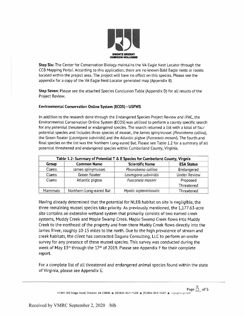
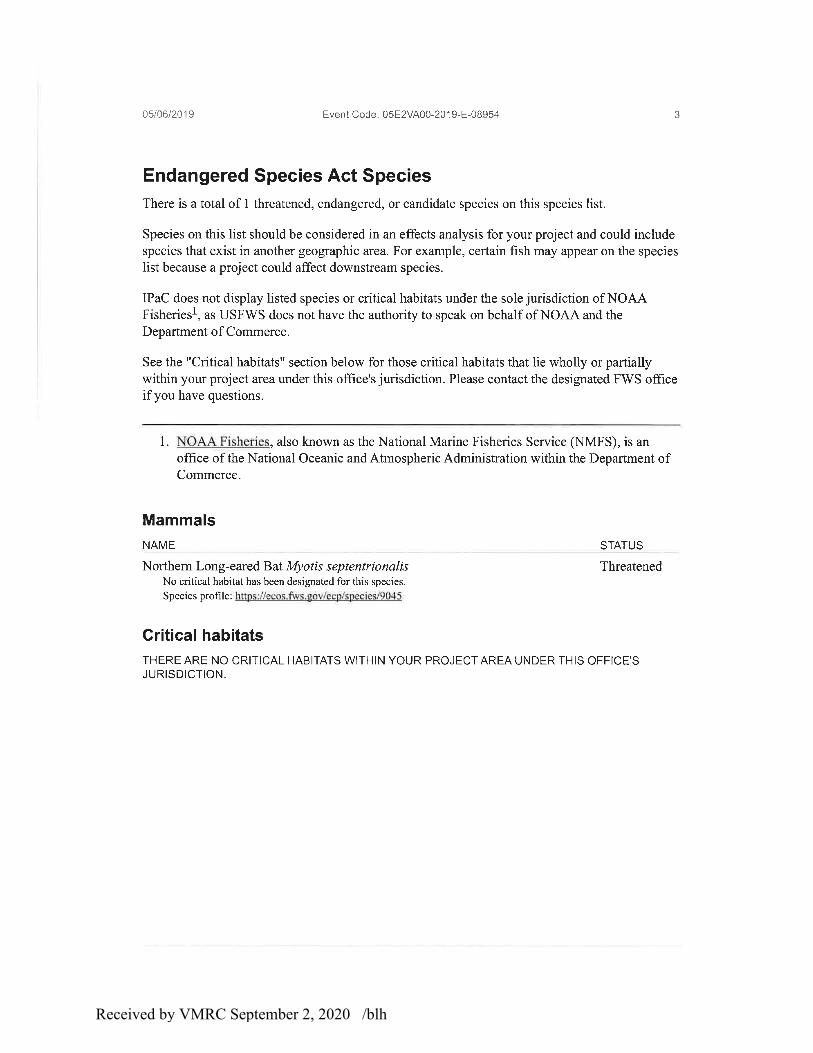
The following report contains two sections. The first was prepared by Koontz Bryant Johnson Williams and contains information obtained from the U.S. Fish and Wildlife Service. The aim of this section was to identify the potential for the presence of any threatened and endangered species within the project area and from there to pursue further investigation. This report will show that KBJW identified a total of four potential species with the potential for onsite presence. These included James Spinymussel (Pleurobema collina), Green Floater (Lasmigona subviridis), Atlantic Pigtoe (Fusconaia masoni) and the Northern Long-Eared Bat (Myotis septentrionalis).
The second portion was prepared by Daguna Consulting, LLC and contains their findings on the presence of any threatened and endangered mussel species within the project area. Field work was conducted in May of 2019.
Received by VMRC September 2, 2020 /blh
Received by VMRC September 2, 2020 /blh

Received by VMRC September 2, 2020 /blh

Received by VMRC September 2, 2020 /blh
Received by VMRC September 2, 2020 /blh

Received by VMRC September 2, 2020 /blh
Received by VMRC September 2, 2020 /blh

Received by VMRC September 2, 2020 /blh
Received by VMRC September 2, 2020 /blh

Received by VMRC September 2, 2020 /blh

Received by VMRC September 2, 2020 /blh

Received by VMRC September 2, 2020 /blh

Received by VMRC September 2, 2020 /blh

Received by VMRC September 2, 2020 /blh

Received by VMRC September 2, 2020 /blh
Received by VMRC September 2, 2020 /blh
Received by VMRC September 2, 2020 /blh

Received by VMRC September 2, 2020 /blh

Received by VMRC September 2, 2020 /blh

Received by VMRC September 2, 2020 /blh

Received by VMRC September 2, 2020 /blh

Received by VMRC September 2, 2020 /blh

Received by VMRC September 2, 2020 /blh

Received by VMRC September 2, 2020 /blh

Received by VMRC September 2, 2020 /blh

Received by VMRC September 2, 2020 /blh

Received by VMRC September 2, 2020 /blh
Received by VMRC September 2, 2020 /blh

Received by VMRC September 2, 2020 /blh

REVISED FINAL REPORT
Surveys for Protected Freshwater Mussels
at the Proposed Green Ridge Recycling and Disposal Facility
in Cumberland County, VA
by
Brett J. K. Ostby and B. B. Beaty
Daguna Consulting, LLC
7509 Pin Oak Circle
Bristol, VA 24202
for
Koontz, Bryant, Johnson, Williams Group
11901 Old Stage Road
Chester, VA
May 29th, 2019
Revised August 15th, 2019
Final Revision December 5th, 2019
Received by VMRC September 2, 2020 /blh
2 of 23
INTRODUCTION The proposed Green Ridge Recycling and Disposal Facility is planned for rural Cumberland
County, Virginia. Preliminary review of the property indicated that streams potentially
containing freshwater mussels may be present. Therefore, the project developer requested a
survey for the imperiled freshwater mussels to better understand any potential impact. Nearby
perennial streams include Muddy Creek and Maple Swamp Creek. These perennial streams
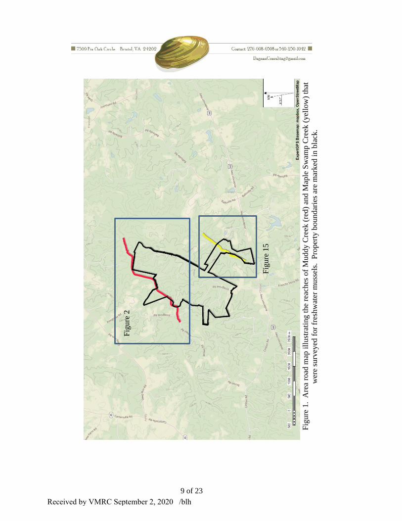
border and, in some places, flow through the Green Ridge property (Figure 1). Many unnamed
tributaries to these streams drain the property.
The James River Basin is inhabited by the federally endangered James Spinymussel
(Pleurobema collina), the state-threatened Green Floater (Lasmigona subviridis), and the state-
threatened Atlantic Pigtoe (Fusconaia masoni). The state-listed Green Floater is known from the
James River upstream and downstream of the Muddy Creek confluence (The Catena Group
2010, Chazal et al. 2012). Relic shell material of the Atlantic Pigtoe was recently detected in the
Powhatan County reach of the James River by Chazal et al. (2012). The James Spinymussel is
known from nearby Rock Island Creek (~ 40 km to the northwest, Chazal et al. 2012). Ostby
(2007) detected a significant population of a common mussel species (Eastern Elliptio, Elliptio
complanata) in a small unnamed stream in Powhatan County (~20 km to the east). That small
unnamed stream was comparable to the perennial streams on the Green Ridge site. Chazal et al.
(2012) conducted 2 surveys of Davis Creek, a tributary to Muddy Creek entering downstream of
the Green Ridge site. They identified suitable habitat but detected no native mussels in those
surveys.
On May 25 and 26, 2019, biologists Brett Ostby and Braven Beaty of Daguna Consulting, LLC
visited the Green Ridge property to assess potential mussel habitat in streams and conduct
surveys for freshwater mussels where necessary. Surveys were conducted to meet the
requirements of “Abbreviated Surveys” as defined in “Freshwater Mussel Guidelines for
Virginia (USFWS and VDGIF 2013)”. Most efforts focused on Muddy Creek and Maple
Swamp Creek.
METHODS Stream Assessment
We either visited streams by hiking through the site or assessed streams as they entered either
Muddy Creek or Maple Swamp Creek. Assessments determined whether sufficient flow and
suitable substrate were present to support freshwater mussels. We also assessed overall stream
conditions. In some streams with sufficient flow, we searched for mussels.
Stream Surveys
The perennial streams (Muddy Creek and Maple Swamp Creek) were surveyed for mussels to
qualitatively assess species composition, abundance, and the possible presence of protected
species. In accordance with the published Virginia freshwater mussel survey guidelines, we
searched reaches of stream extending from 400 downstream to 100 m upstream of proposed
impacts. Because most habitats were shallow (<0.5 m), we used viewscopes and unaided visual
Received by VMRC September 2, 2020 /blh
3 of 23
inspection. In some areas tactile searches were employed. All stream reaches were surveyed
unless the habitat was deemed “unsuitable” for mussels based on the site visit. The
“unsuitability” of any stream reach(es) as habitat for mussels was fully documented. We
searched stream banks and exposed shoals for mussel shells to obtain a complete list of species at
the site. Surveys were conducted when water level and clarity were suitable to locate shells and
live individuals with ease. Sufficient effort was expended to visually inspect a sufficient amount
of suitable habitat so that we could state with reasonable confidence that endangered and/or
threatened species did or did not occur in the reach sampled. Representative specimens of each
species detected were photographed. Geographical Information System (GIS) programs were
used to georeference survey boundaries, location of protected species, and location of other
pertinent features.
RESULTS Weather and Stream Conditions
Skies were clear on both May 25th and May 26th. Air temperature reached a high of 29 oC (85 oF) on May 25th and 32 oC (90 oF) on May 26th. Flows were assumed to be near median in
Muddy Creek and Maple Swamp Creek based on information from nearby gages, including
USGS 02036500 on Fine Creek at Fine Creek Mills, VA and USGS 02039500 on the
Appomattox River at Farmville, VA. Little to no rain had fallen in the area over the preceding
week. Water clarity in Muddy Creek was limited due to tannins and turbidity from an unknown
source. In general, the streambed was clearly visibly in laminar flows less than 0.4 m depth.
Water temperature in Muddy Creek was 22 oC (76 oF) when surveyed on May 25th. Maple
Swamp Creek had no evidence of tannins and was considerably clearer, with all streambed
habitats visible from the water surface in laminar flow. Water in Maple Swamp Creek was 18oC
(64 oF) during the May 26th survey.
Muddy Creek Habitat and Species Observations
We surveyed Muddy Creek from the abandoned Miller Lane bridge (37.584320, -78.106711) to
upstream of the Pine Grove culvert crossing (37.567270, -78.138347), with the exception of a
100 m reach directly downstream of the Pine Grove crossing (Figure 2). The total surveyed
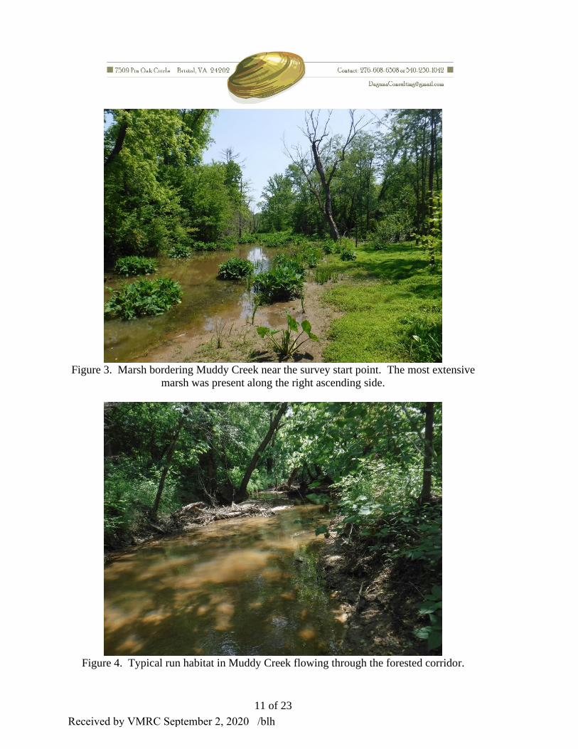
reach was approximately 3,800 m. Muddy Creek flowed through a corridor of mature
bottomland forests, with extensive marshes in the 1000 m reach upstream of the abandoned
bridge (Figure 3). Its average bankfull width was 7 m with wetted width usually 5-6 m.
Bankfull height was 1 to 1.5 m throughout, with sand banks forming a natural dike between the
channel and marsh areas. In forested areas, banks were steep but stable and usually vegetated
(Figure 4).
Instream habitat in Muddy Creek was 95% run habitat with a sand streambed (see Figure3). The
sand streambed ranged from firm to soft. All instream habitat structure in the lower 3,400 m of
the surveyed reach was formed by large woody debris. Approximately 5% of the habitat was
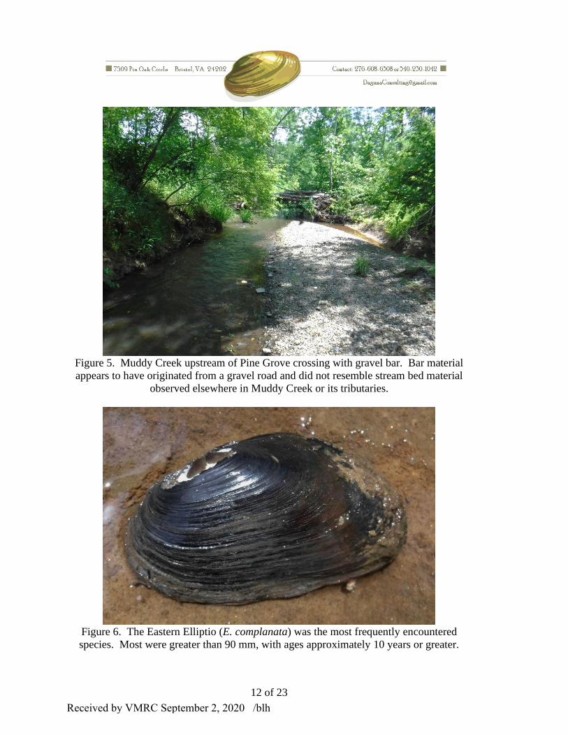
pool. Exposed bedrock, boulders, cobble and gravel were only observed starting 300 m
downstream of the Pine Grove crossing. From 400 m downstream to 200 m upstream of the Pine
Grove crossing, a few riffles were noted (Figure 5). Overall the streambed was 99% sand, with
Received by VMRC September 2, 2020 /blh

4 of 23
some patches being unstable and soft. Maximum water depth was 1.25 m with most habitats less
than 0.4 m deep.
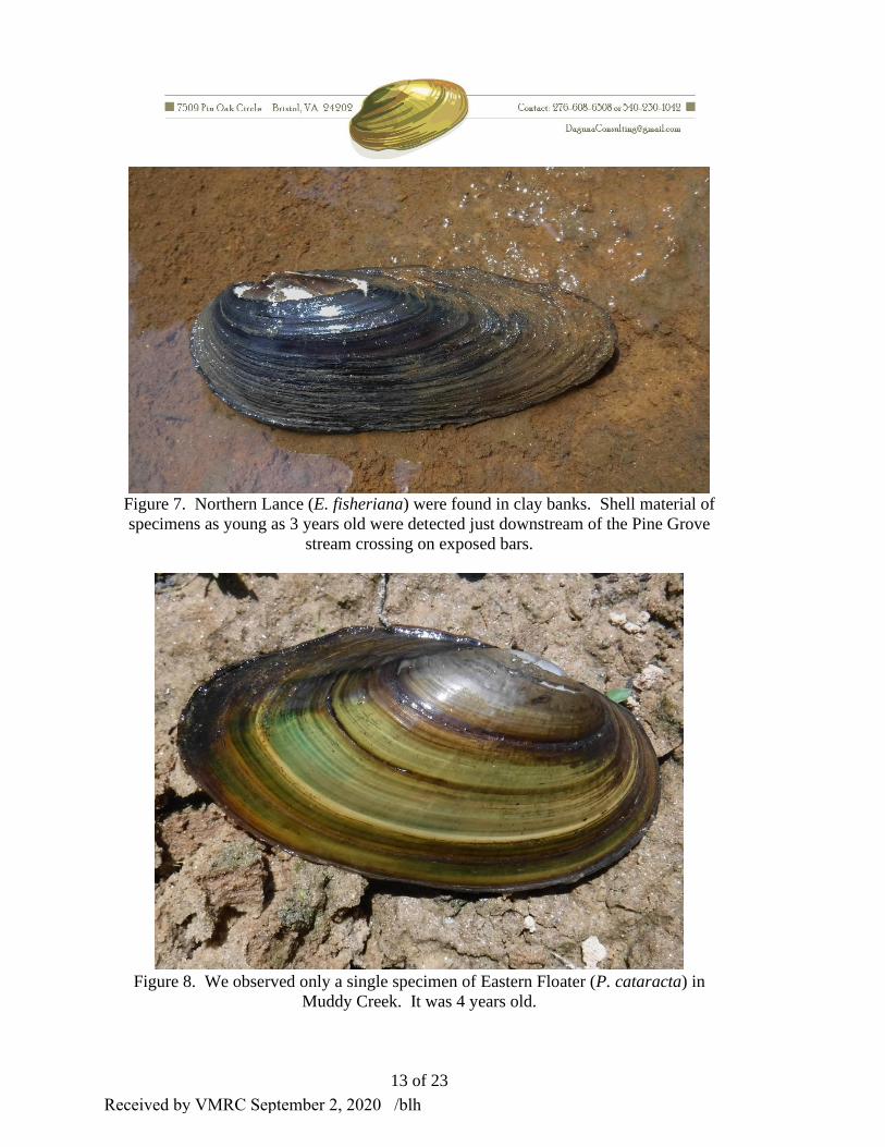
In a 9 person-hour effort, we detected 12 live Eastern Ellipito (E. complanata), 5 live Northern
Lance (E. fisheriana) and 1 live Eastern Floater (Pyganodon cataracta) in the main channel of
Muddy Creek. Figures 6-8 are photographs of example specimens. We detected live mussels
only from the start point to approximately 1000 m upstream. We observed recent shell material
on exposed banks nearer the Pine Grove crossing, but no live specimens were detected in the
vicinity. Non-native Asian Clams (Corbicula fluminea) were present throughout the stream but
not common. There was little habitat for aquatic insects except near the Pine Grove crossing
where we observed a few mayfly larvae under cobbles. We also observed some water scorpions
(Ranatra) in large woody debris closer to the survey start point. We observed cyprinids, mostly
dace, and centrarchids. Several centrarchid nests were noted near the survey start point. Three
frog species were abundant in Muddy Creek and its associated wetlands including Green Frogs,
Cricket Frogs and Leopard Frogs. Tadpole of American Toads and calls of Grey Treefrogs were
also noted.
We noted several tributaries entering Muddy Creek (marked as Trib 1-3 and 5-6 in Figure 2 and
geo-referenced as Trib 1-6 in Table 1) but none appeared suitable for freshwater mussels, being
either too small or unstable (Figures 9-14, see Table 1 for locations). We extensively searched a
tributary flowing from the south which eventually dissipated into a marsh but found no evidence
of mussels (Trib 1, see Figures 9 and 10). The largest tributary flowing through the Green Ridge
property into Muddy Creek from the northwest had a significantly incised channel clogged by
sand with little flow (Trib 3, 37.5744, -78.12536, see Figure 12). Upstream of the Pine Grove
Road crossing, we assessed and surveyed an unnamed tributary draining from the south. This
stream showed evidence of recent catastrophic disturbance, with a newly incised channel cut into
clay banks (Figure 14). There was also a copious amount of gravel, likely originating from
Brown Road, in the stream bed (see Figure 5). Further survey of this stream was not warranted.
Other tributaries flowing off the Green Ridge site into the surveyed reach of Muddy Creek as
marked on the topographic map by dotted blue lines (see Figure 2) were not detected during the
survey of Muddy Creek because they were likely dry on May 25th.
Maple Swamp Creek Habitat and Species Observations
At the survey start point (37.55975, 78.10566), Maple Swamp Creek flowed along a marsh on its
left ascending side and a mature forest on the other (Figure 15 and 16). This reach had low
banks (<0.5 m). It was exclusively run habitat with a sand stream bed. Some patches of sand
were extremely soft. Large woody debris was common. Bankfull width was 3-4 m and mostly
wetted. Water depth was usually less than 0.3 m.
Moving from downstream to upstream the character of Maple Swamp Creek gradually changed.
Further upstream, this stream flowed through a mature forested corridor with higher banks.
Upstream of the unnamed tributary labeled Trib 7, riffles and larger streambed particles became
more common. For approximately the upstream 600 m of the surveyed reach, bankfull height
was usually 1 to 1.5 m, reaching a maximum of 2 m. For the upstream 600 m of the surveyed
Received by VMRC September 2, 2020 /blh

5 of 23
reach habitat was 75% run, 10% riffle and 5% pool (Figure 17). While most of the streambed
remained sand (75%), boulder, cobble and gravel were more common. Some habitats had an
exposed bedrock streambed.
In a 5 person-hour effort, we surveyed an approximately 1,800 m reach, detecting no evidence of
native mussels. No Asian Clams (C. fluminea) were detected either. Fish were more common in
Maple Swamp Creek than in Muddy Creek, with dace, central stone rollers, and darters observed.
Aquatic insects were more frequently encountered in Maple Swamp Creek than in Muddy Creek,
including mayfly larvae, whirligig beetles, caddis fly larvae and water pennies. Several frog
species were abundant in Maple Swamp Creek and its associated wetlands including Green
Frogs, Cricket Frogs and Leopard Frogs. Calls of Grey Treefrogs were also noted.
Two apparently perennial tributaries (Trib 7 and 8 on Figure 15) were assessed. No evidence of
mussels was detected though suitable habitat and habitat complexity were noted near Maple
Swamp Creek in both cases (Figures 18 and 19).
CONCLUSION Muddy Creek supports a low-density mussel assemblage comprised of three common species.
We found no evidence to suggest additional species inhabited the surveyed reach. None of the
Muddy Creek tributaries draining the Green Ridge property appeared to provide suitable habitat
for native mussels. We found no evidence to suggest Maple Swamp Creek or its tributaries were
inhabited by native mussels. Disturbances to any stream flowing off the Green Ridge property
might impact native mussels living downstream in Muddy Creek. Maple Swamp Creek is also a
tributary to Muddy Creek.
Adequate habitat area was searched to detect extremely low-density populations of protected
species. Using a sampling equation from Smith (2006), we calculated post hoc detection
probabilities based on total area searched and assumed detection of an individual mussel when
present (or search efficacy, Table 2). We surveyed at least 19,000 m2 of habitat in Muddy Creek
and 5,400 m2 in Maple Swamp Creek. Generally, detection of an individual mussel is 0.2 on a
scale from 0 to 1, where “0” means an individual was present but not detected and “1” means an
individual was detected. An individual detection rate of 0.1 was more appropriate for Muddy
Creek due to tannins and turbidity, whereas 0.2 was appropriate for Maple Swamp Creek. We
had an extremely high probability (>0.99) to detect mussels present at 0.01 m-2 in both Maple
Swamp Creek and Muddy Creek.
Densities in Muddy Creek were so low that it would require large areas be surveyed to detect
existing populations, so it should be no surprise that Department of Conservation and Recreation,
Division of Natural Heritage surveys conducted by Chazal et al (2012) failed to detect mussels in
the Muddy Creek drainage.
Received by VMRC September 2, 2020 /blh

6 of 23
LITERATURE CITED Ostby, B. J. K. 2007. Stream Survey for Protected Mussels in Unnamed Tributaries to Fine
Creek, Powhatan County, Virginia. Report for Balzer and Associates, Powhatan, VA. 13 pp.
Chazal, A. C., B. T. Watson and B. C. Flower. 2012. Results of James Spinymussel Surveys in
the James River and Tributaries of Central and Eastern Virginia. Report for Virginia Department
of Game and Inland Fisheries, Richmond, VA. 222 pp.
Smith, D. R. 2006. Survey design for detecting rare freshwater mussels. Journal
of the North American Benthological Society 25(3): 701-711.
The Catena Group. 2010. Freshwater Mussel Survey Report for Proposed Water Intake, James
River, Powhatan Co, VA. Report for Malcom Pirnie, Inc. Newport News, VA. 15 pp.
U. S. Fish and Wildlife Service and Virginia Department of Game and Inland Fisheries. 2013.
Freshwater Mussel Guidelines for Virginia. Gloucester, VA. 9 pp.
Received by VMRC September 2, 2020 /blh

7 of 23
Table 1. Latitude and longitude markers (WGS84) for mussel surveys and assessments.
Label Lattitude Longitude Figure
Assessment Trib 1 upstream 37.57729 -78.11288
Assessment Trib 1 and photo 37.57812 -78.11368 9
Assessment Trib 1 downstream and photo 37.58120 -78.11529 10
Muddy Creek survey start 37.58423 -78.10672
Assessment Trib 2 and photo 37.57520 -78.12201 11
Assessment Trib 3 and photo 37.57440 -78.12536 12
Larger substrate and exposed bed upstream 37.57089 -78.12895
Assessement Trib 4 and first riffle 37.57006 -78.12954
Shells on exposed bar 37.56992 -78.13188
Assessment Trib 5 and photo 37.56804 -78.13322 13
Road gravel noted in streambed 37.56740 -78.13779 5
Upstream Assessement Trib 6 and photo 37.56806 -78.13294 14
Muddy Creek survey end 37.56729 78.13835
Upstream Assessement Trib 7 37.55895 -78.11561
Assessment Trib 7 and photo 37.55569 -78.11260 17
Maple Swamp Creek survey start 37.55971 -78.10574 15
Assessement Trib 8 and photo 37.55217 -78.11458 18
Upstream Assessement Trib 8 37.55216 -78.11551
Maple Swamp Creek survey end 37.54780 -78.11513
Received by VMRC September 2, 2020 /blh

8 of 23
Table 2. Probability of detecting a species (p) using Smith (2006) equation, p = 1 - e-βαμ, given
search efficacy (β), actual area covered in a survey (α), and a theoretical density (μ). We also
present a theoretical population size for a survey reach for a given density (0.01 or 0.005
individuals per meter square). For example, if we were only able to detect 1 in 10 L. subviridis
present in Muddy Creek and there were only 94 in the entire surveyed reach, we had a 0.9913
probably to detect at least a single individual.
p β α μ
Probability of
populuation
detection
Probability of
Individual Detection
Area Visually
Searched
Poulation
Density
Population Size
in Survey Reach
Muddy Creek 0.9999 0.05 19000 0.01 190
1.0000 0.1 19000 0.01 190
0.9913 0.05 19000 0.005 95
0.9999 0.1 19000 0.005 95
Maple Swamp 1.0000 0.2 5400 0.01 54
Creek 0.9955 0.1 5400 0.01 54
0.9328 0.05 5400 0.01 54
0.9955 0.2 5400 0.005 27
0.9328 0.1 5400 0.005 27
0.7408 0.05 5400 0.005 27
Stream
Received by VMRC September 2, 2020 /blh
9 of 23
Fig
ure
15
Fig
ure
2
Fig
ure
1.
Are
a ro
ad m
ap i
llu
stra
tin
g t
he
reac
hes
of
Mu
dd
y C
reek
(re
d)
and
Map
le S
wam
p C
reek
(yel
low
) th
at
wer
e su
rvey
ed f
or
fres
hw
ater
mu
ssel
s.
Pro
per
ty b
ou
nd
arie
s ar
e m
ark
ed i
n b
lack
.
Fig
ure
15
Fig
ure
2
Received by VMRC September 2, 2020 /blh

10 of 23
Fig
ure
2.
To
po
gra
ph
ic m
ap i
llust
rati
ng
su
rvey
rea
ch o
f M
ud
dy
Cre
ek (
red
) an
d i
ts t
ributa
ries
that
wer
e as
sess
ed.
Pro
per
ty b
ou
nd
arie
s ar
e m
ark
ed i
n b
lack
. T
rib
uta
ry 4
was
no
t m
ark
ed h
ere
du
e to
lab
el o
ver
lap. A
ll a
sses
smen
t ar
e
geo
-ref
eren
ced
in T
able
1.
Received by VMRC September 2, 2020 /blh
11 of 23
Figure 3. Marsh bordering Muddy Creek near the survey start point. The most extensive
marsh was present along the right ascending side.
Figure 4. Typical run habitat in Muddy Creek flowing through the forested corridor.
Received by VMRC September 2, 2020 /blh
12 of 23
Figure 5. Muddy Creek upstream of Pine Grove crossing with gravel bar. Bar material
appears to have originated from a gravel road and did not resemble stream bed material
observed elsewhere in Muddy Creek or its tributaries.
Figure 6. The Eastern Elliptio (E. complanata) was the most frequently encountered
species. Most were greater than 90 mm, with ages approximately 10 years or greater.
Received by VMRC September 2, 2020 /blh
13 of 23
Figure 7. Northern Lance (E. fisheriana) were found in clay banks. Shell material of
specimens as young as 3 years old were detected just downstream of the Pine Grove
stream crossing on exposed bars.
Figure 8. We observed only a single specimen of Eastern Floater (P. cataracta) in
Muddy Creek. It was 4 years old.
Received by VMRC September 2, 2020 /blh

14 of 23
Figure 9. Stream feeding Muddy Creek from the south (Trib 1) was deeply incised in
some locations. It was likely too small to support native mussels but did harbor dace.
Figure 10. Forested marsh near the Muddy Creek channel where the unnamed tributary
channel (Trib 1) pictured in Figure 9 dissipated.
Received by VMRC September 2, 2020 /blh

15 of 23
Figure 11. A beaver dam blocked this small tributary draining the Green Ridge site from
the south (37.57520, -78.12201). This stream was too small to support freshwater
mussels, so no further survey was warranted.
Received by VMRC September 2, 2020 /blh

16 of 23
Figure 12. Unnamed tributary feeding Muddy Creek from the northwest had little flow
and contributed large amounts of sand to the stream (37.5744, -78.12536). This stream
drains the Green Ridge site and was not surveyed. Flow was only a few mm deep and
filled less than half the channel, suggesting it may be ephemeral.
Figure 13. We followed this unnamed tributary as we exited Muddy Creek and made
several checks (37.56804, -78.13322). Like other feeding tributaries it was too small to
support mussels.
Received by VMRC September 2, 2020 /blh

17 of 23
Figure 14. A recently incised channel within an older channel upstream of the new
Brown Road crossing. This stream recently suffered a catastrophic event forming a new
and deeper channel.
Received by VMRC September 2, 2020 /blh

18 of 23
Figure 15. Topographic map illustrating survey reach of Maple Swamp Creek (yellow)
and its tributaries that were assessed. Property boundaries are marked in black.
Received by VMRC September 2, 2020 /blh

19 of 23
Figure 16. Run habitat with a sand streambed in Maple Swamp Creek near survey start.
Figure 17. More complex meandering instream habitat farther upstream in Maple
Swamp Creek. Boulders and cobble in the streambed here were absent downstream. We
observed more fish, including darters in this habitat.
Received by VMRC September 2, 2020 /blh
20 of 23
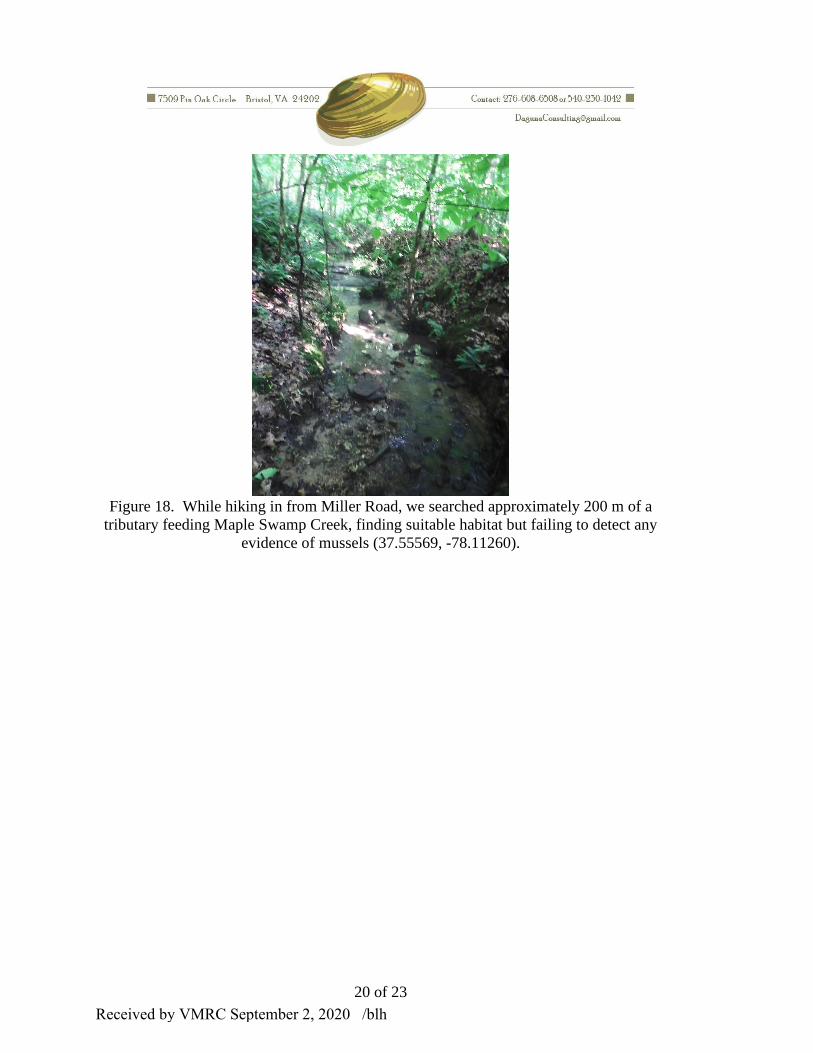
Figure 18. While hiking in from Miller Road, we searched approximately 200 m of a
tributary feeding Maple Swamp Creek, finding suitable habitat but failing to detect any
evidence of mussels (37.55569, -78.11260).
Received by VMRC September 2, 2020 /blh

21 of 23
Figure 19. We searched an approximately 200 m reach of a small tributary feeding
Maple Swamp Creek from its mouth upstream finding no evidence of mussels (37.5521,
-78.11458).
Received by VMRC September 2, 2020 /blh

22 of 23
Survey Record #1
Site #: DAGUNA05252019.1
Stream: Muddy Creek
County: Cumberland
Description: Surveyed 3,800 m reach of main channel and assessed several feeding
tributaries
Drainage: James
USGS Quadrangle Map: Whiteville/Trenholm
Projection: WGS 84
Survey Start: 37.58423, -78.10672
Survey End: 37.56729, -78.13835
Survey Date: 5/25/2019 and 5/26/2019
Survey Effort: 9 person-hours
Personnel: B. J. K. Ostby, B. B. Beaty
Mollusks Observed:
12 Live Elliptio complanta
5 Live E. fisheriana
1 Live Pyganodon cataracta
Live Corbicula fluminea (uncommon)
Received by VMRC September 2, 2020 /blh

23 of 23
Survey Record #2
Site #: DAGUNA05262019.1
Stream: Maple Swamp Creek
County: Cumberland
Description: Surveyed 1,800 m of main channel and assessed 2 feeding tributaries
Drainage: James
USGS Quadrangle Map: Trenholm
Projection: WGS 84
Survey Start: 37.55971, -78.10574
Survey End: 37.547796, -78.11513
Survey Date: 5/26/2019
Survey Effort: 5 person-hours
Personnel: B. J. K. Ostby, B. B. Beaty
Mollusks Observed:
None
Received by VMRC September 2, 2020 /blh

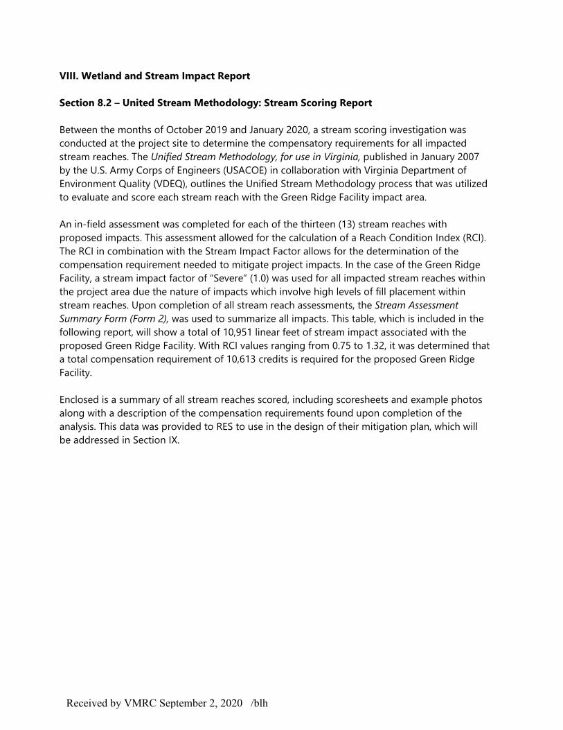
VIII. WETLAND AND STREAM IMPACT REPORT
The wetland and stream impact report will begin with a summary of all impacts, both primary and
secondary, that are associated with the proposed construction of the Green Ridge Facility. Following this
summary, a complete report of all stream scoring conducted across the property is included. The goal of
the stream scoring process was to determine an accurate compensation requirement for the
construction of the project. This compensation requirement was utilized in the design of the Impact
Mitigation Report that is included in Section IX. A complete set of impact maps are included at the end
of Section VIII.
Received by VMRC September 2, 2020 /blh

VIII. Wetland and Stream Impact Report
Section 8.1 Primary and Secondary Impacts – The following is a brief summary and description of all associated stream impacts for the proposed construction of the Green Ridge Recycling and Disposal Facility, LLC.
Received by VMRC September 2, 2020 /blh

VIII. Wetland and Stream Impact Report
Section 8.1 Primary and Secondary Impacts - The Green Ridge Facility is approximately 1,178+ acres in size. Of this acreage, 238 acres will be dedicated to lined-landfill (disposal unit boundary). The waste management unit boundary, which includes items such as leachate and gas management, maintenance and office facilities, and fueling facilities, will be a total of 438.1 acres. The impacts associated with this project include both primary and secondary impacts that stem from landfill impacts, roadway realignment impacts on Pinegrove Road and entryway impacts coming off of Route 60. These impacts will affect both perennial and intermittent tributaries within the wetland system. In regards to the calculation of impact areas, a width of five (5) feet was used to determine the area for all perennial impacts while all intermittent impacts were calculated using a width of three (3) feet. A summary of all impacts is included in Table 1.3: Summary of Wetland and Water Impacts for the Proposed Green Ridge Facility. Overall, there will be a total of 43,803 ft2 (1.006 acres) of impact associated with the Green Ridge Facility. The following is a summary description of all project impacts.
A. Primary ImpactsThis project will require a total oftwenty-one (21) varying impactsacross the site and of these twenty-one impacts, nineteen (19) will beconsidered primary. All nineteenprimary impacts will be consideredpermanent.
Impacts 1.1-9.1 (Table 1.1) will resultfrom filling within the 238-acredisposal area and will compriseapproximately 0.957 acres of the total1.006 acres of impact (roughly 88% oftotal impact area). Impacts EW.1-EW.4will result from the construction of theentryway road off of Route 60.Entryway impacts will constitute an estimated 0.059 acres of impact (6% of total impactarea). Lastly, Impact RR.3, which results from the realignment of Pinegrove Road aroundthe proposed landfill area. RR.3 is roughly 0.008 acres (<1% of total impacts). Please notethat the Roadway Realignment in Table 1.2 include both primary and secondary roadwayimpacts. A break-down of impact composition can be found in Table 1.1 Primary v.Secondary Impacts and Table 1.2: Composition of Impact Causes.
B. Secondary ImpactsA total of two (2) secondary impacts will be associated with the proposed facility. Thefirst, Impact RR.1, is approximately 850 ft2 (0.02 acres) while the second, Impact RR.2, isan estimated 1,275 ft2 (0.029 acres). This makes for a total of 2,125 ft2 (0.049 acres) of
Received by VMRC September 2, 2020 /blh

secondary impacts. Both secondary impacts are associated with the placement of the proposed stormwater basins and will be considered permanent. Of the seven (7) total stormwater basins, only two have been identified in areas with the potential to cause secondary impacts. The basins associated with RR.1 and RR.2 have the potential to discharge water to the existing channels at velocity rates and volumes above current levels during high intensity rainfall events. Therefore, while not a certainty, the possibility for erosional impacts, change in channel morphology, and change in stream flow regime are possible. Therefore, these locations have been considered secondary impacts and have been added to the overall impact table accordingly.
Received by VMRC September 2, 2020 /blh

Impact
#
Impact
Type
Impact
DescriptionLat./Long.
Cowardin
Class
Stream
Length
(ft.)
Stream
Width
(ft.)
Waters
impact area
(square feet)
Waters
impact
area
(acreage)
Approximate
contributing
drainage area
(square
miles)
DEQ Class
of
Resources
Volume of fill
below mean
Ordinary
High Water
Mark
Dune/beach
impact area
(square feet)
1.1 P F, PE, PR, V R3 700 5 3,500 0.080
1.2 P F, PE, PR, V R3 184 5 920 0.021
1.3 P F, PE, IN, V R4 952 3 2,856 0.066
2.1 P F, PE, PR, V R3 2,323 5 11,615 0.267
2.2 P F, PE, IN, V R4 542 3 1,626 0.037
3.1 P F, PE, PR, V R3 433 5 2,165 0.050
3.2 P F, PE, IN, V R4 1,382 3 4,146 0.095
4.1 P F, PE, PR, V R3 820 5 4,100 0.094 0.04
5.1 P F, PE, PR, V R3 300 5 1,500 0.034
5.2 P F, PE, IN, V R4 814 3 2,442 0.056
6.1 P F, PE, IN, V R4 239 3 717 0.016 0.02
7.1 P F, PE, IN, V R4 408 3 1,224 0.028 0.02
8.1 P F, PE, IN, V R4 131 3 393 0.009 0.02
9.1 P F, PE, IN, V R4 513 3 1,539 0.035 0.04
RR.1 S F, PE, PR, V R3 170 5 850 0.020 0.08
RR.2 S F, PE, PR, V R3 255 5 1,275 0.029 0.05
RR.3 P F, PE, IN, V R4 122 3 366 0.008 0.04
EW.1 P F, PE, IN, V R4 117 3 351 0.008 0.44
EW.2 P F, PE, PR, V R3 181 5 905 0.021 0.88
EW.3 P F, PE, PR, V R3 109 5 545 0.013 1.96
EW.4 P F, PE, IN, V R4 256 3 768 0.018 0.03
10951 N/A 43803 1.006
Table 1.3: Summary of Wetland and Water Impacts for the Proposed Green Ridge Facility
37.5657,
-78.1231
(Central
point of
project
site)
Total:
N/A N/A
N/A
0.18
0.11
0.04
0.05
Class III
Received by VMRC September 2, 2020 /blh

F Fill P
EX Excavation S
S Structure
T Tidal
NT Non-tidal
TE Temporary
PE Permanent
PR Perennial
IN Intermittent
SBSubaqueous
bottom
DB Dune/beach
ISHydrolog.
Isolated
V Vegetated
NVNon-
vegetated
MC
Mechanized
clearing of
PFO
Secondary
Impact Type Impact Description
KEY
Primary
Received by VMRC September 2, 2020 /blh
VIII. Wetland and Stream Impact Report Section 8.2 – United Stream Methodology: Stream Scoring Report Between the months of October 2019 and January 2020, a stream scoring investigation was conducted at the project site to determine the compensatory requirements for all impacted stream reaches. The Unified Stream Methodology, for use in Virginia, published in January 2007 by the U.S. Army Corps of Engineers (USACOE) in collaboration with Virginia Department of Environment Quality (VDEQ), outlines the Unified Stream Methodology process that was utilized to evaluate and score each stream reach with the Green Ridge Facility impact area. An in-field assessment was completed for each of the thirteen (13) stream reaches with proposed impacts. This assessment allowed for the calculation of a Reach Condition Index (RCI). The RCI in combination with the Stream Impact Factor allows for the determination of the compensation requirement needed to mitigate project impacts. In the case of the Green Ridge Facility, a stream impact factor of “Severe” (1.0) was used for all impacted stream reaches within the project area due the nature of impacts which involve high levels of fill placement within stream reaches. Upon completion of all stream reach assessments, the Stream Assessment Summary Form (Form 2), was used to summarize all impacts. This table, which is included in the following report, will show a total of 10,951 linear feet of stream impact associated with the proposed Green Ridge Facility. With RCI values ranging from 0.75 to 1.32, it was determined that a total compensation requirement of 10,613 credits is required for the proposed Green Ridge Facility. Enclosed is a summary of all stream reaches scored, including scoresheets and example photos along with a description of the compensation requirements found upon completion of the analysis. This data was provided to RES to use in the design of their mitigation plan, which will be addressed in Section IX.
Received by VMRC September 2, 2020 /blh

Project # LocalityCowardin
Class.HUC Date SAR #
Impact/SAR
length
Impact
Factor
2017-890 R3/R4 02080205 10/2/19 1.1 700 1
CI
Score 2.0
NOTES>>
High Suboptimal:
Riparian areas
with tree stratum
(dbh > 3 inches)
present, with 30%
to 60% tree
canopy cover and
containing both
herbaceous and
shrub layers or a
non-maintained
understory.
Low Suboptimal:
Riparian areas
with tree stratum
(dbh > 3 inches)
present, with >
30% tree canopy
cover and a
maintained
understory.
Recent cutover
(dense
vegetation).
High Marginal:
Non-maintained,
dense herbaceous
vegetation with
either a shrub
layer or a tree
layer (dbh > 3
inches) present,
with <30% tree
canopy cover.
Low Marginal:
Non-maintained,
dense herbaceous
vegetation,
riparian areas
lacking shrub and
tree stratum, hay
production, ponds,
open water. If
present, tree
stratum (dbh >3
inches) present,
with <30% tree
canopy cover with
maintained
understory.
High Poor:
Lawns, mowed,
and maintained
areas, nurseries;
no-till cropland;
actively grazed
pasture, sparsely
vegetated non-
maintained area,
recently seeded
and stabilized, or
other comparable
condition.
Low Poor:
Impervious
surfaces, mine
spoil lands,
denuded surfaces,
row crops, active
feed lots, trails, or
other comparable
conditions.
High Low High Low High Low
Condition
Scores1.2 1.1 0.85 0.75 0.6 0.5
% Riparian Area> 100% 100%
Score > 1.2
% Riparian Area> 75% 25% 100% Rt Bank CI > 1.20 CI
Score > 1.2 1.1 Lt Bank CI > 1.18 1.19
CI
Score 1.20
1. Channel Condition: Assess the cross-section of the stream and prevailing condition (erosion, aggradation)
Tree stratum (dbh > 3 inches) present,
with > 60% tree canopy cover and a
non-maintained understory. Wetlands
located within the riparian areas.
1.5
E
Suboptimal
Often incised, but less than Severe or
Poor. Banks more stable than Severe
or Poor due to lower bank slopes.
Erosion may be present on 40-60% of
both banks. Vegetative protection on
40-60% of banks. Streambanks may
bevertical or undercut. AND/OR 40-
60% of stream is covered by
sediment. Sediment may be
temporary/transient, contribute
instability. Deposition that contribute to
stability, may be forming/present.
AND/OR V-shaped channels have
vegetative protection on > 40% of the
banks and depositional features which
contribute to stability.
Severe
3
of % Riparian
Blocks equal 100
2 1
Habitat elements are typically present
in greater than 50% of the reach.
Right Bank
1.5
Poor
0.9
3. INSTREAM HABITAT: Varied substrate sizes, water velocity and depths; woody and leafy debris; stable substrate; low embededness; shade;
undercut banks; root mats; SAV; riffle poole complexes, stable features.
Left Bank
PoorMarginal
Conditional Category
Marginal
2. RIPARIAN BUFFERS: Assess both bank's 100 foot riparian areas along the entire SAR. (rough measurements of length & width may be acceptable)
Ensure the sums
2.4
For use in wadeable channels classified as intermittent or perennial
Optimal
Riparian
Buffers
Hannah Miller
Conditional Category
Suboptimal MarginalOptimal
Optimal
Channel
Condition
Project Name
Cumberland - Green Ridge Landfill
Instream
Habitat/
Available
Cover
Poor
Stable habitat elements are typically
present in 30-50% of the reach and
are adequate for maintenance of
populations.
Stable habitat elements are typically
present in 10-30% of the reach and
are adequate for maintenance of
populations.
Habitat elements listed above are
lacking or are unstable. Habitat
elements are typically present in less
than 10% of the reach.
Overwidened/incised.
Vertically/laterally unstable. Likely to
widen further. Majority of both banks
are near vertical. Erosion present on
60-80% of banks. Vegetative
protection present on 20-40% of
banks, and is insufficient to prevent
erosion. AND/OR 60-80% of the
stream is covered by sediment.
Sediment is temporary/transient in
nature, and contributing to instability.
AND/OR V-shaped channels have
vegetative protection is present on >
40% of the banks and stable sediment
deposition is absent.
Reach 1 - Section 1.1 (GPS name - RCH1 - START)
Stream Name and Information
Suboptimal
Conditional Category
Slightly incised, few areas of active
erosion or unprotected banks. Majority
of banks are stable (60-80%).
Vegetative protection or natural rock
prominent (60-80%) AND/OR
Depositional features contribute to
stability. The bankfull and low flow
channels are well defined. Stream
likely has access to bankfull benches,
or newly developed floodplains along
portions of the reach. Transient
sediment covers 10-40% of the stream
bottom.
1.6
Name(s) of Evaluator(s)
Very little incision or active erosion; 80-
100% stable banks. Vegetative
surface protection or natural rock,
prominent (80-100%). AND/OR
Stable point bars/bankfull benches are
present. Access to their original
floodplain or fully developed wide
bankfull benches. Mid-channel bars,
and transverse bars few. Transient
sediment deposition covers less than
10% of bottom.
3. Enter the % Riparian Area and Score for each riparian category in the blocks below.
NOTES>> Easement
located within portion of
riparion buffer.
NOTES>>
0.5
2. Determine square footage for each by measuring or estimating length and width. Calculators are provided for you
below.
1.2
1. Delineate riparian areas along each stream bank into Condition Categories and Condition Scores using the
descriptors.
Stream Assessment Form (Form 1)Unified Stream Methodology for use in Virginia
Deeply incised (or excavated),
vertical/lateral instability. Severe
incision, flow contained within the
banks. Streambed below average
rooting depth, majority of banks
vertical/undercut. Vegetative
protection present on less than 20% of
banks, is not preventing erosion.
Obvious bank sloughing present.
Erosion/raw banks on 80-100%.
AND/OR Aggrading channel. Greater
than 80% of stream bed is covered by
deposition, contributing to instability.
Multiple thread channels and/or
subterranean flow.
1 of 2
Received by VMRC September 2, 2020 /blh

Project # Locality Cowardin Class. HUC Date Data Point SAR length Impact Factor
2017-890 R3/R4 02080205 10/2/19
SCORE 1.3 1.1 0.9 0.7 1.50
NOTE: The CIs and RCI should be rounded to 2 decimal places. The CR should be rounded to a whole number. 1.18
826
INSERT PHOTOS:
Example of Reach 1.1
DESCRIBE PROPOSED IMPACT:
REACH CONDITION INDEX and STREAM CONDITION UNITS FOR THIS REACH
Negligible Moderate
Channel
Alteration
Applicant
Stream Impact Assessment Form Page 2
THE REACH CONDITION INDEX (RCI) >>
RCI= (Sum of all CI's)/5
4. CHANNEL ALTERATION: Stream crossings, riprap, concrete, gabions, or concrete blocks, straightening of channel, channelization,
embankments, spoil piles, constrictions, livestock
Channelization, dredging, alteration,
or hardening absent. Stream has an
unaltered pattern or has naturalized.
1.5
Minor
Greater than 80% of reach is disrupted
by any of the channel alterations listed
in the parameter guidelines AND/OR
80% of banks shored with gabion,
riprap, or cement.
60 - 80% of reach
is disrupted by any
of the channel
alterations listed in
the parameter
guidelines. If
stream has been
channelized,
normal stable
stream meander
pattern has not
recovered.
Conditional Category
CR = RCI X LF X IF
COMPENSATION REQUIREMENT (CR) >>
NOTES>>
Severe
0.5
Less than 20% of
the stream reach
is disrupted by any
of the channel
alterations listed in
the parameter
guidelines.
40 - 60% of reach
is disrupted by any
of the channel
alterations listed in
the parameter
guidelines. If
stream has been
channelized,
normal stable
stream meander
pattern has not
recovered.
20-40% of the
stream reach is
disrupted by any
of the channel
alterations listed in
the parameter
guidelines.
2 of 2
Received by VMRC September 2, 2020 /blh
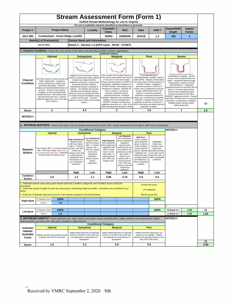
Project # LocalityCowardin
Class.HUC Date SAR #
Impact/SAR
length
Impact
Factor
2017-890 R3/R4 02080205 10/2/19 1.2 184 1
CI
Score 1.6
NOTES>>
High Suboptimal:
Riparian areas
with tree stratum
(dbh > 3 inches)
present, with 30%
to 60% tree
canopy cover and
containing both
herbaceous and
shrub layers or a
non-maintained
understory.
Low Suboptimal:
Riparian areas
with tree stratum
(dbh > 3 inches)
present, with >
30% tree canopy
cover and a
maintained
understory.
Recent cutover
(dense
vegetation).
High Marginal:
Non-maintained,
dense herbaceous
vegetation with
either a shrub
layer or a tree
layer (dbh > 3
inches) present,
with <30% tree
canopy cover.
Low Marginal:
Non-maintained,
dense herbaceous
vegetation,
riparian areas
lacking shrub and
tree stratum, hay
production, ponds,
open water. If
present, tree
stratum (dbh >3
inches) present,
with <30% tree
canopy cover with
maintained
understory.
High Poor:
Lawns, mowed,
and maintained
areas, nurseries;
no-till cropland;
actively grazed
pasture, sparsely
vegetated non-
maintained area,
recently seeded
and stabilized, or
other comparable
condition.
Low Poor:
Impervious
surfaces, mine
spoil lands,
denuded surfaces,
row crops, active
feed lots, trails, or
other comparable
conditions.
High Low High Low High Low
Condition
Scores1.2 1.1 0.85 0.75 0.6 0.5
% Riparian Area> 100% 100%
Score > 1.2
% Riparian Area> 100% 100% Rt Bank CI > 1.20 CI
Score > 1.2 Lt Bank CI > 1.20 1.20
CI
Score 0.90
1. Channel Condition: Assess the cross-section of the stream and prevailing condition (erosion, aggradation)
Tree stratum (dbh > 3 inches) present,
with > 60% tree canopy cover and a
non-maintained understory. Wetlands
located within the riparian areas.
1.5
E
Suboptimal
Often incised, but less than Severe or
Poor. Banks more stable than Severe
or Poor due to lower bank slopes.
Erosion may be present on 40-60% of
both banks. Vegetative protection on
40-60% of banks. Streambanks may
bevertical or undercut. AND/OR 40-
60% of stream is covered by
sediment. Sediment may be
temporary/transient, contribute
instability. Deposition that contribute to
stability, may be forming/present.
AND/OR V-shaped channels have
vegetative protection on > 40% of the
banks and depositional features which
contribute to stability.
Severe
3
of % Riparian
Blocks equal 100
2 1
Habitat elements are typically present
in greater than 50% of the reach.
Right Bank
1.5
Poor
0.9
3. INSTREAM HABITAT: Varied substrate sizes, water velocity and depths; woody and leafy debris; stable substrate; low embededness; shade;
undercut banks; root mats; SAV; riffle poole complexes, stable features.
Left Bank
PoorMarginal
Conditional Category
Marginal
2. RIPARIAN BUFFERS: Assess both bank's 100 foot riparian areas along the entire SAR. (rough measurements of length & width may be acceptable)
Ensure the sums
2.4
For use in wadeable channels classified as intermittent or perennial
Optimal
Riparian
Buffers
Hannah Miller
Conditional Category
Suboptimal MarginalOptimal
Optimal
Channel
Condition
Project Name
Cumberland - Green Ridge Landfill
Instream
Habitat/
Available
Cover
Poor
Stable habitat elements are typically
present in 30-50% of the reach and
are adequate for maintenance of
populations.
Stable habitat elements are typically
present in 10-30% of the reach and
are adequate for maintenance of
populations.
Habitat elements listed above are
lacking or are unstable. Habitat
elements are typically present in less
than 10% of the reach.
Overwidened/incised.
Vertically/laterally unstable. Likely to
widen further. Majority of both banks
are near vertical. Erosion present on
60-80% of banks. Vegetative
protection present on 20-40% of
banks, and is insufficient to prevent
erosion. AND/OR 60-80% of the
stream is covered by sediment.
Sediment is temporary/transient in
nature, and contributing to instability.
AND/OR V-shaped channels have
vegetative protection is present on >
40% of the banks and stable sediment
deposition is absent.
Reach 1 - Section 1.2 (GPS name - RCH2 - START)
Stream Name and Information
Suboptimal
Conditional Category
Slightly incised, few areas of active
erosion or unprotected banks. Majority
of banks are stable (60-80%).
Vegetative protection or natural rock
prominent (60-80%) AND/OR
Depositional features contribute to
stability. The bankfull and low flow
channels are well defined. Stream
likely has access to bankfull benches,
or newly developed floodplains along
portions of the reach. Transient
sediment covers 10-40% of the stream
bottom.
1.6
Name(s) of Evaluator(s)
Very little incision or active erosion; 80-
100% stable banks. Vegetative
surface protection or natural rock,
prominent (80-100%). AND/OR
Stable point bars/bankfull benches are
present. Access to their original
floodplain or fully developed wide
bankfull benches. Mid-channel bars,
and transverse bars few. Transient
sediment deposition covers less than
10% of bottom.
3. Enter the % Riparian Area and Score for each riparian category in the blocks below.
NOTES>>
NOTES>>
0.5
2. Determine square footage for each by measuring or estimating length and width. Calculators are provided for you
below.
1.2
1. Delineate riparian areas along each stream bank into Condition Categories and Condition Scores using the
descriptors.
Stream Assessment Form (Form 1)Unified Stream Methodology for use in Virginia
Deeply incised (or excavated),
vertical/lateral instability. Severe
incision, flow contained within the
banks. Streambed below average
rooting depth, majority of banks
vertical/undercut. Vegetative
protection present on less than 20% of
banks, is not preventing erosion.
Obvious bank sloughing present.
Erosion/raw banks on 80-100%.
AND/OR Aggrading channel. Greater
than 80% of stream bed is covered by
deposition, contributing to instability.
Multiple thread channels and/or
subterranean flow.
1 of 2
Received by VMRC September 2, 2020 /blh

Project # Locality Cowardin Class. HUC Date Data Point SAR length Impact Factor
2017-890 R3/R4 02080205 10/2/19
SCORE 1.3 1.1 0.9 0.7 1.50
NOTE: The CIs and RCI should be rounded to 2 decimal places. The CR should be rounded to a whole number. 1.04
191
INSERT PHOTOS:
Example of Reach 1.2
DESCRIBE PROPOSED IMPACT:
REACH CONDITION INDEX and STREAM CONDITION UNITS FOR THIS REACH
Negligible Moderate
Channel
Alteration
Applicant
Stream Impact Assessment Form Page 2
THE REACH CONDITION INDEX (RCI) >>
RCI= (Sum of all CI's)/5
4. CHANNEL ALTERATION: Stream crossings, riprap, concrete, gabions, or concrete blocks, straightening of channel, channelization,
embankments, spoil piles, constrictions, livestock
Channelization, dredging, alteration,
or hardening absent. Stream has an
unaltered pattern or has naturalized.
1.5
Minor
Greater than 80% of reach is disrupted
by any of the channel alterations listed
in the parameter guidelines AND/OR
80% of banks shored with gabion,
riprap, or cement.
60 - 80% of reach
is disrupted by any
of the channel
alterations listed in
the parameter
guidelines. If
stream has been
channelized,
normal stable
stream meander
pattern has not
recovered.
Conditional Category
CR = RCI X LF X IF
COMPENSATION REQUIREMENT (CR) >>
NOTES>>
Severe
0.5
Less than 20% of
the stream reach
is disrupted by any
of the channel
alterations listed in
the parameter
guidelines.
40 - 60% of reach
is disrupted by any
of the channel
alterations listed in
the parameter
guidelines. If
stream has been
channelized,
normal stable
stream meander
pattern has not
recovered.
20-40% of the
stream reach is
disrupted by any
of the channel
alterations listed in
the parameter
guidelines.
2 of 2
Received by VMRC September 2, 2020 /blh

Project # LocalityCowardin
Class.HUC Date SAR #
Impact/SAR
length
Impact
Factor
2017-890 R4 02080205 10/2/2019 1.3 952 1
High Suboptimal:
Riparian areas
with tree stratum
(dbh > 3 inches)
present, with 30%
to 60% tree
canopy cover and
containing both
herbaceous and
shrub layers or a
non-maintained
understory.
Low Suboptimal:
Riparian areas
with tree stratum
(dbh > 3 inches)
present, with
>30% tree canopy
cover and a
maintained
understory.
Recent cutover
(dense
vegetation).
High Marginal:
Non-maintained,
dense herbaceous
vegetation with
either a shrub
layer or a tree
layer (dbh > 3
inches) present,
with <30% tree
canopy cover.
Low Marginal:
Non-maintained,
dense herbaceous
vegetation,
riparian areas
lacking shrub and
tree stratum, hay
production, ponds,
open water. If
present, tree
stratum (dbh >3
inches) present,
with <30% tree
canopy cover with
maintained
understory.
High Poor:
Lawns, mowed,
and maintained
areas, nurseries;
no-till cropland;
actively grazed
pasture, sparsely
vegetated non-
maintained area,
recently seeded
and stabilized, or
other comparable
condition.
Low Poor:
Impervious
surfaces, mine
spoil lands,
denuded surfaces,
row crops, active
feed lots, trails, or
other comparable
conditions.
High Low High Low High Low
Condition
Scores1.2 1.1 0.85 0.75 0.6 0.5
% Riparian Area> 100% 100%
Score > 1.5
% Riparian Area> 100% 100% Rt Bank CI > 1.50 CI
Score > 1.5 Lt Bank CI > 1.50 1.50
NOTE: The CIs and RCI should be rounded to 2 decimal places. The CR should be rounded to a whole number. 0.75
714
INSERT PHOTOS:
Tree stratum (dbh > 3 inches) present,
with > 60% tree canopy cover and an
non-maintained understory. Wetlands
areas.
1.5
CI= (Sum % RA * Scores*0.01)/2
REACH CONDITION INDEX and STREAM CONDITION UNITS FOR THIS REACH
RCI= (Riparian CI)/2
CR = RCI X LF X IF
NOTES>>
COMPENSATION REQUIREMENT (CR) >>
Conditional Category
of % Riparian
Blocks equal 100
2. RIPARIAN BUFFERS: Assess both bank's 100 foot riparian areas along the entire SAR. (rough measurements of length & width may be acceptable)
Ensure the sums
3. Enter the % Riparian Area and Score for each riparian category in the blocks below.
2. Determine square footage for each by measuring or estimating length and width. Calculators are provided for you
below.
1. Delineate riparian areas along each stream bank into Condition Categories and Condition Scores using the
descriptors.
Suboptimal
THE REACH CONDITION INDEX (RCI) >>
Cumberland - Green Ridge Landfill
Reach 1 - Section 1.3 (GPS name - RCH3 - START)
Stream Name and Information
Right Bank
Left Bank
PoorMarginal
Ephemeral Stream Assessment Form (Form 1a)Unified Stream Methodology for use in Virginia
For use in ephemeral streams
Optimal
Riparian
Buffers
Hannah Miller
Name(s) of Evaluator(s)
Project Name
1 of 2
Received by VMRC September 2, 2020 /blh

DESCRIBE PROPOSED IMPACT:
2 of 2
Received by VMRC September 2, 2020 /blh

Project # LocalityCowardin
Class.HUC Date SAR #
Impact/SAR
length
Impact
Factor
2017-890 R3 02080205 1/30/2020 EW1 290 1
CI
Score 2.0
NOTES>>
High Suboptimal:
Riparian areas
with tree stratum
(dbh > 3 inches)
present, with 30%
to 60% tree
canopy cover and
containing both
herbaceous and
shrub layers or a
non-maintained
understory.
Low Suboptimal:
Riparian areas
with tree stratum
(dbh > 3 inches)
present, with >
30% tree canopy
cover and a
maintained
understory.
Recent cutover
(dense
vegetation).
High Marginal:
Non-maintained,
dense herbaceous
vegetation with
either a shrub
layer or a tree
layer (dbh > 3
inches) present,
with <30% tree
canopy cover.
Low Marginal:
Non-maintained,
dense herbaceous
vegetation,
riparian areas
lacking shrub and
tree stratum, hay
production, ponds,
open water. If
present, tree
stratum (dbh >3
inches) present,
with <30% tree
canopy cover with
maintained
understory.
High Poor:
Lawns, mowed,
and maintained
areas, nurseries;
no-till cropland;
actively grazed
pasture, sparsely
vegetated non-
maintained area,
recently seeded
and stabilized, or
other comparable
condition.
Low Poor:
Impervious
surfaces, mine
spoil lands,
denuded surfaces,
row crops, active
feed lots, trails, or
other comparable
conditions.
High Low High Low High Low
Condition
Scores1.2 1.1 0.85 0.75 0.6 0.5
% Riparian Area> 100% 100%
Score > 1.5
% Riparian Area> 100% 100% Rt Bank CI > 1.50 CI
Score > 1.5 Lt Bank CI > 1.50 1.50
CI
Score 1.20
Stream Assessment Form (Form 1)Unified Stream Methodology for use in Virginia
Deeply incised (or excavated),
vertical/lateral instability. Severe
incision, flow contained within the
banks. Streambed below average
rooting depth, majority of banks
vertical/undercut. Vegetative
protection present on less than 20% of
banks, is not preventing erosion.
Obvious bank sloughing present.
Erosion/raw banks on 80-100%.
AND/OR Aggrading channel. Greater
than 80% of stream bed is covered by
deposition, contributing to instability.
Multiple thread channels and/or
subterranean flow.
Very little incision or active erosion; 80-
100% stable banks. Vegetative
surface protection or natural rock,
prominent (80-100%). AND/OR
Stable point bars/bankfull benches are
present. Access to their original
floodplain or fully developed wide
bankfull benches. Mid-channel bars,
and transverse bars few. Transient
sediment deposition covers less than
10% of bottom.
3. Enter the % Riparian Area and Score for each riparian category in the blocks below.
NOTES>>
NOTES>>
0.5
2. Determine square footage for each by measuring or estimating length and width. Calculators are provided for you
below.
1.2
1. Delineate riparian areas along each stream bank into Condition Categories and Condition Scores using the
descriptors.
Stream Name and Information
Suboptimal
Conditional Category
Slightly incised, few areas of active
erosion or unprotected banks. Majority
of banks are stable (60-80%).
Vegetative protection or natural rock
prominent (60-80%) AND/OR
Depositional features contribute to
stability. The bankfull and low flow
channels are well defined. Stream
likely has access to bankfull benches,
or newly developed floodplains along
portions of the reach. Transient
sediment covers 10-40% of the stream
bottom.
1.6
Name(s) of Evaluator(s)
Project Name
Cumberland - Green Ridge Landfill
Instream
Habitat/
Available
Cover
Poor
Stable habitat elements are typically
present in 30-50% of the reach and
are adequate for maintenance of
populations.
Stable habitat elements are typically
present in 10-30% of the reach and
are adequate for maintenance of
populations.
Habitat elements listed above are
lacking or are unstable. Habitat
elements are typically present in less
than 10% of the reach.
Overwidened/incised.
Vertically/laterally unstable. Likely to
widen further. Majority of both banks
are near vertical. Erosion present on
60-80% of banks. Vegetative
protection present on 20-40% of
banks, and is insufficient to prevent
erosion. AND/OR 60-80% of the
stream is covered by sediment.
Sediment is temporary/transient in
nature, and contributing to instability.
AND/OR V-shaped channels have
vegetative protection is present on >
40% of the banks and stable sediment
deposition is absent.
Reach 10 - EW1 (Includes impacts EW.2 and EW.3)
For use in wadeable channels classified as intermittent or perennial
Optimal
Riparian
Buffers
Hannah Miller
Conditional Category
Suboptimal MarginalOptimal
Optimal
Channel
Condition
Marginal
2. RIPARIAN BUFFERS: Assess both bank's 100 foot riparian areas along the entire SAR. (rough measurements of length & width may be acceptable)
Ensure the sums
2.4
Poor
0.9
3. INSTREAM HABITAT: Varied substrate sizes, water velocity and depths; woody and leafy debris; stable substrate; low embededness; shade;
undercut banks; root mats; SAV; riffle poole complexes, stable features.
Left Bank
PoorMarginal
Conditional Category
of % Riparian
Blocks equal 100
2 1
Habitat elements are typically present
in greater than 50% of the reach.
Right Bank
1.5
1. Channel Condition: Assess the cross-section of the stream and prevailing condition (erosion, aggradation)
Tree stratum (dbh > 3 inches) present,
with > 60% tree canopy cover and a
non-maintained understory. Wetlands
located within the riparian areas.
1.5
E
Suboptimal
Often incised, but less than Severe or
Poor. Banks more stable than Severe
or Poor due to lower bank slopes.
Erosion may be present on 40-60% of
both banks. Vegetative protection on
40-60% of banks. Streambanks may
bevertical or undercut. AND/OR 40-
60% of stream is covered by
sediment. Sediment may be
temporary/transient, contribute
instability. Deposition that contribute to
stability, may be forming/present.
AND/OR V-shaped channels have
vegetative protection on > 40% of the
banks and depositional features which
contribute to stability.
Severe
3
1 of 2
Received by VMRC September 2, 2020 /blh

Project # Locality Cowardin Class. HUC Date Data Point SAR length Impact Factor
2017-890 R3/R4 02080205 1/30/2020 290 1
SCORE 1.3 1.1 0.9 0.7 1.50
NOTE: The CIs and RCI should be rounded to 2 decimal places. The CR should be rounded to a whole number. 1.24
360
INSERT PHOTOS:
Examples of Reach 10 - Near impact EW.3 Example of Reach 10 - near Impact EW.2
DESCRIBE PROPOSED IMPACT:
NOTES>>
Severe
0.5
Less than 20% of
the stream reach
is disrupted by any
of the channel
alterations listed in
the parameter
guidelines.
40 - 60% of reach
is disrupted by any
of the channel
alterations listed in
the parameter
guidelines. If
stream has been
channelized,
normal stable
stream meander
pattern has not
recovered.
20-40% of the
stream reach is
disrupted by any
of the channel
alterations listed in
the parameter
guidelines.
CR = RCI X LF X IF
COMPENSATION REQUIREMENT (CR) >>
THE REACH CONDITION INDEX (RCI) >>
RCI= (Sum of all CI's)/5
4. CHANNEL ALTERATION: Stream crossings, riprap, concrete, gabions, or concrete blocks, straightening of channel, channelization,
embankments, spoil piles, constrictions, livestock
Channelization, dredging, alteration,
or hardening absent. Stream has an
unaltered pattern or has naturalized.
1.5
Minor
Greater than 80% of reach is disrupted
by any of the channel alterations listed
in the parameter guidelines AND/OR
80% of banks shored with gabion,
riprap, or cement.
60 - 80% of reach
is disrupted by any
of the channel
alterations listed in
the parameter
guidelines. If
stream has been
channelized,
normal stable
stream meander
pattern has not
recovered.
Conditional Category
Applicant
Stream Impact Assessment Form Page 2
Moderate
Channel
Alteration
Negligible
REACH CONDITION INDEX and STREAM CONDITION UNITS FOR THIS REACH
2 of 2
Received by VMRC September 2, 2020 /blh

Project # LocalityCowardin
Class.HUC Date SAR #
Impact/SAR
length
Impact
Factor
2017-890 R4 02080205 1/30/2020 11 373 1
High Suboptimal:
Riparian areas
with tree stratum
(dbh > 3 inches)
present, with 30%
to 60% tree
canopy cover and
containing both
herbaceous and
shrub layers or a
non-maintained
understory.
Low Suboptimal:
Riparian areas
with tree stratum
(dbh > 3 inches)
present, with
>30% tree canopy
cover and a
maintained
understory.
Recent cutover
(dense
vegetation).
High Marginal:
Non-maintained,
dense herbaceous
vegetation with
either a shrub
layer or a tree
layer (dbh > 3
inches) present,
with <30% tree
canopy cover.
Low Marginal:
Non-maintained,
dense herbaceous
vegetation,
riparian areas
lacking shrub and
tree stratum, hay
production, ponds,
open water. If
present, tree
stratum (dbh >3
inches) present,
with <30% tree
canopy cover with
maintained
understory.
High Poor:
Lawns, mowed,
and maintained
areas, nurseries;
no-till cropland;
actively grazed
pasture, sparsely
vegetated non-
maintained area,
recently seeded
and stabilized, or
other comparable
condition.
Low Poor:
Impervious
surfaces, mine
spoil lands,
denuded surfaces,
row crops, active
feed lots, trails, or
other comparable
conditions.
High Low High Low High Low
Condition
Scores1.2 1.1 0.85 0.75 0.6 0.5
% Riparian Area> 100% 100%
Score > 1.5
% Riparian Area> 100% 100% Rt Bank CI > 1.50 CI
Score > 1.5 Lt Bank CI > 1.50 1.50
NOTE: The CIs and RCI should be rounded to 2 decimal places. The CR should be rounded to a whole number. 0.75
280
INSERT PHOTOS:
Tree stratum (dbh > 3 inches) present,
with > 60% tree canopy cover and an
non-maintained understory. Wetlands
areas.
1.5
CI= (Sum % RA * Scores*0.01)/2
REACH CONDITION INDEX and STREAM CONDITION UNITS FOR THIS REACH
RCI= (Riparian CI)/2
CR = RCI X LF X IF
NOTES>>
COMPENSATION REQUIREMENT (CR) >>
Conditional Category
of % Riparian
Blocks equal 100
2. RIPARIAN BUFFERS: Assess both bank's 100 foot riparian areas along the entire SAR. (rough measurements of length & width may be acceptable)
Ensure the sums
3. Enter the % Riparian Area and Score for each riparian category in the blocks below.
2. Determine square footage for each by measuring or estimating length and width. Calculators are provided for you
below.
1. Delineate riparian areas along each stream bank into Condition Categories and Condition Scores using the
descriptors.
Suboptimal
THE REACH CONDITION INDEX (RCI) >>
Cumberland - Green Ridge Landfill
Reach 11 - Section EW2 (includes impacts EW.1 and EW.4)
Stream Name and Information
Right Bank
Left Bank
PoorMarginal
Ephemeral Stream Assessment Form (Form 1a)Unified Stream Methodology for use in Virginia
For use in ephemeral streams
Optimal
Riparian
Buffers
Hannah Miller
Name(s) of Evaluator(s)
Project Name
1 of 2
Received by VMRC September 2, 2020 /blh

DESCRIBE PROPOSED IMPACT:
2 of 2
Received by VMRC September 2, 2020 /blh

Project # LocalityCowardin
Class.HUC Date SAR #
Impact/SAR
length
Impact
Factor
2017-890 R3 02080205 1/30/2020 12 425 1
CI
Score 2.4
NOTES>>
High Suboptimal:
Riparian areas
with tree stratum
(dbh > 3 inches)
present, with 30%
to 60% tree
canopy cover and
containing both
herbaceous and
shrub layers or a
non-maintained
understory.
Low Suboptimal:
Riparian areas
with tree stratum
(dbh > 3 inches)
present, with >
30% tree canopy
cover and a
maintained
understory.
Recent cutover
(dense
vegetation).
High Marginal:
Non-maintained,
dense herbaceous
vegetation with
either a shrub
layer or a tree
layer (dbh > 3
inches) present,
with <30% tree
canopy cover.
Low Marginal:
Non-maintained,
dense herbaceous
vegetation,
riparian areas
lacking shrub and
tree stratum, hay
production, ponds,
open water. If
present, tree
stratum (dbh >3
inches) present,
with <30% tree
canopy cover with
maintained
understory.
High Poor:
Lawns, mowed,
and maintained
areas, nurseries;
no-till cropland;
actively grazed
pasture, sparsely
vegetated non-
maintained area,
recently seeded
and stabilized, or
other comparable
condition.
Low Poor:
Impervious
surfaces, mine
spoil lands,
denuded surfaces,
row crops, active
feed lots, trails, or
other comparable
conditions.
High Low High Low High Low
Condition
Scores1.2 1.1 0.85 0.75 0.6 0.5
% Riparian Area> 100% 100%
Score > 1.5
% Riparian Area> 100% 100% Rt Bank CI > 1.50 CI
Score > 1.5 Lt Bank CI > 1.50 1.50
CI
Score 1.20
1. Channel Condition: Assess the cross-section of the stream and prevailing condition (erosion, aggradation)
Tree stratum (dbh > 3 inches) present,
with > 60% tree canopy cover and a
non-maintained understory. Wetlands
located within the riparian areas.
1.5
E
Suboptimal
Often incised, but less than Severe or
Poor. Banks more stable than Severe
or Poor due to lower bank slopes.
Erosion may be present on 40-60% of
both banks. Vegetative protection on
40-60% of banks. Streambanks may
bevertical or undercut. AND/OR 40-
60% of stream is covered by
sediment. Sediment may be
temporary/transient, contribute
instability. Deposition that contribute to
stability, may be forming/present.
AND/OR V-shaped channels have
vegetative protection on > 40% of the
banks and depositional features which
contribute to stability.
Severe
3
of % Riparian
Blocks equal 100
2 1
Habitat elements are typically present
in greater than 50% of the reach.
Right Bank
1.5
Poor
0.9
3. INSTREAM HABITAT: Varied substrate sizes, water velocity and depths; woody and leafy debris; stable substrate; low embededness; shade;
undercut banks; root mats; SAV; riffle poole complexes, stable features.
Left Bank
PoorMarginal
Conditional Category
Marginal
2. RIPARIAN BUFFERS: Assess both bank's 100 foot riparian areas along the entire SAR. (rough measurements of length & width may be acceptable)
Ensure the sums
2.4
For use in wadeable channels classified as intermittent or perennial
Optimal
Riparian
Buffers
Hannah Miller
Conditional Category
Suboptimal MarginalOptimal
Optimal
Channel
Condition
Project Name
Cumberland - Green Ridge Landfill
Instream
Habitat/
Available
Cover
Poor
Stable habitat elements are typically
present in 30-50% of the reach and
are adequate for maintenance of
populations.
Stable habitat elements are typically
present in 10-30% of the reach and
are adequate for maintenance of
populations.
Habitat elements listed above are
lacking or are unstable. Habitat
elements are typically present in less
than 10% of the reach.
Overwidened/incised.
Vertically/laterally unstable. Likely to
widen further. Majority of both banks
are near vertical. Erosion present on
60-80% of banks. Vegetative
protection present on 20-40% of
banks, and is insufficient to prevent
erosion. AND/OR 60-80% of the
stream is covered by sediment.
Sediment is temporary/transient in
nature, and contributing to instability.
AND/OR V-shaped channels have
vegetative protection is present on >
40% of the banks and stable sediment
deposition is absent.
Reach 12 - Section RR1 (includes impacts RR.1 and RR.2)
Stream Name and Information
Suboptimal
Conditional Category
Slightly incised, few areas of active
erosion or unprotected banks. Majority
of banks are stable (60-80%).
Vegetative protection or natural rock
prominent (60-80%) AND/OR
Depositional features contribute to
stability. The bankfull and low flow
channels are well defined. Stream
likely has access to bankfull benches,
or newly developed floodplains along
portions of the reach. Transient
sediment covers 10-40% of the stream
bottom.
1.6
Name(s) of Evaluator(s)
Very little incision or active erosion; 80-
100% stable banks. Vegetative
surface protection or natural rock,
prominent (80-100%). AND/OR
Stable point bars/bankfull benches are
present. Access to their original
floodplain or fully developed wide
bankfull benches. Mid-channel bars,
and transverse bars few. Transient
sediment deposition covers less than
10% of bottom.
3. Enter the % Riparian Area and Score for each riparian category in the blocks below.
NOTES>>
NOTES>>
0.5
2. Determine square footage for each by measuring or estimating length and width. Calculators are provided for you
below.
1.2
1. Delineate riparian areas along each stream bank into Condition Categories and Condition Scores using the
descriptors.
Stream Assessment Form (Form 1)Unified Stream Methodology for use in Virginia
Deeply incised (or excavated),
vertical/lateral instability. Severe
incision, flow contained within the
banks. Streambed below average
rooting depth, majority of banks
vertical/undercut. Vegetative
protection present on less than 20% of
banks, is not preventing erosion.
Obvious bank sloughing present.
Erosion/raw banks on 80-100%.
AND/OR Aggrading channel. Greater
than 80% of stream bed is covered by
deposition, contributing to instability.
Multiple thread channels and/or
subterranean flow.
1 of 2
Received by VMRC September 2, 2020 /blh
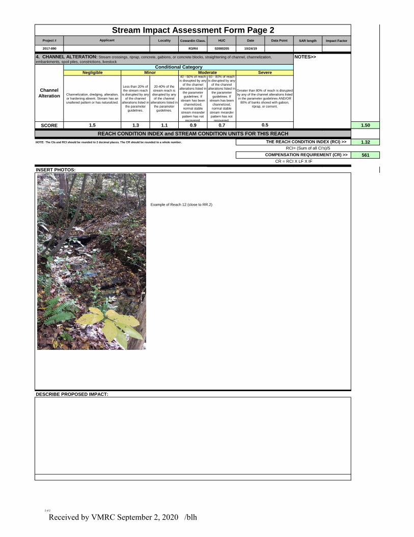
Project # Locality Cowardin Class. HUC Date Data Point SAR length Impact Factor
2017-890 R3/R4 02080205 10/24/19
SCORE 1.3 1.1 0.9 0.7 1.50
NOTE: The CIs and RCI should be rounded to 2 decimal places. The CR should be rounded to a whole number. 1.32
561
INSERT PHOTOS:
Example of Reach 12 (close to RR.2)
DESCRIBE PROPOSED IMPACT:
REACH CONDITION INDEX and STREAM CONDITION UNITS FOR THIS REACH
Negligible Moderate
Channel
Alteration
Applicant
Stream Impact Assessment Form Page 2
THE REACH CONDITION INDEX (RCI) >>
RCI= (Sum of all CI's)/5
4. CHANNEL ALTERATION: Stream crossings, riprap, concrete, gabions, or concrete blocks, straightening of channel, channelization,
embankments, spoil piles, constrictions, livestock
Channelization, dredging, alteration,
or hardening absent. Stream has an
unaltered pattern or has naturalized.
1.5
Minor
Greater than 80% of reach is disrupted
by any of the channel alterations listed
in the parameter guidelines AND/OR
80% of banks shored with gabion,
riprap, or cement.
60 - 80% of reach
is disrupted by any
of the channel
alterations listed in
the parameter
guidelines. If
stream has been
channelized,
normal stable
stream meander
pattern has not
recovered.
Conditional Category
CR = RCI X LF X IF
COMPENSATION REQUIREMENT (CR) >>
NOTES>>
Severe
0.5
Less than 20% of
the stream reach
is disrupted by any
of the channel
alterations listed in
the parameter
guidelines.
40 - 60% of reach
is disrupted by any
of the channel
alterations listed in
the parameter
guidelines. If
stream has been
channelized,
normal stable
stream meander
pattern has not
recovered.
20-40% of the
stream reach is
disrupted by any
of the channel
alterations listed in
the parameter
guidelines.
2 of 2
Received by VMRC September 2, 2020 /blh
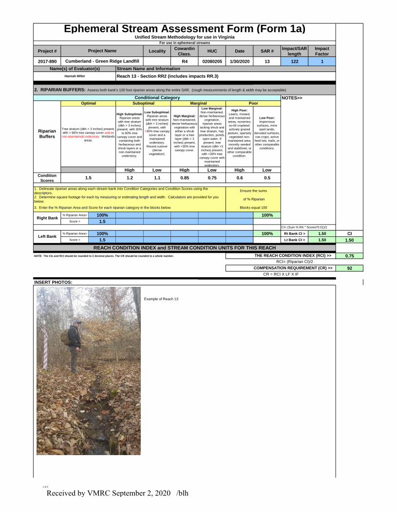
Project # LocalityCowardin
Class.HUC Date SAR #
Impact/SAR
length
Impact
Factor
2017-890 R4 02080205 1/30/2020 13 122 1
High Suboptimal:
Riparian areas
with tree stratum
(dbh > 3 inches)
present, with 30%
to 60% tree
canopy cover and
containing both
herbaceous and
shrub layers or a
non-maintained
understory.
Low Suboptimal:
Riparian areas
with tree stratum
(dbh > 3 inches)
present, with
>30% tree canopy
cover and a
maintained
understory.
Recent cutover
(dense
vegetation).
High Marginal:
Non-maintained,
dense herbaceous
vegetation with
either a shrub
layer or a tree
layer (dbh > 3
inches) present,
with <30% tree
canopy cover.
Low Marginal:
Non-maintained,
dense herbaceous
vegetation,
riparian areas
lacking shrub and
tree stratum, hay
production, ponds,
open water. If
present, tree
stratum (dbh >3
inches) present,
with <30% tree
canopy cover with
maintained
understory.
High Poor:
Lawns, mowed,
and maintained
areas, nurseries;
no-till cropland;
actively grazed
pasture, sparsely
vegetated non-
maintained area,
recently seeded
and stabilized, or
other comparable
condition.
Low Poor:
Impervious
surfaces, mine
spoil lands,
denuded surfaces,
row crops, active
feed lots, trails, or
other comparable
conditions.
High Low High Low High Low
Condition
Scores1.2 1.1 0.85 0.75 0.6 0.5
% Riparian Area> 100% 100%
Score > 1.5
% Riparian Area> 100% 100% Rt Bank CI > 1.50 CI
Score > 1.5 Lt Bank CI > 1.50 1.50
NOTE: The CIs and RCI should be rounded to 2 decimal places. The CR should be rounded to a whole number. 0.75
92
INSERT PHOTOS:
Example of Reach 13
Tree stratum (dbh > 3 inches) present,
with > 60% tree canopy cover and an
non-maintained understory. Wetlands
areas.
1.5
CI= (Sum % RA * Scores*0.01)/2
REACH CONDITION INDEX and STREAM CONDITION UNITS FOR THIS REACH
RCI= (Riparian CI)/2
CR = RCI X LF X IF
NOTES>>
COMPENSATION REQUIREMENT (CR) >>
Conditional Category
of % Riparian
Blocks equal 100
2. RIPARIAN BUFFERS: Assess both bank's 100 foot riparian areas along the entire SAR. (rough measurements of length & width may be acceptable)
Ensure the sums
3. Enter the % Riparian Area and Score for each riparian category in the blocks below.
2. Determine square footage for each by measuring or estimating length and width. Calculators are provided for you
below.
1. Delineate riparian areas along each stream bank into Condition Categories and Condition Scores using the
descriptors.
Suboptimal
THE REACH CONDITION INDEX (RCI) >>
Cumberland - Green Ridge Landfill
Reach 13 - Section RR2 (includes impacts RR.3)
Stream Name and Information
Right Bank
Left Bank
PoorMarginal
Ephemeral Stream Assessment Form (Form 1a)Unified Stream Methodology for use in Virginia
For use in ephemeral streams
Optimal
Riparian
Buffers
Hannah Miller
Name(s) of Evaluator(s)
Project Name
1 of 2
Received by VMRC September 2, 2020 /blh

DESCRIBE PROPOSED IMPACT:
2 of 2
Received by VMRC September 2, 2020 /blh