commencment report for wapc final - amazon simple storage
TRANSCRIPT
11
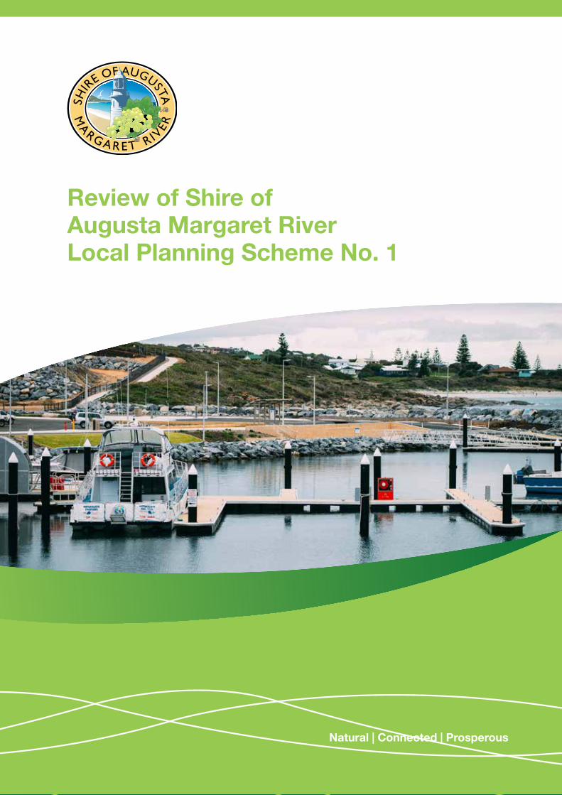
Review of Shire of Augusta Margaret River Local Planning Scheme No. 1
Natural | Connected | Prosperous

32 32
Acknowledgement of CountryThe Shire of Augusta Margaret River would like to acknowledge that we are on Wadandi and Pibelmen country whose ancestors and their descendants are the traditional owners of this country.
We acknowledge that they have been custodians for many centuries and continue to perform age old ceremonies of celebration, initiation and renewal. We acknowledge their living culture and their unique role in the life of this region.
The Shire is committed to Aboriginal Australians sharing fairly and equitably in the Shire’s cultural, environmental and economic future.
Contents
Introduction 4
Our History 4
Our Shire Now 4
Scheme History 6
Strategic Context 6
Development Activity 7
Our Vision for the Future 10
Planning for the Future 13
Consultation 15
Analysis 16
Recommendation 16
APPENDIX 1 - Amendments to LPS1 17
APPENDIX 2 - Margaret River aerial time lapse photography 2000-2017 28
APPENDIX 3 - Cowaramup aerial time lapse photography 2000-2017 29
APPENDIX 4 - East Margaret River District Structure Plan 30
APPENDIX 5 - Consultation plan 31

44
Our History
The Shire of Augusta Margaret River and surrounding areas between Augusta and Bunbury are the traditional lands of the Nyungar people known as the Wadandi, the people who live by the ocean and follow the forest paths. Prior to European settlement, this area had been occupied by Aboriginal communities for at least 40,000 years, as evidence from the Devil’s Lair site has shown. Numerous sites still exist and remain important but their locations often remain confidential because of their spiritual and cultural significance and to prevent damage from unauthorised visitors.
The Shire was also one of the first areas settled by Europeans in Western Australia over 180 years ago. In May 1830 Governor Stirling led a party of settlers to the mouth of a river and inlet, naming it after Vice Admiral Sir Henry Blackwood. He also declared a townsite at the mouth of the river naming it Augusta in honour of Princess Augusta Sophia. The Bussell family were a prominent pioneer family, central in the founding of Margaret River townsite and established the first homestead (Ellensbrook) in the area in 1857. After World War I, an attempt by the Government to attract migrants to Western Australia and establish farms in the region (known as the Group Settlement Scheme) attracted new settlers and in 1922 over 100 settlers moved into the area.
During the twentieth century, the region established itself as a thriving agricultural area through beef, dairy and sheep farming. In the 1970s and 1980s the wine industry was developed and quickly became one of the region’s valuable assets.
Our Shire NowThe community of Augusta Margaret River now has a population of 14,258 and 3,724 families (2016 ABS census). The community is spread across three townsites, Cowaramup, Margaret River and Augusta, and five villages, Witchcliffe, Rosa Brook, Karridale/ Kudardup, Gracetown and Prevelly/Gnarabup.
With more than 250 active community groups, volunteerism is very high and a central part of life in the shire.
The shire is a popular tourist destination and internationally recognised wine region. The area is well known for its rural landscapes, scenic forests, national parks, caves, restaurants, art galleries, coastal scenery, beaches, world class surf, iconic events and for diversity in its community and local economy.
There is also substantial farming activity, primarily beef and dairy farming along with sheep farming, horticulture, viticulture, aquaculture, permaculture and agro-forestry.
Value adding of produce is significant with locally made dairy products and boutique gourmet ranges widely available.
Source: ABS, Census of Population and Housing 2016
Male 50%Female 50%
Families 3,678
Shire Australia
Born in Australia 69.6% 66.7%
Aboriginal people 1.4% 2.8%
MarriedDe facto marriedNot married
48.7%16.6%34.8%
47.7%10.4%41.9%
Couples with childrenCouples with no childrenOne parent family
43.2%42.2%14%
44.5%37.8%15.8%
Average vehicles per dwelling
2 1.8
Median weekly household income
$1,285 $1,438
Median weekly rent $300 $335
Median monthly mortgage $1,733 $1,755
Unoccupied dwellings 29.2% 11.2%
Population 2016 14,687
Median Age(Australian 38) 39Voluntary work for organisation/group2016 – Count of persons aged 15 years and over
21%
3.7%Average annual growth rate 2011-2016
Population expected to increase to around 17,500 in 2026 with 1.8% average annual growth
3.3%Unemployment Rate 2016
$860mGross regional product 2015/16
COUNTRY OF BIRTH
DWELLING STRUCTURE
Owned outright 31%
Mortgaged 36.8%
Rented 29%
94.5%Separate House
[Australia 74.1%]
2.1%Apartment and/or flat
[Australia 13.3%]
3.4%Semi-detached
townhouse
[Australia 12.9%]
7.6%England
0.8%Germany
1%South Africa
69.6%Australia
3%New
Zealand
76 76
Scheme Details
Local Planning Scheme No. 1 was gazetted in 2010. Since that time, it has not been consolidated or reviewed. It has however been regularly amended including three omnibus amendments which have kept the scheme in line with changes to the state government planning framework such as the Planning and Development (Local Planning Schemes) Regulations which include the model scheme text.
The Shire’s Local Planning Strategy was approved by the WAPC in 2011. A minor review was undertaken in 2016 which resulted in the incorporation of the Shire’s Local Tourism Planning Strategy, and the inclusion of detailed criteria guiding the re-subdivision of rural residential land.
Allied to the Local Planning Strategy, the Shire has also produced relevant strategies over the last 7 years, such as:
• Margaret River Car parking Strategy;
• Affordable Housing Strategy;
• Environmental Elements of Sustainability Strategy;
• Local Tourism Planning Strategy; and
• Community Strategic Plan 2036
Development Activity Lot Creation
Developers maintained a generous supply of ‘approved’ lots over the seven year period since LPS1 came into effect. An average of 165 lots were created per year across the Shire during that period.
Year 2010 2011 2012 2013 2014 2015 2016 2017 (Oct)
Subdivision Approvals (No. of lots approved)
682 289 225 343 667 219 231 50
Cleared Lots (Clearances Issued)
303 65 31 101 156 276 224 158
Figure 1 - Source: Shire of Augusta Margaret River
Residential Dwellings
The ABS recorded that there were 7,740 residential dwellings in the Shire as at the 2016 census, an increase of 930 since the previous census.
No. of Dwellings June 2011 June 2016 Increase
Shire of Augusta Margaret River 6,810 7,740 930
Figure 2 - Source: ABS Census data
Building licences
Building licences for residential dwellings issued over the period since LPS1 was gazetted reveals that, on average, 196 dwellings were completed each year.
Year 2010 2011 2012 2013 2014 2015 2016 2017 (Oct)
No. of licences issued 206 133 155 218 226 231 205 170
Figure 3 - Source: Shire of Augusta Margaret River
Commercial Development (Building Licences Issued)
A consistent amount of new commercial development has commenced in the Shire over the years since its gazettal amounting to an average of 23 building licence being issued per year.
Year 2010 2011 2012 2013 2014 2015 2016 2017 (Oct)
No. of licences issued 17 23 25 11 25 48 16 20
Figure 4 - Source: Shire of Augusta Margaret River
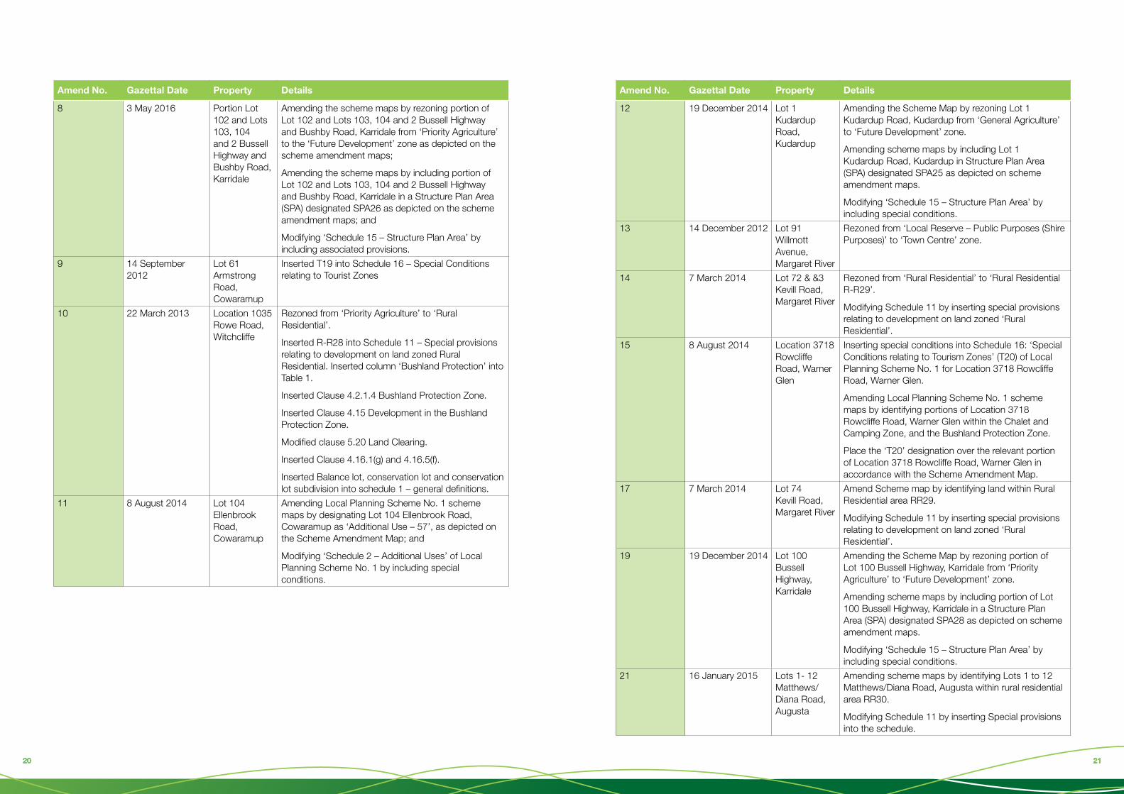
Strategic ContextScheme Amendments
At the time of writing, 60 Amendments to LPS1 had been initiated. Appendix 1 details those amendments which have been gazetted.
Local planning strategy amendments
There has been one amendment to the LPS since it was gazetted.
Amendment No. Amendment summary WAPC endorsement date
1. Included content in the LPS relating to tourism, the subdivision of rural residential lots, and the creation of conservation lots.
Aligned with these modifications is the formal inclusion of the Local Tourism Planning Strategy (LTPS) as an Appendix to the LPS.
2/2/2017
98 98
Endorsed Structure Plans
Residential development continues to be undertaken in accordance with existing structure such as that which is in place for Rapids Landing and Brookfield in Margaret River. In 2018 the Shire supported a structure plan which will provide for an additional 400 residential lots east of Brookfield which now awaits approval by the WAPC.
Year 2010 2011 2012 2013 2014 2015 2016 2017 (Oct)
No. of Structure Plans with WAPC approval.
6 3 3 4 6 3 4 0
Figure 5 - Source: Shire of Augusta Margaret River
Population Change
Since LPS1 was gazetted, the population of the Shire has grown from 12,228 (2011 ABS) to 14,687 (2016 ABS). The growth in population predicted by the WAPC over that time period in the highest of 5 ‘bands’ (band E) was 3.09% which would have resulted in a population of 14,240 (WA Tomorrow). As confirmed via the census, growth expectations were exceeded by 0.58% per annum.
If the population continues to grow at the highest of the predicted rates, it will reach 15,740 by 2021 and 17,090 by 2026. In order to establish a predicted population to the year 2031 (which accords with the 15 year planning horizon required of the Local Planning Strategy), the Shire has applied an average annual growth rate of 1.7% which results in a population of 19,000 by 2031.
Population Projections 2016-2031
2016 2021 2026 2031
Margaret River 7,000 8,400 9,400 10,250
Remainder of Shire 7,687 7,700 8,100 8,750
Shire of Augusta MR 14,687 16,100 17,500 19,000
Average annual growth rate 1.7%
Figure 6 - Source: Shire of Augusta Margaret River
The future resident population of the various towns and localities within the Shire is harder to predict. It is reasonable to assume however, that Margaret River will continue to be the most populated centre, given the availability of land for housing and the employment, education retail and social infrastructure towards which the population naturally gravitates towards. The growth of Margaret River between 2000 and 2017 is illustrated at Appendix 2.
The growth of Cowaramup over the last 5 years has exceeded expectations and it is now the second most populated centre in the shire. The growth of Cowaramup between 2000 and 2017 is illustrated at Appendix 3.
It is uncertain as to whether growth in Cowaramup will continue at a much higher level than other centres, or slow such that it maintains its relative portion of the overall population. Given this uncertainty, two population distribution scenarios are provided (see figure 7)
2016 2021 2026 2031 (Scenario 1) 2031 (Scenario 2) (1.5% growth rate all centres
– 3.4% Cowaramup)
Augusta 1,420 1556 1680 1824 1778
Margaret River 7,000 8,400 9,400 10,250 8752
Cowaramup 1,540 1688 1750 1900 2543
Prevelly/Gnarabup 660 723 788 855 825
Other areas/rural 4,067 4444 4830 5244 5092
Shire 14,687 16100 17500 19000 18990
Figure 7 - Source: Regional Population Growth, ABS 2017 and
Shire of AMR.
Note: The boundaries of statistical areas have changed slightly for the 2016 Census due to factors such as a change in statistical geography and increasing population. Accordingly, the boundaries of localities may not be directly comparable between 2006, 2011 and 2016.

1110 1110
Our Vision For The Future
The following is an excerpt from Council’s Community Strategy Plan for the future to the year 2036. It expresses a vision of the future that the Shire will attempt to achieve, in part through the periodic review and modification of the planning framework, to ensure that it supports the intended outcomes.
In 2036, the Augusta Margaret River community will continue to adapt to changing climate, environment and social dynamics and celebrate a sense of place for our local Indigenous culture and our multicultural and creative community. The shire will be resilient and independent through self-sufficiency of food, energy, services and strong governance. The local economy will be vibrant and diverse. Though it has increased its resident population, the shire has adjusted to an ageing demographic, become a premier ecologically and culturally sustainable accredited tourism destination on a world basis. In 2036, the region will be truly sustainable and prosperous.
Our communities are diverse and in defined areas, each with unique characteristics and sense of place. Planning for development has ensured efficient access to resources for these communities. Alternative and innovative forms of housing, including increases in density, confine land dedicated for urban purposes, provide high levels of amenity for the community and ensure growth has occurred in conjunction with a thriving agricultural environment. Together these places form a healthy, welcoming, inclusive and cohesive community that shares resources, embraces multiculturalism and has support systems in place to make this a secure and
happy place to live in a changing world.
Placing a major emphasis on liveability, affordability, inclusion and social justice in the community has paid dividends with more people now accessing a range of local employment opportunities and affordable housing options. As a result, the region retains its young people to live and work where they grew up and the diverse community can focus on developing its unique creative capital as an asset, which is also a major drawcard for tourists. In fact, through ongoing education of local youth and visitors alike, the regional ‘brand’ has become truly embedded in the community as a set of Augusta Margaret River ‘cultural values’ that tourists and locals observe and show due respect. Tourism is a major component of the region’s economy and character and is highly diversified. People continue to be attracted to the region to enjoy the natural environment in all its forms. Tourist ecological sustainability hubs including the UNESCO Geo Park and the Centre for Sustainability are major attractions, and volunteering has become a major way that visitors engage with and contribute to local communities.
Respectful tourism has evolved as a result of managing the tourist experience to those locations that have the infrastructure for a quality experience,
accreditation of all tourism operators and the nurturing of a tourist culture around the ‘cultural values’ of the community.
The volunteer and community groups remain the glue that connects the community, with Local Government serving as the instrument to exercise leadership, facilitate initiatives and ensure everyone works together closely. The shire is focused on policies, planning and services that enable the Community to continuously evolve and is a world leader in participatory governance and deliberative democracy.
Augusta Margaret River is an Australian leader in climate change mitigation and adaptation. Throughout the shire in towns, communities and farms, there is close to 100% use of carbon free renewable energy from wave, wind, solar and continuously emerging technologies. The shire has embraced distributed energy resources, with residents and visitors using the internet and automated controls to run demand-side technologies that meet their needs. Micro-grids incorporating generation and storage have enabled the shire to become independent of central-station power plants and transmission lines, and electric vehicle charging and energy smart house solutions are abundant. The shire operates at the forefront of sustainable water harvesting, use and recycling to address reducing rainfall levels in the region.
A concerted effort to reduce the amount of waste sent to landfill has also allowed the community to remain sustainable and protect the natural environment during this growth phase. The shire supports a strong local economy that is based on commercial farming for food production and processing, wine and tourism. It is a thriving hub for ecologically responsive agricultural industries developed from viticulture, horticulture, dairy, wool, creative industries
and hemp. Regenerative agriculture is the driving force for a diversity of forms of agriculture that provide local people with all their needs while simultaneously enhancing natural systems and resources. Mixed production farms and smaller agricultural enterprises are thriving as a result of niche markets and holistic production management.
The local economy loop is boosted by innovation and business working hubs in the area that bring additional income into the region and opportunities for innovation and digital commerce. A university campus specialising in sustainable development complements the working hubs, provides opportunities for career development and attracts students to the region.
Our environment is conserved, protected, rehabilitated and celebrated, informed by Indigenous knowledge. Co-management of significant areas of land by Nyungar people means the cultural heritage and values of Traditional Owners are well managed through collaborative and empowering arrangements. Forests are managed for their intrinsic values, National Parks join Margaret River and the Whicher Range, Marine Parks have coastal interpretive centres and coastal planning manages social uses and enjoyment. Our river and river bank systems are rehabilitated and healthy whilst our oceans and coastal habitats remain world class and are enjoyed for their beauty.

1312 1312
Planning For The Future Margaret River
The majority of the Shire’s population are located, and will continue to be located within the Margaret River townsite. The LPS in 2010 estimated that at 2021, the population of Margaret River would be between 7000 (permanent residents) and 10,500 (total population). Taking a longer term view, the Strategy identified land sufficient to cater for a population of 15,000. As a consequence, significant landholdings remain undeveloped and available to cater for future growth.
The majority of growth will occur to the east of the existing townsite. The East Margaret River District Structure Plan was prepared by the Shire in 2016 and adopted by the WAPC in 2017, and sets out the basic structural and infrastructure parameters necessary to cater for an additional 2000 new residential lots sufficient to cater for 4000-5000 new residents. The growth planned for East Margaret River together with existing zoned but undeveloped land, easily cater for the rate of predicted growth over a 15 year timeframe.
A copy of the East Margaret River District Structure Plan can be found at appendix 4.
Cowaramup
The increase in Cowaramup’s population whilst small in numerical terms (745 persons) accelerated rapidly between the 2011 and 2016 census increasing by over 100% to 1540 persons. The attraction of Cowaramup to residents appears to be the ‘community feel’ which small towns often exhibit and the availability of larger treed lots of a type unavailable in Margaret River.
The LPS identifies significant amounts of land for the future growth of Cowaramup. Even if the strong growth experienced in the town over the last 10 years continues, there are sufficient lots (729) planned but as yet undeveloped which would provide for a lot release of 48 per year (10 lots above the long term average) and a population of up to 3654 persons.
Coastal nodes
The coastal nodes of Gnarabup, Gracetown and Prevelly, provide for niche housing and lifestyle opportunities but do not form part of the Shire’s strategic housing growth area. At the time of writing, the extent of existing and future development within these settlements was as follows:
Gnarabup
• 288 residential zoned blocks
• 30 are vacant
• 4 have dwellings currently under construction
Gracetown
• 153 residential zoned lots
• 1 under construction
• 1 vacant with expired building approval
Prevelly
• 145 residential zoned lots
• 10 vacant
• 3 dwellings currently under construction
• 1 undeveloped 2.3ha structure plan area (R15/30)

1514 1514
Southern townsites and villages
The Shire’s Southern townsites and villages consist of Witchcliffe, Karridale, Kudardup and Augusta. Each of these settlements has extensive areas of land identified for future growth, however to date have not progressed at the same rate as Margaret River and Cowaramup.
Witchcliffe
The progress of development in Witchcliffe has been predominantly stalled in the period since adoption of LPS1 due to the absence of a sewer service. All of the 100 residential and rural residential lots which have been created in that time are serviced with onsite effluent disposal means. Council has recently released for public comment a revised Witchcliffe Village Strategy which proposes to allow structure plans for all lots west of Bussell Highway to be revised to provide for 2000m2 lots therefore making them suitable for onsite servicing. If given final approval by Council and the WAPC, this would reduce the overall future lot release from 1025 to 741. In any event, there remains significant land available to cater for future demand for the foreseeable future.
Karridale
The Karridale Village Strategy provides a guide for the development of Karridale to a population of approximately 500. Detailed Structure Plans are in place for the two primary development areas. A subdivision approval issued for the eastern cell is being implemented in stages with 36 lots thus far being created. A subdivision for the western cell has been lodged.
Kudardup
The Kudardup village strategy provides 2 residential development investigation areas (DIA’s) which will allow for future land development to cater for a population of approximately 500 persons. The northern most DIA has been rezoned to ‘Future Development’ and a structure plan is in place which provides for approximately 140 lots. No subdivision had been progressed at the time of writing.
Augusta
Whilst population growth in Augusta has been low, planning is in place to provide for a range of different residential development options including single residential green field development, infill grouped dwelling development, mixed use (residential and commercial), light industrial and a private retirement village.
The two primary residential DIA’s are north and south of Hillview Road to the west of the existing town centre. To the north, a structure plan is in place which will allow the creation of approximately 450 lots, of which 72 have been created. At the time of writing, 21 of the created lots remained vacant.
South of Hillview Road, a structure plan is in place which provides for the creation of 500 new residential lots of varying size, a golf course and a retirement village. No subdivision or development has yet commenced on this site.
Demand for additional rural residential lots has been fulfilled via infill subdivision of existing large lots down to 1ha in precincts such as ‘Matthews Road’. Urban infill is possible with many large lots present in the existing town centre, however has been hampered due to suitable land being zoned ‘Town Centre’ and hence requiring a commercial component. A scheme amendment currently with the Minister for signing will address this issue.
Of concern is the fact that the substantial (22ha) area zoned for Light Industrial subdivision and development south of Hillview Road is heavily vegetated and may not be able to be developed for environmental reasons.
ConsultationIn order to ensure that a revised Strategy and scheme is consistent with the communities’ aspirations, a comprehensive consultation process will be followed in the development of the revised documents. The consultation plan can be found at appendix 5 however in summary consists of:
• A series of workshops to explore with Councillors and the community the major issues impacting on the sustainable development of the Shire
• Preparation of Issues and Options Papers as an outcome from each workshop, detailing for further consideration by the community, planning issues and suggested responses.
• Ongoing discussion with the community using the Issues and Options papers as the basis for consultation via a dedicated ‘Your Say’ web page and conventional web and print means.

1716 1716
AnalysisGiven that the Shire has continued to keep LPS1 updated, via the preparation and subsequent gazettal of three omnibus amendments, wholesale change to the scheme appears unwarranted. LPS1 is generally consistent with the Model Scheme text, has been amended to appropriately refer to the Deemed Provisions, and is therefore set out in a contemporary format. However, it is now the appropriate time to review the scheme to determine whether it addresses to a ‘best practice standard’ the following issues which will likely form the basis for community workshops:
Planning for resilience • Climate change adaptation
• Environmental protection
• Water
• Renewable energy
The future of food • Subdivision and development controls for
agricultural lands.
Planning for Local Commerce• Creating a supporting planning environment
for small business
• Sufficiency of land for commerce and industry
The towns and villages of the future – part 1• Demographic changes
• The size and structure of urban areas
• Protection from bushfire.
• Preserving local character
The town and villages of the future – part 2 • Affordability
• Infill development
• Sustainable building design
Planning rules – are they delivering the outcomes we want to see? • Land use controls
• Zoning and the zoning table
• signage
• The exercise of discretion in decision making
• Inclusionary zoning.
• Restrictive covenants
RecommendationThat Council, pursuant to Regulation 66(3) of the Planning and Development (Local Planning Schemes) Regulations 2015 recommend to the Western Australian Planning Commission that:
1. The Shire of Augusta Margaret River Local Planning Strategy should be reviewed to ensure that it addresses contemporary planning, economic, social and environmental issues as will be informed by a comprehensive consultation process; and
2. The Shire of Augusta Margaret River Planning Scheme No.1 should be amended to accord with a revised Strategy.
Appendix 1
Local Planning Scheme No. 1 – Text Amendments
Amend No. Gazettal Date Property Details
1 9 November 2012 Whole Shire (Omnibus)
Inserted or modified the following definitions into Schedule 1 –
Permanent Streams and Watercourses
Intermittent Streams and Watercourses
Laundromat/Drycleaner
Height
Small Bar
Lunch Bar
Tavern
Brewery
Rural Workers Accommodation
Made minor adjustments through Schedule 1.
Made minor adjustments to the following clauses –
4.2.2.2(d)
4.2.3.1
4.16.2
4.17.8(c)
4.21.5(a)
4.27.2(d)
4.32.2
6.2.6.4(c)
6.2.8.1(a)
6.2.10.1(c)
6.4.2.1
5.13.1(g)
6.2.6.1
4.20.3(b)(iv)
4.20.4(b)(iv)
6.2.8.1
4.20.2(f)
4.24
5.19
8.2.

1918 1918
Amend No. Gazettal Date Property Details
Made changes to Schedule 10 RR6 and RR11.
Replaced reference to clause 9.14 with 4.15 within Schedule 12.
Modified T16, T4 and T14 within Schedule 16.
Added structure plans numbered 15 – 20 within Schedule 17.
Modified the following use classes within Table 1 –
Grouped Dwelling
Laundromat/Drycleaner
Brewery
Cinema/Theatre
Exhibition Centre
Markets
Reception Centre
Child Care Premises
Family Day Care
Deleted ‘Factory Unit’ from Table 1 and Schedule 1 – Definitions.
Modified the ‘Restricted Use’ provision for RU2 within Schedule 3.
Inserted ‘A55’ and ‘A56’ into Schedule 6 – Additional uses.
Modified Schedule 11.
Modified SPA20 within Schedule 15.
2 30 September 2016
Lot 300 Salter Street, Gracetown
Amending Local Planning Scheme No. 1 scheme map by rezoning portion of Lot 300 Salter Street, Gracetown from ‘Parks and Recreation’ reserve to ‘Future Development’ zone and reserve for ‘National Parks and Nature Reserves’ in accordance with the Scheme Amendment Map.
Amending Local Planning Scheme No. 1 scheme map by including a portion of Lot 300 Salter Street, Gracetown in a Development Contribution Area (DCA) designated DCA1 in accordance with the Scheme Amendment Map.
Amending Local Planning Scheme No. 1 scheme map by including a portion of Lot 300 Salter Street, Gracetown in a Structure Plan Area (SPA) designated SPA23 in accordance with the Scheme Amendment Map.
Modifying ‘Schedule 15 – Structure Plan Area’ in the scheme text by including special provisions.
Amend No. Gazettal Date Property Details
3 11 January 2013 Lot 1017 Redgate Road, Witchcliffe
Rezoned from ‘Priority Agriculture’ to ‘Future Development’ zone.
Inserted Areas 22 and 23 (with associated provisions) into Schedule 15 – Structure Plan Areas.
4 10 August 2012 Lot 8 St Alouarn Place, Margaret River
Deleting reference to Lot 8 from Schedule 2 – Additional Uses (A37)
Insert provisions into Schedule 11 – Rural Residential Zone (R-R25)
Modify map by deleting ‘Additional Uses’ zone and ‘A37’ symbol from Lot 8 and replace with ‘RR25’.
5 25 November 2011 Lot 254 Le Souef Street, Margaret River
Rezoned from Public Purposes reserve to Residential Zone with an applied R Code of R30/40.
6 5 August 2016 Lot 3 Darch Road and Lot 4 Rosa Brook Road, Margaret River
Amending Local Planning Scheme No. 1 scheme maps by rezoning portion of Lot 3 Darch Road, Margaret River from ‘General Agricultural’ to the ‘Industry’ zone, and Lots 567 and 568 Darch Road from ‘General Agriculture’ to Highways and Main Roads’ reserve and Lot 566 from ‘Priority Agriculture’ and ‘Additional Use (No. 55)’ to ‘Highways and Main Roads’ reserve as depicted on the scheme amendment maps.
Amending Local Planning Scheme No. 1 scheme maps by designing portion of Lot 3 Darch Road, Margaret River as ‘Restricted Use’ classification ‘RU 17’ as depicted on the scheme amendment maps.
Amending Local Planning Scheme No. 1 scheme maps by including portion of Lot 4 Rosa Brook Road and Lot 3 Darch Road, Margaret River in a ‘Structure Plan Area’ (SPA) designated as ‘SPA24’ as depicted on the scheme amendment maps.
Modifying ‘Schedule 3 – Restricted Uses’ by including RU17.
Modifying ‘Schedule 15 – Structure Plan Areas’ by including SPA 24 into the schedule.
7 22 March 2013 Lot 1 Caves Road, Margaret River
Inserted Rural Residential Zone (RR27) into Schedule 11.
2120 2120
Amend No. Gazettal Date Property Details
8 3 May 2016 Portion Lot 102 and Lots 103, 104 and 2 Bussell Highway and Bushby Road, Karridale
Amending the scheme maps by rezoning portion of Lot 102 and Lots 103, 104 and 2 Bussell Highway and Bushby Road, Karridale from ‘Priority Agriculture’ to the ‘Future Development’ zone as depicted on the scheme amendment maps;
Amending the scheme maps by including portion of Lot 102 and Lots 103, 104 and 2 Bussell Highway and Bushby Road, Karridale in a Structure Plan Area (SPA) designated SPA26 as depicted on the scheme amendment maps; and
Modifying ‘Schedule 15 – Structure Plan Area’ by including associated provisions.
9 14 September 2012
Lot 61 Armstrong Road, Cowaramup
Inserted T19 into Schedule 16 – Special Conditions relating to Tourist Zones
10 22 March 2013 Location 1035 Rowe Road, Witchcliffe
Rezoned from ‘Priority Agriculture’ to ‘Rural Residential’.
Inserted R-R28 into Schedule 11 – Special provisions relating to development on land zoned Rural Residential. Inserted column ‘Bushland Protection’ into Table 1.
Inserted Clause 4.2.1.4 Bushland Protection Zone.
Inserted Clause 4.15 Development in the Bushland Protection Zone.
Modified clause 5.20 Land Clearing.
Inserted Clause 4.16.1(g) and 4.16.5(f).
Inserted Balance lot, conservation lot and conservation lot subdivision into schedule 1 – general definitions.
11 8 August 2014 Lot 104 Ellenbrook Road, Cowaramup
Amending Local Planning Scheme No. 1 scheme maps by designating Lot 104 Ellenbrook Road, Cowaramup as ‘Additional Use – 57’, as depicted on the Scheme Amendment Map; and
Modifying ‘Schedule 2 – Additional Uses’ of Local Planning Scheme No. 1 by including special conditions.
Amend No. Gazettal Date Property Details
12 19 December 2014 Lot 1 Kudardup Road, Kudardup
Amending the Scheme Map by rezoning Lot 1 Kudardup Road, Kudardup from ‘General Agriculture’ to ‘Future Development’ zone.
Amending scheme maps by including Lot 1 Kudardup Road, Kudardup in Structure Plan Area (SPA) designated SPA25 as depicted on scheme amendment maps.
Modifying ‘Schedule 15 – Structure Plan Area’ by including special conditions.
13 14 December 2012 Lot 91 Willmott Avenue, Margaret River
Rezoned from ‘Local Reserve – Public Purposes (Shire Purposes)’ to ‘Town Centre’ zone.
14 7 March 2014 Lot 72 & &3 Kevill Road, Margaret River
Rezoned from ‘Rural Residential’ to ‘Rural Residential R-R29’.
Modifying Schedule 11 by inserting special provisions relating to development on land zoned ‘Rural Residential’.
15 8 August 2014 Location 3718 Rowcliffe Road, Warner Glen
Inserting special conditions into Schedule 16: ‘Special Conditions relating to Tourism Zones’ (T20) of Local Planning Scheme No. 1 for Location 3718 Rowcliffe Road, Warner Glen.
Amending Local Planning Scheme No. 1 scheme maps by identifying portions of Location 3718 Rowcliffe Road, Warner Glen within the Chalet and Camping Zone, and the Bushland Protection Zone.
Place the ‘T20’ designation over the relevant portion of Location 3718 Rowcliffe Road, Warner Glen in accordance with the Scheme Amendment Map.
17 7 March 2014 Lot 74 Kevill Road, Margaret River
Amend Scheme map by identifying land within Rural Residential area RR29.
Modifying Schedule 11 by inserting special provisions relating to development on land zoned ‘Rural Residential’.
19 19 December 2014 Lot 100 Bussell Highway, Karridale
Amending the Scheme Map by rezoning portion of Lot 100 Bussell Highway, Karridale from ‘Priority Agriculture’ to ‘Future Development’ zone.
Amending scheme maps by including portion of Lot 100 Bussell Highway, Karridale in a Structure Plan Area (SPA) designated SPA28 as depicted on scheme amendment maps.
Modifying ‘Schedule 15 – Structure Plan Area’ by including special conditions.
21 16 January 2015 Lots 1- 12 Matthews/Diana Road, Augusta
Amending scheme maps by identifying Lots 1 to 12 Matthews/Diana Road, Augusta within rural residential area RR30.
Modifying Schedule 11 by inserting Special provisions into the schedule.
2322 2322
Amend No. Gazettal Date Property Details
22 8 August 2014 Lot 5 Todhunter Place, Margaret River
Amending the Scheme Map to depict Lot 5 Todhunter Place, Margaret River with the Residential R5 density code.
24 18 September 2015
Lot 2 Ashton Street, Margaret River
Rezoning portion of Lot 2 Ashton Street, Margaret River from ‘Rural Residential’ to ‘Residential R5’ and amending the scheme maps accordingly.
Modifying Schedule 15 – SPA 14 by including special provisions.
25 27 November 2015 Lot 118 Orchid Ramble, Margaret River
Amending the Scheme maps by removing the ‘Additional Use 39’ designation from Lot 118 Orchid Rarmble.
Modifying Schedule 2 – ‘Additional Uses’ by deleting text relating to ‘Additional Use 39’.
Applying a ‘Tourism’ (T21) designation to the land.
Adding special conditions relating to Tourist Zones to Schedule 16.
26 18 March 2016 Part Location 410 Caves Road, Margaret River
Amending Schedule 2 ‘Additional Uses’ applicable to Part Location 410 Caves Road, Margaret River.
28 29 August 2017 Sussex Locations 2807 & 2812 Bussell Highway, Witchcliffe
Rezoning Sussex Location 2807 & 2812 Bussell Highway, Witchcliffe from ‘Priority Agriculture’ to ‘Future Development’ and modifying the scheme map accordingly.
Amending the scheme map by including Sussex Location 2807 & 2812 Bussell Highway, Witchcliffe in a Structure Plan (SPA) designated SPA 34 as depicted on the scheme amendment maps.
Modifying ‘Schedule 11 – Structure Plan Area’ of the scheme by inserting associated provisions.
29 24 March 2016 Omnibus Amendment 2 (Whole Shire)
Amending various provisions of the Local Planning Scheme Text with text to be deleted and new text to be included.
30 28 August 2015 Lot 3 of Location 1683 Bussell Highway, Forest Grove
Removing provisions under Schedule 16 for T15.
Amending Scheme Text by modifying Schedule 16 – Special Conditions relating to Tourist Zones by including a special condition.
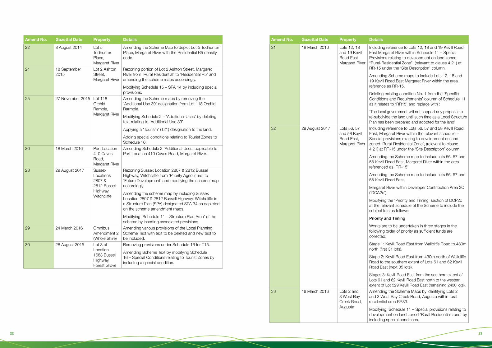
Amend No. Gazettal Date Property Details
31 18 March 2016 Lots 12, 18 and 19 Kevill Road East Margaret River
Including reference to Lots 12, 18 and 19 Kevill Road East Margaret River within Schedule 11 – Special Provisions relating to development on land zoned “Rural-Residential Zone”, (relevant to clause 4.21) at RR-15 under the ‘Site Description’ column.
Amending Scheme maps to include Lots 12, 18 and 19 Kevill Road East Margaret River within the area reference as RR-15.
Deleting existing condition No. 1 from the ‘Specific Conditions and Requirements’ column of Schedule 11 as it relates to ‘RR15’ and replace with :
‘The local government will not support any proposal to re-subdivide the land until such time as a Local Structure Plan has been prepared and adopted for the land’
32 29 August 2017 Lots 56, 57 and 58 Kevill Road East, Margaret River
Including reference to Lots 56, 57 and 58 Kevill Road East, Margaret River within the relevant schedule – Special provisions relating to development on land zoned ‘Rural-Residential Zone’, (relevant to clause 4.21) at RR-15 under the ‘Site Description’ column.
Amending the Scheme map to include lots 56, 57 and 58 Kevill Road East, Margaret River within the area referenced as ‘RR-15’.
Amending the Scheme map to include lots 56, 57 and 58 Kevill Road East,
Margaret River within Developer Contribution Area 2C (‘DCA2c’).
Modifying the ‘Priority and Timing’ section of DCP2c at the relevant schedule of the Scheme to include the subject lots as follows:
Priority and Timing
Works are to be undertaken in three stages in the following order of priority as sufficient funds are collected:
Stage 1: Kevill Road East from Wallcliffe Road to 430m north (first 31 lots).
Stage 2: Kevill Road East from 430m north of Wallcliffe Road to the southern extent of Lots 61 and 62 Kevill Road East (next 35 lots).
Stages 3: Kevill Road East from the southern extent of Lots 61 and 62 Kevill Road East north to the western extent of Lot 529 Kevill Road East (remaining 2430 lots).
33 18 March 2016 Lots 2 and 3 West Bay Creek Road, Augusta
Amending the Scheme Maps by identifying Lots 2 and 3 West Bay Creek Road, Augusta within rural residential area RR33.
Modifying ‘Schedule 11 – Special provisions relating to development on land zoned ‘Rural Residential zone’ by including special conditions.

2524 2524
Amend No. Gazettal Date Property Details
34 22 January 2016 Carparking Requirements
Inserting at Schedule 12 content relating to Commercial Uses (Margaret River Town Centre and Tourism Zone only)
Adding Clause at 5.8.9 of LPS 1 – Active Transport
35 9 December 2016 Developer Contributions
Introducing Development Contributions Plans into Schedule 14 of the Scheme and removing the existing text.
Amending Local Planning Scheme No. 1 Scheme Maps by identifying the Development Contributions Areas.
37 24 March 2016 Lot 26 Le Souef Street, Margaret River and Lot 472 (Reserve 28016) Stirling Street, Augusta
Amending the Local Planning Scheme No. 1 Scheme Maps to:
Rezone Lot 26 Le Souef Street, Margaret River from ‘Reserve (Public Purposes – Community Purposes)’ to ‘Residential R30/40’.
Rezone Lot 472 (Reserve 28016) Stirling Street, Augusta from ‘Reserve (Parks and Recreation)’ to ‘Residential R15’
38 26 July 2016 Lots 43, 44, 45 and 46 Hall Road, Cowaramup
Rezoning Lots 43, 44, 45 and 46 Hall Road, Cowaramup from ‘Residential’ to ‘Town Centre’; and
Amending the Scheme maps accordingly.
39 13 January 2017 Lot 112 Caves Road, Gracetown
Amending the Local Planning Scheme No. 1 maps to rezone Lot 112 Caves Road, Gracetown from ‘Caravan Park’ to ‘Rural Residential’.
Amending Schedule 16 by removing conditions 2 and 9 at reference T13 and substituting new condition 2.
Introducing specific provisions applicable to Lot 112 Caves Road, Gracetown under reference ‘RR34’ of Schedule 7 of the Scheme and amend Scheme Maps accordingly.
Include Lot 112 Caves Road, Gracetown in Schedule 2 of the Scheme with reference to ‘A58’ by amending the Scheme Maps accordingly and introducing associated conditions.
Amend No. Gazettal Date Property Details
40 2 June 2017 Lot 4 Wallcliffe Road, Margaret River
Amending Schedule 4 – Special Use Zones, as it applies to ‘S9’ Lot 4 Wallcliffe Road, Margaret River by:
Adding ‘Telecommunications Infrastructure’ as an ‘A’ land use at point 4 of the Special Use column.
Modifying the use class symbols applicable to permissible uses listed at point 4 of the ‘Special Use’ column such that they reflect those set out at clause 4.3 of the scheme as follows:
Shop (Golf) ‘AA’ ‘D’
Residential Building ‘SA’ ‘A’
Holiday Cabin and Chalets ‘SA’ ‘A’
Licensed Restaurant ‘SA’ ‘A’
Eating House ‘SA’ ‘A’
Function Centre ‘SA’ ‘A’
Short Stay Use of Single Dwelling ‘SA’ ‘A’
Adding to Special Provision No. 2 of the ‘Conditions’ column circumstances in which the 8m height limit may be varied as follows:
2.New development shall be restricted to a height of 8 metres (unless varied under Clause 5.13.3 or subject to Clause 5.13.4) as calculated in accordance with the local government’s Scheme and Policy requirements.

2726 2726
Amend No. Gazettal Date Property Details
Modifying entries within Schedules to remove reference to ability of the local government to approve or refuse minor modifications to Structure Plans and reference to the Structure Plan preparation process and renumbering subsequent provisions as required.
Deleting text contained within Clause 1.4 of the Scheme and replacing it with text contained within Clause 7 of Schedule 1 Part 1 of the Planning and Development (Local Planning Scheme) Regulations 2015.
Amending Clause 3.5 to state: “Where the local government is consulted under Part 1 section 6 of the Planning and Development Act 2005, it shall have regard to the matters outlined in clause 67 of the Deemed Provisions in providing comments about the public work the subject of the consultation.”
42 9 December 2016 Lot 51 Tunbridge Street, Margaret River
Rezoning Lot 51 Tunbridge Street, Margaret River from ‘Residential R15’ to ‘Future Development’ zone and amending Scheme Map accordingly.
Including the subject land within a ‘Structure Plan Area’ under Schedule 11 of the Scheme Text by inserting associated provisions.
43 26 July 2016 Structure Plan Areas – Schedule 13
Deleting Schedule 13 ‘Transitional provisions – outline development plans, detailed outline plans and structure plans adopted by the scheme’ and its contents and renumbering Schedule 14 to Schedule 13 accordingly.
Modifying the text applicable to ‘SPA5’ to Schedule 11 ‘Structure Plan Areas’ by deleting text and replacing with new text.
Adding new land areas and associated provisions to Schedule 11 ‘Structure Plan Areas’.
Amending the Scheme Map in regard to the aforementioned Structure Plan Areas, as depicted on Scheme Amendment Map Nos 1 to 5, respectively.
Amend No. Gazettal Date Property Details
41 1 July 2016 Whole Shire – New Regs
Deleting clauses from the Scheme Text, and renumbering the subsequent clauses/schedules accordingly, as they have been superseded by the deemed provisions set out in the Planning and Development (Local Planning Scheme) Regulations 2015 Schedule 2.
2.2 to 2.5 inclusive
6.2.2 to 6.2.11.2 inclusive
7.0 to 11.7.2 inclusive
Schedules 6, 7, 8 and 9
Removing the following clauses from the Scheme Text and inserting them into Schedule A – Supplemental Provisions:
8.2 (h), (i) and (j)
Delete the following definitions from Schedule 1, as they have been superseded by the definitions in the deemed provisions set out in the Planning and Development (Local Planning Scheme) Regulations 2015 Schedule 2: Advertisement, Amenity, Cultural heritage significance, Local Government, Local Planning Strategy, Owner, Premises, Residential Design Codes, Substantially commenced.
Amend clauses by removing the cross reference to the clause or schedule deleted by the amendment and replace them with the correct cross reference.
Delete all reference to ‘planning approval’ and replace with ‘development approval’ throughout the scheme.
Modifying entries within Schedules to correctly reference the need for wither:
a) Local Development Plan approved by the local government, in accordance with the process set out in Part 6 of the Deemed Provisions; and/or
b) Structure Plan approved by the Commission, in accordance with the process set out in Part 4 of the Deemed Provisions.
Modifying where necessary provisions which require that subdivision and development ‘comply with’ a structure plan and replacing with ‘have due regard for’; and
Renumber the remaining scheme provisions sequentially.

2928 2928
Appendix 2 Appendix 3
Margaret River 2000
Cowaramup 2000
Margaret River 2007
Cowaramup 2007
Margaret River 2012
Cowaramup 2012
Margaret River 2015
Margaret River 2004
Cowaramup 2004
Margaret River 2010
Cowaramup 2010
Margaret River 2013
Cowaramup 2013
Margaret River 2017
Cowaramup 2017
Margaret River 2000 Cowaramup 2000
Margaret River 2007 Cowaramup 2007
Margaret River 2012 Cowaramup 2012
Margaret River 2015
Margaret River 2004 Cowaramup 2004
Margaret River 2010 Cowaramup 2010
Margaret River 2013 Cowaramup 2013
Margaret River 2017 Cowaramup 2017

3130 3130
Appendix 4 Appendix 5
Review of LPS 1 and Local Planning Strategy Project Plan 2018Project commencement: January 2018
Project Completion: September 2019 (final drafts sent to WAPC)
Project Staff: Matt Slocomb (50% FTE equivalent), Matt Cuthbert (25% FTE equivalent)
Project Budget: $25,000 (17/18 budget)
Background
The Shire’s Local Planning Scheme (No.1) was gazetted in 2010. Its accompanying Local Planning Strategy was approved in 2011. The Planning and Development (Local Planning Schemes) Regulations 2015 require that the Shire commence a review of its Scheme prior to April 2019, and advise the WAPC accordingly. It is common place (and good practice) to review the Local Planning Strategy in tandem with the scheme.
Project Tasks, Timeline and Sequence of Tasks
Date Task Output
2018
February 2018 Planning Committee Workshop No. 1
COMPLETE
Draft project approach, timeline and major issues to be covered.
April 2018 REPORT TO COUNCIL1 – see notes
Request WAPC approval for intended review program.
Regulation 66 report prepared and adopted by Council. Send to WAPC.
Endorsed project approach, timeline and major issues to be covered.
May 2018 Planning Committee Workshop No. 22 – see notes
Issue 1 – Planning for resilience
• Climate change adaptation
• Environmental protection
• Water
• Renewable energy
Collect material to inform preparation and release for public comment of an Issues and Options Paper.
Staff to commence development of revised LPS document
June 2018 Planning Committee Workshop
Issue 2 – The future of food
• Subdivision and development controls for agricultural lands.
As per previous
July 2018 Planning Committee Workshop
Issue 3 – Planning for Local Commerce
• Creating a supportive planning environment for small business
• Sufficiency of land for commerce and industry
As per previous

3332 3332
August (approx.) 2018
Receive WAPC advice to progress with review.
Review project actions and timelines to ensure they accord with any advice received from WAPC.
August 2018 Consolidate Feedback received to date
Staff commence preparing draft Strategy
Publish consultation paper outlining for the public in summary form, the input received to that point.
September 2018
Planning Committee Workshop
Issue 4 – The towns and villages of the future – part 1
• Demographic changes
• The size and structure of urban areas
• Protection from bushfire.
• Preserving local character
As per previous
October 2018 Planning Committee Workshop
Issue 5 – The town and villages of the future – part 2
• Affordability
• Infill development
• Sustainable building design
As per previous
November 2018
Planning Committee Workshop
Issue 6 – Planning rules – are they delivering the outcomes we want to see?
• Land use controls
• Zoning and the zoning table
• Signage
• The exercise of discretion in decision making
• Inclusionary zoning.
• Restrictive covenants
As per previous
December 2018
Staff to consolidate all feedback received to date.
Prepare consultation outcomes paper.
Provide draft LPS to Planning Committee members for review
2019Late January 2019
Planning Committee Workshop Agreement to preferred approaches across all topic areas.
Publish consultation paper outlining for the public in summary form, the input received to that point.
February 2019 REPORT TO COUNCIL– Resolve to send draft strategy to WAPC for certification for broad public consultation3 – see notes.
Letter to WAPC requesting certification of LPS
March 2019 Staff prepare draft amendments to LPS1 Draft Amendment documents
April 2019 Planning Committee Workshop Explain and discuss proposed amendments
May 2019 REPORT TO COUNCIL Council resolve to advertise Scheme amendment in sync with Local Planning Strategy (subject to WAPC certification).
June 2019 Statutory consultation process begins Undertake targeted consultation with groups on request.
July 2019 Planning Committee Workshop Consider refinements to draft Scheme/Strategy
August – September 2019
Staff prepare response to submissions / need for modifications
Schedule of submissions
September 2019 Planning Committee Workshop – Review outcomes of consultation
September 2019 REPORT TO COUNCIL Council consider report on submissions and resolve to recommend WAPC endorse amendment to LPS1 and Strategy

3534 3534
Notes
Note 1
A report is required by the Planning and Development (Local Planning Schemes) Regulations 2015, within 6 months of a scheme review becoming required (prior to April 2019).
Regulation 66 states:
(3) The report must make recommendations as to —
(a) whether the scheme —
(i) is satisfactory in its existing form; or
(ii) should be amended; or
(iii) should be repealed and a new scheme prepared in its place; and
(b) whether the local planning strategy for the scheme —
(i) is satisfactory in its existing form; or
(ii) should be reviewed; or
(iii) should be repealed and a new strategy prepared in its place.
It is envisaged that the report will recommend that the scheme be amended and the strategy reviewed, and subject to council and WAPC endorsement, the review process will begin. In view of the size of the project and the need to complete it in a timely way, some matters can be progressed prior to receiving the WAPC’s advice as set out in the project timeline.
Note 2
Each issue will then be the subject of a separate meeting to:
• Define the issue
• Assess adequacy of current responses in LPS1/strategy
• Suggest alternative/improved responses.
Council may elect to request expert input by way of a presentation/advice from suitably qualified individuals on each topic area however there is currently no budget allocation for this.
The planning committee may elect to conduct part of each of its topic based meeting in public, whereby interested community members could attend and listen to the presentations and then participate in a discussion thereafter. The committee could conclude the session with discussions in private.
Meeting outcomes will inform preparation of an ‘Issues and Options Paper’ which will subsequently be the basis for ‘rolling’ community consultation. Input on each Issues and Options Paper will be sought directly from groups or individuals having a specific interest or knowledge of the content but will also be advertised for broader community input.
Note 3
The Planning and Development (Local Planning Schemes) Regulations require that prior to advertising a Local Planning Strategy that:
(1) Before advertising a draft local planning strategy under regulation 13 the local government must provide a copy of the strategy to the Commission.
(2) On receipt of a copy of a draft local planning strategy the Commission must, as soon as reasonably practicable, assess the strategy for compliance with regulation 11(2).
(3) If the Commission is not satisfied that a draft local planning strategy complies with regulation 11(2) the Commission may, by notice in writing, require the local government to
(a) modify the draft strategy; and
(b) provide a copy of the draft strategy as modified to the Commission for assessment under subregulation (2).
If the Commission is satisfied that a draft local planning strategy complies with regulation 11(2) it must certify the strategy accordingly and provide a copy of the certification to the local government for the purpose of proceeding to advertise the strategy.
Consultation ‘Methods’
Your Say
Your Say will be the primary web based consultation tool used for this project. The project will have its own page with all relevant material being loaded or linked to the page as it is prepared. Stakeholders will be encouraged to register with the page via conventional print/web/face to face contact points.
Planning Committee Meetings (PCM)
Meetings will be held monthly from March to November. Subject to need and Council endorsement, the first part of meetings will be open to the public. As required, one or more guest speakers will be invited to present information on a pre-determined topic. The objective will be to explore the issue and identify options as to how each can be addressed. An open dialogue / QandA session amongst guest speakers, general public / councillors will follow.
Having considered the comments provided by both guest speakers/community, Council will then discuss in private how the Scheme/Strategy ought to be amended to address the issues raised.
Material collected from each meeting will be used as an input into the project.
Options and Issues Papers
Immediately following each Planning Committee Meeting, staff will prepare an Issues and Options Paper setting out:
• The topic discussed at the previous PCM
• The Issues raised at the meeting
• Options supported by Council for potential inclusion in draft LPS/LPS1.
Each Issues and Options Papers will be released as soon as completed with an invitation for interested community members to review and provide comment.
At a project ‘mid-way’ point the results of consultation received to that point will be compiled and released. Similarly, at the completion of the consultation process, feedback received will be compiled and released.
Draft LPS/LPS1
Once prepared, the draft documents will be released for public comment. The documents will be accompanied by an explanatory paper setting out the ways in which each document responds to the Issues raised in the preceding consultation process.
Small group - Face to face consultation.
It is commonplace for individuals or interest groups to seek to meet staff once they have undertaken a review of the draft documents to determination whether/how their interests have been addressed. Staff will make themselves available to meet on an as requested basis during this time.
Council Reports
Council Reports will be required to be prepared at three key points throughout the project being:
• Project commencement
• Consideration of draft documents for broad (statutory) consultation
• Consideration of outcomes of consultation and draft modified documents for referral to WAPC.
Council reports are publicly available and provide a means of providing comprehensive information to interested community members. Council meetings also provide an opportunity for individuals to present their point of view directly to council (deputations).

3636
PO Box 61, Margaret River Western Australia 6285
T (08) 9780 5255 | F (08) 9757 2512
[email protected] amrshire.wa.gov.au