comments on proposals 59 and 63 (formerly ac 7) following comments were submitted as on-time...
TRANSCRIPT

The following comments were submitted as on-time comments and record copies to the December 2015 Bristol Bay Finfish Meeting in regards to Proposals 59 and 63.
Lake Iliamna Fish and Game Advisory Committee Minutes November 26, 2015 – truncated to only include
comments on Proposals 59 (formerly AC 4)
Nushagak Fish and Game Advisory Committee Minutes October 20 & 21, 2015– truncated to only include
comments on Proposals 59 and 63 (formerly AC 7)
Curt Armstrong (formerly PC 05)
Janet Armstrong Schlagel (formerly PC 23)
BBEDC – truncated to only include comments on Proposals 59 and 63 (formerly PC 56)
Alannah Hurley (formerly PC 84)
Diane Wetter (formerly PC 92)
Tiel Smith (formerly RC 15)
Barbara Nunn (formerly RC 24)
Alannah Hurley (formerly RC 25)
Barbara Nunn (formerly RC 48)
Janet Schlagel (formerly RC 125)
ADFG (formerly RC 126)
Janet Schlagel (formerly RC 142)

Page 1
Lake Iliamna Fish and Game Advisory Committee
November 26, 2015 Meeting Minutes
I. Call to Order: Randy Alverez - 11:40am, 10-26-15
II. Roll Call:
Members Present: Joel Jacko, Elijah Eknaty, Tim Anelon, Tinny Hedlund, Randy Alverez, George Alexie, Billy Trefon, Lyle Wilder Members Absent: Jim Tilly, Greg Anelon Number Needed For Quorum on AC: 6
III. Approval of Agenda: Tinny moves, Lyle seconds
IV. Approval of Previous Meeting Minutes: From meeting date:
V. Fish and Game Staff Present: Travis Lons, Travis Elison
VI. Guests Present: Several by teleconference - sorry spelling may be incorrect - Molly Dishner, Ian Fo, Jason Dye (sport Fish), Gean Sandon, Gala Hoseth, Courtney Carty, Nancy Marfly
VII. Old Business: none
VIII. New Business: Comments on Proposals to follow
AC 41 of 10

Page 8
BRISTOL BAY FINFISH
DECEMBER 2–9, 2015 ALASKA BOARD OF FISHERIES
Mandatory- Please Summarize Your Proposal Comments in this Form
BOG or BOF Proposal Number
Proposal Description
Supports or Opposes? Number
Support Number Oppose
Comments/Discussion (list Pros and Cons)/Amendments to Proposal
Support Support as Amended Oppose No Action
0 8 the outer river boundaries do a good job of killing salmon when they are opened and letting different parts of the run through is important for the genetics up stream
BOF 58 Expand the boundaries of the Naknek Section of the Naknek-Kvichak District.
Support Support as Amended Oppose No Action
4 4
moving the boundary out would provide for better fishing of the west line in the Naknek with current changes. some discussion on how the expansion of the boundary would increase interception effecting escapement and allocation
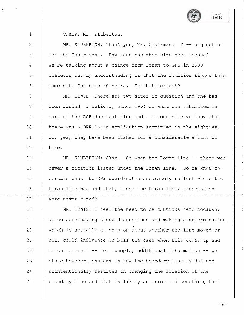
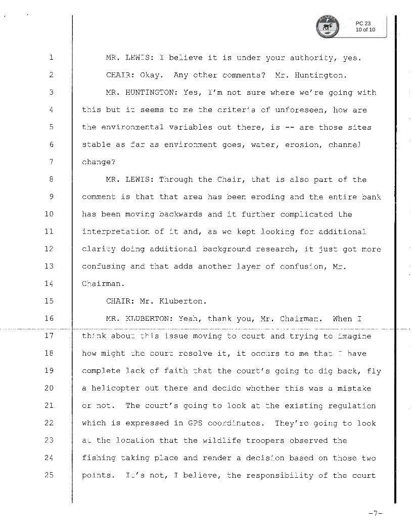
BOF 59 Revise boundaries of closed waters at Graveyard Point in the Naknek-Kvichak District.
Support Support as Amended Oppose No Action
0 7
Discussion on how the boundaries have some variance from the loran days and now GPS has come and possibly moved the boundary. Didn't feel it was possible that it would have moved that much and erosion is more the culprit for the issue. Lyle abstained from voting
BOF 60 Create a special harvest area in the Graveyard Creek area.
Support Support as Amended Oppose No Action
0 8
BOF 78 Change the boundaries, methods of harvest, and seasons for subsistence harvests of sockeye salmon in the Naknek River drainage.
Support Support as Amended Oppose No Action
8 0 need to align state and federal regs
AC 48 of 10

Nushagak AC October 20 & 21 2015 Final 11-19-15 Page 1
Nushagak Advisory Committee October 20 & 21, 2015
Dillingham City Council Chambers
I. Call to Order: 12:34 PM By Chairman Frank Woods.
II. Roll Call: Members Present: Frank Woods, Chair, Gayla Hoseth, Joe Chythlook (vice Chair) , Lloyd (Tom) O'Connor, Dan Dunaway Secretary , Curt Armstrong, Dennis Andrew, Travis Ball, Glen Wysoki (arr 1:05 pm), Jonathan Forsling (by phone) , Mariano Floresta, Steve Perkins (alt), Jim Woolington (phone) . Members Absent: Manokotak rep, Luki Akelkok (Ekwok), Chris Carr ( Portage), Chris Strub (alt).
Number Needed For Quorum: 8
Full Member list: Attached at the back of these minutes is a list of all members, the seat they occupy, community of residence, and term expiration date.
List of User Groups Present: In the meeting on or the AC? On the AC and in the public attending, most people identify with more than one of the following
groups with nearly 100% being subsistence users as well as members other user groups. In no
particular order:
Subsistence fishing and hunting
Commercial Drift
Commercial Set
Trapping
Sport fishing
Sport Fishing guide
Big game guide
Air Taxi
BBEDC represented by Gene Sandone by phone
Alternate Steve Perkins was seated with the committed given absences. A quorum was
declared.
III. Approval of Agenda: Joe C. Moved to adopt, Travis B. 2nd. There was a discussion on when to meet to prepare for the Board of Game - consensus was later by teleconference. Dennis A. asked to add an item IV under new business to discuss CDQ Boundaries. Gayla H. asked to add a line Public Comments to Agenda after Elections. AC agreed by consensus noting usually for these meetings, public members are encouraged and allowed to participated in discussions, especially proposals. Tom O. expressed concern for several meetings without a Manokotak representative - consensus was to add Item V under New Business titled Vacancies on AC.
AC 71 of 25
Nushagak AC October 20 & 21 2015 Final 11-19-15 Page 13
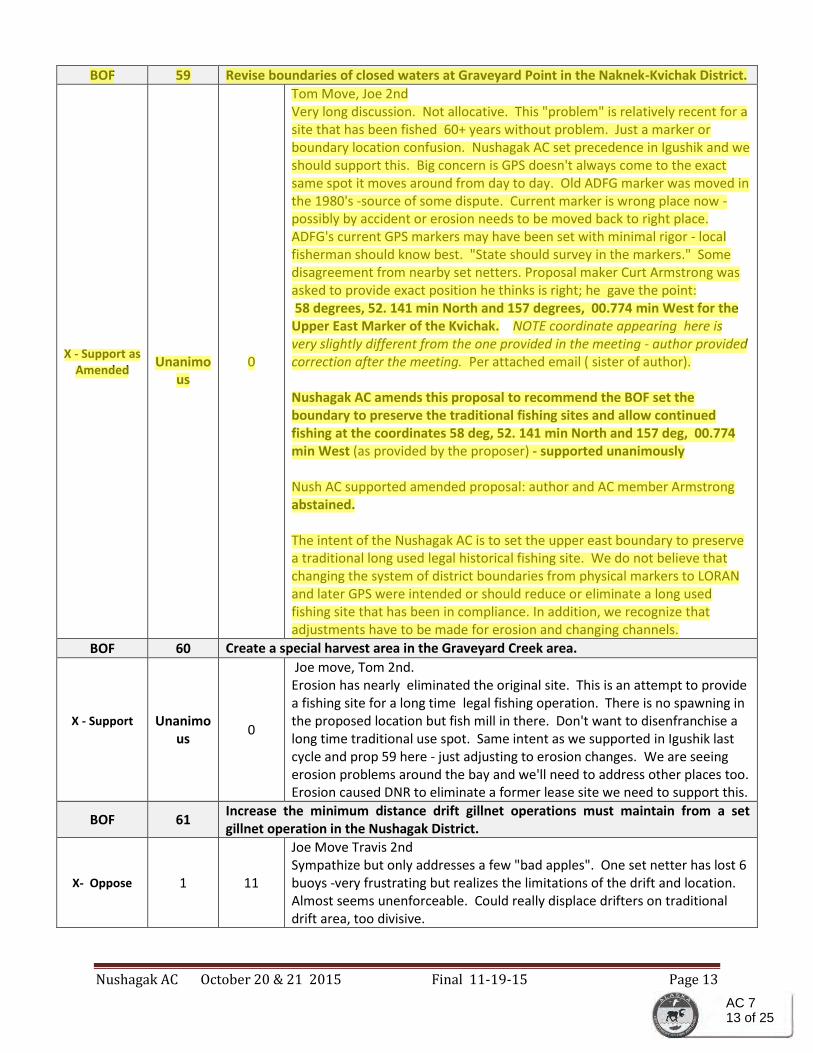
BOF 59 Revise boundaries of closed waters at Graveyard Point in the Naknek-Kvichak District.
X - Support as Amended
Unanimo
us 0
Tom Move, Joe 2nd Very long discussion. Not allocative. This "problem" is relatively recent for a site that has been fished 60+ years without problem. Just a marker or boundary location confusion. Nushagak AC set precedence in Igushik and we should support this. Big concern is GPS doesn't always come to the exact same spot it moves around from day to day. Old ADFG marker was moved in the 1980's -source of some dispute. Current marker is wrong place now - possibly by accident or erosion needs to be moved back to right place. ADFG's current GPS markers may have been set with minimal rigor - local fisherman should know best. "State should survey in the markers." Some disagreement from nearby set netters. Proposal maker Curt Armstrong was asked to provide exact position he thinks is right; he gave the point: 58 degrees, 52. 141 min North and 157 degrees, 00.774 min West for the Upper East Marker of the Kvichak. NOTE coordinate appearing here is very slightly different from the one provided in the meeting - author provided correction after the meeting. Per attached email ( sister of author). Nushagak AC amends this proposal to recommend the BOF set the boundary to preserve the traditional fishing sites and allow continued fishing at the coordinates 58 deg, 52. 141 min North and 157 deg, 00.774 min West (as provided by the proposer) - supported unanimously Nush AC supported amended proposal: author and AC member Armstrong abstained. The intent of the Nushagak AC is to set the upper east boundary to preserve a traditional long used legal historical fishing site. We do not believe that changing the system of district boundaries from physical markers to LORAN and later GPS were intended or should reduce or eliminate a long used fishing site that has been in compliance. In addition, we recognize that adjustments have to be made for erosion and changing channels.
BOF 60 Create a special harvest area in the Graveyard Creek area.
X - Support
Unanimo
us 0
Joe move, Tom 2nd. Erosion has nearly eliminated the original site. This is an attempt to provide a fishing site for a long time legal fishing operation. There is no spawning in the proposed location but fish mill in there. Don't want to disenfranchise a long time traditional use spot. Same intent as we supported in Igushik last cycle and prop 59 here - just adjusting to erosion changes. We are seeing erosion problems around the bay and we'll need to address other places too. Erosion caused DNR to eliminate a former lease site we need to support this.
BOF 61 Increase the minimum distance drift gillnet operations must maintain from a set gillnet operation in the Nushagak District.
X- Oppose 1 11
Joe Move Travis 2nd Sympathize but only addresses a few "bad apples". One set netter has lost 6 buoys -very frustrating but realizes the limitations of the drift and location. Almost seems unenforceable. Could really displace drifters on traditional drift area, too divisive.
AC 713 of 25

Nushagak AC October 20 & 21 2015 Final 11-19-15 Page 14
BOF 62 Increase the minimum distance drift gillnet operations must maintain from a set gillnet operation in the Nushagak District.
X- Oppose 0 Unanim
ous
Joe Move Travis 2nd Proponent - designed to prevent drifters from fishing at the INSIDE end of sent nets. Asking for drifters to respect the 100 feet rule INSIDE end. If drifters get inside it might prevent set net from being set. Sometimes a drifter gets inside, goes dry and interfere with a set net operation. This asks drifters to respect shore leases. Long discussion of the law it appears there is sufficient laws that generally favor the set netter already and liability mostly falls on the drifter. Current regs already accomplish what this tries to do - current regs makes drifter liable. Current regs are sufficient.
BOF 63 Change the seaward minimum distance between set gillnet gear in the Clark’s Point area in the Nushagak District.
X- Support as amended to:
SUPPORT
IN CONCEPT
10 2
Joe Move, Gayla 2nd. Very, very long discussion to explain situation and to explore solutions. Several affected set-netters present and active in discussion - potential for conflicts. Erosion is changing the area and reducing the time some set nets can reach water to fish. Historically modest to low producing sites. Some solutions may encroach on other sites. This mainly involves a limited number of sites and they need to get together to work out a solution. Could affect drifters if the set nets get to move out too far. This is a small area and a very few sites. Let affected users work something out. Formed and authorized a stakeholder committee to seek consensus, and develop recommendations to bring before the Board. Nushagak AC amends proposal to: Nushagak AC Supports a solution to
address the changing beach contours In Concept.: adjustments to
regulations that would address the changing beach contours brought on by
erosion. The AC s hopes a consensus can be reached by the concerned
stakeholders. The concerned stakeholders are highly recommended by the
Nushagak AC to provide a report of the details and their recommendations
to the BOF meeting in December. Nushagak Committee's intent is to
support the stakeholders' recommended solution.
Potential stakeholders include affected set net site holders, Alannah Hurley (author of 63), Diane Wetter, Eddie Heyano, Nick Smeaton, Opie, a drift fisher, AC members Mariano Floresta (Clarks Pt.), Tom O'Connor, and other interested stake holders..
BOF 64 Increase fishing time for drift gillnet gear during incoming tides in the Nushagak District.
AC 714 of 25

PC 051 of 1

PC 231 of 10
PC 232 of 10

PC 233 of 10

PC 234 of 10

PC 235 of 10

PC 236 of 10

PC 237 of 10
PC 238 of 10

PC 239 of 10
PC 2310 of 10

1
ALASKA BOARD OF FISHERIES BRISTOL BAY FINFISH
DECEMBER 2-8, 2015
Alaska Board of Fisheries Proposals WRITTEN COMMENTS
BY
The Bristol Bay Economic Development Corporation
NOVEMBER 2015
PC 561 of 42

27
PROPOSAL 59 – 5 AAC 06.350. Closed waters RECOMMENDATION: NEUTRAL Revise boundaries of closed waters at Graveyard Point in the Naknek-Kvichak District, as follows: Change the GPS numbers on the east (Graveyard Point) side of the river. BBEDC COMMENTS: BBEDC is neutral on Proposal 59. This issue was fully addressed at the Statewide meeting in March. We believe that this is an issue between set netters near Graveyard Point. Therefore, BBEDC is neutral on this proposal.
********************************************** PROPOSAL 60 – 5 AAC 06.XXX. Graveyard Creek Special Harvest Area Management Plan. RECOMMENDATION: NEUTRAL Create a special harvest area in the Graveyard Creek area, as follows: We request the Board of Fisheries to create a special harvest area or something similar to allow certain right(s) to be protected and preserved or simply restore our right to fish. We request this be done via grandfathered rights or creating special provisions created for cases similar in nature. COMMENT: BBEDC is neutral on Proposal 60. Fishermen fishing in Graveyard Creek have been informed that they are fishing illegally. They would like to create a special harvest area within the creek to allow them to fish their set net sites. The stream is non anadromous stream and has no spawning stock of salmon.
**********************************************
PC 5627 of 42

29
entire District or within a specific area encroaches on the drifter’s fishing area. Note, however, if a drift gillnetter entangles a set net he may receive a citation from Public Safety. BBEDC opposes this proposal.
********************************************** PROPOSAL 63 – 5 AAC 06.331. Gillnet specifications and operations. RECOMMENDATION: NEUTRAL Change the seaward minimum distance between set gillnet gear in the Clark’s Point area in the Nushagak District from, 500 feet to 750 feet to compensate for a mud bar that is filling in. BBEDC COMMENTS: BBEDC is neutral on Proposal 63. This proposal is allocative in nature in that it reduces the area that the drift gillnets can fish and gives it to the set netters. It reallocates resources. However, we understand that environmental changes have caused these sites to have insufficient water for adequate fishing time. Therefore, BBEDC is neutral on this proposal. We urge the BOF to consider the possible allocative aspects of this proposal between gear types and within the set net gear types when deliberating on this proposal.
********************************************** PROPOSAL 64 – 5 AAC 06.367. Nushagak District Commercial Set and Drift Gillnet
Sockeye Salmon Fisheries Management and Allocation Plan. RECOMMENDATION: SUPPORT Increase fishing time for drift gillnet gear during incoming tides in the Nushagak District. Drift gillnet openings will begin at least one hour before book high water. BBEDC COMMENTS: BBEDC supports Proposal 64. This proposal seeks to schedule the drift gill net opening at least one hour before the high tide. Fishers would rather fish on the flood rather the high tide or the ebb. There is more productive and more efficient fishing on the flood. BBEDC supports this proposal.
********************************************** PROPOSAL 65 – 5 AAC 06.367. Nushagak District Commercial Set and Drift Gillnet Sockeye Salmon Fisheries Management and Allocation Plan. RECOMMENDATION: OPPOSE In the Nushagak District repeal emergency order authority to limit gillnet mesh to not exceed four and three-quarters inches, as follows:
BBEDC COMMENTS: BBEDC Opposes Proposal 65. The regulation, 5 AAC 06.367(e), was adopted during the previous Bristol Bay finfish BOF meeting. The main purpose of the original proposal and subsequent regulation was to be able to harvest one stock of sockeye salmon over another (Nushagak River vs. Wood River sockeye salmon stocks). Fishermen presented it and lobbied for it. However, some fishermen believe that stock specific harvests of
PC 5629 of 42

November 19, 2015
Alannah Hurley
PO BOX 1488
Dillingham, AK 99576
(907) 843-1633
RE: Support for Bristol Bay Proposal #63
Attachments:
1) Clark’s Point Village Council Letter of Support
2) Clark’s Point Set Net Fleet Support Statement
4) Visual Aid Photos of Clark’s Point Beach and Proposal Area
5) Shore Fishery Lease Map of Proposal Amendment Area
Dear Board of Fish Members,
Quyana (thank you) for your service and reviewing Bristol Bay Proposal #63. I look forward to meeting
and discussing this important proposal with you at the upcoming Board of Fish meeting but am happy to
submit additional comments, the attached support documents, and visual aids for your review. First, I’d
like to highlight that this proposal has the full support of the Clark’s Point set netters (I’m only awaiting
response from one permit holder) and also from the local tribal government, the Clark’s Point Village
Council who represents 99% of Clark’s Point residents.
Another important highlight not included in the proposal is all of Clark’s Point set net fleet are Bristol
Bay watershed residents and or have generational roots in Clark’s Point and the commercial fishery. The
vast majority of the sites in the proposed area of change are “single-site” fishermen who rely primarily
on the income from their single set net operation. The sites in the area that that will be impacted by this
proposal make up just under half of the entire Clark’s point set net fleet and therefore would directly
positively impact the vast majority of the beach. These highlights and the reasons outlined in the
proposal/letter from the Village Council explain the broad and enthusiastic support of proposal #63.
The Nushagak Advisory Council is in full support of the concept (an extension of seaward distance to
accommodate mud flat fishermen) and reasoning supporting proposal #63. But due to concerns raised
at the meeting, the AC encouraged stakeholders in the area to meet to address the challenges and
concerns raised. We convened the suggested stakeholder meeting this month and while we weren’t
able to agree on all points, we were able to find a solution to one of the challenges that arose.
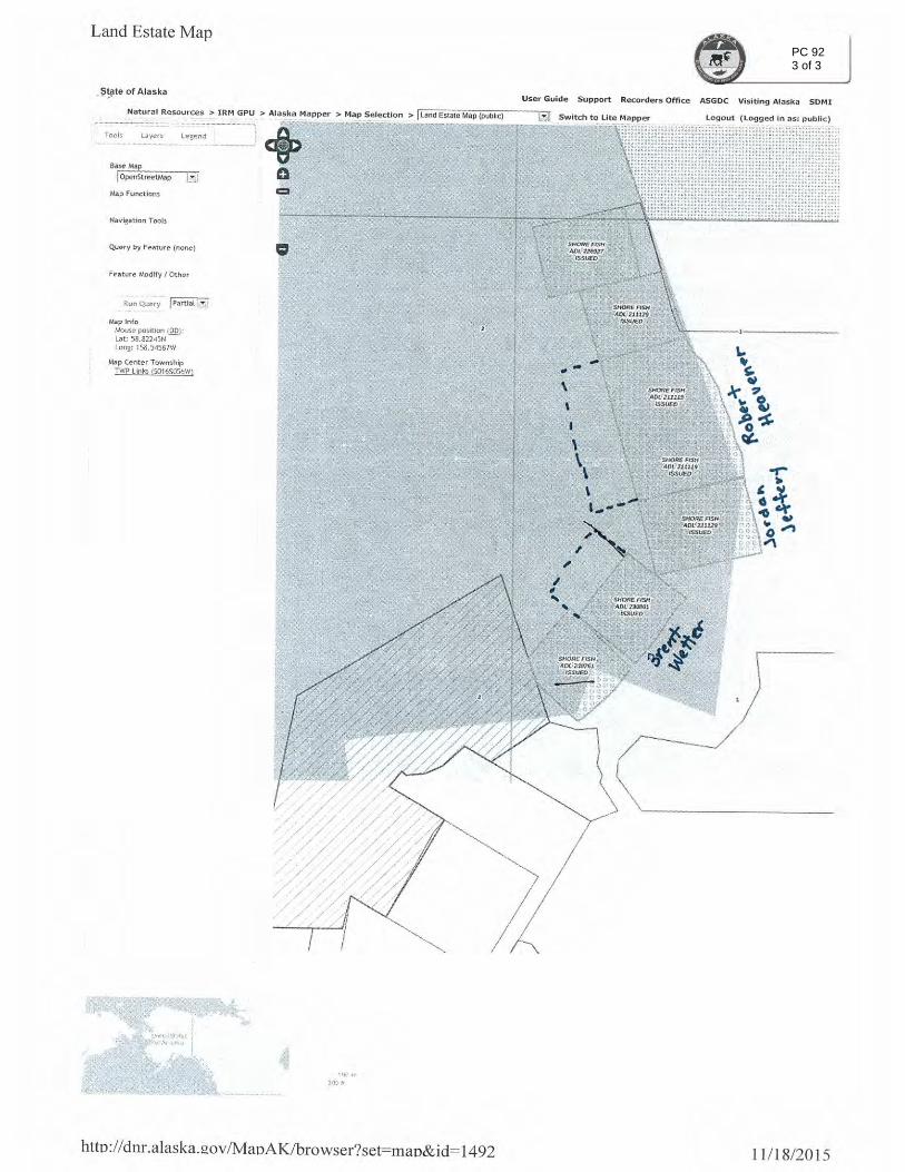
That solution is proposal #63’s impacted area must exclude the most southern set net site on Clark’s
Point beach because if it’s extended to 750 ft. its shore fishery lease would intersect with Diane Wetter’s
shore fishery lease across the creek on the Ekuk side of the beach. Diane Wetter’s sites on the Ekuk spit
fish parallel (not seaward) to the Clark’s Point beach and so to accommodate for this challenge we must
exclude the most southern (last) site on Clark’s point beach. This exclusion is supported by the last site’s
Captain (Christina Jeffery) as she accepts there is no way for her to extend her fishing distance without
PC 841 of 7

intersecting with Diane’s shore fishery lease. Please see the attachment with shore fishery lease maps
that illustrate this challenge and the necessity of an exclusion of the last site from this proposal area.
Therefore the amended GPS coordinate is (included in the amendment below) at the 2nd to last site on
Clark’s Point beach. An extension of the 2nd to last site (Captained by Robert Heavener) will not interfere
with Diane Wetter’s sites and therefore makes sense to be the new southern boundary of the proposal
area.
As author of Proposal #63 I’m amending this proposal to the new GPS coordinate in bold below as a
solution to the challenge stated above. The new proposed regulation would read:
Gillnet specifications and operations. Change the seaward minimum distance between set gillnet gear in
the Clark’sPoint area in the Nushagak District, as follows:
5 AAC 06.331(n)(2) is amended to read:
From the cannery dock at Clark’s Point to an ADF&G regulatory marker at First Creek, 500 feet from the
mean high tide mark, or to the minus 3 foot low tide mark whichever location is closer to the mean high
tide mark. Except between 50° 49.945' N lat., 158° 33.456' W long., and 50° 49' 18.3” N lat., 158° 33'
05.8” W long (at Clark’s Point Bluff mudflat) 750 feet from the mean high tide mark, or to the minus
three foot low tide mark whichever location is closer to the mean high tide mark.
Best wishes,
Alannah Hurley
Lifelong Bristol Bay Resident, Subsistence fishermen, and 3rd Generation Set Netter on Clark’s Point
beach.
PC 842 of 7
PC 843 of 7

Clark’s Point Set Net Fleet Support Statement:
I am a Clark’s Point set netter and support Proposal #63 to extend the set net distance from 500ft. to
750 feet on the Clark’s Point bluff mudflat area specified in the proposal.
Clark’s Point Captain’s Name:
Christina Jeffery – Site in area of proposed change
Robert Heavener Jr. – Site in area of proposed change
Nina Heavener- Site in area of proposed change
Joseph Wassily – Site in area of proposed change
Barbara Nunn – Site in area of proposed change
Lawrence Olson – Site in area of proposed change
Renetta Haggard – Site in area of proposed change
Fred John Jr. – Site in area of proposed change *(awaiting support response)*
Nicole Jeffery
Gloria Thorson
Sophie Bullard
Christina Edenshaw
Desmond Hurley
Alannah Hurley
Theron Heavener
Malcom Wright
Mariano Floresta
Terry Steben
PC 844 of 7

Combine Flats 1000ft.Limit
Clark’s Point Bluff Mudflat 500ft. Limit
Ekuk
Clark’s Point
Photo A: Taken at about ½ tide (coming in off a low -2 tide to a 18 foot high
tide
PC 845 of 7

Ekuk
Clark’s Point
Bouy at 500 foot limit
Photo C : Taken on the top and in the middle of Clark’s Point bluff at 0 low
tide.
Photo B: Proposal #63 Area of proposed extension (Taken at the
same time as photo A )
PC 846 of 7

Photo D: Buoy at 500 ft. limit at a 0
outgoing tide in the middle of Clark’s
Point Bluff Mudflat.
Diane Wetter’s Ekuk Beach Set
Net Sites (Across the large creek
that separates Clark’s Point and
Ekuk beaches)
Last site on Clark’s
Point beach
(excluded from
proposal due to if
extended it will
intersect with
Diane’s sites).
Proposal Amendment
Visual Aid. (Shore
Fishery Lease Map from
DNR)
PC 847 of 7

PC 921 of 3

PC 922 of 3
PC 923 of 3

Response to Suggested Proposal 59 Smith/Ten Kley
Date: 1 December 2015
To: Alaska Department of Fish and Game
Boards Support Section
P.O. Box 115526
Juneau, AK 99811-5526
Fax: (907) 465-6094
Email: [email protected]
From: L. Tiel Smith, Benjamin Smith, Alec Smith, Erin Smith
Silke Smith, Lyle Smith, Niel Smith, Kaleb Smith
Reid Ten Kley, Eike Ten Kley
RC 0 1 5
We are responding to Proposal 59 regarding the change to the Naknek-Kvichak north-eastern
boundary line at Graveyard Point, which includes two set-net locations. We are the owners of
the ne!ghboring net locations.
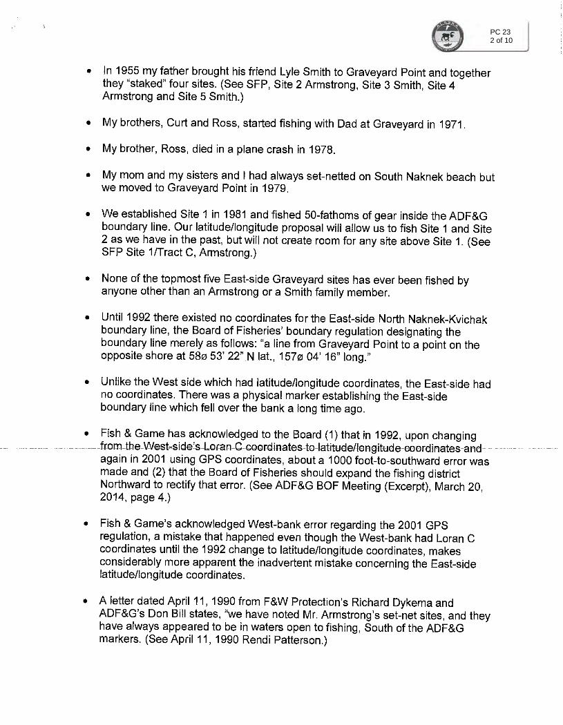
Background Family history as shared by the Armstrong and Smith families is that back in the mid-1950's,
Dick Armstrong obtained his net location on the east side of the Kvichack River from the
watchman of the Graveyard Point Cannery. It was the first net location south of the north
eastern boundary line. Lyle Smith took ownership of the second net location down from the
boundary line. The two men fished independently but from time-to-time partnered. They had
grown up together since childhood and were close friends. Off season, they spent time
together, and their families continued to be intertwined, with the children growing up side-by
side.
As time progressed, more net locations were added below the boundary line. The Vantrease
family (later to become the Ten Kleys) began to gain some net locations. Then both the
Armstrong and Smith families each gained an additional net location further down from the
boundary line so that the net locations finally laid out Armstrong, Smith, Armstrong, Smith,
Vantrease, Vantrease, and so on.
1

Response to Suggested Proposal 59
Smith/Ten Kley
Issue Instead of 1980 as stated in Proposal 59, it was during the early-1990's, based on a journal
entry and several personal recollections, that the Armstrongs added an additional net location
above their first on the north-eastern boundary line. They initially referred to it as a half-site
net location.
Earlier however, the State of Alaska had initiated the Department of Natural Resources Shore
Fishery Leasing Program for Commercial Set Net. The Armstrong's two net locations referenced
in Proposars-9-the ongmal m1a-rgsu's net location and the newer early-1990 s net ocat1on
as well as their prior net location further down from the boundary line, were not established
within the shore fisheries lease program, while all the other adjacent net locations were
surveyed, recorded, and leased from the State of Alaska by their owners.
Statement The Armstrongs are our dear friends and so this is a difficult action for us to provide comment.
We acknowledge the mid-1950's net location on the north-eastern boundary line as it has been
historically established. However, we do not endorse moving the boundary line to include the
newer early-1990's net location located above what was widely known to be the north-eastern
boundary line.
The inclusion ofthe newer early-1990's net location has had an economic impact on a number
of the adjacent net locations over the years. It has limited the amount of fish caught for several
of the net locations south of the north-eastern boundary line.
Final Recommendation: We would support a north-eastern boundary line change that
accommodated the Armstrong's initial mid-1950's net location. We would not support moving
the north-eastern boundary line to include the newer early-1990's net location.
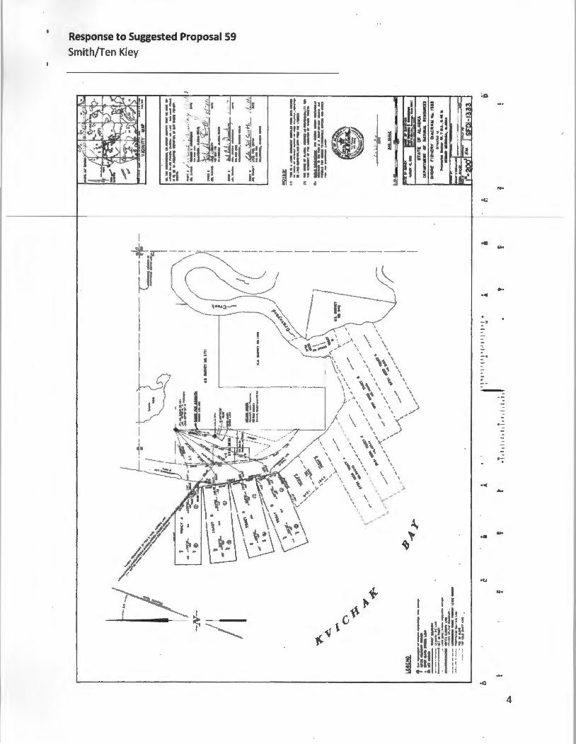
Evidence
• Attachment: DNR Shore Fishery Diagram SFP-1333 (SFDl-1333) which includes the
signatures of Dick Armstrong, Lyle Smith, Curt Armstrong, and L. Tiel Smith. Dated
August 19, 1988. All four original net locations of the Armstrongs and Smiths, with the
Armstrong's mid-1950's track on the farthest eastern boundary line, are included in the
survey. The Armstrong's newer early-1990's net location is not included in the survey.
• Survey Plat Link: http://dnr.alaska.gov/gis/raster/dnr/surveys/20000731/00020487.pdf
2
----
Response to Suggested Proposal 59
Smith/Ten Kley
Notary and Signature I submit these statements and affirmations as if given under oath.
STATE OF ALASKA THIRD JUDICIAL DISTRICT
) ) ss:
THIS IS TO CERTIFY that on this day of March 2015, before me, the undersigned Notary Public in and for Alaska, personally appeared L. Tiel Smith, known to me and to me known to be the si ato described herein and who executed the fore oin document and he acknowledged to me that he signed the same as his free and voluntary act and deed, for the uses and purposes therein stated.
IN WITNESS WHEREOF, I hereunto set my hand and official seal on the day and year first hereinabove written.
Notary Public in and for Alaska Seal:
My commission expires: ______ _
3
Response to Suggested Proposal 59
Smith/Ten Kley
' > ,
"' ~"
.... • c.;
.. ... . -·
. --
·-·< •.
.,. ...
•U
,,,.
4

Barbara Nunn Dillingham, AK
RC 0 2 4
Clarks Point/lgushik Setnet Fisherman/Permit Holder
Chairman Kluberton and Members of the Board:
Alaska Board of Fisheries In regards to Proposal 63
December 2, 2015
I am a Dillingham resident and Bristol Bay setnet fisherman and permit holder. I currently fish at Clarks Point and am in Support of Proposal 63. My site is one that would be affected by this proposal if it were to pass. The mudflats over the years have changed and on the smaller tides there ins't enough water to fish . By extending the limit out to 750 ft this would allow for myself and others in this area to have enough fishing time for a productive setnet season.

Proposal #63
Extension of Clark’s Point Bluff Mudflat Set Net
Seaward Distance from 500ft. To 750 ft.

Combine Flats 1000ft.Limit
Clark’s Point Bluff Mudflat 500ft. Limit
Photo A: Taken at ½ tide on the incoming (coming in from a -2 low tide to a 18 foot
high tide)
Ekuk
Clark’s Point Clark’s Point Dock 500ft. Limit Begins
Ekuk Beach 500ft.

Photo C:
Buoy at 500 ft. limit
at a 0 outgoing tide
in the middle of
Clark’s Point Bluff
Mudflat.

Clark’s Point
Proposal Amendment
Visual Aid. (Shore
Fishery Lease Map from
DNR)
Last site on Clark’s
Point beach
(excluded from
proposal due to if
extended it will
intersect with
Diane’s sites).
Wetter’s Ekuk Beach Set Net
Sites (Across the large creek that
separates Clark’s Point and Ekuk
beaches)
Wetter’s Ekuk Beach Set Net
Sites
Last site on
Clark’s Point
beach Excluded
Ekuk

Ekuk
Ekuk Spit 2 Sites
2nd to Last Clark’s Point Site (southern extension border)
Ekuk Spit 2 Sites

Barbara Nunn Dillingham, AK Clarks Point/lgushik Setnet Fisherman/Permit Holder
Chairman Kluberton and Members of the Board:
RC Q48
Alaska Board of Fisheries In regards to Proposal 63
December 2, 2015
I am a Dillingham resident and Bristol Bay setnet fisherman and permit holder. I currently fish at Clarks Point and am in Support of Proposal 63. My site is one that would be affected by this proposal if it were to pass. The mudflats over the years have changed and on a 15ft tide there is not enough water to fish By extending the limit out to 750 ft this would allow for myself and others in this area to have enough fishing time for a productive setnet season.

RC 125
Submitted by Janet Armstrong Schlagel by
request of Board member Kluberton

RC 126
Submitted by the Alaska Department of Fish and Game at the request of Board Chairman Kluberton December 5, 2015

RC ., It " I 't' L
Submitted by the Alaska Department of Fish and Game at the request of Board Chairman
Kluberton
December 5, 2015