committee report by the director of ... the director of environment and neighbourhood services...
TRANSCRIPT

COMMITTEE REPORT BY THE DIRECTOR OF ENVIRONMENT AND NEIGHBOURHOOD SERVICES READING BOROUGH COUNCIL ITEM NO. 15 PLANNING APPLICATIONS COMMITTEE: 13 January 2016 Ward: Southcote App No.: 151175 Address: Former Elvian School, Bath Road, Reading Proposal: A Hybrid application seeking outline planning permission for a new 6 form entry secondary school with all matters other than access reserved for consideration at a later date and detailed permission for 118 dwellings, access, car parking, landscaping and amenity space, following the demolition of the existing buildings. Applicant: Taylor Wimpey West London Date received: 16 July 2015 Major Application 13 week target decision date: 10 October 2015 – extended to 31st January 2016 Planning Guarantee (26 weeks) Date: 14th January 2016
RECOMMENDATION: Delegate to the Head of Planning & Regulatory Services to: GRANT Full Planning Permission, subject to the satisfactory completion of a S.106 legal agreement or REFUSE permission should the legal agreement not be completed by the 31st January 2016 unless a later date is agreed by the Head of Planning Development & Regulatory Services. The S106 legal agreement to secure:
Playing field compensation
• Compensation provided for the loss of part of the playing field, as required by Sport England and which would be supported by local plan policy CS28 (Loss of Open Space) and the NPPF with a financial contribution of £50,000 to go towards improvements to pitches on Prospect Park. Payment to be made on the completion of the agreement.
• A school sports facilities community use management agreement Facilities for Pedestrians:
• To mitigate the impact on the transport infrastructure adjacent to the site with a financial contribution of £65,000 to go towards:
• the creation of a pedestrian crossing facility within close proximity of the application site.
• the introduction of Kassel kerbs at the four bus stops (2 inbound and 2 outbound) closest to the application site on Southcote Lane and Kassel kerbs at the two bus stops (1 inbound and 1 outbound) closest to the application site on the A4 Bath Road.
• Implementation of parking restrictions along Southcote Lane boundary of the site and along the access road into the site to reduce any overspill parking from the development.
• As the Legal Agreement will cover the Coley Park site (151173) the other

pedestrian works are improvements to the footpath towards Wensley Road to a value of £10,000. Payments to be made on the completion of the agreement. Affordable housing
• To provide 50 of the dwellings (26.5%) across both sites (Coley Park & Elvian) as affordable units (subsidised housing that enables the asking price or rent to be substantially lower than the prevailing market prices or rents in the locality, and is subject to mechanisms that will ensure that the housing remains affordable for those who cannot afford market housing) with 70% at affordable rent and 30% as shared ownership. Equates to 19 dwellings (16.1%) on Elvian and 31 dwellings (43.7%) at Coley Park). Construction ESP
• At least one (1) month prior to Implementation of the Development a Construction ESP shall be submitted to the Council for Approval and following approval the Construction ESP shall be implemented, observed and complied with to the reasonable satisfaction of the Council. Alternatively, a financial contribution towards an Employment Skills and Training Plan for construction – to be prepared by Reading UK CIC. Payment to be made on the completion of the agreement. Conditions to include: Generic – for whole site (school and residential) development
• Full - time limit - three years • Approved Drawings & Documents • Details of phasing to be approved before any work commences. • Details and samples of all materials to be used externally. Prior to commencement
of the relevant phase. • An Arboricultural Method Statement consistent with the recommendations in
revised Arboricultural Impact Assessment TW19751aiaA submitted on 11/12/15 and Tree Protection Plan TWWL19751-03B
• Implementation of approved AMS. • Lighting layout and specifications to be approved • Lighting layout and specifications in accordance with approved details • Details of hard and soft landscaping scheme to be submitted and approved prior to
commencement of the relevant phase. Hard surfacing to be designed using SUDS principles and include tree pit specifications.
• Approved soft landscaping to be implemented prior to occupation of the relevant phase
• Prior to the implementation of the approved landscaping, a Landscape Management Plan covering a minimum of 5 years, incorporating information on the arrangements for management of communal areas, shall be submitted and approved.
• Landscape Management in accordance with the approved details • Details of boundary treatments to be submitted and approved prior to
commencement of the relevant phase. • Boundary treatments to be implemented in accordance with approved details
prior to occupation of the relevant phase. • Provision of bin stores in accordance with approved drawings, prior to occupation. • Prior to construction written evidence to be submitted to and acknowledged,

demonstrating that 100% of the dwellings hereby permitted will achieve a minimum of a 9.5% improvement in the dwelling emission rate over the target emission rate.
• Prior to occupation evidence to be submitted to and acknowledged, demonstrating that 100% of the dwellings hereby permitted have achieved a minimum of a 9.5% improvement in the dwelling emission rate over the target emission rate.
• No development of the relevant residential phase shall commence until details of secure, covered and lockable bicycle storage spaces using Sheffield cycle stands, to meet the required standard of 0.5 spaces per flat, has been provided to and approved by the Local Planning Authority.
• No development of the relevant phase shall commence until a scheme has been submitted to show how the noise mitigation recommendations of the noise assessment can be followed or that alternative but equally or more effective glazing and ventilation will be used. Thereafter the approved scheme shall be used.
• Accesses and internal roads to be constructed prior to occupation of relevant phase
• The existing access to the site shall be stopped up and abandoned immediately after the new access has been brought into use. The footway(s) and verge shall be reinstated to the satisfaction of the Local Planning Authority.
• No dwelling shall be occupied until space for vehicle parking and turning and garage drive lengths have been provided for that dwelling in accordance with the approved drawing. These areas shall thereafter be kept available for parking and turning at all times.
• No development of the residential site shall take place, including any works of demolition, until a Construction Method Statement has been submitted and approved in writing by the local planning authority to deal with noise, dust and highway matters during construction and demolition phases.
• Standard hours of working – construction and demolition phase. • Nesting birds protection provided • Construction Environmental Management Plan to be submitted to the LPA for
approval before any development commences. • No development shall take place until the implementation, maintenance and
management plan of the sustainable drainage scheme has been submitted to and approved by the Local Planning Authority.
• No bonfires on site during demolition or construction. • The implementation of a programme of archaeological work in accordance with a
written scheme of investigation, to be submitted to and approved prior to commencement.
• Investigations into land gas produced by the fill material identified on site to be carried out
• Maintenance of visibility splays • Residential Travel Plan to be submitted • Residential Annual Review
For Outline School development.
• Outline – time limit for submission of reserved matters for the school and implementation
• Details of covered bicycle storage spaces equipped with secure Sheffield cycle

stands shall be provided for approval and these facilities installed in accordance with the approved details before the community facilities are brought into use and linked with the increase of pupils at the school year by year.
• No development of the school site shall take place, including any works of demolition, until a Construction Method Statement has been submitted and approved in writing by the local planning authority to deal with noise, dust and highway matters during construction and demolition phases.
• Noise assessment to be submitted and approved prior to commencement. • Standard hours of working – construction and demolition phase. • No works to Tree 855 (T855 as per the bat survey report, Keystone Environmental
Ltd – September 2015) shall be undertaken until a licence for development works affecting bats has been obtained from the Statutory Nature Conservation Organisation (Natural England) and a copy has been submitted to the Local Planning Authority. Thereafter mitigations measures approved in the licence shall be maintained in accordance with the approved details. Should the status of the site change and the applicant conclude that a licence for development works affecting bats is not required the applicant is to submit a report to the Local Planning Authority detailing the reasons for this assessment and this report is to be approved in writing by the Local Planning Authority.
• Waste Management Plan for the school and sports facility to be submitted and approved prior to occupation.
• Vehicle parking for the school in accordance with approved plans • Bicycle storage for the school (details to be submitted) • School Travel Plan to be submitted • School Travel Plan annual review
Sport England requested conditions
• No development of the school site shall commence until details for the phasing of the development, including the provision of the floodlit AGP, MUGA and Sport Hall facility, have been submitted to and approved in writing by the Local Planning Authority, after consultation with Sport England.
• Prior to commencement of the school development details of the design and layout of the Multi Use Games Area, which shall comply with Sport England’s design guidance note ‘Artificial Surfaces for Outdoor Sport’, shall be submitted to and approved in writing by the Local Planning Authority in consultation with Sport England.
• The Multi Use Games Area (MUGA) shall be constructed, completed in accordance with the approved details and bought into operation for use by the school and members of the public in accordance with the Community Use Agreement (See S106) within 1 month of the school building being occupied.
• Prior to commencement of the school development details of the Artificial Grass Pitch (AGP) design and layout, which shall comply with Sport England’s design guidance note ‘Artificial Surfaces for Outdoor, shall be submitted to and approved in writing by the Local Planning Authority in consultation with Sport England.
• The AGP shall be constructed in accordance with the approved design and layout details and bought into operation for use by the school and members of the public in accordance with the Community Use Agreement (See S106) within 1 month of the school building being occupied.
• Before the AGP is brought into use, a Management and Maintenance Scheme for

the facility including management responsibilities, a maintenance schedule and a mechanism for review shall be submitted to and approved in writing by the Local Planning Authority after consultation with Sport England. The measures set out in the approved scheme shall be complied with in full, with effect from commencement of use of the AGP.
• Pursuant to the appearance reserved matters, details shall be provided of the sports lighting of the AGP to include: the type, design, lux levels, measures to control glare and overspill light and measures to ensure the sports lights are switched off when not in use; to be approved in writing by the Local Planning Authority. The scheme shall accord with Sport England's "Outdoor Sports Lighting" Briefing Note published in September 2010. Thereafter the use of the sports lighting shall be operated in accordance with the approved scheme.
• Unless otherwise agreed in advance and in writing by the Local Planning Authority after consultation with Sport England, the playing field/sports facility and its associated sports lighting shall not be used outside the hours of: (a) 8 a.m. and 10 p.m. Monday to Friday; (b) 8 a.m. and 10 p.m. on Saturday; and (c) 8 a.m. and 8 p.m. on Sunday and public holidays.
• Pursuant to the layout, scale and appearance reserved matters, details of the Sports Hall (to meet Sport England design guidance standards for community use) shall be submitted to and approved in writing by the Local Planning Authority in consultation with Sport England.
• The Sports Hall shall be constructed in accordance with the approved design and layout details and bought into operation for use by the school and members of the public in accordance with the Community Use Agreement (See S106) within 1 month of the school building being occupied. Informatives to include:
• Terms and conditions. • Building regulations. • A section 106 legal agreement relates to this permission. • Pre-Commencement conditions • Encroachment • Access construction • No tree works other than those specified in the approved arboricultural documents
should be carried out to those tree subject to TPO 93/003 without formal consent from the LPA
• Damage to the highway • Works affecting the highway • Environmental protection information regarding the control of nuisance during
construction and demolition. • Positive and proactive.
1. INTRODUCTION 1.1 This planning application was considered at the 11th November PAC. The Minutes
state; “The Committee was minded to grant the application but deferred the item for officers to provide further information on traffic movements”.

1.2 In the interval the applicant submitted amended plans to change the residential part of the site in the South West corner to replace the previously proposed secondary vehicular access with a footpath. This resulted in the layout of the houses in this corner being changed and all dwellings on the site being accessed from the primary access further east along Southcote Lane.
1.3 Finally, discussions progressed with Sport England on the wording of their
requested conditions to take into account the phasing of the proposed development and the delivery of the compensatory sports facilities on the proposed school site.
2. Information on traffic movements 2.1 Councillors had been concerned that the data used to calculate traffic impacts was
based on surveying the wrong school. Prospect School had been used, on advice from officers, whereas Councillors considered it to be more appropriate to survey Blessed Hugh Farringdon School, which was felt to share more similarity with the assumed catchment area for the WREN school.
2.2 The applicant has responded by researching where pupils at the four schools in
question (Prospect, Blessed Hugh, WREN and Elvian) currently live or lived to justify the basis of their survey and their findings. A copy of their Technical Summary is attached to this report (appendix 1) and the plan below (figure 4) shows the designated catchment areas for Prospect School and for WREN, taken from the Council’s own published Admissions document, with the post codes for Prospect School pupils indicated.
2.3 Officers have read the document and we are satisfied that the data used is
accurate and the findings in terms of pupil catchment areas and thus traffic generation are acceptable. The main points emerging from the additional information are:
• The catchment area and the number of students residing within it for Prospect School are similar to that of the WREN. It is therefore reasonable to utilise survey data for Prospect School to assess the likely impact of the proposed school.
• Blessed Hugh Farringdon Catholic School is an inclusive school which offers a Catholic education. Reading Borough Council document ‘2016/2017 Admission for Secondary Schools states the following regarding Blessed Hugh Farringdon: ‘It was set up primarily to serve the Catholic community in the Greater Reading area and although Catholic children have priority of admission, the Governing Body also welcomes applications from those of other denominations and faiths who support the religious ethos of the school.’ Blessed Hugh Farringdon School consequently does not have a defined catchment and as a result a larger proportion of children reside from outside what would be deemed a local catchment. Transport Officers are subsequently happy that Blessed Hugh Farringdon School is not comparable to the proposed school.
• For clarity an assessment has also been undertaken of the previous Elvian School which confirms that a vast amount of the pupils resided outside of a local catchment with numerous children from as far as Basingstoke, Newbury, Thatcham, Sandhurst, Arborfield, Winnersh, Woodcote and Goring. This would significantly increase the number of trips undertaken by the private car for the drop off and pick up of children to the school.

• As a result of the updated information Transport Officers are happy that the proposals will therefore have a minimal impact on the network.
2.4 Notwithstanding that this information does support their earlier claim that the
traffic generated by the new proposal will not have a detrimental impact on the functioning of adjacent roads and junctions the applicant and council officers have re-considered whether the Bath Road entrances to the school could be used to address the concerns of local residents living on Southcote Lane and roads leading from it.
2.5 The outcome is that the applicant and transport officers have now accepted the
case for allowing pupils to be dropped off via the Bath Road entrances in addition to the drop off facility accessed via Southcote Lane. Given the evidence from post code data of how many pupils live to the north and east of the site it is anticipated that a reasonable proportion of parents who do drop off or pick up pupils would use this facility. A second Technical Note (see appendix 2) has been produced which considers the traffic implications of allowing pupils to the new school to be dropped off/picked up via Bath Road.
2.6 Officers have read this document and the main points arising from it are:
• Following a review of the postcode data supplied for the WREN it was identified that there is an approximate 50/50 split as to which access students would utilise, the trip rate assessment has therefore been undertaken on this basis and Transport Officers are happy with this approach.
• The Technical Note demonstrates the following when the historic Elvian School is compared to the revised access strategy:
o A net reduction of 181 vehicle movements on Southcote Lane in the AM peak;
o A net reduction of 298 vehicle movements on Southcote Lane in the School peak;
o A net increase of 37 vehicle movements on Southcote Lane in the PM peak. It’s worth noting that these movements are all associated with the 118 homes and not the WREN School.
o A net increase of 233 vehicle movements on Bath Road in the AM Peak. o A net increase of 235 vehicle movements on Bath Road in the School
peak • The increases in vehicle movements specified above can be accommodated on
the network. 2.7 The conclusion reached is that the applicant has now provided sufficient
information on transport generation and impacts to address concerns. In addition, the use of Bath Road as an alternative access to the school site will help to reduce pressure on Southcote Lane and officers are satisfied that traffic management measures can reduce the risk of unacceptable manoeuvring on Bath Road.

3. Amended plans 3.1 The applicant found that their proposed secondary access in the S/W corner of the
site was obstructed by telecommunication boxes on the pavement which would have proven extremely complicated and thus expensive to relocate. They therefore explored with officers if the 10 dwellings in this part of the site could be accessed from the primary access instead.
3.2 Officers were able to advise and indeed agree that this change would be an
improvement for the scheme in that: • it presents an improved environment for the “trim-trail”; • means that this part of the frontage can benefit from increased landscaping; • provides better pedestrian permeability for the whole site at a point close to the adjacent bus stops.
3.3 Neighbours have been consulted on the proposed change and provided until 24th
December to submit their comments. None have been received so far. 3.4 Natural Environment Officer - I have no objections to the revised proposals
incorporating a change to the layout in the south-west corner of the site. A revised AIA has been submitted to address this change. Previous comments about conditions for landscaping, services, tree planting and protection still apply.
3.5 Transport – The proposal reduces the number of proposed vehicular accesses onto
Southcote Lane with all vehicle movements now accessed from one central point, this access is designed in accordance with the Councils standards and is therefore acceptable.
3.6 A tracking diagram has been submitted that demonstrates that two-way movements
can be provided along with adequate facilities for refuse collections. The car parking provision and layout remain in accordance with Policy.
3.7 Transport therefore have no objections to the development.

Amended S/W corner of the site 4. Sport England Conditions 4.1 In the update report provided at 11 November PAC it was recorded that Sport
England had sought further reassurance that the playing field compensation in the form of the floodlit artificial pitch, MUGA and Sports Hall on the school site will come forward at an appropriate time and to an appropriate standard. A set of conditions were provided to overcome their concerns. However, the wording of the conditions, by being linked to the residential development, present delivery problems for the residential part of the site, notably the Council’s requirement that the affordable housing units in flat blocks C & D should be provided as soon as possible.
4.2 There has been further negotiation with Sport England. Officers have been able to
explain that the contract arrangement between the EFA and the developer means that the risk of the school development not happening is very low. Furthermore, the proposed terms of the legal agreement and the recommended planning conditions, which Sport England will be consulted on, will ensure that the sports facilities are provided as proposed within a reasonable timeframe (late 2018 is programmed).
4.3 Sport England staff has confirmed that “Given the history and circumstances
particular to this site I confirm that this approach is acceptable to Sport England

but that we would wish to review the legal agreement that ensures that the sports facilities are delivered, as you have suggested”.
5. Consultation responses 5.1 Those who previously commented on the planning application have been consulted
on the additional transport information and residents living near to the south west corner of the site consulted on the proposed change to the access here. So far two sets of comments have been received. Both are reassured that the Bath Road access is being included for pupil drop off and pick up but are still concerned about:
• the potential for increased turnings at the Southcote Lane/Bath Road roundabout,
• why a fourth arm at the Leibenrood Road Junction has not been considered, • clarification of what the technical data shows on traffic flows, • parking assumptions and • what will happen with construction traffic.
5.2 Officer responses to these points are:
Southcote Lane Roundabout The access to and from the Bath Road is a secondary access and assumptions are that approximately 50% of children dropped off / collected by the private car will utilise this access point given the catchment area and existing post code data for existing students at The WREN. The survey of Prospect School showed that only approximately 15% of pupils are driven to school and it is reasonable to assume, given the similar catchment areas for the secondary schools, this proportion would apply to WREN pupils. The Transport Assessment has identified that approximately 60% of vehicles will be travelling west to east in the AM and east to west in the PM, therefore it is unlikely that a significant proportion of vehicle movements would undertake a U-turn at the Bath Road/Southcote Lane roundabout. It should also be stressed that the initial junction assessment for the roundabout included all vehicles travelling to the school from the north undertaking a turning manoeuvre at the roundabout to enter Southcote Lane and in many cases would have subsequently travelled through it for the onward journey. Given that the initial assessment would have resulted in a higher amount of turning manoeuvres at the roundabout no further assessment is required.
Changing the Liebenrood Road / Bath Road Junction to a full crossroads This change was assessed back in 2008 and this identified that it would result in significant delays on all three of the existing arms of the junction and was also shown to introduce diversions by motorists on to the Southcote Lane via Circuit Lane or Burghfield Road. To accommodate any fourth arm would necessitate extensive Highway capacity improvements within the vicinity of the junction and would require land not in the ownership of the applicant.
Clarification of traffic flow diagrams
The main concerns at the Planning Applications Committee in November related to the trip rates attributed to the school and not the residential element. Therefore the traffic flow diagrams appended to the Southcote Lane Vehicle Impact Technical Note illustrate the vehicle movements associated with the existing and proposed

schools only. As a result there are no vehicle movements identified in the PM Peak period, which is 5- 6pm.
Traffic flows have changed since the Elvian School closed but we have to base our assessment on what could happen on the site today if the school was operating to full capacity. This is because the school could re-open today and given the old planning history for it there are no planning limits on how many pupils could be accommodated within the existing buildings.
The proposed vehicle trips generated by the WREN school has been calculated using survey data from Prospect School and I would stress that undertaking actual surveys of a comparable school is the best way to obtain an accurate reflection of the proposed movements, it is acknowledged that there will be some fluctuation over time but this is likely to be insignificant. In addition it is a requirement for the school to sign up to a school travel plan to help reduce car travel by both staff and pupils, this will also help mitigate any increased use of the private car.
Parking
The proposal includes a car parking provision in accordance with the Council’s Parking Standards and Design Supplementary Planning Guidance (SPD) and this is in line with the car ownership data for Southcote. This approach complies with Paragraph 39 of the National Planning Policy Framework (NPPF). The latest research document published in February 2014 by the Housing Minster at Westminster “Space to park” recommends 1 space per 1/2 bed dwelling, 2 spaces per 3/4 bed dwelling with at least a 20% provision for visitor parking on street. It is the Government’s intention that this guidance should be followed. The proposed parking provision for the development has therefore been agreed based on the car ownership figures and the above policy and guidance. It should however be noted that the proposed visitor parking provision is in excess of the 20% requirement on site and therefore the car parking provision for the site complies with Policy.
Construction traffic Matters regarding construction can be addressed though a planning condition attached to the Full and Outline Planning Decision. It is well established in planning matters that it is unreasonable to refuse planning permission due to concerns for the construction phase. An indicative phasing plan showing how the development of the site will be progressed has been provided by the applicant and appears at the end of this report. The Construction Method Statement as recommended to be submitted as a planning condition will be required to define Haul Routes to avoid residential or unsuitable streets and with details of how contractors etc. will be instructed and reminded to use these preferred routes. It will also need to demonstrate how pupils attending the temporary school can still access their school and manage any problems as they arise. Officers will encourage the developer to adopt a similar approach to help local residents and neighbours to that taken when the Bath Road Reservoir site was developed.

5. Conclusion 5.1 Officers advise that the applicant has responded to the concerns expressed about
traffic generation and the request that alternatives are explored. The information provided is comprehensive and logical and the proposed alternative access from Bath Road found to be beneficial and acceptable. The latest amendment to the layout is an acceptable alteration and a resolution has been found to balance Sport England’s concerns against the realities of delivering the proposed development on this site.
5.2 The recommendation is to grant planning permission, subject to a legal agreement and conditions securing contributions and measures as set out above.
Julie Williams

Overall Site Layout Plan showing S/W corner as proposed to be amended

PHASING OF DEVELOPMENT – RESIDENTIAL IN BLUE & SCHOOL IN PINK

TECHNICAL NOTE
J:\33796 Elvian School\Transport\Working Documents\Technical Notes\WREN School Catchment rev B.docx Page 1 of 8
Job Name: Elvian School, Reading
Job No: 33796
Note No: 33796-TN01 rev B
Date: December 2015
Subject: School Catchment Analysis
1. Introduction This Technical Note has been written to respond to the comments at the Reading Borough Council (RBC) planning committee on the 11th November 2015 regarding the approach undertaken to forecast the generation of The WREN school and its categorisation of a ‘local school’. During the pre-application process it was agreed with RBC highway officers that a traffic survey at the Prospect school should be undertaken to forecast generation of The WREN as it was seen as the most comparable to the proposed WREN School. However, during the planning committee meeting concern was raised that the catchment and therefore travel choice of The WREN School would be more similar to Blessed Hugh Farringdon. Therefore, to provide additional information for the committee the home postcodes of pupils attending all three secondary schools have been analysed:
� The WREN Free School; � Prospect School; � Blessed Hugh Farringdon
Historically, the site was occupied by the Elvian School, which closed in July 2010. A travel survey which included pupil home post codes was undertaken in 2007. These postcodes have been reviewed to provide additional context to the travel characteristics of the former Elvian School. 2. The WREN Free School The WREN school pupil admission per form (1 year) is 168 pupils. Based on 168 pupils per form the school would be at maximum pupil capacity in 2021 with 1,176 pupils in year groups 7 to 13. Graph 1 illustrates the school pupil number per admission year. This allows the school opportunity to promote sustainable transport through the Travel Plan throughout this period to minimise demand by car. Graph 1: The WREN Pupil Number per Admission Year

TECHNICAL NOTE
J:\33796 Elvian School\Transport\Working Documents\Technical Notes\WREN School Catchment rev B.docx Page 2 of 8
The WREN School opened in September 2015 with 73 pupils all in Year 7 in temporary accommodation on The Elvian site. The WREN 2015/16 admission was therefore, 95 pupils less than the maximum admission of 168 pupils. The WREN is forecasting the 2016/17 admission which is predicting an admission of circa.140 pupils. Based on a near full admission in 2016/17 and full admission yearly thereafter, it is expected that the school will be near capacity (1,176 pupils) in 2022. Figure 1 and Figure 2 have been extracted from RBC document ‘2016/2017 Admission for Secondary Schools’, and these show The WREN and Prospect School catchment areas respectively. Figure 1: The WREN Catchment Area
Source: RBC 2016/2017 Admissions for Secondary Schools Figure 2: Prospect School Catchment Area
Source: RBC 2016/2017 Admissions for Secondary Schools

TECHNICAL NOTE
J:\33796 Elvian School\Transport\Working Documents\Technical Notes\WREN School Catchment rev B.docx Page 3 of 8
Home postcodes of the current 73 WREN pupils have been supplied by RBC and these are shown on Figure 3 below. The WREN (Red boundary) and Prospect School (Green boundary) catchment areas have also been shown on the plan. Figure 3: The WREN Pupil Home Postcodes
Figure 3 demonstrates that:
� 57 (78%) of the 73 pupils are within The WREN catchment area. � 59 (81%) of the 73 pupils are within The Prospect catchment area.

TECHNICAL NOTE
J:\33796 Elvian School\Transport\Working Documents\Technical Notes\WREN School Catchment rev B.docx Page 4 of 8
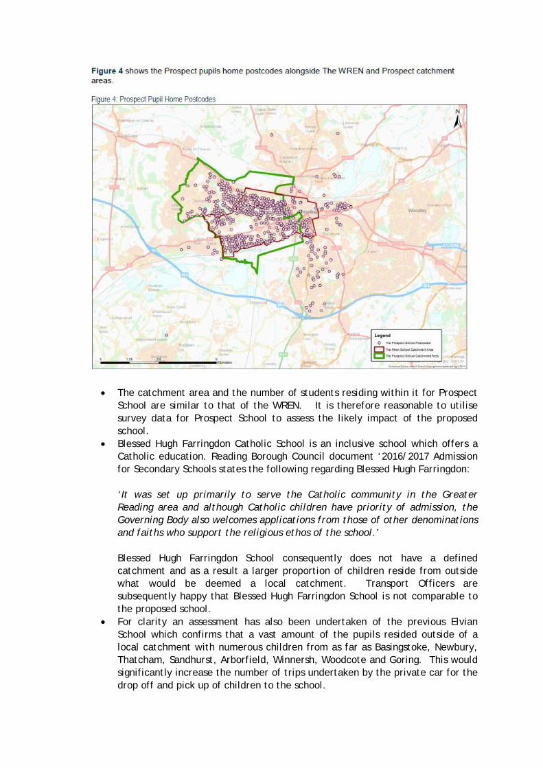
3. Prospect School Home postcodes of the current 1,523 Prospect School pupils have been supplied by RBC. It should be noted that 1 of the postcodes did not plot (this can be attributed to invalid data entry). The home postcodes of 1,522 (99.9%) Prospect School pupils are shown on Figure 4 below. The WREN (Red boundary) and Prospect School (Green boundary) catchment areas have also been shown on the plan. Figure 4 shows the Prospect pupils home postcodes alongside The WREN and Prospect catchment areas. Figure 4: Prospect Pupil Home Postcodes
Figure 4 demonstrates that:
� 1,073 (70%) of the 1,522 pupils are within The WREN catchment area. � 1,318 (87%) of the 1,522 pupils are within The Prospect catchment area.
TECHNICAL NOTE
J:\33796 Elvian School\Transport\Working Documents\Technical Notes\WREN School Catchment rev B.docx Page 5 of 8
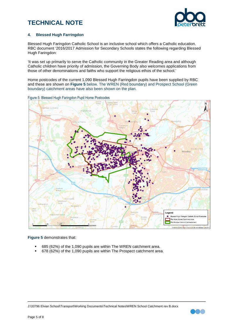
4. Blessed Hugh Farringdon Blessed Hugh Faringdon Catholic School is an inclusive school which offers a Catholic education. RBC document ‘2016/2017 Admission for Secondary Schools states the following regarding Blessed Hugh Faringdon: ‘It was set up primarily to serve the Catholic community in the Greater Reading area and although Catholic children have priority of admission, the Governing Body also welcomes applications from those of other denominations and faiths who support the religious ethos of the school.’ Home postcodes of the current 1,090 Blessed Hugh Farringdon pupils have been supplied by RBC and these are shown on Figure 5 below. The WREN (Red boundary) and Prospect School (Green boundary) catchment areas have also been shown on the plan. Figure 5: Blessed Hugh Faringdon Pupil Home Postcodes
Figure 5 demonstrates that:
� 685 (62%) of the 1,090 pupils are within The WREN catchment area. � 678 (62%) of the 1,090 pupils are within The Prospect catchment area.

TECHNICAL NOTE
J:\33796 Elvian School\Transport\Working Documents\Technical Notes\WREN School Catchment rev B.docx Page 6 of 8
5. Elvian School The former Elvian School was an independent school which offers a co-education, non-denominational Christian school. As set out within the submitted Transport Assessment (TA) a travel survey at the Elvian School was undertaken in 2007. 90 pupils took part in the travel survey, however, 82 (91.1%) pupils included their home postcodes. All 82 (100%) postcodes have been successfully plotted. Figure 6 shows the Elvian School pupils home postcodes alongside The WREN and Prospect catchment areas. Figure 6: Elvian School Pupil Home Postcodes
Figure 6 demonstrates that:
� 19 (23%) of the 82 pupils are within The WREN catchment area. � 31 (38%) of the 82 pupils are within The Prospect catchment area.

TECHNICAL NOTE
J:\33796 Elvian School\Transport\Working Documents\Technical Notes\WREN School Catchment rev B.docx Page 7 of 8
6. Catchment Summary Table 1 summaries the pupil home postcode analysis of The WREN, Prospect School, Blessed Hugh Farringdon and Elvian. Table 1: Secondary School Pupil Home Postcode Summary
The WREN School
Prospect School
Blessed Hugh Farringdon Elvian School
Pupil Postcodes 100% (73) 99.5% (1,522) 100% (1,090) 91.1% (82)
Defined Catchment Area Analysis
WREN Catchment Area 57 (78%) 1073 (70%) 678 (62%) 19 (23%)
Prospect Catchment Area 59 (81%) 1318 (87%) 685 (63%) 31 (38%)
RBC Ward Boundary Analysis
North Reading Wards 0 (0%) 6 (0%) 46 (4%) 8 (10%)
East Reading Wards 1 (1%) 35 (2%) 57 (5%) 0 (0%)
South Reading Wards 2 (3%) 35 (2%) 114 (10%) 0 (0%)
West Reading Wards 58 (79%) 1268 (83%) 675 (62%) 30 (37%)
Central Reading Wards 9 (12%) 164 (11%) 160 (15%) 2 (2%)
Notes: North Reading Wards = Peppard, Thames, Mapledurham, Caversham East Reading Wards = Park, Redlands South Reading Wards = Whitely, Church West Reading Wards = Battle, Kentwood, Norcot, Tilehurst, Southcote, Minster Central Reading Wards = Abbey, Kategrove Table 1 demonstrates that over 80% of WREN pupils and Prospect School pupils are within their defined catchment areas. Furthermore the admission profiles of both WREN and Prospect School are comparable when looking at catchment by Reading Borough Council wards. As stated previously Blessed Hugh Farringdon does not have a defined catchment. However, circa 40% of its pupils are outside the more local Reading West wards. This is significantly higher than The WREN (21%) and Prospect School (17%). It is therefore, very likely that pupils dependence on traveling via car is significantly higher at Blessed Hugh Farringdon compared to The WREN and Prospect School, which has a higher (80%) local catchment. It’s evident therefore that The WREN pupil admission is comparable to a public secondary school (such as Prospect School) with a defined catchment area and not an open catchment secondary school (such as Blessed Hugh Farringdon). The 2007 travel survey at the old Elvian School highlighted a high proportion (48.8%) of pupils travelling by car. This can be attributed to the high proportion (51%) of pupils living outside the Reading Borough Council boundary. This demonstrates that the former Elvian School had a regional catchment. The former Elvian School is therefore not considered to be comparable to The WREN School which is serving the local West Reading community.

TECHNICAL NOTE
J:\33796 Elvian School\Transport\Working Documents\Technical Notes\WREN School Catchment rev B.docx Page 8 of 8
7. Key Headlines � The WREN School and Prospect School have defined catchments as set out in RBC document
‘2016/2017 Admission for Secondary Schools’. � Blessed Hugh Farrington and the old Elvian School have/had an open catchment area. � The WREN School maximum admission roll per year is 168 pupils. Based on an admission roll
per year of 168 pupils The WREN School was projected to reach capacity of 1,176 pupils in 2021. � The WREN School 2015/16 admission roll was c.60% (73) lower than the expected admission for
the year of 168 pupils. The expected admission target for 2016/17 is near full admission. The school is currently therefore targeting a near full capacity (1,176) in 2022.
� A comprehensive WREN School Travel Plan will promote sustainable travel choices to pupils,
parents / guardians and staff through the Travel Plan, which will be conditioned as part of the application.
� As set out within the submitted WREN School Framework Travel Plan monitoring, measures and
surveys will be undertaken for 5 years following occupation of the permanent school. � The WREN School has 78% of its pupils within its defined catchment. � Prospect School has 87% of its pupils within its defined catchment. � The WREN and Prospect School have defined catchment areas and similar pupil admission
characteristics. � Blessed Hugh Farringdon has 62% of its pupils within the defined WREN catchment. � Blessed Hugh Farringdon has 34% of pupils in North, East, South and Central Reading wards. � The WREN (16%) and Prospect School (15%) have pupils in North, East, South and Central
Reading wards. � The number of Blessed Hugh Farringdon pupils travelling by car is likely to be higher than The
WREN School and Prospect School which is serving the local West Reading community. � 51% of the pupils attending the former Elvian School were outside Reading Borough Council
boundary. This demonstrates the regional catchment of the former Elvian School. � Only 23% of pupils attending the former Elvian School were in the defined WREN catchment.
8. Conclusions � The agreed travel survey undertaken at Prospect School provides a comparable travel profile for
The WREN. � The open catchment and pupil admission characteristic of Blessed Hugh Farringdon is not
considered comparable to The WREN which is serving the local West Reading community. � The old Elvian School served a wide catchment with many pupils travelling from outside Reading.
The WREN school serves the local community and therefore the percentage of pupils travelling by car is significantly less than the old Elvian School.

TECHNICAL NOTE
J:\33796 Elvian School\Transport\Working Documents\Technical Notes\A4 Bath Road Impact rev B.docx Page 1 of 8
Job Name: Elvian School, Reading
Job No: 33796
Note No: 33796-TN02 rev B
Date: December 2015
Subject: Southcote Lane Vehicle Impact
1. Introduction This Technical Note has been written to respond to the comments at the Reading Borough Council (RBC) planning committee on the 11th November 2015 regarding vehicular impact on Southcote Lane. This Technical Note should be read in conjunction with ‘PBA Technical Note 33796-TN01 rev B School Catchment Analysis’ . This document has confirmed that The WREN pupil catchment and therefore travel choice is similar to Prospect School. During the planning committee meeting concern was raised regarding the level of vehicle movements on Southcote Lane. Therefore, this note has been prepared to provide additional supporting information on the predicted vehicle impact on Southcote Lane compared to the historic Elvian School. In addition the option to provide an additional on-site pupil drop off / pick up via the A4 Bath Road has also been explored as requested by the committee. 2. Access Strategy The Elvian School Policy Brief states the following regarding access and transport: ‘The main access to the Elvian School was from Southcote Lane (Access 4 as shown on the Site Location Plan - Appendix A) and this should be retained as the principal access point. However, redevelopment proposals should take account of concerns raised by local residents and Councillors in respect of the impacts of additional traffic onto Southcote Lane. Continued use of the existing access off Bath Road (Access 2 as shown on the Site Location Plan - Appendix A) may be acceptable provided it is operated as a left-in / left-out junction only. The internal road layout of any redevelopment proposal should be such that it restricts the potential for traffic movements from this junction. This could be achieved by segregating the northern and southern parts of the site in vehicular terms whilst retaining potential north-south pedestrian links’. Therefore, the following access strategy for the site was agreed with RBC highways. Table 1: Agreed Access Strategy
A4 Bath Road Southcote Lane
WREN School Employees only Pupil drop-off / pick up
Residential 0 homes 118 homes

TECHNICAL NOTE
J:\33796 Elvian School\Transport\Working Documents\Technical Notes\A4 Bath Road Impact rev B.docx Page 2 of 8
3. Transport Assessment - Vehicle Impact As set out within the submitted Transport Assessment vehicle generation of the historic Elvian School has been based on travel surveys at the school in 2007. It’s worth noting that the traffic generation and traffic distribution of the historic Elvian School has been consistent for the 2 previous applications and the public inquiry and have never been challenged. The vehicle generation of the historic Elvian School and the application proposal on the site (WREN School and 118 homes) have been summarised in Table 2 . The table also provides the residual impact on the A4 Bath Road and Southcote Lane. Table 2: Residual Impact (Agreed Access Strategy)
Historic Elvian School Application Proposals Difference
A4
Bat
h R
oad
Sou
thco
te
Lane
Tot
al
A4
Bat
h R
oad
Sou
thco
te
Lane
Tot
al
A4
Bat
h R
oad
Sou
thco
te
Lane
Tot
al
AM Peak
(08:00 - 09:00) 0 423 423 69 406 475 69 -17 52
School Peak
(16:00 – 17:00) 0 497 497 35 399 434 35 -98 -63
PM Peak
(17:00 – 18:00 0 17 17 35 54 89 35 37 72
Table 2 demonstrates the following when the historic Elvian School is compared to the application proposals:
� A new reduction of 17 vehicle movements on Southcote Lane in the AM peak;
� A net reduction of 63 vehicle movements on Southcote Lane in the School peak;
� A net increase of 37 vehicle movements on Southcote Lane in the PM peak. It’s worth noting that these movements are all associated with the 118 homes and not the WREN School.
As set out within Section 10.4 of the submitted TA, the A4 Bath Road has a two-way traffic flow of circa 2,000 vehicles in all peak hour’s assessed. The agreed access strategy has a two-way impact of 35 to 69 two-way trips on the A4 Bath Road. Therefore the maximum impact on the A4 Bath Road is circa 3.5% when compared to the historic Elvian School. The historic Elvian School and application proposals traffic flows are contained within Appendix A .

TECHNICAL NOTE
J:\33796 Elvian School\Transport\Working Documents\Technical Notes\A4 Bath Road Impact rev B.docx Page 3 of 8
4. Additional A4 Bath Road Pupil Drop-off / Pick up - Vehicle Impact Providing an additional pupil drop off / pick up via The A4 Bath Road would have a localised impact on the following junctions on the A4 Bath Road:
� A4 Bath Road roundabout with Circuit Lane;
� A4 Bath Road signalised junction with Liebenrood Road;
� A4 Bath Road roundabout with Southcote Lane. The impact of providing the facility on the A4 Bath Road has been assessed with the following assumptions:
� 100% of staff access / egress via the A4 Bath Road;
� 50% of the pupil drop off / pick up via the A4 Bath Road;
� 50% of the pupil drop off / pick up via Southcote Lane;
� 100% of the 118 homes via Southcote Lane. The revised traffic flows with the additional pupil drop off / pick up via the A4 Bath Road is contained within Appendix A . The vehicle generation of the historic Elvian School and the application proposal on the site (WREN School and 118 homes) with the additional pupil drop off / pick up via the A4 Bath Road is summarised in Table 3 . The table also provides the residual impact on the A4 Bath Road and Southcote Lane. Table 3: Residual Impact (Revised Access Strategy)
Historic Elvian School Application Proposals Difference
A4
Bat
h R
oad
Sou
thco
te
Lane
Tot
al
A4
Bat
h R
oad
Sou
thco
te
Lane
Tot
al
A4
Bat
h R
oad
Sou
thco
te
Lane
Tot
al
AM Peak
(08:00 - 09:00) 0 423 423 233 242 475 233 -181 52
School Peak
(16:00 – 17:00) 0 497 497 235 199 434 235 -298 -63
PM Peak
(17:00 – 18:00 0 17 17 35 54 89 35 37 72
Table 3 demonstrates the following when the historic Elvian School is compared to the revised access strategy:
� A new reduction of 181 vehicle movements on Southcote Lane in the AM peak;
� A net reduction of 298 vehicle movements on Southcote Lane in the School peak;
� A net increase of 37 vehicle movements on Southcote Lane in the PM peak. It’s worth noting that these movements are all associated with the 118 homes and not the WREN School.

TECHNICAL NOTE
J:\33796 Elvian School\Transport\Working Documents\Technical Notes\A4 Bath Road Impact rev B.docx Page 4 of 8
As discussed in Section 3 of this note, the A4 Bath Road has a two-way traffic flow of circa 2,000 vehicles in all peak hour assessed. The revised access strategy has a two-way impact of 35 to 235 two-way trips on the A4 Bath Road. Therefore, the maximum impact on the A4 Bath Road is circa 11.8% when compared to the historic Elvian School. 5. Conclusion This Technical Note has provided additional information with regard to the predicted vehicular impact of the proposed WREN School and 118 homes. This Technical Note should be read in conjunction with ‘PBA Technical Note 33796-TN01 rev B School Catchment Analysis’. The agreed access strategy accords to the RBC’s document ‘The Elvian School Policy Brief’ as it retains Southcote Lane as the principal access point. The historic Elvian School vehicle generation is consistent with the 2 previous applications and public inquiry. These flows have never been challenged. The agreed access strategy results in a vehicle reduction in the AM peak (-17) and School peak (-98) when compared to the historic Elvian School on Southcote Lane. The agreed access strategy results in a vehicle increase in the AM Peak (+69) and School peak (+35) when compared to the historic Elvian School on Bath Road. An additional pupil drop off / pick up via the A4 Bath Road has been explored as requested by the planning committee. The access points off Bath Road accords with ‘The Elvian School Policy Brief’ as it retains the existing operation of the junctions. The revised access strategy results in a vehicle reduction in the AM peak (-181) and School peak (-298) when compared to the historic Elvian School on Southcote Lane. The revised access strategy results in a vehicle increase in the AM Peak (+233) and School peak (+235) when compared to the historic Elvian School on Bath Road. The revised access strategy accords to ‘The Elvian School Policy Brief’ as it takes account of concerns by local residents and Councillors in respect of the impacts of additional traffic on Southcote Lane.

TECHNICAL NOTE
J:\33796 Elvian School\Transport\Working Documents\Technical Notes\A4 Bath Road Impact rev B.docx Page 5 of 8
Appendix A – Traffic Flow Diagram

TECHNICAL NOTE
J:\33796 Elvian School\Transport\Working Documents\Technical Notes\A4 Bath Road Impact rev B.docx Page 6 of 8
The WREN School traffic flows with a drop off / pick up facility on Southcote Lane

TECHNICAL NOTE
J:\33796 Elvian School\Transport\Working Documents\Technical Notes\A4 Bath Road Impact rev B.docx Page 7 of 8
Historic Elvian School traffic flows

TECHNICAL NOTE
J:\33796 Elvian School\Transport\Working Documents\Technical Notes\A4 Bath Road Impact rev B.docx Page 8 of 8
The WREN School traffic flows with a drop off / pick up facility on The A4 Bath Road and Southcote Lane