communicating multi-uav system for cooperative slam-based
TRANSCRIPT

HAL Id: hal-02357577https://hal.archives-ouvertes.fr/hal-02357577
Submitted on 10 Nov 2019
HAL is a multi-disciplinary open accessarchive for the deposit and dissemination of sci-entific research documents, whether they are pub-lished or not. The documents may come fromteaching and research institutions in France orabroad, or from public or private research centers.
L’archive ouverte pluridisciplinaire HAL, estdestinée au dépôt et à la diffusion de documentsscientifiques de niveau recherche, publiés ou non,émanant des établissements d’enseignement et derecherche français ou étrangers, des laboratoirespublics ou privés.
Communicating Multi-UAV System for CooperativeSLAM-based Exploration
Nesrine Mahdoui, Vincent Frémont, Enrico Natalizio
To cite this version:Nesrine Mahdoui, Vincent Frémont, Enrico Natalizio. Communicating Multi-UAV System for Coop-erative SLAM-based Exploration. Journal of Intelligent and Robotic Systems, Springer Verlag, 2019,98 (2), pp.325-343. �10.1007/s10846-019-01062-6�. �hal-02357577�

Noname manuscript No.(will be inserted by the editor)
Communicating Multi-UAV System for cooperativeSLAM-based Exploration
Nesrine Mahdoui · Vincent Fremont · Enrico Natalizio.
Received: date / Accepted: date
Abstract In the context of multi-robot system and
more generally for Technological System-of-Systems, this
paper proposes a multi-UAV (Unmanned Aerial Ve-
hicle) framework for SLAM-based cooperative explo-
ration under limited communication bandwidth. The
exploration strategy, based on RGB-D grid mapping
and group leader decision making, uses a new utility
function that takes into account each robot distance in
the group from the unexplored set of targets, and al-
lows to simultaneously explore the environment and to
get a detailed grid map of specific areas in an optimized
manner. Compared to state-of-the-art approaches, the
main novelty is to exchange only the frontier points
of the computed local grid map to reduce the shared
data volume, and consequently the memory consump-
tion. Moreover, communications constraints are takeninto account within a SLAM-based multi-robot collec-
tive exploration. In that way, the proposed strategy is
also designed to cope with communications drop-out
or failures. The multi-UAV system is implemented into
ROS and GAZEBO simulators on multiple computers
provided with network facilities. Results show that the
proposed cooperative exploration strategy minimizes
Nesrine MahdouiSorbonne Universites, Universite de Technologie deCompiegne, CNRS, UMR 7253, Heudiasyc, 60 200Compiegne, FranceE-mail: [email protected]
Vincent FremontEcole Centrale de Nantes, LS2N, UMR CNRS 6004, Nantes,FranceE-mail: [email protected]
Enrico NatalizioUniversite de Lorraine, LORIA, UMR CNRS 7503,Vandoeuvre-les-Nancy, FranceE-mail: [email protected]
the global exploration time by 25% for 2 UAVs and
by 30% for 3 UAVs, while outperforming state-of-the-
art exploration strategies based on both random and
closest frontiers, and minimizing the average travelled
distance by each UAV by 55% for 2 UAVs and by 62%
for 3 UAVs. Furthermore, the system performance is
also evaluated in a realistic test-bed comprising an in-
frastructure-less network, which is used to support lim-
ited communications. The results of the test-bed show
that the proposed exploration strategy uses 10 times
less data than a strategy that makes the robots ex-
changing their whole local maps.
Keywords Coordinated multi-robot system · UAV ·autonomous exploration, frontier-based exploration ·SLAM · inter-robot communications.
1 Introduction
In the last decades, the robotic community has shown
a growing interest in the development of multi-robot
systems. Several research works showed that these sys-
tems present several advantages, such as increased effi-
ciency, reduced mission time, robustness to robot fail-
ures, and scalability. Hence, these systems are suffi-
ciently flexible to be used in different applications, such
as surveillance, infrastructure inspection, search and
rescue, etc. Among these applications, the exploration
and mapping of unknown environment is still one of
the fundamental problem in aerial robotics. The aim
is to get the most complete and accurate map of the
environment in a relatively short time. Still, when us-
ing multiple robots, many challenges arise especially
when using robots with limited embedded sensor range,
processing capabilities and energy [41]. Indeed, previ-
ous multi-robot exploration research focused on mo-

2 Nesrine Mahdoui et al.
tion planning and collision avoidance [21,15,3]. More
recently, the emphasis moved to robot coordination and
cooperation. Multi-robot systems are mainly composed
of three complementary components – perception [42],
planning and control [1], and communications [23] –
that interact together to get a consistent and robust
system. One of the main challenges of the perception
component is the Simultaneous Localization and Map-
ping (SLAM) where no global positioning system is
used. For the path planning and control component, co-
operative exploration represents one of the main prob-
lems. Thus, in the literature cooperative exploration
strategies have been proposed. Usually, these strategies
are based on a utility function to assign a robot with
an exploration target. The target assignment decision
is performed by using specific information exchanged
among robots. Therefore, communicatiosn are a funda-
mental component of the multi-robot system and com-
munications issues must be taken into account. In fact,
multi-robot systems have to cope with communications
failures in order to ensure the mission continuity. There-
fore, in this paper we address each of the three com-
ponents’ challenges towards the definition of a system
providing robots with precise localization, improving
robots area coverage and coordinating the fleet.
1.1 Contributions
In this paper, we present a coordinated Multiple Un-
manned Aerial Vehicles (UAVs) system in order to ef-
ficiently explore an unknown environment using poten-
tially heterogeneous robots. The main contributions of
this work are fourfold: i) From a System-of-Systems
point of view, we introduce a new fully distributed Multi-
UAV system architecture that does not exploit any global
information (neither map nor GPS); ii) Compared to
existing works, we propose a novel utility function that
takes into account the distance of each robot in the
group from the unexplored set of targets which allows
to cover a larger area by effectively spreading the robots
in the environment; iii) We detail a coordinated explo-
ration strategy, based on an on-line grid-based RGB-
D SLAM system and a dynamic-group-leader decision
making that helps minimizing the global exploration
time and the average traveled distance for each robot;
iv) We design a strategy behavior to deal with commu-
nication limitations and failures, which requires only a
limited information data exchange.
1.2 Paper structure
The paper is organized as follows. In section 2, we start
by introducing a brief state of the art on visual SLAM,
UAV to target assignment, utility function, and com-
munications for Multi-UAV systems. In section 3, we
present an overview of the proposed Multi-UAV sys-
tem. Then, in sections 4 and 5, we detail the proposed
exploration algorithm and the inter-robots communi-
cation module, respectively. We present the results and
discussions about the proposed framework in section 6.
And finally, we conclude in section 8. The nomencla-
ture and variables, used in this paper, are summarized
in Table 1.
Table 1 Nomenclature.
Designation Description
UAVi UAV of index i.pi, vi, ωi Pose, linear velocity, and angular velocity
of UAVi.0W Global reference frame.WFi UAVi’s local reference frame w.r.t 0W.W[R t
]Fi
Transform of rotation R and translation tfrom reference frame 0W to WFi.
PS ,O, L, F , G,T , C
3D points cloud computed by SLAM, 3Dvoxels, 2D cells, frontier points, candi-date frontier points (candidate targets),assigned targets and cluster sets, respec-tively.
ou, of , oo Unknown, free and occupied 3D voxels, re-spectively.
lu, lf , lo Unknown, free and occupied 2D cells, re-spectively.
fi,j Frontier point j of UAVi
ti Target point i.I (ti) Information gain of ti.U (UAVi, tj) Utility of reaching target j by UAVi.θ(i, j) Assignment of UAVi with target j.id Identification number of UAV.r Loop rate.n Number of UAVs in the fleet.nc Number of UAVs in C.nt, Number of targets in T .ng Number of targets in G.ni Number of frontier points of UAVi.s Sensor maximum range.λ Tuning parameter ∈ [0, 1].[rmin, rmax] Range to schedule information gain.σx, σy Parameter to spread the blob in x and y
axis, respectively.dtot Average distances of other UAVs to the
considered target.
2 RELATED WORKS
Cooperative multi-robot systems are playing important
roles in today’s unknown environment exploration ap-
Communicating Multi-UAV System for cooperative SLAM-based Exploration 3
plications. Beside this growing interest for multi-robot
systems, several architectures have been proposed to
manage the system interoperability. The architecture
is often closely related to the decision making process
that can be either centralized or decentralized includ-
ing distributed, hybrid and hierarchical ones [41]. Those
architectures present several advantages and disadvan-
tages that are summarized in Table 2. The central-
ized architecture considers one robot/central server [30]
to manage all the computations and tasks assignment.
However, these centralized approaches are subject to
stranded missions when they do not take into account
communications or robot failures. On another side, works
such as [43,34], propose to use distributed approaches
with fully autonomous robots. These approaches re-
quire robots with increased resources to exchange and
process an important amount of information in order to
synchronize agents and achieve a cooperative mission.
Authors in [38] propose a hybrid approach that consists
in switching from individual to cooperative exploration
behavior when agents are not able to converge to a local
minimum at a satisfying rate. Important computation
requirements are used for this later approach. Taking
into account the advantage of solution optimality from
centralized approach, and the advantage of mission re-
liability and adaptability from decentralized approach;
a leader -based approach has been proposed in our pre-
vious work [22]. The fleet is subdivided into subgroups
– called clusters – such that one robot in each subgroup
is responsible for targets assignment. In this paper, we
propose to improve this work to tackle the problems of
relative localization and inter-robots communications.
In this paper, we also focus on the use of visual
sensor as the main perception modality. These visual
sensors are used to gather information to map the en-
vironment and to estimate the robot’s trajectory. For
that, visual odometry (VO) or SLAM method are dom-
inant. There exist several methods attempting to solve
SLAM [7]. Among them, the ORB-SLAM2 vision based
framework [25] has shown promising results for pose es-
timation. It is a lightweight RGB-D SLAM system and
a feature based method composed of: a tracking thread
for the localization; a local mapping thread for the map-
ping; and a loop closing thread in charge of detecting
loops. These three main threads work in parallel. A
place recognition module is used for re-localization and
loop detection. Hence, in this work, we make use of the
ORB-SLAM2 to construct a model of the environment
and to estimate the robot’s state within it. The map-
ping algorithm is performed while a robot attempts to
reach a target. So, for an effective environment map-
ping, the target should be chosen carefully. There is a
wide variety of goal assignment strategies to affect one
robot to a target.
In [20] a comparison of some assignment strategy
used for multi-robot system is done. The compared strate-
gies include Hungarian-based method [28], Greedy [40],
Broadcast of Local Eligibility (BLE) method [37] and
K-means clustering [36]. Results show that Hungarian-
based methods outperform other approaches in major-
ity of cases. Unlike the Hungarian-based method, the it-
erative assignment can be implemented in a distributed
environment. Also the Hungarian-based approach are
computationally heavy compared to the simple greedy
algorithm which is preferred in applicable scenario.
Most of the target to robot assignments are based
on an utility function that defines the advantage that
a robot have to reach this target according to the mis-
sion’s aim [5]. The work proposed in [2] presents a new
utility function that takes into account the traveling
cost to the target and the connectivity utility. This al-
lows a trade off between minimizing the amount of ex-
ploration time and connectivity. To speed up velocity,
authors in [8] propose a rapid frontier selection tech-
nique to select goals from the robot’s field of view. This
approach minimizes the overall mission time by mini-
mizing the change in velocity of the robot. Nonetheless,
it increases the total path length traveled. In [17], maxi-
mizing the reconstructed model is favored over the mis-
sion time. Further, the proposed approach solves simul-
taneously exploration and coverage problems in order
to maximize the completeness of reconstructed model.
Whereas in [35], the aim is to maximize the utility of
targets that minimizes the potential for overlap in infor-
mation gain amongst members of the fleet. The utility
of reaching a target depends basically on the aim of
the mission while taking into account some additional
constraint such as time, completeness of the map, lim-
ited sensor and communication range, and number of
robots.
For multi-robot exploration, one of the most criti-
cal point is linked to inter-robot communications. The
challenge is to maintain reliable communications dur-
ing the mission, in order to make the robots cooperate
[31,16]. The strategy used for exploration affects the
data exchange among robots including type, destina-
tion and frequency. The exchanged information may be
composed of key-frames and map points shared between
a robot and a server [32], or only features of selected
key-frames and relative-pose estimates shared among
robots and ground station [13]. But mostly, robots ex-
change their local copies of the map and their poses [4,
33,14]. The amount of exchanged data may rapidly in-
crease in size, which may cause network congestion and
data loss. In order to reduce the bandwidth require-

4 Nesrine Mahdoui et al.
Table 2 Multi-robot system decision making architecture.
Approach Centralized Decentralized(distributed or hierarchical)
Advantages Optimal solution.Simple and lightweight processing on-boardrobots.
Robustness in dynamic environment.Reliability in case of other robots failure.Adaptability and flexibility.Decision making autonomy.
Disadvantages Weakness in dynamic environment.Important network requirement.System vulnerability in front of central con-trol agent.Additional computational requirements.Unsuitable for large scale systems.
Suboptimal solution.Complex on-board processing.Important amount of exchanged informa-tion.
ments, authors in [24] propose to send only compressed
key-frames and updated key-frame poses. Authors in
[10] propose a Decentralized Data Fusion-Smoothing
And Mapping (DDF-SAM) approach, where each robot
propagates towards other robots, its condensed local
graph in order to achieve scalability and robustness to
node failure. Most works deal with the communication
problem while assuming ideal communications or aim
to keep team members within range of one another in
order to focus their attention in higher level problem
[33,6]. But considering communication losses and/or
limited bandwidth help to prevent from mission fail-
ure ensuring a more realistic scenario. Indeed, in real
scenarios, many issues can arise such as having distance
among robots that exceeds the communication range,
losing major information in a broken communication
link, losing precious time in sending information due
to limited bandwidth. The exploration strategy have to
take into account the mentioned issues to avoid mission
failure in real world scenario. This topic is understud-
ied, yet, some works began to tackle the explorationproblem while considering communication limitations
[9,32]. In [11], the aim is to sense a geometrically com-
plex environment by assigning targets to robots while
satisfying spatial and temporal resolutions. This ap-
proach uses a min-max energy path planning algorithm
that obeys to a deadline time. Other works [16,29] pro-
pose to use protocol and routing solutions to overcome
the robots’ communication issues. In our work, we make
the choice to let UAVs exchange with each other only
frontier points, robot poses, and assigned targets. This
exchange happens at each iteration while considering
UAVs’ role, which are adapted according to the net-
work topology. This adaptation allows also to cope with
communication limitations.
Local map creation
RGB-Dsensor
Data processing
detection & pose estimation ofother robots
Visual Odometry
Localization
Mapping
Planning
Goal selection
UAVn
Path Planning & control
Local map creation
RGB-Dsensor
Data processing
detection & pose estimation ofother robots
Visual Odometry
(motion estimation)
Localization
Mapping
Planning
Goal selection
Id: MAV2
Path Planning & control
Local map creation
Visualsensor
Data processing
detection & pose estimation ofother robots
Visual Odometry
Localization
Mapping
Planning
Goal selection
Communication
Path Planning & control
UAV1
Network
...
...
......
...
...
2 1
3
4
56
7
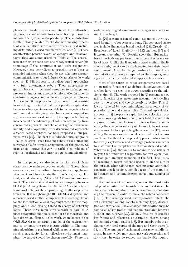
Fig. 1 Architecture block diagram.
3 Multi-UAV system overview
Using potentially heterogeneous UAVs, the main objec-
tive of cooperative exploration is to achieve a full cov-
erage of an unknown environment in minimum time.
3.1 System architecture
The proposed framework in Fig. 1 is an overview of
the software architecture used for Multi-UAV system.
It presents the different modules and data flows among
them. This block diagram is distributed and embed-
ded over all fleet members composed of n UAVs. We
suppose that each UAV is equipped with an embedded
RGB-D visual sensor. To maintain an accurate estimate
of the UAV’s pose in the environment, a simultaneous
localization (block 1) and mapping (block 3) are per-
formed. Block 3 in the mapping layer is responsible for
constructing a detailed grid map of the explored regions
and keeping track of them. In the data processing block
(block 4), some specific information are picked out and
exchanged using the communication layer where the
network (block 7) is in charge of maintaining data flow
among UAVs. The collected data are then locally pro-
cessed in the same block 4 to get exploitable informa-
tion for exploration. Thereafter, block 5 performs tar-

Communicating Multi-UAV System for cooperative SLAM-based Exploration 5
gets selection. Planning the path and reaching it are the
roles of block 6. Block 2 is used to visually detect other
UAVs in the environment then estimate their relative
transform using visual fiducial markers or tags such as
WhyCon [26] or AprilTag [27].
3.2 System coordinate frames
In this paper, we assume that the UAV fleet explore a
3D bounded unknown environment with a global refer-
ence frame 0W (See Fig. 2). Each robot (UAVi, with i ∈N∗), maintains a relative motion matrix Fi
[R t
]UAVi
w.r.t. its corresponding local reference frame WFi, and
a global transform W[R t
]UAVi
w.r.t. the global refer-
ence frame 0W. During the mission, the information
World frame
y
z
x
y
z
x
y
z
x
F1W
F 2W
F 3W
[R t ]UAV1F 1
[R t ]UAV 2F 2
[R t ]UAV 3F 3
UAV1
UAV 3
UAV 2
Local frame 1
Local frame 2
Local frame 3
[R t ]UAV3UAV2
[R t ]UAV3UAV1
[R t ]UAV2UAV1
y
z
xWo
Fig. 2 Multi-UAV global and local coordinate systems.
computed within local frames WFi of all the UAVs
are processed in parallel. Before that, however, thoseinformation need to be converted in 0W by knowing
the UAV’s local reference frame transform w.r.t. 0W
(W[R t
]Fi
). Thereby, UAV’s initial pose in 0W needs
to be known. To do that, the UAV, with the lowest
id number in the fleet (UAV1 in Fig. 2), is consid-
ered as a landmark. The global frame is defined such
that it coincides with the UAV marker’s local frame
where W[R t
]F1
=[I3 0
]. Using block 2 in Fig. 1, the
relative transform UAV1[R t
]UAVi
is estimated, from
which, transform W[R t
]UAVi
and thus W[R t
]Fi
are
computed.
3.3 Roles in the fleet
Cooperation in Multi-UAV systems often goes through
the exchange of data [41]. In a limited communication
ability, the data sharing link cannot always be correctly
established due to limited communication range, data
loss, obstacles, and traffic congestion. In the proposed
work, each group of robots that may communicate with
one another, form a cluster C. The fleet is composed of,
at least, one cluster (if n = nc). In each C, one robot
takes the role of leader and is in charge of making coop-
erative decision, based on some specific shared informa-
tion, for all the other robots in C that have the role of ex-
plorers. The decision making process relies completely
on the leader, which can lead to mission interruption;
especially when the leader to explorer communication
link is lost, or the leader is out of order. To overcome
these problems, the roles are constantly updated, in or-
der to select a leader if the current one experienced
any issue. The roles are not previously defined but are
adapted depending on the fleet topology changes. All
UAVs’ role are initialized to leader. Then, as soon as
UAVs start to exchange their identification number id,
clusters are formed and each UAV chooses its appropri-
ate role. The leader role is taken by the UAV with the
lowest id number in the C.
4 Multi-UAV exploration and coordination
4.1 Simultaneous Localization And Mapping
The exploration task requires the UAV to implicitly
maintain an accurate estimate of its pose in addition to
a map of the observed environment. Fig. 3 shows the
outline of the localization and mapping layers used in
the framework.
RGB-D sensor
Feature-based mapping
Relative Localization
Octomap framework
illustration
Exploration and
navigation
Projection onto z=0
SLAM
Grid-based mapping
Pi
Pi
PS
PS
O L
Ct, D
t
Fig. 3 Localization and Mapping layers outline. pi is therobot’s estimated pose, PS represents the 3D point cloudcomputed by the SLAM system, and O and L contain the 3Dand 2D grid map, respectively.
In this paper, the SLAM module provides an esti-
mate of the robot’s 3D coordinates pi = [x, y, z, qx, qy,

6 Nesrine Mahdoui et al.
qz, qw]> w.r.t. the local reference frame WFi.
Using the estimated motion and the 3D point cloud
from the RGB-D sensor, a 3D occupancy grid is built
during the grid-based mapping process. For that, the
Octomap framework [19] is used. The environment is
approximated to a 3D voxels grid O where each voxel
o ∈ O is represented by its centroid (See Fig. 4). Us-
ing the sensor measurements, voxels are labeled to un-
known ou, free of or occupied oo. This 3D occupancy
grid O is down-projected onto the plane z = 0 of the
local frame WFi to get a 2D cell grid L =proj(z=0)(O).
Cells are occupied as soon as there is an occupied voxel
in the z cell range. And, they are free if all voxels in the
z cell range are so. During the exploration, each robot
chooses a target from L and moves to it while maintain-
ing a fixed z altitude which leads to a 2D exploration
and navigation problem.
4.2 Proposed Exploration Strategy
In a Multi-UAV system, the exploration strategy needs
to be cooperative in order to be efficient. The proposed
strategy is described in Algorithm 1. The main objec-
tive is to cooperatively choose specific regions to be si-
multaneously explored using a frontier-based approach.
This is done by selecting candidate targets and assign-
ing them to each robot in an optimized manner.
Algorithm 1 Exploration strategy for coordinated
Multi-UAV.1: From cells ll ∈ L, select frontier points fi,j ∈ F and
compute their respective information gain I (fi,j).2: Process frontier points fi,j to get candidate goals tk ∈ G
(See Algorithm 2).3: Assign UAVi with target k (See Algorithm 3).4: Send targets to the corresponding robots.
4.2.1 Frontier selection and information gain
The frontier selection process is used to define the fron-
tiers of regions bounded by obstacles or unknown spaces.
In this work, the frontier cells fi,j ∈ F are selected
from the set of cells L (F ⊂ L) such that they are
either i) free lf and adjacent to unknown, or ii) la-
beled as occupied lo. Occupied cells lo are considered
as frontier cells to be able to perform frontier process-
ing in the next step. They could not be chosen as target
and will be discarded later. For example, in Fig. 4, the
frontier cells are: lf (2, 1), lf (2, 2), lo(2, 3), and lo(3, 3).
Thus, for a cluster C containing UAVi, the frontiers are
F={fi,1(2, 1), fi,2(2, 2), fi,3(2, 3), fi,4(3, 3)}.
In frontier-based exploration approaches, only cells ad-
jacent to unknown ones may be defined as candidate
frontier points and are likely to be chosen as target.
Thereby, the information gain is associated to each of
them in order to estimate the utility of reaching each
frontier. This corresponding information gain can be
defined in different manner depending on the mission
purpose. Authors in [6] propose to use a probability
function to reduce an assigned constant value thanks to
the relative distance to the UAV’s pose. This strategy
is general and does not take into account the updated
explored cells. The approach proposed in [17], affects to
the information gain the number of unknown and not
occluded cells in the view frustum of the target. This
method depends on the real estimate of information
gained when visiting the considered pose. However, it
requires more computation. In the proposed strategy,
the information gain are associated in a way that they
define the number of unknown cells lu around the tar-
get.
4.2.2 Frontier points processing
All frontier points fi,j ∈ F of UAVi in the cluster Cwith i ∈ [1...nc], are collected. Points in F are then
processed using Algo. 2 to get candidate frontier points
considered as candidate targets tk ∈ G with k ∈ [1...ng]
(See Fig. 4). The operators⋃
and⋂
are defined such
that, for example, if we have two UAVs with the frontier
points f1,1 = [1, 0] and f1,2 = [2, 3] for UAV1, and f2,1 =
[1, 1] and f2,2 = [2, 3] for UAV2; we would have pu =
{[1, 0], [1, 1], [2, 3]} and pi = {[2, 3]}.
Algorithm 2 Frontier processing algorithm.
Input: Frontier points fi,j ∈ F of UAVi with i ∈ [1...nc].Output: Candidate targets G.1: pu =
⋃nc
i=1 fi,j .2: pi =
⋂nc
i=1 fi,j .3: G = pu \ pi.4: Delete the obstacle frontier points fi,j(x, y) = lo(x, y)
from G.5: return G.
The obstacle frontier points – labeled as occupied
– are only kept to compute the intersection of frontier
points. Only the free frontier cells lf can be considered
as candidate target. When using local frontier points
instead of local maps, the frontier process replaces the
map matching process where the aim is to clear overlap-
ping areas. Indeed, in the frontier processing step, the
points that belong to the overlapping areas are cleared.
Therefore, using frontier points allows important mem-
ory saving.

Communicating Multi-UAV System for cooperative SLAM-based Exploration 7
y
z
O Lproj( z=0)
FreeUnknown Occupied
2 3
23
2,1
F
2,2 2,3
3,3
Frontierselection
G
3,3
Frontierprocessing
1 2
T
1
Targetselection
11
x yx
z
w.r.t the local reference frame WFi
w.r.t the global reference frame 0W
Fig. 4 Grid map structure evolution: from 3D voxels O to 2D cells L to 2D frontier cells F to candidate frontier cells – points– G (candidate targets) to 2D target cells – points – T .
4.2.3 Utility function
The proposed utility function (See Eq. 1) aims to simul-
taneously increase the explored area rate and to reduce
the distance of each UAV to its corresponding target.
It also considers the average distances to each robot in
the group to this target in order to maximize distances
among robots.
U (UAVi, tj) = I (tj) exp(−λ.(dmin(pi, tj)+
+nc − 1∑nc
k=1,k 6=i(dmin(pk, tj)))), (1)
where UAVi is the considered robot, tj ∈ G and I (tj)
are respectively the candidate target and its correspond-
ing information gain, λ is a trade-off parameter, nc is
the number of UAVs in the cluster C, and dmin(pi, tj)
is the minimum distance from UAVi’s pose to the candi-
date target j. The proposed utility function is inspired
from [17] and it has been presented in our previous work
[22]. In the case of a single UAV, the utility function
tends to choose the closest target with the maximum of
information gain. Regarding the Multi-UAV case, the
utility function is based on the average neighbors dis-
tances. As shown in Fig. 5, with an information gain of
I (tj) = 25 and three UAVs in the cluster (nc = 3); an
increasing distance of UAV to the target will reduce the
utility function. Whereas, the more average distance of
other UAVs w.r.t. the target, the more the utility. So
the function tends to chose the closest target to the
considered UAV but at the same time, the farthest one
from the others. The proposed utility function performs
a trade-off between rapid exploration and filling in de-
tails the map using a tuning parameter λ. From Fig.
5a and Fig. 5b, it is noticed that the bigger λ, the less
important the distance dmin(pi, tj) and thus filling in
details is favored over rapid exploration and vice versa.
(a) λ = 0.2
(b) λ = 0.8
Fig. 5 Utility function behavior: I (tj) = 25 , nc = 3,dtot =
∑nc
k=1,k 6=i(dmin(pk, tj)). The average distance ofother UAVs dtot has a minimum value different from zerosince nc is different from zero too.

8 Nesrine Mahdoui et al.
4.2.4 Goal assignment process
In order to make appropriate target-to-UAV assign-
ment, the utility of reaching each candidate frontier is
considered. The goal assignment process is described
in Algo. 3. For each UAVi, the utilities of reaching all
Algorithm 3 Goal assignment algorithm.
Input: Candidate targets tk ∈ G, k ∈ [1...ng] and their re-spective information gain U (tk), position pi of all robotsin the considered cluster C.
Output: θ(UAVi, tg) assignment of UAVi with target g.1: T = ∅.2: while no goal for UAVi do3: Compute its corresponding utility of reaching each re-
maining candidate goal U (UAVi, tk) with tk ∈ G \ T .4: tg= argmaxtk∈G∩T U (UAVi, tk).5: Schedule the information gain of the remaining candi-
dates tk ∈ G \ T .6: T = T ∪ {tg}.7: end while8: return θ(UAVi, tg) assignment.
the candidate targets are computed. Then, the target
tg that maximizes the utility is assigned to UAVi. Af-
ter that, tg is removed and the remaining candidate
targets are scheduled in order to avoid to select the
same target or another one close to it. This assignment
process is performed for the available UAVs in C in
a sequential manner until getting all assigned targets
tg ∈ T with g ∈ [1...nt] (See Fig. 4). The goal selec-
tion process is realized by each cluster/group leader (if
n > nc) or the Fleet leader (if n = nc). This assign-
ment aims to distribute the robots in the environmentin a cooperative way to explore simultaneously different
unknown regions. As long as candidate frontier points
are still available, the leader continues to assign targets
to explorers and they attempt to reach their assigned
goals. When the leader notices that no candidate tar-
gets are left, that means that all the environment has
been explored successfully and the mission is accom-
plished. Thus, it has to send back to the explorers an
acknowledgment to prevent them assuming a commu-
nication loss.
The target assignment process is performed in each
loop. The frequency of assigning targets is important
since it defines when a target should be assigned to the
UAV. This frequency impacts the duration and the ef-
ficiency of the mission. In a distributed approach, as
soon as the UAV reaches its current target, it selects a
new one without consulting the others. In a centralized
approach, the first UAV to reach its current target has
to wait until the others reach their respective targets.
This can be a problem as soon as one of them fails or
leaves the mission. Another possibility is to begin to as-
sign targets once one UAV reaches its target. But this
may generate incomplete tasks. In the proposed strat-
egy, the frequency of assignment or loop rate r is prede-
fined depending on the average time to reach a target
such that r = { svi,max
, svi,min
} where s is the maximum
sensor range and vi is the UAV’s velocity.
The information gain of each remaining candidate tar-
get I (tk)t with tk ∈ G \{tg} at time t − 1, that be-
longs to the threshold range [rmin, rmax], is scheduled
at time t depending on its distance w.r.t. the target
tg, using Eq. 2. This function is Gaussian with an am-
plitude that corresponds to the information gain max-
imum value; a center that corresponds to the target
position (tg(x), tg(y)); and σx and σy that spread the
blob in x and y axis, respectively.
I (tk)t = I (tk)t−1(1− exp(−((tk(x)− tg(x))2
2.σ2x
+(tk(y)− tg(y))2
2.σ2y
))), (2)
where tk(x) and tk(y) are the remaining candidate tar-
get coordinates; tg(x) and tg(y) are the target coordi-
nates; and σx and σy are the spreads of the blob. The
less the distance of the frontier point tk w.r.t. the target
tg, the less the information gain. When reducing the in-
formation gain, the candidate targets are less likely to
be chosen and thus, robots ensure a certain distance
among their future targets.
4.2.5 Path planning and control
As explained in Sect.4.1, UAVs are assumed to nav-
igate in a simplified 2D environment with a fixed z
value. Block 6 in Fig. 1 is responsible for planning a
path to the selected target and attempting to reach it.
For the navigation task, each UAV maintains a local
and a global planner along with a local and a global
costmap, respectively. The costmap is a 2D cell grid
L with additional inflation that consists on propagat-
ing cost values out from occupied cells and decreasing
them with distance. The global costmap has the size of
the UAV’s map whereas, the local costmap has a fixed
size moving window. Given a starting point – the cur-
rent pose – and an endpoint – the assigned target – in
the global costmap, the global planner produces a plan
using a navigation function computed with Dijkstra al-
gorithm [12]. It consists on following the adjacent free
cells until reaching the goal. Then taking into account
the local costmap, the local planner generates velocity
commands for the UAV’s mobile base. A recovery rota-
tional behavior is also performed when needed in order
Communicating Multi-UAV System for cooperative SLAM-based Exploration 9
to clear the robot’s field of view. The described tasks
above are ensured by the move base1 package.
The target assigned by the leader is ensured to belong
to an unknown area using the exploration strategy. The
trajectory planning process is performed locally on each
robot. And since the UAVs do not exchange their lo-
cal maps nor fuse them, they are likely to revisit al-
ready explored areas while following the planned path.
To minimize these overlapped regions during naviga-
tion, a priority is given to frontier points fi,j to be a
target for UAVi over UAVk with k 6= i. This helps the
UAV to maintain the same direction during exploration.
5 Inter-UAV communications
Interactions among members of the fleet are useful for
the exploration strategy to prevent UAVs to explore the
same regions, and allow them to cooperatively discover
the unknown areas more rapidly and in an optimized
manner. However, inter-UAV communications is a chal-
lenging issue that requires to answer some practical
questions: Which type of data nodes must exchange? If
so, how to identify the end-points of the data exchange?
How to cope with communication limitations and how
often data or control information must be exchanged?
In this Section, we will try to give a quick summary of
the answers to these questions.
Concerning the type of exchanged data and the end-
points of the communication flow, in the proposed co-
operative strategy, the UAVs must exchange data and
control information in the following way:
– Data: Only local frontier points fi,j ∈ F , current
pose pi, and current target point tg are exchanged
among the UAVs, instead of the whole copy of the
local map. This is expected to produce a consider-
able reduction of exchanged data volume, and, con-
sequently, memory consumption.
– Control : UAVi with i ∈ [1...nc] forward its id num-
ber and current pose pi. All the explorers UAVk
with k ∈ [1...nc] and k > i, send their local fron-
tier points fk,l ∈ F to the selected leader. Then, the
leader performs the goal assignment process and
sends back to each explorer in C a selected target
point tg to reach.
Concerning the communication limitations, it is impor-
tant to ensure the mission continuity. In case of losing
contact with the leader and before another one is se-
lected, explorers let a timer τ expire while waiting for
target assignment. If no target is received, the explorer
1 http://wiki.ros.org/move base
selects its own target according to local information.
Using this strategy, as long as – at least – one UAV
exists in the fleet, the mission will continue until all the
bounded environment is explored (no candidate frontier
points are left).
In the proposed strategy, data flow exchange is re-
peated at each iteration while taking into account net-
work topology changes to define clusters. The starting
points and endpoints are defined according to these
roles. The UAV’s role also specifies the type of ex-
changed data. In addition to the exchanged current
pose pi and id number i, if the UAVi is an explorer,
it would passively share information about itself and
its surrounding environment with the leader (frontier
points fi,j ∈ F); else, its role would be to send targets
to visit to the explorers (target points tk ∈ G).
6 Results
Simulations have been performed to evaluate the pro-
posed exploration strategy. Additional tests while using
relative localization have been done to measure the sys-
tem performances. Furthermore, experiments using an
infrastructure-less network have been conducted to get
as close as possible to a real UAVs deployment scenario.
The obtained results point out the performance of the
proposed multi-robot system under real network limi-
tations.
The number of robots used for evaluation is limited to
three, however, the proposed system architecture is not
constrained to a fixed number of robots.
6.1 Simulation results
The simulations are performed using Robot Operating
System (ROS) running on a 2.60GHz i7 Linux machine.
For the quad-rotor simulation, the AR-drone model2
equipped with an RGB-D camera in a forward-looking
configuration, is used. A bounded unknown environ-
ment is generated using Gazebo simulator.
6.1.1 Parameters tuning
The utility function (See Eq. 1) used in the exploration
strategy can be tuned, using a trade off parameter λ,
between fast exploration and filling in details the map.
2 http://wiki.ros.org/ardrone autonomy

10 Nesrine Mahdoui et al.
Fig. 6 The impact of variating the trade off parameter λover exploration time.
Fig. 6 shows different runs while varying this pa-
rameter. By increasing λ, the information gained when
reaching the goal is favored over the distance and thus
the cost to it, and vice versa. So, when λ is small, the
traveled distance is small and so the exploration time.
Though, some times during the mission, high values
of λ are noticed to reach higher exploration rate than
smaller ones.
The frequency or loop rate r of target assignment may
also affect exploration time performances. The values
of r are variated to take into account the robot velocity
vi and the sensor’s maximum range s. The impact of
varying the loop rate is evaluated in Fig. 7.
Fig. 7 Exploration time while varying the loop rate r.
Given a robot velocity vi = [0.1, 0.3] m.s−1 and a
maximum sensor range of s = 4 m, loop rate ranges
in r = [10, 40]. The loop rate should not be too small
to allow the robot to reach its target; nor too big to
prevent long waits for the next goal assignment.
Depending on results in Fig. 6 and Fig. 7, respectively,
λ is set to 0.2 and r to 20s. The simulation parameters
are summarized in Table 3.
6.1.2 Performance of the exploration strategy
The proposed exploration strategy has been evaluated
in terms of distribution of the robots in the environ-
ment, overlap rate, exploration time, and total trav-
eled distance by each robot. Furthermore, several val-
idations have been done to select the parameters con-
figuration.
The goal assignment process is performed according to
Table 3 Common parameters.
Parameter ValueRGB-D maximum range s (m) 4loop rate l (s) 20Trade-off parameter λ 0.2RGB-D horizontal FoV π/3Occupancy grid resolution (m) 0.05Range to schedule Ig [σx, σy] (m) [3, 3]Environment dimension (m2) 8× 8Linear velocity vi (m.s−1) [0.1, 0.3]Angular velocity ωi (rad.s−1) [0.1, 0.3]
the algorithm described in Sect. 4.2.4. Nevertheless, af-
ter assigning a target to the first robot in the list, the
same target or another one close to it may be assigned
to the second robot in the list. To overcome these is-
sues, the information gain of the remaining candidate
targets is scheduled. This allows to discard an already
assigned target and to keep a certain distance between
the new target and the previous one assigned.
Suppose that a target is assigned to the first robot in the
cluster list. Fig. 8 shows the goal selected for the second
robot when a sequential assignment is performed:
– without further frontier points processing (See Fig.
8b) which results in assigning the same target to
two different robots;
– while removing the assigned target from the remain-
ing candidate frontier points (See Fig. 8c) which re-
sults in too close assigned targets.
– while scheduling information gain after each tar-
get assignment (See Fig. 8d) which allows to space
out assigned targets. The information gain is sched-
uled following Eq. 2. The information gain value in-
creases with distance to the candidate target tg.
The goal assignment process may sometimes be not
optimal since it depends on the robots’ order in the
list. For example, suppose that robots UAVi and UAVj
have the same best target assignment tk such that it of-
fers the maximum utility over candidate frontier points:
tk = argmaxtmU (UAVi, tm) with tm ∈ G and tk =
argmaxtnU (UAVj , tn) with tn ∈ G. Robot UAVi have
another candidate frontier point tl with U (UAVi, tk) >
U (UAVi, tl) > U (UAVj , tk). So the optimal solution
would be to assign tl to UAVi and tk to UAVj . But, if
UAVi is the first in the list, tk is assigned to it and an-
other candidate frontier point with less utility than tk,
is assigned to UAVj . Thus the solution with sequential
goal assignment is not always optimal.
To overcome this problem, all the number of possi-
ble combinationng !
ng ! (ng−nc)! with ng the number of can-
didate targets and nc the number of robots, needs to
be considered. This considerably increases the compu-
tation time when the robots number increases. There-

Communicating Multi-UAV System for cooperative SLAM-based Exploration 11
(a) Candidate targets.
(b) Targets assignment when no furtherprocess is performed for the remaining can-didate targets.
(c) Targets assignment when UAV1’s tar-get is removed from the remaining candi-date targets.
(d) Targets assignment when the informa-tion gain of the remained candidate targetsis scheduled.
Fig. 8 Goal assignment: after assigning a target to UAV1, atarget is assigned in a sequential manner to UAV2. (a) rep-resents the candidate frontier points with their respective in-formation gain. (b), (c), and (d) represent respectively, thetargets assignment when: no further process is performed forthe remaining candidate targets; UAV1’s target is removedfrom the remaining candidate targets and; the informationgain of the remained candidate targets is scheduled.
fore, in the proposed algorithm, sequential assignment
is favored over computing all possible permutations.
The use of an effective goal assignment process should
limit the generated overlap. In Fig. 9, the time evolution
of overlap is evaluated using two cooperative robots.
The overlap undergoes a significant increase at the end
of the exploration to reach 33%. This is explained by
the closeness of the local maps at the end of the mission
to fully fill in details the global grid map.
While reaching their respective assigned goals, each
robot is in charge of creating a detailed grid map of
Fig. 9 Explored and overlapped area rate using two cooper-ative UAVs.
the visited area in order to get a global map of the
environment.
Fig. 10 shows the evolution of the respective pro-
jected 2D local grid map of two robots during a co-
operative exploration mission. The global projected 2D
grid map is also created and represented for evaluation.
The robots’ initial positions are (1,0,0) for UAV1
and (1,-3,0) for UAV2. Despite a relatively close initial
positions, the proposed strategy effectively spread the
robots so that UAV1 is in charge of the left side of the
environment and UAV2 of the right one.
To effectively evaluate the exploration strategy perfor-
mance in terms of time and traveled distance, different
runs with 1, 2 and 3 UAVs have been conducted until
the explored area rate reaches almost 99%. A traveled
distance evaluation is represented in Fig. 11. This dis-
tance effectively decreases with the number of UAVs.
The average distance traveled by each UAV is reduced
by 55% for 2 UAVs and by 62% for 3 UAVs. The error
of the traveled distance is slightly reduced from 1 to 2
Local map 1 Local map 2 Global map
Fig. 10 Coordinated exploration using two robots. Columns1, 2 and 3 show the evolution of the local grid map of UAV1,UAV2 and the global grid map over time, respectively.

12 Nesrine Mahdoui et al.
Fig. 11 Traveled distance evaluation.
Fig. 12 Average exploration time.
and 3 UAVs.
Fig. 12 shows that the average exploration time de-
creases when the number of robots in the fleet increases.
The computed error is decreased as well. The explo-
ration time is reduced by 25% for 2 UAVs and by 30%
for 3 UAVs. The exploration time and distance are not
directly divided by 2 or 3 when multiplying by 2 or 3
the number of robots, respectively. During these sim-
ulations, the robots’ initial positions are: (1,0,0) for 1
UAV; (1,0,0) and (1,-3,0) for 2 UAVs; and (1,1,0), (1,-
1,0) and (1,-3,0) for 3 UAVs. The results presented
above (See Sec.6.1.2) were evaluated without a rela-
tive localization. So, for a more challenging realistic
scenario, runs with relative localization algorithm have
been performed to evaluate both SLAM and system
performances along relative localization.
6.1.3 Comparison with existing exploration strategies
In order to evaluate our proposed exploration strategy,
we compare it with some state-of-the-art well known
strategies based on both random and closest frontiers.
We present the results obtained with a Random Fron-
tier (RF) selection strategy, as a baseline for compari-
son [18]. Also, we compared our proposed strategy to a
simple but efficient frontier-based exploration strategy
based on exploring the Closest Frontier (CF) [39].
Fig. 13 shows this comparison using 1, 2 and 3 UAVs.
Our proposed strategy clearly outperforms the two other
methods in the three cases. By increasing the number
of UAVs, our strategy gives better results compared to
the others. Moreover, our strategy presents a relatively
small and almost constant variation against the trav-
eled distance range.
UAV1
0
10
20
30
40
trav
eled
dis
tanc
e
One UAVRandomClosestOur strategyRandomClosestOur strategy
UAV1
UAV2
0
10
20
30
40
trav
eled
dis
tanc
e
Two UAVs
UAV1
UAV2
UAV3
0
10
20
30
trav
eled
dis
tanc
e
Three UAVs
Fig. 13 Exploration strategies comparison.
6.1.4 System performance with the relative localization
The ORB-SLAM2 approach [25] have been implemen-
ted3 and evaluated along with the proposed exploration
strategy. Each robot runs its own ORB-SLAM2 within
its local reference frame WFi. But, exchanged informa-
tion among robots have to be expressed in a common
reference frame. So information such as the pose pi and
the frontier points fi,j are necessarily transformed into
the global reference frame 0W before being exchanged.
Therefore the leader makes all the needed computa-
tion and sends back to the explorers the targets in 0W.
When a robot receives its assigned goal, it transforms
it into WFi in order to plan a path to it. To perform a
transformation from local reference WFi to global one0W, the robot has to know – at least – its initial pose
w.r.t. 0W. So, as explained in Section 3.2, the global ref-
erence frame of the environment is initialized such that
it coincides with the local reference frame of the first
group leader in the fleet: 0W ≡ WF1 in this example.
Then, by detecting this robot using tags mounted on
it, the other robots are able to estimate their respective
transform to it F1[R t
]Fj
, j ∈ [2...nc]. For simulation
evaluations, the information of transform – computed
while detecting the tag – are assumed to be known.
The SLAM approach has been implemented along
with our exploration strategy and evaluated using the
Gazebo virtual environment. Despite the need of struc-
ture and texture, the ORB-SLAM2 has been able to
perform localization in a simulated area. Table 4 re-
sumes tests to set some of the required parameters (lin-
ear velocity vi and angular velocity ωi) to perform vi-
sual SLAM without tracking loss or – at least – a fast
re-localization.
3 https : //github.com/raulmur/ORB SLAM2

Communicating Multi-UAV System for cooperative SLAM-based Exploration 13
Table 4 SLAM behavior while modifying linear and angularvelocity. T.L: Tracking Loss; RL: Re-Localization.vi and ωi
are in m.s−1 and rad.s−1, respectively.
PPPPPPωi
vi0.1 0.2 0.3
0.1 No T.L. No T.L. T.L.,R.L.
0.2 No T.L. T.L.,R.L.
T.L.
0.3 T.L.,R.L.
T.L. T.L.
Fig. 14 shows the SLAM system performances dur-
ing one robot exploration. The exploration time is rel-
atively important compared to the exploration without
SLAM since the velocity have been considerably re-
duced. The drift and so the trajectory error are limited
thanks to the loop-closure algorithm performed within
ORB-SLAM2.
Results for exploration using two UAVs running each
one the SLAM algorithm are presented in Fig. 15. As
expected, the exploration time using 1 UAV is greater
than using 2 UAVs. An important drift occurs at the
end of the UAV2’s trajectory because it did not visit a
known place and therefore it could not rectify its tra-
jectory with a loop closure optimization.
(a) The estimated trajectory versus the Groundtruth.
(b) The exploration rate and the estimated posi-tion errors during the mission.
Fig. 14 One UAV exploration using SLAM algorithm. (thekinect’s maximum range is 4m, the UAV’s linear velocity vi ∈[0.1, 0.2] m.s−1 and angular velocity ωi = 0.1 rad.s−1). TheRMSE(x)=0.2968 and RMSE(y)=0.2944.
(a) The estimated trajectory versus the Groundtruth.
(b) The exploration rate and the estimated posi-tion errors during the mission.
Fig. 15 Two UAVs cooperative exploration performing eachone SLAM algorithm. (the kinect’s maximum range is 4m,the UAV’s linear velocity vi ∈ [0.1, 0.2] m.s−1 and angularvelocity ωi = 0.1 rad.s−1). For UAV1, the RMSE(x)=0.2419and RMSE(y)=0.1415 ;for UAV2 the RMSE(x)=0.3649 andRMSE(y)=0.1614.
6.2 System performance using an infrastructureless
network
As the UAVs are equipped with IEEE 802.11b,g wire-
less card, we setup an infrastructureless network within
the set of robots to quantify the data exchange among
members of the fleet, as well as, to determine the per-
formance of the robot network. Runs with 2 and 3
UAVs are performed. The network is composed of two
2.60GHz i7 Linux machines and one 2.50GHz i7 Linux
machine. A multi-master system – also called multi-core
system – is used. Each UAV manages its own master
to avoid losing contact with ROS master in case of un-
stable network connection. In this type of system, a
synchronization among ROS cores is required to allow
robot to robot communication. Hence, the multi-master
fkie package4, where cores synchronization is ensured by
UDP protocol, is used. The TCP protocol is responsible
for exchanging data among ROS topics through the net-
work. For an effective evaluation, especially concerning
the time, clock synchronization needs to be ensured.
Network time protocol (NTP) is used to synchronize
laptops within a few milliseconds of Coordinated Uni-
versal Time (UTC).
The first evaluation aims to point out the amount of
the exchanged data (See Fig. 16). The size of data to
4 http : //wiki.ros.org/multimaster fkie

14 Nesrine Mahdoui et al.
Fig. 16 Data size when UAVs exchange a whole copy of theirlocal grid map versus frontier points of it. Values representthe average exchanged data during the mission.
Fig. 17 Network topology evolution during a loop r withthree cooperative UAVs.
be exchanged is almost divided by 10 in the proposed
strategy that shares only frontier points compared to a
strategy that makes robots to exchange a whole copy of
their local map. Depending on the size and frequency of
the exchanged data, the allocated time for communica-
tions may increase with the increasing number of UAVs.
Thus, evaluations of timing behavior and its potential
impact on the exploration performances have been con-
ducted. Fig. 17 shows the network topology evolution
during data exchange. Threes stages are noticed where
the exchanged information are the following:
– Stage 1: id number and poses pi, i ∈ [1...nc].
– Stage 2: frontier points fi,j , i ∈ [1...nc], j ∈ [1...ni].
– Stage 3: target points assignment θ(UAVi, tk), i ∈[1...nc], k ∈ [1...ng].
Table 5 shows the average data exchange time during
exploration. A slight increase in the computed average
time occurs when increasing the number of UAVs. This
time spent in communication is negligible compared to
the total time of exploration.
To evaluate the system behavior during communi-
cation failure, the network connectivity has been volun-
tarily interrupted during the exploration. Fig. 18 shows
the UAV’s role and the exploration rate performance
when the network connectivity is interrupted and then
recovered.
The system performs neighbor discovering, role selec-
tion and target assignment at each loop of ti+1 = ti+i.r
with t0 = 0s and r = 20s. In Fig. 18a, at t = t0, both
robots begin with a leader role. When discovering each
other (at t = t1), UAV1 selects itself as leader and
UAV2 as explorer. Consequently, UAV1 assigns a tar-
get to UAV2. UAV2 receives the target and attempts
(a) Robot role along with network connectivity.
(b) Exploration rate along with network connectivity.
Fig. 18 Two cooperative robots exploration along with net-work connectivity.
to reach it. At t = t2 + δ, the connectivity is voluntar-
ily interrupted, just after the role selection but before
the target information is assigned to UAV2. After a
time period τ , UAV2 selects a target taking into ac-
count its own local data. In the next loop (at t = t3),
since the connectivity is still interrupted, UAV2 finds
no neighbors and selects itself as a leader. Both robots
perform exploration independently, that is, without co-
operation. Shortly after t = t3, the connectivity is re-
established. Thus, robots are able to cooperate again
and UAV2 takes over the role of explorer.
In Fig. 18b, even after the network connectivity is in-
terrupted, the exploration continues to be performed
by both UAVs. When the connectivity is re-established,
the leader collects the frontier points and performs fron-
tier processing where it finds that no candidates targets
are remaining, that is, all the environment is now ex-
plored. Therefore, the mission is accomplished.
7 Discussion
The aim of this work is to propose a complete system-
of-systems framework used for multi-robot environment
exploration. In this work, we propose both novelty and
exploitation of state-of-the-art methods to make effec-
tive this scalable framework. As a property of system-
of-systems, each of the component/block presented in
Fig. 1 can be replaced using different approaches than
the ones we used here.

Communicating Multi-UAV System for cooperative SLAM-based Exploration 15
Table 5 Communication module timings.
# UAVsTime spent
in stage 1 (s)Time spent
in stage 2 (s)Time spent
in stage 3 (s)Time for
exploration (s)UAV1 UAV2 UAV3 UAV1 UAV2 UAV3 UAV1 UAV2 UAV3
TwoUAVs
UAV1 ∅ 0.136±0.139
∅ ∅ ∅ 0.022±0.017
120, 1
UAV2 0.065±0.068
∅ 0.026±0.008
∅ ∅ ∅
ThreeUAVs
UAV1 ∅ 0.056±0.065
0.575±0.769
∅ ∅ ∅ ∅ 0.335±0.407
0.765±0.678
86
UAV2 0.107±0.111
∅ 0.483±0.678
0.185±0.244
∅ ∅ ∅ ∅ ∅
UAV3 0.267±0.165
0.616±0.549
∅ 0.251±0.109
∅ ∅ ∅ ∅ ∅
Moreover, the proposed exploration strategy ensures
a mission continuity in the case of communication loss.
Nevertheless, the robots may explore regions already
explored by the other ones, since no local maps are ex-
changed nor fused to keep track of visited areas. Thus,
in case of communication loss, the mission accomplish-
ment is favored over consumption minimization of re-
sources, such as time and energy.
In this paper, one limitation is that the explored en-
vironment is free of obstacles. This is due to the concave
shape assumption of the local maps (without obstacles
inside) in the frontier points processing step. This algo-
rithm needs to be adapted in order to take into account
obstacles. Consequently, the utility function will use the
robot path instead of the travelled distance.
8 Conclusions and future works
In this paper, we introduced a new distributed multi-
UAV system architecture for SLAM-based cooperative
exploration under limited communication bandwidth,
designed as a System-of-Systems. Based on their em-
bedded visual sensor, and using state-of-the-art visual-
SLAM algorithms, UAVs are individually able to lo-
calize themselves, discover their neighbors and create a
3D grid map of their environment. To explicitly han-
dle the connectivity limitations, the proposed coopera-
tive exploration strategy is based on a new utility func-
tion that takes into account the distance of each UAV
in the group from the unexplored set of targets, and
makes a trade-off between fast exploration and detailed
grid map using limited network resources. Using the
group leader decision making, targets are assigned to
UAVs in order to simultaneously explore different re-
gions of the environment in an optimized manner. Sim-
ulation results shows that the strategy adopted min-
imizes the mission time by 25% for 2 UAVs and by
30% for 3 UAVs. It also decreases the average trav-
eled distance by each UAV by 55% for 2 UAVs and
by 62% for 3 UAVs. In addition and in contrary to re-
cent approaches, by scheduling exchanged information,
UAVs are efficiently spread out into the environment
while avoiding to select the same target or another
one close to it. Moreover, test-bed results with net-
work communication, show that by exchanging frontier
points, local poses and assigned targets, the adopted
strategy reduces the data needed up to 10 times com-
pared to a strategy that makes the robots to exchange
the whole local maps. Furthermore, the group leader
decision making allows to take into account the com-
munication drop-out or failure by adapting the UAV’s
role according to the network topology changes.
When the communication is interrupted, ending the
mission is favored over the time spent to do it. Thus, in
the future work, under the proposed exploration strat-
egy, we aim to investigate the possibility of keeping
track of other UAVs’ explored area using the frontier
points. Also, we plan to implement the framework on
real quad-rotor fleet; and integrate obstacles for more
complex environment exploration.
Acknowledgements This work has been carried out in theframework of the Labex MS2T and DIVINA challenge team,which are funded by the French Government, through the pro-gram ”Investments for the Future”, managed by the FrenchNational Research Agency (Reference ANR-11-IDEX-0004-02).
References
1. Beard, R.W., McLain, T.W.: Multiple uav cooperativesearch under collision avoidance and limited range com-munication constraints. In: 42nd IEEE InternationalConference on Decision and Control, vol. 1, pp. 25–30Vol.1 (2003)
2. Benavides, F., Monzon, P., Chanel, C.P.C., Grampın,E.: Multi-robot cooperative systems for exploration: Ad-vances in dealing with constrained communication en-vironments. In: Robotics Symposium and IV Brazil-ian Robotics Symposium (LARS/SBR), 2016 XIII LatinAmerican, pp. 181–186. IEEE (2016)

16 Nesrine Mahdoui et al.
3. Bennewitz, M., Burgard, W.: An experimental compar-ison of path planning techniques for teams of mobilerobots. In: Autonome Mobile Systeme 2000, pp. 175–182. Springer (2000)
4. Bresson, G., Aufrre, R., Chapuis, R.: A general consistentdecentralized simultaneous localization and mapping so-lution. Robotics and Autonomous Systems 74, 128 – 147(2015)
5. Burgard, W., Moors, M., Fox, D., Simmons, R., Thrun,S.: Collaborative multi-robot exploration. In: Roboticsand Automation, 2000. Proceedings. ICRA’00. IEEE In-ternational Conference on, vol. 1, pp. 476–481. IEEE(2000)
6. Burgard, W., Moors, M., Stachniss, C., Schneider, F.E.:Coordinated multi-robot exploration. IEEE Transactionson robotics 21(3), 376–386 (2005)
7. Cadena, C., Carlone, L., Carrillo, H., Latif, Y., Scara-muzza, D., Neira, J., Reid, I., Leonard, J.J.: Past, present,and future of simultaneous localization and mapping: To-ward the robust-perception age. IEEE Transactions onRobotics 32(6), 1309–1332 (2016)
8. Cieslewski, T., Kaufmann, E., Scaramuzza, D.: Rapid ex-ploration with multi-rotors: A frontier selection methodfor high speed flight. In: IEEE/RSJ International Con-ference on Intelligent Robots and Systems (IROS) (2017)
9. Couceiro, M.S., Figueiredo, C.M., Rocha, R.P., Ferreira,N.M.: Darwinian swarm exploration under communica-tion constraints: Initial deployment and fault-toleranceassessment. Robotics and Autonomous Systems 62(4),528 – 544 (2014)
10. Cunningham, A., Paluri, M., Dellaert, F.: Ddf-sam: Fullydistributed slam using constrained factor graphs. In: In-telligent Robots and Systems (IROS), 2010 IEEE/RSJInternational Conference. IEEE (2010)
11. Dai, R., Fotedar, S., Radmanesh, M., Kumar, M.:Quality-aware uav coverage and path planning in geomet-rically complex environments. Ad Hoc Networks (2018)
12. Dijkstra, E.W.: A note on two problems in connexionwith graphs. Numerische mathematik 1(1), 269–271(1959)
13. Forster, C., Lynen, S., Kneip, L., Scaramuzza, D.: Col-laborative monocular slam with multiple micro aerial ve-hicles. In: Intelligent Robots and Systems (IROS), 2013IEEE/RSJ International Conference. IEEE (2013)
14. Fox, D., Ko, J., Konolige, K., Limketkai, B., Schulz,D., Stewart, B.: Distributed multirobot exploration andmapping. Proceedings of the IEEE 94(7), 1325–1339(2006)
15. Fujimura, K., Singh, K.: Planning cooperative motionfor distributed mobile agents. Journal of Robotics andMechatronics 8, 75–80 (1996)
16. Gupta, L., Jain, R., Vaszkun, G.: Survey of importantissues in uav communication networks. IEEE Communi-cations Surveys Tutorials 18(2), 1123–1152 (2016). DOI10.1109/COMST.2015.2495297
17. Heng, L., Gotovos, A., Krause, A., Pollefeys, M.: Effi-cient visual exploration and coverage with a micro aerialvehicle in unknown environments. In: 2015 IEEE Interna-tional Conference on Robotics and Automation (ICRA),pp. 1071–1078. IEEE (2015)
18. Holz, D., Basilico, N., Amigoni, F., Behnke, S.: Evalu-ating the efficiency of frontier-based exploration strate-gies. In: Robotics (ISR), 2010 41st International Sympo-sium on and 2010 6th German Conference on Robotics(ROBOTIK), pp. 1–8. VDE (2010)
19. Hornung, A., Wurm, K.M., Bennewitz, M., Stachniss,C., Burgard, W.: Octomap: An efficient probabilistic
3d mapping framework based on octrees. AutonomousRobots 34(3), 189–206 (2013)
20. Kulich, M., Juchelka, T., Preucil, L.: Comparison of ex-ploration strategies for multi-robot search. Acta Poly-technica 55(3), 162–168 (2015)
21. Latombe, J.C.: Robot Motion Planning. Kluwer Aca-demic Publishers, Norwell, MA, USA (1991)
22. Mahdoui, N., Fremont, V., Natalizio, E.: Cooperativeexploration strategy for micro-aerial vehicles fleet. In:2017 IEEE International Conference on Multisensor Fu-sion and Integration for Intelligent Systems (MFI 2017),pp. 1–6. IEEE, Daegu, Korea (2017)
23. Min, B.C., Parasuraman, R., Lee, S., Jung, J.W., Matson,E.T.: A directional antenna based leaderfollower relaysystem for end-to-end robot communications. Roboticsand Autonomous Systems 101, 57 – 73 (2018)
24. Mohanarajah, G., Usenko, V., Singh, M., D’Andrea,R., Waibel, M.: Cloud-based collaborative 3d mappingin real-time with low-cost robots. IEEE Transactionson Automation Science and Engineering 12(2), 423–431(2015)
25. Mur-Artal, R., Tardos, J.D.: ORB-SLAM2: an open-source SLAM system for monocular, stereo and RGB-Dcameras. IEEE Transactions on Robotics 33(5), 1255–1262 (2017)
26. Nitsche, M., Krajnık, T., Cızek, P., Mejail, M., Duckett,T.: Whycon: An efficent, marker-based localization sys-tem. In: IROS Workshop on Open Source Aerial Robotics(2015)
27. Olson, E.: AprilTag: A robust and flexible visual fiducialsystem. In: Proceedings of the IEEE International Con-ference on Robotics and Automation (ICRA), pp. 3400–3407. IEEE (2011)
28. Pal, A., Tiwari, R., Shukla, A.: Multi robot explorationusing a modified a* algorithm. In: Asian Conference onIntelligent Information and Database Systems, pp. 506–516. Springer (2011)
29. Perkins, C.E., Royer, E.M.: Ad-hoc on-demand dis-tance vector routing. In: Proceedings WMCSA’99.Second IEEE Workshop on Mobile Computing Sys-tems and Applications, pp. 90–100 (1999). DOI10.1109/MCSA.1999.749281
30. Rocha, R., Dias, J., Carvalho, A.: Cooperative multi-robot systems: A study of vision-based 3-d mapping usinginformation theory. Robotics and Autonomous Systems53(3), 282 – 311 (2005)
31. Rooker, M.N., Birk, A.: Multi-robot exploration underthe constraints of wireless networking. Control Engineer-ing Practice 15(4), 435–445 (2007)
32. Schmuck, P.: Multi-uav collaborative monocular slam. In:Robotics and Automation (ICRA), 2017 IEEE Interna-tional Conference on, pp. 3863–3870. IEEE (2017)
33. Schuster, M.J., Brand, C., Hirschmller, H., Suppa, M.,Beetz, M.: Multi-robot 6d graph slam connecting decou-pled local reference filters. In: 2015 IEEE/RSJ Inter-national Conference on Intelligent Robots and Systems(IROS), pp. 5093–5100 (2015)
34. Sheng, W., Yang, Q., Tan, J., Xi, N.: Distributed multi-robot coordination in area exploration. Robotics and Au-tonomous Systems 54(12), 945–955 (2006)
35. Simmons, R., Apfelbaum, D., Burgard, W., Fox, D.,Moors, M., Thrun, S., Younes, H.: Coordination formulti-robot exploration and mapping. In: AAAI/IAAI,pp. 852–858 (2000)
36. Solanas, A., Garcia, M.A.: Coordinated multi-robot ex-ploration through unsupervised clustering of unknownspace. In: Intelligent Robots and Systems, 2004.(IROS

Communicating Multi-UAV System for cooperative SLAM-based Exploration 17
2004). Proceedings. 2004 IEEE/RSJ International Con-ference on, vol. 1, pp. 717–721. IEEE (2004)
37. Werger, B.B., Mataric, M.J.: Broadcast of local eligibilityfor multi-target observation. In: Distributed autonomousrobotic systems 4, pp. 347–356. Springer (2000)
38. Wu, W., Zhang, F.: Robust cooperative exploration witha switching strategy. IEEE Transactions on Robotics28(4), 828–839 (2012)
39. Yamauchi, B.: A frontier-based approach for autonomousexploration. In: Proceedings 1997 IEEE InternationalSymposium on Computational Intelligence in Roboticsand Automation CIRA’97. ’Towards New ComputationalPrinciples for Robotics and Automation’, pp. 146–151(1997). DOI 10.1109/CIRA.1997.613851
40. Yamauchi, B.: Frontier-based exploration using multiplerobots. In: Proceedings of the second international con-ference on Autonomous agents, pp. 47–53. ACM (1998)
41. Yan, Z., Jouandeau, N., Cherif, A.A.: A survey and anal-ysis of multi-robot coordination. International Journal ofAdvanced Robotic Systems 10(12), 399 (2013)
42. Yang, S., Scherer, S.A., Yi, X., Zell, A.: Multi-cameravisual slam for autonomous navigation of micro aerialvehicles. Robotics and Autonomous Systems 93, 116 –134 (2017)
43. Yuan, J., Huang, Y., Tao, T., Sun, F.: A cooperative ap-proach for multi-robot area exploration. In: IntelligentRobots and Systems (IROS), 2010 IEEE/RSJ Interna-tional Conference on, pp. 1390–1395. IEEE (2010)
Nesrine Mahdoui graduated from Ecole Nationale d’Ingenieur enGenie electrique, Tunisia, and she received an M.Sc. degree in Com-plex Systems in Interaction from the Universite de Technologie deCompiegne (UTC), France, in 2015. She is actually finishing her PhDin Systems of Systems Engineering at the UTC. Her research inter-ests are related to multi-robot’s perception and communication forcooperative SLAM applications.Vincent Fremont received the M.S. degree in automatic control andcomputer science from the Ecole Centrale de Nantes, France, in 2000and the Ph.D. degree in automatic control and computer science fromthe Ecole Centrale de Nantes, France, in 2003. He joined the Insti-tut de Recherche en Communications et Cybernetique de Nantes in2000, and the Laboratoire de Vision et Robotique de Bourges, in 2003.From 2005 to 2018, he was an Associate Professor at the Universitede Technologie de Compiegne (UTC). Since 2018, he is a Full Profes-sor at Ecole Centrale de Nantes within the LS2N Lab. His researchinterests belong to perception for autonomous mobile robotics withan emphasis on computer vision, machine learning and multi-sensorfusion.Enrico Natalizio is a Full Professor at Universite de Lorraine withinthe LORIA Lab. Until 2018, he was an Associate Professor at the Uni-versite de Technologie de Compiegne (UTC), France, in the Networkand Optimization Group within the Heudiasyc Lab. He obtained hisPh.D. from the Universita della Calabria, Italy and he was a visit-ing researcher at the Broadband Wireless Networking Laboratory atGeorgia Tech in Atlanta, USA. Between 2005 and 2010, he workedas a research fellow and a contract professor at the Universita dellaCalabria, Italy. From 2010 to 2012 he worked at INRIA Lille as apostdoctoral researcher. His current research interests include groupcommunication in wireless robot and sensor networks and coordina-tion and cooperation among swarm networked devices.