community-based transportation plan - … bayshore 2008...bayshore community-based transportation...
TRANSCRIPT
By San Mateo County Transit District
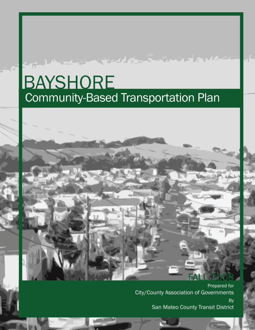
BAYSHORECommunity-Based Transportation Plan
Prepared forCity/County Association of Governments
FALL 2008
BAYSHORE COMMUNITY-BASED TRANSPORTATION PLAN (CBTP)
Acknowledgements A special thanks to the Bayshore Community-Based Transportation Plan Stakeholder Committee, the Daly City City Manager’s Office, and the Bayshore Community for their vital participation throughout the planning process.
Technical Advisory Committee Joseph Curran – City of Daly City Linda Holman – San Mateo County Human Services Agency Kevin Keck – San Francisco Municipal Transportation Authority Therese Knudsen – Metropolitan Transportation Commission Diana Shu – San Mateo County City/County Association of Governments Peter Straus - San Francisco Municipal Transportation Authority Danica Toy – San Mateo County Human Services Agency
San Mateo County Transit District Project Team Corinne Goodrich – Manager, Strategic Development Ronny Kraft – Project Manager Marion Payet – Senior Planner Cherry Chaicharn – Senior Planner Kimberly O’Neill – Intern, Strategic Development 1250 San Carlos Avenue San Carlos, CA 94070
BAYSHORE COMMUNITY-BASED TRANSPORTATION PLAN (CBTP)
Table of Contents Executive Summary....................................................................................................................3
Bayshore Neighborhood Profile ..............................................................................................4 Community Outreach ..............................................................................................................5 Recommended Transportation Strategies ..............................................................................6 Action Plan..............................................................................................................................6
Chapter 1: Introduction ............................................................................................................11 Background...........................................................................................................................11 Bayshore Community-Based Transportation Plan ................................................................11 Project Area ..........................................................................................................................12
Chapter 2: Existing Conditions Summary ..............................................................................14 Demographics.......................................................................................................................14 Transportation .......................................................................................................................15 Other Planning Efforts...........................................................................................................23 Transportation Gaps .............................................................................................................25
Chapter 3: Community Outreach.............................................................................................26 Outreach Strategies ..............................................................................................................26 Stated Transportation Needs ................................................................................................28 Potential Solutions ................................................................................................................29
Chapter 4: Transportation Strategies .....................................................................................31 Evaluation of the Transportation Strategies ..........................................................................31 Evaluation Criteria.................................................................................................................33 Evaluation and Prioritization of Transportation Strategies ....................................................34
Chapter 5: Action Plan .............................................................................................................75 Summary of Transportation Strategies .................................................................................76 Implementation Timeline .......................................................................................................80
List of Tables Table ES- 1: Implementation Matrix..............................................................................................7 Table ES- 2: Next Steps .............................................................................................................10 Table 1: Stated Transportation Needs and Potential Strategies Matrix ......................................30 Table 2: Summary Evaluation of Transportation Strategies .......................................................35 Table 3: Potential Shuttle Stop Analysis .....................................................................................41 Table 4: Implementation Matrix...................................................................................................77 Table 5: Next Steps ....................................................................................................................80
List of Figures Figure 1: Project Area .................................................................................................................12 Figure 2: Aerial View of the Project Area ....................................................................................13 Figure 3: Racial Breakdown........................................................................................................14 Figure 4: Major Roads ................................................................................................................16 Figure 5: SamTrans Fixed Routes ..............................................................................................18 Figure 6: Muni Fixed Routes.......................................................................................................20 Figure 7: Mode of Commute in the Bayshore Neighborhood......................................................22 Figure 8: Geneva Avenue and Bayshore Boulevard...................................................................60 Figure 9: Main Street and Bayshore Boulevard ..........................................................................60
BAYSHORE COMMUNITY-BASED TRANSPORTATION PLAN (CBTP)
Appendices (separate document) Appendix A: Stakeholder Committee…………………………………………………………………...2 Appendix B: Existing Conditions Report….................................................................................... 3 Appendix C: Community Outreach Results……………………………..…………………………… 48 Appendix D: Funding Sources………………………………………………………………………… 67

BAYSHORE COMMUNITY-BASED TRANSPORTATION PLAN (CBTP)
Executive Summary The Bayshore Community-Based Transportation Plan (CBTP) examines the transportation needs of the Bayshore community in Daly City and recommends steps to address these needs. This project is part of the Metropolitan Transportation Commission’s (MTC) Community-Based Transportation Planning Program, a collaborative planning process to identify transportation needs in low-income communities throughout the region. With a strong emphasis on community participation, the Bayshore CBTP identifies transportation gaps within the Bayshore neighborhood, and recommends projects to address them. Daly City is located at the northernmost tip of San Mateo County, adjacent to San Francisco City and County. The Bayshore neighborhood is located in the far eastern part of Daly City to the north of Brisbane. The northern border of the project area lies on the border between San Mateo County and San Francisco. The study area for this plan was defined in consultation with the City of Daly City and includes U.S. Census Tract 6002. A Technical Advisory Committee was formed to oversee the development of this plan and includes representatives of MTC, Daly City, the San Mateo County City/County Association of Governments (C/CAG), the San Francisco Municipal Transportation Authority (SFMTA), and the San Mateo County Human Services Agency (HSA).
Bayshore Neighborhood Profile Demographics The population of the Bayshore neighborhood is 3,890 people, which is 3.75% of Daly City’s total population, according to the 2000 U.S. Census. The residents of the Bayshore neighborhood are slightly younger than Daly City and San Mateo County as a whole. The racially diverse nature of this neighborhood mirrors that of Daly City with Asians comprising 57% of the population, 24% Hispanic/Latino, 10% African American, and 7% Caucasian. Twenty-eight percent of the Bayshore’s households are considered linguistically isolated and a relatively high percentage of households are below the poverty line when compared to Daly City and the County. Approximately two-thirds of the housing units in the project area are owned by the householder.
Transportation The City of Daly City is served by many transit agencies, including two major BART lines (Daly City to Richmond and Daly City to Fremont), SamTrans, Muni, and Caltrain (at Bayshore Station). Two SamTrans school service routes, 24 and 121, serve the Bayshore neighborhood along Geneva Avenue. SamTrans regular fixed routes 292 and 397 run adjacent to the project area along Bayshore Boulevard to the east. Also operated by SamTrans, the combination fixed-route demand response Bayshore/Brisbane shuttle serves the project area, and connects to the Bayshore Caltrain Station and the City of Brisbane during the midday on weekdays.
PAGE 4 OF 81
BAYSHORE COMMUNITY-BASED TRANSPORTATION PLAN (CBTP)
Community Outreach Community outreach was conducted to increase the participation of residents, community-based organizations (CBO’s) and agencies serving the Bayshore community in the planning process. A Stakeholder Committee was appointed by Daly City staff and 17 active members provided guidance and input to the planning process and work products. In addition, the San Mateo County Transit District (District) conducted the following outreach strategies:
1. Resident Survey 2. CBO/Agency Interviews 3. Presentations 4. Public Service Announcements 5. Targeted Mailing List 6. Hotline
Listed below are the most commonly stated transportation needs that were developed from all of the above outreach efforts. The stated transportation needs generally fell into three categories:
• Access to transit and community facilities within the Project Area • Access to places outside of the Project Area • Information and Cost
These three categories were used throughout the remainder of the planning process and this report to group the stated transportation needs and their corresponding transportation strategies.
Stated Transportation Needs Access to transit and community facilities within the Project Area 1. A shelter is needed at the bus stop at the corner of Bayshore Blvd and Geneva Ave, in front
of the 7-Mile House Restaurant. 2. Better transit amenities are needed. 3. Residents do not feel safe waiting at transit stops. 4. Walking is dangerous because of fast moving traffic and insufficient crossing time. 5. The Muni stop at Santos Street and Geneva Avenue is difficult to get to from most parts of
the neighborhood. 6. It is difficult to walk up the hill to the residences at the southern part of the project area, the
community center, and library. 7. Regular fixed-route bus service that goes through the neighborhood is needed. Access to places outside of the Project Area: 8. Getting to the western portion of Daly City for shopping, grocery, and medical appointments
is difficult and time consuming on transit. Destinations in this area include: A) Safeway Food and Drug, 4950 Mission St. SF & 85 Westlake Ave. B) Shopping in the Westlake District John Daly Blvd. & Lake Merced Blvd. C) Serramonte Shopping Center, 3 Serramonte Ctr. Daly City D) Doelger Senior Center, 101 Lake Merced Blvd. Daly City E) North Peninsula Food Pantry, 31 Beppler St. Daly City F) Seton Hospital, 1900 Sullivan Ave in Daly City G) Daly City Clinic, 380 90th St in Daly City
PAGE 5 OF 81
BAYSHORE COMMUNITY-BASED TRANSPORTATION PLAN (CBTP)
PAGE 6 OF 81
9. It is difficult to get to Balboa Park BART and Daly City BART. 10. Residents need better access to transit that serves City College. 11. Residents need better access to transit that serves Chinatown and downtown San
Francisco. 12. Residents need better transportation to grocery stores. 13. Residents need better connections to Kaiser Hospital in South San Francisco. 14. School District finances are stretched to provide bus service from the Bayshore
neighborhood to high schools. 15. Taxis often will not serve the Bayshore neighborhood. Information and Cost: 16. There is a lack of information about transportation options. 17. There is a need for information about transportation options in languages other than
English. 18. Transferring between public transit systems is costly.
Recommended Transportation Strategies A list of potential strategies was formed to address the transportation needs identified through the outreach process. These potential strategies were categorized by the need group they would address and then developed into recommended transportation strategies. Each of these strategies, which are detailed in Chapter 4, include an explanation of the specific transportation needs they address, a project description, potential transportation and community impacts, implementation requirements, further analysis need/ongoing study, and financial considerations. Each strategy also contains an analysis of the project against evaluative criteria.
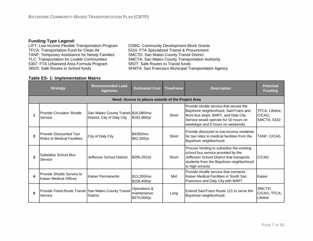
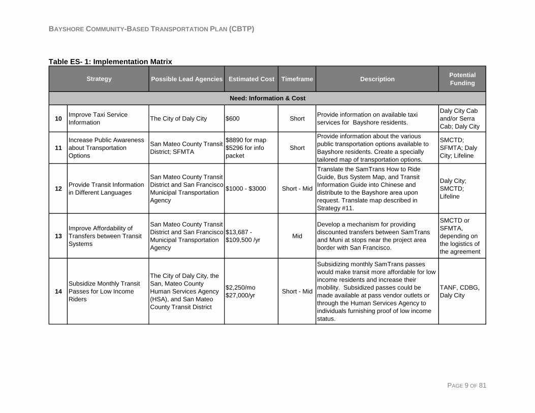
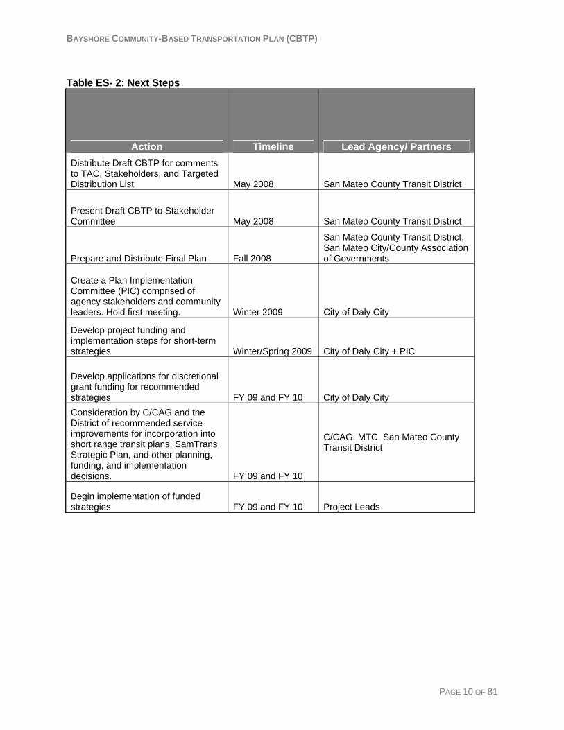
Action Plan The success of this Community-Based Transportation Plan will depend on moving forward with timely implementation of the recommended strategies. Table ES-1 shows the 14 recommended transportation strategies along with their corresponding lead agency, estimated cost, timeframe, and potential funding sources. Proposed implementation actions and responsibilities for the coming months are shown in Table ES- 2.
BAYSHORE COMMUNITY-BASED TRANSPORTATION PLAN (CBTP)
Funding Type Legend: LIFT: Low Income Flexible Transportation Program CDBG: Community Development Block Grants TFCA: Transportation Fund for Clean Air 5310: FTA Specialized Transit & Procurement TANF: Temporary Assistance for Needy Families SMCTD: San Mateo County Transit District TLC: Transportation for Livable Communities SMCTA: San Mateo County Transportation Authority 5307: FTA Urbanized Area Formula Program SR2T: Safe Routes to Transit funds SR2S: Safe Routes to School funds SFMTA: San Francisco Municipal Transportation Agency Table ES- 1: Implementation Matrix
Recommended Lead Agencies Estimated Cost Timeframe Description Potential
Funding
1 Provide Circulator Shuttle Service
San Mateo County Transit District; City of Daly City
$16,080/mo$192,960/yr Short
Provide shuttle service that serves the Bayshore neighborhood, SamTrans and Muni bus stops, BART, and Daly City. Service would operate for 10 hours on weekdays and 6 hours on weekends.
TFCA; Lifeline; C/CAG; SMCTA; 5310
2 Provide Discounted Taxi Rides to Medical Facilities City of Daly City $4350/mo
$52,200/yr ShortProvide discounts to low-income residents for taxi rides to medical facilities from the Bayshore neighborhood.
TANF; C/CAG
3 Subsidize School Bus Service Jefferson School District $295,291/yr Short
Procure funding to subsidize the existing school bus service provided by the Jefferson School District that transports students from the Bayshore neighborhood to high schools.
C/CAG
4 Provide Shuttle Service to Kaiser Medical Offices Kaiser Permanente $13,200/mo
$158,400/yrMid
Provide shuttle service that connects Kaiser Medical Facilities in South San Francisco and Daly City with BART.
Kaiser
5 Provide Fixed-Route Transit Service
San Mateo County Transit District
Operations & maintenance$370,000/yr
Long Extend SamTrans Route 121 to serve the Bayshore neighborhood.
SMCTD; C/CAG; TFCA; Lifeline
Strategy
Need: Access to places outside of the Project Area
PAGE 7 OF 81
BAYSHORE COMMUNITY-BASED TRANSPORTATION PLAN (CBTP)
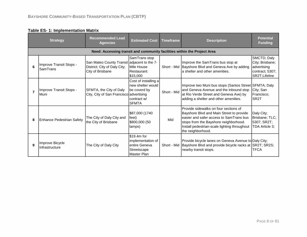
Table ES- 1: Implementation Matrix
Recommended Lead Agencies Estimated Cost Timeframe Description Potential
Funding
6 Improve Transit Stops - SamTrans
San Mateo County Transit District; City of Daly City; City of Brisbane
SamTrans stop adjacent to the 7-Mile House Restaurant: $15,000
Short - MidImprove the SamTrans bus stop at Bayshore Blvd and Geneva Ave by adding a shelter and other amenities.
SMCTD; Daly City; Brisbane; advertising contract; 5307; SR2T;Lifeline
7 Improve Transit Stops - Muni
SFMTA, the City of Daly City, City of San Francisco
Cost of installing a new shelter would be coverd by advertising contract w/ SFMTA
Short - Mid
Improve two Muni bus stops (Santos Street and Geneva Avenue and the inbound stop at Rio Verde Street and Geneva Ave) by adding a shelter and other amenities.
SFMTA; Daly City; San Francisco; SR2T
8 Enhance Pedestrian Safety The City of Daly City and the City of Brisbane
$87,000 (1740 feet)$800,000 (50 lamps)
Mid
Provide sidewalks on four sections of Bayshore Blvd and Main Street to provide easier and safer access to SamTrans bus stops from the Bayshore neighborhood. Install pedestrian-scale lighting throughout the neighborhood.
Daly City; Brisbane; TLC; 5307; SR2T; TDA Article 3;
9 Improve Bicycle Infrastructure The City of Daly City
$19.4m for implementation of entire Geneva Streetscape Master Plan
Short - MidProvide bicycle lanes on Geneva Avenue to Bayshore Blvd and provide bicycle racks at nearby transit stops.
Daly City; SR2T; SR2S; TFCA
Strategy
Need: Accessing transit and community facilities within the Project Area
PAGE 8 OF 81
BAYSHORE COMMUNITY-BASED TRANSPORTATION PLAN (CBTP)
PAGE 9 OF 81
Table ES- 1: Implementation Matrix
Possible Lead Agencies Estimated Cost Timeframe Description Potential Funding
10 Improve Taxi Service Information The City of Daly City $600 Short Provide information on available taxi
services for Bayshore residents.
Daly City Cab and/or Serra Cab; Daly City
11Increase Public Awareness about Transportation Options
San Mateo County Transit District; SFMTA
$8890 for map$5296 for info packet
Short
Provide information about the various public transportation options available to Bayshore residents. Create a specially tailored map of transportation options.
SMCTD; SFMTA; Daly City; Lifeline
12 Provide Transit Information in Different Languages
San Mateo County Transit District and San Francisco Municipal Transportation Agency
$1000 - $3000 Short - Mid
Translate the SamTrans How to Ride Guide, Bus System Map, and Transit Information Guide into Chinese and distribute to the Bayshore area upon request. Translate map described in Strategy #11.
Daly City; SMCTD; Lifeline
13Improve Affordability of Transfers between Transit Systems
San Mateo County Transit District and San Francisco Municipal Transportation Agency
$13,687 - $109,500 /yr Mid
Develop a mechanism for providing discounted transfers between SamTrans and Muni at stops near the project area border with San Francisco.
SMCTD or SFMTA, depending on the logistics of the agreement
14Subsidize Monthly Transit Passes for Low Income Riders
The City of Daly City, the San, Mateo County Human Services Agency (HSA), and San Mateo County Transit District
$2,250/mo$27,000/yr Short - Mid
Subsidizing monthly SamTrans passes would make transit more affordable for low income residents and increase their mobility. Subsidized passes could be made available at pass vendor outlets or through the Human Services Agency to individuals furnishing proof of low income status.
TANF, CDBG, Daly City
Strategy
Need: Information & Cost
BAYSHORE COMMUNITY-BASED TRANSPORTATION PLAN (CBTP)
Table ES- 2: Next Steps
Action Timeline Lead Agency/ Partners Distribute Draft CBTP for comments to TAC, Stakeholders, and Targeted Distribution List May 2008 San Mateo County Transit District
Present Draft CBTP to Stakeholder Committee May 2008 San Mateo County Transit District
Prepare and Distribute Final Plan Fall 2008
San Mateo County Transit District, San Mateo City/County Association of Governments
Create a Plan Implementation Committee (PIC) comprised of agency stakeholders and community leaders. Hold first meeting. Winter 2009 City of Daly City
Develop project funding and implementation steps for short-term strategies Winter/Spring 2009 City of Daly City + PIC
Develop applications for discretional grant funding for recommended strategies FY 09 and FY 10 City of Daly City Consideration by C/CAG and the District of recommended service improvements for incorporation into short range transit plans, SamTrans Strategic Plan, and other planning, funding, and implementation decisions. FY 09 and FY 10
C/CAG, MTC, San Mateo County Transit District
Begin implementation of funded strategies FY 09 and FY 10 Project Leads
PAGE 10 OF 81
BAYSHORE COMMUNITY-BASED TRANSPORTATION PLAN (CBTP)
Chapter 1: Introduction Background The Bayshore Community-Based Transportation Plan (CBTP) examines the transportation needs of the Bayshore community in Daly City and recommends steps to address these needs. This project is part of the Metropolitan Transportation Commission’s (MTC) Community-Based Planning Program, a collaborative planning process to identify transportation needs in low-income communities throughout the region. The CBTP program evolved out of two reports completed in 2001 - the Lifeline Transportation Network Report and the Environmental Justice Report. The Lifeline Report identified travel needs in low-income communities and recommended community-based transportation planning as a way for communities to set priorities and evaluate options for filling transportation gaps. Using the Lifeline Report as a starting point, the Bayshore CBTP identifies transportation gaps within the Bayshore neighborhood, and recommends projects to address them. The MTC Lifeline Transportation Planning Program objectives include:
• Target planning efforts in low income communities
• Facilitate community participation in prioritizing transportation needs and identify potential solutions
• Cultivate collaboration between the community, transit agencies, congestion management agencies and MTC
• Build community capacity through Community Based Organization involvement in the planning process
In accordance with MTC guidelines, this Community-Based Transportation Plan is being conducted under the auspices of the San Mateo City/County Association of Governments (C/CAG), in its role as the Congestion Management Agency for the county. C/CAG selected the San Mateo County Transit District (the District) to conduct the planning process for the Bayshore CBTP.
Bayshore Community-Based Transportation Plan The community-based planning process is a collaborative effort which involves extensive community and stakeholder involvement at every stage of the planning process. A Technical Advisory Committee comprised of staff representing the City of Daly City, the San Mateo County Human Services Agency (HSA), C/CAG, MTC, the San Francisco Municipal Transportation Agency (SFMTA) and the District was formed to oversee the process. Additionally, a Stakeholder Committee, comprised of Bayshore residents, community based organizations, and stakeholders, was appointed by city staff and provided input throughout the planning process. Chapter 2 contains a summary of existing conditions of the Bayshore CBTP project area. These include information about demographics, transportation, and other planning efforts that affect the area.
PAGE 11 OF 81

BAYSHORE COMMUNITY-BASED TRANSPORTATION PLAN (CBTP)
Chapter 3 explains the community outreach process and presents the results. This chapter also contains a list of stated transportation needs and potential solutions which emerged from the outreach findings. Chapter 4 contains a program of fourteen transportation strategies to address the transportation needs identified through the outreach process. The strategy descriptions each contain:
• Transportation Need Addressed • Project Description • Potential Transportation & Community Impacts • Implementation Requirements • Potential Funding and Cost Estimate
Chapter 5 contains an action plan which outlines some suggested next steps for successful implementation of the strategies outlined in Chapter 4.
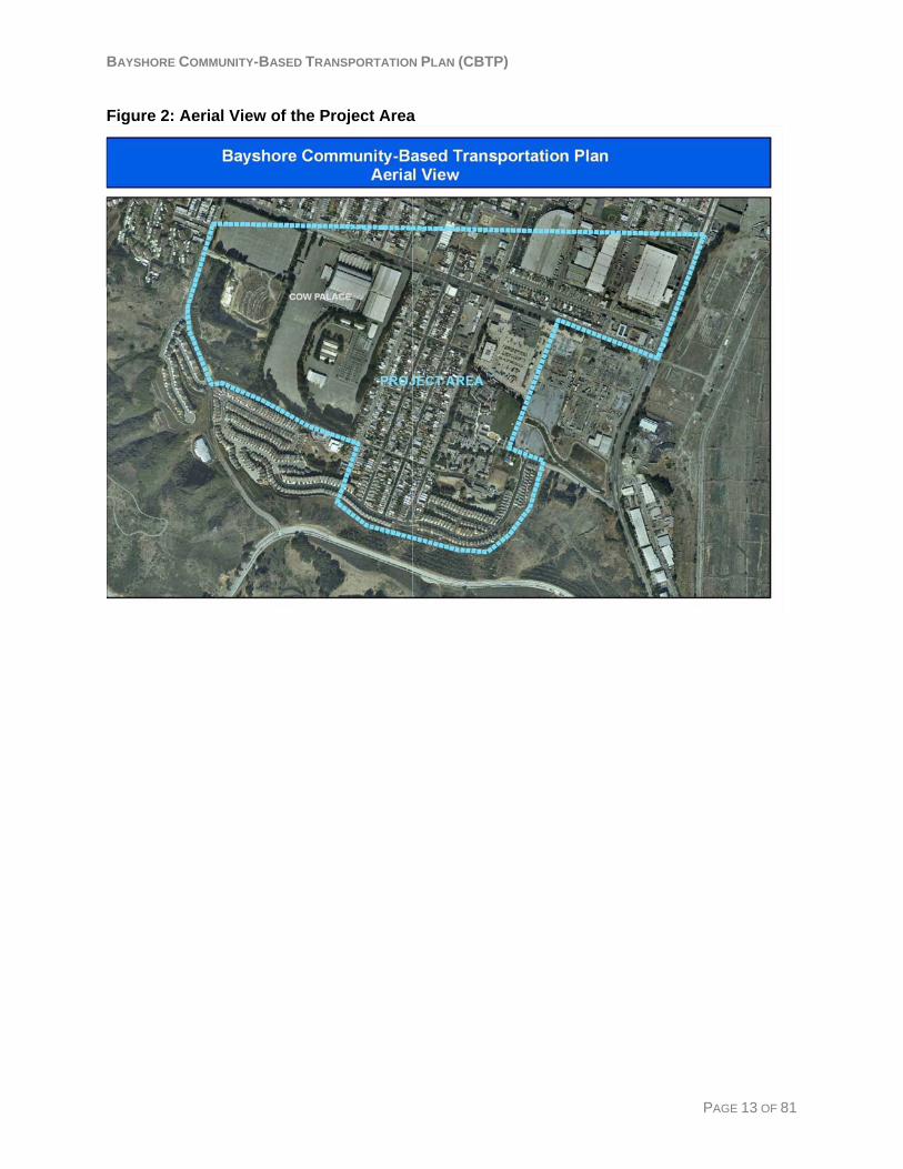
Project Area Daly City is located at the northern borderof San Mateo County, adjacent to San Francisco City and County. The Bayshore neighborhood is located in the far eastern part of Daly City to the north of the city of Brisbane. The northern border of the project area lies on the border between San Mateo County and San Francisco. The study area for this plan was defined in consultation with the City of Daly City and includes U.S. Census Tract 6002 as shown in the maps below. Figure 1: Project Area
PAGE 12 OF 81
BAYSHORE COMMUNITY-BASED TRANSPORTATION PLAN (CBTP)
Figure 2: Aerial View of the Project Area
PAGE 13 OF 81
BAYSHORE COMMUNITY-BASED TRANSPORTATION PLAN (CBTP)
Chapter 2: Existing Conditions Summary This section contains a summary of the Existing Conditions Report that was completed September 2007 prior to conducting the community outreach process. The full version of this report can be found in Appendix B.
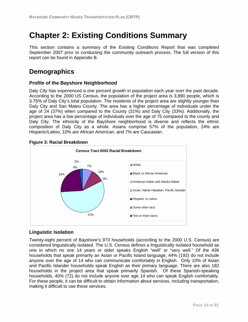
Demographics Profile of the Bayshore Neighborhood Daly City has experienced a one percent growth in population each year over the past decade. According to the 2000 US Census, the population of the project area is 3,890 people, which is 3.75% of Daly City’s total population. The residents of the project area are slightly younger than Daly City and San Mateo County. The area has a higher percentage of individuals under the age of 24 (37%) when compared to the County (31%) and Daly City (33%). Additionally, the project area has a low percentage of individuals over the age of 75 compared to the county and Daly City. The ethnicity of the Bayshore neighborhood is diverse and reflects the ethnic composition of Daly City as a whole. Asians comprise 57% of the population, 24% are Hispanic/Latino, 10% are African American, and 7% are Caucasian. Figure 3: Racial Breakdown
Census Tract 6002 Racial Breakdown
7%
10%
0%
57%
24%
0%
2%White
Black or African American
American Indian and Alaska Native
Asian, Native Hawaiian, Pacific Islander
Hispanic or Latino
Some other race
Two or more races
Linguistic Isolation Twenty-eight percent of Bayshore’s 973 households (according to the 2000 U.S. Census) are considered linguistically isolated. The U.S. Census defines a linguistically isolated household as one in which no one 14 years or older speaks English “well” or “very well.” Of the 436 households that speak primarily an Asian or Pacific Island language, 44% (192) do not include anyone over the age of 14 who can communicate comfortably in English. Only 10% of Asian and Pacific Islander households speak English as their primary language. There are also 182 households in the project area that speak primarily Spanish. Of these Spanish-speaking households, 40% (72) do not include anyone over age 14 who can speak English comfortably. For these people, it can be difficult to obtain information about services, including transportation, making it difficult to use these services.
PAGE 14 OF 81
BAYSHORE COMMUNITY-BASED TRANSPORTATION PLAN (CBTP)
Incidence of Below Poverty Level Households The Bayshore neighborhood has a higher percentage of households living in poverty than Daly City and San Mateo County. Ten percent (266) of Bayshore households are below the poverty line, as compared to 7% of households in Daly City and 6% of households in San Mateo County.
Income About one quarter of the households in the Bayshore neighborhood have annual incomes between $50,000 and $75,000. The percentage of households with incomes less than $50,000 annually is slightly higher in the Bayshore area (39%) than in Daly City (37%) and San Mateo County (33%). Twelve percent (12%) of Bayshore households have annual incomes under $15,000, as compared to 9% and 7% of households in the City and County respectively Approximately two-thirds of the housing units in the project area are owned by the householder.
Crime According to the Daly City Records Management System, from January to June of 2007 the Bayshore neighborhood accounted for an average of 13.6% of the total number of crimes reported in Daly City. This is a disproportionate crime rate when considering that the Bayshore area’s population accounts for only 3.75% of Daly City’s total population.
Public Assistance The San Mateo County Human Services Agency, or HSA, offers several programs to aid adults, children, and families in financial need. Within the Bayshore neighborhood, 145 households utilize at least one HSA program.
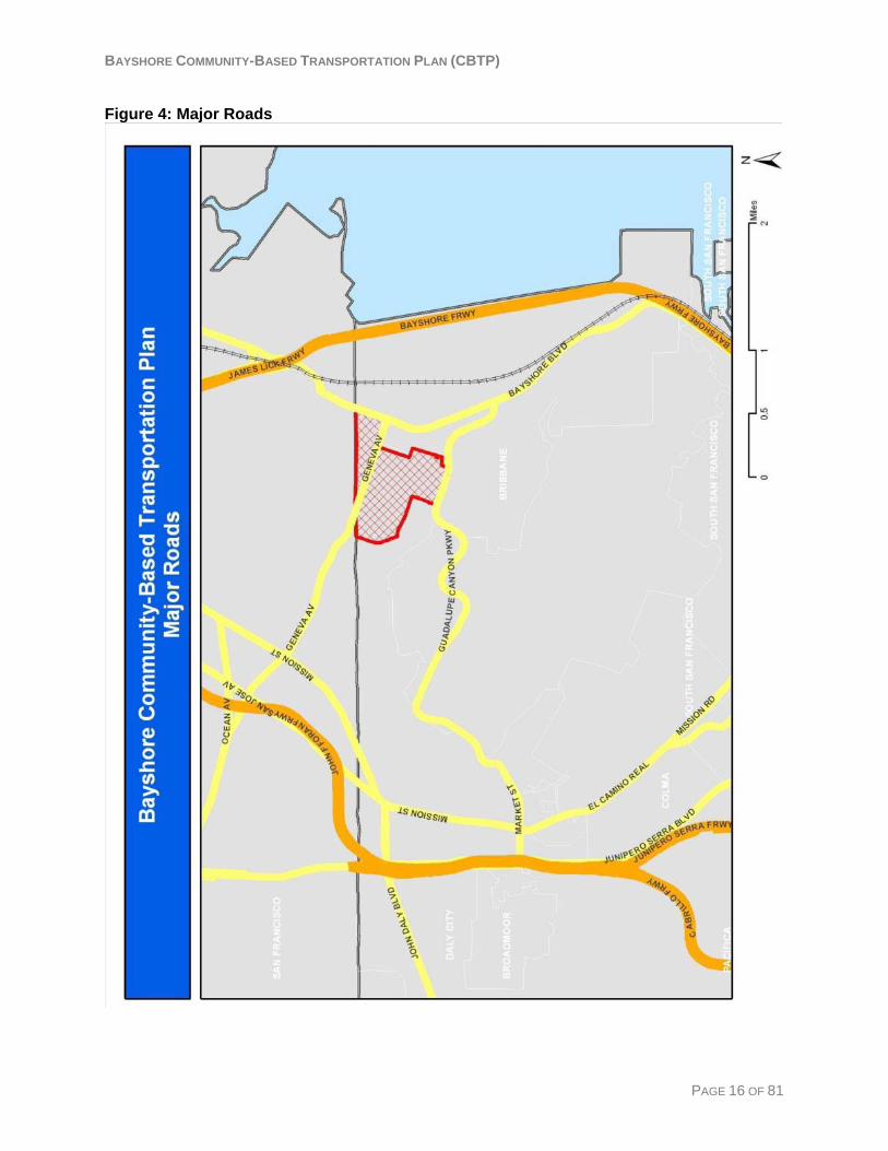
Transportation Road Access and Level of Service for Traffic The Bayshore neighborhood lies near U.S. Highway 101 to the east and Interstate 280 to the north. The area is served by two main arterial roads, Bayshore Boulevard and Geneva Avenue as shown in Figure 4. Bayshore Boulevard extends south from Highway 101 in San Francisco County into Brisbane. Geneva Avenue is a four-lane road that starts from a “T” intersection off Bayshore Boulevard and extends northwest into San Francisco County. Both Geneva Avenue and Bayshore Boulevard experience high levels of traffic and congestion. The level of traffic congestion is measured by Level of Service (LOS) using a ratio of the volume of traffic to the capacity of the roadway. The range in LOS is from A to F, with LOS A characterized as free flowing traffic conditions and progressing to LOS F or “bottleneck” situations. According to C/CAG, the county’s Congestion Management Agency (CMA), the level of service (LOS) for Geneva Avenue and Bayshore Boulevard was A in 1991. The most recent study from the San Mateo County CMA in 2005 shows the level of service has degraded to LOS E for both roadways.
PAGE 15 OF 81
BAYSHORE COMMUNITY-BASED TRANSPORTATION PLAN (CBTP)
Figure 4: Major Roads
PAGE 16 OF 81
BAYSHORE COMMUNITY-BASED TRANSPORTATION PLAN (CBTP)
Transit Service Overview The City of Daly City is served by many transit agencies, including two major BART lines (Daly City to Richmond and Daly City to Fremont), SamTrans, Muni, and Caltrain (at Bayshore Station). Two SamTrans school service routes, 24 and 121, serve the project area along Geneva Avenue. SamTrans regular fixed routes 292 and 397 run adjacent to the project area along Bayshore Boulevard to the east. Also operated by SamTrans, the combination fixed-route demand response Bayshore/Brisbane shuttle serves the project area, and connects to the Bayshore Caltrain Station and the City of Brisbane during the midday on weekdays. In June 2007, approximately 1% of Redi-Wheels paratransit trips taken by Daly City residents originated in the project area. The Bayshore neighborhood is relatively close to the Bayshore Caltrain station, yet there is no direct pedestrian or bicycle access to this station from the project area. Daly City BART is approximately five miles from the center of the Bayshore neighborhood. Muni fixed-route 9 serves the project area along Geneva Avenue and connects the neighborhood with downtown San Francisco. Express route 9X stops on the northern border of the project area at Geneva Avenue and Santos Street. Muni “Owl” service 91 also serves the project area along Geneva Avenue. The last stop for the new Muni Third Street light rail, also known as the “T” Line, is located at Sunnydale Avenue and Bayshore Boulevard, hundreds of feet beyond the San Francisco County line and the northeast corner of the project area. Biking to this station is possible, however Muni does not allow bicycles on its metro trains.
SamTrans The Bayshore is served by four SamTrans routes: 24, 121, 292, and 397 (Figure 5). Only route 292 runs on a 30-minute daily schedule, with service hours from 4 AM to 2 AM. Route 397 is late night “Owl” service which operates on hourly frequencies. Routes 24 and 121 are limited service routes serving schools on school days during the school year.
PAGE 17 OF 81

BAYSHORE COMMUNITY-BASED TRANSPORTATION PLAN (CBTP)
Figure 5: SamTrans Fixed Routes
PAGE 18 OF 81
BAYSHORE COMMUNITY-BASED TRANSPORTATION PLAN (CBTP)
Redi-Wheels Paratransit Service and Use Redi-Wheels is San Mateo County’s paratransit service and is available for disabled passengers who cannot independently ride regular SamTrans buses some or all of the time. Rides must be scheduled ahead of time. There are currently 924 registered Redi-Wheels riders in Daly City, which represents 13% of San Mateo County’s 7,188 eligible passengers. In the month of June 2007, there were 2,913 arranged trips through Redi-Wheels originating in Daly City, with 43% (1,261) of these trips having a destination still within Daly City. Other common destinations originating in Daly City were South San Francisco with 319 trips (11% of total trips), and San Francisco with 303 trips (10% of total trips). Redi-Wheels use by Bayshore residents is low on a per capita basis. Of the 2,913 Redi-Wheels trips occurring in Daly City in June 2007, an estimated 37 trips originated in the Bayshore area.
Caltrain Service and Ridership The closest Caltrain station to the residents of the Bayshore area is the Bayshore Station, located on Tunnel Avenue near its intersection with Lathrop Avenue. There is no direct pedestrian access to the station from the project area. Some Caltrain riders have found that the quickest access to the station from the intersection of Bayshore Blvd and Geneva Avenue is by walking on a path through a small stretch of private property. This is not an ideal situation and steps are being taken to resolve this issue.
MUNI Service and Ridership San Francisco Municipal Transportation Agency (Muni) provides service in San Francisco City and County. There are four Muni lines that run in or near to the Bayshore neighborhood (Figure 6). Muni 9 provides local service and Muni 9X provides express bus service for 20 hours of the day. Muni 9AX and 9BX are variations of the 9X express bus line that operate northbound during the AM peak and southbound during the PM peak period in place of the 9X. Muni “Owl” service 91 is also provided between 1 and 5 AM along the same streets used by the 9X. All Muni bus lines that run in or near the project area stop at the intersection of Geneva Avenue and Santos Street on the northern border of the project area between Daly City and San Francisco. The new Muni Metro T-Line began full service in April 2007. The T-Line runs underneath Market Street in San Francisco, follows Third Street south from the San Francisco 4th and King Caltrain station, and ends at Sunnydale Avenue and Bayshore Avenue. The Sunnydale stop is located about a tenth of a mile from the northeastern corner of the project area. T-Line Metro trains are currently scheduled to run on 9-10 minute headways.
PAGE 19 OF 81

BAYSHORE COMMUNITY-BASED TRANSPORTATION PLAN (CBTP)
Figure 6: Muni Fixed Routes
PAGE 20 OF 81
BAYSHORE COMMUNITY-BASED TRANSPORTATION PLAN (CBTP)
Muni will soon launch a Geneva Corridor Transit Priority Project that will look at measures to expedite transit movements along Geneva avenue. While the study will emphasize the street segment between Naples Street and Ocean Avenue, the segments east of Naples will be examined as well.
Bayshore/Brisbane Shuttle The Bayshore/Brisbane shuttle is a free demand response service operated by SamTrans that connects the Bayshore Caltrain Station with the Bayshore neighborhood and the City of Brisbane during the midday on weekdays. The shuttle service is designed to operate along a regular fixed-route until a ride request is made to the driver’s cell phone; however the shuttle is currently operating almost entirely on demand. The average ridership in June 2007 was 27 passengers per day. A SamTrans survey showed that 71% of riders listed their occupation as retired, 14% were disabled, and 15% took the shuttle to jobs. The Bayshore/Brisbane shuttle replaced the very low-performing SamTrans route 34 in August 2004. Several months before the route was canceled, staff from the cities and SamTrans began to work on a solution to the transportation needs for this area. A survey was performed to determine where the residents wished to travel. One of the options proposed was to work with Brisbane and Daly City to determine if there could be another way to provide more cost-effective service. The resulting Bayshore/Brisbane shuttle service successfully reaches its target market, costs less to provide than regular fixed-route bus service, and has received positive feedback from the community. The Bayshore/Brisbane shuttle is funded by C/CAG, the San Mateo County Transportation Authority (TA), Daly City, and Brisbane. In fiscal year 200505/06 the service cost $142,447 to operate for approximately 1,560 service hours. Annual ridership was approximately 7,500, yielding productivity of 4.8 passengers per hour at a cost of $12 per passenger.
Mode of Commute Eleven percent of the households in the Bayshore neighborhood do not have access to a car, as compared to 6% in San Mateo County and 8% in Daly City. Residents of both the Bayshore project area and Daly City have relatively high rates of transit use as compared to the State of California and San Mateo County. According to the 2000 U.S. Census, 16% (254 residents) of the Bayshore area population, and an even higher 18% (8,858) of Daly City’s population, use public transit for their work commute. In California and the County, public transit use for commute trips is 5% and 7%, respectively. Bayshore and Daly City residents also use other commute alternatives to driving alone at a higher rate than the state and county. Fifty-eight percent of both Bayshore and Daly City workers drive alone to work, while 72% of California workers and 73% of San Mateo County workers drive alone to work. In addition, the carpool rate in the project area is relatively high at 22%, compared to 20% in Daly City as a whole, 13% in the County, and 15% in the State.
PAGE 21 OF 81
BAYSHORE COMMUNITY-BASED TRANSPORTATION PLAN (CBTP)
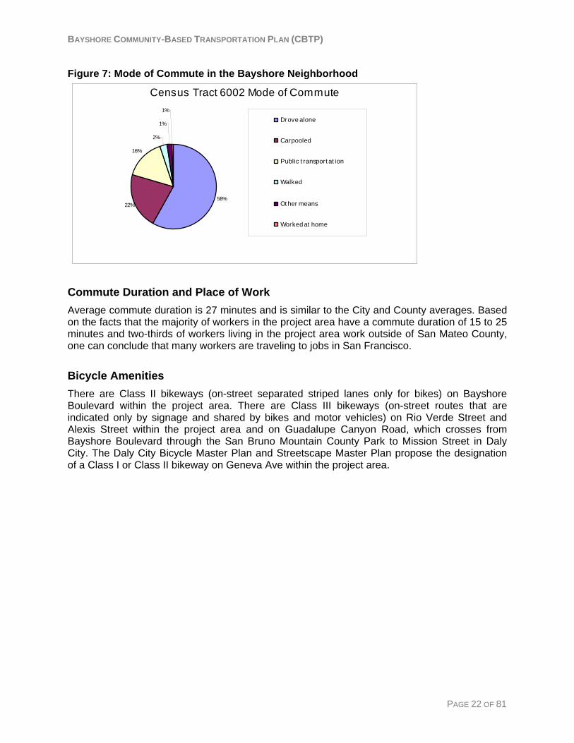
Figure 7: Mode of Commute in the Bayshore Neighborhood
Census Tract 6002 Mode of Commute
58%22%
16%
2%
1%
1%
Drove alone
Carpooled
Public t ransport at ion
Walked
Ot her means
Worked at home
Commute Duration and Place of Work Average commute duration is 27 minutes and is similar to the City and County averages. Based on the facts that the majority of workers in the project area have a commute duration of 15 to 25 minutes and two-thirds of workers living in the project area work outside of San Mateo County, one can conclude that many workers are traveling to jobs in San Francisco.
Bicycle Amenities There are Class II bikeways (on-street separated striped lanes only for bikes) on Bayshore Boulevard within the project area. There are Class III bikeways (on-street routes that are indicated only by signage and shared by bikes and motor vehicles) on Rio Verde Street and Alexis Street within the project area and on Guadalupe Canyon Road, which crosses from Bayshore Boulevard through the San Bruno Mountain County Park to Mission Street in Daly City. The Daly City Bicycle Master Plan and Streetscape Master Plan propose the designation of a Class I or Class II bikeway on Geneva Ave within the project area.
PAGE 22 OF 81
BAYSHORE COMMUNITY-BASED TRANSPORTATION PLAN (CBTP)
Other Planning Efforts Planning Documents The Bayshore neighborhood is a designated Daly City redevelopment area as described in the Bayshore Redevelopment Plan (July 1999). There is also a Geneva Avenue Urban Design Plan (January 2001) and a Geneva Streetscape Master Plan, which recommend specific operational and aesthetic improvements to Geneva Avenue within the Bayshore project area.
Daly City General Plan The Daly City General Plan identifies several goals for the Bayshore neighborhood. The General Plan also identifies several improvement constraints, including aging public utility systems, deteriorating physical infrastructure, and a lack of easily developable land within the Bayshore area. Since the City’s General Plan is presently under revision and further development, the Bayshore Redevelopment Project is a more current resource to the Community-Based Transportation Plan at this time.
Daly City Bayshore Redevelopment Project In June of 2007, the City of Daly City submitted an application to the regional FOCUSing Our Vision Program for Priority Development Area designation of the Bayshore neighborhood. The Bayshore Redevelopment Project Area of Daly City includes the Bayshore neighborhood, with a main commercial corridor along Geneva Avenue and a major activity center at the Cow Palace. The Redevelopment Project is generally described in the Bayshore Redevelopment Plan and has incorporated several other plans that focus on a particular region or aspect of redevelopment. These other major plans that include the Bayshore are the Geneva Avenue Urban Design Plan (2001), the Geneva Avenue Streetscape Master Plan (2002), and the Community Development Program for the Cow Palace/Carter Martin Area (2004). Bayshore Redevelopment Plan (July 1999) The Bayshore Redevelopment Plan emphasizes elimination of physical and economic conditions that restrict the successful revitalization of the Bayshore area by improving its commercial and residential areas. The Plan’s goals include: providing basic services to Project Area residents, implementing policies and objectives according to the City’s General Plan, protecting and preserving the residential areas during rehabilitation efforts to enhance the neighborhood’s character, promoting commercial development, and installation of improved public infrastructure. Geneva Avenue Urban Design Plan (January 2001) Geneva Avenue is a major thoroughfare of the Bayshore area. As part of the Bayshore Redevelopment Program, Daly City aims to make Geneva Avenue a more successful commercial corridor for the Bayshore community. The corridor serves as the “heart” of this community which connects San Francisco, Brisbane, and Daly City. The Geneva Avenue Urban Design Plan describes opportunities for economic development and public improvements, as well as design guidelines, promotional efforts, and implementation measures necessary for revitalization of this vital part of the Bayshore neighborhood. This revitalization includes providing more job opportunities for a variety of ages and income levels,
PAGE 23 OF 81
BAYSHORE COMMUNITY-BASED TRANSPORTATION PLAN (CBTP)
maximizing current land use, producing quality local services for the residents of the Bayshore area, encouraging local transit use, and creating a more walkable neighborhood. Geneva Avenue Streetscape Master Plan (2002) The Geneva Avenue Streetscape Plan describes specific improvements necessary to make Geneva Avenue more pedestrian friendly and bring higher levels of pedestrian activity to the corridor. These improvements include development of pedestrian infrastructure along the avenue and encouraging more economic activity along the commercial corridor. Pedestrian safety and the Avenue’s functionality as a commercial destination are also addressed, as well as the Avenue’s aesthetic appeal. It will integrate a green environment within the urban setting and offers the foundation for high quality development that will revitalize the area. The implementation will be on a block-by-block basis starting at Santos Street and Bayshore Avenue simultaneously. The master plan was proposed to be implemented over two to five years. Community Development Program: Cow Palace/Carter Martin Area (July 2004) The Cow Palace Carter Street area is defined by Geneva Avenue to the north, Carter Street to the west, Martin Street to the south, and residential properties along Rio Verde Street to the east. The area currently includes the Cow Palace, the former Geneva Drive-In Theater, and an adjacent property facing Carter and Martin Streets that is owned by the Daly City Redevelopment Agency. According to the Bayshore Redevelopment Plan, these sites have been identified as Opportunity Sites for development. This Community Development Program aims to create more employment opportunities in the neighborhood by incorporating more commercial space into the site. Meanwhile, the program will keep a balance between commercial, residential, public, and open space in the area.
Transportation Plans The San Mateo County Welfare to Work Plan The San Mateo County Welfare to Work Transportation Planning Project was completed in April 2001. The Plan recommends a set of transportation strategies and implementation procedures to both improve the mobility of CalWORKs participants and other low-income individuals and connect them with employment opportunities. The Metropolitan Transportation Commission (MTC), in cooperation with the San Mateo County Human Services Agency (HSA) and the San Mateo County Transit District (the District), sponsored the development of the Plan. Relevant recommended strategies include:
• Improved Access to HSA One-Stop Centers • Fare Assistance • Children’s Transportation Program
SamTrans Short Range Transit Plan (FY 2003/04 – 2012/13) The six main objectives of the Plan are:
1. Multi-Modal Performance Monitoring System 2. 20-Year Strategic Plan 3. El Camino Grand Boulevard Initiative 4. Transit-Oriented Development (TOD) 5. Station Access Improvements 6. Clean Fuels
PAGE 24 OF 81

BAYSHORE COMMUNITY-BASED TRANSPORTATION PLAN (CBTP)
While each of these objectives is likely to affect the Bayshore area, some operations and financial plans outlined in the SRTP and predicted for the 20-year Strategic Plan have the potential to directly affect the project area:
• Prepare for Muni’s Third Street Light Rail service. • Work closely with cities to ensure coordination as they pursue their shuttle programs.
San Mateo County Human Services Agency Transportation Programs The Human Service Agency (HSA) in San Mateo County is currently able to provide a limited amount of bus passes, bus tickets and emergency taxi vouchers to participating CalWORKs clients who need transportation assistance. The HSA was recently awarded a Lifeline Transportation grant from the Metropolitan Transportation Commission to increase the availability of bus passes and taxi vouchers available to clients. The HSA also occasionally refers clients to the Family Loan Program run by the Family Service Agency, which can assist needy families in obtaining auto loans. The Bayshore Family Resource Center is located at the Bayshore Elementary School near the center of the project area. They can provide a limited number of bus tickets for parents and children to participate in self-sufficiency and/or family strengthening activities. The Daly City Community Services Center is located at 350 90th Street in Daly City, approximately five miles from the center of the project area. This is where CalWORKs clients living in the Bayshore area must travel to apply for HSA Services.
Transportation Gaps The MTC Lifeline report identifies SamTrans Route 292 as a Lifeline Transportation Network route because it serves a pre-defined concentration of CalWorks households, serves essential destinations and is a SamTrans trunkline route. A temporal gap analysis based on hours of operation and frequency of service shows that Route 292 does not represent a temporal gap. The project area is not specifically identified as a spatial gap in the report.
PAGE 25 OF 81
BAYSHORE COMMUNITY-BASED TRANSPORTATION PLAN (CBTP)
Chapter 3: Community Outreach The backbone of this Community-Based Transportation Plan is the input and support of the community and stakeholder agencies. Daly City and District staff partnered to involve residents, community-based organizations (CBO’s), and agencies serving the Bayshore community throughout the planning process. This chapter contains an explanation of the community outreach process and a summary of the outreach findings.
Outreach Strategies Community outreach was conducted from October to December 2007. Based upon input from the Stakeholder Committee meeting on August 27, the outreach strategies emphasized one-on-one contact with residents and other stakeholders. Each strategy was designed to elicit information on transportation needs and gaps and potential solutions. Objectives of the community outreach include:
• Maximize one-on-one contact with residents, organizations and other stakeholders • Gain a more thorough understanding of the community’s transportation needs and
service gaps • Learn about potential transportation solutions and available resources
Resident Survey The San Mateo County Transit District (District) created and distributed approximately 4,500 postage-paid surveys (1,500 in English, Spanish, and Chinese) targeted to Bayshore neighborhood residents. The survey asked residents to provide information about where they travel and by what mode, to identify transportation gaps and barriers that exist and help identify potential solutions to those gaps. Surveys in each of the three languages were distributed to:
• Every household (mailed to approximately 850 addresses) • Brown Bag food program • Bayshore Family Center • Lawson Hall • Bayshore Library/Community Center • Bayshore Childcare Center • Midway Village
Additionally, each student at the Bayshore Elementary and Intermediate School was given a survey in each language to take home and bring back to school. The classroom at each school that brought back the most completed surveys was rewarded with round-trip Caltrain tickets to use on a field trip. Resident surveys were also distributed at presentations made to community groups regarding the Bayshore Community-Based Transportation Plan. One hundred and fifteen resident surveys were returned (79 English, 21 Chinese, and 15 Spanish). This represents approximately four percent of Bayshore residents over the age of 15 and approximately 12% of households. Appendix C contains a copy of the resident survey and the results.
PAGE 26 OF 81
BAYSHORE COMMUNITY-BASED TRANSPORTATION PLAN (CBTP)
CBO/Agency Interviews One-on-one interviews were conducted over the phone with agencies and community based organizations that serve clients living in the Bayshore neighborhood. Interviewees were asked to identify the unmet transportation needs of their clients and to help identify solutions to those gaps. Interviews were completed with representatives of Operation Brown Bag/Second Harvest Food Bank, The North Peninsula Food Pantry and Dining Center of Daly City, San Mateo County Human Service Agency, and the Peninsula Works Children’s Fund. Appendix C contains detailed results of the CBO/agency interviews.
Presentations Three community organizations agreed to include the Community-Based Transportation Plan as an item on their meeting agendas. Presentations consisted of a brief summary of the Bayshore CBTP purpose and process as well as a discussion with meeting attendees regarding transportation gaps and solutions. These meetings also served as a means to spread the word about the Bayshore CBTP and to discover helpful resources to aid in meeting our outreach objective of maximizing contact with the Bayshore community. Presentations were made to the following community organizations:
• Bayshore School District School Board (Nov. 13, 2007) • Bayshore Residents Association (Dec. 4, 2007) • Bayshore Friendship Club (Dec. 6, 2007)
Appendix C contains detailed results of the outreach presentations.
Public Service Announcements A public service announcement was posted on the Daly City local access cable channel notifying the public of the CBTP planning process, the opportunity to respond to the resident survey, and the opportunity to have a presentation given to stakeholder organizations.
Targeted Mailing List All individuals, agencies, businesses, and CBOs that provided their contact information at any meeting, via e-mail, or via phone were added to a project mailing list. Notification of the release of the draft CBTP and request for comments were mailed to this list.
Hotline All of the outreach materials - the resident survey, press release, fact sheet, and meeting materials - included the project manager’s name and contact information. Two calls were received during the outreach process.
PAGE 27 OF 81
BAYSHORE COMMUNITY-BASED TRANSPORTATION PLAN (CBTP)
Stated Transportation Needs The following is a list of the most commonly stated transportation needs collected from all of the outreach efforts described in the previous section, including: the resident survey, CBO/agency interviews, stakeholder meetings, community meetings, and the telephone hotline. The stated transportation needs generally fell into three areas of need:
• Access to transit and community facilities within the Project Area
• Access to places outside of the Project Area
• Information and Cost These three categories were used throughout the remainder of the planning process and this report to group the stated transportation needs and their corresponding transportation strategies.
Stated Transportation Needs Access to transit and community facilities within the Project Area 19. A shelter is needed at the bus stop at the corner of Bayshore Blvd and Geneva Ave, in front
of the 7-Mile House Restaurant. 20. Better transit amenities are needed. 21. Residents do not feel safe waiting at transit stops. 22. Walking is dangerous because of fast moving traffic and insufficient crossing time. 23. The Muni stop at Santos St and Geneva Ave is difficult to get to from most parts of the
neighborhood. 24. It is difficult to walk up the hill to the residences at the southern part of the project area, the
community center, and library. 25. Regular fixed-route bus service that goes through the neighborhood is needed. Access to places outside of the Project Area: 26. Getting to the western portion of Daly City for shopping, grocery, and medical appointments
is difficult and time consuming on transit. Destinations in this area include: A) Safeway Food and Drug, 4950 Mission St. SF & 85 Westlake Ave. B) Shopping in the Westlake district, John Daly Blvd. & Lake Merced Blvd. C) Serramonte Shopping Center, 3 Serramonte Ctr. Daly City D) Doelger Senior Center, 101 Lake Merced Blvd. Daly City E) North Peninsula Food Pantry, 31 Beppler St. Daly City F) Seton Hospital, 1900 Sullivan Ave in Daly City G) Daly City Clinic, 380 90th St in Daly City
27. It is difficult to get to Balboa Park BART and/or Daly City BART. 28. Residents need better access to transit that serves City College. 29. Residents need better access to transit that serves Chinatown and downtown San
Francisco. 30. Residents need better transportation to grocery stores. 31. Residents need better connections to Kaiser Hospital in South San Francisco. 32. School District finances are stretched to provide bus service from the Bayshore
neighborhood to high schools. 33. Taxis often will not serve the Bayshore neighborhood.
PAGE 28 OF 81
BAYSHORE COMMUNITY-BASED TRANSPORTATION PLAN (CBTP)
Information and Cost: 34. There is a lack of information about transportation options. 35. There is a need for information about transportation options in languages other than
English. 36. Transferring between public transit systems is costly.
Potential Solutions The following table shows the stated transportation needs from the previous section and some corresponding potential solutions that were proposed during the outreach process or suggested by District and Muni staff. These “Stated Needs” and “Potential Solutions” were reviewed by the Technical Advisory Committee, Stakeholder Committee, and District staff. Chapter 4 presents the potential solutions that were developed into transportation strategies.
PAGE 29 OF 81
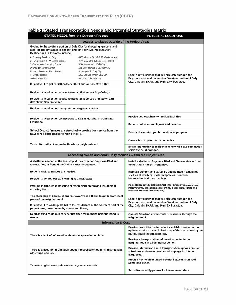
BAYSHORE COMMUNITY-BASED TRANSPORTATION PLAN (CBTP)
Table 1: Stated Transportation Needs and Potential Strategies Matrix POTENTIAL SOLUTIONS
A) Safeway Food and Drug 4950 Mission St. SF & 85 Westlake Ave. B) Shopping in the Westlake district John Daly Blvd. & Lake Merced Blvd. C) Serramonte Shopping Center 3 Serramonte Ctr. Daly CityD) Doelger Senior Center 101 Lake Merced Blvd. Daly CityE) North Peninsula Food Pantry 31 Beppler St. Daly CityF) Seton Hospital 1900 Sullivan Ave in Daly CityG) Daly City Clinic 380 90th St in Daly City
Provide taxi vouchers to medical facilities.
Kaiser shuttle for employees and patients.
Free or discounted youth transit pass program.
Outreach to City and taxi companies.
Better information to residents as to which cab companies serve the neighborhood.
Install a shelter at Bayshore Blvd and Geneva Ave in front of the 7-mile House Restaurant.
Pedestrian safety and comfort improvements (streetscape improvements, pedestrian-scale lighting, longer signal timing and increased crosswalk visibility etc.).
Operate SamTrans fixed-route bus service through the neighborhood.
Provide more information about available transportation options, such as a specialized map of the area showing bus routes, shutle information, etc.
Provide a transportation information center in the neighborhood at a community center.
Provide information about transportation options, transit schedules and routes, and transit signage in different languages.
Provide free or discounted transfer between Muni and SamTrans buses.
Subsidize monthly passes for low-income riders.
Transferring between public transit systems is costly.
There is a lack of information about transportation options.
Taxis often will not serve the Bayshore neighborhood.
Accessing transit and community facilities within the Project Area
Information & Cost
The Muni stop at Santos St and Geneva Ave is difficult to get to from most parts of the neighborhood.
It is difficult to walk up the hill to the residences at the southern part of the project area, the community center and library.
Getting to the western portion of Daly City for shopping, grocery, and medical appointments is difficult and time consuming on transit. Destinations in this area include:
A shelter is needed at the bus stop at the corner of Bayshore Blvd and Geneva Ave, in front of the 7-Mile House Restaurant.
It is difficult to get to Balboa Park BART and/or Daly City BART.
School District finances are stretched to provide bus service from the Bayshore neighborhood to high schools.
There is a need for information about transportation options in languages other than English.
Residents need better access to transit that serves Chinatown and downtown San Francisco.
Residents do not feel safe waiting at transit stops.
Walking is dangerous because of fast moving traffic and insufficient crossing time.
Residents need better transportation to grocery stores.
Regular fixed-route bus service that goes through the neighborhood is needed.
Better transit amenities are needed.
STATED NEEDS from the Outreach Process
Residents need better connections to Kaiser Hospital in South San Francisco.
Access to places outside of the Project Area:
Local shuttle service that will circulate through the Bayshore area and connect to: Western portion of Daly City, Caltrain, BART, and Muni 9/9X bus stop.
Residents need better access to transit that serves City College.
Local shuttle service that will circulate through the Bayshore area and connect to: Western portion of Daly City, Caltrain, BART, and Muni 9X bus stop.
Increase comfort and safety by adding transit amenities such as lit shelters, trash receptacles, benches, information, and map displays.
PAGE 30 OF 81
BAYSHORE COMMUNITY-BASED TRANSPORTATION PLAN (CBTP)
Chapter 4: Transportation Strategies Evaluation of the Transportation Strategies The community outreach process and stakeholder committee meetings identified both transportation needs and potential solutions. San Mateo County District staff developed the potential solutions into draft strategies by expanding the project description, and assessing likely transportation and community impacts, implementation requirements, and financial aspects. It also is noted where additional research is needed. The expanded potential strategies were evaluated against the criteria, which was approved by the TAC and Stakeholder Committee, to determine their feasibility and potential effectiveness in addressing the transportation needs of Bayshore residents. This section presents a summary of the strategies within each of the three transportation need categories. A description of the evaluation criteria can be found in the following section.
Strategies to Improve Access to Places Outside of the Project Area Bayshore residents’ transportation needs associated with access to places outside the project area generally concern taking medical trips, getting to the western portion of Daly City, getting to downtown San Francisco, and getting to BART stations. Based on the evaluation criteria the most potentially effective and feasible strategies are:
• Provide Circulator Shuttle Service that connects the Bayshore community with transit options and the western portion of Daly City (Strategy #1)
• Taxi Discount Program for rides to Medical Facilities (Strategy #2) Other strategies that would address some of these needs, but that may be less feasible because of certain barriers, are:
• Subsidize School Bus Service (Strategy #3) • Provide a Shuttle to Kaiser Medical Offices (Strategy #4) • Provide Fixed-Route Transit that goes through the project area (Strategy #5)
Strategies to Improve Access to Transit Services and Local Community Facilities Bayshore residents’ transportation needs associated with access to nearby transit and community facilities within the project area generally concern difficulty walking through the project area due to steep terrain, concerns about safety, traffic, and the amount of time it takes to walk to transit stops along the project area border. Based on the evaluation criteria the strategy that best meet the evaluation criteria is:
• Improve SamTrans Bus Stops within or adjacent to the project area (Strategy #6) Other strategies that may be harder to implement because of jurisdictional and cost issues are:
• Improve Muni Bus Stops within or adjacent to the project area (Strategy #7) • Enhance Pedestrian Safety (Strategy #8) • Improve Bicycle Infrastructure (Strategy #9)
PAGE 31 OF 81
BAYSHORE COMMUNITY-BASED TRANSPORTATION PLAN (CBTP)
Strategies to Improve Information and Reduce the Cost of Transportation Needs associated with information and cost issues generally concerned a lack of information among residents about transportation options, information translated to different languages, and the costs associated with living near the service areas of two different transit systems (SamTrans and Muni). The strategies that are the most feasible and have the most potential to be effective are:
• Improve Taxi Service Information (Strategy #10) • Increase Public Awareness about Transportation Options (Strategy #11) • Provide Transit Information in Different Languages (Strategy #12) • Improve the Affordability of Transfers between Transit Systems (Strategy #13)
The other strategy that may be difficult to implement because of organizational barriers but would have high community impact is:
• Subsidize Monthly Passes for Low Income Transit Riders (Strategy #14)
PAGE 32 OF 81
BAYSHORE COMMUNITY-BASED TRANSPORTATION PLAN (CBTP)
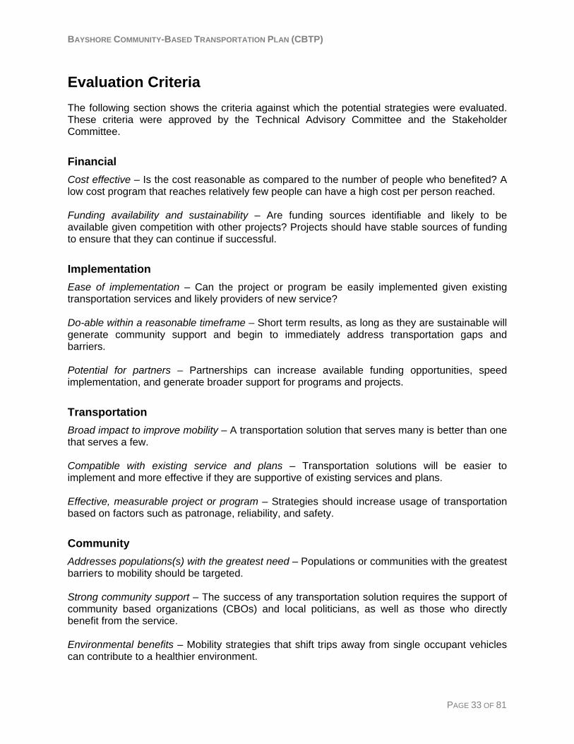
Evaluation Criteria The following section shows the criteria against which the potential strategies were evaluated. These criteria were approved by the Technical Advisory Committee and the Stakeholder Committee.
Financial Cost effective – Is the cost reasonable as compared to the number of people who benefited? A low cost program that reaches relatively few people can have a high cost per person reached. Funding availability and sustainability – Are funding sources identifiable and likely to be available given competition with other projects? Projects should have stable sources of funding to ensure that they can continue if successful.
Implementation Ease of implementation – Can the project or program be easily implemented given existing transportation services and likely providers of new service? Do-able within a reasonable timeframe – Short term results, as long as they are sustainable will generate community support and begin to immediately address transportation gaps and barriers. Potential for partners – Partnerships can increase available funding opportunities, speed implementation, and generate broader support for programs and projects.
Transportation Broad impact to improve mobility – A transportation solution that serves many is better than one that serves a few. Compatible with existing service and plans – Transportation solutions will be easier to implement and more effective if they are supportive of existing services and plans. Effective, measurable project or program – Strategies should increase usage of transportation based on factors such as patronage, reliability, and safety.
Community Addresses populations(s) with the greatest need – Populations or communities with the greatest barriers to mobility should be targeted. Strong community support – The success of any transportation solution requires the support of community based organizations (CBOs) and local politicians, as well as those who directly benefit from the service. Environmental benefits – Mobility strategies that shift trips away from single occupant vehicles can contribute to a healthier environment.
PAGE 33 OF 81
BAYSHORE COMMUNITY-BASED TRANSPORTATION PLAN (CBTP)
PAGE 34 OF 81
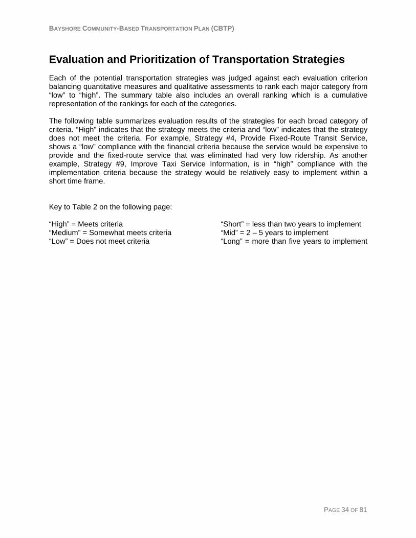
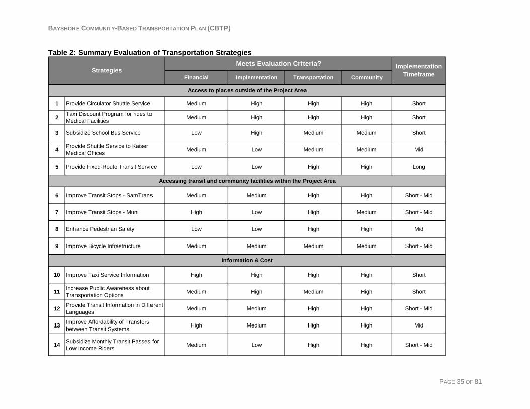
Evaluation and Prioritization of Transportation Strategies Each of the potential transportation strategies was judged against each evaluation criterion balancing quantitative measures and qualitative assessments to rank each major category from “low” to “high”. The summary table also includes an overall ranking which is a cumulative representation of the rankings for each of the categories. The following table summarizes evaluation results of the strategies for each broad category of criteria. “High” indicates that the strategy meets the criteria and “low” indicates that the strategy does not meet the criteria. For example, Strategy #4, Provide Fixed-Route Transit Service, shows a “low” compliance with the financial criteria because the service would be expensive to provide and the fixed-route service that was eliminated had very low ridership. As another example, Strategy #9, Improve Taxi Service Information, is in “high” compliance with the implementation criteria because the strategy would be relatively easy to implement within a short time frame. Key to Table 2 on the following page: “High” = Meets criteria “Short” = less than two years to implement “Medium” = Somewhat meets criteria “Mid” = 2 – 5 years to implement “Low” = Does not meet criteria “Long” = more than five years to implement
BAYSHORE COMMUNITY-BASED TRANSPORTATION PLAN (CBTP)
Table 2: Summary Evaluation of Transportation Strategies
Financial Implementation Transportation Community
1 Provide Circulator Shuttle Service Medium High High High Short
2 Taxi Discount Program for rides to Medical Facilities Medium High High High Short
3 Subsidize School Bus Service Low High Medium Medium Short
4 Provide Shuttle Service to Kaiser Medical Offices Medium Low Medium Medium Mid
5 Provide Fixed-Route Transit Service Low Low High High Long
6 Improve Transit Stops - SamTrans Medium Medium High High Short - Mid
7 Improve Transit Stops - Muni High Low High Medium Short - Mid
8 Enhance Pedestrian Safety Low Low High High Mid
9 Improve Bicycle Infrastructure Medium Medium Medium Medium Short - Mid
10 Improve Taxi Service Information High High High High Short
11 Increase Public Awareness about Transportation Options Medium High Medium High Short
12 Provide Transit Information in Different Languages Medium Medium High High Short - Mid
13 Improve Affordability of Transfers between Transit Systems High Medium High High Mid
14 Subsidize Monthly Transit Passes for Low Income Riders Medium Low High High Short - Mid
Access to places outside of the Project Area
Accessing transit and community facilities within the Project Area
Information & Cost
Strategies Implementation Timeframe
Meets Evaluation Criteria?
PAGE 35 OF 81
BAYSHORE COMMUNITY-BASED TRANSPORTATION PLAN (CBTP)
Recommended Transportation Strategies The following section shows the project details and evaluation for each of the fourteen strategies. Each strategy includes:
• A list of identified transportation needs of the Bayshore area that the strategy addresses • Project description • Potential transportation and community impacts • Potential funding sources and estimated cost • An evaluation of the project details against the criteria described in the previous section
PAGE 36 OF 81
BAYSHORE COMMUNITY-BASED TRANSPORTATION PLAN (CBTP)
Strategy #1: Provide Circulator Shuttle Service Transportation Needs Addressed:
• Getting to the western portion of Daly City for shopping, grocery, and medical appointments is difficult and time consuming on transit.
• Residents need better access to transit that serves Chinatown and downtown San Francisco.
• Residents need better connections to Kaiser Hospital in South San Francisco. • Residents need better transportation to grocery stores. • Residents need better access to transit that serves City College. • It is difficult to get to Balboa Park BART and/or Daly City BART. • It is difficult to access to destinations at the southern part of the project due to the steep
terrain. The resident survey results showed that there are three clusters of destinations for trips that residents reported were difficult to make: downtown San Francisco (57 mentions), western Daly City (54 mentions), and southern San Francisco (22 mentions). Common destinations in downtown San Francisco included Chinatown and Civic Center. Common destinations in Daly City included Serramonte Shopping Center, Westlake Shopping Center, and Seton Medical Center. Common destinations in southern San Francisco were City College, Balboa Park BART, and Safeway. ‘Grocery’ shopping and ‘Other Shopping’ were among the most common trip purposes of residents’ difficult trips. The other outreach efforts reflected these findings and also showed that residents often have a hard time traveling within the neighborhood due to the length of time it takes, the steep terrain, and limited mobility.
Project Description: Providing a circulator shuttle service would improve the mobility of Bayshore residents to important destinations. Potential circulator service shuttle stops are: the T-Line stop at Sunnydale Avenue, stops within the Bayshore neighborhood, Balboa Park BART, Top of the Hill (SamTrans and Muni connections), Daly City BART station, and Colma BART station. These stops would provide access to BART, Muni, and many SamTrans bus lines that connect with BART stations. The shuttle could share the existing bus stops and additional bus stops would be considered within the neighborhood. Potential Shuttle Route: One possible shuttle route would start at the intersection of Geneva Avenue and Bayshore Boulevard and enter the project area heading south on Schwerin Street, continue up the hill to Bay Ridge Drive and exit the project area by way of Rio Verde Street back to Geneva Avenue. The shuttle would then head northwest on Geneva Avenue towards Balboa Park BART station. From there the shuttle would head south on Alemany Boulevard to Daly City BART station, Top of the Hill, and then south to Colma BART station. Following Colma BART station the shuttle would head back towards the project area by way of Guadalupe Canyon Parkway to minimize travel time. This route would take approximately one hour to complete and is approximately 13 miles in length, including 5 to7 stops within the project area and five stops outside of the project area.
PAGE 37 OF 81
BAYSHORE COMMUNITY-BASED TRANSPORTATION PLAN (CBTP)
Potential Shuttle Stops: Many of the destinations that the shuttle would serve, if the residents were to instead use regular fixed-route transit, would start with catching the Muni 9X outbound at the northwest corner of Santos Street and Geneva Avenue. The outreach process revealed that many Bayshore residents find the walk to this stop difficult given various barriers such as crime, impaired mobility, young children, and heavy parcels. Additionally, the average distance a person is willing to walk to access public transit is generally accepted as about a quarter-mile. Assuming the average walking speed of a fully ambulatory person is 3 miles per hour, the walk from the farthest potential shuttle stop to Santos Street and Geneva Avenue would take approximately 18 minutes and is .9 miles away. The closest potential shuttle stop is at Rio Verde Street and Geneva Avenue. This stop would be .25 miles, about a five minute walk, from the 9X stop at Santos Street and Geneva Avenue. The average distance from the most densely populated areas of the project area is .5 miles, or a 10 minute walk. Table 3 shows an analysis of potential shuttle stops and their relation to secondary destinations. Alternative: One possible alternative would be to provide service directly to destinations that Bayshore residents wish to access, such as, Kaiser Hospital, Seton Medical Center, and Serramonte Shopping Center. This option would increase the trip length and therefore decrease the number of trips the shuttle could make in a given timeframe. The benefit to this alternative is that riders would not have to make a single transfer if traveling to these destinations.
Potential Transportation and Community Impacts Providing a circulator service would improve the mobility of Bayshore residents. Access to existing transportation systems and access to major destinations in Daly City would be improved. The circulator service would also enhance safety for residents. Additionally, many common destinations of Bayshore residents are located in close proximity to a BART station or are easily accessible by SamTrans from a BART station. Improving access to BART would increase access to destinations such as grocery stores, Serramonte shopping center, Seton Hospital, City College, Chinatown and downtown San Francisco.
Implementation Requirements Lead Agencies: San Mateo County Transit District; City of Daly City Potential Partners: The Peninsula Traffic Congestion Relief Alliance; C/CAG; Businesses
Further Analysis Needed/Ongoing Study: The District and Daly City would need to develop an operating and funding plan. The expansion of the Bayshore/Brisbane shuttle will need to be taken into account when planning a new service.
Financial Potential Funding Sources: Regional Transportation Fund for Clean Air (TFCA); Lifeline Transportation Program; C/CAG Local Transportation Services Program; SMCTA Shuttle Funding; FTA 5310 Capital Grants
PAGE 38 OF 81

BAYSHORE COMMUNITY-BASED TRANSPORTATION PLAN (CBTP)
San Mateo County Transportation Authority (SMCTA) Shuttle Funding will be available in 2009 - $60 million dollars over 25 years ($2.4 million per year). However, no policy has been developed at this time for the distribution of these funds. Preliminary Cost Estimate: One possible route is approximately 13 miles long and takes approximately one hour to complete. Parking Company of America charges approximately $60 per hour to operate a 21 passenger shuttle. Assuming a minimum operation time of 10 hours per weekday (8 AM to 6 PM) and 6 hours on weekends (11 PM to 5 PM) the shuttle would cost approximately $16,080 per month and $192,960 per year. Total hours per month Cost per month Cost per year Weekdays 220 (10 hours per day, 22
days average per month) $13,200 $158,400
Weekends 48 (6 per day, 8 days average per month)
$2,880 $34,560
Total 268 $16,080 $192,960
PAGE 39 OF 81
BAYSHORE COMMUNITY-BASED TRANSPORTATION PLAN (CBTP)
PAGE 40 OF 81
Evaluation Financial - MEDIUM Cost Effective, Funding Availability and Sustainability There are various sources of local funding available for shuttle operation. The existing Bayshore/Brisbane shuttle has an average cost of $12 per passenger, which is within normal range for a demand-response service. The East Palo Alto Community Shuttle, which would most likely have a similar ridership type and hours of operation to a new circulator shuttle for Bayshore, has an average operation cost of $6.73 per passenger with approximately 8 rides given per service hour. Implementation - HIGH Ease of implementation, Do-able within a reasonable timeframe, Potential for partners The implementation timeframe is likely short (to be 0-2 years). Various funding sources and partners are available for new shuttle services. Shuttle contracts are relatively simple to initiate. Transportation - HIGH Broad impact to improve mobility, Compatible with existing service and plan, Effective, measurable project or program This service would positively affect a large amount of Bayshore residents by providing service within their neighborhood and connecting them with major destinations and transfer sites to other transit systems. Community - HIGH Addresses populations(s) with the greatest need, Strong community support, Environmental benefits Many Bayshore residents expressed difficulty with accessing transit systems that would take them to their important destinations. This service would connect residents with many different transit systems and important services, such as grocery, medical, and shopping.
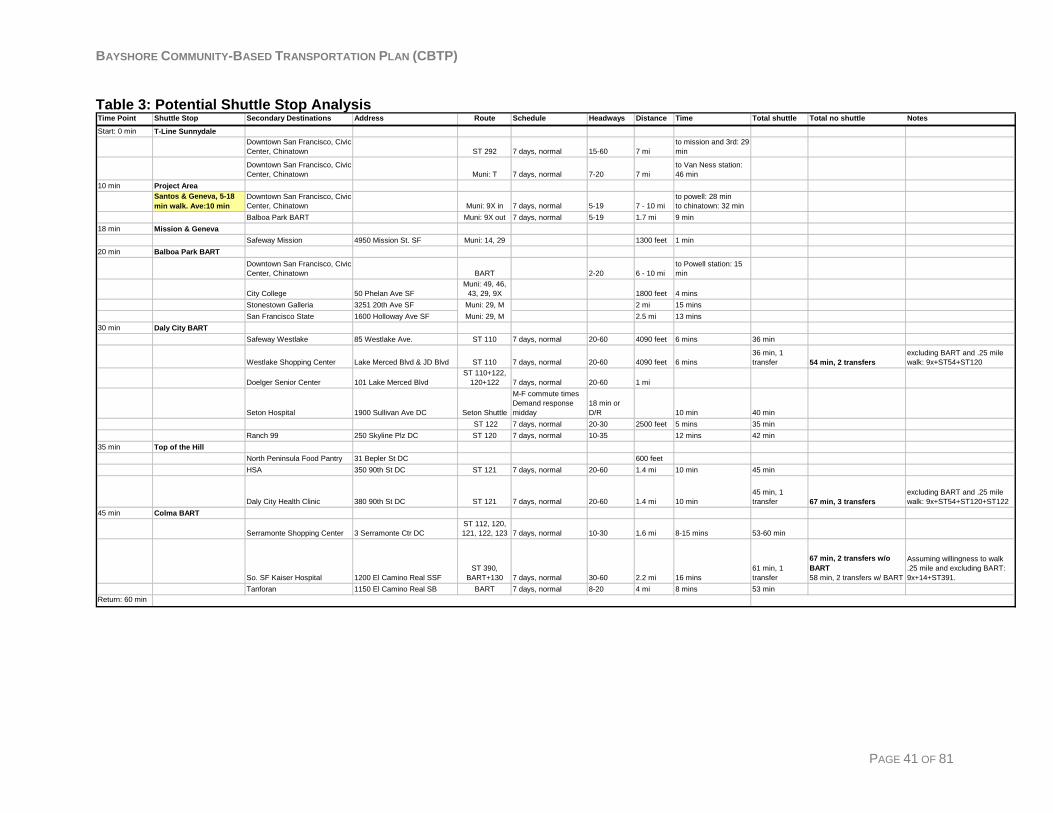
BAYSHORE COMMUNITY-BASED TRANSPORTATION PLAN (CBTP)
Table 3: Potential Shuttle Stop Analysis
Time Point Shuttle Stop Secondary Destinations Address Route Schedule Headways Distance Time Total shuttle Total no shuttle Notes
Start: 0 min T-Line Sunnydale Downtown San Francisco, Civic Center, Chinatown ST 292 7 days, normal 15-60 7 mi
to mission and 3rd: 29 min
Downtown San Francisco, Civic Center, Chinatown Muni: T 7 days, normal 7-20 7 mi
to Van Ness station: 46 min
10 min Project AreaSantos & Geneva, 5-18 min walk. Ave:10 min
Downtown San Francisco, Civic Center, Chinatown Muni: 9X in 7 days, normal 5-19 7 - 10 mi
to powell: 28 minto chinatown: 32 min
Balboa Park BART Muni: 9X out 7 days, normal 5-19 1.7 mi 9 min18 min Mission & Geneva
Safeway Mission 4950 Mission St. SF Muni: 14, 29 1300 feet 1 min20 min Balboa Park BART
Downtown San Francisco, Civic Center, Chinatown BART 2-20 6 - 10 mi
to Powell station: 15 min
City College 50 Phelan Ave SFMuni: 49, 46,
43, 29, 9X 1800 feet 4 minsStonestown Galleria 3251 20th Ave SF Muni: 29, M 2 mi 15 minsSan Francisco State 1600 Holloway Ave SF Muni: 29, M 2.5 mi 13 mins
30 min Daly City BARTSafeway Westlake 85 Westlake Ave. ST 110 7 days, normal 20-60 4090 feet 6 mins 36 min
Westlake Shopping Center Lake Merced Blvd & JD Blvd ST 110 7 days, normal 20-60 4090 feet 6 mins36 min, 1 transfer 54 min, 2 transfers
excluding BART and .25 mile walk: 9x+ST54+ST120
Doelger Senior Center 101 Lake Merced BlvdST 110+122,
120+122 7 days, normal 20-60 1 mi
Seton Hospital 1900 Sullivan Ave DC Seton Shuttle
M-F commute timesDemand response midday
18 min or D/R 10 min 40 min
ST 122 7 days, normal 20-30 2500 feet 5 mins 35 minRanch 99 250 Skyline Plz DC ST 120 7 days, normal 10-35 12 mins 42 min
35 min Top of the HillNorth Peninsula Food Pantry 31 Bepler St DC 600 feetHSA 350 90th St DC ST 121 7 days, normal 20-60 1.4 mi 10 min 45 min
Daly City Health Clinic 380 90th St DC ST 121 7 days, normal 20-60 1.4 mi 10 min45 min, 1 transfer 67 min, 3 transfers
excluding BART and .25 mile walk: 9x+ST54+ST120+ST122
45 min Colma BART
Serramonte Shopping Center 3 Serramonte Ctr DCST 112, 120, 121, 122, 123 7 days, normal 10-30 1.6 mi 8-15 mins 53-60 min
So. SF Kaiser Hospital 1200 El Camino Real SSFST 390,
BART+130 7 days, normal 30-60 2.2 mi 16 mins61 min, 1 transfer
67 min, 2 transfers w/o BART 58 min, 2 transfers w/ BART
Assuming willingness to walk .25 mile and excluding BART: 9x+14+ST391.
Tanforan 1150 El Camino Real SB BART 7 days, normal 8-20 4 mi 8 mins 53 minReturn: 60 min
PAGE 41 OF 81
BAYSHORE COMMUNITY-BASED TRANSPORTATION PLAN (CBTP)
Strategy #2: Provide Discounted Taxi Rides to Medical Facilities
Transportation Needs Addressed: • Residents need better transportation to grocery stores. • Residents need better connections to Kaiser Hospital in South San Francisco. • Getting to the western portion of Daly City for shopping, grocery, and medical
appointments is difficult and time consuming on transit. • It is difficult to walk up the hill to the residences at the southern part of the project area,
the community center and library. The resident survey showed that among the self-reported ‘difficult’ trips for Bayshore residents, 21% were for medical purposes, which is the highest percentage of all other reported trip purposes. Most hospitals and medical centers that were reported as destinations by Bayshore residents are approximately four to eight miles away and would include two transfers if taking transit. Additionally, the Bayshore neighborhood is a low income community with approximately 10% of households living in poverty, compared with 7% in Daly City and 6% in San Mateo County. Bayshore’s median household income was $61,070 in 1999, compared to the median income for San Mateo County as a whole at $70,819 in the same year.
Project Description: This strategy proposes providing discounted fares to low-income Bayshore residents for taxi rides to and from medical facilities. One possible way to do this would be a reimbursement program which would involve a contract between Daly City and one or both of their taxi cab companies to provide the discounted rides to a pre-determined list of medical facilities. One possible discount mechanism could require that customers apply through the City of Daly City to be eligible to receive a certain amount of discounted rides to medical facilities. Daly City could then supply the taxi company with a list of eligible recipients and eligible destinations. Daly City would then reimburse the taxi company for the amount equal to revenue lost from providing the discount. Low income status could be verified by participation in one or more of the public assistance programs provided by the County Human Services Agency. The City of Daly City would be responsible for securing funding and administering this program. This project likely would have fairly low administrative costs and oversight since Daly City already contracts with their two taxi companies.
Potential Transportation and Community Impacts Many Bayshore residents reported difficulty making medical trips. Discounted taxi rides would allow residents door-to-door rides to their medical trip, thereby reducing trip time, dependence on friends and family for rides, and cost. Redi-Wheels paratransit service does not offer same day service. Providing a discount for low-income residents may fulfill the need for urgent medical issues since both cab companies have wheelchair accessible vehicles in their fleet.
PAGE 42 OF 81
BAYSHORE COMMUNITY-BASED TRANSPORTATION PLAN (CBTP)
Implementation Requirements Lead Agency: City of Daly City Management control, convenience for users and the City, and administrative cost would need to be considered in further development of the discount mechanism. Potential Partners: Serra Yellow Cab and Daly City Cab, San Mateo County Human Services Agency SMCTD staff may provide assistance to Daly City in obtaining project funding.
Financial Potential Funding Sources: Temporary Assistance to Needy Families fund (TANF); C/CAG Local Transportation Services Program Preliminary Cost Estimate Approximately 145 Bayshore households participate in at least one HSA program. Assuming a limit of $30 in discounts per household per month, the program would cost a maximum of $4350 per month not including administrative costs.
PAGE 43 OF 81
BAYSHORE COMMUNITY-BASED TRANSPORTATION PLAN (CBTP)
Preliminary Evaluation Financial - MED Cost Effective, Funding Availability and Sustainability This program is low-cost per beneficiary ($30 or less) with likely low administrative costs. Competitive funding sources for transportation programs that benefit low-income riders are available. Implementation - HIGH Ease of implementation, Do-able within a reasonable timeframe, Potential for partners This is a short term program. Implementation would require securing a funding source and initiating a reimbursement and discount mechanism. Transportation - HIGH Broad impact to improve mobility, Compatible with existing service and plan, Effective, measurable project or program A large percentage of survey respondents reported having difficulty making medical trips and other outreach efforts showed that residents have difficulty getting to medical destinations. Community – HIGH Addresses populations(s) with the greatest need, Strong community support, Environmental benefits This program would benefit low-income riders who take trips to medical destinations. The outreach process revealed that many Bayshore residents have difficulty getting to medical appointments and medical centers since they are far from the project area and not easily accessible by transit.
PAGE 44 OF 81
BAYSHORE COMMUNITY-BASED TRANSPORTATION PLAN (CBTP)
Strategy #3: Subsidize School Bus Service Transportation Needs Addressed:
• School District finances are stretched to provide bus service from the Bayshore neighborhood to high schools.
Students living in the Jefferson School District have the freedom to choose among four high schools. SamTrans currently provides service to two of these high schools from the Bayshore area and the Jefferson School District provides service to the two others. During the outreach process, the Jefferson School District administrative staff expressed that transportation from the Bayshore neighborhood to these two high schools is difficult and expensive to provide. Students currently pay a $300 annual fee to the School District for this service.
Project Description: This strategy involves subsidizing the existing school bus service currently provided by the Jefferson School District to transport students coming from Brisbane and the Bayshore neighborhood. This would involve seeking funding sources that could be used for school service. The City of Daly City would be willing to work with the Jefferson School District to seek and/or leverage outside funding sources to subsidize school service to the Bayshore neighborhood.
Potential Transportation and Community Impacts Subsidizing the school bus service would ensure that students have continued access to the high school of their choosing by lessening the financial impact on the school district.
Implementation Requirements Lead Agency: Jefferson School District Potential Partner: City of Daly City
Further Analysis Needed/Ongoing Study: Funding sources and other case studies need to be researched.
Financial Potential Funding Sources: C/CAG Local Transportation Services Program Preliminary Cost Estimate: The cost that the Jefferson School District pays to operate the service is $295,291 after subsidies and fee revenue.
PAGE 45 OF 81
BAYSHORE COMMUNITY-BASED TRANSPORTATION PLAN (CBTP)
Evaluation Financial - LOW Cost Effective, Funding Availability and Sustainability Funding availability and sustainability is a barrier. Implementation – HIGH Ease of implementation, Do-able within a reasonable timeframe, Potential for partners The service is already in operation. Implementation of this strategy would depend on availability of funding. Implementation timeframe is short because this service is already in place. Transportation - MEDIUM Broad impact to improve mobility, Compatible with existing service and plan, Effective, measurable project or program This strategy would ensure the continued transportation of Bayshore students to the high schools. There are currently 84 Bayshore residents who use this service. Community - MEDIUM Addresses populations(s) with the greatest need, Strong community support, Environmental benefits This strategy would positively impact the Jefferson School District and help to ensure the continued service for Bayshore students.
PAGE 46 OF 81

BAYSHORE COMMUNITY-BASED TRANSPORTATION PLAN (CBTP)
Strategy #4: Provide a Shuttle Service to Kaiser Medical Offices Transportation Needs Addressed:
• Residents need better connections to Kaiser Hospital in South San Francisco. Outreach results show that Bayshore residents find it difficult to access the Kaiser Medical Center and Kaiser medical offices in South San Francisco and Daly City. The Bayshore/Brisbane shuttle currently serves the Kaiser medical center and offices on a limited basis.
Project Description: The City of Daly City would work with Kaiser to provide shuttle service that would allow Bayshore residents easier access to Kaiser Medical Center and Kaiser medical offices on Hickey Boulevard. The shuttle service could operate similar to the Kaiser shuttle in Redwood City, which transports employees to and from Sequoia Station during commute hours and patients during the midday. Additionally, the shuttle could provide a link between the offices on Hickey Boulevard and the South San Francisco Medical Center.
Potential Transportation and Community Impacts Providing a shuttle service that connects Bayshore residents with Kaiser medical facilities would improve access to health care and enhance community health and mobility.
Implementation Requirements Lead Agency: Kaiser Permanente Potential Partners: City of Daly City; City of South San Francisco Potential Barrier: Kaiser Hospital currently has no plans to implement a shuttle service for their South San Francisco Medical Center or the medical offices at Hickey Boulevard.
Financial Potential Funding Sources: Kaiser Permanente Preliminary Cost Estimate: Cost would depend on the route and hours of operation of the shuttle service. Parking Company of America charges approximately $60 per hour to operate a 21 passenger shuttle. Assuming an operating schedule of 10 hours per weekday, the cost per month is $13,200 and $158,400 per year.
PAGE 47 OF 81
BAYSHORE COMMUNITY-BASED TRANSPORTATION PLAN (CBTP)
Further Analysis Needed/ Ongoing Study: In order to move forward with this strategy the City of Daly City would need to work with Kaiser Hospital to explore the creation of a shuttle service that would allow Bayshore residents easier access to the Kaiser medical facilities. Evaluation Financial - MEDIUM Cost Effective, Funding Availability and Sustainability A route analysis would need to be undertaken to evaluate operation costs based on the route and hours of operation. Implementation - LOW Ease of implementation, Do-able within a reasonable timeframe, Potential for partners Kaiser and the City of Daly City would need to work together to implement a shuttle service. At this time, Kaiser does not plan to provide shuttle service to their South San Francisco Medical Center nor the offices at Hickey Boulevard, resulting in a mid-term implementation timeframe. Transportation - MEDIUM Broad impact to improve mobility, Compatible with existing service and plan, Effective, measurable project or program Based on the resident survey, medical trips were one of the most common trip purposes of Bayshore residents’ difficult trips. A Kaiser shuttle service would improve access to medical facilities. Kaiser Medical Center in South San Francisco was identified as one of the main destinations for Bayshore residents’ difficult trips. Community - MEDIUM Addresses populations(s) with the greatest need, Strong community support, Environmental benefits Medical trips were one of the most common trip purposes of Bayshore residents’ difficult trips. However, these trips are split among various other medical centers including Seton Hospital and the Daly City Health Clinic.
PAGE 48 OF 81
BAYSHORE COMMUNITY-BASED TRANSPORTATION PLAN (CBTP)
Strategy #5: Provide Fixed Route Transit Service Transportation Needs Addressed:
• Regular fixed-route bus service that goes through the neighborhood is needed. • The Muni stop at Santos St and Geneva Ave is difficult to get to from most parts of the
neighborhood. • It is difficult to walk up the hill to the residences at the southern part of the project area,
the community center and library. • Getting to the western portion of Daly City for shopping, grocery, and medical
appointments is difficult and time consuming on transit. • Residents need better transportation to grocery stores.
Project Description: Providing SamTrans fixed-route transit service would improve the mobility of Bayshore residents. The fixed-route service could be an extension of the existing Route 121 serving Daly City. Route 121 was chosen because, if it were extended to the Bayshore neighborhood, it would connect Bayshore residents with Daly City BART, grocery stores, Seton Medical Center, Top of the Hill, Serramonte Shopping Center, and other destinations which Bayshore residents identified as important and difficult for them to get to. Route 121 currently ends at Bellevue Avenue and South Hill Boulevard. The extended route would continue onto South Hill Boulevard and then onto Geneva Avenue. The route would then follow discontinued SamTrans Route 34 through the neighborhood on Carter Street, Martin Street and Schwerin Street and would end on Geneva Avenue. The fixed route service could share the existing bus stops and additional bus stops would be considered within the neighborhood. A comprehensive route study would need to be undertaken.
Potential Transportation and Community Impacts Extending SamTrans Route 121 into the neighborhood would provide more direct service to neighborhood residents. Access to existing transportation systems and to major destinations in Daly City would be improved. Residents who find it difficult to walk through the neighborhood to access transit on Geneva Avenue or Bayshore Boulevard would have increased mobility due to closer proximity to transit stops.
Implementation Requirements Lead Agency: San Mateo County Transit District Low Ridership on discontinued SanTransRoute 34 SamTrans Route 34 used to connect the Bayshore neighborhood to Downtown South San Francisco and San Bruno BART station. Route 34 was canceled due to low ridership. Average weekday ridership was 49 in February 2001 and decreased to 27 in February 2004. Muni Route 28L alternative ending SFMTA has proposed some changes to Route 28L with an alternative ending at the Sunnydale T-Line station. If the alternative route end is implemented, the 28L Route would go through the
PAGE 49 OF 81

BAYSHORE COMMUNITY-BASED TRANSPORTATION PLAN (CBTP)
Bayshore neighborhood from Balboa BART station to the T-Line station along Geneva Avenue with a stop at Santos Street. The new Route 28L would provide Bayshore residents with direct service to BART and the T-Line and would improve connections to San Francisco State University and City College.
Financial Potential Funding Sources: SamTrans operating funds; C/CAG Local Transportation Services Program; Regional Transportation Fund for Clean Air (TFCA); Lifeline Transportation Program Preliminary Cost Estimate: The cost of extending SamTrans Route 121 would be relatively expensive because Route 121 has short headways. The extension to the Bayshore neighborhood would add an estimated 4,166 annual hours and 53,968 annual miles. The annual cost of the extension is estimated at $370,000, including operation and maintenance costs and without administrative overhead. This assumes that all current Route 121 trips are extended seven days per week.
Evaluation Financial - LOW Cost Effective, Funding Availability and Sustainability An extension of SamTrans Route 121 will be expensive and, due to budget constraints, SamTrans is not planning route extensions or additional fixed-route service at this time. In addition, a comprehensive route study would have to be undertaken. Implementation - LOW Ease of implementation, Do-able within a reasonable timeframe, Potential for partners Lack of funding is a barrier to implementation. Implementation timeframe is long. Transportation - HIGH Broad impact to improve mobility, Compatible with existing service and plan, Effective, measurable project or program A SamTrans fixed-route service connecting the Bayshore neighborhood to Daly City “Top of the Hill” and Daly City BART station would improve Bayshore residents’ mobility. Community - HIGH Addresses populations(s) with the greatest need, Strong community support, Environmental benefits Many Bayshore residents expressed the need for fixed route transit service and complained about the many connections and different transit systems they had to take to make a trip.
PAGE 50 OF 81
BAYSHORE COMMUNITY-BASED TRANSPORTATION PLAN (CBTP)
Strategy #6: Improve Transit Stops - SamTrans Transportation Needs Addressed:
• Better transit amenities are needed. • A shelter is needed at the bus stop at the corner of Bayshore Blvd and Geneva Ave in
front of the 7-Mile House Restaurant. • Residents do not feel safe waiting at transit stops. • There is a lack of information about transportation options.
The SamTrans northbound and southbound stops at Bayshore Boulevard and Geneva Avenue are the two SamTrans stops identified through the outreach process that need better transit stop amenities. The southbound stop at this location is not accessible by sidewalk from the Bayshore neighborhood because of angled parking in front of the 7-Mile House Restaurant which lies between Geneva Avenue and the bus stop. There are currently no SamTrans or Muni shelters anywhere within or proximate to the project area. In 2007, there was an average of 126 daily riders boarding at the Bayshore and Geneva Avenue bus stop in the southbound direction.
Project Description: The northbound and southbound SamTrans bus stops at Bayshore Boulevard and Geneva Avenue were identified as the two SamTrans stops needing the most improvement to Bayshore residents. Improvements to these stops could include shelters, lighting, benches or SIMME seats (pole with seats), trash receptacles, information boards or kiosks, newspaper racks, bicycle racks, and public phones. Posted information about transit and other transportation services could be expanded and also provided in Spanish and Chinese. SIMME seats could provide an alternative for seating at transit stops. SamTrans currently has 8 to 10 SIMME seat poles in store. The Southbound stop at Bayshore Boulevard and Geneva Avenue emerged throughout the outreach process as the highest priority SamTrans stop for improvements. This stop has the highest ridership of SamTrans stops in the neighborhood with an average of 126 daily riders (Route 292 and Route 397 combined). The stop is located just south of the 7 Mile House Restaurant and is not connected to Geneva Ave by a sidewalk. Adding a sidewalk would require removing existing diagonal parking in front of the restaurant and resistance from the restaurant owner is possible. In addition, this bus stop is located in the City of Brisbane. The San Mateo County Transit District is in the process of replacing its entire inventory of 204 shelters with new shelters containing advertising. The process will take approximately two years at which time the District will consider additional locations. However, it is possible that one of the replaced shelters could be moved to this location or that a shelter could be funded and installed using other methods of funding. The outreach process also showed that residents feel a shelter is needed at the northbound bus stop on Bayshore Boulevard and Geneva Avenue as well, however, the average daily ridership is five riders, which does not currently justify the installation of a shelter. The Brisbane Baylands project across the street from Bayshore neighborhood may cause an increase in ridership for the SamTrans routes along Bayshore Avenue. Residents also requested the installation of bicycle racks at this specific bus stop.
PAGE 51 OF 81
BAYSHORE COMMUNITY-BASED TRANSPORTATION PLAN (CBTP)
Another possible solution would be to obtain an easement from the property owner adjacent to this transit stop, which is PG&E. If the fence were moved back it could be possible to provide a sidewalk and concrete pad for a shelter at this location. The compatibility of this option with PG&E’s existing facilities would need to be explored.
Potential Transportation and Community Impacts Providing a shelter and enhancing the transit stop amenities and information at bus stops would improve the passenger experience at those stops. SamTrans bus riders would feel more comfortable and safe waiting for their bus. Additionally, project area residents would have better access to transit information through an information display within the shelter. The visibility of the bus stops would also improve the image of transit in the area, which would attract new and retain existing riders.
Implementation Requirements Lead Agencies: San Mateo County Transit District , the City of Daly City, and the City of Brisbane Potential Roles and Partnerships: General maintenance – City of Daly City, Community-Based Organizations, and adjacent property owners Design and construction oversight – San Mateo County Transit District, City of Brisbane Streetscape amenities: - City of Brisbane, City of Daly City, City of San Francisco
Further Analysis Needed/Ongoing Study In some cases, adding bus shelters to the existing SamTrans stops would likely violate ADA regulations unless property was acquired to widen the sidewalk and add a shelter. This would likely encounter resistance from property owners and neighbors.
Financial Potential Funding Sources: San Mateo County Transit District capital/operating funds; City of Daly City general funds; City of Brisbane general funds; advertising revenues; FTA Transportation Enhancements fund (Section 5307); Safe Routes to Transit program; Lifeline Transportation Program Preliminary Cost Estimate: The cost will vary depending on the amenities provided. Examples of estimated costs: Shelter with bench: $7,700; concrete shelter pad: $700; trash receptacle: $200 to $300; new pole and sign: $100; SIMME seats: $400 to $800 each; telephone: $500; general information board: $225 (shelter); bicycle racks: $300 per rack; sidewalks: $50 per linear foot. Cleaning costs approximately $50 per shelter per month ($600 per year). Glass repair costs $100 per month ($1,200 per year). Maintenance costs would likely range from $600 to $1,800 annually per site depending on the level of repairs needed.
PAGE 52 OF 81
BAYSHORE COMMUNITY-BASED TRANSPORTATION PLAN (CBTP)
Estimated Cost for bus stop adjacent to 7-Mile House Restaurant: Trash receptacle: $200 Telephone: $500 Sidewalk to stop: $12,500 Cleaning &Maintenance: $1800 Shelter: Covered by advertising contract Total = $15,000
Evaluation Financial - MEDIUM Cost Effective, Funding Availability and Sustainability The addition of a shelter at the southbound stop location requires a sidewalk to connect it to Geneva Ave. There is also the possibility to re-use an old shelter (as bus shelters are being replaced by new ones under the new advertising shelter program). Implementation - MEDIUM Ease of implementation, Do-able within a reasonable timeframe, Potential for partners Implementation could not take place until a sidewalk is built on Bayshore Boulevard because of accessibility issues. Vandalism to the shelter is a potential issue. This project has a short to mid-term timeframe. Transportation - HIGH Broad impact to improve mobility, Compatible with existing service and plan, Effective, measurable project or program Installation of a new shelter at Bayshore Boulevard and Geneva Avenue would increase riders’ comfort and safety. About 126 riders per day board at this stop. Community - HIGH Addresses populations(s) with the greatest need, Strong community support, Environmental benefits Many Bayshore residents expressed that transit amenities were a needed transportation improvement.
PAGE 53 OF 81
BAYSHORE COMMUNITY-BASED TRANSPORTATION PLAN (CBTP)
Potential Strategy #7: Improve Transit Stops - Muni Transportation Needs Addressed:
• Better transit amenities are needed. • Residents do not feel safe waiting at transit stops. • There is a lack of information about transportation options.
The Muni 9 inbound stop at Rio Verde Street and Geneva Avenue in front of McDonalds, and the Muni 9 and 9X stops (inbound and outbound) at the intersection of Santos Street and Geneva Avenue are the two Muni bus stop locations identified through the outreach process that need better transit stop amenities. These are also the transit stops with the highest amount of average daily boardings within or near the project area. There are currently no SamTrans or Muni shelters anywhere within or proximate to the project area.
Project Description: This strategy involves improvements to Muni transit stops within or near the project area. These amenities could include a shelter, lighting, trash receptacles, transit information boards or kiosks, newspaper racks, bicycle racks, and public phones. Posted information about transit and other transportation services would be expanded and also provided in Spanish and Chinese. Landscaping and signage would increase the site’s visibility. The following bus stops are the highest priority Muni stops for this strategy:
• Santos St and Geneva Ave (9X, 9AX, 9BX), inbound and outbound • Rio Verde St and Geneva Ave (9) in front of McDonalds, inbound
The research done for the San Francisco Transit Effectiveness Project (SF TEP) shows that the average daily boardings at these three stops are: Santos St & Geneva Ave Outbound: 161 Santos St & Geneva Ave Inbound: 193 Geneva Ave & Rio Verde Inbound: 222 There are three other Muni stops located at Santos St and Geneva Ave that could be improved:
• 9 inbound on Santos St • 9 outbound on Geneva Ave • 9AX inbound on Geneva Ave
The implementation timeframe for this project is at least one year because of a new shelter advertising contract between Muni and Infinity Outdoor.
Potential Transportation and Community Impacts: Providing a shelter and enhancing the transit stop amenities and information at bus stops would improve the passenger experience at those stops. Muni service patrons would feel more comfortable and safe waiting for their bus. Additionally, project area residents would have better access to transit information through an information display within the shelter. The visibility of the bus stops would also improve the image of transit in the area, which would attract new and retain existing riders.
PAGE 54 OF 81
BAYSHORE COMMUNITY-BASED TRANSPORTATION PLAN (CBTP)
Implementation Requirements: Lead Agencies: Muni, the City of Daly City and the City of San Francisco. Potential Roles and Partnerships: Muni would be responsible for the installation and maintenance of a new shelter at the identified Muni stops. Depending on the jurisdiction in which the shelter is located, the department of public works in Daly City or San Francisco would be responsible for the installation of trash receptacles and other streetscape amenities at bus stops. Potential Barriers Site conditions, encroachment permits, public acceptability, and availability of a power supply are all common barriers to the installation of a bus stop shelter. One proposed site for a shelter at Santos Street and Geneva Avenue, within Daly City, was denied by the City. Another site within San Francisco was denied by the property owner. An additional site within San Francisco jurisdiction was deemed unsuitable because of site conditions.
Further Analysis Needed/Ongoing Study: The reasons for the rejection of a proposed stop at Santos Street and Geneva Avenue would need to be further examined, as well as potential encroachment issues, terrain, and power supply issues for all proposed shelter locations and streetscape amenities. The draft proposals from the San Francisco Municipal Transportation Agency Transit Effectiveness Project Results recommend the addition of a 28 Super Limited route which has an alternate ending that serves Geneva Avenue all the way to Bayshore Boulevard. Additional information on this proposal can be found at: www.sftep.com.
Financial: Potential Funding Sources: SFMTA capital/operating funds; City of Daly City general funds; City of San Francisco general funds; Safe Routes to Transit program; Lifeline Transportation Program Preliminary Cost Estimate: The costs of installing the individual shelters would be covered through the advertising contracts. Barriers to implementation, such as public opposition or power supply issues, may increase the cost of installation.
PAGE 55 OF 81
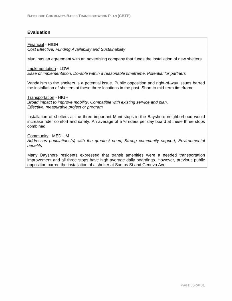
BAYSHORE COMMUNITY-BASED TRANSPORTATION PLAN (CBTP)
Evaluation Financial - HIGH Cost Effective, Funding Availability and Sustainability Muni has an agreement with an advertising company that funds the installation of new shelters. Implementation - LOW Ease of implementation, Do-able within a reasonable timeframe, Potential for partners Vandalism to the shelters is a potential issue. Public opposition and right-of-way issues barred the installation of shelters at these three locations in the past. Short to mid-term timeframe. Transportation - HIGH Broad impact to improve mobility, Compatible with existing service and plan, Effective, measurable project or program Installation of shelters at the three important Muni stops in the Bayshore neighborhood would increase rider comfort and safety. An average of 576 riders per day board at these three stops combined. Community - MEDIUM Addresses populations(s) with the greatest need, Strong community support, Environmental benefits Many Bayshore residents expressed that transit amenities were a needed transportation improvement and all three stops have high average daily boardings. However, previous public opposition barred the installation of a shelter at Santos St and Geneva Ave.
PAGE 56 OF 81
BAYSHORE COMMUNITY-BASED TRANSPORTATION PLAN (CBTP)
PAGE 57 OF 81
Strategy #8: Enhance Pedestrian Safety Transportation Needs Addressed:
• Walking is dangerous because of fast moving traffic and insufficient crossing time. • Residents do not feel safe waiting at transit stops. • The Muni stop at Santos St and Geneva Ave is difficult to get to from most parts of the
neighborhood. • It is difficult to walk up the hill to the residences at the southern part of the project area,
the community center and library. The results of the resident survey show that safety was the third most important transportation improvement identified by Bayshore residents. Additional input from the outreach process has shown that residents do not feel safe walking within the neighborhood because of fast moving traffic and crime.
Project Description: This strategy proposes installing pedestrian-scale lighting on Geneva Ave and Bayshore Boulevard to improve the sense of security and safety for pedestrians and adding sidewalks in areas that would allow safer and easier access to SamTrans bus stops on Bayshore Blvd. The addition of sidewalks at the locations listed below would provide pedestrian access to three SamTrans bus stops. Bus service at these three stops serves the entire length of San Mateo County and downtown San Francisco. However, each of the bus stops and areas which need sidewalks are located in the City of Brisbane, although they are most likely accessed primarily by Bayshore residents because of their proximity. Suggested areas for additional sidewalks include:
• On the west side of Bayshore Blvd between Geneva Ave and the southbound SamTrans bust stop next to the 7-Mile House restaurant, (See Figure 8, line 1)
• Continuation of the sidewalk on the south side of Main Street from where it ends at the city line with Brisbane to Bayshore Blvd. (See Figure 9, line 2)
• Along the west side of Bayshore Blvd from Main St to the southbound SamTrans bus stop. (See Figure 9, line 3)
• Along the east side of Bayshore Blvd from Industrial way to the northbound SamTrans bus stop. (See Figure 9, line 4)
Potential Transportation and Community Impacts Providing streetscape improvements will improve the overall safety of residents by making pedestrians more visible and separated from traffic. Pedestrian safety improvements will also improve access to SamTrans service and therefore improve mobility.
BAYSHORE COMMUNITY-BASED TRANSPORTATION PLAN (CBTP)
Implementation Requirements Lead Agencies: The City of Daly City and the City of Brisbane Potential Barriers: Areas with no existing sidewalks are located in Brisbane.
Financial Potential Funding Sources: City of Daly City general funds; City of Brisbane general funds; TLC planning and capital grant program; FTA Section 5307 Transportation Enhancements fund; Safe Routes to Transit program; TDA Article 3 Bike/Ped program administered through C/CAG Preliminary Cost Estimate: One pedestrian-scale lamp: $16,000; sidewalks: $50 per linear foot (for 5' wide sidewalk with curb and gutter). Total sidewalk areas: $87,000 (1740 feet) Assuming the addition of 50 pedestrian-scale lamps: $800,000 + installation costs
Studies and Plans Studies and Plans relating to streetscape improvements in Bayshore: The Daly City Community Development Program: Cow Palace/Carter Martin Area (July 2004) plans to: restore the Cow Palace, add a much-needed supermarket and branch bank, possibly add a new school site to serve the Bayshore neighborhood, provide adequate parking, improve the pedestrian and bicycle routes in the area, and accommodate local transit service. The Daly City 2001 Geneva Avenue Urban Design Plan describes opportunities for economic development and public improvements, as well as design guidelines. The 2002 Geneva Avenue Streetscape Plan describes specific improvements necessary to make Geneva Avenue more pedestrian friendly and bring higher levels of pedestrian activity to the corridor. Pedestrian safety is also addressed in the plan. Additionally, San Francisco County Transportation Authority, San Francisco Municipal Transportation Agency (Muni) and Caltrain are applying for a Station Area Planning grant (Bi-County Area Planning and Design Study) from the Metropolitan Transportation Commission. The Bayshore neighborhood would be integrated in the Bayshore Intermodal Station planning area. Signal timing A resident mentioned not having enough time to cross the streets. A San Mateo County Transit District planner tested the signal timing by walking slowly and established that there was sufficient time to cross the street. In addition, there are pedestrian refuges on Geneva Avenue and Bayshore Boulevard. The City of Daly City reported that pedestrian crossing times were updated in 2006 to meet the State standard and that they recently installed pedestrian countdown timers at each of the crosswalks in the project area.
PAGE 58 OF 81
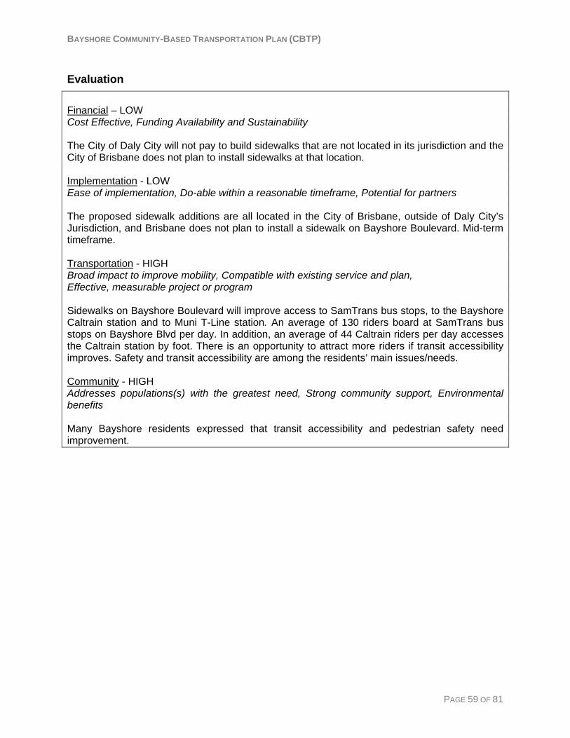
BAYSHORE COMMUNITY-BASED TRANSPORTATION PLAN (CBTP)
Evaluation Financial – LOW Cost Effective, Funding Availability and Sustainability The City of Daly City will not pay to build sidewalks that are not located in its jurisdiction and the City of Brisbane does not plan to install sidewalks at that location. Implementation - LOW Ease of implementation, Do-able within a reasonable timeframe, Potential for partners The proposed sidewalk additions are all located in the City of Brisbane, outside of Daly City’s Jurisdiction, and Brisbane does not plan to install a sidewalk on Bayshore Boulevard. Mid-term timeframe. Transportation - HIGH Broad impact to improve mobility, Compatible with existing service and plan, Effective, measurable project or program Sidewalks on Bayshore Boulevard will improve access to SamTrans bus stops, to the Bayshore Caltrain station and to Muni T-Line station. An average of 130 riders board at SamTrans bus stops on Bayshore Blvd per day. In addition, an average of 44 Caltrain riders per day accesses the Caltrain station by foot. There is an opportunity to attract more riders if transit accessibility improves. Safety and transit accessibility are among the residents’ main issues/needs. Community - HIGH Addresses populations(s) with the greatest need, Strong community support, Environmental benefits Many Bayshore residents expressed that transit accessibility and pedestrian safety need improvement.
PAGE 59 OF 81

BAYSHORE COMMUNITY-BASED TRANSPORTATION PLAN (CBTP)
Figure 8: Geneva Avenue and Bayshore Boulevard Figure 8: Geneva Avenue and Bayshore Boulevard
Figure 9: Main Street and Bayshore Boulevard
PAGE 60 OF 81 81

BAYSHORE COMMUNITY-BASED TRANSPORTATION PLAN (CBTP)
Strategy #9: Improve Bicycle Infrastructure Transportation Needs Addressed:
• Bicycle infrastructure improvements are needed.
Project Description: The project would extend the bicycle lane on Geneva Avenue in San Francisco to the Bayshore neighborhood. Bicycle racks would be added at main bus stops and stations. The Daly City Bicycle Master Plan and Streetscape Master Plan propose the designation of a Class I or Class II bikeway on Geneva Ave within the project area. Muni is also in the beginning phases of a Geneva Corridor Improvement Plan.
Potential Transportation and Community Impacts Providing bicycle infrastructure such as bicycle lanes and racks would improve access to transit systems.
Implementation Requirements Lead Agencies: The City of Daly City
Further Analysis Needed/Ongoing Study: The Geneva Streetscape Master Plan includes the inclusion of bicycle lanes on Geneva in conjunction with the reconfiguration of parking and lane widths. The feasibility and cost of adding a bike lane without reconfiguration would need to be examined.
Financial Potential Funding Sources: The City of Daly City general funds; Safe Routes to Transit program; Safe Routes to School program; TFCA Regional Fund – Bicycle Facility Program Preliminary Cost Estimate: Bicycle racks: $300 per rack (9-bike capacity bike storage rack). Bicycle path cost estimate on Geneva Avenue: The Geneva Avenue Master Plan estimated implementation costs for the portion in Daly City at approximately $16.5M in 2002 dollars. Based on inflation rates, that cost would be approximately $19.4M in 2007 dollars. (CPI index for 2008 is not available.)
PAGE 61 OF 81
BAYSHORE COMMUNITY-BASED TRANSPORTATION PLAN (CBTP)
Evaluation Financial - MEDIUM Cost Effective, potential funding. The project would be relatively expensive, but funding could be available through grants. Implementation – MEDIUM Ease of implementation, feasible within a reasonable timeframe, Potential for partners The project is compatible with existing plans. Once funding is available, implementation will be easy. Some project elements are have a short implementation timeframe, such as the installation of bike racks, while others have mid-term timeframes. Transportation - MEDIUM Broad impact to improve residents’ mobility and transit accessibility. Compatible with existing plans. As access to transit is considered difficult by residents, bicycle access will improve residents’ access to major transit stations and overall mobility. The bicycle mode is also a good alternative to low income residents as gas prices are increasing in the country. Community - MEDIUM Community support. Environmental benefits Bicycle infrastructure will likely have community support as it will add an alternative mode of transportation. Bicycle access to Muni T-Line and Bayshore Caltrain stations will have some environmental benefits in the potential of reducing car trips.
PAGE 62 OF 81

BAYSHORE COMMUNITY-BASED TRANSPORTATION PLAN (CBTP)
Strategy #10: Improve Taxi Service Information Transportation Needs Addressed:
• Better information is needed about which Taxi companies serve the Bayshore neighborhood.
Bayshore residents reported that taxis occasionally would not serve their neighborhood. However, there are two Daly City companies that are authorized to serve the Bayshore neighborhood. Most likely the problem stems from the circumstance that since the Bayshore neighborhood is within the 415 telephone area code, residents receive a San Francisco phone book. The two Daly City cab companies advertise in the Daly City phone book and not the San Francisco phone book. Bayshore residents who have had issues with taxi service may have been calling San Francisco taxi companies that are not authorized to pick up passengers in Daly City.
Project Description: This strategy would address the confusion that exists among some Bayshore residents as to which cab companies serve their neighborhood. Two cab companies, Daly City Cab and Serra Cab, serve the Bayshore neighborhood. Potential solutions would involve a public information campaign to inform Bayshore resident’s about the taxi services that are available to them. This could take the form of direct mailers, refrigerator magnets, fliers, etc.
Potential Transportation and Community Impacts Providing information on taxi service would improve reliability, mobility and safety of the Bayshore residents as they would contact the two taxi companies that serve the neighborhood, and no longer call San Francisco taxi companies or other taxi companies that do not serve Daly City.
Implementation Requirements Lead Agency: The City of Daly City Potential Partners: Serra Cab and Daly City Cab
Financial Potential Funding Sources: Taxi company marketing; City of Daly City general fund Preliminary Cost Estimate Direct mailer: 850 households at $.041 = $349 Translation: minimum $125 per language, two languages = $250 Approximate total: $600
PAGE 63 OF 81
BAYSHORE COMMUNITY-BASED TRANSPORTATION PLAN (CBTP)
Evaluation Financial - HIGH Cost Effective, Funding Availability and Sustainability This project is cost effective as it would reach a large amount of people for a relatively low cost. Implementation - HIGH Ease of implementation, Do-able within a reasonable timeframe, Potential for partners Implementation would be easy and the project is short term. Transportation - HIGH Broad impact to improve mobility, Compatible with existing service and plan, Effective, measurable project or program Information about which taxi companies serve the Bayshore neighborhood would improve residents’ mobility as information would reach all households. Program success would be measured by the number of complaints CBOs and the City receive, and also by comparing log reports from before and after the implementation. Community – HIGH Addresses populations(s) with the greatest need, Strong community support, Environmental benefits This strategy addresses Bayshore residents’ need to be informed about which taxi services serve their neighborhood. Efforts would be made to reach the entire community. Increased information would benefit those residents who use taxi services.
PAGE 64 OF 81
BAYSHORE COMMUNITY-BASED TRANSPORTATION PLAN (CBTP)
Strategy #11: Increase Public Awareness about Transportation Options
Transportation Needs Addressed:
• There is a lack of information about transportation options. The resident survey shows that 56% of respondents feel ‘not very informed’ or ‘not at all informed’ about public transportation in their area. The other outreach efforts reflected this finding and also showed that brochures, pamphlets/maps on transit vehicles, the internet, information displays, and word of mouth are the best ways for residents to learn about public transportation options. Residents need information on both SamTrans and Muni service because the neighborhood is adjacent to the border with San Francisco and many residents are traveling to destinations in San Francisco.
Project Description: Given that the target population is relatively small (850 households), one potential solution would be a door hanger offering information, and possibly free transit vouchers, that residents could request by detaching and returning a postage-paid postcard to SamTrans. The door hanger could include English, Chinese, and Spanish translations of the offer. If requested, residents could be sent a packet which includes transit information materials for Muni and SamTrans, such as the How to Ride Guide, as well as free round-trip transit passes. This would give Bayshore residents everything they needed to learn about and try using transit. Another potential solution could be a specialized map tailored to the Bayshore neighborhood showing different transportation options to key destinations. This map would show the route and schedule information for the various services that connect the Bayshore neighborhood with important destinations that were identified through the outreach process. This map could also be translated to Chinese and Spanish to address the need for information in different languages. Additionally, Bayshore residents indicated that an effective way to spread information to their community is through community organizations such as the Bayshore Friendship Club, the Bayshore Childcare Center, the elementary and intermediate school, and local food programs. They also mentioned that the school newspaper and other school mailings are good ways to distribute information.
Potential Transportation and Community Impacts Providing transportation information would increase awareness about public transportation in the area and therefore improve the mobility of residents.
Implementation Requirements Lead Agencies: San Mateo County Transit District; San Francisco Municipal Transportation Agency
PAGE 65 OF 81
BAYSHORE COMMUNITY-BASED TRANSPORTATION PLAN (CBTP)
Potential Roles and Partnerships: SamTrans and Muni would need to work together to put the necessary information together and share costs. The Peninsula Congestion Relief Alliance may be a potential partner for a public information campaign.
Financial Potential Funding Sources: SMCTD operating funds; SFMTA operating funds; Daly City general funds; Lifeline Transportation Program Preliminary Cost Estimate A specialized transit map similar to the one described in the project description was created for the City of East Palo Alto. The costs associated with this map are: $3200: 40 hours staff time $1440: 32 hours for the graphic designer at $45/hr $4,000: printing $250: translation $8890 Door Hanger and Info Packet: Assuming door hangers are placed on every door and 300 people request information: Translating the How to Ride Guide to Chinese would cost approximately $1000. return postage for 300 households at $0.41 each would cost approximately $123, postage for sending an information packet to 300 households assuming weight is not higher than standard amount allows: $123, translating door hangers to two languages: $250, printing 850 door hangers: approximately $2000. 600 SamTrans one-way vouchers at $1.50 each: $900, 600 Muni one-way vouchers at $1.50 each: $900. Approximate Total: $5296
PAGE 66 OF 81

BAYSHORE COMMUNITY-BASED TRANSPORTATION PLAN (CBTP)
Evaluation Financial – MEDIUM Cost Effective, Funding Availability and Sustainability Funding availability is uncertain. It would be cost effective to give out transit vouchers on a per request basis, as mentioned in the project description, rather than mailing them to each household. Implementation – HIGH Ease of implementation, Do-able within a reasonable timeframe, Potential for partners Short-term. Translation and mailings can be done within a relatively short time frame. Implementation would also depend on receptivity of partner agencies. Transportation – MEDIUM Broad impact to improve mobility, Compatible with existing service and plan, Effective, measurable project or program This strategy would spread information about transportation options and encourage the use of public transit. Community – HIGH Addresses populations(s) with the greatest need, Strong community support, Environmental benefits The Bayshore community members expressed a lack of information about their transportation options.
PAGE 67 OF 81
BAYSHORE COMMUNITY-BASED TRANSPORTATION PLAN (CBTP)
Strategy #12: Provide Transit Information in Different Languages Transportation Needs Addressed:
• There is a need for information about transportation options in languages other than English.
• There is a lack of information about transportation options. The 2000 U.S. Census shows that 28% of Bayshore households are linguistically isolated, meaning that no one in the household speaks English ‘Well’ or ‘Very well’. Among households that speak primarily an Asian or Pacific Island language, 44% are linguistically isolated and among Spanish speaking households, 40% are linguistically isolated. The resident survey shows that 22% of respondents preferred public transportation information in Chinese and 16% preferred Spanish. Additionally, 31% of survey respondents reported that English is spoken ‘Not well’ or ‘Not at all’ in their home. Muni information is available over the phone through their 311 service. Operators are available in Spanish and English plus 100+ other languages available on-call. Muni translates some written materials to Spanish and Cantonese on demand as a result of a major project or services change. They have an upcoming pilot program which will translate five sample pages about fares from the Muni website. Currently, SamTrans translates the Bus System Map, Transit Information Guide, and the How to Ride Guide into Spanish. SamTrans also has customer service representatives available who speak Spanish.
Project Description: This strategy would, with additional funding, translate the SamTrans How to Ride Guide, Bus System Map, and Transit Information Guide into Chinese and distribute these materials to the Bayshore area upon request. Additionally, a specialized transit map, as described in Strategy #11, could also be translated into Chinese and Spanish.
Potential Transportation and Community Impacts Providing transportation information in languages other than English would allow residents who do not speak English well increased mobility and comfort with using public transportation.
Implementation Requirements Lead Agency: San Mateo County Transit District Potential Roles and Partnerships: The City of Daly City and partners involved with Strategy #11.
Financial Potential Funding Sources: City of Daly City general funds; SMCTD operating funds; Lifeline Transportation Program
PAGE 68 OF 81
BAYSHORE COMMUNITY-BASED TRANSPORTATION PLAN (CBTP)
Preliminary Cost Estimate: The cost of translating a double-sided brochure at approximately 1,369 words costs approximately $561 for a standard time frame. Minimum translation cost is about $125 per language. Translating the How to Ride Guide to Chinese would cost approximately $1000
Evaluation Financial – MEDIUM Cost Effective, Funding Availability and Sustainability The cost is relatively low depending upon the number of materials to be printed and disseminated. Implementation - MEDIUM Ease of implementation, Do-able within a reasonable timeframe, Potential for partners Implementation may be difficult depending on the scope of the translation project. Short to mid-term timeframe. Transportation - HIGH Broad impact to improve mobility, Compatible with existing service and plan, Effective, measurable project or program This strategy would improve public awareness of the different transportation options in the neighborhood. If the information guides were translated it would improve understanding of public transit and potentially increase ridership. Community - HIGH Addresses populations(s) with the greatest need, Strong community support, Environmental benefits A large percentage of the Bayshore community speaks primarily Chinese and Spanish. This strategy would address the transportation information needs of that community.
PAGE 69 OF 81
BAYSHORE COMMUNITY-BASED TRANSPORTATION PLAN (CBTP)
Strategy #13: Improve Affordability of Transfers between Transit Systems
Transportation Needs Addressed:
• Transferring between public transit systems is costly for Bayshore residents who live close to the border and who, therefore, often find it necessary to use at least two different transit systems to access their destinations.
During the outreach process, many residents and stakeholders expressed that cost was a barrier to their ability to use public transportation. Additionally, the 2000 U.S. Census shows that 10% of Bayshore residents are below the poverty line, compared with 7% for the County.
Project Description: The San Mateo County Transit District (the District) and San Francisco Municipal Transportation Authority (SFMTA) would work together to develop discounted transfers for selected routes and stop locations that operate near the border between the two counties. VTA and SamTrans accept each other’s monthly pass at shared bus stops. It is possible that the same kind of agreement could be reached between the District and SFMTA if the revenue is equitably exchanged. Another possible alternative would be to accept Muni transfer receipts as fare on select SamTrans routes and stops.
Potential Transportation and Community Impacts Providing discounted transfers would make transit more affordable for Bayshore residents, therebyimproving their mobility. If monthly passes were accepted by both transit systems on certain lines among specified geographic boundaries it would decrease the cost for residents who use both systems because of their proximity to both SamTrans and Muni bus and rail lines.
Implementation Requirements Lead Agencies: San Mateo County Transit District and the San Francisco Municipal Transportation Authority Potential Roles and Partnerships: The District and the SFMTA would work together to create an equitable agreement and system of compensation for free or discounted transfers.
Further Analysis Needed/Ongoing Study: The existing agreement between Valley Transportation Authority (VTA) and SMCTD needs to be studied further. The expired agreement between SMCTD and Muni needs to be studied further. Additionally, the cost impact to each agency would also need to be analyzed to develop an equitable agreement.
PAGE 70 OF 81
BAYSHORE COMMUNITY-BASED TRANSPORTATION PLAN (CBTP)
Financial Potential Funding Sources: SMCTD operating funds or SFMTA operating funds, depending on the logistics of the agreement Preliminary Cost Estimate: Cost would depend upon the projected number of riders that would use the transfer. Assuming 25-200 transfers are given per day at $1.50 per transfer: $37.50 - $300 per day and $13,687 - $109,500 per year.
Evaluation Financial - HIGH Cost Effective, Funding Availability and Sustainability An equitable revenue exchange would need to be developed between the District and SFMTA. Implementation - MEDIUM Ease of implementation, Do-able within a reasonable timeframe, Potential for partners The implementation timeframe is mid-term. Any changes would need to be adopted in the codified tariff for both agencies. Transportation - HIGH Broad impact to improve mobility, Compatible with existing service and plan, Effective, measurable project or program Results would be measurable based on fare counts. Breadth of impact would need to be determined by a ridership survey in order to find out the number of passengers that transfer between SamTrans and Muni within specified zones. Community - HIGH Addresses populations(s) with the greatest need, Strong community support, Environmental benefits This strategy would benefit those riders who are paying two fares to ride both transit systems for a single trip. Many Bayshore residents are low-income and therefore, a lower cost transfer between systems would benefit this community.
PAGE 71 OF 81

BAYSHORE COMMUNITY-BASED TRANSPORTATION PLAN (CBTP)
Strategy #14: Subsidize Monthly Transit Passes for Low Income Riders
Transportation Needs Addressed:
• Transferring between public transit systems is costly.
Project Description: This strategy would subsidize discounted transit passes for low income Bayshore residents thus making transit more affordable and increase their mobility.
Potential Transportation and Community Impacts The upfront cost of a monthly transit pass is too high for some low income individuals and forces them to purchase tickets for individual trips at $1.50 per trip. About 12% of Bayshore households have annual incomes below $15,000. In addition, some residents have to purchase Muni tickets as well to complete their trip. This project ideally would be complemented by Strategy # 12 (Improve Affordability of Transfers between Transit Systems), which would help low income residents who use Muni and SamTrans for the same trip.
Implementation Requirements Lead Agencies: The City of Daly City, the San Mateo County Human Services Agency (HSA), and San Mateo County Transit District.
Financial Potential Funding Sources: Temporary Assistance to Needy Families fund (TANF), Community Development Block Grants (CDBG), the City of Daly City, private foundations Preliminary Cost Estimate: the cost of the program will depend on the amount of subsidy and the number of participants. Approximately ten percent of Bayshore households are below the poverty line. If ten percent of Bayshore residents between the ages of 20 and 64 (about 225 people according to the U.S. Census 2000) were given a subsidy of $10 off the regular SamTrans monthly pass price, it would cost San Mateo County Transit District $2,250 per month plus administrative costs. San Mateo County Lifeline monthly pass program: In partnership with the CORE SERVICES Agency Network, the San Mateo County Human Services Agency will be implementing the Lifeline Transportation Grant in April 2008. This will provide approximately six SamTrans monthly bus passes per Family Resource Center and at each of the CORE Agencies per month. To qualify for the one time only bus pass the adult has to be actively engaged in a Family Self-Sufficiency activity such as work or training, or Family Strengthening activity such as parenting class or family counseling. It is first come, first served. HSA anticipates serving 1,500 participants per year in San Mateo County. There is one Family Resource Center in the Bayshore neighborhood meaning only six one time only monthly bus passes are available each month for individuals who participate in one of the programs. Participants only are eligible to receive one free monthly pass for the year.
PAGE 72 OF 81
BAYSHORE COMMUNITY-BASED TRANSPORTATION PLAN (CBTP)
San Francisco Muni Lifeline pass: San Francisco HSA offers a $10 discount on the Muni monthly pass. Muni Lifeline passes are discounted Muni monthly passes for qualified low-income San Francisco residents. The lifeline pass costs $35 a month instead of $45 a month. Qualified low-income individuals include persons currently receiving public assistance through one of the following San Francisco County assistance programs: CAAP (General Assistance, Cash Assistance Linked to Medi-Cal, Personal Assisted Employment Services, Cash Assistance Program for Immigrants), CalWorks, Food Stamps, and/or MediCal. Individuals who have received either a Federal Earned Income Tax Credit or the local Working Families Tax Credit or enrolled in a financial assistance program through a utility company may also be eligible pending proof of eligibility1. Individuals are only allowed to purchase one Lifeline Fast Pass per month for their own personal use. TransLink® Opportunity: A program that subsidizes trip-to-work transit costs could be monitored by TransLink® smart card. This is based on a pilot program that AC Transit will start with City of Alameda employees in May 2008. It would be feasible once TransLink® is fully operational on SamTrans and Muni to trace subsidized trips through the smart card. A reporting service could be set up and would give a monthly report. There are some privacy concerns but it could be part of the agreement for the participants to provide information. Concerns regarding fraud (giving the card to someone else) could be deterred by showing a photo employee ID while swapping the TransLink® card. The bus driver could have a different sound for “subsidized trip-to-work” cards and would then check the employee ID. There are also some concerns about checking photo IDs. (Information from Nate Gilbertson, MTC) The AC Transit Universal Pass program: The AC Transit Universal Pass program provides an organization’s employees, students, or residents with an AC Transit bus pass that is valid at any time on all AC Transit lines, both local and transbay. The program enables a client (employer, school, residential community or developer, or other approved aggregator) to purchase passes for every person (program participant) within the participant universe. By purchasing passes for an entire universe of people, universal passes are offered to clients at a significantly discounted rate compared to regular AC Transit fares. AC Transit strongly discourages clients to charge employees a fee for the pass. The AC Transit Universal Pass program uses TransLink® as the program’s fare instrument. The cost of pass production for the initial passes and any TransLink® related transaction costs are incorporated in the per participant price. To prevent fraud, photo ID (name and photo) will be required on each TransLink® card for all program participants. Tracking data will be possible through TransLink® and reports will be produced. Employees of the City of Alameda will start this program in May 2008. Although the program targets trip-to-work trips, participants will be able to use the pass on weekends. (Information from Nichele Ayers of AC Transit)
1 Source: San Francisco Human Services Agency
PAGE 73 OF 81

BAYSHORE COMMUNITY-BASED TRANSPORTATION PLAN (CBTP)
Evaluation Financial - MEDIUM Cost Effective, Funding Availability and Sustainability It is relatively cost effective as compared to the number of people who would benefit from a subsidized monthly pass. Implementation – LOW Ease of implementation, Do-able within a reasonable timeframe, Potential for partners Administrating the program would require substantial coordination between the District, HSA, and Daly City and is dependent on the implementation of Translink® on SamTrans buses and other results of the AC Transit pilot programs. Short to Mid term. Transportation - HIGH Broad impact to improve mobility, Compatible with existing service and plan, Effective, measurable project or program This strategy would improve mobility of low income residents in the Bayshore area by lowering the cost of riding public transit. The program results and effectiveness would be carefully monitored. Community - HIGH Addresses populations(s) with the greatest need, Strong community support, Environmental benefits Based on the resident survey, there is a need for a subsidized monthly pass for low income adults.
PAGE 74 OF 81
BAYSHORE COMMUNITY-BASED TRANSPORTATION PLAN (CBTP)
Chapter 5: Action Plan The success of the Bayshore Community-Based Transportation Plan will depend on moving forward with timely implementation of the recommended strategies to close transportation gaps. This chapter lays out a plan of action to establish an implementation process and timeline, secure commitments by lead agencies and project partners, and pursue required funding. The organizations identified for the transportation strategies include one or more of the following:
• City of Daly City • San Mateo County Transit District (the District) • San Francisco Municipal Transportation Agency (SFMTA) • City of San Francisco • City of Brisbane • Jefferson School District • Kaiser Permanente • San Mateo County Human Services Agency
The planning process was crafted to ensure appropriate agencies were represented and actively involved, and members of the community and CBOs were afforded opportunities to provide in-depth input. The implementation process will require continued commitment by the organizations named above. Daly City may choose to designate a staff person that would facilitate implementation of the CBTP by coordinating the efforts of the lead agencies, other partners, and the Bayshore community. This person could also update the Daly City City Council on the implementation progress. MTC’s requirements for the completed Community-Based Transportation Plans address the County Congestion Management Agency (CMA), which is C/CAG in San Mateo County, and transit policy boards, which include the District, Caltrain, and BART in San Mateo County. The requirements include:
“Once the plan is finalized, CMA staff will participate in regional forums to report on project findings, or to otherwise share information resulting from the planning process. MTC will make the results from each community-based planning effort available to all CMAs and transit agencies.” “Upon completion of the planning project, CMA staff will report to the Commission on resulting key findings and recommendations. Materials and meetings will be translated when appropriate.” “Project findings will be forwarded to applicable local or county-level policy boards and to MTC. Recommended service improvements will be forwarded to transit policy boards for consideration and subsequent incorporation into Short Range Transit Plans (SRTPs) and/or other future service expansion plans and to CMA policy boards for planning, funding and implementation discussions.”
PAGE 75 OF 81
BAYSHORE COMMUNITY-BASED TRANSPORTATION PLAN (CBTP)
PAGE 76 OF 81
Summary of Transportation Strategies The fourteen strategies recommended in Chapter four are summarized in Table 4. The strategies are grouped by the broad areas of needs addressed and indicate a recommended lead agency or agencies, estimated cost, the likely timeframe for implementation, and potential funding sources for each strategy. A “short-term” timeframe for implementation is less than two years, a “mid-term” timeframe is 3 to 5 years, and a “long-term” time frame is over 5 years. The first need area of need, access to places outside of the project area, includes five recommended strategies. These are: providing a circulator shuttle service, giving discounts to low-income residents for taxi rides to medical facilities, subsidizing school bus service to highs schools, providing shuttle service to Kaiser medical facilities, and providing fixed-route transit service through the project area. The second area of need, accessing transit and community facilities within the project area, includes four recommended strategies. These are: improving the southbound SamTrans bus stop at Geneva Ave and Bayshore Blvd, improving Muni bus stops, providing sidewalks on key segments of Bayshore Blvd and Main Street, and improving bicycle infrastructure. The third area of need, information and cost, includes five recommended strategies. These are: improving information about taxi service options, increasing public awareness about available public transportation options, providing transit information in languages other than English, improving the affordability of transfers between SamTrans and Muni, and subsidizing monthly transit passes for low-income residents.

BAYSHORE COMMUNITY-BASED TRANSPORTATION PLAN (CBTP)
Funding Type Legend: Lifeline: Lifeline Transportation Program CDBG: Community Development Block Grants TFCA: Transportation Fund for Clean Air 5310: FTA Specialized Transit & Procurement TANF: Temporary Assistance for Needy Families SMCTD: San Mateo County Transit District TLC: Transportation for Livable Communities SMCTA: San Mateo County Transportation Authority 5307: FTA Urbanized Area Formula Program SR2T: Safe Routes to Transit funds SR2S: Safe Routes to School funds SFMTA: San Francisco Municipal Transportation Agency Table 4: Implementation Matrix
Recommended Lead Agencies Estimated Cost Timeframe Description Potential
Funding
1 Provide Circulator Shuttle Service
San Mateo County Transit District; City of Daly City
$16,080/mo$192,960/yr Short
Provide shuttle service that serves the Bayshore neighborhood, SamTrans and Muni bus stops, BART, and Daly City. Service would operate for 10 hours on weekdays and 6 hours on weekends.
TFCA; Lifeline; C/CAG; SMCTA; 5310
2 Provide Discounted Taxi Rides to Medical Facilities City of Daly City $4350/mo
$52,200/yr ShortProvide discounts to low-income residents for taxi rides to medical facilities from the Bayshore neighborhood.
TANF; C/CAG
3 Subsidize School Bus Service Jefferson School District $295,291/yr Short
Procure funding to subsidize the existing school bus service provided by the Jefferson School District that transports students from the Bayshore neighborhood to high schools.
C/CAG
4 Provide Shuttle Service to Kaiser Medical Offices Kaiser Permanente $13,200/mo
$158,400/yrMid
Provide shuttle service that connects Kaiser Medical Facilities in South San Francisco and Daly City with BART.
Kaiser
5 Provide Fixed-Route Transit Service
San Mateo County Transit District
Operations & maintenance$370,000/yr
Long Extend SamTrans Route 121 to serve the Bayshore neighborhood.
SMCTD; C/CAG; TFCA; Lifeline
Strategy
Need: Access to places outside of the Project Area
PAGE 77 OF 81
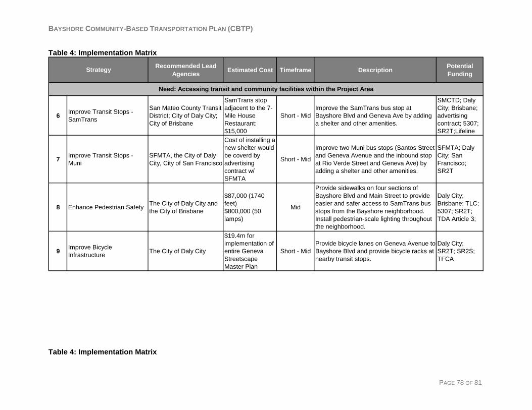
BAYSHORE COMMUNITY-BASED TRANSPORTATION PLAN (CBTP)
Table 4: Implementation Matrix
Recommended Lead Agencies Estimated Cost Timeframe Description Potential
Funding
6 Improve Transit Stops - SamTrans
San Mateo County Transit District; City of Daly City; City of Brisbane
SamTrans stop adjacent to the 7-Mile House Restaurant: $15,000
Short - MidImprove the SamTrans bus stop at Bayshore Blvd and Geneva Ave by adding a shelter and other amenities.
SMCTD; Daly City; Brisbane; advertising contract; 5307; SR2T;Lifeline
7 Improve Transit Stops - Muni
SFMTA, the City of Daly City, City of San Francisco
Cost of installing a new shelter would be coverd by advertising contract w/ SFMTA
Short - Mid
Improve two Muni bus stops (Santos Street and Geneva Avenue and the inbound stop at Rio Verde Street and Geneva Ave) by adding a shelter and other amenities.
SFMTA; Daly City; San Francisco; SR2T
8 Enhance Pedestrian Safety The City of Daly City and the City of Brisbane
$87,000 (1740 feet)$800,000 (50 lamps)
Mid
Provide sidewalks on four sections of Bayshore Blvd and Main Street to provide easier and safer access to SamTrans bus stops from the Bayshore neighborhood. Install pedestrian-scale lighting throughout the neighborhood.
Daly City; Brisbane; TLC; 5307; SR2T; TDA Article 3;
9 Improve Bicycle Infrastructure The City of Daly City
$19.4m for implementation of entire Geneva Streetscape Master Plan
Short - MidProvide bicycle lanes on Geneva Avenue to Bayshore Blvd and provide bicycle racks at nearby transit stops.
Daly City; SR2T; SR2S; TFCA
Strategy
Need: Accessing transit and community facilities within the Project Area
Table 4: Implementation Matrix
PAGE 78 OF 81
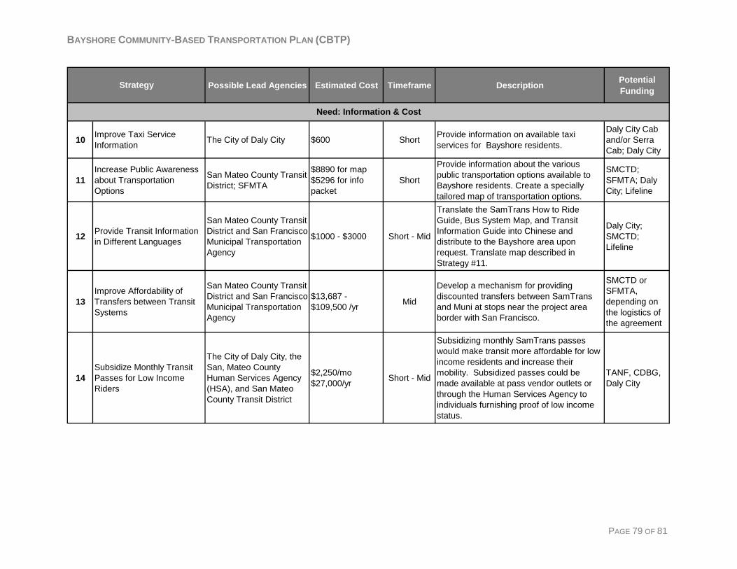
BAYSHORE COMMUNITY-BASED TRANSPORTATION PLAN (CBTP)
PAGE 79 OF 81
Possible Lead Agencies Estimated Cost Timeframe Description Potential Funding
10 Improve Taxi Service Information The City of Daly City $600 Short Provide information on available taxi
services for Bayshore residents.
Daly City Cab and/or Serra Cab; Daly City
11Increase Public Awareness about Transportation Options
San Mateo County Transit District; SFMTA
$8890 for map$5296 for info packet
Short
Provide information about the various public transportation options available to Bayshore residents. Create a specially tailored map of transportation options.
SMCTD; SFMTA; Daly City; Lifeline
12 Provide Transit Information in Different Languages
San Mateo County Transit District and San Francisco Municipal Transportation Agency
$1000 - $3000 Short - Mid
Translate the SamTrans How to Ride Guide, Bus System Map, and Transit Information Guide into Chinese and distribute to the Bayshore area upon request. Translate map described in Strategy #11.
Daly City; SMCTD; Lifeline
13Improve Affordability of Transfers between Transit Systems
San Mateo County Transit District and San Francisco Municipal Transportation Agency
$13,687 - $109,500 /yr Mid
Develop a mechanism for providing discounted transfers between SamTrans and Muni at stops near the project area border with San Francisco.
SMCTD or SFMTA, depending on the logistics of the agreement
14Subsidize Monthly Transit Passes for Low Income Riders
The City of Daly City, the San, Mateo County Human Services Agency (HSA), and San Mateo County Transit District
$2,250/mo$27,000/yr Short - Mid
Subsidizing monthly SamTrans passes would make transit more affordable for low income residents and increase their mobility. Subsidized passes could be made available at pass vendor outlets or through the Human Services Agency to individuals furnishing proof of low income status.
TANF, CDBG, Daly City
Strategy
Need: Information & Cost
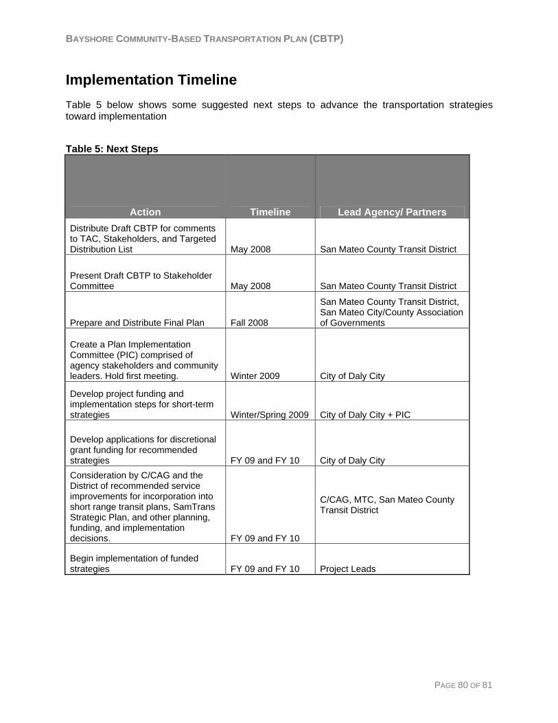
BAYSHORE COMMUNITY-BASED TRANSPORTATION PLAN (CBTP)
Implementation Timeline Table 5 below shows some suggested next steps to advance the transportation strategies toward implementation Table 5: Next Steps
Action Timeline Lead Agency/ Partners Distribute Draft CBTP for comments to TAC, Stakeholders, and Targeted Distribution List May 2008 San Mateo County Transit District
Present Draft CBTP to Stakeholder Committee May 2008 San Mateo County Transit District
Prepare and Distribute Final Plan Fall 2008
San Mateo County Transit District, San Mateo City/County Association of Governments
Create a Plan Implementation Committee (PIC) comprised of agency stakeholders and community leaders. Hold first meeting. Winter 2009 City of Daly City
Develop project funding and implementation steps for short-term strategies Winter/Spring 2009 City of Daly City + PIC
Develop applications for discretional grant funding for recommended strategies FY 09 and FY 10 City of Daly City Consideration by C/CAG and the District of recommended service improvements for incorporation into short range transit plans, SamTrans Strategic Plan, and other planning, funding, and implementation decisions. FY 09 and FY 10
C/CAG, MTC, San Mateo County Transit District
Begin implementation of funded strategies FY 09 and FY 10 Project Leads
PAGE 80 OF 81
BAYSHORE COMMUNITY-BASED TRANSPORTATION PLAN (CBTP)
PAGE 81 OF 81
Lifeline Funding This section gives some information regarding MTC’s Lifeline Transportation Program funding. Additional potential funding sources for the recommended strategies are summarized in Appendix D. MTC’s Lifeline Program is designed to fund projects that improve mobility for low-income residents in the Bay Area. The next Call for Projects for Lifeline funding will be administered by C/CAG late summer 2008. The Lifeline program is designed to fund projects that come from Community-Based Transportation Plans. Many of the recommended strategies in this CBTP would potentially be eligible to receive Lifeline funding. These include:
• #1: Provide Circulator Shuttle Service • #2: Provide Discounted Taxi Rides to Medical Facilities • #3: Subsidize School Bus Service • Select elements of other recommended strategies
According to the Guiding Principles for County Lifeline Programs from the most recent Lifeline funding cycle, the Lifeline Program supports community-based transportation projects that:
• Are developed through a collaborative and inclusive planning process that includes broad partnerships among a variety of stakeholders such as public agencies, transit operators, community-based organizations and other community stakeholders, and outreach to underrepresented stakeholders.
• Address transportation gaps and/or barriers identified through a Community-Based Transportation Plan (CBTP), countywide or regional Welfare-to-Work Transportation Plan, or are otherwise based on a documented assessment of needs within the designated communities of concern. Findings emerging from one or more CBTPs may also be applied to other low-income areas, or otherwise be directed to serve low-income constituencies within the county, as applicable.
• Improve a range of transportation choices by adding a variety of new or expanded services including but not limited to: enhanced fixed route transit services, shuttles, children’s programs, taxi voucher programs, improved access to autos, capital improvement projects. Transportation needs specific to elderly and disabled residents of low-income communities may also be considered when funding projects.
The Lifeline Call for Projects will be available on the C/CAG website (http://www.ccag.ca.gov/) in August or September 2008.