community history and rural development: why … in: agricultural systems 59:193-214 (1999)...
TRANSCRIPT
Published in: Agricultural Systems 59:193-214 (1999)
Community History and Rural Development: Why Some
Farmers Participate More Readily than Others
Bradley B. Walters
Department of Human Ecology
Cook Office Building,
Rutgers, the State University of New Jersey
55 Dudley Rd., New Brunswick, NJ 08901-8520 USA
Angelita Cadelina
Department of Biology, Silliman University
Dumaguete City, Negros Oriental, Philippines 6200
Ariston Cardano
Department of Environment and Natural Resources
Ayungon, Negros Oriental, Philippines
Eduardo Visitacion
Department of Agriculture
Bais City, Negros Oriental, Philippines 6206
Key Words: Philippines, rural development, reforestation, soil conservation, community participation,
research-extension methods
ABSTRACT
Past explanations of why rural people respond as they do to external development interventions have
emphasized the role of key limiting factors or critical characteristics (wealth, education, land tenure, etc.)
which are thought to influence peoples' behavior in predictable ways. Efforts to promote tree planting
and soil conservation in eight neighboring villages in the Philippines revealed that variation in
participation did not reflect clear patterns based on existing household or village characteristics.
Instead, specific responses to interventions reflected a complex, but interpretable interaction between
existing socio-economic factors and historic trends or events. Characteristics like the degree of local
knowledge, security of land tenure and community cohesion affected peoples' participation, in general,
but their specific influence was neither predictable nor consistent between and even within individual
villages. An appreciation of the specific historic context was often sufficient to explain these variations.
The following historic trends and events were found to have important consequences for peoples'
participation: migration and settlement history; family & group lineages; history of socio-political
organization and conflict; history of physical isolation; labor history; economic-ecological history;
environmental history; and past exposure to development agents. The paper concludes with a
preliminary checklist of questions intended to assist researchers and development agents to discover
relevant and interesting historical information about rural villages.
3
INTRODUCTION
Explaining why rural smallholders in the tropics respond as they do to external development intervention
has been a goal of many studies in recent years. Understandably, efforts of this kind have often sought to
develop predictive frameworks and models of human behavior. In most cases, this has involved the
identification of critical factors that, if understood, would enable general predictions about the outcome of
given forms of intervention across a wide variety of contexts. For example, secure land or resource
tenure is now frequently cited as a necessary pre-requisite for enlisting participation in land improvement
activities like tree planting (Fortmann, 1985; Raintree, 1987 Amacher et al., 1993; Netting, 1993; but see
White and Runge, 1994; Sain and Barreto, 1996). Other works have highlighted the importance of
income, marketing and credit (Hyman, 1983; Feder et al., 1985; Godoy, 1992), labor variability
(Fortmann and Rocheleau, 1985; Guggenheim and Spears, 1991; Godoy, 1992; Netting, 1993; Thacher et
al., 1997), "rational" or economic decision-making (Vayda, 1983; Cadelina, 1985; Feder et al., 1985;
Cancian, 1989; Amacher et al., 1993; Netting, 1993; Low, 1994; Arnold, 1995; Current et al., 1995),
social organization and institutions (Uphoff, 1986; Cernea, 1989; Ostrom, 1990; Guggenheim and Spears,
1991; White, 1992a,1992b; Rudel and Horowitz, 1993; Tendler, 1993), and intervention strategies
(Korten, 1980; Chambers, 1986; Jones and Wallace, 1986; Falconer, 1987; Chambers, 1994; Scoones and
Thompson, 1994).
There is now a wealth of theory and practical experience that continues to contribute to our
understanding and appreciation of the factors that influence development intervention. At the same time,
however, placing undue emphasis on the identification of so-called key characteristics or critical factors
can be misleading. For one, the more certain factors are emphasized, the greater is the likelihood that
other factors--perhaps less commonly encountered, but nonetheless important in a particular context--may
be overlooked. Furthermore, social and economic characteristics are always embedded in particular
historic contexts which may alter their meaning or significance, often in unexpected ways.
This article is an empirical contribution to a growing literature in the social sciences which
emphasizes the importance of understanding histories and local socio-ecological contexts as a basis for

4
explaining present-day patterns of social organization and human behavior (North, 1990; Peluso, 1992;
Putnam, 1993; Vayda, 1994; Cornell and Gil-Swedberg, 1995; Taylor and Garcia-Barrios, 1995; Sowell,
1996; Vayda, 1996; Adelman and Morris, 1997; Landes, 1998). Specifically, the article describes and
compares the social responses of eight, seemingly similar, neighboring villages in Negros Oriental
Province of the Philippines to a development program that promoted tree planting and soil and water
conservation (Walters, 1994b; Walters et al., 1994; Walters, 1997). We argue that rural development
agents can enrich their understanding and improve their effectiveness by attending to local social and
ecological histories.
Hindsight and two years of project experience have proven many of the project staff’s initial
assumptions about the target villages and predictions based on these assumptions to be inaccurate. This is
not surprising given that virtually all rural development projects are problem-ridden. What is surprising,
however, is that our subsequent efforts to explain why project interventions were more successful in some
villages than in others were not always well aided by the existing literature on the adoption and diffusion
of tree planting and other agricultural innovations. This is because much of the variability encountered
by this project was explained, not in terms of any one or several static characteristics or factors, but rather
by better understanding specific village and peoples’ histories. For example, the propensity for villagers
to cooperate with program staff and with each other had much to do with their previous encounters with
external agents and their prior experience working together in past situations. Similarly, the way in which
land tenure security played a role in farmers' decisions to participate in land improvement activities was
often made clear only as staff came to understand particular historical patterns or events in individual
villages. Land tenure security, in itself, was neither a good, nor consistent predictor of participation in the
project.
The first section of this paper briefly describes the general study area and outlines the methods
used in this analysis. The next section provides a general historical overview of settlement and land use
within the Bais Bay watershed study area. This is followed by a summary of the Bais Bay Basin
Program's efforts to promote tree planting and soil-water conservation and an account and explanation of
the Program's experience in each of the eight villages. The paper concludes with a synthesis of important

5
findings and recommendations for incorporating a more historically-sensitive approach to the study and
practice of rural development interventions.
6
STUDY AREA AND RESEARCH METHODS
The eight villages studied were located in the mid and upper reaches of the Bais Bay Basin, a mid-size
watershed that drains eastward along the southeastern side of Negros island, in the Central Visayas region
of the Philippines (Figure 1). The watershed straddles three local government jurisdictions (two
municipalities and one city) although most of the area falls within the City of Bais. The watershed
includes about 6,000 ha of fertile lowlands, virtually all of which are held in large private haciendas and
planted to sugar cane, and about 10,000 ha of mountainous uplands. These lands drain eastward into two
shallow and productive coastal bays that are used intensively for fishing and aquaculture (Figure 1;
Walters 1995). Most of the uplands have been cleared of natural forest and planted either to sugar cane,
coconut or various subsistence crops, especially corn (Table 1). Soil erosion resulting from deforestation,
farming and road building is widespread and severe throughout much of the uplands.
The research methods and analysis used in this study involved a combination of ethnographic
and historical investigation, and participatory evaluation. Historical information concerning settlement
and land use in the watershed was obtained primarily from interviews with long-time residents of the
areas in question, as well as through consultations with local government officials. The village case
studies were derived in large part through participant observations and interpretations that resulted from
the direct experience and interpretations of the four authors, each of whom served as staff on the project
between 1991 and 1993. In particular, Cardano and Visitacion lived and worked intermittently in each of
the eight villages between 1991 and 1993. In addition to their roles as principal extension agents, they
were responsible for gathering historical and socio-economic information on the individual villages and
reporting back to Cadelina and Walters on a regular basis regarding their investigations and experience
working at each site.
Walters was specifically tasked with undertaking a process documentation and evaluation of the
overall project and so kept a detailed diary of events and submitted regular progress reports to the central
project administration in Los Banos and in Canada (Walters, 1994b). These reports served subsequently
as references for this paper. In addition, Walters engaged in ongoing, informal discussions during the
7
project with Cardano, Visitacion, Cadelina and other Program staff, and regular staff meetings were held
to discuss the progress and problems associated with the project.
Prior to Walters’ departure in 1993, he interviewed 30 of the 38 original farmer cooperators from
the eight target villages, as well as twelve other residents from these villages, in order to obtain their
assessments of the Program and the reasons for its relative success or failure. (The detailed results of this
survey are summarized in Walters et al., 1994.) Walters also did semi-structured interviews with each
staff member and with the staff as a group in order cross-check facts, synthesize the project experience on
a village-by-village basis, and permit individual and collective interpretations as to why the project was
more or less successful in each village. Walters then synthesized these findings and applied counter-
factual analysis to evaluate the relevance of specific historical events and factors as probable causes of
project success or failure (see Fearon, 1990). In so doing, questions are posed as to whether or not the
presence of a particular event or factor has influenced the outcome of, in this case, the project
intervention. To answer this, a counter factual question is proposed: “were this factor/event different,
might the project outcome have also been different?”. In cases where the answer is likely affirmative, then
such factors or events can be rightly attributed causal importance.
Finally, the resulting analysis and interpretation was re-examined and confirmed by individual project
staff.
HISTORY OF SETTLEMENT, DEFORESTATION AND LAND USE
This section reviews the historical patterns of settlement and land use in the Bais watershed. For this
purpose, a distinction between a "north" and a "south" arm of the watershed is made because differences
in topography and soils between the two arms have posed very different constraints on road building,
settlement and subsequent agricultural development. Each of the arms included four target villages.
The North Arm of the Watershed

8
According to long-time residents, much of the uplands in Bais prior to the Second World War were still
heavily forested. Access was limited to trails and foot-paths and the lands were sparsely settled by
subsistence cultivators who grew corn and other vegetables using shifting cultivation, called kaingin.
Beginning in the late 1940's and continuing in fits and starts ever since, the local government of
Bais has financed road construction up the northern side of the watershed through what are now the
villages of Canlumbog, Malai-ba and later Tagpo and Amalao (Figure 1). Initial roads were constructed
to facilitate commercial logging, although their expansion and enhancement has continued as part of the
local government's long-term efforts to link remote areas to lowland markets and other services, as well as
to establish on overland link to the eastern side of Negros island. Road construction hastened further
influxes of shifting cultivators to Malai-ba and Tagpo between the late 1950's and early 1970's. Shifting
cultivation has since given way to more sedentary agriculture in most areas as natural population growth
and continued migration have absorbed remaining accessible lands.
Road construction also had the delayed effect of altering the land ownership and agricultural
patterns by linking remote upland areas to the lucrative sugar cane markets in the lowlands. Owners of
large sugar cane haciendas in the lowlands were the first to exploit this opportunity and several laid claim
in the 1960's to virtually all of the lands in the Canlumbog/Malai-ba area, as well as a few scattered
parcels further up the watershed in and around the villages of Tagpo and (what later became) Amalao.
They planted sugar on the best lands and coconut elsewhere and hired locals to work and manage their
farms.
In Canlumbog, in particular, absentee owners engaged in various tenant-laborer arrangements that
permitted local farmers to grow corn and other crops on idle lands or amidst coconut groves. Similar
arrangements were common in Malai-ba, but during the late 1970's government land reform under
Marcos distributed most of the lands around Malai-ba to the local laborer and tenant population. At the
time this study was being conducted, many of the lands in the community of Canlumbog were similarly
being considered for redistribution under Aquino's Comprehensive Land Reform Program.
The lands around what is now the community of Amalao offer yet a different case history. Here,
a lowland elite obtained a lease for about one hundred ha's of public land from the Bureau of Land

9
Management for raising cattle. This same elite encountered labor conflicts on his lowland hacienda in the
late 1960's. As part of a strike settlement agreement brokered by the local City government, the upland
lease was transferred in small, private lots over to the strikers and their families. The strikers settled there
in 1972, establishing the community of Amalao (Figure 1 and see below). These settlers removed most of
the remaining forest cover from the area within a few years.
During the 1970's, smallholder farmers throughout the northern watershed began adopting sugar
cane as their predominant agricultural crop, citing the opportunity to earn high cash profits as the
principal motive. Today, sugar cane is mono-cropped on the majority (>75%) of both large and
smallholder lands on the northern watershed (Table 1). Corn, the major staple food, is grown seasonally
by many smallholders and tenant farmers on smaller plots. Coconut is also widespread, particularly on
the large land holdings. There are virtually no natural forests remaining in the northern arm of the
watershed and remarkably little land is devoted to the production of other kinds of fruits and vegetables or
livestock.
The South Arm of the Watershed
The history of land use in the uplands of the southern arm of the watershed has differed in important
respects from the north. Overall, there is relatively little good-quality agricultural land in the southern
watershed. Nonetheless, the lower elevation uplands of the southern watershed were attractive to early
settlers because of the geographic proximity of these lands to Bais City proper (Figure 1). For example,
informants say that the lands around Banga-banga, the village nearest to town, were deforested and, in
places, severely degraded as early as the 1940's.
A few of the better lands further up the watershed around Panala-an and Tina-an were sparsely
settled by shifting cultivators before the Second World War. The few suitable lands in Tina-an were
mostly claimed by these early settlers and their descendants. A sharp influx of additional migrants to the
Panala-an area in the late 1960's/early 1970's combined with natural increase quickly brought local
population densities there to levels whereby all suitable agricultural lands were claimed and more settled
10
forms of agriculture began replacing previous shifting cultivation. Forest cover has remained higher on
this side of the watershed because many of the slopes are simply too steep to farm. At the same time,
however, considerable erosion and degradation has occurred on steep slopes that have been farmed.
The narrow valley bottom, sizable river and steep surrounding terrain has also precluded the
construction of a road up the southern arm of the watershed. This has restricted the development of the
area and has limited sugar cane growing to only a few, scattered locations along the lower end of the
valley where cane trucks can gain access during low river flow periods. As a result, elites from the
lowland have had little interest in acquiring lands here and most of the area has remained under the
control of smallholders.
Today, subsistence crops such as corn predominate the landscape around the communities of
Panala-an and Tina-an. The Community of Kambalagas, located in the uppermost portion of the south
arm of the watershed, was the last area to be settled. This area has the richest soils and retains the greatest
proportion of forest cover in the entire watershed (about 20%). These features create conditions that are
well suited to growing corn and commercially valuable fruits and vegetables, such as egg plant, garlic,
green beans, peppers and bananas. A road recently constructed from the northern side across to
Kambalagas (Figure 1) has increased access to lowland markets, although the road is long and bad and
high transportation costs have thus far limited the amount of land converted from mixed vegetables and
fruit to sugar cane to about one third of the farmed area.
In summary, a view of the overall Bais watershed today reveals a deforested and considerably
degraded mountain landscape that is significantly populated and intensively farmed over much of its area.
However, this gross perspective hides tremendous local differences that are the historical consequence of
varied environmental conditions, social groups and economic forces. Most obvious among these has been
the impact of 20km of roads being built up one side, but not the other side of the watershed (Figure 1).
Road building has accelerated settlement, altered land tenure patterns and transformed the local
agricultural economy of northern villages to one nearly completely dominated by sugar cane. However,
as was already briefly outlined and will be further discussed, important differences resulting from
historical vagaries exist on a much finer scale: between and within individual villages.
11
THE BAIS BAY BASIN DEVELOPMENT ACTION PROGRAM:
STRATEGIES AND EXPERIENCE
The Bais Bay Basin Development Action Program (DAP) was intended to test and promote strategies for
linking environmental conservation with rural development. The Program involved a number of
concurrent projects in both the uplands and along the coast of the watershed (Walters, 1994a, 1994b,
1997). The specific environment-development priorities in each case were identified in 1991 at a
consultative agro-ecosystem workshop involving a number of university experts and local
government/non-government officials and representatives (Walters, 1994b). The upland, watershed
restoration component of the Program that is considered in this paper was intended to reduce soil erosion
and flooding, and loss of forests and associated biological diversity by (1) reforesting upland riparian
habitat with indigenous tree species and (2) promoting the adoption of soil and water conservation
techniques among smallholder farmers. These priorities reflected concern about the sustainability of
farming systems in the uplands and also a genuine anxiety that the degraded condition of the watershed
might eventually result in disastrous flooding as had just occurred on November 4, 1991 in Ormoc, Leyte,
whereupon 6000 people were killed as a result of a severe flash flood (Duenas, 1991).
Community participation and local institutional development were considered essential
components of this overall strategy. However, the Program's explicit emphasis on ecological restoration
and resource management was an important factor in its selecting the watershed--as opposed to particular
communities or a municipality--as a key unit for planning and initial project implementation. Ecological
linkages at the watershed level--such as severe soil upland erosion leading to coastal sedimentation--were
striking in Bais and it was thought that community-level efforts could be made more effective overall by
coordinating them at the watershed level (Walters, 1994a).
To achieve watershed-wide impacts, Program staff decided, at least initially, to spread efforts
widely using a community leader/farmer trainer approach in which key representatives from a number of
communities would be given focused support and training with the expectation that knowledge and action
would rapidly spread (through a multiplier effect) from these selected individuals to the wider community
12
(see Walters, 1994a, 1994b and Walters et al., 1994 for a critical evaluation of this and other strategies
used in the Program).
From maps and visual surveys, eight villages were identified as priority targets based on the
actual and potential seriousness of deforestation and soil erosion (Figure 1). For each village, Program
staff initially solicited the participation of three to six farmer cooperators who had been identified by
other village members as respected and capable individuals. These representatives were contracted by the
Program to assume initial responsibility for Program activities in their respective villages. The
cooperators’ tasks included construction and management of seedling nurseries; collection, rearing,
planting and caring of indigenous tree seedlings; and participation in soil and water conservation training
workshops.
The basis for initial mobilization and technical transfer involved intensive small group and one-
to-one training and field support. Extension staff met regularly with cooperators, assisted them in their
construction of a seedling nursery, and advised them on techniques for seedling care and planting.
Seeds, seedlings, tools and other materials were provided as needed. The village cooperators were paid a
small monthly fee for the reforestation work only to defer costs and provide a small added incentive. In
consultation with the cooperators, about 10 km of upland riparian habitat were targeted for reforestation.
Once nurseries were up and running, staff shifted emphasis to the promotion of soil and water
conservation. This was initiated in each village by a public meeting held in the local elementary school.
This meeting was advertised by staff and through the village cooperators and open to all interested
residents. The meeting was intended as both a training seminar and community mobilizing event.
Discussions about the value of soil conservation and basic instruction on how to apply different
techniques were presented in the morning, and this was followed by participatory farm planning exercises
and field demonstrations in the afternoon. Interested individuals were then organized into small work
groups, traditionally called alayon, in order to facilitate participation and save labor in the installation of
soil and water conservation infrastructure. Participants were also encouraged to share their experiences
with members in their village not present at the meeting and to consider enlisting kin and friends in
similar alayon.
13
Alayon work groups became the focus of most subsequent extension training and support. Staff
made regular visits to villages and arranged to meet with representatives of alayon groups to demonstrate
different techniques, including hedgerows, sediment traps, rock walls and drainage canals. In recognition
of the importance of imitation in the spread of novel technologies, staff initially focused field trials and
training on “model” farms that were subsequently showcased to the wider community and used in cross-
farm visits.
In summary, the Program's strategy ensured that each of the eight villages received roughly
similar "treatments" during the initial stages. However, experience revealed a wide variety of social
responses--many quite unexpected--between different villages and even within the same village. These
highly varied and often unpredictable responses prompted staff to adopt intervention strategies that were
increasingly tailored to individual villages (Walters et al., 1994). The following section examines our
experience working in the eight villages, highlighting the important causal-historical factors that either
enhanced or impeded farmer participation, collective action and technical transfer in each village. These
experiences are summarized in annotated form in Table 2.
CASE STUDIES OF INDIVIDUAL VILLAGE RESPONSES
Canlumbog Village
When the Program began in late 1991, virtually all of the lands in Canlumbog were held in mid-size
plantations (15 - 30 ha) owned by absentee landlords. Local residents worked these plantations as paid
laborers and in exchange for the rights to farm small tenant plots of 0.5 ha or less. Shortly after
beginning, we learned that there was a great deal of uncertainty about whether ongoing negotiations with
the Department of Agrarian Reform would eventually lead to distribution of some or all of this property
to local residents. In either case, the village was sharply divided into pro- and anti-land reform factions
when the Program began there.
Given the uncertainty over land tenure, existing political divisions, and the residents' relative
14
inexperience with independent farming, project staff had predicted that residents would not be interested
in tree planting or soil-water conservation. Contrary to expectation, however, many residents
demonstrated early a keen interest in the Program. The presence of a strong, supportive resident leader
who was much respected in the community was an important factor. But, the relative ease at which
residents initially mobilized was difficult to explain solely in terms of leadership.
The clue to this pattern of behavior was revealed when staff considered historical labor patterns in
the area: most adult residents living in Canlumbog had considerable experience working seasonally as
paid laborers on local and nearby, lowland sugar cane haciendas. Specifically, the residents' particular
experience working in teams, by contract, and under authority as plantation laborers emerged as an asset
for certain Program initiatives. In particular, the contract nursery management and tree planting, with its
clear tasks and set payments, was agreeable to many residents because it made intuitive sense to them as
experienced contract laborers. Likewise, residents were eager to participate in group activities that
involved learning new information and skills. This was also contrary to initial expectation given that
farm management represented a relatively small economic priority for most of them. But again, the key
social processes involved in the Program’s initial learning and mobilization efforts--namely, meeting at
set times and locations, taking directions from perceived authority figures, and working in groups--were
familiar to them as hacienda laborers.
Political divisions, inexperience and uncertainty over land tenure eventually proved problematic,
nonetheless. For one, participants were technically unskilled and lacked self-confidence in farm
management and so required more instruction and support than Program staff had initially anticipated (or
were ultimately able) to provide. Technically complicated tasks like managing the indigenous tree
nursery were poorly performed as a result. Also, residents were more eager to learn new farm
management skills than they were to apply them in the form of actual land improvements. With few
exceptions, participants planted trees and implemented soil & water conservation only within or
immediately adjacent their own tenant gardens and homes, which is still significant given they did not
own even these lands (although some clearly had hopes that they soon would).
15
Malai-ba Village
Land reform programs in the 1970's under the Marcos administration broke up several large land holdings
in Malai-ba and distributed these in small, private parcels to a relatively small population of resident
laborers and tenants. The local topography is steep, however, and intensive farming on these small plots
of land has led to severe and widespread soil erosion. This combination of factors--shared history, small
population, secure land tenure and severity of environmental deterioration--plus the presence of a strong
local leader made it relatively easy to access and mobilize the residents of Malai-ba from the outset. For
example, in contrast to a number of the other communities, the cooperators in Malai-ba easily gained the
support of landowners and were able to plant trees on most of the targeted areas.
Unfortunately, factors that served as positive attributes in one respect proved detrimental in
another. In the case of the tree planting, a conflict was encountered between restoring and protecting
degraded lands, on the one hand, and maximizing production from small holdings, on the other. In short,
these farmers were accustomed to intensively cultivating all of their lands, including riparian areas. Even
though most farmers either permitted or actively participated in tree planting, many of the young trees
were eventually crowded out by faster growing sugar cane and other crops. A landslide resulting from
road construction along steep slopes also destroyed some of the planted areas.
Existing technical knowledge in Malai-ba was low, as in Canlumbog, and participants required a
level of technical support and supervision that staff were not always able to provide. For example, many
of the initial seedlings died in the nursery shortly after delivery because the cooperators did not
understand how to properly care for them. Likewise, a number of the cooperators and other residents
were eager to develop SWC on their farms early on, but these farmers needed more support than the staff
were able to provide at that time and this opportunity was largely missed.
Amalao Village
The village of Amalao was literally created by the stroke of a pen in 1972 when the Mayor of Bais City
16
brokered a settlement between a group of striking hacienda workers and their landlords. The workers
agreed to end the strike in exchange for each family receiving a plow, a carabaw (draft animal) and 1.0 ha
of land in what had previously been a pasture lease on public land. The socio-economic and ecological
conditions in Amalao were thus like Malai-ba: a relatively small population of farmers, sharing a common
history, and each with precariously small, marginal land holdings.
The residents of Amalao, like those in Malai-ba, were relatively easy to mobilize as a group:
more than half of all households participated regularly in meetings and training sessions and alayon work
groups were effectively employed for soil and water conservation work. Unfortunately, like both Malai-
ba and Canlumbog, the farmers were also relatively inexperienced in technical matters and required
considerable support which, in this case, they got in the form of regular, live-in visits from one of the
Program's staff (Walters, 1994). The added staff attention was doubly important because, in contrast to
Malai-ba and Canlumbog, there were no strong, natural leaders in Amalao.
The unusual history of Amalao had nonetheless bestowed upon the village unique problems
involving the tenure and condition of the lands. First, in brokering the relocation deal the Bais City
government had used national forest lands as its major bargaining chip without formal consent of the
national government! The result was that the residents of Amalao were perceived as private landowners
by the local government, but they were seen as squatters in the eyes of the national government. The
residents of Amalao were very concerned about this, but if anything, this concern about tenure insecurity
translated into greater interest and levels of participation in the Program, not less, as might otherwise
have been expected. The reasons for this response appeared to reflect the residents' belief that since
government had a hand in settling them there, their claims were legitimate, even if they were unresolved.
Furthermore, the villagers hoped that the Program staff could assist them to resolve the issue with the
appropriate government authorities, either by organizing the villagers or speaking on their behalf.
The second problem concerned the poor condition of many of the lands, the direct result of their
having been previously used as cattle pasture. Extensive, degraded areas were overrun with cogon
grasses (Imperata cylindrica) rendering them marginal for farming and practically unavailable for tree
planting. This combined with the small productive holdings, placed a premium on usable farm land and
17
thereby further restricted the areas available for planting trees. Given these conditions, successful tree
planting was limited to relatively unproductive lands around homes and some creeks.
Tagpo Village
Tagpo's history is distinctly different from the previous three villages in several crucial respects. Since
first settlement the majority of lands in Tagpo were claimed and have since remained in the hands of
successive migrations of smallholders, most of whom have established private, undisputed ownership
over parcels of land ranging in size from 2 to 6 ha's. Tagpo is located several kilometers from the main
mountain road. This relative remoteness probably accounts for the area not having been claimed by elites
during the 1950's and 60's, as occurred in and around Canlumbog and Malai-ba. The City helped build a
road into Tagpo during the early 1970's, enabling cane trucks to access the area and thus prompting the
widespread planting of sugar cane on most of the lands there. However, the road is long, rugged and
usually washes out during the wet season. Tagpo thus continues to endure a degree of isolation not
experienced by many of the other target villages.
Program staff were initially optimistic about working in Tagpo because many of the apparent
ingredients for promoting land improvement were already present, including secure private land tenure
and high levels of farming skills amongst the local population. Furthermore, many of the residents of
Tagpo were already aware of the environmental dangers associated with excessive deforestation and soil
erosion: a few years prior two children were drowned in a flash flood which residents acknowledged had
been partly caused by deforestation and soil erosion.
Surprisingly, however, Tagpo turned out to be one of the most complex and difficult villages to
work in. Residents were often distrustful of Program staff; group meetings were poorly attended, often in
spite of apparent expressions of interest; and sharp political divisions were revealed within the village that
initially undermined attempts to generate widespread participation. The Program eventually made
progress in Tagpo, but only after many months of frequent visits and dogged determination by Program
staff, and appropriate adaptation to local circumstances that included, among other things, establishing
18
one village tree nursery for each of the two political factions (Walters, 1994b).
One reason for this resistance was that past agricultural extension projects--while raising the level
of local knowledge and skills--appear to have instilled a sense of local skepticism about outsiders who
came to their village with promises to assist them. However, Program staff agreed that the combined
effects of remoteness, a staggered history of settlement, and the independent and dispersed history of
farming were also important because they had conditioned a relatively self-sufficient and atomistic
attitude among its residents. The contrast with the previous villages was both striking and ironic: whereas
the residents of Canlumbog, Malai-ba and Amalao were unskilled, but enthusiastic and cooperative, the
farmers of Tagpo were highly experienced, but skeptical and uncooperative.
Kambalagas Village
Kambalagas is the only village that has historically been more isolated than Tagpo. The lands around
Kambalagas are designated public forest lands and extend to the summit of the Southern arm of the
watershed. Only a few smallholder families had settled the area prior to 1975. Access to and from the
lowlands was by a long, sometimes treacherous foot path via the villages of Tina-an and Panala-an.
Around 1980 a very long, rough dirt road was punched through to Kambalagas along the upper reaches of
the watershed from the main northern mountain road (Figure 1). This was followed by additional
settlement to the area and some farmers began to grow sugar cane, although high transportation costs
remained prohibitive for many.
The remoteness and recent settlement of Kambalagas meant that the soils were still relatively
fertile and substantial areas of land still forested (about 20% of the total area). The forest cover and soils
provided micro-environmental conditions unique in the entire watershed and suitable for growing a
diversity of high value vegetables and fruits like egg plant, garlic, peppers and banana. It was, therefore,
relatively easy for staff to enlist farmer participation in the Program given their vested economic interests
in maintaining healthy watershed conditions. Moreover, the farmers' experience propagating a wide
variety of plants and managing diverse, multi-crop farms was an asset when it came to reforesting and
19
applying novel soil conservation techniques. The reforestation component of the Program was more
successful in Kambalagas than in any other community and large numbers of residents eagerly
participated in soil & water conservation training workshops (Walters et al., 1994).
Staff did, however, encounter difficulties during two stages of the Program. At the outset,
residents were extremely cautious of Program staff, fearing that they were associated with the national
government and had intentions of evicting the residents. Most of the residents pay taxes to the local
government for the lands they farm, but they nonetheless have few illusions about the legal frailty of
these claims. Apparently, these fears had been stirred-up by past visits from national forestry officials
who had expressed the desire to return the fields back into their intended, original forested condition.
Fortunately, several staff had a historical rapport with some of the residents and were able to convince
them of our benign intentions.
Kambalagas was politically divided and, overall, had little community cohesion. Like Tagpo,
Kambalagas was a relatively young, frontier village populated by residents lacking a shared identity and
limited in their collective work experience. As a result, activities that involved substantial shared labor
and group work, like building rock walls or digging drainage canals, were slow to get going.
Tina-an Village
Tina-an is a small, relatively isolated village located in a steep valley about 1 km downstream of
Kambalagas (Figure 1). The area was initially settled prior to the Second World War and most of its
current residents are descendants and extended kin of these first settlers. Road building since the War has
opened up historically remoter areas like Kambalagas, but these new roads have bypassed Tina-an
completely and the village remains today perhaps the most remote in the entire watershed. All products
destined for market must be carried out by hand via a long, sometimes treacherous foot path. For this
reason, farmers in Tina-an restrict their efforts to producing crops for local consumption and a few high-
valued vegetables and fruits like peppers, egg plant and bananas.
Our experiences in Tagpo and Kambalagas suggested that the effects remoteness and isolation
20
can have on local people are not always advantageous to external intervention. The Program's experience
in remote Tina-an was, nonetheless, almost entirely positive. Like the farmers in Tagpo and Kambalagas,
but unlike those in Canlumbog, Malai-ba and Amalao, residents of Tina-an were relatively self-reliant and
skilled and so required little direct technical support. One of the residents had even worked in the past for
the Department of Environment and Natural Resources (DENR) and served in this project as a resident
technical advisor for the tree nursery and reforestation work. His contribution added tremendously to the
success of these components of the Program (Walters et al., 1994).
But in contrast to Tagpo and Kambalagas, Tina-an farmers were also easily mobilized and quick
to cooperate with Program staff and among themselves. Several factors helped explain this difference.
For one, land tenure was not as major a concern as it had been initially in Kambalagas. A few of the
residents held legal private titles, but even those who didn't had strong historical claims to their lands--
claims which had been re-enforced in recent years by forestry officials coming to their village and
allocating formal certificates of land stewardship under the national Integrated Social Forestry Program
(Payuan, 1985). Second and equally important, the residents shared a long history of close social contact
and self-reliance based to a large degree on close kinship ties and re-enforced by historical physical
isolation. In short, individuals appeared to know where they fit in the local social order and the
endorsement and leadership of a key few individuals quickly led to the participation of most others.
Panala-an Village
Panala-an is a large village of nearly 200 households spread along 0.5 km of the lower reaches of the
southern arm of the Bais watershed (Figure 1). The area is characterized by a wide (50m - 200m), flat
valley bottom with steep surrounding valley slopes. While there is no road entering the area, the river bed
is passable by truck during the dry season and farmers with suitable arable land often grow sugar cane.
The settlement and land tenure history of Panala-an is complex. Successive waves of settlement
and out-migration by smallholders, beginning around the 1920's and continuing until the early 1970's,
have been juxtaposed with large claims made by absentee landowners and the subsequent distribution of

21
some these holdings to smallholders. By 1991 this had resulted in a mixture of mostly small land
holdings (2 - 5ha)--some privately titled and others on public forest lands--and a few large, absentee
owned parcels with tenants. Certificate of land stewardship agreements have also been provided by the
DENR to a number of smallholder public land claimants, thus further re-enforcing the belief that claims
on public property in Panala-an are legitimate.
Program staff were not surprised by the absence of overall community cohesion given the large
and diverse character of Panala-an. At the same time, however, several strong leaders and a number of
technically competent individuals emerged early in the process and subsequently mobilized a sizable
contingent of extremely enthusiastic farmers. The steep hillsides and long history of farming had resulted
in severe degradation and abandonment of many lands in the area and participating individuals were
clearly anxious to prevent this from occurring on their own farms.
The Program made a lot of progress quickly in Panala-an. The village tree nursery was very well
managed and two large alayon work groups formed and quickly engaged themselves in intensive training
and development of soil & water conservation techniques on their farms. The work groups were mostly
comprised of a mixture of extended family members and their friends. The rapid formation and
effectiveness of these groups demonstrated clearly the value of sometimes by-passing the village as a unit
and focusing directly on interested members and sub-groups, with the added hope that intended effects
will eventually spread more widely (Cernea, 1989; White, 1992b).
One final point merits mentioning. Flash floods accumulating from the upper reaches of the
watershed reach their peak in volume and velocity right around Panala-an. Severe floods result in re-
channeling of the river bed and can wash away homes and wipe-out entire fields of crops that have been
planted on the fertile valley bottom. Historical experience with such floods has left a strong impression
on many residents. On the positive side, residents needed little convincing about the importance of soil
and water conservation and reforestation. On the negative side, the threat of floods gave them little
incentive to invest in land improvement near the river, the intended initial target of the reforestation.
Eager program staff encouraged them to plant trees near the river anyway. Unfortunately, the villagers
experience proved accurate: a flash flood wiped-out hundreds of planted seedlings within weeks after the
22
first major planting!
Banga-banga Village
Banga-banga is a small community located on the steep upper slopes of the southern most edge of the
Bais watershed. Like Panala-an and Tina-an, Banga-banga was first settled by smallholders before the
War. Lowland elites have had no historic interest in the area because of the poor access, which has
always been limited to long, steep foot trails. As of 1991, most of the land holdings were small, private
titled or tax-declared on public timberlands. There appears to be no anxiety about tenure security.
Banga-banga was the most complicated village to work with. The Program was directly opposed
from the outset by local political leaders because staff failed to consult the local barangay captain--the
senior, locally-elected official--when they first entered the area and this lead to speculation that we were
affiliated with the New People's Army (NPA), the militant wing of the Philippine Communist Party.
Such speculation, we discovered, was founded on experience. The NPA had been active in the area a few
years prior and experts from the same university that we represented had previously been in consort with
them. However well founded the accusation, the result was dramatic: farmers who initially agreed to
participate were pressured to not cooperate with program staff at all. Once again, ignorance of the
particular historical context of an area carried a price: it took six months of negotiating with local
politicians and farmers for the Program to recover from this initial setback.
In the meantime, one particularly entrepreneurial farmer came forward and offered to assume
leadership for the Program in Banga-banga. This farmer was technically knowledgeable and highly
motivated. His family held fairly sizable holdings (about 15 ha's combined), although as with much of
the area, his lands were steep and had been farmed for so long that they were almost completely
exhausted. He saw the Program as primarily providing an opportunity for him to add value to his
degraded property by planting trees and restoring soil quality. Unfortunately, it became clear with time
that his motives were also political (he was a direct challenger to the barangay captain) and his
23
management style monopolistic (he made little effort to work with others and sought to capture the
Program for his own family's benefit).
Program staff eventually enlarged the reach of the Program in Banga-banga and had begun SWC
workshops with a number of farmers shortly before the senior author of this article departed.
Nonetheless, Banga-banga stands out as a stark example of the unpredictability of social responses in the
absence of understanding about a people's particular local history.

24
DISCUSSION
A number of prominent social scientists have demonstrated that historical experience significantly affects
the subsequent behavior of individuals and institutions and, in turn, constrains the range of possibilities
available for intervention (North, 1990; Peluso, 1992; Putnam, 1993; Landes, 1998). Tendler (1989), for
example, argues that interventions for poverty alleviation were more likely to succeed when based on an
intimate understanding of historic, situational constraints and opportunities afforded by the case at hand.
Similarly, Biggs (1995) found that successful programs in farming systems research (FSR) had been
crafted by practitioners to suit local institutional and situational contexts. Hirschman (1984) likewise
illustrates that efforts to mobilize collective action were far more likely to succeed where local people had
prior experience working collectively (i.e. had a greater reservoir of "social capital"), even in cases where
their prior experience was long past and had been directed towards very different objectives (see also
Putnam, 1993; Cornell and Gil-Swedberg, 1995). Anthropologists have also found that individuals and
groups maintain varying amounts of accumulated technical knowledge that are drawn upon under certain
conditions, but otherwise remain dormant in their regular, day-to-day practices--and thus unapparent to
outsiders (e.g. Colson, 1979, 1984).
The analysis of eight village responses in Bais provided numerous examples of how variable
histories--resulting from the timing and origin of migration and settlement, changes in land use and
economic production, evolving social and political allegiances and conflicts, and past experiences with
development agents--can have profound consequences for subsequent technological adoption decisions
and performance by smallholders. In the final sections of this paper, we synthesize some of the more
pertinent experiences to illustrate the causal relationship between past and present in Bais. The paper
concludes with a discussion of some of the methodological considerations arising from these findings.

25
Historic Trends with Present-day Consequences
Project staff were initially unaware of the prior extent of pertinent technical experience that existed in the
villages. Since the majority of smallholders devoted most of their efforts to farming sugar cane and/or
maize, it was generally assumed, for example, that few farmers had experience planting and husbanding
indigenous tree species like the ones being used for reforestation in the project. This turned out to be
largely the case in villages composed of former hacienda laborers. Later interviews with farmers
revealed, nonetheless, that most farmers in all villages (35 of the 37 total interviewed) had at least some
previous experience planting trees of some kind. More importantly, one-third of these farmers (n = 13)
had prior experience planting the same kinds of indigenous hardwood species being used in this project
(Walters et al. 1994). Inattention to the full extent and variability of farmers' prior tree husbandry
experience reflected, in part, the near total absence of hardwoods growing in and around most of the
villages. That farming and resource use patterns had changed dramatically in recent history--the
widespread adoption of sugar mono-cultures by smallholders was a relatively recent phenomenon in
many areas--was not initially considered. In either case, our initial ignorance led us to make inaccurate
assessments of the needs of different groups for technical support from project staff. Dove (1992)
observed similar inattention to local knowledge of tree husbandry by forestry extension agents in
Pakistan.
Variability in the patterns of land tenure and perceptions of tenure security were also inextricably
linked to historical context and experience. The idea that secure land tenure is an important pre-requisite
for smallholder participation in land improvement has attained an almost lawlike status in rural
development, although several recent studies provide evidence to the contrary (e.g. White, 1992b; Sain
and Baretto, 1996). For example, White and Runge (1994:30) found that, among Haitian smallholders,
“short-term and insecure land tenure arrangements did not hinder either the installation of soil
conservation practices or individual choices to participate in” watershed management activities. Land
tenure was an important factor in the Bais Program, but the particular relationship between land tenure
security and participation was not always clear, nor consistent. This, in part, reflected the wide diversity
26
of land tenure arrangements (Table 1). It reflected also a variation in the specific meaning of apparently
similar types of tenure. For example, it was difficult to generalize about smallholders' perceptions of the
validity of their own claims to public timber lands because these perceptions varied depending on, among
other things, how long they had occupied their respective land and whether or not previous experiences
with government officials had led them to believe that their claims were legitimate. Where public lands
had been settled and claimed for longer periods, as in Tina-an, Panala-an and Banga-banga, residents
demonstrated less concern about tenure security and this appeared, in general, to foster their participation
(but see below). By contrast, many of the smallholders in Amalao and Kambalagas were anxious about
their more recent claims.
Complicating the matter of tenure even further was the finding that active participation in land
improvement activities was not necessarily precluded in cases where serious anxieties concerning tenure
security still existed. For example, participation by residents of Amalao and Kambalagas was
forthcoming once it was made clear to residents that the Program did not pose a direct threat to their
uncertain claims. And in the case of Amalao, the desire to resolve concerns over land tenure security
actually served as an incentive to participate in the project. The relatively poor participation by residents
in Tagpo, where most farmers have private holdings, further highlights the complexity of the land tenure
issue.
The notion of "community cohesiveness” serves as a third illustration of the problematic nature of
predicting village responses based only on current characteristics. Community cohesiveness is widely
assumed to be an asset to participation, especially when development interventions involve local
collective work or knowledge sharing. The degree and kind of community cohesiveness in Bais varied
for historical reasons from village to village and this had important consequences for our efforts to
mobilize the respective villages.
Studies have shown, for example, that patterns of forest clearing and settlement in frontier areas
are not random, but commonly reflect coordinated efforts between extended family members and other
networks and groups (e.g. Vayda and Sahur, 1985; Rudel and Horowitz, 1993). The establishment of
Tina-an reflected such a pattern: the entire village is a cohesive unit based on a dense network of extended
27
family relationships maintained by several decades of relative physical isolation. The consequence of this
was that Tina-an residents were both easy to mobilize and required minimal technical support once they
got started. By contrast, the settlement patterns in Panala-an and Kambalagas were complex and highly
staggered in time resulting in varied and sub-divided social identities. This clearly limited the ability of
Project staff to generate village-wide cooperation, but the successful efforts in these two villages illustrate
that sub-village groups based on extended family and friends can also be effective units of cohesive social
action (Cernea, 1989; White, 1992b; White and Runge, 1994). In either case, the evidence from Bais
would suggest that historical experience and continuity among members of a smallholder group, be they
representative of entire villages or sub-units thereof, are common features of effectively cooperating
social units (Axelrod, 1984; Ostrom, 1990).
Prior collective work or organizational experience may also foster community cohesion and
promote subsequent collective action (Hirschman, 1984). In Maissade, Haiti, for example, participation
in collective watershed management efforts was strongly correlated with membership in groupman farmer
organizations (White and Runge, 1994). Similarly in Bais, the cohesiveness of residents in each of
Canlumbog, Malai-ba and Amalao reflected their respective histories working together as cane cutters and
other laborers on large sugar haciendas. Such group work experience meant that residents in these
communities were more easily mobilized into alayon work groups under the project. Not surprisingly,
however, work as hacienda laborers did not instill many leadership or technical skills and thus, in contrast
with Tina-an, these villages required considerably more leadership guidance and technical support from
Project staff.
Historic Events with Present-day Consequences
Relatively isolated events can also have profound and lasting influences, particularly on peoples'
perceptions. For example, experience with calamitous events--most notably flash floods--raised the
awareness among members of several villages about the possible consequences of environmental
degradation and thus the value of addressing this problem. Villagers observations of flood waters also
28
gave them insights about the relative suitability of different sites for planting trees.
The significance of historical events is, nonetheless, particularly well illustrated by considering
the historical experience of local villagers with external development agents. The eight villages varied in
their prior encounters with government and non-government extension workers and officials. In most
cases, such encounters were presumably of little consequence: government officials and extension agents
frequently made trips into the mountains (especially around election time) for a variety of reasons and
residents rarely made mention of these visits. There were, however, a number of instances whereby prior
visits/experience with outsiders profoundly influenced locals' subsequent interaction with our own staff
(Walters, 1994b, 1997). The most striking example of this was the suspicion and opposition encountered
in Banga-banga as a result of the community's prior negative experience with members of the New
Peoples' Army. Similarly, residents in Kambalagas were wary of outsiders who spoke of reforestation
because of prior encounters with DENR officials who had suggested the villagers could be evicted from
their lands for that purpose.
Seriously negative encounters such as these were probably the exception, however, rather than
the rule. For example, in Tina-an and Panala-an, our Program benefitted from prior visits by DENR
officials who had provided social forestry tenure contracts and limited technical training in farm
management. Similarly, Thacher et al. (1997) found that Costa Rican farmers who had prior interactions
with government extension agents were more likely to participate in recent tree planting programs. In
Bais, it was not uncommon to encounter expressions of confidence from smallholders who had benefitted
from previous City-sponsored water, road building or other projects, especially when it became apparent
to them that our project was strongly backed by the Mayor (Walters et al., 1994).
Methodological Issues
Studies of farmer responses to development interventions have relied largely on de-contextualized
modeling of farmer decision-making and point-in-time surveys of farmer characteristics (Feder et al.,
1985). These approaches are important, but their utility is often compromised by their inability to

29
accurately represent the complexity of the phenomenon under study and to account for the fluid and
contingent forces influencing farmer behavior and decision-making in particular socio-economic and
environmental contexts (Barlett, 1980). “Farming systems research” (FSR) (e.g. Shaner et al., 1982;
Hildebrand, 1986; Jones and Wallace, 1986; Jones and Street, 1990) and related “farmer-first” (FF)
approaches (e.g. Chambers et al., 1989; Scoones and Thompson, 1994) overcome many of the problems
associated with economic models and longitudinal survey techniques, but FSR and FF approaches also
tend to neglect consideration of history in their methods of inquiry (for exceptions, see Box, 1989;
Cornwall et al., 1994). In fact, with its explicit emphasis on elucidating system characteristics and
identifying regionally homogeneous systems (Hildebrand, 1986b; Jones and Wallace, 1986b), FSR, in
particular, is arguably a-historical in its conceptual and methodological orientation.
We argue that an understanding of smallholder responses to external development interventions
in the present can be significantly improved if closer attention is paid to local histories and their possible
present consequences. This will entail, not an abandonment of existing theory and research tools, but a
redirecting of emphasis to incorporate explicit historical analysis (North, 1990). This section considers
how such a redirection might be partly achieved by considering how researchers can better learn about
rural people and how extension agents can better prepare to perform interventions with them.
Detailed case studies and arguments for the use of causal-historical analysis as it applies to
smallholder settlement and forest use can be found in Rudel (1995), Rudel and Horowitz (1993), Vayda
(1983 and 1996), and Vayda and Sahur (1985). These particular studies are less concerned with
immediate development intervention, but they illustrate well the value of detailed, comparative case
history studies and their potential utility in land use policy and planning. Similarly, it might be
instructive to do more comparative studies in the hopes of revealing some general historical patterns of
smallholder responses to intervention (eg. Netting, 1993). For example, this study suggests that in Bais
the origin of migrants and their time since settlement may influence their willingness or ability to
cooperate with outsiders and among themselves. This observation raises interesting questions for the
wider Philippines where upland smallholders are of such diverse and often recent migratory origin (Cruz
et al., 1986).

30
Box (1989) and Cornwall et al. (1994) illustrate how historical analysis can be used to enrich
FSR and FF approaches. These authors note that the application of more progressive and participatory
methods does not, in itself, guarantee success in researcher-farmer or extension-farmer collaborations if
development agents fail to ask the right questions. Both authors recognize that questions about peoples’
particular histories are too often not asked.
In more directly applied contexts, as was the case in Bais, there is a demand for immediate,
highly specific and relevant information about smallholders living in specific target villages. In such
cases, extension agents are lucky if they can invest more than a few days intensively investigating local
conditions. Fortunately, our own experience suggests that rural residents often enjoy recounting the past
and it is not difficult to elucidate a great deal of potentially relevant historical information on things like
migration and settlement, historical agricultural and land use activities, prior encounters with extension
agents, socio-political rivalries and so on.
Much has been written recently on methods for learning rapidly about smallholders and other
rural people (Chambers, 1994; Mikkelsen, 1994). However, rapid assessment methodologies, including
rapid and participatory rural appraisal and agro-ecosystem analysis, are rarely explicit about the value of
investigating local history, though it would seem that a variety of the methods and tools available to rapid
assessment users--including causal analysis and key informant/group interviews--are potentially well
suited for historical investigations (e.g. Cornwall et al., 1994). Migration and settlement patterns, for
example, may be obtained by interviewing older residents. Likewise, group discussions can elicit and
provide consensus about important historical events or experiences. A preliminary checklist of questions
that may assist development agents in their assessment of villages is present in Table 3. This list is
intended as a preliminary guide to facilitate more in-depth historical inquiry.
This having been said, no amount of historical inquiry is going to provide development agents
and rural communities with absolute predictive certainty (Cronon, 1993). The historical factors or events
that proved critical for the Bais Program were often revealed as surprises as the project unfolded. This
was, in part, a result of staff not giving adequate attention to historical factors at the outset. Nonetheless,

31
we are confident that many of the surprise encountered would not have been predicted, even if we had
taken the extra time early on to investigate past events and histories. For that matter, we are still unable to
explain many of these surprises, even with the aid of hindsight!
What was so striking about the villages and people living in Bais was the profound variation in
histories that existed within such a small and apparently homogeneous area (see also Beebe, 1994). Staff
learned to appreciate this variability and its consequences by doing development work with these
communities: that is, we learned by doing (Ison et al., 1997; Korten, 1980). Our relative success in each
village depended on our ability to adapt to local situations and this led us to abandon a relatively
inflexible development plan in favor of a much more successful village-(or sub-village-)specific strategy.
In this respect, our experiences in Bais and the arguments presented in this paper agree with the need for a
more flexible, adaptive approach to rural development (Korten, 1980; Payuan, 1985; Chambers, 1986;
Falconer, 1987; Box, 1989; Cernea, 1989; Ison et al., 1997; Scoones and Thompson, 1994).
Involving intended beneficiaries in project design and implementation is one way of bringing
knowledge of past development experience to bear on the new effort. The local people will know
what, if anything, has been tried before and what, if anything, worked. There seems almost a
compulsion within development agencies to confirm the saying that "history repeats itself."
Indeed, when projects "reinvent the wheel" they usually end up in square one with a plan which
has already failed. -- Norman Uphoff (1991:494)
Attention to history is increasingly important because rural areas, like their urban counterparts,
are undergoing rapid and continuous change throughout much of the tropical world (Colson, 1984; Brown
et al., 1990; Vayda, 1994; Taylor and Garcia-Barrios, 1995). The Philippines, for example, has
experienced massive migrations to, from, and within rural areas, and dramatic and varied changes in land
use during the past few decades (Cruz et al., 1986; Bautista, 1990; Kummer, 1991; Kummer et al., 1994;
Myers, 1988). Economic and social relationships in rural areas are always evolving, but such changes are
increasingly driven by external forces and are, therefore, all the more abrupt and unpredictable
(Balisacan, 1992; Montes and Lim, 1996). Historical investigations can contribute to an understanding of
this flux and thus better inform development agents about possible opportunities or constraints afforded
by their intervention.

32
33
ACKNOWLEDGMENTS
Special thanks are extended to Chris Ablan, Betty Abregana, Andrea Alveola and Nelson Vilar of
Silliman University; Ben Malayang III and Percy Sajise of the Institute of Environmental Science and
Management at U.P. Los Banos; Shirley Conover and Peter Guy of Dalhousie University; and the City of
Bais and the many farmer cooperators and government officials who participated in the Bais Bay Basin
Program. The Program was funded by the Canadian International Development Agency. The authors are
grateful to Tom Rudel, Pete Vayda and Thomas White for comments on earlier drafts of the manuscript.
34
REFERENCES
Adelman, I. and Morris, C.T. (1997) Editorial: development history and its implications for development
theory. World Development 25, 831-840.
Amacher, G.S., Hyde, W.F. and Mohammed, R. (1993) Local adoption of new forestry technologies: an
example from Pakistan's northwest frontier province. World Development 21, 445-453.
Arnold, J.E.M. (1995) Framing the issues. In Tree Management in Farmer Strategies: Responses to
Agricultural Intensification, ed. J.E.M. Arnold and P.A. Dewees, pp. 3-17. Oxford: New York.
Axelrod, R. (1984) The Evolution of Cooperation. Basic Books: New York.
Balisacan, A.M. (1992) Rural poverty in the Philippines: incidence, determinants and policies. Asian
Development Review 10, 125-163.
Barlett, P. F. (1980) Adaptive strategies in peasant agricultural production. Annual Review of
Anthropology 9, 545-573.
Bautista, G.M. (1990) The forestry crisis in the Philippines: nature, causes and issues. The Developing
Economies 28(1), 67-94.
Beebe, J. (1994) The concept of the average farmer and putting the farmer first. Journal of Farming
Systems Research-Extension 4, 1-16.
Biggs, S.D. (1995) Farming systems research and rural poverty: relationships between context and
content. Agricultural Systems 47, 161-174.
Box, L. (1989) Virgilio’s theorem: a method for adaptive agricultural research. In Farmer First: Farmer
Innovation and Agricultural Research, ed. R. Chambers, A. Pacey and L.A.Thrupp, pp. 61-67.
Intermediate Technology Publications: London.
Brown, P., Brookfield, H. and Gran, R. (1990) Land tenure and transfer in Chimbu, Papua New Guinea:
1958-1984--a study of continuity and change, accommodation and opportunism. Human Ecology
18, 21-49.
Cadelina, R.V. (1985) Social forestry program prospects and implications on the community and
household levels. In Proceedings of the First Asian Forestry Congress (Book III), pp. 770-781.
ASEAN: Manila.
35
Cancian, F. (1989) Economic behavior in peasant communities. In Economic Anthropology, ed. S.
Plattner,
pp. 127-170. Stanford University Press: Standford.
Cernea, M. (1989) User groups as producers in participatory afforestation strategies. World Bank
Discussion Papers, No. 70. The World Bank: Washington, D.C.
Chambers, R. (1986) Normal professionalism, new paradigms and development. IDS Discussion Paper
vol. 227. University of Sussex:Sussex, U.K.
Chambers, R. (1994) The origins and practice of participatory rural appraisal. World Development 22,
953-
969.
Chambers, R., Pacey, A. and Thrupp, L.A. (1989) Farmer First: Farmer Innovation and Agricultural
Research. Intermediate Technology Publications: London.
Colson, E. (1979) In good years and in bad: food strategies for self-reliant societies. Journal of
Anthropological Research 35, 18-29.
Colson, E. (1984) The reordering of experience: anthropological involvement with time. Journal of
Anthropological Research 40, 1-13.
Cornell, S. and Gil-Swedberg, M.C. (1995) Sociohistorical factors in institutional efficacy: economic
development in three American Indian cases. Economic Development and Cultural Change 43,
239-268.
Cornwall, A., Guijt, I. and Welbourn, A. (1994) Acknowledging process: methodological challenges for
agricultural research and extension. In Beyond Farmer First, ed. I. Scoones and J. Thompson, pp.
98-117. Intermediate Technology Publications: London.
Cronon, W. (1993) The uses of environmental history. Environmental History Review 17, 1-22.
Cruz, M.C.J., Zosa-Feranil, I. and Goce, C. (1986) Population pressure and migration: implications for
upland development in the Philippines. Philippine Institute for Development Studies and Centre
for Policy and Development Studies Working Paper, No. 86-06.
Current, D., Lutz, E., Scherr, S. (ed’s) (1995) Costs, benefits, and farmer adoption of agroforestry. World
36
Bank Environment Paper, No. 14. The World Bank: Washington, D.C.
Dove, M.R. (1992) Forester's beliefs about farmers: a priority for social science research in social
forestry.
Agroforestry Systems 17, 13-41.
Duenas, M. (1991) Tragedy in Ormoc: killer flood. Philippine Free Press, 133(47) (November 23), 4,21.
Falconer, J. (1987) Forestry extension: a review of the key issues. ODI Social Forestry Network Paper,
No. 4e. Overseas Development Institute: London.
Fearon, J.D. (1990) Counterfactuals and hypothesis testing in political science. World Politics 43:169-
195.
Feder, G., Just, R.E. and Zilberman, D. (1985) Adoption of agricultural innovations in developing
countries: a survey. Economic Development and Cultural Change 33, 255-298.
Fortmann, L. (1985) The tree tenure factor in agroforestry with particular reference to Africa.
Agroforestry
Systems 2, 229-251.
Fortmann, L. and Rocheleau, D. (1985) Women and agroforestry: four myths and three case studies.
Agroforestry Systems 2, 253-272.
Godoy, R.A. (1992) Determinants of smallholder commercial tree cultivation. World Development 20,
713-725.
Guggenheim, S. and Spears, J. (1991) Sociological and environmental dimensions of social forestry
projects. In Putting People First: Sociological Variables in Rural Development (Second Edition),
ed. M. Cernea, pp. 304-339. The World Bank and Oxford University Press: Washington, D.C.
and New York.
Hildebrand, P.E. (ed.) (1986) Perspectives on Farming Systems Research and Extension. Lynne Rienner:
Boulder, Colorado.
Hildebrand, P.E. (1986b) The concept of “homogeneous systems” and its usefulness. In Perspectives on
Farming Systems Research and Extension, ed. P.E. Hildebrand, pp. 52-53. Lynne Rienner:

37
Boulder.
Hirschman, A.O. (1984) Getting Ahead Collectively: Grassroots Experiences in Latin America.
Pergamon:
New York.
Hyman, E.L. (1983) Smallholder tree farming in the Philippines: a comparison of two credit programs.
UNASYLVA 35(139), 25-31.
Jones, J.G.W. and Street, P.R. (ed’s.) (1990) Systems Theory Applied to Agriculture and the Food Chain.
Elsevier: Amsterdam.
Jones, J.R. and Wallace, B.J. (ed’s.) (1986) Social Sciences and Farming Systems Research. Westview
Press: Boulder.
Jones, J.R. and Wallace, B.J. (1986b) Social Science in Farming Systems Research. In Social Sciences
and
Farming Systems Research, ed’s. J.R. Jones and B.J. Wallace, pp. 1-20. Westview Press:
Boulder.
Korten, D.C. (1980) Community organization and rural development: a learning process approach. The
Public Administration Review 40, 480-511.
Kummer, D.M. (1991) Deforestation in the Postwar Philippines. University of Chicago Press: Chicago..
Kummer, D., Concepcion, R. and Canizares, B. (1994) Environmental degradation in the uplands of
Cebu.
The Geographical Review 84, 266-276.
Landes, D.S. (1998) The Wealth and Poverty of Nations. W.W. Norton & Co.: New York.
Low, A.R.C. (1994) Environmental and economic dilemmas for farm-households in Africa: when 'low-
input sustainable agriculture' translates to 'high-cost unsustainable livelihoods'. Environmental
Conservation 21, 220-224.
Mikkelsen, B. (1994) Methods for Development Work and Research: A Guide for Practitioners. Sage:
London.
38
Montes, M.F. and Lim, J.Y. (1996) Macroeconomic volatility, investment anemia and environmental
struggles in the Philippines. World Development 24, 341-357.
Myers, N. (1988) Environmental degradation and some economic consequences in the Philippines.
Environmental Conservation 15, 205-214.
Netting, R.McC. (1993) Smallholders, Householders: Farm Families and the Ecology of Intensive,
Sustainable Agriculture. Stanford University Press: Standford.
North, D.C. (1990) Institutions, Institutional Change and Economic Performance. Cambridge University
Press: New York.
Ostrom, E. (1990) Governing the Commons: The Evolution of Institutions for Collective Action.
Cambridge University Press: New York.
Payuan, E.V. (1985) Social forestry in the Philippines. In Proceedings of the First Asian Forestry
Congress (Book III), pp. 647-659. ASEAN: Manila.
Peluso, N.L. (1992) Rich Forests, Poor People. University of California Press: Berkeley.
Putnam, R.D. (1993) Making Democracy Work: Civic Traditions in Modern Italy. Princeton University
Press: Princeton.
Raintree, J. B. (ed.) (1987) Land, Trees and Tenure. International Council for Research on Agroforestry:
Nairobi and the Land Tenure Centre: Madison, Wisconsin.
Rudel, T.K. (1995) When do property rights matter? Open access, informal social controls, and
deforestation in the Ecuadorian Amazon. Human Organization 54, 187-194.
Rudel, T.K. and Horowitz, B. (1993) Tropical Deforestation: Small Farmers and Land Clearing in the
Ecuadorian Amazon. Columbia University Press: New York.
Sain, G.E. and Barreto, H.J. (1996) The adoption of soil conservation technology in El Salvador: linking
productivity and conservation. Journal of Soil and Water Conservation 51, 313-321.
Scoones, I. and Thompson, J. (ed’s.) (1994) Beyond Farmer First. Intermediate Technology Publications:
London.
Shaner, W.W., Philipp, P.F. and Schmehl, W.R. (1982) Farming Systems Research and Development:
Guidelines for Developing Countries. Westview press: Boulder.
39
Sowell, T. (1996) Migrations and Cultures: A World View. Basic Books: New York.
Taylor, P. and Garcia-Barrios, R. (1995) The social analysis of ecological change: from systems to
intersecting processes. Social Science Information 34, 5-30.
Tendler, J. (1989) Whatever happened to poverty alleviation? World Development 17, 1033-1044.
Tendler, J. (1993) Tales of dissemination in small-farm agriculture: lessons for institution builders. World
Development 21, 1567-1582.
Thacher, T., Lee, D.R. and Schelhas, J.W. (1997) Farmer participation in reforestation incentive programs
in Costa Rica. Agroforestry Systems 35, 269-289.
Uphoff, N. (1986) Local Institutional Development: An Analytical Sourcebook, with Cases. Kumarian
Press: West Hartford, Connecticut.
Uphoff, N. (1991) Fitting projects to people. In Putting People First: Sociological Variables in Rural
Development (Second Edition), ed. M. Cernea, pp. 467-511. The World Bank and Oxford
University Press: Washington, D.C and New York.
Vayda, A.P. (1983) Progressive contextualization: methods for research in human ecology.
Human Ecology 11, 265-281.
Vayda, A.P. (1994) Actions, variations and change: the emerging anti-essentialist view in anthropology.
In
Assessing Cultural Anthropology, ed. R. Borofsky, pp. 320-330. McGraw-Hill: New York.
Vayda, A.P. (1996) Methods and explanations in the study of human actions and their environmental
effects. CIFOR/WWF Special Publication. Center for International Forestry Research: Bogor,
Indonesia.
Vayda, A.P. and Sahur, A. (1985) Forest clearing and pepper farming by Bugis migrants in East
Kalimantan: antecedents and impacts. Indonesia 39, 93-110.
Wade, R. (1988) Village Republics: Economic Conditions for Collective Action in South India.
Cambridge University Press: New York.
Walters, B. B. (1994a) Strategic issues for the Bais Bay Basin Development Action Program, Negros
Oriental: Looking Back and to the Future. Silliman Journal 34, 1-8.

40
Walters, B. B. (1994b) Process documentation and analysis of the first phase of the Development Action
program of the Bais Bay Basin, Philippines. ERMP Reports, No. 11. Environment and Resource
Management Project: Halifax, Canada and Laguna, Philippines.
Walters, B.B. (1995) People, policies and resources: mangrove restoration and conservation in the Bais
Bay Basin, Negros Oriental and wider Philippine context. In Philippine Coastal Resources Under
Stress, ed. M.A. Juinio-Menez and G.F. Newkirk, pp. 151-165. Coastal Resources Research
Network, Dalhousie University: Halifax, Canada and Marine Science Institute, University of the
Philippines: Quezon City, Philippines.
Walters, B.B. (1997) Human ecological questions for tropical restoration: experiences from planting
native
upland trees and mangroves in the Philippines. Forest Ecology and Management 99, 275-290.
Walters, B.B., Cadelina, A.M, Cardano, A. and Visitacion, E. (1994) Watershed restoration and
protection
in the Bais Bay Basin, Philippines. ERMP Reports, No. 12. Environment and Resource
Management Project: Halifax, Canada and Laguna, Philippines.
White, T. A. (1992a) Peasant initiative for soil conservation: case studies of recent technical and social
innovations from Maissade, Haiti. Working Paper, No. 3. The Environmental and Natural
Resources Policy and Training Project: Madison, Wisconsin.
White, T. A. (1992b) Peasant cooperation for watershed management in Maissade, Haiti: factors
associated
with participation. Working Paper, No. 4. The Environmental and Natural Resources Policy and
Training Project: Madison, Wisconsin.
White, T.A. and Runge, C.F. (1994) Common property and collective action: lessons from cooperative
watershed management in Haiti. Economic Development and Cultural Change 43, 1-41.

41
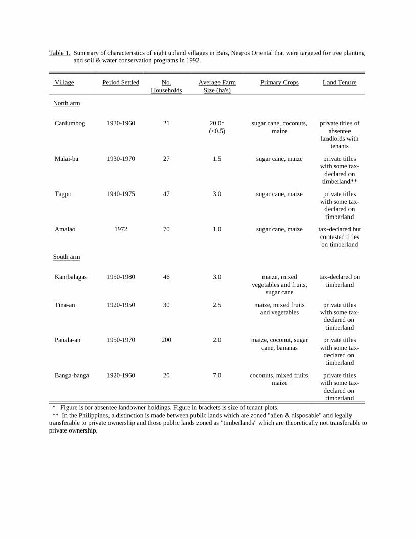
Table 1. Summary of characteristics of eight upland villages in Bais, Negros Oriental that were targeted for tree plantingand soil & water conservation programs in 1992.
Village Period Settled No.Households
Average FarmSize (ha's)
Primary Crops Land Tenure
North arm
Canlumbog 1930-1960 21 20.0*(<0.5)
sugar cane, coconuts,maize
private titles ofabsentee
landlords withtenants
Malai-ba 1930-1970 27 1.5 sugar cane, maize private titleswith some tax-
declared ontimberland**
Tagpo 1940-1975 47 3.0 sugar cane, maize private titleswith some tax-
declared ontimberland
Amalao 1972 70 1.0 sugar cane, maize tax-declared butcontested titleson timberland
South arm
Kambalagas 1950-1980 46 3.0 maize, mixedvegetables and fruits,
sugar cane
tax-declared ontimberland
Tina-an 1920-1950 30 2.5 maize, mixed fruitsand vegetables
private titleswith some tax-
declared on timberland
Panala-an 1950-1970 200 2.0 maize, coconut, sugarcane, bananas
private titleswith some tax-
declared on timberland
Banga-banga 1920-1960 20 7.0 coconuts, mixed fruits,maize
private titleswith some tax-
declared on timberland
* Figure is for absentee landowner holdings. Figure in brackets is size of tenant plots. ** In the Philippines, a distinction is made between public lands which are zoned "alien & disposable" and legallytransferable to private ownership and those public lands zoned as "timberlands" which are theoretically not transferable toprivate ownership.
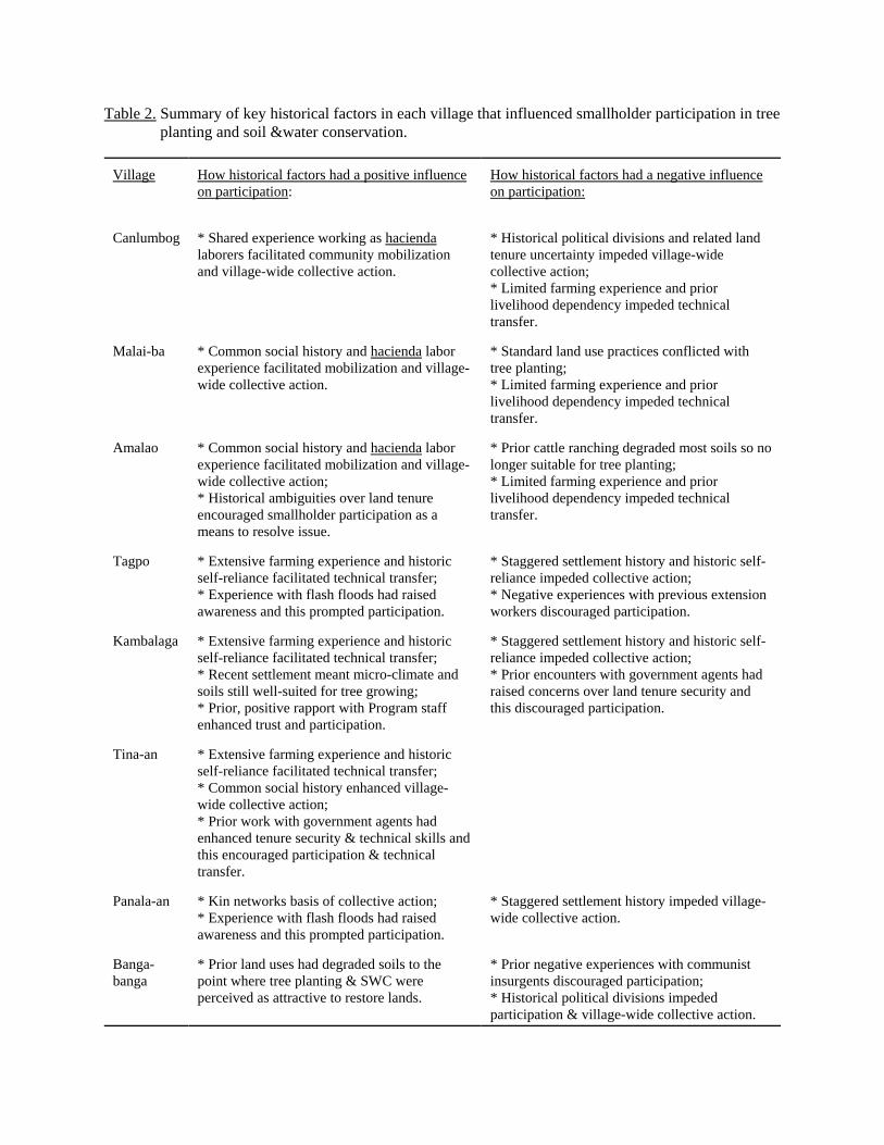
Table 2. Summary of key historical factors in each village that influenced smallholder participation in tree planting and soil &water conservation.
Village How historical factors had a positive influenceon participation:
How historical factors had a negative influenceon participation:
Canlumbog * Shared experience working as haciendalaborers facilitated community mobilizationand village-wide collective action.
* Historical political divisions and related landtenure uncertainty impeded village-widecollective action;* Limited farming experience and priorlivelihood dependency impeded technicaltransfer.
Malai-ba * Common social history and hacienda laborexperience facilitated mobilization and village-wide collective action.
* Standard land use practices conflicted withtree planting; * Limited farming experience and priorlivelihood dependency impeded technicaltransfer.
Amalao * Common social history and hacienda laborexperience facilitated mobilization and village-wide collective action;* Historical ambiguities over land tenureencouraged smallholder participation as ameans to resolve issue.
* Prior cattle ranching degraded most soils so nolonger suitable for tree planting;* Limited farming experience and priorlivelihood dependency impeded technicaltransfer.
Tagpo * Extensive farming experience and historicself-reliance facilitated technical transfer; * Experience with flash floods had raisedawareness and this prompted participation.
* Staggered settlement history and historic self-reliance impeded collective action;* Negative experiences with previous extensionworkers discouraged participation.
Kambalaga * Extensive farming experience and historicself-reliance facilitated technical transfer;* Recent settlement meant micro-climate andsoils still well-suited for tree growing;* Prior, positive rapport with Program staffenhanced trust and participation.
* Staggered settlement history and historic self-reliance impeded collective action;* Prior encounters with government agents hadraised concerns over land tenure security andthis discouraged participation.
Tina-an * Extensive farming experience and historicself-reliance facilitated technical transfer; * Common social history enhanced village-wide collective action;* Prior work with government agents hadenhanced tenure security & technical skills andthis encouraged participation & technicaltransfer.
Panala-an * Kin networks basis of collective action;* Experience with flash floods had raisedawareness and this prompted participation.
* Staggered settlement history impeded village-wide collective action.
Banga-banga
* Prior land uses had degraded soils to thepoint where tree planting & SWC wereperceived as attractive to restore lands.
* Prior negative experiences with communistinsurgents discouraged participation;* Historical political divisions impededparticipation & village-wide collective action.

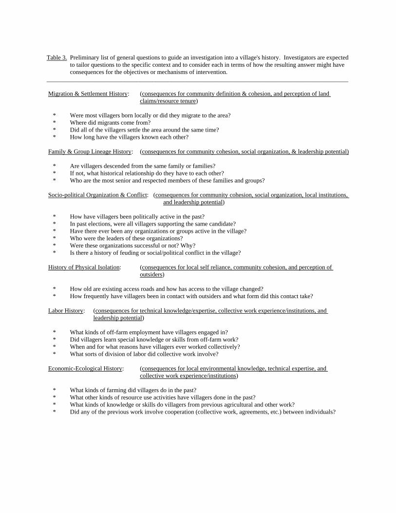
Table 3. Preliminary list of general questions to guide an investigation into a village's history. Investigators are expectedto tailor questions to the specific context and to consider each in terms of how the resulting answer might haveconsequences for the objectives or mechanisms of intervention.
_________________________________________________________________________________________________
Migration & Settlement History: (consequences for community definition & cohesion, and perception of land claims/resource tenure)
* Were most villagers born locally or did they migrate to the area? * Where did migrants come from? * Did all of the villagers settle the area around the same time? * How long have the villagers known each other?
Family & Group Lineage History: (consequences for community cohesion, social organization, & leadership potential)
* Are villagers descended from the same family or families? * If not, what historical relationship do they have to each other? * Who are the most senior and respected members of these families and groups?
Socio-political Organization & Conflict: (consequences for community cohesion, social organization, local institutions, and leadership potential)
* How have villagers been politically active in the past? * In past elections, were all villagers supporting the same candidate? * Have there ever been any organizations or groups active in the village? * Who were the leaders of these organizations? * Were these organizations successful or not? Why? * Is there a history of feuding or social/political conflict in the village?
History of Physical Isolation: (consequences for local self reliance, community cohesion, and perception of outsiders)
* How old are existing access roads and how has access to the village changed? * How frequently have villagers been in contact with outsiders and what form did this contact take?
Labor History: (consequences for technical knowledge/expertise, collective work experience/institutions, and leadership potential)
* What kinds of off-farm employment have villagers engaged in? * Did villagers learn special knowledge or skills from off-farm work? * When and for what reasons have villagers ever worked collectively? * What sorts of division of labor did collective work involve?
Economic-Ecological History: (consequences for local environmental knowledge, technical expertise, and collective work experience/institutions)
* What kinds of farming did villagers do in the past? * What other kinds of resource use activities have villagers done in the past? * What kinds of knowledge or skills do villagers from previous agricultural and other work? * Did any of the previous work involve cooperation (collective work, agreements, etc.) between individuals?
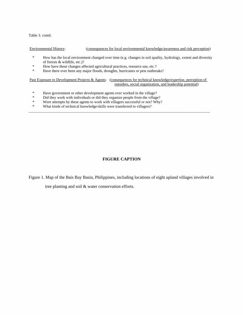
Table 3. contd.
Environmental History: (consequences for local environmental knowledge/awareness and risk perception)
* How has the local environment changed over time (e.g. changes in soil quality, hydrology, extent and diversityof forests & wildlife, etc.)?
* How have these changes affected agricultural practices, resource use, etc.? * Have there ever been any major floods, droughts, hurricanes or pest outbreaks? Past Exposure to Development Projects & Agents: (consequences for technical knowledge/expertise, perception of
outsiders, social organization, and leadership potential)
* Have government or other development agents ever worked in the village? * Did they work with individuals or did they organize people from the village? * Were attempts by these agents to work with villagers successful or not? Why? * What kinds of technical knowledge/skills were transferred to villagers? _______________________________________________________________________________________________
FIGURE CAPTION
Figure 1. Map of the Bais Bay Basin, Philippines, including locations of eight upland villages involved in
tree planting and soil & water conservation efforts.