community technology mapping: inscribing places when
TRANSCRIPT

Community technology mapping: inscribing placeswhen Beverything is on the move^
Deborah Silvis1 & Katie Headrick Taylor1 & Reed Stevens2
Received: 12 September 2017 /Accepted: 12 April 2018 /Published online: 11 May 2018# International Society of the Learning Sciences, Inc. 2018
Abstract Interactive, digital mapping technology is providing new pedagogical possibilities forchildren and their families, as well as new methodological opportunities for education researchers.Our paper reports on an example of this novel terrain we call BCommunity Technology Mapping^(CTM). CTM was a designed task that was part of a larger ethnographic study of children andfamilies’ digital media and technology practices in and around their homes. CTM incorporatedinteractive digital mapping technology with a structured interview protocol as a pedagogical contextfor young people and a methodological tool for researchers. As a pedagogical context for computer-supported collaborative learning, CTM supported young people to see and reflect on their everydaytechnological practices as temporally and spatially organized across scales of human interaction. Asa methodological tool, CTM allowed researchers to see families’ place-based and on-the-moveactivities that were outside the more naturalistic observations of home-based technology use. Ouranalysis of CTM draws upon video recordings and screen captures of young people’s reflections onand live mappings of places they typically used technology and engaged with media.We found thatchildren developed strategies with the mapping technology to make places visible, make themcoherent, and make them mobile. These strategies produced a Bcascade of inscriptions^ within theCTM task formapping newmobilities of digital, daily life.We argue that interactive digital mappingtechnologies not only support researchers to ask new questions about the spatiotemporal aspects oflearning phenomena, but also contribute to a new genre of place-based, digital literacies- locativeliteracy- for learners to navigate.
Intern. J. Comput.-Support. Collab. Learn (2018) 13:137–166https://doi.org/10.1007/s11412-018-9275-0
* Deborah [email protected]
Katie Headrick [email protected]
Reed [email protected]
1 Learning Sciences & Human Development, College of Education, University of Washington, Seattle,WA, USA
2 Learning Sciences School of Education and Social Policy, Northwestern University, Evanston, IL,USA

Keywords Mapping . Families . Computer-supported collaborative learning . Pedagogicalapproaches . Researchmethods
Introduction
Understanding how people use technology to collaboratively achieve new ways of seeing andlearning about the world is a core issue for CSCL. When the technologies change, so changesthe nature of collaboration and how we study Bthe type of learning that takes place incollaborative groups and the design of collaborative learning processes^ (Cress et al. 2015,p. 109). This article focuses on a novel pedagogical and research approach for computer-supported collaborative learning we call Community Technology Mapping (CTM). In whatfollows, we describe the design of this approach that utilized interactive digital mapping andgeospatial technologies to support a new form of digital literacy.
Young people’s learning over time and across settings has always been mediated bytechnologies, be they older or newer tools. This Birreducible tension^ between learner andmeditational means has been an interest of sociocultural research for many years (e.g., Wertsch1991; Vygotsky 1978; Cole 2006), with significant implications for computer-supportedcollaborative learning (Roschelle and Teasley 1995). But in just the past decade, the natureof these technologies has changed drastically, and the rate of change increased exponentially(Friedman 2016). Today, ubiquitous mobile media (e.g., Google Maps™, Twitter™,YouTube™, Pokémon Go™ in combination with unlimited data plans on smartphones)amplify the many ways and number of locations in which learning opportunities arise. Eachseized learning opportunity might now include physically co-present participants or geograph-ically and temporally distant collaborators (e.g., Farman 2010). Understanding how techno-logical change and learning intersect- and how such junctures create opportunities for newways of experiencing and knowing the world- requires developing methods for observingthese mobilities in everyday activity (Leander et al. 2010) and pedagogical tools that supportnew forms of digital and spatial literacies (Taylor 2017).
Digital mapping software and geospatial applications are potential assets for researchers toexamine emergent, distributed, and mobile aspects of learning (Taylor et al. 2017a). Applica-tions like Google Earth™, Google Maps™, and Social Explorer™ support thegeovisualization of patterns (Elwood 2010) that may be related to family travel, leisureactivities, and available community assets (e.g., libraries, community centers, schools). Butwe still need a more complete understanding of how these widely accessible tools not onlypresent new means of investigation for us, but also create a new genre of digital literacy forlearners to navigate (e.g., diSessa 1997).
Little is known about interactive digital mapping technology as a methodological tool ineducation research or as a pedagogical tool in design-based studies with children (Gordonet al. 2016). How, for instance, might this technology open up new digital literacies, allowingchildren to, among other things, see their own routines as spatiotemporally organized phe-nomena (Ellegård and Hägerstrand, 1977) and think across scales of human activity (Interna-tional Society for Technology in Education (ISTE) 2016; NGSS Lead States 2013; Taylor andHall 2013; Taylor 2017)? These literacies bear significance across an array of disciplines thatconsider the human relationship to our planet (e.g., ecology, urban planning, geography,climate science). In this context, education researchers are developing new CSCL environ-ments (e.g. Shapiro et al. 2017) and pedagogical arrangements (Higgins et al. 2011) to help
138 D. Silvis, et al.

specify relationships between children’s engagement with emerging digital technology anddiverse places in which their learning occurs.
The objectives of this paper are twofold. The first objective is to describe a methodologicalinnovation that uses interactive digital mapping technology. The second objective is to analyzethis method as a pedagogical tool for young participants (and their parents) to learn a newgenre of digital literacy. In this way, the current analysis addresses a central premise of CSCL,which Stahl et al. (2014) recently articulated in their definition of the field. That is,
CSCL research is both a theoretical enterprise, concerned with how groups makemeaning, and a design endeavor, concerned with how to design artifacts of collaborationmedia, representational guidance, group interaction and pedagogical approaches topromote collaborative learning (p. 239).
Regarding our first objective, we want to introduce and advocate for a new method of exploringyoung people’s understandings of and relationships to places they regularly go during their Bdailymedia rounds^ (Taylor et al. 2017b), or their regular routines that increasingly involve digital media.This method, which we call Community TechnologyMapping (CTM), involved a task that childrencompleted at the end of a larger ethnographic study of their mobile technology use. In this task,children were asked to create a map in Google Earth™ by identifying and drawing places andpathways where they regularly spent time using (and not using) technology. This method, we argue,helped researchers see important learning and teaching activities that happened outside of morenaturalistic observations of children using technology around their homes. In this way, CTMallowed researchers to create a more holistic picture of typical weekly activities and spatiotemporalpatterns in families’ learning lives (Erstad 2011).
The second objective of this paper is to analyze young people’s participation in CTM as anexample of a new form of digital literacy we call Blocative literacies^ (Taylor 2017), whichinvolve the use of new, location aware media to support learning about place and space. Thisobjective brings CTM into line with a rich body of work in CSCL concerned with thedevelopment and empirical study of computer-supported pedagogical tools for knowledgesharing. Extending extant studies of collaborative activity supported by computer screens(Stevens 2000), multi-touch tables (Higgins et al. 2011), mobile phones (Roschelle and Pea2002; Ryokai and Agogino 2013), digital video (Zahn et al. 2012), VR (Yoon et al. 2012), andmuseum exhibits (Shapiro et al. 2017), we are contributing a novel pedagogical approach forstudying learning during collaborative digital mapping. Through CTM, young people learnedhow to see their typical daily lives as spatiotemporal phenomena that are organized by aconfluence of factors, including time constraints, the built environment, and interests sharedbetween family members. Participants also created new renderings of places and pathways onthe map that represented their connections to places of import.
Our two objectives guide the following research questions:
& What were researchers able to see about children’s daily media rounds from the mappingtask?
& What sorts of strategies did young people use to make their everyday places and pathwaysknown (to themselves and others) within the mapping task?
& How did CTM support young people to consider the spatiotemporal organization of daily life?
To answer these research questions, we analyze the processes of inscription (Latour 1986,1987) that organized children’s activities in and out of the CTM task. We will describe how
Intern. J. Comput.-Support. Collab. Learn 139

children’s participation in CTM followed a typical set of processes that allowed them to inscribeplaces they routinely went during a week (e.g., school, the YMCA). We call this typical set ofprocesses inscribing places, which occurred as children made places visible, made placescoherent, and made places mobile. Places that children inscribed included grandparents’ houses,schools, grocery stores, community centers, friends’ houses, and their own homes. Our analysisshows how these three processes involved children coordinating the resources available to themin their social-material surroundings (Goodwin 2013), including other family members, routinequalities of daily life, and familiar aspects of their neighborhoods. We further argue that bymaking it possible for researchers to see children’s daily activities and weekly itineraries, thisCSCL pedagogical approach disclosed how children’s relationships to places are being re-mediated (Cole and Griffin 1983) by new digital technologies.
In what follows, we outline the conceptual terrain in which this study is situated, highlight-ing several key concepts that framed our analysis. Next, we describe the research design of theoverarching study of which the CTM task was only one component, and how we analyzedchildren’s participation in the task. Then, we present our findings in three sections, elaboratinghow, in inscribing places, children made places visible, made them coherent, and made themmobile. Finally, we discuss how these findings add to methodological and pedagogicalunderstandings of learners’ technologically mediated and mobile activities. We argue that bymaking it possible for researchers to see children’s daily and weekly activities, the task servedas a unique site for disclosing sociotechnical arrangements (Star 1999) that underlie children’srelationships to place and space. We draw on these findings to suggest how CTM presents amethodological and pedagogical context for studying a new genre of digital literacy- locativeliteracies- that involves location-based and digital mapping technologies.
Framework
(Digital) maps as inscriptions
As Enyedy (2005) wrote, BLike any symbol system, whether it is a programminglanguage or mathematical notation system, maps are powerful ways of seeing andunderstanding the world around us^ (p. 428). Across much of human history, maps havebeen paradigmatic Binscription devices^ (Latour 1986), meaning any tool or techniquethat works to represent and reproduce knowledge of the world. Through iterations ofinscriptions (i.e., from scalable drawings in situ to automated reproductions of paper-based maps for mass production), early explorers drew up maps of the entire world.Latour (1987, 1991) contended that these maps thereby drew together all the human andnonhuman actors enrolled to produce them.
Paradoxically, this labor that made the world visible and transportable, effectivelyrendered invisible all the social and material work that went into translating heteroge-neous perceptions of place into Cartesian space (e.g., Star 1999). Latour called the mapan Bimmutable mobile,^ meaning, it maintains its representational power (immutability)precisely because it has been mobilized through this chain of production (and erasure).The outcome of such sociotechnical work is a discernible, coherent, transportable map(Latour 1987). Such a way of thinking about maps as inscriptions has, in turn, mobilizeda whole body of literature concerned with the sociotechnical construction of cartographicknowledge (e.g. Bingham and Thrift 2000; Vertesi 2008).
140 D. Silvis, et al.
Contemporary cartography has been (and continues to be) reconfigured through interactivedigital media (e.g., Phillips 2013) where the on-going production of space takes place at thecomputer interface. Digital maps are an example of what Stahl et al. (2014) refer to asdialectical artifacts (p. 239), because they are produced by the very interactions which theymediate. Maps are also increasingly dynamic, multi-perspectival, crowd-sourced, publiclyaudited, and open-source (Farman 2010). This re-figuring of an old and establishedsociotechnical system–and in light of new mobilities largely rendered by the digital—requiresa reconsideration of the notion of immutable mobiles (Lammes 2016; November et al. 2010).
The mobile aspects of maps can now be thought about in a number of ways. Two ofthese aspects are most relevant to our study. First, digital maps disrupt a fixed represen-tational grid intelligible in two dimensions and orient users to a dynamic spatio-temporaldimension that moves around as you interact with it. Places and points of interest aremade visible and mobile through on-screen navigation to and through them. Whereaspaper-based maps restricted representations to what would fit onto folded paper, todayemergent features of the landscape, 3D buildings, and live traffic events materialize onthe edge of the digital screen. Second, a user’s physical mobility is altered through thenew mapping interfaces (Jenson et al. 2015; Lammes 2016); while navigating with adigital map application, one’s geo-referenced position moves on the surface of the map,so the user can adjust her pathway accordingly, in real time. In virtual space, a personcan move themselves (sometimes with the aid of an on-screen icon or avatar such asGoogle Earth’s Pegman, or the ubiquitous blue dot in Google Maps) through mappedspaces, visiting places they have never been before in person or would like to re-visit.
November et al. (2010) posit that because of users’ interactions at the digital map interface(i.e. the re-mediation of space through technology), many of the invisible actors and processeslost in translations of place to paper are re-materialized. Digital maps have the ability to rendervisible and mobile all the inscriptions of these heterogeneous actors, reassembling them in theevent of a user navigating. As November and colleagues put it, Beverything is on the move^[italics in original] (p. 596) once mapping is conceived of in this new way. They continue,
Today it is impossible to ignore that, whenever a printed map is available, there exist,upstream as well as downstream, a long and costly chain of production that requirespeople, skills, energy, software, and institutions and on which the constantly changingquality of the data always depends (p. 584).
Interactive digital mapping opens up the possibility for learners to see and analyze parts of thischain of inscriptions.
Methods for mapping learning and mobile media
Research is just beginning on how young people negotiate inscriptions (Taylor 2017) throughinteractive digital mapping (e.g. Gordon et al. 2016). Learning on-the-move (Taylor and Hall2013) requires new methods for mapping new mobilities (Leander et al. 2010) that specify thespatiotemporal dimensions of sociotechnical systems in which everyday learning is embedded.Such methods attend to how mobility through space- of people and their technologicallymediated activities- can be observed and documented (Taylor et al. 2017a, b). An earlyinnovation supporting this work was the advent of video recording technology and itsaffordances for understanding movement of people and their tools in and across activitysettings (e.g., Stevens and Hall 1998). More recently, tools like wearable cameras (i.e.
Intern. J. Comput.-Support. Collab. Learn 141

Taylor and Hall 2013; Umphress and Sherin 2015) and augmented reality (Ryokai andAgogino 2013) are being used in learning research to capture and facilitate participants’dynamic interactions.
A secondary challenge for researchers studying learning on-the-move has been to develop ameans of documenting place-based dynamics or Btargeting the spatial aspect of learning^ inthe data record (Leander et al. 2010, p. 356). In other words, digital maps now serve as vitaltools for developing methods for literally mapping the new mobilities of learners. Mobile andgeolocative technologies (i.e., GPS and GIS) have been invaluable in this regard, and a numberof recent studies of learning and mobility have utilized the geolocative capability of mobiledevices (Gordon et al. 2016; Hall et al. 2015; Taylor 2017). Geolocative technologies havebeen used to augment place-based learning (Kimiko and Agogino 2013), to design novellearning activities for bodies on-the-move (Taylor and Hall 2013; Ma 2016), and to reconfig-ure how we represent spatial data (Shapiro et al. 2015).
Long interested in how young people construct spatial representations of their everydayexperiences (Hart 1977), the field of children’s geographies has catalyzed these new methodsfor understanding learning in and about places. More recently, novel empirical tools have madeyoung people’s own understandings of place-making (e.g., Taylor & Phillips 2017) visible inresearch (e.g. Gordon et al. 2016; Santo et al. 2010). CTM follows in this innovativemethodological tradition (e.g. Hall et al. 2015) and also leverages a popular media platform(i.e., Google Earth) and GIS technology that geographers and educational scholars are nowutilizing to understand learning phenomena (Patterson 2007). Google Earth, the online digitalmapping application we used in the CTM task, has been used in a small number of studies oflearning, for example, to reconstruct historical narratives of places (Gordon et al. 2016). Thepresent analysis of CTM builds on this scholarship by presenting a design for an interactivedigital mapping task that collaboratively develops learners’ locative literacies building upontheir cartographic, digital inscriptions of their weekly itineraries.
Locative literacies
In the two decades since multiliteracies became an educational focus (Cazden et al. 1996), therole of digital technology in young people’s lives has changed dramatically. Whereas moreformal competencies like computing and coding (e.g. diSessa 1997) still garner researchers’attention, understanding how young people learn and, to some degree, live their lives online isof central concern in today’s digital literacies research (Ito et al. 2013). However, persistentBdigital native^ discourse perpetuates a view that youth in a networked era come to their variedtechnological practices with already well (in)formed ideas about tools and technical know-how(Jenkins et al. 2016). It is simply not the case that young people approach new media andtechnology fully literate. Rather, developing fluency with technology requires support (Barronet al. 2009) and takes place through collaborative participation in cultural practices (Cress et al.2015; Roschelle and Teasley 1995) that are constantly being re-mediated by emergingtechnologies (e.g., Cole 2006). Using dynamic and interactive digital maps is an example ofhow educators and caregivers cannot assume children are fluent users because they have seen apaper map or watched someone use a digital map application.
Maps have a history as pedagogical tools in educational research (e.g. Enyedy 2005;Enyedy and Mukhopadhyay 2007) however interactive digital maps have not receivedsubstantial attention in the literature on multiliteracies or computer-supported collabora-tive learning.
142 D. Silvis, et al.

Like all literacies, digital literacy involves uptake of reading and writing practices (Gee2003), dialectical processes of deciphering (reading) and inscribing (writing) one’s world(Freire and Macedo 1998). These processes are inherently ideological, and learning in digitalcontexts inherits all the traditional, analog struggles over agency, authoring or legitimizingknowledge, and accessing opportunities to learn (Ito et al. 2010). Locative literacies thenreorient traditional literacies around two axes: new media and emerging social spaces forlearning. Digital tools amplify the temporality and spatiality of reading and writing practices-and re-mediate place-based ways of knowing- by opening up new opportunities for learningacross (and about) contexts (Leander et al. 2010).
Learning is not just situated in contexts, but organized by contexts (Lave andWenger 1991;Ma and Munter 2014). What has been called the Bspatial turn^ (Kingston 2010) in the socialsciences invites new analyses of digital literacies that foreground the heterogeneous space-times (Leander et al. 2010) and the (often contentious) processes of place-making (Taylor &Phillips 2017). Mapping software and applications like Google Earth present potential peda-gogical opportunities for developing new forms of digital literacy because they key into thealready spatially-inflected and mobile aspects of learning. We concur with cultural geographersElwood and Leszczynski (2012) who have written that,
The ascendance of location as a primary way of engaging the web and the increasingubiquity of digital media with a spatial component suggests a comparative accessibilityand ease of use to these technologies by non-experts in a wider range of everydaypractices… [and] may be part of a transformation in the forms of action that individualsand social groups understand as constituting activism or engagement (p. 556).
It is this notion of locative literacies- as transforming the forms of actions that constituteengagement in everyday practices- that CTM was designed to support and make visible.
Design and methods
Community Technology Mapping is a method that emerged from a larger ethnography calledLearning across Networked and Emergent Spaces (LANES), designed to investigate the role ofmobile media and technology in reorganizing families’ everyday routines in and around theirhomes (Taylor et al. 2017a, b). The LANES project was itself part of an even broader multi-sited, multi-year, multi-method effort to understand families’ changing technology and mediaengagement, the Families and Media project (Gee et al. 2017).
We consider this larger ethnography and its methods an example of digital ethnography, anew approach or collection of approaches that account for how social processes emerge in thedigital age and with digital tools and practices (Pink et al. 2016). While some digitalethnographies focus on activities that take place specifically in virtual spaces (e.g. boyd2014), other forms examine broader contexts in which digital media and technology areimplicated, which may involve studying the media engagement of physically co-presentparticipants and/or their online activities. It is in this latter, broader sense that CTM and othermethods were employed in this study.
The purpose of our digital ethnography was less about focusing explicitly on the socialsignificance of a single device or media form (i.e. tablet computers, the latest video game, orGoogle Earth, for that matter) and more about orienting the ethnographic lens towards what is
Intern. J. Comput.-Support. Collab. Learn 143
technological about how research participants are going about the activities under study (Pinket al. 2016). The larger study included video-recorded participant observation, interviews, andexperience sampling, in addition to the CTM task. CTM incorporated interactive digitalmapping technology with a structured interview protocol as a CSCL pedagogical context foryoung people and methodological tool for researchers. In what follows we describe the taskstructure, the participants and setting, and our analytic approach.
The CTM task protocol
The CTM task took place during the final observational visit with each family in the study.CTM was designed to address two explicit objectives: (1) to make visible how children usedmobile media during their daily rounds (Erickson 2004) at times not observed duringfieldwork and (2) to facilitate children’s reflections on the relationships between physicalenvironment and digital technology use. The typical activity structure of the task can be brokendown into five main steps (see Appendix for CTM protocol). First, a researcher accessedGoogle Earth (GE) on her laptop and established a participant’s comfort level with using GE tomap places they frequently go, providing assistance and instruction when necessary. Mostparticipants had some prior working knowledge of the application.
Next, the researcher asked the participants to map places they regularly went where theymight use technology. During this phase, participants identified and located these places,dropped a marker on the location, labeled the location, and repeated these sub-steps for eachlocation they chose to map. After participants had found and labeled these places, theresearcher asked them to draw the pathways they typically traveled between them; mostparticipants were able to trace pathways between at least a few places. Then, the researcherasked participants to identify and label technology Bhotspots,^ or places where they felt mostengaged with technology, usually by changing the location’s marker color. Finally, in the post-task phase, the researcher debriefed the CTM task with participants and sometimes with aparent in a follow-up interview (see Appendix for final interview protocol). The task typicallylasted one hour per participant.
The task settings
CTM was typically performed in children’s homes and on the researchers’ laptops, mostoften at the kitchen or dining table, though sometimes in the living room. The task wascollaborative in that it always involved at least one other person- such as a parent, asibling, or simply the researcher- as well as the technology being used for digitalmapping. While we generally reserve discussion of these interactions and the attendingplace-making processes for empirical analysis, it is worth describing the home settingsand media ecologies in which CTM activities were set. This description gives a sense ofthe material and personal configurations that will become important later on for estab-lishing how inscribing places occurred.
The kitchen or dining table was the most common spot in the house for conductingthe CTM activity. The relatively large table surface allowed young people and theircollaborators to sit side-by-side and operate the computer while co-viewing the screen(Takeuchi and Stevens 2011). It also permitted the researcher to position herself nearby,usually at an adjacent corner of the table, out of the frame but still close at hand fortechnical assistance and conversation. The kitchen was also a hub of activity in many
144 D. Silvis, et al.

homes (Graesch 2013), with siblings and parents (or grandparents) frequently enteringand exiting, making it a strategic location for participating children to solicit help fromknowledgeable family members when needed (Fig. 1).
An important final note about these task settings was that they sometimes included acollection of heterogeneous household items not necessarily relevant to the study or thetask per se. These objects, such as handheld game consoles, smartphones, snacks, pets,and placemats all interacted with participants and also inscribed themselves into thetask. While these peripheral materials did not end up in the digital maps, their tracesremain in the video record, and their presence contributed to what was a decidedly Bun-task-like^ feeling of CTM. Participants- and their adult collaborators- reported enjoyingCTM, and this was likely partly due to the relatively uncontrolled and comfortableatmosphere of studying families in their own homes (Goodwin and Goodwin 2013).Therefore, while we refer to CTM as a Btask^ throughout this analysis, it was perhapsmore an activity Bsetting,^ in Lave’s (1988) sense, that resulted from the relationbetween the quotidian, durable aspects of the environment and the situated actions ofparticipants and researchers. In this way, CTM responds to a challenge to not onlydesign adequate CSCL pedagogical tools and settings, but also interactive situations thatinvite deep learning (Cress et al. 2015).
Participants
Twelve children (boys and girls, Caucasian and African American) between the ages ofnine and thirteen years old participated in this task. They were recruited for the largerstudy of young people’s media and technology use that took place in a large Midwesterncity over the course of one year. Some of the participants lived in the same or geograph-ically close neighborhoods, and several of their maps involved overlapping areas, thoughof course, they were not privy to this. They had lived in their current neighborhoods forvarying amounts of time, one family having just moved to the city in the months prior toparticipating in the study. Of the twelve participants, four (two pairs of sisters) weresiblings. One of these sibling pairs collaborated in Community Technology Map
Fig. 1 Theo (wearing a GoPro head camera) and his Mom search for their house in Google Earth on theresearcher’s laptop. Theo placed his smartphone next to the computer for background music
Intern. J. Comput.-Support. Collab. Learn 145

producing one map, while the other pair collaborated but created two separate maps. Themajority of the families were enrolled during the school year, and observations andinterviews took place after school or on weekends.
Data collection
The data for the CTM task consist of video recordings of children’s mapping activitiesrecorded on an HD camera positioned adjacent to or just behind the children as theymapped places in Google Earth. A few children wore GoPro head-mounted cameras,which captured children’s own Bcoherent^ angle of vision on the computer screen(Umphress and Sherin 2015). Because it was important to have an accurate image ofhow participants navigated the maps on screen, we utilized screen capture software torecord the mapping process. We also video recorded the interviews of participants andtheir parents about the maps, once they were completed. Over fifteen total hours of videowere reviewed for the present analysis.
Data analysis
The first step in our analysis was to content log all video recordings. Next, we drew on agrounded theoretical approach (Bryant and Charmaz 2007; Glaser and Strauss 1967) andengaged in open coding to iteratively develop the following descriptive categories forchildren’s in-task activities: remembering; selecting; locating; marking; tracing; navigating;narrating; negotiating; maneuvering; interrogating; course-correcting; scaling; homing; no-ticing; ground-truthing; evaluating; reconciling; associating (relating things to places); sto-rying; historicizing; dis-placing. Though we did not aim to generate a formal groundedtheory, we utilized the analytic tools of this methodological approach to develop theoreticalsensitivity (Glaser & Strauss), which allowed us to select or sample from the corpus instancesof activities in CTM that warranted further analysis. We continuously went back to review thevideo data in group video-viewing sessions to develop codes and categories of activities. Asthese forms of activities were developed, we grouped overlapping activities into a few higher-level processes that were present in all children’s mapping and pervaded the task: makingplaces visible; making places coherent; and making places mobile. For example, the processBmaking places visible^ involved the lower level activities selecting, locating, marking,tracing, scaling, and noticing.
Simultaneously, while we were developing this preliminary theoretical framework forcategories of activities, we examined representative instances with a finer granularity(Shapiro et al. 2017). We conducted interaction analysis (e.g., Hall and Stevens 2016;Hontvedt and Arnseth 2013) of Bhotspots^ that occurred in the videos (Jordan andHenderson 1995, p. 43), instances in which the higher-level processes were particularlysalient. From these, we created multi-modal transcripts of representative instances thatdepict how words, gestures, body and hand movements, body position, and human-computer interactions hung together to enact inscribing places. Multi-modal analysis ofinteractions between young people and technology in the activity allowed us to lookacross communication channels young people used to convey meaning while mapping(Goodwin 2013). This helped us look beyond the surface of what people communicatedin order to catch the Bmagic moments^ when they collaboratively accomplished sharedmeaning with tools and artifacts (Cress et al. 2015, p. 111; Roschelle and Teasley 1995).
146 D. Silvis, et al.

Because we were interested in how young people understood spatio-temporal aspects oftheir technology use outside the task, attending to the specific movements, gestures, bodypositions, and navigational strategies used in the task was a particular affordance of thisanalytic approach.
Analytic findings
The first requirement of this task was that children remember past experiences. Withoutremembering, there was no Community Technology Mapping task. During all phases ofthe activity, then, children needed to reconstruct their memories of their daily rounds(Erickson 2004). This involved first deciding which places were relevant and interestingenough (to them) to map. Most appeared to develop a timeline of their day, starting offat home, moving to the bus stop, then off to school, often to an afterschool activitynearby, and finally home again in the evening. Once these places had been plotted,children expanded their timelines to incorporate activities that took place more sporad-ically or on the weekends including attending church, visiting grandparents or cousins,or attending summer camps. To map these places, children developed strategies thatmade their places visible, made them coherent, and made them mobile. This involvedre-producing a Bcascade of inscriptions^ (Latour 1986) as they went about representingtheir place-based activities.
Writing themselves into the map
In order to create a map of places they tended to go, children had to figure out a way ofmaking their daily or weekly itineraries visible. They had to bring to the presentmemories of past experiences in places they had been. These memories putatively residedinside their heads, and the task asked them to bring them out into the open on-screenwhere they could be seen and shared. To do so, they had to re-present absent places andmake them visible. This meant that they had to first find the places on the map, whichwas neither simple nor straightforward. While some children found places by searchingusing Google Earth’s in-app Search function, others did not always have searchableinformation like business names or addresses ready-to-hand. In these cases, childrenhad to develop another strategy we call wayfinding. This other strategy of finding theirway pervaded the task during all phases or prompts. Wayfinding is similar to what Ingold(2011) has called Bwayfaring;^ Bthe task of the wayfarer is not to act out a script receivedfrom predecessors but literally to negotiate a path through the world^ (p. 162).
Wayfinding consisted of children scrolling through their neighborhood or nearby vicinitiesin order to find a place. Wayfinding involved a process of holding the place in mind andhoming in on it while coordinating actions at the digital mapping interface. While somechildren used wayfinding to locate places and label them, others, in a later phase of the task,traced the path traversed during their wayfinding using Google Earth’s drawing function; theyliterally inscribed a path on the map. Once they reached the intended places, children labeledthem, often personalizing the path or place names, or writing themselves into the map. In whatfollows, we provide an example of how the Ichabod sisters trace (i.e. make visible) a path theyroutinely traveled during a typical week and use this to illustrate how inscribing placesinvolved making them visible.
Intern. J. Comput.-Support. Collab. Learn 147

Tanya and Mary’s wayfinding During this portion of their mapping, eleven-year-old Maryand her thirteen-year-old sister Tanya drew a pathway their parents typically drove to get homefrom the Bthe Y^ (the YMCA, a community center) after the girls’ swim practices. Prior to thisdrawing, the two had identified and labeled these two places and several others and hadnegotiated an arrangement whereby they took turns drawing pathways between places andlabeling them. In order to draw pathways in Google Earth, it is necessary to have a dialog boxopen on screen. This enables the drawing feature, which overlays a line (here a thick red line)onto the map as they found their way between locations. It was Mary’s turn to draw thepathway from the Y to home. However, before she could embark on the route, she had tofigure out how to exit the Y parking lot, already visible on-screen.
Mary consulted her sister about this (line 1), and Tanya instructed her. Tanya narratedwhileMarynavigated, explaining how their parent drives them out of the parking lot and usually goes down thestreet until they reach BRidge,^ amajor thoroughfare (lines 2–3). They had the Street Names featureenabled, so theywere able to read these on themap.No sooner hadMary begunwayfinding than shewas abruptly stopped in her tracks as her older sister chastised her for missing the street where sheneeded to turn (line 3). Despite the ability to see where she was on the map, Mary’s actions in-taskbrought an unfamiliar (untraveled) pathway into view for her sister. As Ingold (2011) writesBwayfaring always overshoots its destinations, since wherever you may be… you are already onyourway somewhere else^ (p. 162).Mary quietly acknowledged that she had indeed turned onto thewrong street, BOh,woopsy,^ and she immediately closed the path drawingwindow and re-opened itto start the path again (line 4).1 Mary: So we go out of the parking lot and then- do we- is it here?2 Tanya: We go out of the parking lot and we usually go down um to this street I don’t know3 where it is. Then we go down to Ridge. Mary, you went past Ridge!4 Mary: (quietly) O:h, woopsy ((quits drawing path, re-opens drawing dialogue box))5 Tanya: Ridge is right here, honey ((points at screen)).6 Mary:We go out of the parking lot and we go to here, and thenwe turn and go, (makes siren7 noise) wa-na-na-na-na-na. And then we go down this- then we stop at the stop light and8 then we go through the intersection….9 Tanya: To:: Ashton. (2.0) No to:10 Mary: Dewey.11 Tanya: Yeah.12 Mary: ((drags screen over to expose more of map, sisters giggle)) (sings)Mr. Grinch, da-na-13 na-na.
<5> Ridge is right here, honey <7> We stop at the light <12> drags screen over
On her second attempt, when she exited the parking lot, Mary turned onto Ridge and thencontinued wayfinding while playfully making a sound like an ambulance siren (lines 6–7).Tanya watched silently while Mary narrated and navigated. Mary explained that they usuallystop at the light and then continue through an intersection (lines 7–8). She and her sisterfinished each other’s sentences, Bstorying^ their trail through the landscape (Ingold 2011), as
148 D. Silvis, et al.
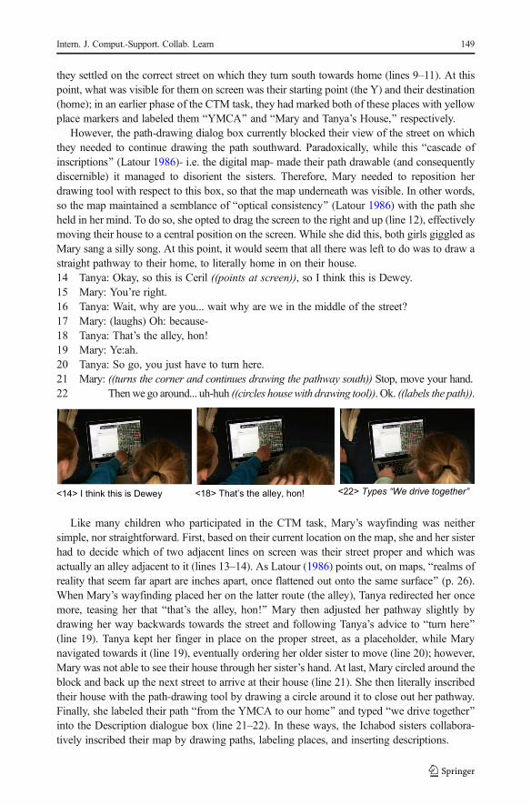
they settled on the correct street on which they turn south towards home (lines 9–11). At thispoint, what was visible for them on screen was their starting point (the Y) and their destination(home); in an earlier phase of the CTM task, they had marked both of these places with yellowplace markers and labeled them BYMCA^ and BMary and Tanya’s House,^ respectively.
However, the path-drawing dialog box currently blocked their view of the street on whichthey needed to continue drawing the path southward. Paradoxically, while this Bcascade ofinscriptions^ (Latour 1986)- i.e. the digital map- made their path drawable (and consequentlydiscernible) it managed to disorient the sisters. Therefore, Mary needed to reposition herdrawing tool with respect to this box, so that the map underneath was visible. In other words,so the map maintained a semblance of Boptical consistency^ (Latour 1986) with the path sheheld in her mind. To do so, she opted to drag the screen to the right and up (line 12), effectivelymoving their house to a central position on the screen. While she did this, both girls giggled asMary sang a silly song. At this point, it would seem that all there was left to do was to draw astraight pathway to their home, to literally home in on their house.14 Tanya: Okay, so this is Ceril ((points at screen)), so I think this is Dewey.15 Mary: You’re right.16 Tanya: Wait, why are you... wait why are we in the middle of the street?17 Mary: (laughs) Oh: because-18 Tanya: That’s the alley, hon!19 Mary: Ye:ah.20 Tanya: So go, you just have to turn here.21 Mary: ((turns the corner and continues drawing the pathway south)) Stop, move your hand.22 Thenwe go around... uh-huh ((circles housewith drawing tool)). Ok. ((labels the path)).
<14> I think this is Dewey <18> That’s the alley, hon! <22> Types “We drive together”
Like many children who participated in the CTM task, Mary’s wayfinding was neithersimple, nor straightforward. First, based on their current location on the map, she and her sisterhad to decide which of two adjacent lines on screen was their street proper and which wasactually an alley adjacent to it (lines 13–14). As Latour (1986) points out, on maps, Brealms ofreality that seem far apart are inches apart, once flattened out onto the same surface^ (p. 26).When Mary’s wayfinding placed her on the latter route (the alley), Tanya redirected her oncemore, teasing her that Bthat’s the alley, hon!^ Mary then adjusted her pathway slightly bydrawing her way backwards towards the street and following Tanya’s advice to Bturn here^(line 19). Tanya kept her finger in place on the proper street, as a placeholder, while Marynavigated towards it (line 19), eventually ordering her older sister to move (line 20); however,Mary was not able to see their house through her sister’s hand. At last, Mary circled around theblock and back up the next street to arrive at their house (line 21). She then literally inscribedtheir house with the path-drawing tool by drawing a circle around it to close out her pathway.Finally, she labeled their path Bfrom the YMCA to our home^ and typed Bwe drive together^into the Description dialogue box (line 21–22). In these ways, the Ichabod sisters collabora-tively inscribed their map by drawing paths, labeling places, and inserting descriptions.
Intern. J. Comput.-Support. Collab. Learn 149
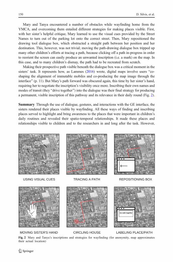
Mary and Tanya encountered a number of obstacles while wayfinding home from theYMCA, and overcoming them entailed different strategies for making places visible. First,with her sister’s helpful critique, Mary learned to use the visual cues provided by the StreetNames to turn out of the parking lot onto the correct street. Then, Mary repositioned thedrawing tool dialogue box, which obstructed a straight path between her position and herdestination. This, however, was not trivial; moving the path-drawing dialogue box tripped upmany other children’s efforts at tracing a path, because clicking off a path in-progress in orderto reorient the screen can easily produce an unwanted inscription (i.e. a mark) on the map. Inthis case, and to many children’s dismay, the path had to be recreated from scratch.
Making their prospective path visible beneath the dialogue box was a critical moment in thesisters’ task. It represents how, as Lammes (2016) wrote, digital maps involve users Bco-shaping the alignment of immutable mobiles and co-producing the map image through theinterface^ (p. 11). But Mary’s path forward was obscured again, this time by her sister’s hand,requiring her to negotiate the inscription’s visibility once more. Inscribing their own names andmodes of transit (they Bdrive together^) into the dialogue was their final strategy for producinga permanent, visible inscription of this pathway and its relevance in their daily round (Fig. 2).
Summary Through the use of dialogue, gestures, and interactions with the GE interface, thesisters rendered their places visible by wayfinding. All these ways of finding and inscribingplaces served to highlight and bring awareness to the places that were important in children’sdaily routines and revealed their spatio-temporal relationships. It made these places andrelationships visible to children and to the researchers in and long after the task. However,
Fig. 2 Mary and Tanya’s inscriptions and strategies for wayfinding (for anonymity, map approximatestheir actual location)
150 D. Silvis, et al.

though visible and durable, inscriptions have the contradictory effect of erasing all the complexwork done to create them (Latour 1986, 1987). Furthermore, as maps become durableinscriptions (Latour 1991), they can constrain future inscriptions, as we saw when therelatively durable dialogue box (one layer of inscription) hindered the sisters’ drawing ofpathways (another inscription layer). In this regard, there is a unique advantage to having videorecorded the CTM task: we were able to re-view the process of mapping in order to examineinscriptions as works in progress or Bmaps-in-the-making^ (Gordon et al. 2016). Observingchildren’s wayfinding, labeling, and describing at the level of moment-to-moment interactionsshowed us how inscriptions are evidence of techno-scientific controversies, especially whenmapping collaboratively. Techno-scientific controversies take place when scientific perspec-tives on a matter of concern are being contended, before things are settled as matters of fact(Latour 1986), just as Tanya and Mary debated where to establish their pathway and preciselymap their knowledge of their route home. The result of these contested moves and coordinatedinteractional processes were that children were able to make their places visible to us and toeach other.
Inscriptions fundamentally engage writing practices (Latour 1986) and involve a visuallanguage, to the degree that what gets written-in is visible and used to communicate (Rudwick1976; Latour 1986; Wilson 2011). For today’s digital map users, learning to use this languageis part of developing locative literacies. As the case of Mary and Tanya illustrates, the mainways children made places visible and legible was to locate them through searching andwayfinding and to mark them by tracing paths and labeling places. And yet, something morepersonal appeared to happen when children inscribed the maps in these ways. They actuallyappeared to be writing themselves into the map, making their very personal and particularhistories in places visible to us (and to them) through wayfinding (Ingold 2011). We saw thiswhen they playfully narrated their itineraries while navigating through spaces. It was alsoapparent in the ways they chose to label, or to ascribe a place’s name by inscribing it. Oneparticipant’s local mall became BLeah’s mall.^ Another boy’s school was made BTheo’sschool.^ The Ichabod sisters annotated the place marker designating their path home fromswim practice with the words Bwe drive together.^ In this way, locating places and pathwayson the map and labeling them was more than a mere matter of re-inscribing the place name.Rather, children’s mapping process entailed moments of making places their own, and namingthem as such. Children thereby made places visible by writing themselves into the map.
Seeing through the map
Another process through which inscribing places took shape was the way children made theirplaces coherent with past experiences in and of places. Making places coherent involvedreconstructing narratives of places and reconciling a remembered place with a representedplace. In order to remember and plot their experiences, children relied heavily on narrativestrategies. Their talking and reasoning aloud (sometimes to themselves, often to collaborators)showed how part of making places by creating a map was making them coherent with apersonal narrative or a life story under-construction (Linde 1993). While locating places anddrawing pathways, children showed how they became aware of the presence of the natural andbuilt environment inscribed or Bincorporated^ (Ingold 1993) in their memories of places–aspatial awareness made perceptible by the mapping task. However, the images of mappedspaces did not always necessarily cohere with children’s memories of places. There are
Intern. J. Comput.-Support. Collab. Learn 151

significant Basymmetries between interface producers and users^ (Lammes 2016, p. 9),something children wrestled with in the context of CTM. At times, these struggles forcoherence enabled them to see through the map to its (on-going) construction. In the followinganalysis, we show how Leah worked diligently to find coherence between her personalmemories and the map before her eyes.
Leah locates Grandma’s house Leah had been locating and labeling the places shefrequently spent her time for roughly twenty minutes, when she decided to map her Grand-mother’s house in a town which is Bso small^ (line 1), where she visits every other month orso. Unsure of the address, she searched for the name of the town in the Google Earth searchfield and the map zoomed in to Shimmer Lake (line 3). It landed directly over the lake itself,and Leah leaned in closer to examine it, noticing the ice over the image of the lake, and notingthat Bthis must be winter^ (line 3). She commented that the surface of the lake had aninteresting ice formation (line 6). The researcher (R) agreed and asked her where ShimmerLake is (line 7), to which Leah replied glibly that it is Bin the middle of nowhere^ (line 8).Leah scrolled away from the lake to an adjacent residential neighborhood (line 10). Demon-strating her perspective on the remoteness of this small town, Leah joked that she Bdidn’t thinkthey had street names^ (line 10). Both the ice on the lake and the presence of street namesdisrupted Leah’s first-hand knowledge of these places, knowledge which did not appear toBfit^ in the geometric space of this map (November et al. 2010).1 Leah: I go to my Grandmother’s house which is in Shimmer Lake, which I know is so small.2 R: (laughs)3 Leah: Alright, alright ((zooms into map, moves close to screen)). So here’s- oh, this must be4 winter.5 R: Hmm.6 Leah: That’s an interesting ice formation.7 R: Yeah, for sure. (3.0) Where is Shimmer Lake?8 Leah: It’s in the middle of nowhere.9 R: (laughing) Is it?10 Leah: ((moving the map around on the screen)) I didn’t think they had street names.11 R: (laughs)12 Leah: Well here’s a river, their house is kind of by a river.13 R: You can approximate if you want.14 Leah: Because I know there is a sign Bdead end road.^15 R: Um-hm.16 Leah: ((leans close to screen, points with mouse)) I think it’s this one.17 R: Um-kay.18 Leah: ((still staring at place mouse is pointing)) Um:::. Actually it’s not.19 She has like a huge garage. ((moves map down to view a nearby street, locates another20 house)). This is probably it.
Having explored these surprising elements depicted on the map, she then began searchingfor her grandmother’s house in earnest. First, she seemed to be orienting to a nearby naturalfeature, mentioning that her grandmother’s house is Bkind of near a river^ (line 12). When theresearcher suggested that Leah could just Bapproximate^ the location (line 13) and drop a pinin the general vicinity of where the house might be, Leah nonetheless persisted. She continuedsearching and commenting on signposts and landmarks that would help her find the place that
152 D. Silvis, et al.

was consistent with her grandmother’s house, such as a dead-end sign (line 14) and a hugegarage (line 19). Even when she thought she had located an aerial view of a house thatmatched her memory of this place, she hesitated to commit to it, reconsidering when thehouse’s garage did not appear large enough (line 18). Finally, Leah settled on a house thatsatisfied her interest in marking a place sufficiently similar to the one of her memory (line 18).While we are still uncertain whether she found the Bcorrect^ house, her actions in-task signaledhow Bthe correspondence between maps and lands is made in practice [italics in original](November et al. 2010, p. 585).
Leah’s persistent efforts to locate the Bright^ place despite the confusing or contradictoryevidence provided by the map illustrated how centrally important coherence was to hermapping process. It was virtually inconceivable (to her) that she settle for an approximateplace, when Google Earth made it Bvirtually^ conceivable to locate very precisely whichhouse was part of her itinerary. The specificity with which she approached her place-making speaks to how all children narrated their places while navigating to them. Thestories they told conveyed rich and detailed experiences of being in places and of the natureof their activities in certain places. The CTM activity became a vital site for reconstructingstoried places and for making places cohere with memories and embodied experiences(Ingold 1993).
At the same time, the map provided unusual, disorienting evidence of emplacement,such as ice formations, street names, a river, and a huge garage, information thatcontradicted her memory of this place (Fig. 3). Leah had approached the map as a truthfulrepresentation of a place she already thought she knew well, and she first searched forBsupporting evidence^ (Enyedy and Mukhopadhyay 2007) that reinforced her personalknowledge of her grandmother’s community. When her expectations of what she wouldfind there pulled her up short (Kerdeman 2003), she struggled to bring a sense of stabilityand structure to things, and she noticed new facets of this place, which were not part of herincomplete memory of being there.
These digitally emergent elements of the built and natural environment updated Leah’sunderstanding of this place in the CTM process. Emergent elements also provided a glimpseinto the map’s construction, which we call seeing through the map. As Ingold (1993) wrote,Bthe activities that comprise the taskscape are unending, the landscape is never complete:neither ‘built’ nor ‘unbuilt’, it is perpetually under construction^ (p. 162). This backstage viewof the construction of places through digital mapping software may have provided childrenglimpses not only into how places and maps are spatio-temporally contingent; it also conveyedto us how life stories (Linde 1993) or place-based histories (Gordon et al. 2016) are likewisealways under-construction.
Summary The critical geographer Harley famously noted that cartography is seldom whatcartographers say it is (Crampton 2010). Maps reorganize space in ways that can contradictone’s experience, requiring Bground-truthing^ (Taylor and Hall 2013). When children encoun-tered an image of their world that broke with familiar recollections of places, they appeared toexperience a disorientation that needed to be reconciled. They worked to bring a semblance ofcoherent order to these images in a number of ways. Some played with the recalcitrant imageas one would in a video game, noting the unsettling Bcreepiness^ of the world that typicallycaused them little trouble. Other children analyzed the Brepresentational infrastructure^ (Star1990), bringing into focus how the map was a sociotechnical construction by literally invokingthe invisible work of Google Earth photographers and their vans. Latour (1991) suggests that
Intern. J. Comput.-Support. Collab. Learn 153

the power of inscriptions rests on their heterogeneous Brepresentatives^ lining up andBspeaking^ with one voice (Callon 1986). According to this view, the efforts of childrenduring CTM were effectively attempts to reassemble all the disparate actors who suddenlyappeared to have incoherent interests, such as street signs, lakes, garages, Google Earth images(and photographers), and the digital mapping interface itself.
Remembered place
Mapped place
Leah’s words
Map image
Shimmer Lake Lake is
frozen
<3> this
must be
winter
Dead end road sign
Street names,
roads
<9> I didn’t
think they
had street
names
Kind of by a river
River nearby <11>Well
here’s a
river
Has a huge garage
Small garage <18> This is
probably it
Fig. 3 Leah works to bring coherence to her map
154 D. Silvis, et al.

Still other children pointed out to their collaborators how a given feature of the builtenvironment or the landscape had changed over time, considering the technology’s imagehistory while simultaneously narrating their own. For example, when Leah noticed the ice overShimmer Lake, she brought forth not only the lake’s changing temporality but also the image’shistory. Lammes (2016) points out that in BGoogle Earth, hinging as it does on a multitude ofvisible and re-combinable layers, the status of the image has changed^ (p. 8). Seeing the imageof the frozen lake from the bird’s eye view of Google Earth disrupted Leah’s otherwisecoherent impression of this place. Having seen through the map in this way, Leah’s narrativeof this place was changed. Now it was a place that underwent seasonal change. Similarly, itbecame a place designated by street names. These new stories she told herself about this placecreated a new version of her place-based narrative, one no less coherent but certainly changed.It was as if, rather than forcing the recalcitrant images or inconsistent evidence back intoalignment, she was translating (Latour 1986) or modifying the text of her narrative into thedynamic context of the task, Bfor the forms of the landscape arise alongside those of thetaskscape, within the same current of activity^ (Ingold 1993, p. 162).
These changes in perception reflect children’s learning, particularly their learning aboutspatio-temporal relationships to place and about the representational power of socio-technicalsystems (Star 1999). These are important criteria for developing locative literacies. On the onehand, seeing through the map allowed Leah to see how the map-making had taken place at aparticular time; on the other hand, she perceived familiar places differently because of theirappearance on the digital map. This suggests that seeing through the map also enabled Leah tosee through her preconceptions of place (i.e. that it was a town so small it lacked even streetsigns) to an emerging reality in which she saw Shimmer Lake anew, perhaps as a place definedby heterogeneous spaces (Leander et al. 2010) and across scales of time (Lemke 2000).Furthermore, CTM allowed us to see how these places were not anonymous place-holdersin a child’s routine (i.e. Bthe mall,^ BGrandma’s house,^ or Bschool^). They were meaningfuland storied places inflected by children’s rich experiences in and of them. While for theresearcher, Leah could have Bapproximated^ place by dropping her pin on any house inShimmer Lake, for Leah it was pivotal that her place be found, for only a specific place wascoherent with her experience of being there.
Everything is on-the-move
While, we have so far illustrated how digital mapping, specifically Google Earth, reconfiguresor re-mediates children’s cartography in many ways, we would emphasize that any consider-ation of their interactions with digital maps must account for children’s mobilities. As childrenwent about making places visible and making places coherent during CTM, they were alwaysenacting mobile ways of knowing (Leander et al. 2010; Taylor and Hall 2013; Taylor 2017).And the work of inscribing places mobilized all the sociotechnical work that had occurredupstream from the task (Latour 1986) that made it possible for children to interact with digitalmaps in the first place. We now turn to how children enacted mobility in place-making. Inwhat follows, we describe the modes of mobility of one child who was in the process of tracinga route to a friend’s house to illustrate how, to inscribe places, children moved across scalesand negotiated displacements in the task.
Natalie engaged in wayfinding, the same strategy used by the Ichabod sisters, in order tofind her way to her friend’s house, an activity that took nearly twenty minutes (a full quarter of
Intern. J. Comput.-Support. Collab. Learn 155

the total task time, and only ten minutes less than it does driving there in real time). In whatfollows, drawing from four sequential segments of Natalie’s mapping we highlight howentangled modes of mobility- which we call the dynamic, corporeal, performative, andrelational- allowed her to locate the right route to a destination. We argue that these tangledmobilities of digital mapping open up methodological and pedagogical opportunities forunderstanding the spatio-temporal organization of children’s activities and for Bmappingnew mobilities^ (Leander et al. 2010). We also describe how using GE technology revealspossibilities for heterogeneous sociotechnical processes- or inscriptions- to be mobilized indigital mapping (November et al. 2010).
Natalie makes a mobile map Natalie had been scrolling down the highway towards herfriend’s house for close to five minutes when her mom finally signaled that Natalie hadreached the exit- a cloverleaf- and directed her to get off the highway. As Natalie scrolleddown, the screen image moved upwards. At the same time, the motion of Natalie’s fingers onthe track pad inadvertently caused the screen orientation to swivel, so that the cloverleaf, whichshe had avoided (it turns out, incorrectly) by taking a straighter exit pathway headed south-bound, rotated off the screen. Her mom then pointed up in the air above the computer,indicating a part of the map not visible on screen. She directed Natalie, BYou need to go thatway.^ The two debated this point. Natalie and her mom used the computer screen as therepository and reference for their gestures. However, the disorienting dynamics of the screencomplicated easy navigating. As a resource or Bsubstrate^ on which they operated to come to anew shared understanding of this pathway (Goodwin 2013, p. 8), the dynamics of thecomputer interface needed to be negotiated. In a reversal of roles (and contrary to theireveryday mobilities), Natalie was Bdriving,^ and so she had decisions to make about how tocoordinate her body to make the turns and maneuvers that would keep her on the correctcourse towards her destination. Her mother copiloted by using the same deictic gesturescommon to families in automobiles, where the dynamics of attentional frames and rapidlychanging visual cues are similarly complex (Goodwin and Goodwin 2012).
Of course, the dynamic experience of mapping in GE does not perfectly simulate livedmobilities; Natalie and her Mom drew upon bodies as semiotic resources (Hall et al., 2015) inorder to come to a mutual understanding of the proper path through the exit ramp (Goodwinand Goodwin 2012). When Mom asked Natalie to remember which way they usually take offthe exit, Natalie turned to look at her, taking her hands off of the trackpad and reorientingtowards her mom in a new interactional frame. Accordingly, the researcher’s camera anglerotated to face them, and Mom said, BWe go on that circle up that way,^ gesturing somewherebetween the computer screen and their bodies. Natalie disputed this, countering her mother’sproposal by sweeping her own arm to the right and pointing in a slight clockwise direction.Natalie’s sweeping arm was swiftly met by her Mom coupling to her daughter’s body; Momanimated Natalie’s arm (Goffman 1979), swinging it in a counter-clockwise direction. Nataliesmiled, reluctantly resumed navigating, and returned to the point of the exit where thecloverleaves diverged. Arriving at an agreed upon heading through the exit involved re-animating corporeal experiences which had been inscribed in their bodies through the livedpractice of having driven through this physical space (Taylor 2017). Their mobile bodiesbecame mapping technologies available for inscribing places.
As the two continued to find their way, Natalie echoed her mom’s narrated navigating,mimicking in a whispered, slightly sarcastic voice, BOkay, I’m getting off,^ while she exited thehighway towards the cloverleaf once again. Her mom encouraged her to Bkeep following it.̂ In a
156 D. Silvis, et al.

playful tone, Natalie humored her mom, BYeah, this one, right here^. However, she proceeded totake the same route as before, and her mom abruptly halted her, telling her to go back. Natalieslumped her shoulders andmock-cried, BI told youwewent too far.^ She sang aloud as she draggedthe screen along the arc of the cloverleaf, simulating the motion of driving around it and then ontothe road to which it led off the highway. These negotiations between Natalie, Mom, and the screenlaminated different modes of travel, agencies, and mobilities (Jenson et al. 2015) within a singleBperformative cartography^ (Verhoeff 2012).
Natalie, like several other young people in the study, played a number of roles, shifting backand forth between positioning herself as a confident and inexperienced Bdriver^; one minute,she was teasing her mom with false bravado, and the next she was foiled again by the interface.According to Verhoeff (2012), the interplay of feedback- the movement back and forth-between user and map that takes place at the computer interface makes mapping a performancerather than a pre-formed representation that is simply understood by the user. The screen wasmore than a display onto which a path was inscribed. The map interactively played withNatalie and her mom, producing a highly performative- and collaborative- cartographicexperience (Fig. 4).1 Natalie: Oh. Um. This is not it.2 Screen: [((continues moving down, on same road))]3 Mom: That is it4 Screen: [((cars, buildings start to appear on screen))]5 Natalie: Oh maybe it is. Maybe that’s a gas station?6 Screen: [((reaches an intersection, makes a turn, moving to left))]7 Mom: So that’s the-8 Natalie: [and then-
Fig. 4 Natalie and her mom negotiate a cloverleaf highway exit
Intern. J. Comput.-Support. Collab. Learn 157

9 Mom: [uh-huh.10 Natalie: do we- yeah11 Mom: [yeah, here.12 Screen: [((large parking lot appears on screen))].13 Natalie: There go Walmart! Ooh Walmart looks so fake. Nobody ((points)) actually parks-.14 Mom: (laughs) Yeah, they might have put that in there, that doesn’t look too…
well maybe-.15 Natalie: Who would miss- who would miss that ((points into screen)) parking space?
Natalie did not at first recognize that she had made the right move off the highway,claiming that BThis is not it^ (line 1). When familiar objects like cars and buildingsbegan to appear on the screen, Natalie mumbled softly that she may indeed be in theright place, suggesting BMaybe that’s a gas station?^ (line 5). She reached an intersec-tion, automatically turning right, and she and her mom uttered, with increasing prosody,a series of short and over-lapping phrases related to what they were seeing on thescreen and how Natalie was scrolling through this area (lines 7–11). With this rapidexchange, the two mutually established that they were in the right place, which Nataliedemonstrated by enthusiastically exclaiming, BThere go Walmart!^ (line 13). Pointing atthe parking lot on the screen, she claimed that the Walmart Blooks so fake.^ Her momlaughed and offered an explanation that BThey might have put that [image] in there^(line 14). Natalie warranted her claim by pointing emphatically at a parking space nearthe building and asking, BWho would miss that parking spot?^ (line 15). In otherwords, the image must have been faked, because no real person would fail to park insuch a prime parking spot. Natalie’s disbelief is reminiscent of what we observed Leahand other participants do when confronted with map images that did not ring true tochildren’s familiar experiences in places.
Although she was finally headed the right way, Natalie continued to appear displaced. Itwas only once she started to relate her location on the map to the objects in the builtenvironment that she seemed to regain a sense of connectedness to this location. She reliedon these relational cues, formerly inscribed in her experience of being in this place, toground her position on the map. And yet, this relational strategy, a kind of virtual ground-truthing, only got her so far. No sooner had she established firm footing in this place, thena disruption to the authenticity of the map again displaced her, and she started to doubt theBstatus^ (Lammes 2016) of the Google Earth image of Walmart.
This suggests a more profound displacement at work here. In seeing through themap, Natalie called up all the work that had gone into making it. Even her Mominvoked the former presence of some other actors, when she suggested that Bthey^ musthave just placed the Bfake^ image of Walmart’s parking lot into the map. The relationsbetween heterogeneous actors were momentarily made visible, re-mobilized by themapping process (November et al. 2010). The transparent reliability of the map wasquestioned, and Natalie and her Mom saw through it to its construction. It was onlythrough this active and processual mapping Bevent^ that the contingent relationsbetween Natalie, her Mom, the computer interface, the highway, a gas station, Walmart,and the Google Earth photographers emerged. By finding her way to her friend’s houseNatalie Bdrew together^ (Latour 1986) or re-mobilized an assemblage of dis-placedactors and infrastructures, making them all visible once again and re-inscribing relationswith them through interactive digital mapping.
158 D. Silvis, et al.

Summary Natalie’s mobile activities and virtual places performatively co-producedeach other (Verhoeff 2012). Natalie’s mobilites surfaced how heterogeneous associa-tions or relations between people, objects, and contexts are implicated in sociotechnicalsystems often treated as transparent or naturalized, a realization Bowker and Star (1999)refer to as Binfrastructural inversion.^ Through a cascading series of displacements ofmaterials and people, a durable inscription like a map can stand for complex experi-ences and socio-technical processes (Latour 1986). The interleaving of multiple aspectsof mobility- dynamic, corporeal, performative, and relational- was part of inscribingplaces. By drawing together the heterogeneous actors- cars and busses, Walmarts,highways, parents and siblings, frozen lakes, satellites in space, people who takeGoogle Earth photos, laptop computers, researchers, and young children- complexsocio-technical systems got reduced to single, transportable digital maps, which wethen took back to our labs and analyzed.
The maps generated in CTM were immutable and mobile (Latour 1986); children createdpermanent maps of their daily activities that we were able to review in analysis of these data.Yet, if we take a closer look at the CTM task and the process of mapping–something we can dobecause of the enduring nature of video-recorded data–we see a less stable arrangement ofplace and space. The places kids mapped were literally on the move as they flew, zoomed, andscrolled through Google Earth. The ability to create traces and mark-ups of children’sexperiences on a readable (digital) page was made possible by the dynamic, interactive natureof Google Earth. The ability to move through space virtually in ways that were typically offlimits, to change scales (by zooming in or out), to modify perspectives (i.e. in street-view) wasentirely technologically mediated. CTM allowed children to make places mobile in all of theseways, while remaining more or less stationary in the comforts of their homes. But it also putsome of the maps Bimmutability^ back into circulation by bringing into view how maps aredynamic and unstable (sometimes unbelievable, as in Natalie’s skepticism regarding theWalmart parking lot) representations of space. In this task, everything was on the move.
Discussion
This paper has examined a novel research activity called Community Technology Mapping.Children created maps or inscriptions of their regular activities which involved personal andcollaborative (re)constructions of actual places and lived experiences, which were then written-in to the virtual map. In doing so, they were inscribing places. We have described howinscribing places involved processes of making places visible, making places coherent, andmaking places mobile. We now turn to a discussion of how inscribing places served youngpeople and how it served researchers by highlighting what we see as the key pedagogical andmethodological affordances of the task. We end by offering what we believe are importantcontributions of CSCL approaches like this to developing locative literacies and the implica-tions of locative literacies to learning more broadly.
CTM served several pedagogical purposes. First, it allowed children to produce a spatial andtemporal representation of their movements and itineraries. This mobilized a new spatio-temporallanguage for their perceptions of daily life, a new way of seeing their relationship to their world(Latour 1986; Lammes 2016). CTM created a space (in their homes) in which children’s shiftingunderstandings of the spatiotemporal organization of the world (outside of the home) temporarily
Intern. J. Comput.-Support. Collab. Learn 159

unfolded, bringing into perspective for them how their everyday activities have technology foldedinto them. By and large, children in the study were surprised to see they did not regularly go to allthat many places; perhaps this is related to their age, but it is also indicative of a troubling newrelationship some perceive between digital media use and adolescents’ social isolation (Twenge2017). As a CSCL pedagogical approach, CTM makes it possible for children to produce newartifacts or representational resources to use in their learning (Stahl et al. 2014), specifically inlearning how their activities are spatio-temporally organized.
A second pedagogical affordance of the task involved the interactive, digital medium ofGoogle Earth itself. The task offers new possibilities for developing locative literacies becauseof the use of this novel medium for generating place-based narratives based in young people’slived experiences, one which is not fixed but editable (Gordon et al. 2016). Digital mappingadds a dynamic dimension to traditional paper maps as tools for surfacing and building onchildren’s emerging understandings of place. Had we provided children with a paper map oftheir neighborhood and a pencil and asked them to draw their pathways and label their places,the complex dynamics of navigating through virtual space would not have been available.Creating new interactional and mediational spaces in which collaboration can take place is partof the on-going work of designing CSCL pedagogical approaches (Roschelle and Teasley1995). We see CTM as part of a new ensemble of learning arrangements for developinglocative literacies (Taylor et al. 2017b; Taylor & Silvis, 2017).
A third pedagogical move- less obvious to some children, though puzzling andpotentially transformative for others- was the emergent disclosures of the Bbackstage^work and invisible infrastructures of digital maps (Star 1999). As young people engagedin interactive digital mapping, they pried open Bblack-boxes^ (Latour 1986) sealedtightly by the powerful illusion of images’ authenticity. It was simply not the case thatwhen children brought their places and pathways out into view to be mapped, that thesewere then perfectly recognizable to them. Rather than re-presenting the immutability ofmapped space, the CTM task showed something quite different; it revealed the invisiblework that makes inscriptions appear in the first place and then appear immutable(Lammes 2016). As children generated these representations they effectively tested themap’s truthfulness as a representation of space. Inscribing places allowed participants tosee through the map to its construction. While CSCL pedagogical approaches have beenparticularly useful for helping young people visualize valued content in new ways (e.g.Ryokai and Agogino 2013; Shapiro et al. 2017; Zahn et al. 2012) the ways technologiescan also embed these same value systems invisibly has gone relatively unquestioned.CTM attempts to intervene by providing a computer-supported approach for collabora-tively interrogating cartographic inscriptions specifically, but digital ones more broadly.
Controversies emerged in the negotiations between mappers and their collaborators,and inconsistencies between the map’s image and the mapper’s experiences made thehidden work of inscription visible (Latour 1986), supporting children to adopt newcritical stances towards the map. Whereas one minute Natalie navigated past herWalmart, suddenly the parking lot looked fake and she found that instead she was seeingBWalmart.^ This Bmovement towards abstraction^ recalls Latour’s (1999) work withpedologists and botanists in the Amazon, in which he showed how they had gone tothe forest of Boa Vista and brought back with them in their soil samples the Bforest ofBoa Vista,^ which the scientists subsequently wrote into their papers in incessant chainsof inscription. In this same way, the current paper might be seen as part of an on-goinginscription process that includes Google Earth technology, the CTM task, and all the
160 D. Silvis, et al.

actors that continue to participate in this particular chain of inscriptions long after thetask’s completion. Even our data are on-the-move (Radinsky 2017).
As a methodological tool, CTM first made visible to us how children organized theirdaily routines and made sense of their everyday activities through local material arrange-ments beyond their homes. The task externalized, through talk and interactions with thetechnology, children’s past experiences as already inscribed by places and things (Chi1997). CTM allowed researchers to see how the material environment had written itselfinto children’s remembered experiences, an aspect of learning that is often hard to tapinto in traditional learning situations. This is consistent with recent work in children’sgeographies (e.g. Gordon et al. 2016; Jenson et al. 2015; Taylor 2017) that focuses onhow emerging forms of mobility support new relationships to places and offset apotential consequence of children’s declining independent mobility (Barker et al.2009). In CTM, the knowledge of young people was a resource for understanding therich details of the physical environment they perceived during their daily rounds acrosseven short distances and at hyperlocal scales.
CTM also revealed to us certain spatial exigencies of late childhood mobilities such asstaying on the sidewalk, walking to the bus stop, being driven to sports practice, andbeginning to taste the freedom of walking with friends to the local coffee shop on amajor thoroughfare. These mundane, yet personal insights are important for understand-ing families’ changing mobilities (Jenson et al. 2015). Allowing young people to writethemselves into the map was one way of eliciting these incidental phenomena in theirfirst-person accounts. Whereas young people may not have seen these details as relevantto researchers’ broader scientific interests in place, mapping, and technology use, wewere given a more textured view of children’s experiences because they literally took usthrough the steps of their daily rounds.
In addition to showing us what young people did do (or had to do because theirparents or school required it), we saw what children wished they could do. CTMpermitted young people to go Boff the grid^ for a brief moment and explore places ormodes of transit that defied their parents or the laws of physics. CTM allowed us to see aversion of children’s accounts which live reenactments (Pink et al. 2016) of these sameroutines could fail to capture, because young people might sanitize their activities for thecamera. CTM gave us a window into their playful performances like wandering off thesidewalk into the virtual street or pretending to drive down the highway when they weretoo young to legally be behind the wheel. These rare glimpses of hoped-for mobilities areimportant for understanding place and space from a youth perspective, linking toimagined, possible geographies of opportunity (Tate 2008).
Finally, in the context of a study of how mobile technology and new media are incorpo-rated in the everyday lives of our young participants, the maps they created and then talkedover in follow-up interviews revealed how technology is embedded in how young peoplespend their time. Had we simply used a paper map to plot the same locations and trace thesame routes, we would have lost an opportunity to observe a novel instantiation of theincreasing technological saturation of children’s home lives (Pink and Mackley 2013), animportant site for developing locative literacies. While the CTM recordings and digitalartifacts contribute to substantive analyses of children’s technology use, the current analysishas shown that this is also methodological evidence of how we might continue to developnew methods for mapping children’s mobilities (Leander et al. 2010). CTM points to howdata and methods on learning in a networked age are also on-the move (Radinsky 2017).
Intern. J. Comput.-Support. Collab. Learn 161

Conclusion
Google Earth and other interactive mapping applications provide a platform for learnersto examine the relationship between how learning is place-based and technologicallymediated. As a methodological tool, moreover, the task revealed how places are notgiven, and they are not stable sites of shared meanings. Places are made throughcollaborative socio-technical work, and Beverything is on the move^ (November et al.2010). The points of interest, relationships between places and things, and dynamicmovements of childhood are merely provisional. These too, are on-the-move throughspace, in time, and across everyday activities.
At this particular technological moment, when digital mapping applications arerapidly replacing paper maps, we might reflect on whether young people a decade fromnow will ever have the experience of unfolding a paper map or spinning a globe to learnsomething about the world. In a networked era, children’s daily lives are shaped bydigital maps and the logic of space informed by them. It is these ways of knowing- andmore importantly, of re-shaping cartographic knowledge- that locative literacies makeavailable. This new form of literacy will be an important component of global and digitalcitizenship as more people and places come online in a digital environment saturated bygeolocative technologies (Elwood and Leszczynski 2012; Taylor & Silvis, 2017). AsLeander et al. (2010) wrote,
BGaining an understanding about where you are in the world promotes realizations ofwhere others are in relation. Targeting the spatial aspect of learning is thus an importantway of promoting democratic values and citizenship^ (p. 356).
Geospatial technologies present new means for learners not only mapping places butcollaboratively examining the construction of places as consequential for learning. As anovel pedagogical approach for CSCL, CTM contributes to our repertoire of contexts forlearners to create artifacts and representational resources using emerging digital technol-ogies (Stahl et al. 2014). We have situated this task in homes, but also see how it couldbe applied in multiple pedagogical contexts given the ubiquity of platforms like GoogleEarth and the rapid proliferation of mobile mapping applications more broadly. Given theplace-based orientation of this particular pedagogical approach to CSCL, significantdimensions for design adaptations will include spatial, temporal, social, and mediationalcontingencies of the interactional spaces where CTM is enacted (Roschelle and Teasley1995). What relationships inhere between participants and other potential CTM settings?How might conducting CTM outside of the home serve to center community-basedaspects of Community Technology Mapping in ways that may be constrained by takingindividual people’s homes as starting points? These strike us as important pedagogicalconsiderations for moving CTM out into children’s broader learning environments andcontinuing to study learning as a place-making process.
Acknowledgements This work was made possible by the generous families who welcomed us into their homesas well as field work contributed by Dionne Champion. It was supported by NSF Grant SBE-0354453, partnersat the LIFE Center, and the Joan Gantz Cooney Center’s Families andMedia Project. We would also like to thankAdam Bell and others at the Interaction Analysis Lab at the University of Washington, Sarah Elwood forcomments on early analysis and insights on Google Earth mapping, and Karen Wieckert, Ben Shapiro, and threeanonymous AERA reviewers in the Culture, Media, and Learning SIG for valuable feedback on this project.
162 D. Silvis, et al.

Appendix: CTM Interview Protocol
Open Google Earth:
& Have participant type in their home address in the search field& Ask participant to insert placemarker in location of home and label whatever they want
(but preferably something that we know means Bhome).& Ask P to mark with placemarkers and name all of the typical places they go to in the course
of a week.
– While they are doing that, pay attention to how they are doing that – are they followingstreets, zooming in and out?
& Now, ask participants, if they can, to mark the pathways they take between locations.& Ask P to identify the places that they’ve marked where it would be most likely for them
use technology.& Ask P to identify the places that they’ve mapped where they have the most fun, or feel the
most engaged.& BFly^ to each place that they’ve marked and ask:
– Who are you typically with in this place?– What are you usually doing in this place?– When you’re not in this place, is there anything you miss about it?– When you are in this place, who are you with?– When you’re in this place, what are the different activities that you’re doing?– When you arrive and leave this place, by what means of travel are you doing so?
& Along pathways between places you go, do you ever use media and/or technology?
– If so, are there particular pathways? On what does it depend?– What kind of media do you use in these Bmoving^ moments?
References
Barker, J., Kraftl, P., Horton, J., & Tucker, F. (2009). The road less travelled- new directions in children’s andyoung people’s mobilities. Mobilities, 4(1), 1–10.
Barron, B., Martin, C. K., Takeuchi, L., & Fithian, R. (2009). Parents as learning partners in the development oftechnological fluency. International Journal of Learning and Media, 1(2), 55–77.
Bingham, N., & Thrift, N. (2000). Some new instructions for travelers: The geography of Bruno Latour &Michael Serres. In Crang & N. Thrift (Eds.), Thinking Spaces. New York: Routledge.
Bowker, J., & Star, S. L. (1999). Sorting things out: Classification and its consequences. Cambridge: MIT Press.boyd, d. (2014). It’s complicated: The social lives of networked teens. New Haven: Yale University Press.Bryant, A., & Charmaz, K. (2007). Grounded theory methods and practice. In A. Bryant & K. Charmaz (Eds.),
The SAGE handbook of grounded theory. SAGE: Los Angeles.Callon, M. (1986). Some elements of a sociology of translation: Domestication of the scallops and the fishermen
of St. Brieuc Bay. In J. Law (Ed.), Power, action, and belief: A new sociology of knowledge? (pp. 196–233).London: Routledge.
Intern. J. Comput.-Support. Collab. Learn 163

Cazden, C., Cope, B., Fairclough, N., Gee, J., et al. (1996). A pedagogy of multiliteracies: Designing socialfutures. Harvard Educational Review, 66(1), 60–92.
Chi, M. T. H. (1997). Quantifying qualitative analyses of verbal data: A practical guide. The Journal of theLearning Sciences, 6(3), 271–315.
Cole, M. (2006). The fifth dimension: An after-school program built on diversity. New York: Russel SageFoundation.
Cole, M., & Griffin, P. (1983). A socio-historical approach to re-mediation. Quarterly Newsletter of theLaboratory of Comparative Human Cognition, 5(4), 69–99.
Crampton, J. W. (2010). Mapping: A critical introduction to cartography and GIS. Wiley-Blackwell.Cress, U., Stahl, G., Ludvigsen, S., & Law, N. (2015). The core features of CSCL: Social situation, collaborative
knowledge processes and their design. International Journal of Computer-Supported CollaborativeLearning, 10, 109–116.
diSessa, A. A. (1997). Changing minds: Computers, learning, and literacy. Cambridge: MIT Press.Ellegård, K., & Hägerstrand, T. (1977). Activity organization and the generation of daily travel: Two future
alternatives. Economic Geography, 53(2), 126–152.Elwood, S. (2010). Geographic information science: emerging research on the societal implications of the
geospatial web. Progress in Human Geography, 34(3), 349–357.Elwood, S., & Leszczynski, A. (2012). New spatial media, new knowledge politics. Transactions of the Institute
of British Geographers, 38, 544–559.Enyedy, N. (2005). Inventing mapping: Creating cultural forms to solve collective problems. Cognition and
Instruction, 23(4), 427–466.Enyedy,N.,&Mukhopadhyay, S. (2007). They don’t shownothing I didn’t know: Emergent tensions between culturally
relevant pedagogy and mathematics pedagogy. The Journal of the Learning Sciences, 16(2), 139–174.Erickson, F. (2004). Talk and social theory: Ecologies of speaking and listening in everyday life. Cambridge, UK:
Polity Press.Erstad, O. (2011). The learning lives of digital youth-beyond the formal and informal. Oxford Review of
Education, 38(1), 25–43.Farman, J. (2010). Mapping the digital empire: Google Earth and the process of postmodern cartography. New
Media & Society, 12(6), 869–888.Freire, P., & Macedo, D. (1998). Literacy: Reading the word and the world. Thinking, 14, 1.Friedman, T. L. (2016). Thank you for being late: An optimist’s guide to thriving in the age of acceleration. New
York: Farrar, Straus & Giroux.Gee, J. P. (2003).What video games have to teach us about learning and literacy. New York: Palgrave Macmillan.Gee, E., Takeuchi, L. M., & Wartella, E. (Eds.). (2017). Children and families in the digital age: Learning
together in a media saturated culture. New York: Routledge.Glaser, B. G., & Strauss, A. L. (1967). The discovery of grounded theory: Strategies for qualitative research.
New Brunswick: Aldine Transaction Publishers.Goffman, E. (1979). Footing. Semiotica, 25, 1–29.Goodwin, C. (2013). The co-operative, transformative organization of human action and knowledge. Journal of
Pragmatics, 46, 8–23.Goodwin, M. H., & Goodwin, C. (2012). Car talk: Integrating texts, bodies, and changing landscapes. Semiotica,
191(1), 257–286.Goodwin, M. H., & Goodwin, C. (2013). Nurturing. In E. Ochs & T. Kremer-Sadlick (Eds.), Fast-forward
Family: Home, work, and relationships in middle-class America. Berkeley: University of California Press.Gordon, E., Elwood, S. & Mitchell, K. (2016). Critical spatial learning: Participatory mapping, spatial histories,
and youth civic engagement. Children’s Geographies, 14(5), 558–572.Graesch, A. P. (2013). At home. In E. Ochs & T. Kremer-Sadlick (Eds.), Fast-forward family: Home, work and
relationships in middle-class America. Berkeley: University of California Press.Hall, R.&Stevens, R. (2016). Interaction analysis approaches to knowledge in use. InA.A. diSessa,M. Levin, andN.J.S.
Brown (Eds.), Knowledge and interaction: A synthetic agenda for the learning sciences. New York: Routledge.Hall, R., Ma, J. Y., & Nemirovsky, R. (2015). Rescaling bodies in/as representational instruments in GPS
drawing. In V. Lee (Ed.), Learning technologies and the body: Integration and implementation in formal andinformal learning environments. New York: Routledge.
Hart, R. (1977). Children’s experience of place: A developmental study. New York: Irvington Publishers.Higgins, S. E., Mercier, E., Burd, E., & Hatch, A. (2011). Multi-touch tables and the relationship with
collaborative classroom pedagogies: A synthetic review. Computer-Supported Collaborative Learning, 6,515–538.
Hontvedt, M., & Arnseth, H. C. (2013). On the bridge to learn: Analysing the social organization of nauticalinstruction in a ship simulator. Computer-Supported Collaborative Learning, 8, 89–112.
Ingold, T. (1993). The temporality of the landscape. World Archaeology, 25, 152–174.
164 D. Silvis, et al.

Ingold, T. (2011). Being alive: Essays on movement, knowledge and description. London: Routledge.International Society for Technology in Education. (2016). ISTE national educational technology standards
(NETS). Retrieved from http://www.iste.org/docs/Standards-Resources/iste-standards_students-2016_one-sheet_final.pdf?sfvrsn=0.23432948779836327.
Ito, M., Baumer, S., Bittanti, M., boyd, d., Cody, R., et al. (2010). Hanging out, messing around, and geekingout: Kids living and learning with new media. Boston: MIT press.
Ito, M., Gutierrez, K., Livingstone, S., Penuel, B., Rhodes, J., et al. (2013). Connected learning: An agenda forresearch and design. Irvine: CA: Digital Media and Learning Research Hub.
Jenkins, H., Ito, M., & Boyd, d. (2016). Participatory culture in a networked era. Cambridge, UK: Polity.Jenson, O. B., Sheller, M., & Wind, S. (2015). Together and apart: Affective ambiences and negotiation in
families’ everyday life and mobility. Mobilities, 10(3), 363–382.Jordan, B., & Henderson, A. (1995). Interaction analysis: Foundations and practices. Journal of the Learning
Sciences, 4(10), 39–103.Kerdeman, D. (2003). Challenging self-understanding as a focus of teaching and learning. Journal of Philosophy
of Education, 37(2), 293–308.Kimiko, R., & Agogino, A. (2013). Off the paved paths: Exploring nature with a mobile augmented reality
learning tool. International Journal of Mobile Human Computer Interaction, 5(2), 21–49.Kingston, R. (2010). Mind over matter?: History and the spatial turn. Cultural and Social History, 7(1), 111–121.Lammes, S. (2016). Digital mapping interfaces: From immutable mobiles to mutable images. New Media &
Society, 1–15.Latour, B. (1986). Visualisation and cognition: Thinking with eyes and hands. In H. Kuklick (Ed.), Knowledge
and society studies in the sociology of culture past and present. Jai Press, 6, 1–40.Latour, B. (1987). Science in action. Ch. 6, Centres of calculation, 215–257.Latour, B. (1991). Technology is society made durable. In J. Law (Ed.), A sociology of monsters: Essays on
power, technology and domination. London: Routledge.Latour, B. (1999). Circulating reference: Sampling the soil in the Amazon forest. In Pandora’s hope: Essays on
the reality of science studies. Cambridge: Harvard University Press.Lave, J. (1988). Cognition in practice: Mind, mathematics & culture in everyday life. New York: Cambridge
University Press.Lave, J., & Wenger, E. (1991). Situated learning: Legitimate peripheral participation. Cambridge, UK:
Cambridge University Press.Leander, K. M., Phillips, N. C., & Taylor, K. H. (2010). The changing social spaces of learning: Mapping new
mobilities. Review of Research in Education, 34(1), 329–394.Lemke, J. L. (2000). Across the scales of time: Artifacts, activities, and meanings in ecosocial systems. Mind,
Culture, and Activity, 7, 273–290.Linde, C. (1993). Life stories: The creation of coherence. New York: Oxford University Press.Ma, J. (2016). Designing disruptions for productive hybridity: The case of walking scale geometry. Journal of the
Learning Sciences, 25(3), 335–371.Ma, J. Y., & Munter, C. (2014). The spatial production of learning opportunities in skateboard parks. Mind,
Culture, and Activity, 21(3), 238–258.NGSS Lead States. (2013). Next generation science standards: for states, by states (interdependent relationships
in ecosystems). Retrieved from http://www.nextgenscience.org/.November, V., Camacho-Hubner, E., & Latour, B. (2010). Entering a risky territory: Space in the age of digital
navigation. Environment and Planning D: Society and Space, 28, 581–599.Patterson, T. C. (2007). Google Earth as a (not just) geography education tool. Journal of Geography, 106(4),
145–152.Phillips, N. C. (2013). Investigating adolescents’ interpretations and reproductions of thematic maps and map
argument performances in the media. (Doctoral dissertation, Vanderbilt University).Pink, S., & Mackley, K. L. (2013). Saturated and situated: Expanding the meaning of media in the routines of
everyday life. Media, Culture & Society, 35(6), 677–691.Pink, S., Horst, H., Postill, J., Hjorth, L., Lewis, T., & Tacci, J. (2016). Digital ethnography: Principles and
practice. Los Angeles: SAGE.Radinsky, J. (2017). Data on the move. Talk presented at Learning on the Move Workshop. Nashville, TN.Roschelle, J. & Pea, R. (2002). To unlock the learning value of wireless mobile devices, understand coupling.
Proceedings of the IEE InternationalWorkshop onWireless andMobile Technologies in Education. Växjö, Sweden.Roschelle, J., & Teasley, S. (1995). The construction of shared knowledge in collaborative problem-solving. In C.
E. O’Malley (Ed.), Computer supported collaborative learning (pp. 69–97). Heidelberg, Germany:Springer-Verlag.
Rudwick, M. (1976). The emergence of a visual language for geological science, 1760–1840. History of Science,14, 149–195.
Intern. J. Comput.-Support. Collab. Learn 165

Santo, C. A., Ferguson, N., & Trippel, A. (2010). Engaging urban youth through technology: The youthneighborhood mapping initiative. Journal of Planning Education and Research, 30(1), 52–65.
Shapiro, B., Hall, R., & Heiberger, L. (2015). Assembling American roots music: Visitors’ micro-curation andengagement in museum gallery spaces. Paper presented at the Annual Meetings of the Association ofAmerican Geographers, Chicago, IL.
Shapiro, B., Hall, R., & Owens, D. A. (2017). Developing & using interaction geography in a museum.International Journal of Computer-Supported Collaborative Learning, 12, 377–399.
Stahl, G., Ludvigsen, S., Law, N., & Cress, U. (2014). CSCL artifacts. International Journal of Computer-Supported Collaborative Learning, 9, 237–245.
Star, S. L. (1990). Power, technology and the phenomenology of conventions: On being allergic to onions. TheSociological Review, 28(1), 26–56.
Star, S. L. (1999). The ethnography of infrastructure. American Behavioral Scientist, 43(3), 377–391.Stevens, R. (2000). Divisions of labor in school and in the workplace: Comparing computer and paper-supported
activities across settings. The Journal of the Learning Sciences, 9(4), 373–401.Stevens, R., & Hall, R. (1998). Disciplined perception: Learning to see in technoscience. In M. Lampert & M. L.
Blunk (Eds.), Talking mathematics in school: Studies of teaching and learning (pp. 107–150). New York:Cambridge University Press.
Takeuchi, L., & Stevens, R. (2011). The new co-viewing: Designing for learning through joint media engage-ment. A report of The Joan Ganz Cooney Center at Sesame Workshop and LIFE Center.
Tate, W. F. (2008). Geography of opportunity: Poverty, place, and educational outcomes. EducationalResearcher, 37(7), 397-411.
Taylor, K. H. (2017). Learning along lines: Locative literacies for reading and writing the city. Journal of theLearning Sciences, 26(4), 533–574.
Taylor, K.H. & Phillips, N. (2017). Place-making. In K. Peppler, (Ed.), The Encyclopedia of Out-of-schoolLearning Time. New York: SAGE.
Taylor, K. H., & Hall, R. (2013). Counter-mapping the neighborhood on bicycles: Mobilizing youth to reimaginethe city. Technology, Knowledge and Learning, 18(1–2), 65–93.
Taylor, K. H., & Silvis, D. (2017). Mobile city science: Technology-supported collaborative learning atcommunity scale. Paper presented at the Conference on Computer Supported Collaborative Learning(CSCL 2017). Philadelphia, PA: International Society of the Learning Sciences.
Taylor, K.H., Takeuchi, L. & Stevens, R. (2017a). Mapping the daily media round: Novel methods forunderstanding families’ mobile technology use. Learning, Media and Technology, 1–15.
Taylor, K. H., Silvis, D., & Stevens, R. (2017b). Collecting and connecting: Intergenerational learning withdigital media. In E. Gee, L. M. Takeuchi, & E. Wartella (Eds.), Children and families in the digital age:Learning together in a media saturated culture. New York: Routledge.
Twenge, J. "Have smartphones destroyed a generation?" The Atlantic, Sept. 2017, https://www.theatlantic.com/magazine/archive/2017/09/has-the-smartphone-destroyed-a-generation/534198/.
Umphress, J., & Sherin, B. (2015). The body as viewfinder: Using wearable cameras in learning research. In V.Lee (Ed.), Learning technologies and the body: Integration and implementation in formal and informallearning environments. New York: Routledge.
Verhoeff, N. (2012). Mobile screens: The visual regime of navigation. Amsterdam University Press.Vertesi, J. (2008). Mind the gap: The London underground and the users’ representations of urban spaces. Social
Studies of Science, 38(1), 7–33.Vygotsky, L. S. (1978). Mind in society: The development of higher psychological processes. Cambridge:
Harvard University Press.Wertsch, J. V. (1991). Voices of the mind: A sociocultural approach to mediated action. Cambridge: Harvard
University Press.Wilson, M. W. (2011). ‘Training the eye’: Formation of the geocoding subject. Social & Cultural Geography, 12, 04.Yoon, S. A., Elinich, K., Wang, J., Steinmeier, C., & Tucker, S. (2012). Using augmented reality and knowledge-
building scaffolds to improve learning in a science museum. Computer-Supported Collaborative Learning,7, 519–541.
Zahn, C., Krauskopf, K., Hesse, F. W., & Pea, R. (2012). How to improve collaborative learning with video toolsin the classroom? Social vs. cognitive guidance for student teams. Computer-Supported CollaborativeLearning, 7, 259–284.
166 D. Silvis, et al.