company profile - · pdf filepartner allows for keeping abreast of new technologies. ......
TRANSCRIPT

Company Profile 2009

ICON Technologies, Company Profile, 2009

ICON Technologies, Company Profile, 2009
About Us ICON Technologies was established at the beginning of year 2004, in Cairo, Egypt, with the
main vision of specializing in Geographical Information Systems (GIS).
ICON Technologies operates in the field of GIS implementations, with the focus being on applications' development and knowledge-transfer.
Since its establishment, ICON Technologies has managed to successfully implement several GIS projects, which directly benefited, and gained the satisfaction of its customers, both inside and outside of Egypt.
ICON Technologies past successes relied, as well as the future ones shall rely, on its staff’s qualifications; key members with over 12 years of GIS experience, in addition to the skills and dedication of the younger ICON Technologies' staff. Moreover, being an ESRI development partner allows for keeping abreast of new technologies.
Our Areas of Expertise • Strategic planning and consulting for the implementation of GIS projects • User needs assessment and requirements analysis • Training and knowledge transfer for GIS • Digital data processing and digital cartography • Application development (C#, Java, .Net, Visual Basic, ArcObjects) • Spatial data modeling, database design and development • Development of Internet based GIS applications
The Strategy we follow ICON Technologies strategy focuses on the welfare of its customers, through: • Value Added Maximization; especially that GIS projects in general consume considerable resources
and involve many components over many stages. • Sustainability; introducing guarantees that the project will be maintained for a long time span, to
harvest the returns on investment.
Methodology of GIS Implementations GIS implementations by ICON Technologies followed, as well as the future ones shall follow, the methodology of: • Existing Resources Utilization; utilizing any resources already available at the customer’s disposal,
to optimize the project’s efficiency. • Integration; current or future integration is planned for (e.g. inter-departmental integration or
cooperation with external entities). • User Involvement; involving of direct and indirect users, in as much project-related activities, as
possible (e.g. verified user needs assessment and co-development of applications). • Scalability; applications are built in a modular architecture, source-code and comprehensive
documentation are delivered to the customer, which allows for future expansion.

ICON Technologies, Company Profile, 2009
Kuwait Integrated Environmental Information Network (KIEIN)
The Kuwait Integrated Environmental Information Network (KIEIN)1 acts as a network for environmental information dissemination in Kuwait, supporting the decision and policy makers, planners and researchers in Kuwait with the needed spatial and environmental information and indicators. KIEIN constitutes 2 inter-related GIS, firstly KIEIN Desktop Application (custom ArcGIS 9.2&Spatial/3D Analyst), secondly KIEIN Web-Based Application (custom ArcIMS 9.2), both share central geo-environmental database (ArcSDE & Oracle).
A. KIEIN Desktop application • Geo-Environmental Database
− Designing data models − Defining the Relationships between Data
Models − Validating the Data Models with regard to
existing data and end-users' requirements − Building the physical components of the
database using CASE Tools • Data Manager Module
− Accessing and searching the Geo-environmental Database.
− Creating user-customized work-environments and adding local/Geo-environmental data to them.
− Manipulating the representation of work-environment and their underlying data.
• Inquiry Module
− Querying the Geo-environmental Database. − Different methods to define the criteria which
constitute a query. − Search for complete layer/table, or even a set of
features/records in one or several layers/tables. 1 KIEIN was developed by ICON Technologies in collaboration with GISCON Solutions, Germany, and Kuwait GIS, Kuwait.

ICON Technologies, Company Profile, 2009
• Analyzer Module
− Analyzing data and producing new outputs − providing various data-dependant types of
analysis depending on the input data specifications
− Generic functionality suitable for users coming from diverse backgrounds.
• Indicators Module
− Calculating of certain socio-economic indicators. − Retrieving of pre-calculated indicators. − Mapping of socio-economic indicators using
different classification scenarios. • Raster Module
− Disaggregating socio-economic data from aggregated levels to a raster level, based on land-use types and weights.
• Reporting Module
− Easily creating ready-for-printing reports that present spatial and attribute data.
− Producing several types of reports (map reports, graph reports, attribute reports) based on pre-saved templates.

ICON Technologies, Company Profile, 2009
• Update Module
− Updating the attributes of the Geo-environmental Database layers and tables.
− Updating the metadata of the stored layers. − Changing basic symbolizations of layers and
storing layer files as default symbology. − Updating is available only for authorized users.
• Time Series module
− Spatial Decision Support System extracts information from continuous data by answering two questions, the first: “where was the required values recorded and when?”, and the second: “what are the values recorded at a certain location and when?”.
• Relative Sensitivity Index Module
− Calculating the Relative Sensitivity Index (RSI) for shoreline types based on sensitivity parameters and their weights.
− Ranking and classifying shoreline types based on the RSI.

ICON Technologies, Company Profile, 2009
B. KIEIN Web Application (http://kiein.kisr.edu.kw/):
KIEIN Web Based Application provides the user with the capabilities to search, analyze, Display and present the geo-environmental database & GIS based indicators.
− Manipulating layers (turn on/off, changing
selectable layer). − Displaying legend of map. − Navigating the map (zoom-in, zoom-out, pan,
measure, whole view extent, go back to previous extent, and go to next extent).
− Finding features. − Identifying features. − Displaying attribute data. − Selecting features (select by attributes and/or by
graphics). − Previewing Recently Opened Maps. − Inserting Graphics and/or Text. − Buffering points placed by user. − Buffering features of a layer and selecting
underlying features in the same layer. − Buffering features of a layer and selecting
intersected features in different layer. − Overlaying 2 layers and selecting the
intersecting features. − Displaying pre-saved indicators classified on the
map (air quality, seawater quality and socio-economic indicators)
− Producing a printable map report. − Searching Metadata.

ICON Technologies, Company Profile, 2009
Land Resources Information Management System (LRIMS) for Libya
Land Resources Information Management System (LRIMS) for Libya1 is a comprehensive GIS-based software application for modeling land-responses to agricultural policies, aiming at supporting environmental management, land evaluation and land-use planning in Libya. The project was initiated under cooperation between Libya, FAO, and UNDP. LRIMS is a desktop GIS application based on ESRI's ArcGIS 9.x and Spatial Analyst Ext. S/W.
• Land Utilization Types (LUT) Module
− LUTs are defined in terms of a specified range of products, and the management system, including the operations and inputs, used to produce these products. A range of LUTs are selected to reflect current land use and/or land use under a projected improved situation.
• Climate Module
− Analyzes meteorological data and crop requirements to find out the relationships between climatic conditions and yields.
− The process leads to the assessment of the agro-climatic suitability of the considered crops and to the generation of agro-climatic zones.
• Water Module
− Comprises four main functions, which are: • Estimation of steady flow discharge at any
location. • Estimation of groundwater
recharge/withdrawal. • Identification of potential areas for
sustainable water withdrawals. • Estimation of groundwater quality.
1 LRIMS was developed by ICON Technologies in collaboration with ROC, Egypt, , and GISCON Solutions, Germany.

ICON Technologies, Company Profile, 2009
• Soil Module
− Tackles the Agro-Edaphic suitability of different soils to crop requirements.
• Topography Module
− Studies of the effect of topography on land suitability for agriculture.
− The dominant topographic factor governing the suitability of an area for either irrigation or rain-fed agriculture is the terrain slope, both are handled in topography module.
• Crop Module
− Comprises of different components under a single interface. − Incorporates the following components:
• The readily available software package CropWat (Windows Version)
• Functionality Enhancements (customized enhancement functionalities, built to enhance the overall functionality).
• Suitability Analysis (customized compatibility functionalities, built to make the module more suitable for LES).
ICON Technologies, Company Profile, 2009
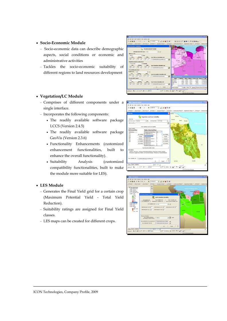
• Socio-Economic Module
− Socio-economic data can describe demographic aspects, social conditions or economic and administrative activities
− Tackles the socio-economic suitability of different regions to land resources development
• Vegetation/LC Module
− Comprises of different components under a single interface.
− Incorporates the following components: • The readily available software package
LCCS (Version 2.4.5) • The readily available software package
GeoVis (Version 2.3.6) • Functionality Enhancements (customized
enhancement functionalities, built to enhance the overall functionality).
• Suitability Analysis (customized compatibility functionalities, built to make the module more suitable for LES).
• LES Module
− Generates the Final Yield grid for a certain crop (Maximum Potential Yield - Total Yield Reduction).
− Suitability ratings are assigned for Final Yield classes.
− LES maps can be created for different crops.

ICON Technologies, Company Profile, 2009
GIS for the Ministry of Housing
The GIS for the Ministry of Housing1, Utilities and Urban Communities is mainly concerned with real-estate marketing, in addition to offering distinguished services to the investors and the public.
A. Real-Estate GIS on the Web
• Displaying City Information − About, transportation, landmarks, photos, etc. − City map navigation − Control of map layers − Printing map layouts − Identifying a map feature and displaying its
details
• Search and Query − Finding features by related keywords − Search by name, location, type, etc. − Finding nearest facility (facility of a certain type, within a specified distance, from a user-defined
point)
• Parcels Classification − Identifying classification field, classification
method, and number of classes − Displaying thematically classified maps
• Real-Estate Marketing
− Identifying residential real-estate opportunity (city, parcel/building, area, and price)
− Identifying services real-estate opportunity (city, parcel/building, area, and price)
− Reviewing details of results and location on map
1 MOH GIS was developed by ICON Technologies in collaboration with QSIT, Egypt and RAYA, Egypt

ICON Technologies, Company Profile, 2009
B. Data-Management Desktop Application • Search and Query
− Attribute search, spatial search, and graphical search.
• Layer Classification
− Thematic, charts, dot-density, etc. • Land-Parcels Management:
− Data entry for attributes (considering relations, coding, validation, etc.)
− Linking with files, photos, etc. − Geometry editing (splitting, merging,
modifying, etc.) • Spatial Data Manipulation:
− Projection, edge-matching, spatial adjustment/geo-referencing, etc.
− Importing data (AutoCAD, GPS, sketches, etc.) − Editing geographical features
• Reporting
− Templates, customization of layouts, etc.
• Printing/Exporting Maps • Automatic Linkage
− Between geodatabases at the new communities (Zayed, El-Shorouk, El-Obour) and the central geodatabase of the Ministry.

ICON Technologies, Company Profile, 2009
GIS for Electricity Trouble Call
The GIS for Electricity Trouble Call is built for the benefit of "Canal Electricity Distribution Company". It is a decision support system that serves in the management of electricity outages for low-voltage electricity distribution networks. It is a desktop GIS application based on ESRI's ArcGIS 9.2.
• System Settings − User-Privileges management, backup, setting
parameters.
• Editing Network Elements − Editing geometry of electricity network elements
(meters, cables, poles, boxes, transformers, etc.) while considering rules, relations, coding, etc.
− Data entry forms for each type of network elements.
− Re-building network after editing. • Managing Customer's Data
− Adding, removing, modifying customers' data/meters data.
− Keeping track of customers old data − Importing customers' data from external database
(billing). • Registering Trouble Calls
− Adding/removing details of trouble calls. − Avoiding redundant calls. − Alerting of the status of repair. − Automatic clearance of closed cases.

ICON Technologies, Company Profile, 2009
• Managing Trouble Calls
− Backward-Tracing from customers to transformer.
− Identifying customers served by a transformer (forward trace).
− Analyzing trouble calls to reach defected elements.
− Reviewing details of defected elements (including history).
− Reviewing impacted customers by an outage − Issuing work orders.
• Managing Work Orders
− Monitoring opened and closed work orders. − Assigning repair teams. − Determining repair components/requirements. − Closing work orders while keeping track of
repair details (date, defected element, components, duration, team, etc.).
• Reporting
− Time-dependant reports (outages details for a specific time period, work orders details for a specific time period, repairing outages, etc.).
− Electricity loads reports (comparison of design versus actual loads for different network elements).
− Customer reports (customers served by a certain transformer, classification of customers by activity, details of a specific customer, etc.).

ICON Technologies, Company Profile, 2009
Cadastre Module for Seychelles The Cadastre Module for Seychelles1 is a GIS application which incorporates different
capabilities needed for cadastre data manipulation, starting with querying capabilities, to reporting capabilities, and quality checking capabilities. In addition to production of land utilization layer (map) from actual parcels data. It is a desktop GIS application based on ESRI's ArcGIS 9.2.
• Users Management − User-Privileges management and setting parameters.
• Join Assistant − By using this module, the user with the capability to join
data in parcel layers and ownership tables.
• Quality Assurance − Provides the user with an automated process for
the quality check of the Parcels layer & its owners related data, through a simple and efficient manner, that holds the necessary Quality Assurance functions and procedures
− The user chooses whether to do analysis for the whole parcels layer or a defined area, then selecting among more than 30 (spatial & attributes) checking functions.
• Producing "Land Utilization Types (LUT) Layer" − Provides the user with the capability to come up with a Land Utilization Types layer (LUT layer),
from the parcels layer.
• Inquiry Module − Querying the GIS Database (layers & tables). − Defining the criteria which describe the needed data − Retrieving data needed whether this data is a complete layer/table, or even a set of
features/records in one or several layers/tables.
• Reporting Module − Responsible for facilitating parcel-data
reporting, by offering comprehensive tools for the presentation and mapping of spatial and attribute data, that allow the user to produce reports and maps, and to print them in an easy manner.
1 Seychelles Cadastre was developed by ICON Technologies in collaboration with ROC, Egypt
ICON Technologies, Company Profile, 2009
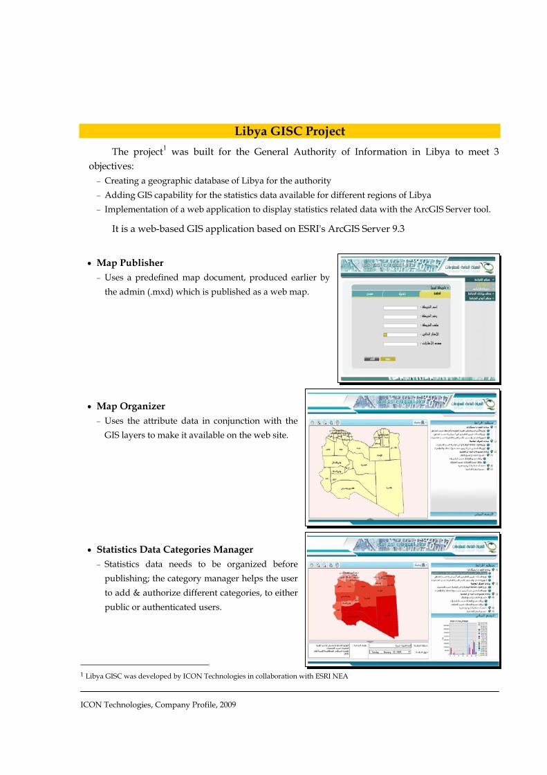
Libya GISC Project The project1 was built for the General Authority of Information in Libya to meet 3
objectives: − Creating a geographic database of Libya for the authority − Adding GIS capability for the statistics data available for different regions of Libya − Implementation of a web application to display statistics related data with the ArcGIS Server tool.
It is a web-based GIS application based on ESRI's ArcGIS Server 9.3
• Map Publisher
− Uses a predefined map document, produced earlier by the admin (.mxd) which is published as a web map.
• Map Organizer
− Uses the attribute data in conjunction with the GIS layers to make it available on the web site.
• Statistics Data Categories Manager
− Statistics data needs to be organized before publishing; the category manager helps the user to add & authorize different categories, to either public or authenticated users.
1 Libya GISC was developed by ICON Technologies in collaboration with ESRI NEA

ICON Technologies, Company Profile, 2009
• Map Viewer
− Authenticated users or public users can use the map viewer to view & query statistical maps (Demography, economic, social …)
− Charts & statistics-graphics can be displayed in and around the map
• Advanced Search
− Authenticated users or public users can use the advanced search to reach a specific map, under a pre-determined category, for a certain year.

ICON Technologies, Company Profile, 2009
Libya Investment Map
Libya Investment Map (LIM)1 was built for the Libyan Foreign Investment Board to serve the purposes of marketing investment opportunities in Libya. It is a web-based GIS application based on ESRI's ArcGIS Server 9.3.
• Searching Investment Zones − Searching by investment field/activity − Displaying search results − Reviewing investment zone details (area,
location, rules and regulations, design documents, photos, etc.)
• Searching investment opportunities − Search by location − Search by investment field − Search by investment activity/opportunity/project − Displaying search results − Reviewing opportunity details (area, location, activity, rules/regulations, documents, photos, etc.)
• Applying for investment project − Data entry screens for applicant's details − Data entry screens for investor's details − Data entry screens for project details
(investment field, activity, area required, project time line, construction period, cost, financing details, raw material, products and services, capacity, energy requirements, etc.)
− Populating the central DB with the details
• Managing application for investment projects − Search for applications (by date, investment
field, activity, etc.) − Adding feedback (reply) to the applications − Reviewing status of applications (completion, replies, procedures, etc.)
• General − Map navigation tools − User privileges management − Managing website advertisement
1 LIM was developed by ICON Technologies in collaboration with ESRI NEA

ICON Technologies, Company Profile, 2009
South Sinai GIS Project The project aimed at building a GIS Unit in South Sinai Governorate, capable of serving
the geographically-related needs of other departments. It involved developing customized applications for each of: Urban Planning Dept., Environmental Dept., Quarries Dept., and Water Resources Dep. The desktop GIS applications are based on ESRI's ArcGIS 9.x.
• Urban Planning
− Compares existing and planned situations. − Identifies areas deprived from a certain service.
• Environment Protection − Enables the user to estimate the potential pollution areas
due to a certain pollution source. − Detects changes in polluted areas. − Identifies areas subjected to flash floods.
• Quarries Management − Identifies the concentration of certain ore. − Determines the closest roads to quarries.
• Water Resource Management − Determines the groundwater distribution over
population. − Estimates the quality of groundwater by determining
the TDS values. − Monitors the drawdown in groundwater wells.

ICON Technologies, Company Profile, 2009
Port Said GIS Project The project aimed at enhancing the GIS Center in Port Said Governorate, to be more
capable of serving the geographically-related needs of other departments. It involved developing customized tools for geo-referencing schematics, map archiving, and map editing. The desktop GIS tools are based on ESRI's ArcGIS 8.x
• Layers Manager − Manipulates the available layers in terms of visualization, metadata, querying, classification, and
retrieving the related data.
• Geo-Referencing − Serves the needs of geo-referencing and spatial
adjustments for any type of maps, sketches, images, etc .
• Archiving − Enables the user to order, archive, browse, and
add metadata for master plans.
• Map Editor − Enables the user through various tools to
perform and save all possible edit operations on a map

ICON Technologies, Company Profile, 2009
Water Resources Management GIS Project
This WRM GIS is built to the benefit of the Water Resources Department, Libya, and is customized for Jeffara plain. WRM calculates water balances through the analysis of rainfall data, groundwater data, terrain data, and water consumption. WRM also analyzes water quality data. It is a desktop GIS application based on ESRI's ArcGIS 8.x
• Evapo-transpiration Calculator
− Estimates the evaporation and transpiration for a certain type of land-cover. − Forms an evapo-transpiration grid for a desired area.
• Direct/Indirect Rainfall
− Forms a grid for rainfall values, hence calculate the values of direct infiltration (to be used in calculating aquifer balance).
− Forms a grid for rainfall values over catchments areas, calculate the water runoff, and hence calculate the values of indirect infiltration (to be used in calculating aquifer balance).
• Aquifer Balance − Determines the balance of an aquifer using the
grids of evapo-transpiration, direct infiltration, indirect infiltration and groundwater wells discharge.
• Water Quality
− Determines the characteristics of water quality of an aquifer.
− Determines the characteristics of water quality of new-proposed well.

ICON Technologies, Company Profile, 2009
Social Fund for Development (SFD) GIS Project
SFD GIS1 is built to the benefit of the Social Fund for Development, targeting the communities and areas in most need for development. The built GIS helps the decision makers to allocate available resources to the targeted areas/communities, through deducing a group of relative indicators (sectored/general), giving a comprehensive image about the deprivation conditions. It is a desktop GIS application based on ESRI's ArcGIS 8.x
• Schema Management
− Dedicated for managing schemas (management of social-indicators' categories) in terms of which sectors underlie which categories and which variables underlie which sectors.
− Enables the user of type “Administrator” to create, fully manipulate or remove the schemas.
• Scenario Builder
− Dedicated for executing various scenarios (combination of sectors, variables and weights), thus coming up with custom indicator values for administrative units.
− Enables the user of type “Administrator” or the user of type “Planner” to create, run and view the results of a certain scenario.
• Visual Analysis − Dedicated for visualizing the output of the
scenarios with the aid of geographical maps. − Enables the user of type “Administrator” or the
user of type “Planner” to classify/reclassify the outputs resulting from a scenario on a map.
1 SFD GIS was developed by ICON Technologies in collaboration with QSIT, Egypt
ICON Technologies, Company Profile, 2009
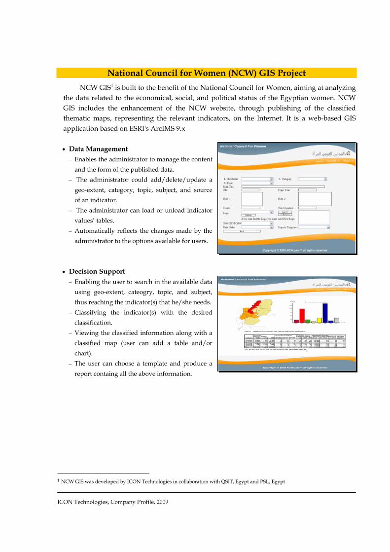
National Council for Women (NCW) GIS Project
NCW GIS1 is built to the benefit of the National Council for Women, aiming at analyzing the data related to the economical, social, and political status of the Egyptian women. NCW GIS includes the enhancement of the NCW website, through publishing of the classified thematic maps, representing the relevant indicators, on the Internet. It is a web-based GIS application based on ESRI's ArcIMS 9.x
• Data Management
− Enables the administrator to manage the content and the form of the published data.
− The administrator could add/delete/update a geo-extent, category, topic, subject, and source of an indicator.
− The administrator can load or unload indicator values’ tables.
− Automatically reflects the changes made by the administrator to the options available for users.
• Decision Support
− Enabling the user to search in the available data using geo-extent, cateogry, topic, and subject, thus reaching the indicator(s) that he/she needs.
− Classifying the indicator(s) with the desired classification.
− Viewing the classified information along with a classified map (user can add a table and/or chart).
− The user can choose a template and produce a report containg all the above information.
1 NCW GIS was developed by ICON Technologies in collaboration with QSIT, Egypt and PSL, Egypt
ICON Technologies, Company Profile, 2009
Training Projects
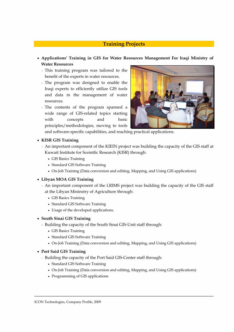
• Applications' Training in GIS for Water Resources Management For Iraqi Ministry of Water Resources − This training program was tailored to the
benefit of the experts in water resources. − The program was designed to enable the
Iraqi experts to efficiently utilize GIS tools and data in the management of water resources.
− The contents of the program spanned a wide range of GIS-related topics starting with concepts and basic principles/methodologies, moving to tools and software-specific capabilities, and reaching practical applications.
• KISR GIS Training − An important component of the KIEIN project was building the capacity of the GIS staff at
Kuwait Institute for Sceintfic Research (KISR) through: • GIS Basics Training • Standard GIS Software Training • On-Job Training (Data conversion and editing, Mapping, and Using GIS applications)
• Libyan MOA GIS Training − An important component of the LRIMS project was building the capacity of the GIS staff
at the Libyan Mininstry of Agriculture through: • GIS Basics Training • Standard GIS Software Training • Usage of the developed applications.
• South Sinai GIS Training − Building the capacity of the South Sinai GIS-Unit staff through:
• GIS Basics Training • Standard GIS Software Training • On-Job Training (Data conversion and editing, Mapping, and Using GIS applications)
• Port Said GIS Training − Building the capacity of the Port Said GIS-Center staff through:
• Standard GIS Software Training • On-Job Training (Data conversion and editing, Mapping, and Using GIS applications) • Programming of GIS applications

ICON Technologies, Company Profile, 2009
Consultation Projects
• Consultation with FAO − Consultation in Mapping of Natural Resources for “Agricultural Use and Planning in
Libya” project with FAO, 2004. Consultation tasks, included: • GIS database verification. • Quality Control over Jeffara plain maps production • Assessment of “Agro-Ecological Zoning” project requirements
• Consultation with ESRI NEA − Various consultation activities (e.g. proposal building, systems development, etc.) in
cooperation with ESRI NEA, in relation to the following projects: • Agricultural Cadastre project • EPADP GIS Project • EFS GIS Project
• Consultation with MOCA − Consultation in GIS and related technologies for the Ministry of Civil Aviation, with
regards to building a GIS unit under the general department of surveying and obstacles. Consultation tasks, included:
• Supervision of GIS application development. • Assessment of “surveying and obstacles department” staff capabilities and needs. • Developing of GIS application testing plan. • Supervision of GIS on-job training for staff.

ICON Technologies Address: 18, El-Obour Bldgs, Salah Salem st., Cairo, Egypt Tel & Fax: (+202) 24040010 Email: [email protected]