comparison of forest biomass estimates in siberia … · raster format at 1 km resolution has been...
TRANSCRIPT
COMPARISON OF FOREST BIOMASS ESTIMATES IN SIBERIA USING
SPACEBORNE SAR, INVENTORY-BASED INFORMATION AND
THE LPJ DYNAMIC GLOBAL VEGETATION MODEL
Maurizio Santoro
(1), Christian Beer
(2), Anatoly Shvidenko
(3), Ian McCallum
(3),
Urs Wegmüller(1)
, Andreas Wiesmann(1)
, Christiane Schmullius(4)
(1)
Gamma Remote Sensing, Worbstrasse 225, CH-3073 Gümligen, Switzerland,
Email: [email protected], [email protected], [email protected] (2)
Max Planck Institute for Biogeochemistry, Hans Knöll Strasse 10, D-07745 Jena, Germany,
Email: [email protected] (3)
International Institute for Applied Systems Analysis (IIASA), Schlossplatz 1, A-2361 Laxenburg, Austria,
Email: [email protected], [email protected] (4)
Department of Earth Observation, Friedrich-Schiller University, Grietgasse 6, D-07743 Jena, Germany,
Email: [email protected]
ABSTRACT
Estimation of forest biomass using spaceborne SAR
data is an active field of investigation. C-band
backscatter is known to provide little information on
biomass because of the weak sensitivity to forest
biophysical properties. However, if a large multi-
temporal dataset is used, it should be possible to
improve the estimation. This assumption has been tested
with ENVISAT ASAR Wide Swath (WS) data over a
400.000 km2 large region in Central Siberia. Forest
biomass, expressed as growing stock volume, has been
retrieved using an approach based on a Water-Cloud
like model and a multi-temporal combination of
estimates. To avoid any dependence of the modelling
procedure upon in situ training data, a novel training
approach based on the information content of the
MODIS Vegetation Continuous Fields tree canopy
cover product has been developed. Biomass has been
estimated at 1 km resolution to be comparable both to
the inventory data and the coarse-scale biomass
simulations by the LPJ Dynamic Vegetation Model. The
patterns of biomass estimated from ASAR WS and from
the inventory compare well. This result is far beyond
initial expectations. Compared to LPJ-based simulated
biomass, the WS-based biomass presents a much higher
degree of detail making comparison difficult. ENVISAT
ASAR WS data appear as a potential candidate for
estimation of large-scale forest biomass for a wide range
of applications.
1. INTRODUCTION
Forest biomass information is required at different
levels and scales, ranging from polygon level as used in
forest inventory (high resolution, order of hectares) to
grid level as used in Dynamic Global Vegetation
Models (DGVMs) (low resolution, order of several km).
DGVMs like the Lund-Potsdam-Jena (LPJ) are
powerful tools to study the ecosystem response to
changes in environmental conditions like warming. This
is reached by process-based simulation of vegetation
structure and function. The dominance of a certain
vegetation type and the size of pools like vegetation or
soil carbon content are obtained by the integration of
fast processes like carbon assimilation but also slow
processes like carbon allocation to plant compartments,
mortality, litterfall, and fire disturbances.
Evaluation of the fast processes by using flux
measurements, e.g. by the eddy covariance technique,
has improved knowledge concerning the representation
of fast responses of the ecosystem. On the contrary, the
evaluation of pool sizes is still an open issue. It is
essential to determine slow processes that might still not
be represented in the model, and to know about the
validity of the model over a long time period. For this,
the spatial distribution of biomass over a large transect
that comprises several climatic conditions is required.
For instance, in [1] biomass simulated by LPJ was
compared to inventory data collected during the last 30
years over a 3 Million km² transect in Central Siberia
(SIBERIA-II Project study area). Although the north-
south gradient of biomass obtained from LPJ and the
inventory showed good agreement, differences occured,
in particular at high latitudes.
In their current state both the LPJ and the inventory-
based estimates suffer from errors and uncertainties in
particular in this region. On one hand well known
processes which limit biomass in permafrost regions are
not represented in the model yet. On the other hand
inventory data from very remote regions have become
obsolete. For this reason it is necessary to obtain
accurate and up-to-date biomass information from other
sources, which could serve both for inventory purposes
and as driver in vegetation modelling.
Spaceborne SAR data are a potential candidate for the
retrieval of forest biomass since the SAR backscatter
coefficient can be directly related to the forest above-
ground biomass. The sensitivity of the backscatter to the
biomass increases for increasing wavelength.
Furthermore, the importance of multi-temporal
_____________________________________________________
Proc. ‘Envisat Symposium 2007’, Montreux, Switzerland 23–27 April 2007 (ESA SP-636, July 2007)

combination of biomass estimates from individual
images and the choice of images depending on the
environmental conditions have been highlighted as ways
to improve the biomass estimates.
Currently the only spaceborne SAR providing global
coverage and for which a long time series of data is
available is ENVISAT ASAR. ENVISAT started
operations in 2002 with a repeat-pass cycle of 35 days.
ASAR operates at C-band in a multi-mode
configuration. In the Wide Swath (WS) mode ASAR
acquires data over large swaths (400 km) with a
relatively good resolution (75 m) and a large number of
looks (~ 100). Because of the large swath, the overlap
between neighbouring satellite tracks is significant
which in turn means that for a point on the ground
multi-temporal datasets of backscatter values become
available on short time intervals (e.g. 3 days at the
latitudes of the study area of this investigation). The
main limitation of ENVISAT ASAR for estimating
biomass is the weak sensitivity of the C-band
backscatter to forest biomass. However, if a large multi-
temporal dataset is available, we might pick out a
clearer signal related to the forest structure and thus
obtain a less uncertain biomass estimate. To prove this
hypothesis we analysed a multi-temporal ENVISAT
ASAR WS dataset acquired between spring 2003 and
summer 2004 over a 400.000 km2-large area within the
SIBERIA-II Project study area [2].
Section 2 describes the database of WS images.
Sections 3 and 4 we briefly present the inventory data
and the process-based modelling of biomass with the
LPJ DGVM. Section 5 gives an overview of the test
region of this study. Section 6 illustrates the
methodology applied to retrieve forest biomass from the
SAR data. Results and conclusions from the comparison
of biomass retrieved from ASAR WS, from the
inventory and simulated by LPJ are presented in
Sections 7 and 8 respectively.
2. ENVISAT ASAR WS IMAGERY
During 2003 and 2004 ENVISAT ASAR data in Wide
Swath mode have been acquired regularly for the study
area of the SIBERIA-II Project. The aim was to build up
a consistent archive of data with unique properties
(large swath and reasonable resolution) that could be
exploited during the project for several applications as
well as in future studies to understand and map
biophysical processes of northern latitudes.
Data processing and archiving has been described in [2].
Several hundred ASAR WS image frames were
radiometrically calibrated, geocoded and terrain
corrected. To address the large north-south extent of the
SIBERIA-II Project study area an Albers Equal Area
Conic projection was chosen. For geocoding and terrain
correction a DEM obtained from mosaicing SRTM 3
arcsec and GTOPO30 30 arcsec DEMs were used.
Above 60° N the DEM consisted of GTOPO30 only.
Each frame was split into 100 km x 100 km tiles with a
pixel spacing of 100m in easting and northing and
stored in stacks of co-localized data. In addition, the
local incidence angle, the local pixel area normalization
factor, and the Gamma MAP filtered backscatter
coefficients have been stored.
To reduce the nonlinear dependence and the
dependency of the backscatter from the incidence angle,
the backscatter coefficient γ=σ0/cosθ was computed (σ0
being the backscatter coefficient and θ the local
incidence angle). For the data analysis γ was
additionally corrected for pixel area size effects due to
topography. This correction reduces the topographic
information in the backscatter values and makes the
different values more comparable. It should be noted
that for the areas above 60° N, where only the
GTOPO30 DEM was available, the effect of the local
slope on the backscatter coefficient could only partially
be compensated for. This caused the normalized
backscatter coefficient to include a residual component
due to the local topography not represented in the
GTOPO30 DEM.
Finally all WS were multi-looked to obtain a pixel size
of 1 km x 1 km, i.e. a size useful for the comparison
with biomass from the inventory and simulated by LPJ.
Hence, we also further filtered the images for speckle.
3. FOREST INVENTORY DATA
In the SIBERIA-II Project study area over 30,000
individual forest and non-forest polygons have been
delineated. A polygon can be considered as an area with
similar properties in terms of species composition,
biomass etc and homogeneous forest cover. The
polygons were delineated by Russian regional
vegetation experts. The digital planimetric base used for
geo-registration was at a scale of 1:1 Million. The
thematic information was obtained by combining data
from in situ measurements, aerial photography based
estimates and spaceborne remote sensing data at
different scales (MODIS and Landsat ETM). Data
associated to each forest polygon include species
composition, age, average height and diameter, relative
stocking, site index and growing stock volume.
Growing stock volume represents the total standing
volume per unit area and is measured in m3/ha.
Conversion factors depending on species composition
can be applied to derive above-ground and total forest
biomass from the growing stock volume. Due to the
vastness of the area and the remoteness of large parts of

the region, the inventory data has different levels of
accuracy and up-to-date status. From the GIS a map in
raster format at 1 km resolution has been obtained.
4. BIOMASS SIMULATION BY THE LPJ DGVM
DGVMs aim at deriving biomass by integrating the
most important carbon fluxes into and out of the
ecosystem over long time periods (~1000 a). Currently
the model establishment takes into account
photosynthetic carbon uptake, respiration, allocation,
litterfall and mortality. Vegetation structure is
represented by a discrete set of functional types that
compete for light and water resources. In doing so, all
state variables are estimated as a function of
temperature, precipitation, radiation and soil texture
type. The resolution of model results is determined by
the resolution of these drivers, in the present case being
0.5° in space and monthly in time. In this study we use
the model from [3] enhanced for boreal application, e.g.
by including soil freeze-thaw dynamics as described in
[1]. Anthropogenic effects are not considered in this
model version. LPJ calculates total plant biomass and
growing stock volume is approximated by dividing 80%
of this value (above-ground part) by a mean carbon
density of 300 kgC/m³.
5. TEST REGION
To develop and test the growing stock retrieval method
we considered an 1000 km long and 400 km wide area
(53-63° N, 91-99° E) within the SIBERIA-II project
study area. This subset was chosen based on a number
of reasons: availability of a large multi-temporal and
multi-angle WS dataset (40 tiles including between 10
and 60 measurements of the backscatter coefficient per
pixel), an acceptable level of radiometric compensation
for local topography, reasonable quality of the ground
reference data, possibility to test the sensitivity of the
biomass upon the backscatter coefficient for a large
range of forest conditions, and sufficient extent to
provide an adequate comparison with the coarse scale
biomass simulated by LPJ.
The test region stretches from light coniferous taiga in
the North to the dark coniferous taiga in the South,
including the Western Sayani Mountains. Both the
easternmost part of the Siberian Lowlands as well as a
large part of the Yenisey Krijag, a hilly mountainous
area, are included. The test region is mostly forested,
with growing stock decreasing for increasing latitude.
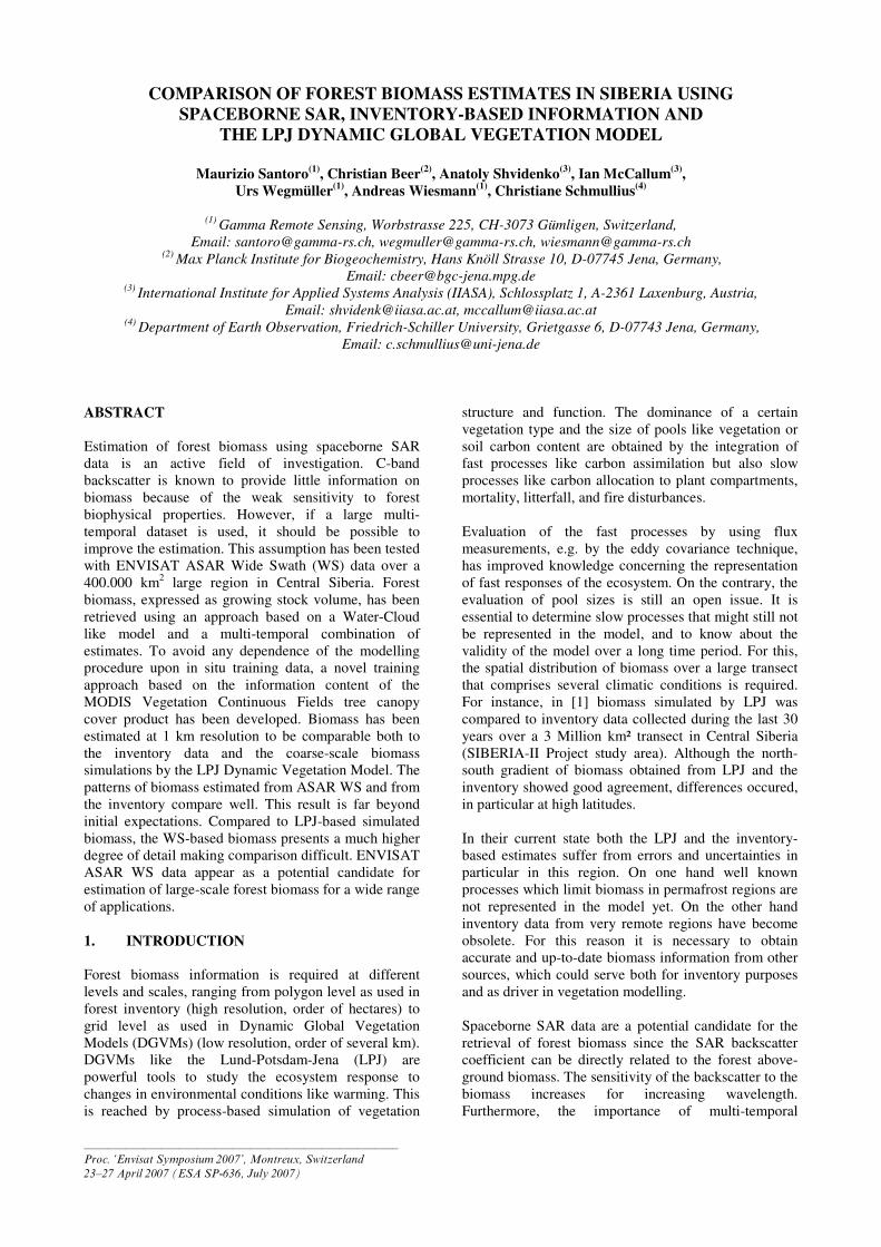
This is illustrated in Fig. 3b.
Other ground reference data consisted of daily
observations of temperature, wind speed, precipitation
and snow depth collected at several weather stations
mostly located in the southern part of the test region.
6. WS-BASED RETRIEVAL METHOD
Forest biomass retrieval using C-band backscatter is
known to be of very limited potential due to the weak
sensitivity of the backscatter to the forest structural
properties. In addition, for increasing soil moisture
and/or wetness of the soil, the correlation between
backscatter and biomass goes from a slight positive
correlation to no correlation up to a slight negative
correlation. Several studies have indicated that by
increasing the incidence angle the sensitivity of the
backscatter to the biomass increases. Hence shallow
angles are suggested for forest applications.
At first we compared the distribution of backscatter
measurements with respect to growing stock volume for
the WS range of incidence angles (approximately 20° to
40°). An example is reported in Fig. 1. For one tile we
illustrate the dependence of the backscatter upon
growing stock volume (and corresponding modelled
backscatter) under steep (~ 20°) and shallow incidence
angles (~ 40°) for different environmental conditions.
Fig. 1 shows that the sensitivity of the forest backscatter
to growing stock volume depended primarily on the
environmental conditions at the time of image
acquisition. Since we could not detect any consistent
behaviour for different viewing geometries, we then
decided to keep all images regardless of the look angle
and develop a retrieval algorithm that would be
independent from different look angle and tree
attenuation.
The retrieval method is based on the Water-Cloud like
model presented in [4]:
( ) ( )[ ]tree
o
vegtree
o
gr
o
gr
o
for TT −++−= 11 σσησησ (1)
Figure 1. Backscatter coefficient as a function of
growing stock volume under steep and shallow
incidence angles for (a) dry/frozen, (b) light rainy, (c)
dry, and (d) rainy conditions.

in which σgr0 and σveg
0 represent the backscatter
coefficient of soil and forest canopy respectively, η is
the area-fill factor, i.e. the fraction of forest canopy
cover, and Ttree the two-way tree transmissivity. This
can be expressed as e-αh
, where h is the vegetation
canopy height and α two-way tree canopy attenuation.
Eq. (1) can be written in terms of growing stock
volume, V, as follows
( ) Vo
gr
Vo
veg
o
for ee ββ σσσ −− +−= 1 (2)
where Ve β− expresses the two-way forest transmissivity
as a function of V. β is an empirically derived
coefficient [5]. Eq. (2) can be derived from Eq. (1) by:
h
V
e
eα
β
η−
−
−
−=
1
1 (3)
To be able to retrieve growing stock volume the model
in Eq. (2) needs to be trained since it contains three
unknowns (σgr0, σveg
0 and β). Traditionally, a set of in
situ measurements and corresponding backscatter
measurements are used to train the model. This method
requires the availability of some sort of reference data.
For retrieval in large areas this is a considerable
limitation since in situ data, in particular in remote
areas, can be scarce and/or out-of-date. To overcome
this difficulty we have developed a novel model training
approach based on the information contained in the
MODIS Vegetation Continuous Fields (VCF) tree
canopy cover product [6]. A similar procedure has been
developed for ERS coherence data in [7].
The VCF product provides global sub-pixel estimates of
landscape components (tree canopy cover, herbaceous
cover, and bare cover) at 500 m pixel size. The basic
idea is that since σ0
gr represents the backscatter
coefficient of a bare surface, it can be determined by
masking the SAR image for low tree canopy cover
percentage. σ0veg can then be determined by masking the
SAR image for high tree canopy cover percentage and
then compensating for residual ground backscatter
component. In this work we assumed the coefficient β
to be constant and equal to 0.0055 ha/m3 in accordance
to previous modelling work in European and Siberian
boreal forests using ERS interferometric data [8].
The forest backscatter was modelled on a tile-by-tile
basis. To obtain comparable pixel sizes, the VCF
product was downsampled to 1 km pixel size. By
analysing the distribution of the backscatter coefficient
for the pixels flagged as “ground” based on the VCF
information, σ0gr was determined as the value
corresponding to the peak of the distribution. Mostly the
distribution followed a unimodal pattern. In a few cases
we observed a bimodal distribution, which
corresponded to different backscatter levels of the
ground within the tile. This occurred typically under
rainy or freeze/thaw conditions. Such cases were
automatically excluded from further investigation since
they would in any case return wrong biomass estimates.
Once σ0gr had been determined, σ
0veg was obtained by
inverting Eq. (2) in which σ0for represented the
backscatter coefficient corresponding to the peak of the
distribution for all pixels with VCF value at least 75%
of the maximum VCF value found in the tile. In this
way we took into account that σ0veg represents the forest
backscatter for an infinitely opaque forest canopy.
Fig. 2 illustrates modelled and measured backscatter
together with the distribution of the backscatter
coefficient for pixels flagged as “ground” for two tiles
with different percentage of “ground” pixels. When the
percentage of “ground” pixels was high, the distribution
presented a clear peak at a level in accordance with the
σ0gr value we would have expected by looking at the
measurements of the backscatter as a function of the
growing stock volume (left part of Fig. 2). When instead
only a few pixels were identified as “ground” the
estimate of σ0gr was in some cases erroneous as in the
case illustrated on the right side of Fig. 2, where we
would have expected a lower value. It should be noticed
that the large dispersion of the backscatter
measurements in the upper right plot (> 150 m3/ha)
refers to dense forest according to the inventory that
were likely affected by disturbances in the period
between the inventory and the acquisition of the WS
data. This was a major issue in several frames, thus
highlighting the importance of a model training method
that is independent from in situ measurements.
Figure 2. Modelled and measured backscatter as a
function of growing stock volume for a tile including a
large number of “ground” pixels (20 %, left) and very
few “ground” pixels (2%, right).

Growing stock volume was retrieved for all points
identified as forests in the inventory data. To improve
the retrieval, multi-temporal combination of estimates
from individual images was performed. As weights the
span of the backscatter, i.e. the difference ∆σ=σveg0-
σgr0, was used. To avoid that cases with very little or no
sensitivity of the backscatter to the growing stock
volume would corrupt the multi-temporal estimate,
images for which ∆σ<0.5 dB were discarded. The
reason for such a low threshold is the rather weak
sensitivity of the backscatter to the growing stock
volume, typically between 0 and 3 dB. A higher
threshold would have resulted in rejecting many images.
7. RESULTS AND DISCUSSION
Fig. 3 shows a comparison between WS-based growing
stock volume (a) and from the inventory (b). The
agreement between the two growing stock maps has
been expressed in terms of the correlation coefficient r,
being equal to 0.37. The overall agreement between the
two growing stock maps is quite remarkable. This is far
beyond initial expectation considering the weak
sensitivity of C-band backscatter to biomass. The
comparison of the WS-based growing stock volumes
with LPJ simulated values in Fig 3c clearly shows a
large scale agreement but also the limitation of the
DGVM to represent spatial heterogeneity mainly due to
the coarse resolution of climatic drivers. This
comparison demonstrates the need for more advanced
retrieval of the DGVM model parameters, e.g. using a-
priori knowledge about the parameters and remotely
sensed biomass in a Bayesian approach. Also quite
remarkable is the similarity of spatial patterns between
the WS-based growing stock volume and the VCF tree
canopy cover product (Fig. 3c).
Fig. 3 shows also that in some areas the growing stock
volume retrieved from the WS backscatter is not in line
with the in situ measurements. Not considering here that
the C-band might by itself be an explanation for the
retrieval error, we identified five major reasons for the
discrepancies, which must be assessed in detail.
(i) Variable accuracy and date of the forest inventory
data. The most frequent example of inventory data
having become obsolete is given by recent
disturbances. While the forest inventory data
indicated values above 150-200 m3/ha, the
backscatter was found to be consistently low, at the
level of the ground backscatter (see e.g. the
example on the right in Fig. 2). This resulted in very
low retrieved growing stock volumes. In most cases
the occurrence of a disturbance was supported by
the low VCF tree canopy cover percentage.
(ii) Incorrect modelling of the backscatter due to too
few “ground” pixels. If a tile includes too few
“ground” pixels, the estimate of σgr0 might be in
most cases erroneous thus leading to incorrect
estimates of the growing stock volume. A possible
way to improve the retrieval is to rely on σgr0 values
of neighbouring tiles as well.
(iii) Quality and date of the VCF product. We assumed
that the VCF represents an unbiased and accurate
estimate of the tree canopy cover, thus being a
parameter that could directly be used for estimating
the model parameters. In the future the relationship
between the values of the VCF product and the
actual canopy cover, with relation to the
corresponding growing stock, should be assessed to
see whether the assumption we made was correct. It
should also be noticed that the VCF product was
based on MODIS imagery from the year 2000, thus
not including most recent changes with respect to
the year of acquisition of the ASAR WS data. How
much this affected modelling and retrieval will be
assessed when MODIS VCF products timed with
the WS data become available.
(iv) Regenerating forests on wet soils. Although the
growing stock volume is low (~ 50 m3/ha), the wet
soils cause the backscatter to be comparable to the
level measured in dense forests. Hence, the
retrieved growing stock volume is clearly
overestimated. Further studies should assess if the
retrieval accuracy improves if only data acquired
under winter/frozen conditions are used.
(v) Imperfect compensation of the backscatter
coefficient for local topography. Above 60° N we
noticed that the WS-based volumes for sloped areas
facing the radar were higher than for sloped areas
away from the radar. This is a consequence of the
coarse resolution of the GTOPO30 DEM used for
radiometric compensation at these latitudes. No
solution seems at this moment available.
8. CONCLUSIONS
In this paper we have investigated the possibility to
retrieve forest biomass from multi-temporal ENVISAT
ASAR data acquired in Wide Swath mode for large area
studies, comparing the results with inventory data and
values simulated with the LPJ DGVM. As a test area we
considered a 400.000 km2 large area in Central Siberia.
To retrieve the biomass from WS backscatter a Water-
Cloud like model was used. For model training a novel
approach based on the MODIS VCF product was
applied. In this way the dependency of the retrieval
method on in situ data for training was removed. The
modelled backscatter described well the relationship
between the observed backscatter and the growing stock
volume, from which it can be concluded that the
modelling approach is robust. The spatial distribution of
the forest biomass retrieved from ASAR WS data shows
remarkable agreement with inventory-based estimates

and VCF tree canopy cover. The spatial details of
biomass retrieved from ASAR WS are important to
validate current DGVMs and are the basis for more
detailed retrieval of parameters used in DGVMs.
Discrepancies with inventory data were found at the
local scale, the reasons being multiple (e.g. obsolete
reference data, distorted estimate of the model
parameter, time difference between VCF and ASAR
data, imperfect compensation for topographic effect due
to coarse DEM available). The results are without any
doubt far beyond what commonly expected from C-
band SAR backscatter and are likely to open a new field
of investigation on forest biomass estimation using SAR
data for regional to global applications.
9. ACKNOWLEDGMENTS
ENVISAT ASAR data has been acquired and
distributed under the AO-225 SIBERIA. Data
processing and collection of inventory data have been
supported by the EC-funded 5th FP SIBERIA-II Project
(Contract No. EVG1-CT-2001-00048).
10. REFERENCES
1. Beer, C., Lucht, W., Gerten, D., Thonicke, K. &
Schmullius, C. (2007). Effects of soil freezing and
thawing on vegetation carbon density in Siberia: A
modeling analysis with the Lund-Potsdam-Jena
Dynamic Global Vegetation Model (LPJ-DGVM).
Global Biogeochemical Cycles, 25 (1), GB1012.
2. Wiesmann, A., Wegmüller, U., Santoro, M., Strozzi,
T. & Werner, C. (2004). Multi-temporal and multi-
incidence angle ASAR Wide Swath data for land
cover information. In Proc. 4th International
Symposium on Retrieval of Bio- and Geophysical
Parameters from SAR Data for Land Applications.
3. Sitch, S., et al. (2003). Evaluation of ecosystem
dynamics, plant geography and terrestrialcarbon
cycling in the LPJ dynamic global vegetation model.
Global Change Biology, 9, 161-185.
4. Askne, J., Dammert, P., Fransson, J., Israelsson, H. &
Ulander, L.M.H. (1995). Retrieval of forest
parameters using intensity and repeat-pass
interferometric SAR information. In Proc. Retrieval
of Bio- and Geophysical Parameters from SAR Data
for Land Applications.
5. Pulliainen, J.T., Heiska, K., Hyyppä, J. &
Hallikainen, M.T. (1994). Backscattering properties
of boreal forests at the C- and X-bands. IEEE Trans.
Geosci. Remote Sensing, 32 (5), 1041-1050.
6. Hansen, M.C., DeFries, R.S., Townshend, J.R.G.,
Sohlberg, R.A., Dimiceli, C. & Carroll, M. (2002).
Towards an operational MODIS continuous field of
percent tree cover algorithm: Examples using
AVHRR and MODIS data. Remote Sens. Environ.,
83, 303-319.
7. Cartus, O., Santoro, M., Schmullius, C., Yong, P. &
Li, Z. (2007). Creation of large area forest biomass
maps for Northeast China using ERS-1/2 tandem
coherence. In Proc. ENVISAT Symposium 2007.
8. Santoro, M., Shvidenko, A., McCallum, I., Askne, J.
& Schmullius, C. (2007). Properties of ERS-1/2
coherence in the Siberian boreal forest and
implications for stem volume retrieval. Remote Sens.
Environ., 106 (2), 154-172.
(a) (b) (c) (d)
Figure 3. (a) WS-based, (b) forest inventory, (c) LPJ-based growing stock volume [m³/ha], and (d) MODIS VCF
tree canopy cover [%].