compartment review presentation … with a high water table. there is a flowing creek in section 22....
TRANSCRIPT

COMPARTMENT REVIEW PRESENTATION
GAYLORD FOREST MANAGEMENT UNIT
COMPARTMENT: 66
ENTRY YEAR: 2013 ACREAGE: 1,241
COUNTY: Charlevoix Revision Date: 05/18/2011 Stand Examiner: Kimberly Lentz Legal Description: T38N, R10W, Sections 10, 22, 27, & 34 Management Goals: To provide for the protection, integrated management and responsible use of a healthy, productive, and undiminished forest resource base for the social, recreational, environmental, and economic benefit of the State of Michigan. Soil and Topography: The most predominant soil type is Roscommon Sand. Low, wet areas are Tawas Muck or Lupton Association. Other upland soils include Second Sandy Loam and Angelica Loam. Terrain is primarily level located on lowland. Ownership Patterns, Development, and Land Use in and Around the Compartment: In Section 22, state owns 160 acres. Section 27 is all state ownership except one private 40 acre parcel. In Section 34, the West ½ of section, the NE1/4 of the SE ¼, and the N1/2 NE ¼ is state ownership. There is also an isolated 40 acre parcel state-owned in Section 10 by Egg lake which is surrounded by private and wetland. Unique, Natural Features: None noted Archeological, Historical, and Cultural Features: The Beaver Island History map noted that Hannigan Rd. was named after Tom “Hannigan” Boyle. Prior to that road name, it was called Mill Road when oxen pulled cars over a wooden track to Sweet’s Mill. Special Management Designations or Considerations: Dedicated and Proposed Special Conservation Area – Great Lakes Islands.

Watershed and Fisheries Considerations: Compartment is primarily lowland with marshes and lowland brush with a high water table. There is a flowing creek in Section 22. Portions of Section 27 are completely flooded by beaver dam activity. Fisheries comment is to apply appropriate Best Management Practices when working in the proximity of surface water. Wildlife Habitat Considerations: This compartment is on Beaver Island and consists mainly of lowland areas utilized by white-tailed deer and various furbearers. Stand 27 is going to be clear cut if possible due to the wet nature and access to provide some early successional habitat within this compartment. Mineral Resource and Development Concerns and/or Restrictions: Surface sediments consist of lacustrine (lake) sand and gravel. The glacial drift thickness varies between 300 and 400 feet. Beneath the glacial drift are the Devonian Detroit River Group and the Mackinac Breccia. The Detroit River is mined for salt and the Mackinac is used for stone in other areas in the State. The nearest gravel pits are less than one mile to the east. Gravel potential in the compartment is thought to be good. Oil and gas potential appears to be limited. Two wells were drilled on the island in 1961 as dry holes. One of the wells was located in Section 27. These wells were “deep” tests, with one reaching Precambrian age rocks. None of the State land is currently leased in the compartment. Vehicle Access: Kings Highway and Hannigan Road are the two driveable roads adjacent to compartment boundaries. All other logging roads including the Johnny Martin Trail are now flooded with hike in only access. Survey Needs: No survey needs at this time. Recreational Facilities and Opportunities: The hiking trails previously maintained by the Island residents are no longer evident due to flooding by beaver activity. Fire Protection: No foreseen problems Additional Compartment Information:
The following 3 reports from the IFMAP Inventory System are attached: ♦ Cover Type by Age Class ♦ Proposed Treatments – No Limiting Factors ♦ Proposed Treatments – With Limiting Factors
The following information is displayed, where pertinent, on the attached compartment maps: ♦ Base feature information, stand numbers, cover types ♦ Proposed treatments ♦ Proposed road access system ♦ Suggested potential and current SCA’s

Fox Lake
Barneys Lake
Round Lake
Egg Lake
Lake Geneserath
Greenes Lake
Millers Marsh
East Side Dr
Kin
gs H
wy
Fox
Lake
Rd
Wes
t Sid
e R
d
Sloptown Rd
Pogenog Rd
Hannigan Rd
Fox Bay Loop
Dar
keyt
own
Rd
McCauley Rd
Greens Lake Rd
Redd
ing
Rd
Pogenog Rd
East Side Dr
Hannigan Rd
85°29’0"W
85°29’0"W
85°30’0"W
85°30’0"W
85°31’0"W
85°31’0"W
85°32’0"W
85°32’0"W
85°33’0"W
85°33’0"W
85°34’0"W
85°34’0"W
85°35’0"W
85°35’0"W
45°4
3’0"
N
45°4
3’0"
N
45°4
2’0"
N
45°4
2’0"
N
45°4
1’0"
N
45°4
1’0"
N
45°4
0’0"
N
45°4
0’0"
N
45°3
9’0"
N
45°3
9’0"
N
45°3
8’0"
N
45°3
8’0"
N
45°3
7’0"
N
45°3
7’0"
N
1 0 10.5 Miles
Compartment 066T38N, R10W, Sec. 10, 22, 27, 34County: CharlevoixUnit: GaylordYOE: 2013Acres: 1,241 GIS CalculatedStand Examiner: Kim LentzMap Revised: 5/26/2011Map Phase: Pre-Review
27
10
22
34
Cover Type & Treatment Map
LegendMiris CornersRemonumented Section CornersCounty Paved RoadsCounty Gravel RoadsPoor Dirt RoadsCounty Poor Dirt RoadsTrail (Non-Recreation)Bike TrailHorse TrailHiking TrailSki TrailLakes and RiversIntermittent Stream/DrainStream
TreatmentsClearcut (w/Reserves, Patch/Strip)
Forest Stands Level 3
411 - Northern Hardwood413 - Aspen Types611 - Lowland Deciduous Forest612 - Lowland Coniferous Forest613 - Lowland Mixed Forest
Non-Forest Stands Level 3
330 - Low-Density Trees500 - Water622 - Lowland Shrub623 - Emergent Wetland

East Side Dr
Kin
gs H
wy
Fox
Lake
Rd
Wes
t Sid
e R
d
Sloptown Rd
Pogenog Rd
Hannigan Rd
Fox Bay Loop
Dar
keyt
own
Rd
McCauley Rd
Greens Lake Rd
Pogenog Rd
Hannigan Rd
85°29’0"W
85°29’0"W
85°30’0"W
85°30’0"W
85°31’0"W
85°31’0"W
85°32’0"W
85°32’0"W
85°33’0"W
85°33’0"W
85°34’0"W
85°34’0"W
45°4
3’0"
N
45°4
3’0"
N
45°4
2’0"
N
45°4
2’0"
N
45°4
1’0"
N
45°4
1’0"
N
45°4
0’0"
N
45°4
0’0"
N
45°3
9’0"
N
45°3
9’0"
N
45°3
8’0"
N
45°3
8’0"
N
45°3
7’0"
N
45°3
7’0"
N
Stand Boundary Map
LegendMiris CornersRemonumented Section CornersCounty Paved RoadsCounty Gravel RoadsPoor Dirt RoadsCounty Poor Dirt RoadsTrail (Non-Recreation)Hiking TrailSki TrailBike TrailHorse TrailIntermittent Stream/DrainStreamStand Boundaries
Forest Stands Level 3
411 - Northern Hardwood413 - Aspen Types611 - Lowland Deciduous Forest612 - Lowland Coniferous Forest613 - Lowland Mixed Forest
Non-Forest Stands Level 3
330 - Low-Density Trees500 - Water622 - Lowland Shrub623 - Emergent Wetland
1 0 10.5 Miles
Compartment 066T38N, R10W, Sec. 10, 22, 27, 34County: CharlevoixUnit: GaylordYOE: 2013Acres: 1,241 GIS CalculatedStand Examiner: Kim LentzMap Revised: 5/26/2011Map Phase: Pre-Review
27
10
22
34

85°29’0"W
85°29’0"W
85°30’0"W
85°30’0"W
85°31’0"W
85°31’0"W
85°32’0"W
85°32’0"W
85°33’0"W
85°33’0"W
85°34’0"W
85°34’0"W
45°4
3’0"
N
45°4
3’0"
N
45°4
2’0"
N
45°4
2’0"
N
45°4
1’0"
N
45°4
1’0"
N
45°4
0’0"
N
45°4
0’0"
N
45°3
9’0"
N
45°3
9’0"
N
45°3
8’0"
N
45°3
8’0"
N
45°3
7’0"
N
45°3
7’0"
N
Dedicated & Proposed Special Conservation Area Map
LegendMiris CornersStand Boundaries
Dedicated Special Conservation AreasEcological Reference AreasGreat Lakes IslandsCritical Coastal Habitat (Piping Plover)Critical Dunes
Forest Stands Level 3
411 - Northern Hardwood413 - Aspen Types611 - Lowland Deciduous Forest612 - Lowland Coniferous Forest613 - Lowland Mixed Forest
Non-Forest Stands Level 3
330 - Low-Density Trees500 - Water622 - Lowland Shrub623 - Emergent Wetland
1 0 10.5 Miles
Compartment 066T38N, R10W, Sec. 10, 22, 27, 34County: CharlevoixUnit: GaylordYOE: 2013Acres: 1,241 GIS CalculatedStand Examiner: Kim LentzMap Revised: 5/26/2011Map Phase: Pre-Review
27
10
22
34
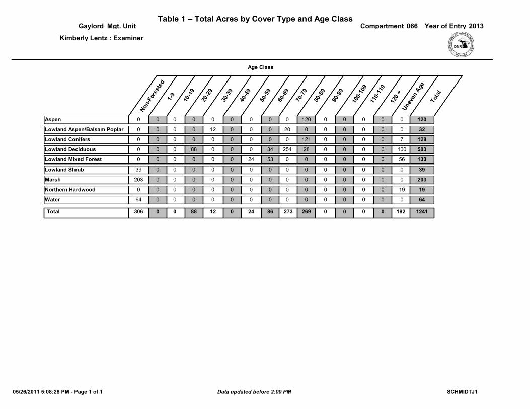
Table 1 – Total Acres by Cover Type and Age ClassCompartmentGaylord Mgt. Unit 066
Non
-For
este
d1-
9
10-1
9
20-2
9
30-3
9
40-4
9
50-5
9
60-6
9
70-7
9
80-8
9
Une
ven
Age
Tota
l
Year of Entry 2013
Age Class
90-9
9
100-
109
110-
119
120
+
: ExaminerKimberly Lentz
00Aspen 00 0 0 0 0 0 0 0 120 0 0 1200
00Lowland Aspen/Balsam Poplar 00 0 0 12 0 0 0 20 0 0 0 320
70Lowland Conifers 00 0 0 0 0 0 0 0 121 0 0 1280
1000Lowland Deciduous 00 0 88 0 0 0 34 254 28 0 0 5030
560Lowland Mixed Forest 00 0 0 0 0 24 53 0 0 0 0 1330
00Lowland Shrub 039 0 0 0 0 0 0 0 0 0 0 390
00Marsh 0203 0 0 0 0 0 0 0 0 0 0 2030
190Northern Hardwood 00 0 0 0 0 0 0 0 0 0 0 190
00Water 064 0 0 0 0 0 0 0 0 0 0 640
0 0 1822730 88Total 306 0 12 0 24 86 269 0 0 1241
SCHMIDTJ105/26/2011 5:08:28 PM - Page 1 of 1 Data updated before 2:00 PM
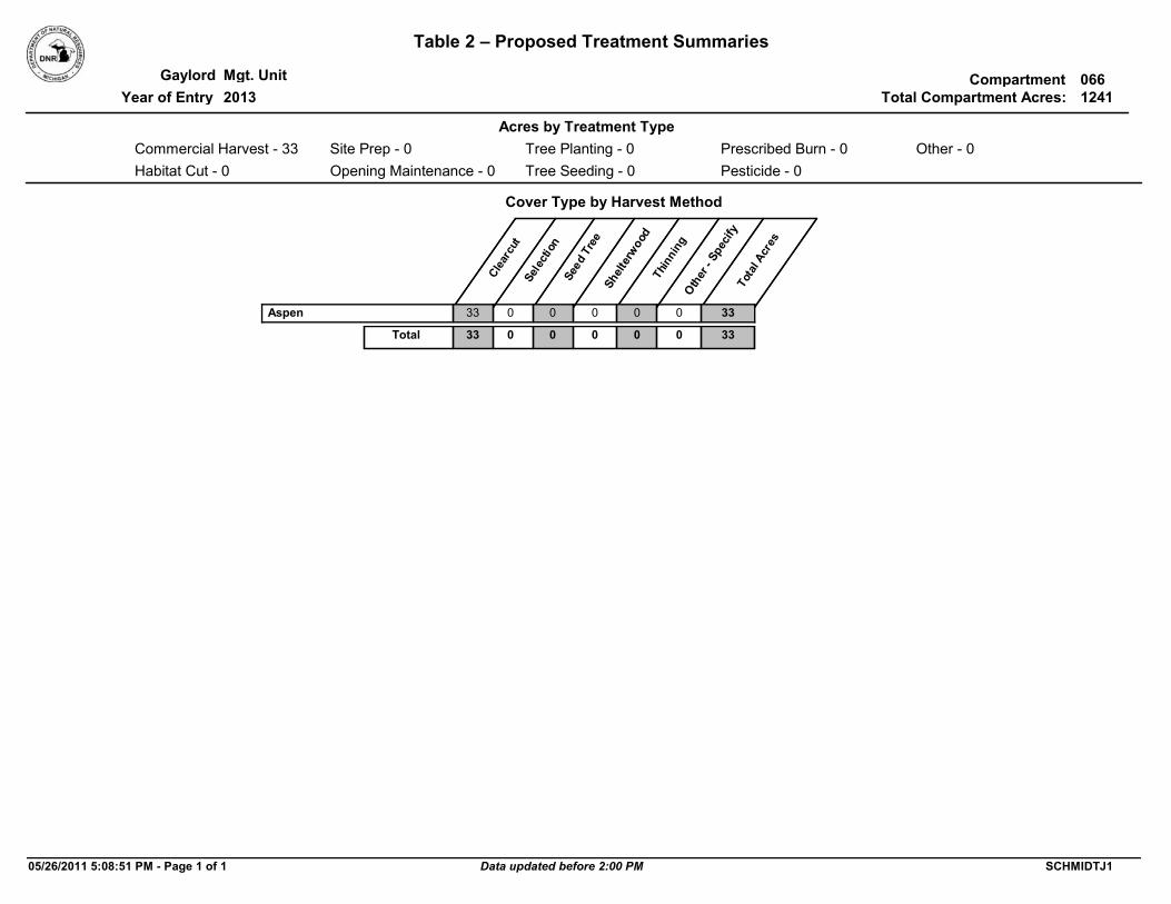
Table 2 – Proposed Treatment Summaries
CompartmentGaylord Mgt. Unit 066Total Compartment Acres: 1241
Cover Type by Harvest Method
Cle
arcu
tSe
lect
ion
Seed
Tre
eSh
elte
rwoo
dTh
inni
ngO
ther
- Sp
ecify
Tota
l Acr
es
Commercial Harvest - 33 Site Prep - 0
Acres by Treatment Type
Tree Planting - 0
Tree Seeding - 0
Prescribed Burn - 0
Pesticide - 0Opening Maintenance - 0
Other - 0
Habitat Cut - 0
Year of Entry 2013
Aspen 33 0 0 0 0 0 33
33 0Total 0 0 0 0 33
05/26/2011 5:08:51 PM - Page 1 of 1 SCHMIDTJ1Data updated before 2:00 PM

2013
TreatmentName
Acres StandAge
Cover TypeObjective
SizeDensity
TreatmentType
TreatmentMethod
Stage1CoverType
Mgt. Unit Table 3 -- Treatments Prescribed with No Limiting Factor
066Compartment:
Year of EntryStand
Gaylord
Approval Status
Other Comments:
Prescription Specs:
#Error
NextSteps:
0Total Treatment
Acreage Proposed:
05/26/2011 5:08:36 PM - Page 1 of 1 SCHMIDTJ1Data updated before 2:00 PM

2013
TreatmentName
Acres StandAge
Cover TypeObjective
SizeDensity
TreatmentType
TreatmentMethod
Stage1CoverType
Mgt. Unit Table 4 -- Treatments Prescribed with a Limiting Factor
066Compartment:
Year of EntryStand
Gaylord
Approval Status
52066027-Cut 80High Density Log
Moniter success of regeneration if harvest occurs.
4130 - AspenHarvest Clearcut33.0
Very difficult access within a wetland complex. Previous logging Road (Johnny Martin's Trail) is currently flooded and blocked by private ownership.
Final harvest high ground to regenerate aspen.
OtherComment:
PrescriptionSpecs:
27 4130 - Aspen
NextSteps:
Limiting Factor and No Treatment Reason
4A: No market for species/product
Remote aspen stand in wetland type on Beaver Island.
Cmpt. Review Proposal
33.0Total Treatment
Acreage Proposed:
05/26/2011 5:08:39 PM - Page 1 of 1 SCHMIDTJ1Data updated before 2:00 PM

2013
TreatmentName
Acres StandAge
Cover TypeObjective
SizeDensity
TreatmentType
TreatmentMethod
Stage1CoverType
Out of YOE -- Treatments Prescribed with No Limiting Factor
Year of Entry:
Approval Status
Other Comments:
Prescription Specs:
NextSteps:
0Total Treatment
Acreage Proposed:
05/26/2011 5:08:41 PM - Page 1 of 1 SCHMIDTJ1Data updated before 2:00 PM

Level 4 Cover Type Acres
StandAge
SizeDensity
BA Range
Mgt. Unit 5 – Forested Stands 066Compartment:Stand
Gaylord
GeneralComments:
2013Year of Entry:
3 4136 - Aspen, Mixed Conifer
High Density Pole
16.2 85 Remote survey utilizing data from last inventory. Defective aspen overtopping swamp conifer.
5 6132 - Mixed Lowland Forest with Cedar
High Density Pole
38.0 Uneven Age This stand was logged by Graves leaving defective Q.Aspen log-sized trees in overstory. Swamp conifer species throughout with some variability in density. Patches of excellent regeneration of aspen 30' height, balsam fir 10' height, black spruce 10' height,
and white cedar 6"-12" height. Some areas with heavy blowdown and flooded timber. Old logging trail that was
established through stand is flooded and not driveable. Unique wetland with beaver dam to the south of this stand.
7 6117 - Lowland Deciduous, Mixed
Coniferous
High Density Log
99.9 Uneven Age 51-80 Majority of stand is swamp conifer species on the west two-thirds of stand. The southeast portion along an old logging trail was
cut heavily by Graves in past. Dense sugar maple regenerating in south with more quaking aspen & balsam fir regen along the north half of the logging trail. Residual Apen logs and white
birch are dying out of stand.
8 6132 - Mixed Lowland Forest with Cedar
High Density Pole
17.6 Uneven Age 81-110 Featured stand is swamp conifer with an inclusion of Aspen/red maple mix in southeast corner of stand. Inclusion resulted from a Graves cut, leaving overtopping Q. Aspen/Birch which is dying
out of stand. Cut also produced successful regeneration of aspen and balsam fir in understory. (Approx. 23 yrs. old)
11 6123 - Lowland Fir High Density Pole
109.3 81 81-110 Primarily swamp conifer with intermixed quaking aspen & red maple. White birch mortality in stand. Multiple wet areas
dominated by cool season grasses scattered throughout stand. Multiple streams feed into adjacent non-forested wetland.
13 6112 - Lowland Aspen High Density Pole
12.4 37 Stand examiner collected forested data for this stand. Aspen is regenerating from previous harvest done estimated 30-40 years
ago. Conifer component mix.
14 6132 - Mixed Lowland Forest with Cedar
High Density Pole
24.4 54 81-110 Lowland swamp conifer with intermixed quaking aspen & red maple. This forested stand connects the adjacent forested
stands to the northeast and southwest in a section with lots of beaver flooded wetland.
18 4134 - Aspen, Spruce/Fir
Medium Density Pole
70.8 81 51-80 Forested stand that was cut by Graves in 1998, and currently regenerating. Large Super Canopy, decadent aspen left in overstory of no timber value. Well established aspen & red
maple regeneration.
19 6117 - Lowland Deciduous, Mixed
Coniferous
High Density Pole
253.8 74 81-110 Variable stand with lowland deciduos and swamp conifer mix. Beaver dams have caused some flooding in areas.
21 6112 - Lowland Aspen High Density Log
19.6 76 111-140 Hardwood-Aspen stand on an upland island surrounded by wetlands.
24 6118 - Lowland Deciduous with Cedar
Medium Density Pole
16.2 85 111-140 Lowland deciduous with defective overtopping quaking aspen & swamp conifer mix.
05/26/2011 5:08:31 PM - Page 1 of 2 SCHMIDTJ1Data updated before 2:00 PM

Level 4 Cover Type Acres
StandAge
SizeDensity
BA Range
Mgt. Unit 5 – Forested Stands 066Compartment:Stand
Gaylord
GeneralComments:
2013Year of Entry:
26 6128 - Lowland Coniferous, Mixed
Deciduous
Medium Density Pole
6.9 Uneven Age 51-80 Mixed stand with swamp conifer & lowland hardwood. Red maple & white birch dying out. Transitional stand between
northern hardwood and marsh.
27 4130 - Aspen High Density Log
33.0 80 111-140 Nice stand with decent Big Tooth Aspen mixed with red maple poles. Heavy balsam fir understory. Some wet areas. Some
blowdown & mortality starting. B.T. Aspen site index = 70
28 6117 - Lowland Deciduous, Mixed
Coniferous
Low Density Sapling
88.4 20 Stand examiner determined there was 25-50% tree cover in this stand. Scattered red maple & paper birch 30' tall. Some 40' tall tamarak. A few cedar & balsam fir. Standing water. Tag alder
also heavy.
30 6117 - Lowland Deciduous, Mixed
Coniferous
Medium Density Log
33.6 65 1-50 Stand is wet. Paper birch & aspen mortality and blowdown common. Stand is converting to swamp conifer species
predominantly balsam fir & cedar. Quaking aspen site index = 65.
31 6128 - Lowland Coniferous, Mixed
Deciduous
Low Density Pole
11.6 80 1-50 Water flooded stand. Most of cedar is standing dead due to beaver flooding in area. Some white pine survived flooding on
higher soil mounds. Extremely difficult to access due to excessive windthrow and water. Parcel is also surrounded by
private.
32 4112 - Maple, Beech, Cherry Association
Medium Density Log
19.4 Uneven Age 51-80 Northern Hardwood log stand selectively marked and cut by Graves in 1998. Noted beech scale with some limb breakage and mortality in sawlog size beech. Access road (old Johnny
Martin Trail) into this stand is no longer driveable, but completely flooded.
34 6117 - Lowland Deciduous, Mixed
Coniferous
Medium Density Pole
11.5 80 1-50 Remote stand with difficult access across windthrown, beaver flooded area, and landlocked by private.
35 6139 - Mixed Lowland Forest
Medium Density Pole
52.8 65 51-80 Mixed stand with lowland conifer and decidous species. Standing water. Some mortality. Scattered cedar understory.
Patches of tag alder common. Scattered elm and large diameter white pine.
05/26/2011 5:08:31 PM - Page 2 of 2 SCHMIDTJ1Data updated before 2:00 PM
Cover Type Acres
Mgt. Unit 6 – Nonforested Stands 066Compartment:
Stand
Gaylord
General Comments:
2013Year of Entry:
Managed Site
Management Priority (Objective)
1 6.950 - Water N\A Unspecified
2 11.76220 - Alder/willow N\A Unspecified
4 5.66230 - Cattail N\A Unspecified
6 19.06230 - Cattail N\A Unspecified
9 14.650 - Water N\A Unspecified
10 17.950 - Water N\A Unspecified
12 27.0 Change to reflect non-forested stand with tag alder, lowland brush.
6220 - Alder/willow N\A Unspecified
15 5.650 - Water N\A Unspecified
16 24.36239 - Mixed Emergent Wetland N\A Unspecified
17 9.06239 - Mixed Emergent Wetland N\A Unspecified
20 38.26239 - Mixed Emergent Wetland N\A Unspecified
22 59.76239 - Mixed Emergent Wetland N\A Unspecified
23 29.96239 - Mixed Emergent Wetland N\A Unspecified
25 19.050 - Water N\A Unspecified
29 4.46239 - Mixed Emergent Wetland No Low (NonForested)
33 12.5623 - Emergent Wetland N\A Unspecified
05/26/2011 5:08:32 PM - Page 1 of 1 SCHMIDTJ1Data updated before 2:00 PM

SCA Name Acres
Mgt. Unit
7 – PROPOSED SPECIAL CONSERVATION AREA* (SCA) DETAILS
066Compartment:
SCA Type
Gaylord
Comments
* This is a partial list of SCAs for this compartment. Not included are those areas identified under other Department initiatives (Natural Rivers, Deer Wintering Areas, etc.). Those will be identified in separate, future map and report products.
2013Year of Entry:
Stand
05/26/2011 5:08:29 PM - Page 1 of 1 SCHMIDTJ1Data updated before 2:00 PM

Type
Mgt. Unit 066Compartment:Gaylord
Description
* This is a list of Dedicated Biodiversity Areas for this compartment along with a 1/4 mile buffer surrounding the compartment. Refer to Dedicated Conservation Area Map for areas that the below listed Conservation Areas are located.
8 – DEDICATED CONSERVATION AREA DETAILS
Conservation Area SCA = Special Conservation Area
HCVA = High Conservation Value AreaERA = Ecological Reference Area
2013Year of Entry
Ecological Reference Areas (ERAs) are high quality examples of natural communities that have been identified as Element Occurrences (EOs) by the Michigan Natural Features Inventory (MNFI) within the context of their natural community classification system. Element Occurrences with viability ranks of A (Excellent) or B (Good) and a Global (G) or State (S) element (rarity) ranking of endangered (1), threatened (2), or rare (3) serve as an initial base of ERAs. They may be located upon any ownership in the State. The system is comprised of individual or associations of natural community types that are managed for restoration and maintenance of natural ecological processes and values. The public may submit recommendations for lands as ERAs using the DNR Conservation Area Recommendation Form.
Ecological Reference Areas
ERA
Great Lakes Islands provide significant habitat for numerous species, including many rare plants and animals, several of which are endemic or largely restricted to the Great Lakes region. Due to their isolation, islands provide good examples of many Great Lakes-associated natural communities and ecosystems, and thus have potential to provide insights for understanding the consequences of human disturbance on the increasingly fragmented ecosystems of the mainland.
Great Lakes Islands
SCA
05/26/2011 5:08:29 PM - Page 1 of 1 SCHMIDTJ1Data updated before 2:00 PM