compendium of 143 illinois lakes: bathymetry, physio-chemical
TRANSCRIPT

I LL I N 0 IUNIVERSITY OF ILLINOIS AT URBANA-CHAMPAIGN
PRODUCTION NOTE
University of Illinois atUrbana-Champaign Library
Large-scale Digitization Project, 2007.
S


577,63Au74Cv.1
Natural History SurveyLibrary
,
Douglas J. Austen, James T.Stephen T. Sobaski ar
June 1c
Aquatic Ecology Technical Report 93/9 (1)
ILLINOIS
cf/eN3 (7) I
NATURALSUR
Compendium of 143 lllin(physico-chemical feal
Volume 1 - Lakes in FF-69-R(
Final RepDivision of F
Illinois Department
Center for Aqu
r
lwý

C13 F ,Nattal History Survey
Library
I
C
Illinois Natural History SurveyAquatic Ecology Technical Report 93/9 (1)
Compendium of 143 Illinois Lakes:Bathymetry, physico-chemical features, and
habitats
Volume 1 - Lakes in Regions 1, 2 and 3
Final ReportF-69-R(4-6)June 1993
Douglas J. Austen, James T. Peterson, Barry Newman,Stephen T. Sobaski & Peter B. Bayley
Peter B. Bayley, P incipal InvestigatorCenter for Aquatic Ecology
avid . Philipp, DirectorCenter for Aquatic Ecology
Illinois Natural History Survey607 E. PeabodyChampaign, IL 61820
Aquatic Ecology Technical Report 93/9 (1) Wlinds Natural History SurveyAusten et al.

SUMMARY OF PROJECT
Data Base Management and Analysis of Fisheries in Illinois (Project F-69-R(4-6)) is acontinuation of F-69-R(1-3) and F-46-R with significant additions. The Final report isdivided into four Aquatic Ecology Technical Reports 93/6 through 93/9:
'Fisheries Analysis System (FAS): STATE FAS Database and Programs' (93/6)describes the design of the new statewide database based on Paradox 4.0. Uploading,text outputs, and reporting procedures are described. A new set of stand-aloneprograms to output catch-per-unit-effort, stock indices, length frequencies, andcondition factors from the statewide database are described. Updates to DOC9DISTRICT FAS programs are described, in addition to a new program that outputslimnological data.
'Fisheries Analysis System (FAS): Creel Survey Analyses' (93/7) summarizes resultsfrom 107 annual daytime creels begun in F-69-R(1-3), F-29-D, and continued throughF-69-R(4-6). A highly stratified random design produced 95% confidence limits of±10-30% of mean total harvest and ±5-15% of total angling effort for most of thedaytime creel surveys, which included impoundments ranging from 13 to 18,900acres. Increasing the proportion of day-periods sampled from 30 to 45-55% improvedthe precision of estimates on smaller lakes, but precision was already relatively lowfor large lakes (with more than one section) at the 25-35% level. Therefore, samplingcosts could be reduced on larger lakes with minimal loss in precision. Seventy-eightpercent of the variation in log(harvest/area) was explained by log(angler-hours/area). This strong, linear relationship indicated that high angling intensitiesdid not result in a reduction in total harvest. Also, a preliminary analysis acrosslakes suggested that high yields were not obtained at the expense of smaller fish.
'Environmental Classification of Illinois Lakes and Relationships with fishcommunities' (93/8) is the first analysis that attempts to classify Illinois lakesaccording to physico-chemical features and relate this classification to fish speciesand guilds. This provides a first step towards understanding, and eventuallymanaging, groups of ecologically similar lakes, and to utilizing group members astreatments and controls in experimental management programs.
Finally, the 'Compendium of 143 Illinois Lakes: bathymetry, physico-chemicalfeatures, and Habitats' (93/9) contains the first detailed information on a large set ofIllinois lakes of use to managers and researchers. This is a culmination of field workbegun during F-46-R in 1985. Maps indicate bathimetry, shoreline habitat types, andIllinois Department of Conservation fish sampling locations. Tables describephysical, chemical, and historical information on each lake.
Aauatic Ecology Technical Reoort 93/9 (1) Ilindois Natural History SurveyAusten et al.

Table of Contents
Preface ................ ............................................ . 1Acknowledgements ................................................ 1Listing of all lakes in Volumes 1 and 2 ordered alphabetically by lake
name with map reference - lakes in Volume 1 in uppercase and bold .... 2M ethods .......................................................... 8References......................................................... 13Compendium of Illinois Lakes - Volume 1 ............................ 15
Disclaimer: the maps in this publication are not intended for navigation orengineering purposes.
Preface
This report contains a variety of information about 143 Illinois lakes given in a table,nd two figures for each lake. The tables lists various characteristics of the lake suchis location, morphometry, water chemistry, species present in the lake and generalhabitat descriptions. The first figure is a bathymetric map of the lake showingselected contours. All contours mapped are not shown due to lack of space. Thesecond figure gives habitat descriptions and location of IDOC sampling sites. Thesemaps are not intended for navigation or engineering purposes.
This technical report is part of the final report of Project F-69-R (4-6), Data Base Management and Analysis ofFisheries in Impoundments, which was conducted under a memorandum of understanding between the IllinoisDepartment of Conservation and the Board of Trustees of the University of Illinois. The actual work was performedby the Illinois Natural History Survey, a division of the Department of Energy and Natural Resources. The projectwas supported through Federal Aid in Sport Fish Restoration (Dingell-Johnson) by the U.S. Fish and Wildlife Service,the Illinois Department of Conservation, and the Illinois Natural History Survey. The form, content, and datainterpretation are the responsibility of the University of Illinois and the Illinois Natural History Survey, and not thatof the Illinois Department of Conservation.
AcknowledgmentsNumerous people have helped with the development of this compendium
including: Chuck Alexander, Craig Birkey, Dan Gavrilovic, Rob Maher, and JoeStepping. We would also like to thank numerous state agencies and privateconsulting firms who provided base maps for many water bodies. We have tried tolist on the map the proper credit for the original map source where available.
Aquatic Ecology Technical Report 93/9 (1) Austen et al. Ilinois Natural History Survey

2
Listing of all lakes in Volumes 1 and 2 ordered alphabetically by lake namewith map reference - lakes in Volume 1 in uppercase and bold
Lake Name County
A llison lake ............................ARGYLE LAKE ..................Ashland new reservoir ...................Augusta ......................... ....ATWOOD..................Baldwin lake ...........................Beall woods ............................Beaver dam lake.........................BIG LAKE .......................BLUFF LAKE (FCOL) .............Borah lake .............................BRAIDWOOD LAKE .............CANTON LAKE .................CARLTON..................Carthage Lake ....................CATHERINE (FCOL) ..............C entralia ..............................CHANNEL LAKE (FCOL) .........CHARLESTON SIDE CHANNEL L.CLINTON LAKE .................Coffeen lake............................CROSS LAKE ....................DAWSON LAKE.................DECATUR ......................DEFIANCE LAKE.............DIAMOND LAKE.............Dolan State Lake ...................DRESDEN LAKE.................EAST BRANCH RESERVOIR .....East Fork Lake................. ....EUREKA ........................FAIRFIELD ......................Ferne Clyffe ............................Forbes Lake ............................FOREST LAKE ...................FOX/NIPPERSINK (FCOL) ........Frank Holten Lake #3 ...................Frank Holten Main Lake .................GAGES LAKE.....................GEORGE........................GEORGETOWN RESERVOIR .....
Region District Map Reference
Logan ............. 4...... 11 ........... 1MCDONOUGH .1 .... 3 ........ 2Cass ........ ...... 4...... 11 . . . . . . ... 3Hancock........... 4...... 10 .......... 4MCHENRY.....2 .... 5 ........ 5Randolph ......... 4...... 13 .......... 6W abash ........... 5...... 15 .......... 7Macoupin.......... 4...... 12 .......... 8KENDALL......2 .... 7 ........ 9LAKE ......... 2 ... 6 ........ 10Richland .......... 5...... 15 .......... 11WILL .......... 2 .... 7 ........ 12FULTON ....... 1 .... 3 ........ 13WHITESIDE .... 1 .... 2 ........ 14Hancock........... 4...... 10 ...... ... 15LAKE .......... 2 .... 6 ........ 16M arion ............ 5...... 14 .......... 17LAKE .......... 2 .... 6 ........ 18COLES ......... 3 ... 9 ........ 19DEWITT ....... 3 .... 8 ........ 20Montgomery ....... 4...... 12 .......... 21LAKE .......... 2 .... 6 ........ 22MCLEAN ...... 3 .... 8 ........ 23MACON ....... 3 .... 9 ........ 24MCHENRY ..... 2 .... 5 ........ 25LAKE .......... 2 .... 6 ........ 26Hamilton ......... 5...... 16 .......... 27GRUNDY ...... 2 .... 7 ........ 28DUPAGE ....... 2 .... 5 ........ 29Richland .......... 5...... 15 .......... 30WOODFORD ... 1 .... 4 ........ 31LAKE .......... 2 .... 6 ........ 32Johnson....... 5...... 18 .......... 33M arion ...... ..... 5...... 14 .......... 34LAKE .......... 2 .... 6 ........ 35LAKE .......... 2 .... 6 ........ 36St. Clair .......... 4.... . 13 ......... 37St. Clair .......... 4...... 13 ........ . 38LAKE .......... 2 .... 6 ........ 39ROCKISLAND .1 .... 2 ........ 40VERMILLION .. 3 .... 8 ........ 41
Aquatic Ecology Technical Report 93/9 (1) Illinois Natural History SurveyAusten et al.

3
Lake Name
Gillespie New City Lake ................Gillespie Old City Lake .................Glen Shoals ....... ..................GRASS LAKE (FCOL).............Grennville New City Lake ...............Greenville Old City Lake ................HEIDECKELAKE ................HERRICKLAKE .................HIGHLAND LAKE ...............Highland Old City Lake ................Hillsboro Old City Lake .................HOMER LAKE ...................HONEY LAKE ...................Horseshoe Lake........................Horton Lake............................Jacksonville ............................Jones State Lake ........................KAKUSHA ......................Kinkaid Lake ...........................LAKE OF THE WOODS ...........LASALLE COOLING POND .......LE-AQUA-NA ...................LINCOLN TRAIL LAKE ..........LONG LAKE-KSP...............Lou Yeager Lake ........................MALLARD LAKE ................MARIE (FCOL)...................MATTOON .....................MAZONIA LAKE #7 .............MAZONIA LAKE #8 .............MAZONIA LAKE #9 .............MAZONIA LAKE #10 ............MCCULLOM LAKE ..............Mereosia ...............................Mermet State Lake ......................MILL CREEK LAKE ..............MILLIKEN ......................MINGO .....................MONEE RESERVOIR.............Mt Olive New City Lake ................Mt Olive Old City Lake ................Mt Sterling Lake .......................Murphysboro ......................... ..Murraywood Reservoir .................Newton Lake ...........................N ellie .................................
County Region District Map Reference
Macoupin.......... 4 ... 12 .......... 42M acoupin.......... 4...... 12 .......... 43Montgomery ....... 4...... 12 .......... 44LAKE .......... 2 .... 6 ........ 45Bond .............. 4 ...... 12 .......... 46Bond .............. 4...... 12 .......... 47GRUNDY ...... 2 .... 7 ........ 48DUPAGE ...... 2 .... 5 ........ 49LAKE .......... 2 .... 6 ........ 50Madison........... 4...... 12 .......... 51Montgomery ....... 4...... 12 .......... 52CHAMPAIGN .. 3 .... 8 ........LAKE .......... 2 .... 6 ........ 53Alexander ......... 5 ...... 18 ........... 54Hancock........ . .. 4. .... 10 ........ . 55M organ ............ 4...... 11 .......... 56Saline ............ 5 ...... 17 ......... .57LASALLE ...... 1 .... 2 ........ 58Jackson ............ 5...... 18 .......... 59CHAMPAIGN .. 3 .... 8 ........ 60LASALLE ...... 1 .... 2 ........ 61STEPHENSON..1 .... 1 ........ 62CLARK ........ 3 ... 9 ........ 63VERMILLION .. 3 .... 8 ........ 64Montgomery ....... 4...... 12 ......... 65DUPAGE ...... 2 .... 5 ........ 66LAKE ........ 2 ... 6 ........ 67COLES ......... 3....9... 9 .... 68GRUNDY ...... 2 .... 7 ........ 69GRUNDY ...... 2 .... 7........ 70GRUNDY ...... 2 .... 7 ........ 71GRUNDY ...... 2 .... 7 7 ........ 72MCHENRY ..... 2 .... 5 ........ 73Cass .............. 4 ...... 11 .......... 74M assac ............ 5...... 17 .......... 75CLARK ........ 3 .... 9 ........ 76WILL .......... 2 .... 7 ........ 77VERMILLION .. 3 .... 8 ........ 78WILL .......... 2 .... 7 ........ 79M acoupin.......... 4...... 12 .......... 80M acoupin.......... 4...... 12 ......... 81Brown........... . 4...... 10 ......... 82Jackson ........... 5 ...... 18 .......... 83M organ........... 4 ...... . 11 ........ . 84Jasper ............. 5 ...... 15 .......... 85Fayette ........ . 5...... 14 ......... 86
Aquatic Ecology Technical Report 93/9 (1) Illinois Natural History SurveyAusten et al.
Region District Map Reference
OAKLAND CITY LAKE...........One Horse Gap Lake .....................O tter Lake ..............................Palmyra-Modesto Lake..................PANA LAKE..................PARADISE....................PARIS EAST LAKE...............PARIS WEST LAKE ..............Petersburg ........................... ..PETITE LAKE (FCOL) .............PIERCE LAKE....................PISCATEER'S LAKE..............PISTAKEE LAKE (FCOL).........Pittsfield Lake .........................POND6-KSP ...................Pounds Hollow Lake.....................POWERTON LAKE ..............Ram sey Lake ...........................Randolph County Lake ..................Red H ills ..............................ROUND LAKE...................SAG QUARRY (EAST) CC ........Sam Parr Lake ..........................SAND LAKE ....................Sangchris ..............................Sara ...................................SAUK TRAIL....................Schuy-Rush Lake ......................SHABBONA LAKE ..............Siloam Springs .........................Silver Lake ............................SPORTSMENS LAKE - KSP .......SPRING LAKE (NORTH) .........SPRING LAKE (SOUTH) ..........Springfield .............................Staunton City Lake......................STERLING LAKE LCFP ...........SUMMERSET ...................TAMPIERCCFPD ................Tecumseh Lake .........................TOWER LAKE ...................TURNER LAKE-COLSP...........Vandalia Lake ......................VERMILLION ...................Vernor Lake .............................Virginia City Reservoir ................
COLES ......... 3 .... 9 ........ 87Pope .............. 5 ...... 17 .......... 88Macoupin.......... 4...... 12 .......... 89Macoupin.......... 4...... 12 .......... 90SHELBY ........ 3 .... 9 ........ 91COLES ......... 3 .... 9 ........ 92EDGAR ........ 3 .... 9 ........ 93EDGAR ........ 3 .... 9 ........ 94Menard ........... 4 ..... 11 .......... 95LAKE .......... 2 .... 6 ........ 96WINNEBAGO .. 1 .... 2 ........ 97(OOK .......... 2 .... 6 ........ 98LAKE .......... 2 .... 6 ........ 99Pike .............. 4...... 10 ........ . 100VERMILLION .. 3 .... 8 ........ 101Hardin ............ 5 ...... 17 .......... 102TAZEWELL .... 1 .... 4 ........ 103Fayette ........... 5...... 14 .......... 104Randolph ......... 4...... 13 .......... 105Lawrence .......... 5...... 15 .......... 106LAKE .......... 2 .... 6 ........ 107COOK.......... 2 .... 6 ........ 108Jasper ........... .. 5. .... 15 .......... 109LAKE .......... 2 .... 6 ........ 110Christain ......... 4...... 11 .......... 111Effingham ......... 5........ 14 .......... 112HENRY ........ 1 .... 2 ........ 113Schuyler .......... 4...... 10 .......... 114DEKALB ....... 1 .... 1 ........ 115Adam s ............ 4...... 10 .......... 116Madison........... 4...... 12 ........ . 117VERMILLION .. 3 .... 8 ........ 118TAZEWELL .... 1 .... 4 ........ 119TAZEWELL .... 1 .... 4 ........ 120Sangamon ......... 4...... 11 ......... 121Macoupin.......... 4...... 12 .......... 122LAKE .......... 2 .... 6 ........ 123WINNEBAGO .. 1 .... 1 ........ 124COOK .......... 2 .... 6 ........ 125Hardin ............ 5...... 17 .......... 126LAKE .......... 2 .... 6 ........ 127LAKE .......... 2 .... 6 ........ 128Fayette ........... 5...... 14 ......... 129VERMILLION .. 3 .... 8 ........ 130Richland .......... 5...... 15 .......... 131Cass .............. 4...... 11 ......... 132
or- , n 1-
CountyLake Name
"lin4s . Iatur i .istorv Survev

5
Lake Name County Region District Map Reference
WALNUT POINT LAKE..........Walton Park Lake ......................Washington County Lake ...............W averly Lake ..........................WELDON SPRINGS ..............WILDERNESS LAKE .............Wildwood Lake ........................WOLF LAKE ....................WOOD LAKE....................ZURICH ........................
DOUGLAS ..... 3 ....Montgomery ....... 4......Washington ....... 4......M organ ............ 4......DEWITT ....... 3 ....MCHENRY ..... 3 ....Brown............. 4......COOK ......... 2 ....MOULTRIE.....3 ....LAKE ......... 2 ....
91213118510696
........ 133.......... 134.......... 135.......... 136
........ 137
........ 138.......... 139........ 140........ 141........ 142
Aquatic Ecology Technical Report 93/9 (1) Austen et al. Iindois Natural History Survey

6
12 26\
53 142
Lake County, note that the FoxChain (#32) consists of lakes10, 16, 33, 41, 55, 64, 107, 110.
Figure 1. Locations of Illinois lakes as referenced by number in Table of Contents.
Aquatic Ecology Technical Report 93/9 (1) Illinois Natural History SurveyAusten et al.

7
Figure 2. Illinois Department of Conservation planning and management regions
Aquatic Ecology Technical Report 93/9 (1) Ilinois Natural History SurveyAusten et al.

METHODS
Lake Morphometry
For each lake an attempt was made to obtain either a recent hydrographic map ora pre-impoundment topographic map of the basin. In general, pre-impoundmentmaps were obtainable for power plant lakes and impoundments created since about1970. In addition, agencies such as the Illinois State Water Survey (ISWS) and theLake County Health Department have created bathymetric maps of many lakes. Ifthe map was over 20 years old, we generally visited the lake and assessed it forevidence of significant siltation. If this was the case we re-mapped sections of thelake, such as the upper end and coves with inflowing streams.
In some cases it was necessary to create original maps. This proceeded as follows:(1) an outline of the shoreline was obtained either from aerial photographs or fromUnited States Geological Survey (USGS) 7.5' topographic maps, (2) using a graphingsonar (Si-Tek HE-357 or Eagle Mach 1) straight, constant-speed transects were madebetween known points on the shoreline of the lake (the number of transectsdepending on the complexity of the bottom contours), (3) the sonar strip chart of thetransects was interpreted and drawn on to an enlarged copy of the lake outline, (4)contours were hand drawn on the map, (5) all maps were then either digitized orscanned and entered into the ARC/INFO geographic information system (GIS)operated by the Illinois Natural History Survey, (6) coverages were then convertedinto Lambert feet coordinates by locating the map on a 7.5' USGS topographic mapand digitizing reference points both on the map and on the quadrangle for which wehad known Lambert feet coordinates, (7) depths were assigned to the contours, andthe GIS gave length of each contour and areas between adjacent contour lines. Itshould be noted that, due to limited resources, the maps were developed in amanner such that the accuracy of depths is no better than approximately 0.5 meter,an amount that was deemed appropriate for broad scale biological research butwhich may be unsuitable for engineering and navigation purposes.
From these data, surface area, maximum depth, and shoreline length werecalculated. All GIS data were stored in English units and, where necessary, wereconverted to metric equivalents. Volume, shoreline development index (SDI), andmean depth (z) were calculated by the formulas in Wetzel (1975):
(1) V = i=1 to n [h/3 (Ai + Ai+1 + 4(Ai + Ai+l))]
where: V = volume (ft3)h = vertical depth of the stratum (ft)i = number of depth stratumAi = area at depth i (ft2)
Aquatic Ecology Technical Report 93/9 (1) Illinois Natural History SurveyAusten et al.

9
L(2) SDI =
2 4( * Ao)
where: L = length of shoreline (m)Ao = surface area of lake (m2)
(3) z = V/Ao
where: z = mean depth (m)V = volume (m3 )Ao = surface area (m2)
(4) Dv = 3 * (z / Zm) (Cole 1979)
where: Dv = volume developmentz = mean depth (m)Zm = maximum depth (m)
Watershed area was taken from literature sources or calculated from USGS maps.Retention time was typically calculated as lake volume divided by annual outflow.Because annual outflow was rarely available, the retention time for each lake wascalculated based on a method described in IEPA (1978) as follows:
storage capacity (m3)Retention time (years) =
annual runoff (m3/y)
where: storage capacity is the amount of water that the lake holds.
Annual runoff was taken from figure 5 in IEPA (1978) (in inchesper square mile per year). This was converted to cubicmeters of runoff per year for the watershed.
Water Chemistry
Data on four variables were collected; Secchi disk depth, conductivity, pH, andalkalinity. As with the lake mapping data, we first located water chemistry datacollected by other agencies, particularly the IEPA. Where possible we acquired theirdata and calculated average values from collections in July or August. When not
Aquatic Ecology Technical Report 93/9 (1) Minds Natural History SurveyAusten et al.

10
available, we measured these directly as follows: (1) Secchi disk depth was measuredduring midday on the shady side of the boat using a standard 20 cm black and whitedisk, with depth recorded as the average of depth where disk fades from visibilitywhen lowered and when it appears upon being raised, (2) conductivity wasmeasured at 0.5 m depth using a Hanna Instruments HI 8633 conductivity meter, (3)pH was measured using a Cole-Parmer model 5985-80 Digi-sense pH meter, (4) totalalkalinity was measured by acid titration to pH 4.5 using 0.02N H 2S0 4 withalkalinity being equal to the number of ml of acid used. Water samples for pH andalkalinity analysis were taken at 0.5 m depth, chilled, and analyzed that evening inthe laboratory.
Weather Data
One hundred and seventy-five weather reporting stations located throughoutIllinois collect data for the Midwest Climate Information System (MICIS) database.Latitude and longitude for each weather station in MICIS and lakes in the FASdatabase were determined. By finding the smallest Euclidean distance between eachcombination of station and lake, the stations were paired with the individual lakes.From each weather reporting station we obtained two statistics describing grosstemperature conditions. Cooling degree days (also called growing degree days) is thesum over a year of the difference between the average daily temperature and a basetemperature of 50° F. Length of growing season is the number of days between thelast day in the spring with a 32" F low and the first day in the fall with a 32 ° F low.Both statistics were calculated as the mean value over the period from 1948 to 1990.
Habitat Descriptions
Habitat coding, given in the second map for each lake, attempts to characterizethe major habitat types for each lake. All habitats were visually inspected andcoding was based on a priori discussions of what comprised each specific habitattype. To improve consistency of habitat ratings, three people did all ratings, at leastone of which visited each lake. Three types of habitat are discussed: (1) shorelinehabitat consisting of the water-land interface, (2) inshore substrate type and, (3) hardcover rating which rates the amount of woody cover in the water near shore. Forhabitat and substrate we characterized each section of shoreline with a primary andsecondary code; only the primary code is shown in the lake map and the lakesummary page. Both primary and secondary codes are stored in the ARC/INFOsystem and are accessible when necessary. Codes are as follows:
Aquatic Ecology Technical Report 93/9 (1) Illinois Natural History SurveyAusten et al.

11
Habitat Codes Listed for Each Lake
Habitat:W = Woody debrisE = Emergent vegetationR = Rip rap0 = Open areaD = DocksT = Retaining wall or dam faceU = Unknown
Substrate:M = Mud or siltC = ClayS = SandG = GravelB = Rock or boulderU = Unknown
Hard Cover Rating:0 = 0% woody debris and no docks.1 = 0% woody debris with docks or 1-33% woody debris.2 = 1-33% woody debris with many docks or 34-66% woody debris.3 = 34-66% woody debris with many docks or > 67% woody debris.
In the tabular output for each lake a habitat description is given showing thepercentage of the lake comprised of each habitat type and the percentage of the eachhabitat type that was sampled by electrofishing. This is useful as an indicator of thepotential sampling bias accorded to selection for or against certain habitat types.This information can also be used when comparing samples between lakes wheresamples encompassed differing percentages of habitats. Correction can be made fordifferential habitat sampling.
Species Presence
This is based on a search of all samples in the state FAS system for each lake. Ifthe species was caught in any sample on a particular lake it is noted as being presentin that lake.
Aquatic Ecology Technical Report 93/9 (1) Ilinois Natural History SurveyAusten et al.

12
IDOC Lake Class
Indicates the ownership and management responsibility for the lake.
ST - State: waters owned or leased by the Illinois Department ofConservation.
PU - Public: waters open to the public and owned or leased by othergovernmental agencies.
OR - Organizational: waters owned or leased by sportsmen's club,homeowners association, scouts, etc.
PR - Private: privately owned or leased waters which are not operated byorganizations or as commercial areas.
Lake Type Codes
Indicates the origin of the lake
AA - artificial, dammed onlyAD - artificial, dug and dammedAO - artificial, otherAQ - artificial, quarryAS - artificial, strip mineNB - natural, bottomlandNG - natural, glacialNO - natural, otherN R - natural, river backwaterNS - natural, sinkholeUN- unknown
Natural Division
The natural division listed for each lake refers to the classification ofSchwegman (1973). These 14 divisions were based on physiography, flora, fauna,soil types and soil origins. The natural divisions (Figure 3) were distinguishedaccording to "differences in significant aspects of topography, soils, bedrock, glacialhistory and distribution of plants and animals" (Schwegman 1973). Whether thesedivisions influence fish communities is unknown.
Aauatic Ecology Technical Report 93/9 (1) Illinois Natural History SurveyAusten et al.

13
Availability of Maps
Copies of maps will be available from the Illinois Department of Conservation,Division of Fisheries, 600 North Grand Avenue West, Springfield, IL 62701-1787.
REFERENCES
Cole, G. A. 1979. Textbook of Limnology. Second Edition. The C.V. Mosby Company, St. Louis, Missouri.
IEPA. 1978. Assessment and classification of Illinois lakes. Volume I. Staff Report, Water QualityManagement Planning Program, Illinois Environmental Protection Agency, Springfield, Illinois.
Schwegman, J. E. 1973. Comprehensive plan for the Illinois Nature Preserves System, Part 2. TheNatural Divisions of Illinois. Illinois Nature Preserves Commission, Springfield, IL. 32 pages.
Wetzel, R. G. 1975. Limnology. Saunders. Philadelphia, Pennsylvania.
Aquatic Ecology Technical Report 93/9 (1) Austen et al. Wlmdois Natural History Survey

Wisconsin Driffless Division
S2 Rock River Hill Country DivisionO Freeport Sectionb Oregon Section
3 Northeastern Moroinal Divisiona Morainol Sectionb Lake Michigan Dunes Sectionc Chicago Lake Ploain Section
d Winnebogo Drift Section
7 Grand Prairie Divisiona Grand Prairie Sectionb Springfield Sectionc Western Sectiond Green River Lowland Section* Konkakee Sand Area Section
SUpper Mississippi River and IllinoisRiver Bottomlands Divisiona Illinois River Sectionb Mississippi River Section
6 Illinois River and MississippiRiver Sand Areas Divisiono Illinois River Sectionb Mississippi River Section
7 Western Forest-Prairie Divisiona Golesburg Sectionb Corlinville Section
S 8 | Middle Mississippi Border Divisiona Glaciated Sectionb Driftless Section
9 Southern Till Plain Divisiona Effingham Plain Sectionb Mt Vernon Hill Country Section
[ 0 Wabash Border Divisiona Bottomlands Sectionb Southern Uplands Sectionc Vermilion River Section
11 Ozark Divisiona Northern Sectionb Central Sectionc Southern Section
SLower Mississippi River Bottomlands Co Northern Sectionb Southern Section
S1 j Shownee Mills Divisiona Greater Shownee Hills Sectionb Lesser Shawnee Hills Section
W Coastal Plain Divisiona Cretaceous Hills Sectionb ectte.»lond» Section
Figure 3. The natural divisions of Illinois as proposed in Schwegman (1973)
Aquatic Ecology Technical Report 93/9 (1)
14
Illinois Natural History SurveyAusten et al.

15
Compendium of 143 Illinois Lakes:Bathymetry, physico-chemical features, and
habitats
Volume 1 - Lakes in Regions 1, 2 and 3
Illinois Natural History SurveyAquatic Ecology Technical Report 93/9 (1)
Douglas J. Austen, James T. Peterson, Barry Newman,Stephen T. Sobaski & Peter B. Bayley
Aquatic Ecology Technical Report 93/9 (1) Ilinois Natural History SurveyAusten et al.

ARGYLE LAKE
County: MC DONOUGHLatitude: 402706Longitude: 904722
Township: T5NRange: R3WSection: 6
IDOC Region: 1IDOC District: 3IDOC Lake Number: 28STORET Code: RD-AO5-EIDOC Lake Class: STLake Origin: AANatural Division: 7A
Year Constructed: 1949
USGS 75' Quad: COLCHESTERMajor River Basin: ILLINOISInflowing Stream: INTOutflowing Stream: INT>LAMOLING>ILLINOIS
Typical Water Chemistry:Secchi Disk Depth (cm): 1133Conductivity (umhos): 312Total Alkalinity (mg/1): 121pH: 8.733
Surface Area (ha): 32.6Surface Area (acres): 78.3Mean Depth (m): 4.88Maximum Depth (m): 11.27Shore Length (km): 7.61Shoreline Dev. Index: 3.76
Watershed Area (ha): 1697Storage Cap. (1000 m3): 1594.58Retention Time (yrs): 0.6Volume Dev. Index: 3.1
Maximum Length (km):Maximum Width (km):Inshore Mean Depth (m):Pool Elevation (m msl):
1.121.6
2.5186.2
Climatic Information:Growing Season (days): 179Growing Deg. Days (50*F base): 3590
Habitat Description as a Proportion of Total Shoreline and Shoreline Sampled by Electrofishing
Percent of Percent of Total Shomline
Habitat Type Total Shoreline Sampled by Electrofi g
D/C/1R/B/0W/C/2
72
912
38
Fish Species Present in Lake (based on IDOC sampling):Black BullheadBlack CrappieBluegillBluegill X RedearChannel CatfishGolden ShinerGreen SunfishLargemouth BassPumpkinseedRedear SunfishTiger Muskellunge
Aquatic Ecology Technical Report 93/9 (1)
wy Aj Asia as& air
Illinois Natural History SurveyAusten et al.

Notes and Comments:
Aquatic Ecology Technical Report 93/9 (1) Illinois Natural History SurveyAusten et al.

ARGYLE LAKE
N
SCALE
0
j
(4 3Aquatic Ecology Technical Report 93/9 (1)
Map Source: Illinois Natural History SurveyMapping Method: Transect, outline from 7.5 min.USGS topographic mapDate completed: 8/23/89
Ulinois Natural History SurveyAusten et al.
" I
ell-
ýA-
1%
'Aif

ARGYLE LAKE
W/C/2
W/C/2
W/C/2
N
K/D/IU
Blinois Natural History SurveyAquatic Ecology Technical Report 93/9 (1)
Habitat Codes (given as a three character code: Habitat/Substrate/Hard Cover)Habitat: Substrate: Hard Cover Rating:W = Woody debris M = Mud or silt 0 = 0% woody debris and no docks.E = Emergent vegetation C = Clay 1 = 0% woody debris with docks orR = Rip rap S = Sand 1-33% woody debris.0 = Open area G = Gravel 2 = 1-33% woody debris with many docksD = Docks B = Rock or boulder or 34-66% woody debris.T = Retaining wall or dam face U = Unknown 3 = 34-66% woody debris with many docksU = Unknown or greater than 67% woody debris.
Information comDiled by the Illinois Natural History Survey, completed 8/23/89V -- - - - --- - - - r - - - l - -- - - --- - &T.. . . . . . . d - - - - F - -" •- -I I
Austen et al.

LAKE ATWOOD
County: MCHENRYLatitude: 421344Longitude: 881532
Township: T43NRange: R8ESection: 2,1
IDOC Region: 2IDOC District: 5IDOC Lake Number: 70STORET Code: VT-B02-SIDOC Lake Class: PULake Origin:Natural Division: 3A-
Surface Area (ha): 8.5Surface Area (acres): 20.4Mean Depth (m): 4.057Maximum Depth (m): 8.839Shore Length (km): 1.985Shoreline Dev. Index: 1.92
Year Constructed: 1974
USGS 7.5' Quad: CRYSTAL LAKEMajor River Basin: FOXInflowing Stream: NONE(GRAVEL PIT)Outflowing Stream: NONE
Typical Water Chemistry:.Secchi Disk Depth (cm): 396Conductivity (umhos): 681Total Alkalinity (mg/1): 191pH: 7.5
Watershed Area (ha): 23Storage Cap. (1000 m3): 344.55Retention Time (yrs): 7.4Volume Dev. Index: 1.38
Maximum Length (km): 0.451Maximum Width (km): 0.39Inshore Mean Depth (m): 4.7Pool Elevation (m msl): 259.4
Climatic Information:Growing Season (days): 158Growing Deg. Days (50°F base): 2694
Habitat Description as a Proportion of Total Shoreline and Shoreline Sampled by ElectrofishingPercent of Percent of Total Shoreline
Habitat Type Total Shoreline Sampled by ElectrofishingO/S/0 87 78W/S/1 13 8
Fish Species Present in Lake (based on IDOC sampling):BluegillChannel CatfishGrass PickerelGreen SunfishLake ChubsuckerLargemouth BassRainbow TroutSmallmouth Bass
Aquatic Ecology Technical Report 93/9 (1) Illinois Natural History SurveyAusten et al.

Notes and Comments:
Aquatic Ecology Technical Report 93/9 (1) Austen et al. lnoins Natural History Survey

LAKE ATWOOD
SCALEI
500ftCONTOUR INTERVAL 2ft
Map Source: Lake Co. Forest Preserve Dist.Mapping Method: Basin planDate completed: 1988
Aquatic Ecology Technical Report 93/9 (1)
0
N
//
IIý
Illinois Natural History SurveyAusten et al.

LAKE ATWOOD
W/S/1
El
El El
Habitat Codes (given as a three character code: HabiHabitat: Substrate: HardW = Woody debris M = Mud or silt 0 =CE = Emergent vegetation C = Clay 1 = CR = Rip rap S = Sand0 = Open area G = Gravel 2 = 1D = Docks B = Rock or boulderT = Retaining wall or dam face U = Unknown 3 = 3U = UnknownLnfnrmatinn cnmniled hv the Tllinnis Ntnural Hist
itat/Substrate/Hard Cover)I Cover Rating:)% woody debris and no docks.)% woody debris with docks or
1-33% woody debris.-33% woody debris with many docks
or 34-66% woody debris.4-66% woody debris with many docks
or greater than 67% woody debris.ory Survey, completed 10/29/86•
Aquatic Ecology Technical Report 93/9 (1)
0/
A
TN
p yG
I
Austen et al. Ilinis Natural History Survey

BIG LAKECounty: KENDALLLatitude: 413753Longitude: 883133
Township: T36NRange: R6ESection: 2
IDOC Region: 2IDOC District: 7IDOC Lake Number: 55Storet Code: VT-B04-PIDOC Lake Class: STLake Origin:Natural Division: 4A
Year Constructed: 1960
USGS 7 .5'Quad: PLANOMajor River Basin: FOX RIVERInflowing Stream: NONEOutflowing Stream: NONE (GRAVEL PIT)
Typical Water Chemistry:Secchi Disk Depth (cm): 610Conductivity (umhos): 432Total Alkalinity (mg/1): 230pH: 7.9
Surface Area (ha): 9.0Surface Area (acres): 21.6Mean Depth (m): 3.61Maximum Depth (m): 6.4Shore Length (km): 1.49Shoreline Dev. Index: 1.39
Watershed Area (ha): 10Storage Cap. (1000 m3): 324.44Retention Time (yrs): 15.5Volume Dev. Index: 1.69
Maximum Length (km): 0.578Maximum Width (km): 0.299Inshore Mean Depth (m): 3Pool Elevation (m msl): 178.3
Climatic Information:Growing Season (days): 163Growing Deg. Days (50°F base): 3038
Habitat Description as a Proportion of Total Shoreline and Shoreline Sampled by ElectrofishingPercent of Percent of Total ShorelineHabitat Tye Total Shoreline Sampyled by ElectrofishimeD/S/1O/S/0T/S/0W/S/2
175223
175223
Fish Species Present in Lake (based on IDOC sampling):Black Bullhead WalleyeBlack Crappie White BassBluegill White CrappieBluntnose Minnow White SuckerCarpChannel CatfishGreen SunfishGreen Sunfish X BluegillLargemouth BassPumpkinseedRedear SunfishSmallmouth Bass
Illinois Natural History SurveyAquatic Ecology Technical Report 93/9 (1)
• T - Ir .... i ------ TT-- I'll-- ......
Austen et al.

Notes and Comments:
Aquatic Ecology Technical Report 93/9 (1) Austen et al. Ilinois Natural History Survey

, History Surveyoutline from ASCS
500ft
Aquatic Ecology Technical Reoort 93/9 (1) Austen et al. glinois Natural History Survey

BIG LAKE
T/S/0
W/S/2 O/S/0
Aquatic Ecology Technical Report 93/9 (1)
Habitat Codes (given as a three character code: Habitat/Substrate/Hard Cover)Habitat: Substrate: Hard Cover Rating:W = Woody debris M = Mud or silt 0= 0% woody debris and no docks.E = Emergent vegetation C = Clay 1 = 0% woody debris with docks orR = Rip rap S = Sand 1-33% woody debris.0 = Open area G = Gravel 2 = 1-33% woody debris with many docksD = Docks B = Rock or boulder or 34-66% woody debris.T = Retaining wall or dam face U = Unknown 3 = 34-66% woody debris with many docksU = Unknown or greater than 67% woody debris.Information compiled by the Illinois Natural History Survey, completed 6/11/90
OOOWW
.0p
Iinis Natural History SurveyAusten et al.

BLUFF LAKE(Fox Chain of Lakes)
County: LAKELatitude: 422733Longitude: 880730
Township: T46NRange: R9ESection: 24
IDOC Region: 2IDOC District: 6IDOC Lake Number:STORET Code: VT-BO1-JIDOC Lake Class: -Lake Origin: NGNatural Division: 3A
Year Constructed:
USGS 75 Quad: FOX LAKE*Major River Basin: FOXInflowing Stream: TRIB FROM L. MARIEOutflowing Stream: OUTFLOW TO PETITE L.
Typical Water Chemistry:.Secchi Disk Depth (cm): 47Conductivity (umhos): 581Total Alkalinity (mg/1): 237pH: 8.0
Surface Area (ha): 38.5Surface Area (acres): 92.4Mean Depth (m): 4.29Maximum Depth (m): 8.84Shore Length (km): 4.08Shoreline Dev. Index: 1.85
Watershed Area (ha): 243Storage Cap. (1000 m3): 1654.04Retention Time (yrs): 3.4Volume Dev. Index: 1.45
Maximum Length (kmin):Maximum Width (km):Inshore Mean Depth (m):Pool Elevation (m msl):
0.90.94
1.8224.9
Climatic Information:Growing Season (days): 158Growing Deg. Days (50*F base): 2694
Habitat Description as a Proportion of Total Shoreline and Shoreline Sampled by Electrofishing
Percent of Percent of Total Shoreline
t atibalf Type Total Shoreline Sampled by Electrof g
T/G/1U/U/0
973
Fish Species Present in Lake (based on IDOC sampling):
N/A
Aquatic Ecology Technical Report 93/9 (1) Illinois Natural History SurveyAusten et al.

Notes and Comments:
Aquatic Ecology Technical Report 93/9 (1) Austen et al. inois Natural History Survey

BLUFF LAKE
N
I
Map Source: Illinois Natural History SurveyUMapping Method: Transect, outline from 7.5 min.
I USGS topographic map1000ft rDate completed: 5/4/89
Aquatic Ecology Technical ReDort 93/9 (1)
SCALE
I
I
Austen et al. Illindois Natural History Survey
BLUFF LAKE
T/G/1
T/G/1
Aquatic Ecology Technical Report 93/9 (1)
N
Habitat Codes (given as a three character code: Habitat/Substrate/Hard Cover)Habitat: Sustrate: Hard Cover RatinW = Woody debris M = Mud or silt 0 = 0% woody debris and no docks.E = Emergent vegetation C = Clay I = 0% woody debris with docks orR = Rip rap S = Sand 1-33% woody debris.0 = Open area G = Gravel 2 = 1-33% woody debris with many docksD = Docks B = Rock or boulder or 34-66% woody debris.T = Retaining wall or dam face U = Unknown 3 = 34-66% woody debris with many docksU = Unknown or greater than 67% woody debris.Information compiled by the Illinois Natural History Survey, completed 5/4/89
i i rt
,q%
Ilinois Natural History SurveyAusten et al.

BRAIDWOOD LAKECounty: WILLLatitude: 411353Longitude: 881214
Township: T32NRange: R9ESection: 3,4,9,10
IDOC Region: 2IDOC District: 7IDOC Lake Number: 62Storet Code: RF-B02-CIDOC Lake Class: PRLake Origin: ADNatural Division: 4A
Surface Area (ha): 933.9Surface Area (acres): 2241.3Mean Depth (m): 2.67Maximum Depth (m): 24.69Shore Length (km): 24.12Shoreline Dev. Index: 2.22
Year Constructed: 1981
USGS75' Quad: ESSEX*Major River Basin: KANKAKEEInflowing Stream: PUMPED FROM KANK ROutflowing Stream: PUMPED TO KANK R
Typical Water Chemistry:Secchi Disk Depth (cm): 61Conductivity (umhos): 954Total Alkalinity (mg/1): 157pH: 8.8
Watershed Area (ha): 243Storage Cap. (1000 m3): 24965.24Retention Time (yrs): N/AVolume Dev. Index: 0.32
Maximum Length (km): 3.95Maximum Width (km): 4.56Inshore Mean Depth (m): 1.13Pool Elevation (m msl): 181.4
Climatic Information:Growing Season (days): 174Growing Deg. Days (50°F base): 3126
Habitat Description as a Proportion of Total Shoreline and Shoreline Sampled by ElectrofishingPercent of Percent of Total Shoreline
Habitat Type Total Shoreline Sampled by ElectrofishingE/C/1 9 2E/C/0 68 33O/C/0 2 1R/B/0T/U/0
21 13
Fish Species Present in Lake (based on IDOC sampling):Black Bullhead Ghost ShinerBlack Crappie Gizzard ShadBlackstripe Topminnow Shorthead RedhorseBluegill Golden RedhorseBluntnose Minnow Grass PickerelBrook Silverside Green SunfishCarp Hybrid Striped BassChannel Catfish Largemouth BassCommon Shiner LogperchEmerald Shiner Longear SunfishFathead Minnow Orangespotted SunfishFreshwater Drum Redear Sunfish
Rock BassSand ShinerSilver RedhorseSlenderhead DarterSmallmouth BassSpotfin ShinerSpottail ShinerStriped BassTiger MuskellungeWalleyeWhite Crappie
Aquatic Ecology Technical Report 93/9 (1) Illinois Natural History SurveyAusten et al.

Notes and Comments:
Aquatic Ecology Technical Report 93/9 (1) Austen et al. Ilinois Natural History Survey

BRAIDWOOD LAKE 4
A/
IAVadpY Luu . ,UL. LlLLULLW..VV .c L i-,LLUUl %.U./
Illinois Natural History SurveyMapping Method: Pre-impoundment Survey/
Transect updateDate completed: 12/78 & 8/4/89
Aquatic Ecology Technical Report 93/9 (1) Ulinacs Natural History Survey
SCALEL0 1.0mi
COUNTOURS AT 5, 10, 30, & 50ft
v w
i
Austen et al.

BRAIDWOOD LAKEDIR/ In
R/B/O
R/B/I
Aquatic Ecology Technical Report 93/9 (1)
Habitat Codes (given as a three character code: Habitat/Substrate/Hard Cover)1Habitat: Substrate: Hard Cover Rating:W = Woody debris M = Mud or silt 0 = 0% woody debris and no docks.E = Emergent vegetation C = Clay 1 = 0% woody debris with docks orR = Rip rap S = Sand 1-33% woody debris.0 = Open area G = Gravel 2 = 1-33% woody debris with many docksD = Docks B = Rock or boulder or 34-66% woody debris.T = Retaining wall or dam face U = Unknown 3 = 34-66% woody debris with many docksU = Unknown or greater than 67% woody debris.
Information compiled by the Illinois Natural History Survey, completed 8/4/89 •
-q
NM i of w 4L
Austen et al. Ilinais Natural History Survey

CANTON LAKECounty: FULTONLatitude: 403352Longitude: 895821
Township: T7NRange: R5ESection: 30,19
IDOC Region: 1IDOC District: 3IDOC Lake Number: 27STORET Code: RD-B0O5-DIDOC Lake Class: -Lake Origin: AANatural Division: 7A
Surface Area (ha): 91.7Surface Area (acres): 220.0Mean Depth (m): 3.719Maximum Depth (m): 9.45Shore Length (km): 12.55Shoreline Dev. Index: 3.69
Year Constructed: 1939
USGS 75' Quad: CANTON/BANNERMajor River Basin: ILLINOISInflowing Stream: W BR COPPERAS CROutflowing Stream: SAME>COPPERAS CR>IL R
Typical Water Chemistry.Secchi Disk Depth (cm): 149Conductivity (umhos):Total Alkalinity (mg/1): 121pH: 7.5
Watershed Area (ha): 3937Storage Cap. (1000 m3): 3409.48Retention Time (yrs): 0.5Volume Dev. Index: 1.18
Maximum Length (km): 2.489Maximum Width (km): 1.91Inshore Mean Depth (m): 1.6Pool Elevation (m msl): 175.9
Climatic Information:Growing Season (days): 180Growing Deg. Days (50°F base): 3551
Habitat Description as a Proportion of Total Shoreline and Shoreline Sampled by ElectrofishingPercent of Percent of Total Shoreline
Habitat Type Total Shoreline Sampled by ElectrofishingE/C/0 6 6E/C/1 6 5O/C/0 18 6R/B/0 4 2T/C/0W/C/2W/C/3W/C/1
1192025
112
21
Fish Species Present in Lake (based on IDOC sampling):
N/A
Aauatic Eco4ogy Technical ReDort 93/9 (1) Austen et al. ilincs Natural History Survey

Notes and Comments:
Aquatic Ecology Technical Report 93/9 (1) Austen et al. Ilinois Natural History Survey

SCALE
0 1500ft
M ap Source: Canton City Dept. of Pub. WorksMapping Method: Transect, outline origin
unknownDate completed: 1979
Acuatic Ecolccv Technical eoort 93/9 (1 I
CANTON LAKEf
)Ilinois Natural History SurveyAusten et al.
I ' I
kL
Ale,a

CANTON LAKE
W/C/1
W/C/1 E/E/C/i _
w/c
A'
E/C/O
/2W/C/2
W/C/1
W/C/1
W/C/3 C7^W/C/2
W/C/3
W/C/2
W/C/l
O/C/o
fC/l
W/C/2
o/C/o
Aquatic Ecology Technical Report 93/9 (1)
docks or 34-66% woody debris.3 = 34-66% woody debris with many
docks or > 67% woody debris.
Data compiled by the IllinoisNatural History Survey
Date 1070
f
OLIC 17 / 7 • 0
ilinois Natural History SurveyAusten et al.

LAKE CARLTONCounty: WHITESIDELatitude: 415045Longitude: 895747
Township: T22NRange: R5ESection: 31
IDOC Region: 1IDOC District: 2IDOC Lake Number: 5Storet Code: RP-B04-FIDOC Lake Class: STLake Origin: AANatural Division: 2A
Surface Area (ha): 29.1Surface Area (acres): 69.8Mean Depth (m): 3.43Maximum Depth (m): 8.23Shore Length (km): 4.43Shoreline Dev. Index: 2.31
Year Constructed: 1969
USGS 75' Quad: MORRISONMajor River Basin- ROCKInflowing Stream: INTOutflowing Stream: INT>ROCK CR>ROCK R
Typical Water Chemistry:Secchi Disk Depth (cm): 1636Conductivity (umhos): 288Total Alkalinity (mg/1): 219pH 5.8
Watershed Area (ha): 573Storage Cap. (1000 m3): 996.64Retention Time (yrs): 0.9Volume Dev. Index: 1.24
Maximum Length (km): 0.59Maximum Width (km): 1.19Inshore Mean Depth (m): 2.1Pool Elevation (m msl): 201.5
Climatic Information:Growing Season (days): 165Growing Deg. Days (50*F base): 3209
Habitat Description as a Proportion of Total Shoreline and Shoreline Sampled by Electrofishing
Percent of Percent of Total Shoreline
Habitat Type Total Shoreline
Sampled by Electrpfi g
D/C/1E/S/1R/B/0W/B/1W/S/2W/C/2
83019131812
85
1710108
Fish Species Present in Lake (based on IDOC sampling):Black BullheadBlack CrappieBluegillBrook SilversideChannel CatfishGolden ShinerGreen SunfishLargemouth BassMuskellungeRedear SunfishWalleye
Aquatic Ecology Technical Report 93/9 (1)
, ,,.y .. .... .... . .... pfA.v..,, .'V,' .. .. &'ar".. ..--
Ilinois Natural History SurveyAusten et al.

Notes and Comments:
Aquatic Ecology Technical Report 93/9 (1) Austen et al. Ilinois Natural History Survey

LAKE CARLTON
LLE
500 ft.
Mapping Metnod: I ransect, outline trom 7/. mmn.USGS topographic mapDate completed: 9/13/88
atural History Survey
Aquatic Ecology Technical Report 93/9 (1) Austen et al. Ilinais Natural History Survey
LAKE CARLTON
E2
W/S/2
I
C/1
El
R/B/O
R/B/0O
Aquatic Ecology Technical Report 93/9 (1)
Habitat CodesHabitat/Substrate/Hard Cover
Habitat:W = Woody debrisE = Emergent vegetationR = Rip rap0 = Open areaD = DocksT = Retaining wall or dam faceU = Unknown
Substrate:M = Mud or siltC = ClayS = SandG = GravelB = Rock or boulderU = Unknown
Hard Cover Rating:0 = 0% woody debris and no docks.1 = 0% woody debris with docks or
1-33% woody debris.2 = 1-33% woody debris with many
docks or 34-66% woody debris.3 = 34-66% woody debris with many
docks or > 67% woody debris.
Data compiled by the IllinoisNatural History Survey
DateNk. Mý ý Wý - ..WO- r
ý 1^ 1
Winois Natural History SurveyAusten et al.

LAKE CATHERINE(Fox Chain of Lakes)
County: LAKELatitude: 422909Longitude: 880742
Township: T46NRange: R9ESection: 1,12
IDOC Region: 2IDOC District: 6IDOC Lake Number. 4220STORET Code: RT-B01-DIDOC Lake Class:Lake Origin: NGNatural Division: 3A
Surface Area (ha): 62.3Surface Area (acres): 149.5Mean Depth (m): 5.15Maximum Depth (m): 12.19Shore Length (km): 5.94Shoreline Dev. Index: 2.12
Year Constructed:
USGS 75' Quad:Major River Basin: FOXInflowing Stream: TREVOR CROutflowing Stream: TO CHANNEL L
Typical Water Chemistry:Secchi Disk Depth (cm): 184Conductivity (umhos): 456Total Alkalinity (mg/1): 210pH: 8.0
Watershed Area (ha): 1457Storage Cap. (1000 m3): 3207.16Retention Time (yrs): 1.1Volume Dev. Index: 1.26
Maximum Length (kan): 1.7Maximum Width (km): 0.84Inshore Mean Depth (m): 1.2Pool Elevation (m msl): 224.9
Climatic Information:Growing Season (days): 158Growing Deg. Days (50*F base): 2694
Habitat Description as a Proportion of Total Shoreline and Shoreline Sampled by ElectrofishingPercent of Percent of Total Shoreline
Habitat Type Total Shoreline Sampled by ElectrofishingR/B/1 52 42U/U/0 48
Fish Species Present in Lake (based on IDOC sampling): (Channel L. and Catherine L. samples are pooled)
Black BullheadBlack CrappieBlackchin ShinerBluegillBluntnose MinnowBowfinBrown BullheadBrook SilversideBullhead MinnowCarpChannel CatfishGolden ShinerGrass PickerelGreen SunfishJohnny Darter
Lake ChubsuckerLargemouth BassLogperchMuskellungeNorthern PikePumpkinseedQuillback CarpsuckerWalleyeWarmouthWhite BassWhite SuckerYellow BullheadYellow PerchYellow Bass
Aquatic Ecology Technical Report 93/9 (1) Illinois Natural History SurveyAusten et al.

Notes and Comments:
Aquatic Ecology Technical Report 93/9 (1) Austen et al. Ilinois Natural History Survey

N
100ft
ry Surveye from 7.5 min.
USGS topographic mapDate completed: 5/3/89
Aauatic Ecology Technical Reoort 93/9 (1)
LAKE CATHERINE
Wlindis Natural History SurveyAusten et al.

LAKE CATHERINE
I/u/o
R/B/i
IE1
1G1A,
R/B/1lE1
Aquatic Ecology Technical Report 93/9 (1)
tN
abitat CodesSubstrate/Hard Cover
ody debrisergent vegetation>rapen areacksaining wall or dam faceknown
d or siltyidIvel:k or boulderknown
r Rating:ody debris and no docks.ody debris with docks orwoody debris.woody debris with many>r 34-66% woody debris.o woody debris with manyDr > 67% woody debris.
npiled by the Illinoisal History SurveyDate 5/3/89
--Iq%
Illinois Natural History Survey
O/U/(
Austen et al.

CHANNEL LAKE(Fox Chain of Lakes)
County: LAKELatitude: 422911Longitude: 880815
Township: T46NRange: R9ESection: 1,2,11,12,14
IDOC Region: 2IDOC District: 6IDOC Lake Number. 4221STORET Code: RT-B01-IIDOCLake Class: -Lake Origin: NGNatural Division: 3A
Surface Area (ha): 145.2Surface Area (acres): 348.5Mean Depth (m): 3.9Maximum Depth (m): 11.58Shore Length (km): 1439Shoreline Dev. Index: 3.36
Year Constructed: 1939
USGS 7.5' Quad:Major River Basin: FOXInflowing Stream: SILVER L, LAKE CATHARINE (WI)Outflowing Stream: TO L MARIE
Typical Water Chemistry:Secchi Disk Depth (cm): 142Conductivity (umhos): 452Total Alkalinity (mg/1): 201pH: 7.9
Watershed Area (ha): 1457Storage Cap. (1000 m3): 5658.49Retention Time (yrs): 1.9Volume Dev. Index: 1.0
Maximum Length (km): 2.63Maximum Width (km): 1.8Inshore Mean Depth (m): 1.1Pool Elevation (m msl): 224.9
Climatic Information:Growing Season (days): 158Growing Deg. Days (50*F base): 2694
Habitat Description as a Proportion of Total Shoreline and Shoreline Sampled by Electrofishing
Percent of Percent of Total Shoreline
J-labitpt Type Total Shoreline Spmpled by Electmfishing
E/G/0T/G/1U/U/0W/G/3
16321636
118
16
Fish Species Present in Lake (based on IDOC sampling): (Channel L. and Catherine L. samples are pooled)
Black BullheadBlack CrappieBlackchin ShinerBluegillBluntnose MinnowBowfinBrown BullheadBrook SilversideBullhead MinnowCarpChannel CatfishGolden ShinerGrass PickerelGreen SunfishJohnny Darter
Lake ChubsuckerLargemouth BassLogperchMuskellungeNorthern PikePumpkinseedQuillback CarpsuckerWalleyeWarmouthWhite BassWhite SuckerYellow BullheadYellow PerchYellow Bass
Aauatic Ecology Technical Report 93/9 (1) Illinois Natural History SurveyAusten et al.

Notes and Comments:
Aquatic Ecology Technical Report 93/9 (1) Austen et al. Ilinois Natural History Survey

CHANNEL LAKE(Fox Chain of Lakes)
r
t
j~75 mm.
Aquatic Ecology Technical Report 93/9 (1) Austen et al. Illinois Natural History Survey

CHANNEL LAKE
u/u/o
W/G/3
T/G/1
1
Gl 2
T/G/11E3
U/U/oU/U/o
T/G/1
T/G/1
N
T/G/1
Aut Ecology%& %.&%FAA %0 %Oraa Technical Report 93/94A%, (1) ANAu&%A 9 GAStn tllns ar tyS v
W/G/3
Habitat Codes (given as a three character code: Habitat/Substrate/Hard Cover)Habitat:L hate Hard Cover Rating:W = Woody debris M = Mud or silt 0 = 0% woody debris and no docks.E = Emergent vegetation C = Clay I = 0% woody debris with docks orR = Rip rap S = Sand 1-33% woody debris.0 = Open area G = Gravel 2 = 1-33% woody debris with many docksD = Docks B = Rock or boulder or 34-66% woody debris.T = Retaining wall or dam face U = Unknown 3 = 34-66% woody debris with many docksU = Unknown or greater than 67% woody debris.Information cnmniled hv the Illinnis Natural Histnrv Survevy comnleted 5/4/89
Aquatic Ecology Technical Report 93/9 (1) Austen et al. linois Natural History Survey

CHARLESTON SIDE CHANNEL LAKE
County: COLESLatitude: 392813Longitude: 880837
Township: T12NRange: R9ESection: 24,25
IDOC Region: 3IDOC District: 9IDOC Lake Number: 118Storet Code: RB-A06-CIDOC Lake Class: PULake Origin: AANatural Division: 4A
Surface Area (ha): 132.2Surface Area (acres): 317.4Mean Depth (m): 2.36Maximum Depth (m): 4.88Shore Length (km): 5.85Shoreline Dev. Index: 1.43
Year Constructed: 1947
USGS 75' Quad: CHARLESTON SMajor River Basin: WABASHInflowing Stream: UN-NAMED TRIBSOutflowing Stream: EMBARRASS R>WABASH R>OHIO R
Typical Water Chemistry.Secchi Disk Depth (cm): 347Conductivity (umhos): 362Total Alkalinity (mg/1): 134pH: 85
Watershed Area (ha): 560Storage Cap. (1000 m3): 3117.23Retention Time (yrs): 0.002Volume Dev. Index: 1.44
Maximum Length (km): 1.74Maximum Width (km): 1.35Inshore Mean Depth (m): 1.2Pool Elevation (m msl): 179.2
Climatic Information:Growing Season (days): 182Growing Deg. Days (50°F base): 3546
Habitat Description as a Proportion of Total Shoreline and Shoreline Sampled by ElectrofishingPercent of Percent of Total Shoreline
Habitat Type Total Shoreline Sampled by ElectrofishingR/B/0 22 11W/U/1 18 18W/U/3 46 12W/S/1 14 14
Fish Species Present in Lake (based on IDOC sampling):Black Bullhead Green SunfishBlack Crappie Green Sunfish X BluegillBluegill Green Sunfish X WarmouthBluegill X Orangespotted Sun. Green X Longear SunfishBrook Silverside Hybrid Striped BassCarp Largemouth BassChannel Catfish Longear SunfishFlathead Catfish Orangespotted SunfishGizzard Shad River CarpsuckerGolden Redhorse Shorthead RedhorseGolden Shiner Spotted BassGrass Pickerel Spotted Sucker
WarmouthWhite CrappieYellow Bullhead
Aquatic Ecology Technical Report 93/9 (1) Illinois Natural History SurveyAusten et al.

Notes and Comments:
Aquatic Ecology Technical Report 93/9 (1) Austen et al. Hlindois Natural History Survey

CHARLESTON SIDE CHANNEL LAKE
N
SMap Source: Illinois Natural History SurveyMapping Method: Transect, outline from ASCS
aerial photoDate completed: 10/29/86
Aquatic Ecology Technical Report 93/9 (1) Illinois Natural History SurveyAusten et al.

CHARLESTON SIDE CHANNEL LAKE
B/0
tNI
HabilatiW= Woody debrisE = Emergent vegetationR = Rip rap0= Open areaD = DocksT = Retaining wall or dam faceU = Unknown
Habitat CodesHabitat/Substrate/Hard Cover
Substrate: Hard Cover Rating:M = Mud or silt 0 = 0% woody debris and no docks.C = Clay 1 = 0% woody debris with docks orS = Sand 1-33% woody debris.G = Gravel 2 = 1-33% woody debris with many docksB = Rock or boulder or 34-66% woody debris.U = Unknown 3 = 34-66% woody debris with many docks
or greater than 67% woody debris.
Information compiled by the I 6
Aquatic Ecology Technical Report 93/9 (1)
.. . . .- -r ... .. &&&. W.&.... ... . . . . . . . . . . . . . L. 01668 . .T % . . ..I,'%.. . . . • I%"--J^
Ilinois Natural History SurveyAusten et al.

CLINTON LAKECounty: DEWITTLatitude: 401403Longitude: 884320
Township: T19NRange: R3ESection: 4
IDOC Region: 3IDOC District: 8IDOC Lake Number: 91Storet Code: RE-A04-IIDOC Lake Class: STLake Origin: AANatural Division: 4A
Year Constructed: 1978
USGS 75' Quad: DEWITTMajor River Basin: SANGAMONInflowing Stream: N FK SALT CR/SALT CROutflowing Stream: SALT CR>SANGAMON R>IL R
Typical Water Chemistry:Secchi Disk Depth (cm): 44Conductivity (umhos): 426Total Alkalinity (mg/1): 192pH:
Surface Area (ha): 1981.0Surface Area (acres): 4754.4Mean Depth (m): 3.35Maximum Depth (m): 12.19Shore Length (km): 209Shoreline Dev. Index: 13.2
Watershed Area (ha): 76666Storage Cap. (1000 m3): 91534.54Retention Time (yrs): 0.5Volume Dev. Index: 0.82
Maximum Length (km):Maximum Width (km):Inshore Mean Depth (m):Pool Elevation (m msl):
1.38210.3
Climatic Information:Growing Season (days): 187Growing Deg. Days (50 0 F base): 3445
Habitat Description as a Proportion of Total Shoreline and Shoreline Sampled by ElectrofishingPercent of Percent of Total Shoreline
Habitat Tvpe Total Shoreline Samoled by ElectrofishingR/B/0R/B/1W/C/3W/C/2W/M/2W/C/1
181363
52
17
Fish Species Present in Lake (based on IDOC sampling):Bigmouth Buffalo Grass PickerelBlack Bullhead Green SunfishBlack Crappie Green Sunfish X BluegillBlackstripe Topminnow Hybrid Striped BassBluegill Largemouth BassBrown Bullhead Red ShinerCarp Shorthead RedhorseChannel Catfish Silver RedhorseFlathead Catfish Smallmouth BassFreshwater Drum Spotfin ShinerGizzard Shad Spotted SuckerGolden Redhorse Striped Bass
Tiger MuskellungeWalleyeWhite BassWhite CrappieYellow Bullhead
mauatic Eccloav T echnical Reoort 93/9 (1) Illinois Natural History SurveyAusten et al.

Notes and Comments:
Aquatic Ecology Technical Report 93/9 (1) Illinois Natural History SurveyAusten et al.

CLINTON LAKE
'q AT P
0 2.0mi
CONTOUR INTERVAL 10ft.
Map Source: Illinois Power Co.Mapping Method: Pre-impoundmentDate completed: Unknown
Aauatic Ecology Technical Reoort 93/9 (1)
I.o %-v3 Ij -
Wlinis Natural History SurveyAusten et al.

CLINTON LAKE
W/M/2W/M/2
W/C/1
W/C/1
R/B/I
W/C/1
W/C/1
W/C/1W/C/1
W/C/1
1/2
( W/C/1
R/B/0O
W/C/1
W/C/1
W/C/2
W/C/1wI, -,f
Aquatic Ecology Technical Report 93/9 (1)
Habitat Codesibitat/Substrate/Hard Cover»itat:= Woody debris= Emergent vegetation= Rip rap= Open area= Docks= Retaining wall or dam face= Unknown
istrate:= Mud or silt= Clay= Sand= Gravel= Rock or boulder= Unknown
I Cover Rating:0% woody debris and no docks.0% woody debris with docks or1-33% woody debris.1-33% woody debris with manydocks or 34-66% woody debris.34-66% woody debris with manydocks or > 67% woody debris.
ta compiled by the IllinoisNatural History Survey
Da.te A /11 /RQ
-- -a - -O-v --W*41
L..,Pa M7 " / 42 .. / 0 ,
v
I
Ilinois Natural History SurveyAusten et al.

CROSS LAKE
County: LAKELatitude: 422949Longitude: 880514
Township: 46NRange: 10ESection: 5
IDOC Region: 2IDOC District. 6IDOC Lake Number:Storet Code:IDOC Lake Class: PRLake Origin: NGNatural Division: 3A
Year Constructed:
USGS 7.5' Quad: ANTIOCH*/FOX LAKE*Major River Basin: FOXInflowing Stream: NONEOutflowing Stream: TREAVOR CR>L CATHERINE>FOX R
Typical Water Chemistry:Secchi Disk Depth (cm): 189Conductivity (umhos): 430Total Alkalinity (mg/1): 118pH: 8.4
Surface Area (ha): 35.5Surface Area (acres): 85.1Mean Depth (m): 351Maximum Depth (m): 11.28Shore Length (km): 2.88Shoreline Dev. Index: 1.36
Watershed Area (ha): 121Storage Cap. (1000 m3): 1243.86Retention Time (yrs): 5.1Volume Dev. Index: 0.93
Maximum Length (km):Maximum Width (km):Inshore Mean Depth (m):Pool Elevation (m msl):
0.760.9
0.85247.5
Climatic Information:Growing Season (days): 171Growing Deg. Days (50T base): 2796
Habitat Description as a Proportion of Total Shoreline and Shoreline Sampled by ElectrofishingPercent of Percent of Total Shoreline
Habitat Type Total Shoreline Sampled by ElectrofishingE/S/0 24 10O/S/O 23 23R/S/0T/S/0
2727 27
Fish Species Present in Lake (based on IDOC sampling):Black Crappie Yellow BullheadBluegill Yellow PerchBluntnose MinnowCarpGrass PickerelLake ChubsuckerLargemouth BassNorthern PikePumpkinseedRosyface ShinerWalleyeWarmouth
Aauatic Ecology Technical Reoort 93/9 (1) Illinois Natural History SurveyAusten et al.

Notes and Comments:
Aquatic Ecology Technical Report 93/9 (1) Austen et al. Blindois Natural History Survey

CROSS LAKE
t SCALEN I I
0 500 ft
Map Source: Wisconsin Dept. of Nat. Res.Mapping Method: Unknown, outline revised by
INHS with ASCS aerial photoDate completed: unknown
Ulinas Natural History Surveyý, , I 0 . * chnc l : 0 --Wj orVI e. ra I - Austen et al.

CROSS LAKE
O/S/0
TI
T/S/0
E/S/0 El
E/S/0
E/S/0
El'S/O
El
R/S/0 IN
Aquatic Ecology Technical Report 93/9 (1)
Habitat Codes (given as a three character code: Habitat/Substrate/Hard Cover)Habitat: Substrate: Hard Cover Rating:W = Woody debris M = Mud or silt 0= 0% woody debris and no docks.E = Emergent vegetation C = Clay 1 = 0% woody debris with docks orR = Rip rap S = Sand 1-33% woody debris.0 = Open area G = Gravel 2 = 1-33% woody debris with many docksD = Docks B = Rock or boulder or 34-66% woody debris.T = Retaining wall or dam face U = Unknown 3 = 34-66% woody debns with many docksU = Unknown or greater than 67% woody debris.Information compiled by the Illinois Natural History Survey, completed 10/29/86)
Ilindis Natural History SurveyAusten et al.

DAWSON LAKE
County: MCLEANLatitude: 402403Longitude: 884320
Township: T23NRange: R4ESection: 35
IDOC Region: 3IDOC District 8IDOC Lake Number: 92STORET Code: RE-A02-EIDOC Lake Class: STLake Origin: ADNatural Division: 4A
Surface Area (ha): 61.6Surface Area (acres): 147.9Mean Depth (m): 3.08Maximum Depth (m): 7.92Shore Length (km): 8.17Shoreline Dev. Index: 2.93
Year Constructed: 1964
USGS 7.5' Quad: ARROWSMITHMajor River Basin: SANGAMONInflowing Stream: INTOutflowing Stream: N FK SALT CR>SALT CR>SANG R>IL
Typical Water Chemistry:Secchi Disk Depth (cm): 103Conductivity (umhos): 289Total Alkalinity (mg/1): 100pH: 9.5
Watershed Area (ha): 1166Storage Cap. (1000 m3 ): 1900.51Retention Time (yrs): 0.7Volume Dev. Index: 1.16
Maximum Length (km): 1.98Maximum Width (km): 0.82Inshore Mean Depth (m): 1.45Pool Elevation (m msl): 253
Climatic Information:Growing Season (days): 175Growing Deg. Days (50°F base): 3263
Habitat Description as a Proportion of Total Shoreline and Shoreline Sampled by Electrofishing
Percent of Percent of Total Shoreline
Habitat Type Total Shoreline Sampled by Elistrofiphing
D/S/1E/S/2R/B/0W/S/1W/S/2W/M/1
2154
18584
948
434
Fish Species Present in Lake (based on IDOC sampling):Black Bullhead Northern PikeBlack Crappie Redear SunfishBlack X White Crappie WalleyeBluegill White CrappieBluegill X Redear White SuckerCarp Yellow BullheadChannel Catfish Yellow PerchGizzard ShadGolden ShinerGreen SunfishGreen Sunfish X BluegillLargemouth Bass
Aquatic Ecology Technical Report 93/9 (1)
-- | .... T ....... i T ......... "1" I ---- 'Ii'Ti-- T----T- _--_
Hlinois Natural History SurveyAusten et al.

Notes and Comments:
Aquatic Ecology Technical Report 93/9 (1) Ilinois Natural History SurveyAusten et al.

DAWSON LAKE
SCALEI I0
Map Source: Illinois StaMapping Method: Trar
unknownDate completed: 9/86
fN
IUlinois Natural History Survey
SCALEI I0"Map Source: Illinois StaMapping Method: TrarunknownDate completed: 9/86
^-~Z / . corl a / M 1 Austen et al.

DAWSON LAKE
W/S/2
W/S/2
W/S/1
W/S/2
D/S/I
W/1
W 1j4E/S/2
Aquatic Ecology Technical Report 93/9 (1)
H bit t Cod i
h h d Hbi
Cxin ui Lm %-,vu* kgiven as a uuM Lnief LVUe. jIa UUo L UU %-vUVUI)Habitat: Substrate: Hard Cover Rating:W = Woody debris M = Mud or silt 0 = 0% woody debris and no docks.E = Emergent vegetation C = Clay I = 0% woody debris with docks orR = Rip rap S = Sand 1-33% woody debris.0 = Open area G = Gravel 2 = 1-33% woody debris with many docksD = Docks B = Rock or boulder or 34-66% woody debris.T = Retaining wall or dam face U = Unknown 3 = 34-66% woody debris with many docksU = Unknown or greater than 67% woody debris.
,Information compiled by the Illinois Natural History Survey, completed 9/860 1104
ml/ S-I %
Austen et al. Illinois Natural History Survey

LAKE DECATUR
County: MACONLatitude: 395228Longitude: 885159
Township: T16NRange: R2ESection: 22
IDOC Region: 3IDOC District: 9IDOC Lake Number: 130Storet Code: RE-B02-AIDOC Lake Class: PULake Origin: AANatural Division: 4A
Surface Area (ha): 1210.5Surface Area (acres): 2905.1Mean Depth (m): 1.826Maximum Depth (m): 6.706Shore Length (km): 60.79Shoreline Dev. Index: 4.92
Year Constructed: 1922
USGS 75' Quad: DECATURMajor River Basin: SANGAMONInflowing Stream: SANGAMON ROutflowing Stream: SANGAMON R>IL R
Typical Water Chemistry:.Secchi Disk Depth (cm): 34Conductivity (umhos): 5569Total Alkalinity (mg/1): 208pH: 8..0
Watershed Area (ha): 234645Storage Cap. (1000 m3): 22136.93Retention Time (yrs): 0.1Volume Dev. Index: 0.82
Maximum Length (km): 10.74Maximum Width (km): 12.61Inshore Mean Depth (m): 0.7Pool Elevation (m msl): 186.8
Climatic Information:Growing Season (days): 182Growing Deg. Days (500F base): 3656
Habitat Description as a Proportion of Total Shoreline and Shoreline Sampled by ElectrofishingPercent of Percent of Total Shoreline
Habitat Type Total Shoreline Sampled by ElectrofishingD/M/1 42 9E/M/0R/B/0T/S/0W/C/2W/S/1W/M/1
101
313
Fish Species Present in Lake (based on IDOC sampling):Bigmouth Buffalo Golden RedhorseBlack Buffalo Golden ShinerBlack Crappie Green SunfishBlackstripe Topminnow Green Sunfish X BluegillBluegill Largemouth BassBrook Silverside LogperchCarp Orangespotted SunfishChannel Catfish Shorthead RedhorseFathead Minnow Smallmouth BassFlathead Catfish Smallmouth BuffaloFreshwater Drum WalleyeGizzard Shad White Bass
White CrappieYellow Bullhead
Aquatic Ecology Technical Report 93/9 (1) Illinois Natural History SurveyAusten et al.

Notes and Comments:
Aquatic Ecology Technical Report 93/9 (1) Ilinois Natural History SurveyAusten et al.

LAKE DECATUR
N
SCALE
0 1mi.
Map Source: Illinois State Water SurveyMapping Method: Transect, outline originunknownDate completed: 1983
Aquatic Ecology Technical Report 93/9 (1)
J
Austen et al.
mmmmvhhý
Ulinois Natural History Survey

W/C/2
LAKE DECATUR
R
D/I
R/B/0
D/M/I E
R/B/0
R/B/0D/M/1 D/M/I
W/C/2
W/C/2
W/C/2
M/I E210 D/M/I
R/B/0
D/M/i
D/M/1 4R/B/0
E/M/0
Aquatic Ecology Technical Report 93/9 (1)
D/M/I
D)
Habitat Codes (given as a three character code: Habitat/Substrate/Hard Cover)Habitati Substrate; Hard Cover Rating:W= Woody debris M = Mud or silt 0 = 0% woody debris and no docks.E = Emergent vegetation C = Clay 1 = 0% woody debris with docks orR = Rip rap S = Sand 1-33% woody debris.0 = Open area G = Gravel 2 = 1-33% woody debris with many docksD = Docks B = Rock or boulder or 34-66% woody debris.T = Retaining wall or dam face U = Unknown 3 = 34-66% woody debris with many docksU = Unknown or greater than 67% woody debris.Information compiled by the Illinois Natural History Survey, completed 7/11/85
VVt a AV% a I
h- a or MF JL
Illinois Natural History SurveyAusten et al.

DEFIANCE LAKECounty: MCHENRYLatitude: 421909Longitude: 881332
Township: T44NRange: R9ESection: 6
IDOC Region: 2IDOC District: 5IDOC Lake Number: 67Storet Code: RT-BO2-BIDOC Lake Class: STLake Origin: NGNatural Division: 3A
Surface Area (ha): 19.0Surface Area (acres): 45.5Mean Depth (m): 2.89Maximum Depth (m): 5.79Shore Length (km): 2.04Shoreline Dev. Index: 132
Year Constructed-
USGS 75' Quad: WAUCONDAMajor River Basin: FOXInflowing Stream: NONEOutflowing Stream: INT TO MARSH
Typical Water Chemistry:Secchi Disk Depth (cm): 168Conductivity (umhos): 535Total Alkalinity (mg/1): 237pHl 8.1
Watershed Area (ha): 405Storage Cap. (1000 m3): 548.84Retention Time (yrs): 0.7Volume Dev. Index: 1.49
Maximum Length (km): 0.58Maximum Width (km): 0.59Inshore Mean Depth (m): 1.6Pool Elevation (m msl): 224.0
Climatic Information:Growing Season (days): 158Growing Deg. Days (50*F base): 2694
Habitat Description as a Proportion of Total Shoreline and Shoreline Sampled by Electrofishing
Percent of Percent of Total Shomline
Hphitat Type Total Shoreline Sampled by Electrofi g
E/U/0W/U/1W/U/2
147115
147115
Fish Species Present in Lake (based on IDOC sampling):Black Bullhead Green SunfishBlack Crappie Lake ChubsuckerBluegill Largemouth BassBluegill X Pumpkinseed Longnose GarBowfin Northern PikeBrook Silverside PumpkinseedCarp WarmouthCentral Mudminnow White CrappieChannel Catfish Yellow PerchFathead MinnowGolden ShinerGrass Pickerel
Aquatic Ecology Technical Report 93/9 (1)
AW16WAA b=AA9b&sT-:d GJV
Ulinois Natural History SurveyAusten et al.

Notes and Comments:
Aquatic Ecology Technical Report 93/9 (1) Austen et al. Ilinois Natural History Survey

DEFIANCE LAKE
SCALE
0 500ft
Map Source: Illinois Natural History SurveyMapping Method: Transect, outline from ASCS
aerial photoDate completed: 4/28/87
Aauatic Ecoloy Technical Reoort 93/9 (1) Austen et al. liincxs Natural History Survey
e
.0,1
I
ý6.-
/
\

E/U/0
G1
DEFIANCE LAKE
El W/U/1
El
T1
T2G2
W/U/2
El
N
Mlinois Natural History SurveyAquatic Ecology Technical Report 93/9 (1)
Habitat Codes (given as a three character code: Habitat/Substrate/Hard Cover)
Habitat: ubstrate: Hard CoverRatingW = Woody debris M = Mud or silt 0 = 0% woody debris and no docks.
E = Emergent vegetation C = Clay 1 = 0% woody debris with docks or
R = Rip rap S = Sand 1-33% woody debris.
0 = Open area G = Gravel 2 = 1-33% woody debris with many docks
D = Docks B = Rock or boulder or 34-66% woody debris.
T = Retaining wall or dam face U = Unknown 3 = 34-66% woody debris with many docks
U = Unknown or greater than 67% woody debris.
Information compiled by the Illinois Natural History Survey, completed 10/29/86,
Alo
144
wI / %I I
Austen et al.

DIAMOND LAKE
County: LAKELatitude: 421500Longitude: 880025
Township: T44NRange: R10ESection: 36
IDOC Region: 2IDOC District: 6IDOC Lake Number: 273Storet Code: RG-B01-BIDOC Lake Class: PCLake Origin: NGNatural Division: 3A
Year Constructed:
USGS 7.5' Quad: GRAYSLAKE*/LAKE ZURICH*Major River Basin: DES PLAINESInflowing Stream: INTOutflowing Stream: INT<INDIAN CR<DES PLAINES<KANK
Typical Water Chemistry:.Secchi Disk Depth (cm): 81Conductivity (umhos): 405Total Alkalinity (mg/1): 188pH: 82
Surface Area (ha): 63.4Surface Area (acres): 152.1Mean Depth (m): 2.83Maximum Depth (m): 8.23Shore Length (km): 4.73Shoreline Dev. Index: 1.67
Watershed Area (ha): 162Storage Cap. (1000 m3): 1792.7Retention Time (yrs): 5.4Volume Dev. Index: 1.03
Maximum Length (km):Maximum Width (km):Inshore Mean Depth (m):Pool Elevation (m msl):
1.191.03
0.9225.6
Climatic Information:Growing Season (days): 158Growing Deg. Days (50°F base): 2694
Habitat Description as a Proportion of Total Shoreline and Shoreline Sampled by ElectrofishingPercent of Percent of Total Shoreline
Habitat Type Total Shoreline Sampled by ElectrofishingD/S/1 58 50E/S/0 6 6O/S/0 18 18R/B/0 1 1T/S/0U/U/0
89
8
Fish Species Present in Lake (based on IDOC sampling):Black Bullhead Green Sunfish X BluegillBlack Crappie Green Sunfish X PumpkinseedBluegill Largemouth BassBluegill X Pumpkinseed Northern PikeBrown Bullhead Orangespotted SunfishCarp PumpkinseedChannel Catfish WalleyeGolden Shiner White SuckerGoldfish Yellow BullheadGreen Sunfish Yellow Perch
Aauatic Ecology Technical Reoort 93/9 (1) Illinois Natural History SurveyAusten et al.

Notes and Comments:
Aquatic Ecology Technical Report 93/9 (1) Ilinois Natural History SurveyAusten et al.

DIAMOND LAKE
[Map Source: Illinois Natural History SurveyMapping Method: Transect, outline from 7.5 min.
USGS topographic mapDate completed: 4/28/87
Aquatic Ecology Technical Report 93/9 (1)
N r
I
,w W %f waib
Illinois Natural History SurveyAusten et al.

DIAMOND LAKE
O/S/O R/B/O
Habitat Codes (given as a three character code: Habitat/Substrate/Hard Cover)Habitat Sbstrte: Hard Cover Rating:W = Woody debris M = Mud or silt 0 = 0% woody debris and no docks.E = Emergent vegetation C = Clay 1 = 0% woody debris with docks orR = Rip rap S = Sand 1-33% woody debris.0 = Open area G = Gravel 2 = 1-33% woody debris with many docksD = Docks B = Rock or boulder or 34-66% woody debris.T = Retaining wall or dam face U = Unknown 3 = 34-66% woody debris with many docksU = Unknown or greater than 67% woody debris.
Information comniled by the Illinois Natural History Survey. completed 10/29/86)
Aquatic Ecology Technical Report 93/9 (1)
T I In
E/S/0
>/S/1
N
*
U/U/O
Z-
Ilinois Natural History SurveyAusten et al.

DRESDEN LAKECounty: GRUNDYLatitude: 412117Longitude: 881500
Township: T33NRange: R8ESection: 11
IDOC Region: 2IDOC District: 7IDOC Lake Number: 65Storet Code: UD-BO1-DIDOC Lake Class: PRLake Origin: AONatural Division: 4A
Surface Area (ha): 462.0Surface Area (acres): 1108.9Mean Depth (m): 3.127Maximum Depth (m): 6.401Shore Length (km): 24.778Shoreline Dev. Index: 3.25
Year Constructed: 1971
USGS 7.5' Quad: COAL CITY/WILMINGTONMajor River Basin: ILLINOISInflowing Stream: PUMP FROM KANKOutflowing Stream: PUMP FROM KANK>IL
Typical Water Chemistry:Secchi Disk Depth (cm): 35Conductivity (umhos): 575Total Alkalinity (mg/1): 171pHi-
Watershed Area (ha): 525Storage Cap. (1000 m3): 14457.52Retention Time (yrs): 12.8Volume Dev. Index: 1.46
Maximum Length (km): 4.671Maximum Width (km): 2.074Inshore Mean Depth (m): 2.25Pool Elevation (m msl): 159.1
Climatic Information:Growing Season (days): 163Growing Deg. Days (50°F base): 3038
Habitat Description as a Proportion of Total Shoreline and Shoreline Sampled by Electrofishing
Percent of Percent of Total Shoreline
Habitat Type Total Shoreline Sampled by Electrofi g
E/C/0O/C/0R/B/0
594
1236
Fish Species Present in Lake (based on IDOC sampling):Bluegill Orangespotted SunfishBluntnose Minnow Shorthead RedhorseCarp Smallmouth BassChannel Catfish Smallmouth BuffaloEmerald Shiner Spotfin ShinerFreshwater Drum WalleyeGizzard Shad Yellow BullheadGreen SunfishGreen Sunfish X BluegillLargemouth BassLongear SunfishLongnose Gar
Aquatic Ecology Technical Report 93/9 (1)
a "" ---- T -'T--- . . . T . . . . . . . . . . ..-."
Illinois Natural History SurveyAusten et al.

Notes and Comments:
Aquatic Ecology Technical Report 93/9 (1) Austen et al. Ilinois Natural History Survey

DRESDEN LAKE
Imi
[ JAquatic Ecology Technical Report 93/9 (1) Illinaois Natural History SurveyAusten et al.

N
N0
C/E/O
Ilinois Natural History SurveyAquatic Ecology Technical Report 93/9 (1)
DRESDEN LAKE
B/R/O
B/R/O
B/R/B/R/O
C/E/O
C/O/o
C/E/O
C/O/o
Habitat Codes (given as a three character code: Habitat/Substrate/Hard Cover)Habitat: Substrate: Hard Cover Rating:W = Woody debris M = Mud or silt 0 = 0% woody debnris and no docks.E = Emergent vegetation C = Clay I = 0% woody debris with docks orR = Rip rap S = Sand 1-33% woody debris.0 = Open area G = Gravel 2 = 1-33% woody debris with many docksD = Docks B = Rock or boulder or 34-66% woody debris.T = Retaining wall or dam face U = Unknown 3 = 34-66% woody debris with many docksU = Unknown or greater than 67% woody debris.
, Information comniled bv the Illinois Natural History Survey, completed 10/90 -
B/R/C
Austen et al.

EAST BRANCH RESERVOIR
County: DUPAGELatitude: 415546Longitude: 880332
Township: T40NRange: R10ESection: 26
IDOC Region: 2IDOC District: 5IDOC Lake Number: 1495Storet Code:IDOC Lake Class: PULake Origin: AQNatural Division: 3A
Year Constructed: 1980
USGS 75' Quad: LOMBARDMajor River Basin: DES PLAINSInflowing Stream: NONEOutflowing Stream: NONE(GRAVEL PIT)
Typical Water Chemistry:Secchi Disk Depth (cm): 67Conductivity (umhos): 851Total Alkalinity (mg/1): 152pH: 86
Surface Area (ha): 16.3Surface Area (acres): 39.2Mean Depth (m): 1.74Maximum Depth (m): 6.4Shore Length (km): 2.98Shoreline Dev. Index: 2.08
Watershed Area (ha): 59Storage Cap. (1000 m3): 284.614Retention Time (yrs):Volume Dev. Index: 0.81
Maximum Length (km):Maximum Width (km):Inshore Mean Depth (m):Pool Elevation (m msl):
0.780.5
1216.4
Climatic Information:Growing Season (days): 164Growing Deg. Days (50°F base): 3049
Habitat Description as a Proportion of Total Shoreline and Shoreline Sampled by ElectrofishingPercent of Percent of Total Shoreline
Habitat Type Total Shoreline Sampled by ElectrofishingE/S/0 100 80
Fish Species Present in Lake (based on IDOC sampling):Black BullheadBluegillCarpChannel CatfishGoldfishGreen SunfishGreen Sunfish X BluegillLargemouth Bass
Aquatic Ecology Technical Report 93/9 (1) llinois Natural History SurveyAusten et al.

Notes and Comments:
Aquatic Ecology Technical Report 93/9 (1) Illinics Natural History SurveyAusten et al.

EAST BRANCH RESERVOIR
N
s(
0C
MapPI
MapDate I
Ulincas ,Natural History' urvevAustpn or t-!
^ lmmmý
I.
/
v or

EAST BRANCH RESERVOIR
E/S/I
N
0
E/S/O
E/S/0 El
Aquatic Ecology Technical Report 93/9 (1)
HabitatHabitat:
W = wE = ER = R0= 0D= DT = RU = U
SubstratM= MC= CS = SaG = GB = R(U = U
Hard Coy0= 0% wI =0% w
1-3392 = 1-339
docks3 = 34-66
docks
Data coILT. A--Naturai ristory survey
Date )N , - -- .MO_______lf
I
Austen et al. Ilinois Natural History Survey

LAKE EUREKACounty: WOODFORDLatitude: 404218Longitude: 891639
Township: T26NRange- R2WSection: 13,24
IDOC Region: 1IDOC District 4IDOC Lake Number: 38Storet Code: SD-A03-SIDOC Lake Class: PULake Origin: AANatural Division: 4A
Surface Area (ha): 11.2Surface Area (acres): 27.0Mean Depth (m): 2.4Maximum Depth (m): 5.79Shore Length (km): 2.32Shoreline Dev. Index: 1.95
Year Constructed: 1942
USGS 75' Quad: EUREKAMajor River Basin: ILLINOISInflowing Stream: WALNUT CROutflowing Stream: SAME>MACKINAW R>ILL R
Typical Water Chemistry:Secchi Disk Depth (cm): 62Conductivity (umhos): 444Total Alkalinity (mg/1): 167pH: 7.8
Watershed Area (ha): 688Storage Cap. (1000 m3): 27053Retention Time (yrs): 0.2Volume Dev. Index: 1.24
Maximum Length (km): 0.43Maximum Width (km): 0.87Inshore Mean Depth (m): 2.1Pool Elevation (m msl): 216.4
Climatic Information:Growing Season (days): 172Growing Deg. Days (50°F base): 3663
Habitat Description as a Proportion of Total Shoreline and Shoreline Sampled by ElectrofishingPercent of Percent of Total Shoreline
Habitat Tvnp Total Shorelinp Samnlod hv PEle•rnfishineO/G/0T/G/0
946
946
Fish Species Present in Lake (based on IDOC sampling):Black BullheadBluegillCarpChannel CatfishGizzard ShadGolden ShinerGreen SunfishLargemouth BassRedear SunfishWhite Crappie
Aquatic Ecology Technical Report 93/9 (1) Illinois Natural History SurveyAusten et al.

Notes and Comments:
Aquatic Ecology Technical Report 93/9 (1) Ilinois Natural History SurveyAusten et al.

T. A T•I FTTRT T A
SCALE
0500ft
0O~ft
Map Source: Illinois Natural History SurveyMapping Method: Transect, outline from 7.5 min.
USGS topographic map,Date completed: 8/22/89
Aquatic Ecology Technical Report 93/9 (1) Ilinois Natural History SurveyAusten et al.

LAKE EUREKA
O/G/O
HaHabitat/S
Habitat:W = WocE = EmeR = RipO= OpeD = DocT = RetU = Unk
Substrate:M = MucC = ClayS = San<G = GraB = RocU = Unk
Hard Cover0=0% woe1 =0% wo<
1-33%v2 = 1-33%'
docks o3 = 34-66%
docks o
Data conNatur
El
T/G/O
Aquatic Ecology Technical Report 93/9 (1)
GI
f __
-.60FI
Ilinois Natural History SurveyAusten et al.
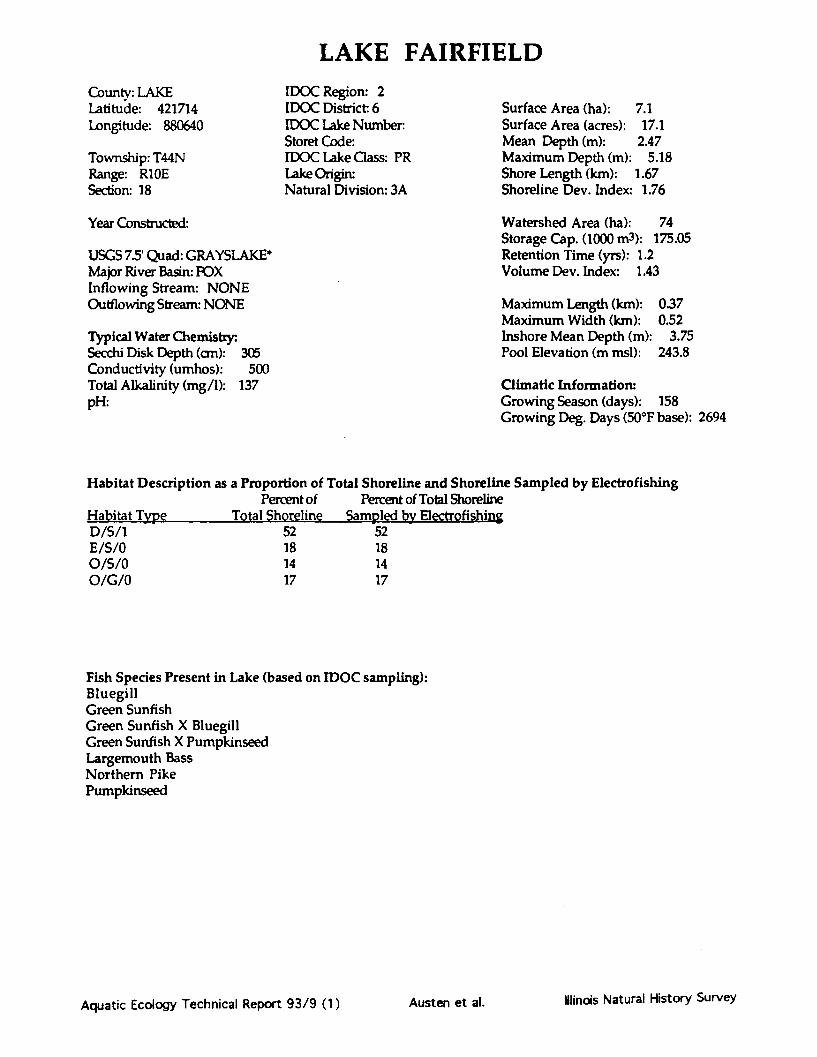
LAKE FAIRFIELDCounty: LAKELatitude: 421714Longitude: 880640
Township: T44NRange: R10ESection: 18
Year Constructed:
IDOC Region: 2IDOC District: 6IDOC Lake Number:Storet Code:IDOC Lake Class: PRLake Origin:Natural Division: 3A
USGS 7.5' Quad: GRAYSLAKE*Major River Basin: FOXInflowing Stream: NONEOutflowing Stream: NONE
Typical Water Chemistry:Secchi Disk Depth (cm): 305Conductivity (umhos): 500Total Alkalinity (mg/1): 137pH:
Surface Area (ha): 7.1Surface Area (acres): 17.1Mean Depth (m): 2.47Maximum Depth (m): 5.18Shore Length (km): 1.67Shoreline Dev. Index: 1.76
Watershed Area (ha): 74Storage Cap. (1000 m3): 175.05Retention Time (yrs): 1.2Volume Dev. Index: 1.43
Maximum Length (km): 0.37Maximum Width (km): 0.52Inshore Mean Depth (m): 3.75Pool Elevation (m msl): 243.8
Climatic Information:Growing Season (days): 158Growing Deg. Days (50°F base): 2694
Habitat Description as a Proportion of Total Shoreline and Shoreline Sampled by ElectrofishingPercent of Percent of Total Shoreline
Habitat Type Total Shoreline Sampled by ElectrofishingD/S/1 52 52E/S/0 18 18O/S/0 14 14O/G/0 17 17
Fish Species Present in Lake (based on IDOC sampling):BluegillGreen SunfishGreen Sunfish X BluegillGreen Sunfish X PumpkinseedLargemouth BassNorthern PikePumpkinseed
Aquatic Ecology Technical Report 93/9 (1) Illinois Natural History SurveyAusten et al.

Notes and Comments:
Aquatic Ecology Technical Report 93/9 (1) Austen et al. Ilinois Natural History Survey

LAKE FAIRFIELD
SCALE
0
N -~
Map Source: Lake Co. Health Dept.Mapping Method: UnknownDate completed: 1986
Aauatic Ecology Technical Report 93/9 (1)
500ft
Illindis Natural History SurveyAusten et al.

LAKE FAIRFIELD
O/G/O
D/S/I
lI % v
Aquatic Ecology Technical Report 93/9 (1)
$S/1
fS/0
L..f L %
-N -
abitat CodesSubstrate/Hard Cover
ody debrisiergent vegetationSrapen areackstaining wall or dam faceknown
d or siltyidavel:k or boulderknown
r Rating:ody debris and no docks.ody debris with docks orwoody debris.woody debris with many>r 34-66% woody debris.o woody debris with many>r > 67% woody debris.
npiled by the Illinois:al History Survey
Date
Ilinois Natural History SurveyAusten et al.

FOREST LAKE
County: LAKELatitude: 421252Longitude: 880310
Township: T43NRange: R10ESection: 10,15
IDOC Region: 2IDOC District: 6IDOC Lake Number:Storet Code: RG-B01-ZGIDOC Lake Class: PRLake Origin:Natural Division: 3A
Year Constructed: 1934
USGS 7.5' Quad: LAKE ZURICH*Major River Basin: DES PLAINESInflowing Stream: NONEOutflowing Stream: INT>INDIAN CR>DES PLAINES R
Typical Water Chemistry:Secchi Disk Depth (cm): 56Conductivity (umhos): 900Total Alkalinity (mg/1): 187pH: 8.2
Surface Area (ha): 15.7Surface Area (acres): 37.6Mean Depth (m): 1.78Maximum Depth (m): 3.05Shore Length (km): 2.48Shoreline Dev. Index: 1.76
Watershed Area (ha): 174Storage Cap. (1000 m3): 279.66Retention Time (yrs): 0.8Volume Dev. Index: 1.75
Maximum Length (km):Maximum Width (km):Inshore Mean Depth (m):Pool Elevation (m msl):
0.440.81
1.6241.7
Climatic Information:Growing Season (days): 158Growing Deg. Days (50*F base): 2694
Habitat Description as a Proportion of Total Shoreline and Shoreline Sampled by ElectrofishingPercent of Percent of Total Shoreline
Habitat Type Total Shoreline Sampled by ElectrofishingD/C/1 16 16O/C/O 42 40O/S/0 3 3R/B/0 21 21T/C/0 11 11T/U/0 2 2W/C/1 6 6
Fish Species Present in Lake (based on IDOC sampling):Black CrappieBluegillBluegill X PumpkinseedBluntnose MinnowCarpGolden ShinerLargemouth BassNorthern PikePumpkinseedWarmouthWhite CrappieYellow Perch
Aquatic Ecology Technical Report 93/9 (1) Illinois Natural History SurveyAusten et al.

Notes and Comments:
Aquatic Ecology Technical Report 93/9 (1) Ilinois Natural History SurveyAusten et al.

FOREST LAKE
N
SCALE
rey17.5 min.
\ .JI
Aauatic Ecolooy Technical Reoort 93/9 (1)
ff --- mmma
Illinois Natural History SurveyAusten et al.

FOREST LAKE
E/C/
O/C
Aquatic Ecology Technical Report 93/9 (1)
'0
fB/O
N
R/B/O
Habitat Codesat/Substrate/Hard Cover
W = Woody debrisE = Emergent vegetationR = Riprap0 = Open areaD = DocksT = Retaining wall or dam faceU = Unknown
M = Mud or siltC = ClayS = SandG = GravelB = Rock or boulderU = Unknown
Rating:ody debris and no docks.ady debris with docks or
1-33% woody debris.woody debris with many docks
^4 6A- .e.c. d,.vivt, Adis
3 = 34-66% woody debris with many docksor greater than 67% woody debris,
Data compiled by the IllinoisNatural History Survey
LDatek , a.,*4W_______.Z
Ilinois Natural History SurveyAusten et al.

FOX/NIPPERSINK(Fox Chain of Lakes)
County: LAKELatitude: 422435Longitude: 881902
Township: T45NRange: R9ESection: 2,3,4,33,34
IDOC Region: 2IDOC District: 6IDOC Lake Number: 4222STORET Code: RT-BO1-FIDOC Lake Class: PULake Origin: NGNatural Division: 3A
Surface Area (ha): 990.3Surface Area (acres): 2376.8Mean Depth (m): 1.378Maximum Depth (m): 5.486Shore Length (km): 37.045Shoreline Dev. Index: 3.32
Year Constructed: 1935
USGS 75' Quad:Major River Basin: FOXInflowing Stream: FOX R./SQUAW CROutflowing Stream: FOX R
Typical Water Chemistry:Secchi Disk Depth (cm): 37Conductivity (umhos): 588Total Alkalinity (mg/1): 227pH: 8.3
Watershed Area (ha): 336700Storage Cap. (1000 m3): 13650.61Retention Time (yrs): 0.1Volume Dev. Index: 0.75
Maximum Length (km): 5.788Maximum Width (km): 3.911Inshore Mean Depth (m): 0.75Pool Elevation (m msl): 224.9
Climatic Information:Growing Season (days): 158Growing Deg. Days (50*F base): 2694
Habitat Description as a Proportion of Total Shoreline and Shoreline Sampled by ElectrofishingPercent of Percent of Total Shoreline
Habitat Type Total Shoreline Sampled by ElectrofishingD/S/1 2 2D/B/1 33 15E/M/0 16 3E/M/2 20 4R/B/1R/B/0T/M/1T/B/0U/U/0W/M/2
16611
1
201
Fish Species Present in Lake (based on IDOC sampling):Black Bullhead Largemouth BassBlack Crappie LogperchBluegill Orangespotted SunfishBluntnose Minnow PumpkinseedBrown Bullhead Pumpkinseed X Green SunfishBrook Silverside Quillback CarpsuckerBullhead Minnow Spotted SuckerCarp Striped ShinerChannel Catfish Silver RedhorseEmerald Shiner Tadpole MadtomGolden Shiner WalleyeGreen Sunfish Warmouth
White BassWhite CrappieWhite SuckerYellow PerchYellow Bass
Aquatic Ecology Technical Report 93/9 (1) Ulinds Natural History SurveyAusten et al.

Notes and Comments:
Aquatic Ecology Technical Report 93/9 (1) Austen et al. Winois Natural History Survey

FOX/NIPPERSINK LAKES(Fox Chain of Lakes)
N -~
u5u5 topograpmc mapDate completed: 10/90 )
Aquatic Ecology Technical Report 93/9 (1)
//
r1.Austen et al. Illinois Natural History Survey

FOX/NIPPERSINK LAKES
Aquatic Ecology Technical Report 93/9 (1) Austen et at. Khincxs Natural History survey
Habitat Codes (given as a three character code: Habitat/Substrate/Haid Cover)Hiat Substrate: Hard Cover RatinW = Woody debris M = Mud or silt 0 = 0% woody debris and no docks.E = Emergent vegetation C = Clay I = 0% woody debris with docks orR = Rip rap S = Sand 1-33% woody debris.0 = Open area G = Gravel 2 = 1-33% woody debris with many docksD = Docks B = Rock or boulder or 34-66% woody debris.T = Retaining wall or dam face U = Unknown 3 = 34-66% woody debris with many docksU = Unknown or greater than 67% woody debris.
Information compiled by the Illinois Natural History Survey, completed 10/29/86,
Austen et al. Illinois Natural History Surveyaft
Aquatic Ecology Technical Report 93/9 (1)

GAGES LAKECounty: LAKELatitude: 422102Longitude: 875948
Township: T45NRange: R11ESection: 30
IDOC Region: 2IDOC District: 6IDOC Lake Number:Storet Code: RG-B01-IIDOC Lake Class: PULake Origin: NGNatural Division: 3A
Year Constructed:
USGS 7.5' Quad: LIBERTYVILLE*/GRAYSLAKE*Major River Basin: DES PLAINESInflowing Stream: INT/MARSHESOutflowing Stream: INT>MILL CR>DES PLAINES R
Typical Water Chemistry:Secchi Disk Depth (cm): 107Conductivity (umhos): 720Total Alkalinity (mg/1): 115pH: 8.0
Surface Area (ha): 53.2Surface Area (acres): 127.8Mean Depth (m): 2.36Maximum Depth (m): 14.63Shore Length (km): 6.25Shoreline Dev. Index: 2.41
Watershed Area (ha): 518Storage Cap. (1000 m3): 1258.29Retention Time (yrs): 1.7Volume Dev. Index: 0A8
Maximum Length (km):Maximum Width (km):Inshore Mean Depth (m):Pool Elevation (m msl):
1.441.26
1.1237.7
Climatic Information:Growing Season (days): 175Growing Deg. Days (50°F base): 2755
Habitat Description as a Proportion of Total Shoreline and Shoreline Sampled by Electrofishing
Habitat TypeO/G/0O/S/0R/B/0T/G/0T/S/0W/S/2W/S/1
Percent ofTotal Shoreline
9281
50417
Percent of Total ShorelineSampled by Electrofishing
1141
34
17
Fish Species Present in Lake (based on IDOC sampling):Black CrappieBluegillBrown BullheadCarpEmerald ShinerLargemouth BassPumpkinseedYellow Perch
Aquatic Ecology Technical Report 93/9 (1) Austen et al. Illinois Natural History Suivvy

Notes and Comments:
Aquatic Ecology Technical Report 93/9 (1) Austen et al. llinois Natural History Survey

GAGES LAKE
Map Source: Illinois Dept. of ConservationMapping Method: Unknown, outline from ASCS
aerial photoDate completed: 10/11/66
Aauatic Ecology Technical ReDort 93/9 (1)
IAusten et al.
mbýA WWof& &
OF
Illinois Natural History Survey

GAGES LAKE
O/G/O
El
T/G/OA TI
AGI
El
O/s/0W/S/2
El
O/S/o
Aquatic Ecology Technical Report 93/9 (1)
O/G
O/s/o
T/S/O
o/s/o
N
T/S/0
O/S/o
Hab
W= NE = Emergent vegetation C = Clay 1 = 0% woody debris with docks orR = Rip rap S = Sand 1-33% woody debris.0 = Open area G = Gravel 2 = 1-33% woody debris with many docksD = Docks B = Rock or boulder or 34-66% woody debris.T = Retaining wall or dam face U = Unknown 3 = 34-66% woody debris with many docksU = Unknown or greater than 67% woody debris.Information compiled by the Illinois Natural History Survey, completed 10/29/86,
T/G/0
,a
Ih_
AVr
Ilinois Natural History SurveyAusten et al.

LAKE GEORGECounty: ROCK ISLANDLatitude: 412558Longitude: 904957
Township: TI7NRange: R4WSection: 27,34,35
IDOC Region: 1IDOC District: 2IDOC Lake Number: 8Storet Code: RL-B01-AIDOC Lake Class: PULake Origin: AANatural Division: 5B
Surface Area (ha): 65.6Surface Area (acres): 157.3Mean Depth (m): 6.49Maximum Depth (m): 16.76Shore Length (km): 10.18Shoreline Dev. Index: 3.54
Year Constructed: 1966
USGS 7.5' Quad: MONTEPELIERMajor River Basin: MISS NO CENTRALInflowing Stream: BIG BRANCHOutflowing Stream: BIG BRANCH>MISS
Typical Water Chemistry:Secchi Disk Depth (cm): 43Conductivity (umhos): 410Total Alkalinity (mg/1): 184pH: 8.4
Watershed Area (ha): 1918Storage Cap. (1000 m3): 4256.35Retention Time (yrs): 1.2Volume Dev. Index: 1.16
Maximum Length <km): 1.83Maximum Width (km): 2.13Inshore Mean Depth (m): 3.3Pool Elevation (m msl): 185.9
Climatic Information:Growing Season (days): 171Growing Deg. Days (500F base): 3225
Habitat Description as a Proportion of Total Shoreline and Shoreline Sampled by Electrofishing
Percent of Percent of Total Shomline
t atibaIJ- Type Total Shoreline Sampled by Elayrpfi g
E/S/0R/B/0W/S/2W/S/1
935
83
232
49
Fish Species Present in Lake (based on IDOC sampling):Black Bullhead Tiger MuskellungeBluegill WalleyeCarp White CrappieChannel Catfish White SuckerFreshwater Drum Yellow BullheadGizzard ShadGolden ShinerGreen SunfishLargemouth BassLongear SunfishMuskellungeRedear Sunfish
Aquatic Ecology Technical Report 93/9 (1)
%.F lb %Asa %.IF a a vr
Ilindois Natural History SurveyAusten et al.

Notes and Comments:
Aquatic Ecology Technical Report 93/9 (1) Ilinois Natural History SurveyAusten et al.

LAKE GEORGE
0c
0AT 10 0i51CONTOUR INTERVAL 10ft
Map Source: U.S. Geological SurveyMapping Method: USGS surveyDate completed: 1975
Aquatic Ecology Technical Report 93/9 (1)
IN .F0fm4b4b 16JL
Illinois Natural History SurveyAusten et al.

LAKE GEORGE
W/S/1
W/S/ l
W/S/1
W/S/l
E/S/0
E/S/0
N
Aquatic Ecology Technical Report 93/9 (1)
Habitat/Substrate/Hard Cover)r Habitat Codes (given as a three character code:Habitat: Substrate: Hard Cover Rating:W= Woody debris M = Mud or silt 0 = 0% woody debris and no docks.
E = Emergent vegetation C = Clay 1 = 0% woody debris with docks or
R = Rip rap S = Sand 1-33% woody debris.0 = Open area G = Gravel 2 = 1-33% woody debris with many docks
D = Docks B = Rock or boulder or 34-66% woody debris.
T = Retaining wall or dam face U = Unknown 3 = 34-66% woody debris with many docks
U = Unknown or greater than 67% woody debris.Infnrmatinn cnmnilerd hv the Illinois Natural Historv Survey. completed 9/15/88
'V •._.LAA"%J" .... ., Fs&- ... . y.,f AA L. & ,. r J . & a.;........ ...... .. ....... S. .. .. .,a"'- • " "a
Austen et al. Ilinois Natural History Survey

GEORGETOWN RESERVOIRCounty: VERMILLIONLatitude: 395730Longitude: 873842
Township: T17NRange: R11WSection: 6,7
IDOC Region: 3IDOC District: 8IDOC Lake Number: 4401Storet Code: RB-A04-SIDOC Lake Class: PULake Origin: AANatural Division: 10C
Surface Area (ha): 22.9Surface Area (acres): 55.1Mean Depth (m): 92Maximum Depth (m): 3.05Shore Length (km): 9.03Shoreline Dev. Index: 5.32
Year Constructed: 1936
USGS 75 Quad: GEORGETOWNMajor River Basin: WABASHInflowing Stream: LIL VERMILLION ROutflowing Stream: SAME>VERMIL. R>WABASH R.
Typical Water Chemistry:Secchi Disk Depth (cm): 51Conductivity (umhos): 559Total Alkalinity (mg/1): 185pH: 8.2
Watershed Area (ha): 6993Storage Cap. (1000 m3): 211.56Retention Time (yrs): 0.1Volume Dev. Index: 0.9
Maximum Length (km): 1.62Maximum Width (km): 1.81Inshore Mean Depth (m): 1.05Pool Elevation (m msl): 187.7
Climatic Information:Growing Season (days): 182Growing Deg. Days (50°F base): 3665
Habitat Description as a Proportion of Total Shoreline and Shoreline Sampled by ElectrofishingPercent of Percent of Total Shoreline
Habitat Type Total Shoreline Sampled by ElectrofishingE/M/0 29 10O/M/1O/M/0T/U/0U/U/0W/M/1W/M/2
1211
3477
Fish Species Present in Lake (based on IDOC sampling):Bluegill Spotted SuckerBrown Bullhead WarmouthCarp White CrappieGolden Redhorse White SuckerGoldfishGreen SunfishGreen Sunfish X BluegillLargemouth BassLongear SunfishOrangespotted SunfishRed Shiner
Aquatic Ecology Technical Report 93/9 (1) Ilinois Natural History SurveyAusten et al.

Notes and Comments:
Aquatic Ecology Technical Report 93/9 (1) Alindis Natural History SurveyAusten et al.

GEORGETOWN RESERVOIR
SC0 N
LDate completed: 11/4273/
Aquatic Ecology Technical Report 93/9 (1)
/
Illinois Natural History SurveyAusten et al.

HalHabW =E =R =0 =D =T =U =
SubsM =
T/U/O
GEORGETOWN RESERVOIR
Habitat Codesbitat/Substrate/Hard Coveritat:
Woody debrisEmergent vegetationRip rap
" Open areaDocksRetaining wall or dam faceUnknown
trate:- Mud or silt
C = ClayS = SandG = GravelB = Rock or boulderU = Unknown
Hard Cover Rating:0 = 0% woody debris and no docks.1 = 0% woody debris with docks or
1-33% woody debris.2 = 1-33% woody debris with many
docks or 34-66% woody debris.3 = 34-66% woody debris with many
docks or > 67% woody debris.
Data compiled by the IllinoisNatural History Survey
Date 11/23/88 j
N
W/M/2
W/M/1
O/M/O
O/M/
O/M/
E/M/O
O/M/O
E/M/0 M/2
El W/M/2S E/M/0
E/M/0
EIM/O '0
O/M/O
E/M/IW/M/2
W/M/1
E/M/0
U/U/O
u/u)
W/M/1
U/U/0
Aquatic Ecology Technical Report 93/9 (1)
/0
A/0
1/2
lo"
j
Austen et al. Ilinois Natural History Survey

GRASS LAKE(Fox Chain of Lakes)
County: LAKELatitude: 422550Longitude: 880948
Township: T46NRange: R9ESection: 34
Year Constructed: 1939
USGS 7.5' Quad:Major River Basin: FOXInflowing Stream: FOX ROutflowing Stream: FOX R
Typical Water Chemistry:Secchi Disk Depth (cm): 29Conductivity (umhos): 650Total Alkalinity (mg/1): 298pH: 8.4
IDOC Region: 2IDOC District: 6IDOC Lake Number. 4223STORET Code: RT-B01-QIDOC Lake Class:Lake Origin: NGNatural Division: 3A
Surface Area (ha): 605.0Surface Area (acres): 1451.4Mean Depth (m): 0.686Maximum Depth (m): 1.829Shore Length (km): 29.104Shoreline Dev. Index: 3.33
Watershed Area (ha): 598Storage Cap. (1000 m3): 4147.92Retention Time (yrs): 0.1Volume Dev. Index: 1.12
Maximum Length (km): 3.543Maximum Width (km): 4.093Inshore Mean Depth (m): 0.5Pool Elevation (m msl): 224.9
Climatic Information:Growing Season (days): 158Growing Deg. Days (500F base): 2694
Habitat Description as a Proportion of Total Shoreline and Shoreline Sampled by ElectrofishingPercent of Percent of Total Shoreline
Habitat Type Total Shoreline Sampled by ElectrofishingD/M/1 2 1E/M/0 54 31R/B/0 6 2T/M/1 14U/U/0 1W/M/1 24
Fish Species Present in Lake (based on IDOC sampling):Black BullheadBlack CrappieBluegillBowfinBrown BullheadBrook SilversideCarpChannel CatfishGolden ShinerGreen SunfishLargemouth BassLogperchOrangespotted Sunfish
PumpkinseedQuillback CarpsuckerSpotted SuckerShorthead RedhorseTadpole MadtomWalleyeWarmouthWhite BassWhite CrappieYellow BullheadYellow PerchYellow Bass
Aquatic Ecology Technical Report 93/9 (1) Ilincis Natural History Surve,Austen et al.

Notes and Comments:
Aquatic Ecology Technical Report 93/9 (1) IMincis Natural History SurveyAusten et al.

GRASS LAKE
3
q
N
Map Source: Illinois Natural History SurveyMapping Method: Transect, outline from 7.5 min.USGS topographic maDate completed: 10/90
Aquatic Ecology Technical Report 93/9 (1) Illinois Natural History SurveyAusten et al.

GRASS LAKE
E/M/0O E/M/O
NU/U/o
E/M/O
E/M/0
E/M/O
U/U/o
E/M/O3E1I
E/fE/kO'f. I% -ftW/M/I
3E3
3E3
E/M/O
D/M/I3E2
T/M/I
R/B/O
E/M/O
Aquatic Ecology Technical Report 93/9 (1)
Habitat Codes (given as a three character code: Habitat/Substrate/Hard Cover)Habitat: Substrate: Hard Cover Rating:W = Woody debris M = Mud or silt 0 = 0% woody debris and no docks.E = Emergent vegetation C = Clay 1 = 0% woody debris with docks orR = Rip rap S = Sand 1-33% woody debris.0 = Open area G = Gravel 2= 1-33% woody debris with many docksD = Docks B = Rock or boulder or 34-66% woody debris.T = Retaining wall or dam face U = Unknown 3 = 34-66% woody debris with many docksU = Unknown or greater than 67% woody debris.Information compiled by the Illinois Natural History Survey, completed 10/29/86
Austen et al. Ilinois Natural History Survey
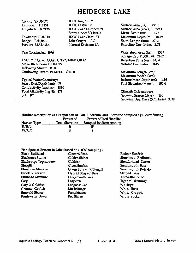
HEIDECKE LAKE
County: GRUNDYLatitude: 412151Longitude: 882136
Township: T33N,T3Range: R7E,R8ESection: 32,33,4,5,6
IDOC Region: 2IDOC District 7IDOC Lake Number: 59Storet Code: SD-B01-XIDOC Lake Class: STLake Origin: AONatural Division: 4A
Year Constructed: 1976
USGS 7.5' Quad: COAL CITY*/MINOOKA*Major River Basin: ILLINOISInflowing Stream: IL ROutflowing Stream- PUMPED TO IL R
Typical Water Chemistry:Secchi Disk Depth (cm): 75Conductivity (umhos): 1830Total Alkalinity (mg/1): 171pH: 8.2
Surface Area (ha): 791.3Surface Area (acres): 1899.1Mean Depth (m): 2.75Maximum Depth (m): 18.29Shore Length (km): 27.41Shoreline Dev. Index: 2.75
Watershed Area (ha): 1332Storage Cap. (1000 m3): 24670Retention Time (yrs): N/AVolume Dev. Index: 0.45
Maximum Length (km):Maximum Width (km):Inshore Mean Depth (m): 1.16Pool Elevation (m msl): 152.4
Climatic Information:Growing Season (days): 163Growing Deg. Days (50*F base): 3038
Habitat Description as a Proportion of Total Shoreline and Shoreline Sampled by ElectrofishingPercent of Percent of Total Shoreline
Habitat Type Total Shoreline Sampled by ElectrofishingR/B/0 86 25W/C/1 14 9
Fish Species Present in Lake (based on IDOC sampling):Black Bullhead Gizzard ShadBlacknose Shiner Golden ShinerBlackstripe Topminnow GoldfishBluegill Green SunfishBluntnose Minnow Green Sunfish X BluegillBrook Silverside Hybrid Striped BassBullhead Minnow Largemouth BassCarp LogperchCarp X Goldfish Longnose GarChannel Catfish MuskellungeEmerald Shiner PumpkinseedFreshwater Drum Red Shiner
Redear SunfishShorthead RedhorseSlenderhead DarterSmallmouth BassSmallmouth BuffaloStriped BassThreadfin ShadTiger MuskellungeWalleyeWhite BassWhite CrappieWhite Sucker
Aquatic Ecology Technical Report 93/9 (1) Illinois Natural History SurveyAusten et al.

Notes and Comments:
Aquatic Ecology Technical Report 93/9 (1) Austen et al. Ilinois Natural History Survey

HEIDECKE LAKE

HEIDECKE LAKE
R/B/O
R/B/C
0
l/0
W/C/1IG2w
1E5
W/C/1
lElR/B/01GIVo
1E4
W/C/1
W/C/1
R/B/O R/B/0
N
Ilinois Natural History SurveyAquatic Ecology Technical Report 93/9 (1)
Habitat Codesitat/Substrate/Hard Covertat:
Woody debrisEmergent vegetationRip rapOpen areaDocksRetaining wall or dam faceUnknown
trate:Mud or siltClaySandGravelRock or boulderUnknown
Cover Rating:Fo woody debris and no docks.70 woody debris with docks or33% woody debris.33% woody debris with many...- % ., A, U.U.7 ...34 66 .. d.-u d I.
uc,,r l J+-UUoc wooUUU y UoUIIs.
3 = 34-66% woody debris with manydocks or > 67% woody debris.
Data compiled by the IllinoisNatural History Survey
Date 4/28/91
Austen et al.

HERRICK LAKECounty: DUPAGELatitude: 414942Longitude: 880836
Township: T39NRange R10ESection: 30,31
IDOC Region: 2IDOC District: 5IDOC Lake Number: 74STORET Code: WG-A09-MIDOC Lake Class: PULake Origin:Natural Division: 3A-
Surface Area (ha): 7.5Surface Area (acres): 18.0Mean Depth (m): 1.664Maximum Depth (m): 3.962Shore Length (km): 1.725Shoreline Dev. Index: 1.77
Year Constructed: 1930
USGS 7.5' Quad: NAPERVILLEMajor River Basin: DES PLAINESInflowing Stream: CONNECTED TO LAKE VIA CANALOutflowing Stream: INT
Typical Water Chemistry:Secchi Disk Depth (cm): 54Conductivity (umhos): 468Total Alkalinity (mg/1): 135pH: 8.7
Watershed Area (ha): 111Storage Cap. (1000 m3): 125.218Retention Time (yrs): 0.5Volume Dev. Index: 1.26
Maximum Length (km): 0.465Maximum Width (km): 0.414Inshore Mean Depth (m): 1.2Pool Elevation (m msl): 228.6
Climatic Information:Growing Season (days): 164Growing Deg. Days (50°F base): 3049
Habitat Description as a Proportion of Total Shoreline and Shoreline Sampled by ElectrofishingPercent of Percent of Total Shoreline
Habitat Type Total Shoreline Sampled by ElectrofishingD/S/1 15 15E/S/0 11O/S/oT/U/0W/S/1
431
30
431
30
Fish Species Present in Lake (based on IDOC sampling):Black BullheadBluegillCarpChannel CatfishGolden ShinerGreen SunfishLargemouth BassWhite Crappie
Aquatic Ecology Technical Report 93/9 (1) Illinois Natural History SurveyAusten et al.

Notes and Comments:
Aquatic Ecology Technical Report 93/9 (1) Austen et al. Ilinois Natural History Survey

HERRICK LAKE
N
SCALE0 500ft0 500ft
'IF'Css Tar- -v
Map Source: DuPage Co. Forest Preserve Dist.Mapping Method: UnknownDate completed: Unknown

HERRICK LAKE
+El
O/S/oEl
W/S/l
O/S/0 O/S/oEl
Aquatic Ecology Technical Report 93/9 (1)
El
Habitat Codes (given as a three character code: Habitat/Substrate/Hard Cover)Habitat: Substra Hard Cover Rating:W = Woody debris M = Mud or silt 0 = 0% woody debris and no docks.E = Emergent vegetation C = Clay 1 = 0% woody debris with docks orR = Rip rap S = Sand 1-33% woody debris.0 = Open area G = Gravel 2 = 1-33% woody debris with many docksD = Docks B = Rock or boulder or 34-66% woody debris.T = Retaining wall or dam face U = Unknown 3 = 34-66% woody debris with many docksU = Unknown or greater than 67% woody debris.Information compiled by the Illinois Natural History Survey, completed 10/29/86)
Austen et al. Illinois Natural History Survey

HIGHLAND LAKECounty: LAKELatitude: 422140Longitude: 880342
Township: T45NRange: R10ESection: 21,22
IDOC Region: 2IDOC District: 6IDOC Lake Number.Storet Code: RT-B01ZPIDOC Lake Class: PRLake Origin: NGNatural Division: 3A
Surface Area (ha): 43.0Surface Area (acres): 103.2Mean Depth (m): 3.38Maximum Depth (m): 11.28Shore Length (km): 2.56Shoreline Dev. Index: 1.09
Year Constructed:
USGS 75' Quad: GRAYSLAKE*Major River Basin: POXInflowing Stream: INT/MARSHESOutflowing Stream: ROUND L>LONG L>SQUAW CR>FOXL>R
Typical Water Chemistry:Secchi Disk Depth (cm): 137Conductivity (umhos): 361Total Alkalinity (mg/1): 89pH: 82
Watershed Area (ha): 283Storage Cap. (1000 m3): 1543.94Retention Time (yrs): 2.5Volume Dev. Index: 0.89
Maximum Length (km): 0.74Maximum Width (km): 0.81Inshore Mean Depth (m): 1.2Pool Elevation (m msl): 237.4
Climatic Information:Growing Season (days): 158Growing Deg. Days (50°F base): 2694
Habitat Description as a Proportion of Total Shoreline and Shoreline Sampled by ElectrofishingPercent of Percent of Total Shoreline
Habitat Type Total Shoreline Sampled by ElectrofishingO/S/O 100 90
Fish Species Present in Lake (based on IDOC sampling):Black CrappieBluegillCarpChannel CatfishGreen Sunfish X BluegillLargemouth BassPumpkinseedWarmouthYellow BullheadYellow Perch
Aquatic Ecology Technical Report 93/9 (1) Illindois Natural History SurveyAusten et al.

Notes and Comments:
Aquatic Ecology Technical Report 93/9 (1) Austen et al. Illinois Natural History Survey
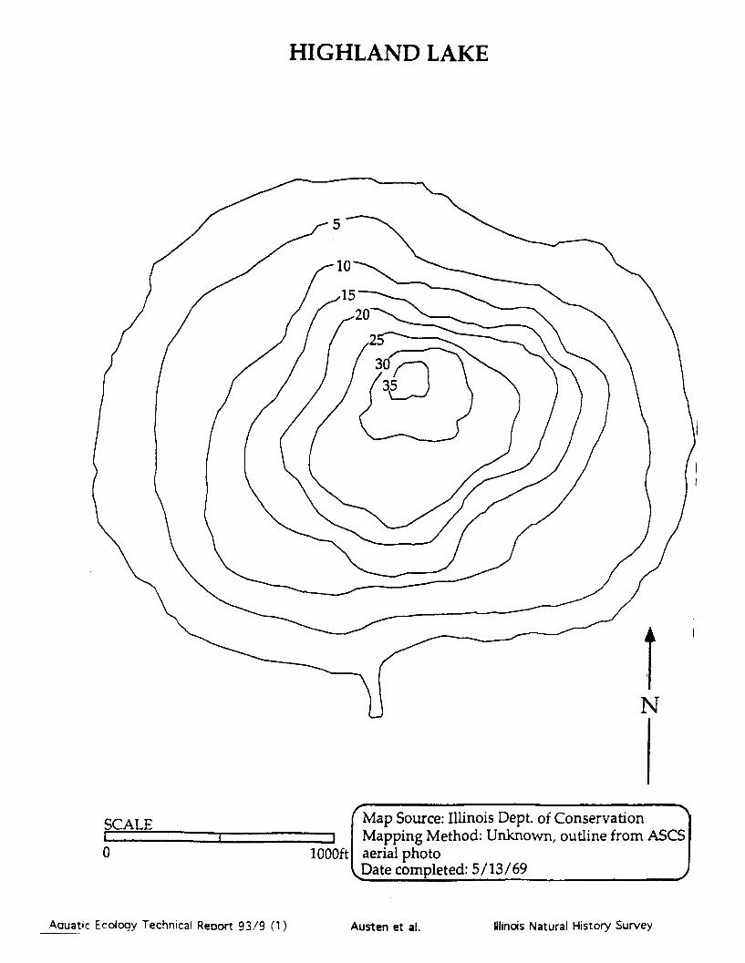
HIGHLAND LAKE
Map Source: Illinois Dept. of ConservationI Mapping Method: Unknown, outline from ASCS
1000ft aerial photoFDate completed: 5/13/69
Aauatic Ecology Technical Reoort 93/9 (1)
SCALE
0
I
Austen et al. Illinois Natural History Survey

HIGHLAND LAKE
_ N
Aquatic Ecology Technical Report 93/9 (1)
Habitat Codes (given as a three character code: Habitat/Substrate/Hard Cover)Habia: Substrate: Hard Cover Rating:W = Woody debris M = Mud or silt 0= 0% woody debris and no docks.E = Emergent vegetation C = Clay I = 0% woody debris with docks orR = Rip rap S = Sand 1-33% woody debris.0 = Open area G = Gravel 2 = 1-33% woody debris with many docksD = Docks B = Rock or boulder or 34-66% woody debris.T = Retaining wall or dam face U = Unknown 3 = 34-66% woody debris with many docksU = Unknown or greater than 67% woody debris.Information compiled by the Illinois Natural History Survey, completed 10/29/86j
Illinois Natural History SurveyAusten et al.
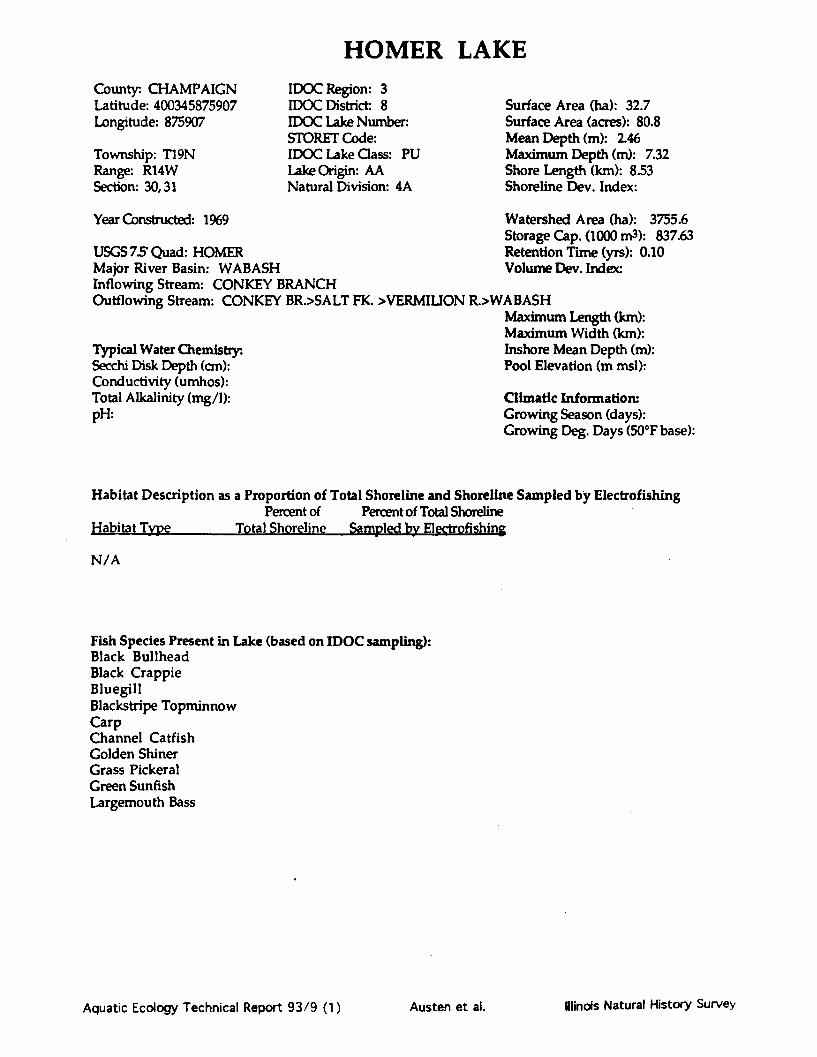
HOMER LAKECounty:. CHAMPAIGNLatitude: 400345875907Longitude: 875907
Township: T19NRange: R14WSection: 30,31
IDOC Region: 3IDOC District 8IDOC Lake Number.STORET Code:IDOC Lake Class: PULake Origin: AANatural Division: 4A
Surface Area (ha): 32.7Surface Area (acres): 80.8Mean Depth (m): 2.46Maximum Depth (m): 7.32Shore Length (km): 8.53Shoreline Dev. Index:
Year Constructed: 1969 Watershed Area (ha): 3755.6Storage Cap. (1000 m3): 837.63
USGS 7.5' Quad: HOMER Retention Time (yrs): 0.10Major River Basin: WABASH Volume Dev. Index:Inflowing Stream: CONKEY BRANCHOutflowing Stream: CONKEY BR.>SALT FK. >VERMILION R.>WABASH
Maximum Length (km):Maximum Width (km):
Typical Water Chemistry: Inshore Mean Depth (m):Secchi Disk Depth (cm): Pool Elevation (m msl):Conductivity (umhos):Total Alkalinity (mg/1): Climatic Information:pH: Growing Season (days):
Growing Deg. Days (50°F base):
Habitat Description as a Proportion of Total Shoreline and Shoreline Sampled by ElectrofishingPercent of Percent of Total Shoreline
Habitat Type Total Shoreline Sampled by Electrofishing
N/A
Fish Species Present in Lake (based on IDOC sampling):Black BullheadBlack CrappieBluegillBlackstripe TopminnowCarpChannel CatfishGolden ShinerGrass PickeralGreen SunfishLargemouth Bass
Aquatic Ecology Technical Report 93/9 (1) Ilinois Natural History SurveyAusten et al.

Notes and Comments:
Aquatic Ecology Technical Report 93/9 (1) Austen et al. Illinois Natural History Survey

HOMER LAKE
tural History Surveyisect, outline from 7.5 min.Lap
lOQOft
Aquatic Ecology Technical Report 93/9 (1)
^
Illinois Natural History SurveyAusten et al.

HOMER LAKE
E/M/I
W/IV
R/B/O
U/U/O
E/M/IR/B/O
R/B/O T/U/O
-~l WIw
€ Habitat CodesHabitat/Substrate/Hard Cover
Habitat:W = Woody debrisE = Emergent vegetationR = Rip rap0 Open areaD = DocksT = Retaining wall or darn faceU = Unknown
Substrate:M = Mud or siltC = ClayS = SandG = GravelB = Rock or boulderU = Unknown
Hard Cover Rating:0 = 0% woody debris and no docks.I = 0% woody debris with docks or
1-33% woody debris.2 = 1-33% woody debris with many
docks or 34-66% woody debris.3 = 34-66% woody debris with many
docks or > 67% woody debris.
Data compiled by the IllinoisNatural History Survey
Date
wl
*t'hnrds ,~ n --w TP I c! r%•,ustn "t •l,

HONEY LAKECounty: LAKELatitude: 421202Longitude: 880748
Township: T43NRange: R93Section: 13
IDOC Region: 2IDOC District: 6IDOC Lake Number:STORET Code: RT-BO2ZUIDOC Lake Class: PRLake Origin: AONatural Division: 3A
Year Constructed:
USGS 75' Quad: BARRINGTON*Major River Basin: FOXInflowing Stream: INT FROM MARSHOutflowing Stream: INT TO MARSH
Typical Water Chemistry:Secchi Disk Depth (cm): 259Conductivity (umhos): 635Total Alkalinity (mg/1): 120pH:
Surface Area (ha): 25.9Surface Area (acres): 62.2Mean Depth (m): 1.67Maximum Depth (m): 6.096Shore Length (kin): 2.59Shoreline Dev. Index: 1.43
Watershed Area (ha): 239Storage Cap. (1000 m3): 432.88Retention Time (yrs): 0.9Volume Dev. Index: 0.82
Maximum Length (km):Maximum Width (km):Inshore Mean Depth (m):Pool Elevation (m msl):
0.810.56
0.71238.7
Climatic Information:Growing Season (days): 158Growing Deg. Days (50°F base): 2694
Habitat Description as a Proportion of Total Shoreline and Shoreline Sampled by ElectrofishingPercent of Percent of Total Shoreline
Habitat Type Total Shoreline Sampled by ElectrofishingE/U/0 58 7O/S/0 3 3W/U/1 37 28W/U/0 2
Fish Species Present in Lake (based on IDOC sampling):Bluegill
Largemouth BassNorthern PikePumpkinseedYellow Bullhead
Aquatic Ecology Technical Report 93/9 (1) Illinois Natural History SurveyAusten et al.

Notes and Comments:
Aquatic Ecology Technical Report 93/9 (1) Austen et al. lindois Natural History Survey

HONEY LAKE
0 50
I aerial photo
ot Date completed: 5/5/69'4 yd

HONEY LAKE
eP 1 1 A1%
E/U/C
N
Aquatic Ecology Technical Report 93/9 (1)
Habitat Codes (given as a three character code: Habitat/Substrate/Hard Cover)Habitat:i Substrate: Hard Cover RatingW= Woody debris M = Mud or silt 0 = 0% woody debris and no docks.E = Emergent vegetation C = Clay 1 = 0% woody debris with docks orR = Rip rap S = Sand 1-33% woody debris.0 = Open area G = Gravel 2 = 1-33% woody debris with many docksD = Docks B = Rock or boulder or 34-66% woody debris.T = Retaining wall or dam face U = Unknown 3 = 34-66% woody debris with many docksU = Unknown or greater than 67% woody debris.
• Information compiled by the Illinois Natural History Survey, completed 10/29/86
Austen et al. Ilinois Natural Hstory Survey

LAKE KAKUSHACounty: LASALLELatitude: 413338Longitude: 890813
Township: T36NRange: R1ESection: 29
IDOC Region: 1IDOC District: 2IDOC Lake Number: 21Storet Code: VT-B01-KIDOC Lake Class:Lake OriginNatural Division: 4A-
Year Constructed: 1981
USGS 7.5' Quad: MENDOTA WESTMajor River Basin: ILLInflowing Stream: INTOutflowing Stream: INT>L MENDOTA>L VERMILLIAN>IL
Typical Water Chemistry.Secchi Disk Depth (cm): 30Conductivity (umhos): 426Total Alkalinity (mg/1): 166pl+ 75
Surface Area (ha): 22.9Surface Area (acres): 55.0Mean Depth (m): 1.3Maximum Depth (m): 3.66Shore Length (km): 3.85Shoreline Dev. Index: 2.26
Watershed Area (ha): 550Storage Cap. (1000 m3): 297.55Retention Time (yrs): 0.3Volume Dev. Index: 1.06
Maximum Length (km):Maximum Width (km):Inshore Mean Depth (m):Pool Elevation (m msl):
1.020.8
0.85243.8
Climatic Information:Growing Season (days): 164Growing Deg. Days (50°F base): 3138
Habitat Description as a Proportion of Total Shoreline and Shoreline Sampled by ElectrofishingPercent of Percent of Total Shoreline
Habitat Type Total Shoreline Sampled by ElectrofishingE/U/0 88 88R/B/0 12
Fish Species Present in Lake (based on IDOC sampling):Black Crappie Redear SunfishBlack X White Crappie Spotfin ShinerBluegill White CrappieBluegill X RedearBluntnose MinnowBrook SilversideChannel CatfishFathead MinnowGolden ShinerGreen SunfishGreen Sunfish X BluegillLargemouth Bass
Aquatic Ecology Technical Report 93/9 (1) Austen et al. Ilinois Natural History Survey

Notes and Comments:
Aquatic Ecology Technical Report 93/9 (1) Austen et al. Ilindois Natural History Survey

LAKE KAKUSHA
N
SCALEI , I , I i
0 1000ft
Map Source: Illinois Natural History SurveyMapping Method: Transect, outline from 7.5min.USGS topographic mapDate completed: 8/22/89
Aquatic Ecology Technical Report 93/9 (1) Austen et al. Illinois Natural History Survey

LAKE KAKUSHA
Habitat Codes (given as a three character code: ILHabitat Su am IW = Woody debris M Mud or silt CE = Emergent vegetation C = Clay IR Riprap S Sand0 Open area 0 Gravel ID Docks B = Rock or boulderT =Retaining wall or dam face U - Unknown 3U - UnknownInformation compiled by the Illinois Natural H
abitat/Substrate/Hard Cover)trd Cover Rating:) 0% woody debris and no docks.S= 0% woody debris with docks or
1-33% woody debris.S= 1-33% woody debris with many docks
or 34-66% woody debris.= 34-66% woody debris with many docks
or greaer than 67% woody debris.[istorv Survey,. completed 10/29/86.
Aquatic Ecology Technical Report 93/9 (1)
N
I
El
.ddp-
M_.W ý WI ý ý_ --OFT ___
inas Natural History SurveyAusten et al.

LAKE OF THE WOODSCounty: CHAMPAIGNLatitude: 401201Longitude: 882250
Township: T20NRange: R7ESection: 11,14
IDOC Region: 3IDOC District 8IDOC Lake Number: 362Storet Code: RE-B01-GIDOC Lake Class: PULake Origin: AANatural Division: 4A
Surface Area (ha): 10.5Surface Area (acres): 25.2Mean Depth (m): 2.86Maximum Depth (m): 6.7Shore Length (km): 2.26Shoreline Dev. Index: 1.96
Year Constructed: 1945
USGS 75 Quad: MAHOMETMajor River Basin: SANGAMONInflowing Stream: 2 INT TRIBOutflowing Stream: INT TRIB>SANGAMON R>IL R
Typical Water Chemistry:Secchi Disk Depth (an): 76.624Conductivity (umhos): 481.97101Total Alkalinity (mg/1): 218.2%pH: 8.1
Watershed Area (ha): 206Storage Cap. (1000 m3): 30051Retention Time (yrs): 0.6Volume Dev. Index: 1.28
Maximum Length (km): 0.43Maximum Width (km): 0.66Inshore Mean Depth (m): 2.6Pool Elevation (m msl): 216.4
Climatic Information:Growing Season (days): 187Growing Deg. Days (50*F base): 3445
Habitat Description as a Proportion of Total Shoreline and Shoreline Sampled by ElectrofishingPercent of Percent of Total Shoreline
Habitat Tvne Total Shorelinp Samnlhd bv ElectrofishinerD/M/1E/M/0O/M/OO/S/0R/B/0T/M/0W/M/2W/M/1O/S/0W/S/1
33
179
211112238713
331798
111223788
Fish Species Present in Lake (based on IDOC sampling):Black Bullhead Largemouth BassBluegill Longear SunfishBluegill X Redear Redear SunfishBrown Bullhead Tiger MuskellungeChannel Catfish White CrappieGizzard ShadGolden ShinerGreen SunfishGreen Sunfish X Bluegill
Aquatic Ecology Technical Report 93/9 (1) Ilinois Natural History SurveyAusten et al.

Notes and Comments:
Aquatic Ecology Technical Report 93/9 (1) Austen et al. inois Natural Hstory Survey

LAKE OF THE WOODS
SCALE
500ft
Map Source: Illinois State Water SurveyMapping Method: Transect, outline fromaerial photoDate completed: 1980
Aquatic Ecology Technical Report 93/9 (1)
0
ff Bm 2i - u mm
Austen et al. Winds Natural History Survey

LAKE OF THE WOODS
E/M/OE1
T/M/0
O/s/0
El
W/M/l
El
El
R/B/O
Aquatic Ecology Technical Report 93/9 (1)
HabitatHabitsW =E =R -0=DTU =
SubstrM =C =SGB =U =
Hard C
1= 0%1-m
2= 1-3docks or 34-66% woody debris.
3 = 34-66% woody debris with manydocks or > 67% woody debris
Data compiled by the IllinoisNatural History Survey
Date
oo"m w
M/2
Austen et al. Illinois Natural History Survey

LASALLE COOLING LAKECounty: LASALLELatitude: 411530Longitude: 883822
Township: T32NRange: R5ESection: 9,10,11,14
IDOC Region: 1IDOC District: 2IDOC Lake Number: 23STORET Code.IDOC Lake Class: STLake Origin:Natural Division:
Surface Area (ha): 776.7Surface Area (acres): 1864.1Mean Depth (m): 4.7Maximum Depth (m): 21.64Shore Length (km): 33.48Shoreline Dev. Index: 3.38
Year Constructed:
USGS 7.5' Quad: MARSEILLES/SENECA /ODELLMajor River Basin: ILLINOISInflowing Stream: PUMPED FROM ILOutflowing Stream: PUMPED TO IL
Typical Water Chemistry:Secchi Disk Depth (cm): 66Conductivity (umhos): 577Total Alkalinity (mg/1): 170pH:
Watershed Area (ha): 1087Storage Cap. (1000 m3): 36526.85Retention Time (yrs):Volume Dev. Index: 0.65
Maximum Length (km): 4.7951Maximum Width (km): 2.7459Inshore Mean Depth (m): 1.2Pool Elevation (m msl):
Climatic Information:Growing Season (days): 163Growing Deg. Days (50°F base): 3038
Habitat Description as a Proportion of Total Shoreline and Shoreline Sampled by ElectrofishingPercent of Percent of Total Shoreline
Habitat Type Total Shoreline Sampled by ElectrofishingR/B/0 100 22
Fish Species Present in Lake (based on IDOC sampling):BluegillCarpChannel CatfishEmerald ShinerFreshwater DrumGizzard ShadGoldfishGreen SunfishHybrid Striped BassLargemouth BassRuddSkipjack HerringSmallmouth BassWalleyeYellow Bullhead
Aquatic Ecology Technical Report 93/9 (1) Austen et al. Ilinois Natural History Survey

Notes and Comments:
Aquatic Ecology Technical Report 93/9 (1) Austen et al. Winds Natural History Survey

LASALLE COOLING LAKE
nonwealth Edison Co.Pre-impoundment survey
nknown
T 4, 10, 16, 20, 30,60, & 70
ES0.5
0.5mi
Aquatic Ecology Technical Report 93/9 (1) Austen et al. Ilinois Natural History Survey

LASALLE COOLING LAKE
R/
R/B/O
R/B/C
RIB/O
Aquatic Ecology Technical Report 93/9 (1)
Habitat CodesHabitat/Substrate/Hard Cover
Habitat:W = Woody debrisE = Emergent vegetationR = Riprap0 = Open areaD = DocksT i- D i«t;n:,,& , w- l dAm faua
= AuuiUI vwaui a oruJ Iam
= Unknown
bstrate:= Mud or silt= Clay= Sand= Gravel= Rock or boulder= Unknown
d Cover Rating:0% woody debris and no docks.0% woody debris with docks or1-33% woody debris.1-33% woody debris with manydocks or 34-66% woody debris.34-66% woody debris with manydocks or > 67% woody debris.
kta compiled by the IllinoisNatural History Survey
-N--"-
R/B/O
R/B/0
Austen et al. llincis Natural History Survey
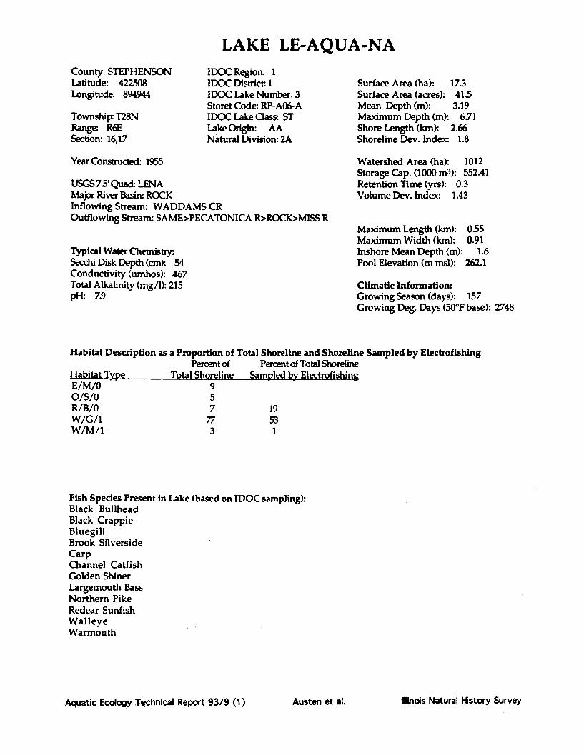
LAKE LE-AQUA-NACounty: STEPHENSONLatitude: 422508Longitude: 894944
Township: T28NRange: R6ESection: 16,17
IDOC Region: 1IDOC District: 1IDOC Lake Number: 3Storet Code: RP-AO6-AIDOC Lake Class: STLake Origin: AANatural Division: 2A
Surface Area (ha): 17.3Surface Area (acres): 41.5Mean Depth (m): 3.19Maximum Depth (m): 6.71Shore Length (km): 2.66Shoreline Dev. Index: 1.8
Year Constructed: 1955
USGS 75' Quad: LENAMajor River Basin: ROCKInflowing Stream: WADDAMS CROutflowing Stream: SAME>PECATONICA R>ROCK>MISS R
Typical Water Chemistry:Secchi Disk Depth (cm): 54Conductivity (umhos): 467Total Alkalinity (mg/1): 215pH: 7.9
Watershed Area (ha): 1012Storage Cap. (1000 m3): 552.41Retention Time (yrs): 0.3Volume Dev. Index: 1.43
Maximum Length (km): 0.55Maximum Width (km): 0.91Inshore Mean Depth (m): 1.6Pool Elevation (m msl): 262.1
Climatic Information:Growing Season (days): 157Growing Deg. Days (50*F base): 2748
Habitat Description as a Proportion of Total Shoreline and Shoreline Sampled by ElectrofishingPercent of Percent of Total Shoreline
Habitat Twve Total Shoreline Sampled by ElectrofishineE/M/0O/S/0R/B/0W/G/1W/M/1
7719531
Fish Species Present in Lake (based on IDOC sampling):Black BullheadBlack CrappieBluegillBrook SilversideCarpChannel CatfishGolden ShinerLargemouth BassNorthern PikeRedear SunfishWalleyeWarmouth
Aquatic Ecology Technical Report 93/9 (1) Austen et al. llinois Natural History Survey

Notes and Comments:
Aquatic Ecology Technical Report 93/9 (1) Austen et al. Ilinois Natural History Survey

LAKE LE-AQUA-NA
SCALE
0 500ft
LunknownDate completed: 1986 J
Aquatic Ecology Technical Report 93/9 (1)
irveyie origin
AWN
Minds Natural History SurveyI% -mmo4r
op-
Austen et al.
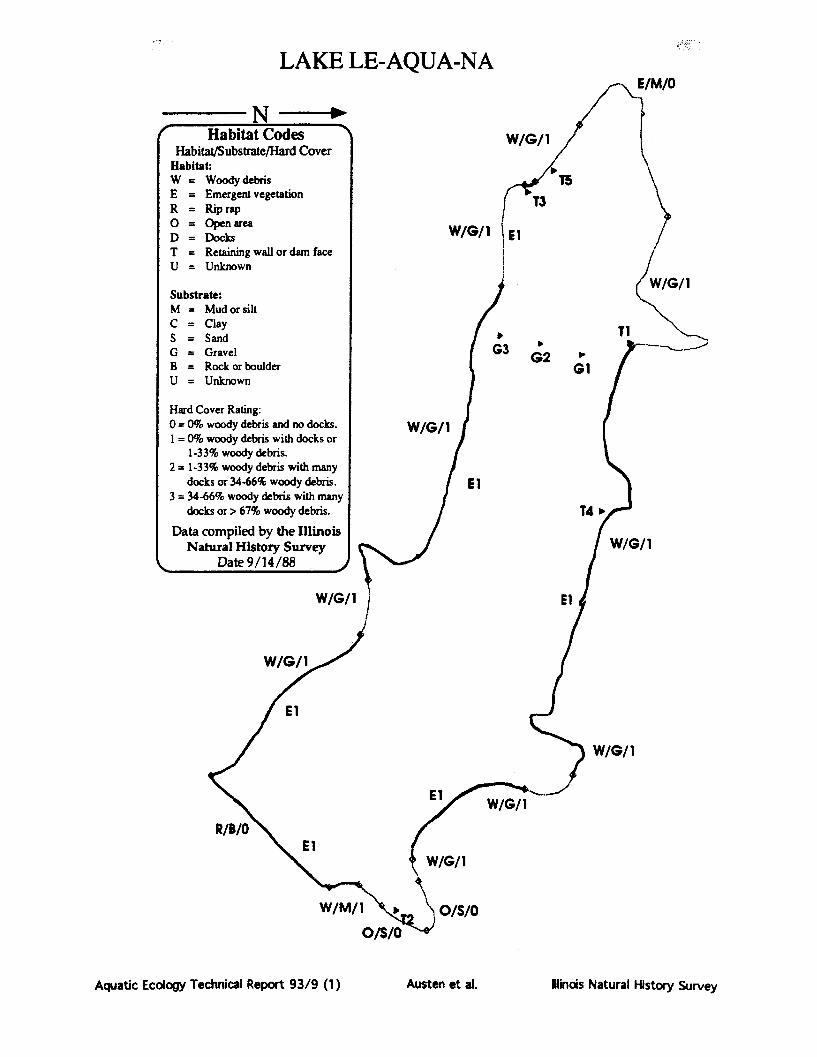
LAKE LE-AQUA-NA. E/M/O
Habitat Codes W/G/ /Habitat/Substrate/Hard Cover
Habitat:W = Woody debris T5E = Emergent vegetation T3R = Riprap0 = Open area W/G/ID = Docks W/G/1 ElT = Retaining wall or dam faceU = Unknown
W/G/iSubstrate:M = Mud or siltC = ClayS Sand TiG = Gravel G3 2B Rock or boulder GU = Unknown
Hard Cover Rating:0 = 0% woody debris and no docks. W/G/11 = 0% woody debris with docks or
1-33% woody debris.2 = 1-33% woody debris with many
docks or 34-66% woody debris. El3 = 34-66% woody debris with many
docks or > 67% woody debris. T4 0
Data compiled by the IllinoisNatural History Survey W/G/1
Date 9/14/88 j
W/G/i1 El
W/G/1
El
W/G/1
I OE Eyl W/G/I
W/G/1
W/M/i o/S/0
O/S/O"
Aquatic Ecology Technical Report 93/9 (1) Austen et al. Illinois Natural History Survey

LINCOLN TRAIL LAKECounty: CLARKLatitude: 392020Longitude: 874323
Township: T1ON,T1Range: R12WSection: 2,3,10,35
IDOC Region: 3IDOC District 9IDOC Lake Number: 115Storet Code: RB-B01-GIDOC Lake Class: STLake Origin: AANatural Division: 10B
Year Constructed: 1956
USGS 75 Quad: SNYDERMajor River Basin: WABASHInflowing Stream: NONE (INTER)Outflowing Stream: SANDY BR>MILL CR>WABASH R>OHIO
Typical Water Chemistry:Secchi Disk Depth (cm): 138Conductivity (umhos): 225Total Alkalinity (mg/1): 86pH: 86
Surface Area (ha): 56.9Surface Area (acres): 136.7Mean Depth (m): 4.84Maximum Depth (m): 10.67Shore Length (km): 8.66Shoreline Dev. Index: 3.23
Watershed Area (ha): 850Storage Cap. (1000 m3): 2754.8Retention Time (yrs): 0.9Volume Dev. Index: 1.36
Maximum Length (km):Maximum Width (km):Inshore Mean Depth (m):Pool Elevation (m msl):
1.471.51
2.35165.2
Climatic Information:Growing Season (days): 166Growing Deg. Days (50*F base): 2710
Habitat Description as a Proportion of Total Shoreline and Shoreline Sampled by ElectrofishingPercent of Percent of Total Shoreline
Habitat Type Total Shoreline Sampled by ElectrofishingE/S/0 5 5O/S/2R/B/0W/S/2W/S/1
67
80
55
44
Fish Species Present in Lake (based on IDOC sampling):Black Bullhead Redear X Warmouth HybridBlack Crappie Tadpole MadtomBlackstripe Topminnow WarmouthBluegill Warmouth X BluegillBluegill X Redear White CrappieChannel Catfish White SuckerFathead MinnowGolden RedhorseGreen SunfishLargemouth BassRedear SunfishRedear X Green Sunfish
Aquatic Ecolo hnical Report 93/9 (1) Ilindois Natural History SureAusten et al.

Notes and Comments:
Aquatic Ecology Technical Report 93/9 (1) Austen et al. Ilinois Natural History Survey

LINCOLN TRAIL LAKE
N
SCALE
0 1000ft
Map Source: Illinois Natural History SurveyMapping Method: Transect, outline from 7.5 min.
USGS topographic mapDate completed: 10/28/86
Aquatic Ecology Technical Report 93/9 (1) Ilinois Natural History SurveyAusten et al.

LINCOLN TRAIL LAKE
W/S/2
W/S/2
W/S/l
W/S
W/
R/EE3
R/B/O
Aquatic Ecology Technical Report 93/9 (1)
Habitat Codes (given as a three character code: Habitat/Substrate/Hard Cover)Habitat:S ull Hard Cover Rating:W = Woody debris M = Mud or silt 0 = 0% woody debris and no docks.E = Emergent vegetation C = Clay 1 = 0% woody debris with docks orR = Rip rap S = Sand 1-33% woody debris.0 = Open area G = Gravel 2 = 1-33% woody debris with many docksD = Docks B = Rock or boulder or 34-66% woody debris.T = Retaining wall or dam face U = Unknown 3 = 34-66% woody debris with many docksU = Unknown or greater than 67% woody debris.Information compiled by the Illinois Natural History Survey, completed 10/29/86,
I
linois Natural History SurveyAusten et al.

LONG LAKE(Kickapoo State Park)
County: VERMILLIONLatitude: 400768Longitude: 874430
Township: T19NRange: R12WSection: 4,5,8,9
IDOC Region: 3IDOC District: 8IDOC Lake Number: 95Storet Code: RB-A02-MIDOC Lake Class: STLake Origin: ASNatural Division: 10C
Year Constructed: 1927
USGS 75' Quad: DANVILLE NW*Major River Basin: WABASHInflowing Stream: NONEOutflowing Stream: NONE
Typical Water Chemistry:.Secchi Disk Depth (cm): 792Conductivity (umhos): 1723Total Alkalinity (mg/1): 146pH: 72
Surface Area (ha): 20.7Surface Area (acres): 49.7Mean Depth (m): 2.667Maximum Depth (m): 10.973Shore Length (km): 5.472Shoreline Dev. Index: 3.39
Watershed Area (ha): 40Storage Cap. (1000 m3): 552.41Retention Time (yrs): 9.1Volume Dev. Index: 0.72
Maximum Length (km): 1.47Maximum Width (km): 1.26Inshore Mean Depth (m): 3.18Pool Elevation (m msl): 164.6
Climatic Information:Growing Season (days): 166Growing Deg. Days (50°F base): 3456
Habitat Description as a Proportion of Total Shoreline and Shoreline Sampled by Electrofishing
Percent of Percent of Total Shoreline
t atibaII- Type Total Shoreline Sampled by Electr g
O/C/0oT/S/0W/C/2
21
97 15
Fish Species Present in Lake (based on IDOC sampling):Black Bullhead Green Sunfish X BluegillBlack Crappie Lake ChubsuckerBlackstripe Topminnow Largemouth BassBluegill Longear SunfishBluegill X Redear Northern PikeBrook Silverside PumpkinseedCarp Redear SunfishCentral Mudminnow WarmouthChannel Catfish White CrappieGizzard Shad White SuckerGolden Shiner Yellow PerchGrass Pickerel
Aquatic Ecology Technical Report 93/9 (1)
0 A%.FA6aA %,~Aawara WIX Ads%ý%.ILA WA&§gA gas& ry
Austen et al. Illinois Natural History Survey

Notes and Comments:
Aquatic Ecology Technical Report 93/9 (1) Austen et al. lindois Natural History Survey

LONG LAKE
N
CONTOURS AT 5, 15, 25, 35ft
L 'iU•via .c. Ummoi0 Naturai rustory surveyMapping Method: Transect, outline from ASCSaerial photo
Date completed: 7/27/89
Aquatic Ecology Technical Report 93/9 (1) Austen et al. Ilinois Natural History Survey

LONG LAKE
W/C/2
O/C/O
W/C/2
W/C/2 O/C/O
W/C/2
W/C/2 W/C/2
W/C/2
W/C/2
NW/C/2
W/C/2
Aquatic Ecology Technical Report 93/9 (1)
Habitat Codes (given as a three character code: Habitat/Substrate/Hard Cover)Habitat: Substrate: Hard Cover Rating:W= Woody debris M = Mud or silt 0 = 0% woody debris and no docks.E = Emergent vegetation C = Clay 1 = 0% woody debris with docks orR = Rip rap S = Sand 1-33% woody debris.0 = Open area G = Gravel 2 = 1-33% woody debris with many docksD = Docks B = Rock or boulder or 34-66% woody debris.T = Retaining wall or dam face U = Unknown 3 = 34-66% woody debris with many docksU = Unknown or greater than 67% woody debris.
Information compiled by the Illinois Natural History Survey, completed 10/29/86,%4 -a af or w ,Winois Natural History SurveyAusten et al.

MALLARD LAKECounty: DUPAGELatitude: 425136Longitude: 880730
Township: T40NRange: R10ESection: 18
IDOC Region: 2IDOC District 5IDOC Lake Number: 79STORET CodeIDOC Lake Class: PULake Origin: NONatural Division: 3A
Surface Area (ha): 30.8Surface Area (acres): 73.8Mean Depth (m): 3.14Maximum Depth (m): 7.92Shore Length (km): 3.72Shoreline Dev. Index: 1.89
Year Constructed: 1951
USGS 75' Quad: WEST CHICAGOMajor River Basin: DES PLAINESInflowing Stream: WBR DUPAGE ROutflowing Stream: NONE
Typical Water Chemistry:Secchi Disk Depth (cm): 91Conductivity (umhos): 730Total Alkalinity (mg/1): 122pH: 8.5
Watershed Area (ha): 34Storage Cap. (1000 m3): 966.29Retention Time (yrs): 14.0Volume Dev. Index: 1.18
Maximum Length (km): 0.707Maximum Width (km): 0.921Inshore Mean Depth (m): 1.6Pool Elevation (m msl): 233.5
Climatic Information:Growing Season (days): 162Growing Deg. Days (50*F base): 2618
Habitat Description as a Proportion of Total Shoreline and Shoreline Sampled by ElectrofishingPercent of Percent of Total Shoreline
Habitat Type Total Shoreline Sampled by Electrofishing
N/A
Fish Species Present in Lake (based on IDOC sampling):Black CrappieBluegillCarpChannel CatfishFlathead CatfishGizzard ShadGreen SunfishGreen Sunfish X BluegillLargemouth BassWhite CrappieWhite Sucker
Aquatic Ecology Technical Report 93/9 (1) Austen et al. Ilinois Natural History Survey

MALLARD LAKE
N
SCALE
500ft
tVAdppulg jJ11Ime• ou. meu; dlt , uume UU 1 rm a,.V D
aerial photoDate completed: 6/90
Aquatic Ecology Technical Report 93/9 (1)
,d -- %
,.I
Austen et al. Ilinois Natural History Survey

LAKE MARIE(Fox Chain of Lakes)
County: LAKELatitude: 422746Longitude: 880804
Township: T46NRange: R9ESection: 12,13,14,24
IDOC Region: 2IDOC District: 6IDOC Lake Number: 4226STORET Code: RT-B01-RIDOC Lake Class: PULake Origin NGNatural Division: 3A
Surface Area (ha): 243.8Surface Area (acres): 585.0Mean Depth (m): 2.6Maximum Depth (m): 7.925Shore Length (km): 24.945Shoreline Dev. Index: 4.5
Year Constructed: 1939
USGS 75' Quad:Major River Basin: FOXInflowing Stream: FROM CHANNEL L/TREAVOR CR(WI)Outflowing Stream: POX R
Typical Water Chemistry:Secchi Disk Depth (cm): 46Conductivity (umhos): 581Total Alkalinity (mg/1): 218pH: 8.0
Watershed Area (ha): 1700Storage Cap. (1000 m3): 6345.12Retention Time (yrs): 0.1Volume Dev. Index: 0.98
Maximum Length (km): 2.722Maximum Width (km): 3.507Inshore Mean Depth (m): 1Pool Elevation (m msl): 224.9
Climatic Information:Growing Season (days): 158Growing Deg. Days (50°F base): 2694
Habitat Description as a Proportion of Total Shoreline and Shoreline Sampled by ElectrofishingPercent of Percent of Total Shoreline
Habitat Tvnw Tntal Shoreline amnled hv ElectrnfishineT/G/IU/U/0W/G/1
36 29
63
Fish Species Present in Lake (based on IDOC sampling):Black Bullhead Silver RedhorseBlack Crappie Quillback CarpsuckerBluegill WalleyeBrown Bullhead WarmouthCarp White BassChannel Catfish White CrappieGolden Shiner White SuckerGreen Sunfish Yellow PerchLargemouth Bass Yellow BassLogperchMuskellungeNorthern HogsuckerOrangespotted SunfishPumpkinseedSpotted Sucker
Aquatic Ecology Technical Report 93/9 (1) Austen et al. Minds Natural History Survey

Notes and Comments:
Aquatic Ecology Technical Report 93/9 (1) Austen et al. linois Natural History Survey

LAKE MARIE
SCALE
1.OmiL0
Map Source: Illinois Natural History SurveyMapping Method: Transect, outline from 7.5 min.USGS topographic mapDate completed: 10/90
Aquatic Ecology Technical Report 93/9 (1) Austen et al. Ilinois Natural History Survey

LAKE MARIE
U/U/O
W/G/I
W/G/i
WWG/i 2E3
2E3
W/G/ ,2E
S / T/G/1
u/u/oW/G/I
Aquatic Ecology Technical Report 93/9 (1)
2G3&
T/G/I
2E2
Habitat Codes (given as a three character code: Habitat/Substrate/Hard Cover)Hita Substrate: Hard Cover RatingW= Woody debris M = Mud or silt 0 = 0% woody debris and no docks.E = Emrgent vegetation C = Clay I = 0% woody debris with docks orR = Rip rap S = Sand 1-33% woody debris.0 = Open area G = Gravel 2 = 1-33% woody debris with many docksD = Docks B = Rock or boulder or 34-66% woody debris.T = Retaining wall or dam face U = Unknown 3 = 34-66% woody debris with many docksU = Unknown or greater than 67% woody debris.Information compiled by the Blinois Natural History Survey, completed 10/29/86
I
I
Austen et al. Illinois Natural History Survey

LAKE MATTOON
County: COLESLatitude: 392216Longitude: 882750
Township: TIONRange: R6ESection: MANY
IDOC Region: 3IDOC District: 9IDOC Lake Number. 156STORET Code: RC-A09-FIDOC Lake Class: PULake Origin: AANatural Division: 4A
Surface Area (ha): 411.6Surface Area (acres): 987.8Mean Depth (m): 3.47Maximum Depth (m): 9.4Shore Length (km): 45.47Shoreline Dev. Index: 6.32
Year Constructed: 1955
USGS 75' Quad: MATTON W/NEOGAMajor River Basin: WABASHInflowing Stream: LIL WABASH ROutflowing Stream: LIL WABASH R>WABASH R>OHIO R
Typical Water Chemistry:Secchi Disk Depth (ancm): 52Conductivity (umhos): 396Total Alkalinity (mg/1): 80pH: 8.7
Watershed Area (ha): 14245Storage Cap. (1000 m3): 1428556Retention Time (yrs): 0.4Volume Dev. Index: 1.13
Maximum Length (km): 5.27Maximum Width (km): 4.27Inshore Mean Depth (m): 1.3Pool Elevation (m msl): 192.9
Climatic Information:Growing Season (days): 183Growing Deg. Days (50°F base): 3561
Habitat Description as a Proportion of Total Shoreline and Shoreline Sampled by Electrofishing
Percent of Percent of Total Shoreline
p5J- hitat Type Totpl Shoreline Spmpled by Electrofishing
D/C/0D/C/1E/C/0E/M/0O/C/0O/G/0R/B/0T/C/1W/M/2W/G/1
428
3217562
2
5
2
3
Fish Species Present in Lake (based on IDOC sampling):Black Bullhead Largemouth BassBlack Crappie Longear SunfishBluegill Orangespotted SunfishCarp Red ShinerChannel Catfish Spottail ShinerFreshwater Drum White CrappieGizzard Shad Yellow BullheadGolden ShinerGreen SunfishGreen Sunfish X Bluegill
Aquatic Ecology Technical Report 93/9 (1) Austen et al. Iindois Natural History Survey

Notes and Comments:
Aquatic Ecology Technical Report 93/9 (1) minds Natural History SurveyAusten et al.

LAKE MATTOON
f
N
SCALEI I0 3000ftCONTOUR INTERVAL 4ft
aerial photo•Date completed: unknown
Aquatic Ecology Technical Report 93/9 (1)
.Ap- mft%ý
Austen et al. linds Natural History Survey

LAKE MATTOON
W/C/2
W/C/3
O/C/o"O/C/o
(/0/ E/M/O
:1 0o
N
Ilinois Natural History SurveyAquatic Ecology Technical Report 93/9 (1)
'0
R/B/O
D/C/1
R/B/0 &I %,"
Habitat Codes (given as a three character code: Habitat/Substrate/Hard Cover)Habitat: Substrate: Hard Cover Rating:W= Woody debris M = Mud or silt 0= 0% woody debris and no docks.E = Emergent vegetation C = Clay 1 = 0% woody debris with docks orR = Rip rap S = Sand 1-33% woody debris.0 = Open area G = Gravel 2 = 1-33% woody debris with many docksD = Docks B = Rock or boulder or 34-66% woody debris.T = Retaining wall or dam face U = Unknown 3 = 34-66% woody debris with many docksU = Unknown or greater than 67% woody debris.
jInformation compiled by the Illinois Natural History Survey, completed 10/29/86•
/1
Austen et al.

MAZONIA LAKE #7County. GRUNDYLatitude: 411152Longitude: 881641
Township: T31NRange: R8ESection: 2
Year Constructed: 1962
USGS 75' Quad: GARDNERMajor River Basin: ILLINOISInflowing Stream: NONEOutflowing Streamr NONE
Typical Water Chemistry:.Secchi Disk Depth (cm): 213.36Conductivity (umhos): 960Total Alkalinity (mg/1): 159pHR 8.1
IDOC Region: 2IDOC District: 7IDOC Lake Number: 4216Storet Code:IDOC Lake Class: STLake Origin: ASNatural Division: 4E-
Surface Area (ha): 13.7Surface Area (acres): 32.9Mean Depth (m): 4.3Maximum Depth (m): 9.75Shore Length (km): 5.88Shoreline Dev. Index: 4.48
Watershed Area (ha): 34Storage Cap. (1000 m3): 589.3Retention Time (yrs): 7.6Volume Dev. Index: 1.32
Maximum Length (km):Maximum Width (km):Inshore Mean Depth (m):Pool Elevation (m msl):
0.971.27
4.9182
Climatic Information:Growing Season (days): 174Growing Deg. Days (50*F base): 3126
Habitat Description as a Proportion of Total Shoreline and Shoreline Sampled by ElectrofishingPercent of Percent of Total Shoreline
Habitat Type Total Shoreline Sampled by ElectrofishingE/C/0 100 67
Fish Species Present in Lake (based on IDOC sampling):Black Bullhead Golden ShinerBlackstripe Topminnow Grass PickerelBluegill Green SunfishBluntnose Minnow Green Sunfish X BluegillBrook Silverside Johnny DarterBullhead Minnow Largemouth BassCarp LogperchChannel Catfish Longear SunfishCommon Shiner Longnose GarFreshwater Drum Northern PikeGizzard Shad Shorthead RedhorseGolden Redhorse Silver Redhorse
White CrappieWhite SuckerYellow BullheadYellow Perch
Aquatic Ecology Technical Report 93/9 (1) Austen et al. Ilinois Natural History Survey

Notes and Comments:
Aquatic Ecology Technical Report 93/9 (1) Austen et al. Ilinois Natural History Survey

MAZONIA LAKE #7
N
SCALE
SGS to pographic map 6/7/89Date compfeted: 6/7/89
Aquatic Ecology Technical Report 93/9 (1)
- | !
Austen et al. lincis Natural History Survey

MAZONIA LAKE #7
E/C/0
N*
/
E/C/O
E/C/O
Aquatic Ecology Technical Report 93/9 (1)
Habitat Codes (given as a three character code: Habitat/Substrate/Hard Cover)Habitat Substat; Hard Cover Rating:W = Woody debris M = Mud or silt 0 = 0% woody debris and no docks.E = Emergent vegetation C = Clay 1 = 0% woody debris with docks orR = Rip rap S = Sand 1-33% woody debris.0 = Open area G = Gravel 2 = 1-33% woody debris with many docksD = Docks B = Rock or boulder or 34-66% woody debris.T = Retaining wall or dam face U = Unknown 3 = 34-66% woody debris with many docksU = Unknown or greater than 67% woody debris.Information comviled by the Illinois Natural History Survey. completed 10/29/86.F -- - -- - * * * _
Ilinois Natural History SurveyAusten et al.

MAZONIA LAKE #8County. GRUNDYLatitude: 411137Longitude: 881627
Township: T31NRange: R8ESection: 2
IDOC Region: 2IDOC District: 7IDOC Lake Number: 4217Storet Code:IDOC Lake Class: STLake Origin: ASNatural Division: 4E
Surface Area (ha): 7.3Surface Area (acres): 17.6Mean Depth (m): 3.42Maximum Depth (m): 7.925Shore Length (km): 2.77Shoreline Dev. Index: 2.88
Year Constructed: 1962
USGS 75' Quad: GARDNERMajor River Basin: ILLINOISInflowing Stream: NONEOutflowing Stream: TO MAZ L 9>MAZON R>ILL R
Typical Water Chemistry:.Secchi Disk Depth (cm): 244Conductivity (umhos): 736Total Alkalinity (mg/1): 161pHa 8.0
Watershed Area (ha): 49Storage Cap. (1000 m3): 250.79Retention Time (yrs): 2.2Volume Dev. Index: 1.29
Maximum Length (km): 1.06Maximum Width (km): 0.44Inshore Mean Depth (m): 3.25Pool Elevation (m msl): 182
Climatic Information:Growing Season (days): 174Growing Deg. Days (50*F base): 3126
Habitat Description as a Proportion of Total Shoreline and Shoreline Sampled by ElectrofishingPercent of Percent of Total Shoreline
Habitat Type Total Shoreline Sampled by ElectrofishingE/C/0 100 62
Fish Species Present in Lake (based on IDOC sampling):Black Bullhead Green SunfishBlackstripe Topminnow Green Sunfish X BluegillBluegill Largemouth BassBluntnose Minnow LogperchBrook Silverside Longear SunfishCarp Longnose GarCarp X Goldfish Northern PikeChannel Catfish Shorthead RedhorseFreshwater Drum Smallmouth BuffaloGizzard Shad White CrappieGolden Redhorse White SuckerGrass Pickerel Yellow Bullhead
Aquatic Ecology Technical Report 93/9 (1) Ilinois Natural History SurveyAusten et al.

Notes and Comments:
Aquatic Ecology Technical Report 93/9 (1) Austen et al. Illinds Natural History Survey
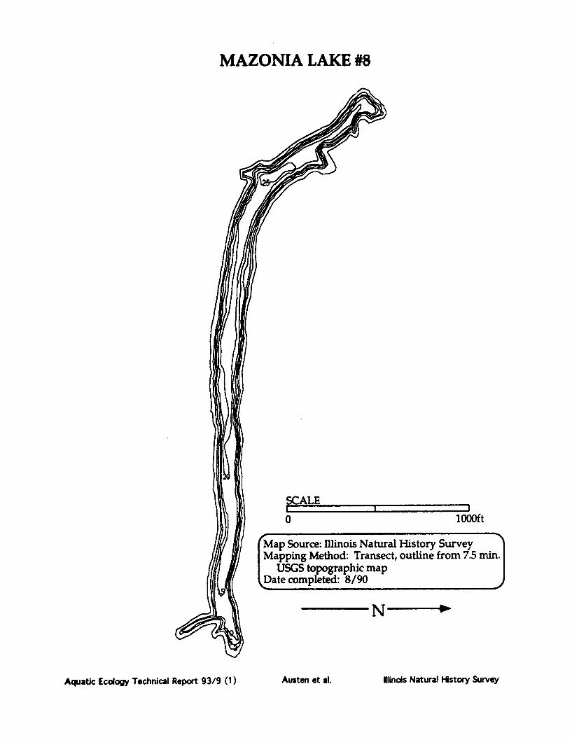
MAZONIA LAKE #8
SCALE
lOOO1ft
al History Survey:t, outline from 7.5 min.
I-- ____j
Aquatic Ecology Technical Report 93/9 (1)
0
Austen et al. Ilinois Natural History Survey

MAZONIA LAKE #8
E/C/0
E/C/O
I
SE/i-
El(
))
Aquatic Ecology Technical Report 93/9 (1)
I N
Habitat Codes "Habitat/Substrate/Hard Cover
' Habitat:W = Woody debrisE = Emergent vegetationR = Rip rap0 = Open areaD = DocksT = Retaining wall or dam faceU = Unknown
Substrate:M = Mud or siltC = ClayS = SandG = GravelB = Rock or boulderU = Unknown
Hard Cover Rating:0 = 0% woody debris and no docks.1 = 0% woody debris with docks or
1-33% woody debris.2 = 1-33% woody debris with many
docks or 34-66% woody debris.3 = 34-66% woody debris with many
docks or > 67% woody debris.
Data compiled by the IllinoisNatural History Survey
Date 10/29/86
I
Iir Iwa .bt/E/u I
C/O
I
I
Austen et al. Winois Natural History Survey

MAZONIA LAKE #9County: GRUNDYLatitude: 411117Longitude: 881556
Township: T31NRange: R8ESection: 2,1
IDOC Region: 2IDOC District 7IDOC Lake Number: 4218Storet Code:IDOC Lake Class: STLake Origin: ASNatural Division: 4E
Year Constructed: 1962
USS 7.5' Quad: GARDNERMajor River Basin: ILLINOISInflowing Stream: FROM MAZ L 8Outflowing Stream: INT >MAZON R>ILL R
Typical Water Chemistry:.Secchi Disk Depth (cm): 244Conductivity (umhos): 725Total Alkalinity (mg/1): 177pH: 7.9
Surface Area (ha): 14.2Surface Area (acres): 34.0Mean Depth (m): 3.45Maximum Depth (m): 7.925Shore Length (km): 5.64Shoreline Dev. Index: 4.23
Watershed Area (ha): 49Storage Cap. (1000 m3): 489.254Retention Time (yrs): 4.4Volume Dev. Index: 1.3
Maximum Length (km):Maximum Width (km):Inshore Mean Depth (m):Pool Elevation (m msl):
1.680.64
3.5182
Climatic Information:Growing Season (days): 174Growing Deg. Days (50*F base): 3126
Habitat Description as a Proportion of Total Shoreline and Shoreline Sampled by ElectrofishingPercent of Percent of Total Shoreline
Habitat Type Total Shoreline Sampled by ElectrofishingE/C/0 100 54
Fish Species Present in Lake (based on IDOC sampling):Bigmouth Buffalo Golden ShinerBlack Bullhead Grass PickerelBlackstripe Topminnow Green SunfishBluegill Green Sunfish X BluegillBluntnose Minnow Largemouth BassBrook Silverside LogperchCarp Longnose GarChannel Catfish Northern PikeFathead Minnow Orangespotted SunfishFreshwater Drum Shorthead RedhorseGizzard Shad Silver RedhorseGolden Redhorse Smallmouth Bass
Smallmouth BuffaloSpotfin ShinerSpotted SuckerWhite CrappieWhite SuckerYellow Bullhead
Aquatic Ecology Technical Report 93/9 (1) Austen et al. Ilinois Natural History Survey

Notes and Comments:
Aquatic Ecology Technical Report 93/9 (1) Austen et al. linois Natural History Survey

MAZONIA LAKE #9
1000ftat 3,5,10,15,20, and 25 feet
tois Natural History Survey1: Transect, outline from 7.5 min.aphic map8/90
Aquatic Ecology Technical Report 93/9 (1) Austen et al. Ilinois Natural History Survey

MAZONIA LAKE #9
c I' I/n
N -~
E/C/O
E/C/O
E/C/0O
E/C/0O
E/C/0
Aquatic Ecology Technical Report 93/9 (1)
E/C/O
' Habitat CodesHabitat/Substrate/Hard Cover
Habitat:W = Woody debrisE = Emergent vegetationR = Rip rap0 = Open areaD = DocksT = Retaining wall or dam faceU = Unknown
Substrate:M = Mud or siltC = ClayS = SandG = GravelB = Rock or boulderU = Unknown
Hard Cover Rating:0 = 0% woody debris and no docks.1 = 0% woody debris with docks or
1-33% woody debris.2 = 1-33% woody debris with many
docks or 34-66% woody debris.3 = 34-66% woody debris with many
docks or > 67% woody debris.
Data compiled by the IllinoisNatural History Survey
ý4 _ Date 11/90
linois Natural History SurveyAusten et al.
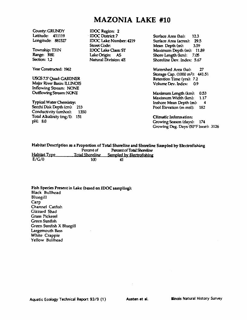
MAZONIA LAKE #10County. GRUNDYLatitude: 411119Longitude: 881527
Township: T31NRange: R8ESection: 1,2
Year Constructed: 1962
IDOC Region: 2IDOC District: 7IDOC Lake Number: 4219Storet Code:IDOC Lake Class: STLake Origin: ASNatural Division: 4E
USGS 7.5' Quad: GARDNERMajor River Basin: ILLINOISInflowing Stream: NONEOutflowing Stream: NONE
Typical Water Chemistry:Secchi Disk Depth (cm): 213Conductivity (umhos): 1350Total Alkalinity (mg/1): 151pH: 8.0
Surface Area (ha): 12.3Surface Area (acres): 295Mean Depth (m): 3.59Maximum Depth (m): 11.89Shore Length (km): 7.05Shoreline Dev. Index: 5.67
Watershed Area (ha): 27Storage Cap. (1000 m3): 441.51Retention Time (yrs): 7.2Volume Dev. Index: 0.9
Maximum Length (km):Maximum Width (km):Inshore Mean Depth (m):Pool Elevation (m msl):
0.531.17
4182
Climatic Information:Growing Season (days): 174Growing Deg. Days (50°F base): 3126
Habitat Description as a Proportion of Total Shoreline and Shoreline Sampled by ElectrofishingPercent of Percent of Total Shoreline
Habitat Type Total Shoreline SamnldM hv Fle•1rnfishinoE/G/0 100 41
Fish Species Present in Lake (based on IDOC sampling):Black BullheadBluegillCarpChannel CatfishGizzard ShadGrass PickerelGreen SunfishGreen Sunfish X BluegillLargemouth BassWhite CrappieYellow Bullhead
Aquatic Ecology Technical Report 93/9 (1) Ilinois Natural History SurveyAusten et al.

Notes and Comments:
Aquatic Ecology Technical Report 93/9 (1) Austen et al. Ilinois Natural History Survey

MAZONIA LAKE #10
-N
Map SotMappin]
USGSI 'l~.^-kl imnin
\~ L~UL~ LIJAAIyA~I~A. 1,1 1 1 ~
Aquatic Ecology Technical Report 93/9 (1)
I
(
Austen et al. Iinois Natural History Survey

MAZONIA LAKE #10
E/G/O
E/G/0
E/G/O,
)
E/G/O
Aquatic Ecology Technical Report 93/9 (1)
Ha HatHabitat/Sul
Habitat:W = WoodE = EmerlR = Rip raO = OpenD = DocksT = RetairU = Unkn<
Substrate:M = MudcC = ClayS = SandG = GraveB = RockU = Unkn<
Hard Cover R0 = 0% wood1 = 0% wood
1-33% wc2 = 1-33% w<
docks or3 = 34-66% '
docks or:
Data compNatural
D,%h- ."Oe* ^
ailder
Austen et al. Iinois Natural History Survey

MCCULLOM LAKECounty: MCHENRYLatitude: 422139Longitude: 881725
Township: T45NRange: R8ESection: 22
IDOC Region: 2IDOC District: 5IDOC Lake Number: 68Storet Code: RT-BO2ZDIDOC Lake Class: PULake Origin: AANatural Division: 3A
Surface Area (ha): 101.6Surface Area (acres): 243.7Mean Depth (m): 1.23Maximum Depth (m): 2.9Shore Length (km): 4.67Shoreline Dev. Index: 1.3
Year Constructed: 1890
USGS 7.5' Quad: MCHENRYMajor River Basin: FOXInflowing Stream: INTOutflowing Stream: DUTCH CR>FOX R
Typical Water Chemistry:Secchi Disk Depth (cm): 112Conductivity (umhos): 547Total Alkalinity (mg/1): 176pH: 8.2
Watershed Area (ha): 261Storage Cap. (1000 m3): 1251.01Retention Time (yrs): 0.7Volume Dev. Index: 1.27
Maximum Length (km): 1.13Maximum Width (km): 1.36Inshore Mean Depth (m): 0.6Pool Elevation (m msl): 230.7
Climatic Information:Growing Season (days): 158Growing Deg. Days (50*F base): 2694
Habitat Description as a Proportion of Total Shoreline and Shoreline Sampled by ElectrofishingPercent of Percent of Total Shoreline
Habitat Type Total Shoreline Sampled by ElectrofishingE/M/1 23 23R/B/0T/S/1T/S/0
46211
446
Fish Species Present in Lake (based on IDOC sampling):Black Bullhead Yellow PerchBlack CrappieBluegillBrown BullheadCarpChannel CatfishGolden ShinerGreen Sunfish X BluegillLargemouth BassNorthern PikePumpkinseedROCK BASS
Aquatic Ecology Technical Report 93/9 (1) Austen et al. Illinois Natural History Survey

Notes and Comments:
Aquatic Ecology Technical Report 93/9 (1) Austen et al. Ilinois Natural History Survey

MC CULLOM LAKE
SCALE0 1000ft
Map Source: Illinois Dept. of ConservationMapping Method: Unknown, outline from ASCS
aerial photoDate completed: 6/23/58
Aquatic Ecology Technical Report 93/9 (1) Austen et al. Ilindis Natural History Survey

MC CULLOM LAKE
Aquatic Ecology Technical Report 93/9 (1)
Habitat Codes (given as a three character code: Habitat/Substrate/Hard Cover)Habitat Substrate: Hard Cover Ratin:W= Woody debris M = Mud or silt 0 = 0% woody debris and no docks.E = Emergent vegetation C = Clay 1= 0% woody debris with docks orR = Rip rap S = Sand 1-33% woody debris.0 = Open area G = Gravel 2 = 1-33% woody debris with many docksD = Docks B = Rock or boulder or 34-66% woody debris.T = Retaining wall or dam face U = Unknown 3 = 34-66% woody debris with many docksU = Unknown or greater than 67% woody debris.Information compiled by the Illinois Natural History Survey, completed 10/29/86,
NW a of w m
Ilinois Natural History SurveyAusten et al.

MILL CREEK LAKECounty: CLARKLatitude: 392425Longitude: 874742
Township: TIlINRange: R13WSection: 13
IDOC Region: 3IDOC District: 9IDOC Lake Number. 116Storet Code: RB-B01-WIDOC Lake Class: PULake Origin: AANatural Division:
Surface Area (ha): 304.5Surface Area (acres): 730.9Mean Depth (m): 6.614Maximum Depth (m): 18.29Shore Length (km): 7239Shoreline Dev. Index: 11.7
Year Constructed: 1980
USGS 75' Quad: CLARKSVILLEMajor River Basin: WABASHInflowing Stream: MILL CR/BRUSHY BR/SNAKEDON BROutflowing Stream: MILL CR>WABASH R>OHIO R
Typical Water Chemistry:.Secchi Disk Depth (cm): 187Conductivity (umhos): 242Total Alkalinity (mg/1): 101pHa 8.1
Watershed Area (ha): 4915Storage Cap. (1000 m3): 20144.26Retention Time (yrs): 1.5Volume Dev. Index: 1.08
Maximum Length (km): 3.95Maximum Width (km): 5.85Inshore Mean Depth (m): 4.25Pool Elevation (m msl): 185.6
Climatic Information:Growing Season (days): 166Growing Deg. Days (50°F base): 2710
Habitat Description as a Proportion of Total Shoreline and Shoreline Sampled by ElectrofishingPercent of Percent of Total Shoreline
Habitat Type Total Shoreline Sampled by ElectrofishingD/C/1E/C/1E/C/2R/B/0
67717
12
Fish Species Present in Lake (based on IDOC sampling):Black Bullhead Longear SunfishBlack Crappie Orangespotted SunfishBlackstripe Topminnow Redear SunfishBluegill Redear X Green SunfishBluegill X Redear Striped ShinerChannel Catfish WalleyeGizzard Shad White CrappieGolden Shiner White SuckerGrass Carp Yellow BullheadGreen SunfishGreen Sunfish X BluegillLargemouth Bass
Aquatic Ecology Technical Report 93/9 (1) Austen et al. Illinois Natural History Survey
Notes and Comments:
Aquatic Ecology Technical Report 93/9 (1) Ilinois Natural History SurveyAusten et al.
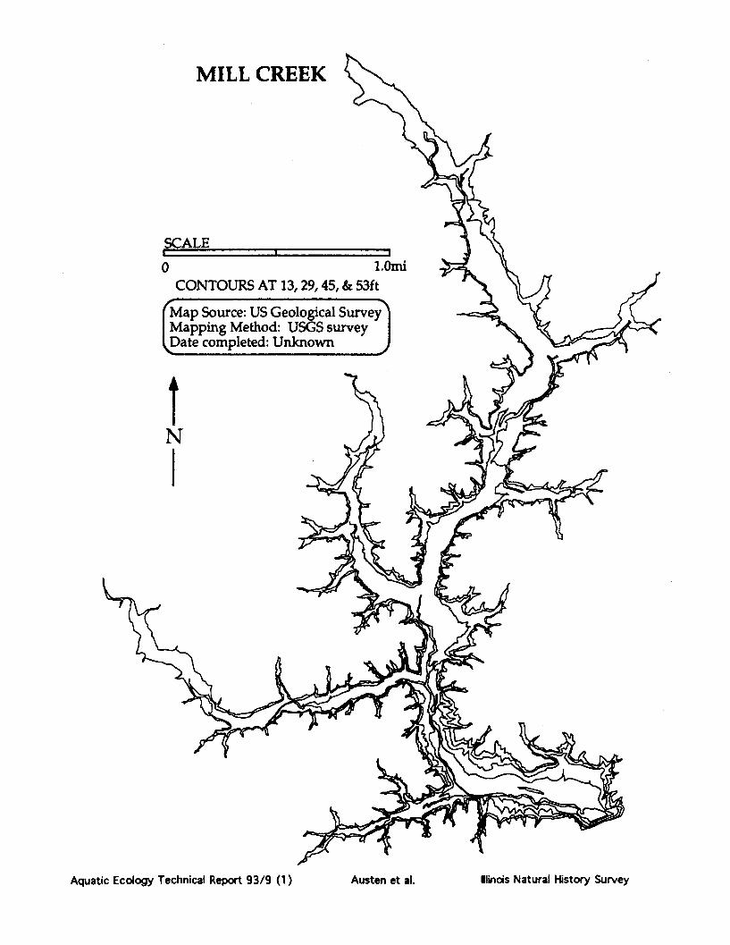
MILL CREEK
SCALE
1.0miCONTOURS AT 13,29,45, & 53ft
Map Source: US Geological SurveyMapping Method: USGS surveyDate completed: Unknown
N
Aquatic Ecology Technical Report 93/9 (1)
0
-- I m
Ilinois Natural History SurveyAusten et al.

MILL CREEK
Habitat CodesHabitat/Substrate/Hard Cover 2
Habitat:W= WE = ErR = Ri0= OD= DT = R<U = U
SubstratNM= MC = C]S =SG= GB = RU = U
Hard Cov0=0% 0w
= 0% w1-339
2 = 1-339docks
3 = 34-66docks
Data ccNatt
E/C/2
/1
E/C/1
Ilinois Natural Hstory SurveyAquatic Ecology Technical Report 93/9 (1)
Al
Austen et al.

LAKE MILLIKENCounty: WILLLatitude: 402006Longitude: 881100
Township: T33NRange: R9ESection: 15,22
IDOC Region: 2IDOC District: 7IDOC Lake Number: 57Storet Code:IDOC Lake Class: STLake Origin: ADNatural Division: 4A
Surface Area (ha):Surface Area (acres):Mean Depth (m):Maximum Depth (m):Shore Length (km):Shoreline Dev. Index:
Year Constructed:
USGS 7.5' Quad: WILMINGTONMajor River Basin: KANKAKEEInflowing Stream: NONEOutflowing Stream: NONE
Typical Water Chemistry:Secchi Disk Depth (cm): 61Conductivity (umhos): 495Total Alkalinity (mg/1): 200pH: 8.5
Watershed Area (ha): 48Storage Cap. (1000 m3): 43.18Retention Time (yrs): 0.5Volume Dev. Index: 0.51
Maximum Length (km):Maximum Width (km):Inshore Mean Depth (m):Pool Elevation (m msl):
1.030.4
0.31161.5
Climatic Information:Growing Season (days): 179Growing Deg. Days (50*F base): 3355
Habitat Description as a Proportion of Total Shoreline and Shoreline Sampled by Electrofishing
Percent of Percent of Total Shoreline
t atibalf Type Total Shoreline Sampled by Electrpf n
R/B/0W/U/1
3070
3070
Fish Species Present in Lake (based on IDOC sampling):Black BullheadBlack CrappieBluegillBrook SilversideCarpEmerald ShinerGizzard ShadGreen SunfishLargemouth BassPumpkinseedRedear SunfishSmallmouth BassWhite Crappie
Aquatic Ecology Technical Report 93/9 (1)
10.425.0
412.44
2.42.1
aw %as Gý m &xv.~mo9Id dxr%16 W 4%& ga w
Ilinois Natural History SurveyAusten et al.

Notes and Comments:
Aquatic Ecology Technical Report 93/9 (1) Austen et al. Ilinois Natural History Survey

T.AKE MTTITTIKT
(
Map Source: I]Mapping Met]USGS topograDate complete
Aquatic Ecology Technical Report 93/9 (1) Ilinois Natural History SurveyAusten et al.

LAKE MILLIKIN
R/B/
N
W/U/1
Habitat CodesHabitat/Substrate/Hard Cover
WER0DTU
Substrate: MCSGBU
Woody debrisEmergent vegetationRip rapOpen areaDocksRetaining wall or dam facUnknown
Mud or siltClaySandGravelRock or boulderUnknown
Hard Cover Rating:0 = 0% woody debris and no docks.1 = 0% woody debris with docks or
1-33% woody debris.2 = 1-33% woody debris with many docks
or 34-66% woody debris.3 = 34-66% woody debris with many docks
or greater than 67% woody debrisData compiled by the Illinois
Natural History SurveyDate 5/1/RQ A
Aquatic Ecology Technical Report 93/9 (1)
Habitat:
W/U/1
Austen et al. linois Natural History Survey
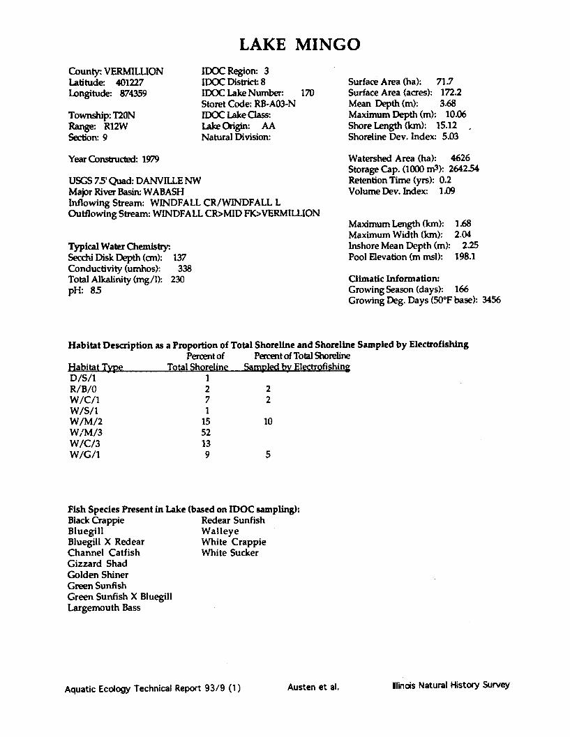
LAKE MINGO
County: VERMILLIONLatitude: 401227Longitude: 874359
Township: T20NRange: R12WSection: 9
IDOC Region: 3IDOC District. 8IDOC Lake Number:Storet Code: RB-A03-NIDOC Lake Class:Lake Origin: AANatural Division:
170
Year Constructed: 1979
USGS 75' Quad: DANVILLE NWMajor River Basin: WABASHInflowing Stream: WINDFALL CR/WINDFALL LOutflowing Stream: WINDFALL CR>MID FK>VERMILLION
Typical Water Chemistry:Secchi Disk Depth (cm): 137Conductivity (umhos): 338Total Alkalinity (mg/1): 230pH: 8.5
Surface Area (ha): 71.7Surface Area (acres): 172.2Mean Depth (m): 3.68Maximum Depth (m): 10.06Shore Length (km): 15.12Shoreline Dev. Index: 5.03
Watershed Area (ha): 4626Storage Cap. (1000 m3): 2642.54Retention Time (yrs): 0.2Volume Dev. Index: 1.09
Maximum Length (km):Maximum Width (km):Inshore Mean Depth (m):Pool Elevation (m msl):
1.682.04
2.25198.1
Climatic Information:Growing Season (days): 166Growing Deg. Days (50°F base): 3456
Habitat Description as a Proportion of Total Shoreline and Shoreline Sampled by ElectrofishingPercent of Percent of Total Shoreline
Habitat Tvnr Total Shoreline Samnled byv Electrofishin,D/S/1R/B/0W/C/1W/S/1W/M/2W/M/3W/C/3W/G/1
1271
1552139
22
10
5
Fish Species Present in Lake (based on IDOC sampling):Black Crappie Redear SunfishBluegill WalleyeBluegill X Redear White CrappieChannel Catfish White SuckerGizzard ShadGolden ShinerGreen SunfishGreen Sunfish X BluegillLargemouth Bass
Aquatic Ecology Technical Report 93/9 (1) Illinois Natural History SurveyAusten et al.

Notes and Comments:
Aquatic Ecology Technical Report 93/9 (1) Austen et al. Winois Natural History Survey

LAKE MINGO
SCALEI ,, I
0 0.5mi
Map Source: Illinois Natural History SurveyMapping Method: Transect, outline from ASCS
aerial photoD~ate completed: 4/8/87 ,
Aquatic Ecology Technical Report 93/9 (1)
N
Ilinois Natural History SurveyAusten et al.

LAKE MINGO
W/M/3
W/M/2
W/M/2
W/C/3
W/G/IW/C/1
W/C/l
R/B/0
N
W/C/l
Aquatic Ecology Technical Report 93/9 (1)
W/M/3
Habitat Codes (given as a three character code: Habitat/Substrate/Hard Cover)Habiat: SubsInalei: Hard Cover Rating:W= Woody debris M = Mud or silt 0 = 0% woody debris and no docks.E = Emergent vegetation C a Clay I = 0% woody debris with docks orR = Rip rap S = Sand 1-33% woody debris.0 = Open area G = Gravel 2 = 1-33% woody debris with many docksD = Docks B = Rock or boulder or 34-66% woody debris.T = Retaining wall or dam face U = Unknown 3 = 34-66% woody debris with many docksU = Unknown or greater than 67% woody debris.Information compiled by the Illinois Natural History Survey, completed 10/29/86ý
Austen et al. linods Natural History Survey

MONEE RESERVOIRCounty: WILLLatitude: 412330Longitude: 874539
Township: T34NRange: R13ESection: 32
IDOC Region: 2IDOC District: 7IDOC Lake Number: 61STORET Code:IDOC Lake Class: PULake OriginNatural Division: 3A
Surface Area (ha): 17.7Surface Area (acres): 42.5Mean Depth (m): 2.777Maximum Depth (m): 8.23Shore Length (km): 3.175Shoreline Dev. Index: 2.12
Year Constructed:
USGS 75' Quad: FRANKFURTMajor River Basin: KANKAKEEInflowing Stream: NONEOutflowing Stream: NO NAME>ROCK CR>KANK R
Typical Water Chemistry:Secchi Disk Depth (cm): 29Conductivity (umhos): 491Total Alkalinity (mg/1): 119pH:
Watershed Area (ha): 363Storage Cap. (1000 m3): 492.21Retention Time (yrs): 0.6Volume Dev. Index: 1.01
Maximum Length (km): 0525Maximum Width (km): 0.805Inshore Mean Depth (m): 2.82Pool Elevation (m msl): 228.6
Climatic Information:Growing Season (days): 165Growing Deg. Days (50*F base): 2996
Habitat Description as a Proportion of Total Shoreline and Shoreline Sampled by ElectrofishingPercent of Percent of Total Shoreline
Habitat Type Total Shoreline Sampled by Electrofishing
N/A
Fish Species Present in Lake (based on IDOC sampling):Black BullheadBlack CrappieBluegillCarpChannel CatfishGolden ShinerGreen SunfishLargemouth BassNorthern PikeWarmouthWhite CrappieYellow Bullhead
Aquatic Ecology Technical Report 93/9 (1) Austen et al. Ilinois Natural History Survey

MONEE RESERVOIR
N
SCALE
0 500ftCONTOUR INTERVAL 2ft
Map Source: Will Co. Forest Preserve Dist.Mapping Method: Basin planDate completed: 1991
Aquatic Ecology Technical Report 93/9 (1)
• j !
F00-
Austen et al. Ilinois Natural History Survey
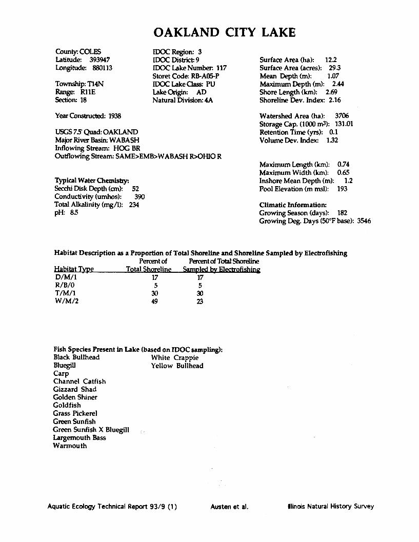
OAKLAND CITY LAKECounty : COLESLatitude: 393947Longitude: 880113
Township: T14NRange: R11ESection: 18
IDOC Region: 3IDOC District 9IDOC Lake Number. 117Storet Code: RB-A05-PIDOC Lake Class: PULake Origin: ADNatural Division: 4A
Year Constructed: 1938
USGS 7.5' Quad: OAKLANDMajor River Basin: WABASHInflowing Stream: HOG BROutflowing Stream: SAME>EMB>WABASH R>OHIO R
Typical Water Chemistry:.Secchi Disk Depth (cm): 52Conductivity (umhos): 390Total Alkalinity (mg/1): 234pH: 8.5
Surface Area (ha): 12.2Surface Area (acres): 29.3Mean Depth (m): 1.07Maximum Depth (m): 2.44Shore Length (km): 2.69Shoreline Dev. Index: 2.16
Watershed Area (ha): 3706Storage Cap. (1000 m3): 131.01Retention Time (yrs): 0.1Volume Dev. Index: 132
Maximum Length (km): 0.74Maximum Width (km): 0.65Inshore Mean Depth (m): 1.2Pool Elevation (m msl): 193
Climatic Information:Growing Season (days): 182Growing Deg. Days (50*F base): 3546
Habitat Description as a Proportion of Total Shoreline and Shoreline Sampled by ElectrofishingPercent of Percent of Total Shoreline
Habitat Type Total Shoreline Sampled by ElectrofishingD/M/1 17 17R/B/0 5 5T/M/1 30 30W/M/2 49 23
Fish Species Present in Lake (based on IDOC sampling):Black Bullhead White CrappieBluegill Yellow BullheadCarpChannel CatfishGizzard ShadGolden ShinerGoldfishGrass PickerelGreen SunfishGreen Sunfish X BluegillLargemouth BassWarmouth
Aquatic Ecology Technical Report 93/9 (1) Hlinois Natural History SurveyAusten et al.

Notes and Comments:
Aquatic Ecology Technical Report 93/9 (1) Austen et al. Ilinois Natural History Survey

OAKLAND CITY LAKE
Map Source: ]Mapping Met
aerial photDate complet
0 500ft IX T
Illinois Natural History Surveythod: Transect, outline from ASCStoed: 4/9/87
IN
Aquatic Ecology Technical Report 93/9 (1) Austen et al. Minois Natural History Survey

OAKLAND CITY T.AKE.W/M/2
W/M/2
N
El
W/M/2
D/MjT/M/I
V /IL A1I/M/ I
W/M/2
Aquatic Ecology Technical Report 93/9 (1)
Habitat Codes (given as a three character code: Habitat/Substrate/Hard Cover)Habilat: Substrate; Hard Cover Rating:W= Woody debris M = Mud or silt 0 = 0% woody debris and no docks.E = Emergent vegetation C = lay 1 = 0% woody debris with docks orR = Rip rap S = Sand 1-33% woody debris.0 = Open area G = Gravel 2 = 1-33% woody debris with many docksD = Docks B = Rock or boulder or 34-66% woody debris.T = Retaining wall or dam face U = Unknown 3 = 34-66% woody debris with many docksU = Unknown or greater than 67% woody debris.Information compiled by the llinois Natural History Survey, completed 4/9/87
Ilinois Natural History SurveyAusten et al.

PANA LAKECounty: CHRIST/SHELBYLatitude: 392155Longitude: 890116
Township: T I1NRange: R2ESection: 30
IDOC Region: 3IDOC District: 9IDOC Lake Number: 155Storet Code: RO-B03-FIDOC Lake Class: PULake Origin: AANatural Division: 9A
Surface Area (ha): 85.4Surface Area (acres): 205.0Mean Depth (m): 4.173Maximum Depth (m): 10.973Shore Length (km): 18.464Shoreline Dev. Index: 5.63
Year Constructed: 1952
USGS 7.5' Quad: PANA OR OCONEEMajor River Basin: KASKASKIAInflowing Stream: INTOutflowing Stream: BECKS CR>KASK R
Typical Water Chemistry:.Secchi Disk Depth (cm): 69Conductivity (umhos): 271Total Alkalinity (mg/1): 86pH: 8.9
Watershed Area (ha): 3756Storage Cap. (1000 m3): 3564.91Retention Time (yrs): 0.1Volume Dev. Index: 1.14
Maximum Length (km): 1.809Maximum Width (km): 2.543Inshore Mean Depth (m): 3.6Pool Elevation (m msl): 195.4
Climatic Information:Growing Season (days): 192Growing Deg. Days (50°F base): 3698
Habitat Description as a Proportion of Total Shoreline and Shoreline Sampled by ElectrofishingPercent of Percent of Total Shoreline
Habitat Type Total Shoreline Sampled by ElectrofishingR/B/0 8 5R/C/1 7 7W/C/1W/M/2W/S/2
58207
21
Fish Species Present in Lake (based on IDOC sampling):Black Bullhead Longear SunfishBlack Crappie Orangespotted SunfishBlackstripe Topminnow Redear SunfishBluegill Tiger MuskellungeCarp WarmouthChannel Catfish White CrappieFreshwater Drum Yellow BullheadGizzard ShadGolden ShinerGreen SunfishGreen Sunfish X BluegillLargemouth Bass
Aquatic Ecology Technical Report 93/9 (1) Austen et al. Ilindois Natural History Survey

Notes and Comments:
Aquatic Ecology Technical Report 93/9 (1) Austen et al. Illinois Natural History Survey

PANA LAKE
Map Source: Illinois Natural History SurveyMapping Method: Transect, outline from 7.5 min.
USGS topographic mapDate completed: 6/26/87
SCALE
0 0.5mi
N
luatic Ecology Technical Report 93/9 (1) Austen et al. linois Natural History Survey
moor

PANA LAKE
W/M/2
W/M/2
W/C/1
W/C/1W/C/1
W/C/1
R/B/O
Habitat/HabitatW =E =R =0=D =T =U =
SubstraM =C-SG =B =U -
Hard Coo =0%m1= 0%
1-332 =1-33
dock3 = 34-66% woody debris with many
docks or > 67% woody debris.
Data compiled by the IllinoisNatural History Survey
Date 6/26/87
W/C/1
W/C/1
R/B/O
K/D/U
Aquatic Ecology Technical Report 93/9 (1)
R/B/OW/M/2
N
Jolrv
'%%, --- -1 -- -IAusten et al. Iindois Natural History Survey

LAKE PARADISECounty: COLESLatitude: 392447Longitude: 882627
Township: Tl INRange: R7ESection: 4,5,8
IDOC Region: 3IDOC District 9IDOC Lake Number: 119Storet Code: RC-A09-GIDOC Lake Class: PULake Origin: AANatural Division: 4A
Surface Area (ha): 57.6Surface Area (acres): 138.2Mean Depth (m): 2.59Maximum Depth (m): 4.88Shore Length (km): 6.36Shoreline Dev. Index: 2.36
Year Constructed: 1931 Watershed Area (ha): 4686Storage Cap. (1000 m3): 1628.36
USGS 7.5 Quad: MATTOON W Retention Time (yrs): 0.1Major River Basin: WABASH Volume Dev. Index: 1.59Inflowing Stream: LIL WABASH ROutflowing Stream: SAME>MATTOON>LIL WAB>WABASH>OH
Maximum Length (km): 1.34Maximum Width (km): 1.67
Typical Water Chemistry: Inshore Mean Depth (m): 1.5Secchi Disk Depth (cm): 39 Pool Elevation (m msl): 208.9Conductivity (umhos): 454Total Alkalinity (mg/1): 152 Climatic Information:pH: 8.1 Growing Season (days): 183
Growing Deg. Days (50°F base): 3561
Habitat Description as a Proportion of Total Shoreline and Shoreline Sampled by ElectrofishingPercent of Percent of Total Shoreline
Habitat Type Total Shoreline Sampled by ElectrofishingD/C/1 6 6E/S/0 15 3E/S/1 5 5E/C/0 3 2O/C/0 6 3O/S/0 1 0R/B/0 13 13T/U/0 1 0W/S/1 2 2W/C/3 4 4W/S/2 3 3W/C/1 39 18W/C/2 1 1
Fish Species Present in Lake (based on IDOC sampling):Black Bullhead Freshwater DrumBluegill Gizzard ShadBluegill X Longear Golden ShinerCarp Green SunfishChannel Catfish Largemouth BassFlathead Catfish Longear Sunfish
Orangespotted SunfishRedfin ShinerTiger MuskellungeWarmouthWhite CrappieYellow Bullhead
Aquatic Ecology Technical Report 93/9 (1) Ilinois Natural History SurveyAusten et al.

Notes and Comments:
Aquatic Ecology Technical Report 93/9 (1) Austen et al. Ilinois Natural History Survey

LAKE PARADISE
N
SCALE0 1000ft
j JVAGljp lg 1 eJ•UtUU. : 1 4alnlt ,l UUUUile rUlll /...•Ill.jUSGS topographic map 5Date completed: 5/22/90
Aquatic Ecology Technical Report 93/9 (1) Austen et al. Ilinois Natural History Survey

E/S/0'0
E/S/O
E/S/0
O/S/o
W/S/2
C/IE/S/1
E2
W/C/1
El E/C/O " E/C/0
N
R/B/O
R/B/O
Aquatic Ecology Technical Report 93/9 (1)
LAKE PARADISE
W/C/2
E2
"V,0
E
D/C/1
R/B/0
O/C/o
Habitat Codes (given as a three character code: Habitat/Substrate/Hard Cover)HabitaL S te Hard Cover Ratin:W = Woody debris M = Mud or silt 0 = 0% woody debris and no docks.E = Emergent vegetation C = Clay 1= 0% woody debris with docks orR = Rip rap S = Sand 1-33% woody debris.0 = Open area G = Gravel 2 = 1-33% woody debris with many docksD = Docks B = Rock or boulder or 34-66% woody debris.T = Retaining wall or dam face U = Unknown 3 = 34-66% woody debris with many docksU = Unknown or greater than 67% woody debris.Information compiled by the Illinois Natural History Survey, completed 10/29/86,
I
!
linois Natural History SurveyAusten et al.

PARIS EAST LAKECounty: EDGARLatitude: 393753Longitude: 874043
Township: T14NRange: R12WSection: 31,25
IDOC Region: 3IDOC District: 9IDOC Lake Number: 128Storet Code: RB-A04-LIDOC Lake Class: PULake Origin: AANatural Division: 4A
Surface Area (ha): 67.9Surface Area (acres): 163.0Mean Depth (m): 255Maximum Depth (m): 6.4Shore Length (km): 12.53Shoreline Dev. Index: 4.28
Year Constructed: 1916
USGS 75 Quad: PARIS NMajor River Basin: WABASHInflowing Stream: PARIS W LOutflowing Stream: SUGAR CR>WABASH R>OHIO R
Typical Water Chemistry.Secchi Disk Depth (cm): 46Conductivity (umhos): 350Total Alkalinity (mg/1): 103pH: 8.8
Watershed Area (ha): 5180Storage Cap. (1000 m3): 1735.7Retention Time (yrs): 0.2Volume Dev. Index: 1.19
Maximum Length (km): 1.45Maximum Width (km): 1.93Inshore Mean Depth (m): 1.45Pool Elevation (m msl): 201.2
Climatic Information:Growing Season (days): 166Growing Deg. Days (50*F base): 2710
Habitat Description as a Proportion of Total Shoreline and Shoreline Sampled by Electrofishing
Percent of Percent of Total Shoreline
Uphitpt Type Total Shoreline Sampled by strofis g
E/C/0O/S/0R/B/0R/G/0R/B/1W/C/2W/C/1W/G/1
91614
63
1
2
I
47
Fish Species Present in Lake (based on IDOC sampling):Black Bullhead Longear SunfishBlack Crappie White CrappieBluegill White SuckerCarp Yellow BullheadChannel CatfishFlathead CatfishGolden ShinerGreen SunfishGreen Sunfish X BluegillLargemouth Bass
Aquatic Ecology Technical Report 93/9 (1)
- I"'r . .. .. . ... ,'r 'w' °,""lr.. . . M. ... . .wa ,- as.....
Austen et al. Ilinois Natural History Survey

Notes and Comments:
Aquatic Ecology Technical Report 93/9 (1) Austen et al. Illinois Natural History Survey
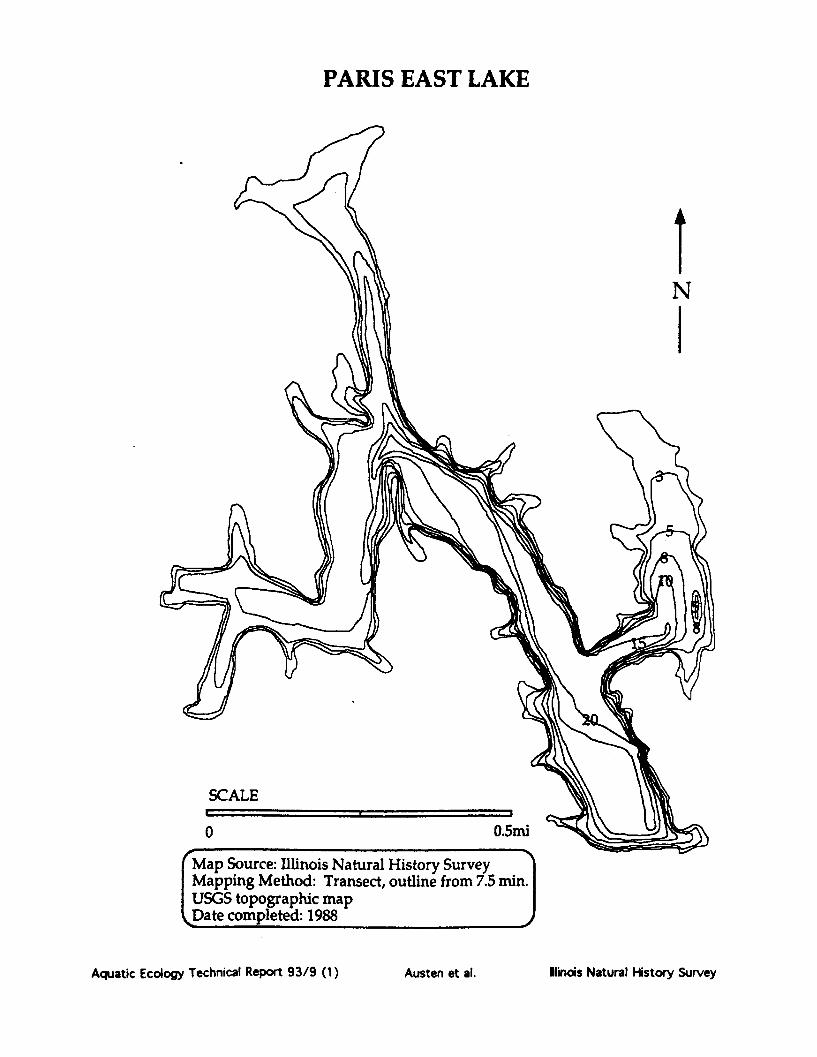
PARIS EAST LAKE
N
SCALE
0 0.5mi
Map Source: Illinois Natural History SurveyMapping Method: Transect, outline from 7.5 min.USGS topographic mapDate completed: 1988
Aquatic Ecology Technical Report 93/9 (1) Austen et al. Ilinois Natural History Survey

PARIS EAST LAKEA
W/G/i
N
t/C/1
W/C/2
/C/2
R/G/O
W/C/1
Aquatic Ecology Technical Report 93/9 (1)
Habitat Codes (given as a three character code: Habitat/Substrate/Hard Cover)Habitat: Substrate: Hard Cover Rating:W= Woody debris M = Mud or silt 0 = 0% woody debris and no docks.E = Emergent vegetation C = Clay I = 0% woody debris with docks orR = Rip rap S = Sand 1-33% woody debris.0 = Open area G = Gravel 2 = 1-33% woody debris with many docksD = Docks B = Rock or boulder or 34-66% woody debris.T = Retaining wall or dam face U = Unknown 3 = 34-66% woody debris with many docksU = Unknown or greater than 67% woody debris.Information compiled by the Illinois Natural History Survey, completed 7/19/88
E/C
Austen et al. Ilinois Natural History Survey
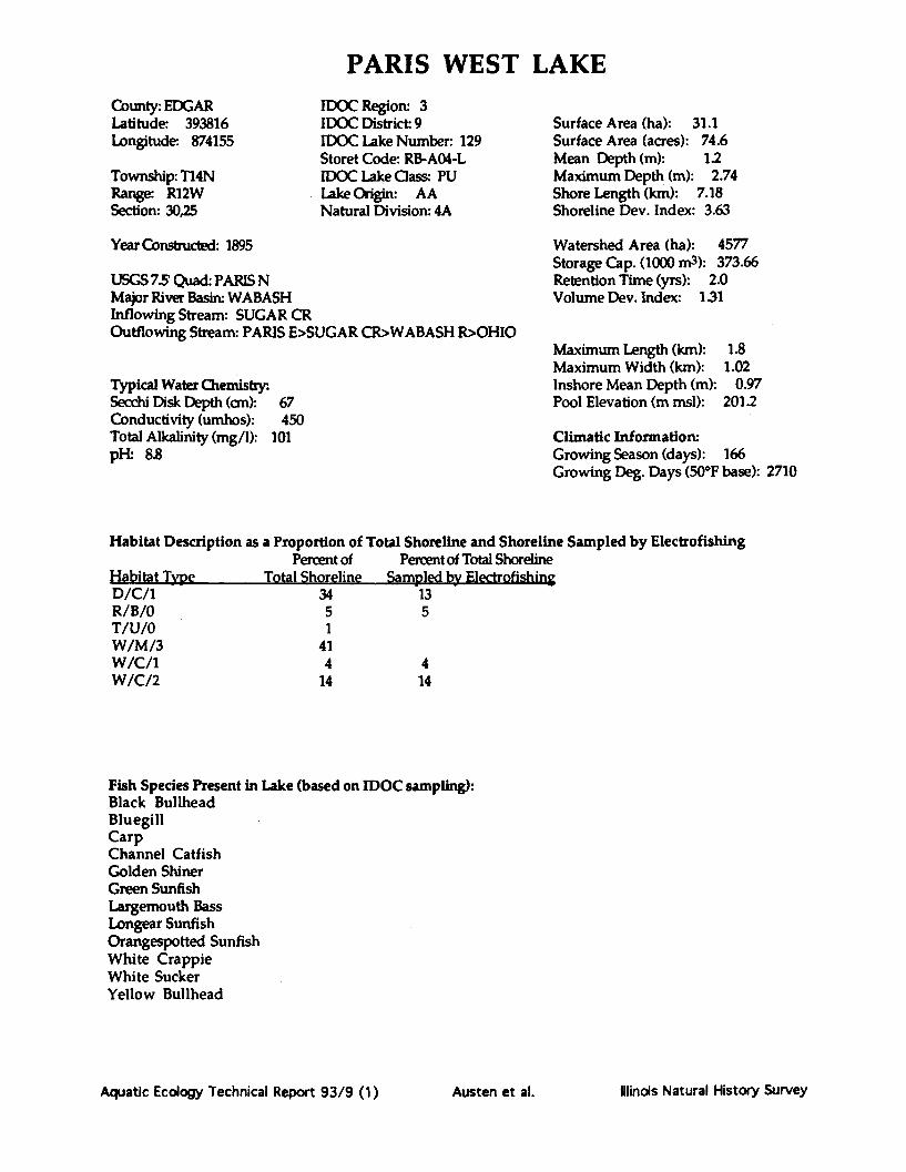
PARIS WEST LAKECounty: EDGARLatitude: 393816Longitude: 874155
Township: T14NRange: R12WSection: 30,25
IDOC Region: 3IDOC District: 9IDOC Lake Number: 129Storet Code: RB-AO4-LIDOC Lake Cass: PULake Origin: AANatural Division: 4A
Year Constructed: 1895
USGS 7.5' Quad: PARIS NMajor River Basin: WABASHInflowing Stream: SUGAR CROutflowing Stream: PARIS E>SUGAR CR>WABASH R>OHIO
Typical Water Chemistry:Secchi Disk Depth (cm): 67Conductivity (umhos): 450Total Alkalinity (mg/l): 101pH- 8.8
Surface Area (ha): 31.1Surface Area (acres): 74.6Mean Depth (m): 1.2Maximum Depth (m): 2.74Shore Length (km): 7.18Shoreline Dev. Index: 3.63
Watershed Area (ha): 4577Storage Cap. (1000 m3): 373.66Retention Time (yrs): 2.0Volume Dev. Index: 131
Maximum Length (km):Maximum Width (km):Inshore Mean Depth (m):Pool Elevation (m msl):
1.81.02
0.97201.2
Climatic Information:Growing Season (days): 166Growing Deg. Days (50*F base): 2710
Habitat Description as a Proportion of Total Shoreline and Shoreline Sampled by Electrofishing
Percent of Percent of Total Shoreline
Habitat Type Total Shoreline Smpled by Electrofishing
D/C/1R/B/0T/U/0W/M/3W/C/1W/C/2
3451
414
14
135
414
Fish Species Present in Lake (based on IDOC sampling):Black BullheadBluegillCarpChannel CatfishGolden ShinerGreen SunfishLargemouth BassLongear SunfishOrangespotted SunfishWhite CrappieWhite SuckerYellow Bullhead
Aquatic Ecology Technical Report 93/9 (1)
-- -- T¥--- T---T ....... "i'-T .... ---- • ...........
Illinois Natural History SurveyAusten et al.
Notes and Comments:
Aquatic Ecology Technical Report 93/9 (1) Austen et al. Iinois Natural History Survey

PARIS WEST LAKE
SCALE
0
Aquatic Ecology Technical Report 93/9 (1) Ilinos Natural History Survey
Y5 mini
dwmý
dW'%F %F %F 41L GP
Austen et al.

PARIS WEST LAKE
W/M/3
W/C/2
W/C/2
W/C/2
D/C/1
D/C/1
T/U/0
N -~
Aquatic Ecology Technical Report 93/9 (1)
D/C/1R/B/0
Habitat CodesHabitat/Substrate/Hard Cover
Habitat:W = Woody debrisE = Emergent vegetationR = Riprap0 = Open areaD = DocksT = Retaining wall or dam faceU = Unknown
Substrate:M = Mud or siltC = ClayS = SandG = GravelB = Rock or boulderU = Unknown
Hard Cover Rating:0 = 0% woody debris and no docks.I = 0% woody debris with docks or
1-33% woody debris.2 = 1 -33% woody debris with many
docks or 34-66% woody debris.3 = 34-66% woody debris with many
docks or > 67% woody debris.
Data compiled by the IllinoisNatural History Survey
Date 7/19/88 J"%0
D/
Fore
Austen et al. Ilinois Natural History Survey

PETITE LAKE(Fox Chain of Lakes)
County: LAKELatitude: 422545longitude: 880755
jownship: T46Nlange: R9E,R10ection: 25,30,36
IDOC Region: 2IDOC District: 6IDOC Lake Number: 4224STORET Code: VT-B01-WIDOC Lake Class:Lake Origin: NGNatural Division: 3A
Surface Area (ha): 97.7Surface Area (acres): 234.5Mean Depth (m): 1.579Maximum Depth (m): 4.877Shore Length (km): 14.848Shoreline Dev. Index: 4.23
Year Constructed: 1939
USGS 7.5' Quad: fox lake/antiochMajor River Basin: FOXInflowing Stream: BLUFF LOutflowing Stream: FOX L>FOX R
Typical Water Chemistry:Secchi Disk Depth (cm): 41Conductivity (umhos): 606Total Alkalinity (mg/1): 286pH: 8.3
Watershed Area (ha): 405Storage Cap. (1000 m3): 1544.12Retention Time (yrs): 0.1Volume Dev. Index: 0.97
Maximum Length (km): 1.629Maximum Width (km): 2.946Inshore Mean Depth (m): 1.22Pool Elevation (m msl): 224.9
Climatic Information:Growing Season (days): 158Growing Deg. Days (50*F base): 2694
Habitat Description as a Proportion of Total Shoreline and Shoreline Sampled by Electrofishing
Percent of Percent of Total Shoreline
Habitat Type Total Shoreline Sampl@ by Electrpf g
T/M/1U/U/0W/M/2
362
62
12
6
Fish Species Present in Lake (based on IDOC sampling):Black Bullhead Quillback CarpsuckerBlack Crappie WalleyeBluegill White BassBowfin White CrappieBrown Bullhead White SuckerBrook Silverside Yellow PerchCarp Yellow BassChannel CatfishGreen SunfishLargemouth BassLogperchMuskellungeNorthern PikePumpkinseed
Aquatic Ecology Technical Report 93/9 (1)
. , %,#"a a.... ..-... r. I"
19"&*-_16 FrT &.&AS. y--y .....-
Illinois Natural History SurveyAusten et al.

Notes and Comments:
Aquatic Ecology Technical Report 93/9 (1) Austen et al. Ilinois Natural History Survey

PETITE LAKE
SCALE
0
N
Aquatic Ecology Technical Report 93/9 (1)
)urce: Illinois Natural History Surveyig Method: Transect, outline from 7.5opographic map)mpleted: 10/24/89
W04WISA8 8LA
Austen et al. Ilinois Natural History Survey

PETITE LAKE
N
fM/2
T/M/I
W/M/2 / 4E1
W/M/2
T/M/I
T/M/1
W/M/2
Aquatic.cology.echnica Report 93/9 (1) Austen a.NaturWalH.story.Surve y
Habitat Codes (given as a three character code: Habitat/Substrate/Hard Cover)Habitat: S ra Hard Cover Rating:W = Woody debris M = Mud or silt 0 = 0% woody debris and no docks.E = Emergent vegetation C = Clay 1= 0% woody debris with docks orR = Rip rap S = Sand 1-33% woody debris.0 = Open area G = Gravel 2 = 1-33% woody debris with many docksD = Docks B = Rock or boulder or 34-66% woody debris.T = Retaining wall or dam face U = Unknown 3 = 34-66% woody debris with many docksU = Unknown or greater than 67% woody debris.Infnrmation comniled by the Illinnis Natural History Survey. completed 10/24/891
Ilinois Natural History SurveyAquatic Ecology Technical Report 93/9 (1) Austen et al.

PIERCE LAKECounty: WINNEBAGOLatitude: 422043Longitude: 885904
Township: T45NRange: R2ESection: 26,27
IDOC Region: 1IDOC District. 2IDOC Lake Number: 17Storet Code: RP-B02-CIDOC Lake Class: STLake Origin: AANatural Division: 2A
Surface Area (ha): 61.2Surface Area (acres): 146.9Mean Depth (m): 3.41Maximum Depth (m): 10.06Shore Length (km): 6.72Shoreline Dev. Index: 2.42
Year Constructed: 1960
USGS 7.5' Quad: CALEDONIAMajor River Basin: ROCKInflowing Stream: WILLOW CROutflowing Stream: WILLOW CR>ROCK R
Typical Water Chemistry:Secchi Disk Depth (cm): 79Conductivity (umhos): 462Total Alkalinity (mg/1): 163pH: 8S8
Watershed Area (ha): 8150Storage Cap. (1000 m3): 2091.23Retention Time (yrs): 0.4Volume Dev. Index: 1.01
Maximum Length (km): 0.92Maximum Width (km): 1.8Inshore Mean Depth (m): 1.1Pool Elevation (m msl):
Climatic Information:Growing Season (days): 152Growing Deg. Days (50°F base): 2813
Habitat Description as a Proportion of Total Shoreline and Shoreline Sampled by ElectrofishingPercent of Percent of Total Shoreline
Habitat Type Total Shoreline Sampled by ElectrofishingE/G/0 15 15E/B/0 2 2E/U/0O/G/0R/B/0R/B/2U/U/0W/G/2W/U/3
6722
43176
67215
176
Fish Species Present in Lake (based on IDOC sampling):Black Bullhead MuskellungeBlack Crappie Smallmouth BassBluegill Spotfin ShinerBluntnose Minnow WalleyeBrook Silverside White CrappieBrown Bullhead White SuckerCarp Yellow BullheadChannel Catfish Yellow PerchGizzard ShadGolden ShinerGreen SunfishLargemouth Bass
Aquatic Ecology Technical Report 93/9 (1) Austen et al. Ilinois Natural History Survey

Notes and Comments:
Aquatic Ecology Technical Report 93/9 (1) Austen et al. Ilinois Natural History Survey

PIERCE LAKE
SCAL
0
Map SMappiaerial pDate c
Aquatic Ecology Technical Report 93/9 (1)
4b f F f- s
Austen et al. Ilindois Natural History Survey

PIERCE LAKE
R/B/O
U/U/o
E
U/U/O
E2
W/G/2
E5
G2
¢3
u/u/o
Aquatic Ecology Technical Report 93/9 (1)
U/U/OE/G/0
E4
G3
--- N-
E42
U/U/O0" Habitat Co<Habitat/Substrate/Ha]
Habitat:W = Woody debrisE = Emergent vegetatR = Rip rapO = Open areaD = DocksT = Retaining wall orU = Unknown
Substrate:M = Mud or siltC = ClayS = SandG = GravelB = Rock or boulderU = Unknown
Hard Cover Rating:0 = 0% woody debris anx1 = 0% woody debris wit
1-33% woody debris.2 = 1-33% woody debris
docks or 34-66% wo<3 = 34-66% woody debri
docks or > 67% wooc
Data compiled by thi1LT-«-L --..ll U**.-A^..- t
iNamJra nistory burveyDate 9/9/85 j
;/0
0
0
Austen et al. llinois Natural History Survey
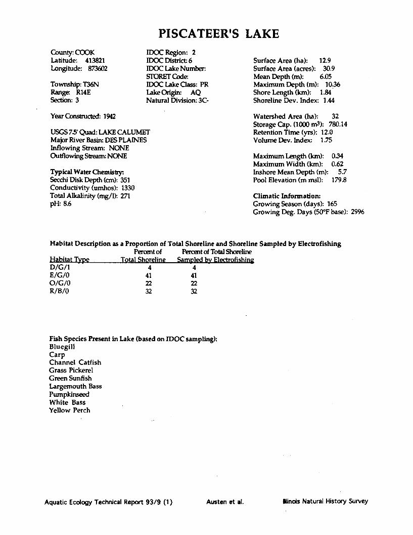
PISCATEER'S LAKECounty: COOKLatitude: 413821Longitude: 873602
Township: T36NRange. R14ESection: 3
IDOC Region: 2IDOC District- 6IDOC Lake Number:STORET Code.IDOC Lake Oass: PRLake Origin: AQNatural Division: 3C-
Surface Area (ha): 12.9Surface Area (acres): 30.9Mean Depth (m): 6.05Maximum Depth (m): 10.36Shore Length (km): 1.84Shoreline Dev. Index: 1.44
Year Constructed: 1942
USGS 75' Quad: LAKE CALUMETMajor River Basin: DES PLAINESInflowing Stream: NONEOutflowing Stream: NONE
Typical Water ChemistrySecchi Disk Depth (cm): 351Conductivity (umhos): 1330Total Alkalinity (mg/1): 271pH: 8.6
Watershed Area (ha): 32Storage Cap. (1000 m3): 780.14Retention Time (yrs): 12.0Volume Dev. Index: 1.75
Maximum Length (km): 0.34Maximum Width (km): 0.62Inshore Mean Depth (m): 5.7Pool Elevation (m msl): 179.8
Climatic Information:Growing Season (days): 165Growing Deg. Days (50*F base): 2996
Habitat Description as a Proportion of Total Shoreline and Shoreline Sampled by Electrofishing
Percent of Percent of Total Shoreline
Hebitat Type Total Shoreline Sampled by Electrofish g
D/G/1E/G/0O/G/OR/B/0
4412232
4412232
Fish Species Present in Lake (based on IDOC sampling):BluegillCarpChannel CatfishGrass PickerelGreen SunfishLargemouth BassPumpkinseedWhite BassYellow Perch
Aquatic Ecology Technical Report 93/9 (1)
-ýWm
Austen et al. Ilinois Natural History Survey


Notes and Comments:
Aquatic Ecology Technical Report 93/9 (1) Austen et al. lindois Natural History Survey

PISCATEER LAKE
I rI~2,')'Oft
Aquatic Ecology Technical Report 93/9 (1)
ois Natural History Survey: Transect, outline from 7.5 minc map8/1/89
iLE
XA
Ilinois Natural History SurveyAusten et al.

PISCATEER LAKE
D/Gj
O/G/O
Aquatic Ecology Technical Report 93/9 (1)
- -Habitat Codes 'Habitat/Substrate/Hard Cover
Habitat:W = Woody debrisE = Emergent vegetationR = Rip rap0 = Open areaD = DocksT = Retaining wall or dam faceU = Unknown
Substrate:M = Mud or siltC = ClayS = SandG = GravelB = Rock or boulderU = Unknown
Hard Cover Rating:0 = 0% woody debris and no docks.1 = 0% woody debris with docks or
1-33% woody debris.2 = 1-33% woody debris with many
docks or 34-66% woody debris.3 = 34-66% woody debris with many
docks or > 67% woody debris.
Data compiled by the IllinoisNatural History Survey
Date 8/1/89Nl _- - -I , .O f
llinois Natural History SurveyAusten et al.

PISTAKEE LAKE(Fox Chain of Lakes)
County: LAKELatitude: 422339Longitude: 881216
Township: T45NRange: R9ESection: 9,16
IDOC Region: 2IDOC District: 6IDOC Lake Number: 4225STORET Code: RT-B01-UIDOC Lake Class: PULake Origin: NGNatural Division: 3A
Surface Area (ha): 714.9Surface Area (acres): 1715.7Mean Depth (m): 2.256Maximum Depth (m): 10.973Shore Length (km): 35.005Shoreline Dev. Index: 3.69
Year Constructed: 1939
USGS 7.5' Quad: WAUCONDA/FOX LAKEMajor River Basin: FOXInflowing Stream: FOX ROutflowing Stream: FOX R
Typical Water Chemistry:.Secchi Disk Depth (cm): 39Conductivity (umhos): 609Total Alkalinity (mg/1): 271pH: 85
Watershed Area (ha): 688Storage Cap. (1000 m3): 16135Retention Time (yrs): 0.1Volume Dev. Index: 0.61
Maximum Length (km): 3.732Maximum Width (km): 21.268Inshore Mean Depth (m): 0.75Pool Elevation (m msl): 224.6
Climatic Information:Growing Season (days): 158Growing Deg. Days (50*F base): 2694
Habitat Description as a Proportion of Total Shoreline and Shoreline Sampled by ElectrofishingPercent of Percent of Total Shoreline
Habitat Type Total Shoreline Sampled by ElectrofishingE/M/0 6 1T/S/1 43 17T/M/1 17U/U/0W/S/1W/M/2
249
84
Fish Species Present in Lake (based on IDOC sampling):Bluegill X Green Sunfish LogperchBlack Bullhead MuskellungeBlack Crappie Orangespotted SunfishBluegill PumpkinseedBluegill X Orangespotted SunfishBrook Silverside Pumpkinseed X BluegillBullhead Minnow Pumpkinseed X Green SunfishCarp Smallmouth BassChannel Catfish Spotted SuckerEmerald Shiner Striped ShinerFlathead Catfish Quillback CarpsuckerFathead Minnow WalleyeGolden Shiner White BassGreen Sunfish White CrappieLargemouth Bass White Sucker
Yellow BullheadYellow PerchYellow Bass
Aquatic Ecology Technical Report 93/9 (1) Austen et al. Illinois Natural History Survey

Notes and Comments:
Aquatic Ecology Technical Report 93/9 (1) Austen et al. Ilinois Natural History Survey

PISTAKEE LAKE
Mapping MeUSGS topogr
Date comple
thod: Transect, outline from 7.5 mmin.raphc map
ted: 4/91
Aquatic Ecology Technical Report 93/9 (1)
SCALE
0 1.Omi
N
Austen et al. llinois Natural History Survey

PISTAKEE LAKE
Aquatic Ecology Technical Report 93/9 (1)
Habitat Codes (given as a three character code: Habitat/Substrate/Hard Cover)Habitat , ubstA Hard Cover RatingW= Woody debris M = Mud or silt 0 = 0% woody debris and no docks.E = Emergent vegetation C = Clay I = 0% woody debris with docks orR = Rip rap S = Sand 1-33% woody debris.0 = Open area G = Gravel 2 = 1-33% woody debris with many docksD = Docks B = Rock or boulder or 34-66% woody debris.T = Retaining wall or dam face U = Unknown 3 = 34-66% woody debris with many docksU = Unknown or greater than 67% woody debris.Information compiled by the Illinois Natural History Survey, completed 10/29/86J-OF 7
T/S--f -F .
Austen et al. Ilinois Natural History Survey

POND 6(Kickapoo State Park)
County: VERMILLIONLatitude: 395530Longitude: 874417
Township: T19NRange: R12WSection: 8
IDOC Region: 3IDOC District: 8IDOC Lake Number: 113STORET CodeIDOC Lake Class: STLake Origin:Natural Division: 10C
Surface Area (ha): 5.7Surface Area (acres): 13.7Mean Depth (m): 3.12Maximum Depth (m): 6.71Shore Length (km): 3.04Shoreline Dev. Index: 3.6
Year Constructed: 1926
USGS 7.5' Quad: DANVILLE NW & SWMajor River Basin: WABASHInflowing Stream: INTERMITTENT TRIBSOutflowing Stream: NONE
Typical Water Chemistry:Secchi Disk Depth (cm):Conductivity (umhos): 890Total Alkalinity (mg/1): 282pH: 8.2
Watershed Area (ha): 1.66Storage Cap. (1000 m3): 177.27Retention Time (yrs): 0.4Volume Dev. Index: 1.39
Maximum Length (km): 0.78Maximum Width (km): 0.38Inshore Mean Depth (m):Pool Elevation (m msl): 170.4
Climatic Information:Growing Season (days): 182Growing Deg. Days (50°F base): 3665
Habitat Description as a Proportion of Total Shoreline and Shoreline Sampled by ElectrofishingPercent of Percent of Total Shoreline
Habitat Type Total Shoreline Sampled by ElectrofishingW/C/2 100 25
Fish Species Present in Lake (based on IDOC sampling):
N/A
Aquatic Ecology Technical Report 93/9 (1) Ilinois Natural History SurveyAusten et al.

Notes and Comments:
Aquatic Ecology Technical Report 93/9 (1) Austen et al. Illinois Natural History Survey

POND #6 - KSP
N
SCALE
Aquatic Ecology Technical Report 93/9 (1)
[istory Surveyitline from 7.5 min
0CONTOUR INTE
Austen et al. Ilinois Natural History Survey
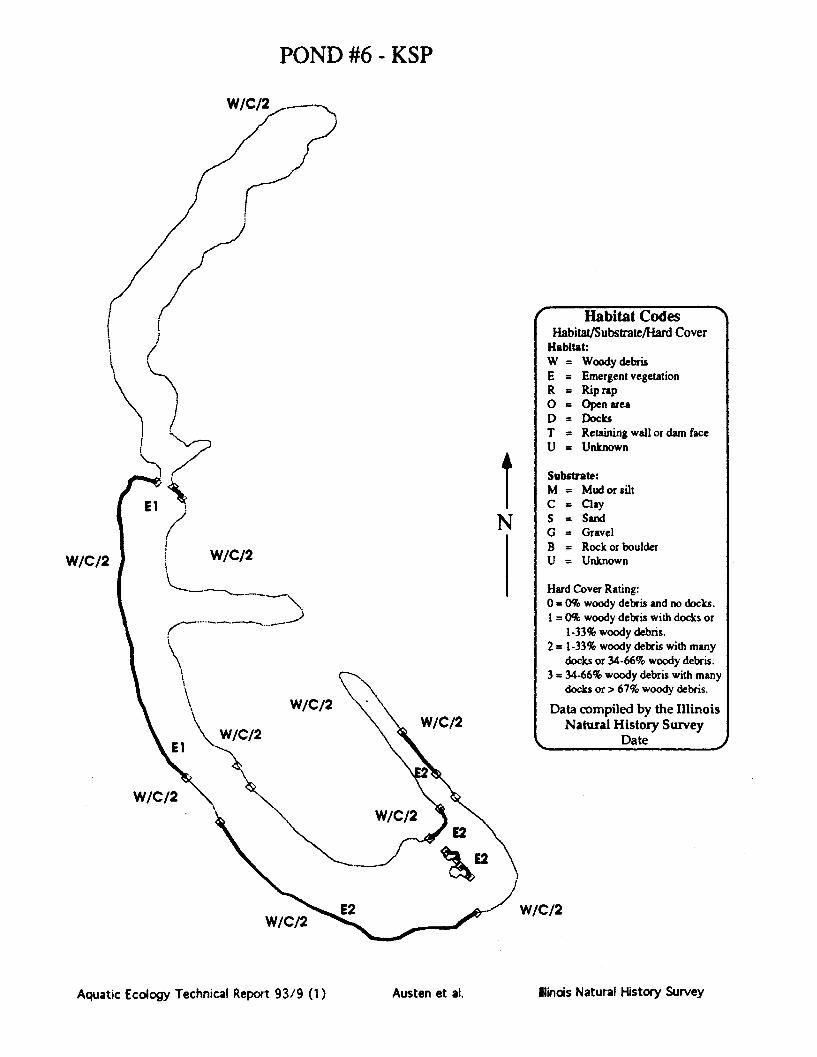
POND #6 - KSP
/AI If' I%
W/C/2
W/C/2
W/C/2
W/C/2
Aquatic Ecology Technical Report 93/9 (1)
W/C/2
N
' Habitat CodesHabitat/Substrate/Hard Cover
Habitat:W = Woody debrisE = Emergent vegetationR = Rip rap0 = Open areaD = DocksT = Retaining wall or dam faceU = Unknown
Substrate:M = Mud or siltC = ClayS = SandG = GravelB = Rock or boulderU = Unknown
Hard Cover Rating:0 = 0% woody debris and no docks.I = 0% woody debris with docks or
1-33% woody debris.2 = 1-33% woody debris with many
docks or 34-66% woody debris.3 = 34-66% woody debris with many
docks or > 67% woody debris.
Data compiled by the IllinoisNatural History Survey
DateW/C/2
W/C/2
W/C/2
'%% -- -- MWWWOOIF
Mlinois Natural History SurveyAusten et al.

POWERTON LAKECounty: TAZWELLLatitude: 403230Longitude: 894230
Township: T24NRange: R5WSection: 7,8,5
IDOC Region: 1IDOC District: 4IDOC Lake Number: 39Storet Code:IDOC Lake Class: STLake Origin: ADNatural Division: 5A
Surface Area (ha): 537.3Surface Area (acres): 1289.4Mean Depth (m): 3.15Maximum Depth (m): 457Shore Length (km): 17.53Shoreline Dev. Index: 2.13
Year Constructed: 1971
USGS 75' Quad: PEKINMajor River Basin: ILLINOISInflowing Stream: NONEOutflowing Streamn PUMPED TO ILL R
Typical Water Chemistry:Secchi Disk Depth (cm): 75Conductivity (umhos): 795Total Alkalinity (mg/1): 230pH-
Watershed Area (ha): 551Storage Cap. (1000 m3): 16903.91Retention Time (yrs): N/AVolume Dev. Index: 2.06
Maximum Length (km): 3.326Maximum Width (km): 2.458Inshore Mean Depth (m): 3.9Pool Elevation (m msl): 132.6
Climatic Information:Growing Season (days): 180Growing Deg. Days (50°F base): 3551
Habitat Description as a Proportion of Total Shoreline and Shoreline Sampled by ElectrofishingPercent of Percent of Total Shoreline
Habitat Type Total Shoreline Sampled by ElectrofishingR/B/0 100 40
Fish Species Present in Lake (based on IDOC sampling):Bigmouth Buffalo Hybrid Striped BassBlack Bullhead Largemouth BassBlack Crappie LogperchBluegill Orangespotted SunfishCarp River CarpsuckerChannel Catfish River ShinerEmerald Shiner SuagerFreshwater Drum Skipjack HerringGizzard Shad Smallmouth BassGolden Shiner Smallmouth BuffaloGreen Sunfish Spotfin ShinerGreen Sunfish X Bluegill Spottail Shiner
Threadfin ShadWalleyeWhite BassYellow Bullhead
Aquatic Ecology Technical Report 93/9 (1) Austen et al. Ilindois Natural History Survey

Notes and Comments:
Aquatic Ecology Technical Report 93/9 (1) Ilinois Natural History SurveyAusten et al.

POWERTON LAKE
Aquatic Ecology Technical Report 93/9 (1)
,a-(
IAusten et al. llinois Natural History Survey

POWERTON LAKE
Aquatic Ecology Technical Report 93/9 (1) Austen et al. Ilm~s Natural History Survey
Habitat Codes (given as a three character code: Habitat/Substrate/Hard Cover)Habitat: Substrate: Hard Cover Rating:W = Woody debris M = Mud or silt 0 = 0% woody debris and no docks.
E = Emergent vegetation C = Clay 1 = 0% woody debris with docks or
R = Rip rap S = Sand 1-33% woody debris.
0 = Open area G = Gravel 2 = 1-33% woody debris with many docks
D = Docks B = Rock or boulder or 34-66% woody debris.
T = Retaining wall or dam face U = Unknown 3 = 34-66% woody debris with many docks
U = Unknown or greater than 67% woody debris.
, Information compiled by the Illinois Natural History Survey, completed 10/29/86
le--- --------------------------- ~
llinois Natural History SurveyAquatic Ecology Technical Report 93/9 (1) Austen et al.

ROUND LAKE
County: LAKELatitude: 422142Longitude: 880436
Township: T45NRange: R10ESection: 21
IDOC Region: 2IDOC District: 6IDOC Lake Number:Storet Code: RT-B01-HIDOC Lake Class: PULake Origin: NGNatural Division: 3A
Year Constructed:
USGS 7.5' Quad: GRAYSLAKE*Major River Basin: POXInflowing Stream: INT FROM LONG LOutflowing Stream: NONE
Typical Water Chemistry:Secchi Disk Depth (cm): 111Conductivity (umhos): 485Total Alkalinity (mg/1): 85pH: 9.0
Surface Area (ha): 94.6Surface Area (acres): 227.0Mean Depth (m): 3.08Maximum Depth (m): 11.28Shore Length (km): 6.28Shoreline Dev. Index: 1.82
Watershed Area (ha): 202Storage Cap. (1000 m3): 2917.01Retention Time (yrs): 7.4Volume Dev. Index: 0.82
Maximum Length (km):Maximum Width (km):Inshore Mean Depth (m):Pool Elevation (m msl):
1.641.25
1.2231.3
Climatic Information:Growing Season (days): 158Growing Deg. Days (50°F base): 2694
Habitat Description as a Proportion of Total Shoreline and Shoreline Sampled by ElectrofishingPercent of Percent of Total Shoreline
Habitat Type, .Total Shoreline Sampled by ElectrofishingD/S/1 44 7E/S/0 13 1E/S/1 40 40o/S/0W/G/3
12
Fish Species Present in Lake (based on IDOC sampling):Black CrappieBluegillCarpChannel CatfishGrass PickerelLargemouth BassNorthern PikePumpkinseedYellow Perch
Aquatic Ecology Technical Report 93/9 (1) llinois Natural History SurveyAusten et al.

Notes and Comments:
Aquatic Ecology Technical Report 93/9 (1) Austen et al. Ilinois Natural History Survey

ROUND LAKE
Ij
SCALE
0 l000ft
Aquatic Ecology Technical Report 93/9 (1)
Map Source: Illinois Department of Conservation
Mapping Method: Unknown, outline from ASCSaerial photoDate completed: 10/25/66
t
Austen et al. Ilinois Natural History Survey

ROUND LAKE
E/S/(
vs/i/
El
E/S/lO/S/o
Aquatic Ecology Technical Report 93/9 (1)
Habitat Codes (given as a three character code: Habitat/Substrate/Hard Cover)Habitat: htal Hard Cover RatingW = Woody debris M = Mud or silt 0 = 0% woody debris and no docks.E = Emergent vegetation C = Clay 1 = 0% woody debris with docks orR = Rip rap S = Sand 1-33% woody debris.0 = Open area G = Gravel 2 = 1-33% woody debris with many docksD = Docks B = Rock or boulder or 34-66% woody debris.T = Retaining wall or dam face U = Unknown 3 = 34-66% woody debris with many docksU = Unknown or greater than 67% woody debris.Information compiled by the Illinois Natural History Survey, completed 7/29/88 •
Jop-
Ilinois Natural History SurveyAusten et al.

SAG QUARRY (EAST)County: COOKLatitude: 414130Longitude: 875544
Township: T37NRange: R11ESection: 13
IDOC Region: 2IDOC District: 6IDOC Lake Number: 87STORET Code:IDOC Lake Class: PULake Origin: AQNatural Division: 3A
Surface Area (ha): 6.0Surface Area (acres): 14.5Mean Depth (m): 1.49Maximum Depth (m): 5.18Shore Length (km): 3.53Shoreline Dev. Index: 4.06
Year Constructed: 1930
USGS 75 Quad: SAG BRIDGEMajor River Basin: DES PLAINESInflowing Stream: NONEOutflowing Stream: NONE
Typical Water Chemistry:.Secchi Disk Depth (cm): 213Conductivity (umhos): 1007Total Alkalinity (mg/1): 182pH: 8.4
Watershed Area (ha): 38Storage Cap. (1000 m3): 89.68Retention Time (yrs): 1.1Volume Dev. Index: 0.86
Maximum Length (km): 0.37Maximum Width (km): 0.42Inshore Mean Depth (m):Pool Elevation (m msl):
Climatic Information:Growing Season (days): 165Growing Deg. Days (500F base): 2996
Habitat Description as a Proportion of Total Shoreline and Shoreline Sampled by ElectrofishingPercent of Percent of Total Shoreline
Habitat Type Total Shoreline Sampled by ElectrofishingE/M/0 0E/S/1 19E/G/0 47 7S/G/0S/U/0S/B/0T/U/0W/M/W/S/1
42113
419
1
Fish Species Present in Lake (based on IDOC sampling):
N/A
Aquatic Ecology Technical Report 93/9 (1) Klinois Natural History SurveyAusten et al.

Notes and Comments:
Aquatic Ecology Technical Report 93/9 (1) Austen et al. Ilinois Natural History Survey

SAG QUARRY
N
SCALEI I 50 500)ft Map Source: Cook Co. Forest Preserve Dist
Mapping Method: UnknownDate completed: Unknown
Aquatic Ecology Technical Report 93/9 (1) Austen et al. Illinois Natural History Survey

/
T/U/O N
T/U/0
W/S/l
El
T/U/O
T/U/O
6/ IV./ w
Ilinois Natural History SurveyAquatic Ecology Technical Report 93/9 (1)
SAG QUARRY
W/M/2'
E/G/O
T/U/O
Habitat Codes (given as a three character code: Habitat/Substrate/Hard Cover)Haitat Substrate: Hard Cover Rating:W= Woody debris M = Mud or silt 0 = 0% woody debris and no docks.E = Emergent vegetation C = Clay I = 0% woody debris with docks orR = Rip rap S = Sand 1-33% woody debris.0 = Open area G = Gravel 2 = 1-33% woody debris with many docksD = Docks B = Rock or boulder or 34-66% woody debris.T = Retaining wall or dam face U = Unknown 3 = 34-66% woody debris with many docksU = Unknown or greater than 67% woody debris.Information comniled by the Illinois Natural History Survey. completed 8/2/89,7
I
Austen et al.

SAND LAKE(Illinois Beach State Park)
County : LAKELatitude: 422439Longitude: 880230
Township: T45NRange: R10ESection: 2,3
IDOC Region: 2IDOC District 6IDOC Lake Number: 82Storet Code: RG-B01-MIDOC Lake Class: STLake Origin NGNatural Division: 3A
Year Constructecd
USGS 75' Quad: ANTIOCH*Major River Basin: DES PLAINESInflowing Stream: NONEOutflowing Stream: MARSH>4TH L>MILL CR>DES PLAINE
Typical Water Chemistry:.Secchi Disk Depth (cm): 85Conductivity (umhos): 483Total Alkalinity (mg/1): 224pH- 7.9
Surface Area (ha): 7.4Surface Area (acres): 17.8Mean Depth (m): 1.48Maximum Depth (m): 3.66Shore Length (km): 1.16Shoreline Dev. Index: 1.2
Watershed Area (ha): 96Storage Cap. (1000 m3): 109.67Retention Time (yrs): 7.1Volume Dev. Index: 1.21
Maximum Length (km):Maximum Width (km):Inshore Mean Depth (m):Pool Elevation (m msl):
0.320.33
1.3236.5
Climatic Information:Growing Season (days): 158Growing Deg. Days (50°F base): 2694
Habitat Description as a Proportion of Total Shoreline and Shoreline Sampled by ElectrofishingPercent of Percent of Total Shoreline
Habitat Type Total Shoreline Sampled by ElectrofishingE/S/1 100 100
Fish Species Present in Lake (based on IDOC sampling):Black Bullhead White CrappieBlack Crappie White SuckerBluegill Yellow PerchCarpCentral MudminnowChannel CatfishGolden ShinerGoldfishGreen SunfishLargemouth BassPumpkinseedSauger
Aquatic Ecology Technical Report 93/9 (1) Illinois Natural History SurveyAusten et al.

Notes and Comments:
Aquatic Ecology Technical Report 93/9 (1) Austen et al. Alinois Natural History Survey
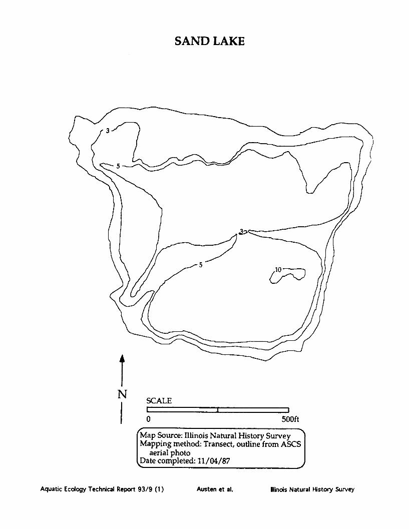
SAND LAKE
SCALE
0 500ft
Map Source: Illinois Natural History SurveyMapping method: Transect, outline from ASCS
aerial photoDate completed: 11/04/87
Aquatic Ecology Technical Report 93/9 (1)
IN
I
Austen et al. Illinois Natural History Survey

SAND LAKE
Habitat Codes (given as a three character code: Habitat/Substrate/Hard Cover)Habitat:W = Woody debrisE = Emergent vegetationR = Rip rap0 = Open areaD = DocksT = Retaining wall or dam face
SubsItrate:M = Mud or siltC = ClayS = SandG = GravelB = Rock or boulderU = Unknown
Had Cover Rating:0 = 0% woody debris and no docks.1 = 0% woody debris with docks or
1-33% woody debris.2 = 1-33% woody debris with many docks
or 34-66% woody debris.3 = 34-66% woody debris with many docks
U = Unknown or greater than 67% woody debris.Information compiled by the Illinois Natural History Survey, completed 10/29/86•
Aquatic Ecology Technical Report 93/9 (1) Ilinois Natural History SurveyAusten et al.

SAUK TRAILCounty: HENRYLatitude: 412004Longitude: 895249
Township: T16NRange: R5ESection: 26,35
IDOC Region: 1IDOC District: 2IDOC Lake Number: 7STORET Code: RP-A01-DIDOC Lake Class: STLake Origin: AANatural Division: 4C
Surface Area (ha): 21.0Surface Area (acres): 50.4Mean Depth (m): 2.33Maximum Depth (m): 6.1Shore Length (km): 3.42Shoreline Dev. Index: 2.1
Year Constructed: 1956
USGS 75' Quad: KEWANEE NMajor River Basin: ROCKInflowing Stream: UNNAMED TRIBOutflowing Stream: TRIB>MUD CR>GREEN R>ROCK R
Typical Water Chemistry:Secchi Disk Depth (cm): 53Conductivity (umhos): 361Total Alkalinity (mg/1): 187pH: 7.2
Watershed Area (ha): 1554Storage Cap. (1000 m3): 488.27Retention Time (yrs): 0.8Volume Dev. Index: 1.14
Maximum Length (km): 0.87Maximum Width (km): 0.78Inshore Mean Depth (m): 1.35Pool Elevation (m msl): 216.5
Climatic Information:Growing Season (days): 158Growing Deg. Days (50°F base): 3124
Habitat Description as a Proportion of Total Shoreline and Shoreline Sampled by ElectrofishingPercent of Percent of Total Shoreline
Habitat Type Total Shoreline Sampled by ElectrofishingD/G/1 8 8R/B/0 5 5W/G/1 87 87
Fish Species Present in Lake (based on IDOC sampling):Black CrappieBluegillBrook SilversideCarpChannel CatfishEmerald ShinerGolden ShinerGreen SunfishLargemouth BassMuskellungeRedear SunfishWhite CrappieYellow Bullhead
Aquatic Ecology Technical Report 93/9 (1) Alinois Natural History SurveyAusten et al.
Notes and Comments:
Aquatic Ecology Technical Report 93/9 (1) Austen et al. Ilindois Natural History Survey

SAUK TRAIL
N
0 - 1000ft
Aquatic Ecology Technical Report 93/9 (1)
ASCS
Austen et al. Ilinis Natural History Survey

SAUK TRAIL
T I/I
El
W/G/i
W/G/iN
aquatic Ecology Technical Report 93/9 (1)
Habitat Codes (given as a three character code: Habitat/Substrate/Hard Cover)Habitat: Substrate: Hard Cover Rating:W = Woody debris M = Mud or silt 0 = 0% woody debris and no docks.E = Emergent vegetation C = Clay I = 0% woody debris with docks orR = Rip rap S = Sand 1-33% woody debris.0 = Open area G = Gravel 2 = 1-33% woody debris with many docksD = Docks B = Rock or boulder or 34-66% woody debris.T = Retaining wall or dam face U = Unknown 3 = 34-66% woody debris with many docksU = Unknown or greater than 67% woody debris.Information compiled by the Illinois Natural History Survey, completed 9/14/88
N% - - -- - -4f ---- -
Austen et al. linois Natural History Survey

SHABBONA LAKECounty: DEKALBLatitude: 414422Longitude: 885122
Township: T38NRange: R3ESection: 27
IDOC Region: 1IDOC District: 1IDOC Lake Number: 14Storet Code: VT-B04-UIDOC Lake Class: STLake Origin: AANatural Division: 4A
Year Constructed: 1973
USGS 7.5' Quad: SHABBONA GROVE*/WATERMAN
Major River Basin: ILLINOISInflowing Stream: INDIAN CROutflowing Stream: INDIAN CR>FOX R>IL R
Typical Water Chemistry:Secchi Disk Depth (cm): 153Conductivity (umhos): 513Total Alkalinity (mg/1): 261pH: 8.1
Surface Area (ha): 126.8Surface Area (acres): 304.3Mean Depth (m): 4.65Maximum Depth (m): 12.8Shore Length (km): 10.5Shoreline Dev. Index: 2.63
Watershed Area (ha): 5217Storage Cap. (1000 m3): 5904.72
Retention Time (yrs): 0.6Volume Dev. Index: 1.09
Maximum Length (km):Maximum Width (km):Inshore Mean Depth (m):Pool Elevation (m msl):
1.881.92
1.5249.9
Climatic Information:Growing Season (days): 163Growing Deg. Days (500 F base): 3038
Habitat Description as a Proportion of Total Shoreline and Shoreline Sampled by ElectrofishingPercent of Percent of Total Shoreline
Habitat Type Total Shoreline Sampled by ElectrofishingE/C/1 6 3R/B/0 30 24W/C/2 5 5W/C/3 42 14W/C/1 17 10
Fish Species Present in Lake (based on IDOC sampling):Black Bullhead Tiger MuskellungeBlack Crappie WalleyeBluegill White CrappieBrook Silverside White SuckerBrown Bullhead Yellow BullheadChannel Catfish Yellow PerchGizzard ShadGolden RedhorseGolden ShinerGreen SunfishLargemouth BassMuskellunge
Aquatic Ecology Technical Report 93/9 (1) Austen et al. lindois Natural History Survey

Notes and Comments:
Aquatic Ecology Technical Report 93/9 (1) Austen et al. Ilinois Natural History Survey

SHABBONA LAKE
SCALE
0 2000ft
Mapping Method: Pre-impoundment study
Date completed: 3/8/74
Aquatic Ecology Technical Report 93/9 (1)
XT
Austen et al. Hlinois Natural History Survey

SHABBONA LAKE
R/B/0 / W/C/3
W/C/3 W/C/1 E/C/l
E/C/IW/C/3
E7 E2
A
GI
W/C/3 E F R/B/
R/
W/C/1
E60
El
W/C/l
2
'2
E6
R/B/O
R/B/O
Habitat Codes (given as a three character code: Habitat/Substrate/Hard Cover)Habitat ubstrate: Hard Cover Rating:W= Woody debris M = Mud or silt 0= 0% woody debris and no docks.E = Emergent vegetation C = Clay 1 = 0% woody debris with docks orR = Rip rap S = Sand 1-33% woody debris.0 = Open area G = Gravel 2 = 1-33% woody debris with many docksD = Docks B = Rock or boulder or 34-66% woody debris.T = Retaining wall or dam face U = Unknown 3 = 34-66% woody debris with many docksU = Unknown or greater than 67% woody debris.Information compiled by the Illinois Natural History Survey, completed 5/24/88
Aquatic Ecology Technical Report 93/9 (1)
0
Ilindois Natural History SurveyAusten et al.

SPORTSMEN'S LAKE(Kickapoo State Park)
County: VERMILLIONLatitude: 400820Longitude: 874430
Township: T20NRange: R12WSection: 32
IDOC Region: 3IDOC District: 8IDOC Lake Number: 98STORET Code:IDOC Lake Class: STLake Origin:Natural Division: 4A
Year Constructed: 1953
USGS 7.5' Quad: DANVILLE NWMajor River Basin: WABASHInflowing Stream: NONEOutflowing Stream: NONE
Typical Water Chemistry:Secchi Disk Depth (cm):Conductivity (umhos):Total Alkalinity (mg/1):pH:
Surface Area (ha): 14.4Surface Area (acres): 34.7Mean Depth (m): 5.64Maximum Depth (m): 15.54Shore Length (km): 6.77Shoreline Dev. Index: 5.03
Watershed Area (ha): 73Storage Cap. (1000 m3): 812.34Retention Time (yrs):Volume Dev. Index: 1.08
Maximum Length (km):Maximum Width (km):Inshore Mean Depth (m):Pool Elevation (m msl): 170.4
Climatic Information:Growing Season (days):Growing Deg. Days (50*F base):
Habitat Description as a Proportion of Total Shoreline and Shoreline Sampled by ElectrofishingPercent of Percent of Total Shoreline
Habitat Type Total Shoreline Sampled by ElectrofishingO/C/0 94 19W/C/1 6 4
Fish Species Present in Lake (based on IDOC sampling):BluegillBlackstripe TopminnowBluntnose MinnowBrook SilversideCarpChannel CatfishGrass PickerelGreen SunfishGizzard ShadLargemouth BassLongear SunfishRedear SunfishWarmouthWhite Crappie
Aquatic Ecology Technical Report 93/9 (1) Austen et al. Illinois Natural History Survey

Notes and Comments:
Aquatic Ecology Technical Report 93/9 (1) Austen et al. Ilinois Natural History Survey

SPORTSMANS LAKE
j
0CONTOUR INTERVAL 10ft
l000ft
L Map Source: Illinois
Natural History
SurveyMap Source: Illinois Natural History SurveyMapping Method: Transect, outline from ASCS
aerial photoDate completed: 3/29/90
Aquatic Ecology Technical Report 93/9 (1)
Ono"I I I
linois Natural History SurveyAusten et al.

SPORTSMANS LAKE
O/C/o
W/C/l
O/C/0
0o
O/C/o
o/c/o
O/C/0
Habitat CodesHabitat/Substrate/Hard Cover
Habitat:W = Woody debrisE = Emergent vegetationR = Rip rap0 = Open areaD = DocksT = Retaining wall or dam faceU = Unknown
Substrate:M = Mud or siltC = ClayS = SandG = GravelB = Rock or bouU = Unknown
V -/V Wkxj UAUXU flau nIIU 0IP .
1 = 0% woody debris with docks or1-33% woody debris.
2 = 1-33% woody debris with manydocks or 34-66% woody debris.
3 = 34-66% woody debris with manydocks or > 67% woody debris.
Data compiled by the IllinoisNatural History Survey
Date 3/29/90
Llder
0/0/0
O/C/0
O/C/o
W/C/l
N w/c/1
Aquatic Ecology Technical Report 93/9 (1)
Arl- MMOMMMWA.
=,.--- --- -- -- - --- -- -- -^ -- -- ^,-M^ ^
Austen et al. Winds Natural History Survey

SPRING LAKE (NORTH)County: TAZEWELLLatitude: 402834Longitude: 895101
Township: T23NRange: R7WSection: 16
IDOC Region: 1IDOC District 4IDOC Lake Number: 40Storet Code: RD-B05-QIDOC Lake Class: STLake Origin: NRNatural Division: 5A
Year Constructed: 1918
USGS 7.5' Quad: GLADSFORD/MANITOMajor River Basin: ILLINOISInflowing Stream: SPRING FEDOutflowing Stream: RUNOFF TO IL R
Typical Water Chemistry:Secchi Disk Depth (cm): 107Conductivity (umhos): 252Total Alkalinity (mg/1): 118pH: 8.9
Surface Area (ha): 194.1Surface Area (acres): 465.9Mean Depth (m): 54Maximum Depth (m): 2.65Shore Length (km): 19.82Shoreline Dev. Index: 4.01
Watershed Area (ha): 256Storage Cap. (1000 m3): 1048.82Retention Time (yrs):Volume Dev. Index: 0.61
Maximum Length (km):Maximum Width (km):Inshore Mean Depth (m):Pool Elevation (m msl):
5.846.11
0.56132.3
Climatic Information:Growing Season (days): 180Growing Deg. Days (50°F base): 3551
Habitat Description as a Proportion of Total Shoreline and Shoreline Sampled by ElectrofishingPercent of Percent of Total Shoreline
Habitat Type Total Shoreline Sampled by ElectrofishingE/G/1 95 28R/B/0 5 5
Fish Species Present in Lake (based on IDOC sampling):Black Bullhead Green Sunfish X BluegillBlack Crappie Largemouth BassBluegill MuskellungeBluegill X Redear Redear SunfishBrown Bullhead WarmouthCarp White CrappieChannel Catfish Yellow BullheadFathead MinnowGizzard ShadGolden ShinerGrass PickerelGreen Sunfish
Aquatic Ecology Technical Report 93/9 (1) Illinois Natural History SurveyAusten et al.

Notes and Comments:
Aquatic Ecology Technical Report 93/9 (1) Austen et al. Ilinois Natural History Survey

SPRING LAKE (NORTH)
SCALE
0~L.Omi
Map Source: Illinois Dept. of ConservationMapping Method: Transect, outline from IDOC
aerial photoDate completed: 1980
Aquatic Ecology Technical Report 93/9 (1) Austen et al. Illinois Natural History Survey
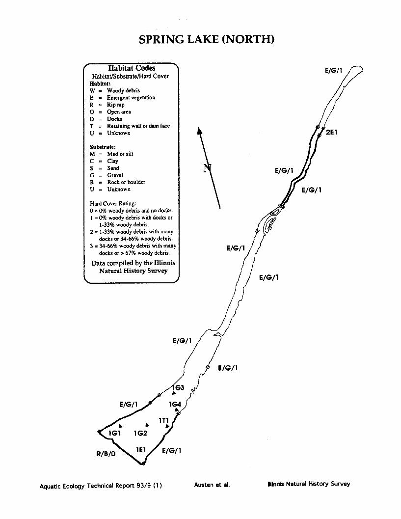
SPRING LAKE (NORTH)
' Habitat Codes " E/G/1 'Habitat/Substrate/Hard Cover /
Habitat:W = Woody debrisE = Emergent vegetationR = Rip rap0 = Open area /D = Docks /T = Retaining wall or dam faceU = Unknown 2E1
Substrate:M = Mud or siltC = ClayS = Sand E/G/1G = GravelB = Rock or boulderU = Unknown E/G/1
Hard Cover Rating:0 = 0% woody debris and no docks.1 = 0% woody debris with docks or
1-33% woody debris.2 = 1-33% woody debris with many
docks or 34-66% woody debris.3 = 34-66% woody debris with many E/G/1 /
docks or > 67% woody debris.
Data compiled by the Illinois /Natural History Survey / /
/
E/G/
/ /
E/G//1I
R//0 EE/G/1
R/B/O ls l E//1
Aquatic Ecology Technical Report 93/9 (1) Austen et al. tlinois Natural History Survey

SPRING LAKE (SOUTH)County: TAZEWELLLatitude: 402701Longitude: 895340
Township: T23NRange: R7WSection: 10,9
IDOC Region: 1IDOC District: 4IDOC Lake Number: 465Storet Code: RD-BO5-QIDOC Lake Class: STLake Origin: NRNatural Division: 5A
Surface Area (ha): 277.9Surface Area (acres): 667.0Mean Depth (m): 1.146Maximum Depth (m): 2.134Shore Length (km): 8.303Shoreline Dev. Index: 1.4
Year Constructed: 1918
USGS 7.5' Quad: DUCK ISLAND*Major River Basin: ILLINOISInflowing Stream: SPRING FEDOutflowing Stream: LEVEED OFF FROM RIVER
Typical Water Chemistry:Secchi Disk Depth (cm): 50Conductivity (umhos): 298Total Alkalinity (mg/1): 151pH: 8.5
Watershed Area (ha): 325Storage Cap. (1000 m3): 3188.66Retention Time (yrs):Volume Dev. Index: 1.61
Maximum Length (km): 3.07Maximum Width (km): 3.75Inshore Mean Depth (m): 0.6Pool Elevation (m msl): 132.3
Climatic Information:Growing Season (days): 180Growing Deg. Days (50°F base): 3551
Habitat Description as a Proportion of Total Shoreline and Shoreline Sampled by ElectrofishingPercent of Percent of Total Shoreline
Habitat Tvre Total Shoreline Samnlid bv ElectrnfishineE/G/OR/B/0
928
648
Fish Species Present in Lake (based on IDOC sampling):Black Bullhead MosquitofishBlack Crappie Northern PikeBluegill Redear SunfishBluegill X Redear Yellow BullheadBrook SilversideChannel CatfishFathead MinnowFreshwater DrumGizzard ShadGreen SunfishGreen Sunfish X BluegillLargemouth Bass
Aquatic Ecology Technical Report 93/9 (1) Ilindis Natural History SurveyAusten et al.

Notes and Comments:
Aquatic Ecology Technical Report 93/9 (1) Austen et al. lindis Natural History Survey

SPRING LAKE (SOUTH)
*N
imi
Aquatic Ecology Technical Report 93/9 (1)
vation
rom IDOC
Illinois Natural History SurveyAusten et al.

SPRING LAKE (SOUTH)
E/G/02EI
R/B/0
2EI
2E 1
E/G/0E/G/0
E/G/0
E/G/0
E
Aquatic Ecology Technical Report 93/9 (1)
Substrate:M = Mud or siltC = ClayS = SandG = GravelB = Rock orbouU = Unknown
S.r
y
3 = 34-66% woody debris with manydocks or > 67% woody debris.
Data compiled by the IllinoisNatural History Survey
Date
Ilinois Natural History Survey
mmmmwý
r
lder
mmullkh.
Austen et al.

STERLING LAKE(Lake County Forest Preserve District)
County: LAKELatitude: 422826Longitude: 875628
Township: T46NRange: R22ESection: 10
IDOC Region: 2IDOC District: 6IDOC Lake Number: 555STORET Code.IDOC Lake Class: PCLake Origin: AQNatural Division: 3A
Year Constructed:
USGS 7.5' Quad: WADSWORTH*Major River Basin: DES PLAINESInflowing Stream: NONEOutflowing Stream: NONE
Typical Water Chemistry:.Secchi Disk Depth (cm): 137Conductivity (umhos): 625Total Alkalinity (mg/1): 150pH: 8.0
Surface Area (ha): 28.6Surface Area (acres): 68.5Mean Depth (m): 437Maximum Depth (m): 7.01Shore Length (km): 3.73Shoreline Dev. Index: 1.96
Watershed Area (ha): 72Storage Cap. (1000 m3): 1249.04Retention Time (yrs): 8.5Volume Dev. Index: 1.87
Maximum Length (km):Maximum Width (km):Inshore Mean Depth (m):Pool Elevation (m msl):
Growing Season (days): 175
1.290.91
4.95202.7
Climatic Information:
Growing Deg. Days (50*F base): 2755
Habitat Description as a Proportion of Total Shoreline and Shoreline Sampled by ElectrofishingPercent of Percent of Total Shoreline
Habitat Type Total Shoreline Sampled by ElectrofishingO/C/0 50 52W/C/1 39 35W/G/1 11 5
Fish Species Present in Lake (based on IDOC sampling):Black Bullhead MuskellungeBlack Crappie Northern PikeBluegill PumpkinseedBluntnose Minnow Sand ShinerBowfin Smallmouth BassCarp Spotfin ShinerCarp X Goldfish Spotted SuckerChannel Catfish WalleyeEmerald Shiner White SuckerGolden Shiner Yellow BullheadGreen Sunfish Yellow PerchGreen Sunfish X BluegillJohnny DarterLargemouth Bass
Aquatic Ecology Technical Report 93/9 (1) Austen et al. Illinois Natural History Survey

Notes and Comments:
Aquatic Ecology Technical Report 93/9 (1) Austen et al. Ilnois Natural History Survey

STERLING LAKE
A
lOOOft
Aquatic Ecology Technical Report 93/9 (1)
;urvey
om 7.5 min
Austen et al. Ilinois Natural History Survey

STERLING LAKE
S ir/ ' /ft 6nw/ c/c/
NI N IW/C/1
W/C/10//do
W/G/
W/G/i
Nl IO/C/O NI
o/c/ W/C/iI 1Jw/1
/UIQI\
N
Aquatic Ecology Technical Report 93/9 (1)
Habitat CodesHabitat/Substrate/Hard Cover
Habitat:W = Woody debrisE = Emergent vegetationR = Rip rap0 = Open areaD = DocksT = Retaining wall or dam faceU = Unknown
Substrate:M = Mud or siltC = ClayS = SandG = GravelB = Rock or boulderU = Unknown
Hard Cover Rating:0 = 0% woody debris and no docks.I = 0% woody debris with docks or
1-33% woody debris.2 = 1-33% woody debris with many
docks or 34-66% woody debris.3 = 34-66% woody debris with many
docks or > 67% woody debris.
Data compiled by the IllinoisNatural History Survey
Date
dir . . . .. - - O O"~
Ilinois Natural History SurveyAusten et al.

LAKE SUMMERSET
County: WINNEBAGOLatitude: 422654Longitude: 892305
Township: T28NRange: R10E,R9Section: 6,1
IDOC Region: 1IDOC District 1IDOC Lake Number:Storet Code: RP-A06-IIDOC Lake Class: ORLake Origin: AANatural Division: 2A
Surface Area (ha): 108.5Surface Area (acres): 260.5Mean Depth (m): 3.87Maximum Depth (m): 10.06Shore Length (km): 8.99Shoreline Dev. Index: 2.43
Year Constructed: 1%96
USGS 75' Quad: DAVISMajor River Basin: ROCKInflowing Stream: SBR OTTER CROutflowing Stream: SAME<SUGR R<PECATONICA R<ROCK
Typical Water Chemistry:Secchi Disk Depth (cm): 137Conductivity (umhos): 225Total Alkalinity (mg/l): 248pH: 8.0
Watershed Area (ha): 1821Storage Cap. (1000 m3): 4205.53Retention Time (yrs): 1.9Volume Dev. Index: 1.15
Maximum Length (km): 1.33Maximum Width (km): 2.83Inshore Mean Depth (m): 1.2Pool Elevation (m msl): 251.5
Climatic Information:Growing Season (days): 152Growing Deg. Days (50°F base): 2813
Habitat Description as a Proportion of Total Shoreline and Shoreline Sampled by ElectrofishingPercent of Percent of Total Shoreline
Habitat Type Total Shoreline Sampled by ElectrofishingE/S/1 7 7R/B/0W/G/1 87 38
Fish Species Present in Lake (based on IDOC sampling):Black CrappieBluegillCarpLargemouth BassNorthern PikeWalleyeYellow Bullhead
Aquatic Ecology Technical Report 93/9 (1) Ilinois Natural History SurveyAusten et al.

Notes and Comments:
Aquatic Ecology Technical Report 93/9 (1) Austen et al. Ilincis Natural History Survey

LAKE SUMMERSET
2000ft
al History Surveyt, outline from 7.5 min.
Aquatic Ecology Technical Report 93/9 (1)
N%. - ..000'
gift
Austen et al. Ilinois Natural History Survey

LAKE SUMMERSET
' Habitat Cod4Habitat/Substrate/Hard
Habitat:W = Woody debrisE = Emergent vegetatiR = Rip rap0 = Open areaD = DocksT = Retaining wall or dU = Unknown
Substrate:M = Mud or siltC = ClayS = SandG = GravelB = Rock or boulderU = Unknown
Hard Cover Rating:0 = 0% woody debris andI = 0% woody debris with
1-33% woody debris.2 = 1-33% woody debris w
docks or 34-66% wood3 = 34-66% woody debris
docks or > 67% woody
Data compiled by theNatural History Su
Date 11/3/87
esSCc
Dn
lam
io ddoc
ith iy dewithdeb
Illiirve
ps/i
E4
Aquatic Ecology Technical Report 93/9 (1)
R/B/OW/G/l
v
00
Austen et al. Ilinois Natural History Survey

LAKE TAMPIER(Cook County Forest Preserve District)
County: COOKLatitude: 415346Longitude: 875442
Township: T37NRange: R12ESection: 31
IDOC Region: 2IDOC District: 6IDOC Lake Number: 88STORET Code: RG-B03ZOIDOC Lake Class: PULake Origin: ADNatural Division: 3A
Surface Area (ha): 49.1Surface Area (acres): 117.8Mean Depth (m): 2.081Maximum Depth (m): 457Shore Length (km): 5.347Shoreline Dev. Index: 2.15
Year Constructed: 1964
USGS 7.5' Quad: SAG BRIDGEMajor River Basin: DES PLAINESInflowing Stream: INTOutflowing Stream: INT>LONG RUN CR>CHI DR CAN>ILL
Typical Water Chemistry:Secchi Disk Depth (cm): 76.2Conductivity (umhos): 761Total Alkalinity (mg/1): 126pH: 8.3
Watershed Area (ha): 627Storage Cap. (1000 m3): 1021.81Retention Time (yrs): 0.7Volume Dev. Index: 1.36
Maximum Length (km): 1.235Maximum Width (km): 0.743Inshore Mean Depth (m): 1.9Pool Elevation (m msl): 207.3
Climatic Information:Growing Season (days): 165Growing Deg. Days (50*F base): 2996
Habitat Description as a Proportion of Total Shoreline and Shoreline Sampled by Electrofishing
Percent of Percent of Total Shoreline
Habitat Type Total Shoreline Sympled by Electrofishing
E/C/0O/C/0O/S/0R/B/0T/U/0W/C/1
1262
591I
11
1202
56110
Fish Species Present in Lake (based on IDOC sampling):
N/A
Aquatic Ecology Technical Report 93/9 (1) llinois Natural History SurveyAusten et al.

Notes and Comments:
Aquatic Ecology Technical Report 93/9 (1) Austen et al. Ilindois Natural History Survey

LAKE TAMPIER
C
Aquatic Ecology Technical Report 93/9 (1) Ilinois Natural History SurveyAusten et al.

LAKE TAMPIER
O/Cl
N
R/B/0 R/B/O
Aquatic Ecology Technical Report 93/9 (1)
HabitaHabitat/Substra
Habitat:W = WoodydeE = EmergentR = Rip rapO = Open areaD = DocksT = RetainingU = Unknown
Substrate:M = MudorsilC = ClayS = SandG = GravelB = Rock or bcU = Unknown
Hard Cover Ratini0 = 0% woody del1 = 0% woody del
1-33% woody2= 1-33% woody
docks or 34-6(3 = 34-66% wood
docks or > 67% woody debris.
Data compiled by the IllinoisNatural History Survey
<__________j
vl Aab 19
Ilinois Natural History SurveyAusten et al.

TOWER LAKECounty: LAKELatitude: 421402Longitude: 880921
Township: T43NRange: R9ESection: 2
IDOC Region: 2IDOC District: 6IDOC Lake Number:Storet Code: RT-B01ZFIDOC Lake Class: PRLake Origin: NGNatural Division: 3A
Surface Area (ha): 26.3Surface Area (acres): 63.0Mean Depth (m): 1.06Maximum Depth (m): 1.98Shore Length (km): 5.29Shoreline Dev. Index: 2.91
Year Constructed: 1915
USGS 75' Quad: BARRINGTON*Major River Basin: FOXInflowing Stream: TRIB/MARSHOutflowing Stream: SAME>POX R
Typical Water Chemistry.Secchi Disk Depth (cm): 31Conductivity (umhos): 600Total Alkalinity (mg/1): 171pH: 8.6
Watershed Area (ha): 156Storage Cap. (1000 m3): 277.93Retention Time (yrs): 0.9Volume Dev. Index: 1.6
Maximum Length (km): 0.99Maximum Width (km): 0.9Inshore Mean Depth (m): 1.05Pool Elevation (m msl): 228.0
Climatic Information:Growing Season (days): 158Growing Deg. Days (50*F base): 2694
Habitat Description as a Proportion of Total Shoreline and Shoreline Sampled by ElectrofishingPercent of Percent of Total Shoreline
Habitat Tvnv Total Shoreline Samnled byv ElectrofishinzO/G/0O/S/0O/C/0R/B/0R/G/0T/C/0W/C/1W/G/2
2321225
139
5107422
Fish Species Present in Lake (based on IDOC sampling):Black BullheadBlack CrappieBluegillCarpChannel CatfishGreen SunfishGreen Sunfish X BluegillLargemouth BassNorthern PikePumpkinseedWarmouthYellow Bullhead
Aquatic Ecology Technical Report 93/9 (1) Austen et al. Ilinois Natural History Survey
Notes and Comments:
Aquatic Ecology Technical Report 93/9 (1) Austen et al. Illinois Natural History Survey

TOWER LAKE
t
SCALE
0 500ft
(qf
Aquatic Ecology Technical Report 93/9 (1)
Map Source: Lake Co. Health Dept.Mapping Method: Transect, outline origirunknownDate completed: 1988
Austen et al. Ilinois Natural History Survey

TOWER LAKE
0//do N
R/G/O
W/C/1
R/B/O
Aquatic Ecology Technical Report 93/9 (1)
Habitat Codes (given as a three character code: Habitat/Substrate/Hard Cover)Habitat: Substrate: Hard Cover Ratin:W= Woody debris M = Mud or silt 0 = 0% woody debris and no docks.E = Emergent vegetation C = Clay 1 = 0% woody debris with docks orR = Rip rap S = Sand 1-33% woody debris.0 = Open area G = Gravel 2 = 1-33% woody debris with many docksD = Docks B = Rock or boulder or 34-66% woody debris.T = Retaining wall or dam face U = Unknown 3 = 34-66% woody debris with many docksU = Unknown or greater than 67% woody debris.Information compiled by the Illinois Natural History Survey. comnleted 10/29/86.
)
Austen et al. Ilinois Natural History Survey

TURNER LAKE(Chain of Lake State Park)
County: LAKELatitude: 422655Longitude: 881123
Township: T46NRange: R9ESection: 21
IDOC Region: 2IDOC District: 6IDOC Lake Number: 482Storet Code: YT-B01ZAIDOC Lake Class: STLake Origin: NGNatural Division: 3A
Surface Area (ha): 14.2Surface Area (acres): 34.1Mean Depth (m): 9Maximum Depth (m): 2.44Shore Length (km): 1.83Shoreline Dev. Index: 1.37
Year Constructed:
USGS 75' Quad: FOX LAKE*Major River Basin: FOXInflowing Stream: NONEOutflowing Stream: TRIB>MARSH
Typical Water Chemistry:Secchi Disk Depth (cm): 208Conductivity (umhos): 320Total Alkalinity (mg/1): 228pH: 8.3
Watershed Area (ha): 202Storage Cap. (1000 m3): 128.54Retention Time (yrs): 0.3Volume Dev. Index: 1.11
Maximum Length (km): 0.7Maximum Width (km): 0.39Inshore Mean Depth (m): 0.47Pool Elevation (m msl): 228.6
Climatic Information:Growing Season (days): 158Growing Deg. Days (50°F base): 2694
Habitat Description as a Proportion of Total Shoreline and Shoreline Sampled by ElectrofishingPercent of Percent of Total Shoreline
Habitat Type Total Shoreline Sampled by ElectrofishingE/M/0 100 70
Fish Species Present in Lake (based on IDOC sampling):Black Bullhead Green Sunfish X BluegillBlack Crappie Iowa DarterBluegill Johnny DarterBluegill X Pumpkinseed Lake ChubsuckerBowfin Largemouth BassBrown Bullhead Northern PikeCarp PumpkinseedCentral Mudminnow Tadpole MadtomChannel Catfish Yellow BullheadGolden ShinerGrass PickerelGreen Sunfish
Aquatic Ecology Technical Report 93/9 (1) Austen et al. Ilinois Natural History Survey

Notes and Comments:
Aquatic Ecology Technical Report 93/9 (1) Ilinois Natural History SurveyAusten et al.

TURNER LAKE
Mappmg Mvetnoa: i ransect, ouumie irom. imm.USGS topographic map
Date completed: 4/29/87
Ilinois Natural History SurveyAquatic Ecology Technical Report 93/9 (1) Austen et al.

TURNER LAKE
E/M/O
E/M/0
E/M/0
Aquatic Ecology Technical Report 93/9 (1)
IaDitat iuoaesHabitat/Substrate/Hard Cover
Habitat:W = Woody debrisE = Emergent vegetationR = Rip rap0 = Open areaD = DocksT = Retaining wall or dam faceU = Unknown
Substrate:M = Mud or siltC = ClayS = SandG = GravelB = Rock or boulderU = Unknown
Hard Cover Rating:0 = 0% woody debris and no docks.1 = 0% woody debris with docks or
1-33% woody debris.2 = 1-33% woody debris with many
docks or 34-66% woody debris.3 = 34-66% woody debris with many
docks or > 67% woody debris.
Data compiled by the IllinoisNatural History Survey
L fDateNI.- AeGL ILIF- 'If
14f
Austen et al. Ilinois Natural History Survey

LAKE VERMILLIONCounty: VERMILLIONLatitude: 401047Longitude: 873821
Township: T20NRange: R11WSection: 31
IDOC Region: 3IDOC District 8IDOC Lake Number. 113STORET Code: RB-A03-DIDOC Lake Class: PRLake Origin: ADNatural Division: 10C
Surface Area (ha): 269.6Surface Area (acres): 647.0Mean Depth (m): 1.66Maximum Depth (m): 4.877Shore Length (km): 18.13Shoreline Dev. Index: 3.11
Year Constructed: 1925
USGS 7.5' Quad: DANVILLE NWMajor River Basin: WABASHInflowing Stream: NFK VERMILLIONOutflowing Stream: NFK VERM>VERM>WABASH R
Typical Water Chemistry:Secchi Disk Depth (cm): 29Conductivity (umhos): 510Total Alkalinity (mg/1): 157pH: 8.5
Watershed Area (ha): 69155Storage Cap. (1000 m3): 4489.143Retention Time (yrs): 0.1Volume Dev. Index: 1.02
Maximum Length (km): 1.857Maximum Width (km): 5.139Inshore Mean Depth (m): 0.7Pool Elevation (m msl): 175.6
Climatic Information:Growing Season (days): 166Growing Deg. Days (50°F base): 3456.
Habitat Description as a Proportion of Total Shoreline and Shoreline Sampled by Electrofishing
Percent of Per tent of Total Shoreline
Hobitat Ty e Total Shoreline Sam led by Electrofish g
E/M/0O/C/oO/M/0R/B/0T/M/0W/M/1W/C/2W/M/2W/C/1W/C/0
6963
p,... .....................................-............-
723
Fish Species Present in Lake (based on IDOC sampling):Bigmouth Buffalo Golden RedhorseBlack Buffalo Golden ShinerBlack Bullhead Green SunfishBlack Crappie Gizzard ShadBluegill Largemouth BassBrook Silverside LogperchBullhead Minnow Longear SunfishCarp MuskellungeChannel Catfish Northern HogsuckerEmerald Shiner Orangespotted SunfishFlathead Catfish Red ShinerFreshwater Drum River Carpsucker
Smallmouth BuffaloSpotted SuckerSpotfin ShinerQuillback CarpsuckerWalleyeWarmouthWhite BassWhite CrappieWhite SuckerYellow BassYellow Bullhead
Aquatic Ecology Technical Report 93/9 (1) Austen et al. Illinois Natural History Survey

Notes and Comments:
Aquatic Ecology Technical Report 93/9 (1) Austen et al. Ilinois Natural History Survey

LAKE VERMILLION
N
Map Source: Illinois Natural History SurveyMapping Method: Transect, outline from 7.5 min.
USGS topographic mapDate completed: 9/90
0 0.5mi
Aquatic Ecology Technical Report 93/9 (1) Austen et al. Ilinois Natural History Survey

LAKE VERMILLION
N
(
W/M/2
W/M/2
O/C/o
W/M/2
Aquatic Ecology Technical Report 93/9 (1)
S aDitat oodesHabitat/Substrate/Hard Cover
Habitat:W = Woody debrisE = Emergent vegetation
R Rip rap0 = Open areaD = DocksT = Retaining wall or dam faceU = Unknown
Substrate:M = Mud or siltC = ClayS = SandG = GravelB = Rock or boulderU = Unknown
Hard Cover Rating:0 = 0% woody debris and no docks.1 = 0% woody debris with docks or
1-33% woody debris.2 = 1-33% woody debris with many
docks or 34-66% woody debris.3 = 34-66% woody debris with many
docks or > 67% woody debris.
Data compiled by the IllinoisNatural History Survey
DatQe 9/13/9o&.o S s%ý.-I %P a %
%a • a lombA
Jr, TV-lL-!DA-A d-4-2-- 1%
'%W , '% %
linois Natural History SurveyAusten et al.

WALNUT POINT LAKECounty: DOUGLASSLatitude: 394021Longitude: 880205
Township: T15NRange: R10ESection: 36
IDOC Region: 3IDOC District. 9IDOC Lake Number: 127Storet Code: RB-A05-KIDOC Lake Class: STLake Origin: AANatural Division: 4A
Surface Area (ha): 21.8Surface Area (acres): 52.3Mean Depth (m): 3.82Maximum Depth (m): 9.75Shore Length (km): 8.95Shoreline Dev. Index: 5.4
Year Constructed: 1968
USGS 7.5' Quad: OAKLANDMajor River Basin: WABASHInflowing Stream: INTOutflowing Stream: INT>EMB R>WABASH R
Typical Water Chemistry:Secchi Disk Depth (cm): 70Conductivity (umhos): 383Total Alkalinity (mg/1): 146pH: 8.3
Watershed Area (ha): 103Storage Cap. (1000 m3): 832.23Retention Time (yrs): 0.3Volume Dev. Index: 1.17
Maximum Length (km): 1.07Maximum Width (km): 1.04Inshore Mean Depth (m): 3.75Pool Elevation (m msl): 196
Climatic Information:Growing Season (days): 182Growing Deg. Days (50°F base): 3546
Habitat Description as a Proportion of Total Shoreline and Shoreline Sampled by Electrofishing
Percent of Percent of Total Shoreline
Sphitat Ty e Total Shoreline Sam led b Electrofis n
D/C/2D/C/1
R/B/0W/C/1W/C/3 91 53
Fish Species Present in Lake (based on IDOC sampling):Black BullheadBlack CrappieBluegillBluegill X RedearBrown BullheadChannel CatfishFathead MinnowGolden ShinerGreen SunfishGreen Sunfish X BluegillLargemouth BassLongear SunfishRedear Sunfish
Aquatic Ecology Technical Report 93/9 (1)
*V»»»«W-».V^»»..-^. AyW t" AL %ja &.72 IL&.LC
Austen et al. Illinois Natural History Survey

WALNUT POINT LAKE
t0 1000ftCONTOUR INTERVAL 5ft
Aquatic Ecology Technical Report 93/9 (1)
Map Source: Illinois Natural History SurveyMapping Method: Transect, outline from basin planDate completed: 7/16/881
I
tbS •L •lbL -a A - .-
Ilinois Natural History SurveyAusten et al.

WALNUT POINT LAKE
D/C/1
W/C/3
D/C/1
Aquatic Ecology Technical Report 93/9 (1)
Habitat Codes (given as a three character code: Habitat/Substrate/Hard Cover)Haisttt Substrate: Hard Cover Rating:W= Woody debris M = Mud or silt 0 = 0% woody debris and no docks.E = Emergent vegetation C = Clay 1 = 0% woody debris with docks orR = Rip rap S = Sand 1-33% woody debris.0 = Open area G = Gravel 2 = 1-33% woody debris with many docksD = Docks B = Rock or boulder or 34-66% woody debris.T = Retaining wall or dam face U = Unknown 3 = 34-66% woody debris with many docksU = Unknown or greater than 67% woody debris.Information compiled by the Illinois Natural History Survey, completed 7/16/88
I
Austen et al. Ilinois Natural History Survey

WELDON SPRINGS LAKECounty: DEWITILatitude: 400708Longitude: 885521
Township: T19NRange: R2ESection: 12
IDOC Region: 3IDOC District: 8IDOC Lake Number: 93STORET Code: RE-A02-DIDOC Lake Class: STLake Origin:Natural Division: 4A
Surface Area (ha): 12.0Surface Area (acres): 28.9Mean Depth (m): 3.47Maximum Depth (m): 8.53Shore Length (km): 3.38Shoreline Dev. Index: 2.75
Year Constructed: 1900
USGS 75' Quad: MAROAMajor River Basin: SANGAMONInflowing Stream: INTERMITTENT TRIBSOutflowing Stream: SALT CR.>SANGAMON R.>ILLINOIS R
Typical Water Chemistry:Secchi Disk Depth (cm): 173Conductivity (umhos): 412Total Alkalinity (mg/1): 189pH:82
Watershed Area (ha): 222Storage Cap. (1000 m3): 414.74Retention Time (yrs): 0.7Volume Dev. Index: 1.22
Maximum Length (km): 0.76Maximum Width (km): 0.43Inshore Mean Depth (m):Pool Elevation (m msl): 210.6
Climatic Information:Growing Season (days): 175Growing Deg. Days (50*F base): 3263
Habitat Description as a Proportion of Total Shoreline and Shoreline Sampled by Electrofishing
Percent of Percent of Total Shoreline
Mphitpt Type Total Shoreline Sampled by Electrofi g
D/M/IE/M/0O/C/0O/M/0T/U/0T/C/0W/M/2W/M/1W/M/3
56185
55115
Fish Species Present in Lake (based on IDOC sampling):Black Bullhead Gizzard ShadBlack Crappie Golden ShinerBlackstripe Topminnow Green SunfishBluegill Largemouth BassBrown Bullhead Redear SunfishCarp White CrappieChannel CatfishFreshwater Drum
Aquatic Ecology Technical Report 93/9 (1)
a %.f %%4 a %.Ora a ws %ý a a a a V- wt;
Illinois Natural History SurveyAusten et al.

Notes and Comments:
Aquatic Ecology Technical Report 93/9 (1) Austen et al. Winois Natural History Survey

Notes and Comments:
Aquatic Ecology Technical Report 93/9 (1) Austen et al. Ilinois Natural History Survey

WELDON SPRINGS
N
SCALE
0 500ft
Map Source: Illinois Natural History SurveyMapping Method: Transect, outline from ASCS
aerial photoDate completed: 10/23/86
Aquatic Ecology Technical Report 93/9 (1) Austen et al. Ilinois Natural History Survey

WELDON SPRINGS
E/M/0
N
D/M/I
W/M/2
W/M/2W/M/l
W/M/3
T3
E3
W/M/l
E3
El
E4
E/M/2
O/C/o
Aquatic Ecology Technical Report 93/9 (1)
Habitat/Substrate/Hard CoverHabitat:W = Woody debrisE = Emergent vegetationR = Rip rap0 = Open areaD = DocksT = Retaining wall or dam faceU = Unknown
Substrate:M = Mud or siltC = ClayS = SandG = GravelB = Rock or boulderU = Unknown
Hard Cover Rating:0 = 0% woody debris and no docks.1 = 0% woody debris with docks or
1-33% woody debris.2 = 1-33% woody debris with many
docks or 34-66% woody debris.3 = 34-66% woody debris with many
docks or > 67% woody debris.
Data compiled by the IllinoisNatural History Survey
Date 10/23/86
Austen et al. Ilinois Natural History Survey
-w ---1 -
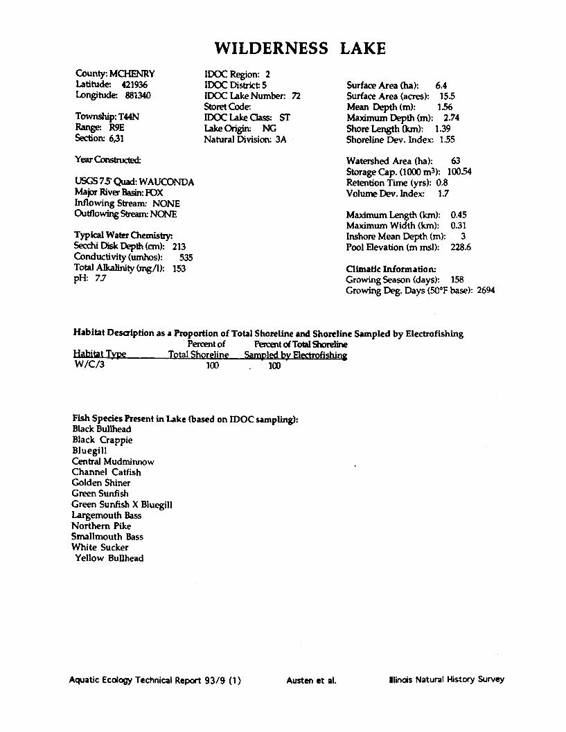
WILDERNESS LAKECounty: MCHENRYLatitude 421936Longitude 881340
Township: T44NRange R9ESection: 6,31
IDOC Region: 2IDOC District: 5IDOC Lake Number: 72Storet Code.IDOC Lake Class: STLake Origi NGNatural Division: 3A
Surface Area (ha): 6.4Surface Area (acres): 15.5Mean Depth (m): 1.56Maximum Depth (m): 2.74Shore Length (km): 1.39Shoreline Dev. Index: 1.55
Year Constucted-
USGS 75 Quad: WAUCONDAMajor River Basin: FOXInflowing Stream: NONEOutflowing Stream: NONE
Typical Water Chemistry:Secchi Disk Depth (cm): 213Conductivity (umhos): 535Total Alkalinity (mg/1): 153pH: 7.7
Watershed Area (ha): 63Storage Cap. (1000 m3): 100.54Retention Time (yrs): 0.8Volume Dev. Index: 1.7
Maximum Length (km): 0.45Maximum Width (km): 0.31Inshore Mean Depth (m): 3Pool Elevation (m msl): 228.6
Climatic Information:Growing Season (days): 158Growing Deg. Days (50*F base): 2694
Habitat Description as a Proportion of Total Shoreline and Shoreline Sampled by Electrofishing
Percent of Percent of Total Shoreline
fishitat Type Total Shoreline Sampled by Bectrofishing
W/C/3 100 100
Fish Species Present in Lake (based on IDOC sampling):Black BullheadBlack CrappieBluegillCentral MudminnowChannel CatfishGolden ShinerGreen SunfishGreen Sunfish X BluegillLargemouth BassNorthern PikeSmallmouth BassWhite SuckerYellow Bullhead
Aquatic Ecology Technical Report 93/9 (1)
_ _ w
Ilinois Natural History SurveyAusten et al.

Notes and Comments:
Aquatic Ecology Technical Report 93/9 (1) Austen et al. Iinois Natural History Survey

WILDERNESS LAKE
N
500ft
Aquatic Ecology Technical Report 93/9 (1)
I History Survey
,outline from ASCS
Austen et al. Ilinois Natural History Survey

WILDERNESS LAKE
N
IAGl
W/C/3 El
Aquatic Ecology Technical Report 93/9 (1)
Habitat CodesHabitat/Substrate/Hard CoverHabitat:W Woody debris
= Emergent vegetation= Rip rap
) = Open area) = Docksr = Retaining wall or dam faceU = Unknown
;ubstrate:4 = Mud or silt
= Clay= Sand= Gravel= Rock or boulder
I = Unknown
lard Cover Rating:= 0% woody debris and no docks.
M • •0% d• d ,bi .. da o f y e rs wjl tocks or
1-33% woody debris.2 =1-33% woody debris with many
docks or 34-66% woody debris.3 = 34-66% woody debris with many
docks or > 67% woody debris.
Data compiled by the IllinoisNatural History Survey
Date%hý v V D INt .
indois Natural Istory SurveyAusten et al.

WOLF LAKECounty: COOKLatitude: 414018Longitude: 873150
Township: T37NRange: R15ESection: 29
IDOC Region: 2IDOC District. 6IDOC Lake Number: 84Storet Code: RH-A06-AIDOC Lake Class: STLake Origin: NGNatural Division: 3C
Year Constructed:
USGS 75' Quad: LAKE CALUMETMajor River Basin: DES PLAINESInflowing Stream: NONEOutflowing Stream: WOLF CR>CALUMET R>L MICH
Typical Water Chemistry:Secchi Disk Depth (cm): fConductivity (umhos):Total Alkalinity (mg/1):pH: 8.
83302
72
Surface Area (ha): 158.4Surface Area (acres): 380.2Mean Depth (m): 1.798Maximum Depth (m): 4.877Shore Length (km): 13.213Shoreline Dev. Index: 2.96
Watershed Area (ha): 202Storage Cap. (1000 m3): 2851.76Retention Time (yrs): 6.2Volume Dev. Index: 1.1
Maximum Length (km): 1.133Maximum Width (km): 2.265Inshore Mean Depth (m): 1.1Pool Elevation (m msl): 177.4
Climatic Information:Growing Season (days): 165Growing Deg. Days (50*F base): 2996
Habitat Description as a Proportion of Total Shoreline and Shoreline Sampled by ElectrofishingPercent of Percent of Total Shoreline
Habitat Type Total Shoreline Sampled by ElectrofishingD/G/1E/G/0O/S/OO/C/OR/B/0T/U/0W/C/1
22
14642
12272
Fish Species Present in Lake (based on IDOC sampling):ALEWIFE GoldfishBlack Bullhead Grass PickerelBlack Crappie Green SunfishBluegill Green Sunfish X BluegillBluntnose Minnow Green Sunfish X PumpkinseedBrown Bullhead Johnny DarterCarp Lake ChubsuckerCarp X Goldfish Largemouth BassChannel Catfish Longear SunfishEmerald Shiner Northern PikeGizzard Shad Orangespotted SunfishGolden Shiner Pumpkinseed
River CarpsuckerSmallmouth BassSmallmouth BuffaloTiger MuskellungeWalleyeWarmouthWhite SuckerYellow Perch
Aquatic Ecology Technical Report 93/9 (1) Ilinois Natural History SurveyAusten et al.

Notes and Comments:
Aquatic Ecology Technical Report 93/9 (1) Ilinois Natural History SurveyAusten et al.

WOLF LAKE
ural History Surveysect, outline from USGS
Aquatic Ecology Technical Report 93/9 (1)
N
0.25mi
IIlinois Natural History Survey
\
1fAusten et al.

WOLF LAKE
NR/B/O
R/B/C
O/C/C
O/Cl
Aquatic Ecology Technical Report 93/9 (1)
Habitat CodesHabitat/Substrate/Hard Cover
Habitat:W = Woody debrisE = Emergent vegetationR = Rip rap0 = Open areaD = DocksT = Retaining wall or dam faceU = Unknown
Substrate:M = Mud or siltC = ClayS = SandG = GravelB = Rock or boulderU = Unknown
Hard Cover Rating:0 = 0% woody debris and no docks.I = 0% woody debris with docks or
1-33% woody debris.2 = 1-33% woody debris with many
docks or 34-66% woody debris.3 = 34-66% woody debris with many
docks or > 67% woody debris.
Data compiled by the IllinoisNatural History Survey
Date J1%. %a v %ý - .-OOIF
I
Winois Natural History SurveyAusten et al.

WOOD LAKECounty: MOULTRIELatitude: 393139Longitude: 883650
Township: TI3NRange: R5ESection: 34,35
IDOC Region: 3IDOC District: 9IDOC Lake Number: 140STORET CodeIDOC Lake Class: PULake Origin:Natural Division: 4A
Year Constructed: 1965
USGS 75 Quad: SULIVANMajor River Basin: KASKASKIAInflowing Stream: TRIBOutflowing Stream: SAME>LAKE SHELBYVILLE
Typical Water Chemistry:Secchi Disk Depth (cm): 91Conductivity (umhos): 420Total Alkalinity (mg/1): 118pH: 8.3
Surface Area (ha): 11.2Surface Area (acres): 26.9Mean Depth (m): 2.23Maximum Depth (m): 5.79Shore Length (km): 3.41Shoreline Dev. Index: 2.87
Watershed Area (ha): 465Storage Cap. (1000 m3): 250.42Retention Time (yrs): 0.2Volume Dev. Index: 1.15
Maximum Length (km):Maximum Width (kmin):Inshore Mean Depth (m):Pool Elevation (m msl):
0510.85
1.6175
Climatic Information:Growing Season (days): 183Growing Deg. Days (50°F base): 3561
Habitat Description as a Proportion of Total Shoreline and Shoreline Sampled by Electrofishing
Percent of Percent of Total Shoreline
Habitat Type Total Shoreline Sam led by Ele-trofishn
E/M/1R/M/0W/M/1
114
77
113
41
Fish Species Present in Lake (based on IDOC sampling):
N/A
Aquatic Ecology Technical Report 93/9 (1)
p ILA& IrglW
Austen et al. Ilinois Natural History Survey

Notes and Comments:
Aquatic Ecology Technical Report 93/9 (1) Austen et al. Ilinois Natural History Survey

WOOD LAKE
SCALEi --
Map SoiMappin4
aerialDate coi
Aquatic Ecology Technical Report 93/9 (1) Ulinois Natural History SurveyAusten et al.

WOfn TATWE
W/M/ __r %IFA
/M/I
E/M/1I
El
E2 W/M/I
W/M/2
El
El
W/M/1l
E2R/M/O
R/M/0
Aquatic Ecology Technical Report 93/9 (1)
Habitat CodesHabitat/Substrate/Hard Cover
Habitat:W = Woody debrisE = Emergent vegetationR = Rip rap0 = Open areaD = DocksT = Retaining wall or dam faceU = Unknown
Substrate:M = Mud or siltC = ClayS = SandG = GravelB = Rock or boulderU = Unknown
Hard Cover Rating:0 = 0% woody debris and no docks.1 = 0% woody debris with docks or
1-33% woody debris.2 = 1-33% woody debris with many
docks or 34-66% woody debris.3 = 34-66% woody debris with many
docks or > 67% woody debris.
Data compiled by the IllinoisNatural History Survey
Date 8/18/88,q% mmompool
Austen et al. linois Natural History Survey
LOP L-JA •XiJ, %--

LAKE ZURICHCounty. LAKELatitude: 421142Longitude: 880554
Township: T43NRange: R10ESection: 17,18,19,20
IDOC Region: 2IDOC District. 6IDOC Lake Number:Storet Code: RT-B02-SIDOC Lake Class: PRLake Origin: NGNatural Division: 3A
Year Constructed:
USGS 75' Quad: LAKE ZURICH*Major River Basin: POXInflowing Stream: NONEOutflowing Stream: INT<GRSY<FLINT CR<FOX<ECHO L
Typical Water Chemistry:Secchi Disk Depth (cm): 124Conductivity (umhos): 525Total Alkalinity (mg/1): 80pH: 9.0
Surface Area (ha): 88.1Surface Area (acres): 211.4Mean Depth (m): 3.07Maximum Depth (m): 9.75Shore Length (km): 4.12Shoreline Dev. Index: 1.23
Watershed Area (ha): 502Storage Cap. (1000 m3): 2706.68Retention Time (yrs): 3.0Volume Dev. Index: 0.94
Maximum Length (km):Maximum Width (km):Inshore Mean Depth (m):Pool Elevation (m msl):
1.171.2
0.85256.9
Climatic Information:Growing Season (days): 158Growing Deg. Days (500F base): 2694
Habitat Description as a Proportion of Total Shoreline and Shoreline Sampled by ElectrofishingPercent of Percent of Total Shoreline
Habitat TypevTotal Shoreline Samoled by ElectrofishineE/S/0E/S/1O/S/0R/B/0R/B/1W/S/0
228216
28
22818628
Fish Species Present in Lake (based on IDOC sampling):Black CrappieBluegillBluegill X PumpkinseedBluntnose MinnowBrook SilversideCarpGrass PickerelLake ChubsuckerLargemouth BassNorthern PikePumpkinseedYellow Perch
Aquatic Ecology Technical Report 93/9 (1) Austen et al. Ilinois Natural History Survey

Notes and Comments:
Aquatic Ecology Technical Report 93/9 (1) Ilinois Natural History SurveyAusten et al.
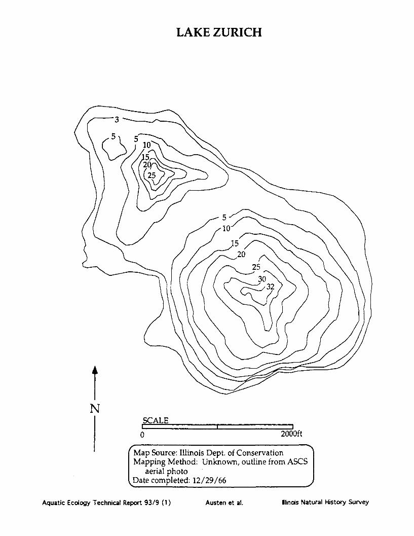
LAKE ZURICH
NSCALE
0 2000ft
Map Source: Illinois Dept. of ConservationMapping Method: Unknown, outline from ASCS
aerial photoDate completed: 12/29/66
Aquatic Ecology Technical Report 93/9 (1)
l
Austen et al. Ilinois Natural History Survey

LAKE ZURICH
E/S/1
Aquatic Ecology Technical Report 93/9 (1)
fr ! o» _ 4 - - - -
Habitat LCodes (given as a three character code: Habitat/Substrate/Hard Cover)Habiitatl Su ate: Hard Cover RatiW = Woody debris M = Mud or silt 0= 0% woody debris and no docks.E = Emergent vegetation C = Clay 1 = 0% woody debris with docks orR = Rip rap S = Sand 1-33% woody debris.0 = Open area G = Gravel 2 = 1-33% woody debris with many docksD = Docks B = Rock or boulder or 34-66% woody debris.T = Retaining wall or dam face U = Unknown 3 = 34-66% woody debris with many docksU = Unknown or greater than 67% woody debris.Information compiled by the Illinois Natural Historv Snrvev enmnleted i nno fl
Austen et al. Illinois Natural History Survey