completing the industrial wastewater permit application · completing the industrial wastewater...
TRANSCRIPT

September 2006Form TCEQ-10411/10055-Instructions
TCEQ
Completing theIndustrial WastewaterPermit Application
Printed on
Recycled Paper Texas Commission on Environmental Quality

-i-TCEQ-10411/10055-Instructions (Revised 09/2006)
TABLE OF CONTENTS
PURPOSE . . . . . . . . . . . . . . . . . . . . . . . . . . . . . . . . . . . . . . . . . . . . . . . . . . . . . . . . . . . . . . . . . . . . . . . . . . . . . . -1-OBJECTIVES . . . . . . . . . . . . . . . . . . . . . . . . . . . . . . . . . . . . . . . . . . . . . . . . . . . . . . . . . . . . . . . . . . . . . . . . . . . -1-STATUTORY AND REGULATORY CITATIONS . . . . . . . . . . . . . . . . . . . . . . . . . . . . . . . . . . . . . . . . . . . . . -1-ABBREVIATIONS AND ACRONYMS . . . . . . . . . . . . . . . . . . . . . . . . . . . . . . . . . . . . . . . . . . . . . . . . . . . . . . -1-DEFINITIONS . . . . . . . . . . . . . . . . . . . . . . . . . . . . . . . . . . . . . . . . . . . . . . . . . . . . . . . . . . . . . . . . . . . . . . . . . . . -2-WHO SHOULD APPLY FOR A WASTEWATER PERMIT? . . . . . . . . . . . . . . . . . . . . . . . . . . . . . . . . . . . . -11-WHEN IS THE APPLICATION SUBMITTED? . . . . . . . . . . . . . . . . . . . . . . . . . . . . . . . . . . . . . . . . . . . . . . . -11-HOW IS THE APPLICATION SUBMITTED? . . . . . . . . . . . . . . . . . . . . . . . . . . . . . . . . . . . . . . . . . . . . . . . . -11-HOW MUCH IS THE APPLICATION FEE? . . . . . . . . . . . . . . . . . . . . . . . . . . . . . . . . . . . . . . . . . . . . . . . . . . -11-HOW DO I OBTAIN MORE INFORMATION? . . . . . . . . . . . . . . . . . . . . . . . . . . . . . . . . . . . . . . . . . . . . . . -12-HOW DO I SUBMIT THE APPLICATION? . . . . . . . . . . . . . . . . . . . . . . . . . . . . . . . . . . . . . . . . . . . . . . . . . . -13-INSTRUCTIONS FOR ADMINISTRATIVE REPORT 1.0 . . . . . . . . . . . . . . . . . . . . . . . . . . . . . . . . . . . . . . . -14-
APPLICANT INFORMATION . . . . . . . . . . . . . . . . . . . . . . . . . . . . . . . . . . . . . . . . . . . . . . . . . . . . . . -14-CONTACT INFORMATION . . . . . . . . . . . . . . . . . . . . . . . . . . . . . . . . . . . . . . . . . . . . . . . . . . . . . . . . -15-NOTICE INFORMATION . . . . . . . . . . . . . . . . . . . . . . . . . . . . . . . . . . . . . . . . . . . . . . . . . . . . . . . . . . -15-FACILITY INFORMATION . . . . . . . . . . . . . . . . . . . . . . . . . . . . . . . . . . . . . . . . . . . . . . . . . . . . . . . . -16-LOCATION INFORMATION . . . . . . . . . . . . . . . . . . . . . . . . . . . . . . . . . . . . . . . . . . . . . . . . . . . . . . . -17-MISCELLANEOUS INFORMATION . . . . . . . . . . . . . . . . . . . . . . . . . . . . . . . . . . . . . . . . . . . . . . . . -19-SIGNATURE PAGE . . . . . . . . . . . . . . . . . . . . . . . . . . . . . . . . . . . . . . . . . . . . . . . . . . . . . . . . . . . . . . . -20-SUPPLEMENTAL PERMIT INFORMATION FORM . . . . . . . . . . . . . . . . . . . . . . . . . . . . . . . . . . . . -20-
INSTRUCTIONS FOR ADMINISTRATIVE REPORT 1.1 - NEW AND AMENDMENT . . . . . . . . . . . . . . -21-AFFECTED LANDOWNER INFORMATION . . . . . . . . . . . . . . . . . . . . . . . . . . . . . . . . . . . . . . . . . . -21-ORIGINAL PHOTOGRAPHS . . . . . . . . . . . . . . . . . . . . . . . . . . . . . . . . . . . . . . . . . . . . . . . . . . . . . . . -23-
INSTRUCTIONS FOR TECHNICAL REPORT 1.0 . . . . . . . . . . . . . . . . . . . . . . . . . . . . . . . . . . . . . . . . . . . . -24-FACILITY/SITE INFORMATION . . . . . . . . . . . . . . . . . . . . . . . . . . . . . . . . . . . . . . . . . . . . . . . . . . . -24-SIC CODE . . . . . . . . . . . . . . . . . . . . . . . . . . . . . . . . . . . . . . . . . . . . . . . . . . . . . . . . . . . . . . . . . . . . . . -24-TREATMENT SYSTEM . . . . . . . . . . . . . . . . . . . . . . . . . . . . . . . . . . . . . . . . . . . . . . . . . . . . . . . . . . . -25-IMPOUNDMENTS . . . . . . . . . . . . . . . . . . . . . . . . . . . . . . . . . . . . . . . . . . . . . . . . . . . . . . . . . . . . . . . -25-OUTFALL/DISPOSAL METHOD INFORMATION . . . . . . . . . . . . . . . . . . . . . . . . . . . . . . . . . . . . . -27-BLOWDOWN AND ONCE-THROUGH COOLING WATER DISCHARGES . . . . . . . . . . . . . . . . -28-STORM WATER MANAGEMENT . . . . . . . . . . . . . . . . . . . . . . . . . . . . . . . . . . . . . . . . . . . . . . . . . . -28-DOMESTIC SEWAGE, SEWAGE SLUDGE, AND/OR SEPTAGE DISPOSAL . . . . . . . . . . . . . . . -29-IMPROVEMENTS OR COMPLIANCE/ENFORCEMENT REQUIREMENTS . . . . . . . . . . . . . . . . -29-TOXICITY TESTING . . . . . . . . . . . . . . . . . . . . . . . . . . . . . . . . . . . . . . . . . . . . . . . . . . . . . . . . . . . . . -30-OFF-SITE/THIRD PARTY WASTES . . . . . . . . . . . . . . . . . . . . . . . . . . . . . . . . . . . . . . . . . . . . . . . . . -30-RADIOACTIVE MATERIALS . . . . . . . . . . . . . . . . . . . . . . . . . . . . . . . . . . . . . . . . . . . . . . . . . . . . . . -30-MAJOR AMENDMENTS . . . . . . . . . . . . . . . . . . . . . . . . . . . . . . . . . . . . . . . . . . . . . . . . . . . . . . . . . . -30-MINOR MODIFICATIONS . . . . . . . . . . . . . . . . . . . . . . . . . . . . . . . . . . . . . . . . . . . . . . . . . . . . . . . . . -31-MINOR AMENDMENTS . . . . . . . . . . . . . . . . . . . . . . . . . . . . . . . . . . . . . . . . . . . . . . . . . . . . . . . . . . -31-
WORKSHEETS TO THE PERMIT APPLICATION TECHNICAL REPORT . . . . . . . . . . . . . . . . . . . . . . . . -32-INSTRUCTIONS FOR WORKSHEET 1.0 - EPA EFFLUENT CATEGORICAL GUIDELINES . . . . . . . . . -34-
CATEGORICAL INDUSTRIES . . . . . . . . . . . . . . . . . . . . . . . . . . . . . . . . . . . . . . . . . . . . . . . . . . . . . -34-PRODUCTION/PROCESS DATA . . . . . . . . . . . . . . . . . . . . . . . . . . . . . . . . . . . . . . . . . . . . . . . . . . . -35-PROCESS/NON-PROCESS WASTEWATER FLOWS . . . . . . . . . . . . . . . . . . . . . . . . . . . . . . . . . . . -35-NEW SOURCE DETERMINATION . . . . . . . . . . . . . . . . . . . . . . . . . . . . . . . . . . . . . . . . . . . . . . . . . . -35-
INSTRUCTIONS FOR WORKSHEET 2.0 - POLLUTANT ANALYSIS REQUIREMENTS . . . . . . . . . . . . -36-GENERAL REQUIREMENTS . . . . . . . . . . . . . . . . . . . . . . . . . . . . . . . . . . . . . . . . . . . . . . . . . . . . . . -36-TESTING REQUIREMENTS . . . . . . . . . . . . . . . . . . . . . . . . . . . . . . . . . . . . . . . . . . . . . . . . . . . . . . . -37-
INSTRUCTIONS FOR WORKSHEET 3.0 - LAND APPLICATION OF EFFLUENT . . . . . . . . . . . . . . . . . -46-TYPE OF DISPOSAL SYSTEM . . . . . . . . . . . . . . . . . . . . . . . . . . . . . . . . . . . . . . . . . . . . . . . . . . . . . -46-LAND APPLICATION AREA . . . . . . . . . . . . . . . . . . . . . . . . . . . . . . . . . . . . . . . . . . . . . . . . . . . . . . . -46-
ANNUAL CROPPING PLAN . . . . . . . . . . . . . . . . . . . . . . . . . . . . . . . . . . . . . . . . . . . . . . . . . . . . . . . -46-

-ii-TCEQ-10411/10055-Instructions (Revised 09/2006)
STORM WATER MANAGEMENT . . . . . . . . . . . . . . . . . . . . . . . . . . . . . . . . . . . . . . . . . . . . . . . . . . -46-WELL AND MAP INFORMATION . . . . . . . . . . . . . . . . . . . . . . . . . . . . . . . . . . . . . . . . . . . . . . . . . . -47-SOIL MAP AND SOIL ANALYSIS . . . . . . . . . . . . . . . . . . . . . . . . . . . . . . . . . . . . . . . . . . . . . . . . . . -47-EFFLUENT AND SOIL MONITORING DATA . . . . . . . . . . . . . . . . . . . . . . . . . . . . . . . . . . . . . . . . -48-POLLUTANT ANALYSIS . . . . . . . . . . . . . . . . . . . . . . . . . . . . . . . . . . . . . . . . . . . . . . . . . . . . . . . . . -48-
INSTRUCTIONS FOR WORKSHEET 3.1 - SURFACE LAND DISPOSAL OF EFFLUENT . . . . . . . . . . . -49-SURFACE SPRAY (IRRIGATION) . . . . . . . . . . . . . . . . . . . . . . . . . . . . . . . . . . . . . . . . . . . . . . . . . . -49-EVAPORATION PONDS . . . . . . . . . . . . . . . . . . . . . . . . . . . . . . . . . . . . . . . . . . . . . . . . . . . . . . . . . . -49-EVAPOTRANSPIRATION BEDS . . . . . . . . . . . . . . . . . . . . . . . . . . . . . . . . . . . . . . . . . . . . . . . . . . . -49-EDWARDS AQUIFER RECHARGE AREA . . . . . . . . . . . . . . . . . . . . . . . . . . . . . . . . . . . . . . . . . . . -50-
INSTRUCTIONS FOR WORKSHEET 3.2 - SUBSURFACE LAND APPLICATION OF EFFLUENT . . . . -51-SUBSURFACE APPLICATION . . . . . . . . . . . . . . . . . . . . . . . . . . . . . . . . . . . . . . . . . . . . . . . . . . . . . -51-EDWARDS AQUIFER RECHARGE AREA . . . . . . . . . . . . . . . . . . . . . . . . . . . . . . . . . . . . . . . . . . . -51-
INSTRUCTIONS FOR WORKSHEET 3.3 - SUBSURFACE AREA DRIP DISPERSAL LAND APPLICATION OF EFFLUENT . . . . . . . . . . . . . . . . . . . . . . . . . . . . . . . . . . . . . . . . . . . . . . -52-
ADMINISTRATIVE QUESTIONS . . . . . . . . . . . . . . . . . . . . . . . . . . . . . . . . . . . . . . . . . . . . . . . . . . . -52-SUBSURFACE AREA DRIP DISPERSAL SYSTEM . . . . . . . . . . . . . . . . . . . . . . . . . . . . . . . . . . . . -52-REQUIRED PLANS . . . . . . . . . . . . . . . . . . . . . . . . . . . . . . . . . . . . . . . . . . . . . . . . . . . . . . . . . . . . . . . -53-FLOOD AND RUNON PROTECTION . . . . . . . . . . . . . . . . . . . . . . . . . . . . . . . . . . . . . . . . . . . . . . . . -53-EDWARDS AQUIFER RECHARGE AREA . . . . . . . . . . . . . . . . . . . . . . . . . . . . . . . . . . . . . . . . . . . -53-
INSTRUCTIONS FOR WORKSHEET 4.0 - RECEIVING WATERS . . . . . . . . . . . . . . . . . . . . . . . . . . . . . . -54-DOMESTIC DRINKING WATER SUPPLY . . . . . . . . . . . . . . . . . . . . . . . . . . . . . . . . . . . . . . . . . . . -54-DISCHARGE INTO TIDALLY INFLUENCED WATER . . . . . . . . . . . . . . . . . . . . . . . . . . . . . . . . . -54-CLASSIFIED SEGMENT . . . . . . . . . . . . . . . . . . . . . . . . . . . . . . . . . . . . . . . . . . . . . . . . . . . . . . . . . . -54-DESCRIPTION OF RECEIVING WATERS . . . . . . . . . . . . . . . . . . . . . . . . . . . . . . . . . . . . . . . . . . . . -55-GENERAL CHARACTERISTICS OF WATER BODY . . . . . . . . . . . . . . . . . . . . . . . . . . . . . . . . . . . -55-
INSTRUCTIONS FOR WORKSHEET 4.1 - STREAM PHYSICAL CHARACTERISTICS WORKSHEET -56-DATA COLLECTION . . . . . . . . . . . . . . . . . . . . . . . . . . . . . . . . . . . . . . . . . . . . . . . . . . . . . . . . . . . . . -56-SUMMARIZE MEASUREMENTS . . . . . . . . . . . . . . . . . . . . . . . . . . . . . . . . . . . . . . . . . . . . . . . . . . . -57-
INSTRUCTIONS FOR WORKSHEET 5.0 - SEWAGE SLUDGE MANAGEMENT AND DISPOSAL . . . . -58-SEWAGE SLUDGE SOLIDS MANAGEMENT PLAN . . . . . . . . . . . . . . . . . . . . . . . . . . . . . . . . . . . -58-SLUDGE MANAGEMENT/DISPOSAL . . . . . . . . . . . . . . . . . . . . . . . . . . . . . . . . . . . . . . . . . . . . . . -58-PERMIT AUTHORIZATION FOR SEWAGE SLUDGE DISPOSAL . . . . . . . . . . . . . . . . . . . . . . . . -59-
INSTRUCTIONS FOR WORKSHEET 6.0 - INDUSTRIAL WASTE CONTRIBUTION . . . . . . . . . . . . . . . -60-ALL POTWs . . . . . . . . . . . . . . . . . . . . . . . . . . . . . . . . . . . . . . . . . . . . . . . . . . . . . . . . . . . . . . . . . . . . . -60-POTWs WITH A PROGRAM OR REQUIRED TO DEVELOP A PROGRAM . . . . . . . . . . . . . . . . -60-SIGNIFICANT INDUSTRIAL USER INFORMATION . . . . . . . . . . . . . . . . . . . . . . . . . . . . . . . . . . . -61-
INSTRUCTIONS FOR WORKSHEET 7.0 - STORM WATER RUNOFF WORKSHEET . . . . . . . . . . . . . . -62-SITE MAP . . . . . . . . . . . . . . . . . . . . . . . . . . . . . . . . . . . . . . . . . . . . . . . . . . . . . . . . . . . . . . . . . . . . . . -62-FACILITY/SITE INFORMATION . . . . . . . . . . . . . . . . . . . . . . . . . . . . . . . . . . . . . . . . . . . . . . . . . . . -63-POLLUTANT ANALYSIS . . . . . . . . . . . . . . . . . . . . . . . . . . . . . . . . . . . . . . . . . . . . . . . . . . . . . . . . . -63-STORM EVENT DATA . . . . . . . . . . . . . . . . . . . . . . . . . . . . . . . . . . . . . . . . . . . . . . . . . . . . . . . . . . . . -65-
INSTRUCTIONS FOR WORKSHEET 8.0 - AQUACULTURE . . . . . . . . . . . . . . . . . . . . . . . . . . . . . . . . . . . -66-INSTRUCTIONS FOR WORKSHEET 9.0 - CLASS V INJECTION WELL . . . . . . . . . . . . . . . . . . . . . . . . . -72-INSTRUCTIONS FOR WORKSHEET 10.0 - JOHN GRAVES SCENIC RIVERWAY . . . . . . . . . . . . . . . . . -73-INSTRUCTIONS FOR WORKSHEET 11.0 - COOLING WATER INTAKE STRUCTURES . . . . . . . . . . . -76-EXAMPLE 1 - COMMON PROCESS OR PROCESS MODIFICATIONS . . . . . . . . . . . . . . . . . . . . . . . . . . . -79-EXAMPLE 2 - COMMON TREATMENT UNITS . . . . . . . . . . . . . . . . . . . . . . . . . . . . . . . . . . . . . . . . . . . . . -80-EXAMPLE 3 - FLOW DIAGRAM . . . . . . . . . . . . . . . . . . . . . . . . . . . . . . . . . . . . . . . . . . . . . . . . . . . . . . . . . . -81-EXAMPLE 4 -SLUDGE MANAGEMENT PLAN . . . . . . . . . . . . . . . . . . . . . . . . . . . . . . . . . . . . . . . . . . . . . . -82-EXAMPLE 5 - ADJACENT AND DOWNSTREAM LANDOWNER MAP . . . . . . . . . . . . . . . . . . . . . . . . . -83-EXAMPLE 6 -WATER BALANCE AND STORAGE CALCULATION . . . . . . . . . . . . . . . . . . . . . . . . . . . . -85-TRANSFER SIGNATURE PAGE . . . . . . . . . . . . . . . . . . . . . . . . . . . . . . . . . . . . . . . . . . . . . . . . . . . . . . . . . . -91-
Texas Commission on Environmental QualityWastewater Permitting Section

-1-TCEQ-10411/10055-Instructions (Revised 09/2006)
Industrial Wastewater Permit Application
PURPOSE
Industrial facilities which generate wastewater may use this application to apply for a permit to discharge and/ordispose of wastewater.
OBJECTIVES
Use of these instructions will answer the following questions.! Who must complete and submit an application?! When must the completed application be submitted?! How do I complete the application?! How do I get more information and assistance in completing the application?
STATUTORY CITATIONS
Texas Water Code Chapters 5 and 2640 Code of Federal Regulations
PRIMARY REGULATORY CITATIONS
All Chapters are found within Title 30 of the Texas Administrative Code
Chapter 21Chapter 39Chapter 40Chapter 50Chapter 55Chapter 60Chapter 80Chapter 213Chapter 281Chapter 305Chapter 307
Chapter 308 Chapter 309 Chapter 311Chapter 312Chapter 314Chapter 315Chapter 317Chapter 319Chapter 325Chapter 332Chapter 351
ABBREVIATIONS AND ACRONYMS
AMU - Agricultural Management UnitBOD5 - Biochemical Oxygen Demand (5-day)CAFO - Confined Animal Feeding OperationCASRN - Chemical Abstract Service Registration NumberCBOD5 - Carbonaceous Biochemical Oxygen Demand (5-day)CFR - Code of Federal RegulationsCIU - Categorical Industrial UserCWIS - Cooling Water Intake StructureDMR - Discharge Monitoring ReportDO - Dissolved OxygenEPA - Environmental Protection AgencyIU - Industrial UserMAL - Minimum Analytical LevelMDL - Method Detection LimitABBREVIATIONS AND ACRONYMS (CONTINUED)
MER - Monthly Effluent Report

-2-TCEQ-10411/10055-Instructions (Revised 09/2006)
MGD - Million Gallons per DayMLSS - Mixed Liquor Suspended Solidsmg/L - Milligrams per Liter MSDS - Material Safety Data Sheets:g/L - Micrograms per LiterNPDES - National Pollutant Discharge Elimination SystemNH3-N - Ammonia NitrogenOCC - Office of the Chief ClerkP2 - Pollution PreventionPOTW - Publicly Owned Treatment WorksQA/QC - Quality Assurance/Quality ControlSADDS - Subsurface Area Drip Dispersal SystemSAR - Sodium Adsorption RatioSPIF - Supplemental Permit Information FormSIC - Standard Industrial Classification SIU - Significant Industrial UserSWDA - Solid Waste Disposal ActTAC - Texas Administrative CodeTBLL - Technically Based Local LimitsTLAP - Texas Land Application PermitTMDL - Total Maximum Daily LoadTCEQ - Texas Commission on Environmental QualityTPDES - Texas Pollutant Discharge Elimination System TSS - Total Suspended SolidsUSDA - United States Department of AgricultureUSGS - United States Geological SurveyWWTP - Wastewater Treatment Plant
DEFINITIONS
303(d)-List - A list of water bodies identified as impaired or threatened in accordance with the Federal Clean WaterAct Section 303(d).
Act of God - If a person can establish that an event that would otherwise be a violation of a permit, an order, the rulesadopted by the Commission, or the Texas Water Code was caused solely by an act of God, war, strike, riot, or othercatastrophe, the event is not a violation of that permit, order, rule, or statute.
Algae - Plants that lack true roots, stems, and leaves. Algae consists of nonvascular plants that attach to rock anddebris in the water or are suspended in the water column. Such plants may be green, blue-green, or olive in color,slimy to the touch, and usually have a coarse filamentous structure.
Annual Average Flow - The arithmetic average of all daily flow determinations taken within the preceding 12consecutive calendar months.
Aquatic Macrophyte - Vascular plants that usually are arranged in zones corresponding closely to successively greaterdepths in shallow water. The characteristic plant forms that dominate these gradients (in order of decreasing depth)are: (1) submersed rooted aquatics; (2) floating-leaved rooted aquatics; (3) immersed rooted aquatics; (4) marginalmats. Some vascular plants (like duckweed) may live unattached in the water and may occur anywhere on the watersurface.

-3-TCEQ-10411/10055-Instructions (Revised 09/2006)
Biochemical Oxygen Demand (5-day) - The amount of dissolved oxygen consumed in five days by biologicalprocesses breaking down organic matter
Categorical Industrial User (CIU) - An industrial user that is subject to Categorical Pretreatment Standards accordingto 40 CFR §403.6 and 40 CFR Chapter I, Subchapter N, §405 - 471, which are technology-based standards developedby EPA setting industry-specific effluent limits. (A list of industrial categories subject to Categorical PretreatmentStandards is included in Worksheet 1.0.)
Classified Waters - Water bodies classified as segments with specific uses and criteria in Appendix A or D of 30 TAC§307.10 of the Texas Surface Water Quality Standards.
Class I Sludge Management Facility - Any publicly owned treatment works (POTW) identified under 40 CFR§403.10(a) as being required to have an approved pretreatment program and any other treatment works treatingdomestic sewage classified as a Class I sludge management facility by the regional administrator in conjunction withthe executive director because of the potential for its sludge use or disposal practices to adversely affect public healthand the environment.
Commercial User - Industrial Users who are not considered to be a significant single source of toxics because of theirsmall size, generally low flow and insignificant pollutant levels or loadings, including but not limited to, radiatorshops, car washes, small laundries, gasoline stations, dry cleaners and restaurants.
Commission - The Texas Commission on Environmental Quality
Composite Sample - A sample made up of a minimum of three effluent portions or as specified in 30 TAC §319.9collected in a continuous 24-hour period or during the period of daily discharge if less than 24 hours, and combinedin volumes proportional to flow, and collected no closer than two hours apart. For purposes of the TPDESPretreatment Program, a composite sample is defined in 40 CFR §403, Appendix E.
Continuous Discharge - A “discharge” which occurs without interruption throughout the operating hours of thefacility, except for infrequent shutdowns for maintenance, process changes, or other similar activities.
Cooling Water Intake Structure - The total physical structure and any waterways used to withdraw cooling waterfrom waters of the United States. The cooling water intake structure extends from the point at which water iswithdrawn from the surface water source up to, and including, the intake pumps.
Daily Average Concentration - The arithmetic average of all effluent samples, composite or grab as required by apermit, within a period of one calendar month, consisting of at least four separate representative measurements.
Daily Average Flow - The arithmetic average of all determinations of the daily discharge within a period of onecalendar month. The daily average flow determination shall consist of determinations made on at least four separatedays. If instantaneous measurements are used to determine the daily discharge, the determination shall be the averageof all instantaneous measurements taken during a 24-hour period or during the period of daily discharge if less than24 hours. Daily average flow determination for intermittent discharges shall consist of a minimum of three flowdeterminations on days of discharge.
Design Flow - The wet weather maximum 30-day average flow of wastewater.
Disinfection - A chemical or physical process that kills pathogenic organisms in water.
Discharge Monitoring Report - The EPA uniform national form, including any subsequent additions, revisions, ormodifications for the reporting of self-monitoring results by permittees. Permittees with TPDES permits are requiredto submit this form. Monitoring results must be reported on a approved TPDES self-report form, DMR Form EPANo. 3320-1, signed and certified.

-4-TCEQ-10411/10055-Instructions (Revised 09/2006)
Disposal - The disposal, deposit, injection, dumping, spilling, leaking, or placing of any solid, liquid, or hazardouswaste into or on any land or water so that such waste or any constituent thereof may enter the environment or beemitted into the air or discharged into any waters, including groundwater.
Domestic sewage - Waste and wastewater from humans or household operations that is discharged to a wastewatercollection system or otherwise enters a treatment works.
Effluent - Wastewater, treated or untreated, that flows out of a treatment plant sewer.
Effluent Limitations - Restrictions established by the TCEQ or EPA on quantities, rates, and concentrations inwastewater discharges.
Executive Director - The Executive Director of the Texas Commission on Environmental Quality or his/her designee.
Existing Facility - Any facility used for the storage, processing, or disposal of domestic wastewater and which hasobtained approval of construction plans and specifications as of March 1, 1990.
Facility - All contiguous land and fixtures, structures, or appurtenances used for storing, processing, or disposing ofwaste. (See also the definition relating to sewage sludge.)
Fixture of the Land - An item that has become so annexed to the realty that it is regarded as part of the land (i.e.,ponds, lagoons).
Glide - Portion of the water column that resembles flow that would be found in a shallow canal. Water surfacegradient over a glide is nearly zero, so velocity is slow, but flow is shore to shore without eddy development.
Grab Sample - An individual sample collected in less than 15 minutes.
Industrial User - Any industrial or commercial facility that discharges wastewater to the treatment works that is notdomestic wastewater. Domestic wastewater includes wastewater from connections to houses, hotels, non-industrialoffice buildings, institutions, or sanitary waste from industrial facilities. A non-regulated IU does not meet thedefinition of SIU or CIU.
Industrial wastewater - Wastewater generated in a commercial or industrial process.
Interference - A discharge that, alone or in conjunction with a discharge or discharges from other sources, both: (1)Inhibits or disrupts the treatment system, its treatment processes or operations, or its sludge processes, use or disposal;and (2) Therefore is a cause of a violation of any requirement of the facility’s NPDES permit (including an increasein the magnitude or duration of a violation) or of the prevention of sewage sludge use or disposal in compliance withthe following statutory provisions and regulations or permits issued thereunder (or more stringent State or localregulations): Section 405 of the Clean Water Act, the Solid Waste Disposal Act (SWDA) (including title II, morecommonly referred to as the Resource Conservation and Recovery Act (RCRA), and including State regulationscontained in any State sludge management plan prepared pursuant to subtitle D of the SWDA), the Clean Air Act,the Toxic Substances Control Act, and the Marine Protection, Research and Sanctuaries Act.
Intermittent Stream - A stream which has a period of zero flow for at least one week during most years. Where flowrecords are available, a stream with a two-year, seven-day flow of less than 0.1 cubic feet per second is consideredintermittent.
Major Amendment of Permit - Any change that is not listed in 40 CFR §122.63 is considered a major amendment.A major amendment changes a substantive term, provision, requirement, or a limiting parameter of a permit.
-5-TCEQ-10411/10055-Instructions (Revised 09/2006)
Minimum Analytical Level - The lowest concentration at which a particular substance can be quantitatively measuredwith a defined precision level, using approved analytical methods. The minimum analytical level is not the publishedmethod detection limit for an EPA-approved analytical method, which is based on laboratory analysis of the substancein reagent (distilled) water. The minimum analytical level is based on analyses of the analyte in the matrix of concern(i.e., wastewater effluents). The commission will establish general minimum analytical levels that will be applicablewhen information on matrix-specific minimum analytical levels is unavailable.
Minor Amendment of Permit - An amendment to improve or maintain the permitted quality or method of disposalof waste or injection of fluid if there is neither a significant increase of the quantity of waste or fluid to be dischargedor injected nor a material change in the pattern or place of discharge or injection. A minor amendment includes anyother change to a permit issued under 30 TAC §305, Subchapter D that will not cause, or relax a standard or criterionwhich may result in a potential deterioration of quality of water in the state. A Minor amendment may also include,but is not limited to: except for TPDES permits, changing an interim compliance date in a schedule of compliance;provided the new date is not more than 120 days after the date specified in the existing permit and does not interferewith attainment of the final compliance date; and except for TPDES permits, requiring more frequent monitoring orreporting by the permittee.
Minor Modification of Permit - Under 40 CFR §122.63 and 30 TAC §305.62(c)(3), minor modification may only:(a) correct typographical errors(b) require more frequent monitoring or reporting by the permittee(c) change an interim compliance date in a schedule of compliance (not to exceed 120 days of date specified in
existing permit and will not interfere with final compliance date); or(d) allow for a change in ownership or operational control of a facility where the Director determines that no other
change in the permit is necessary.(e) (1) change the construction schedule for a discharger which is a new source;
(2) delete a point source outfall when the discharge from that outfall is terminated;(f) [reserved];(g) incorporate conditions of a POTW pretreatment program as enforceable conditions of the POTW’s permits
Monthly Effluent Report - Facilities with Texas Land Application Permits or Sludge Permits are required to completethis form or equivalent.
National Pollutant Discharge Elimination System - The national program for issuing, amending, terminating,monitoring, and enforcing permits, and imposing and enforcing pretreatment requirements, under CWA, Sections 307,402, 318, and 405. The term includes an approved program.
New Discharger - Any building, structure, facility or installation from which there is or may be a discharge ofpollutants that did not commence the discharge of pollutants at a particular site prior to August 13, 1979, which is nota new source, and which has never received a finally effective NPDES permit for discharges at that site.
New Facility - Any domestic wastewater treatment facility which is not an existing facility.
Nuisance Odor Prevention - The reduction, treatment, and dispersal of potential odor conditions that interfere withanother’s use and enjoyment of property that are caused by or generated from a wastewater treatment plant unit, whichconditions cannot be prevented by normal operation and maintenance procedures of the wastewater treatment unit.
Operator - The person responsible for the overall operation of a facility or beneficial use site.
Outfall - The point or location where waterborne waste discharges from a sewer system, treatment facility, or disposalsystem into or adjacent to water in the state.
Overhanging Vegetation - Vegetation that overhangs the water column and indirectly provides fish food and coverand shades the water from solar radiation.
Owner - The person who owns a facility or part of a facility.

-6-TCEQ-10411/10055-Instructions (Revised 09/2006)
Pass Through - A discharge which exits the POTW into waters of the United States in quantities or concentrationsthat, alone or in conjunction with a discharge or discharges from other sources, is a cause of a violation of anyrequirement of the POTW’s NPDES permit (including an increase in the magnitude or duration of a violation)
Peak Flow - The highest two hour average flow rate expected to be delivered to the treatment units under anyoperational conditions, including periods of high rainfall (generally the two-year, 24 hour storm is assumed) andprolonged periods of wet weather.
Permit - A written document issued by the Commission which, by its conditions, may authorize the permittee toconstruct, install, modify, or operate, in accordance with stated limitations a specified facility for waste discharge,for solid waste storage, processing or disposal, or for underground injection.
Perennial Stream - Normally flowing stream.
Persistent Pools - Enduring pools containing sufficient habitat to maintain significant aquatic life uses.
Person - An individual, corporation, organization, government, governmental subdivision or agency, business trust,estate, partnership, or any other legal entity or association.
Pool - An area of the water column that has slow velocity and is deeper that a riffle, run, or glide. The water surfacegradient of pools is very close to zero and their channel profile is usually concave. Pools often have eddies withvarying directions of flow.
Process Wastewater - Any water which, during manufacturing or processing, comes into direct contact with or resultsfrom the production or use of any raw material, intermediate product, finished product, byproduct or waste product.
Publicly Owned Treatment Works (POTW) - Any device or system used in the treatment (including recycling andreclamation) of municipal sewage or industrial wastes of a liquid nature which is owned by the State or a municipality.This definition includes sewers, pipes, or other conveyances only if they convey wastewater to a POTW providingtreatment.
Renewal of Permit - An extension of the effective date of a permit that authorizes the continued discharge or disposalof wastewater without changes in substantive term, provision, requirement, or limiting parameter of a permit.
Riffle - Portion of water column that is usually constricted where water velocity is fast due to a change in surfacegradient. Stream depth is generally shallow and the channel profile is usually straight to convex. Surface flowthrough riffles usually ripples due to constriction, shallowness, and presence of irregular bottom substrates.
Riparian Zone - Area that includes the stream bank and flood plain.
Run - Portion of the water column that has rapid non-turbulent shore to shore flow. A run is too deep to be a riffleand flow is too fast to be a pool. The channel profile under a run is usually a uniform flat plane.
Significant Industrial User (SIU) - An industrial user defined in 40 CFR §403.3(t) as follows:
1. Subject to Categorical Pretreatment Standards according to 40 CFR §403.6 and 40 CFR Chapter I, SubchapterN; and
2. Any other industrial user that:
1. Discharges an average of 25,000 gallons per day or more of process wastewater to the treatmentworks (excluding sanitary, noncontact cooling and boiler blowdown wastewater);
2. Contributes a process waste stream that makes up 5 percent or more of the average dry weatherhydraulic or organic capacity of the treatment works; or
3. Is designated as such by the Control Authority as defined in 40 CFR §403.12(a) on the basis that theindustrial user has a reasonable potential for adversely affecting the treatment works operation or forviolating any pretreatment standard or requirement (according to 40 CFR §403.8(f)(6)).
-7-TCEQ-10411/10055-Instructions (Revised 09/2006)
Site - The land or water area where any facility or activity is physically located or conducted, including adjacent landused in connection with the facility or activity.
Stream Bend - Curved part of a stream. A well defined bend has a deep outside area and shallow inside areaaccentuated by point bar development. Due to sharp bending, stream flow is forced to the outside and eddies developon the inside of the bend. A moderately developed bend forces some flow to the outside and has only a slight changein depth across the channel. A poorly defined bend has no noticeable change in water depth across the channel, andstream flow is generally not forced to one side.
Stream Depth - The vertical height of the water column from the existing water surface level to the channel bottom.
Stream Width - The horizontal distance along the transect line from shore to shore along the existing water surface.
Substantial Change in the Function or Use - An increase in the pollutant load or modification in the existing purposeof the unit.
Substrate - The mineral or organic material that forms the bottom of the stream. Classification of substrate materialsby particle size:
BedrockLarge Boulders >17.7 in (> 45 cm)Boulders 9.8 - 17.7 in (25 - 45 cm)Rubble 2.4 - 9.8 in (6 -25 cm)Gravel 0.2 - 2.4 in (6 - 60 mm)Sand 0.002 -0.2 in (0.06 - 6 mm)Mud/Silt <0.0002 in (<0.06 mm)
Subsurface Area Drip Dispersal System - a waste dispersal system that 1) uniformly injects processed wastewatereffluent into the ground at a depth of not more than 48 inches; and 2) spreads the waste over the entire disposal area sothat the soil hydrologic absorption rate and crop/plant root absorption rate are not exceeded. The following systems arenot subsurface area drip dispersal systems: 1) wastewater disposal systems authorized under Chapter 285 of this title(On-Site Sewage Facilities) and Texas Health and Safety Code 366; 2) disposal systems for oil and gas waste, tar sands,sulfur, brine from desalination plants and hazardous waste as defined by The Texas Health and Safety Code, Section361.003; and/or 3) drainfields, leaching chambers, or other gravity trench systems.
Technically Based Local Limits - Specific discharge limits developed and enforced by POTWs upon industrial orcommercial users to prevent interference and pass through and address the specific prohibitions, needs and concernsof a POTW. This will include consideration of its receiving waters, sludge contamination and/or worker health andsafety problems. The term Pass Through means a Discharge which exits the POTW into waters of the United Statesin quantities or concentrations which, alone or in conjunction with a discharge or discharges from other sources, isa cause of a violation of any requirement of the POTW’s NPDES permit (including an increase in the magnitude orduration of a violation). The term Interference means a Discharge which, alone or in conjunction with a dischargeor discharges from other sources, both: (1) Inhibits or disrupts the POTW, its treatment processes or operations, orits sludge processes, use or disposal; and (2) Therefore is a cause of a violation of any requirement of the POTW’sNPDES permit (including an increase in the magnitude or duration of a violation) or of the prevention of sewagesludge use or disposal in compliance with the following statutory provisions and regulations or permits issuedthereunder (or more stringent State or local regulations): Section 405 of the Clean Water Act, the Solid WasteDisposal Act (SWDA) (including title II, more commonly referred to as the Resource Conservation and Recovery Act(RCRA), and including State regulations contained in any State sludge management plan prepared pursuant to SubtitleD of the SWDA), the Clean Air Act, the Toxic Substances Control Act, and the Marine Protection, Research andSanctuaries Act.
Texas Land Application Permit - An authorization issued by the Commission for the discharge of waste adjacent to waterin the state in compliance with the Texas Water Code.
Texas Pollutant Discharge Elimination System - The state program for issuing, amending, terminating, monitoring, and
-8-TCEQ-10411/10055-Instructions (Revised 09/2006)
enforcing permits, and imposing and enforcing pretreatment requirements, under CWA, Sections 307, 402, 318, and 405,the Texas Water Code, and Texas Administrative Code regulations.
Total Maximum Daily Load - The maximum amount of a pollutant that a lake, river, stream, or estuary can receivewithout seriously harming its beneficial uses. A detailed water quality assessment that provides the scientific foundationfor a watershed action plan. A watershed action plan outlines the steps necessary to reduce pollutant loads in a certainbody of water to restore and maintain uses or aquatic life.
Total Suspended Solids - A measure of the suspended solids in wastewater or effluent.
TPDES Wastewater Permit - An authorization issued by the Commission for the discharge of waste into water in the statein compliance with the Clean Water Act and the Texas Water Code.
Transect Line - A straight line, perpendicular to stream flow, between two points on opposite stream banks.
Treatment Facility (facility) - Wastewater facilities used in the conveyance, storage, treatment, recycling, reclamationand/or disposal of domestic sewage, industrial wastes, agriculture wastes, recreational wastes, or other wastes includingsludge handling or disposal facilities under the jurisdiction of the Commission.Tree Canopy - The uppermost spreading branchy layer of streamside trees that shades the water surface.
Unclassified Water - Smaller water bodies which are not designated as segments with specific uses and criteria inAppendix A or D of 30 TAC §307.10 of the Texas Surface Quality Standards.
Vascular - Relating to a channel for the conveyance of a body fluid or to a system of such channels; supplied with ormade up of such channels and especially blood vessels.
Wastewater Treatment Plant Unit - Any apparatus necessary for the purpose of providing treatment of wastewater (i.e.,aeration basins, splitter boxes, bar screens, sludge drying beds, clarifiers, overland flow sites, treatment ponds or basinsthat contain wastewater, etc.). For purposes of compliance with the requirements of 30 TAC §309.13(e) (relating toUnsuitable Characteristics), this definition does not include off-site bar screens, off-site lift stations, flow meteringequipment, or post-aeration structures needed to meet permitted effluent minimum dissolved oxygen limitations.
Wetlands - Those areas that are inundated or saturated by surface water or groundwater at a frequency and duration tosupport, and that under normal circumstances do support, a prevalence of vegetation typically adapted for life in saturatedsoil conditions. Wetlands generally include swamps, marshes, bogs, and similar areas.
GENERAL DEFINITIONS RELATING TO SEWAGE SLUDGE DEFINED IN 30 TAC §312.8
Active Sludge unit - A sludge unit that has not closed and/or is still receiving sewage sludge.
Aerobic digestion - The biochemical decomposition of organic matter in sewage sludge into carbon dioxide, water andother by-products by microorganisms in the presence of free oxygen.
Agricultural Management Unit - A portion of land application area contained within an identifiable boundary, such asa river, fence, or road, where the area has a known crop or land use history.
Agronomic Rate - The whole sludge application rate (dry weight basis) designed: (A) to provide the amount of nitrogenneeded by the crop or vegetation grown on the land; and (B) to minimize the amount of nitrogen in the sewage sludgethat passes below the root zone of the crop or vegetation grown on the land to the groundwater.

-9-TCEQ-10411/10055-Instructions (Revised 09/2006)
Beneficial Use - Placement of sewage sludge onto land in a manner which complies with the requirements of 30 TAC312 Subchapter B, and does not exceed the agronomic need or rate for a cover crop or any metal or toxic constituentlimitations which the cover crop may have. Placement of sewage sludge on the land at a rate below the optimal agronomicrate will be considered a beneficial use.
Bulk Sewage Sludge - Sewage sludge that is not sold or given away in a bag or other container for application to the land.
Class A Sewage Sludge - Sewage sludge meeting one of the pathogen reduction requirements on 30 TAC §312.82(a).
Class B Sewage Sludge - Sewage sludge meeting one of the pathogen reduction requirements on 30 TAC §312.82(b).
Domestic Septage - Either liquid or solid material removed from a septic tank, cesspool, portable toilet, Type III marinesanitation device, or similar treatment works that receives only domestic sewage. Domestic septage does not includeliquid or solid material removed from a septic tank, cesspool, or similar treatment works that receives either commercialwastewater or industrial wastewater and does not include grease removed from a grease trap.
Dry Weight Basis - Calculated on the basis of having been dried at 105 degrees Celsius until reaching a constant mass(i.e., essentially 100% solids content).
Facility - Includes all contiguous land, structures, other appurtenances, and improvements on the land used for the surfacedisposal, land application for beneficial use, or incineration of sewage sludge.
Groundwater - Water below the land surface in the saturated zone.
Land Application - The spraying or spreading of sewage sludge onto the land surface; the injection of sewage sludgebelow the land surface; or the incorporation of sewage sludge into the soil so that the sewage sludge can either conditionthe soil or fertilize crops or vegetation grown in the soil.
Monofill - A landfill trench in which sewage sludge is the only type of solid waste placed.
Off-site - Property which cannot be characterized as “on-site”.
On-site - The same or contiguous property owned, controlled or supervised by the same person. If the property is dividedby public or private right-of-way, the access shall be by crossing the right-of-way or the right-of-way shall be under thecontrol of the person.
Place Sewage Sludge or Sewage Sludge Placed - Disposal of sewage sludge on a surface disposal site.
Process or Processing - These terms shall have the same meaning as “treat” or “treatment”.
Saltwater - A coastal water which has a measurable elevation change due to normal tides. In the absence of tidalinformation, saltwater is generally considered to be a coastal water which typically has a salinity of two parts per thousandor greater in a significant portion of the water column.
Sewage Sludge - Solid, semi-solid, or liquid residue generated during the treatment of domestic sewage in treatmentworks. Sewage sludge includes, but is not limited to, domestic septage, scum, or solids removed in primary, secondary,or advanced wastewater treatment processes; and material derived from sewage sludge. Sewage sludge does not includeash generated during the firing of sewage sludge in a sludge incinerator or grit and screenings generated duringpreliminary treatment of domestic sewage in a treatment works.
Sludge Unit - Land on which only sewage sludge is placed for disposal. A sludge unit shall be used for sewage sludge.This does not include land on which sewage sludge is either stored or treated.
Sludge Unit Boundary - The outermost perimeter of a surface disposal site.

-10-TCEQ-10411/10055-Instructions (Revised 09/2006)
Transporter - Any person who collects, conveys, or transport sewage sludge, water treatment plant sludge, grit trap waste,grease trap waste, chemical toilet waste and/or septage by roadway, ship, rail, or other means.
Treat of Treatment of Sewage Sludge - The preparation of sewage sludge for final use or disposal including thickening,stabilization, and dewatering. This does not include storage.
Vector Attraction - The characteristic of sewage sludge that attracts rodents, flies, mosquitos, or other organisms capableof transporting infectious agents.
Water Treatment Sludge - Sludge generated during the treatment of either surface water or groundwater for potable use,which is not an industrial solid waste as defined in 30 TAC §335.1.

-11-TCEQ-10411/10055-Instructions (Revised 09/2006)
WHO SHOULD APPLY FOR A WASTEWATER PERMIT?
The owner(s) of an industrial facility which generates wastewater seeking authorization from the TCEQ to 1) dischargewastewater into water in the state (TPDES) or 2) dispose of wastewater adjacent to waters in the state by irrigation,evaporation, or subsurface disposal (TLAP) must be the applicant for a permit. For TPDES permits, whoever has overallfinancial responsibility for the operation of the facility must submit the application for a permit as a co-permittee withthe facility owner. The facility operator is not required to apply as co-permittee if they do not have overall financialresponsibility of the facility operations.
This application is not applicable for entities seeking a municipal wastewater permit. A municipal wastewater permitapplication must be submitted in order to obtain a municipal wastewater permit.
WHEN IS THE APPLICATION SUBMITTED?
For new and amendment applications, the completed application should be submitted at least 180 days before the datethe proposed discharge or disposal is to occur. For renewal applications, the completed application must be submittedat least 180 days before the expiration date of the current permit.
HOW IS THE APPLICATION SUBMITTED?
One original and three copies of the entire application must be submitted. Use the following addresses to deliver theapplication.
The regular mailing address is: The hand delivery address is:Executive Director Water Quality Applications TeamTexas Commission on Environmental Quality Texas Commission on Environmental QualityAttn: Registration, Review, & Reporting Division Building F, Room 2101Permits Administrative Review Section (MC161) 12100 Park 35 CircleWater Quality Applications Team Austin, Texas 78753P.O. Box 13087Austin, Texas 78711-3087
The express mail address is:Water Quality Applications Team (MC161)Texas Commission on Environmental Quality12100 Park 35 CircleAustin, Texas 78753
HOW MUCH IS THE APPLICATION FEE?
Industrial Wastewater Permit Application fees are based upon the EPA Major/Minor facility designation. All newTPDES permit applications are considered minors until designated otherwise by the EPA. The applicability ofEPA categorical guidelines (see Table 1, page 31) for the facility as follows:
EPA Classification NewMajor
Amend. RenewalMinor
Amend./Mod.
Minor facility not subject to categorical standardspromulgated by the EPA (40 CFR §400-471) $350 $350 $315 $150
Minor facility subject to categorical standardspromulgated by the EPA (40 CFR §400-471) $1,250 $1,250 $1,215 $150
Major facility N/A $2,050 $2,015 $450

-12-TCEQ-10411/10055-Instructions (Revised 09/2006)
Postage fees of $50.00 for New and Amendments and $15.00 for Renewals have been included with the applicationfees to cover the expense of the required notice (30 TAC §305.53). For new and major amendments the $50.00postage fee covers the expense of notifying up to one hundred (100) landowners. An additional $50.00 postage feewill be required for each additional increment of up to one hundred (100) landowners.
Application and postage fees must be paid by check or money order made payable to the Texas Commission onEnvironmental Quality. Fees are to be sent under separate cover making reference to the type of application, namefo the applicant, and permit number of existing permit, and mailed to:
Texas Commission on Environmental QualityRevenues Section (MC 214)P.O. Box 13088Austin, Texas 78711-3088
To expedite the processing of the application, please provide a copy of the check with the application package. Toverify receipt of payment or any other questions you may have regarding payment of fees to the TCEQ, please callthe Revenues Section, Cashiers Office at (512) 239-0357. The applicant is responsible for the cost of publishing thepublic notice in the newspaper concerning the application for a permit. The applicant will be provided the informationnecessary to publish, including instructions, by Water Quality Applications Team for the first notice, and by theTCEQ Office of Chief Clerk for the second notice.
Important Note to all Applicants and Permittees: If your permit is in effect September 1, you will be assessedan annual Water Quality fee. It is the responsibility of the permittee to submit a cancellation or transfer form in atimely manner. Pursuant to 30 TAC Section 305.66, failure to pay fees is good cause for permit denial or revocation.If an applicant has outstanding fees, a proposed permit application will not be considered for approval by theCommission or Executive Director. For account balance information, contact the Financial Administration Division,Revenue Section, at (512) 239-0354.
HOW DO I OBTAIN MORE INFORMATION?
Information on wastewater permitting and the industrial wastewater permit applications are available on the TCEQweb page at http://www.tceq.state.tx.us/nav/permits/wq_industrial.html. Questions can also be directed tospecific areas within the Water Quality Division:
(512) 239-4433 - Permit information and application forms(512) 239-5150 - Water Quality Applications Team, administrative information(512) 239-4433 - Industrial Permits Team, technical information(512) 239-4433 - Pretreatment Team, technical information(512) 239-3410 - Sludge/Transporter Team, technical information(512) 239-0600 - Environmental Law Division(512) 239-4422 - Stream survey and receiving water assessment(512) 239-4422 - Toxicity testing requirements(512) 239-0900 - Central Records, copies of records and permits on file(512) 239-0028 - TCEQ Publications(512) 463-5555 - Texas Secretary of State to obtain information on Charter Numbers(800) 252-1386 - State Comptroller of Texas to obtain Tax Identification
The Texas Administrative Code can be viewed through the Texas Secretary of State and the TCEQ web sites. Therules Internet address for the Secretary of State is http://info.sos.state.tx.us/pub/plsql/readtac$ext.viewtac. TheInternet rules address for the TCEQ is http://www.TCEQ.state.tx.us/oprd/rules/indxpdf.html. Printed and diskettecopies (in WordPerfect Format) of TCEQ rules are available through TCEQ Publications. The initial copy is free andthe customer is allowed to reproduce as many additional copies as needed. Should the TCEQ be requested toreproduce additional copies, a fee will be charged as per General Services Commission Guidelines. The mailingaddress is: TCEQ Publications, MC 195, P.O. Box 13087, Austin, Texas 78711-3087. The telephone number is (512)239-0028. The fax number is (512) 239-4488.

-13-TCEQ-10411/10055-Instructions (Revised 09/2006)
HOW DO I SUBMIT THE APPLICATION?
Submit the application when it is completed. Only those sections and worksheets that are relevant should besubmitted depending on the type(s) of authorizations being sought by the applicant. Rarely will all sections andworksheets of the application be submitted. The Administrative Report 1.0 and Technical Report 1.0 must besubmitted by all applicants, while others, such as the Worksheet 3.0 (Land Disposal of Effluent) are used only whenthe applicant is requesting authorization to irrigate with treated effluent or another method of land disposal of effluent.If there is a question as to which section must be submitted, please call the Wastewater Permitting Section.When submitting the application, arrange the sections of the application as listed in the Submission Checklist.Indicate on the Submission Checklist which sections of the application have been submitted. Use the Table ofContents as Page 1 of the application for easier processing of the application.
If the answer to a question requires more space than is provided, submit a separate attachment to the question.The separate attachments must be clearly cross-referenced back to the original question. In the space providedthe applicant’s should write “See Attachment 1.” Failure to clearly cross-reference attachments may resultin delays in processing the application.
THE INSTRUCTIONS MUST BE FOLLOWED WHILE COMPLETING THE APPLICATION. THEINFORMATION BEING SUBMITTED WILL NOT BE CLEAR UNLESS THE INSTRUCTIONS AREFOLLOWED. Each item in the application is cross referenced to a page number in the instructions. All itemsmust be addressed. If an item is not addressed, a Notice of Deficiency letter will be sent to the applicant’srepresentative unless an explanation is provided as to why the item is not applicable. Failure to follow theinstructions while completing the application may result in significant delays in processing the application.
Applicant’s are required to keep records of all data used to complete the permit application and any supplementalinformation submitted as part of the application process for a period of at least three years from the date theapplication is signed.
THE APPLICATION FORM MAY NOT BE ALTERED IN ANY WAY. APPLICATIONS THAT ARE NOTIN THE SAME FORMAT AND PAGE NUMBERING SEQUENCE WILL NOT BE PROCESSED AND WILLBE RETURNED. QUESTIONS CANNOT BE DELETED OR REARRANGED.

-14-TCEQ-10411/10055-Instructions (Revised 09/2006)
INSTRUCTIONS FOR INDUSTRIAL ADMINISTRATIVE REPORT 1.0
THE FOLLOWING ITEMS ARE REQUIRED FOR ALL PERMIT APPLICATIONS - RENEWALS,AMENDMENTS AND NEW. PLEASE READ THE INSTRUCTIONS CAREFULLY. FOLLOW WHILECOMPLETING THE APPLICATION.
1. APPLICANT INFORMATION
This section of the application is for all entities that need to apply for the permit and to verify their legal status
a. Identify the applicant and provide a mailing address and telephone number for the applicant. It is the responsibilityof the Facility Owner to apply for the permit and be the name of the entity on the permit. The mailing addressprovided by the applicant should also be an address where permit correspondences can be received. The addressprovided will be used on the permit. For TPDES and TLAP permits, the owner of the treatment facility must applyfor the permit.
The following is an example of how the applicant and address should be completed in the application. XYZ ChemicalCompany, 123 S. Live Oak Street, Anytown, Texas 77777. The Facility Owner is XYZ Chemical Company. TheStreet No. is 123. The Street Name is South Live Oak. The street type is Street (e.g., Avenue, Parkway, Circle,Highway). The City is Anytown. The State and Zip code are Texas and 77777. If the mailing address is a P.O. Box,insert the P.O. Box number within the space provided for the street name. If needed, insert suite numbers within thespace provided for the street name. Please verify that the mailing address is valid. The address is checked throughthe United States Postal Service (USPS.com) for validity.
If the applicant is a corporation, the Charter Number on file with the Texas Secretary of State and the TaxIdentification number on file with the State Comptroller of Texas must be provided. If the applicant is not registeredwith the Texas Secretary of State or is not an individual, a copy of the agreement which formed the entity must besubmitted. The agreement must be recorded in the county where the project is located. The application cannot befurther processed unless the applicant is authorized to do business in the state of Texas.
If the applicant is a corporation, the Tax Identification Number on file with the State Comptroller of Texas must beprovided. This information must show the applicant is in good standing with the Comptroller.
As the facility owner, you need to provide the Customer Reference Number (CN). If you already have one becauseof another association with the TCEQ (e.g., a drinking water treatment plant, municipal landfill), provide that numberin the space provided. If you do not have a CN, complete the TCEQ Core Data Form (Form 10400). See theinstructions to that form for more information on completing and submitting the form.
If the applicant for the permit is not the same as the current permittee, the permit must be transferred. If theowner of the treatment facility is submitting the application, but the current permit has not been transferred to thecurrent owner (e.g. permit issued to Jane Dunn, but the applicant is Joe Smith), the current permit must be transferredprior to the application being reviewed. This application contains the information necessary for the TCEQ to transferthe permit. If a transfer is necessary, the Transfer Signature Page must be completed and submitted with theapplication. Failure to provide the Transfer Signature Page will result in significant delays in the processing of theapplication. The Transfer Signature Page is provided with the instructions starting on Page 75. A $100 transfer feemust be mailed to the revenues section and an updated Core Data Form must also be submitted.
A transfer of the permit using this form using this form can only occur when a permit application is underadministrative review. At all other times, the “Application and Instructions to Transfer a Wastewater Permit or CAFOPermit/Registration” form (TCEQ-20031) must be completed and submitted, along with a $100 transfer fee.
b. For TPDES permits, whoever has overall responsibility for the operation of the facility must submit the applicationfor a permit as a co-permittee along with the facility owner. The facility operator is not required to apply as co-permittee if they do not have overall responsibility of the facility operations. If co-permittees are required, pleaseindicate the address to be used on the permit and for permit correspondences (either the address provided for item 1.aor 1.b). See item 1.a for an example of the address should be completed in the application. If the mailing address is

-15-TCEQ-10411/10055-Instructions (Revised 09/2006)
a P.O. Box, insert the P.O. Box number within the space provided. If needed, insert suite numbers within the spaceprovided for the street name.
If the applicant is a corporation, the Charter Number on file with the Texas Secretary of State and the TaxIdentification number on file with the State Comptroller of Texas must be provided. If the applicant is not registeredwith the Texas Secretary of State or is not an individual, a copy of the agreement which formed the entity must besubmitted. The agreement must be recorded in the county where the project is located. The application cannot befurther processed unless the applicant is authorized to do business in the state of Texas.
If the facility is considered a fixture of the land (e.g., ponds, units half-way in the ground), there are two options. Theowner of the land can apply for the permit as a co-permittee or a copy of an executed deed recorded easementmust be provided. The deed recorded easement must give the facility owner sufficient rights to the land for theoperation of the treatment facility.
As a facility owner, you need to provide the Customer Reference Number (CN). If you already have one because ofanother association with the TCEQ (e.g., a drinking water treatment plant, municipal landfill), provide that numberin the space provided. If you do not have a CN, complete the TCEQ Core Data Form (Form 10400). See theinstructions to that form for more information on completing and submitting the form
c. If the applicant is an individual, provide information on the individual as required by the Texas Water Code.Complete the address as shown above in item 1.a. The address provided must be the individual’s home address. Ifthe operator must apply as co-permittee and is an individual, provide a separate sheet for information on the operator.
As the facility owner, you need to provide the Customer Reference Number (CN). If you already have one becauseof another association with the TCEQ (e.g., a drinking water treatment plant, municipal landfill), provide that numberin the space provided. If you do not have a CN, complete the TCEQ Core Data Form (Form 10400). See theinstructions to that form for more information on completing and submitting the form.
The above information is to include all entities that need to apply for the permit and for the TCEQ to verify the legalstatus of the applicant(s) for a permit.
2. CONTACT INFORMATION
Provide the person’s name(s), mailing address, phone number, fax number and e-mail address for the applicationcontact. The contact is one or more entities that can provide administrative and technical information during theapplication process. This entity will be contacted by staff during the application process if additional information isrequired. The following is an example of how the contact name(s) and address should be completed in the application.Mr. John Doe, 123 S. Live Oak Street, Anytown, Texas 77777. The contact is Mr. John Doe. The Street No. is 123.The Street Name is South Live Oak. The street type is Street (e.g., Avenue, Parkway, Circle, Highway). The Cityis Anytown. The State and Zip code are Texas and 77777. The phone and fax number must also be provided. If themailing address is a P.O. Box, insert the P.O. Box number within the space provided for the P.O. Box. Insert suitenumbers within the line provided for the street name.
Below the name and address is a space to indicate by a check mark if the contact is either the Administrative and/orTechnical contact. If the contact can answer administrative and technical questions, check both spaces. Two contactsmay be provided in the application, one administrative and one technical. If additional contacts are provided, pleaseprovide a separate attachment to the application.
3. NOTICE INFORMATION
a. Provide the persons’s name, company name, mailing address, telephone number and fax number that will publishthe notices required during the processing of the application. Only one person can be provided. This entity will becontacted to publish the required notices in a newspaper of the largest general circulation in the county where the
facility is/will be located. This person must be available during the application processing since the first notice, the

-16-TCEQ-10411/10055-Instructions (Revised 09/2006)
“Notice of Receipt of Application and Intent to Obtain a Water Quality Permit” must be published within 30 days ofthe application being declared Administratively Complete.
b. Provide the method of receiving the required notice information (below item 3.c. on Administrative Report 1.0).The day the application is declared Administratively Complete the notice package will be sent to them via the methodchosen by the applicant in the application. The notice package includes the TCEQ declaration of completeness, anotice ready for publication, instructions for publishing the notice, and a publication affidavit.
The second notice, “Notice of Application and Preliminary Decision” must be published within 30 days of a draftpermit being filed with the Office of Chief Clerk (OCC). Detailed information may be obtained by referring toTCEQ’s web site and 30 TAC Chapters 39, 50, 55, and 281 regarding notice, public comments, and response tocomment procedures. All information necessary to publish the second notice, as well as proof of publication, will bemailed by the OCC. The address to mail the required information back to the TCEQ will be included in theinformation from the OCC. If the mailing address is a P.O. Box, insert the P.O. Box number within the spaceprovided for the street name.
c. Provide the person’s name, company name, mailing address, telephone number and fax number of the oneindividual that will be identified as the notice contact in the two notices that are mailed out and published as part ofthe permitting process. This individual may be contacted by the public to answer general and specific questions aboutall aspects of the permit application. If the mailing address is a P.O. Box, insert the P.O. Box number within the spaceprovided for the P.O. Box. Insert suite numbers within the line provided for the street name.
d. Provide the name and physical address for the public place where the application information will be availablefor viewing and copying. The information requested in this portion of the application regards a public place wherethe complete application and draft permit and Technical Summary/Statement of Basis, and Fact Sheet, if applicable,must be made available for viewing and copying by the general public by the date the first notice is published. Thepublic place must be located within the county in which the facility is/will be located. The address must be a physicaladdress. Post office box addresses are not acceptable.
e. Bilingual notice may be required for new permit applications, major amendment applications and renewalapplications, (not applicable for minor amendment or minor modification applications). If an elementary school ormiddle school nearest to the facility offers a bilingual program, notice may be required to be published in analternative language. The Texas Education Code, upon which the TCEQ alternative language notice requirementsare based, triggers a bilingual education program to apply to an entire school district should the requisite alternativelanguage speaking student population exist. However, there may not exist any bilingual-speaking students at aparticular school within a district which is required to offer the bilingual education program. For this reason, therequirement to publish notice in an alternative language is triggered if the nearest elementary or middle school, as apart of a larger school district, is required to make a bilingual education program available to qualifying students andthe school either has students enrolled at such a program on-site, or has students who attend such a program at anotherlocation in satisfaction of the school’s obligation to provide such a program as a member of a triggered district.
If it is determined that a bilingual notice is required, the applicant is responsible for ensuring that the publication inthe alternate language is complete and accurate in that language.
4. FACILITY INFORMATION
This section of the application provides non-technical information on the facility name, address, associated permits,and ownership.
a. Provide the TCEQ Permit No. and the EPA Identification No. if the facility has an existing permit. For newfacilities, this space should be marked N/A. Provide the facility Regulated Entity Number. Since a proposed or existing facility is associated with this application,you need to provide a Regulated Entity Number (RN). Each facility will have a unique number. If this facility doesnot have an RN, complete the TCEQ Core Data Form (Form 10400). See the instructions to that form for more

-17-TCEQ-10411/10055-Instructions (Revised 09/2006)
information on completing and submitting the form.
b. Provide the facility name. If the facility does not have a name, mark the space N/A. Provide the county in whichthe plant is located and the county in which the outfall is located.
c. Provide the name of the owner of the facility. The plant owner must be the applicant for the permit (same asitem 1).
d. Provide the name and mailing address of the owner of the land where the facility is located. If the mailing addressis a P.O. Box, insert the P.O. Box number within the space provided. If the owner of the land is not the same as theapplicant, a long term lease agreement for the life of the facility must be provided. A lease agreement can only besubmitted if the facility is not a fixture of the land (e.g., above-ground package plant).
If the facility is considered a fixture of the land (e.g., ponds, units half-way in the ground), there are two options. Theowner of the land can apply for the permit as a co-permittee or a copy of an executed deed recorded easement mustbe provided. A long term lease agreement is not sufficient if the facility is considered a fixture of the land.
Both the long term lease agreement and the deed recorded easement must give the facility owner sufficient rights tothe land for the operation of the facility.
e. Provide the name and mailing address of the owner of the effluent disposal site (e.g., irrigation, evaporation), ifapplicable. If the mailing address is a P.O. Box, insert the P.O. Box number within the space provided. This itemis only applicable for effluent disposal sites (e.g., irrigation, subsurface drip irrigation, evaporation). It is not for thepoint of discharge to the receiving waters. If the owner of the land is not the same as the applicant, a long term leaseagreement must be provided. The lease agreement must give the facility owner uses of the land for effluent disposal.If the term of the lease agreement is less than five years, the permit may be drafted for a term equivalent to the termof the lease.
If ponds (i.e., holding ponds, evaporation ponds) are located on land not owned by the applicant, there are twooptions. The owner of the land can apply for the permit as a co-permittee or a copy of an executed deed recordedeasement must be provided. The deed recorded easement must give the facility owner sufficient rights to the landfor the operation of the facility and must be recorded in the county where the facility is located.
If the land is to be acquired by the facility owner, a copy of an executed option to purchase agreement must besubmitted. The option to purchase must give a legal description of the land to be purchased and identify when theoption to purchase agreement expires. An option to purchase may only be submitted with a new permit application.
f. Provide the name and mailing address of the owner of the sewage sludge disposal site. The owner of the sewagesludge disposal site only needs to be provided if authorization for the disposal of sewage sludge on property ownedor under the direct control of the applicant is being sought in the permit. If the owner of the land where the sewagesludge disposal site is located is not the same as the applicant, a long term lease agreement for at least the term of thepermit must be provided. If sludge is hauled by a registered transporter to a separate site that is permitted or registeredby the TCEQ, such as a municipal solid waste landfill or a registered land application site, ownership information doesnot need to be provided.
5. LOCATION INFORMATION
The following information provides specific location information used in describing the location of the facility, thedischarge route, the effluent disposal site, and other information relevant to the facility.

-18-TCEQ-10411/10055-Instructions (Revised 09/2006)
a. Provide a location description of the facility. Do not provide directions to the facility. The location descriptionmust use easily identifiable landmarks found on the USGS map submitted with the application. The description mustinclude the direction and distance in feet or miles from road intersections. If the existing permit includes anaccurate description, indicate so by checking yes on the application form. If, however, the application is for anew facility or the description is inaccurate, provide an accurate description. Two examples of acceptable locationdescriptions are: 1) The facility is located 2,600 feet southwest of the intersection of State Highway 20 and Farm-to-Market Road 1200; 2) The facility is located approximately 1.2 miles east of the intersection of Farm-to-Market Road345 and County Road 10. NOTE: a new location requires a new (separate) permit - permits are site specific.
b. Provide a description of the effluent discharge route. The discharge route must follow the flow of effluent fromthe point of discharge to the nearest major watercourse (from the point of discharge to a classified segment as definedin 30 TAC Chapter 307). If the existing permit includes an accurate description, indicate so by checking yes onthe application form. Two examples of a discharge route are: 1) through a six-inch pipe to a county drainage ditch;thence to Doe Creek; thence to the Brazos River, or; 2) from the plant site to an unnamed tributary of Joe Creek;thence to Joe Creek; thence to Quail Creek; thence to the Jane River Below Charles Lake. Classified segments canbe found in 30 TAC Section 307.10 Appendix A and segment location descriptions can be found in 30 TAC Section307.10 Appendix C. The issuance of a permit does not grant a permittee the right to use the specific dischargeroute. The issuance of a permit does not grant the permittee the right to use private or public property forconveyance of wastewater along the discharge route described above. The permittee must acquire all propertyrights as may be necessary to use the discharge route.
c. Provide a location description of the effluent disposal site (e.g., irrigation, subsurface drip irrigation, evaporation).Do not provide directions to the disposal site. The location description must use easily identifiable landmarks foundon the USGS map submitted as an attachment to the application. The description must include the distance in feetor miles from road intersections. If the existing permit includes an accurate description, indicate so by checkingyes on the application form. If, however, the application is for a new facility or the description is inaccurate, providean accurate location description. Two examples of acceptable location descriptions are: 1) The effluent disposal siteis located 2,600 feet southwest of the intersection of State Highway 20 and Farm-to-Market Road 1200; 2) Theeffluent disposal site is located 1.2 miles east of the intersection of Farm-to-Market Road 345 and County Road 10.NOTE: a change in location or increase in acreage requires a major amendment.
d. Provide a description of how the treated effluent gets from the treatment facility to the effluent disposal site. Anexample of the flow of effluent to the disposal site is: from the treatment plant through a six-inch pipe to a one acreholding pond; thence via a four-inch pipe to the irrigation site. A major amendment to the permit is required in orderto use an effluent disposal site different than the one described in an existing permit.
e. Provide the name of the nearest watercourse to the effluent disposal site to which rainfall runoff might flow if notcontained within the disposal site. The name of the nearest watercourse for TLAP is included as part of the permit.This assists staff in determining the watershed in which the facility is/will be located.
f. Provide this information only if authorization for the disposal of sewage sludge is being sought in the permit.If sewage sludge is disposed of at a site permitted or registered by another entity, it is not necessary to addressownership or the location description of the sewage sludge disposal site. If sewage sludge is generated andauthorization for disposal is sought in the permit, provide a location description for the sewage sludge site. Thelocation description must use easily identifiable landmarks found on the USGS map submitted as an attachment tothe application. The description must include the distance in feet or miles from road intersections.
g. Provide a complete original USGS Topographic Quadrangle Map(s). These maps are in color and have a 7.5minute scale. One source for the map is to call 1-888-275-8747. Copies of the original USGS quadrangle maps maysuffice provided that they are color copies of original quality and scale and contain all the information of the originalUSGS map, including the latitude and longitude. One mile in all directions from the facility and any effluent orpermitted sludge disposal sites must be shown on the map(s). More than one map may be required to show onemile in all directions. All applicable information below must be included on the USGS Map. On the map, thefollowing must be clearly shown and clearly labeled:• the applicant’s property boundary

-19-TCEQ-10411/10055-Instructions (Revised 09/2006)
• the boundaries of the treatment plant• the point of discharge• the highlighted discharge route for a distance of three stream miles or until the effluent reaches a classified
segment (only use a yellow or light colored highlighter - do not mark over the discharge route with dark ink)• the boundaries of the effluent disposal site such as the irrigation tract or subsurface drainfield• all ponds including storage/evaporation/holding ponds• the sewage sludge disposal site if it is in the existing permit or if the applicant is seeking authorization
through a new/amended permit application• all new and future commercial developments, housing developments, industrial sites, parks, schools, and
recreational areas• within one mile of the treatment facility, all springs, public water supply wells, monitor wells, surface water
supply intakes, water treatment plants, potable water storage facilities, and sewage treatment facilities• around the point of discharge and one mile downstream of the discharge route, all parks, playgrounds, and
schoolyards must be highlighted and the name provided on the map
h. Indicate whether the facility is located in Bexar, Comal, Hays, Kinney, Medina, Travis, Uvalde, or WilliamsonCounty. These counties are listed since the Edwards Aquifer is located under the boundaries of these counties. If thefacility is or will be located in one of these counties, 30 TAC §215, Edwards Aquifer Rules, may be applicable andthe applicant may be required to provide additional information.
i. Provide the name and distance to the nearest city from the location of the facility. The name and distance from thenearest city is used by the commission to include that city on the notice mailing list.
j. Answer the question yes or no whether the treated effluent is discharged to a city, county, state highway right-of-way, or flood control district drainage ditch. Authorization from this entity must be obtained prior to commencingdischarge. A permit does not grant this authorization. It must be authorized by the owner of the structure. If the answer to the question for this item is yes, please read the following an answer the remaining questions asappropriate.
For renewal application, indicate whether the entity granted authorization.
For new and amendment application, indicate by a check mark whether the entity granted authorization or ifauthorization is still pending. Provide a copy of the letter sent to the owner of the drainage structure with theapplication. Upon receipt, provide a copy of the response letter.
Indicate by a check mark that the owner of right-of-way or drainage ditch has been contacted and approved thedischarge. If authorization is still pending, provide a copy of the proof of contact. If approved, provide approval letter.
k. Indicate whether the facility is located on, or the discharge route passes through, Indian Land.
6. MISCELLANEOUS INFORMATION
a. Provide the names of two individuals that can be contacted by the agency as needed during the term of the permit.Include their phone number and mailing address if different than the permanent address used for the permit. Theindividuals should be of the level of Vice President or higher of a corporation, an Elected Official of a City or County,or a General Partner of a Partnership.
b. List each person formerly employed by the TCEQ who represented your company and was paid for serviceregarding the application. Any violation of the Health and Safety Code, Texas Water Code, or Government Coderelating to conflict of interest may result in denial of the application of filing of charges with the appropriate office.

-20-TCEQ-10411/10055-Instructions (Revised 09/2006)
c. For all applications permitted for, or requesting an increase of 5 MGD or more, provide the name of each countyor counties within 100 statute miles downstream of the point(s) of discharge.
d. Provide the addresses for receiving the self-monitoring forms and the annual billing invoices. It is important toprovide complete and accurate information in order to obtain forms and invoices in a timely manner. If during thelife of the permit the contacts change, the permittee must notify the TCEQ of the change via mail. The mailingaddress for notifying the TCEQ of any contact and address changes are the same as provided in the applicationinstructions.
7. SIGNATURE PAGE
The application must be signed by one of the individuals listed below, depending on the type of entity that is applyingfor the permit:• Corporation - principal executive office of at least the level of vice president• Partnership - general partner as identified in the partnership agreement• Sole Proprietorship - the proprietor• Municipality - ranking elected official• Independent School District - at least the level of assistant superintendent• State, federal, or other public facility - a principal executive officer
The application may be signed by a designated representative. The designated representative must be authorized bythe applicant. Proof of authorization must be submitted in the form of a letter from one of the above principalexecutive officers. The letter must explicitly state that the individuals signing the application has the authority to doso.
If a co-permittee is required, a signature page from both entities must be submitted. Make a copy of the blanksignature page if a co-permittee signature page must be submitted.
The signature page must bear the seal of the notary public and other requested notary information. The signature dateand the notary date must be the same date. If the dates differ, the signature page will not be accepted. If the signaturepage is not notarized, the signature page will not be accepted.
8. SUPPLEMENTAL PERMIT INFORMATION FORM (SPIF)
This form applies to TPDES permit applications. The SPIF must be completed as a separate document. The TCEQwill mail a copy of the SPIF to each agency as required by the TCEQ Memorandum of Agreement with the EPA. Ifany of the items are not completely addressed and/or further information is needed, you will be contacted to providethe information before the permit is issued. Each item must be completely addressed. When filling out the SPIF, DONOT REFER TO A RESPONSE OF ANY ITEM IN THE PERMIT APPLICATION FORM. Each attachment mustbe provided with this form, separately from the administrative report of the application. The application will not bedeclared administratively complete without this form being completed in its entirety including all attachments

-21-TCEQ-10411/10055-Instructions (Revised 09/2006)
INSTRUCTIONS FOR INDUSTRIAL ADMINISTRATIVE REPORT 1.1
THE FOLLOWING ITEMS ARE REQUIRED ONLY FOR NEW PERMIT APPLICATIONS AND MAJORAMENDMENT APPLICATIONS; THE FOLLOWING ITEMS ARE NOT REQUIRED FOR RENEWAL ORMINOR AMENDMENT/MODIFICATION APPLICATIONS.
1. AFFECTED LANDOWNER INFORMATION
a. The following information is required for the affected landowners list and other interested parties. Please use theformat described below. Examples of landowners maps have been provided for review and assistance. Affectedlandowner information is critical to the processing of the application and any errors may cause significant delays inthe processing of the application.
The landowners list is used by the TCEQ to notify affected landowners by mail of the application. These individuals,as well as others, can provide comments on the application or request a contested case hearing on the application.
(1) All applicants must submit a map that clearly shows the following:• the applicant’s property boundaries• the location of the treatment facility within the applicant’s property• the property boundaries of landowners surrounding the applicant’s property
(2) For applications discharging wastewater to waters in the state, in addition to the landowners in item a above, themap must clearly show the following:• the point of discharge• the highlighted discharge route for one mile downstream from point of discharge• the property boundaries of all landowners surrounding the point of discharge and on both sides of the
discharge route for one full stream mile downstream if the point of discharge• If the point of discharge is to a lake, bay estuary, or effected by tides, the delineate the property boundaries
of landowners along the shoreline for a ½ mile radius from the point of discharge
(3) For applications using land disposal of effluent, in addition to the landowners in item a above, the map mustclearly show the following:• the property boundaries of the effluent disposal sites• all effluent holding/storage/evaporation ponds• the property boundaries of all landowners surrounding the disposal site.
(4) For sewage sludge beneficial use land application site and/or incineration site; the map must clearly show thefollowing:• the property boundaries of the beneficial use land application site and/or incineration site within the
applicants property boundaries• the property boundaries of the landowners surrounding the applicant’s property boundaries where the
beneficial use land applications site and/or incineration site is located
(5) For sewage sludge disposal (monofill), the map must clearly show the following:• the property boundaries of the sludge disposal site within the applicant’s boundaries.• the property boundaries of the landowners within ½ mile in all directions from the applicant’s property
boundaries where the sewage sludge disposal site is located
Each type of affected landowner must be identified on the above maps. For example, in an application to increaseflow, landowner from item 2 above must be shown. For increases in flow at a plant and disposal of wastewater viairrigation, landowners from items 1 and 3 above must be shown. If the application is for a new permit in whichirrigation and beneficial land application of sewage sludge is being proposed, landowners from items 1, 3 and 4 mustbe shown. If there are questions as to which landowners must be identified, call the Wastewater Permitting Sectionstaff. The landowners map should be a USGS map, a city or county plat, another map sketch, or drawing with a scale
-22-TCEQ-10411/10055-Instructions (Revised 09/2006)
adequate enough to show the cross-referenced affected landowners. The landowners map must include a scaleso that the TCEQ can verify that all landowners within the required distances have been identified.
Two examples of affected landowner maps have been provided as Example 5. The first map shows a proposedbeneficial land application site. The map also shows all landowners surrounding the applicant’s property. In this map,landowners 1-10 must be identified as affected landowners with the landowner’s name and mailing address submittedwith the application in the format described in item 2.b. below. If the application area was for irrigation ofwastewater, the same landowners would be affected land and the landowner information would be submitted with theapplication. The second map shows all the landowners adjacent to the applicant’s property, surrounding the point ofdischarge, and all landowners along the discharge route for a distance of one mile downstream. In this map,landowners 1-10 must be identified as affected landowners with the landowner’s name and mailing address submittedwith the application in the format described in item 1.b. below.
b. In an effort to expedite processing of the application, the TCEQ requires applicants to provide the mailing list inone of two formats. Either submit the mailing list on a 3 ½-inch computer disk using software compatible withWordPerfect, as allowed by 30 TAC 39.5(b), or if more convenient, four sets of printed labels of the list may beprovided in lieu of a computer disk. One of these two methods of providing the affected landowners mailingaddresses must be used. The application cannot be declared Administratively Complete until one of the two isreceived.
Please label the disk with the applicant’s name and permit number. Within the file stored on the disk, type the permitnumber and applicant’s name on the top line before typing the addresses. Names and addresses must be typed in theformat indicated below. This format is required by the U.S. Postal Service for machine readability. Each letter in thename and address must be capitalized, contain no punctuation, and the appropriate two-character abbreviation mustbe used for the state. Each entity listed must be blocked and spaced consecutively as shown below.
EXAMPLE:
Permit No. 00000. XYZ Chemical Company
SHARMAN DUNNRR 1 BOX 34SEA TX 76724
MR AND MRS EDWARD PEABODY1405 MONTAGUE LNSEA TX 76710-1234
A list submitted on computer disk should be the only item on that disk. Do not submit a list on a disk that includesmaps or other materials submitted with your application.
If you provide the list on printed labels, please use sheets of labels containing 30 labels per page. Please provide fourcomplete sets of labels of the adjacent landowners list.
Each name and corresponding address must appear only once on the mailing labels or computer disk even if the entityowns more than one tract of land identified on the landowners map. Please eliminate duplicate names and addresses.c. All landowners identified must be clearly cross-referenced to a list of the landowner name’s and complete mailingaddresses. The cross reference must be in consecutive numeric order (1, 2, 3). The complete list of affectedlandowners must be provided on a separate sheet of 8 ½" by 11" paper. DO NOT USE PROPERTY TAX TRACTNUMBERING SYSTEM.
d. Answer the question yes or no as to whether any permanent school fund land is affected by this application. Thisinformation is required by the Texas Water Code 5.115. If yes, provide the location of the property and foreseeableimpacts and effects this application has on the land(s). 2. ORIGINAL PHOTOGRAPHS
-23-TCEQ-10411/10055-Instructions (Revised 09/2006)
At least one original photograph of each of the following must be submitted with the application:
• At least one photograph of the new and expanded treatment unit(s) location.• At least one photograph of the existing/proposed point of discharge and as much area downstream as can be
captured on film. If the discharge is to an open water body (e.g., lake, bay) the point of discharge should bein the middle of the photograph with as much area on both sides of the discharge as can be captured on film.
• At least one photograph of the existing/proposed effluent disposal site.
Submit a plot plan or map which indicates the location of each photograph and the direction (e.g., northwest) thecamera was facing when the photograph was taken.
-24-Technical Report 1.0, TCEQ-10411/10055 (Revised 09/2006)
INSTRUCTIONS FOR INDUSTRIAL TECHNICAL REPORT 1.0
THE FOLLOWING ITEMS ARE REQUIRED FOR ALL PERMIT APPLICATIONS - RENEWALS,AMENDMENTS AND NEW. PLEASE READ THE INSTRUCTIONS CAREFULLY. FOLLOW WHILECOMPLETING THE APPLICATION.
Please provide detailed technical information as needed. Please note that if an item does not apply to your facility,write N/A to indicate that you have considered it. Attach separate reports or additional sheets as needed. Cross-reference all attachments to the question in the Technical Report.
1. FACILITY/SITE INFORMATION:
a. Provide a brief narrative description of the general nature of your business and the type of industrial and/orcommercial activity at the plant including what specific products are manufactured or produced and/or whatservices are provided.
b. SIC and NAICS Codes: List in descending order of significance, up to four 4-digit standard industrialclassification (SIC) codes and four NAICS codes that best describe your facility in terms of the principalproducts or services you produce or provide. List in descending order of significance, up to four NAICS Codeswhich best described the activities in which you are engaged.
c. Provide a detailed description of the processes at the facility which generate wastewater. The description shouldinclude information such as any modifications to your process water/storm water handling facilities, the start-upor shutdown of any process or treatment units, any wastewater recycle projects, or any changes in productionthroughput.
d. Provide a list of raw materials, major intermediates, and products handled at your facility that may be reasonablyexpected to be present in effluent which is either discharged or disposed of via the authorizations requested inthis application. Provide corresponding Chemical Abstracts Systems (CAS) numbers. Be specific and avoidtrade names. For commercial (non-manufacturing) facilities, provide a list of chemicals used on-site whichcould impact effluent quality. (Attach additional pages if necessary.) If a material meeting the abovedescription is confidential information as defined by 30 TAC §1.5(d), the requirements of this provision maybe satisfied by identifying the existence of the material and providing non-confidential information about thematerial. The applicant must submit adequate information about the material, as determined by the ExecutiveDirector, for the Executive Director to complete the technical review of the application.
e. Attach a facility map (drawn to scale) showing:
• Production areas, maintenance areas, materials handling areas, and waste disposal areas.
• Location of each unit of the wastewater treatment plant including the location of sumps and impoundments.
Provide a reference to the attachment with the above information in the space provide.
f. Answer either yes or no as to whether this is a new permit application for an existing facility. If yes, providebackground discussion which explains the reason for pursuing an authorization to dispose of wastewater (e.g.new process which generates wastewater, enforcement action, etc.).
g. Answer either yes or no as to whether the treatment facility is or is planned to be located above the elevationof the 100-year frequency flood event. List the source of data you used to make your determination. Treatmentunits must be protected from innundation from a 100-year frequency flood event. If no, provide the elevationof the 100-year frequency flood plain and describe what protective measures are in use or planned to be usedto prevent flooding of the treatment facility/disposal area. If applicable, provide the size of dikes or otherprotective structures being utilized. Include a site map showing the location of the treatment plant within the100-year frequency flood level.
h. For new or amendment permit applications, answer either yes or no as to whether any constructions operations

-25-Technical Report 1.0, TCEQ-10411/10055 (Revised 09/2006)
will result in the filling of a water in the state. For purposes of tracking the 401 certification by the TCEQ theCorps of Engineers permit number is used. Please provide this information if available. It is the responsibilityof the applicant to contact the U.S. Army Corps of Engineers to obtain all necessary authorization, includinga Federal Clean Water Act Chapter 404 Dredge and Fill permit, if necessary. The TCEQ is responsible forcertifying that federal permits for the discharge of fill material into waters in the state are consistent with thestate water quality standards. This information about the Corps of Engineers 404 discharge permit is requestedto ensure the most efficient review of all actions by TCEQ on a waste water discharge permit that also requiresa Corps permit.
2. TREATMENT SYSTEM
a. List any physical, chemical, and/or biological treatment process that you use for the treatment of wastewaterauthorized or to be authorized for disposal at your facility. This list should be specific and include each unitin the treatment process and dimensions (e.g. dissolved air floatation, chemical precipitation, equalization, pHcontrol, aeration, steam stripping, clarification, anaerobic lagoon). Please specify the associated outfall for eachtreatment unit and which wastewaters are chlorinated prior to discharge.
b. Attach a flow schematic with a water balance showing each treatment unit (including any lagoons, ponds orimpoundments) and all sources of wastewater flow into the treatment plant and to each outfall/point of disposal.This schematic should include all process wastewater, cooling water, domestic wastewater, and storm water.The water balance must show average flows at intake, between units, treatment units, and discharge points. Ifa water balance cannot be determined (e.g. for certain mining activities), the applicant may provide instead apictorial description of the nature and amount of any sources of water and any collection and treatmentmeasures. (See Example 3)
3. IMPOUNDMENTS
Answer either yes or no whether impoundments (e.g. lagoons or ponds) are used or are planned to be used fortreatment, disposal, containment, or evaporation of wastewater. If yes, complete item 3(a) for existingimpoundments and items 3(a) - 3(f) for new or proposed impoundments. If no, proceed to the Item No. 4. Forpermit applications with more impoundments than columns provided, copies of page 4 may be used to provide theappropriate information on the additional outfalls and numbered accordingly (e.g. page 4a, 4b, etc.).
a. Provide the following information in the table provided:
Designation: Indicate the appropriate use designation for each existing or proposed impoundment by designating“T” for Treatment, “D” for Disposal, “C” for Containment, or “E” for Evaporation.
Discharge Point: Provide a response to this item if a discharge occurs from the impoundments by designating theoutfall associated with each impoundment. If there are multiple impoundments contributing to an individual outfallindicate the same outfall for the respective ponds. Indicate “N/A” if there are no discharges associated with any ofthe impoundments.
Liner Information: Review the following liner types and specifications.
(1) Compacted Clay Liner: The soil liner shall contain at least 3 feet, along the sides and bottom, of clay-rich soilmaterial compacted in lifts of no more than 9 inches, to 95% standard proctor density at the optimum moisturecontent to achieve a permeability equal to or less than 1 x 10⁻⁷ cm/sec.

-26-Technical Report 1.0, TCEQ-10411/10055 (Revised 09/2006)
(2) In-Situ Clay Liner: The soil liner shall contain at least 3 feet, along the sides and bottom, of clay-rich soilmaterial having more than 30% passing a 200-mesh sieve, liquid limit greater than or equal to 30%, and aplasticity index greater than or equal to 15, to achieve a permeability equal to or less than 1 x 10⁻⁷ cm/sec.
(3) Synthetic/Plastic/Rubber Liner: The liner shall be either a plastic or rubber membrane liner at least 30 milsin thickness which completely covers the sides and the bottom of the pond and which is not subject todegradation due to reaction with wastewater with which it will come into contact. If this lining material isvulnerable to ozone or ultraviolet deterioration it should be covered with a protective layer of soil of at least 6inches. A leak detection system is also required.
If the impoundments are lined to comply with the liner specifications outlined above, indicate so by providing oneof the following letter designations for the appropriate liner type: 1) compacted clay liner (C), 2) in-situ clay liner(I), or 3) synthetic/plastic/rubber liner (S). All new impoundments shall meet the requirements of one of thespecified liner types. If the existing pond liner does not meet these specifications, provide a reference to theattachment that provides a description of the alternate liner and any additional technical information necessary foran evaluation.
Dimensions: Provide the dimensions of the impoundments (e.g. length, width, depth from water surface at capacity,depth from natural ground level, and depth of freeboard). Depth from water surface shall mean the depth from thewater surface at the impoundment’s maximum capacity excluding two (2) feet of freeboard for all proposedimpoundments and excluding the amount of freeboard required for all existing impoundments. Depth below thenatural ground level should not include bermed or elevated portions of the impoundments. Indicate the freeboardrequired for existing permits and the design freeboard for proposed impoundments. Please provide all dimensionunits in feet and volume and surface area information in the units indicated for each. For impoundments withirregular shapes, submit surface area (instead of length and width), the average depth, and the maximum depth belownatural ground level.
ITEMS 3.b. THROUGH 3.f. ARE REQUIRED ONLY FOR NEW OR PROPOSED IMPOUNDMENTS
b. Submit any available data on the following items and provide a reference to the attachment in the space provide.
(1) For impoundments using a synthetic liner: liner permeability, liner thickness, test results on liner compatibilitywith appropriate wastes, test results from clay borrow source, test results from liner construction, etc.
(2) For impoundments using in-situ soils as the liner: soils boring information, the depth of impermeable clay soils,test results on soil permeability, procedures for compaction of top layer of in-situ soil, etc.
c. Answer either yes or no as to whether any leak detection systems or ground water monitoring wells are in placeor are planned. If yes, describe in a separate attachment, the leak detection system for each pond and/or attachany available ground water monitoring well data. Provide a reference to the attachment in the space provide.All ground water monitoring wells must be numbered and accurately located on a map submitted with theapplication.
Existing ground water monitoring data should be summarized and evaluated to determine if there is astatistically significant trend in concentrations and/or a statistically significant difference compared withbackground. The ground water monitoring summary should also include information on the monitoring wellssuch as the driller's logs, well completion data, ground water elevations, sampling procedures, etc.
d. Answer either yes or no as to whether the bottom of the pond is above the seasonal high water table in the mostshallow water bearing zone. If no, provide additional information describing the depth of the seasonal highwater in the most shallow water bearing zone in relation to the depth of the bottom of the new or proposedimpoundment and how this may or may not impact groundwater.
e. On a USGS quadrangle map, accurately locate and identify water supply wells and/or monitor wells within a½ mile radius of the impoundments. Copies of the original USGS quadrangle maps with the appropriate

-27-Technical Report 1.0, TCEQ-10411/10055 (Revised 09/2006)
information may suffice provided that they are color copies of original quality and scale and all the features ofthe original map and the information required by this item are legible and can be clearly deciphered. Note: Thewell locations may also be provided in the map required in Item 5(g) of the Administrative Report. Submitcopies of State Water Well Reports (driller's logs, completion data), and data on depths to ground water forwater supply wells and/or monitor wells including a description of how the depths to ground water wereobtained. Well reports may be obtained by contacting the Central Records Offices of TCEQ at (512)239-0900.
For TLAP permit applications: The response to this item may reference information provided in Worksheet3.0 (Item 8) if the impoundments and the land application disposal area encompass the same general area.
f. Indicate by a check mark if any other pertinent site-specific data that is available pertaining to the ground water,soils, geology, etc. that has been or can be used to assess the potential for migration of wastes from theimpoundments and the potential for contamination of ground water or surface water is included with the permitapplication. Additional data may include logs and location plats of borings, soil analyses, water quality data,etc.
4. OUTFALL/DISPOSAL METHOD INFORMATION
Please complete the table to provide the following information concerning each outfall for discharge operations andeach final point of effluent disposal for no-discharge operations:
• description of the location of each discharge outfall/point of disposal and the sampling location (if different);• description of the discharge or disposal operations; • and a list of the contributing wastestreams (e.g. process wastewater, cooling tower blowdown, once through
cooling water, sanitary wastewater); and• the percentage of total flow for each wastestream to be discharged or disposed of via this permit.
For permit applications with more than four (4) outfalls, copies of page 7 may be used to provide the appropriateinformation on the additional outfalls and numbered accordingly (e.g. page 7a, 7b, etc.).
For TLAP permit applications, indicate the disposal method and the individual application area (I), evaporationpond (E), or subsurface drainage system (S) by providing the appropriate letter designation for the disposal methodfollowed by a numerical designation for each disposal area (e.g. pond, application area) in the space provided for“Outfall”designation. (i.e “E1" for evaporation pond 1, “I2" for application area No. 2, etc.).
Location information: Provide the latitude and longitude (e.g. degrees, minutes, and seconds) to the nearest 15seconds of each outfall for TPDES permit applications or each final point of disposal for TLAP applications. ForTLAP applications, the specified sampling point may suffice as the final point of disposal for location informationpurposes. Also provide a narrative description of the outfall or final point of disposal in the location description partof the table (e.g. Outfall 001; at the outlet weir of the treatment plant prior to entering the river or where effluentis land applied via the irrigation system on tract 3).
Flow information: Provide the daily average and daily maximum flow information in million gallons/day (MGD)in the spaces provided using the permitted flow for existing facilities and the proposed flow for new or amendmentpermit applications (e.g. 0.5 MGD daily average and 1.0 MGD daily maximum).
Discharge Duration: Indicate the duration of the discharge in hours/day, days/month, and months/year. Existingpermits should base the response on historical discharge data. New or amended facilities should base the responseon design flow rates and discharge durations. Note: This information should be representative of periods of themaximum volume or duration of discharge anticipated at the facility. If necessary, please provide additionalinformation to clarify or explain an atypical discharge duration or frequency.
Pumped or Gravity: Indicate with a check mark whether discharges via the permitted or proposed outfall arethrough a gravity/flow through system or if discharges are a result of pumping.
Measurement Device: Provide the type of flow measurement device (e.g. V-notch weir, Totalizer, Parshall Flume)used or to be used to measure flow from discharge via the permitted or proposed outfall; from the treatment systemto the storage/disposal system for TLAP permits; and/or from the storage system to the irrigation system for TLAP

-28-Technical Report 1.0, TCEQ-10411/10055 (Revised 09/2006)
permits.
Discharge Frequency: Indicate with a check mark whether the permitted or proposed discharge is continuous,intermittent, or seasonal. A continuous discharge is defined (40 CFR §122.2) as a “discharge” that occurs withoutinterruption throughout the operating hours of the facility, except for infrequent shutdowns for maintenance, processchanges, or other similar activities. Seasonal discharges are considered continuous discharges which typically onlyoccur during a fraction of a calendar year (e.g. a peaking power plant which primarily operates and dischargesduring summer months). The response to this item should correspond to the information provided for dischargeduration.
Contributing Wastestreams: Provide a list of the wastestreams to be discharged or disposed of via this outfall withthe volume and the percent contribution of the total discharge for each wastestream (e.g. process wastewater: 0.12MGD/12%; boiler blowdown: 0.18 MGD/18% , once through cooling water: 0.65 MGD/65%; sanitary wastewater:0.05 MGD/5%).
5. BLOWDOWN AND ONCE-THROUGH COOLING WATER DISCHARGES
a. Answer either yes or no as to whether the facility uses cooling towers or boilers that discharge blowdown and/orother wastestreams to the outfall(s).
b. Answer either yes or no as to whether the facility discharges once-through cooling water to the outfall(s). c. If yes to either item a or b, the following information on all chemical additives including biocides must be
submitted for cooling towers, boilers, and once-through cooling discharges.
• Manufacturers Product Identification Number.• Product Use. (e.g., biocide, fungicide, corrosion inhibitor, etc.)• Chemical Composition including Chemical Abstracts System (CAS) number for each ingredient.• Classify product as non-persistent, persistent, or bioaccumulative.• Product or active ingredient half-life.• Frequency of product use (e.g., 2 hr/day once every two weeks).• Product toxicity data specific to fish and aquatic invertebrate organisms. If this data is for the whole product
or active ingredient, provide the concentration of the whole product or the concentration of the active ingredientin the respective wastestream.
For guidance in determining the product classification, you may refer to the proposed Implementation Procedures[Page 62 of Procedures to Implement the Texas Surface Water Quality Standards (RG-194)]. If aquatic toxicityinformation is not available, additional effluent biomonitoring may be required. Provide MSDS sheets with theabove specified information for each specific wastestream and the associated chemical additives and specify whichoutfalls are affected. If the MSDS sheets do not contain the information specified above, it will be necessary toobtain the information from the manufacturer. This information may be provided as a summary of the actual MSDSsheets provided that all the required information is included and the MSDS sheets are referenced. Provide areference to the attachment with the above information in the space provide.
d. Cooling Towers and Boilers: Provide information in the spaces provided for the total number of coolingtowers and/or boilers on-site and the daily average and daily maximum volume of total blowdown dischargedto the outfall(s).
6. STORM WATER MANAGEMENT
Answer either yes or no as to whether there are any existing or proposed outfalls which discharge storm water runoffcommingled with other wastestreams. If yes, provide the information in item a. If no, proceed to Item No. 7. Note:If discharges via existing or proposed outfalls consist of storm water runoff only, Worksheet 7.0 may be requiredto be completed and submitted with this application. See instructions for Worksheet 7.0 for further guidance.a. For each outfall with a component of storm water runoff, provide a brief narrative description of the industrial
processes and activities that occur outdoors or in some manner that may result in exposure of the materials toprecipitation or runoff in areas where runoff is generated (e.g. coal pile storage area, equipment washdown area,maintenance chemical storage area, etc.). Note: Analytical testing is required if the pollutants listed in Table2 of Worksheet 2.0 may be believed present as a result of contact with storm water runoff contributing to the

-29-Technical Report 1.0, TCEQ-10411/10055 (Revised 09/2006)
discharge via the appropriate outfall(s). 7. DOMESTIC SEWAGE, SEWAGE SLUDGE, AND/OR SEPTAGE MANAGEMENT AND DISPOSAL
a. Please check the appropriate method(s) of domestic sewage and domestic sewage sludge treatment/disposal.Indicate one of the following choices in the spaces provided and complete Worksheet 5.0 if directed:
• Domestic sewage is not generated on-site. If domestic sewage is not generated on-site, proceed to Item No.8.
• Domestic treatment sludges and/or domestic septage ARE commingled with industrial wastewater treatmentsludges prior to sludge use or disposal. If this item describes the management of domestic sewage at the facility,proceed to Item No. 8.
• Industrial wastewater and domestic sewage are treated separately. Domestic treatment sludges and/or domesticseptage ARE NOT commingled with industrial wastewater treatment sludges prior to sludge use or disposal.If this item describes the management of domestic sewage at the facility, complete Worksheet 5.0 of theapplication.
• If your facility is a POTW, complete Worksheet 5.0 of the application.
• Facility is connected to a wastewater treatment plant permitted to receive domestic sewage, or the domesticsewage is transported off-site to a permitted facility for treatment and/or disposal. If this item describes themanagement of domestic sewage at the facility, complete item no. 7.b.
• Domestic sewage is disposed of by on-site septic tank. If this item describes the management of domesticsewage at the facility, complete item no. 7.b.
• If domestic sewage is managed by a method other than those mentioned above, provide a description of themanagement of the waste and the disposal method in the space provided.
b. Provide the following information in the table provided if instructed to do so by the previous item. Provide thename and TCEQ, NPDES, and/or TPDES Permit No. of the waste disposal facility which receives the domesticsewage/septage. If hauled by motorized vehicle, provide the name and TCEQ Registration No. of the hauler.
8. IMPROVEMENTS OR COMPLIANCE/ENFORCEMENT REQUIREMENTS
Answer either yes or no as to whether this facility is currently required to meet any implementation schedule for theconstruction, operation, or upgrading of your wastewater treatment equipment. This requirement includes Federal,State, or local authority permit conditions, administrative or enforcement orders, enforcement compliance scheduleletters, stipulations, court orders, or grant and loan conditions. If yes, provide a brief summary of the requirementswhich includes background discussion of the requirements, an identification of each compliance/abatementrequirement, and a listing of the required and projected final compliance dates.

-30-Technical Report 1.0, TCEQ-10411/10055 (Revised 09/2006)
9. TOXICITY TESTING
Answer either yes or no as to whether you have any knowledge or reason to believe that any biological test for acuteor chronic toxicity has been made on any of your discharges or on a receiving water in relation to your dischargewithin the last three (3) years. If yes, identify the tests and describe their purposes in the space provided. Pleaseattach copies of all test performed that have not been previously submitted to the TCEQ and/or the EPA.
10. OFF-SITE/THIRD PARTY WASTES
Answer either yes or no as to whether this facility receives wastes from off-site sources for treatment in your facility,disposal on-site via land application (irrigation, evaporation, etc.), and/or discharge via a permitted outfall If no,proceed to Item No. 11. If yes, provide responses to the following items. Note: Please review 40 CFR §437(Centralized Waste Treatment) to determine the applicability of these guidelines to your facility.
a. Indicate with a check mark that a detailed attachment was provided with the applications that includes a list ofthe waste(s) received (including volumes, characterization, and compatibility with on-site wastes), identify thesource(s) of the waste(s)(name and address of the generator), and describe the relationship of the waste source(s)with your facility’s activities. Please be specific in identifying off-site waste sources and characterizing thesewastes and the compatibility with the existing or proposed treatment available at the facility. Provide areference to the attachment with the above information in the space provide.
b. Answer yes or no as to whether wastewater from a TCEQ, NPDES, and/or TPDES permitted facility iscommingled with your wastewater after your final treatment and prior to discharge via your final outfall/finalpoint of disposal. If yes, provide the name, address, and TCEQ, NPDES, and/or TPDES permit number of thecontributing facility and a copy of any agreements and/or contracts relating to this activity.
c. Answer either yes or no as to whether this facility is a Publicly Owned Treatment Works (POTW) that acceptsprocess wastewater from any Significant Industrial User (SIU) and has or is required to have an approvedpretreatment program under the NPDES/TPDES program. If yes, complete Worksheet 6.0 of the application.
11. RADIOACTIVE MATERIALS
Radioactive materials shall not be discharged in excess of the amount regulated by 30 TAC §336 (relating toRadioactive Substance Rules) in accordance with 30 TAC §7.118 (Memorandum of Understanding between theTexas Department of Health and the Texas Commission on Environmental Quality Regarding Radiation ControlFunctions).
Answer either yes or no as to whether radioactive materials are mined, used, stored, or processed at this facility.If yes, list the radioactive materials and provide the results of at least one analysis of your effluent in picocuries perliter (pCi/L) for all radioactive parameters which may be present. (This requirement is not applicable to radioactivematerials fixed in a device or instrument.) If this application is for a new facility submit results from similarfacilities, treatability studies, or literature sources.
THE FOLLOWING ITEMS ARE ONLY REQUIRED FOR EXISTING PERMITTED FACILITIES.
Note: For amendment without renewal applications, please note that only the parts of the applications which areapplicable to the amendment request are required to be submitted. Please contact and coordinate with the programarea to determine what specific information will be required to be submitted with the amendment application.
12. MAJOR AMENDMENTS REQUESTS
Answer either yes or no as to whether you are requesting a major amendment of an existing permit. A majoramendment is defined in 30 TAC §305.62(c)(1) which states that a major amendment is an amendment that changesa substantive term, provision, requirement, or a limiting parameter of a permit. Examples of a major amendment

-31-Technical Report 1.0, TCEQ-10411/10055 (Revised 09/2006)
request include but are not limited to: an increased flow limit, a reduced monitoring frequency, removal of aneffluent limitation, addition of a new wastestream, addition of a new outfall, etc.
If yes, list each specific request and provide discussion on the scope of any requested permit changes in the spaceprovided. Explain why the permit amendment is needed and provide supplemental information or additional datathat will support the request. For example, if your request is to increase a flow limit, provide an explanation whichjustifies an increased volume of discharge (e.g. expanded production, additional boilers/cooling towers, change inprocess, etc.). Provide an attachment if additional information is necessary. If no, proceed to the item No. 13.
13. MINOR MODIFICATIONS
Answer either yes or no as to whether you are requesting any minor modifications to the permit. A minormodification is defined in 40 CFR §122.63 30 and 30 TAC §305.62(c)(3) which states that a minor modification isa change for the purpose of making corrections or allowances for changes. Minor modifications may only:
• correct typographical errors• require more frequent monitoring or reporting by the permittee• change an interim compliance date in a schedule of compliance (not to exceed 120 days of date specified in
existing permit and will not interfere with final compliance date); or• allow for a change in ownership or operational control of a facility where the Director determines that no other
change in the permit is necessary.• (1) change the construction schedule for a discharger which is a new source;
(2) delete a point source outfall when the discharge from that outfall is terminated;• [reserved];• incorporate conditions of a POTW pretreatment program as enforceable conditions of the POTW’s permits
If yes, provide an itemized list and discuss the requested changes in the space provided. Provide an attachment ifadditional information is necessary. If no, proceed to Item No. 14.
14. MINOR AMENDMENT REQUESTS
Answer either yes or no as to whether you are requesting any minor amendments to the permit. A minoramendment is defined in 30 TAC §305.62(c)(2) which states that a minor amendment is an amendment to improveor maintain the permitted quality or method of disposal of waste. A minor amendment includes any other changesthat will not cause or relax a standard or criterion which may result in a potential deterioration of water quality inthe state.
If yes, provide an itemized list and discuss the requested changes in the space provided. Provide an attachment ifadditional information is necessary.

-32-Technical Report 1.0, TCEQ-10411/10055 (Revised 09/2006)
WORKSHEETSTO THE INDUSTRIAL WASTEWATER PERMIT APPLICATION TECHNICAL REPORT
The following worksheets may be required to be completed and submitted with the permit application. Dependingon the method of disposal, authorizations being sought, or the permitted flow from the facility, some of the followingworksheets must be submitted as part of the application. Please indicate on Page 1 of the Administrative Reportif the worksheet is completed and submitted with the application based on the following:
WORKSHEET 1.0: EPA EFFLUENT CATEGORICAL GUIDELINES
If the applicant seeks authorization to discharge wastewaters which are subject to EPA Effluent LimitationGuidelines - Title 40 of the Code of Federal Regulations (40 CFR), §400 - §471, complete and submit thisworksheet. Note: See Worksheet 1.0, Table 1 (page 31of these instructions) for a listing of all industries andbusinesses that are subject to effluent limitation guidelines.
WORKSHEET 2.0: POLLUTANT ANALYSES REQUIREMENTS
For all applicants submitting a renewal, amendment, or new permit application for TPDES permits, complete andsubmit this worksheet. Applications for a permit to dispose of all wastewater by land disposal or TPDES permitapplications applying for individual permit coverage for discharges of storm water runoff only are not required tocomplete this worksheet. Complete this worksheet for each outfall.
WORKSHEET 3.0: LAND DISPOSAL OF EFFLUENT
If the application includes the disposal of wastewater via land disposal (irrigation, subsurface disposal, evaporation,etc.), complete and submit this worksheet.
WORKSHEET 3.1: SURFACE LAND APPLICATION AND EVAPORATION
If land disposal method is by surface land application (irrigation, overland flow, etc.) or evaporation, complete andsubmit this worksheet.
WORKSHEET 3.2: SUBSURFACE IRRIGATION SYSTEMS (NON-DRIP SYSTEMS)
If land disposal method is by a subsurface land application non-drip system (conventional drainfield, pressuredosing, mound system, etc.), complete and submit this worksheet.
WORKSHEET 3.3: SUBSURFACE AREA DRIP SYSTEMS
If land disposal method is by a subsurface area drip system, complete and submit this worksheet.
WORKSHEET 4.0: RECEIVING WATERS
If the application includes the discharge of treated effluent directly to surface waters in the state (i.e., to Doe Creek,or to an unnamed tributary), complete and submit this worksheet.
WORKSHEET 4.1: STREAM PHYSICAL CHARACTERISTICS
If the application is for a designated major permit, a new permit application, or an amendment to add a new outfall,complete and submit this worksheet.
WORKSHEET 5.0: SEWAGE SLUDGE MANAGEMENT AND DISPOSAL
If the sewage sludge is managed or disposed of in accordance with the conditions specified in Item No. 9 of theTechnical Report 1.0, complete and submit this worksheet.

-33-Technical Report 1.0, TCEQ-10411/10055 (Revised 09/2006)
WORKSHEET 6.0: INDUSTRIAL WASTE CONTRIBUTION
If the applicant is a Publicly Owned Treatment Works (POTW) complete and submit this worksheet. Note thatprivately-owned facilities do not need to submit this worksheet with the technical report.
WORKSHEET 7.0: DISPOSAL OF STORM WATER RUNOFF
If the application is for an individual TPDES permit for outfalls with discharges consisting solely of storm waterrunoff or solely of storm water runoff and one or more of the specified non-storm water wastestreams, pleasecomplete and submit this worksheet.
WORKSHEET 8.0: AQUACULTURE
If the application is for an individual TPDES permit for outfalls with discharges of wastewaters resulting fromaquaculture activities, please complete and submit this worksheet.
WORKSHEET 9.0: CLASS V INJECTION WELL INVENTORY/AUTHORIZATION FORM
If the application includes the disposal of wastewater via subsurface disposal, please complete and submit thisworksheet to appropriate program area as directed.
WORKSHEET 10.0: THE JOHN GRAVES SCENIC RIVERWAY
If the application is for an individual TPDES permit for outfalls with discharges of wastewaters from a municipalsolid waste or mining facility located within a water quality protection area in the John Graves Scenic Riverway,please complete and submit this worksheet.

-34-Technical Report 1.0, TCEQ-10411/10055 (Revised 09/2006)
INSTRUCTIONS FOR WORKSHEET 1.0 - EPA EFFLUENT CATEGORICAL GUIDELINES
REQUIRED FOR ALL APPLICATIONS FOR TPDES PERMITS FOR DISCHARGES OFWASTEWATERS SUBJECT TO EPA EFFLUENT LIMITATION GUIDELINES.
1. CATEGORICAL INDUSTRIES: Please review the following table to determine if your facility is subject to categoricaleffluent guidelines.
TABLE 1
INDUSTRY CFR INDUSTRY CFR
Dairy Products Processing 405 Coal Mining 434
Grain Mills 406 Oil and Gas Extraction 435
Canned and Preserved Fruits and Vegetables 407 Mineral Mining and Processing 436
Canned and Preserved Seafood Processing 408 Centralized Waste Treatment * 437
Sugar Processing 409 Pharmaceutical Manufacturing 439
Textile Mills 410 Ore Mining and Dressing 440
Cement Manufacturing 411 Transportation Equipment Cleaning * 442
Feedlots 412 Paving and Roofing Materials 443
Electroplating 413 Waste Combusters * 444
Organic Chemicals, Plastics, and Synthetic Fibers 414 Landfills * 445
Inorganic Chemicals 415 Paint Formulating 446
Soap and Detergent Manufacturing 417 Ink Formulating 447
Fertilizer Manufacturing 418 Gum and Wood Chemicals Manufacturing 454
Petroleum Refining 419 Pesticide Chemicals 455
Iron and Steel Manufacturing 420 Explosives Manufacturing 457
Nonferrous Metals Manufacturing 421 Carbon Black Manufacturing 458
Phosphate Manufacturing 422 Photographic 459
Steam Electric Power Generating 423 Hospital 460
Ferroalloy Manufacturing 424 Battery Manufacturing 461
Leather Tanning and Finishing 425 Plastics Molding and Forming 463
Glass Manufacturing 426 Metal Molding and Casting 464
Asbestos Manufacturing 427 Coil Coating 465
Rubber Manufacturing 428 Porcelain Enameling 466
Timber Products Processing 429 Aluminum Forming 467
Pulp, Paper, and Paperboard 430 Copper Forming 468
Meat Products 432 Electrical and Electronic Components 469
Metal Finishing 433 Nonferrous Metals Forming and Metal Powders 471
* New effluent guidelines which have been approved since last application revision

-35-Technical Report 1.0, TCEQ-10411/10055 (Revised 09/2006)
Table 1 is a list of effluent limitation guidelines as found in Title 40 Code of Federal Regulations, §400 - §471.Check one or more of the categories that apply to wastewater generated at your facility. Answer either yes or noas to whether your facility is seeking authorization to discharge or are currently permitted to discharge wastewatersubject to one or more of the effluent guidelines referenced in Table 1. If yes, provide the appropriate category andthe associated 40 CFR reference in the space provided and proceed through the worksheet as directed. If no, youare not required to complete this worksheet. Note: TLAP permit applications are not required to complete thisworksheet.
2. PRODUCTION/PROCESS DATA
Industrial wastewater must be treated to levels that meet the requirements of applicable USEPA Effluent LimitationGuidelines - Title 40 of the Code of Federal Regulations (40 CFR), §400 - §471. Therefore, the permit applicationmust contain all information necessary to calculate permit limits based on these guidelines.
a. Production Data:
If limitations in the above referenced guidelines that apply to your facility are expressed in terms of production (e.g.lbs of pollutant/1000 lbs of production), provide a quantity representative of the actual level of production over thelast three years, if available, for each category or subcategory. For refineries (40 CFR §419), please include the sizeof each process unit, the throughput of the refinery, and the throughput of each unit.
b. Organic Chemicals, Plastics, and Synthetic Fibers Manufacturing Data (40 CFR §414):
For facilities subject to effluent limitation guidelines for organic chemicals, plastics and synthetic fibersmanufacturing, provide the fraction of total plant production that falls into each subpart (for instance, 45%commodity chemicals, 35% bulk chemicals, and 30% specialty chemicals.) Also identify processes in AppendicesA and B to 40 CFR §414 that are used and provide the flow of metal bearing waste streams and cyanide bearingwaste streams, if any. See 40 CFR §414.
c. Refineries (40 CFR §419):
For facilities subject to effluent limitation guidelines for refineries (40 CFR §419), please identify the specificsubcategory (i.e., topping, cracking, petrochemical, lube, and/or integrated) your facility is classified as and includea justification for the classification and how it is applicable to your operations in the space provided.
3. PROCESS/NON-PROCESS WASTEWATER FLOWS
Provide a breakdown of all process wastewater flows and non-process wastewater flows as defined for the industryin the appropriate guideline category. This quantitative listing of all wastewater sources is required in addition toa schematic flow diagram and the outfall information.
4. NEW SOURCE DETERMINATION
Please list all the processes that are both subject to USEPA Effluent Limitation Guidelines and generate awastewater that is discharged or proposed to be discharged via this permit. Please provide the appropriate 40 CFRguideline and the appropriate subpart for each process listed. For existing facilities, provide the date each processbegan which may include the date construction for the process commenced.

-36-Technical Report 1.0, TCEQ-10411/10055 (Revised 09/2006)
INSTRUCTIONS FOR WORKSHEET 2.0 - POLLUTANT ANALYSES REQUIREMENTS
REQUIRED FOR APPLICANTS SUBMITTING A RENEWAL, AMENDMENT, OR NEW PERMITAPPLICATIONS FOR TPDES PERMITS. APPLICATIONS FOR A PERMIT TO DISPOSE OF ALLWASTEWATER BY LAND DISPOSAL OR TPDES PERMIT APPLICATIONS APPLYING FORINDIVIDUAL PERMIT COVERAGE FOR DISCHARGES OF STORM WATER RUNOFF ONLY ARENOT REQUIRED TO COMPLETE THIS WORKSHEET.
Worksheet 2.0 contains a series of analytical tables which may need to be completed in order for the application tobe technically complete. Analytical data requirements for outfalls with storm water only discharges are outlinedin Worksheet 7.0. Analytical data requirements for TLAP permits are outlined in Worksheet 3.0.
GENERAL REQUIREMENTS:
All information submitted with this worksheet shall comply with the following:
• For pollutants currently regulated in your permit, report the analytical results from the four (4) most recentsamples from the Monthly Effluent Reports or Discharge Monitoring Reports and the averages of these valuesfor all pollutants in the existing permit regardless of the required monitoring frequency. (For pH, report theminimum and maximum values.)
• Tables 1, 2, 3, and 4: For pollutants not currently regulated in your permit, provide the analytical results fromat least four (4) separate grab or composite samples collected at a frequency of 1/week for a period of 4 weeksfrom the wastewater stream unless otherwise specified in the application or approved by the TCEQ. Also,provide the average of the four samples calculated as directed below. Approval to submit less than four (4)samples should be obtained from the TCEQ prior to application submittal.
• Tables 5, 7, 8, and 9: For pollutants not currently regulated in your permit, average and maximumconcentrations may be calculated from at least one (1) analytical result obtained from a grab or compositesample. Indicate the number of samples analyzed for each pollutant.
The quantitative data may be data collected over the past 365 days.
• Test methods shall be sensitive enough to detect the pollutants at the Minimum Analytical Level (MAL).These values are subject to change and you may wish to contact the TCEQ Industrial Permitting Team at (512)239-4433 before requesting these tests. Failure to use tests capable of meeting the MAL may compromise theanalyses and retesting may be required. See the following TABLE 10 (page 38 of these instructions) for MALand suggested method of analyses information for these pollutants.
• Averaging Calculations: When more than one analytical result is available or required, calculate the averagevalues according to the following guidelines. In these instructions, the term “level of detection” shall be thelevel of detection achieved for that specific analytical test.
• For any detectable result, the actual analytical result shall be used verbatim regardless of the MAL.
• For any non-detectable result in which the level of detection was as sensitive as or more sensitive than thespecified MAL AND the analytical data for that parameter includes other samples with detectable results,THEN a value of one-half of the level of detection shall be used for averaging purposes. [Example: Sampleresults are 14 ug/l, 12 ug/l, and two samples which were non-detect at a MAL of 10 ug/l; the value of 5 ug/lwould be used for the “non-detects” for averaging purposes resulting in an average concentration of 9 ug/l(summation of 14, 12, 5, and 5 all divided by 4)]
• For any non-detectable results in which the level of detection was as sensitive as or more sensitive than thespecified MAL AND all sample results for that parameter were non-detect, THEN the average shall bereported as less than the level of detection. [Example: non-detect at a MAL of 10 ug/l is reported as < 10

-37-Technical Report 1.0, TCEQ-10411/10055 (Revised 09/2006)
ug/l.]
• For any non-detectable result in which the level of detection was NOT as sensitive as the specified MAL,THEN a value equivalent to the level of detection shall be used for averaging and reporting purposes.[Example: The specified MAL is 10 ug/l and the sample results are 26 ug/l, 22 ug/l, and two samples whichwere non-detect at an achieved level of detection of 20 ug/l; the value of 20 ug/l would be used for the “non-detects” for averaging purposes resulting in an average concentration of 22 ug/l (summation of 26, 22, 20,and 20 divided by 4)]
• If any of the analyses reported in this application are performed by a contract laboratory or a consulting firm,provide the name, address, and telephone number for each laboratory and/or firm. Also specify whichpollutants were analyzed by which laboratory/firm.
• If this application is for a new discharge, results from similar facilities, treatability studies, design information,or literature sources may be submitted when real effluent analytical data is not available. The basis of the“results” submitted should be explained.
• For facilities which have an intermittent discharge from final retention impoundments when the impoundmentsreach holding capacity and a discharge is not foreseen in the near future; samples of the effluent currentlystored in the impoundment may be used to satisfy the analytical requirements.
• For each table indicate the sample type, either composite (C) or grab (G), by checking the appropriate letterdesignation. Also, provide the date and time the sample was collected.
• Grab samples must be used for pH, temperature, cyanide, total phenols, residual chlorine, oil and grease, fecalcoliform, and enterococci. 24-hour composite samples must be used for all other pollutants.
TESTING REQUIREMENTS:
Following is a list of conditions that determine when a particular table is required to be completed and when it isnot required. Please note that the term “complete table required” means that all pollutants listed on that table arerequired to be tested if the table is required. The term “partial table required” means that only certain pollutantsfrom the table (as determined by the instructions) will be required to be tested if the table is required.
1. TABLE 1: Complete table required for all external outfalls. Not required for internal outfalls.
Outfalls with discharges that contain any wastewater other than solely storm water runoff and/or solely storm waterand the specified non-storm water wastestreams must complete Table 1.
2. TABLE 2: Complete table required for all external outfalls that discharge process wastewater. Partial tablerequired for all external outfalls with nonprocess wastewater discharges. Not required forinternal outfalls.
Table 2 contains a list of organic compounds included in the Texas Surface Water Quality Standards at 30 TAC§307.6. For each external outfall that contains process wastewater, provide the results of an analysis of allpollutants. For each external outfall with discharges of nonprocess wastewater (including noncontact coolingwater), provide analysis only for those pollutants that are used at the facility as a feedstock, intermediate, product,byproduct, coproduct, maintenance chemical or that could in any way contribute to contamination in the wastewaterstreams. If storm water runoff is commingled with non-process wastewater prior to discharge via an external outfall,provide analysis only for those pollutants which may be present as a result of exposure to precipitation or runoff.Please respond with a “N/A” for each individual pollutant that is not analyzed under these conditions. Cyanide shallbe tested for total cyanide, cyanide amenable to chlorination, or weak, acid dissociable which ever is moreappropriate.
3. TABLE 3: Partial table (only those pollutants that are required by the conditions specified) required for each

-38-Technical Report 1.0, TCEQ-10411/10055 (Revised 09/2006)
external outfall. Not required for internal outfalls.
Table 3 contains testing requirements for the compound “Tributyltin” and for the indicator bacteria “Enterococci”.Not all applicants are required to test for tributyltin or enterococci. Testing is required only under the conditionsspecified below.
a. TRIBUTYLTIN: Testing is required for 1) industrial/commercial facilities which directly dispose ofwastewater from the types of operations listed below OR 2) domestic facilities which receive wastewater fromthe types of industrial/commercial operations listed below.
• Manufacturers and formulators of tributyltin or related compounds, including, but not limited to SIC code2879.
• Painting of ships, boats and marine structures, including, but not limited to SIC code 1721. • Ship and boat building and repairing, including, but not limited to SIC codes 3731, 3732 and 3441.• Ship and boat cleaning, salvage, wrecking and scaling, including, but not limited to SIC codes 4499 and 7699.• Operation and maintenance of marine cargo handling facilities and marinas, including, but not limited to SIC
codes 4491 and 4493. • Facilities engaged in wood preserving, including, but not limited to, SIC code 2491. • Any other industrial/commercial facility for which tributyltin is known to be present, or for which there is any
reason to believe that tributyltin may be present in the effluent.
Answer either yes or no as to whether any of the above conditions apply to your facility. If yes, indicate with acheck mark in the spaces provided which types of operations apply and provide the appropriate testing results intable provided. Report an average and maximum value if more than one analytical result is available. If no, notesting is required.
b. ENTEROCOCCI
Testing is required for each existing or proposed outfall discharging directly into saltwater receiving waters (Seedefinition of saltwater for further guidance). Answer either yes or no as to whether this condition applies to yourfacility. If yes, provide the appropriate testing results in the table provided. Report an average and maximum valueif more than one analytical result is available. If no, no testing is required.
4. TABLE 4: Complete table required for all external outfalls which discharge process wastewater and otherwastewaters, which may contain pesticides or herbicides, from a facility that manufactures orformulates pesticides or herbicides. Not required for internal outfalls.
Table 4 contains a list of pesticide compounds included in the Texas Surface Water Quality Standards at 30 TAC307.6. Table 4 must be completed if the facility manufactures or formulates pesticides or herbicides. Testing isrequired for each existing or proposed outfall discharging wastewater that contains process wastewater or maycontain pesticides or herbicides.
Answer either yes or no as to whether these conditions apply to your facility. If yes, provide the appropriate testingresults in the table provided. Report an average and maximum value if more than one analytical result is available.If no, no testing is required for Table 4.
5. TABLE 5: Complete table required for all external outfalls. Not required for internal outfalls.
Review Table 5 and mark the appropriate column with an "X" if you believe a specific constituent to be present orabsent in your discharge. Base your determination on your knowledge of raw materials, maintenance chemicals,intermediates, and products handled at your facility and/or previous analyses of your wastewater. Also, base yourdecisions on materials which may be exposed to precipitation or storm water runoff if there are storm water runoffcontributions commingled with other wastestreams. You must provide the results of at least one analysis for eachconstituent believed present. Report an average and maximum value if more than one analytical result is available.
6. TABLE 6: Response required for all permit applications.

-39-Technical Report 1.0, TCEQ-10411/10055 (Revised 09/2006)
Table 6 is a list of primary industrial categories with a breakdown of Gas Chromatography/Mass Spectrometry(GC/MS) testing requirements for priority pollutants. Categories are defined in 40 CFR §400 - §471. Review allof the categories and indicate with a check mark any category that applies to your facility. If testing is required,indicate with a check mark in the box provided that the testing results for the appropriate parameters in Table 7 areprovided with the application. If none these categories apply to your facility, indicate by checking “N/A”. If “N/A”is the appropriate response, no testing is required.
7. TABLE 7 Complete table required for each external outfall under the conditions specified. Not requiredfor internal outfalls.
Table 7 contains a list of priority pollutants. If you are a primary industry as shown in Table 6 and processwastewater is discharged, you must analyze for those GC/MS fractions as shown in Table 7. If you are not a primaryindustry and if you believe that a specific constituent (except for: acrolein, acrylonitrile, 2,4 dinitrophenol, or 2-methyl-4,6 dinitrophenol) is present in an amount greater than 10 ppb, you must provide the results of at least oneanalysis. If you believe that acrolein, acrylonitrile, 2,4 dinitrophenol, or 2-methyl-4,6 dinitrophenol is present in anamount greater than 100 ppb, you must provide results for these chemicals. Base your determination on yourknowledge of raw materials, maintenance chemicals, intermediates, and products handled at your facility or analysisof your wastewater. Report an average and a maximum value if more than one analytical result is available.
8. TABLE 8 (DIOXINS/FURAN COMPOUNDS): Partial table (only those pollutants that are required by theconditions specified) required for each external outfall. Not required for internal outfalls.
Under certain conditions, the applicant may be responsible for providing analyses of the effluent from its processwastewater outfalls for Dioxin/Furan compounds. Please review the specified conditions and proceed as instructed.The applicant is required to report that 2,3,7,8 Tetrachlorodibenzo-P-Dioxin (TCDD) may be discharged if theapplicant 1) knows or has reason to believe that TCDD or any congeners of TCDD will or may be present in theeffluent or 2) uses or manufactures one of the compounds listed below.
a. Please review the following compounds and answer either yes or no whether any of these compounds aremanufactured and/or used in a process at the facility.
• 2,4,5-trichlorophenoxy acetic acid (2,4,5-T) CAS #93-76-5 • 2-(2,4,5-trichlorophenoxy) propanoic acid (Silvex, 2,4,5-TP) CAS #93-72-1 • 2-(2,4,5-trichlorophenoxy) ethyl 2,2-dichloropropionate (Erbon) CAS #136-25-4 • 0,0-dimethyl 0-(2,4,5-trichlorophenyl) phosphorothioate (Ronnel) CAS #299-84-3 • 2,4,5-trichlorophenol (TCP) CAS #95-95-4• Hexachlorophene (HCP) CAS #70-30-4 If yes, indicate with a check mark in the space provided which compound(s) apply and provide a brief descriptionof the conditions of its presence at the facility.
b. Answer either yes or no as to whether you know or have any reason to believe that 2,3,7,8 Tetrachlorodibenzo-P-Dioxin (TCDD) or any congeners of TCDD may be present in your effluent.
If yes, provide a brief description of the conditions for its presence in the space provided.
c. If your responded yes to either item a or b, complete one analysis of a composite sample of each processwastewater outfall for Dioxin/Furan compounds. An additional sample of sludge from the wastewatertreatment system must also be analyzed. The samples shall be analyzed and reported for congeners ofchlorinated dibenzo-p-dioxins and dibenzofurans and also reported as toxicity equivalents (TEQ) based on therelative toxic equivalence factors provided in Interim Procedures for Estimating Risks Associated withExposures to Mixtures of Chlorinated Dibenzo-p-Dioxins and Dibenzofurans (CDD's and CDF's) and 1989Update, EPA/625/3-89/016, March 1989. Provide the data from the results in Table 8.
Table 8 is provided to report the concentrations and the equivalents of the congeners in units of parts per quadrillion(ppq) for wastewater and parts per trillion (ppt) for sludges. The analyses should be made using EPA method 1613

-40-Technical Report 1.0, TCEQ-10411/10055 (Revised 09/2006)
or an equivalent method if approved by the TCEQ. An example of a completed Table 8 is as follows:
EXAMPLE: Compound
Equivalent Concentration EquivalentsFactors (ppq) (ppq)
2,3,7,8-TCDD 1 13 13 1,2,3,7,8-PeCDD 0.5 22 11 2,3,7,8-HxCDDs 0.1 17 1.7 2,3,7,8-TCDF 0.1 20 2 1,2,3,7,8-PeCDF 0.05 100 5 2,3,4,7,8-PeCDF 0.5 120 60 2,3,7,8-HxCDFs 0.1 100 10 Total 102.7
Test methods utilized must be sensitive enough to quantify the constituents at the Minimum Analytical Level(MAL) specified.

-41-Technical Report 1.0, TCEQ-10411/10055 (Revised 09/2006)
9. TABLE 9 (HAZARDOUS SUBSTANCES): Partial table (only those pollutants that are required by theconditions specified) required for each external outfall. Not required for internal outfalls.
On the following page is a list of hazardous substances which are required to be identified by the applicant ifexpected to be present in any wastewater discharged or disposed of via this permit. Please review all substanceslisted below and answer the subsequent questions.
Toxic Pollutants
Asbestos
Hazardous Substances
Acetaldehyde Dinitrobenzene Nitrotoluene
Allyl alcohol Diquat Phenolsulfonate
Allyl chloride Disulfoton Phosgene
Amyl acetate Diuron Propargite
Anilin Epichlorohydrin Propylene oxide
Benzonitrile Ethion Pyrethrins
Benzyl chloride Ethylene diamine Quinoline
Butyl acetate Formaldehyde Resorcinol
Butylamine Furfural Strontium
Carbofuran Isoprene Strychnine
Carbon disulfide Isopropanolamine Styrene
Coumaphos Kepone 2,4,5-T
Cresol Mercaptodimethur TDE (Tetrachlorodiphenylethane)
Crotonaldehyde Methyl mercaptan Trichlorofan
Cyclohexane Methyl methacrylate Triethylamine
Dicamba Mevinphos Trimethylamine
Dichlobenil Mexacarbate Uranium
Dichlone Monoethylamine Vanadium
2,2-Dichloropropionic acid Monomethylamine Vinyl acetate
Dichlorvos Naled Xylene
Diethylamine Naphthenic acid Xylenol
Dimethylamine Naphthenic acid Zirconium
a. Answer either yes or no as to whether any of the above hazardous substances are believed present in thedischarge.
b. Answer either yes or no as to whether there are any pollutants listed in Item No. 1.d on Page No. 1 of theIndustrial Technical Report that are believed present in the discharge and have not been analytically quantifiedelsewhere in this application.
If yes to either question, Table 9 must be completed for pollutants listed in Table 9-A and for pollutants related tomaterials handled on-site (raw materials, intermediate products, products, etc., as listed in Item 1.d. on Page No. 1of the Industrial Wastewater Permit Application Technical Report), that are believed to be present in a wastewaterdischarge. For analytical results that are non-detect, please report the analytical values as less than the detectionlevel (example: a result that is non-detect with a detection level of 50 ug/l should be reported as “< 50 ug/l”).

-42-Technical Report 1.0, TCEQ-10411/10055 (Revised 09/2006)
10. TABLE 10: MINIMUM ANALYTICAL LEVELS FOR APPLICATION SCREENING
POLLUTANT CASRN* MAL ug/L Suggested Method
Aldrin 309-00-2 0.05 608
Alphahexachlorocyclohexane 319-84-6 0.05 608
Aluminum 7429-90-5 30 202.2
Arsenic 7440-38-2 10 206.2
Barium 7440-39-3 10 208.2
Benzene 71-43-2 10 624
Benzidine 92-87-5 50 625
Benzo [a] anthracene 56-55-3 10 625
Benzo [a] pyrene 50-32-8 10 625
betahexachlorocyclohexane 319-85-7 0.05 608
Bis(chloromethyl)ether 542-88-1 ** **
Cadmium 7440-43-9 1 213.2
Carbon Tetrachloride 56-23-5 10 624
Carbaryl 63-25-2 5 632
Chlordane 57-74-9 0.15 608
Chlorobenzene 108-90-7 10 624
Chloroform 67-66-3 10 624
Chlorpyrifos 2921-88-2 0.05 1657
Chromium 7440-47-3 10 218.2
Hexavalent Chromium 18540-29-9 10 218.4
Trivalent Chromium 16065-83-1 *** ***
p-Chloro-m-Cresol 59-50-7 10 625
4,6-Dinitro-o-Cresol 534-52-1 50 625
p-Cresol 106-44-5 10 625
Copper 7440-50-8 10 220.2
Chrysene 218-01-9 10 625
Total Cyanide 57-12-5 20 335.2
Cyanide, Amenable to Chlorination. 57-12-5 20 335.1
Cyanide, Weak Acid Dissociable 57-12-5 20 4500-CN I.
4,4'-DDD 72-54-8 0.1 608
4,4'-DDT 50-29-3 0.1 608

-43-Technical Report 1.0, TCEQ-10411/10055 (Revised 09/2006)
POLLUTANT CASRN* MAL ug/L Suggested Method
2,4'-D 97-75-7 10 615
Danitol 39515-41-8 **** ****
Demeton 8065-48-3 0.20 1657
Diazinon 333-41-5 0.5 1657
Dibromochloromethane 124-48-1 10 624
1,2-Dibromoethane 106-93-4 2 618
Dieldrin 60-57-1 0.1 608
1,4-Dichlorobenzene 106-46-7 10 625
1,2-Dichloroethane 107-06-2 10 624
1,1-Dichloroethylene 75-35-4 10 624
Dicofol 115-32-2 20 617
Dioxins/Furans(TCDD Equivalents)2,3,7,8-TCDD1,2,3,7,8-PeCDD2,3,7,8-HxCDDs 1,2,3,4,7,8-HxCDD 1,2,3,6,7,8-HxCDD 1,2,3,7,8,9-HcCDD2,3,7,8-TCDF1,2,3,7,8-PeCDF2,3,4,7,8-PeCDF2,3,7,8-HxCDFs 1,2,3,4,7,8-HxCDF 1,2,3,6,7,8-HxCDF 1,2,3,7,8,9-HxCDF2,3,4,6,7,8-HxCDF
1746-01-6 40321-76-4
39227-28-657653-85-719408-74-351207-31-957117-41-657117-31-4
70648-26-957117-44-972918-21-960851-24-5
10-5 or ppq50
505050105050
50505050
1613
Diuron 330-54-1 0.09 632
Endosulfan I (Alpha) 959-98-8 0.1 608
Endosulfan II (Beta) 33213-65-9 0.1 608
Endosulfan sulfate 1031-07-8 0.1 608
Endrin 72-20-8 0.1 608
Fluoride 1984-48-8 500 340.3
Gammahexachlorocyclohexane(Lindane) 58-89-9 0.05 608
Guthion 86-50-0 0.1 1657
Heptachlor 76-44-8 0.05 608
Heptachlor Epoxide 1024-57-3 1.0 608
Hexachlorobenzene 118-74-1 10 625
Hexachorbutdiene 87-68-3 10 625
Hexachloroethane 67-72-1 20 625

-44-Technical Report 1.0, TCEQ-10411/10055 (Revised 09/2006)
POLLUTANT CASRN* MAL ug/L Suggested Method
Hexachlorophene 70-30-4 10 604.1
Lead 7439-92-1 5.0 239.2
Malathion 121-75-5 0.1 1657
Mercury 7439-97-6 0.2 245.1
Methoxychlor 72-43-5 2.0 617
Methyl Ethyl Ketone 78-93-3 50 624
Mirex 2385-85-5 0.2 617
Nitrate-Nitrogen 14797-55-8 1000 352.1
Nickel 7440-02-0 10 249.2
Nitrobenzene 98-95-3 10 625
N-Nitrosodiethylamine 55-18-5 20 625
N-Nitroso-di-n-Butylamine 924-16-3 20 625
Parathion 56-38-2 0.1 1657
Pentachlorobenzene 608-93-5 20 625
Pentachlorophenol 87-86-5 50 625
Phenanthrene 85-01-8 10 625
Polychlorinated Biphenyls(PCBs)PCB-1232PCB-1242PCB-1254PCB-1221PCB-1248PCB-1260PCB-1016
11141-16-553469-21-911097-69-111104-28-212672-29-611096-82-512674-11-2
1.01.01.01.01.01.01.0
608
Pyridine 110-86-1 20 625
Selenium 7782-49-2 10 270.2
Silver 7440-22-4 2.0 272.2
1,2,4,5-Tetrachlorobenzene 95-94-3 20 625
Tetrachloroethylene 127-18-4 10 624
Toxaphene 8001-35-2 5.0 608
2,4,5-TP (Silvex) 93-72-1 2.0 615
Tributyltin 688-73-3 0.010 TCEQ 1001
2,4,5-Trichlorophenol 95-95-4 50 625
Trichloroethane 79-01-6 10 624
1,1,1-Trichloroethane 71-55-6 10 624

-45-Technical Report 1.0, TCEQ-10411/10055 (Revised 09/2006)
POLLUTANT CASRN* MAL ug/L Suggested Method
TTHM (Total)ChloroformBromoformDichlorobromomethaneChlorodibromomethane
67-66-375-25-275-27-4124-48-1
10101010
624
Vinyl Chloride 75-01-4 10 624
Zinc 7440-66-6 5.0 289.2
* Chemical Abstracts Service Registry Number
** Hydrolyzes in water. Will not require applicant to analyze at this time.
*** Trivalent Chromium (Cr) determined by subtracting Hexavalent Cr from Total Cr.
**** EPA procedure not approved. Will not require applicant to analyze at this time.

-46-Technical Report 1.0, TCEQ-10411/10055 (Revised 09/2006)
INSTRUCTIONS FOR WORKSHEET 3.0 - LAND APPLICATION OF EFFLUENT
REQUIRED FOR ALL RENEWAL, AMENDMENT, AND NEW APPLICATIONS FOR A PERMIT TODISPOSE OF WASTEWATER BY LAND DISPOSAL.
1. TYPE OF DISPOSAL SYSTEM
Indicate by checking the type of existing/proposed system utilized for land disposal of treated effluent. If the methodutilized is not listed, check “Other” and describe in detail the existing/proposed disposal system.
2. LAND APPLICATION AREA
Fill in each box with the appropriate information. Provide the amount of effluent for irrigation/land disposal in gallonsper day. Provide the total number of acres irrigated. Describe the land use (i.e., golf course, landscape, pastureland,agricultural land) and the type of crops (Bermuda grass, alfalfa, cotton, native vegetation). Also indicate if theirrigation/land disposal site is/will have public access. Public access is not limited to the general public. For example,controls need to be in place at a golf course so that irrigation does not occur while people are playing golf.
Recommended Data Sources: Data for net evaporation and precipitation values may be obtained from the TexasWate r D e v e lo p me n t B o a r d ’ s ( T W D B ) E v a p o r a t i o n / P r e c i p i t a t i o n D a t a f o r T e x a shttp://hyper20.twdb.state.tx.us/Evaporation/evap.html. Data for evapotranspiration values may be obtained from thefollowing documents: Bulletin 6019 - “Consumptive Use Of Water By Major Crops In Texas”, Texas WaterDevelopment Board, November 1960, or John Borelli, Clifford B. Fedler and James M. Gregory “Mean CropConsumptive Use and Free-Water Evaporation for Texas” Texas Water Development Board, November, February 1,1998. Please provide all the appropriate documentation if data utilized in the water balance/storage calculations arefrom sources other than these.
3 ANNUAL CROPPING PLAN:
Submit an annual cropping plan that includes but is not limited to the following items
• All types of crops grown on effluent irrigated land.• Growing seasons for each crop including months the field is left fallow (no crops).• Harvesting method and number of harvests per year for each crop.• The minimum and maximum harvest height of the crop (e.g. mowing height for grasses)• Anticipated or actual crop yields in the appropriate units for each crop for each disposal site.• A breakdown of the approximate acreage for each soil type from the disposal areas and the percent of the total
acreage for each soil type.• Nitrogen loading requirements for each crop in lbs/acre/year.• Additional fertilizer requirements for each crop, proposed additional fertilizer applications for each crop, and
methods of fertilizer application for each crop, based on annual soil sampling and analysis. • Supplemental watering requirements for each crop.• Salt tolerances of each crop in mmhos/cm.• A breakdown of the acreage and the percent of the total acreage for each crop grown on the disposal areas.• If the proposed crop is existing native vegetation that will not be harvested, include a justification that the non-
removal of crops will not lead to a buildup in nutrients.
4. STORM WATER MANAGEMENT
a. Answer either yes or no as to whether storm water runoff is a component of the effluent disposed of via landapplication.

-47-Technical Report 1.0, TCEQ-10411/10055 (Revised 09/2006)
b. If yes, complete the table with the appropriate information requested. The information required for calculatingthe anticipated volume of stormwater runoff includes 1) the area in acres from which storm water is collectedand routed to the disposal site; 2) the soil type designation for the soils that make up the majority of the areafrom which storm water runoff is collected; and 3) the cover type of the areas from which storm water runoffis collected (i.e. grazed pasture, meadow, row crop land, concrete slab, etc.). If there is more than one covertype, provide a breakdown of the percent of the total drained area for each cover type listed.
c. If no, provide a description of tailwater controls and storm water runon controls used for the disposal area inthe space provided.
5. WELL AND MAP INFORMATION
Indicate the exact boundaries of the land application operation on the USGS topographic map (7.5-minute scale) of thearea. Indicate on the USGS topographic map (7.5-minute scale) all land that is to be a part of the disposal operationin addition to the following: on-site buildings; waste disposal or treatment facilities; effluent storage and tail watercontrol facilities; buffer zones; all surface waters in the state on and within 500 feet of the property. Indicate on theUSGS topographic map all water wells located within a ½ mile radius of disposal site or property boundaries. Indicateon the USGS topographic map all springs and seeps onsite and located within 500 feet of the property boundaries.Provide a scale drawing to show details of the above items. Note: Copies of the original USGS quadrangle maps withthe appropriate information may suffice provided that they are color copies of original quality and scale and all thefeatures of the original map and the information required by this item are legible and can be clearly deciphered.
Fill in the table with all of the information for all of the water wells located within a ½ mile radius of the disposal siteor property boundaries. Each well should be given a unique ID that can be cross referenced from the map to the table.Fill in the well use (private, public, livestock, etc); state whether the well is producing (yes or no); whether the wellsis open, cased, capped, or plugged; and the proposed best management practice for that well. In addition, provideaspects of construction such as casing, yield, static elevation, water quality, and age for each well. Submit copies ofState Water Well Reports (driller’s logs, completion data), and data on depths to ground water for water wells within500 feet of the property line, including a description of how the depths to ground water were obtained. Well reportsmay be obtained by contacting the Central Records Offices of TCEQ at (512)239-0900. An additional source ofwell reports is online at the Texas Water Development Board website (http://wiid.twdb.state.tx.us). Localgroundwater resources below the wastewater application site shall be monitored to establish preoperational baselinegroundwater quality for the following: total dissolved solids, nitrate-nitrogen, chlorides, sulfates, pH, and Coliformbacteria.
Indicate whether groundwater monitoring wells or lysimeters are planned around the land application site. If yes, thena map identifying the proposed location of the monitoring wells or lysimeters should be submitted, along with a theproposed depth of the wells or lysimeters, proposed sampling schedule, and proposed monitoring parameters.
6. SOIL MAP AND SOIL INFORMATION
Provide a soils map depicting the location of the crops currently being grown. These locations should be identified byfield and crop on the soils map. Soil evaluations for subsurface area drip dispersal systems will be provided with allthe information required in 30 TAC Section 222.73. See Instructions for Domestic Worksheet 3.3, subsection 2,Required Plans.
• Accurately locate the area to be used for land application on a U.S. Department of Agriculture (USDA) NaturalResources Conservation Service (NRCS) Soil Survey Map. Updated soil information may be obtained fromNRCS at http://www.tx.nrcs.usda.gov/. The map should accurately indicate the location of the crops beinggrown with the locations identified by fields and crops. Include engineering properties (No. 200 Sieve, LiquidLimit, Plasticity), soil permeability for each texture class, and seasonal high water table.
• Provide a breakdown of each soil type for the irrigated areas and indicate the percentage of the total irrigatedare for each soil type. The soil types are utilized in calculating runoff and for groundwater impact evaluations.

-48-Technical Report 1.0, TCEQ-10411/10055 (Revised 09/2006)
• Provide analyses of the soil in the land application area for pH, conductivity, sodium adsorption ratio (SAR-notto exceed an SAR of 10) and its constituent parameters (Na, Ca and Mg reported in mg/L), total nitrogen,nitrate-nitrogen, potassium, phosphorous, calcium, magnesium, sulphur, and sodium. Plant available nutrients(potassium, phosphorous, calcium, magnesium, sulphur, and sodium) can be obtained from a Mehlich III soilextract. The nutrient parameters should be analyzed on a plant-available basis. All results shall be reported inmg/kg dry weight basis (parts per million). When reporting the results, include all information concerningfertilizer recommendations.
Composite or benchmark sampling techniques should be used when sampling the soils of the wastewaterapplication area. Individual soil types, as defined by the USDA Soil Conservation Service Soil Survey, shouldbe sampled individually at zones 0-6, 6-18, and 18-30 inches. Each composite sample shall represent no morethan 80 acres with no less than 15 subsamples representing each composite sample. Each benchmark sampleshall represent no more than 80 acres with at least 7 subsamples for each benchmark composite sample.Subsamples shall be composited by individual site, zone, and soil type for analysis and reporting.
7. EFFLUENT AND SOIL MONITORING DATA
This item is required for all renewal and amendment applications. Provide the monitoring data for the previous 2 years(for a minimum of 24 months) for the parameters regulated in the current permit. Provide the daily average data if thepermit includes a daily average limit. If the permit includes only a single grab limit, provide the maximum single grabvalue for the month. This information is not required for a new permit application unless the facility’s permit expiredand operation continued.
Provide the daily average flow (30-day average) in gallons per day for each month and the total number of acresirrigated. Also, provide irrigation application rate in acre-feet per acre per month. Explain any persistent excursionsand discuss any corrective actions for the parameter(s) shown in item 5 and for pH, chlorine residual or other parametersregulated in the current permit.
8. POLLUTANT ANALYSIS
A complete table is required for all permit applications for the authorization of land application of effluent. Forpollutants not currently regulated in your permit, provide at least four (4) separate analytical results obtained from four(4) grab or composite samples collected at a frequency of 1/week for a period of 4 weeks from the wastewater streamunless otherwise specified in the application or approved by the TCEQ. Prior approval to submit less than four (4)samples should be obtained from the TCEQ prior to application submittal. Complete the table as outlined in the GeneralRequirements of Worksheet 2.0. (See instructions, page 36-37)

-49-Technical Report 1.0, TCEQ-10411/10055 (Revised 09/2006)
INSTRUCTIONS FOR WORKSHEET 3.1 - SURFACE LAND DISPOSAL OF EFFLUENT
REQUIRED FOR ALL RENEWAL, AMENDMENT, AND NEW APPLICATIONS FOR A PERMIT TODISPOSE OF WASTEWATER BY SURFACE LAND DISPOSAL.
1. SURFACE SPRAY (IRRIGATION)
Complete the applicable section and provide water balance and storage calculations, as needed. Provide a separateengineering report of water balance and storage volume calculation using 30 TAC §309.20, Subchapter C, LandDisposal of Sewage Effluent as guidance. Provide a nitrogen balance for the crop system. Provide a reference to theattachment with this information in the space provide. An example of a water balance and storage calculation isprovided as Example 6.
For the information regarding irrigation operations, provide the following: acres irrigated; design application frequencyin hour per day and days per week; the average and maximum slope of the irrigation site; the design application ratein acre-feet/area/year; the design total nitrogen loading rate, and the effluent conductivity in mmhos/cm. Estimate theirrigation efficiency. An irrigation efficiency rate of 85% will be used unless a more specific efficiency rate is provided.Describe the application method and equipment, (e.g., row irrigation, spray irrigation using a center pivot sprinklersystem, etc.)
Irrigation shall be limited to prevent excessive nitrogen application. The annual liquid loading shall not exceed thatwhich would introduce more nitrogen than is annually required by the crop plus 20% volatilization. Values for cropnitrogen requirements shall be justified in the design report. The application rate shall be calculated by the formula L= N/2.7C, where L is the annual liquid loading in acre-feet, C is the effluent nitrogen concentration in mg/L, and N isthe annual crop requirement of nitrogen plus 20% volatilization in pounds per acre per year.
2. EVAPORATION PONDS
For evaporation ponds, provide a separate engineering report of evaporation calculations for average long termconditions and worse case conditions (i.e., maximum rainfall and minimum evaporation from the past 25 years ofclimatological data). The calculations will be used to evaluate the suitability of the disposal volume of theevaporation pond(s). It is necessary to determine the maximum feasible long-term disposal volume under averageconditions to prevent effluent accumulation as well as to determine the adequacy of the system under extremeconditions of maximum rainfall and minimum evaporation.
The storage volume calculations consisting of items 12 - 20 of the water balance and storage calculations (See Example6 ) can be used as one method of demonstrating pond storage capabilities. For column 13, provide the amount ofeffluent sent to the evaporation pond (normally the permitted flow converted to inches per month per acre of surfacearea of the evaporation pond(s)).
Recommended Data Sources: Data for net evaporation values may be obtained from the Texas Water DevelopmentBoard’s Evaporation/Precipitation Data for Texas, http://hyper20.twdb.state.tx.us/Evaporation/evap.html. Pleaseprovide all the appropriate documentation if data utilized in the water balance/storage calculations are from sourcesother than these.
3. EVAPOTRANSPIRATION BEDS
Provide the requested information on the evapotranspiration beds. Describe any lining to protect groundwater. Includea certification by a licensed Texas professional engineer that the liner meets TCEQ requirements. Provide a separateengineering report of water balance and storage volume calculations.
4. OVERLAND FLOW
For overland flow, describe the method of application and design requirements according to 30 TAC §317.10, AppendixB, Overland Flow Process.

-50-Technical Report 1.0, TCEQ-10411/10055 (Revised 09/2006)
5. EDWARDS AQUIFER RECHARGE AREA
Answer either yes or no as to whether the waste disposal activities are subject to 30 TAC §213, Edwards Aquifer Rules.If yes, provide a report that describes the surface geologic units present in the proposed land application site andidentifies the location and extent of any significant recharge areas in the land application site.
-51-Technical Report 1.0, TCEQ-10411/10055 (Revised 09/2006)
INSTRUCTIONS FOR WORKSHEET 3.2 - SUBSURFACE LAND APPLICATION OF EFFLUENT
REQUIRED FOR ALL RENEWAL, AMENDMENT, AND NEW APPLICATIONS FOR A PERMIT TODISPOSE OF WASTEWATER BY SUBSURFACE LAND DISPOSAL.
1. SUBSURFACE APPLICATION
For subsurface soil absorption that does not meet the definition of a subsurface area drip dispersal system provided in30 TAC Section 222, check the type of system being used/proposed. Provide all the requested information that isspecific to the type of system used/proposed. Provide a separate engineering report of the water balance and storagecalculations. The requirements of 30 TAC §309.20, Subchapter C, Land Disposal of Sewage Effluent may bereferenced for guidance.
Note: For all proposed and existing subsurface disposal systems, the Class V injection Well Inventory/AuthorizationForm (Worksheet 9.0) must be submitted in accordance with 40 CFR 144.1(g)(iv). See Instructions for Worksheet9.0 for further guidance.
2. EDWARDS AQUIFER RECHARGE AREA
Indicate whether the subsurface system is located on the Edwards aquifer recharge zone as designated in 30 TACChapter 213, Edwards Aquifer Rules. The official Edwards Aquifer boundaries can be viewed athttp://gis2.tceq.state.tx.us/website/iredwards1/viewer.htm. Indicated whether the subsurface system is located on theEdwards aquifer transition zone as designated in 30 TAC Chapter 213, Edwards Aquifer Rules. If the subsurfacesystem is located on the Edwards aquifer recharge zone or the Edwards aquifer transition zone, then the system maybe prohibited by 30 TAC Section 213.8. Call the Wastewater Permitting Section at (512) 239-4433 to determine if theproposed activity is affected by this rule.

-52-Technical Report 1.0, TCEQ-10411/10055 (Revised 09/2006)
INSTRUCTIONS FOR WORKSHEET 3.3 - SUBSURFACE AREA DRIP DISPERSAL LANDAPPLICATION OF EFFLUENT
REQUIRED FOR ALL RENEWAL, AMENDMENT, AND NEW APPLICATIONS FOR A PERMIT TODISPOSE OF WASTEWATER BY SUBSURFACE AREA DRIP DISPERSAL LAND DISPOSAL.
If the proposed system meets the definition of a subsurface drip dispersal system as defined in 30 TAC Chapter 222,Subsurface Area Drip Dispersal System, then complete this worksheet.
1. ADMINISTRATIVE QUESTIONS
TCEQ is required to prepare a compliance history for the owner of the wastewater treatment facility, the owner ofthe land where the wastewater treatment facility is located, the owner of the subsurface area drip dispersal system,and the owner of the land where the subsurface area drip dispersal system is located.
a. Identify the business entities that are related to the owner of the treatment facility. The business entitieswould share the same owner(s) or partial owner(s); or the same member(s) of a partnership; or each businessentity that is managed by the owner of the treatment facility.
b. Identify the business entities that are related to the owner of the land where the treatment facility is located.The business entities would share the same owner(s) or partial owner(s); or the same member(s) of apartnership; or each business entity that is managed by the owner of the land where the treatment facilityis located.
c. Identify the owner of the subsurface area drip dispersal system.
d. Identify the business entities that are related to the owner of the subsurface area drip dispersal system (itemc). The business entities would share the same owner(s) or partial owner(s); or the same member(s) of apartnership; or each business entity that is managed by the owner of the subsurface area drip dispersalsystem (item c).
e. Identify the owner of the land where the subsurface area drip dispersal system is located.
f. Identify the business entities that are related to the owner of the land where the subsurface area dripdispersal system is located (item e). The business entities would share the same owner(s) or partialowner(s); or the same member(s) of a partnership; or each business entity that is managed by the owner ofthe land where the subsurface dispersal system is located (item e).
2. SUBSURFACE AREA DRIP DISPERSAL SYSTEM
Describe the subsurface area drip dispersal system that is being proposed or used at this facility to include at a minimum,remote control capability of the automated drip dispersal system, description of the filters prior to entering the dispersalsystem, distance between drip lines, distance between emitters in a drip line, rating of each emitter (G/hr), flushingcapability of the dispersal system, placement of drip lines [surface or below ground level (depth)], number of dosingsor cycles per day, duration of each dosing, time elapsed between the end of one dosing and the beginning of the nextdosing, number of dispersal zones, days per week that irrigation is proposed.
For the information regarding irrigation operations, provide the following: acres irrigated; the average and maximumslope of the irrigation site; depth to groundwater; infiltration rate of the soils; and the effluent conductivity in dS/m(same as mmhos/cm).
For the information regarding irrigation operations, provide the following: acres irrigated; the average and maximumslope of the irrigation site; depth to groundwater; infiltration rate of the soils; and the effluent conductivity inmmhos/cm.
Note: For all proposed and existing subsurface area drip disposal systems, the Class V injection Well
-53-Technical Report 1.0, TCEQ-10411/10055 (Revised 09/2006)
Inventory/Authorization Form (Worksheet 9.0) must be submitted in accordance with 40 CFR 144.1(g)(iv). SeeInstructions for Worksheet 9.0 for further guidance.
3. REQUIRED PLANS
For new facilities or facilities proposing to expand a subsurface area drip dispersal system, indicate that a RechargeFeature Plan is provided with all information required in 30 TAC Section 222.79.
For new facilities or facilities proposing to expand a subsurface area drip dispersal system, indicate that a Soilevaluation is provided with all information required in 30 TAC Section 222.73. The soil evaluation shall contain at aminimum, at least one profile hole per soil type and its description; total depth of the profile hole; primary rooting depth(depth where most plant roots are concentrated); secondary rooting depth (base of primary rooting depth to the depthwhere plant roots are no longer discernible); description of each soil horizon to include description of its texture,structure, color, presence of mottling and percent coarse fragments; restrictive horizons; potential water bearing zones;and active water bearing zones. Soil evaluations are to be performed by a licensed Texas professional geoscientist orengineer qualified in the subject.
For new facilities or facilities proposing to expand a subsurface area drip dispersal system, indicate that a SitePreparation Plan is provided with all information required in 30 TAC Section 222.75. This plan will list the soillimitations of the affected area and how each limitation will be not restrict the intended use of the affected area. Thisplan must include the following, if applicable: A site plan to minimize rainfall run-on and maximize rainfall runoff fromthe dispersal zones, design criteria to compensate for any restrictive horizon within the soil column, soil importationwith descriptions of the chemical and physical characteristics of the proposed import material, and any planned removalof existing vegetation and large stones from the terrain surface to 12 inches below the proposed placement of the driplines.
4. FLOOD AND RUNON PROTECTION
Indicate whether the subsurface area drip dispersal system is within the 100-year frequency flood level. List the sourceof data used to make your determination. If the site is within the 100-year frequency flood level, provide a descriptionof how the site will be protected from inundation.
Indicate whether the subsurface area drip dispersal system is within a designated floodway. New or expandingsubsurface area drip dispersal system are not permitted in a designated floodway. Provide the source of data used todetermine the floodway.
5. EDWARDS AQUIFER RECHARGE AREA
Indicate whether the subsurface area drip dispersal system is located on the Edwards aquifer recharge zone as designatedin 30 TAC Chapter 213, Edwards Aquifer Rules. The official Edwards Aquifer boundaries can be viewed athttp://gis2.tceq.state.tx.us/website/iredwards1/viewer.htm. Indicated whether the subsurface area drip dispersal systemis located on the Edwards aquifer transition zone as designated in 30 TAC Chapter 213, Edwards Aquifer Rules. If thesubsurface area drip dispersal system is located on the Edwards aquifer recharge zone or the Edwards aquifer transitionzone, then the system may be prohibited by 30 TAC Section 213.8. Call the Wastewater Permitting Section at (512)239-4433 to determine if the proposed activity is affected by this rule.

-54-Technical Report 1.0, TCEQ-10411/10055 (Revised 09/2006)
INSTRUCTIONS FOR WORKSHEET 4.0 - RECEIVING WATERS
REQUIRED FOR ALL APPLICANTS SUBMITTING A RENEWAL, AMENDMENT, OR NEW PERMITFOR TPDES PERMITS. APPLICATIONS FOR A PERMIT TO DISPOSE OF ALL WASTEWATER BYLAND DISPOSAL ARE NOT REQUIRED TO COMPLETE THIS WORKSHEET.
All applicants must submit USGS quadrangle maps showing the location of the facility and the discharge point(s)and/or the land treatment/land application area, as appropriate. If this is an application for a discharge permit, USGSquadrangle maps must be submitted that depict the discharge route for three miles from the point of discharge oruntil a classified segment is reached as defined in 30 TAC §307, Appendix C, Texas Surface Water QualityStandards, whichever is first. Use highlights (not black marker) to show the discharge route. The map(s) submittedas part of the Administrative Report 1.0 can be used for this worksheet. Copies of the original USGS quadranglemaps with the appropriate information may suffice provided that they are color copies of original quality and scaleand all the features of the original map and the information provided are legible and can be clearly deciphered. Thepermittee should retain a copy of the information for reference in subsequent applications.
If the facility has, or is proposing multiple points of discharge (outfalls) and the outfalls do not enter the samereceiving water, attached additional sheets for each outfall. The outfalls that flow into each receiving water shouldbe listed.
1. DOMESTIC DRINKING WATER SUPPLY
Answer the question yes or no as to whether a surface water intake for domestic drinking water supply is locatedwithin 5 miles downstream of the existing/proposed outfall(s). If yes, identify and label any surface water intakefor domestic drinking water supply located within five miles downstream from the point/proposed point ofdischarge. Identify the owner, and accurately locate and label the intake point for the drinking water supply on theUSGS 7.5-minute topographic map.
2. DISCHARGE INTO TIDALLY INFLUENCED WATER
Items b. and c. are yes/no questions. The information is specific to each outfall/point of discharge. If the dischargeis to tidally influenced waters, indicate the width of the receiving water at the outfall. If oyster reefs and/or seagrasses are located in the vicinity of the discharge, provide the distance and direction from the outfall.
3. CLASSIFIED SEGMENT
Indicate if the discharge is directly into (or within 300 feet of) a classified segment as defined in Appendix C or apartially classified waterbody as defined in Appendix D of the Texas Surface Water Quality Standards (30 TAC§307.10). The Water Quality Standards Team of the Water Quality Assessment Section can be contacted todetermine if the receiving water is a classified segment.
If yes, stop here. You do not need to complete Items 4 and 5. It is not necessary to complete Worksheet 2.1 -Stream Physical Characteristics Worksheet.
If no, and the discharge goes into a watercourse such as a creek, ditch, or series of tributaries prior to flowing intoa classified segment, then complete Items 4 and 5.
-55-Technical Report 1.0, TCEQ-10411/10055 (Revised 09/2006)
4. DESCRIPTION OF RECEIVING WATERS
Provide the name of the immediate receiving waters in the space provided. If unnamed, enter designation whichbest describes the immediate receiving water body (e.g. unnamed tributary, unnamed ditch, flood control ditch, etc.)
a. These items refer to the immediate receiving water (at the point the treated effluent is discharged). Check the itemwhich best describes the first receiving water into which the discharge will flow after it leaves the outfall.
If the immediate receiving water is a lake, TCEQ permits typically require the point of discharge to the main bodyof the lake to be at a point not less than 10 feet below the surface (at normal elevation) and not less than 50 feet fromthe shoreline.
b. If a man-made channel, ditch, or stream was checked in item 4.a, answer item 4.b. Check only one of thecharacteristics that best describes and characterizes the area upstream of the discharge point for existingdischargers. For a new permit application, check only one of the characteristics that best describes and characterizesthe area downstream of the proposed discharge. Check the method used to determine the characteristic fordescribing the area upstream or downstream.c. List the names of all perennial streams that join the receiving water(discharge route) within three miles downstream of the existing or proposed point of discharge. c. Answer yes or no as to whether the receiving water characteristics change within three miles downstream of thepoint of discharge. If yes, provide a discussion of how the characteristics change.
d. Provide general observations of the water body during normal dry weather conditions.
5. GENERAL CHARACTERISTICS OF WATER BODY
a. Check all of the activities that influence the area upstream of the existing or proposed point of discharge. Theseitems refer to the immediate receiving water (e.g., a drainage ditch, a stream, a lake, a bay, etc.). If “other” ischecked, explain what the influence is in the space provided.
b. Check all of the activities that are known or observed to occur on the waterbody receiving the discharge, bothupstream and down. If the waterbody has a use that is not listed, check “other” and describe the use in the spaceprovided.
c. Check the description that best describes the aesthetics of the receiving water and surrounding area.

-56-Technical Report 1.0, TCEQ-10411/10055 (Revised 09/2006)
INSTRUCTIONS FOR WORKSHEET 4.1 - STREAM PHYSICAL CHARACTERISTICSWORKSHEET
TPDES PERMIT APPLICATIONS APPLYING FOR INDIVIDUAL PERMIT COVERAGE FORDISCHARGES OF STORM WATER RUNOFF ARE NOT REQUIRED TO SUBMIT THIS WORKSHEET.REQUIRED ONLY FOR THE FOLLOWING PERM IT APPLICATIONS:
• New permit application;• All EPA designated majors• Amendment permit applications requesting to add a new outfall.
Note that Worksheet 4.1 applies only to perennial streams and intermittent streams with persistent(perennial) pools as identified in Worksheet 4.0, item 4.b. If the discharge is directly to a classified segmentas defined in Appendix C or to a partially classified water body as defined in Appendix D of the Texas SurfaceWater Quality Standards (30 TAC §307.10), it is not necessary to complete Worksheet 4.1. If the informationrequired in this section has been provided in a previous application, please resubmit the information. If thedischarge is to an intermittent stream, Worksheet 4.1 is not required.
Questions on conducting a stream assessment or completing this worksheet should be directed to the Water QualityStandards Team of the Water Quality Assessment Section.
Provide the date and time the data was collected for the worksheet. Provide the stream name. If the stream isunnamed, enter “unnamed tributary of <downstream creek>” or “unnamed ditch”. If the stream is a ditch controlledby a flood control district and has a designation, enter that designation. Provide the general location where the datawas collected. For example, “100 meters upstream to 0.5 miles downstream of the discharge point,” “upstream ofHighway 345 road crossing”. CONDUCT THE PHYSICAL ASSESSMENT DOWNSTREAM OF A PROPOSEDOUTFALL AND UPSTREAM FOR AN EXISTING OUTFALL.
1. DATA COLLECTION
Summarize the measurements in Item 2. Item 1 is divided into two portions. The upper portion of item 1 is forgeneral information and observations made over the entire reach, while the lower or boxed portions are formeasurements and observations made at specific transect locations.
Transect measurements are usually made beginning at the point of discharge (outfall) and continuing downstream.Once these are completed, the general observations are made over the reach while returning to the point of discharge.
Observe or measure stream widths with a minimum of four and a maximum of ten equally spaced locations overa 0.5 mile reach. The number of transects depends upon width variability. At each point where width measurementsare made, also measure the water depth at 4-10 points across the transect. Include transects within each habitat type(pool, riffle, run, glide) if they exist. If pools are present, include measurements across the deepest area to determinethe maximum pool depth within the reach. Show the location of the transects on the USGS map and the proposedpoint of discharge.
Characterize each transect site as riffle, run, glide or pool. For a definition of each, see the Definitions section ofthe instructions.

-57-Technical Report 1.0, TCEQ-10411/10055 (Revised 09/2006)
After finishing the transect measurements, complete the general observation portion of the worksheet. Count thenumber of stream bends and determine their definition (well, moderate, poor - see Definitions section). Count thenumber of riffles and estimate the magnitude of flow fluctuations. Look for evidence of debris in bank trees or itsposition on stream banks (upper, middle, lower). Another indication of flow fluctuations is how well stream flowcovers the channel. If water has receded from banks exposing bottom substrates, fluctuations may be severe. Thebest source of evidence is historical USGS stream flow records, if available. Indicate observed channel obstructions(fences, log jams, culverts, low water bridges, beaver dams, etc.) and channel modifications (channelized, cleared,leveed, concrete lined, rip-rapping, etc.).
2. SUMMARIZE MEASUREMENTS
Calculate the stream bed slope over the entire reach assessed. This information can be determined from USGS mapsby measuring the drop in elevation over the reach assessed and dividing by the total length of the reach assessed.(ft./ft.) From the USGS or county map, approximated the drainage area above the most downstream transect.
Provide the length in feet of the stream reach assessed.
Enter the total number of transects made across the stream.
Enter the average stream width in feet by averaging all transect stream widths.
Enter the average stream depth in feet by averaging all transect stream depths recorded.
Measure the stream velocity in cubic feet per second at an appropriate point in the reach assessed. This should bedone when the transects are made. Include the type of flow meter used, or the type of method, such as floating chiptimes over a fixed distance, etc. IT IS VERY IMPORTANT TO IDENTIFY THE FLOW MEASUREMENTMETHOD.
Provide the flow fluctuations over the reach. See general observations made in item 1.
Enter the number of riffles in the reach assessed.

-58-Technical Report 1.0, TCEQ-10411/10055 (Revised 09/2006)
INSTRUCTIONS FOR WORKSHEET 5.0 - SEWAGE SLUDGE MANAGEMENT AND DISPOSAL
THE FOLLOWING IS REQUIRED FOR ALL TPDES PERMIT APPLICATIONS THAT MEET THECONDITIONS AS OUTLINED IN TECHNICAL REPORT 1.0, ITEM NO. 7.
1. SEWAGE SLUDGE SOLIDS MANAGEMENT PLAN
Answer either yes or no to items a and b, to determine whether a solids management plan is required with theapplication.
If yes to items a. or b., provide a solids management plan. The Lake Houston Watershed is defined in 30 TAC§311.31 as the entire drainage area of Lake Houston, with the exception of that portion of the drainage basin of theWest Fork of the San Jacinto River that lies upstream of the Lake Conroe Dam. The Lake Houston Watershedincludes all permit applications for facilities that discharge to Segment Numbers 1002, 1003, 1004, 1008, 1009,1010, 1011, and 1015. An example of a solids management plan is provided as Example 4.
The solids management plan should include the following:
• The dimensions (length x width x height) and capacities ( in gallons or ft3) of all sewage sludge handlingand treatment units and processes.
• Calculations showing the amount of solids generated at design flow and at 75 percent, 50 percent and 25percent of design flow.
• Operating range for mixed liquor suspended solids in the treatment process based on the projected actualand design flow expected at the facility.
• A description of the procedure and method of solids removal from both the wastewater and sludge treatmentprocesses.
• Quantity of solids to be removed from the process and schedule for removal of solids designed to maintainan appropriate solids inventory.
• Identification and ownership of the ultimate disposal site and a system of documenting the amount of solidsdisposed of in dry weight form.
• If the treatment system uses facultative lagoons, provide calculations describing the design life of the sludgeholding volume in the ponds. Provide the location and depth of any monitoring wells located in the areaof, and adjacent to, the facultative lagoons. Describe how the sludge will ultimately be disposed of uponreaching the design life of the facultative lagoons and other ponds, if utilized.
2. SEWAGE SLUDGE MANAGEMENT AND DISPOSAL
a. Check all of the options that are currently utilized by the applicant to dispose of sewage sludge from this facility.
b. Provide detailed information for each site utilized. The site information must include the name of the site, thesite’s Registration/Permit Number, and the county in which the disposal site(s) is located.
c. Provide the method used to haul the sludge to the disposal site. The hauler’s Registration Number must also beprovided, if applicable. Check whether the sludge is hauled in liquid, semi-liquid, semi-solid, or solid form. If thesewage sludge is land applied, check whether it is used for land reclamation or soil conditioning. If sewage sludgeis transported to another wastewater treatment plant for further treatment, provide a written statement or a copy ofcontractual agreements confirming that the wastewater treatment plant identified above will accept and beresponsible for the sludge from the plant for the life of the permit (at least five years). If such a statement or contactis not provided, authorization for such an activity cannot be included in a permit.

-59-Technical Report 1.0, TCEQ-10411/10055 (Revised 09/2006)
d. Based on the disposal method for sewage sludge authorized in the existing permit or requested in the application,you may be required to submit the SLUDGE TECHNICAL REPORT as an attachment to the application. If thecurrent permit contains authorization for sludge land application, composting, marketing and distribution,incineration, or sludge lagoons, the applicable sections of the separate Sludge Technical Report must be submittedin order for this activity to be renewed in the reissued permit. Failure to provide this information will delayprocessing of the application.
3. PERMIT AUTHORIZATION FOR SEWAGE SLUDGE DISPOSAL
Provide responses, either yes or no, to the series of questions. If any of the questions are answered yes, the SludgeTechnical Report must be submitted as part of the permit application. Failure to submit the Sludge Technical Reportwill result in delays in processing the application.
Adding new authorization for beneficial land application, surface disposal, and/or incineration of sewage sludge toa permit requires a major amendment. Authorization for Composting of sewage sludge requires a major amendmentto the permit if the composting operation has the potential to cause a degradation of water quality or the additionof treatment units will encroach upon the buffer zone. Prior to submitting an application, contact the WastewaterPermitting Section for a determination of whether a major amendment is required.
If you are requesting to continue the current authorization in your existing permit for any of the following, you mustprovide the information required in the SLUDGE TECHNICAL REPORT: 1) authorization to beneficially landapply sewage sludge at this site or a site under your direct control; 2) new authorization to beneficially landapply sewage sludge at this site or a site under your direct control; 3) authorization to market and distributesewage sludge at this facility or a facility under your direct control; 4) authorization to compost sewagesludge; 5) authorization to surface dispose sewage sludge at this site or site under your direct control.

-60-Technical Report 1.0, TCEQ-10411/10055 (Revised 09/2006)
INSTRUCTIONS FOR WORKSHEET 6.0 - INDUSTRIAL WASTE CONTRIBUTION
ALL PUBLICLY OWNED TREATMENT WORKS (POTWs) must provide the industrial waste contributioninformation in Worksheet 6.0. Privately-owned facilities are not required to complete and submit this worksheet.
1. ALL POTWs
a. All POTWs must complete this item. Answer the question yes or no as to whether the POTW has an approvedpretreatment program or is developing an approved pretreatment program. If no, answer all remaining questionsin item 1. If yes, skip to item 2 and answer all questions.
b. Provide the number of each of the listed types of industrial users that discharge to your POTW. Provide the totalflow from each type of industrial user. The definition of each type of use can be found in the Definitions sectionof the instructions.
c. Answer yes or no as to whether the POTW has experienced treatment plant interference in the past three years.The definition of interference can be found in the Definition section of the instructions. If the POTW hasexperienced interference, provide all dates, duration, description of the interference, probable cause(s), and possiblesource(s) in the space provided. Submit a separate attachment if necessary.
d. Answer yes or no as to whether the POTW has experienced treatment plant pass through in the past three years.The definition of pass through can be found in the Definition section of the instructions. If the POTW hasexperienced pass through, provide all dates, description of pollutants passing through the treatment plant, probablecause(s), and possible source(s) in the space provided. Submit a separate attachment if necessary.
2. POTWs WITH APPROVED PROGRAMS OR THOSE REQUIRED TO DEVELOP A PROGRAM
a. Answer yes or no as to whether there have been any substantial modifications to the POTWs approvedpretreatment program that have not been approved according to 40 CFR §403.18. If yes, identify on a separateattachment all substantial and nonsubstantial modifications that have not been submitted to the Approval Authority(TCEQ). Provide a reference to the attachment with the above information in the space provide.
Please note that following TPDES permit issuance, you must provide a written technical reassessment to certify theadequacy of existing Technically Based Local Limits (TBLLs) or a request to modify the POTW’s pretreatmentprogram and revise their TBLLs according to 40 CFR §403.5(c)(1).
b. Answer yes or no as to whether the POTW has experienced treatment plant interference in the past three years.The definition of interference can be found in the Definition section of the instructions. If the POTW hasexperienced interference, provide all dates, duration, description of the interference, probable cause(s), and possiblesource(s) in the space provided. Submit a separate attachment if necessary.
c. Answer yes or no as to whether the POTW has experienced treatment plant pass through in the past three years.The definition of pass through can be found in the Definition section of the instructions. If the POTW hasexperienced pass through, provide all dates, description of pollutants passing through the treatment plant, probablecause(s), and possible source(s) in the space provided. Submit a separate attachment if necessary.
d. List any and all parameters measured above the MAL in your POTW’s effluent during the past three years annualmonitoring scan according to the requirements in the pretreatment section of your TPDES permit. If retests weredone following the above annual testing for any parameters identified in your POTW’s effluent above the MAL,identify all retest parameters, concentrations, MALs and dates. Attach additional sheets as necessary.
e. Answer the question yes or no as to whether the SUI has caused or contributed to any problems. Provide

-61-Technical Report 1.0, TCEQ-10411/10055 (Revised 09/2006)
information concerning any problems the treatment works have experienced that are attributable to discharges fromSIUs. Problems may include upsets, interferences or pass through at the plant, corrosion in the collection system,or other similar events.
3. SIGNIFICANT INDUSTRIAL USER INFORMATION
POTWs THAT DO NOT HAVE AN APPROVED PRETREATMENT PROGRAM ARE REQUIRED TOPROVIDE THE INFORMATION IN ITEM NO. 3. (POTWs that have an approved pretreatment programdo not need to complete item 3 UNLESS this is a new wastewater treatment plant or SIUs have commenceddischarge to an existing plant where none have been discharging previously.)
a. Provide the name, address and requested information of each SIU, as defined in 40 CFR §403, discharging toyour POTW. (Submit additional pages as necessary.)
b. Describe the actual process(es) (rather than simply listing them) at the SIU that affect or contribute to the SIU’sdischarge. For example, in describing a metal finishing operation, include such information as how the product iscleaned prior to finishing, what types of plating baths are in operation (e.g., nickel, chromium), how paint is applied,and how the product is polished. Attach additional sheets if necessary.
c. List principal products that the SIU generates, the raw materials and the rate at which those raw materials are usedto manufacture the products.
d. Flow rate. Process wastewater means any water that, during manufacturing or processing, comes in direct contactwith or results from the production or use of any raw material, intermediate product, finished product, byproduct,or waste product. Indicate the average daily volume, in gallons per day, of process wastewater and non-processwastewater that the SIU discharges into the collection system. Specify whether discharges are continuous or batch(non-continuous).
e. Indicate whether the SIU is subject to technically based local limits (TBLLs) and/or categorical pretreatmentstandards. Technically based local limits are enforceable local requirements developed by treatment works toaddress federal standards as well as state and local Regulations and requirements. Categorical PretreatmentStandards are national technology-based standards developed by EPA, setting industry-specific effluent limits.These standards are implemented by 40 CFR §403-§471.
f. Provide information concerning any problems the treatment works have experienced that are attributable todischarges from the SIUs. Problems may include upsets, interferences or pass through at the plant, corrosion in thecollection system, or other similar events.
-62-Technical Report 1.0, TCEQ-10411/10055 (Revised 09/2006)
INSTRUCTIONS FOR WORKSHEET 7.0 - STORM WATER RUNOFF WORKSHEET
REQUIRED FOR ALL TPDES PERMIT APPLICATIONS APPLYING FOR INDIVIDUAL PERMITCOVERAGE FOR DISCHARGES OF STORM WATER RUNOFF.
Discharges of storm water associated with industrial activities, as defined in 40 CFR 122.26 (b)14 (i-xi), must beauthorized under a TPDES permit. Authorization may be obtained by either applying for coverage under a generalTPDES permit (sometimes referred to as the Multi-Sector General Permit, or MSGP) or under an individual TPDESpermit.
1. Answer either yes or no as to whether discharges from any of the proposed or existing outfalls consist eithersolely of storm water runoff or solely of storm water runoff and one or more of the non-storm waterwastestreams listed below.
• Water from fire fighting activities and fire hydrant flushings• Water from potable water sources• Lawn watering and similar irrigation drainage• Water from the routine external washing of buildings and pavement, conducted without the use of
detergents or other chemicals, and where spills or leaks of toxic or hazardous materials have not occurred(unless all spill material has been removed)
• Air conditioning and compressor condensates• Water from foundation or footing drains where flows are not contaminated with process materials, solvents,
or other pollutants
If yes, proceed as directed. If no, stop here.
2. List each storm water runoff outfall and indicate whether authorizations for discharge is covered underMSGP (TPDES general permit) or if authorization is covered under an individual TPDES permit. If allexisting or proposed storm water outfalls are covered under the MSGP, no further information isrequired. If you have indicated that you are seeking authorization under an individual permit, proceed asdirected.
THE FOLLOWING ITEMS ARE REQUIRED FOR EACH OUTFALL THAT DISCHARGES STORMWATER, AND FOR WHICH YOU ARE SEEKING INDIVIDUAL AUTHORIZATION UNDER THISPERMIT APPLICATION.
3. SITE MAP - Provide a site map (or maps) of the entire facility that includes the following information:
• the location of each storm water outfall to be covered by the permit;• an outline of the drainage area that is within the facility’s boundary and that contributes storm water to each
outfall to be covered by the permit; • connections or discharge points to municipal separate storm sewer systems;• locations of all structures (e.g. buildings, garages, storage tanks); • structural control devices that are designed to reduce pollution in storm water runoff;• process wastewater treatment units (including ponds); • bag house and other air treatment units exposed to precipitation or runoff; • landfills; scrapyards; surface water bodies (including wetlands); • vehicle and equipment maintenance areas; • physical features of the site that may influence storm water runoff or contribute a dry weather flow; • locations where spills or leaks of reportable quantity (as defined in 30 TAC §327.4) have occurred during the
three years before this application was submitted to obtain coverage under an individual permit; and• processing areas, storage areas, material loading/unloading areas, and other locations where significant
materials are exposed to precipitation or runoff.

-63-Technical Report 1.0, TCEQ-10411/10055 (Revised 09/2006)
Indicate by a check mark that all of the above information was provided a facility site map(s). The site map mustclearly show the flow of storm water runoff from each of these locations so that the final outfall where the dischargeleaves the facility’s boundary is apparent. A series of maps must be developed where the amount of informationwould cause a single map to be difficult to read and interpret.
4. FACILITY/SITE INFORMATION
a. Provide an inventory, or list, of materials currently handled at the facility that may be exposed to precipitationin the space provided.
b. Provide narrative descriptions of the industrial processes and activities involving the materials in the above-listed inventory that occur outdoors or in some manner that may result in exposure of the materials toprecipitation or runoff. The description should include, for example, the following types of areas and referencethe locations where these activities occur so that the locations are apparent when referencing the required sitemap:
(a) loading and unloading areas (including areas where chemicals and other materials are transferred);(b) outdoor storage areas; (c) outdoor processing areas; (d) dust producing activities; (e) onsite waste disposal areas; (f) vehicle/equipment maintenance, cleaning, and fueling areas; (g) liquid storage tank areas; (h) railroad sidings, tracks, and rail cars; and
c. Provide a description of any best management practices and controls that you are using to prevent oreffectively reduce pollution in storm water discharges from the facility in the space provide.
5. POLLUTANT ANALYSIS
a. Table 1-SW: This table must be completed for each outfall that discharges storm water runoff associated withindustrial activities (and may include the list of non-storm water discharges as listed in Item 1). The dischargemust be sampled and analyzed for the following pollutants at least once by grab sample during the first 30minutes or once by a flow weighted composite sample if equipment is available for compositing by flow.
b. Table 2-SW: Review the following table to find the SIC codes that apply to each outfall discharging stormwater. If your facility is subject to any of the following SIC Codes, then you must include the requiredanalyses in Table 2-SW:
SIC Code or Major Group
Industrial Activity Description Required Analyses
24xx (except 2434) Lumber and wood products (except wood kitchencabinets)
n/a
26xx (except 265x, 267x) Paper and allied products (except paperboardcontainers and products)
COD
28xx (except 283x, 285x) Chemicals and allied products (except drugs andpaints)
PhosphorousNitrate-NitriteIronAluminum
29xx Petroleum refining industries n/a
311x Leather tanning and finishing n/a

-64-Technical Report 1.0, TCEQ-10411/10055 (Revised 09/2006)
32xx (except 323x), 33xx Stone/clay/glass and concrete products (except glassproducts made of purchased glass); Primary metalindustries
AluminumIron
3441, 373x Fabricated structural metals; Ship and boat buildingand repairing
n/a
10xx Metal mining Nitrate-NitriteTurbidityHardness (as CaC03)Antimony
12xx Coal mining AluminumIron
13xx Oil and gas extraction n/a
14xx Nonmetallic minerals Nitrate-Nitrite
HZ Hazardous waste treatment, storage, or disposalfacilities
AluminumMagnesiumCyanide
LF Landfills, land application sites, or open dumps thatreceive or have received industrial waste
Iron
5015 Motor vehicles parts, used AluminumIron
5093 Scrap and waste materials AluminumIron
SE Steam electric power generating facilities, includingcoal handling sites
Iron
40xx, 41xx, 42xx (except4221-4225), 43xx, 5171
Certain transporation facilities n/a
44xx Water transportation AluminumIron
45xx Transportation by air BOD5Ammonia
TW; 20xx-23xx, 2434,25xx, 265x, 267x, 27xx,283x, 285x, 30xx, 31xx(except 311x), 323x,35xx, 36xx, 37xx (except373x), 38xx, 39xx, 4221-4225
Treatment works treating domestic sewage or an othersewage sludge or wastewater treatment device orsystem, related to municipal or domestic sewage;Certain light industry
n/a
34xx (except 3441) Fabricated metal products (except fabricatedstructural metal)
IronAlumimumNitrate-Nitrite
In addition, Table 2-SW must be completed for every outfall which discharges only storm water runoff associatedwith “industrial activity” and is not regulated by a multi-sector general storm water permit. Each discharge must

-65-Technical Report 1.0, TCEQ-10411/10055 (Revised 09/2006)
be sampled and analyzed for the following pollutants at least once by grab sample during the first 30 minutes or onceby a flow weighted composite sample if equipment is available for composting by flow. Do not include thosepollutants listed previously in TABLE 1-SW.
(1) Include each pollutant that is limited in a USEPA Effluent Guideline to which the facility is subject (40 CFR§400 - §471) except those for which the monitoring frequency is less than once per month.
(2) Include each pollutant that is limited in an existing TCEQ, NPDES, and/or TPDES permit for process waterfor the facility except those for which the monitoring frequency is less than once per month.
(3) Include each pollutant from Worksheet 2.0, TABLES 2, 3, and 4 that is used at the facility as a feedstock,intermediate, product, coproduct, byproduct, maintenance chemical or that could in any way contribute tocontamination of storm water runoff.
(4) Include each pollutant from Worksheet 2.0, TABLES 5, 7, 8, 9-A (Instructions, page 37), and 9-B that youknow or have reason to believe is present in outfalls containing only storm water runoff.
A. For pollutants listed from TABLE 5, either report quantitative data from the analysis of a grab sampleor a flow weighted composite sample or briefly describe the reasons the pollutant is expected to bedischarged.
B. For pollutants listed from TABLE 7 (except for: acrolein, acrylonitrile, 2,4 dinitrophenol, and 2-methyl-4,6 dinitrophenol) that are expected to be discharged in concentrations of 10 ppb or greater, you mustsubmit quantitative data from the analysis of at least one grab sample or one flow weighted compositesample.
C. For acrolein, acrylonitrile, 2,4 dinitrophenol, and 2-methyl-4,6 dinitrophenol, you must submitquantitative data if any of these four pollutants is expected to be discharged in concentrations of 100 ppbor greater.
D. For every pollutant listed from TABLE 7 expected to be discharged in concentrations greater than 10ppb (or 100 ppb for the four pollutants listed above) you must either submit quantitative data or brieflydescribe the reasons the pollutant is expected to be discharged.
For pollutants listed from Table 9-A (Instructions, page 37), explain why the pollutant is believed to be presentand report any analytical data that you have. No additional analysis is required.
6. STORM EVENT DATA
Please provide the following data in the spaces provided for the storm event(s) which resulted in the maximumvalues for the analytical data submitted:
• Date of storm event• Duration of storm event (in minutes)• Total rainfall during storm event (in inches)• Number of hours between beginning of storm measured and end of previous measurable rain event• Maximum flow rate during rain event (gallons/minute)• Total storm water flow from rain event (in gallons)• Provide a description of the method of flow measurement or estimate

-66-Technical Report 1.0, TCEQ-10411/10055 (Revised 09/2006)
INSTRUCTIONS FOR WORKSHEET 8.0 - AQUACULTURE
THE FOLLOWING IS REQUIRED FOR ALL TPDES PERMIT APPLICATIONS APPLYING FORINDIVIDUAL PERMIT COVERAGE FOR DISCHARGES OF AQUACULTURE WASTEWATER.
Discharges of wastewater associated with aquaculture activities, as defined by 40 CFR 122.24, must be authorizedunder a TPDES permit. Authorizations may be obtained by either applying for coverage under a general permit(TPDES Permit TXG130000) or under an individual TPDES permit. Pursuant to Senate Bill 873, the TCEQ shallconsider sensitive habitat guidelines in evaluating applications for all new and expanding facilities located withinthe coastal zone. The TCEQ will only consider items required in the Site Assessment report which are within thescope of its regulatory authority under the TPDES program.
1. FACILITY/SITE INFORMATION
a. Production ponds include all outdoor ponds which are used to raise fish or other aquatic species. In the firstcolumn, provide the number of ponds for each dimension. In the second column, provide the pond dimensionsin feet. In the third column, calculate the surface area for a single pond (in acres). In the fourth column,provide the number of raceways. In the fifth column, provided the raceway dimensions in feet. In the sixthcolumn, provide the number of species tanks. In the seventh column, provide the diameter of the species tankin feet. Calculate the total surface area of the production ponds.
Example: A facility that has four ponds with dimensions of 300 feet wide and 600 feet long; two ponds withdimensions of 100 feet wide and 225 feet long; 6 raceways, two raceways are 4 feet by 50 feet and fourraceways are 4 feet by 60 feet; and 3 tanks 10 feet tall with a 10 ft. diameter and 1 tank 8 feet tall with a 12ft. diameter. The table shall be completed as follows:
Number Area of Number Number of Ponds Dimensions Each Pond of Raceways Dimensions of Tanks Dimensions
4 300' X 600' 4.1 acres 2 4' X 50' 3 10' X 10' dia
2 100' X 225' 0.5 acre 4 4' X 60' 1 8' X 12' dia
Total surface area of all ponds 17.4 acres
b. Answer either yes or no as to whether the facility has developed a TPWD-approved emergency plan.
c. Answer either yes or no as to whether the facility has an aquatic plant transplant authorization. If yes,provide a copy of the authorization letter.
d. Indicate the number of aquaculture facilities within a 25 mile radius of your facility.
2. SPECIES IDENTIFICATION
Complete the table provided identifying:
• Each species being raised.• The supplier of the stock.• The waterbody of origin of the stock, and original supplier, if known.• The status of disease testing and results of the stock.• If applicable, note any authorizations that you have for the stock, such as stocking authorization or
exotic species permit, and attach copies of current authorizations and permits. .
Example:
-67-Technical Report 1.0, TCEQ-10411/10055 (Revised 09/2006)
Species Source of Stock Origin of Stock Disease Status Authorizations
Exotic species example:P. vannameiPacific white shrimp
HarlingenShrimp Farm Pacific Ocean -
Oceanic Institute– Hawaii
Provide copy ofletter fromTVMDL
Provide copyof ExoticSpecies PermitNo. 0000
Native species example:Ictalurus punctatus
Delta Farms Pearl River N/A – noinformation
N/A – noinformation
Native species example:Sciaenops ocellatusRed drum
Red FishUnlimited
Matagorda Bay N/A – noinformation
Provide copyof StockingAuthorizationletter
3. STOCK MANAGEMENT PLAN
Provide a detailed narrative of the maintenance and harvesting procedures at the facility in the space provided. Thestock management plan shall include the following information for each species:
• Provide the total harvest weight in pounds. This is the live weight prior to processing from the last year ofproduction. For a new facility you may estimate the production weight based upon stocking rates, feedrates, management practices, or production from similar facilities.
• Density of the stock in lbs/acre and/or in number/acre.• Identify the sizes upon stocking and subsequent life stages of the stock while maintained at the facility.• Composition of the feed and feed management• Method of harvesting (ex. seining).• Stocking dates and production months prior to harvest• Months in which harvest occurs• Medications and or supplements. Attach manufacturer’s product label or Material Safety Data Sheet
(MSDS) for each drug, medication, or chemical utilized.• Disease monitoring procedures.• Frequency and duration of medical treatments.
4. WATER TREATMENT AND DISCHARGE DESCRIPTION
Provide a detailed description of the discharge practices and water treatment process during a typical wastewaterdischarge schedule for a full year of production. The water treatment and discharge description shall include:
• Water exchange process and percentages of the water exchanged.• Characterize variations in the quality and quantity of the discharge throughout the growing season.• Annual average, daily average, and daily maximum flow volumes.• Estimated number of days of discharge per year and months or seasons in which discharge occurs.• Cleaning and disinfection process of containment structures. Identify chemicals utilized such as chlorine
solutions and detergents. Attach manufacturer’s product label or Material Safety Data Sheet (MSDS) foreach chemical utilized.

-68-Technical Report 1.0, TCEQ-10411/10055 (Revised 09/2006)
• Water treatment and maintenance chemicals. Identify chemicals utilized such as fertilizers, flocculants, andalgicides. Attach manufacturer’s product label or Material Safety Data Sheet (MSDS) for each chemicalutilized.
• Frequency and duration of water treatments.• Description of each wastewater treatment unit and process.
5. SOLID WASTE MANAGEMENT
Provide a detailed description of the facility’s solid waste disposal practices in the space provided. The solid wastemanagement description shall include the following information.
• Identification of sources of solid wastes such as uneaten food and plant and animal waste.• Disposal of dead animals.• Sludge removal practices.
6. SITE ASSESSMENT REPORT AND SENSITIVE HABITAT REQUIREMENTS (Applicable to newand expanding commercial shrimp facilities located within the coastal zone)
In accordance with recent legislation, new and expanding shrimp facilities in the coastal zone are required tocomplete a site assessment report to identify sensitive aquatic habitats within the coastal zone. The completesensitive habitat guidelines are available for viewing online at (website address). The Site Assessment Report mustinclude the following site-specific information:
a. Facility Location• Identify the facility location, intake structures, and outfalls on the appropriate U.S. Geological Survey 7.5'
topographical map in the “Oil Spill Prevention and Response Atlas”. • Provide the priority designation for the area(s) identified in the “Data Supplement” and “Data Supplement
Addendum” accompanying the map. • Provide a description of the organisms and habitat for the area(s) identified in the “Data Supplement
Addendum” accompanying the map.b. Flushing Rate - Describe local circulation patterns, tidal height fluctuations, prevailing wind direction and
velocity, and prevailing current direction and velocity in the vicinity of the discharge and the mixing zone.c. Reefs - Describe the proximity and size of nearby reefs, whether natural or artificially constructed. Identify
known or expected uses of the reefs, such as those used for the commercial harvest of oysters or recreationalfishing.
d. Endangered or Threatened Species - Provide information about the documented presence of endangeredor threatened species or species of concern within the vicinity of the facility and discharge. Identify anypreferred habitats of threatened or endangered species or species of concern in relation to the facility, thedischarge location and intake structures.
e. Spawning - Provide available information about spawning of fish, shellfish and marine organisms in thevicinity of the discharge location and intake structures.
f. Nesting - Identify colonial nesting water birds, and other birds, mammals, reptiles or amphibians that arerecreationally, ecologically or economically important , which nest in the vicinity of the facility and intakeand discharge locations.
g. Bird Roosts - Identify colonial water bird roosts in the vicinity of the facility and intake and dischargelocations.
h. Recreational Use - Identify the known or expected contact and noncontact recreational uses of coastalhabitat in the vicinity of the facility.

-69-Technical Report 1.0, TCEQ-10411/10055 (Revised 09/2006)
i. Nursery Habitat - Identify known nursery habitat for juvenile aquatic organisms in the vicinity of thedischarge and the mixing zone. Determine whether or not seagrasses are present within 2500 feet of thedischarge point. If they are present estimate the density, for example “scattered plants,” “scattered smallpatches (<2-5 m2 per patch),” “semi-continuous (open areas are common),” or “continuous.” Identify anyintertidal marshes in the vicinity.
j. Discharge Characterization - Provide the following information regarding the wastes and potentialimpacts of the facility upon the coastal environment:• Oxygen demand - Identify expected sources, such as feces, uneaten food, and algae, and
concentrations of oxygen-demanding wastes within the effluent. Describe how oxygen-demandingwaste concentrations will vary with time and identify factors that may influence these variations.
• Salinity - Describe expected salinities of the discharge and receiving waters. Characterize anydifferences between them and describe how those differences may change with time.
a. Solids - Describe control of solids control activities during facility construction, operation andmaintenance to ensure minimal solids movement into the coastal environment. Solids controlactivities must be adequate to ensure that solids will not be released into the environment duringconstruction operations and that discharge ditches will not be subject to erosion during wastewaterdischarge activities.
b. Disease - Describe anticipated and known pathogens which could infect the facility. Determinewhether or not the same pathogens may infect native populations. Describe how the facilitymonitors and controls pathogens. Describe how pathogen controls may affect the adjacent coastalecosystem.
c. Exotic species - Provide information regarding non-native species expected to be cultured,likelihood of survival following escape, and potential impact of escaped species upon the coastalecosystem. Potential impacts may include out-competing native species for food and habitat,hybridization with native species, disease transfer, and destruction of habitat.
d. Nutrients - Identify expected sources and concentrations of nutrients, particularly nitrogen andphosphorus, within the effluent. Describe how nutrient concentrations will vary with time andidentify factors that may influence these variations.
e. Noise - Describe equipment and activities which will be expected to generate noise, noise levelsexpected, how noise levels will vary with time of day and season, and what actions the facility willtake to minimize noise impacts on the coastal ecosystem.
f. Shoreline modifications - Describe how facility modifications and construction activities willimpact the coastal environment.
g. Impingment and entrainment of native species - Describe the type(s) of intake structure, waterintake processes, and techniques utilized to ensure minimal entrainment and impingement ofrecreationally, ecologically, or economically important species.
h. Cumulative waste/loading impacts - Identify possible cumulative impacts resulting from thecombined effects of the proposed facility with impacts resulting from nearby activities and/orwastewater discharges.
i. Mitigation - Describe how the facility proposes to mitigate impacts to the coastal environment dueto facility operations and construction activities.

-70-Technical Report 1.0, TCEQ-10411/10055 (Revised 09/2006)
RESOURCES
The “Oi l Sp i l l P r ev en t i on and Response A t l a s” can be v i ewed on l i ne a thttp://www.glo.state.tx.us/oilspill/cdtool.html or by contacting the General Land Office (GLO) or the Texas Parksand Wildlife Department.
TEXAS PARKS AND WILDLIFE
Resource Protection DivisionLower Coast Regional OfficeSmiley Nava, ManagerTAMU-Corpus Christi Natural Resources Center, Suite 25016300 Ocean DriveCorpus Christi, TX 78412Phone: 361-825-3242
Upper Coast Regional OfficeWoody Woodrow, Manager1502 Pine Drive (FM 517) Dickinson, TX 77539Phone: 281-534-0131
Coastal Fisheries DivisionGalveston Bay Ecosystem Office Rebecca Hensley, Program Leader1502 Pine Drive (FM 517) Dickinson, TX 77539 Phone: 281-534-0100
Lake Sabine Ecosystem OfficeJerry Mambretti, Program Leader601 Channel View Dr.Port Arthur, TX 77640 Phone: 409-983-1104
Matagorda Bay Ecosystem Office Bill Balboa, Program Leader2200 Harrison Palacios, TX 77465 Phone: 361-972-6253
San Antonio Bay Ecosystem Office Norman Boyd, Program LeaderP. O. Box 688, 16th and Maple Port O'Connor, TX 77982 Phone: 361-983-4425
Aransas Bay Ecosystem Office Karen Meador, Program Leader702 Navigation Circle Rockport, TX 78382 Phone: 361-729-2328
Corpus Christi Bay Ecosystem Office Paul Choucair, Program Leader702 Navigation Circle Rockport, TX 78382 Phone: 361-729-2328Upper Laguna Madre Ecosystem Office
-71-Technical Report 1.0, TCEQ-10411/10055 (Revised 09/2006)
Kyle Spiller, Program LeaderTAMU-Corpus Christi Natural Resources Center, Suite 25006300 Ocean DriveCorpus Christi, TX 78412 Phone: 361-825-3353
Lower Laguna Madre Ecosystem OfficeRandy Blankinship, Program Leader95 Fish Hatchery Road Brownsville, TX 78520 Phone: 956-350-4490
Wildlife DivisionWildlife – Region 4David Mabie715 S. Highway 35Rockport, Texas 78382Phone: 361-790-0308
Wildlife Diversity Program – endangered and threatened species and species of concernPaul Robertson3000 S. IH-35, Suite 100Austin, Texas 78704Phone: 512-912-7044
TEXAS GENERAL LAND OFFICE
Oil Spill Prevention and Response Atlas - InformationDr. Buzz Martin1700 N. Congress Avenue, Room 340Austin, Texas 78701-1495Phone: 512-475-4622
Oil Spill Prevention and Response Atlas - OrderingStephanie Crenshaw1700 N. Congress Avenue, Room 340Austin, Texas 78701-1495Phone: 512-463-6556
-72-Technical Report 1.0, TCEQ-10411/10055 (Revised 09/2006)
INSTRUCTIONS FOR WORKSHEET 9.0 - CLASS V INJECTION WELL INVENTORY/AUTHORIZATION FORM
REQUIRED FOR ALL AMENDMENT, NEW AND RENEWAL APPLICATIONS THAT DISPOSE OFTREATED EFFLUENT VIA SUBSURFACE DISPOSAL.
Submit an original and one copy of the inventory /authorization form to:
Industrial and Hazardous Wastes Permits Section, MC-130P.O. Box 13087Austin, Texas 78711-3087.
As stated in 30 Texas Administrative Code 331.21, “All geoscientific information submitted to the agency underthis chapter shall be prepared by, or under the supervision of, a licensed professional geoscientist or a licensedprofessional engineer and shall be signed, sealed, and dated by the licensed professional geoscientist or licensedprofessional engineer in accordance with the Texas Geoscience Practice Act and the Texas Engineering PracticeAct.” Any application submitted shall be signed, sealed and dated on the cover letter. In addition to theinventory/authorization form the TCEQ requires that a Core Data Form (Form 10400) be submitted on all incomingapplications. For more information regarding the Core Data Form, call (512) 239-1575 or go to the TCEQ Web siteat:
http://www.tceq.state.tx.us/permitting/central_registry/guidance.html
If you are applying for two or more Class V injection wells that are of similar construction at the same facility youmay use one form.
If you are applying for Class V injection wells of different construction or at different facilities then use one formper construction type and/or facility.
Use the Class V injection well designation key provided at the end of the application to determine the type ofinjection well for which the application is being submitted and indicate this on the top of the application form (RegNo. 5___).
Complete Section I for all notifications and Sections II through V as appropriate.
PLEASE READ . . .
The purpose of this form is to serve as the means for the Class V injection well owner or operator to provide noticeto the UIC Program of intent to construct, operate, and/or convert a well in accordance with the inventory andapproval requirements of 30 Texas Administrative Code 331.10. No Class V injection well may be constructed,operated and/or converted without prior approval from the executive director.

-73-Technical Report 1.0, TCEQ-10411/10055 (Revised 09/2006)
INSTRUCTIONS FOR WORKSHEET 10.0 - THE JOHN GRAVES SCENIC RIVERWAY
REQUIRED FOR A MUNICIPAL SOLID WASTE OR MINING FACILITY LOCATED WITHIN AWATER QUALITY PROTECTION AREA IN THE JOHN GRAVES SCENIC RIVERWAY, APPLYINGFOR AN INDIVUAL TPDES OR TLAP PERMIT. 30 TAC Chapter 311, Subchapter H establishes requirementsfor quarries located within a water quality protection area in the John Graves Scenic Riverway. The subchapter alsorequires municipal solid waste and other mining facilities to maintain on-site documentation of exclusion from therequirements of 30 TAC Chapter 311, Subchapter H.
30 TAC §311.71 defines “water quality protection area”, “John Graves Scenic Riverway”, and “quarry”.
The John Graves Scenic Riverway - That portion of the Brazos River Basin and its contributingwatershed, located downstream of the Morris Shepard Dam on the Possum Kingdom Reservoir in Palo PintoCounty, Texas, and extending to the county line between Parker and Hood Counties, Texas. [30 TAC§311.71(5)]
Water quality protection area – The Brazos River and its contributing watershed within Palo Pinto andParker Counties, Texas, downstream from the Morris Shepard Dam, and extending to the county linebetween Parker and Hood Counties, Texas. [30 TAC §311.71(20)]
Quarry - The site from which aggregates for commercial sale are being, or have been, removed or extractedfrom the earth to form a pit, including the entire excavation, stripped areas, haulage ramps, and theimmediately adjacent land on which the plant processing the raw material is located. The term does notinclude any land owned or leased by the responsible party no being currently used in the production ofaggregates for commercial sale or an excavation to mine clay or shale for use in manufacturing structuralclay products. [30 TAC §311.71(12)]
30 TAC §§311.71 - 311.82 should be thoroughly reviewed prior to completing any portion of this worksheet.
1. EXCLUSIONS: Please indicate whether this facility is subject to the exclusions listed at 30 TAC§311.72(b). These exclusions apply to:
• the construction or operation of a municipal solid waste facility regardless of whether the facilityincludes a pit or quarry that is associated with past quarrying;
• a quarry, or associated processing plant, that since on or before January 1, 1994, has been in regularoperation without cessation of operation for more than 30 consecutive days and under the sameownership (including the construction or modification of associated equipment at such a quarry orassociated processing plant);
• any activity, facility, or operation regulated under Natural Resources Code, Texas Surface CoalMing and Reclamation Act, Chapter 134 (coal mining); or
• quarries mining clay and shale for use in manufacturing structural clay products.
If yes to any of these questions, you are not required to complete the remainder of this worksheet. You arerequired to maintain documentation on-site at the facility demonstrating these exclusions. 30 TAC§311.72(c) outlines the acceptable forms of documentation. If no, continue to Item 2.
• Documentation demonstrating ownership includes, but is not limited to: deeds, property taxreceipts, leases, or insurance records.
• Documentation demonstrating continuous operation without cessation of operation for more than30 consecutive days beginning on or before January 1, 1994, includes, but is not limited to:production records, sales receipts, payroll records, sales tax records, income tax records, orfinancial statements/reports.
• Documentation demonstrating the construction or operation of a municipal solid waste facility; anyactivity, facility, or operation regulated under Natural Resources Code, Texas Surface Coal Mining

-74-Technical Report 1.0, TCEQ-10411/10055 (Revised 09/2006)
and Reclamation Act, Chapter 134; or quarries mining clay and shale for use in manufacturingstructural clay products includes, but is not limited to: any permit issued by the commission,Railroad Commission of Texas, or United States Environmental Protection Agency.
2. LOCATION OF THE QUARRY
Indicate the location of the quarry relative to a navigable water body in the table provided. 30 TAC§311.71(7) defines “navigable.”
Navigable – Designated by the USGS as perennial on the most recent topographic maps(s)published by the USGS, at a scale of 1:24,000.
Definitions for topographic map symbols can be accessed at: http://erg.usgs.gov/isb/pubs/booklets/symbols/.
The distance between the navigable water body and the quarry is measured from the gradient boundary ofthe water body to the perimeter of the quarry. The quarry may fall within multiple applicability zones.
OPERATION OF A QUARRY WITHIN 200 FEET OF A NAVIGABLE WATER BODY ISPROHIBITED BY 30 TAC §311.73(a). YOU WILL NOT BE ISSUED A PERMIT THATAUTHORIZES OPERATION WITHIN THIS AREA.
3. ADDITIONAL APPLICATION REQUIREMENTS
Review the table and determine those additional application requirements that must be submitted accordingto the location of the quarry. Indicate those items submitted with the permit application in the “submitted”column. The Restoration Plan, proof of financial assurance for Restoration, Technical Demonstration,Reclamation Plan, and proof of financial assurance are required attachments to Worksheet 10.0.
a. Restoration Plan. The Restoration Plan is a proposed plan of action for how the responsibleparty will restore the receiving waters to background conditions in the event of an unauthorizeddischarge that affects those receiving waters.
Complete the table provided, indicating that the Restoration Plan addresses the items requiredby 30 TAC §311.76.
b. Financial Assurance for Restoration
Indicate the amount of financial assurance provided and the financial assurance mechanism used.The amount of financial assurance required is determined by the cost estimate required with theRestoration Plan at 30 TAC §311.76(a)(8).
c. Technical Demonstration
Complete the table provided, indicating that the Technical Demonstration addresses the itemsrequired by 30 TAC §311.77.
d. Reclamation Plan
Complete the table provided, indicating that the Reclamation Plan addresses the items required by30 TAC §311.78.

-75-Technical Report 1.0, TCEQ-10411/10055 (Revised 09/2006)
e. Financial Assurance for Reclamation
Indicate the amount of financial assurance provided and the financial assurance mechanism used.The amount of financial assurance required is determined by the cost estimate required with theReclamation Plan at 30 TAC §311.78(a)(2).

-76-Technical Report 1.0, TCEQ-10411/10055 (Revised 09/2006)
INSTRUCTIONS FOR WORKSHEET 11.0 - COOLING WATER INTAKE STRUCTURES
REQUIRED FOR ALL INDIVIDUAL TPDES PERMIT APPLICATIONS FOR:
• MANUFACTURING FACILITIES CONSTRUCTED ON OR AFTER JANUARY 17, 2002• ALL POWER GENERATING FACILITIES
40 CFR Part 125, Subparts I and J regulate the cooling water intake structure(s) certain at power generation andmanufacturing facilities. 40 CFR Part 125, Subparts I and J should be thoroughly reviewed prior tocompleting any portion of the worksheet.
1. Phase I Facilities
40 CFR Part 125, Subpart I (referred to as “316(b) Phase I”) regulates new power generation/manufacturingfacilities.
a. Applicability
Indicate yes, no, or N/A to the questions in the table. If yes to all of the questions, 316(b) PhaseI is applicable to this facility and you will need to continue to Item 1.b. If no or N/A to any ofthe questions, stop here.
Applicability for 316(b) Phase I is discussed at 40 CFR §125.81. Additional information forquestions i. and ii. is provided below.
i. Is this facility defined as a new facility?
New facility (as defined by 40 CFR §125.83):
“. . . any building, structure, facility, or installation that meets the definition of a ‘newsource’ or ‘new discharger’ in 40 CFR §122.2 and §122.29(b)(1), (2), and (4) and is agreenfield or stand alone facility; commences construction after January 17, 2002; and useseither a newly constructed cooling water intake structure, or an existing cooling waterintake structure whose design capacity is increased to accommodate the intake of additionalcooling water. New facilities include only ‘greenfield’ and ‘stand-alone’ facilities. Agreenfield facility is a facility that is constructed at a site at which no other source islocated, or that totally replaces the process or production equipment at an existing facility(see 40 CFR §122.29(b)(1)(i) and (ii)). A stand alone facility is a new, separate facilitythat is constructed on property where an existing facility is located and whose processesare substantially independent of the existing facility at the same site (see 40 CFR§122.29(b)(1)(iii)). New facility does not include new units that are added to a facility forpurposes of the same general industrial operation (for example, a new peaking unit at anelectric generating station).
ii. Is this a point source that uses/proposes to use a cooling water intake structure towithdraw cooling water from waters of the United States?
Withdrawing cooling water from waters of the United States includes obtaining coolingwater by any sort of contract or arrangement with an independent supplier (or multiplesuppliers) of cooling water if the supplier or suppliers withdraw(s) water from waters ofthe United States. It does not include obtaining cooling water from a public water system(potable water) or the use of treated effluent.

-77-Technical Report 1.0, TCEQ-10411/10055 (Revised 09/2006)
b. Compliance Alternative
Where Phase I regulations are applicable, three compliance alternatives are available. Thesecompliance alternatives are listed at 40 CFR §125.84. Please indicate the compliance alternativeselected in the table provided.
c. Application Requirements
The table provided lists application requirements according to the compliance alternative selected.Grey coloration in the cells indicates that the information is not required.
Required information should be submitted in a 316(b) Phase I Compliance Report as an attachmentto the permit application. Both a hard copy and an electronic copy of the 316(b) Phase ICompliance Report is required. The electronic copy should be submitted as a .pdf document.
Please complete the table provided, indicating with an “x” that the information has been submitted.
2. Phase II Facilities
40 CFR Part 125, Subpart J (referred to as “316(b) Phase II”) regulates existing, large power generationfacilities.
a. Applicability
Indicate yes, no, or N/A to the questions in the table. If yes to all of the questions, 316(b) PhaseII is applicable to this facility and you will need to continue to Item 2.b. If no or N/A to any ofthe questions, stop here.
Applicability for 316(b) Phase II is discussed at 40 CFR §125.91. Additional information forquestions iii., iv., and v. is provided below.
iii. Is this a point source that uses/proposes to use a cooling water intake structure towithdraw cooling water from waters of the United States?
Withdrawing cooling water from waters of the United States includes obtaining coolingwater by any sort of contract or arrangement with an independent supplier (or multiplesuppliers) of cooling water if the supplier or suppliers withdraw(s) water from waters ofthe United States. It does not include obtaining cooling water from a public water system(potable water) or the use of treated effluent.
iv. Does the facility have at least one cooling water intake structure that uses >25% ofwater withdrawn used exclusively for cooling purposes (monthly average basis)?
AND
v. Does the facility have a design intake flow of >50 MGD?
In the case of a 316(b) Phase II existing facility that is co-located with a manufacturingfacility, only that portion of the combined cooling water intake flow that is used by the316(b) Phase II facility to generate electricity for sale to another entity will be consideredfor purposes of determining whether the 50 MGD and 25% criteria have been exceeded.
-78-Technical Report 1.0, TCEQ-10411/10055 (Revised 09/2006)
b. Compliance Alternative
The table provided lists application requirements according to the compliance alternative selected.Grey coloration in the cells indicates that this information/item is not required.
Required information/items should be submitted in a 316(b) Phase II Compliance Report as anattachment to the permit application. Both a hard copy and an electronic copy of the Phase IICompliance Report is required. The electronic copy should be submitted as a .pdf document.
Please complete the table provided, indicating with an “x” that the information has been submitted.
-79-Industrial Wastewater Permit Application Instructions (Revised 09/2006) - Example 1
EXAMPLE 1 - COMMON PROCESS OR PROCESS MODIFICATIONS
Conventional plug-flow - Settled wastewater and recycled activated sludge enter the head end of the aeration tank and aremixed by diffused air or mechanical aeration. Air application is generally uniform throughout tank length. During theaeration period, adsorption, flocculation, and oxidation of organic matter occurs. Activated-sludge solids are separated in asecondary settling tank.
Complete-mix - Process is an application of the flow regime of a continuous-flow stirred-tank reactor. Settled wastewaterand recycled activated sludge are introduced typically at several points in the aeration tank. The organic load on theaeration tank and the oxygen demand are uniform throughout the tank length.
Tapered aeration - Tapered aeration is a modification of the conventional plug-flow process. Varying aeration rates areapplied over the tank length depending on the oxygen demand. Greater amounts of air are supplied to the head end of theaeration tank, and the amounts diminish as the mixed liquor approaches the effluent end. Tapered aeration is usuallyachieved by using different spacing of the air diffusers over the tank length.
Step-feed aeration - Step feed is a modification of the conventional plug-flow process in which the settled wastewater isintroduced at several points in the aeration tank to equalize the FIM ration, thus lowering peak oxygen demand. Generallythree or more parallel channels are used. Flexibility of operation is one of the important features of this process.
Modified aeration - Modified aeration is similar to the conventional plug-flow process except that shorter aeration timesand higher FIM ratios are used. BOD removal efficiency is lower than other activated-sludge processes.
Contact stabilization - Contact stabilization uses two separate tanks or compartments for the treatment of the wastewaterand stabilization of the activated sludge. The stabilized activated sludge is mixed with the influent (either raw or settled)wastewater in a contact tank. The mixed liquor is settled in a secondary settling tank and return sludge is aerated separatelyin a reaeration basin to stabilize the organic matter. Aeration volume requirements are typically 50 percent less thanconventional plug flow.
Extended aeration - Extended aeration process is similar to the conventional plug-flow process except that it operates inthe endogenous respiration phase of the growth curve, which requires a low organic loading and long aeration time. Process is used extensively for prefabricated package plants for small communities (see Chap. 14).
High-rate aeration - High-rate aeration is a process modification in which high MLSS concentrations are combined withhigh volumetric loadings. This combination allows high FIM ratios and long mean cell-residence times with relativelyshort hydraulic detention times. Adequate mixing is very important.
Kraus process - Kraus process is a variation of the step aeration process used to treat wastewater with low nitrogen levels. Digester supernatant is added as a nutrient source to a portion of the return sludge in a separate aeration tank designed tonitrify. The resulting mixed liquor is then added to the main plug-flow aeration system.
High-purity oxygen - High-purity oxygen is used instead of air in the activated-sludge process. Oxygen is diffused intocovered aeration tanks and is recirculated. A portion of the gas is wasted to reduce the concentration of carbon dioxide. pHadjustment may also be required. The amount of oxygen added is about four times greater than the amount that can beadded by conventional aeration systems.
Oxidation ditch - The oxidation ditch consists of a ring- or oval-shaped channel and is equipped with mechanical aerationdevices. Screened wastewater enters the ditch, is aerated, and circulates at about 0.8 to 1.2 ft/s (0.25 to 0.35 m/s). Oxidation ditches typically operate in an extended aeration mode with long detention and solids retention times. Secondarysedimentation tanks are used for most applications.
Sequencing batch reactor - The sequencing batch reactor is a fill-and-draw type reactor system involving a singlecomplete-mix reactor in which all steps of the activated-sludge process occur. Mixed liquor remains in the reactor duringall cycles, thereby eliminating the need for separate secondary sedimentation tanks.

-80-Industrial Wastewater Permit Application Instructions (Revised 09/2006) - Example 2
EXAMPLE 2 - COMMON TREATMENT UNITS
LIQUID TREATMENT PROCESSES Primary Treatment01 Pumping raw materials02 Preliminary treatment - bar screen03 Preliminary treatment - grit removal04 Preliminary treatment - comminutors05 Preliminary treatment - othersB1 Imhoff tank06 Scum removal 07 Flow equalization basins 08 Preaeration09 Primary sedimentationD2 Septic tankA5 Facultative lagoon Secondary Treatment10 Trickling filter - rock media11 Trickling filter - plastic media12 Trickling filter - redwood slats13 Trickling filter - other media14 Activated sludge - conventional15 Activated sludge - complete mix16 Activated sludge - contact stabilization17 Activated sludge - extended aeration18 Pure oxygen activated sludge19 Bio-Disc (rotating biological filter)20 Oxidation ditch21 Clarification using tube settlers22 Secondary clarificationB6 Constructed wetlandE5 Natural treatmentE6 Overland flow Advanced Treatment - Biological23 Biological nitrification - separate stage24 Biological nitrification - combined25 Biological denitrification26 Post aeration (reaeration) Advanced Treatment - Physical/Chemical27 Microstrainers - primary28 Microstrainers - secondaryD1 Dunbar beds29 Sand filters30 Mix media filters (sand and coal)31 Other filtrationsB2 Bubble diffuser (compressor)32 Activated carbon - granularB2 Mechanical surface aerator33 Activated carbon - powered34 Two stage lime treatment of raw wastewater35 Two stage tertiary lime treatment36 Single stage lime treatment of raw wastewater
37 Single stage tertiary lime treatment38 Recarbonation39 Neutralization40 Alum addition to primary41 Alum addition secondary42 Alum addition to separate state tertiary43 Ferri-chloride addition to primary44 Ferri-chloride addition to secondary45 Ferri-chloride addition to separate stage tertiary46 Other chemical additions47 Ion exchange48 Breakpoint chlorination49 Ammonia stripping50 Dechlorination Disinfection51 Chlorination for Disinfection52 Ozonation for Disinfection53 Other DisinfectionD3 Ultra violet light Other Treatment57 Stabilization ponds58 Aerated lagoons59 Outfall pumping60 Outfall diffuser61 Effluent to other plants62 Effluent outfallB4 Evapo-transpiration bedsA5 Facultative lagoonsD4 Pressure dosing systemD5 Percolation system Disposal MethodA7 Irrigation - public accessA8 Irrigation - agriculturalB4 Evapo-transpiration bedsB6 Constructed wetlandsC1 Irrigation - pasturelandD4 Pressure dosing systemD5 Percolation systemD8 Other reuse method E1 Evaporation/playaE2 Discharge only SLUDGE TREATMENT PROCESSES65 Aerobic digestion - air66 Aerobic digestion - oxygen67 CompostingF1 Thermophilic digestion68 Anaerobic digestion69 Sludge lagoons70 Heat treatment - dryer71 Chlorine oxidation of sludge72 Lime stabilization
73 Wet air oxidation74 Dewatering - Sludge drying beds, sandF2 Dewatering - sludge drying bed, vacuum assisted75 Dewatering - mechanical - vacuum filter76 Dewatering - mechanical - centrifuge77 Dewatering - mechanical - filter press78 Dewatering - others79 Gravity thickening80 Air flotation thickeningD6 Sludge holding tank Disposal89 Co-disposal landfillD7 Sludge-only monofill90 Land application (permitted)91 Commercial land application (register)92 Trenching B5 Transport to another WWTPF3 Transport to Regional compost facility94 Other sludge handling95 Digest gas utilization facilitiesE7 Commercial land application (permit)F4 Dedicated land disposalF5 Marketing and distribution - compostedF6 Marketing and distribution - noncomposted MISCELLANEOUS96 Control/lab/maintenance buildings97 Fully automated/digital control (computer)98 Fully automated/analog control99 Semi-automated plantA1 Manually operated and controlled plantA2 Package plantA3 Semi-package plantA4 Custom built plantA7 Irrigation - public accessA8 Irrigation -agriculturalA9 Effluent storage ponds (irrigation)C1 Irrigation - pasturelandD9 Emergency holding pondsE1 Evaporation or playaE8 Monitoring wallsE9 BiomonitoringF7 Storm water (SSO)

-81-Industrial Wastewater Permit Application Instructions (Revised 09/2006) - Example 3
EXAMPLE 3 - FLOW DIAGRAM

-82-Industrial Wastewater Permit Application Instructions (Revised 09/2006) - Example 4
EXAMPLE 4 - SLUDGE MANAGEMENT PLAN
Dimensions and capacities of aerobic digester
TCEQ design volume 20 cubic feet/lb BOD5/dayTCEQ minimum sludge retention time 15 daysDigester volume 7,682.4 cubic feet (19.9 cubic feet/lb BOD5/day)Digester dimensions 3 units @ 20 feet x12 feet x10.67 feetDigester sludge retention time 17.5 days
CBOD5 removal Influent concentration = 206 mg/LEffluent concentration = 10 mg/LNet removal = 196 mg/L
Solids generated 100% flow 75% flow 50% flow 25% flow
Pounds BOD5/day removed 368 276 184 92Pounds of wet sludge produced* 7,724 5,793 3,862 1,931Volume of wet sludge produced 926 gal 695 gal 463 gal 232 gal* assuming 1.5% solids
MLSS operating range = 3,000 mg/L
Sludge will stay in the digester, clear liquor will be decanted of the digester and returned to theheadworks. Sludge is wasted from the final clarifiers to the aerobic digester. Some sludge from theclarifier is also returned to the aeration basins.
Removal schedule (days) 100% flow 75% flow 50% flow 25% flow
Days between sludge removal 62 83 124 248
Sludge will be removed from the digester when the digester is full of thickened solids. Sludge will behauled by a registered transported and to the City of Sea WWTP for further treatment and disposal. Sludge from the City of Sea WWTP is beneficially land applied on property owned and under thedirect control of the City. Authorization for the beneficial land application site is contained in thecity’s TPDES Permit, Permit No. WQ0010000-001.

-83-Industrial Wastewater Permit Application Instructions (Revised 09/2006) - Example 5
EXAMPLE 5 - ADJACENT AND DOWNSTREAM LANDOWNERS

-84-Industrial Wastewater Permit Application Instructions (Revised 09/2006) - Example 5

-85-Industrial Wastewater Permit Application Instructions (Revised 09/2006) - Example 6
EXAMPLE 6 - WATER BALANCE AND STORAGE CALCULATION
Explanation of Tables 1 and 2TABLE 1:
Column
1 Month (example calculations for each column are given for the month of January)
2 Average rainfall for previous 25 years: Data for Corsicana was obtained from the Texas WaterOriented Data Bank for the years 1968 through 1992.
January: Average rainfall = 2.39 inches
3 Average runoff: Method used to determine average runoff is found in Soil Conservation ServiceTechnical Note No. 210-18-TX5. A curve number (N) of 78 is appropriate for Crockett soils(Hydrologic Group D) with continuous grass. The antecedent moisture condition for Navarro Countyis Type III.
Q = (I - 0.2S)2/(I + 0.8S), and S = 1000/N - 10
where Q = runoff in inches,I = average rainfall in inches (from Column 2); and S = potential maximum retention after runoff begins.
January: S = 1000/78 - 10 = 2.82 inchesQ = [2.39 - 0.2(2.82)]2/[2.39 + 0.8(2.82)] = 0.72 inches
4 Average Infiltrated Rainfall (Ri): Obtained by subtracting the average runoff from the average rainfall
January: Ri (avg) = (2.39 in) - (0.72 in) = 1.67 inches
5 Evapotranspiration (E); Data obtained from the Texas Board of Water Engineers, Bulletin 6019:"Consumptive Use of Water by Major Crops in Texas," Table 5. For Coastal Bermuda Grass, applied90% of the listed values for alfalfa as noted on the table.
January: (905)(1.0 inches) = 0.90 inches
6 Required leaching to avoid salinity buildup in soil (L): Equation is from 30 TAC 309.20, Table 1.
L = [Ce/(Cl - Ce)](E - Ri),
where Ce = electrical conductivity of effluent (provided by applicant); and Cl = maximum allowable conductivity of soil solution obtained from 30 TAC 309.20,
Table 3.If (E - Ri) is less than zero (<0), then L = 0
January: L = [(5.4 mg/L)/(12.0 mg/L - 5.4 mg/L)](0.9 in - 1.67 in)(E - Ri) < 0, therefore L = 0.
7 Total Water Needs: Obtained by adding Evapotranspiration ("E," Column 5) and Required Leaching("L," Column 6).
January: 0.90 in + 0.0 in = 0.90 inches

-86-Industrial Wastewater Permit Application Instructions (Revised 09/2006) - Example 6
Column
8 Effluent needed in root zone: Obtained by subtracting the Average Infiltrated Rainfall (Ri, Column 4)from Total Water Needs (Column 7). If value is less than zero, then a value of zero is assumed.
January: 0.90 in - 1.67 in = -0.77 -0.77 < 0, therefore the amount of effluent needed in the root zone = 0.0 inches
9 Net evaporation from reservoir surface: Average evaporation data was obtained from the Texas WaterOriented Data Bank for the years 1966 through 1990. Values were multiplied by the ration of thesurface are of the ponds (5.5 acres) to the irrigation surface area (58 acres). For Griffin Industries, the ratio is5.5/58 = 0.09.
January: Evap. = (0.05 feet)(12 in/ft)(0.09) = 0.06 inches
10Effluent to be applied to land: Obtained by dividing the effluent need in root zone (Column 8) by theirrigation efficiency, K (assumed to be 0.85, or 85%).
January: 0.0/0.85 - 0.0 inches
11 Consumption from reservoir: Obtained by adding the net evaporation from the reservoir surface(Column 9) and the effluent to be applied to the land (Column 10). This is the maximum hydraulicapplication rate that can be applied over the irrigated area.
January: 0.06 in + 0 in = 0.06 inches/acre Total annual application is 98.9 inches per irrigated acre (98.9 in/ac/yr).
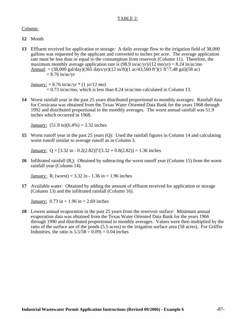
-87-Industrial Wastewater Permit Application Instructions (Revised 09/2006) - Example 6
TABLE 2:
Column:
12 Month
13 Effluent received for application or storage: A daily average flow to the irrigation field of 38,000gallons was requested by the applicant and converted to inches per acre. The average applicationrate must be less than or equal to the consumption from reservoir (Column 11). Therefore, themaximum monthly average application rate is (98.9 in/ac/yr)/(12 mo/yr) = 8.24 in/ac/moAnnual: = (38,000 gal/day)(365 days/yr)(12 in/ft)(1 ac/43,560 ft2)(1 ft3/7.48 gal)(58 ac)
= 8.76 in/ac/yr
January: = 8.76 in/ac/yr * (1 yr/12 mo) = 0.73 in/ac/mo, which is less than 8.24 in/ac/mo calculated in Column 13.
14 Worst rainfall year in the past 25 years distributed proportional to monthly averages: Rainfall datafor Corsicana was obtained from the Texas Water Oriented Data Bank for the years 1968 through1992 and distributed proportional to the monthly averages. The worst annual rainfall was 51.9inches which occurred in 1968.
January: (51.9 in)(6.4%) = 3.32 inches
15 Worst runoff year in the past 25 years (Q): Used the rainfall figures in Column 14 and calculatingworst runoff similar to average runoff as in Column 3.
January: Q = [3.32 in - 0.2(2.82)]2/[3.32 + 0.8(2.82)] = 1.36 inches
16 Infiltrated rainfall (Ri): Obtained by subtracting the worst runoff year (Column 15) from the worstrainfall year (Column 14).
January: Ri (worst) = 3.32 in - 1.36 in = 1.96 inches
17 Available water: Obtained by adding the amount of effluent received for application or storage(Column 13) and the infiltrated rainfall (Column 16).
January: 0.73 in + 1.96 in = 2.69 inches
18 Lowest annual evaporation in the past 25 years from the reservoir surface: Minimum annualevaporation data was obtained from the Texas Water Oriented Data Bank for the years 1966through 1990 and distributed proportional to monthly averages. Values were then multiplied by theratio of the surface are of the ponds (5.5 acres) to the irrigation surface area (58 acres). For GriffinIndustries, the ratio is 5.5/58 = 0.09) = 0.04 inches
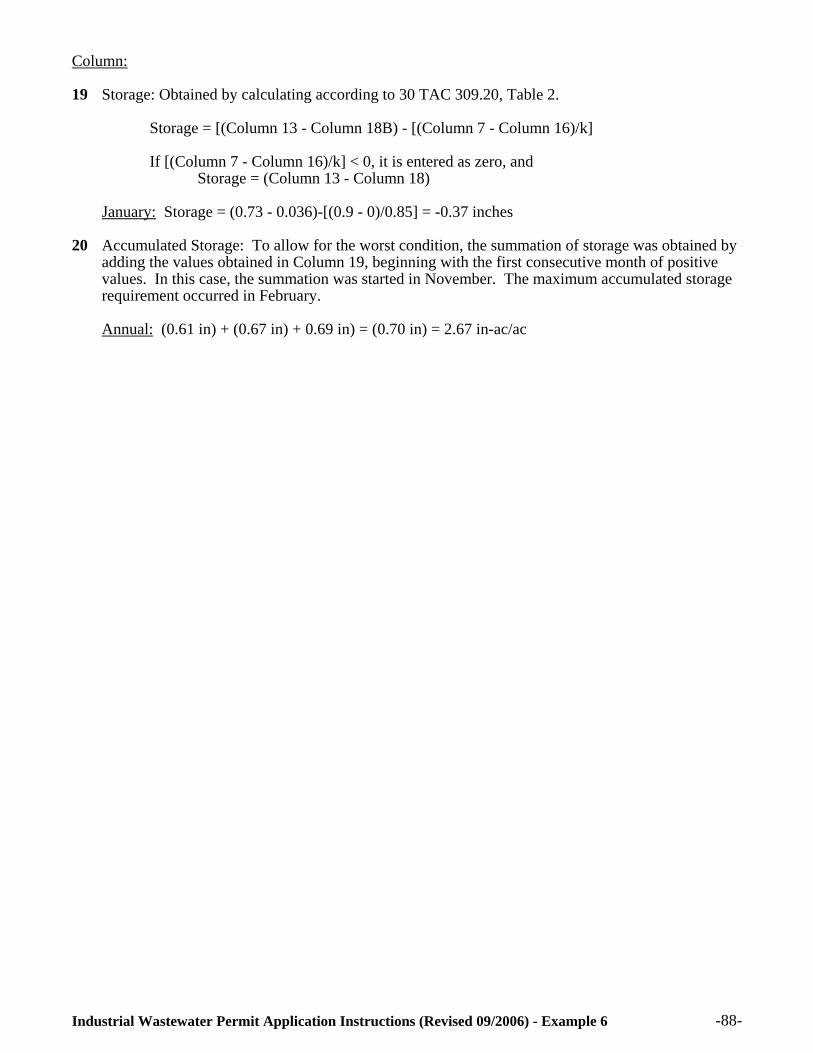
-88-Industrial Wastewater Permit Application Instructions (Revised 09/2006) - Example 6
Column:
19 Storage: Obtained by calculating according to 30 TAC 309.20, Table 2.
Storage = [(Column 13 - Column 18B) - [(Column 7 - Column 16)/k]
If [(Column 7 - Column 16)/k] < 0, it is entered as zero, and Storage = (Column 13 - Column 18)
January: Storage = (0.73 - 0.036)-[(0.9 - 0)/0.85] = -0.37 inches
20 Accumulated Storage: To allow for the worst condition, the summation of storage was obtained byadding the values obtained in Column 19, beginning with the first consecutive month of positivevalues. In this case, the summation was started in November. The maximum accumulated storagerequirement occurred in February.
Annual: (0.61 in) + (0.67 in) + 0.69 in) = (0.70 in) = 2.67 in-ac/ac

-89-Industrial Wastewater Permit Application Instructions (Revised 09/2006) - Example 6
MONTHLY WATER BALANCE, TABLE 1 (1)
(Units in Inches)
1 2 3 4 5 6 7 8 9 10 11
AVG RAIN
AVG RUN OFF
AVG INFILTRATED
RAINFALL
EVAPO TRANS-
PIRATION
REQUIRED LEACHING
TOTAL WATER NEEDS
EFFLUENT REQ’DIN ROOT ZONE
EVAPORATION FROM RESERVOIR
SURFACE
EFFLUENT APPLIED TO LAND
CONSUMPTIONFROM
RESERVOIR
JAN 2.39 0.72 1.67 0.9 0 0.9 0 0.06 0 0.06
FEB 2.8 0.99 1.81 1.3 0 1.3 0 0.03 0 0.03
MAR 2.95 1.09 1.86 3 0.9 3.9 2.1 0.15 2.5 2.6
APR 4.04 1.92 2.12 3.5 1.1 4.6 2.5 0.11 3 3.1
MAY 5.1 2.8 2.3 6.5 3.4 9.9 7.6 0.16 9 9.1
JUN 3.04 1.16 1.88 6.7 3.9 10.6 8.8 0.39 10.3 10.7
JUL 2.24 0.62 1.62 7.4 4.7 12.1 10.5 0.64 12.4 13
AUG 2.21 0.61 1.6 5.1 2.9 8 6.4 0.66 7.5 8.1
SEP 2.97 1.11 1.86 5.3 2.8 8.1 6.3 0.42 7.4 7.8
OCT 3.43 1.44 1.99 4.2 1.8 6 4 0.31 4.7 5
NOV 2.97 1.11 1.86 1.7 0 1.7 0 0.16 0 0.16
DEC 3.31 1.35 1.96 0.72 0 0.72 0 0.08 0 0.08
TOTAL 37.45 14.92 22.53 46.3 21.5 67.8 48.2 3.16 56.8 59.7
(1) Table 1 was completed in accordance with Table 1 of 30 TAC 309.20. Refer to Appendix C for detailed explanation of calculations.

-90-
STORAGE VOLUME CALCULATION, TABLE 2 (1)
(Units in Inches)12 13 14A 14B 15 16 17 18A 18B 19 20
EFFLUENT APPLIED TO LAND (INCHES)
MEAN RAINFALL
DISTRIBUTION(%)
RAINFALL (MAX)
(INCHES)
RUNOFF (MAX)
(INCHES)
INFILTRATEDRAINFALL (INCHES)
TOTAL AVAIL. H2O
(INCHES)
MEAN EVAPORATION
(MIN) (INCHES)
NET EVAPORATION
(MIN) (INCHES)
STORAGE(IN-AC/AC)
ACCUMU-LATED
STORAGE(IN-AC/AC)
JAN 0.73 6.4 3.32 1.36 1.96 2.69 1.8 0.04 0.69 1.97
FEB 0.73 7.5 3.89 1.8 2.09 2.82 1.1 0.03 0.7 2.67
MAR 0.73 7.9 4.1 1.97 2.16 2.86 4.7 0.11 -1.5 1.2
APR 0.73 10.8 5.61 3.23 2.37 3.1 3.6 0.08 -2 -0.83
MAY 0.73 13.6 7.06 4.53 2.53 3.26 4.9 0.11 -8.1 -8.9
JUN 0.73 8.1 4.2 2.05 2.15 2.88 12.4 0.29 -9.5 -18.4
JUL 0.73 6 3.11 1.21 1.9 2.63 20 0.46 -11.8 -30.2
AUG 0.73 5.9 3.06 1.17 1.89 2.62 20.8 0.48 -6.9 -37.1
SEP 0.73 7.9 4.1 1.97 2.13 2.86 13.2 0.3 -6.6 -43.7
OCT 0.73 9.2 4.77 2.52 2.25 2.98 9.6 0.22 -3.9 -47.6
NOV 0.73 7.9 4.1 1.97 2.13 2.86 5.1 0.12 0.61 0.61
DEC 0.73 8.8 4.57 2.35 2.22 2.95 2.6 0.06 0.67 1.28
TOTAL 8.76 100 51.9 26.1 25.8 34.5 99.8 2.29 ------ 2.67(2)
(1) Table 2 was completed in accordance with Table 2 of 30 TAC 309.20. Refer to Appendix C for detailed explanation of calculations.
(2) Storage volume requirement = 2.67 in-ac = (2.67 in-ac/ac)(58 ac)(1 ft/12 in) = 12.9 ac-ft
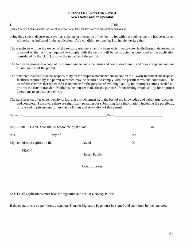
-91-
TRANSFER SIGNATURE PAGENew Owner and/or Operator
I, _________________________________________________________,Title:___________________________(Printed or typed name and title of executive officer of at least the level of vice president or equivalent)
being duly sworn, depose and say: that a change in ownership of the facility for which the subject permit has been issuedwill occur as indicated in the application. As a condition to transfer, I do hereby declare that:
The transferee will be the owner of the existing treatment facility from which wastewater is discharged, deposited ordisposed or the facilities required to comply with the permit will be constructed as described in the applicationconsidered by the TCEQ prior to the issuance of the permit.
The transferee possesses a copy of the permit, understands the terms and conditions therein, and does accept and assumeall obligations of the permit.
The transferee assumes financial responsibility for the proper maintenance and operation of all waste treatment and disposalfacilities required by the permit or which may be required to comply with the permit terms and conditions. Thetransferee certifies that the transfer is not made for the purpose of avoiding liability for improper actions carried outprior to the date of transfer. Neither is the transfer made for the purpose of transferring responsibility for improperoperations to an insolvent entity.
The transferee certifies under penalty of law that this document is, to the best of my knowledge and belief, true, accurate,and complete. I am aware there are significant penalties for submitting false information, including the possibilityof fine and imprisonment for known violations and revocation of this permit.
Signature:________________________________________________Date:____________________________
SUBSCRIBED AND SWORN to before me by the said _____________________________________on this _____________________day of ________________________________________, 20____________.
My commission expires on the_________________ day of ______________________, 20____________.
[SEAL] _______________________________________ Notary Public
_______________________________________County, Texas
NOTE: All applications must bear the signature and seal of a Notary Public
If the operator is a co-permittee, a separate Transfer Signature Page must be signed and submitted by the operator.

-92-
SIGNATURE PAGE FOR TRANSFEROR (CURRENT PERMITTEE)
I (we) consent to the transfer of the permit and certify under penalty of law that this document is, to the best of my/ourknowledge and belief, true, accurate, and complete. I am (We are) aware there are significant penalties for submittingfalse information, including the possibility of fine and imprisonment for known violations and revocation of thispermit.
Owner of the Treatment Facility:
____________________________________________________________________________________(Printed or typed name and title of executive officer of at least the level of vice president)
________________________________________________Date:________________________________(Signature of Ranking Official)
SUBSCRIBED AND SWORN to before me by the said _______________________________________
on this ______________________day of ___________________________________, 20_____________.
My commission expires on the_________________ day of _____________________, 20_____________.
[SEAL] _______________________________________ Notary Public
_______________________________________County, Texas
Operator of Treatment Facility**:
____________________________________________________________________________________(Printed or typed name and title of executive officer of at least the level of vice president)
________________________________________________Date:________________________________(Signature of Ranking Official)
SUBSCRIBED AND SWORN to before me by the said _______________________________________
on this __________________day of _________________________________, 20__________________.
My commission expires on the_____________________ day of _____________________, 20_________.
[SEAL] _______________________________________ Notary Public
_______________________________________County, Texas
NOTE: All applications must bear the signature and seal of a Notary Public
** Operator is only required to sign if operator is required to be a co-permittee.
Applies only to the owner (does not apply when transferring operator):

-93-
If the transferee is unable to obtain the signature page of the transferor, the permit may still be transferred byinvoluntary transfer if:
• the current permittee no longer owns the permitted facility;
• the facilities have not been built and the permittee no longer has sufficient property rights in the site of the proposedfacilities;
• proof of ownership of the site and treatment facility has been provided by the transferee;
• the executive director has provided notice by certified mail to the permittee, using the last address of record, giving an opportunity for hearing; and
• the executive director did not receive a request for hearing from the permittee within 30 days from the date the noticewas mailed.

-94-
THIS PAGE IS ONLY APPLICABLE TO PERMITS THAT INCLUDE COMPOSTING FACILITIES, LANDAPPLICATION AND/OR DISPOSAL OF SEWAGE SLUDGE AND THE TRANSFEREE DOES NOT OWN
THE LAND WHERE SUCH DISPOSAL ACTIVITY IS CONDUCTED.
I,_________________________________________________________________________________________(Typed or printed name) (Title)
understand that I am responsible for operating the site described in the legal description in accordance with the TexasCommission on Environmental Quality requirements in 30 TAC §332 and/or 312, the conditions set forth in thepermit, and any additional conditions as required by the Texas Commission on Environmental Quality. I also certifyunder penalty of law that all information submitted is, to the best of my knowledge and belief, true, accurate, andcomplete. I am aware that there are significant penalties for submitting false information, including the possibilityof fine, imprisonment for violations, and revocation of this permit.
Signature:____________________________________________ Date:__________________________________
SUBSCRIBED AND SWORN to before me by the said ______________________________________________
on this ______________________day of __________________________________________, 20____________.
My commission expires on the___________________ day of __________________________, 20____________.
NOTE: All applications must bear the signature and seal of a Notary Public
[SEAL] _______________________________________ Notary Public
_______________________________________County, Texas
Complete only if Landowner is not the site operator:
I, __________________________________________________ _____________________________________(Typed or printed name) (Title)
owner of the land described in the attached legal description, has all rights and covenants to authorize, the applicant forthis Permit, to use this site for the composting, disposal and/or land application Facility. I understand that 30 TAC§332 and/or 312 requires me to make a reasonable effort to see that the applicant complies to the required operatingconditions stated in the above paragraph. I also certify under penalty of law that all information submitted is, to thebest of my knowledge and belief, true, accurate, and complete. I am aware that there are significant penalties forsubmitting false information, including the possibility of fine, imprisonment for violations, and revocation of thispermit.
Signature:____________________________________________Date:__________________________________
SUBSCRIBED AND SWORN to before me by the said _______________________________________
on this ______________day of __________________________________________, 20____________
My commission expires on the_____________day of ________ _________________, 20____________.
[SEAL] _______________________________________Notary Public
_______________________________________County, Texas
NOTE: All applications must bear the signature and seal of a Notary Public