composition, distribution, and abundance of invasive
TRANSCRIPT

Composition, Distribution, and Abundance of Invasive Exotic Plants At Hot Springs National Park
Cindy E. Becker
Nature’s Keeper Services PO Box 229
Montreal, MO 65591
Technical report NPS/HTLN/HOSP/P2106020870
September 2004
National Park Service Inventory and Monitoring Program
Midwest Region, Heartland Network 6424 W. Farm Road 182
Republic, MO 65738

Table of Contents List of Figures ................................................................................................................................ iii List of Tables ................................................................................................................................. iii Summary ......................................................................................................................................... v Acknowledgements........................................................................................................................ vi Introduction..................................................................................................................................... 1 Study Area ...................................................................................................................................... 2 Materials and Methods.................................................................................................................... 3 Results............................................................................................................................................. 6 Discussion..................................................................................................................................... 11 Conclusion .................................................................................................................................... 13 Literature Cited ............................................................................................................................. 15
ii

List of Figures Figure 1. Geographic location of Hot Springs National Park....................................................... 16
Figure 2. Map of Hot Springs NP with the surveyed features labeled and highlighted. .............. 17
Figure 3. Map indicating the park-wide distribution of Japanese honeysuckle............................ 18
Figure 4. Map indicating the park-wide distribution of common privet....................................... 19
Figure 5. Map indicating the park-wide distribution of nandina and evergreen magnolia........... 20
Figure 6. Map indicating the park-wide distribution of mimosa tree. .......................................... 21
List of Tables Table 1. List of invasive exotic plants surveyed at Hot Springs NP............................................. 22
Table 2. List of feature types, trail/road acronym and name, number of plots, and length (miles)
for all linear and number of non-linear features surveyed. ................................................... 23
Table 3. Frequency of occurrence (%) and average total cover (%) of the surveyed exotic
species, summarized for each trail along a 30 m. belt transect from the trail edge. ............. 24
Table 4. Frequency of occurrence (%) and average total cover (%) of the surveyed exotic
species along foot trails at Hot Springs NP. Values are listed for increasing distances from
the trail edge.......................................................................................................................... 25
Table 5. Trailside (0 – 30 m) % frequency and mean cover for the four exotic species of concern
along foot trails in Hot Springs NP....................................................................................... 26
Table 6. Trailside % frequency and mean cover for the four most commonly encountered exotic
species along foot trails at Hot Springs NP. Values are listed for increasing distances from
the trail edge.......................................................................................................................... 27
iii

Table 7. Frequency of occurrence (%) and mean cover (%) of the surveyed exotic species,
summarized for each road along a 30 m. belt transect from the road edge. ......................... 28
Table 8. Frequency of occurrence (%) and mean cover (%) of the surveyed exotic species along
roads at Hot Springs NP. Values are listed for increasing distances from the road edge. ... 29
Table 9. Roadside % frequency and mean cover for six exotic species of concern along paved,
gravel access, and abandoned dirt roads at Hot Springs NP. Data is summarized for a 30 m.
belt transect from the road edge............................................................................................ 30
Table 10. Roadside % frequency and mean cover for the six most commonly encountered exotic
species along paved, gravel access, and abandoned dirt roads at Hot Springs NP. Values are
listed for increasing distances from the trail edge................................................................. 31
iv

Summary
This study addresses the distribution and abundance of 20 potentially invasive exotic species along roads and trails within Hot Springs National Park, Garland County, Arkansas. Approximately 36.8 km (23 mi) of visitor foot trails, and 16 km (10 mi) of roads, paved and unpaved, and numerous irregular-shaped features at the park were surveyed during the summer of 2003. Japanese honeysuckle and common privet are the most frequently encountered and have the greatest amount of cover along roads and trails. Additionally, mimosa tree and sericea lespedeza (along roads), nandina and evergreen magnolia (along trails), are common. In general, disturbed habitats at the park are characterized by a dense, extensive, and often diverse assemblage of non-native plants, including dense impenetrable tangles of wisteria vines, ornamental vines, Japanese honeysuckle, English ivy, and periwinkle, and thickets including nandina, mimosa, common privet, evergreen magnolia, and tree of heaven. This report provides an initial inventory of the exotic species infestations that are associated with the current and historic travel corridors across the park, as well as descriptive information on exotic abundance in areas affected by resource- and land-use. This study address the impacts exotics have on the native flora, and assists in identifying focus areas for management efforts in exotic species control.
v

Acknowledgements I thank Charles Ramseyer for help in the field. I thank Robin Kennedy, the curator at the Dunn-Palmer Herbarium at the University of Missouri-Columbia for unlimited access to the herbarium. I thank the Hot Springs National Park staff for their assistance and welcome information. In particular, I thank Steve Rudd and the park ranger staff at Hot Springs National Park for logistical assistance throughout the summer, often under extremely interesting circumstances, and Sharon Shugart, curator at Hot Springs National Park, for her enthusiasm and for providing historic maps, reports, and surveys at a moment’s notice. I thank the Heartland Network Inventory and Monitoring Program of the National Park Service for funding this inventory, and Mike Williams, Inventory Specialist of the Heartland Network Inventory and Monitoring Program for his assistance with logistical questions and complications. I thank Maria Furey with her assistance in generating all maps.
vi

Introduction In response to concerns about the condition of natural resources within the national parks, the National Parks Omnibus Management Act of 1998 issued a call for baseline inventory data for parks throughout the nation. These data will provide a pivotal step toward establishing effective monitoring programs that assist in managing and protecting national park resources. In order for scientifically sound management decisions to be made, park management must know what exotic species are present within the park, habitat types and regions of the park currently infested with exotics, and the habitat types most susceptible to future invasion. Further, understanding which exotic species are of immediate concern and those that warrant monitoring for future explosions in growth and distribution is important. The concern over the invasion of non-indigenous plants into natural areas is growing as the prevalence and effect of invasions by non-native plants becomes more widespread. Invasive species are broadly defined as those species that are not native to an area and that may potentially displace or otherwise adversely affect native plant and animal species (Mack et al. 2000; Drake et al 2003). The individual response of different invasive species varies by disturbance and habitat or vegetation type (Stohlgren et al. 1999; Larson et al. 2001), with invasive species most problematic in disturbed areas (Vitousek 1990). Tactics for assuring survival include prolific seed producing abilities, producing seeds that disperse widely and remain viable in the soil for long periods of time (Rejmanek and Richardson 1996), and alternatively, asexual reproductive capabilities through extensive root growth, suckering, and re-sprouting (Thompson et al. 1995). Hot Springs National Park (NP) in Hot Springs, Arkansas is a forested landscape vulnerable to invasion by ornamental and escaped exotic plant species. The park is surrounded by the city of Hot Springs, home to 35,750 people. Within the currently defined perimeter of Hot Springs NP is forested land that in past times experienced various forms of anthropogenic disturbance, including that associated with subsistence living, wealthy estates, logging, and both small- and industrial-scale quarries. As a result, an extensive network of abandoned gravel and dirt roads cross through the park. The affect of the nearby urbanization and the historical land-use of the park acreage – forested areas and Bathhouse Row – on the invasiveness of the native plant communities have never been fully reviewed. Known locations of heavy infestations of Japanese honeysuckle (Lonicera japonica) and kudzu (Pueraria lobata) have been documented, but little information exists regarding the status of any other invasive exotic plants. This study addresses the distribution and abundance of 20 potentially invasive exotic species along roads and trails within Hot Springs NP. This list of potentially exotic species was generated by park staff with the assistance of Arkansas Natural History biologists. Information provided from this study includes which exotic species are currently the most problematic, which exotic species have a potential for encroaching on native habitat, locations of exotic infestation, and locations of potential future infestation. This study will assist in the identifying the need for management efforts, and provide baseline information to address the impacts exotics have on the native flora and for future monitoring efforts.
1

Study Area
Hot Springs National Park (NP) is located in the Ozark Highlands on the eastern edge of the Ouachita Range (west-central Arkansas) approximately 80 km (50 mi) southwest of Little Rock (Figure 1). The underlying rock formations include layers of chert, novaculites, sandstones, and shale – folded, faulted and jointed (Bedinger et al 1974). The hot springs for which the park is named all are found within a narrow belt along the southwest slope of Hot Springs Mountain (Bedinger et al 1974). Habitat types consist of human-use areas – landscaped public-use areas, campground and picnic areas, disturbed habitats, and old fields – and forested lands, with the latter characterized by a transition zone of southern short-leaf pine associations and upland hardwood forest. Within the forested landscape, landscape position is loosely tied to vegetation type, with ridge-tops and gently sloping areas characterized by upland hardwoods, dry south-facing slopes near ridge tops characterized by pine-oak-hickory, south-southeast facing slopes and lower steep northern exposures characterized by a xeric subtype of oak-hickory-pine, lower north-facing slopes and flat areas characterized by a mesic subtype of oak-hickory-pine, and creeks, upland waterways, and highly disturbed mesic environments characterized by a mixed forest type (Dale 1980). Crossing the forested landscape is a network of abandoned logging roads, dirt roads, and foot trails, maintained paved roads, and maintained foot trails. Further, old homesteads, shops, and taverns, overgrown cemeteries, and abandoned quarry and mill sites reflect a time past when the region supported a backwoods populace and economy. Today these travel corridors and sites are archeological treasures. Unfortunately, they are also suspected breeding grounds for ornamental, planted non-native species, and non-native species adaptable to disturbed waste ground.
2

Materials and Methods
Linear features, e.g., visitor foot trails, old logging roads, paved roads, and gravel access roads and non-linear features, e.g., areas within the park of irregular shape, old housing divisions, abandoned homesteads, historic quarry sites, were surveyed for the presence and abundance of exotic species (
3

Table 1) during the summer of 2003 (Table 2). The promenade, brick paths within the vicinity of the bathhouses and springs, and the urban front to the bathhouses were not included in the survey because most of the area has been in formal plantings since federal ownership. Private inholdings in the park were also not surveyed due to sensitive trespassing issues. Many inholdings have known populations of exotic species; likely, inholdings of like-nature, e.g., abandoned quarries and private estates and residences, are also infested. Current and historical references were integrated to create a map of the following layers: (1) current use within the park, including foot trails, dirt access roads, paved roads; (2) subdivisions and land acquired since the 1970’s; (3) foot trails and visitor use features utilized in the 1900s through 1920s; (4) abandoned roads, a network of improved and dirt roads, reminiscent of different time periods throughout the 1900’s; and (5) the locations of private individual estates and rural homesteads on lands acquired prior to 1970 (Hot Springs National Park data). This map was used to stratify sampling effort and assisted with interpretation of exotic species distribution patterns. Non-paved Linear Features See Table 2 for a list of the visitor foot trails, and maintained and abandoned dirt roads surveyed. Beginning at a known location, e.g., trailhead, trail junction, or road entrance, a linear feature was divided into contiguous 50 m. segments. A global positioning system (GPS) coordinate was recorded (NAD83) for the start of each 50 m. segment, using a Geo3XT (position accuracy 1 – 5 m.) hand held unit. Landmarks associated with each trail segment such as trail signs, trail junctions, trail switchbacks, unique rock formations, old road beds, and old homestead locations were recorded as additional relocation information. Where use of the GPS unit was hindered by dense foliage during the summer inventory, segments were temporarily marked. Coordinates for segment locations not collected during summer 2003 were collected during winter 2004 during follow-up visits. This was feasible because many of the exotic tree, shrub, and vine species hold their leaves through the winter, allowing for segment validation. Each 50 m. segment was sampled with two 50 m. by 30 m. belt transects, one to each side of the trail. Each belt transect was divided, width-wise, into three 10 m. sub-belts. Exotic species presence and abundance in each sub-belt were recorded. Species were listed using the following percentage cover classes: 0 – 5%, 6 – 15%, 16 – 25%, 26 – 50%, 51 – 75%, 76 – 100. Where at least one species was present with greater than 50% cover in the sub-belt farthest from trailside, the abundance of exotic species outside the transect was estimated and causal inference was made. Man-made disturbance, e.g., trail, road, perimeter fence, that prevented sampling all three sub-belts were recorded. Paved Linear Features See Table 2 for a list of all paved roads surveyed. Beginning at a known location, e.g., road entrance or road junction, a road was divided into 50 m. lengths or surveyed using a combination of 1/10th mile segments and landmarks such as overlooks, picnic areas, water conduits, and switchback turns, areas identified during reconnaissance as target areas. A global positioning system (GPS) coordinate was recorded for the start of each linear segment and for each non-linear location using a Geo3XT (position accuracy 1 – 5 m.) hand held unit. Opportunities to survey the paved roads were limited during the summer months because of increased vehicular
4

tourist traffic and personal safety issues. Vegetation data was collected during the summer, and GPS coordinates were collected during winter 2004 during follow-up visits. Each linear segment was sampled with two 30 m. wide belt transects, one to each side of the road. Each belt transect was divided, width-wise, into three 10 m. sub-belts. Exotic species presence and abundance in each sub-belt were recorded. Species were listed using the following percentage cover classes: 0 – 5%, 6 – 15%, 16 – 25%, 26 – 50%, 51 – 75%, 76 – 100. Where at least one species is present with greater than 50% cover in the sub-belt farthest from trailside, the abundance of exotic species outside the transect was estimated and causal inference was made. Man-made disturbance, e.g., trail, road, perimeter fence, that prevented sampling all three sub-belts were recorded. Non-linear Features Qualitative information on exotic species distribution and abundance for non-linear features, e.g., subdivision acquisitions, old homestead sites, old quarry sites, and other forms of land disturbance, was collected. Within the area of interest, the overall abundance of each species was recorded using the percentage cover classes: 0 – 5%, 6 – 15%, 16 – 25%, 26 – 50%, 51 – 75%, 76 – 100. The locations of non-linear features were marked on field maps and transferred to a trail map manually. Data Summary Frequency is defined as the number of times a species is present in a given number of plots of a particular size (Raunkiaer 1934). Frequency is reported as the proportion (or percentage) of plots along each trail where a species was encountered. Mean cover is reported using the median value for each cover class, and is the average cover across the plots where the species was encountered. By looking at both frequency and cover values, one can gain a better understanding of the extent of the distribution of individual species along the specified trails and roads.
Exotic species frequency and mean cover are summarized for all foot trails and roads. Results are provided as summed for all exotic species, and for the exotic species with the greatest distribution for the feature type. Results for linear features are described for increasing distances from the trail/road edge as follows: (1) 0 – 10 m from trail/road edge; (2) 11 – 20 m. from trail/road edge; and (3) 21 – 30 m. from trail/road edge, and (4) summarized for the entire 30 m. belt perpendicular to the trail/road. Results for irregular non-linear features are descriptive, not quantitative in nature.
5

Results Approximately 36.8 km (23 mi) of visitor foot trails and 16 km (10 mi) of roads, paved and unpaved, and numerous irregular-shaped features at Hot Springs NP were surveyed during summer 2003. This corresponds to 1474 belt transects along visitor foot trails, 146 belt transects along abandoned dirt roads, 80 belt transects along maintained inner gravel roads, 260 belt transects along maintained paved roads, sampled for the presence, abundance, and composition of invasive exotic species. Sampling took place during the summer of 2003 (June 3 – 5, June 18 – 21, July 16 – 17, and August 27 – 29). Invasive Exotic Species By far, Japanese honeysuckle and common privet (Ligustrum sinense) are the two exotic species with the greatest frequency and cover along roads and trails (Figure 3 and Figure 4). Along trails, the exotic species most frequently encountered are Japanese honeysuckle (Figure 3), common privet (Figure 4), nandina (Nandina domestica) (Figure 5), and evergreen magnolia (Magnolia grandiflora) (Figure 5). Japanese honeysuckle is most prevalent, present along all trails and with the exception of five trails, is found along at least 25% of each trail’s respective lengths. Common privet and nandina are ubiquitous, present along greater than 85% of all trails, but less frequently encountered, relative to Japanese honeysuckle. Evergreen magnolia is present along 12 of the 15 trails. Where found, its frequency and cover do not exceed 20% and 4%, respectively. Japanese honeysuckle and common privet are most common and most abundant in dense thickets within 10 m. from the trail’s edge, and decrease in abundance in increasing distances away from the trails. Conversely, evergreen magnolia and nandina populations are found as individuals scattered within the 30 m. trailside belt transect sampled. The exotic species most frequently encountered along roads are Japanese honeysuckle and common privet (Figure 3 and Figure 4). Japanese honeysuckle and common privet, found along all roads, are present along at least 25% of each road’s respective length. Conversely, abundance along each road’s respective lengths varies. Mimosa tree (Albizia julibrissin) (Figure 6) and sericea lespedeza (Lespedeza cuneata) are also common along roads, present along greater than 90% of all roads sampled. Mimosa is common along some roads (frequency greater than 45%), but with a very low occurrence rate along other roads (frequency less than 20%). Sericea lespedeza and mimosa are most common along the road edge, decreasing in abundance at greater distances from the road. Trails All visitor-use foot trails at Hot Springs NP have exotic species present within a 30 m. trailside belt. Of the fifteen trails surveyed, thirteen trails have exotic species along at least 30% of their length. Table 3 lists the frequency (%) and mean cover of all exotic species surveyed summarized for a 30 m. Table 4 lists the frequency (%) and mean cover of all exotic species surveyed, expressed in increasing distance from the trail. Table 5 and Table 6 list the frequency and mean cover of the four exotic species of greatest concern along foot trails in the park. West Mountain
6

All of the trails on West Mountain have high infestations of exotic species within 30 m. trailside, with exotic species present along greater than 50% of their respective lengths. Common privet, Japanese honeysuckle, evergreen magnolia, and nandina are the most common exotics along West Mountain trails. Where found, the extent of exotic species cover ranges from minimal (Canyon Trail, 10%) to more extensive (Mountain Top Trail, 25%; Oak Trail, 25%; West Mountain Trail, 31%). Exotics are more abundant within 10 m. from the trail edge, but are found along all trails up to 30 m. from the trail edge. Along Canyon Trail, exotics are primarily located within a 10 m. belt along the trail. Along Oak Trail, exotics are more widespread, with frequency and mean cover remaining above 40% within 21 – 30 m. from the trail. Conversely, along Mountain Top Trail and West Mountain Trail, dense patches of exotics were present, with cover estimates greater than 75% in the locations where exotics are found (13% frequency and 22% frequency, respectively. Hot Springs Mountain Dead Chief Trail, Honeysuckle Trail, Hot Springs Mountain Trail, and Peak Trail have target exotic species along greater than 40% of their respective trail lengths within the 30 m. belt surveyed. The exotic species of concern are Japanese honeysuckle, common privet, and nandina. The degree of invasion varies by trail, with cover between 10 – 20% along Honeysuckle Trail, Floral Trail, and Hot Springs Mountain Trail, but between 30 – 35% along Dead Chief Trail and Peak Trail. Exotics are most common within 10 m. from the trail, particularly along Dead Chief Trail (frequency 75%, mean cover 45%) and the Peak Trail (frequency 88%, mean cover 40%). These same two trails are characterized by the most extensive and dense infestations up to 20 – 30 m. from the trail edge. Exotics are also present up to 30 m. from the trail edge along all other trails on Hot Springs Mountain. The exception to this is the Floral Trail, a winding switchback trail. Other exotic species on Hot Springs Mountain include Chinese holly (Ilex cornuta), wisteria (Wisteria floribunda), English ivy (Hedera helix), periwinkle (Vinca major), Japanese privet (Ligustrum japonicum), and crape myrtle (Lagerstroemia indica). This is likely due to the close proximity to Bathhouse Row and the associated landscaped gardens and ornamental plantings. North Mountain and the Sunset Trail When compared to the distribution and abundance of exotics along trails on West Mountain and Hot Springs Mountain, the trails along North Mountain have comparatively lower levels of exotic species. Along North Mountain trails, the exotic species of concern are Japanese honeysuckle and evergreen magnolia. Lower Dogwood Trail and Upper Dogwood Trail have the greatest exotics problems. Along Lower Dogwood Trail, exotic frequency and cover is highest within 10 m from the trail (52% and 23%, respectively). Along Upper Dogwood Trail, while exotics are found throughout the 30 m. trailside belt, mean cover of exotics remains low, less than 10%. Along Goat Rock Trail, Gulpha Gorge Trail, and Upper Dogwood Trail, frequency and cover remain below 35% and 20% respectively, irregardless of distance from trail. Along Sunset Trail, exotic frequency and cover are both below 30% within the 30 m. belt. Within 10 m. from the trail, exotic species frequency is 26% and where found, mean cover is 30%. Exotic species frequency and mean cover decreases away from the trail edge, with a frequency and mean cover of 7% and 25%, respectively, between 20 – 30 m. from the trail. The most common exotic species are Japanese honeysuckle and common privet. Other species found
7

along Sunset Trail are species associated with old homesteads, such as bridal wreath (Spiraea X vanhouttei), periwinkle, and wisteria, as well as exotics common to trails, such as hedge parsley (Torilis arvensis). Roads All roads, irregardless of type (e.g., abandoned, gravel, or paved), surveyed at Hot Springs NP have exotic species present within a 30 m. roadside belt. All are characterized by greater than 70% frequency of exotics, with exotics most common within 10 m from the road edge along all roads surveyed. Within the 30 m. belt transect, exotic abundance varies by road, with the greatest cover of exotics found along Tank Road (mean cover, 50%), a gravel access road, and Black Snake Road (mean cover, 48%), a paved road catering to park traffic and local traffic. Exotics are least abundant along North Mountain Road (mean cover, 13%) and the Hot Springs Mountain-North Mountain Connection (mean cover, 8%). Table 7 lists the roadside % frequency and average total cover of all exotic species surveyed summarized for a 30 m. belt transect from the road edge. Table 8 lists the roadside % frequency and average total cover of all exotic species surveyed, expressed in increasing distance from the road. Table 9 and Table 10 list the frequency and mean cover of the six exotic species of greatest concern for roads. Abandoned Dirt Roads Along abandoned dirt roads, exotic frequency within 10 m. from the road edge ranges between 90 – 100%. Of the abandoned dirt roads surveyed, Little Rock Highway Road has the most extensive exotic infestation, with exotic frequency and mean cover remaining above 45% and 55%, respectively, 20 – 30 m. from the road. Along Little Rock Highway Road, evergreen magnolia joins common privet and Japanese honeysuckle as a problem species. The Logging Road, an old dirt road located off Black Snake Road, is also characterized by an extensive exotic species problem. Exotic species are ubiquitous within 10 m. from the road edge, found along 100% of the trail and 32% mean cover. Distanced from the road edge, frequency and cover remains high, at greater than 40% and 35%, respectively, for both the 11 – 20 m. and 21 – 30 m. segments. Mimosa, common privet, and Japanese honeysuckle are the most commonly encountered species. Indian Mountain Road has a dense exotic infestation within 10 m. from the road (frequency and mean cover, 100% and 80%, respectively), but exotic species are not found greater than 20 m. from the road. Here, sericea lespedeza, common privet, and Japanese honeysuckle are the three most abundant exotic species. Paved and Gravel Access Roads Of the paved roads surveyed, exotic species are most extensive along Black Snake Road, Hot Springs Road, and West Mountain Road, with frequency and mean cover greater than 95% and 55%, respectively, within 10 m. from the road. Frequency and cover remains high along all three roads, greater than 28% and 48%, respectively, between 20 – 30 m. from the road. Along all roads, Japanese honeysuckle and common privet are common and abundant. In addition, along Black Snake Road, mimosa is abundant within 10 m of the road (frequency 48% and cover 9%); along Hot Springs Road, individual nandina plants are scattered within 20 m. of the road edge (frequency 28% and cover 2%); and along West Mountain, evergreen magnolia and nandina are abundant (frequency, 30% and 48%, respectively). Of the paved roads surveyed, North Mountain Road is characterized by the least extensive infestation along its length. Exotics are most prevalent within 10 m. from the road edge (94% frequency and 22% mean cover), but occur
8

in patches 21 – 30 m from the road edge (12% frequency and 46% mean cover). Along North Mountain Road, Japanese honeysuckle, common privet, evergreen magnolia and nandina are the most frequently encountered exotics. The two gravel access roads surveyed, Communication Road and Tank Road, are both characterized by high infestations of exotics. Along Communication Road, roadside exotic frequency and mean cover are 72% and 15%, respectively, with frequency and cover decreasing at distances greater than 11 m. from the road. Conversely, along Tank Road, overall roadside exotic frequency and mean cover are 100% and 50%, respectively, and with exotics prominent both within 10 m. from the road edge (100% frequency and 70% cover), and between 21 – 30 m. from the road (46% frequency and 73% cover). Along the gravel access roads surveyed, mimosa, sericea lespedeza, common privet, and Japanese honeysuckle are exotic species of concern. Sericea lespedeza is found primarily in isolated patches along the road edge, while mimosa, common privet, and Japanese honeysuckle are prominent throughout the 30 m. belt along Communication Road, and within a 20 m. belt along Tank Road. Irregular Features Along roads and trails are numerous historic or archeological sites. We surveyed old homesteads, abandoned quarries, and old log yards, and stone structural walls for exotic species. Along with Japanese honeysuckle and common privet, old homesteads often were identified by flowering shrubs such as flowering quince (Chaenomeles spp.), forsythia (Forsythia spp.), bridal wreath, nandina, daffodils, periwinkle, and in a few cases, English ivy. Abandoned Anglo-American quarries, such as those found on Indian Mountain, the Sunset Trail, and at the beginning of Little Rock Highway Road, and along abandoned road beds are infested with established, extensive populations of sericea lespedeza, common privet, Japanese honeysuckle, and mimosa. Masonry retaining walls – an example can be found on Sunset Trail between the Gulpha Gorge campground and Stone Bridge Road – are overgrown with Japanese honeysuckle. Creeks serve as conduits of invasive species, both through vegetative spread and by seed. Some of the most impressive infestations of Japanese honeysuckle, common privet, evergreen magnolia, nandina, Chinese holly, and wisteria are located along the creeks that run through Hot Springs NP, particularly where there is a secondary disturbance mechanism, such as a road, a trail, or an attempt to channel the stream. The disturbance is not limited to larger creek systems, with many of the steep ravines and tributaries that run through the park blanketed with exotics. While these features were not surveyed along their length, the exotic cover remained high at increasing distances away from roads and trails. Along the perimeters of the park bordering Bathhouse Row in the city of Hot Springs, an inventory of the exotic plants provides insight into the length of time the area has been landscaped. The portion of Oak Trail that runs along Bathhouse row and behind Avery Hospital provides an opportunity to view the effect that escaped ornamental vines and shrubs can have on native vegetation. A dense impenetrable tangle of wisteria vines, ornamental vines, nandina, mimosa, evergreen magnolia, common privet, Chinese holly, English ivy, periwinkle, and Japanese honeysuckle is impenetrable by any and all native plants that once graced that location. However, underlying this area are numerous abandoned road beds, homestead foundations, trails,
9

and masonry walls. The history of the area is likely as complex as the tangle of exotics that greets the eye.
10

Discussion The Hot Springs, Arkansas region has experienced various waves of population growth and economic expansion since European inhabitation in the late 1700’s. The first scientific study to address the origin and heat source of the thermal springs was conducted in 1804. In 1834, the Hot Springs Reservation was established under Federal management, with the impetus for designation driven by the therapeutic value of the waters and the associated related interests and opportunities. Direct Federal supervision was implemented in 1877 and the area was designated as a National Park in 1921. The current purpose of the park has shifted to a more preservation-driven objective – to preserve and protect the hot springs for present and future generations. The importance of this lies in the direct relationship between land management, population growth, and the resultant pressure on natural resources and land-use. As far back as 1926, the non-native species, Japanese honeysuckle, catalpa (Catalpa bignonioides, Catalpa speciosa), Chinaberry (Melia Azedarach), and empress tree (Paulownia tomentosa) were recorded in Gulpha Creek, Hot Springs Creek, and/or valleys near the town of Hot Springs (Palmer 1926). Many of the trees and shrubs we today consider exotic and invasive were originally planted as formal plantings. Architectural renderings of the original formal plantings along the Promenade and in the vicinity of Bathhouse Row demonstrate that the species in this survey have been used in landscape design since the 1930’s (archives, Hot Springs National Park). Invasive Exotic Species of Concern Invasive species, those that out-compete the native flora and have the potential of altering the environment around them, are a prioritized concern. Current infestations of Japanese honeysuckle and common privet, abundant along trails and roads, abandoned man-made features in the park, ravines and creeks, are so extensive that a majority of the native flora has been replaced. When found together, the result is an impenetrable thicket of dense shrubs covered with ground- and shrub-creeping vines. The dominance of Japanese honeysuckle and common privet at Hot Springs NP is not surprising, with both introduced species welcomed by private landowners, gardeners, landscaping professionals, and public for multiple uses – wildlife habitat enhancement, natural wind breaks, erosion control, and ornamental purposes. Nandina is a surprise addition to the list of exotic species at Hot Springs NP, because it was not initially listed as a targeted species. Nandina is a showy Asian shrub/bamboo well established in landscaping and ornamental gardens throughout the town of Hot Springs, as well as along Bathhouse Row and the promenade. At present, nandina’s distribution is likely park-wide. Nandina is present in all habitat types at Hot Springs NP, from steep exposed south-facing slopes to protected north-facing backslopes, as well as in disturbed ground and along roads and trails. Of the species encountered, nandina is the exotic species I am most concerned about. It has successfully invaded glade communities at Hot Springs NP that are devoid of other exotic plants because of the harsh environmental conditions. Evergreen magnolia, a tree native to states south of Arkansas, is present throughout the park. Scattered populations of evergreen magnolia are most common in north-facing slopes, gently sloping uplands, upland waterways and ravines, bottomlands, and highly disturbed mesic
11

habitats. Its distribution is likely not restricted to roads or trails as could be inferred by this report. Planted widely for its dark evergreen foliage and large, showy flowers, evergreen magnolia has been extensively used at Hot Springs NP in plantings both along Bathhouse Row and the Promenade as well as throughout the city of Hot Springs. Distribution of this aggressive native tree is aided by small mammal dispersal, vegetative spread through root suckering, and evergreen leaves. On March 10, 2004, evergreen magnolia was in full leaf and near bloom, ensuring an early competitive advantage over the native bottomland species, umbrella magnolia (Magnolia tripetala). Evergreen magnolia is currently absent from the northwest corner of the park. Isolated populations of “weed” trees common in urban environments have been found in the park interior. The tree of heaven (Ailanthus altissima), common in heavily disturbed areas and open roadsides, is found along power lines and in disturbed areas along the gravel access roads. Tree of heaven is a rapid colonizer, particularly when without competition from other woody trees. While currently not a problem, it could easily become a species of concern, particularly in razed subdivisions and along roads. The mimosa tree, well-adapted to disturbed habitats and open roadsides, is abundant along Black Snake Road, in acquired subdivisions and quarries, and along the urban-park interface. Mimosa is capable of rapid colonization when opportunities arise, and may become more abundant, particularly in open disturbed ground along roads and acquired subdivision and quarry sites. Also encountered were potentially invasive exotic species that currently have small localized populations, including kudzu, sericea lespedeza, and shrubby honeysuckle (Lonicera maacki). In the park interior, kudzu is found in three isolated populations, on Black Snake Road, West Mountain Road, and along the Floral Trail. However, the peripheral of the park is also dotted with isolated populations, particularly where there is an urban-park interface. Kudzu is considered one of the most problematic exotic species in southern states. When not treated, kudzu is extremely destructive to the trees and shrubs strangled by its twining vines. Sericea lespedeza is currently restricted to abandoned roads and quarry sites, inner access roads, open disturbed areas along roads, and power lines. Soil disturbance seems to be a key component for sericea’s establishment. Sericea lespedeza has been shown to quickly out-compete native flora in grassland systems once established. Shrubby honeysuckle was located in proximity to old homesteads, and tree of heaven was primarily found along trails in close proximity to recent road disturbance. These species have the potential to increase exponentially once established. Habitats of Concern Wet and wet-mesic ecosystems are often the most vulnerable and most susceptible to exotic invasion. Hot Springs NP is no exception; the creeks and ravines are over-run with exotic species, and may be beyond restoration, with native species loss an unknown. The other habitat type of concern is the extensive glade/open savanna habitat characterizing the upper slopes and steep south-facing slopes throughout Hot Springs NP. The glades, while degraded from lack of fire and encroachment by cedars, are relatively exotic “free”. Nandina, with its seeds dispersed by birds, and its tolerance of xeric conditions, has colonized freely throughout the glade systems at the park. As an ornamental species like nandina gains in abundance and distribution, unique natural communities such as glades and open savannas risk infestation and subsequent losses in diversity.
12

Conclusion This survey establishes baseline information on the distribution and abundance of exotic species along roads and trails, both current and historic, at Hot Springs NP. It also provides descriptive information concerning areas disturbed by resource- and land-use. This information will prove helpful in determining which exotic species are to be prioritized for future management efforts, the habitats most affected by exotic species, and which habitats are at the greatest risk of future infestation. The natural ecosystems at Hot Springs NP are subjected to many stressors, both external and internal. These include fire suppression, land disturbance, urban encroachment, and usage by visitors, both on foot and in vehicles. Ecosystems of reduced health are more vulnerable to invasion by non-native systems than intact systems. It is inevitable that a number of non-native plants will become a part of the flora. However, invasive species, those that out-compete the native flora and have the potential of altering the environment around them, are a prioritized concern. Following are some recommendations for future surveys and management. Current infestations of Japanese honeysuckle and common privet, abundant along trails and roads, abandoned man-made features in the park, ravines and creeks, are so extensive that a majority of the native flora has been replaced. When found together, the result is an impenetrable thicket. These areas are of concern for various reasons, including human safety, aesthetics, and loss of habitat and plant biodiversity. Shrubs and vine removal must be coupled with spot application of a stump sprout herbicide and reseeding of native shrubs and wildflowers to improve success. Removal of the exotics alone will solve the immediate human safety issue, but the re-sprout abilities of common privet will counteract any efforts to clear the area in the course of a few years. A number of highly visible, well-traveled trails would serve for public restoration projects, including trail lengths along West Mountain Trail, Oak Trail, and Honeysuckle Trail. Habitat restoration efforts are most successful with the involvement of the general public, through active volunteer work and the distribution of educational materials. Disturbed bottomlands in the park, in general, are characterized by a dense, extensive, diverse assemblage of non-native plants. These habitats, once harboring unique natural communities, are today characterized by the same suite of exotic species throughout their length. The most extensive infestations of Japanese honeysuckle, common privet, evergreen magnolia, nandina, Chinese holly, and wisteria are located along lowland creeks and in ravines, most of which have been altered at some point in history. Understanding the effects of channelization, dams, and roads on creek hydrology will be integral to all restoration efforts. The state of these systems will necessitate habitat re-creation, a costly endeavor. A restoration of Gulpha Gorge Creek has the greatest potential. Of the species encountered, nandina and sericea lespedeza are two exotic species of concern. Nandina has successfully invaded glade communities at Hot Springs NP that are devoid of other exotic plants because of the harsh environmental conditions. Sericea lespedeza, while its current distribution is not great, is a prolific seeder, and can quickly establish previously disturbed ground, forming a monoculture impenetrable to most native species.
13

Species loss to man-made alterations since European management of the Hot Springs mountain systems are likely great and without records, beyond comprehension and understanding. However, the march of exotic species across the landscape can be documented today. I recommend an inventory of the natural communities at Hot Springs NP that includes an analysis of their potential invasiveness, current infestations, and a comprehensive study of the current distribution and abundance of conservative native species that were recorded in early botanical surveys within the park.
14

Literature Cited Bedinger, M.S, S.J. Pearson, J.E. Reed, R.T. Sniegocki, and C.G. Stone. 1974. The waters of
Hot Springs National Park, Arkansas; Their origin, nature, and management. USGS Open File Report 92531; prepared in cooperation with the National Park Service, Little Rock, AR.
Dale, E.E. 1980. Final Report on the Vegetation Communities at Hot Springs National Park, Garland County, Arkansas. Hot Springs National Park Archives.
Drake, S.J., J. F. Weltzin, and P.D. Parr. 2003. Assessment of non-native invasive plant species on the United States Department of Energy Oak Ridge National Environmental Research Park. Castanea 68 (1): 15 – 30.
Larson, D.L., P. J. Anderson, and W. Newton. 2001. Alien plant invasion in mixed-grass prairie: effects of vegetation type and anthropogenic disturbance. Ecological Applications 11(1): 128 – 141.
Mack, R.N., D. Simberloff, W.M. Lonsdale, H. Evans, M. Clout, and F.A. Bazzaz. 2000. Biotic invasions: Causes, epidemiology, global consequences, and control. Ecological Applications 10: 689 – 710.
Palmer, E. J. 1926. The ligneous flora of Hot Springs National Park and vicinity. Journal of the Arnold Arboretum 7: 104 – 135.
Raunkiaer, C. 1934. The life forms of plants and statistical plant geography. Oxford: Oxford University Press.
Rejmanek, M. and D. M. Richardson. 1996. What attributes make some plant species more invasive? Ecology 77: 1655 – 1661.
Smith, E.B. 1988. An atlas and Annotated List of the Vascular Plants of Arkansas, University of Arkansas Bookstore, Fayetteville, AR.
Steyermark, J.A. 1963. Flora of Missouri, Iowa State University Press, Ames. Stohlgren, T.J., D. Binkley, G.W. Chong, M.A. Kalkhan, L.D. Schell, K.A. Bull, Y. Otsuki,
G. Newman, M. Bashkin, and Y. Son. 1999. Exotic plant species invade hot spots of native plant diversity. Ecological Monographs 69: 25 – 46.
Thompson, K., J.G. Hodgson, and T. Rich. 1995. Native and alien invasive plants: more of the same? Ecography 18: 390 – 402.
Vitousek, P.M. 1990. Biological invasions and ecological processes: towards an integration of population biology and ecosystem studies. Oikos 57: 7 – 13.
15

Figure 1. Geographic location of Hot Springs National Park.
16

Figure 2. Map of Hot Springs NP with the surveyed features labeled and highlighted.
17

Figure 3. Map indicating the park-wide distribution of Japanese honeysuckle. Points are color-coded to indicated the trailside abundance at each location, using a graduated green to blue color scale under the premise that the darker the color, the greater the abundance. Distribution along Black Snake Road, a small section of Sunset Trail, and Indian Mountain Road are not presented.
18

Figure 4. Map indicating the park-wide distribution of common privet. Points are color-coded to indicated the trailside abundance at each location, using a graduated green to blue color scale under the premise that the darker the color, the greater the abundance. Distribution along Black Snake Road, a small section of Sunset Trail, and Indian Mountain Road are not presented.
19
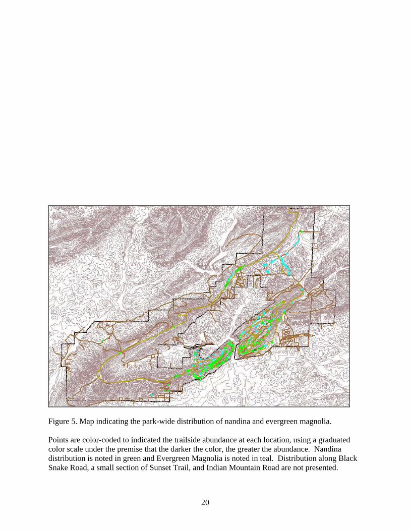
Figure 5. Map indicating the park-wide distribution of nandina and evergreen magnolia. Points are color-coded to indicated the trailside abundance at each location, using a graduated color scale under the premise that the darker the color, the greater the abundance. Nandina distribution is noted in green and Evergreen Magnolia is noted in teal. Distribution along Black Snake Road, a small section of Sunset Trail, and Indian Mountain Road are not presented.
20

Figure 6. Map indicating the park-wide distribution of mimosa tree. Points are color-coded to indicated the trailside abundance at each location, using a graduated green to blue color scale under the premise that the darker the color, the greater the abundance. Distribution along Black Snake Road, a small section of Sunset Trail, and Indian Mountain Road are not presented.
21

Table 1. List of invasive exotic plants surveyed at Hot Springs NP.
Physiognomy
Scientific Name
Common Name
Ailanthus altissima Tree of Heaven Nandina domestica Nandina Albizia julibrissin Mimosa Catalpa speciosa Catalpa tree Elaeagnus angustifolia Russian olive Ligustrum sinense Common Privet
Lonicera sp. Shrubby honeysuckles
Ligustrum japonicum Japanese privet Mahonia bealei Mahonia Spirea X vanhouttei Bridal Wreath Magnolia grandiflora Evergreen Magnolia
Trees and shrubs Ilex cornuta Chinese holly Wisteria floribunda Wisteria, all species Hedera helix English ivy Pueraria lobata Kudzu
Lonicera japonica Japanese honeysuckle Trailing or climbing
vine Vinca major Periwinkle Unknown Bamboo * Bromus inermis Smooth brome * Bromus japonicus Japanese brome *
Grasses Sorghum halepense Johnson grass Herbaceous plants Lespedeza cuneata Sericea lespedeza
*Originally listed for study, smooth brome, Japanese brome, and bamboo were not encountered during any survey and are not referred to in this report.
22
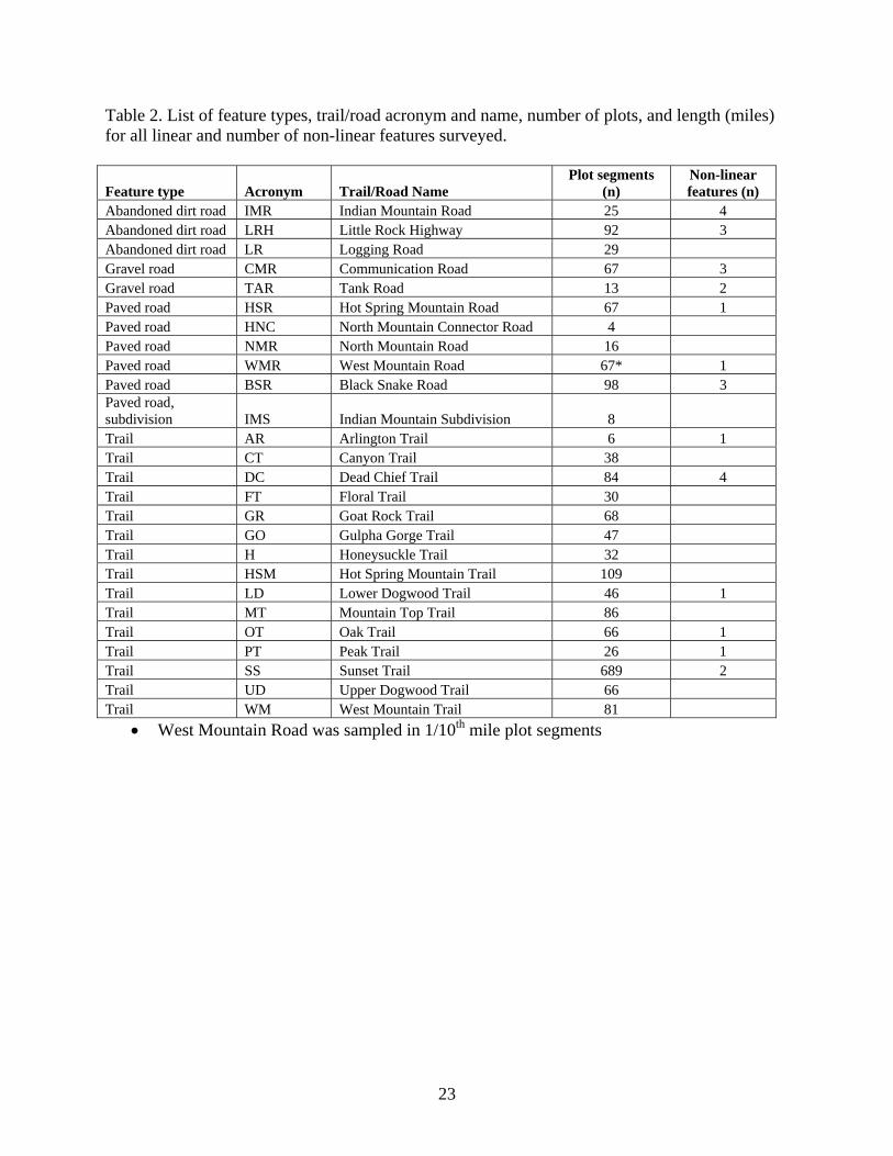
Table 2. List of feature types, trail/road acronym and name, number of plots, and length (miles) for all linear and number of non-linear features surveyed.
Feature type Acronym Trail/Road Name Plot segments
(n) Non-linear features (n)
Abandoned dirt road IMR Indian Mountain Road 25 4 Abandoned dirt road LRH Little Rock Highway 92 3 Abandoned dirt road LR Logging Road 29 Gravel road CMR Communication Road 67 3 Gravel road TAR Tank Road 13 2 Paved road HSR Hot Spring Mountain Road 67 1 Paved road HNC North Mountain Connector Road 4 Paved road NMR North Mountain Road 16 Paved road WMR West Mountain Road 67* 1 Paved road BSR Black Snake Road 98 3 Paved road, subdivision IMS Indian Mountain Subdivision 8 Trail AR Arlington Trail 6 1 Trail CT Canyon Trail 38 Trail DC Dead Chief Trail 84 4 Trail FT Floral Trail 30 Trail GR Goat Rock Trail 68 Trail GO Gulpha Gorge Trail 47 Trail H Honeysuckle Trail 32 Trail HSM Hot Spring Mountain Trail 109 Trail LD Lower Dogwood Trail 46 1 Trail MT Mountain Top Trail 86 Trail OT Oak Trail 66 1 Trail PT Peak Trail 26 1 Trail SS Sunset Trail 689 2 Trail UD Upper Dogwood Trail 66 Trail WM West Mountain Trail 81
• West Mountain Road was sampled in 1/10th mile plot segments
23

Table 3. Frequency of occurrence (%) and average total cover (%) of the surveyed exotic species, summarized for each trail along a 30 m. belt transect from the trail edge.
Mountain Foot Trail Trail acronym % Freq. Mean Cover
Hot Springs Dead Chief Trail DC 76.19 33.76 Hot Springs Floral Trail FT 40.00 10.25 Hot Springs Honeysuckle Trail H 62.50 9.8 Hot Springs Hot Springs Mountain Trail HSM 57.80 18.85 Hot Springs Peak Trail PT 88.46 31.65 North Arlington Trail AR 33.33 10.00 North Gulpha Gorge Trail GO 29.79 2.57 North Goat Rock Trail GR 14.71 12.10 North Lower Dogwood Trail LD 54.35 16.76 North Upper Dogwood Trail UD 36.36 2.87 Outer Sunset Trail SS 28.88 19.28 West Canyon Trail CT 55.26 9.80 West Mountain Top Trail MT 61.63 25.41 West Oak Trail OT 84.85 25.50 West West Mountain Trail WM 61.73 34.00
24

Table 4. Frequency of occurrence (%) and average total cover (%) of the surveyed exotic species along foot trails at Hot Springs NP. Values are listed for increasing distances from the trail edge. 0 - 10 m. 11 - 20 m. 21 - 30 m. Mountain Trail % Freq. Cover % Freq. Cover % Freq. Cover Hot Springs DC 75.00 45.36 57.14 42.08 41.67 45.71 Hot Springs FT 40 21.80 16.67 21.20 - - Hot Springs H 56.25 16.40 40.62 16.78 9.37 24.67 Hot Springs HSM 50.46 33.67 27.52 29.07 14.68 44.50 Hot Springs PT 88.46 39.69 61.54 43.75 42.30 54.18 North AR 33.33 6.00 16.67 10.00 16.67 38.00 North GO 25.53 7.00 6.38 4.67 6.38 2.00 North GR 14.71 14.60 8.82 19.33 4.41 34.00 North LD 52.17 23.33 36.96 23.29 19.56 39.44 North UD 55.55 4.14 32.10 6.33 22.20 6.40 Outer SS 26.12 29.83 17.71 31.03 7.55 25.42 West CT 52.63 26.40 18.42 9.42 7.89 8.00 West MT 59.30 31.72 31.39 48.00 12.79 101.45 West OT 83.33 31.74 59.09 32.20 43.94 44.07 West WM 55.56 52.22 32.10 55.77 22.22 71.78
25

Table 5. Trailside (0 – 30 m) % frequency and mean cover for the four exotic species of concern along foot trails in Hot Springs NP.
Common Privet Japanese
Honeysuckle Evergreen Magnolia Nandina
Trail % Freq. Cover % Freq. Cover % Freq. Cover % Freq. Cover AR - - 16.67 1.00 - - - - CT 18.42 2.71 28.95 14.90 13.16 1.00 26.32 2.00 DC 36.90 12.61 46.42 38.00 16.67 1.36 39.28 6.33 FT 6.67 2.00 36.67 10.54 3.33 1.00 6.67 1.00 GO 10.64 1.00 2.13 7.00 4.25 1.00 10.64 2.00 GR 5.88 11.75 4.41 3.00 - - 4.41 1.00 H 6.25 1.00 34.38 15.63 9.38 1.68 12.50 1.00 HSM 19.27 14.85 40.37 18.03 4.59 1.00 16.51 1.28 LD 10.87 3.40 34.78 23.62 19.57 1.67 8.70 1.75 MT 18.60 3.87 34.88 26.40 9.30 3.25 20.93 2.83 OT 28.79 2.32 57.57 20.58 21.21 1.00 63.64 3.90 PT 50.00 1.00 73.08 34.52 - - 26.92 2.14 SS 9.29 18.55 15.67 18.55 6.53 1.31 5.66 4.77 UD 7.58 5.20 9.09 4.00 18.18 1.08 - - WM 32.10 15.00 32.10 45.5 12.35 1.30 38.27 3.32
26

Table 6. Trailside % frequency and mean cover for the four most commonly encountered exotic species along foot trails at Hot Springs NP. Values are listed for increasing distances from the trail edge.
Common Privet Japanese honeysuckle 0 - 10 m. 11 - 20 m. 21 - 30 m. 0 - 10 m. 11 - 20 m. 21 - 30 m.
Mountain Trail Acronym
% Freq. Cover
% Freq. Cover
% Freq. Cover
% Freq. Cover
% Freq. Cover
% Freq. Cover
Hot Springs FT 6.67 6.00 3.33 1.00 - - 36.67 22.00 13.33 9.27 - - Hot Springs H 6.25 2.00 3.13 1.00 - - 34.38 22.36 28.13 18.00 9.38 6.72 Hot Springs HSM 17.43 25.23 7.34 14.95 1.83 4.28 40.37 27.82 22.02 12.13 13.76 13.95 Hot Springs PT 50.00 2.00 7.69 0.31 - - 73.08 41.89 53.85 33.68 38.46 28.21 North AR - - - - - - 16.67 2.00 - - - - North DC 36.90 18.97 25.00 11.22 22.61 7.48 46.42 43.90 38.09 37.64 27.38 32.51 North GO 10.63 2.00 - - - - 2.13 20.00 - - - - North GR 5.88 13.00 2.94 12.00 2.94 10.00 4.41 8.00 4.41 2.00 - - North LD 8.70 3.20 6.52 4.40 2.17 2.00 34.78 31.37 28.26 22.12 17.39 17.25 North UD 4.55 1.20 6.06 8.40 4.55 6.40 9.09 4.67 6.06 4.00 4.55 3.67 Outer SS 8.99 21.44 4.06 12.59 1.01 3.69 14.80 26.61 11.32 21.68 3.91 7.31 West CT 18.42 8.00 - - - - 28.95 37.27 10.53 5.45 2.63 1.82 West MT 17.44 5.62 8.14 3.12 2.32 2.50 34.88 32.07 22.09 25.73 12.79 21.27 West OT 24.24 2.95 12.12 1.68 9.09 2.00 54.55 25.68 33.33 16.68 27.27 19.31 West WM 29.62 19.69 18.51 12.85 12.34 12.23 32.10 61.31 19.75 38.85 18.52 36.31
Evergreen Magnolia Nandina 0 - 10 m. 11 - 20 m. 21 - 30 m. 0 - 10 m. 11 - 20 m. 21 - 30 m.
Mountain Trail Acronym
% Freq. Cover
% Freq. Cover
% Freq. Cover
% Freq. Cover
% Freq. Cover
% Freq. Cover
Hot Springs FT 3.33 2.00 - - - - 6.67 2.00 - - - - Hot Springs H 9.38 4.67 6.25 1.33 - - 9.38 1.50 6.25 1.00 - - Hot Springs HSM 0.92 0.40 3.67 1.60 - - 16.51 2.44 6.42 0.78 1.83 0.22 Hot Springs PT - - - - - - 26.92 4.29 15.38 2.28 3.85 0.28 North AR - - - - - - - - - - - - North DC 13.09 2.14 8.33 1.00 3.57 0.43 36.90 10.54 22.62 5.57 15.47 2.85 North GO 4.25 2.00 2.13 1.00 2.13 1.00 6.38 4.80 2.13 0.40 2.13 0.40 North GR - - - - - - 4.41 2.00 - - - - North LD 15.22 2.44 8.70 1.78 6.52 0.67 8.70 4.00 2.17 0.50 - - North UD 7.58 0.83 7.58 0.83 6.06 0.67 - - - - - - Outer SS 4.35 1.69 3.62 1.29 2.18 0.67 5.37 7.79 3.48 4.00 1.31 2.31 West CT 7.89 1.20 2.63 0.40 5.26 0.80 26.32 5.20 5.26 0.40 - - West MT 6.97 3.50 5.81 3.25 2.32 2.50 19.77 4.11 8.14 2.56 2.32 1.11 West OT 9.09 0.85 10.61 1.00 10.61 1.00 62.12 5.52 39.39 3.24 34.85 2.67 West WM 8.64 2.20 4.94 2.00 2.47 0.40 35.80 6.06 22.22 3.03 11.11 0.84
27

Table 7. Frequency of occurrence (%) and mean cover (%) of the surveyed exotic species, summarized for each road along a 30 m. belt transect from the road edge.
0 - 30 m.
Road type Road % Freq Mean Cover
Abandoned, Dirt IMR 86.96 33.88 Abandoned, Dirt LR 64.81 23.55 Abandoned, Dirt LRH 74.26 31.67 Gravel CMR 72.12 15.25 Gravel TAR 100.00 49.77 Paved BSR 97.10 47.98 Paved HNC 100.00 8.00 Paved HSR 87.25 39.00 Paved NMR 84.21 12.90 Paved WMR 94.59 43.48
28

Table 8. Frequency of occurrence (%) and mean cover (%) of the surveyed exotic species along roads at Hot Springs NP. Values are listed for increasing distances from the road edge.
0 - 10 m. 11 - 20 m. 21 - 30 m. Road type Road % Freq Cover % Freq Cover % Freq Cover Abandoned, Dirt IMR 100.00 79.68 28.00 78.28 - - Abandoned, Dirt LR 100.00 31.72 55.17 36.37 41.37 45.33 Abandoned, Dirt LRH 94.57 41.59 60.87 46.71 45.65 59.57 Gravel CMR 98.51 35.94 32.83 25.45 8.95 22.67 Gravel TAR 100.00 69.07 53.85 86.57 46.15 73.33 Paved BSR 100.00 57.23 50.00 88.65 39.89 100.00 Paved HNC 100.00 18.00 25.00 20.00 25.00 2.00 Paved HSR 100.00 58.00 56.71 67.79 28.36 73.47 Paved NMR 93.75 22.27 37.50 32.00 12.50 46.00 Paved WMR 97.01 75.08 59.70 60.00 44.78 48.80
29

30
Table 9. Roadside % frequency and mean cover for six exotic species of concern along paved, gravel access, and abandoned dirt roads at Hot Springs NP. Data is summarized for a 30 m. belt transect from the road edge.
Mimosa Sericea Common
Privet Japanese
Honeysuckle Evergreen Magnolia Nandina
0 - 30 m. 0 - 30 m. 0 - 30 m. 0 - 30 m. 0 - 30 m. 0 - 30 m.
Road Road type %
Freq. Cover %
Freq. Cover %
Freq. Cover %
Freq. Cover %
Freq. Cover %
Freq. Cover IMR Dirt 12.00 13.00 52.00 10.54 48.00 15.42 56.00 34.14 - - 4.00 1.00 LR Dirt 44.83 3.61 24.14 7.42 24.13 23.57 51.72 27.73 - - 3.45 1.00 LRH Dirt 1.09 3.00 8.69 13.62 66.30 26.47 75.00 13.14 23.91 1.50 2.17 1.00 CMR Gravel 55.22 4.05 22.39 2.33 43.28 5.28 55.22 17.30 - - 4.48 1.00 TAR Gravel 92.31 10.58 30.80 5.25 38.46 26.80 61.54 43.75 7.69 1.00 - - BSR Paved 67.35 3.68 18.37 12.67 39.79 33.15 47.95 53.47 - - 2.04 1.00 HNC Paved - - 25.00 3.00 75.00 3.00 25.00 20.00 - - - - HSR Paved 19.40 1.85 2.98 1.00 46.27 27.10 91.05 26.05 1.49 1.00 28.36 2.10 NMR Paved 6.25 1.00 12.50 1.00 37.5 9.67 50.00 15.25 18.75 1.00 25.00 1.00 WMR Paved 8.95 1.00 7.46 2.20 61.19 16.73 86.57 28.91 29.85 4.15 47.76 3.62

Table 10. Roadside % frequency and mean cover for the six most commonly encountered exotic species along paved, gravel access, and abandoned dirt roads at Hot Springs NP. Values are listed for increasing distances from the trail edge. Mimosa Evergreen Magnolia Nandina 0 - 10 m. 11 - 20 m. 21 - 30 m. 0 - 10 m. 11 - 20 m. 21 - 30 m. 0 - 10 m. 11 - 20 m. 21 - 30 m.
Road Road type
% Freq. Cover
% Freq. Cover
% Freq. Cover
% Freq. Cover
% Freq. Cover
% Freq. Cover
% Freq. Cover
% Freq. Cover
% Freq. Cover
IMR Dirt 6.52 26.00 2.17 12.67 - - - - - - - - 4.00 2.00 - - - -LR Dirt 24.07 10.00 1.85 0.15 - - - - - - - - - - 3.45 2.00 - -LRH Dirt 0.74 10.00 - - - - 1.36 1.36 1.73 1.73 1.27 1.27 2.17 2.00 2.17 2.00 - -CMR Gravel 34.62 9.30 7.69 2.54 1.92 0.32 - - - - - - 2.98 1.33 1.49 0.67 - -TAR Gravel 92.31 17.00 38.46 9.50 15.38 5.33 7.69 2.00 - - - - - - - - - -BSR Paved 48.51 9.30 5.22 0.94 2.24 0.45 - - - - - - 1.02 1.00 2.04 2.00 1.02 1.00HNC Paved - - - - - - - - - - - - - - - - - -HSR Paved 11.76 4.30 1.96 0.92 - - - - 0.98 2.00 - - 28.36 4.53 11.94 1.68 - -NMR Paved 2.63 2.00 - - - - 5.26 1.33 2.63 0.67 2.63 0.67 25.00 2.00 12.50 1.00 - -WMR Paved 8.95 2.00 2.98 0.67 - - 25.37 4.60 17.91 4.50 13.43 3.00 43.28 7.31 28.35 2.75 10.45 0.68
Japanese Honeysuckle Common Privet Sericea 0 - 10 m. 11 - 20 m. 21 - 30 m. 0 - 10 m. 11 - 20 m. 21 - 30 m. 0 - 10 m. 11 - 20 m. 21 - 30 m.
Road Road type %
Freq. Cover %
Freq. Cover %
Freq. Cover %
Freq. Cover %
Freq. Cover %
Freq. Cover %
Freq. Cover %
Freq. Cover %
Freq. Cover IMR Dirt 56.00 77.28 16.00 25.14 - - 48.00 33.33 8.00 12.50 - - 52.00 30.77 12.00 0.46 - - LR Dirt 51.72 24.80 37.93 29.73 31.03 28.40 24.14 40.86 24.14 16.00 13.79 14.00 24.13 17.42 3.45 2.86 3.45 2.86LRH Dirt 75.00 19.39 36.96 9.77 26.09 10.23 65.22 28.82 39.13 25.38 31.52 24.92 8.69 19.00 4.34 12.75 2.18 9.00CMR Gravel 53.73 39.10 26.86 10.27 5.97 2.32 43.28 14.48 11.95 1.17 - - 22.38 6.13 - - - - TAR Gravel 61.54 51.75 46.15 42.75 38.46 36.75 38.46 34.8 30.77 28.8 15.38 16.40 30.79 15.00 15.38 1.00 - -BSR Paved 46.93 53.02 40.82 54.12 33.67 53.32 38.77 38.33 27.55 31.43 22.45 29.64 18.37 15.88 7.14 11.55 5.10 10.33HNC Paved 25.00 38.00 25.00. 20.00 25.00 2.00 75.00 8.00 - - - - 25.00 10.00 - - - -HSR Paved 91.04 36.69 56.71 25.84 25.37 15.87 46.26 39.10 32.83 28.19 16.42 13.80 2.98 2.00 1.49 1.00 - -NMR Paved 50.00 23.50 12.50 11.25 6.25 11.00 37.50 16.33 18.75 12.33 6.25 0.33 12.50 2.00 6.25 1.00 - -WMR Paved 83.58 47.12 49.25 26.20 34.32 13.62 58.20 33.46 26.86 8.92 14.92 7.76 7.46 3.60 1.49 2.00 - -
31