comprehensive wetland program plan commonwealth of
TRANSCRIPT
Comprehensive Wetland Program Plan Commonwealth of Virginia
2011 - 2015
Submitted By:
Virginia Department of Environmental Quality
629 East Main Street
Richmond, Virginia 23219
In Collaboration with:
Virginia Institute of Marine Science
Center for Coastal Resources Management
David L. Davis, CPWD, PWS
Director, Office of Wetlands & Water Protection
Phone: 804-698-4105
Fax: 804-698-4032
Submitted to EPA pursuant to
Enhancing State and Tribal Programs Initiative for Wetlands Programs
The Environmental Protection Agency
April 2011

Table of Contents
EXECUTIVE SUMMARY .............................................................................................. i Objective Summary ...................................................................................................ii
I. INTRODUCTION ................................................................................................... 1 Statewide Wetland Resources ................................................................................. 1 Threats and Stresses to Wetlands ........................................................................... 2 Chesapeake Bay Commitments ............................................................................... 2
II. MONITORING AND ASSESSMENT .................................................................. 3
Current Efforts .......................................................................................................... 4 Monitoring and Assessment Objectives ................................................................... 5
III. REGULATION .................................................................................................... 6 Background .............................................................................................................. 6
Current Efforts .......................................................................................................... 8 Regulation Objectives ............................................................................................ 11
IV. VOLUNTARY PROTECTION AND RESTORATION ....................................... 12 Voluntary Protection and Restoration Objectives ................................................... 13
V. WATER QUALITY STANDARDS FOR WETLANDS ....................................... 13
Water Quality Standards for Wetlands Objectives ................................................. 14 VI. PLANNING and SUSTAINABILITY .................................................................. 15
Planning and Sustainability Objectives .................................................................. 16 VII. INFORMATION ACQUISITION ........................................................................ 17
Information Needs Objectives ................................................................................ 17
OUTREACH/EDUCATION ........................................................................................ 17 Outreach Objectives ............................................................................................... 18
REFERENCES .......................................................................................................... 18 Appendix A ................................................................................................................ 21
Acronyms ............................................................................................................... 21 Appendix B ….Map of Tidewater Virginia .................................................................. 22
Appendix C ................................................................................................................ 23 State Programs ...................................................................................................... 23
Appendix D ................................................................................................................ 29 Partner Programs ................................................................................................... 29
Appendix E ................................................................................................................ 30 Preserves and Refuges: Wetland Complexes ........................................................ 30
Appendix F ................................................................................................................ 39 Stressors list used for Monitoring and Assessment Program ................................. 39

i
EXECUTIVE SUMMARY This Wetland Program Plan (WPP) has been prepared at the direction of the Environmental Protection Agency (EPA), and summarizes (1) the multiple existing regulatory and voluntary wetland program elements in Virginia, (2) identifies opportunities for improvements in current program objectives and operations, and (3) prioritizes program development to achieve an effective and comprehensive program strategy. The Commonwealth of Virginia’s WPP provides a framework to improve its wetland programs over the next five years (2011-2015) with incorporation of objectives to address wetland management issues. The WPP describes Virginia’s efforts in four core element areas, plus three additional areas critical to the achievement of wetland no-net-loss and net resources gain. The EPA has identified these four core elements as 1) monitoring and assessment, 2) regulation, 3) voluntary restoration, and 4) water quality standards for wetlands. However, long term sustainability of wetland resources in Virginia necessitates actions in other areas, notably: planning, information acquisition and outreach/education. Inclusion of these elements, along with the EPA core elements, creates a comprehensive perspective on Virginia’s wetland resources and facilitates a plan to address those resources. It is estimated that Virginia has lost approximately one-half of its original pre-colonial wetlands acreage. Currently, there are approximately one million acres of wetlands remaining; 75% of these are nontidal wetlands, and the remaining 25% are tidal wetlands. In Virginia, wetland resources are managed primarily by two state agencies operating under corresponding state law: the Department of Environmental Quality (DEQ) implements the Nontidal Wetlands Act and the Virginia Marine Resources Commission (VMRC) has state oversight of the local cooperative implementation of the Tidal Wetlands Act. Many other regulatory and non-regulatory entities operating at local, state, federal and regional scales are involved in wetlands management, research, restoration, and education in Virginia. The primary threats to Virginia’s wetlands are conversion to a different land cover. For nontidal wetland this is most often conversion to uplands associated with development. Tidal wetlands are converted to developed lands, typically associated with shoreline hardening, but are also lost through conversion to open water as a result of sea level rise. A comprehensive plan to address the achievement of no-net-loss and net wetlands gain should include the following core elements, as defined by EPA:
1. Monitoring and Assessment 2. Regulation 3. Voluntary Restoration, and 4. Water Quality Standards for Wetlands.

ii
This plan summarizes efforts on the core elements, and includes other elements identified as critical to Virginia wetlands. Where needed, objectives are identified to address gaps, or strengthen existing efforts. Some of the identified actions items are part of on-going efforts with existing support from State Wetland Development Grant funds. The remaining identified objectives will proceed over the next 5 to 10 years. Funding support for these actions will allow for a shorter timeframe and greater likelihood of successful objective completion.
Objective Summary
Monitoring and Assessment Goal: The proposed objectives are intended to strengthen the monitoring and assessment element through the incorporation of new data, the integration into the overall water quality program and processes to better inform decision-making. Objective 1: Maintain effort to re-calibrate wetland assessment models. Action Item: This effort is underway by DEQ and the Center for Coastal Resources Management (CCRM) at Virginia Institute of Marine Science (VIMS) and has been completed for the coastal plain. The next step is to perform the re-calibration for the piedmont and ridge and valley physiographic provinces. Timeline: The Piedmont is to be completed by 2012. We anticipate the ridge and valley and the re-assessment of the coastal plain to be proposed for the next grant cycle, with the calibration of landuse practices with wetland stressors to be an ongoing activity. Objective 2: Update Monitoring and Assessment Strategy Action Item: DEQ will update its 2005 monitoring and assessment strategy and incorporate the efforts to date in scoping the next 5 year strategy. Timeline: 2011-2013. Objective 3: Iterative landcover data set Action Item: This effort is critical to maintaining a comprehensive picture of Virginia’s wetlands with regard to human or natural losses of wetland acreage and ecosystem services. Timeline: 2015 - 2020. We anticipate this action item to occur in 2015. Additional funding could accelerate the schedule.
Regulation Goal: These objectives will provide the ability to make better permitting decisions relative to cumulative impacts; preserve wetland function by evaluating wetland condition over time; avoid and minimize wetland loss; evaluate performance of compensatory wetland mitigation in replacing wetland acreage and function and evaluate the effectiveness of our regulatory program.

iii
Objective 1: Geo-locate preserved wetlands and evaluate the completeness of DEQ wetland permit records for preserved wetlands. Action Item: DEQ is working with CMI to compare original wetlands permits to the CEDS database, and create a GIS database of visually interpreted wetlands preserved through the permit process. Timeline: Complete September 2011. Objective 2: Track unpermitted wetland impacts. Action Item: DEQ is working with CMI to locate and quantify unpermitted wetland impacts. This activity builds upon a previous pilot effort and will apply wetland change analysis to additional regions and further refine the process by incorporating new methods and additional datasets. Timeline: Complete September 2011 Objective 3: Work with the VDOT to enhance the Wetland Dataviewer to accommodate VDOT permit review and NEPA documentation needs. Action Item: CCRM will work with DEQ and VDOT to develop additional Wetland Dataviewer tools for VDOT and other entities involved in linear projects. Timeline: Start 2012. Dependent on Funding Objective 4: Mitigation bank tracking, evaluation and guidance. Action Item: This effort would be undertaken cooperatively by DEQ and CCRM. The effort includes the incorporation of mitigation bank geospatial information into the wetland dataviewer. This will enhance the effectiveness of the tool for permit review and create an opportunity to evaluate the effectiveness of mitigation efforts to replace ecosystem functions and inform the development of subsequent guidance. Timeline: Start Fall 2011. Dependent on Funding Objective 5: Develop a VMRC general permit for living shorelines. Action Item: Background research and modeling efforts are underway by CCRM. This effort will require cooperative participation of wetland permitting authorities and advisory agencies. Timeline: Begin Summer 2011. Objective 6: Continue to assess the effectiveness of tidal wetland management activities. Action Item: This effort is just underway by CCRM, with completion in 2012. Based upon this assessment, modifications to CCRM outreach efforts and recommendations for any necessary modifications to the regulatory program will be made. Timeline: Started 2010, assessment completed 2012. Modifications to outreach program to start in 2012.
Voluntary Wetland Restoration Goal: Identify the amount of non-regulated restoration activities that can count towards the attainment of a net resource gain.

iv
Objective 1: Develop and implement a voluntary wetland restoration tracking system. Action Item: CCRM has submitted a proposal to the National Oceanic & Atmospheric Administration (NOAA) - Coastal Program to perform this activity. The development of a geo-referenced database combined with an accounting system for tracking credits would enable a complete understanding of the status of mitigation efforts. Timeline: 2015, Dependent upon funding and private property owner confidentiality issues.
Water Quality Standards for Wetlands Goals: Improve the quality of wetlands by gathering and analyzing monitoring data and other information that could become the basis of wetland quality narrative standards. Objective 1: Begin a process to assess the relationship between non-tidal wetlands in the watershed and ambient water quality. CCRM has started a project to look at the role of wetlands in the watershed relative to water quality, particularly water quality impairment. Action Item: CCRM has begun compiling various existing data sets to do this assessment. Timeline: Prototype underway, 2012 - 2015 Planning and Sustainability Goal: To promote the use of living shorelines and improve quality of services through communication efforts. Objective 1: Develop community-scale comprehensive coastal resource management plans (CCRMP). The plans should be specifically designed to support integrated management of current tidal shoreline resources addressing shoreline erosion requirements for local comprehensive plans, and should also provide information to support local planning efforts to adapt to changing conditions in the coastal zone, including sea level rise. Action Item: CCRM will develop these plans for each locality in Tidewater Virginia as funding allows. Timeline: Prototype underway, 2011. Development of comprehensive shoreline guidance mandated by Virginia SB 964 and will be ongoing. Objective 2: Establish and maintain a process for improved communication among state, federal, local non-governmental and governmental partners managing or working in wetlands. Virginia has multiple parties engaged in wetlands preservation and management, including state, federal, and local agencies, as well as numerous local, state, and regional nongovernment organizations (NGOs). The lack of an effective method of consistently sharing information among these groups has been an impediment to efficiency in obtaining common goals.

v
Action Item: VIMS will establish a contact list for all parties, initiate a list-serve communication capability and strategy, and develop a web-based information clearinghouse. Timeline: 2013 – 2015 Information Acquisition Goal: To provide accurate and timely data for continued enhancement of the Wetland Dataviewer. Objective1: Obtain iterative landcover data set Action Item: This effort is critical to a comprehensive picture of Virginia’s wetlands with regard to human and/or natural losses of wetland acreage and ecosystem services. Timeline: 2013 - 2015
Outreach/Education Goal: Develop and provide outreach education to better inform the public and resource decision-makers. Objective 1: Improve public communications print materials Action Item: DEQ is updating and expanding the Public Guide to the Wetland Permitting Process in Virginia, a publication last produced in 2002. Timeline: Complete by September 2011 Objective 2: Improve public access to information via the web Action Item: DEQ is reorganizing our wetland program webpage to include general wetland information that is useful to the public, particularly (1) add information that is helpful during real estate transactions, (2) add information that is useful for watershed planning and watershed management, (3) reorganize our regulatory and compliance pages, and (4) add summary metrics (where appropriate) on the overall success of the wetland permitting and compliance programs. Timeline: Complete by September 2011 Objective 3: Maintain outreach for local government decision-makers. Action Item: CCRM will continue on-going outreach activities directed toward the local government decision-makers on tidal wetland resources. Input from the assessment of tidal wetlands management will guide changes to outreach efforts. Timeline: Ongoing, with new efforts in 2012 to follow on completion of tidal wetland management assessment.

1
I. INTRODUCTION Exceptional wetland diversity occurs across the Virginia landscape. Swamps, streams, tidal marshes, wet meadows, bogs, pocosins, and sinkhole wetlands are just some of Virginia’s wetland communities. Wetland loss and modifications, whether they are primary, secondary and/or cumulative, can adversely impact the role of wetlands in providing valuable ecosystem services. A comprehensive wetland plan to address the achievement of no-net-loss and a net wetlands gain should include core elements, as defined by EPA:
1 Monitoring and Assessment 2 Regulation 3 Voluntary Restoration, and 4 Water Quality Standards for Wetlands.
We also believe it is important to address planning for coastal wetlands sustainability in the face of sea level rise, including critical information needs and education and outreach efforts. This plan summarizes efforts on the core elements, plus additional elements identified as critical to Virginia wetlands. Where needed, objectives are identified to address gaps, or strengthen existing efforts for each element. Statewide Wetland Resources Virginia has approximately 1 million acres of wetlands. An estimated 75% of these acres are palustrine vegetated wetlands, and the remaining 25% of these acres are estuarine wetlands. Approximately 72% of the wetlands in Virginia are in the Coastal Plain, with another 20% in the Piedmont and the remaining 9% in the other physiographic provinces (Tiner and Finn 1986). Virginia is believed to have lost about 40 percent of its original complement of pre-colonial wetlands (National Water Summary on Wetland Resources, United States Geological Survey Water Supply Paper 2425). A study of wetland trends in Southeastern Virginia for 1994-2000 showed a net loss of 2,100 acres (1.3%). The actual loss of vegetated wetlands was even higher, but offset by a gain in pond and open water area. The loss of palustrine wetlands was primarily due to conversion to uplands, while estuarine wetlands were lost through conversion to open water (Tiner, et.al. 2005).

2
Threats and Stresses to Wetlands While some of the primary threats and stresses to Virginia’s wetlands are dependent upon whether the wetlands are non-tidal or tidal, others affect both tidal and non-tidal wetlands. The following list summarizes the major causes of wetland loss in Virginia (Tiner and Finn 1986, Tiner, et al. 2005).
1. Conversion to Other Land Cover – Nontidal wetlands are lost through conversion to uplands. Development conversion is the primary threat. Reservoir and impoundment projects convert nontidal wetlands to open water. Tidal wetlands are lost through conversion to open water and uplands. Conversion to uplands is most commonly associated with shoreline erosion control structures. The conversion of non-tidal adjacent wetlands to tidal wetlands and tidal wetlands to open water is caused by sea level rise.
2. Conversion to Other Uses - This threat is most common for non-tidal temporary and seasonal wetlands that are easier to convert. These threats involve managing wetlands as residential lawn or gardens, timbering, stock-pile storage, and temporary fill. These conversions are generally associated with residential and commercial development.
3. Hydrologic Alterations - Diversions, stream channelization, ditches, etc. can divert or prevent water from reaching wetlands resulting in a change in type or possible conversion to upland.
4. Invasive species –There are a number of species that can be invasive in wetlands. Two plants species of concern are purple loosestrife (Lythrum salicaria) and common reed (Phragmites australis). These species can form dense monotypic stands that reduce habitat and wildlife diversity. Phragmites is identified as one of twelve invasive species, and is targeted in an eradication effort by the Department of Conservation and Recreation (DCR). (http://www.deq.state.va.us/coastal/documents/task10-03-07.pdf).
5. Fragmentation - Fragmentation of wetlands by development, crop fields, roads, fences, berms, or other factors limits or eliminates ecosystem services, notably habitat and water quality. Fragmentation, and associated disturbance, can also lead to increased invasion by non-native and aggressive species like Phragmites. (See Appendix D for an expanded list of stressors used in the wetland monitoring and assessment effort).
Chesapeake Bay Commitments Virginia has agreed to the Major Desired Outcome for Wetlands (Chesapeake Bay 2000 Agreement, Subsection 2.3) to “(i) achieve no net loss of existing wetland acreage and function through regulatory programs; (ii) achieve net wetland resource gain through wetland restoration; and (iii) assist local governments and community groups with development of wetland preservation plans as part of integrated locally based watershed planning.”

3
Virginia had committed to restoring 6,000 new acres of wetlands by 2010 within Virginia’s portion of the Chesapeake Bay. In addition, Virginia has set a goal of restoring 4,000 acres outside of the Bay drainage, for a total of 10,000 new acres statewide.
II. MONITORING AND ASSESSMENT
A monitoring and assessment program is defined as the establishment and operation of appropriate devices, methods, systems and procedures necessary to monitor, compile, and analyze data on the condition of wetlands (adapted from Elements of a State Water Monitoring and Assessment Program, March 2003). Monitoring is the systematic observation and recording of current and changing conditions, while assessment is the use of that data to evaluate or appraise wetlands to support decision-making and planning processes. Wetlands can be characterized both by their condition and by functions. Wetland condition is the current state as compared to reference standards for physical, chemical, and biological characteristics, while functions represent the processes that characterize wetland ecosystems.
The overarching goal of Virginia’s wetland monitoring and assessment strategy is to develop a long-term implementation plan for a wetland monitoring and assessment program that protects the physical, chemical, and biological integrity of the Commonwealth’s water resources, including wetlands. In order to accomplish this goal, it is critical to first know the status of wetland resources in Virginia, in terms of location and extent of wetlands in each watershed, and have a general knowledge of the quality of these wetland resources. Secondly, the functions of wetland resources impacted through our permitting program must be accurately evaluated to determine those functions to be replaced through compensatory mitigation. It is also important to assess the degree to which the required compensatory mitigation is performing in relation to those impacted functions.
The monitoring and assessment strategy follows the “Elements of a Wetland Monitoring and Assessment Program Checklist” developed by the United States Environmental Protection Agency (EPA) in October 2002, as well as the Elements of a State Water Monitoring and Assessment Program (EPA 841-B-03-003, March 2003) and Application of Elements of a State Water Monitoring and Assessment Program for Wetlands (unpublished draft, July 2005).
The assessment method is a multi-service model that involves three levels of data collection. The Level II and Level III sampling are intended to calibrate and validate the model that is applied at the Level I (model development) stage. The data collections are not designed to operate independently. The method characterizes the capacity of the wetland to provide water quality and habitat services using remotely sensed data. The underlying models are based on existing research. They specify the combination of landscape level parameters that are most likely predictive of these capacities. The model application produces a relative score for each wetland for each service. The

4
scores are then refined and calibrated by site visits to randomly selected wetlands. The relationship between structure and function is validated by intensive study of ecological service endpoints.
Current Efforts
Virginia’s wetland monitoring and assessment program is being implemented through a cooperative agreement between DEQ and the Center for Coastal Resources Management at the Virginia Institute of Marine Science (CCRM) using funds awarded through EPA’s Wetland Program Development Grants to continue these efforts. DEQ has received seven grant awards from EPA over the past eight years for this initiative, and Virginia is recognized as one of five states leading this initiative nationally.
Parameters used in the assessment reflect information from published literature, with consideration of on-going work being conducted through the Mid-Atlantic Wetland Workgroup (MAWWG), regarding each parameter’s validity, usefulness, and utility for field data collection.
A level I assessment based on type and surrounding landscape has been completed for all wetlands in Virginia. Each wetland area is given a separate score for habitat and for water quality. T he assessment was done using existing data sets from the National Wetlands Inventory (NWI), Landsat Thematic Mapper (TM) satellite, protocols developed by the Coastal Change Analysis Program (CCAP) of the National Oceanic and Atmospheric Administration (NOAA), U.S. Geologic Survey National Elevation Dataset (NED), and Digital OrthoPhoto Quads. The parameters chosen for Virginia’s Level I assessment wetland quality score include: (i) wetland size, (ii) wetland type, (iii) wetland hydroperiod; (iv) proximity to other wetlands; (v) proximity to roads and highways, (vi) density of roads and highways; and (vii) percent land cover (immediately adjacent to the study wetland, at a 200 meter radius from the study wetland, and at 200-1000 meter radius from the study wetland). The data set will be updated periodically, when resources allow, as revised land cover and NWI maps are updated.
Level II and III assessments have proceeded by physiographic province from the coastal plain to piedmont to the ridge and valley with a sampling effort succeeded by model validation. This phase of the assessment and monitoring effort is complete. The next phase is the re-calibration of the stressors by landcover to verify the correlation of stressor type to landcover and validate the use landcover for condition assessment scoring. The first recalibration effort was done for the coastal plain, with the piedmont and ridge and valley to follow.
The data collected has been compiled into a wetland data viewer created by CCRM with substantial input from DEQ. The goal is to automate the processing of database information through GIS necessary to support DEQ’s regulatory decision-making, allow reporting of wetland condition, and provide information for policy development. In particular, information derived from monitoring will be used to:

5
1. Report ambient wetland conditions in Virginia's Clean Water Act (CWA) Integrated 305(b)/303(d) report;
2. Assist in the evaluation of environmental impacts to wetlands of proposed projects during permit review as part of Virginia's regulatory program, including an assessment of cumulative impacts to wetlands and water quality within a given watershed;
3. Evaluate the performance of wetland restoration and other compensatory wetland mitigation in replacing wetland acreage and function, including changes in wetland condition over time based upon surrounding landscape changes and maturity of the mitigation site; and
4. Evaluate the cumulative impacts of wetland loss and restoration in watersheds relative to ambient ecological conditions and water quality management needs.
Critical to the monitoring and assessment program, as well as to other wetland core elements, is accurate, timely, and iterative landcover data. Such data is required to assess wetland condition, track status and trends, and plan for integrated wetland restoration, preservation, and retreat in the face of sea level rise. The acquisition and provision of landcover data is needed to enable an accurate and effective picture of our wetland resources.
Monitoring and Assessment Objectives Goal: The proposed objectives are intended to strengthen the monitoring and assessment element through the incorporation of new data, the integration into the overall water quality program and processes to better inform decision-making. Objective 1: Maintain efforts to re-calibrate wetland assessment models. Action Item: This effort is underway by CCRM, and has been completed for the coastal plain. The next step is to perform the re-calibration for the piedmont and ridge and valley physiographic provinces. Timeline: The Piedmont is to be completed by 2012. Anticipate the ridge and valley and the re-assessment of the coastal plain to be proposed for the next grant cycle, with the calibration of landuse practices with wetland stressors to be an ongoing activity. Objective 2: Update Monitoring and Assessment Strategy Action Item: DEQ prepared a wetland monitoring and assessment strategy in 2005. The next step is to incorporate the completed efforts to date, and modify the strategy, as appropriate, to plan the next 5 years. Timeline: 2011-2013. Objective 3: Iterative landcover data set Action Item: This effort is critical to maintaining a comprehensive picture of Virginia’s wetlands with regard to human or natural losses of wetland acreage and ecosystem services. Timeline: 2015 - 2020. We anticipate this action item to occur in 2015. Additional funding could accelerate the schedule.

6
III. REGULATION
Background In Virginia, wetlands are managed primarily by two state agencies operating under corresponding state law; the Department of Environmental Quality implements the Nontidal Wetlands Act and the Virginia Marine Resources Commission (VMRC) has state oversight of the local cooperative implementation of the Tidal Wetlands Act. The Virginia General Assembly enacted the Chesapeake Bay Preservation Act in 1988. The Bay Act established a cooperative relationship between the Commonwealth and local governments aimed at reducing and preventing nonpoint source pollution, thus creating a unique partnership between the state and local governments in Tidewater Virginia. The Bay Act recognizes that local governments have the primary responsibility for land use decisions, and expands local government authority to manage water quality and establishes a more specific relationship between water quality protection and local land use decision-making. The Department of Conservation and Recreation, Division of Chesapeake Bay Local Assistance (CBLA) is the only program in Virginia State Government that deals comprehensively with the relationships between land use planning and development and water quality. It is also the only program that assists local governments with land use planning needs, including development of land use regulations, ordinances, and comprehensive plans. As the primary source of assistance to Tidewater localities implementing the Bay Act program, CBLA partners with local governments to protect the Chesapeake Bay and other state waters through sound land use management. The U.S. Army Corps of Engineers (Corps) was delegated the authority from EPA under the federal Clean Water Act and the River and Harbors Act to manage wetlands. In 2001, the Corps issued a State Programmatic General Permit (SPGP-01) to Virginia. This permit was modified in 2007 (07-SPGP-01), and currently covers activities within nontidal waters associated with certain residential, commercial, and institutional developments and linear transportation projects that have minimal individual and cumulative impacts. The 07-SPGP-01 authorizes impacts to nontidal wetlands or waters less than one acre or 2,000 linear feet of streams. Additionally, there are state and federal advisory agencies linked to wetland permit review. These entities include: the Virginia Institute of Marine Science (VIMS), with a mandate for general advisory service and specific responsibilities under the Tidal Wetlands Act; the Virginia Department of Game and Inland Fisheries (DGIF); the Virginia Department of Conservation and Recreation (DCR), the Virginia Department of Historic Resources (DHR); the federal National Resource Conservation Service (USDA-NRCS; the U.S. Fish and Wildlife Service (USFWS); and the National Marine Fisheries Service (NOAA-NMFS).

7
Virginia uses a Joint Permit Application to facilitate permit processing within and between the Corps, state and local authorities, federal authorities, and advisory agencies.
Virginia Water Protection Permit The Virginia Water Protection Permit Program (VWP) is administered by DEQ’s Office of Wetlands & Water Protection. This program serves as Virginia’s Section 401 certification program for federal Section 404 permits issued under the Clean Water Act. State law requires that a VWP permit be obtained before disturbing a wetland or stream by clearing, filling, excavating, draining, or ditching. Application is made through the Joint Permit Application process for concurrent federal and state project review. DEQ can provide Section 401 Certification through issuing a VWP individual or general permit or by issuing Section 401 certification for the Corps nationwide or regional permits. State Water Control Law (Va. Code § 62.1-44.3) and VWP regulations (9 VAC 25-210-10 et seq.) define “State waters” as “all water, on the surface and under the ground, wholly or partially within or bordering the Commonwealth or within its jurisdiction, including wetlands.” The definition of wetlands for purposes of the VWP is same as the federal definition (CFR 33 part 328). "Wetlands" means those areas that are inundated or saturated by surface or groundwater at a frequency and duration sufficient to support, and that under normal circumstances do support, a prevalence of vegetation typically adapted for life in saturated soil conditions. Wetlands generally include swamps, marshes, bogs and similar areas. (§ 62.1-44.3). DEQ prepared a Status and Trends Report for the VWP permit program in 2009 that summarizes trends in permitting, compensation, and compliance activities carried out by the Office of Wetlands and Water Protection. The report covers the time period July, 2001 to December 2009. During this reporting period, compensation in the form of restoration, creation, enhancement or preservation exceeded permitted impacts for wetlands and streams. Full text of the status and trends report can be found on the DEQ website at the following link: http://www.deq.state.va.us/export/sites/default/wetlands/pdf/2009Status_and_Trends_August2010.pdf
Tidal Wetlands Act
The Tidal Wetlands Act (Va. Code §28.2-1300 et seq.) established a state-local program model giving regulatory authority over tidal wetlands to the VMRC, with the option for Tidewater localities to assume the primary regulatory responsibility. Localities are allowed to adopt a model ordinance and regulate tidal wetlands through a citizen Wetland Board with oversight by the VMRC. The intent of the law is to balance preservation and use of tidal wetlands in order to protect the ecosystem services they provide. Those services are specifically identified to include: production of wildlife,
8
waterfowl, finfish, shellfish and flora; protection against floods, tidal storms, and erosion; absorption of silt and pollutants; and provisions for recreational and aesthetic opportunities. Currently, the ordinance is administered by 34 Tidewater counties and cities, and 2 towns (See Appendix B for a map of Tidewater Virginia). Twelve localities have not adopted the ordinance and the VMRC acts as the permitting authority for those locales. The Tidal Wetlands Act defines tidal wetlands as:
1. “Vegetated wetlands" means lands lying between and contiguous to mean low water and an elevation above mean low water equal to the factor one and one-half times the mean tide range at the site…” and
2. "Nonvegetated wetlands" means unvegetated lands lying contiguous to mean low water and between mean low water and mean high water…” (§ 28.2-1302).
Chesapeake Bay Preservation Act
Tidal wetlands and non-tidal wetlands adjacent to tidal wetlands are also considered Resource Protection Areas (RPAs) under the Chesapeake Bay Preservation Act (Va. Code §10.1-2100 thru 10.1-2116). This law covers all Tidewater localities (See Appendix B), and provides an option for all other localities in the Commonwealth to adopt the program as well. The program adds to local land use and other ordinances establishing criteria for the use, development and re-development of land, and further establishes limitations on land uses permitted within RPAs. The operational definition for nontidal RPA wetlands is “... those wetlands other than tidal wetlands that are inundated or saturated by surface or ground water at a frequency and duration sufficient to support, and that under normal circumstances do support, a prevalence of vegetation typically adapted for life in saturated soil conditions, as defined by the U.S. Environmental Protection Agency pursuant to § 404 of the federal Clean Water Act, in 33 CFR 328.3b.” (9 VAC 10-20-40) which are “connected by surface flow and contiguous to tidal wetlands or water bodies with perennial flow” (9 VAC 10-20-80).
Current Efforts
Preserved wetlands data DEQ was recently awarded a grant by EPA for a cooperative effort between DEQ and the Conservation Management Institute (CMI) at Virginia Tech focusing on providing DEQ with a spatial dataset to locate individual wetland permits on a property using high resolution imagery within specified regions of Virginia. Information from DEQ’s Comprehensive Environmental Database System (CEDS) and property plat records are compared to the original records of issued wetland permits. If a record is identified with a wetland permit, the parcel ID and any information or notes related to the location of the wetland on the property are recorded by the team and stored within a GIS database. Identified records with a wetland permit requiring preservation are then compared to the DEQ database. Database entries which have correctly identified preserved wetlands

9
along with those that are missing preserved wetland information are identified. This effort will provide a metric of the quality and accuracy of the data within the DEQ database. Once this work is complete, wetland permit records will be compared to digital plat information. The information will then be evaluated to determine whether these plat records have wetland permits issued or not, as well as any additional information related to the permit (description, location on property). This step will provide DEQ with a measure of how accurately plat records can be relied on to have accurate wetland permit information, and how often they can be reliably used to verify future wetland permit applications. Finally, high resolution imagery available through the Virginia Base Mapping Program (VBMP) will be used to determine whether the preserved wetlands can be photo-interpreted and spatially identified. If a wetland can be identified on the imagery, it will be marked with a point within an ArcGIS shapefile. If the wetland cannot be identified, the entire parcel will be marked within the shapefile that will also indicate whether the permitted wetland appears to have been developed or destroyed.
Track unpermitted activities As part of DEQ’s demonstration pilot grant from October 2005 through September 2008 (BG983925-03), Virginia Tech successfully conducted a wetland change analysis in two small regions of the Commonwealth using automated methods to remotely detect potential wetland losses. The results of this study suggest that a wider application to other regions of the Commonwealth would be worthwhile to DEQ. The general process for the change analysis is:
1. Use satellite imagery (such as Landsat TM) to identify specific pixel changes on the landscape.
2. Incorporate lidar (light detection and ranging) data to identify likely and unlikely areas of potential or former wetlands based on topography and vegetation
3. Use readily available ancillary datasets (e.g., existing wetlands, topography, hydrography) to remove portions of the landscape that are not likely to be wetlands.
4. Incorporate radar (radio detection and ranging) data to refine step 2 based on soil wetness in the initial and subsequent years
5. Use available large-scale aerial photography to further investigate change areas to determine the type and magnitude of change
6. Compare all identified wetland changes to issued wetland permit data. 7. Develop a final dataset of non-permitted wetland changes. 8. Develop a protocol to determine if these non-permitted wetland changes are due
to human-induced or natural occurrences. This expanded application will improve DEQ’s ability to enforce wetland regulations and seek remedies against those individuals who have impacted wetlands without first seeking a permit. Adding this capability to the compliance and enforcement initiatives

10
will help Virginia meet its statutory requirement of no net-loss of wetland acreage and function.
Wetlands Dataviewer
As previously discussed in the monitoring and assessment section (see Section II above), a web-based, geospatial wetlands dataviewer has been built from data collected and compiled by DEQ and CCRM. The uses of the dataviewer are many, but one important application is to support DEQ’s regulatory decision-making for wetland permits. The Virginia Department of Transportation (VDOT) has expressed interest in the dataviewer to enable better planning and assist in transportation project permitting. Some modification of the current viewer is likely to be necessary to meet the specific needs of VDOT particularly when planning for linear projects during their National Environmental Policy Act (NEPA) documentation process.
Living Shorelines Application of living shoreline designs has become a widely accepted and preferred strategy for tidal shoreline management. Because these designs entail a system-level approach, living shoreline treatments reflect the best understanding of how shoreline systems work, and how the benefits they provide can be sustained. For these reasons, promoting the use of living shorelines is seen as desirable by resource managers and scientific advisors across the nation. However, in order for a living shoreline design to be implemented, one or more of the agencies involved in shoreline management may have to accept impacts within targeted resources. This means that successful promotion of living shorelines will require cooperative efforts by the regulatory and advisory authorities. Virginia has pursued efforts to promote the use of living shorelines. While there are many options for promotion of living shorelines in Virginia, the recommendation put forth in a report to the Governor and General Assembly of Virginia, as mandated by Senate Joint Resolution 35 of the 2010 Assembly (CCRM, VIMS, 2010), was for the development of a general permit. This recommendation was included in legislation introduced in the 2011 Session of the General Assembly in Senate Bill 964. The bill has been enrolled (passed the Senate and the House) and awaits the Governor’s signature.
Tidal Wetland Management Assessment Activities in Virginia’s tidal wetlands are regulated at the state and local level by the Tidal Wetlands Act. Local wetland boards were elected to regulate their own wetlands within each Tidewater locality. VMRC retains technical and administrative oversight and an appellate role over these wetlands boards. The wetland boards and/or VMRC have the ability to grant or deny permits for the use or development of wetlands within their jurisdictions. VIMS is mandated by law to provide scientific and technical advice on ecological aspects of tidal wetlands to the local wetlands boards. While ecological

11
aspects of wetlands are considered, a mechanism is not in place to consider the social and economic aspects. VIMS has conducted a study aimed at describing to what extent these issues are being considered and suggesting a framework to facilitate a consistent and transparent process for incorporating these issues in decisions concerning tidal wetlands. CCRM has undertaken a project designed to monitor the permit decisions made by local wetlands boards and compare those decisions with the outcomes suggested by the technical guidance. The justification for project decisions is tracked using Wetland Board Hearing minutes and follow-up with staff after each hearing. The project will develop a comprehensive assessment of the performance of Virginia’s local wetlands boards over a two year period. The outcome of the assessment will be used to direct changes in the guidance offered by CCRM as print material, online products, and training.
Regulation Objectives Goal: These objectives will provide the ability to make better permitting decisions relative to cumulative impacts; preserve wetland function by evaluating wetland condition over time; avoid and minimize wetland loss; evaluate performance of compensatory wetland mitigation in replacing wetland acreage and function and evaluate the effectiveness of our regulatory program. Objective 1: Geo-locate preserved wetlands and evaluate the completeness of DEQ wetland permit records for preserved wetlands. Action Item: DEQ is working with CMI to compare original wetlands permits to the CEDS database, and create a GIS database of visually interpreted wetlands preserved through the permit process. Timeline: Complete September 2011. Objective 2: Track unpermitted wetland impacts. Action Item: DEQ is working with CMI to locate and quantify unpermitted wetland impacts. This activity builds upon a previous pilot effort and will apply wetland change analysis to additional regions and further refine the process by incorporating new methods and additional datasets. Timeline: Complete September 2011 Objective 3: Work with the VDOT to enhance the Wetland Dataviewer to accommodate VDOT permit review and NEPA documentation needs. Activities: CCRM will work with DEQ and VDOT to develop additional Wetland Dataviewer tools for VDOT and other entities involved in linear projects. Timeline: Start 2012.Dependent on Funding Objective 4: Mitigation bank tracking, evaluation and guidance. Action Item: This effort would be undertaken cooperatively by DEQ and CCRM. The effort includes the incorporation of mitigation bank geospatial information into the

12
wetland dataviewer. This will enhance the effectiveness of the tool for permit review and create an opportunity to evaluate the effectiveness of mitigation efforts to replace ecosystem functions and inform the development of subsequent guidance. Timeline: Start Fall 2011. Dependent on Funding Objective 5: Develop a VMRC general permit for living shorelines. Action Item: This effort will be lead by VMRC and require cooperative participation of wetland permitting authorities and advisory agencies. Background research and modeling efforts have been undertaken and continue at VIMS to support permit development. Timeline: Begin Summer 2011. Objective 6: Continue to assess the effectiveness of tidal wetland management activities. Action Item: This effort is just underway by CCRM, with completion in 2012. Based upon this assessment, modifications to CCRM outreach efforts and recommendations for any necessary modifications to the regulatory program will be made. Timeline: Started 2010, assessment completed 2012. Modifications to outreach program to start in 2012.
IV. VOLUNTARY PROTECTION AND RESTORATION
Wetland protection is defined as removing a threat or preventing the decline of wetland conditions (US EPA, 2007).
Wetland restoration is the manipulation of a former or degraded wetland's physical, chemical, or biological characteristics to return its natural functions. Restoration practices include:
Re-establishment, the rebuilding a former wetland; and
Rehabilitation, repairing the functions of a degraded wetland (US EPA, 2007). Tracking voluntary wetlands protection and restoration data in Virginia has proven to be a difficult task. While many voluntary activities throughout Virginia result in restored and preserved wetlands, there is not a single comprehensive data source for tracking voluntary restoration or creation of wetlands that occur outside of a regulatory program. Various non-governmental groups and federal government entities are known to have restored, purchased, or otherwise protected through easements many acres of tidal and non-tidal wetlands. The restoration projects have been undertaken by groups such as The Nature Conservancy, the Chesapeake Bay Foundation, the Department of Defense, the Living River Restoration Trust (formerly, the Elizabeth River Project), and others. The Virginia Department of Game and Inland Fisheries (DGIF) has worked to facilitate and affect the voluntary creation and protection of significant acreage of non-tidal wetlands.

13
In addition to the importance of these data from a Virginia perspective, the data is necessary for tracking restoration goals set by EPA’s Chesapeake Bay Program. The Wetland Assessment Team of the Chesapeake Bay Program works to collect these data from all Bay partners, which are then compiled and reported for the Bay watershed. Virginia has made several unsuccessful attempts to collect data on the types of voluntary restoration projects. The Department of Conservation and Recreation (DCR), DEQ and VIMS have all attempted to gather this data. Despite these various efforts, the last real estimate for Virginia was apparently well under the best judgment of professional staff commonly involved in wetland restoration projects and was considered inaccurate. Virginia needs an effective collection and reporting system for voluntary wetland restoration. This need also highlights the potential benefits of improved coordination among the regulatory and non-regulatory entities with regard to restoration targeting and project planning.
Voluntary Protection and Restoration Objectives Goal: Identify the amount of non-regulated restoration activities that can count towards the attainment of a net resource gain. Objective 1: Develop and implement a voluntary wetland restoration tracking system. Action Item: CCRM has submitted a proposal to the NOAA Coastal Program for funding to perform this activity. The development of a geo-referenced database combined with an accounting system for tracking credits would enable a complete understanding of the status of mitigation efforts. Timeline: 2015, Dependent upon funding and private property owner confidentiality issues.
V. WATER QUALITY STANDARDS FOR WETLANDS
Water quality standards are the foundation of the water quality-based pollution control program mandated by the Clean Water Act (CWA). They define the goals for a water body by designating its highest attainable uses, setting criteria that reflect the current and evolving body of scientific information to protect those uses, and establishing provisions to protect water bodies from further degradation. Federal regulations (40 CFR part 230.3) implementing the CWA include wetlands as "waters of the U.S." and therefore require water quality standards. Water quality standards developed specifically for wetlands help ensure that the provisions of the Clean Water Act, which apply to all surface waters, are consistently applied to wetlands; they also provide a more relevant scientific basis for applying these provisions. Water quality standards (WQS) regulations at 40 CFR Parts 131 and 132 provide specific requirements for

14
development of state and tribal standards including specifying appropriate water uses to be achieved and protected, providing appropriate criteria to support those uses, and applying anti-degradation policies to all waters, including wetlands. The regulation also provides states and tribes with the flexibility to adopt sub-categories of uses and associated criteria to allow for differentiation between types of wetlands, their expected uses, functions and condition.
The EPA 1990 guidance on WQS for wetlands states five key steps for developing water quality standards for wetlands:
(1) define wetlands as "state waters";
(2) designate uses that protect the structure and function of wetlands;
(3) adopt narrative criteria and appropriate numeric criteria in the standards to protect the designated uses;
(4) adopt narrative biological criteria in the standards; and
(5) extend the anti-degradation policy and implementation methods.
Virginia has defined state waters as all surface and groundwater including wetlands (§ 62.1-44.3) and assigned the following designated uses:
Recreation, eg. swimming and boating;
Aquatic life, including game fish;
Wildlife;
Production of marketable fish and shellfish (9 VAC 25-260-10 A.)
Narrative water quality standards for all state waters, including wetlands have been adopted. The “free forms” are found in the general criteria and include substances attributable to industrial, sewerage or other waste that would interfere with the designated use of the waterbody. Numerical criteria for oxygen, pH and temperature assigned by waters class, toxicants, and for specific uses and certain water bodies are found in 9 VAC 25-260 et seq.
Virginia does not have narrative and numeric criteria specific to wetlands. Virginia does have Class VII Waters called swamp waters, which have a special D.O. standard.
Water Quality Standards for Wetlands Objectives Goals: Evaluate the correspondence with trends in water quality monitoring by gathering and analyzing monitoring data and other information that could become the basis of wetland quality standards. Objective 1: Continue a process to assess the relationship between wetlands in the watershed and ambient water quality. CCRM has just started a project to look at the

15
role of wetlands in the watershed relative to water quality, particularly water quality impairment. Action Items: CCRM will continue developing this assessment. Timeline: Prototype underway. 2012 - 2015
VI. PLANNING and SUSTAINABILITY The sustainability of wetland resources in the Commonwealth requires management and planning actions that interface with the EPA Core Elements, and could be considered partially contained by the Core Elements, but are best described and discussed separately. Tidal wetlands are subject to both natural and human pressures. These pressures include: the effects of shoreline hardening, losses due to erosion and land conversion, and marsh drowning from relative sea level rise. Tidal wetland losses can be attributed to human activities, as well as erosion and sea level rise. Most of the human impacts have resulted from activities that were allowed through the permit process. These impacts have been approved after a public interest review finding that the public and private benefits outweigh the public and private detriments. Filling, clearing, and armoring shorelines for many different reasons have resulted in cumulative impacts to tidal wetlands for some time. According to the report, Status and Trends of Wetlands in the Coastal Watersheds of the Eastern United States, 1998 to 2004 (Stedman and Dahl 2008), about 18 percent of all coastal wetlands losses are tidal salt marsh. In Virginia, permitted impacts to tidal wetlands from 1993 to 2003 amounted to about 42 acres per year (Duhring 2004). This impact number includes changes to wetlands from conversion to other aquatic resources (open water) which are not considered loss in the VIMS database tracking process. A smaller subset of the estimate is actual loss as defined by conversion to uplands with an annual average for the reporting period of 11.8 acres. The cumulative losses of tidal wetlands and watershed development are having adverse effects on the health of Virginia’s tidal waters and the animals that inhabit them. Shoreline alteration linked with watershed land development has been shown to have negative effects on water quality and a wide variety of aquatic animal populations including blue crabs, finfish, marsh birds, and the communities of organisms living in the nearshore sediments underwater (Lerberg et al. 2000; DeLuca et al. 2004; King et al. 2005; Bilkovic et al. 2006; Seitz et al. 2006; Bilkovic and Roggero 2008). Current trends suggest tidal marshes will not be able to maintain themselves at present and projected future rates of sea level rise. In fact, estimates of tidal wetlands, beach, and riparian land loss in Virginia due to sea level rise are in the thousands to tens of thousands of acres (NWF 2008). As such, the sustainability of tidal and riparian shoreline resources will largely depend upon the capacity of the resources to move landward. In Virginia, this capacity is increasingly at risk. The capacity of marshes to
16
migrate landward onto vacant land is limited by the high rate of anticipated development and the routine approval of shore protection structures in Virginia and throughout the Atlantic Coast (Titus et.al. 2009). In a recent study conducted by VIMS, development was estimated to cover about 27% of tidal shorelines, and about 500 miles of Virginia’s shorelines are now hardened. Maintaining the capacity of Virginia’s tidal shoreline resources to provide valuable services will require planning to accommodate their need to migrate on the landscape. Plans of this sort would be necessarily comprehensive allowing for both well informed permit decision-making in the near-term, as well as future, long-term planning. Comprehensive coastal resource management plans are under development at CCRM. These plans are created at the scale of individual localities. Local conditions are inventoried, risks to both natural and human resources are assessed, preferred shoreline management strategies are identified, and opportunities to provide for future shoreline resources are delineated. Chesapeake Bay Act localities are required to address shoreline erosion in their local comprehensive plans. The CCRMPs developed by the state, for the localities, could be readily incorporated to meet that requirement. These plans were recommended as an approach to achieve sustained protection of tidal shoreline resources (wetlands, beached, dunes and riparian buffer) in a report to the Governor and General Assembly of Virginia as mandated by Senate Joint Resolution 35 of the 2010 Assembly (CCRM, VIMS 2010). This recommendation was included in legislation introduced in the 2011 Session of the General Assembly in Senate Bill 964. The bill has been enrolled (passed the Senate and the House) and awaits the Governor’s signature.
Planning and Sustainability Objectives Goal: To promote the use of living shorelines and improve quality of services through communication efforts. Objective 1: Develop Community-scale Comprehensive Coastal Resource Management plans (CCRMP). The plans should be specifically designed to support integrated management of current tidal shoreline resources addressing shoreline erosion requirements for local comprehensive plans, and should also provide information to support local planning efforts to adapt to changing conditions in the coastal zone, including sea level rise. Action Items: CCRM will develop these plans for each locality in Tidewater Virginia as funding allows. Timeline: Prototype underway. Development of comprehensive shoreline guidance mandated by Virginia SB 964 and will be ongoing. Objective 2: Establish and maintain a process for improved communication among state, federal, and local non-governmental and governmental partners managing or working in wetlands. Virginia has multiple parties engaged in wetland preservation and management, including state, federal, and local agencies, and numerous local, state,

17
and regional NGOs. The lack of an effective method of consistently sharing information among these groups has been an impediment to efficiency in obtaining common goals. Action Items: VIMS will establish a contact list for all parties, initiate a list-serve communication capability and strategy, and develop a web-based information clearinghouse. Timeline: Dependent upon funding
VII. INFORMATION ACQUISITION
Virginia has a breadth and depth of information about its wetlands, and yet much of the information is dated, or lacks details necessary to manage the resource properly. The most important information need is iterative landcover data that includes accurate, detailed elevation (such as LiDar). Landcover data is required for the on-going monitoring and assessment effort, to track status and trends and plan for integrated wetland restoration, preservation, and tidal wetland retreat in the face of sea level rise.
Information Needs Objectives Goal: To provide accurate and timely data for continued enhancement of the Wetland Dataviewer.
Objective1: Obtain iterative landcover data set Action Item: This effort is critical to a comprehensive picture of Virginia’s wetlands with regard to human and/or natural losses of wetland acreage and ecosystem services. Timeline: 2013 - 2015
OUTREACH/EDUCATION Outreach and education on tidal and nontidal wetland issues in Virginia are undertaken by a broad range of entities from primary and secondary schools, to state agencies, Institutes of higher education and NGOs. Various agencies and non-profits have programs in place to educate the general, or regulated public. Others target specific audiences such as citizens of a certain geographic area, or those in positions of decision-making. Citizen-comprised Local Wetland Boards play a critical role in tidal wetland permit decision-making. Two other citizen boards, the Virginia Marine Resources Commission and the State Water Control Board are responsible for oversight and regulatory decisions for wetlands. Training, publications, and technical advice directed toward citizen decision-makers help ensure better informed decisions. Educational efforts that are directed toward the general public regarding wetland management and ecosystem processes can minimize intended, or unintended adverse wetland impacts among wetland property owners and increase awareness of the importance of wetland resources.

18
Nontidal outreach efforts include two recent efforts at DEQ; 1) to produce a brochure targeted to wetland property owners and 2) enhancement and re-organization of the website to serve information about wetlands to the general public. Also, DEQ staff gives presentations to various groups from schools to any other entity as requested. Further, DEQ participates in informational workshops and environmental conferences.
Outreach Objectives Goal: Develop and provide outreach education to better inform the public and resource decision-makers. Objective 1: Improve public communications and print materials Action Item: DEQ will update and expand the Public Guide to the Wetland Permitting Process in Virginia, a publication last produced in 2002. Timeline: Complete by September 2011 Objective 2: Improve public access to information via the web Action Item: DEQ is reorganizing our webpage to include general wetland information that is useful to the public, particularly information that is helpful during real estate transactions, add information that is useful for watershed planning and watershed management, reorganize our regulatory and compliance pages, and add summary metrics (where appropriate) on the overall success of the wetland permitting and compliance programs. Timeline: Complete by September 2011 Objective 3: Maintain outreach for local government decision-makers. Action Item: CCRM will continue on-going outreach activities directed toward the local government decision-makers. Input from the assessment of tidal wetlands management will guide changes to outreach efforts. DEQ will provide outreach efforts for the public and private sector on the Monitoring and Assessment wetland data viewer. Timeline: Ongoing, with new efforts in 2012 to follow on completion of tidal wetland management assessment.
REFERENCES Bilkovic, D.M., M. Roggero, C.H. Hershner, and K. Havens. 2006. Influence of land use on macrobenthic communities in nearshore estuarine habitats. Estuaries and Coasts 29(6B): 1185-1195 Bilkovic, D.M., and M. Roggero. 2008. Effects of coastal development on nearshore estuarine nekton communities. Marine Ecology Progress Series 358: 27–39. Center for Coastal Resources Management, Virginia Institute of Marine Science, College of William and Mary. 2010. Study of Tidal Shoreline Management in Virginia:

19
Recommendations for Living Shorelines and Tidal Resources Sustainability [SJR 35 (2010)]. http://leg2.state.va.us/dls/h&sdocs.nsf/By+Year/SD162010/$file/SD16.pdf DeLuca, W.V., C.E. Studds, L.L. Rockwood, and P.P. Marra. 2004. Influence of land use on the integrity of marsh bird communities of the Chesapeake Bay, USA. Wetlands 24: 837–847. Duhring, Karen. 2004. Annual Summary of Permitted Tidal Wetland Impacts – 2003. The Virginia Wetlands Report. Virginia Institute of Marine Science, College of William and Mary, Gloucester Pt., VA. Spring 2004 Vol. 19, No.1. http://ccrm.vims.edu/publications/publications_topics/vwr/VWR2004Spring.pdf King, R.S., A.H. Hines, F.D. Craige and S. Grap. 2005. Regional, watershed and local correlates of blue crab and bivalve abundances in subestuaries of Chesapeake Bay, USA. Journal of Experimental Marine Biology and Ecology 319: 101– 116 Lerberg, S.B., A.F. Holland, and D.M. Sanger. 2000. Responses of tidal creek macrobenthic communities to the effects of watershed development. Estuaries 23: 838–853. National Wildlife Federation. 2008. Sea-Level Rise and Coastal Habitats of the Chesapeake Bay: A Summary. http://cf.nwf.org/sealevelrise/pdfs/nwf_chesapeakereportfinal.pdf Seitz, R.D., R.N. Lipcius, N.H. Olmstead, M.S. Seebo, and D.M.Lambert. 2006. Influence of shallow-water habitats and shoreline development upon abundance, biomass, and diversity of benthic prey and predators in Chesapeake Bay. Marine Ecology Progress Series 326: 11–27. Stedman, S. and T.E. Dahl. 2008. Status and trends of wetlands in the coastal watersheds of the Eastern United States 1998 to 2004. National Oceanic and Atmospheric Administration, National Marine Fisheries Service and U.S. Department of the Interior, Fish and Wildlife Service. Tiner, R.W., J.Q. Swords, and H.C. Bergquist. 2005. Recent Wetland Trends in Southeastern Virginia: 1994-2000. U.S. Fish and Wildlife Service, Northeast Region, Hadley, MA. NWI Wetland Trends Report. 17 pp. Tiner, R. W., Jr. and J. T. Finn. 1986. Status and Recent Trends of Wetlands in Five Mid-Atlantic States: Delaware, Maryland, Pennsylvania, Virginia, and West Virginia, U.S. Fish and Wildlife Service, Region 5, National Wetlands Inventory Project, Newton Comer, MA and U.S. Environmental Protection Agency, Region III, Philadelphia, PA. Cooperative publication, p.26-27 http://www.fws.gov/wetlands/_documents/gSandT/StateRegionalReports/StatusRecentTrendsWetlandsFiveMidAtlanticStates.pdf

20
Titus, J.G., D.E. Hudgens, D.L. Trescott, M. Craghan, W.H. Nockols, C.H. Hershner, J.M. Kassakian, C.J. Linn, P.G. Merritt, T.M. McCue, J.F. O’Connell, J. Tanski and J. Wang. 2009. State and local governments plan for development of most land vulnerable to rising sea level along the US Atlantic coast. Environ. Res. Lett. 4 (2009). http://papers.risingsea.net/downloads/plans-for-developing-land-vulnerable-to-sea-level-rise.pdf U.S. Environmental Protection Agency. 2007. River Corridor and Wetland Restoration. http://www.epa.gov/owow/wetlands/restore/. Virginia Department of Environmental Quality. July 2010. Grant Work Plan for FY2011 Wetlands Activities Funded under DEQ’s PPG. Virginia Department of Environmental Quality. 2005. Commonwealth of Virginia’s Wetland Monitoring & Assessment Strategy. Virginia Department of Environmental Quality, Office of Wetlands & Water Protection. 629 East Main Street, 9th Floor Richmond, Virginia. Virginia Department of Game and Inland Fisheries. 2005. Virginia’s Comprehensive Wildlife Conservation Strategy. Virginia Department of Game and Inland Fisheries, Richmond, Virginia.

21
Appendix A Acronyms Department of Environmental Quality (DEQ)
Center for Coastal Resources Management, (CCRM)
Chesapeake Bay Local Assistance (CBLA)
comprehensive coastal resource management plans (CCRMP)
Comprehensive Environmental Database System (CEDS)
Conservation Management Institute (CMI)
Department of Conservation and Recreation (DCR)
Environmental Protection Agency (EPA)
Non-government organizations (NGOs)
Resource Protection Areas (RPAs)
U.S. Army Corps of Engineers (Corps)
Virginia Institute of Marine Science (VIMS)
Virginia Marine Resources Commission (VMRC)
Virginia Water Protection Permit Program (VWPP)
Wetland Program Plan (WPP)

22
Appendix B

23
Appendix C State Programs
Department of Game and Inland Fisheries
The Virginia wildlife action plan unites natural resource agencies and citizens through a common vision and concept for the conservation of the Commonwealth’s wildlife and the habitats in which they live. The following table is a portion of Table 10.1 from the wildlife action plan that includes any actions to occur in wetlands. These actions are ranked by priority and indicate habitat and species affected as well as action category. Virginia Department of Game and Inland Fisheries. 2005. Virginia's comprehensive wildlife conservation strategy. Virginia Department of Game and Inland Fisheries, Richmond, Virginia. http://www.bewildvirginia.org/wildlifeplan/

24
Table 10.1. Conservation actions affecting terrestrial species distributed among priority groups and among action categories within each priority group. The actions are not further prioritized beyond the relative group assigned. X = habitat groups of this taxon are affected, I = individual species within this taxon are affected.
Conservation Action Terr
est
rial
He
rpe
tofa
un
a
Bir
ds
Mam
mal
s
Terr
est
rial
Inve
rte
bra
tes
Habitat Groups Affected Additional Individual Species Affected Action Category
Highest Priority Conservation Actions
Educate public: wildlife needs, water quality, water conservation X X
X
Barrier islands/beaches, mountain forests, wooded wetlands
Education
Creation/restoration/ reclamation of habitat X X, I I
Atlantic white cedar swamps, barrier islands/beaches, coastal marshes, early successional habitats, grasslands, mountain forests, pine savannah, wooded wetlands
Eastern big-eared bat, marsh rabbit, Pungo white-footed mouse, purple sandpiper, snowshoe hare, southeastern fox squirrel, Wayne's warbler
Habitat Management
Forest buffers (maritime pine, etc.) and other upland management of areas surrounding marsh
X, I
Coastal marshes Bicknell's thrush
Habitat Management
Acquire habitat X X I
Coastal Plain, grasslands, high elevation conifer forest, pine savannah, western Piedmont uplands, wooded wetlands
Allegheny woodrat, Carolina northern flying squirrel, Delmarva fox squirrel, eastern big-eared bat, marsh rabbit, southeastern myotis, southern rock vole, southern water shrew, Virginia northern flying squirrel Land Protection
Time of year restrictions (discing of unpaved roads, human access) X X
Barrier islands/beaches, Coastal Plain, western Piedmont uplands
Regulations/ Policy/Law
Exotic species control/removal
X, I
X
Coastal marshes, high elevation deciduous forest, wooded wetlands Black rail
Species Management
Predator control (including feral cat) X, I X
Barrier islands/beaches, coastal marshes, wooded wetlands Chicken turtle, lizards, snakes
Species Management
High Priority Conservation Actions
Work with timber companies to alter practices/protect large forest tracts
X I
Mature deciduous forest, wooded wetlands
Southeastern myotis, eastern big-eared bat Coordination

25
Continue or increase conservation easements (wooded wetlands, groundwater)
X I I Wooded wetlands
Cave invertebrates, Delmarva fox squirrel, eastern big-eared bat, eastern small-footed myotis, gray myotis, marsh rabbit, southeastern fox squirrel, southeastern myotis, southern rock vole, Virginia big-eared bat Land Protection
Develop and implement an urban water bird management plan
X
Coastal marshes
Planning
Carbon sequestration
X
Barrier islands/beaches
Regulations/ Policy/Law
Map non-native Phragmites stands
X, I
Coastal marshes Black rail
Species Management
Priority Conservation Actions
Forestry BMPs I X
Wooded wetlands Bog turtle Habitat

26
Department of Conservation and Recreation, Division of Natural Heritage
The DCR-DNH has developed the Virginia Natural Landscape Assessment (VaNLA), a conservation planning tool that uses wetland-related attributes to identify and then prioritize areas that should be conserved to maintain an intact functioning network of natural habitats/lands on the landscape. This model identifies a network of natural lands (i.e. not only forests but expanses of intact natural lands including wetlands) as habitat cores and interconnecting corridors. The network of cores and corridors are then prioritized with an Ecological Integrity Score; every core over 100 interior acres is ranked from 1 – Outstanding Ecological Integrity to 5 – General Ecological integrity. The process for incorporating wetlands into the model and for setting priorities is described below. A. Identification of core areas: Two of the inputs used to identify intact cores for the VaNLA are wetland-related.
1. UMNWIAcres: This field contains the acreage of unmodified wetlands per VANLA Core or Habitat Fragment (an intact natural area from 10 to 99 acres in size). Unmodified wetlands are based on National Wetlands Inventory data from which farmed, diked, ditched, and otherwise modified wetlands were removed. Beaver impoundments, which are a natural form of modification, were left in the unmodified wetlands layer.
2. UMNWIPERC: This field contains the percent area of unmodified wetlands per
VANLA Core or Habitat Fragment. Unmodified wetlands are based on National Wetlands Inventory data from which farmed, diked, ditched, and otherwise modified wetlands were removed. Beaver impoundments, which are a natural form of modification, were left in the unmodified wetlands layer.
These attributes are used to identify cores to be ranked based on ecological integrity, and these attributes are maintained in the final product, to allow subsequent analyses of cores based on these wetland parameters. B. Prioritization of cores: Each and all cores in the VaNLA were analyzed based on 9 input variables to get at biological diversity, and one of these was the variety of unmodified wetlands within each core.
1.UMNWIVAR: This field contains the variety of unmodified wetlands per VaNLA Core or Habitat Fragment. Unmodified wetlands are based on National Wetlands Inventory data from which farmed, diked, ditched, and otherwise modified wetlands were removed. Beaver impoundments, which are a natural form of modification, were left in the unmodified wetlands layer.
27
The Virginia Coastal Zone Management Program (VCZMP). Virginia’s coastal zone encompasses the 29 counties, 17 cities and 42 incorporated towns in Tidewater Virginia and all of the waters therein, and out to the three-mile Territorial Sea boundary. The coastal zone includes Virginia’s entire Atlantic coast watershed as well as parts of the Chesapeake Bay and Albemarle-Pamlico Sound watersheds. The Virginia CZM Program is part of a national coastal zone management program, a voluntary partnership between the federal government and the U.S. coastal states and territories authorized by the Coastal Zone Management Act of 1972. The Virginia CZM Program was established in 1986 and is reauthorized every four years by an executive order signed by Virginia’s incoming governor. This executive order directs state agencies to carry out their legally established duties consistent with this Program and its ten goals. It also designates the Department of Environmental Quality as the lead agency for the networked program and outlines a conflict resolution process should any state actions be deemed inconsistent with the Program. The VCZMP completed an assessment of coastal resources in 2006 as well as a planning initiative to direct efforts for the next five years through a number of specific strategies, funded under Section 309 of the federal Coastal Zone Management Act. One of the strategies developed through that process targeted shoreline management. The strategy focused on promoting living shorelines. Over a five year period the strategy provided $750,000 for the following completed initiatives:
A "Living Shoreline Summit" with peer reviewed proceedings, to advance the use of this management technique (held December, 2006)
Revised "Wetlands Guidelines" to be used by the Virginia Marine Resources Commission, the Virginia Institute of Marine Science, local wetlands boards and others to guide decisions about shoreline and tidal wetlands management (Drafted by VIMS and submitted to VMRC for consideration)
Data on shoreline conditions: 9 local shoreline inventories and 8 local shoreline evolution reports
Research to document the habitat value and viability of living shorelines and to improve their design (two research projects on “Better Sill Design” completed by VIMS)
Guidance brochure for local governments to use in shoreline management planning
Outreach materials for land use decision-makers, landowners and contractors on living shoreline advantages and design principles
A training program for contractors and local government staff on living shoreline practices
A report on improving management of Virginia's dune and beach resources, including proposed revisions to the Coastal Primary Sand Dunes and Beaches Act
Anticipated changes to the Coastal Primary Sand Dunes and Beaches Act by the Virginia General Assembly

28
Revisions to the Coastal Primary Sand Dunes and Beaches Guidelines. (Drafted by VIMS and submitted to VMRC for consideration)

29
Appendix D Partner Programs
Atlantic Coast Joint Venture The North American Waterfowl Management Plan (NAWMP) was developed and signed in 1986 in response to declining waterfowl populations. This plan lays out a strategy between the United States, Canadian and Mexican (after 1994) governments to restore wetlands. Recovery of these shared resources is implemented through habitat protection, restoration, and enhancement through regionally-based self-directed partnerships known as joint ventures. The original plan was updated in 1994, 1998 and 2004.
The Nature Conservancy The Southern Rivers Program now concentrates on five significant river systems: the North Landing, Northwest, Meherrin, Nottoway, and Blackwater rivers. The Northwest River provides drinking water to 60% of the City of Chesapeake. All five of these mostly freshwater rivers are important wildlife corridors and collectively support a third of the state's non-tidal wetlands. The Southern Rivers, the landscape area that includes Blackwater River Preserve, remains a high priority for conservation action. In 2006, the Conservancy worked with International Paper and private investors to conserve more than 15,000 acres along the Blackwater, Meherrin and Nottoway rivers.

30
Appendix E Preserves and Refuges: Wetland Complexes
Virginia Natural Area Preserves The Natural Area Preserve system protects outstanding examples of natural communities and rare, threatened and endangered species. The following are a subset of the Virginia Preserves that focus on a wetland, or wetland/upland/ shoreline complex. Big Spring Bog. The preserve is characterized by low rolling hills sloping towards a small boulder strewn creek which eventually flows into Chestnut Creek, a tributary of the New River. Featured here is an extremely rare wetland community known as a cranberry glade. The glade occurs as a small opening surrounded by a mixed oak-pine forest. Location: Grayson County Bush Mill Stream. This preserve takes its name from Bush Mill Stream, which runs along the preserve boundary. The stream is a brackish Chesapeake Bay tidal creek that is home to blue crab, Atlantic menhaden and white perch. A rare shrimp-like animal, the tidewater amphipod, lives in the preserve’s springs and groundwater. Location: Northumberland County. Camp Branch Wetlands. The preserve is part of a 188.415 property that has been protected by an open-space easement held by the Virginia Outdoors Foundation. Location : Floyd County. Cherry Orchard Bog. This preserve features a seep that supports a remarkable assemblage of rare plants, including large-flowered camass, bog-buttons, large white fringed orchids and purple pitcher plants. Here, along a power line right-of-way, a steady flow of acidic, low-nutrient groundwater supports these rarities in the remnants of an open wetland, which once covered a significantly larger area. Location: Sussex, Prince George Chestnut Creek Wetlands. Spring-fed wetlands along small streams on this Southern Blue Ridge natural area preserve support four species that are rare in Virginia. A combination of factors including hydrology, soil characteristics, and grazing has maintained the wetlands in an open condition dominated by sedges and grasses while limiting the abundance of trees and shrubs. Prior to settlement in this area, other disturbance processes – such as fire or flooding – may have played a role in keeping these streamside wetlands free of woody plants. Location: Floyd County. Chotank Creek. The preserve is a 1108 acre natural area section of the 1431 acre Cedar Grove farm. This property adjoins the 2,579 acre Caledon State Park and Natural Area which lies to the west. The preserve features upland and bottomland hardwood forests, marsh communities and important nesting, roosting, and foraging habitat for

31
bald eagles. Chotank Creek is a large, meandering creek system which flows into the Potomac River. The significant natural community types observed on the property include brackish scrub, seasonal ponds, swamp forests, as well as dry oak-hickory forest communities that are considered significant because of their size, quality, or unusual vegetation composition. Location: King George County. Cowbane Prairie. The preserve is an outstanding example of a wet prairie. This rare habitat type has been reduced over the years by agricultural and industrial development in the valley. Six rare plants including queen-of-the-prairie, blueflag, and marsh-speedwell, are found at the preserve. Though common to prairies in the Midwest, these plants are extremely rare in Virginia, occurring at only a handful of sites. Many of these prairie species are noted for their beautiful flowers. Location: Augusta Cumberland Marsh. This preserve, a mixture of freshwater tidal marsh and wooded upland along the tidal Pamunkey River, provides pristine habitat for wetland species and migrating waterfowl. Cumberland Marsh supports the world’s largest population of the rare plant sensitive joint vetch. An observation deck on the marsh and extensive woodland trails provide opportunities to view a wide variety of bird species, including bald eagles. This preserve is owned and managed by The Nature Conservancy. Location: New Kent County. Cypress Bridge Swamp. Home to some of the biggest trees in Virginia, Cypress Bridge Swamp Natural Area Preserve offers a glimpse back to a time before the widespread clearing of America’s forests. The core of the preserve is home to trees estimated to be more than 1000 years old and an assortment of sylvan giants, including the largest Carolina ash in the nation, the largest swamp cottonwood in the state and former-champion overcup oak and water tupelos. A 123-foot tall bald cypress here briefly wore the crown for Virginia’s largest tree. Unfortunately, though it still towers over the swamp, this ancient specimen died shortly before the preserve was established. Much less conspicuous but no less significant, the state-rare shade mudflower is also found here. In all, the preserve encompasses nearly 380 acres - mostly bottomland hardwood forest - and borders the Nottoway River for more than three miles. Location : Southampton County. Dameron Marsh. Made up of salt marsh, sand beach and shrub-forest habitats, Dameron Marsh contains some of the most significant wetlands for marsh-bird communities in the Chesapeake Bay. Its sandy shorelines are also home to the federally listed northeastern beach tiger beetle. Location: Northumberland County. Deep Run Pond. This preserve is one of the largest remaining Shenandoah Valley sinkhole pond systems in Virginia. Shenandoah Valley sinkhole ponds are found along the base of the Blue Ridge Mountains in Augusta and Rockingham Counties and are characterized by fluctuating water levels throughout the year. These sinkhole ponds

32
comprise one of Virginia's most unusual and conservation-worthy ecosystems and support an interesting assemblage of rare plants and animals. This 668-acre natural area preserve includes eight sinkhole ponds, two of which support the globally rare Virginia sneezeweed (Helenium virginicum). Location: Rockingham County. Dendron Swamp. Located along the Blackwater River, the canopy trees are consistently over 30 meters tall for a distance of two miles along the Blackwater River. The cypress-tupelo swamp shows only occasional signs of disturbance from logging. Some of the larger cypress trees are 180 to 200 cm in diameter and are estimated to be at least 600 years old. Location: Sussex County. False Cape. This one-by-six mile strip of land between the Atlantic Ocean and Back Bay is remote, largely undeveloped, encompasses a variety of wetland and upland habitats, and thus is a treasure of biological diversity. Maritime forest, interdunal wetlands, swamp forest and Back Bay marshes are just a few of the significant community types represented here. Also, because False Cape is near the northern limit for many southern species, it is home to many state-rare plants and animals. Location: Virginia Beach. Folly Mills Creek. This preserve is an outstanding example of a Shenandoah Valley fen community. The preserve is located in the floodplain of Folly Mills Creek, a tributary of the Shenandoah River. A fen is a special type of wetland with surface water originating from artesian springs and groundwater seepage at the base of a hill. Here, calcareous or circumneutral groundwater fosters the establishment of an interesting plant community with several rare and unusual plants. These types of wetlands were once more common in the Shenandoah Valley, but most of the examples have been lost through drainage and conversion to other land uses. The vegetation is dominated by sedges and other herbaceous plants, cattails, and scattered shrubs. Rare species such as bog buckbean, pussy willow, queen-of-the-prairie, shining ladies' tresses, prairie sedge and smooth loosestrife can be found here. Location: Augusta County. Grafton Ponds. This preserve represents Virginia's best remaining example of a coastal plain pond complex. The many ponds here were formed by dissolution of the underlying calcareous marine deposits of the Yorktown Formation. This wetland complex supports several rare plants and animals for Virginia including Harper's fimbristylis, pond spice, Cuthbert turtlehead, Mabee's salamander and barking treefrog. Location: Newport News. Grayson Glades. This preserve features a globally rare wetland community referred to as a mafic fen. These communities are very limited in Virginia and are characterized by shrubby or herbaceous vegetation, groundwater flow from springs and magnesium-rich soils. Numerous rare species occur here including tuberous grass-pink, ten-angle pipewort, large-leaved grass-of-parnassus, queen-of-the-prairie, sticky false-asphodel

33
and Canada burnet. This property occurs at the headwaters of a small stream system that supports other examples of this globally rare wetland community. Location: Grayson County. Hickory Hollow. Mostly made up of an upland mixed pine-hardwood forest, Hickory Hollow also has a forested wetland, named Cabin Swamp that is home to nearly 500 plant species. Migratory songbirds, wood ducks, kingfishers and wild turkey are commonly seen at this preserve, which is owned by the Northern Neck Audubon Society and managed in partnership with DCR. Location: Lancaster. Hughlett Point. Hughlett Point is on the north side of Dividing Creek on the Northern Neck of Virginia. Made up of wetlands, beach, dune and upland forests, this preserve is teeming with wildlife. The mixture of natural communities provides habitat for waterfowl, songbirds and birds of prey. This preserve also protects the federally threatened northeastern beach tiger beetle. Location: Northumberland County. Magothy Bay. The preserve is currently jointly owned by the Virginia Department of Conservation and Recreation and The Nature Conservancy. This 286-acre preserve encompasses woodlands, forested wetlands and extensive salt marshes. These communities provide habitat for a variety of coastal species. Waterfowl, shorebirds and wading birds forage in the salt marsh for mussel, snails, fish and crustaceans. Diamondback terrapins and clapper rails are common on the mud flats. Location: Northampton. Mount Joy Pond. This preserve supports one of the world’s largest populations of the globally rare Virginia sneezeweed. This and several other rare plants are associated with the large, globally rare sinkhole pond, which is the centerpiece of the preserve. Natural sinkhole ponds in the Shenandoah Valley are quite rare. The ponds are easily degraded through filling or draining. Less than two dozen of these ponds, all in Augusta or Rockingham County, support the Virginia sneezeweed and other rare species. Location: Augusta County. Mutton Hunk Fen. The preserve contains a globally rare sea-level fen community - one of only four in Virginia. Sea-level fens are open, freshwater wetlands located between uplands and wide, oceanside tidal marshes. The freshwater wetland vegetation is sustained by springs at the upland edge that provide large volumes of fresh groundwater. The vegetation consists of an interesting combination of acid-tolerant bog plants and tidal freshwater wetland plants capable of surviving in low nutrient areas. Five state-rare plant species occur here. Location: Accomack County. North Landing River. Almost entirely wetland, this preserve is home to more rare plants, animals and natural communities than is any other place east of the Blue Ridge in Virginia. Freshwater wind tide marshes, cypress swamps, pocosins and Atlantic white

34
cedar forests are all wetland communities found at North Landing River Natural Area Preserve. Location: Virginia Beach. Northwest River. The preserve lines the lower reaches of the Northwest River.. This preserve is mesic upland forest, swamps, and marshes which are home to rare species, such as the silky camelia and canebrake rattlesnake of the upland forests, Dismal Swamp southeastern shrew, epiphytic sedge, and dukes skipper of the swamps, and sawgrass, winged seedbox, and little grass frog of the marshes. Location: Chesapeake. Parkers Marsh. This preserve incorporates Chesapeake Bay beach habitat, low marsh, high marsh and shrub and forest vegetation. The wetland communities provide habitat for a variety of plant and animal species, including migrating waterfowl, shorebirds and songbirds. The extensive saltmarsh is by far the most notable feature within this area, comprising approximately 75% of the site. A maritime shrub community supporting species such as marsh elder and black cherry is found on old dune ridges in the marsh and on the Bay shore. Narrow bands of forest dominated by loblolly pine and black cherry occur along the tops of old dunes. Some of the low primary dunes support grassland species such as saltmeadow cordgrass and beach panic grass. The salt marsh at this site provides ideal habitat for marsh nesting birds. Location: Accomack County.
Nature Conservancy Preserves Fraser Preserve. Fraser Preserve showcases many natural habitats common to the Piedmont, including the Potomac River, lush coldspring swamps, mature hardwood forests, open meadows, river and stream floodplain forests and thickets, steep bluffs, springs, and old fields in various stages of succession. The habitat diversity across the preserve’s 220 acres fosters an abundance of birds (110 species) and wildflowers (300 varieties). The Potomac River forms the preserve’s northern boundary and then, just a few miles downstream, enters the dramatic Potomac Gorge. Location: Fairfax County. Mark's and Jack's Islands. The preserve supports Chesapeake Bay beach habitat, low marsh, high marsh and shrub and forest vegetation. The wetland communities provide habitat for a variety of plant and animal species, including migrating waterfowl, shorebirds and songbirds. The extensive saltmarsh is by far the most notable feature within this area. A maritime shrub community supporting species such as marsh elder and black cherry is found on old dune ridges in the marsh. Narrow bands of forest dominated by loblolly pine and black cherry occur along the tops of old dunes. The salt marsh provides ideal habitat for marsh nesting birds. The small sandy beaches here support the federally threatened Northeastern beach tiger beetle (Cicindela dorsalis dorsalis). Location: Accomack

35
Voorhees. This preserve is situated along the northeast bank of the Rappahannock River on Virginia’s Northern Neck. This hilly 729-acre preserve features a mature hardwood forest and a freshwater tidal marsh. Bald eagles roost and nest along bluffs overlooking the river, sharing the preserve with migratory waterfowl and songbirds. Location: Westmoreland County, east of Fredericksburg. The Virginia Coast Reserve. The Reserve is a dynamic barrier island and lagoon ecosystem represents the longest expanse of coastal wilderness remaining on the east Coast. The Reserve is comprised of 14 barrier islands that form the heart of our reserve, along with key sites on the Eastern Shore mainland, including Brownsville Farm. There are thousands of acres of barrier islands, salt marshes, vast tidal mudflats, shallow bays and forested uplands that make the Virginia Coast Reserve one of the most important migratory bird stopover sites on Earth. Location: Eastern Shore, based in Nassawadox. North Landing River Preserve is one of the largest expanses of undisturbed freshwater marsh habitat along the entire eastern seaboard. This unusual wetland system provides a habitat for southern species of plants that are rare in Virginia, including sawgrass, an integral part of the Florida Everglades. Location: West bank of the North Landing River in Virginia Beach and Chesapeake. Blackwater Reserve. This preserve has one of the best remaining examples of an ancient bald cypress forest in the Southeast. Biologists estimate that some trees at this preserve are at least 800 years old. Location: Southampton County, just below Hickaneck Swamp, extending about one mile on the West Bank of the Blackwater River.
U.S Fish and Wildlife National Wildlife Refuges Occoquan Bay National Wildlife Refuge. This 644 acre refuge has a unique mix of wetlands, forest, and native grasslands that provides a diversity of habitats for wide variety of species. Wetland habitats cover about 50% of the refuge and include wet meadows, bottomland hardwoods, open freshwater marsh, and tidally influenced marshes and streams. Upland meadows and mature oak-hickory-beech forest are interspersed among the wetlands. The unusual number and interspersion of habitats provides visitors a unique opportunity to view a wide variety of wildlife species and habitats in a relatively small area. Location: Prince William County Elizabeth Hartwell Mason Neck National Wildlife Refuge. The refuge, situated along the Potomac River on the Mason Neck peninsula, consists of 2277 acres of oak-hickory forest, freshwater marshes, and has 4.4 miles of shoreline. The refuge has the largest fresh water marsh in Northern Virginia, the largest Great Blue heron rookery in the Mid-Atlantic region (over 1400 nests), is a designated RAMSAR site, and hosts over 200 species of birds, 31 species of mammals, and 44 species of reptiles and amphibians.

36
Location: Fairfax County Featherstone National Wildlife Refuge. Featherstone NWR is located about 22 miles south of Washington D.C. at the confluence of Neabsco Creek and the Potomac River. Composed of wetlands and woodlands, the refuge is a narrow strip along the shore of the Potomac River and mouth of Neabsco Creek with a railroad right of way bordering the western edge. The refuge provides habitat for Neotropical migrants, waterfowl, ospreys, and historically bald eagles. Location: Prince William County Rappahannock River Valley National Wildlife Refuge. Rappahannock River Valley National Wildlife Refuge (NWR) is the newest of four refuges that comprise the Eastern Virginia Rivers National Wildlife Refuge Complex. The goal of the Refuge is to protect 20,000 acres of wetlands and associated uplands along the River and its major tributaries. As of May 2005, a total of 7,711 acres have been purchased from willing sellers or donated by Refuge partners, including 1,033 acres of conservation easements. With help from our conservation partners, including Chesapeake Bay Foundation, The Conservation Fund, The Nature Conservancy, and The Trust for Public Land, we are well on our way toward achieving our land protections goal. Location: Multiple locations along the Rappahannock. Headquartered in Warsaw, Virginia. Plum Tree Island National Wildlife Refuge. Plum Tree Island National Wildlife Refuge is one of four refuges that comprise the Eastern Virginia Rivers National Wildlife Refuge Complex. The Refuge is situated on the southwestern corner of the Chesapeake Bay in the City of Poquoson and is strategically located almost midpoint on the Atlantic Flyway. It consists of 3,501 acres of saltmarsh, shrub-scrub and wooded habitats that provide a haven for waterfowl, marsh-birds, and shorebirds. Location: Poquoson. Presquile National Wildlife Refuge. Presquile National Wildlife Refuge (NWR) is one of four refuges that comprise the Eastern Virginia Rivers National Wildlife Refuge Complex. The Refuge is a 1329-acre island in the James River, located approximately 20 miles south of Richmond, Virginia. Presquile historically provided important habitat for wintering Canada geese that breed along James Bay in eastern Canada. The Refuge is also home to nesting and roosting bald eagles. The Refuge is primarily hardwood swamp, with a fringe of marsh and 300 acres of upland fields. Location:Henrico. James River National Wildlife Refuge. James River National Wildlife Refuge (NWR) is one of four refuges that comprise the Eastern Virginia Rivers National Wildlife Refuge Complex. The Refuge encompasses 4,200 acres of forest and wetland habitats along the James River, bordered by Powells Creek to the west, and the historic Flowerdew Hundred Plantation to the east. Location: Prince George County.
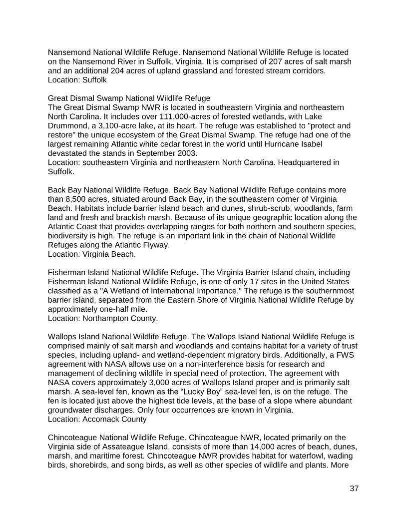
37
Nansemond National Wildlife Refuge. Nansemond National Wildlife Refuge is located on the Nansemond River in Suffolk, Virginia. It is comprised of 207 acres of salt marsh and an additional 204 acres of upland grassland and forested stream corridors. Location: Suffolk Great Dismal Swamp National Wildlife Refuge The Great Dismal Swamp NWR is located in southeastern Virginia and northeastern North Carolina. It includes over 111,000-acres of forested wetlands, with Lake Drummond, a 3,100-acre lake, at its heart. The refuge was established to "protect and restore" the unique ecosystem of the Great Dismal Swamp. The refuge had one of the largest remaining Atlantic white cedar forest in the world until Hurricane Isabel devastated the stands in September 2003. Location: southeastern Virginia and northeastern North Carolina. Headquartered in Suffolk. Back Bay National Wildlife Refuge. Back Bay National Wildlife Refuge contains more than 8,500 acres, situated around Back Bay, in the southeastern corner of Virginia Beach. Habitats include barrier island beach and dunes, shrub-scrub, woodlands, farm land and fresh and brackish marsh. Because of its unique geographic location along the Atlantic Coast that provides overlapping ranges for both northern and southern species, biodiversity is high. The refuge is an important link in the chain of National Wildlife Refuges along the Atlantic Flyway. Location: Virginia Beach. Fisherman Island National Wildlife Refuge. The Virginia Barrier Island chain, including Fisherman Island National Wildlife Refuge, is one of only 17 sites in the United States classified as a "A Wetland of International Importance." The refuge is the southernmost barrier island, separated from the Eastern Shore of Virginia National Wildlife Refuge by approximately one-half mile. Location: Northampton County. Wallops Island National Wildlife Refuge. The Wallops Island National Wildlife Refuge is comprised mainly of salt marsh and woodlands and contains habitat for a variety of trust species, including upland- and wetland-dependent migratory birds. Additionally, a FWS agreement with NASA allows use on a non-interference basis for research and management of declining wildlife in special need of protection. The agreement with NASA covers approximately 3,000 acres of Wallops Island proper and is primarily salt marsh. A sea-level fen, known as the “Lucky Boy” sea-level fen, is on the refuge. The fen is located just above the highest tide levels, at the base of a slope where abundant groundwater discharges. Only four occurrences are known in Virginia. Location: Accomack County Chincoteague National Wildlife Refuge. Chincoteague NWR, located primarily on the Virginia side of Assateague Island, consists of more than 14,000 acres of beach, dunes, marsh, and maritime forest. Chincoteague NWR provides habitat for waterfowl, wading birds, shorebirds, and song birds, as well as other species of wildlife and plants. More

38
than 2,600 acres of man-made marshes, or moist soil management units, are managed for wintering waterfowl and shorebirds during migration. Location: Accomack County.

39
Appendix F Stressors list used for Monitoring and Assessment Program
Sediment Deposits
Eroding Banks
Active Construction
Other sedimentation
Potential Source Discharge
Potential Non-Point Source Discharge
Other hydrologic alterations
Active Agriculture
Unfenced Cattle
Active Timber Harvesting (within 1 yr)
Active Clear Cutting (within 1 yr)
Other toxic inputs
Drain/Ditch
Filling/Grading
Dredging/Excavation
Stormwater inputs/culverts/input ditches
>= 4 lane paved road
2 lane paved road
1 lane paved road
Gravel
Dirt
Railroad
Other roadways (parking lots)
Utility easement maintenance
Herbicide application
Dike/Weir/Dam
Beaver Dam
Mowing
Brush cutting
Excessive herbivory
Timber harvesting (1-5yrs)
Clear cutting (1-5 yrs)
Invasive species present
Other vegetative alteration