conceptual review agenda - fcgov.com
TRANSCRIPT
Conceptual Review AgendaSchedule for 01/22/18 to 01/22/18
281 Conference Room A
Monday, January 22, 2018
Time Applicant InfoProject Name Project Description Planner
Jon McKeon
This is a request to construct a 6,000 square, single-story foot gym/health club at 117 Cameron Dr (parcel #9602407005). The proposed site plan shows the building at the southwest portion of the lot with parking and site access along Cameron Dr. The proposed project is within the General Commercial (CG) zone district and is subject to Administrative (Type 1) review.
Pete Wray 9:30(970) 420-5114
117 Cameron Dr - Health Club
Matt Rankin
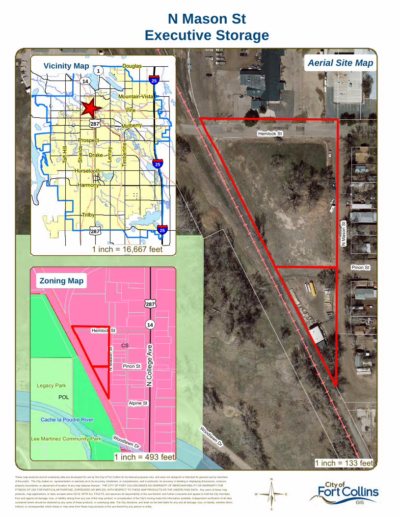
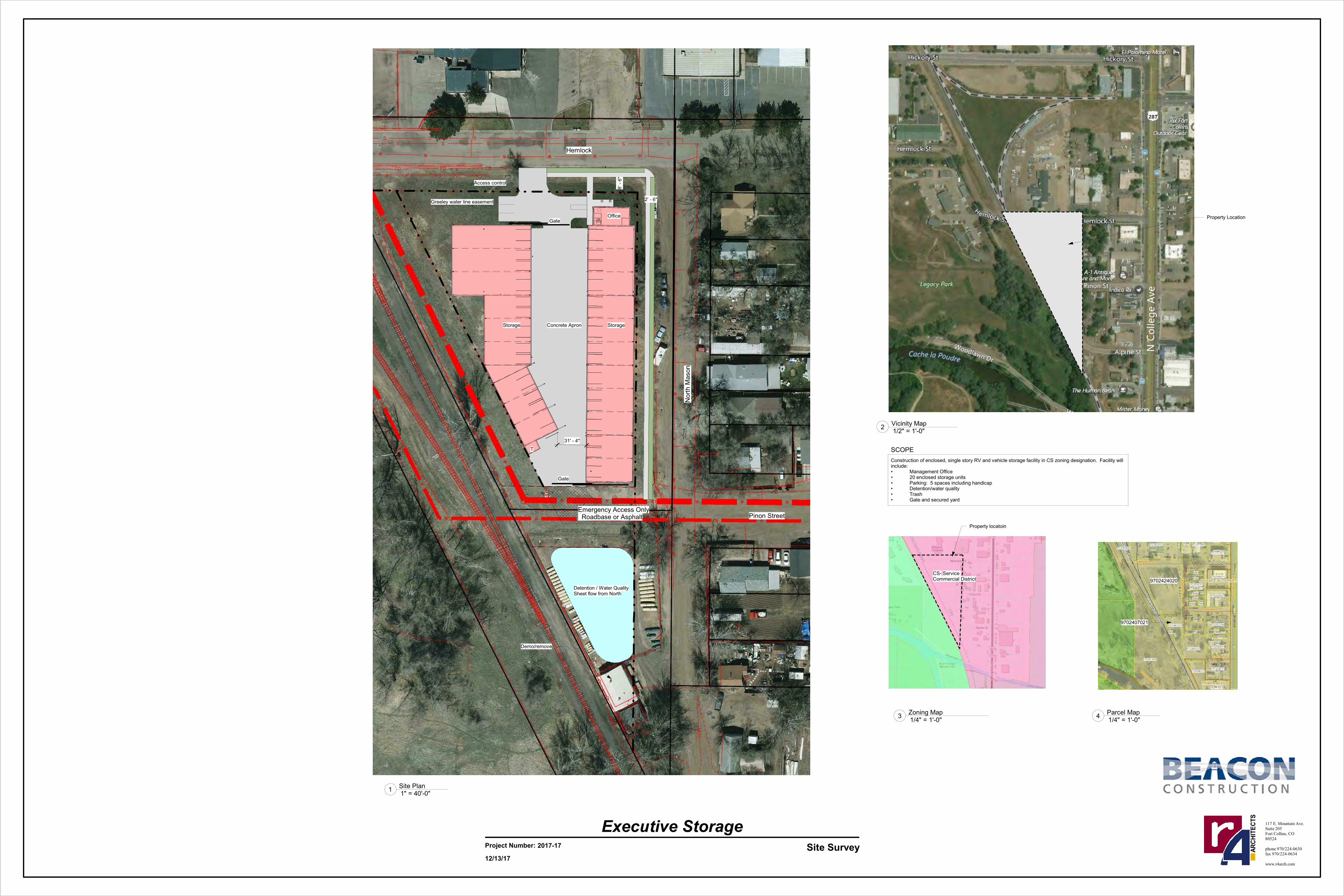
This is a request to construct a 20-unit enclosed storage facility at North Mason and Hemlock Streets (parcel #s 9702424020, 9702407021). The property would be accessed from the north off Hemlock St with a second emergency access located along the south at Pinon St. On-site detention is provided at the south end of the property. The proposed project is within the Service Commercial (CS) zone district and is subject to Administrative (Type 1) review.
Clay Frickey10:15(970) 224-0630
N Mason Storage
Page 1 of 2Agenda as of 01/10/18 at 9:18 am
CDR180001
CDR180002

Monday, January 22, 2018
Time Applicant InfoProject Name Project Description Planner
Shawn Turk
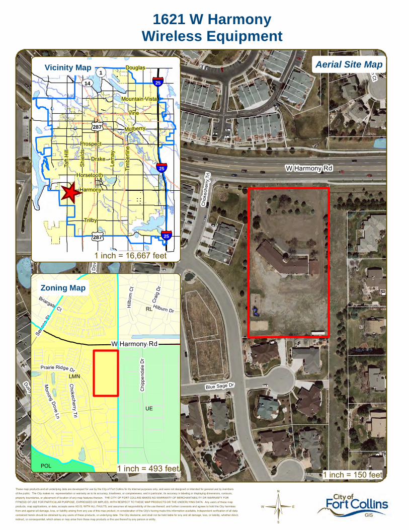
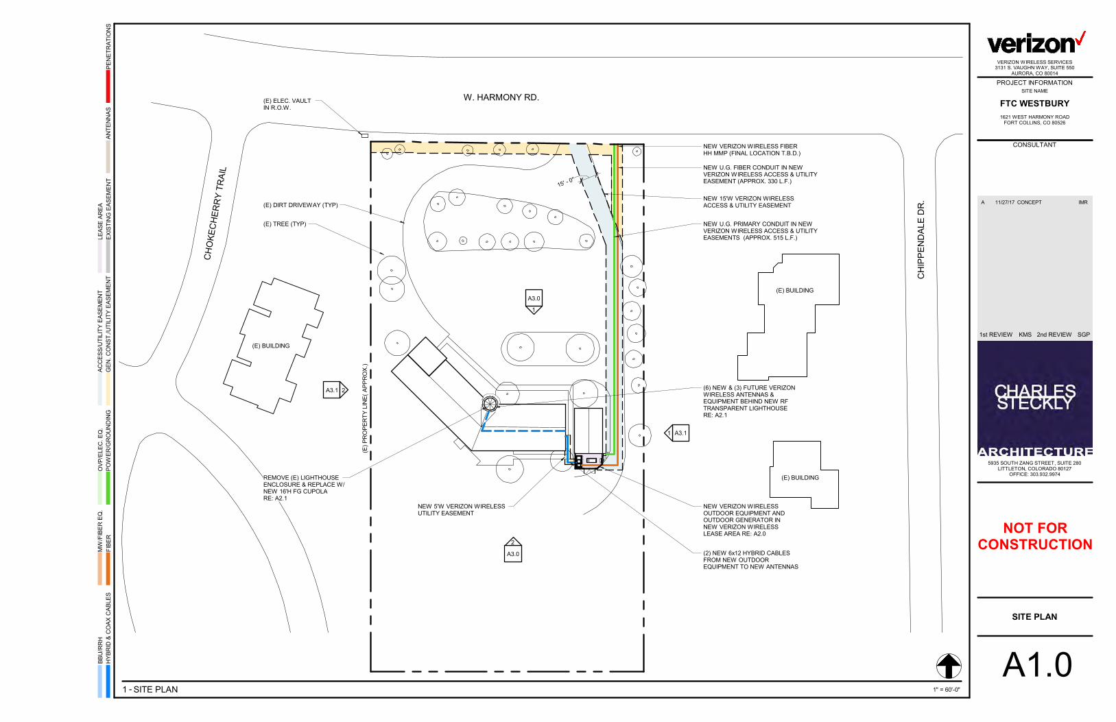
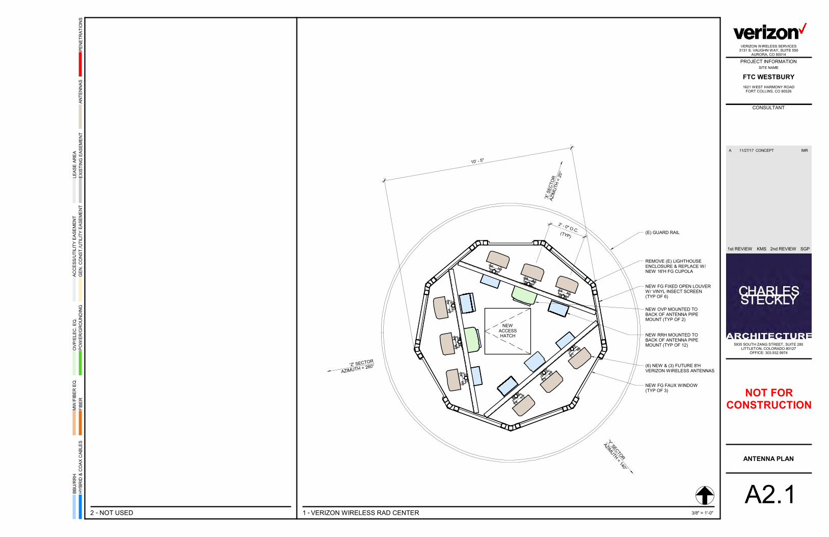
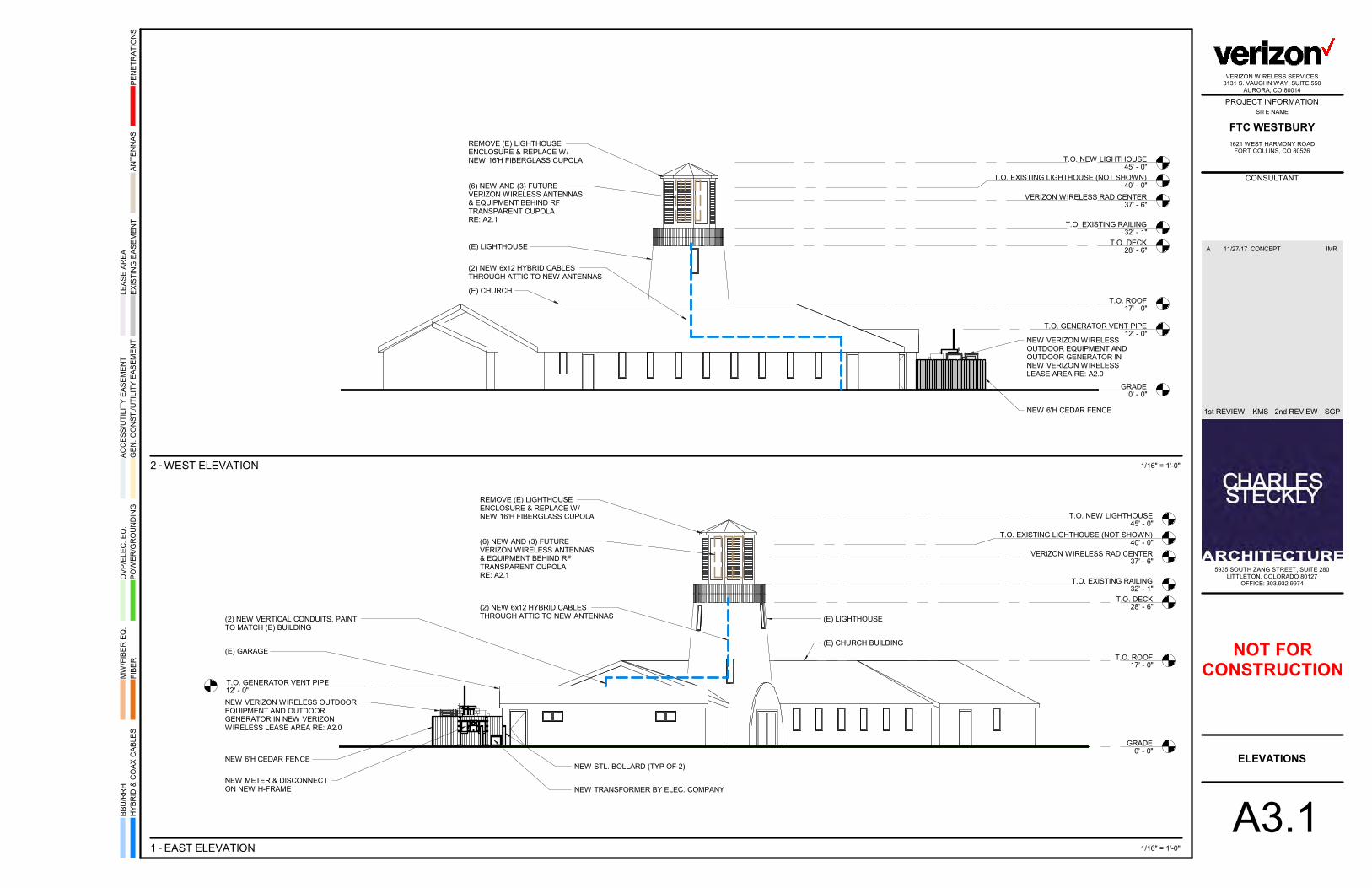
This is a request to install cellular equipment at 1621 W Harmony Rd (parcel# 9603000919). The proposal includes 9 new wireless antennas and support equipment; the existing place of worship has a central lighthouse/cupola feature and the equipment would be placed within this feature. The feature would be rebuilt with materials compatible with the equipment and would thus increase 5 feet in height. Accessory ground equipment would be screened by a 6-foot fence behind the existing building. The proposed project is within the Low-Density Mixed-Use (LMN) zone district and is subject to Planning and Zoning Board (Type 2) review.
Clark Mapes11:00(720) 834-4361
1621 W Harmony WTE
Page 2 of 2Agenda as of 01/10/18 at 9:18 am
CDR180003

Con
ejos
Rd
Cameron Dr
Coronado Ct
©
117 Cameron DrGym/Health Club
These map products and all underlying data are developed for use by the City of Fort Collins for its internal purposes only, and were not designed or intended for general use by members
of the public. The City makes no representation or warranty as to its accuracy, timeliness, or completeness, and in particular, its accuracy in labeling or displaying dimensions, contours,
property boundaries, or placement of location of any map features thereon. THE CITY OF FORT COLLINS MAKES NO WARRANTY OF MERCHANTABILITY OR WARRANTY FOR
FITNESS OF USE FOR PARTICULAR PURPOSE, EXPRESSED OR IMPLIED, WITH RESPECT TO THESE MAP PRODUCTS OR THE UNDERLYING DATA. Any users of these map
products, map applications, or data, accepts same AS IS, WITH ALL FAULTS, and assumes all responsibility of the use thereof, and further covenants and agrees to hold the City harmless
from and against all damage, loss, or liability arising from any use of this map product, in consideration of the City's having made this information available. Independent verification of all data
contained herein should be obtained by any users of these products, or underlying data. The City disclaims, and shall not be held liable for any and all damage, loss, or liability, whether direct,indirect, or consequential, which arises or may arise from these map products or the use thereof by any person or entity.
1 inch = 133 feet
_̂
£¤287
£¤287
£¤287
UV14¬«1
§̈¦25
§̈¦25
§̈¦25
Douglas
Vine
Mountain Vista
Mulberry
Trilby
Lem
ay
Shi
elds
Harmony
Taft
Hill
Prospect
Horsetooth
Drake
Tim
berli
ne
CG
UE
POL
RL
£¤287Cameron Dr
Con
ejos
Rd
W Fairway Ln
Fron
tage
Rd
Fairway Ln
S C
olle
ge A
ve
Aerial Site MapVicinity Map
Zoning Map
1 inch = 494 feet
1 inch = 16,667 feet

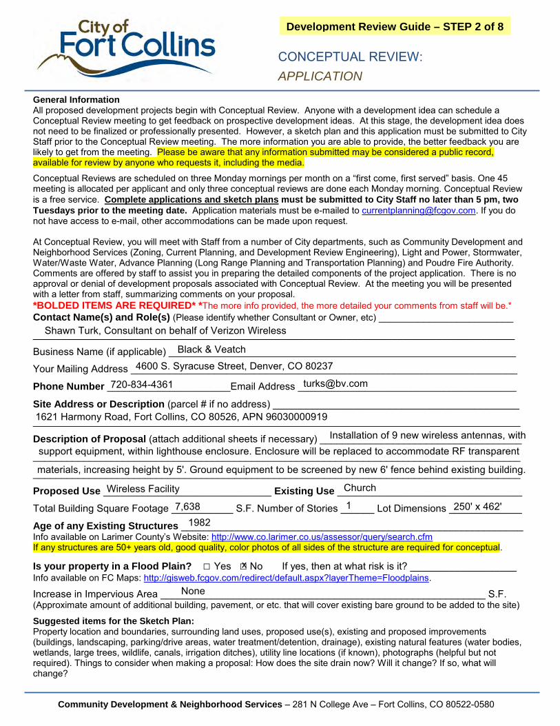
Development Review Guide – STEP 2 of 8 CONCEPTUAL REVIEW:
APPLICATION
General Information All proposed development projects begin with Conceptual Review. Anyone with a development idea can schedule a Conceptual Review meeting to get feedback on prospective development ideas. At this stage, the development idea does not need to be finalized or professionally presented. However, a sketch plan and this application must be submitted to City Staff prior to the Conceptual Review meeting. The more information you are able to provide, the better feedback you are likely to get from the meeting. Please be aware that any information submitted may be considered a public record, available for review by anyone who requests it, including the media. Conceptual Reviews are scheduled on three Monday mornings per month on a “first come, first served” basis. One 45 meeting is allocated per applicant and only three conceptual reviews are done each Monday morning. Conceptual Review is a free service. Complete applications and sketch plans must be submitted to City Staff no later than 5 pm, two Tuesdays prior to the meeting date. Application materials must be e-mailed to [email protected]. If you do not have access to e-mail, other accommodations can be made upon request. At Conceptual Review, you will meet with Staff from a number of City departments, such as Community Development and Neighborhood Services (Zoning, Current Planning, and Development Review Engineering), Light and Power, Stormwater, Water/Waste Water, Advance Planning (Long Range Planning and Transportation Planning) and Poudre Fire Authority. Comments are offered by staff to assist you in preparing the detailed components of the project application. There is no approval or denial of development proposals associated with Conceptual Review. At the meeting you will be presented with a letter from staff, summarizing comments on your proposal. The more info provided, the more detailed your comments from staff will be.
Contact Name(s) and Role(s) (Please identify whether Consultant, Owner, etc.)
Business Name (if applicable)
Mailing Address
Phone Email Address
Site Address (parcel # if address in not available)
Description of Proposal (attach additional sheets if necessary)
Proposed Use Existing Use
Total Building Square Footage Number of Stories Lot Dimensions
Age of any Existing Structures Info available on Larimer County’s Website: http://www.co.larimer.co.us/assessor/query/search.cfm If any structures are 50+ years old, good quality, color photos of all sides of the structure are required for conceptual.
Is your property in a Flood Plain? □ Yes □ No If yes, then at what risk is it?Info available on FC Maps: http://gisweb.fcgov.com/redirect/default.aspx?layerTheme=Floodplains.
Increase in Impervious Area S.F. (Approximate amount of additional building, pavement, or etc. that will cover existing bare ground to be added to the site)
Suggested items for the Sketch Plan: Property location and boundaries, surrounding land uses, proposed use(s), existing and proposed improvements (buildings, landscaping, parking/drive areas, water treatment/detention, drainage), existing natural features (water bodies, wetlands, large trees, wildlife, canals, irrigation ditches), utility line locations (if known), photographs (helpful but not required). Things to consider when making a proposal: How does the site drain now? Will it change? If so, what will change?
Community Development & Neighborhood Services – 281 N College Ave – Fort Collins, CO 80522-0580

Legacy Park
Lee Martinez Community Park
Cache la Poudre River
Hemlock St
N M
ason
St
Woodlawn Dr
Pinon St
©
N Mason StExecutive Storage
These map products and all underlying data are developed for use by the City of Fort Collins for its internal purposes only, and were not designed or intended for general use by members
of the public. The City makes no representation or warranty as to its accuracy, timeliness, or completeness, and in particular, its accuracy in labeling or displaying dimensions, contours,
property boundaries, or placement of location of any map features thereon. THE CITY OF FORT COLLINS MAKES NO WARRANTY OF MERCHANTABILITY OR WARRANTY FOR
FITNESS OF USE FOR PARTICULAR PURPOSE, EXPRESSED OR IMPLIED, WITH RESPECT TO THESE MAP PRODUCTS OR THE UNDERLYING DATA. Any users of these map
products, map applications, or data, accepts same AS IS, WITH ALL FAULTS, and assumes all responsibility of the use thereof, and further covenants and agrees to hold the City harmless
from and against all damage, loss, or liability arising from any use of this map product, in consideration of the City's having made this information available. Independent verification of all data
contained herein should be obtained by any users of these products, or underlying data. The City disclaims, and shall not be held liable for any and all damage, loss, or liability, whether direct,indirect, or consequential, which arises or may arise from these map products or the use thereof by any person or entity.
1 inch = 133 feet
_̂
£¤287
£¤287
£¤287
UV14¬«1
§̈¦25
§̈¦25
§̈¦25
Douglas
Vine
Mountain Vista
Mulberry
Trilby
Lem
ay
Shi
elds
Harmony
Taft
Hill
Prospect
Horsetooth
Drake
Tim
berli
ne
CS
POL
CCR CCN
Legacy Park
Lee Martinez Community Park
Cache la Poudre River
£¤287
¬«14Hemlock St
Woodlawn Dr
N M
ason
St
Pinon St
Alpine St
N C
olle
ge A
ve
Aerial Site MapVicinity Map
Zoning Map
1 inch = 493 feet
1 inch = 16,667 feet

Storage Storage
OfficeGate
T
Gate
Pinon Street
Hemlock
Nort
h M
ason
Detention / Water QualitySheet flow from North
Emergency Access Only Roadbase or Asphalt
Concrete Apron
Access control
31' - 4"
8' -
6"
2' - 6"Greeley water line easement
Demo/remove
Property Location
CS- Service Commercial District
Property locatoin
Project Number: Site Survey
117 E. Mountain Ave.
Suite 205
Fort Collins, CO
80524
phone 970/224-0630
fax 970/224-0634
www.r4arch.com
AR
CH
ITE
CT
S
Executive Storage2017-17
12/13/17
1" = 40'-0"1
Site Plan
1/2" = 1'-0"2
Vicinity Map
1/4" = 1'-0"3
Zoning Map
Construction of enclosed, single story RV and vehicle storage facility in CS zoning designation. Facility will include:• Management Office• 20 enclosed storage units• Parking: 5 spaces including handicap• Detention/water quality• Trash• Gate and secured yard
1/4" = 1'-0"4
Parcel Map
9702424020
9702407021
SCOPE
Prairie Ridge Dr
Cho
kech
erry
Trl
Blue Sage Dr
Mor
ning
Dov
e Ln
Dusty Sage Dr
Hilburn C
t
Dusty
SageLoop
Mor
ning
Dov
e C
t
Sene
ca S
t
W Harmony Rd
©
1621 W HarmonyWireless Equipment
These map products and all underlying data are developed for use by the City of Fort Collins for its internal purposes only, and were not designed or intended for general use by members
of the public. The City makes no representation or warranty as to its accuracy, timeliness, or completeness, and in particular, its accuracy in labeling or displaying dimensions, contours,
property boundaries, or placement of location of any map features thereon. THE CITY OF FORT COLLINS MAKES NO WARRANTY OF MERCHANTABILITY OR WARRANTY FOR
FITNESS OF USE FOR PARTICULAR PURPOSE, EXPRESSED OR IMPLIED, WITH RESPECT TO THESE MAP PRODUCTS OR THE UNDERLYING DATA. Any users of these map
products, map applications, or data, accepts same AS IS, WITH ALL FAULTS, and assumes all responsibility of the use thereof, and further covenants and agrees to hold the City harmless
from and against all damage, loss, or liability arising from any use of this map product, in consideration of the City's having made this information available. Independent verification of all data
contained herein should be obtained by any users of these products, or underlying data. The City disclaims, and shall not be held liable for any and all damage, loss, or liability, whether direct,indirect, or consequential, which arises or may arise from these map products or the use thereof by any person or entity.
1 inch = 150 feet
_̂
£¤287
£¤287
£¤287
UV14¬«1
§̈¦25
§̈¦25
§̈¦25
Douglas
Vine
Mountain Vista
Mulberry
Trilby
Lem
ay
Shi
elds
Harmony
Taft
Hill
Prospect
Horsetooth
Drake
Tim
berli
ne
LMN
UE
RL
POL
Prairie Ridge Dr
Chi
ppen
dale
Dr
Hilburn Dr
Chokecherry
Trl
Cra
ig D
r
Hilb
urn
Ct
Morning
DoveLn
Briargate Ct
Sene
ca S
t
W Harmony Rd
Aerial Site MapVicinity Map
Zoning Map
1 inch = 493 feet
1 inch = 16,667 feet
CONCEPTUAL REVIEW: APPLICATION
Community Development & Neighborhood Services – 281 N College Ave – Fort Collins, CO 80522-0580
Development Review Guide – STEP 2 of 8
General Information All proposed development projects begin with Conceptual Review. Anyone with a development idea can schedule a Conceptual Review meeting to get feedback on prospective development ideas. At this stage, the development idea does not need to be finalized or professionally presented. However, a sketch plan and this application must be submitted to City Staff prior to the Conceptual Review meeting. The more information you are able to provide, the better feedback you are likely to get from the meeting. Please be aware that any information submitted may be considered a public record, available for review by anyone who requests it, including the media.
Conceptual Reviews are scheduled on three Monday mornings per month on a “first come, first served” basis. One 45 meeting is allocated per applicant and only three conceptual reviews are done each Monday morning. Conceptual Review is a free service. Complete applications and sketch plans must be submitted to City Staff no later than 5 pm, two Tuesdays prior to the meeting date. Application materials must be e-mailed to [email protected]. If you do not have access to e-mail, other accommodations can be made upon request.
At Conceptual Review, you will meet with Staff from a number of City departments, such as Community Development and Neighborhood Services (Zoning, Current Planning, and Development Review Engineering), Light and Power, Stormwater, Water/Waste Water, Advance Planning (Long Range Planning and Transportation Planning) and Poudre Fire Authority. Comments are offered by staff to assist you in preparing the detailed components of the project application. There is no approval or denial of development proposals associated with Conceptual Review. At the meeting you will be presented with a letter from staff, summarizing comments on your proposal. *BOLDED ITEMS ARE REQUIRED* *The more info provided, the more detailed your comments from staff will be.*Contact Name(s) and Role(s) (Please identify whether Consultant or Owner, etc) ________________________
______________________________________________________________________________________
Business Name (if applicable) ______________________________________________________________
Your Mailing Address _____________________________________________________________________
Phone Number ______________________Email Address _______________________________________
Site Address or Description (parcel # if no address) ____________________________________________
_______________________________________________________________________________________
Description of Proposal (attach additional sheets if necessary) ____________________________________
_______________________________________________________________________________________
_______________________________________________________________________________________
Proposed Use ______________________________ Existing Use _________________________________
Total Building Square Footage ___________ S.F. Number of Stories ______ Lot Dimensions _____________
Age of any Existing Structures _____________________________________________________________ Info available on Larimer County’s Website: http://www.co.larimer.co.us/assessor/query/search.cfm If any structures are 50+ years old, good quality, color photos of all sides of the structure are required for conceptual.
Is your property in a Flood Plain? □ Yes □ No If yes, then at what risk is it? ___________________Info available on FC Maps: http://gisweb.fcgov.com/redirect/default.aspx?layerTheme=Floodplains.
Increase in Impervious Area __________________________________________________________ S.F. (Approximate amount of additional building, pavement, or etc. that will cover existing bare ground to be added to the site)
Suggested items for the Sketch Plan: Property location and boundaries, surrounding land uses, proposed use(s), existing and proposed improvements (buildings, landscaping, parking/drive areas, water treatment/detention, drainage), existing natural features (water bodies, wetlands, large trees, wildlife, canals, irrigation ditches), utility line locations (if known), photographs (helpful but not required). Things to consider when making a proposal: How does the site drain now? Will it change? If so, what will change?
Shawn Turk, Consultant on behalf of Verizon Wireless
Black & Veatch
4600 S. Syracuse Street, Denver, CO 80237
720-834-4361 [email protected]
1621 Harmony Road, Fort Collins, CO 80526, APN 96030000919
ChurchWireless Facility
None
1 250' x 462'
Installation of 9 new wireless antennas, withsupport equipment, within lighthouse enclosure. Enclosure will be replaced to accommodate RF transparent
materials, increasing height by 5'. Ground equipment to be screened by new 6' fence behind existing building.
19827,638
x

DRAWING INDEX
PROJECT TEAM
SHEET DESCRIPTION
T1.0 TITLE SHEET
LS1 TOPOGRAPHIC SURVEY (DRAFT)
A1.0 SITE PLAN
A2.0 ENLARGED SITE PLAN
A2.1 ANTENNA PLAN
A3.0 ELEVATIONS
A3.1 ELEVATIONS
DIRECTIONS
PROJECT DATA
VICINITY MAP
E. HARMONY RD.(6.4 MILES)
I-25
SITE
(56 M
ILE
S)
FROM DENVER• I-25 NORTH (56 MILES)• EXIT 265 TURN LEFT TO HEAD WEST ON E. HARMONY ROAD • LEFT ON EAST HARMONY ROAD (6.4 MILES)• SITE IS ON THE LEFT WITH A DIRT ACCESS ROAD AFTER
CHIPPENDALE DRIVE
• (6) NEW AND (3) FUTURE VERIZON WIRELESS ANTENNAS AND EQUIPMENT WITHIN RF TRANSPARENT LIGHTHOUSE CUPOLA• NEW OUTDOOR EQUIPMENT CABINETS AND DIESEL GENERATOR WITHIN NEW FENCED LEASE AREA• NEW U.G. ELECTRICAL SERVICE• NEW U.G. FIBER SERVICE
EXISTING CONDITIONS
PROJECT DESCRIPTION
PROJECT TEAM
GOVERNING CODES:
A.D.A. COMPLIANCETHIS FACILITY IS UNMANNED AND NOT FOR HUMAN HABITATION
JURISDICTION CITY OF FORT COLLINS
OCCUPANCY GROUP A-3
CONSTRUCTION TYPE V-B
FULLY SPRINKLERED NO
NO. STORIES 1
OCCUPANCY GROUP U
CONSTRUCTION TYPE V-B, NEMA 3R
FULLY SPRINKLERED N/A
NO. STORIES N/A
APN 9603000919
ZONING DESIGNATION LOW DENSITY MIXED USE
EXISTING BUILDING
EQUIPMENT AREA
2015 IBC, 2015 IFC, 2015 IMC, 2015 IECC, 2017 NEC
INTERNATIONAL CHURCHOF THE FOUR SQUARE GOSPELAARON SCHULER1910 W. SUNSET BLVD #200LOS ANGELES, CA 90026PHONE: 701.391.9377
OWNER
RLF CONSULTING, LLC1214 N. STADEM DRTEMPE, AZ 85281PHONE: 480.445.9189
SURVEYOR
NNOT TO SCALE
HY
BR
ID &
CO
AX
CA
BLE
SF
IBE
R
BB
U/R
RH
MW
/FIB
ER
EQ
.
PO
WE
R/G
RO
UN
DIN
G
OV
P/E
LE
C.
EQ
.
GE
N.
CO
NS
T./
UT
ILIT
Y E
AS
EM
EN
T
AC
CE
SS
/UT
ILIT
Y E
AS
EM
EN
T
EX
IST
ING
EA
SE
ME
NT
LE
AS
E A
RE
A
AN
TE
NN
AS
PE
NE
TR
AT
ION
S
PROJECT INFORMATION
5935 SOUTH ZANG STREET, SUITE 280LITTLETON, COLORADO 80127
OFFICE: 303.932.9974
SITE NAME
CONSULTANT
VERIZON WIRELESS SERVICES3131 S. VAUGHN WAY, SUITE 550
AURORA, CO 80014
1st REVIEW 2nd REVIEW
NOT FOR
CONSTRUCTION
SITE ADDRESS:
SITE NAME:
PROJECT NEW BUILD - CONCEPT
T1.0
TITLE SHEET
FTC WESTBURY
KMS SGP
1621 WEST HARMONY ROADFORT COLLINS, CO 805261621 WEST HARMONY ROAD
FORT COLLINS, CO 80526
FTC WESTBURY
A 11/27/17 CONCEPT IMR
DENVER
CH
IPP
EN
DA
LE
DR
.
CH
OK
EC
HE
RR
Y T
RA
IL
BLACK & VETCHSHAWN TURK4600 S. SYRACUSE STREETSUITE 800DENVER, CO 80237PHONE: 303.229.4681
SITE ACQUISITIONIST
VERIZON WIRELESSRAM NANDIRAJU3131 S. VAUGHN WAYSUITE 550AURORA, CO 80014PHONE: 720.467.0443
RF ENGINEER
VERIZON WIRELESSCONSTRUCTION ENGINEERJASON SHELLEDY3131 S. VAUGHN WAYSUITE 550AURORA CO, 80014CELL: 970.646.1283
CLIENT
CSAiCHARLES STECKLY, AIA5935 S. ZANG STREETSUITE 280LITTLETON, CO 80127CELL: 303.210.8972OFFICE: 303.932.9974
ARCHITECT
EXIT 265

TBC1=5124.93
FV H Y D
WVTBC1=5123.41 TBC1=5122.82
D
TBC1=5121.70
TVWDF1=5121.16WDF1=5122.75
WDF1=5125.04
SS
SS
SS
SS
SS
SS
SS
UGE
UGE
UG
EU
GE
UG
EU
GE
UG
E
GG
GG
GG
GG
G
FO FO FO FO FO FO FO FOG G G G G G G G G G
SD SD SD SD SD SD SD SD
FO
FOFO
FOFO
FOFO
FOFO
FOFO
FOFO
T
TT
T
EV
HARMONY ROAD
GM
EM
60' R.O.W.3 5
APN: 9603216003
APN: 9603215037 APN: 9603215036
AP
N: 9
6031
0600
1
APN: 9603000919
51255124
5123
5122
51235122
5120
5121
5124
5125
5126
5126
51275128
5127
5128
5129
5129
5130
5130
5131
5131
5131
5132
51325132
5132
5131
51305133
5133
5133
5134
5135
5136
5134
5133
5132
5131
51
41.0
BLDG
5141.9 BLDG
5142.0 BLDG
5142
.0 BLD
G
51
32.3
EP
5132.6 EP
51
32.7
NG
51
29.0
NG
51
28.7
NG
51
25.0
NG
51
24.0
NG
51
26.1
NG
51
29.8
NG
51
31.5
NG
51
33.1
NG
51
36.5
NG
51
34.6
NG
51
33.4
NG
51
33.6
NG
51
31.5
NG
51
32.6
NG
51
30.5
NG
5131.7 NG
51
28.4
NG
51
22.7
NG
5173.5 PEAK
51
50.8
PEAK
5151.3 PEAK
51
24.9
TBC
51
21.7
TBC
5141.3 TREE
51
47.4
TREE
51
53.6
TREE
51
52.9
TREE
51
49.0
TREE
51
55.5
TREE
51
40.2
TREE
51
56.6
TREE
51
54.9
TREE
51
50.0
TREE
51
44.1
TREE
51
57.2
TREE
51
58.1
TREE 12" Ø
51
76.0
TREE 16" Ø
51
79.6
TREE 16" Ø
51
69.2
TREE 12" Ø
51
62.0
TREE 12" Ø
5190.2 TREE 18" Ø
51
64.0
TREE 16" Ø
51
56.4
TREE 24" Ø
51
77.9
TREE 16" Ø
51
55.7
TREE
51
52.4
TREE
51
55.5
TREE
51
55.2
TREE
51
57.2
TREE
51
59.6
TREE
5159.6 TREE
N89° 40' 23"E 1320.25'
N89° 40' 23"E250.00'
S0°
05'
31"
W46
2.63
'
N0°
05'
30"
E46
2.63
'
S89° 40' 23"W 249.98'116.39' 133.59'
ACHHN. 14 COR. SEC. 3,T. 6 N., R. 69 W.
REBAR REBAR REBAR
LESSOR'S PARCEL LINE
(E) SIGN
(E) 18.5' LIGHTPOLE
D/W D/W
ACHHN.W. COR. LOT 3,SEC. 3, T. 6 N., R. 69 W.
MONUMENT LINE
STORM SEWER LINE
BREAKLINE
FIBER MANHOLE
GAS METER
SANITARY SEWER CLEANOUT
ELECTRIC METER
FIRE HYDRANTWATER VALVE
CURB STOP
SCHEDULE B HEX
DRY WELL
TELEVISION RISER
STORM MANHOLE
AIR CONDITIONING UNIT
TELEPHONE PEDESTAL
ELECTRICAL PULL BOX
ALUMINUM CAP IN HANDHOLE (ACHH)REBAR
ELECTRIC VAULT
PROPERTY LINEPROPERTY LINE (OTHER)
CENTERLINEWOOD FENCE
SPOT ELEVATION
PV ASPHALTNATURAL GRADENG
U/G ELECTRIC LINE
U/G FIBER OPTIC LINEU/G GAS LINESANITARY SEWER LINE
WATER LINE
UGE UGE
FO FO FO
GAS GAS
SS SS SS
W W W
U/G TELECOMMUNICATION LINET T T
DECIDUOUS TREE
E
EM
EV
FIBER VAULTFV
LIGHT POST
H
Y D
TV
ASSESSORS PARCEL NUMBER
TOP OF CURB
DRIVEWAYEDGE OF PAVEMENT
RIGHT OF WAYSIDEWALK
TBC
D/WEP
R.O.W.SW
APNBUILDINGBLDG
FO
GM
WV
D
2
5280.00 NG
SITUATED IN THE COUNTY OF LARIMER, STATE OF COLORADO:
A PARCEL OF LAND SITUATE IN THE NW 1/4 OF SECTION 3, TOWNSHIP 6 NORTH,RANGE 69 WEST OF THE 6TH P.M., COUNTY OF LARIMER, STATE OF COLORADO,BEING MORE PARTICULARLY DESCRIBED AS FOLLOWS:
CONSIDERING THE NORTH LINE OF SAID NW 1/4 AS BEARING N 89°00'00" E AND WITHALL BEARINGS CONTAINED HEREIN RELATIVE THERETO:
BEGINNING AT THE NORTH 1/4 CORNER OF SAID SECTION 3; THENCE ALONG THENORTH-SOUTH CENTERLINE OF SAID SECTION, SAID LINE ALSO BEING THE WESTLINE OF THE RIDGE, PUD SUBDIVISION, S 00°37'30" E A DISTANCE OF 522.72 FEET;THENCE PARALLEL TO THE NORTH LINE OF SAID SECTION S 89°00'00" W, A DISTANCEOF 250.00 FEET; THENCE PARALLEL TO THE WEST LINE OF THE RIDGE PUDSUBDIVISION, N 00°37'30" W, A DISTANCE OF 522.72 FEET-MORE OR LESS TO THE.NORTH SECTION LINE; THENCE ALONG THE NORTH LINE OF SAID SECTION, N89°00'00" E, A DISTANCE OF 250.00 FEET MORE OR LESS TO THE NORTH 1/4 CORNEROF SAID SECTION AND THE TRUE POINT OF BEGINNING. EXCEPT THE NORTH 60 FEETFOR A ROAD RIGHT OF WAY, COUNTY OF LARIMER, STATE OF COLORADO.
LESSOR'S LEGAL DESCRIPTION
MAGNETIC08° 22'
1. ELEVATIONS SHOWN HEREON ARE REPRESENTED IN NORTH
AMERICAN VERTICAL DATUM OF 1988 (NAVD88) ESTABLISHED FROMGPS DERIVED ELLIPSOID HEIGHTS, APPLYING GEOID 09 SEPARATIONSCONSTRAINING TO NGS CORS STATIONS PROVIDED IN THE "ONLINEPOSITIONING USER SERVICE" (OPUS) SOLUTION FOR THIS SPECIFICSITE.
2. BEARINGS SHOWED HEREON ARE BASED UPON U.S. STATE PLANENAD83 COORDINATE SYSTEM COLORADO STATE PLANE COORDINATE
ZONE NORTH, DETERMINED BY GPS OBSERVATIONS.
3. FIELD WORK FOR THIS PROJECT WAS PERFORMED ON 11/08/17.
PROJECT META DATA1. ALL TITLE INFORMATION IS BASED UPON A COMMITMENT FOR TITLE
INSURANCE PREPARED BY OLD REPUBLIC TITLE NATIONAL TITLECOMPANY, ORDER NO.: 01-17076426-01T EFFECTIVE DATE: 10/09/2017.
2. SURVEYOR HAS NOT PERFORMED A SEARCH OF PUBLIC RECORDS TODETERMINE ANY DEFECT IN TITLE.
3. THE BOUNDARY SHOWN HEREON IS PLOTTED FROM RECORDINFORMATION AND DOES NOT CONSTITUTE A BOUNDARY SURVEY OFTHE PROPERTY.
4. SURVEYOR DOES NOT GUARANTEE THAT ALL UTILITIES ARE SHOWN ORTHEIR LOCATIONS. IT IS THE RESPONSIBILITY OF THE CONTRACTOR ANDDEVELOPER TO CONTACT BLUE STAKE AND ANY OTHER INVOLVEDAGENCIES TO LOCATE ALL UTILITIES PRIOR TO CONSTRUCTION.REMOVAL, RELOCATION AND/ OR REPLACEMENT IS THE RESPONSIBILITYOF THE CONTRACTOR.
DECLINATION
SURVEYOR NOTES
1 11/16/17 PRELIMINARY
SHEET NO. REVISION:
REVISIONS
PROJECT No.
SITE NAME:
SITE ADDRESS:
SHEET TITLE:
FIELD BY:
DRAWN BY:
CHECKED BY:
NO. DATE DESCRIPTION
REUSE OF DOCUMENTTHE IDEAS & DESIGN INCORPORATED HEREON, AS AN
INSTRUMENT OF PROFESSIONAL SERVICE, IS THEPROPERTY OF RLF CONSULTING, LLC & IS NOT TO BEUSED FOR ANY OTHER PROJECT WITHOUT WRITTEN
AUTHORIZATION OF RLF CONSULTING, LLC.
JWS
JTJ
RLF
15010137
FTC WESTBURY
1621 W. HARMONY RD.
FORT COLLINS CO, 80526
TOPOGRAPHIC SURVEY
LS-1
ITEMS 1, 2, 4, AND 6 OF THE CLIENT PROVIDED TITLE REPORT DO NOTCONTAIN GRAPHICALLY PLOTTABLE EASEMENTS, SETBACKS,RESTRICTIONS OR OTHER ENCUMBRANCES. THE SURVEYOR CANNOTGUARANTEE THAT NON-PLOTTABLE ENCUMBRANCES DO NOT EXIST THATMAY AFFECT THE SUBJECT LEASED PREMISES.
3131 S. VAUGHN WAY, SUITE 550AURORA, CO 80014
NORTH
THE PROPOSED LEASE PREMISES SHOWN HEREON APPEAR TO BE WITHIN FLOODZONE "X" AS DELINEATED ON THE FEDERAL EMERGENCY MANAGEMENT AGENCYFIRM MAP NO. 08069C1000F DATED 12/19/06.
FLOOD ZONE "X" IS DEFINED AS: AREAS DETERMINED TO BE OUTSIDE 500-YEARFLOODPLAIN; DETERMINED TO BE OUTSIDE THE 1% AND 0.2% ANNUAL CHANCEFLOODPLAINS.
FLOOD ZONE DESIGNATION
1. SUBJECT TO THE RIGHT OF WAY SET FORTH IN THE DEED, RECORDED02/24/1981, IN BOOK 73, PAGE 64 OF THE LARIMER COUNTY RECORDS.(ILLEGIBLE DOCUMENT)
2. SUBJECT TO THE RIGHT OF WAY SET FORTH IN THE DEED, RECORDED02/13/1897, IN BOOK 77, PAGE 191 OF THE LARIMER COUNTY RECORDS.(ILLEGIBLE DOCUMENT)
3. EXEMPTION PLAT, RECORDED 01/23/1980, IN BOOK 2020, PAGE 734 OFTHE LARIMER COUNTY RECORDS. (REFERENCED)
5. RIGHT-OF-WAY EASEMENT IN FAVOR OF POUDRE VALLEY RURALELECTRIC ASSOCIATION, RECORDED 12/11/1980 IN BOOK 2091, PAGE 510OF LARIMER COUNTY RECORDS. (REFERENCED)
SCHEDULE B EXCEPTIONS
HARMONY RD.
RE
GE
NC
Y D
R.
CH
IPP
EN
DA
LE D
R.
PRAIR
IE RID
GE D
R.
CH
OK
EC
HE
RR
Y T
RL.
PROJECT AREA
CO
LORADO LICENSED
PRO
FESSIONAL LAND SURVEY
ORRY
AN L. FIDLER
38207
TOP OF PIPE = 5173.5 (40' A.G.L)
PEAK = 5172.7 (39.2' A.G.L)
RAILING = 5165.61 (32.1' A.G.L)
DECK = 5162.0 (28.5' A.G.L)
GROUND = 5133.5 (0.0' A.G.L)
LIGHTHOUSE DETAILN.T.S
Ø
A3.0
2
W. HARMONY RD.
CH
IPP
EN
DA
LE
DR
.
(E)
PR
OP
ER
TY
LIN
E(
AP
PR
OX
.)
NEW VERIZON WIRELESS FIBER HH MMP (FINAL LOCATION T.B.D.)
NEW U.G. FIBER CONDUIT IN NEW VERIZON WIRELESS ACCESS & UTILITY EASEMENT (APPROX. 330 L.F.)
NEW U.G. PRIMARY CONDUIT IN NEW VERIZON WIRELESS ACCESS & UTILITY EASEMENTS (APPROX. 515 L.F.)
(E) ELEC. VAULT IN R.O.W.
(E) DIRT DRIVEWAY (TYP)
(E) TREE (TYP)
(E) BUILDING
(E) BUILDING
(E) BUILDING
A3.1 1
A3.0
1
A3.1 2 (6) NEW & (3) FUTURE VERIZON WIRELESS ANTENNAS & EQUIPMENT BEHIND NEW RF TRANSPARENT LIGHTHOUSERE: A2.1
NEW VERIZON WIRELESS OUTDOOR EQUIPMENT AND OUTDOOR GENERATOR IN NEW VERIZON WIRELESS LEASE AREA RE: A2.0
(2) NEW 6x12 HYBRID CABLES FROM NEW OUTDOOR EQUIPMENT TO NEW ANTENNAS
CH
OK
EC
HE
RR
Y T
RA
IL
REMOVE (E) LIGHTHOUSE ENCLOSURE & REPLACE W/ NEW 16'H FG CUPOLARE: A2.1
15' - 0"
NEW 15'W VERIZON WIRELESS ACCESS & UTILITY EASEMENT
NEW 5'W VERIZON WIRELESS UTILITY EASEMENT
HY
BR
ID &
CO
AX
CA
BLE
SF
IBE
R
BB
U/R
RH
MW
/FIB
ER
EQ
.
PO
WE
R/G
RO
UN
DIN
G
OV
P/E
LE
C.
EQ
.
GE
N.
CO
NS
T./
UT
ILIT
Y E
AS
EM
EN
T
AC
CE
SS
/UT
ILIT
Y E
AS
EM
EN
T
EX
IST
ING
EA
SE
ME
NT
LE
AS
E A
RE
A
AN
TE
NN
AS
PE
NE
TR
AT
ION
S
PROJECT INFORMATION
5935 SOUTH ZANG STREET, SUITE 280LITTLETON, COLORADO 80127
OFFICE: 303.932.9974
SITE NAME
CONSULTANT
VERIZON WIRELESS SERVICES3131 S. VAUGHN WAY, SUITE 550
AURORA, CO 80014
1st REVIEW 2nd REVIEW
NOT FOR
CONSTRUCTION
A1.0
SITE PLAN
FTC WESTBURY
KMS SGP
1621 WEST HARMONY ROADFORT COLLINS, CO 80526
A 11/27/17 CONCEPT IMR
- 1" = 60'-0"1 SITE PLAN

NEW BATT. CAB
NEW RF/PDF
CAB
25' - 0" VERIZON WIRELESS LEASE AREA
14' -
0"
VE
RIZ
ON
WIR
ELE
SS
LE
AS
E A
RE
A
NEW 30 KW DIESEL GENERATOR
NEW H-FRAME W/ METER AND DISCONNECTS
NEW H-FRAME W/ ILC & GPS
NEW 10'W CEDAR DOUBLE GATE
20' - 0" 5' - 0"
3' - 0"
3' -
0"
3' - 0"
5' -
0"
(E) CONC. SIDEWALK
NEW U.G. CONDUIT FOR (2) 6x12 HYBRID CABLES IN NEW 5'W VERIZON WIRELESS UTILITY EASEMENT
(E) BUILDING
NEW 6'H CEDAR FENCE (TYP)
NEW 15'W VERIZON WIRELESS ACCESS & UTILITY EASEMENT
NEW U.G. FIBER CONDUIT
NEW GPS ANTENNA
CONNECT NEW LEADER TO (E) DOWNSPOUT
(E) DOWNSPOUT
FUT. RF/PDF
CAB
(2) NEW & (1) FUT. VERIZON WIRELESS OUTDOOR EQUIPMENT CABINETS ON STL. PLINTH ON CONC. SLAB
11"
11' -
0"
CO
NC
. S
LA
B2' -
0"
1' - 2" 5' - 6" CONC. SLAB 1' - 7" 10' - 0" CEDAR GATE 1' - 10"
(E) GARAGE
4"D 3/4" CRUSHED GRAVEL OVER (2) LAYERS OF LANDSCAPE FABRIC INSIDE FENCED AREA
NEW STEEL BOLLARD (TYP OF 2)
NEW TRANSFORMER BY POWER COMPANY
NEW U.G. ELEC. CONDUIT
(2) NEW 2" HYBRID CABLE CONDUITS ATTACHED TO BUILDING, PAINT TO MATCH (E) BUILDING
NEW PENETRATION INTO CHURCH ATTIC FOR HYBRID CABLES
(E) GRAVEL DRIVE & PARKING LOT
HY
BR
ID &
CO
AX
CA
BLE
SF
IBE
R
BB
U/R
RH
MW
/FIB
ER
EQ
.
PO
WE
R/G
RO
UN
DIN
G
OV
P/E
LE
C.
EQ
.
GE
N.
CO
NS
T./
UT
ILIT
Y E
AS
EM
EN
T
AC
CE
SS
/UT
ILIT
Y E
AS
EM
EN
T
EX
IST
ING
EA
SE
ME
NT
LE
AS
E A
RE
A
AN
TE
NN
AS
PE
NE
TR
AT
ION
S
PROJECT INFORMATION
5935 SOUTH ZANG STREET, SUITE 280LITTLETON, COLORADO 80127
OFFICE: 303.932.9974
SITE NAME
CONSULTANT
VERIZON WIRELESS SERVICES3131 S. VAUGHN WAY, SUITE 550
AURORA, CO 80014
1st REVIEW 2nd REVIEW
NOT FOR
CONSTRUCTION
A2.0
ENLARGED SITE PLAN
FTC WESTBURY
KMS SGP
1621 WEST HARMONY ROADFORT COLLINS, CO 80526
A 11/27/17 CONCEPT IMR
- 1/4" = 1'-0"1 ENLARGED SITE PLAN
(TYP)
2' - 0" O.C.
'X' S
EC
TO
RA
ZIM
UT
H =
20°
'Y' S
ECTO
R
AZIM
UTH
= 140°
'Z' SECTOR
AZIMUTH = 260° (6) NEW & (3) FUTURE 8'H VERIZON WIRELESS ANTENNAS
NEW RRH MOUNTED TO BACK OF ANTENNA PIPE MOUNT (TYP OF 12)
REMOVE (E) LIGHTHOUSE ENCLOSURE & REPLACE W/ NEW 16'H FG CUPOLA
NEW FG FIXED OPEN LOUVER W/ VINYL INSECT SCREEN (TYP OF 6)
NEW FG FAUX WINDOW (TYP OF 3)
(E) GUARD RAIL
NEW OVP MOUNTED TO BACK OF ANTENNA PIPE MOUNT (TYP OF 2)
NEW ACCESS HATCH
10' - 5"
HY
BR
ID &
CO
AX
CA
BLE
SF
IBE
R
BB
U/R
RH
MW
/FIB
ER
EQ
.
PO
WE
R/G
RO
UN
DIN
G
OV
P/E
LE
C.
EQ
.
GE
N.
CO
NS
T./
UT
ILIT
Y E
AS
EM
EN
T
AC
CE
SS
/UT
ILIT
Y E
AS
EM
EN
T
EX
IST
ING
EA
SE
ME
NT
LE
AS
E A
RE
A
AN
TE
NN
AS
PE
NE
TR
AT
ION
S
PROJECT INFORMATION
5935 SOUTH ZANG STREET, SUITE 280LITTLETON, COLORADO 80127
OFFICE: 303.932.9974
SITE NAME
CONSULTANT
VERIZON WIRELESS SERVICES3131 S. VAUGHN WAY, SUITE 550
AURORA, CO 80014
1st REVIEW 2nd REVIEW
NOT FOR
CONSTRUCTION
A2.1
ANTENNA PLAN
FTC WESTBURY
KMS SGP
1621 WEST HARMONY ROADFORT COLLINS, CO 80526
A 11/27/17 CONCEPT IMR
- 3/8" = 1'-0"1 VERIZON WIRELESS RAD CENTER-2 NOT USED

GRADE0' - 0"
T.O. NEW LIGHTHOUSE45' - 0"
T.O. DECK28' - 6"
T.O. ROOF17' - 0"
VERIZON WIRELESS RAD CENTER37' - 6"
(6) NEW AND (3) FUTURE VERIZON WIRELESS ANTENNAS & EQUIPMENT BEHIND RF TRANSPARENT CUPOLARE: A2.1
NEW VERIZON WIRELESS OUTDOOR EQUIPMENT AND OUTDOOR GENERATOR IN NEW VERIZON WIRELESS LEASE AREA RE: A2.0
VE
NT
PIP
E
12' -
0"
GE
N.
NEW 6'H CEDAR FENCE
NEW METER & DISCONNECT ON NEW H-FRAME
REMOVE (E) LIGHTHOUSE ENCLOSURE & REPLACE W/ NEW 16'H FIBERGLASS CUPOLA
(2) NEW 6x12 HYBRID CABLES THROUGH ATTIC TO NEW ANTENNAS
(2) NEW VERTICAL CONDUITS, PAINT TO MATCH (E) BUILDING
(E) CHURCH BUILDING
T.O. EXISTING LIGHTHOUSE (NOT SHOWN)40' - 0"
T.O. EXISTING RAILING32' - 1"
GRADE0' - 0"
T.O. NEW LIGHTHOUSE45' - 0"
T.O. DECK28' - 6"
T.O. ROOF17' - 0"
VERIZON WIRELESS RAD CENTER37' - 6"
(6) NEW AND (3) FUTURE VERIZON WIRELESS ANTENNAS & EQUIPMENT BEHIND RF TRANSPARENT CUPOLARE: A2.1
(2) NEW 6x12 HYBRID CABLES THROUGH ATTIC TO NEW ANTENNAS
NEW METER & DISCONNECT ON NEW H-FRAME
(E) LIGHTHOUSE
REMOVE (E) LIGHTHOUSE ENCLOSURE & REPLACE W/ NEW 16'H FIBERGLASS CUPOLA
(2) NEW VERTICAL CONDUITS, PAINT TO MATCH (E) BUILDING
(E) GARAGE
(E) CHURCH BUILDING
NEW TRANSFORMER BY ELEC. COMPANY
NEW STL. BOLLARD (TYP OF 2)
T.O. EXISTING LIGHTHOUSE (NOT SHOWN)40' - 0"
T.O. EXISTING RAILING32' - 1"
HY
BR
ID &
CO
AX
CA
BLE
SF
IBE
R
BB
U/R
RH
MW
/FIB
ER
EQ
.
PO
WE
R/G
RO
UN
DIN
G
OV
P/E
LE
C.
EQ
.
GE
N.
CO
NS
T./
UT
ILIT
Y E
AS
EM
EN
T
AC
CE
SS
/UT
ILIT
Y E
AS
EM
EN
T
EX
IST
ING
EA
SE
ME
NT
LE
AS
E A
RE
A
AN
TE
NN
AS
PE
NE
TR
AT
ION
S
PROJECT INFORMATION
5935 SOUTH ZANG STREET, SUITE 280LITTLETON, COLORADO 80127
OFFICE: 303.932.9974
SITE NAME
CONSULTANT
VERIZON WIRELESS SERVICES3131 S. VAUGHN WAY, SUITE 550
AURORA, CO 80014
1st REVIEW 2nd REVIEW
NOT FOR
CONSTRUCTION
A3.0
ELEVATIONS
FTC WESTBURY
KMS SGP
1621 WEST HARMONY ROADFORT COLLINS, CO 80526
A 11/27/17 CONCEPT IMR
- 1/16" = 1'-0"2 SOUTH ELEVATION
- 1/16" = 1'-0"1 NORTH ELEVATION
GRADE0' - 0"
T.O. NEW LIGHTHOUSE45' - 0"
T.O. DECK28' - 6"
T.O. ROOF17' - 0"
VERIZON WIRELESS RAD CENTER37' - 6"
(6) NEW AND (3) FUTURE VERIZON WIRELESS ANTENNAS & EQUIPMENT BEHIND RF TRANSPARENT CUPOLARE: A2.1
NEW VERIZON WIRELESS OUTDOOR EQUIPMENT AND OUTDOOR GENERATOR IN NEW VERIZON WIRELESS LEASE AREA RE: A2.0
NEW 6'H CEDAR FENCE
NEW METER & DISCONNECT ON NEW H-FRAME
T.O. GENERATOR VENT PIPE12' - 0"
REMOVE (E) LIGHTHOUSE ENCLOSURE & REPLACE W/ NEW 16'H FIBERGLASS CUPOLA
(E) CHURCH BUILDING
(E) LIGHTHOUSE
(2) NEW 6x12 HYBRID CABLES THROUGH ATTIC TO NEW ANTENNAS(2) NEW VERTICAL CONDUITS, PAINT
TO MATCH (E) BUILDING
(E) GARAGE
NEW TRANSFORMER BY ELEC. COMPANY
NEW STL. BOLLARD (TYP OF 2)
T.O. EXISTING LIGHTHOUSE (NOT SHOWN)40' - 0"
T.O. EXISTING RAILING32' - 1"
GRADE0' - 0"
T.O. NEW LIGHTHOUSE45' - 0"
T.O. DECK28' - 6"
T.O. ROOF17' - 0"
VERIZON WIRELESS RAD CENTER37' - 6"
(6) NEW AND (3) FUTURE VERIZON WIRELESS ANTENNAS & EQUIPMENT BEHIND RF TRANSPARENT CUPOLARE: A2.1
NEW VERIZON WIRELESS OUTDOOR EQUIPMENT AND OUTDOOR GENERATOR IN NEW VERIZON WIRELESS LEASE AREA RE: A2.0
NEW 6'H CEDAR FENCE
T.O. GENERATOR VENT PIPE12' - 0"
(E) LIGHTHOUSE
(E) CHURCH
REMOVE (E) LIGHTHOUSE ENCLOSURE & REPLACE W/ NEW 16'H FIBERGLASS CUPOLA
(2) NEW 6x12 HYBRID CABLES THROUGH ATTIC TO NEW ANTENNAS
T.O. EXISTING LIGHTHOUSE (NOT SHOWN)40' - 0"
T.O. EXISTING RAILING32' - 1"
HY
BR
ID &
CO
AX
CA
BLE
SF
IBE
R
BB
U/R
RH
MW
/FIB
ER
EQ
.
PO
WE
R/G
RO
UN
DIN
G
OV
P/E
LE
C.
EQ
.
GE
N.
CO
NS
T./
UT
ILIT
Y E
AS
EM
EN
T
AC
CE
SS
/UT
ILIT
Y E
AS
EM
EN
T
EX
IST
ING
EA
SE
ME
NT
LE
AS
E A
RE
A
AN
TE
NN
AS
PE
NE
TR
AT
ION
S
PROJECT INFORMATION
5935 SOUTH ZANG STREET, SUITE 280LITTLETON, COLORADO 80127
OFFICE: 303.932.9974
SITE NAME
CONSULTANT
VERIZON WIRELESS SERVICES3131 S. VAUGHN WAY, SUITE 550
AURORA, CO 80014
1st REVIEW 2nd REVIEW
NOT FOR
CONSTRUCTION
A3.1
ELEVATIONS
FTC WESTBURY
KMS SGP
1621 WEST HARMONY ROADFORT COLLINS, CO 80526
A 11/27/17 CONCEPT IMR
- 1/16" = 1'-0"1 EAST ELEVATION
- 1/16" = 1'-0"2 WEST ELEVATION