connecting the nodes: a better relationship between
TRANSCRIPT
Creative Components Iowa State University Capstones, Theses and Dissertations
Summer 2019
Connecting the Nodes: A better relationship between Transit-Connecting the Nodes: A better relationship between Transit-
Oriented Development and Pedestrian Connectivity Oriented Development and Pedestrian Connectivity
Tanvi Halde
Follow this and additional works at: https://lib.dr.iastate.edu/creativecomponents
Part of the Urban, Community and Regional Planning Commons
Recommended Citation Recommended Citation Halde, Tanvi, "Connecting the Nodes: A better relationship between Transit-Oriented Development and Pedestrian Connectivity" (2019). Creative Components. 312. https://lib.dr.iastate.edu/creativecomponents/312
This Creative Component is brought to you for free and open access by the Iowa State University Capstones, Theses and Dissertations at Iowa State University Digital Repository. It has been accepted for inclusion in Creative Components by an authorized administrator of Iowa State University Digital Repository. For more information, please contact [email protected].
CONNECTING THE NODES A better Relationship between TOD and Pedestrian Connectivity
By
Tanvi Sharad Halde
A creative component submitted to the graduate faculty in
Partial fulfillment of the requirements for the degree of
MASTER OF COMMUNITY AND REGIONAL PLANNING
MASTER OF URBAN DESIGN
Major: Community and regional planning and Urban Design
Program of Study Committee: Professor Carlton Basmajian, Major Professor
Professor Sungduck Lee, Major Professor Professor Biswa Das, Committee Member
Iowa State University
Ames
Iowa
2019
Copyright Tanvi Sharad Halde, 2019. All rights reserved.
1 | P a g e
TABLE OF CONTENTS
LIST OF FIGURES AND TABLES ..................................................................................................................... 2
CURRENCY EQUIVALENTS .................................................................................................................... 5
LIST OF ABBREVATIONS ....................................................................................................................... 5
ACKNOWLEDGEMENTS ........................................................................................................................ 6
CHAPTER 1. INTRODUCTION ............................................................................................................... 7
CHAPTER 2. LITERATURE REVIEW .................................................................................................................... 14
2.1 Benefits and Challenges of TOD ................................................................................................ 14
2.2 TOD in India .............................................................................................................................. 15
2.3 Draft Development Plan 2014-2034 ......................................................................................... 20
2.4 Projects Features ....................................................................................................................... 27
CHAPTER 3. OBJECTIVE AND RESEARCH QUESTIONS .......................................................................... 31
CHAPTER 4. STUDY AREA AND METHODOLOGY .................................................................................. 33
CHAPTER 5. ANALYSIS ..................................................................................................................... 57
CHAPTER 6. DISCUSSION AND CONCLUSION .......................................................................................... 78
REFERENCES .............................................................................................................................................. 92
APPENDIX .................................................................................................................................................. 96
2 | P a g e
LIST OF TABLES AND FIGURES
Figure No: Description Page No:
Figure 1.1 Mumbai map with selected nodes, Source: Author, 2019. 9
Figure 2.1 Modes of Transit in Mumbai Preferred by Commuters. Source: Author,2019.
18
Figure 2.2 Goals of MMRDA Mumbai Metro Rail Project: Source: Author, 2019. 19
Figure 2.3 Objectives of DP 2014-2034. Source: Draft Development Plan 2034, Greater Mumbai.
21
Figure2.4 Objectives for T.O.D in Mumbai Source: Author, 2019. 22
Figure 2.5 Identified growth nodes and their influence areas
24
Figure 2.6 Transit Oriented Development Zones 26
Table 1 Table shows the Phase wise construction of Metro Lines in Mumbai and their total length.
27
Figure 2.7 Financial structure for Metro Line 2, Source: Government documents, Edelweiss research
29
Figure 2.8 Financial Structure for Metro Line 3, Source: Government documents, Edelweiss research
30
Figure 4.1 Map showing the Proposed Mumbai Metro Rail Lines. 35
Figure 4.2 Map showing the selected nodes along the existing and proposed metro line in Mumbai, India.
36
Table 4.2a Observations made at Node A 40
Table 4.2b Observations made at Node B 42
Figure 4.3 a Pedestrian Analysis for Existing Metro Line 1 (Node A). 45
Figure 4.3b Land Use Map for Node A. 46
3 | P a g e
Figure 4.3c Street Type and circulation 47
Figure 4.3d Selected area for Street intervention. 48
Figure 4.3 e Observations for Node A, Source: Author,2019. 49
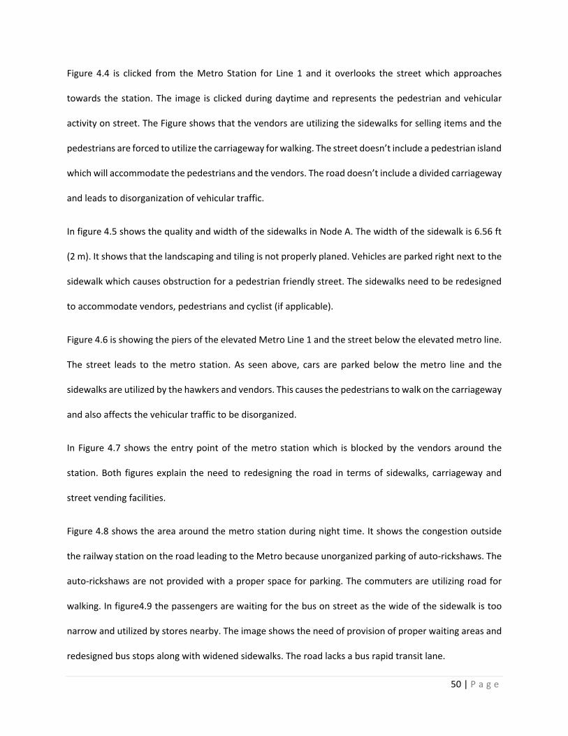
Figure 4.4a Pedestrian Analysis for Existing Metro Line 1 (Node A). 51
Figure 4.4b Land-use map for Node B. 52
Figure 4.4c Street Type and circulation 53
Figure 4.4d: Selected area for Street intervention.
54
Figure 4.4e Observations for Node B, Source: Author,2019. 55
Figure 5.2 Street design template for 36.6m wide road 59
Figure 5.3 Standard for Symbol and Color key for street design guideline. 60
Figure 5.4 The illustration demonstrates the design template for a 42 m wide Road including a Bus rapid transit lane.
61
Figure 5.5 Street Design layout including vending facilities. 62
Figure 5.7: Site Section for Existing Metro Line 1 64
Figure 5.7a Site Section for Existing Metro Line 1 65
Figure 5.7b Site Section for Existing Metro Line 1 65
Figure 5.8a Site Section for Existing Metro Line 1 67
Figure 5.8b Site Section for Existing Metro Line 1 67
Figure 5.9a Site Section for Existing Metro Line 1 68
Figure 5.9b Site Section for Existing Metro Line 1 69
4 | P a g e
Figure 5.10a Site Section for Proposed Metro Line 2. 73
Figure 5.10b Site Section for Proposed Metro Line 2. 74
Figure 5.11a Site Section for Proposed Metro Line 2. 75
Figure 5.11b Site Section for Proposed Metro Line 2. 76
Figure 6.1 Policy Recommendations 80
Figure 6.2 Policy Recommendations 81
Figure 6.3 Policy Recommendations 82
Figure 6.4 Policy Recommendations 83
Figure 6.5 Policy Recommendations 85
5 | P a g e
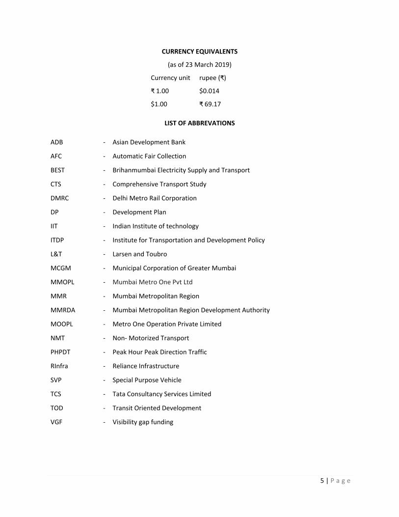
CURRENCY EQUIVALENTS
(as of 23 March 2019)
Currency unit
₹ 1.00
$1.00
rupee (₹)
$0.014
₹ 69.17
LIST OF ABBREVATIONS
ADB - Asian Development Bank
AFC - Automatic Fair Collection
BEST - Brihanmumbai Electricity Supply and Transport
CTS - Comprehensive Transport Study
DMRC - Delhi Metro Rail Corporation
DP - Development Plan
IIT - Indian Institute of technology
ITDP - Institute for Transportation and Development Policy
L&T - Larsen and Toubro
MCGM - Municipal Corporation of Greater Mumbai
MMOPL - Mumbai Metro One Pvt Ltd
MMR - Mumbai Metropolitan Region
MMRDA - Mumbai Metropolitan Region Development Authority
MOOPL - Metro One Operation Private Limited
NMT - Non- Motorized Transport
PHPDT - Peak Hour Peak Direction Traffic
RInfra - Reliance Infrastructure
SVP - Special Purpose Vehicle
TCS - Tata Consultancy Services Limited
TOD - Transit Oriented Development
VGF - Visibility gap funding

6 | P a g e
ACKNOWLEDGEMENTS
I would like to take this opportunity to express my thanks to those who helped me with various aspects
of conducting research and writing of this report. I would like to thank, my major professors and
committee member, Carlton Basmajian, Sungduck Lee and Biswa Das for their guidance patience and
support throughout the research and writing my creative component. It was a great learning opportunity
for myself while working under your guidance.
I would like to thank my friends and family who in a way or other have shared their support, either
emotionally and physically.
The completion of this undertaking would not have been possible without the support and assistance of
many people whose names may not be enumerated. Their contributions are appreciated and gratefully
acknowledged.
7 | P a g e
Chapter 1: Introduction
1.1 Background
India’s growing economy and major advancements in vehicle affordability has caused a significant
increase in the private ownership of vehicles. Mumbai Metropolitan Region (MMR) is one of the fastest
growing regions in India. The MMR consists of 7 municipal corporations, 13 councils and 996 villages
extended over a total area of 4,355 sq. km. The current Population of MMR is 21.3 million. MMR is
projected to have a population of 34.0 million and employment of 15.3 million by the year 2031.In the
city of Mumbai, there is a dominance of passenger movement accompanied by overwhelming
dependence of travel of public transport modes and walk. The city currently consists of overcrowded
public transport systems and a congested road network system due to a large gap between demand and
supply. The city has observed a large population growth since 1951 and is accommodated mostly in the
suburbs while the high concentration of the jobs lies in the downtown of MMR (South Mumbai).The
physical characteristics of the city are such that the suburbs have been constrained to spread northwards
only, and all transport facilities are concentrated within three narrow corridors.1 MMR is historically
heavily dependent on public transport and walking as a mode of transport. Over 40% of workers in MMR
reach their workplace on foot resulting in almost 52% of the total trips per day using walking as a primary
mode of transport.2 Suburban local trains form the lifeline of Mumbai's North-South transport. The
Mumbai Suburban Railway network covers about 248.54 miles (400km) with 7 million average weekday
passenger trips with extremely low fares. The buses contribute to 26% mode of public transport with 3.55
million trips. Brihan Mumbai Electric Supply and Transport (BEST) along with other private transport
provide the bus transport in Mumbai. Intermediate transport like auto-rickshaws and taxis play an
1 India: Mumbai Metro Rail Systems Project, Mumbai Metropolitan Region Development Authority, Government of India for the Asian Development Bank 2 Mitigation Policy packages for Transport sector- Mumbai Metropolitan region
8 | P a g e
important role in accommodating the transport demands to provide access to busses and trains in the
city.
The demand for vehicular transport is significantly higher than the existing capacity of the roads in
Mumbai, India leading to severe congestion. Transit oriented development is one of the effective tools
which can bring a shift from the use of private vehicles to public transport. In highly populated
metropolitan city like Mumbai, residents face many problems in terms of compact housing, scarcity of
open space, crowded public transport and heavy traffic congestion on daily basis. As the existing transport
system in the city is failing to meet the demands of the commuters, Metro rail system has been introduced
in congested areas to reduce the traffic congestion. (MMRDA) is planning to implement TOD along the
newly introduced METRO network. Transit-oriented development (TOD) can directly benefit a transit
agency through increases in ridership and revenues. TODs can also have a positive impact on society by
reducing auto use and reducing the volume of vehicles and congestion on the highway network. However,
its success aspects are unknown and yet to be explored. It is important to evaluate whether the area
where TOD is planned will give the above desired effects and to what extent. Hence, this study focuses on
understanding the relationship between TOD and pedestrian connectivity, before implementing plans for
proposed metro lines in the city. An analysis of the existing metro Line 1 needs to done in terms of street
design parameters which influence the pedestrian behavior. These parameters include sidewalks, off-
street parking, elevated walkways, street vending and accessibility to the transit nodes.
9 | P a g e
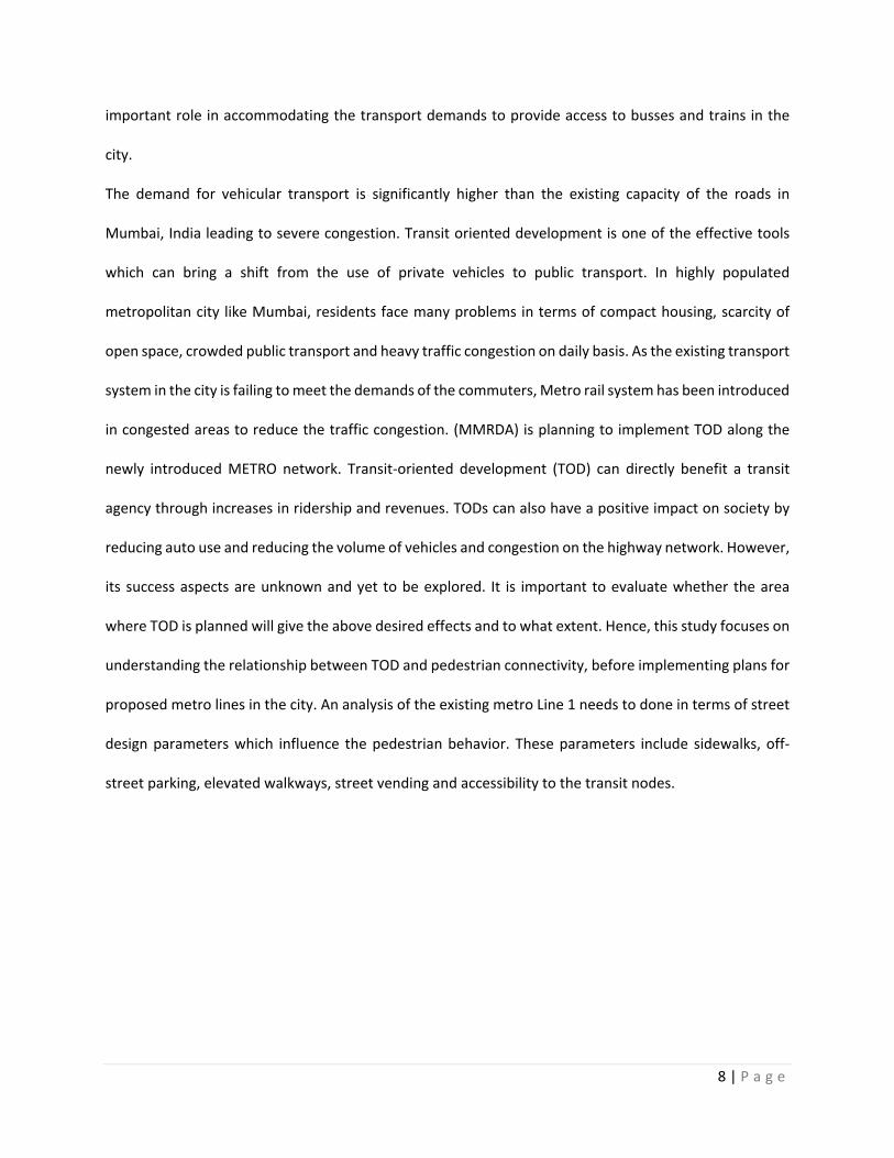
Figure 1.1: Mumbai map with selected nodes, Source: Author, 2019.
This study Includes the Andheri Metro Station on Mumbai Metro Line 1 as a pilot study area which will be
observed to understand the problems faced by the pedestrian to commute to the existing station for
metro line 1. The selected area lies around the Andheri Metro Station and covers half-mile radius area.
The parameters of street design will be observed for the station for existing metro station for Line 1 (Node
A) and area dedicated for proposed metro line 2 (Node B). The results from the observations will set the
guidelines for a better pedestrian connectivity to the transit nodes and to define successful TOD in
Mumbai. The findings from this study will be useful for decision makers, practitioners and policy makers
to predict the passenger behavior before the station has been designed. The recommended street
10 | P a g e
interventions will help to develop better TOD policies based on the predictions and study for the existing
station for metro line 1.
1.2 Research questions and study objectives
This research explores on the relationship between TOD and pedestrian connectivity at neighborhood
scale in Mumbai metropolitan area. TOD is a straightforward concept: concentrate a mix of moderately
dense and pedestrian-friendly development around transit stations to promote transit riding, increased
walk and bicycle travel, and other alternatives to the use of private cars (Shirke, C., Joshi, G. J., Kandala,
V., & Arkatkar, S. S.,2017).
This research investigates the relationship between TOD and pedestrian connectivity. This study
addresses two research questions: 1): What is the level of urban pedestrian connectivity that is related to
TOD in Mumbai, India? 2) How do we implement successful TOD strategies for urban
pedestrian connectivity in Mumbai, India?
The research questions focus on the objective to study:
1) The level of pedestrian connectivity to the existing metro station for line 1 in Mumbai, India.
2) The factors that are involved to promote a better street connection and promote walking modes.
3) To suggest changes in the street design templates mentioned in the manual for India and provide
recommendations for streetscape for the proposed metro line 2 in Mumbai.
4) To suggest the policies that needs to be revised and new policies that needs to be introduced to
have a successful TOD system in Mumbai, India.
1.3 Overview of Data and Methodology
1) What is the level of urban pedestrian connectivity that is related to TOD in Mumbai, India?
Observation method will be used as a methodology to answer the first research question. The existing
Metro Line 1 of Mumbai has 12 stations, out of which 1 station (Andheri station) is selected as a Node A
11 | P a g e
for observation. The Node A is observed in terms of pedestrian connectivity to get results that provide
street design and planning policy recommendations for Node B (Proposed Metro Line2). The selected
Node A and Node B are observed at different times of the weekdays and weekends in to understand the
pedestrian connectivity to the existing Metro Station for line 1 and the area where the proposed metro
line 2 is expected to be constructed. The observation is done by the author by clicking pictures and videos
on site. A mapping analysis is done to understand the existing scenario for Metro station for line 1(Node
A) and proposed line 2 (Node B). The results from the observation method are used to answer the first
question and are used as a base for answering the second research question.
2) How do we implement successful TOD strategies for urban pedestrian connectivity in Mumbai, India?
The results from the analysis for the first research questions, set the general guidelines for my design
suggestions for the proposed metro station (Node B) in Mumbai in terms of planning policies, urban design
implications, city infrastructure. A mapping analysis is done for Node A and Node B which identifies the
pedestrian and vehicular activity in both the nodes and based on the results from the mapping analysis,
the Node A and Node B are narrowed done to a street Section of 0.62 mile (1 km) in length to define the
street design interventions.
1.4 Study Area
The paper focuses on the Metro System in Mumbai, India and explores the relationship between TOD and
pedestrian connectivity. The current situation in India indicates that people are preferring to use private
vehicles than public transport. The main objective of the Mumbai Metro is to provide mass rapid transit
services to people within an approach distance of between 1 and 2 kilometers, and to serve the areas not
connected by the existing Suburban Rail network. The Metro Line 1 and 2 is located in the city of Mumbai
of state of Maharashtra in India. The selected nodes for the existing metro line 1 and proposed metro line
2 will be observed and analyzed. The focus of the study is to observe the pedestrian accessibility in terms
of modes like car, bus, bike and walk to the transit station within a buffer of half- mile radius. TOD has a
12 | P a g e
major principle which aims to increase the pedestrian access and reducing the use of private vehicles in
densely populated areas. The observation is done at different times of the day and are analyzed using
mapping analysis. ITDP EPC manual for street design in Urban India and Street design guidelines for
Mumbai provide a set of standards that need to be followed while designing street. These guidelines will
be used as base for recommending future street interventions for proposed metro line 2. The goal is to
observe existing metro line 1 (Node A), analyze it and provide recommendations in terms of urban design
and planning policy for the proposed metro line 2. The street design guidelines are provided in terms of
street sections in reference to the analysis and observations done for both Nodes A and B.
1.5 Organization of the Study
The paper is organized in sections as follows: Literature review, Study Area, analysis and discussion and
conclusion. Chapter 2 talks about the benefits and challenges of TOD and explains the concepts of TOD. It
explores the issues related to TOD in general and the introduction of TOD in India. The chapter explores
the current debate of TOD in India and the initiatives taken by the government of India for a better TOD
system in India. The chapter narrows down to the rational objective of TOD in city of Mumbai and explores
the metro rail system in Mumbai in terms of connectivity. This chapter explains the Draft development
Plan for Greater Mumbai 2014-2034 and identifies the strategies mentioned for a better TOD system in
Mumbai. It also explores the financial structure of the Metro Line 1, Line 2 and Line 3 which will be studied
further in chapter 4. Chapter 2 identifies the two research questions of the paper and the objectives of
study.
Chapter 4 is study area which explains the methodology that will be used for the selected site. It describes
the objective of the study and methodology used to achieve these objectives. It provides a detailed
explanation of study area and data collection method. The observation method as a methodology is
explained in detail for existing metro line 1 (Node A) and proposed metro line 2 (Node B). The results from
the observation method are explained through mapping analysis and site images to understand the
13 | P a g e
current issues and provide suggestions for street interventions for proposed metro line 2. Chapter 5 is
Analysis, which uses the results from the study area and provides a detailed design proposal in form of
street sections and illustrations. It uses street design guidelines to provide changes in street design and
implement it for the proposed metro line 2 (Node B). Chapter 6 is about discussion, contribution,
limitations and scope of future research for the paper. This chapter discusses the planning policy
recommendations based on the analysis which contribute to have a better relationship between TOD and
Pedestrian connectivity. The paper identifies the considerations that needs to be made in the draft
development plan for Mumbai which includes street design to promote TOD in terms of pedestrian
connectivity. The paper is concluded with the scope of future research.

14 | P a g e
Chapter 2: Literature review
2.1 Benefits and Challenges of Transit oriented development (TOD):
TOD has impacts on social, environmental, economic and individual aspects leading to benefits. The
characteristics of successful Transit Oriented Development (TOD) are outlined: 1) A strategic policy for
nodes: TOD requires the nodes to be developed in order to reduce the external costs on car dependence
and save travel time in traffic congestion; 2) A strategic policy for rapid transit: TOD requires repackaging
of land parcels, re-design of roads and re-orientation towards the rail system. Proactive planning
processes that create these land packages and do the detailed urban design are usually beyond local
government resources; and 3) A public-private partnership mechanism to build rail linked to nodes: Tod
requires the public and private transit system to work simultaneously to get an efficient utilization of the
Metro system.
One of the biggest challenges is that the regulatory framework of most municipalities is not supportive of
TOD. It is common for cities to have zoning ordinances and land development codes designed for
automobile-oriented, single-purpose, suburban-scale development. The key to balancing the
development mix is in understanding the station’s role in the transit network and metropolitan economy.
The imperative for successful TOD of any size or location remains ensuring the walker has precedence
(Curtis 2008).
Parking: Developments where car parking ratios for residents, shoppers and commuters remain generous,
and private car use continues at former levels, will struggle to develop the sense of place and community
to which genuine TOD aspires. Research results show that TOD parking supply and pricing policy seldom
are structured to support transit ridership goals Parking policy is an important determinant of travel
behavior, regardless of proximity to transit.
15 | P a g e
Gentrification: As most cities continue to sprawl, many young families especially from the middle class
prefer returning to the central city resulting in an increase in demand for housing in upmarket
neighborhoods which are usually located around newly ordained public transit projects. It is generally
agreed that in the American context, average prices for homes near transit may be at least 10 per cent
costlier than in the suburbs. In the resultant competition for housing limited by development regulations,
invariably those with poor purchasing power may get replaced by the newly arrived richer households
through the process of gentrification. Gentrification may also result in the exclusion of the low-mobility,
low-income groups that were located on the TOD corridor who may be considered captive groups for
public transit. These groups may then be replaced by middle-income or high-income groups that already
own cars and would be reluctant to use public transit in the absence of adequate push factors in the form
of high taxation and fuel prices.
Stakeholders: It is imperative for stakeholders to actively take part and integrate between various
departments within a city to make a TOD successful. In the Indian context, political will acts as a major
factor in the completion of TOD projects because of the age-old discussions and policies mostly leading
into private vehicle-oriented policies, it is a shift which needs to be backed by willingness from the citizens
as well as the government.
2.2 TOD in India:
Indian cities face a multitude of issues such as severe congestion; deteriorating air quality;
increasing greenhouse gas (GHG) emissions from the transport sector; increasing road accidents; and an
exploding growth in the number of private vehicles (largely motorcycles). With the urban population
projected to more than double in the next generation, the situation could easily get out of control and
thwart India’s economic development efforts unless remedial measures are soon taken. The state of
public transport in the majority of Indian cities has degraded over the years. Rising population and
16 | P a g e
underdeveloped mass transport have led to a rapid rise of personal vehicles, traffic congestion and an
increase in pollution levels. Moreover, most people do not use public transport simply because of the lack
of it and inaccessibility to the transit. Therefore, while augmenting public transport, planning for
accessibility is the need of the hour. Increased density and improved connectivity through TOD can help
achieve that. But, one of the most important reasons for thinking about TOD for Indian cities is the recent
emphasis on public transport at all levels of government (EPC 2012). Scholars have argued that transport
sector in India is extremely energy intensive and needs massive investments in mass transit to quell the
rise of private motorised mobility (Rizvi Transit-Oriented Development: Lessons from Indian Experiences
2013; Yedla 2015). Post the announcement of mission-based programs like Jawaharlal Nehru National
Urban Renewal Mission (JNNURM) in 2005, Atal Mission for Rejuvenation, and Urban Transformation
(AMRUT) and Smart Cities in 2015, there has been huge emphasis on investments in public transport.
Transit systems like metro rail and Bus Rapid Transit (BRT) have found their way into many cities including
Delhi, Mumbai, Kolkata, Chennai. Bengaluru, Hyderabad, Ahmedabad, Rajkot, Surat, Pune, Pimpri-
Chinchwad, Hubli, Dharwad, Lucknow, Kochi, Jaipur, Bhopal and Indore among many others. In western
countries, TOD was used for densifying certain areas but in India the cities already have higher densities.
Hence TOD in Indian cities should be looked at as a tool for improving quality of life and financial means
to provide infrastructure facilities (Petkar and Hamand 2013).
Current debate on TOD in India:
Additionally, the level of diversity of use in these areas is also high, presenting an ideal case for TOD. Many
of the mainstream debates around TOD have centred on the development potential of the areas along
transit corridors The National Urban Transport Policy (NUTP) of 2006 was a response to the massive issues
of congestion and resultant loss of productivity in Indian cities. While it mentioned progressive concepts
like “cities for people” and “encouraging greater use of public transport and non-motorized modes,” it
17 | P a g e
also talked of mass transit systems only in the context of using “land as a resource for financing
investments” (Ministry of Urban Development 2006). It also encouraged cities to pursue the integration
of land use and transport plans. It must be noted that the draft NUTP (Ministry of Urban Development
2014) stresses on TOD as means to bring about high-density urban growth with a view to promoting high
levels of accessibility and shortening trip lengths. “The Government of India would encourage Transit
Oriented Development (TOD) with increased [Floor Area Ratio] FAR along transit corridors with high
density of population should form a part of planning”. Additionally, the reports recognize the need for
Transportation Demand Management (TDM) and controlling the use of personal vehicles in line with the
philosophy behind TOD. The Detailed Project Reports (DPR) for metro rail in cities like Kochi (DMRC 2011),
Jaipur (DMRC 2012) and Pune (DMRC 2013) take inspiration from national policy only sparingly as only
integration of different modes with the metro rail is proposed. Cities like Delhi have had the lead in the
adoption of mass transit from the early 2000s. Overall, the debates have largely centered on realizing the
value of land through which the metro rail corridor runs and integration of private modes with metro
stations. Concrete attempts towards preparation of TOD plans through development plans or standalone
local area plans has not been explored in most cities.
Rational Objectives of Mumbai Metro:
One of the major challenges for the city is to improve the quality of life of the residents by providing
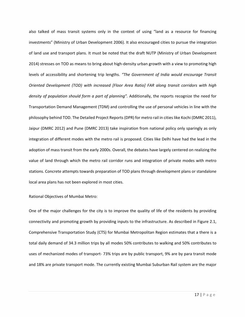
connectivity and promoting growth by providing inputs to the infrastructure. As described in Figure 2.1,
Comprehensive Transportation Study (CTS) for Mumbai Metropolitan Region estimates that a there is a
total daily demand of 34.3 million trips by all modes 50% contributes to walking and 50% contributes to
uses of mechanized modes of transport- 73% trips are by public transport, 9% are by para transit mode
and 18% are private transport mode. The currently existing Mumbai Suburban Rail system are the major
18 | P a g e
source of long distance inter- intra travel in the city, supported by BEST buses to provide cross connection
transport in the city and para transit modes.
Figure 2.1: Modes of Transit in Mumbai Preferred by Commuters. Source: Author,2019.
The Mumbai Suburban Rail System suffers severe overcrowding due to extensive reach across the Mumbai
Metropolitan Region and intensive use by the local urban population. The capacity of the 9- car rail is 1700
but over 4500 passengers travel during peak hours and has a dense crush load of 14 to 16 standing
passengers per square meter of floor space. To decongest the existing suburban rail system and to provide
connectivity at macro and micro level within MMR, MMRDA envisaged a transit network of about 667 km
in 32 transit links. This includes 1) Metro Network (251 km), 2) Monorail Network (179 km) and 3)
suburban Rail network (237 km). MMRDA prepared a Master Plan of Mumbai Metro network in 2003
which includes 9 corridors covering a length of 146.5 km, out of which 32.5 km is underground and 114
km is elevated. The Master Plan for the Mumbai metro along with its progressive implementation
50
36.5
4.5
9
%
Walking Public Transport Para Transit Mode Private
19 | P a g e
was developed by Delhi Metro Rail Corporation (DMRC), in collaboration with TATA Consultancy
Services (TCS) and the Indian Institute of Technology (IIT).
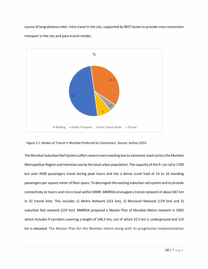
MMRDA has set aims for Metro Rail project3, which are: 1) Providing environmentally sustainable
transport means by mitigating the climate change and air and noise pollution, 2) Reducing the urban
congestion in the city and thus, increasing labor productivity which will contribute to the economic growth
and 3) Enhancing the mobility of the socially disadvantaged population to improve livelihood and increase
their access to education, jobs and other services.
Figure 2.2: Goals of MMRDA Mumbai Metro Rail Project: Source: Author, 2019.
This paper will be focusing on the AIM 2 which is reducing the urban congestion in the city and AIM 3
enhancing the mobility of the socially disadvantaged population to improve livelihood and increase their
access to education, jobs and other services of the Metro Rail Project which is further discussed in Chapter
2.3 which identifies the strategies and goals for TOD in Mumbai.
3 India: Mumbai Metro Rail Systems Project, Mumbai Metropolitan Region Development Authority, Government of India for the Asian Development Bank
Aim for Metro Rail Project In Mumbai
Environmentally Sustainable transport
Climate Change
Noise pollution
Economic Growth
Reducing Urban Congestion
Increasing Labour productivity
Access to jobs and other services
Improve livelihood
Access to jobs and other services
20 | P a g e
2.3 Development 2014-2034, Greater Mumbai:
Mumbai is a city located in India with a population of 18.41 million. The Municipal Corporation for Greater
Mumbai has prepared Draft Development Plan 2034 following the provisions of The Maharashtra Region
& Town Planning Act, 1966. The DP 2034 covers the jurisdiction of the Municipal Corporation of Greater
Mumbai, excluding the areas under Special Planning Authorities appointed under section 40 of the
MR&TP Act 1966. The comprehensive plan is called as Development plan or DP in Mumbai, India. Greater
Mumbai is witnessing trends of stabilizing population growth rate combined with decreasing household
size, increasing workforce participation rate, and increasing per capita income. Greater Mumbai has also
experienced marginal increase in proportion of formal sector employment and growing aspirations and
increasing demand for space and infrastructure. Mumbai has also experienced significant transformation
of its economy. Manufacturing has declined considerably, and services particularly financial services have
expanded. Now the aspiration is to become international center for finance, commerce and
entertainment. This would need to be enabled by the proposed spatial structure. On the other hand, there
is limited availability of land in Greater Mumbai. The City is characterized by inequitable distribution of
space, amenity and infrastructure demand, given its vast population that resides in slums. Further, the
significance of its eco-system under pressure from urbanization and its protection is imperative. DP 2034
therefore needs to find strategies, which promote holistic and inclusive city renewal and redevelopment,
improved access to transportation and amenities, and preservation of its ecology and environment.
Further, provision of amenities and infrastructure required to sustain growth is one of the key challenges
of the DP 2034. The vision and objective section of includes the goals and objectives that the city will
implement for the time span of 2014-2034. The vision projects the 12th Five Year Plan for the City of
Mumbai and aims to make Mumbai a center for economic growth over next two decades and expecting
a GDP growth of 9%-10%. The three major goals of the DP 2034 for greater Mumbai are competitive city,
Inclusive city and sustainable city providing a good quality for life.
21 | P a g e
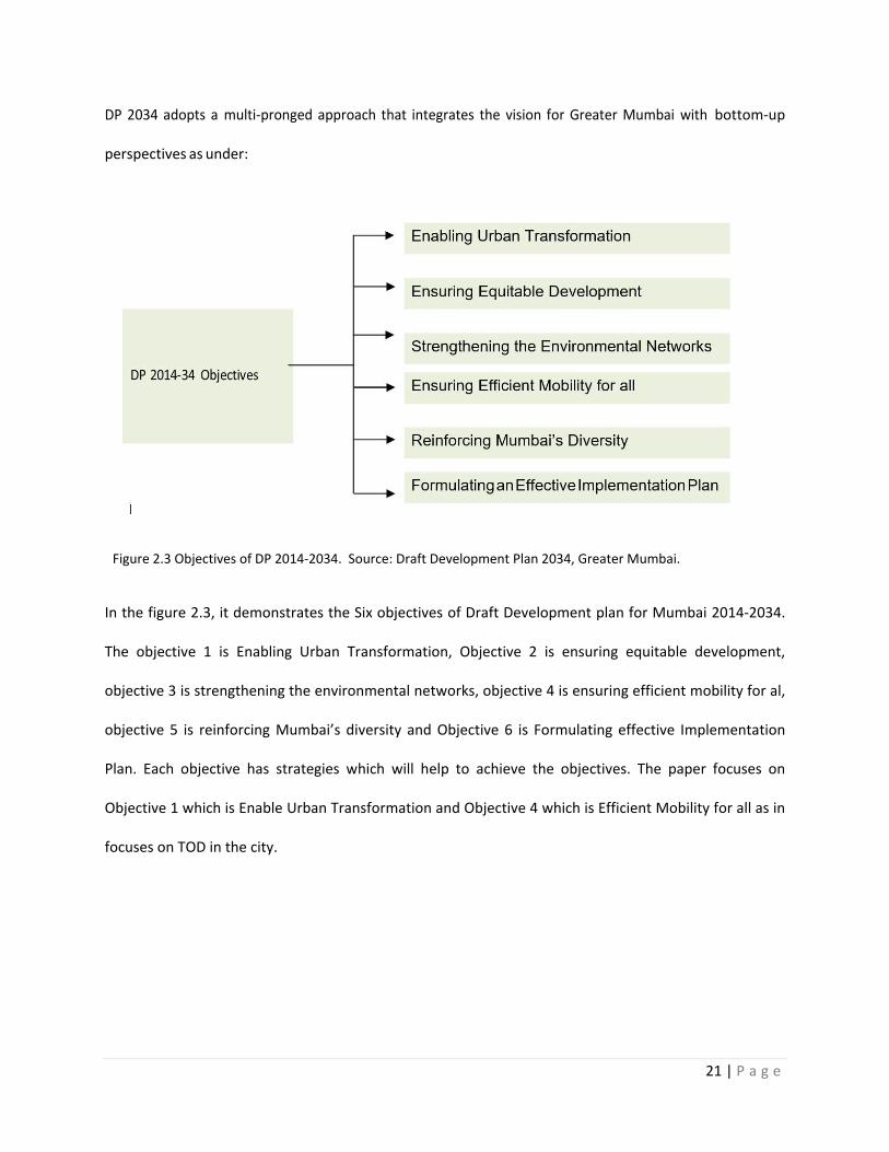
DP 2034 adopts a multi-pronged approach that integrates the vision for Greater Mumbai with bottom-up
perspectives as under:
Figure 2.3 Objectives of DP 2014-2034. Source: Draft Development Plan 2034, Greater Mumbai.
In the figure 2.3, it demonstrates the Six objectives of Draft Development plan for Mumbai 2014-2034.
The objective 1 is Enabling Urban Transformation, Objective 2 is ensuring equitable development,
objective 3 is strengthening the environmental networks, objective 4 is ensuring efficient mobility for al,
objective 5 is reinforcing Mumbai’s diversity and Objective 6 is Formulating effective Implementation
Plan. Each objective has strategies which will help to achieve the objectives. The paper focuses on
Objective 1 which is Enable Urban Transformation and Objective 4 which is Efficient Mobility for all as in
focuses on TOD in the city.
22 | P a g e
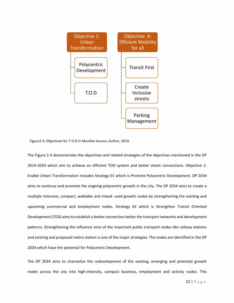
Figure2.4: Objectives for T.O.D in Mumbai Source: Author, 2019.
The Figure 2.4 demonstrates the objectives and related strategies of the objectives mentioned in the DP
2014-2034 which aim to achieve an efficient TOD system and better street connections. Objective 1:
Enable Urban Transformation includes Strategy 01 which is Promote Polycentric Development. DP 2034
aims to continue and promote the ongoing polycentric growth in the city. The DP 2034 aims to create a
multiple intensive, compact, walkable and mixed- used growth nodes by strengthening the existing and
upcoming commercial and employment nodes. Strategy 02 which is Strengthen Transit Oriented
Development (TOD) aims to establish a better connection better the transport networks and development
patterns. Strengthening the influence zone of the important public transport nodes like railway stations
and existing and proposed metro station is one of the major strategies. The nodes are identified in the DP
2034 which have the potential for Polycentric Development.
The DP 2034 aims to channelize the redevelopment of the existing, emerging and potential growth
nodes across the city into high-intensity, compact business, employment and activity nodes. This
Objective 1: Urban
Transformation
Polycentric Development
T.O.D
Objective 4: Efficient Mobility
for all
Transit First
Create Inclusive streets
Parking Management
23 | P a g e
policy would work towards further enhancing the economic primacy of Greater Mumbai in the
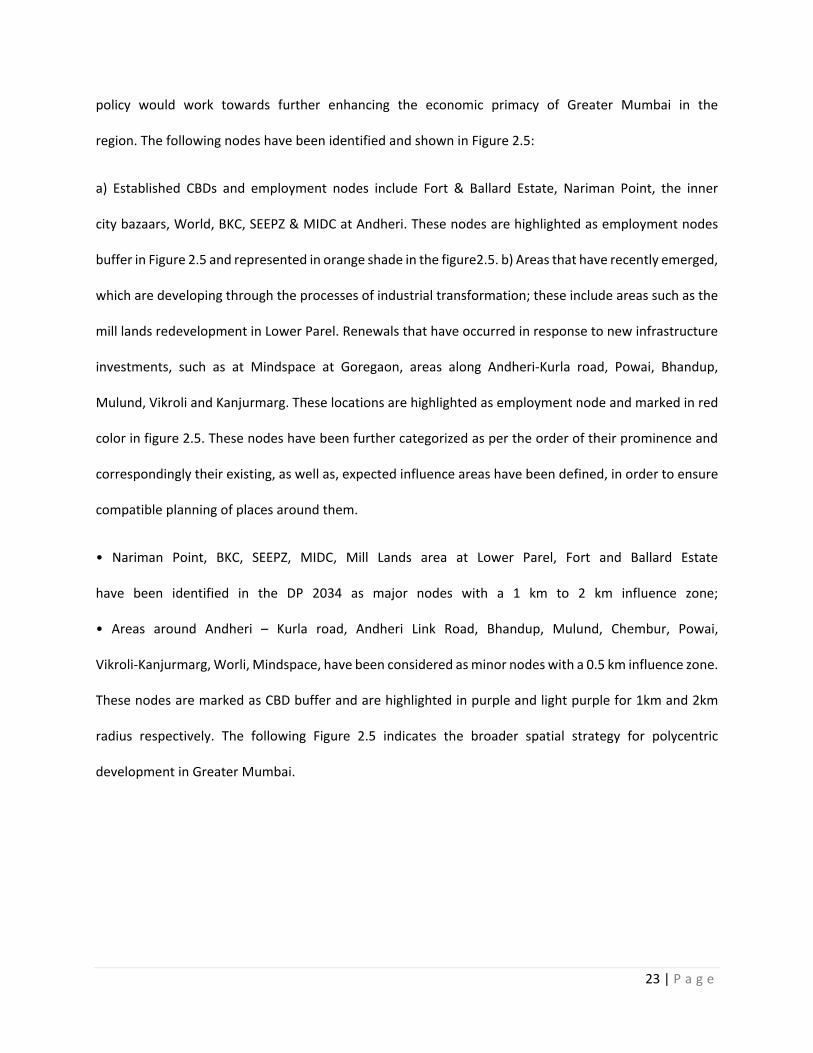
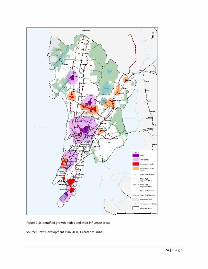
region. The following nodes have been identified and shown in Figure 2.5:
a) Established CBDs and employment nodes include Fort & Ballard Estate, Nariman Point, the inner
city bazaars, World, BKC, SEEPZ & MIDC at Andheri. These nodes are highlighted as employment nodes
buffer in Figure 2.5 and represented in orange shade in the figure2.5. b) Areas that have recently emerged,
which are developing through the processes of industrial transformation; these include areas such as the
mill lands redevelopment in Lower Parel. Renewals that have occurred in response to new infrastructure
investments, such as at Mindspace at Goregaon, areas along Andheri-Kurla road, Powai, Bhandup,
Mulund, Vikroli and Kanjurmarg. These locations are highlighted as employment node and marked in red
color in figure 2.5. These nodes have been further categorized as per the order of their prominence and
correspondingly their existing, as well as, expected influence areas have been defined, in order to ensure
compatible planning of places around them.
• Nariman Point, BKC, SEEPZ, MIDC, Mill Lands area at Lower Parel, Fort and Ballard Estate
have been identified in the DP 2034 as major nodes with a 1 km to 2 km influence zone;
• Areas around Andheri – Kurla road, Andheri Link Road, Bhandup, Mulund, Chembur, Powai,
Vikroli-Kanjurmarg, Worli, Mindspace, have been considered as minor nodes with a 0.5 km influence zone.
These nodes are marked as CBD buffer and are highlighted in purple and light purple for 1km and 2km
radius respectively. The following Figure 2.5 indicates the broader spatial strategy for polycentric
development in Greater Mumbai.
24 | P a g e
Figure 2.5: Identified growth nodes and their influence areas
Source: Draft Development Plan 2034, Greater Mumbai.
25 | P a g e
The objective 04 of the DP 2014-2034 is Efficient Mobility for all. This objective includes strategies that
includes augmentation of the public transit as well as access to public transit, optimizing the network of
street grids, managing on-street and on-plot parking, improving walkability, and suggesting design of
streetscapes that are inclusive, adhere to barrier free codes, and cater to different types of
mobilities. As seen in Figure 2.4, the strategy 12 mentioned is Transit first. It envisages the Transit Oriented
Zones as dense, compact, efficient & vibrant mix-use clusters with quick and easy access to public transit,
where access of private vehicles is regulated and minimized. It suggests station area improvement
guidelines through which suggest multi-modal integration. Strategy 14 of objective 04 is to create inclusive
streets. The DP prioritizes pedestrian movement as walking contributes to large modal share in the city.
This strategy includes facilitation of bus movement, regulation of carriageway space, on-street parking
space, as well as inclusion of street-vending spaces in high pedestrian traffic & mixed-use areas. Strategy
15 of objective 04 is to adopt a parking demand management approach. The DP views parking as a private
good and suggests rationalized on-plot parking provision norms, which also vary based on location
depending on availability of public transit access. It attempts to promote different tools to manage public
parking spaces in the city, which includes variable regulations and management mechanisms for on-street
parking and public car parks within private plots. Create Poly-centric growth nodes around public transit
stations, reduce use of cars, promote sustainable development, decongest roads & promote efficient travel
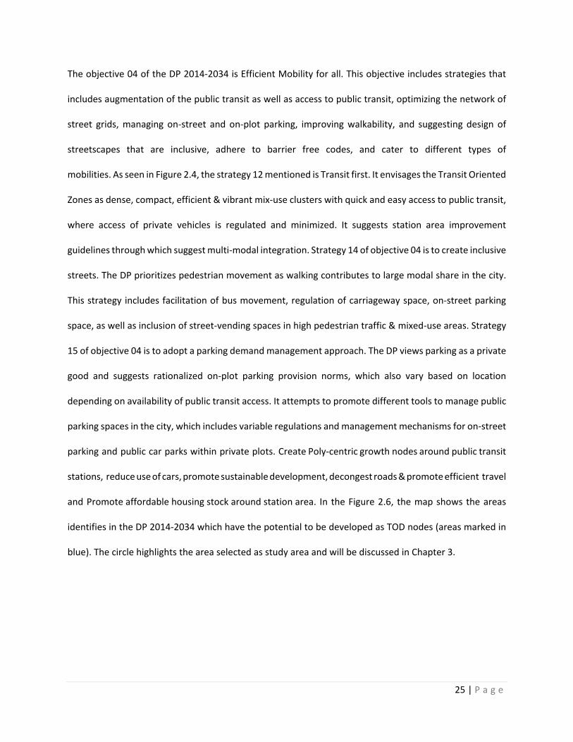
and Promote affordable housing stock around station area. In the Figure 2.6, the map shows the areas
identifies in the DP 2014-2034 which have the potential to be developed as TOD nodes (areas marked in
blue). The circle highlights the area selected as study area and will be discussed in Chapter 3.
26 | P a g e
Figure 2.6: Transit Oriented Development Zones
Source: Draft Development Plan 2034, Greater Mumbai.
27 | P a g e
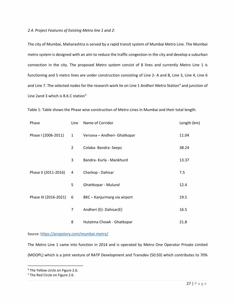
2.4. Project Features of Existing Metro line 1 and 2:
The city of Mumbai, Maharashtra is served by a rapid transit system of Mumbai Metro Line. The Mumbai
metro system is designed with an aim to reduce the traffic congestion in the city and develop a suburban
connection in the city. The proposed Metro system consist of 8 lines and currently Metro Line 1 is
functioning and 5 metro lines are under construction consisting of Line 2- A and B, Line 3, Line 4, Line 6
and Line 7. The selected nodes for the research work lie on Line 1 Andheri Metro Station4 and junction of
Line 2and 3 which is B.K.C station5
Table 1: Table shows the Phase wise construction of Metro Lines in Mumbai and their total length.
Phase Line Name of Corridor Length (km)
Phase I (2006-2011) 1 Versova – Andheri- Ghatkopar 11.04
2 Colaba- Bandra- Seepz 38.24
3 Bandra- Kurla - Mankhurd 13.37
Phase II (2011-2016) 4 Charkop - Dahisar 7.5
5 Ghattkopar - Mulund 12.4
Phase III (2016-2021) 6 BKC – Kanjurmarg via airport 19.5
7 Andheri (E)- Dahisar(E) 16.5
8 Hutatma Chowk - Ghatkopar 21.8
Source: https://propstory.com/mumbai-metro/
The Metro Line 1 came into function in 2014 and is operated by Metro One Operator Private Limited
(MOOPL) which is a joint venture of RATP Development and Transdev (50:50) which contributes to 70%
4 The Yellow circle on Figure 2.6. 5 The Red Circle on Figure 2.6.
28 | P a g e
ownership and Reliance Infrastructure which contributes to 30% ownership. Reliance Infrastructure and
RDTA are planning to extend the operation contract and into bidding for metro rail projects in other Indian
cities. 5% of Mumbai Metro One Pvt Ltd (MMOPL) is owned by RDTA, which is a special purpose vehicle set
up in December 2006, which owns the line and was in charge of its construction. Reliance Infrastructure
owns 69% of the MMOPL, and Mumbai Metropolitan Region Development Authority (MMRDA) owns
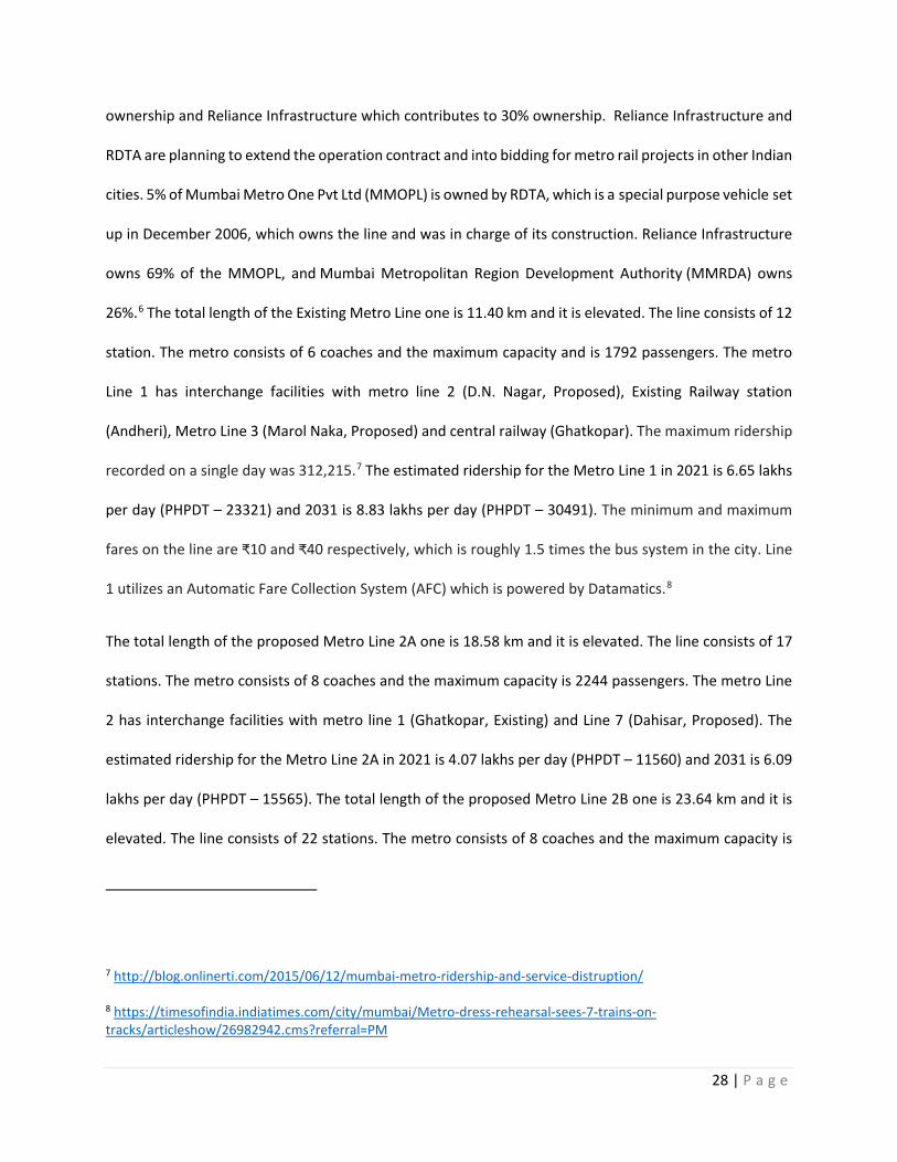
26%.6 The total length of the Existing Metro Line one is 11.40 km and it is elevated. The line consists of 12
station. The metro consists of 6 coaches and the maximum capacity and is 1792 passengers. The metro
Line 1 has interchange facilities with metro line 2 (D.N. Nagar, Proposed), Existing Railway station
(Andheri), Metro Line 3 (Marol Naka, Proposed) and central railway (Ghatkopar). The maximum ridership
recorded on a single day was 312,215.7 The estimated ridership for the Metro Line 1 in 2021 is 6.65 lakhs
per day (PHPDT – 23321) and 2031 is 8.83 lakhs per day (PHPDT – 30491). The minimum and maximum
fares on the line are ₹10 and ₹40 respectively, which is roughly 1.5 times the bus system in the city. Line
1 utilizes an Automatic Fare Collection System (AFC) which is powered by Datamatics.8
The total length of the proposed Metro Line 2A one is 18.58 km and it is elevated. The line consists of 17
stations. The metro consists of 8 coaches and the maximum capacity is 2244 passengers. The metro Line
2 has interchange facilities with metro line 1 (Ghatkopar, Existing) and Line 7 (Dahisar, Proposed). The
estimated ridership for the Metro Line 2A in 2021 is 4.07 lakhs per day (PHPDT – 11560) and 2031 is 6.09
lakhs per day (PHPDT – 15565). The total length of the proposed Metro Line 2B one is 23.64 km and it is
elevated. The line consists of 22 stations. The metro consists of 8 coaches and the maximum capacity is
7 http://blog.onlinerti.com/2015/06/12/mumbai-metro-ridership-and-service-distruption/ 8 https://timesofindia.indiatimes.com/city/mumbai/Metro-dress-rehearsal-sees-7-trains-on-tracks/articleshow/26982942.cms?referral=PM
29 | P a g e
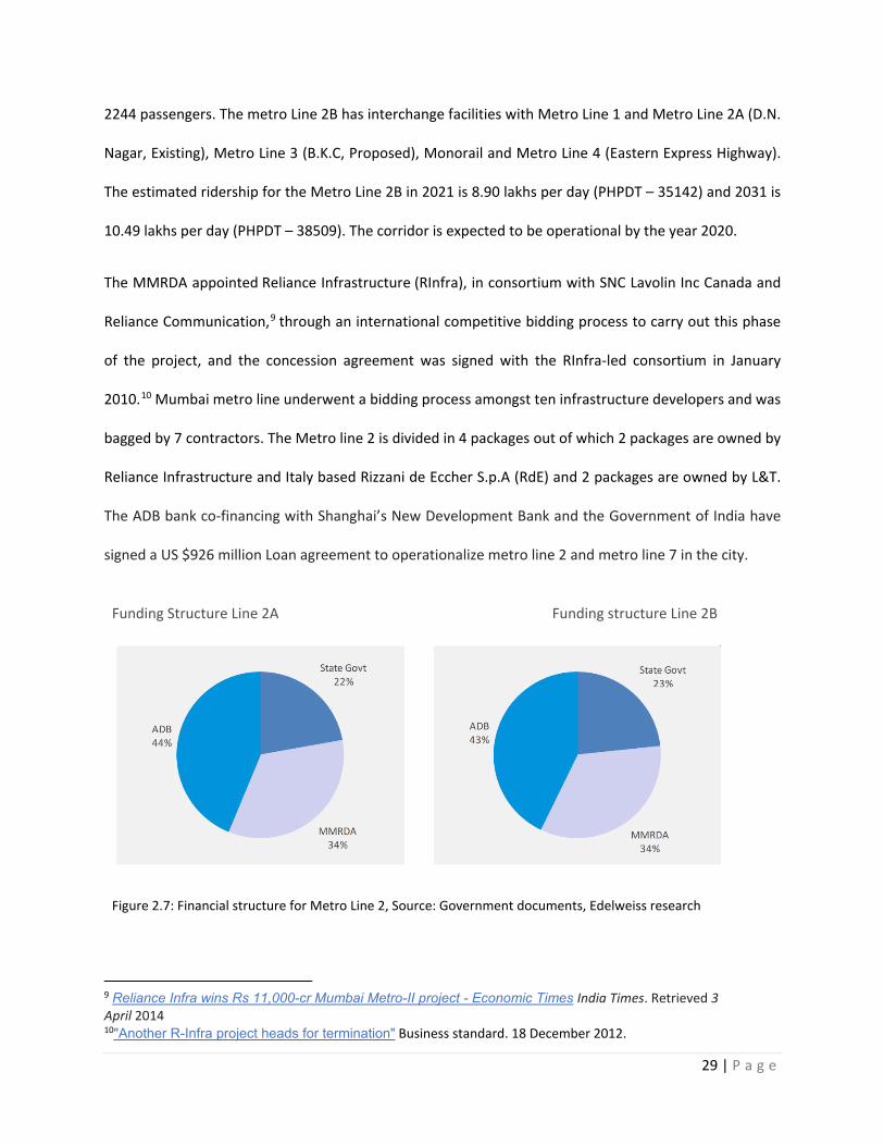
2244 passengers. The metro Line 2B has interchange facilities with Metro Line 1 and Metro Line 2A (D.N.
Nagar, Existing), Metro Line 3 (B.K.C, Proposed), Monorail and Metro Line 4 (Eastern Express Highway).
The estimated ridership for the Metro Line 2B in 2021 is 8.90 lakhs per day (PHPDT – 35142) and 2031 is
10.49 lakhs per day (PHPDT – 38509). The corridor is expected to be operational by the year 2020.
The MMRDA appointed Reliance Infrastructure (RInfra), in consortium with SNC Lavolin Inc Canada and
Reliance Communication,9 through an international competitive bidding process to carry out this phase
of the project, and the concession agreement was signed with the RInfra-led consortium in January
2010.10 Mumbai metro line underwent a bidding process amongst ten infrastructure developers and was
bagged by 7 contractors. The Metro line 2 is divided in 4 packages out of which 2 packages are owned by
Reliance Infrastructure and Italy based Rizzani de Eccher S.p.A (RdE) and 2 packages are owned by L&T.
The ADB bank co-financing with Shanghai’s New Development Bank and the Government of India have
signed a US $926 million Loan agreement to operationalize metro line 2 and metro line 7 in the city.
Funding Structure Line 2A Funding structure Line 2B
Figure 2.7: Financial structure for Metro Line 2, Source: Government documents, Edelweiss research
9 Reliance Infra wins Rs 11,000-cr Mumbai Metro-II project - Economic Times India Times. Retrieved 3 April 2014 10"Another R-Infra project heads for termination" Business standard. 18 December 2012.
30 | P a g e
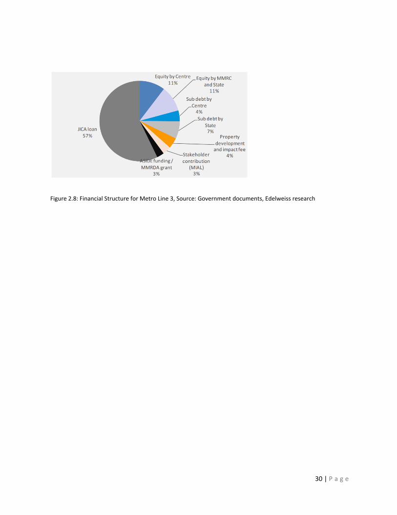
Figure 2.8: Financial Structure for Metro Line 3, Source: Government documents, Edelweiss research
31 | P a g e
Chapter 3: Objectives and Research Questions:
The primary objective of the paper is to understand the relationship between TOD and pedestrian
connectivity in Mumbai, India. The study focuses on the parameters that influence a better pedestrian
connectivity to the transit nodes in the city. The literature review suggests that in a Metropolitan city like
Mumbai, the demand for connectivity to the existing transport in the city is increasing. The connectivity
to transport modes like bus, trains and metro is provided by para transit modes and by walk. The city aims
to achieve TOD and one of the major factors to achieve this is by having a better pedestrian connectivity.
Hence, the study focuses on two research questions:
1) What is the level of urban pedestrian connectivity that is related to TOD?
2) How do we implement successful TOD strategies for urban pedestrian connectivity in Mumbai, India?
The research questions will be answered by using the methodology and study area by observation method
which is discussed in the next chapter. This research questions helps to understand the current scenario
of the streets around the Metro Station for existing line 1. In particular, with TOD it is intended to increase
transit patronage, active travel and reduce car travel, raising revenues, enhance livability and widen
housing choices, by increasing the multimodal access conditions of the city, considering the transit
network as the key transportation infrastructure of the city (Cervero et al., 2004)11. Despite there is not a
single universally accepted definition of a TOD, it is often described in a purely physical description way:
a mixed-use place, with a certain urban density and high-quality walking environment, located within half-
mile (800 m), i.e. 10 min walk, of a transit stop. However, the physical characteristics of these places are
essential but not sufficient to achieve the extensive goals of TOD, which are not focused in creating
physical forms but instead in creating vibrant, rich and livable urban places.
11 Transit-oriented development, integration of land use and transport, and pedestrian accessibility: Combining node-place model with pedestrian shed ratio to evaluate and classify station areas in Lisbon.
32 | P a g e
The research questions focus on the objective to study:
5) The level of pedestrian connectivity to the existing metro station for line 1 in Mumbai, India.
6) The factors that are involved to promote a better street connection and promote walking modes.
7) To suggest changes in the street design templates mentioned in the manual for India and provide
recommendations for streetscape for the proposed metro line 2 in Mumbai.
8) To suggest the policies that needs to be revised and new policies that needs to be introduced to
have a successful TOD system in Mumbai, India.
In the next Chapter 3 Methodology, we will be discussing about the nodes that are identified as study area
for the research and the methodology used to answer the research questions.
33 | P a g e
Chapter 4: Study area and Methodology
To answer the research questions of the study observation method will be used as a method. The study
area will be selected for existing metro line 1 and proposed metro line 2 which will be observed and
analyzed. The study area includes 2 nodes- Node A: existing metro line 1 within buffer of half mile radius
and Node B- Proposed metro line 2 within a buffer of half mile radius. Chapter 3 introduces the study area
used for observation method and explains the results of observation method. These results will be
analyzed in order to provide answers to the research questions.
Study Area:
The paper focuses on the Metro System in Mumbai, India and explores the relationship between TOD and
pedestrian connectivity. The current situation in India indicates that people are preferring to use private
vehicles than public transport. The main objective of the Mumbai Metro is to provide mass rapid transit
services to people within an approach distance of between 1 and 2 kilometers, and to serve the areas not
connected by the existing Suburban Rail network. The city of Mumbai has an existing metro line
implemented in 2006 and began to function in 2014.The existing Metro line 1 consist of 12 stations and
is 7.1 miles in length. There upcoming 2 metro lines in the city currently, namely Line 2 and line 3. Line 2
consists of two sub lines: Line 2A consist of 17 stations (11.55 miles) and Line 2B consists of 22 stations
(14.69 miles). Line 3 consists of 27 stations (20.82 miles). One of the reasons for lack of use of public
transport is that the metro-stations and bus stations are not easily accessible. One of the principles of
TOD is to increase pedestrian access and reduce the use of private vehicles in densely populated areas.
The capacity of the user to access the transit stop is a core component of TOD. The goal of the paper is to
observe the existing metro station (Node A) and based on my analysis making recommendations in terms
of urban design and planning policy for the proposed metro station (Node B).
34 | P a g e
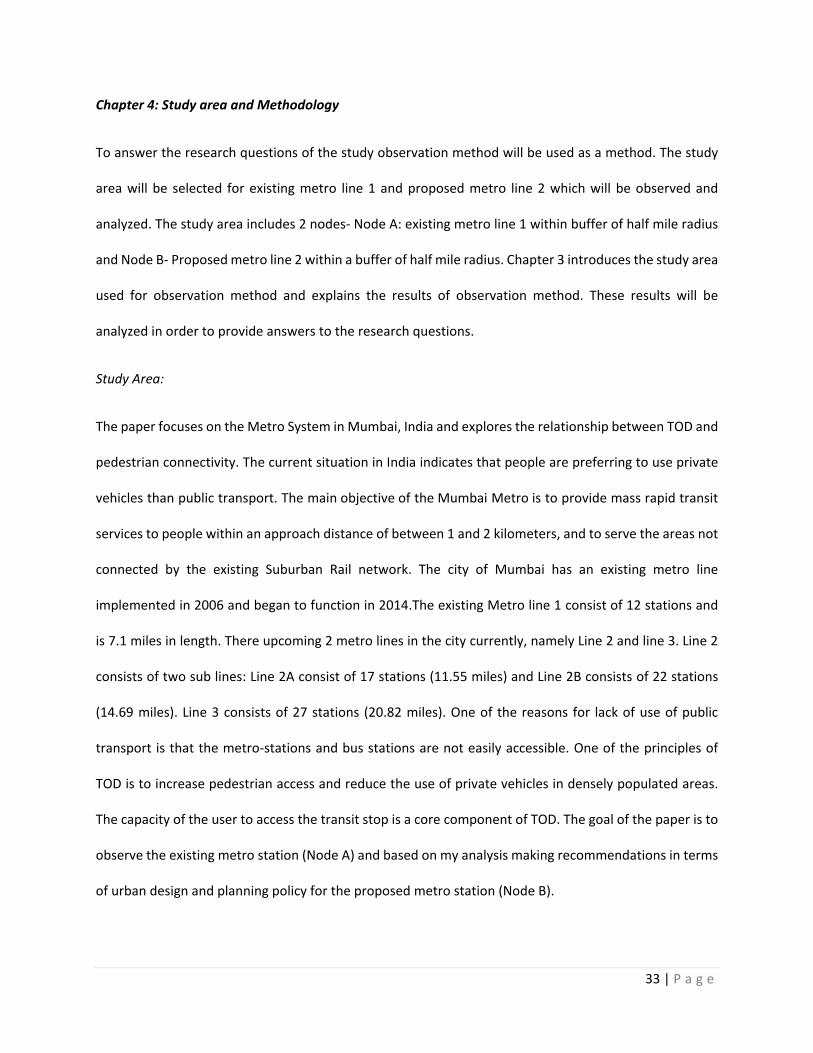
Project Location: The Metro Line 1 and 2 is located in the city of Mumbai of state of Maharashtra in India.
Figure 4.1 shows the layout of the overall Mumbai Metro Rail Network showing the locations of the
project lines. The map also shows the location of the stations of the metro lines. The black line
corresponds to existing Line 1, blue line corresponds to proposed Line 2 and Green line corresponds to
proposed Line 3. The existing Line 1 and proposed Line 3 provides East west connection in the City and
Line 2 provides North south as well as east west connection to the city. The metro Line 1 (Black Line)
consist of 12 stations, Metro line 2A consists of 17 stations and 2B consists of 22stations while Metro line
3 (green line) consists of 27 stations. As seen in the Figure 4.1 Metro Line 1 provides an east-west
connection in the city, metro line 2 provides a North-south connection and diverts to east-west connection
on intersection with line 3. Metro line 3 provides a North south connection in the city. The existing Railway
line in the city provides north- south connection in the city and fails to establish a cross connection
throughout the city. With the help of the Metro lines, the city will be able achieve a cross connection
which will reduce travel time. In order to have a successful TOD system in Mumbai, the city has introduced
metro and mono rail systems and aims to achieve a better public transportation system. The issues need
to be identified which are affecting the level of pedestrian connections to the transit systems in the city
like railways, metro and monorail. For this study two major nodes will be selected as seen in Figure 4.2
which are identified as TOD zones and growth nodes in the Draft Development Plan for Greater Mumbai
as shown in Figure 2.6.
35 | P a g e
Figure 4.1: Map showing the Proposed Mumbai Metro Rail Lines.
Source: UDRI, http://www.loginmumbai.org/map.html#
The nodes are selected on the following criteria:
1) Cross-Connections for railways: The existing and the proposed metro lines intersect each other to
provide transit connections to the areas not connected by the suburban railway. I have selected the nodes
where the lines intersect each other.
36 | P a g e
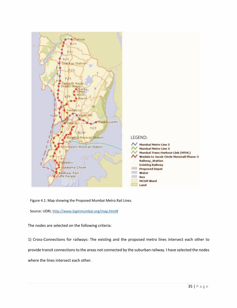
2)Population density: A mass rapid transit service needs to be provided on the region with moderately
dense population. The nodes selected lie in the region with moderate to high population density.
Figure 4.2: Map showing the selected nodes along the existing and proposed metro line in Mumbai, India.
Source: UDRI, http://www.loginmumbai.org/map.html#
In figure 4.2, the map indicates the nodes that are selected for the analysis of the relationship between
TOD and pedestrian connectivity in Mumbai. The Node A highlighted in blue circle is a buffer of half-mile
radius and includes existing railway station (Andheri Station) and metro station (Andheri) within the
selected buffer. The area is a densely populated area (see population density Figure 4.3e in APPENDIX).
The metro line 1 is currently operating and will be observed to understand the causes of hinderances
between TOD and pedestrian connectivity. The selected Node B is a buffer of half-mile radius and includes
37 | P a g e
the intersection of proposed metro line 2 (Income Tax Office station) and metro line 3 (Bandra Station).
The area is selected as it provides a cross connection between two metro lines and lies in a densely
populated area. A detailed study of Node A and Node B is done by observation method as discussed in
Methodology section.
I would like to focus on the accessibility mode like car, bus, bike and walk to the transit station within a
buffer of half-mile radius. I would like to focus on the selected Node A and Node B as seen in Figure 4.2 of
metro station in the city to understand how TOD transforms the urban fabric around a metro station. I
will be focusing on the streetscape, the physical setting and the urban structure around the metro station.
Methodology
Observation method is used to answer the first research question, ‘What is the level of urban pedestrian
connectivity that is related to TOD in Mumbai, India?’. Mapping Analysis based on the observation method
is used to answer the second research question, ‘How do we implement successful TOD strategies for
pedestrian connectivity in Mumbai, India?’.
The first research question is, what is the level of urban pedestrian connectivity that is related to TOD in
Mumbai, India? To understand the level of urban pedestrian connectivity I have used observation method.
Pedestrian behavior is the way the user accesses transit-station nodes by walk, bicycle, car or bus within
the half- mile radius. On my visit to India, I observed the two transit nodes - Existing Metro Station1 (Node
A) and proposed Metro Station 2 (Node B) at different times of day during weekends and weekdays and
analyze the pedestrian behavior of the commuters.
Based on the above measures at the existing metro station in Mumbai, I have done Network Classification
analysis (Schlossberg, M., & Brown, N., 2004) and street section analysis. Network Classification: An
evaluation and categorization of street type and purpose along the road network within the TODs, which
38 | P a g e
provides insight into the basic quality of certain paths for walkability purposes and reflects the hierarchy
of road types and the function of the road network. A mapping analysis categorizing of the street network
as primary, secondary and tertiary street to understand the street network which helps to define the
pedestrian street network. The street section analysis is done by using the guidelines mentioned in ITDP
EPC manual of street design for urban India and Street design guidelines for Mumbai.
The level of pedestrian connection is analyzed by street design parameters at the existing metro station
1 (Node A) and Proposed Metro Line 2 (Node B). I have focused on different parameters in terms of
pedestrian connectivity for observation, which are:
1) Sidewalks: Availability of the sidewalks for the commuters to access the existing station. In India,
most of the trips which are below 1.25 miles (2 km) are done by foot. A Better sidewalk design
promotes safety and comfortable pedestrian mobility. Sidewalks act as a primary feature of street
design and are accessible to all the users regardless of age, gender or special needs. The paper
identifies the sidewalks in Node A and Node B which need to be redesigned to provide a better
pedestrian connectivity to Metro Station.
2) Accessibility to metro-Station: Accessibility by mode of car, bicycle, bus, elevated walkway or
walking within half-mile radius.
3) Elevated walkway to commute: The city of Mumbai has elevated walkway that connects the
commuters to different nodes within the city. Observing the availability of the elevated walkway
for the commuters to access the existing station.
4) Carriageway and Bus-Rapid Transit System: The primary purpose of the carriageway and BRTS is
to provide vehicular mobility. The purpose of the road needs to be identified in terms of speed of
vehicle, major and minor roads, narrow lanes, traffic-calming lanes and pedestrian lanes. Since
39 | P a g e
the streets in India do not provide spaces for walking, cycling and vending spaces, all these
activities tend to be performed on the carriageways. A separated carriageway and BRT lane is
demanded to reduce congestions and improve the user experience.
5) On- street Parking: In City of Mumbai, it is very common to observe streets where cars are parked
without actual provision of parking space. On-street parking is clearly designated, managed,
charged, and restricted in volume, enabling access to nearby properties without disturbing the
flow of motor vehicles, pedestrians, and cyclists. When footpaths and cycle tracks are provided,
they often become parking lots for cars and two-wheelers unless physical barriers or law
enforcement prevent such encroachment. The lack of an adequate parking fee gives the
impression to users that parking is a deemed right. Instead on-street parking should be treated as
a premium service. A high charge encourages short duration parking, thereby allowing multiple
users to access the same spot. It also promotes the use of off-street parking.
6) Spaces for Street Vending: Well-planned spaces for street vending provide citizens with secure
and dignified areas for the trade of goods and services. Existing street design fails to address street
vending. Very few streets in India in have spaces designated for vending. As a result, vendors end
up using spaces intended for others such as footpaths or the carriageway.
7) Landscaping elements and Pedestrian Refuge: A good median reduces conflict between opposite
directions of traffic and acts as pedestrian refuge but has frequent enough breaks to discourage
motor vehicle users from driving in the wrong direction. Medians improve safety for pedestrians
by functioning as refuge islands, which allow pedestrians to cross one direction of travel at a time.
Landscaping improves the livability of streets. It plays a functional role in providing shade to
pedestrians, cyclists, vendors, public transport passengers, and other street users. It also
enhances the aesthetic qualities of streets.
40 | P a g e
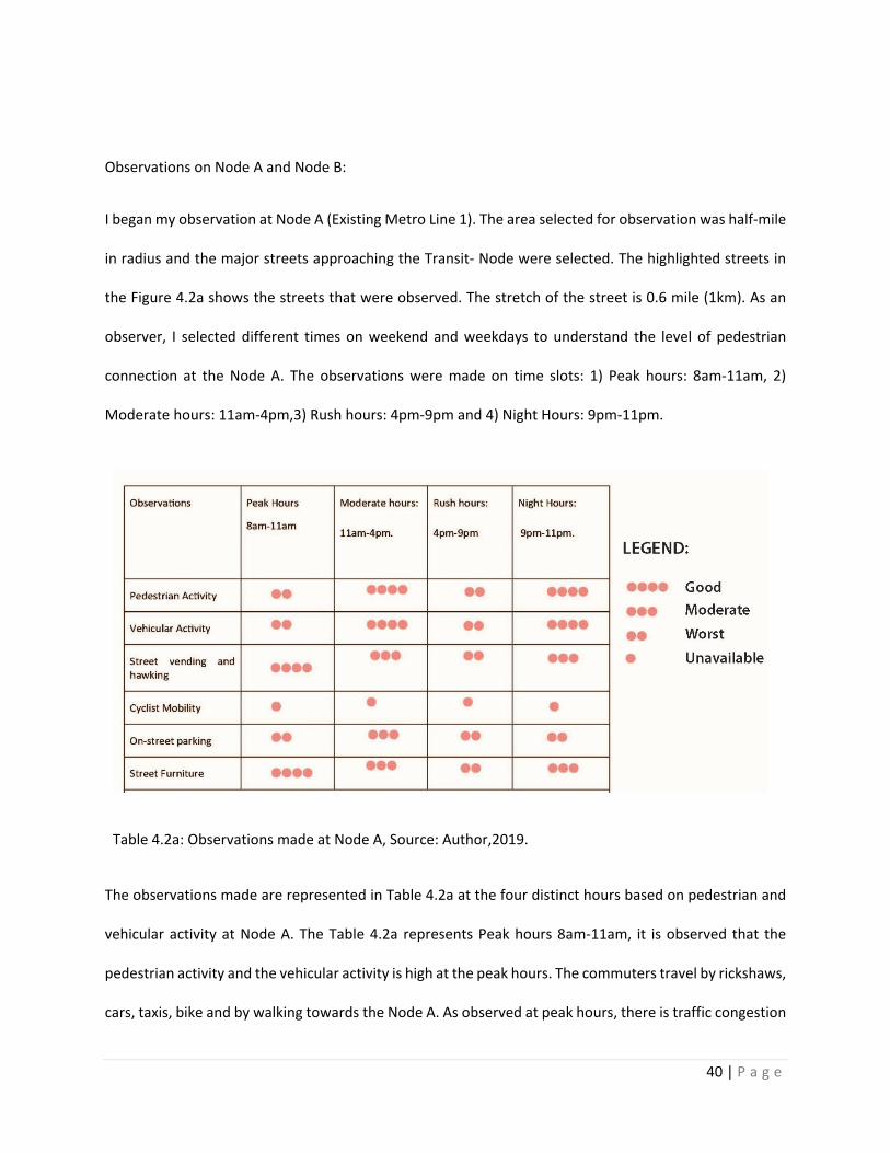
Observations on Node A and Node B:
I began my observation at Node A (Existing Metro Line 1). The area selected for observation was half-mile
in radius and the major streets approaching the Transit- Node were selected. The highlighted streets in
the Figure 4.2a shows the streets that were observed. The stretch of the street is 0.6 mile (1km). As an
observer, I selected different times on weekend and weekdays to understand the level of pedestrian
connection at the Node A. The observations were made on time slots: 1) Peak hours: 8am-11am, 2)
Moderate hours: 11am-4pm,3) Rush hours: 4pm-9pm and 4) Night Hours: 9pm-11pm.
Table 4.2a: Observations made at Node A, Source: Author,2019.
The observations made are represented in Table 4.2a at the four distinct hours based on pedestrian and
vehicular activity at Node A. The Table 4.2a represents Peak hours 8am-11am, it is observed that the
pedestrian activity and the vehicular activity is high at the peak hours. The commuters travel by rickshaws,
cars, taxis, bike and by walking towards the Node A. As observed at peak hours, there is traffic congestion
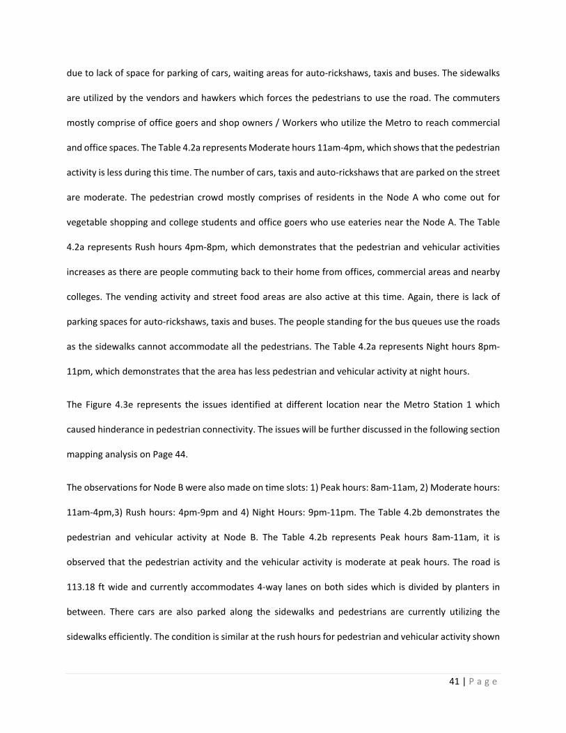
41 | P a g e
due to lack of space for parking of cars, waiting areas for auto-rickshaws, taxis and buses. The sidewalks
are utilized by the vendors and hawkers which forces the pedestrians to use the road. The commuters
mostly comprise of office goers and shop owners / Workers who utilize the Metro to reach commercial
and office spaces. The Table 4.2a represents Moderate hours 11am-4pm, which shows that the pedestrian
activity is less during this time. The number of cars, taxis and auto-rickshaws that are parked on the street
are moderate. The pedestrian crowd mostly comprises of residents in the Node A who come out for
vegetable shopping and college students and office goers who use eateries near the Node A. The Table
4.2a represents Rush hours 4pm-8pm, which demonstrates that the pedestrian and vehicular activities
increases as there are people commuting back to their home from offices, commercial areas and nearby
colleges. The vending activity and street food areas are also active at this time. Again, there is lack of
parking spaces for auto-rickshaws, taxis and buses. The people standing for the bus queues use the roads
as the sidewalks cannot accommodate all the pedestrians. The Table 4.2a represents Night hours 8pm-
11pm, which demonstrates that the area has less pedestrian and vehicular activity at night hours.
The Figure 4.3e represents the issues identified at different location near the Metro Station 1 which
caused hinderance in pedestrian connectivity. The issues will be further discussed in the following section
mapping analysis on Page 44.
The observations for Node B were also made on time slots: 1) Peak hours: 8am-11am, 2) Moderate hours:
11am-4pm,3) Rush hours: 4pm-9pm and 4) Night Hours: 9pm-11pm. The Table 4.2b demonstrates the
pedestrian and vehicular activity at Node B. The Table 4.2b represents Peak hours 8am-11am, it is
observed that the pedestrian activity and the vehicular activity is moderate at peak hours. The road is
113.18 ft wide and currently accommodates 4-way lanes on both sides which is divided by planters in
between. There cars are also parked along the sidewalks and pedestrians are currently utilizing the
sidewalks efficiently. The condition is similar at the rush hours for pedestrian and vehicular activity shown
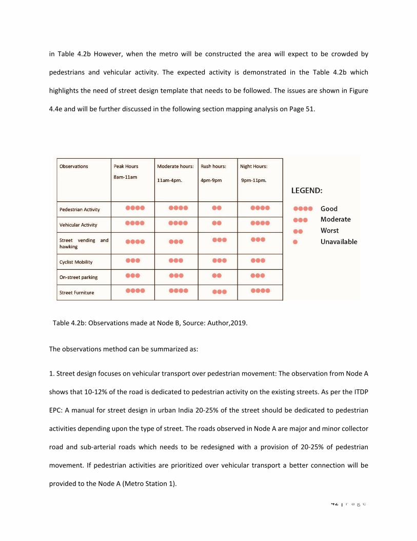
42 | P a g e
in Table 4.2b However, when the metro will be constructed the area will expect to be crowded by
pedestrians and vehicular activity. The expected activity is demonstrated in the Table 4.2b which
highlights the need of street design template that needs to be followed. The issues are shown in Figure
4.4e and will be further discussed in the following section mapping analysis on Page 51.
Table 4.2b: Observations made at Node B, Source: Author,2019.
The observations method can be summarized as:
1. Street design focuses on vehicular transport over pedestrian movement: The observation from Node A
shows that 10-12% of the road is dedicated to pedestrian activity on the existing streets. As per the ITDP
EPC: A manual for street design in urban India 20-25% of the street should be dedicated to pedestrian
activities depending upon the type of street. The roads observed in Node A are major and minor collector
road and sub-arterial roads which needs to be redesigned with a provision of 20-25% of pedestrian
movement. If pedestrian activities are prioritized over vehicular transport a better connection will be
provided to the Node A (Metro Station 1).

43 | P a g e
2. Street design elements like pedestrian areas, utilities, landscaping, street vending, social activities and
cyclist mobility are given less importance: Currently the streets observed at Node A consists of 10% of
area occupied by sidewalks and remaining 90% as vehicular road. The sidewalk is used by street vendors
and hawkers, cars are being parked on it, with lack of amenities like benches, landscaping elements and
no cyclist mobility facilities. A provision should be made for the essential amenities by widening the streets
which will provide space for the commuters to walk on sidewalks and will also accommodate the street
activities.
3. Existing streets are uncomfortable and inconvenient for pedestrian movement: As per the first
observation, pedestrian activities need to be prioritized, as the sidewalk currently doesn’t accommodate
all the commuters due to which the commuters tend to walk on the vehicular road. This makes both the
pedestrians as well as transportation drivers uncomfortable and inconvenient. Pedestrians are also prone
to accidents to improper sidewalk facilities. In order to improve the quality of the streets, the sidewalks
should be widened, the location of the railings should be reconsidered, a planned space should be
provided for the street vendors, along with parking facilities for cars, auto-rickshaw’s and taxis and parking
management is required.
4. Lack of car parking management: The observations show that there is no parking management in Node
A. The cars are parked on streets and sidewalks which occupies the area dedicated for pedestrian. Car
parked on the sidewalks indicates that there is lack of parking spaces near the transit node and also, it
causes hinderances for the commuters in terms of accessibility. A concept of off-street and on-street
parking should be introduced by understanding the commuter pattern at peak hours and parking fees
should be charged to make the citizens more aware about the parking management.
5. Increasing traffic congestion: Traffic congestion is one of major issues in city of Mumbai and it is
observed in Node A as well. Lack of width of sidewalks, lack of space of street vendors, lack of traffic and
44 | P a g e
parking management, least preference for street landscaping and pedestrian activities are issued
observed in node A as the planning policies have not identifies the need of future commuters while
designing the Metro Station. A planning policy focusing on street design elements and parking
management should be considered while redesigning streets for Node B (Proposed Metro Line 2) in order
to accommodate the need of the future commuters.
All the five factors observed cause interruptions in the pedestrian connection to the Node A (Existing
Metro Station 1). These observations from Node A are used to analyses and find the design proposals for
upcoming Metro Station 2 (Node B). The analysis method mentioned above is done for Node A and Node
B. This method helps to understand the level of urban pedestrian connection to the existing metro station
(Node A) and will help to prepare the policy and planning suggestions for the proposed metro station
(Node B).
The second research question is, how do we implement successful T.O.D strategies for pedestrian
connectivity in Mumbai, India?
The success of TODs significantly rests on the capacity of pedestrians to navigate and access the range of
land uses in proximity of transit stations (Schlossberg, M., & Brown, N., 2004). Thus, it seems that
understanding the opportunities for pedestrian movement should be a key component in understanding
and evaluating TODs. The first research question helped to identify how the level of pedestrian
connectivity is related to TOD in Mumbai, India. The results from the analysis for the first research
questions, set the general guidelines for the suggestions for the proposed metro station (Node B) in
Mumbai in terms of planning policies, urban design implications, city infrastructure. A mapping analysis is
done for Node A and Node B which identifies the pedestrian and vehicular activity in the nodes and based
on the results from the mapping analysis, the Node A and Node B are narrowed done to a street Section
of 0.62 mile (1 km) in length to define the street design interventions. The results derived from the
45 | P a g e
mapping analysis of Node A and Node B assist to identify the changes that need to be recommended for
the proposed metro Line 2 (Node B). This analysis discovers the change in urban form around a metro
station. The results identify the factors like landscaping and street interventions that will provide a better
pedestrian connectivity to the proposed metro stations at Mumbai, India.
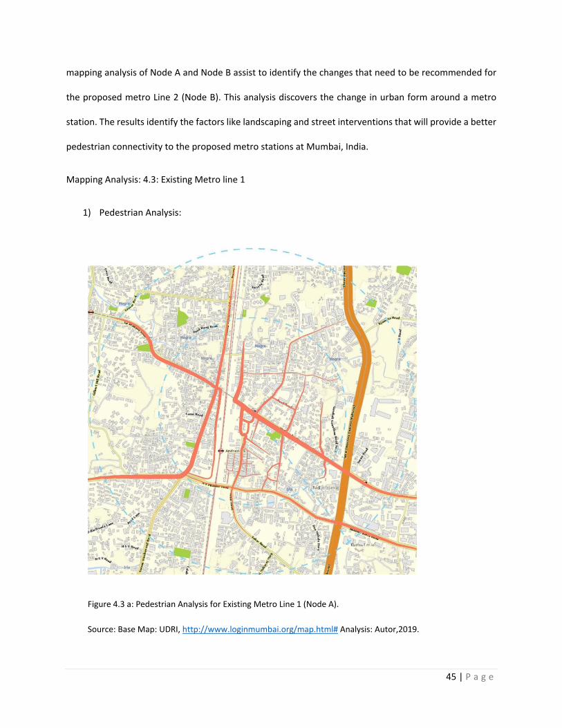
Mapping Analysis: 4.3: Existing Metro line 1
1) Pedestrian Analysis:
Figure 4.3 a: Pedestrian Analysis for Existing Metro Line 1 (Node A).
Source: Base Map: UDRI, http://www.loginmumbai.org/map.html# Analysis: Autor,2019.
46 | P a g e
Figure 4.3ashows the buffer (blue circle) for the existing metro station. The inner radius is 0.5 mile and
the outer radius is 1 mile. The lines in the map indicate the pedestrian activity in the selected region. The
thickness of the line in the above figure represents the number of pedestrians in selected node. The high
line weight represents high pedestrian activity in the area and the tapering line represents reducing
pedestrian activity. The location of existing Metro Station as seen in Figure 4.3a shows that it experiences
a high level of pedestrian activity.
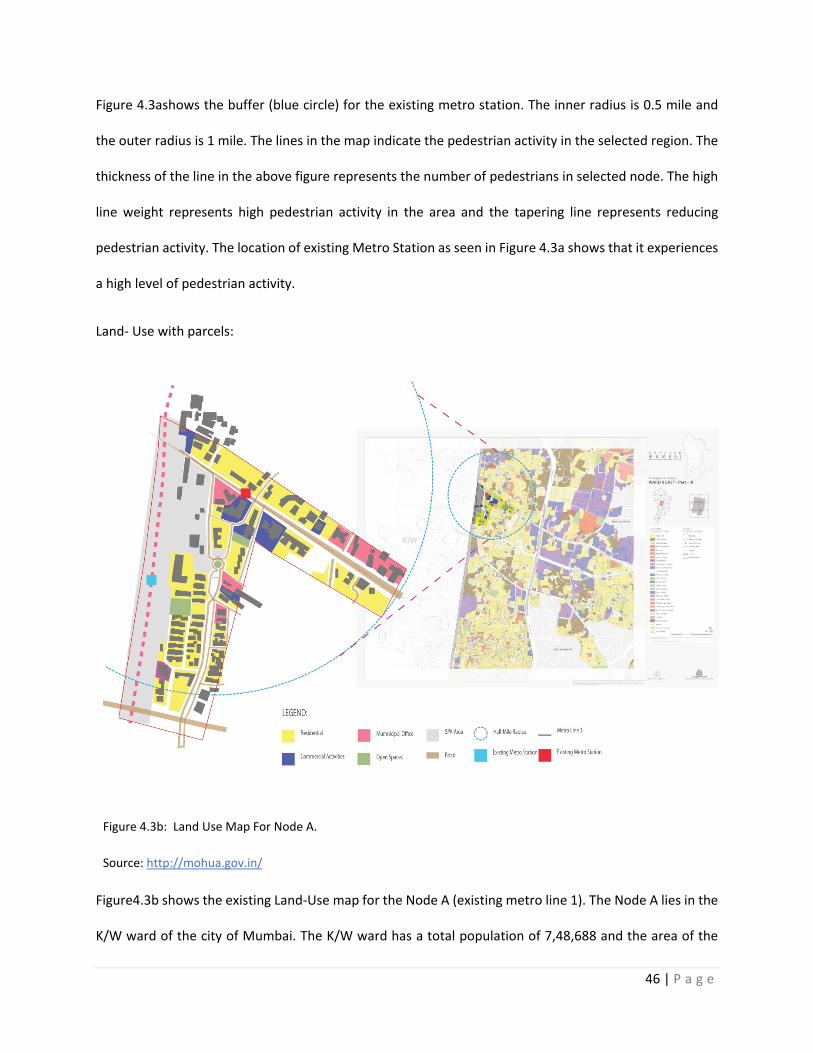
Land- Use with parcels:
Figure 4.3b: Land Use Map For Node A.
Source: http://mohua.gov.in/
Figure4.3b shows the existing Land-Use map for the Node A (existing metro line 1). The Node A lies in the
K/W ward of the city of Mumbai. The K/W ward has a total population of 7,48,688 and the area of the
47 | P a g e
ward is 8.98 sq. mile (23.28 sq. m). As seen in the figure, the selected node has mostly residential area
(yellow region) and commercial areas (blue region).
2) Street Type and circulation:
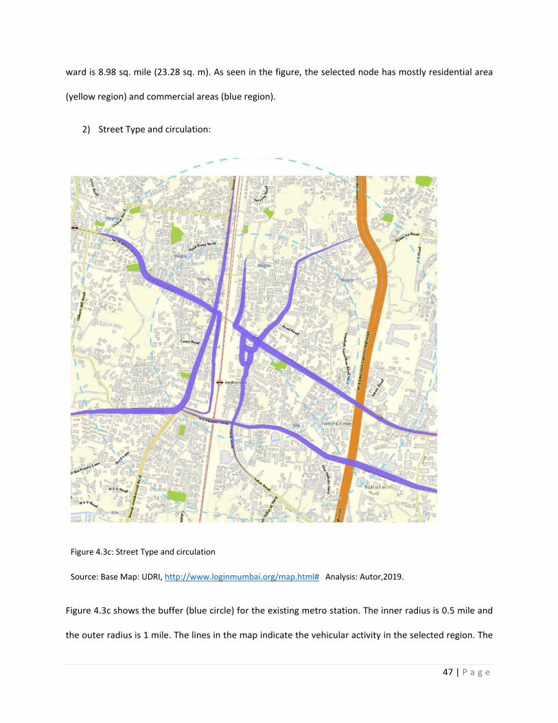
Figure 4.3c: Street Type and circulation
Source: Base Map: UDRI, http://www.loginmumbai.org/map.html# Analysis: Autor,2019.
Figure 4.3c shows the buffer (blue circle) for the existing metro station. The inner radius is 0.5 mile and
the outer radius is 1 mile. The lines in the map indicate the vehicular activity in the selected region. The
48 | P a g e
thickness of the line in the above figure represents the vehicular traffic in selected node. The high line
weight represents high vehicular traffic in the area and the tapering line represents reducing vehicular
traffic. The location of existing Metro Station as seen in Figure 4.3c shows that it experiences a high level
of vehicular traffic. On comparison of Figure4.1.1 and Figure4.1.2, it demonstrates that the station for
Existing metro Line 1 experiences a high pedestrian and vehicular activity. This overlap of pedestrian and
vehicular activity demands a better street connection to have a efficient TOD system.
3) Selected area:
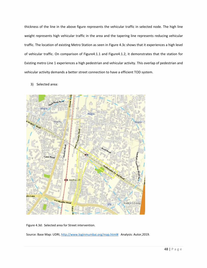
Figure 4.3d: Selected area for Street intervention.
Source: Base Map: UDRI, http://www.loginmumbai.org/map.html# Analysis: Autor,2019.
49 | P a g e
Figure 4.3d shows the street highlighted in yellow is the selected area for analysis of the existing street
condition. The street is selected on basis of the high pedestrian and vehicular activity. The street is 0.62
mile (1 km) in length. The sections of the streets will be further analyzed in Chapter 4 and
recommendations will be provided for the proposed metro line 2.
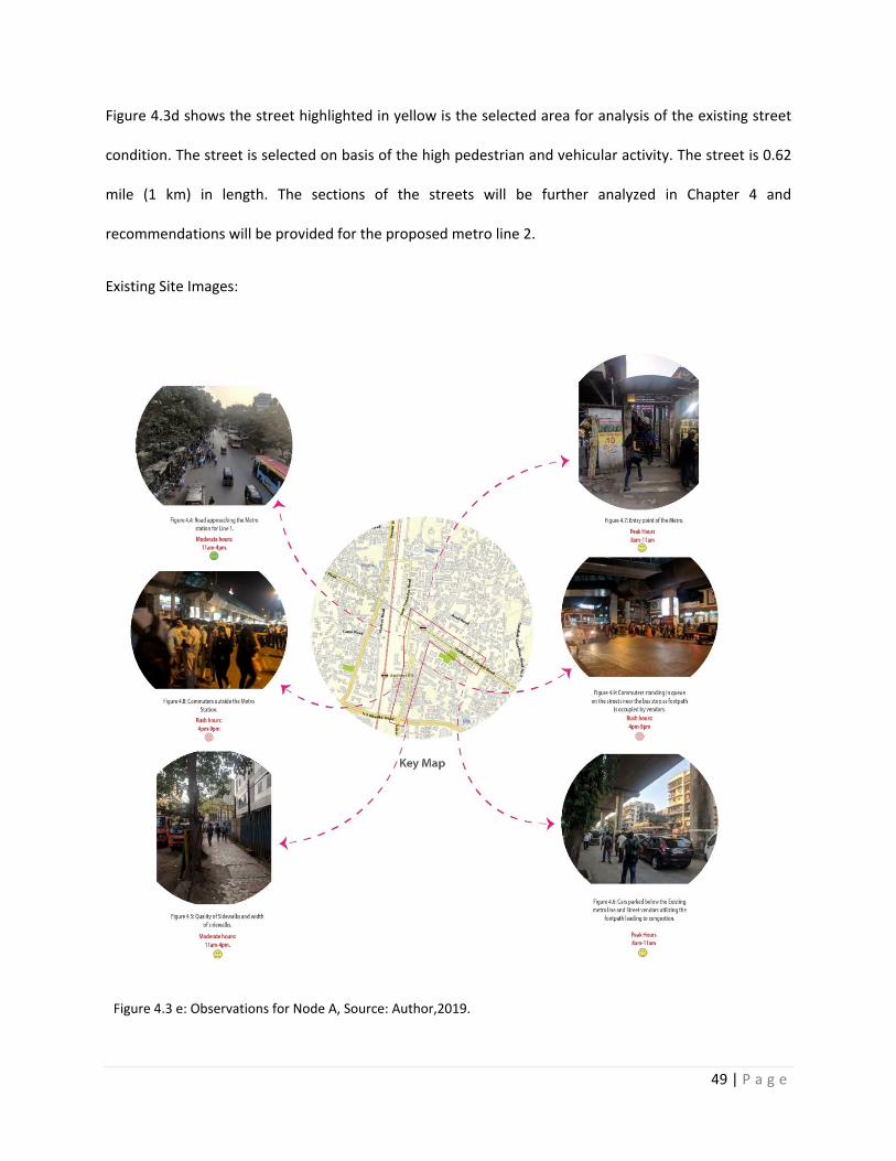
Existing Site Images:
Figure 4.3 e: Observations for Node A, Source: Author,2019.
50 | P a g e
Figure 4.4 is clicked from the Metro Station for Line 1 and it overlooks the street which approaches
towards the station. The image is clicked during daytime and represents the pedestrian and vehicular
activity on street. The Figure shows that the vendors are utilizing the sidewalks for selling items and the
pedestrians are forced to utilize the carriageway for walking. The street doesn’t include a pedestrian island
which will accommodate the pedestrians and the vendors. The road doesn’t include a divided carriageway
and leads to disorganization of vehicular traffic.
In figure 4.5 shows the quality and width of the sidewalks in Node A. The width of the sidewalk is 6.56 ft
(2 m). It shows that the landscaping and tiling is not properly planed. Vehicles are parked right next to the
sidewalk which causes obstruction for a pedestrian friendly street. The sidewalks need to be redesigned
to accommodate vendors, pedestrians and cyclist (if applicable).
Figure 4.6 is showing the piers of the elevated Metro Line 1 and the street below the elevated metro line.
The street leads to the metro station. As seen above, cars are parked below the metro line and the
sidewalks are utilized by the hawkers and vendors. This causes the pedestrians to walk on the carriageway
and also affects the vehicular traffic to be disorganized.
In Figure 4.7 shows the entry point of the metro station which is blocked by the vendors around the
station. Both figures explain the need to redesigning the road in terms of sidewalks, carriageway and
street vending facilities.
Figure 4.8 shows the area around the metro station during night time. It shows the congestion outside
the railway station on the road leading to the Metro because unorganized parking of auto-rickshaws. The
auto-rickshaws are not provided with a proper space for parking. The commuters are utilizing road for
walking. In figure4.9 the passengers are waiting for the bus on street as the wide of the sidewalk is too
narrow and utilized by stores nearby. The image shows the need of provision of proper waiting areas and
redesigned bus stops along with widened sidewalks. The road lacks a bus rapid transit lane.
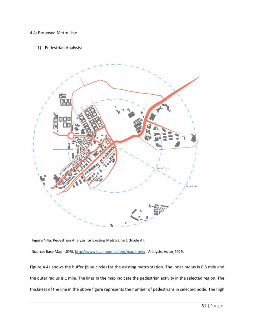
51 | P a g e
4.4: Proposed Metro Line
1) Pedestrian Analysis:
Figure 4.4a: Pedestrian Analysis for Existing Metro Line 1 (Node A).
Source: Base Map: UDRI, http://www.loginmumbai.org/map.html# Analysis: Autor,2019.
Figure 4.4a shows the buffer (blue circle) for the existing metro station. The inner radius is 0.5 mile and
the outer radius is 1 mile. The lines in the map indicate the pedestrian activity in the selected region. The
thickness of the line in the above figure represents the number of pedestrians in selected node. The high
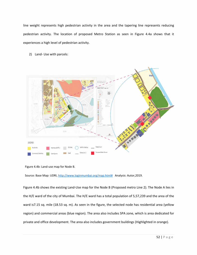
52 | P a g e
line weight represents high pedestrian activity in the area and the tapering line represents reducing
pedestrian activity. The location of proposed Metro Station as seen in Figure 4.4a shows that it
experiences a high level of pedestrian activity.
2) Land- Use with parcels:
Figure 4.4b: Land-use map for Node B.
Source: Base Map: UDRI, http://www.loginmumbai.org/map.html# Analysis: Autor,2019.
Figure 4.4b shows the existing Land-Use map for the Node B (Proposed metro Line 2). The Node A lies in
the H/E ward of the city of Mumbai. The H/E ward has a total population of 5,57,239 and the area of the
ward is7.15 sq. mile (18.53 sq. m). As seen in the figure, the selected node has residential area (yellow
region) and commercial areas (blue region). The area also includes SPA zone, which is area dedicated for
private and office development. The area also includes government buildings (Highlighted in orange).
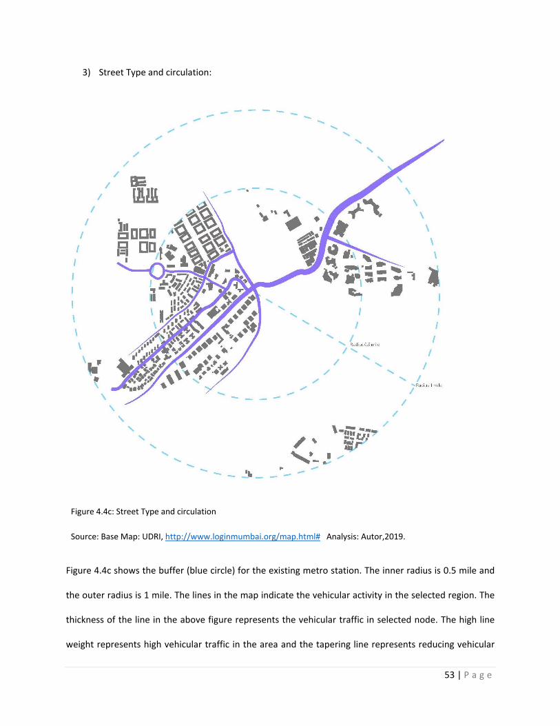
53 | P a g e
3) Street Type and circulation:
Figure 4.4c: Street Type and circulation
Source: Base Map: UDRI, http://www.loginmumbai.org/map.html# Analysis: Autor,2019.
Figure 4.4c shows the buffer (blue circle) for the existing metro station. The inner radius is 0.5 mile and
the outer radius is 1 mile. The lines in the map indicate the vehicular activity in the selected region. The
thickness of the line in the above figure represents the vehicular traffic in selected node. The high line
weight represents high vehicular traffic in the area and the tapering line represents reducing vehicular
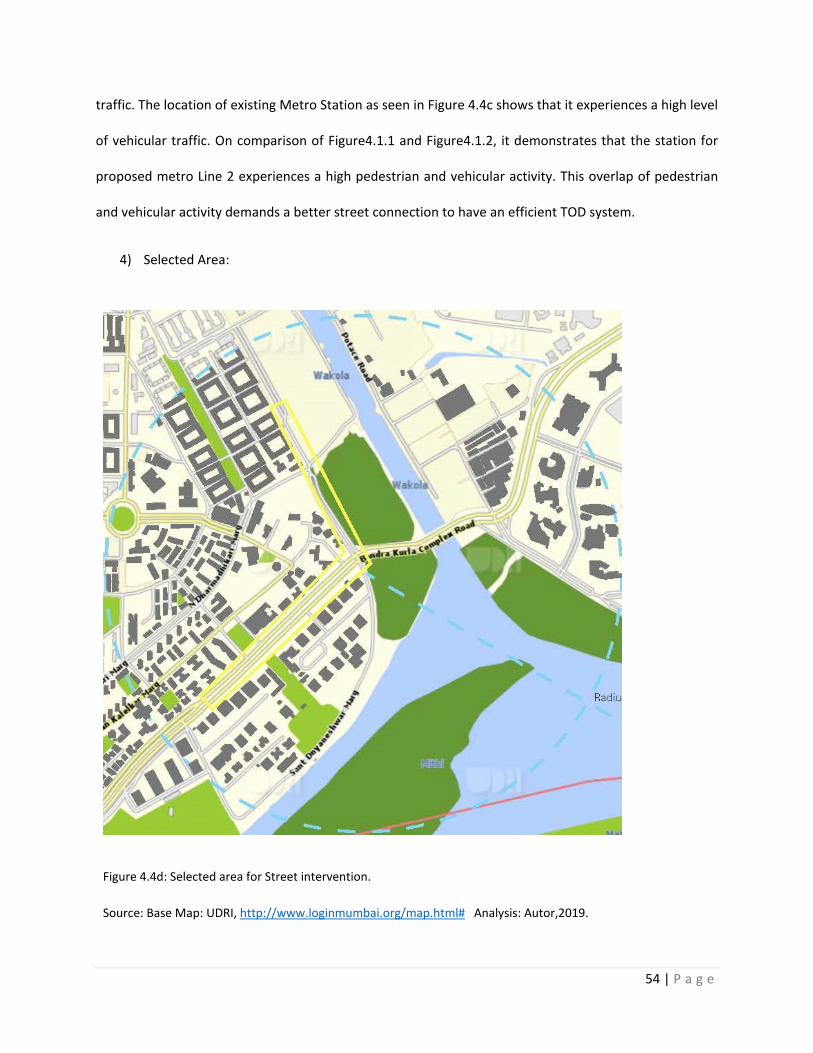
54 | P a g e
traffic. The location of existing Metro Station as seen in Figure 4.4c shows that it experiences a high level
of vehicular traffic. On comparison of Figure4.1.1 and Figure4.1.2, it demonstrates that the station for
proposed metro Line 2 experiences a high pedestrian and vehicular activity. This overlap of pedestrian
and vehicular activity demands a better street connection to have an efficient TOD system.
4) Selected Area:
Figure 4.4d: Selected area for Street intervention.
Source: Base Map: UDRI, http://www.loginmumbai.org/map.html# Analysis: Autor,2019.
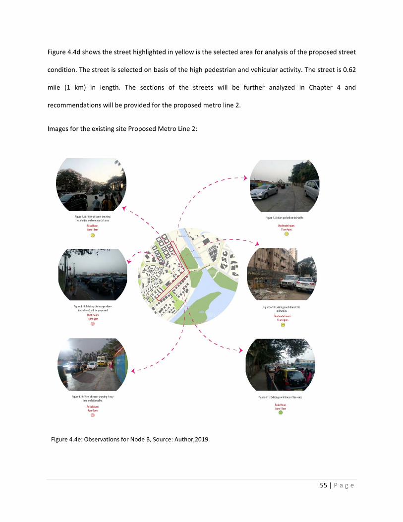
55 | P a g e
Figure 4.4d shows the street highlighted in yellow is the selected area for analysis of the proposed street
condition. The street is selected on basis of the high pedestrian and vehicular activity. The street is 0.62
mile (1 km) in length. The sections of the streets will be further analyzed in Chapter 4 and
recommendations will be provided for the proposed metro line 2.
Images for the existing site Proposed Metro Line 2:
Figure 4.4e: Observations for Node B, Source: Author,2019.
56 | P a g e
Figure 4.10 and figure 4.11 shows the existing road in the selected area. The sidewalks are not utilized by
pedestrians as they are blocked by railing and parked cars. The railing needs to be positioned in a way
which will encourage the pedestrian will use the sidewalk. Th car parking space next to sidewalk needs to
be planned and located alternately and provide openings for sidewalks to be more accessible.
Figure 4.12 and figure 4.13 shows the existing underutilized sidewalks. The car parked on the sidewalk
shows that there is lacking of parking space in the area which is forcing the owners to park on sidewalks.
This alarms for redesign of street as well as a strict policy recommendation for street parking charges to
avoid such incidents.
Based on the results of the observation method, a street analysis is done for the Existing Metro Line 1
(Node A) and Proposed metro Line 2 (Node B) in terms of sections and plans. This analysis will be done
using the guidelines mentioned in street design manual for India and design recommendations will be
provided in next chapter.
57 | P a g e
Chapter 5: Analysis
This chapter includes three typical street sections of the selected street of 0.62-mile (1 km) length for the
existing Metro line 1 which are analyzed based on the Street design guidelines in mentioned in the Street
Design Guidelines for the City of Mumbai and ITDP EPC A manual for Street Design in Urban India. Based
on the results of the analysis of the selected street section for existing metro line 1, design intervention
proposals will be suggested for selected street section for Proposed Metro Line 2. The design
recommendations for the proposed Metro Line 2 consists of two typical street sections for selected street
of 0.62-mile (1km) length and are supported by plans. The analysis is done by understanding the typical
site section which corresponds to the existing site scenario, which will provide recommendations for
street design for proposed Metro Line 2. This chapter is divided in two sections, Section A: Understanding
the guidelines mentioned in the existing manual and Section B: Design Interventions.
Section A: Understanding the guidelines mentioned in Street design guidelines for city of Mumbai and ITDP
EPC a manual for street design in urban India.
Section A explores the guidelines for street design and templates in the 2 manuals namely, Design
Guidelines for the City of Mumbai and ITDP EPC A manual for Street Design in Urban India. The figures
included in this section are extracted from the manual to understand the layout and street design
elements that needs to be considered for roads with varying lanes. 5 images will be discussed from the
manual to understand the street design guidelines.
The guidelines used for determining the street interventions are based on the manual as follows:
1) Street design Guidelines for the city of Mumbai: The objective of this document is to propose a
non-motorized transport strategy for Mumbai along with pedestrian oriented street design
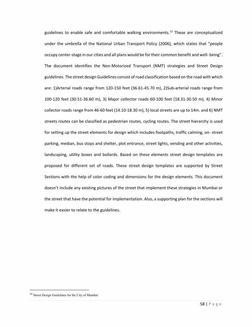
58 | P a g e
guidelines to enable safe and comfortable walking environments.12 These are conceptualized
under the umbrella of the National Urban Transport Policy (2006), which states that “people
occupy center-stage in our cities and all plans would be for their common benefit and well- being”.
The document identifies the Non-Motorized Transport (NMT) strategies and Street Design
guidelines. The street design Guidelines consist of road classification based on the road with which
are: 1)Arterial roads range from 120-150 feet (36.61-45.70 m), 2)Sub-arterial roads range from
100-120 feet (30.51-36.60 m), 3) Major collector roads 60-100 feet (18.31-30.50 m), 4) Minor
collector roads range from 46-60 feet (14.10-18.30 m), 5) local streets are up to 14m. and 6) NMT
streets routes can be classified as pedestrian routes, cycling routes. The street hierarchy is used
for setting up the street elements for design which includes footpaths, traffic calming, on- street
parking, median, bus stops and shelter, plot entrance, street lights, vending and other activities,
landscaping, utility boxes and bollards. Based on these elements street design templates are
proposed for different set of roads. These street design templates are supported by Street
Sections with the help of color coding and dimensions for the design elements. This document
doesn’t include any existing pictures of the street that implement these strategies in Mumbai or
the street that have the potential for implementation. Also, a supporting plan for the sections will
make it easier to relate to the guidelines.
12 Street Design Guidelines for the City of Mumbai
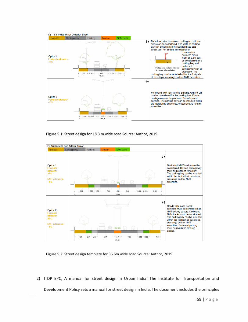
59 | P a g e
Figure 5.1: Street design for 18.3 m wide road Source: Author, 2019.
Figure 5.2: Street design template for 36.6m wide road Source: Author, 2019.
2) ITDP EPC, A manual for street design in Urban India: The Institute for Transportation and
Development Policy sets a manual for street design in India. The document includes the principles
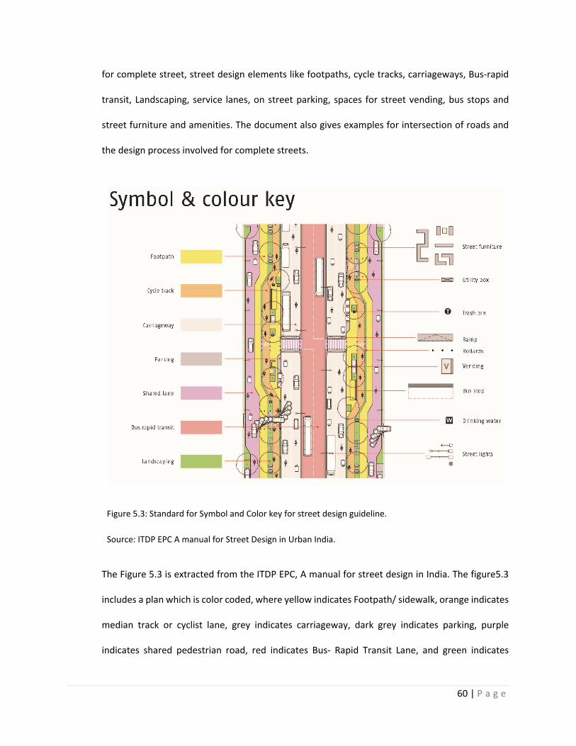
60 | P a g e
for complete street, street design elements like footpaths, cycle tracks, carriageways, Bus-rapid
transit, Landscaping, service lanes, on street parking, spaces for street vending, bus stops and
street furniture and amenities. The document also gives examples for intersection of roads and
the design process involved for complete streets.
Figure 5.3: Standard for Symbol and Color key for street design guideline.
Source: ITDP EPC A manual for Street Design in Urban India.
The Figure 5.3 is extracted from the ITDP EPC, A manual for street design in India. The figure5.3
includes a plan which is color coded, where yellow indicates Footpath/ sidewalk, orange indicates
median track or cyclist lane, grey indicates carriageway, dark grey indicates parking, purple
indicates shared pedestrian road, red indicates Bus- Rapid Transit Lane, and green indicates
61 | P a g e
landscaping. This design template will be used in the paper as a reference for color and symbols
for design interventions.
Figure 5.4: The illustration demonstrates the design template for a 42 m wide Road including a Bus rapid
transit lane.
Source: ITDP EPC A manual for Street Design in Urban India.
The figure 5.4 demonstrates the design template that can be used for a Bus - rapid Transit road
supported by a plan and 3 sections. As per the design template, the street is divided in sections
namely heavy traffic lanes, moderate traffic lanes and non- motorized transit lanes. The bus-rapid
transit lane which consists heavy traffic activity should be placed in the central part of the road
with the bus stop in the middle. After the Bus Rapid Transit Lane, a moderate traffic lane consists
of a carriageway which should be provided which can be 5.50-6.50 wide depending upon the
length of street and traffic congestion. The Pedestrian Lane or Non-motorized traffic lane is the
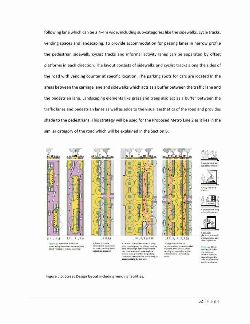
62 | P a g e
following lane which can be 2.4-4m wide, including sub-categories like the sidewalks, cycle tracks,
vending spaces and landscaping. To provide accommodation for passing lanes in narrow profile
the pedestrian sidewalk, cyclist tracks and informal activity lanes can be separated by offset
platforms in each direction. The layout consists of sidewalks and cyclist tracks along the sides of
the road with vending counter at specific location. The parking spots for cars are located in the
areas between the carriage lane and sidewalks which acts as a buffer between the traffic lane and
the pedestrian lane. Landscaping elements like grass and trees also act as a buffer between the
traffic lanes and pedestrian lanes as well as adds to the visual aesthetics of the road and provides
shade to the pedestrians. This strategy will be used for the Proposed Metro Line 2 as it lies in the
similar category of the road which will be explained in the Section B.
Figure 5.5: Street Design layout including vending facilities.
63 | P a g e
Source: ITDP EPC A manual for Street Design in Urban India.
In the Figure 5.5, illustration shows different options for location the vending facilities on the
street. Mumbai is a metropolitan city where street vendors and hawkers are commonly seen in
different parts of the city which often leads to traffic congestion, as they occupy spaces which are
dedicated for vehicular transit. In Figure 4.5, design template is provided for accommodating the
Vendors depending upon the width of the street. In example 1 and 2, the street is 29.5 ft (9 m)
wide and 39.37 ft (12 m) wide respectively. The design template suggests that the pedestrian
islands can be places alternatively on the meandering streets at regular intervals by placing the
vending sections towards the edge of the street and middle of the street alternatively. This design
template helps to reduce the traffic congestion and also diverts the direction of the traffic. The
pedestrian island acts as a platform for informal activities and a speed breaking lane for the
vehicular activity. In example 3, the design template includes a street which is 60-100 ft (18-30.20
m) in width and includes bulb-outs in the parking lane which are located near the pedestrian
crossing to make it more accessible for the vendors and pedestrians. In example 4, a service lane
is interrupted for making space for a large vending platform which can be used as a standard for
designing streets with width more than 120 ft (36.61m). Example 5, consists of a pedestrian island
located at the center of the street with cycle tracks on either side. Figure 5.5 includes sections of
the space utilized for vending facilities depending upon the level of investment and formalization
which includes a simple elevated concrete platform, a fully enclosed shelter, a platform doubling
as lockable storage and a concrete platform with a roof doubling up as a display window. These
design guidelines will be used for street interventions for proposed Metro Line 2 in the Section B
of analysis.
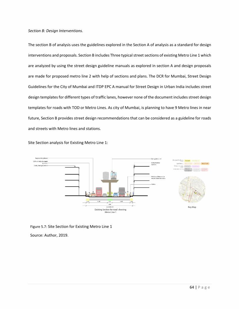
64 | P a g e
Section B: Design Interventions.
The section B of analysis uses the guidelines explored in the Section A of analysis as a standard for design
interventions and proposals. Section B includes Three typical street sections of existing Metro Line 1 which
are analyzed by using the street design guideline manuals as explored in section A and design proposals
are made for proposed metro line 2 with help of sections and plans. The DCR for Mumbai, Street Design
Guidelines for the City of Mumbai and ITDP EPC A manual for Street Design in Urban India includes street
design templates for different types of traffic lanes, however none of the document includes street design
templates for roads with TOD or Metro Lines. As city of Mumbai, is planning to have 9 Metro lines in near
future, Section B provides street design recommendations that can be considered as a guideline for roads
and streets with Metro lines and stations.
Site Section analysis for Existing Metro Line 1:
Figure 5.7: Site Section for Existing Metro Line 1
Source: Author, 2019.
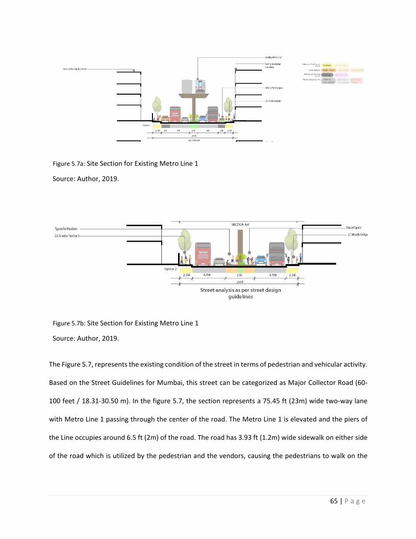
65 | P a g e
Figure 5.7a: Site Section for Existing Metro Line 1
Source: Author, 2019.
Figure 5.7b: Site Section for Existing Metro Line 1
Source: Author, 2019.
The Figure 5.7, represents the existing condition of the street in terms of pedestrian and vehicular activity.
Based on the Street Guidelines for Mumbai, this street can be categorized as Major Collector Road (60-
100 feet / 18.31-30.50 m). In the figure 5.7, the section represents a 75.45 ft (23m) wide two-way lane
with Metro Line 1 passing through the center of the road. The Metro Line 1 is elevated and the piers of
the Line occupies around 6.5 ft (2m) of the road. The road has 3.93 ft (1.2m) wide sidewalk on either side
of the road which is utilized by the pedestrian and the vendors, causing the pedestrians to walk on the
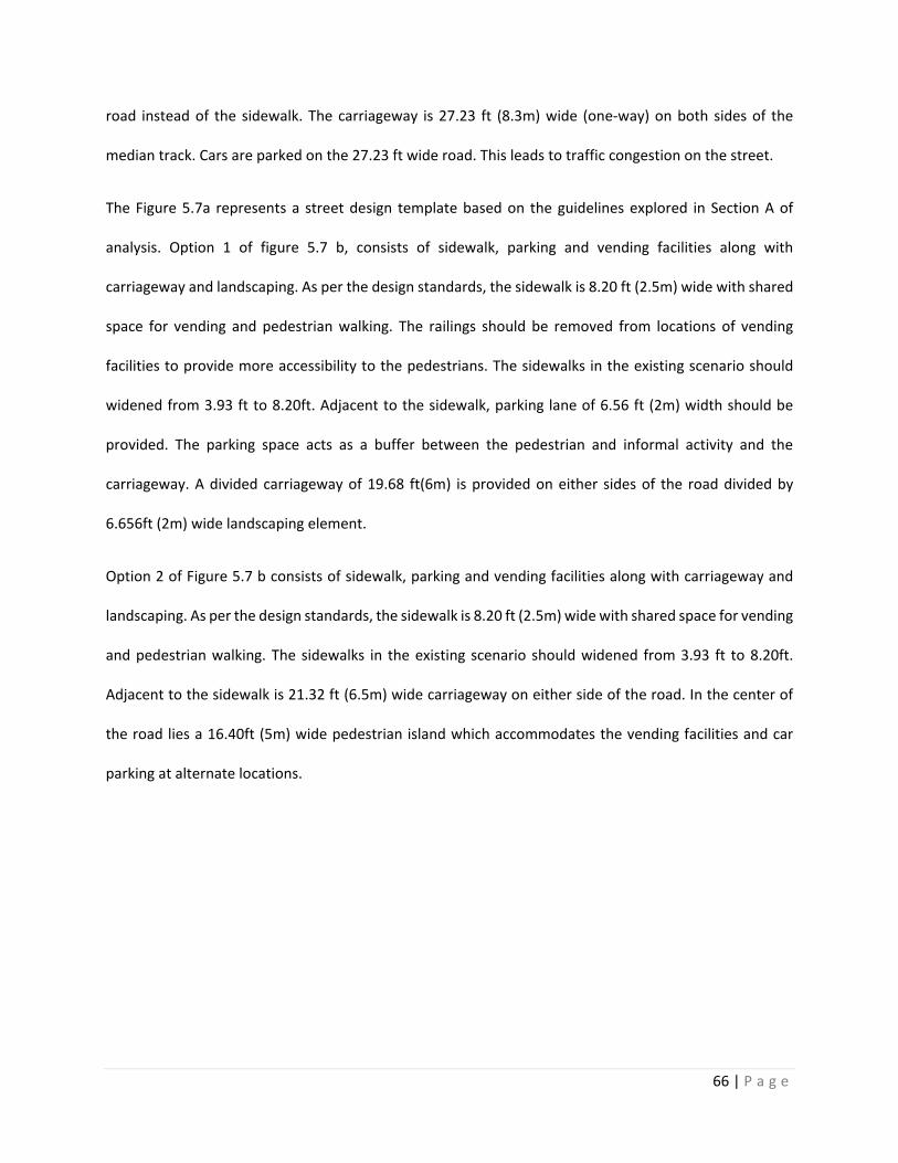
66 | P a g e
road instead of the sidewalk. The carriageway is 27.23 ft (8.3m) wide (one-way) on both sides of the
median track. Cars are parked on the 27.23 ft wide road. This leads to traffic congestion on the street.
The Figure 5.7a represents a street design template based on the guidelines explored in Section A of
analysis. Option 1 of figure 5.7 b, consists of sidewalk, parking and vending facilities along with
carriageway and landscaping. As per the design standards, the sidewalk is 8.20 ft (2.5m) wide with shared
space for vending and pedestrian walking. The railings should be removed from locations of vending
facilities to provide more accessibility to the pedestrians. The sidewalks in the existing scenario should
widened from 3.93 ft to 8.20ft. Adjacent to the sidewalk, parking lane of 6.56 ft (2m) width should be
provided. The parking space acts as a buffer between the pedestrian and informal activity and the
carriageway. A divided carriageway of 19.68 ft(6m) is provided on either sides of the road divided by
6.656ft (2m) wide landscaping element.
Option 2 of Figure 5.7 b consists of sidewalk, parking and vending facilities along with carriageway and
landscaping. As per the design standards, the sidewalk is 8.20 ft (2.5m) wide with shared space for vending
and pedestrian walking. The sidewalks in the existing scenario should widened from 3.93 ft to 8.20ft.
Adjacent to the sidewalk is 21.32 ft (6.5m) wide carriageway on either side of the road. In the center of
the road lies a 16.40ft (5m) wide pedestrian island which accommodates the vending facilities and car
parking at alternate locations.
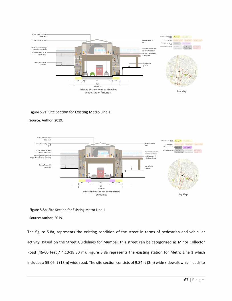
67 | P a g e
Figure 5.7a: Site Section for Existing Metro Line 1
Source: Author, 2019.
Figure 5.8b: Site Section for Existing Metro Line 1
Source: Author, 2019.
The figure 5.8a, represents the existing condition of the street in terms of pedestrian and vehicular
activity. Based on the Street Guidelines for Mumbai, this street can be categorized as Minor Collector
Road (46-60 feet / 4.10-18.30 m). Figure 5.8a represents the existing station for Metro Line 1 which
includes a 59.05 ft (18m) wide road. The site section consists of 9.84 ft (3m) wide sidewalk which leads to
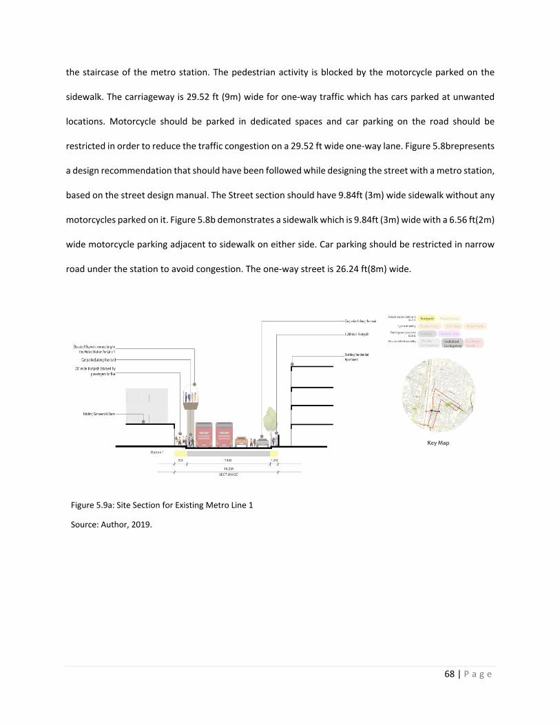
68 | P a g e
the staircase of the metro station. The pedestrian activity is blocked by the motorcycle parked on the
sidewalk. The carriageway is 29.52 ft (9m) wide for one-way traffic which has cars parked at unwanted
locations. Motorcycle should be parked in dedicated spaces and car parking on the road should be
restricted in order to reduce the traffic congestion on a 29.52 ft wide one-way lane. Figure 5.8brepresents
a design recommendation that should have been followed while designing the street with a metro station,
based on the street design manual. The Street section should have 9.84ft (3m) wide sidewalk without any
motorcycles parked on it. Figure 5.8b demonstrates a sidewalk which is 9.84ft (3m) wide with a 6.56 ft(2m)
wide motorcycle parking adjacent to sidewalk on either side. Car parking should be restricted in narrow
road under the station to avoid congestion. The one-way street is 26.24 ft(8m) wide.
Figure 5.9a: Site Section for Existing Metro Line 1
Source: Author, 2019.
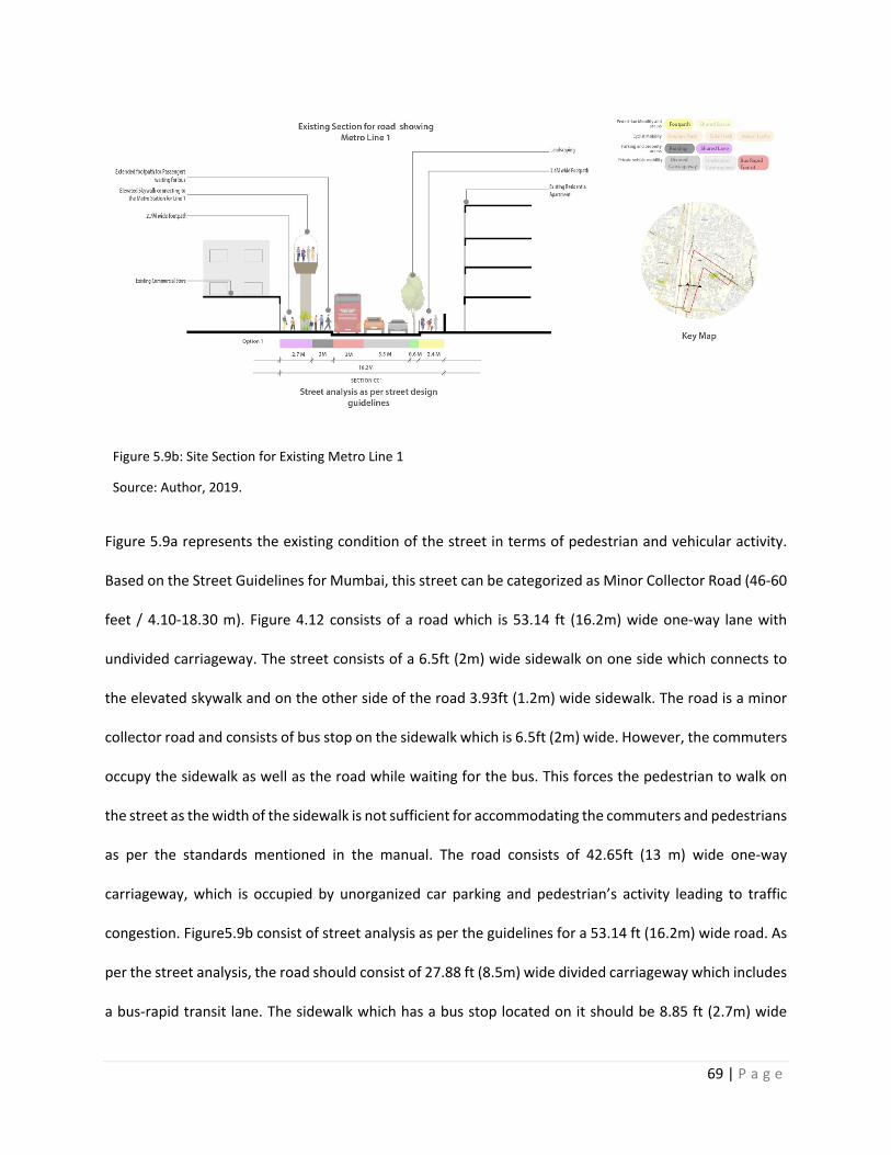
69 | P a g e
Figure 5.9b: Site Section for Existing Metro Line 1
Source: Author, 2019.
Figure 5.9a represents the existing condition of the street in terms of pedestrian and vehicular activity.
Based on the Street Guidelines for Mumbai, this street can be categorized as Minor Collector Road (46-60
feet / 4.10-18.30 m). Figure 4.12 consists of a road which is 53.14 ft (16.2m) wide one-way lane with
undivided carriageway. The street consists of a 6.5ft (2m) wide sidewalk on one side which connects to
the elevated skywalk and on the other side of the road 3.93ft (1.2m) wide sidewalk. The road is a minor
collector road and consists of bus stop on the sidewalk which is 6.5ft (2m) wide. However, the commuters
occupy the sidewalk as well as the road while waiting for the bus. This forces the pedestrian to walk on
the street as the width of the sidewalk is not sufficient for accommodating the commuters and pedestrians
as per the standards mentioned in the manual. The road consists of 42.65ft (13 m) wide one-way
carriageway, which is occupied by unorganized car parking and pedestrian’s activity leading to traffic
congestion. Figure5.9b consist of street analysis as per the guidelines for a 53.14 ft (16.2m) wide road. As
per the street analysis, the road should consist of 27.88 ft (8.5m) wide divided carriageway which includes
a bus-rapid transit lane. The sidewalk which has a bus stop located on it should be 8.85 ft (2.7m) wide
70 | P a g e
having a adjacent parking lane which is 6.56 ft (2m) wide. The parking lane should have bulb-out at the
location of bus stops to accommodate the commuters and bus stop. On the rare side of the road, the
sidewalk should be widened from 3.93ft (1.2m) to 7.87ft (2.4m) with a buffer of 1.96 ft (0.6m) landscape
between the road and sidewalk. This will avoid the pedestrian from walking on the street and causing
traffic congestion.
The analysis for the Node A (Proposed Metro Station 1) can summarized as:
A. The Five major issues identified after the analysis are:
1. Poorly maintained sidewalks: As shown in figures 5.7, 5.8 and 5.9, the sidewalks are not
maintained in terms of pedestrian management. The location of the staircases for entry/ exit of
the commuters to the metro station needs to be planned. The sidewalks tend to end abruptly at
certain locations due to which the pedestrians need to use the vehicular road instead of sidewalks
which causes congestion and safety issues. The width of the sidewalk is not efficient to
accommodate the commuters, pedestrians and street vendors.
2. Lack of parking management: As shown in figures 5.7, 5.8 and 5.9, there is lack of parking
management which obstructs the pedestrian connectivity. Cars are parked right outside the entry
/ exit location to the Metro station 1 which adds up to the commute time as the passenger needs
to divert his direction of walking. Specific areas need to be identified as parking zones and parking
hours should be mentioned on the streets based on the analysis.
3. Absence of Bus rapid transit lane: The analysis demonstrates that the vehicular lane doesn’t
provide any division for Bus rapid transit lane and small/ heavy vehicular lane. As per the ITDP
EPC: A manual for street design in Urban India, the roads consists of divisions like- a carriageway
with heavy vehicular traffic in the center of the road, with small traffic lanes on either sides, BRTS
lanes towards the sidewalk which will be easily accessible by the bus stops, a buffer through
71 | P a g e
landscaping elements like trees, shrubs and plants, a sidewalk which can consists of pedestrian
way, cycle track or shared lane. The redesign of Node B (Proposed Metro Station 2) should
consider these street design elements in order to provide pedestrian friendly street designs.
4. No dedicated space for vendors: The analysis indicates that the vendors are not provided any
dedicated spaces on the streets in Node A. Street vending and street hawking are major activities
in India which demands a consideration in planning policies for street design elements. As the
street lacks the provision for the vendors, it causes hinderance for a free pedestrian movement
around the Metro station. Pedestrian islands should be provided at possible locations to
accommodate street activities.
5. Street design lacks space for future commuters: The analysis shows that future expansion of rail
and metro corridors is not considered while designing the Metro Station 1. The elevated skywalks
which lead to the Metro Station 1 occupy the land which reduces the areas for activities like street
parking, street vending and commuter activities. Most of the commuters access the metro station
by modes of transportation like rail, auto-rickshaw, bus and taxis. There is no dedicated space
around the metro station 1 to accommodate the areas where autos, buses and taxis can be
parked. The location of an auto, bus and taxi stand should be reconsidered while designing the
proposed Metro Line 2 in order to accommodate the future commuters.
B. The design recommendations that can solve these five major issues mentioned above are:
1. Improved Mobility: The widening of the sidewalks will lead to improved mobility for the
pedestrians as well as the vehicular traffic. Improved mobility will help to reduce the commuter
travel time in terms of walkability and it will reduce the congestion on the streets caused because
of mis-management of the pedestrian and vehicular traffic. Improved mobility should be
72 | P a g e
considered as a design guideline for Node B (Proposed Metro Line 2) which will accommodate the
existing and future commuters.
2. Improved pedestrian accessibility: Pedestrian buffer spaces and pedestrian islands should be
provided at locations like street crossing, waiting areas near the entry/exit to the Metro station
and street vending stations. The pedestrian accessibility should include accessibility to areas like
Metro station, nearest amenities, street vendors and bus stops. As per the analysis for Metro Line
1 accessibility to Metro station is only given preference neglecting other areas near the station
like shops, vendors, restaurants, offices, residential and commercial areas. A design template
should consider for Node B (Proposed Metro Line 2) which includes accessibility which responds
to the Land-use.
3. Livability: The existing conditions for Node A indicates that vehicular transit is a priority for street
design. Livability is an important element for street design as it adds the life to the street. On
Indian streets activities like vending and street artists and performers are commonly found. In
order to accommodate these activities, Urban Design policies should be considered while
designing a street. Elements like water fountain, street furniture, interactive walls and street
landscapes adds livability to the street. They also promote walking over use of vehicular transport.
4. Sensitivity to local context: The street design currently in Node A doesn’t respond to the existing
Land-use. The Node B falls in an area where there is a mix of residential and commercial areas.
This indicates that the street will be used by residents as well as office goers at different times of
the day. Addition of a Metro Station indicates that the residential neighborhood will increase
street activity from 8am-8pm. It also indicates that there will be certain time when the street will
be under-utilized. Hence, the street design for Node B should consider that fact to be sensitive to
the future Land-Use. Rail and Metro corridor expansions should be considered while designing a
street which will accommodate the future commuters.
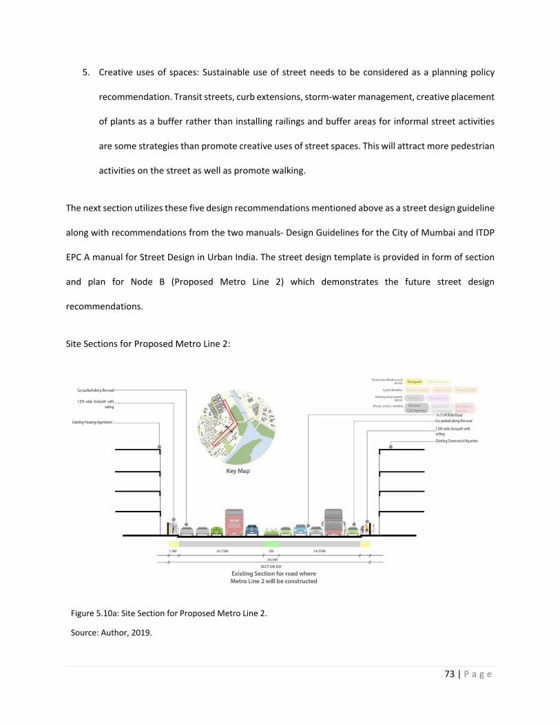
73 | P a g e
5. Creative uses of spaces: Sustainable use of street needs to be considered as a planning policy
recommendation. Transit streets, curb extensions, storm-water management, creative placement
of plants as a buffer rather than installing railings and buffer areas for informal street activities
are some strategies than promote creative uses of street spaces. This will attract more pedestrian
activities on the street as well as promote walking.
The next section utilizes these five design recommendations mentioned above as a street design guideline
along with recommendations from the two manuals- Design Guidelines for the City of Mumbai and ITDP
EPC A manual for Street Design in Urban India. The street design template is provided in form of section
and plan for Node B (Proposed Metro Line 2) which demonstrates the future street design
recommendations.
Site Sections for Proposed Metro Line 2:
Figure 5.10a: Site Section for Proposed Metro Line 2.
Source: Author, 2019.
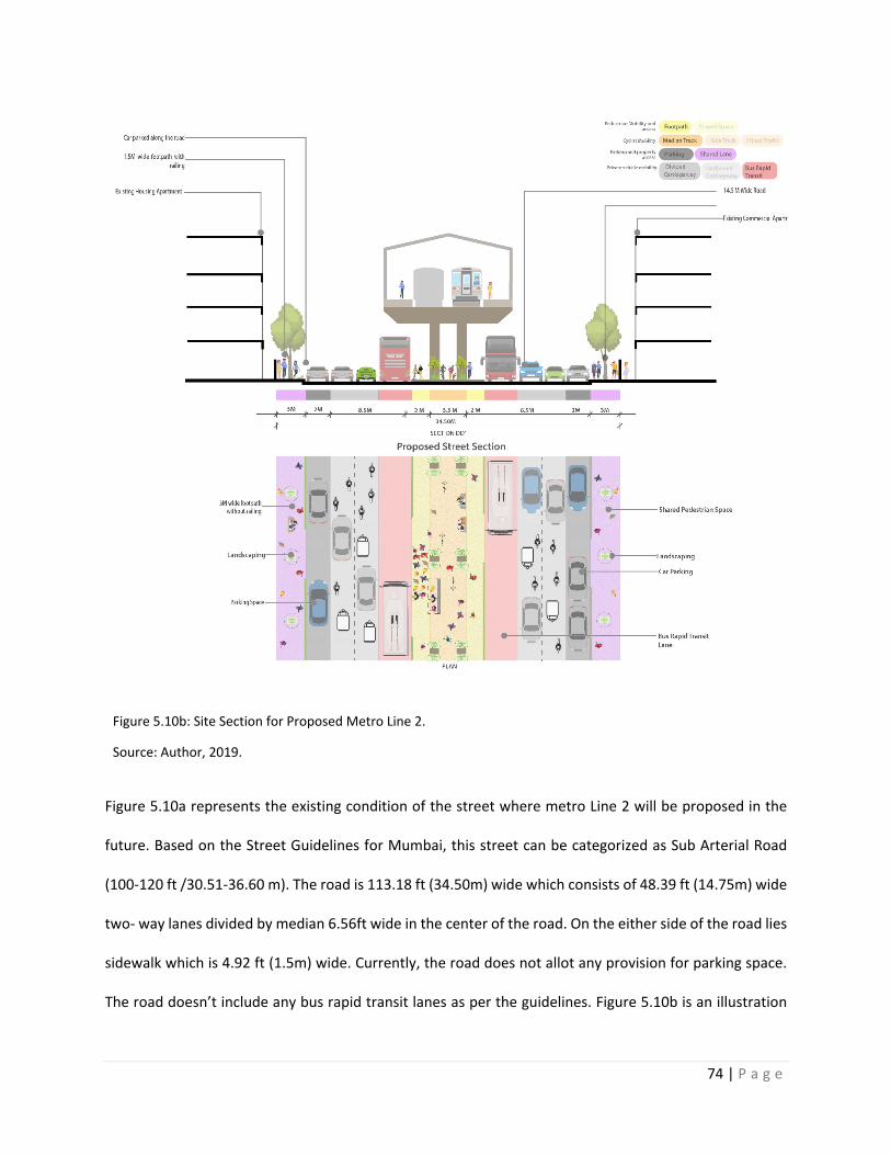
74 | P a g e
Figure 5.10b: Site Section for Proposed Metro Line 2.
Source: Author, 2019.
Figure 5.10a represents the existing condition of the street where metro Line 2 will be proposed in the
future. Based on the Street Guidelines for Mumbai, this street can be categorized as Sub Arterial Road
(100-120 ft /30.51-36.60 m). The road is 113.18 ft (34.50m) wide which consists of 48.39 ft (14.75m) wide
two- way lanes divided by median 6.56ft wide in the center of the road. On the either side of the road lies
sidewalk which is 4.92 ft (1.5m) wide. Currently, the road does not allot any provision for parking space.
The road doesn’t include any bus rapid transit lanes as per the guidelines. Figure 5.10b is an illustration
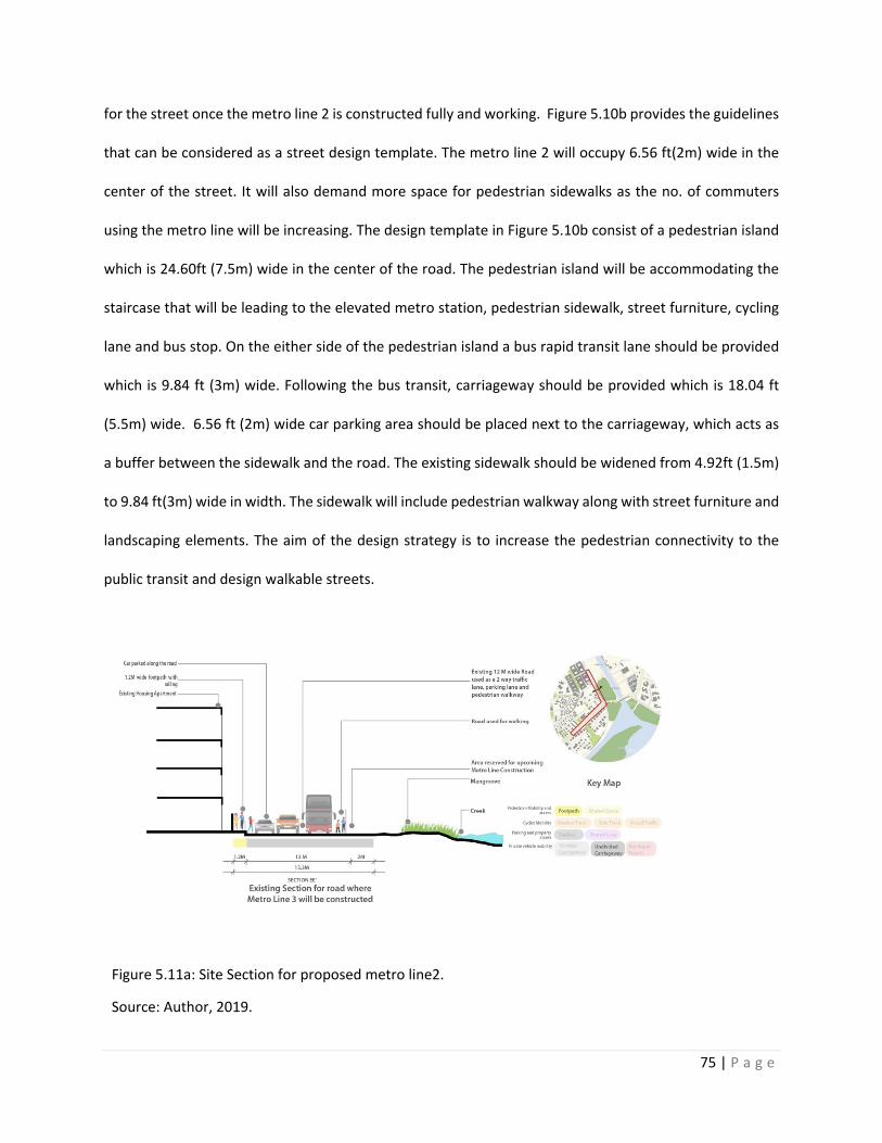
75 | P a g e
for the street once the metro line 2 is constructed fully and working. Figure 5.10b provides the guidelines
that can be considered as a street design template. The metro line 2 will occupy 6.56 ft(2m) wide in the
center of the street. It will also demand more space for pedestrian sidewalks as the no. of commuters
using the metro line will be increasing. The design template in Figure 5.10b consist of a pedestrian island
which is 24.60ft (7.5m) wide in the center of the road. The pedestrian island will be accommodating the
staircase that will be leading to the elevated metro station, pedestrian sidewalk, street furniture, cycling
lane and bus stop. On the either side of the pedestrian island a bus rapid transit lane should be provided
which is 9.84 ft (3m) wide. Following the bus transit, carriageway should be provided which is 18.04 ft
(5.5m) wide. 6.56 ft (2m) wide car parking area should be placed next to the carriageway, which acts as
a buffer between the sidewalk and the road. The existing sidewalk should be widened from 4.92ft (1.5m)
to 9.84 ft(3m) wide in width. The sidewalk will include pedestrian walkway along with street furniture and
landscaping elements. The aim of the design strategy is to increase the pedestrian connectivity to the
public transit and design walkable streets.
Figure 5.11a: Site Section for proposed metro line2.
Source: Author, 2019.
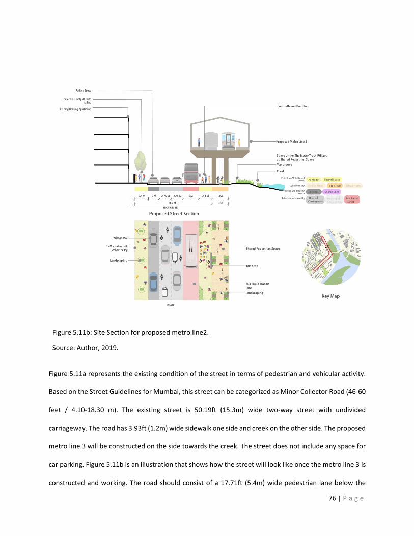
76 | P a g e
Figure 5.11b: Site Section for proposed metro line2.
Source: Author, 2019.
Figure 5.11a represents the existing condition of the street in terms of pedestrian and vehicular activity.
Based on the Street Guidelines for Mumbai, this street can be categorized as Minor Collector Road (46-60
feet / 4.10-18.30 m). The existing street is 50.19ft (15.3m) wide two-way street with undivided
carriageway. The road has 3.93ft (1.2m) wide sidewalk one side and creek on the other side. The proposed
metro line 3 will be constructed on the side towards the creek. The street does not include any space for
car parking. Figure 5.11b is an illustration that shows how the street will look like once the metro line 3 is
constructed and working. The road should consist of a 17.71ft (5.4m) wide pedestrian lane below the
77 | P a g e
elevated metro line 3. The pedestrian lane should consist of 7.87ft (2.4m) wide sidewalk and 9.84 ft(3m)
wide shred lane with street furniture and cycle track. The sidewalk will have bulb- out which will
accommodate the bus stop below the elevated metro line 3. Adjacent to the sidewalk should be a 9.84ft
(3m) wide bus-rapid transit lane. The road should consist a carriageway which is 18.04 ft (5.5m) wide.
Alongside the carriageway, a 6.56ft (2m) wide parking space should be provided on one side of the road.
The existing sidewalk should be widened from 3.93ft (1.2m) to 7.87 ft (2.4m) wide. The sidewalk will be
used as a shared space with landscaping elements and street furniture. These recommendations for street
design can be considered as a guideline for transit-oriented development projects.
The street design templates provided for the selected street sections can be used as an addition to the
manual of street design guidelines for India. The manual should include illustrations including 2-D and 3-
D illustrations of how the street will look, when these interventions are used. In the following Chapter 5,
the strategies are discussed that need to be considered for street designing for TOD to promote pedestrian
connectivity and walkability.
78 | P a g e
Chapter 6: Discussion and Conclusion
The street design guidelines can be implemented on the upcoming metro lines in Mumbai. The problems
identified in the existing streets can be avoided using the street design templates.
The Policy recommendations based on the analysis area as follows:
The Development Control Regulations (DCR) 2034 is a document created by Municipal Corporation of
Greater Mumbai in relation to the Development Plan 2034. The Draft Development Plan (DP) for Greater
Mumbai (2014 – 2036) identifies the potential T.O.D zones within the city as seen in Figure 2.6. However,
it can be supported with a separate document / section where it categorizes the areas at a micro scale for
TOD development. The DP redirects to DCR which set guidelines for streetscape in written format which
can be improvised by adding plans, sections and existing site pictures to make the document more
readable and adaptable. The DCR includes guidelines in terms of administration, development permission,
Land-Uses and Manners of development, FSI, general building requirements and urban safety
requirements. The design guidelines included in the DCR provide standards that needs to be considered
while designing a street which elaborates on streetscapes for public street, road intersections, median
refuge, traffic signals, subways and foot over bridges. The following are the design guidelines mentioned
for streetscapes of public street. The pedestrian crossings should benefit the physically abled and people
with visual impairments by constructing the guide strips to indicate the position of the pedestrian
crossings and have curb ramps. The raised median refuges should be cut through and levelled with the
street level and should have curb ramps. In order to guide the pedestrians who are physically abled and
have visual impairments, a colored tactile marking strip which is at least 1.9 feet (0.6m) wide should be
marked at the beginning and end of the traffic island. The pedestrian traffic lights should be located at the
point of the origin of the crossings and not at the point of destination. The traffic lights should be provided
with clear audible signals and acoustic devices. Signages should be provided for foot over bridges and
79 | P a g e
subways. To enable wheelchair accessibility a provision of slope ramps or lifts should be made at both
ends of the road. The document does not support the guidelines with any sections or plan for Streets. The
document also fails to provide any reference to the existing street guidelines for Urban India created by
ITDP. The document can be improvised by addition of illustrations which provide street design templates
for physically abled and elderly people.
Street Design Guidelines for Greater Mumbai should include the reference images of the street similar to
the guideline created by ITDP for urban streets. The guidelines can include suggestions for Land-use
annexation if required and provide with list of scenarios where the Land-use can be modified. The DCR
and the street Guidelines should be relatable to in terms of Land- use policies. A scoreboard can be created
to grade the quality of the street corresponding to the street guidelines, which will further help to identify
the T.O.D zones within the city. Looking at the financial structure of the Metro lines in Mumbai as shown
in Table 1, a comparative analysis can be made to understand which Model of financial structure worked
better and can be used as a model for other cities in India.
A transport Infrastructure development policy needs to be adopted which promotes Transit oriented
development. The factors that need to be considered are shown in Figure 6.1 1) Connection to transit:
Elevated walkways and Widening of sidewalks, 2) Restricted car use: car restricted zones and car free
zones, car-pooling, promoting cycling and congestion pricing,, 3) Parking policy: Park and Ride, ensuring
parking space at home and office, congestion pricing, and parking management, 4) Road Infrastructure:
improvement of NMT infrastructure, better Bus rapid transit system, expansion of rail and metro corridors
and online ticketing and tracking system.
Planning and Urban design Policy recommendations
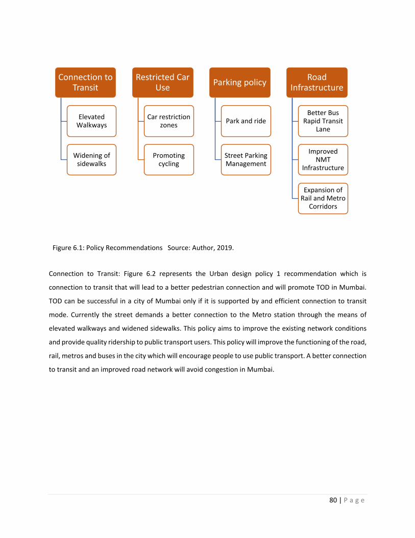
80 | P a g e
Figure 6.1: Policy Recommendations Source: Author, 2019.
Connection to Transit: Figure 6.2 represents the Urban design policy 1 recommendation which is
connection to transit that will lead to a better pedestrian connection and will promote TOD in Mumbai.
TOD can be successful in a city of Mumbai only if it is supported by and efficient connection to transit
mode. Currently the street demands a better connection to the Metro station through the means of
elevated walkways and widened sidewalks. This policy aims to improve the existing network conditions
and provide quality ridership to public transport users. This policy will improve the functioning of the road,
rail, metros and buses in the city which will encourage people to use public transport. A better connection
to transit and an improved road network will avoid congestion in Mumbai.
Connection to Transit
Elevated Walkways
Widening of sidewalks
Restricted Car Use
Car restriction zones
Promoting cycling
Parking policy
Park and ride
Street Parking Management
Road Infrastructure
Better Bus Rapid Transit
Lane
Improved NMT
Infrastructure
Expansion of Rail and Metro
Corridors
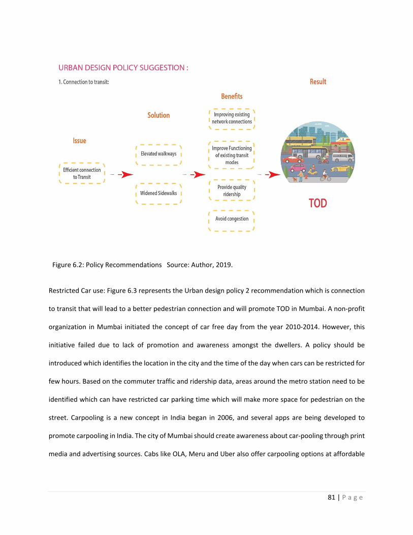
81 | P a g e
Figure 6.2: Policy Recommendations Source: Author, 2019.
Restricted Car use: Figure 6.3 represents the Urban design policy 2 recommendation which is connection
to transit that will lead to a better pedestrian connection and will promote TOD in Mumbai. A non-profit
organization in Mumbai initiated the concept of car free day from the year 2010-2014. However, this
initiative failed due to lack of promotion and awareness amongst the dwellers. A policy should be
introduced which identifies the location in the city and the time of the day when cars can be restricted for
few hours. Based on the commuter traffic and ridership data, areas around the metro station need to be
identified which can have restricted car parking time which will make more space for pedestrian on the
street. Carpooling is a new concept in India began in 2006, and several apps are being developed to
promote carpooling in India. The city of Mumbai should create awareness about car-pooling through print
media and advertising sources. Cabs like OLA, Meru and Uber also offer carpooling options at affordable
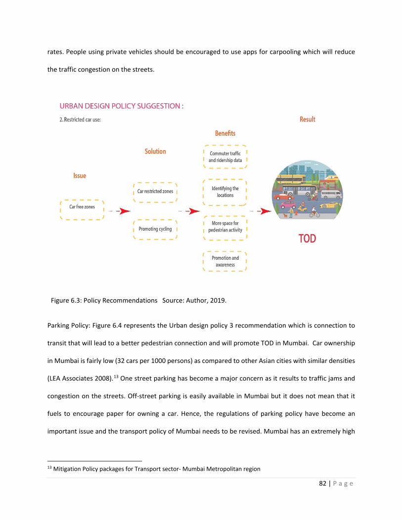
82 | P a g e
rates. People using private vehicles should be encouraged to use apps for carpooling which will reduce
the traffic congestion on the streets.
Figure 6.3: Policy Recommendations Source: Author, 2019.
Parking Policy: Figure 6.4 represents the Urban design policy 3 recommendation which is connection to
transit that will lead to a better pedestrian connection and will promote TOD in Mumbai. Car ownership
in Mumbai is fairly low (32 cars per 1000 persons) as compared to other Asian cities with similar densities
(LEA Associates 2008).13 One street parking has become a major concern as it results to traffic jams and
congestion on the streets. Off-street parking is easily available in Mumbai but it does not mean that it
fuels to encourage paper for owning a car. Hence, the regulations of parking policy have become an
important issue and the transport policy of Mumbai needs to be revised. Mumbai has an extremely high
13 Mitigation Policy packages for Transport sector- Mumbai Metropolitan region
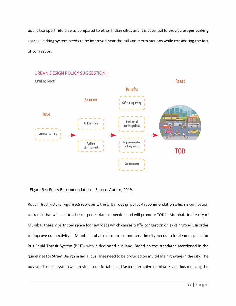
83 | P a g e
public transport ridership as compared to other Indian cities and it is essential to provide proper parking
spaces. Parking system needs to be improved near the rail and metro stations while considering the fact
of congestion.
Figure 6.4: Policy Recommendations Source: Author, 2019.
Road Infrastructure: Figure 6.5 represents the Urban design policy 4 recommendation which is connection
to transit that will lead to a better pedestrian connection and will promote TOD in Mumbai. In the city of
Mumbai, there is restricted space for new roads which causes traffic congestion on existing roads. In order
to improve connectivity in Mumbai and attract more commuters the city needs to implement plans for
Bus Rapid Transit System (BRTS) with a dedicated bus lane. Based on the standards mentioned in the
guidelines for Street Design in India, bus lanes need to be provided on multi-lane highways in the city. The
bus rapid transit system will provide a comfortable and faster alternative to private cars thus reducing the
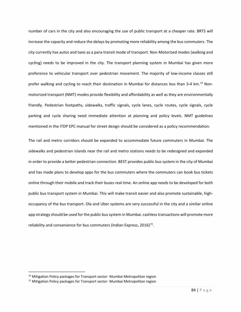
84 | P a g e
number of cars in the city and also encouraging the use of public transport at a cheaper rate. BRTS will
increase the capacity and reduce the delays by promoting more reliability among the bus commuters. The
city currently has autos and taxis as a para-transit mode of transport. Non-Motorized modes (walking and
cycling) needs to be improved in the city. The transport planning system in Mumbai has given more
preference to vehicular transport over pedestrian movement. The majority of low-income classes still
prefer walking and cycling to reach their destination in Mumbai for distances less than 3-4 km.14 Non-
motorized transport (NMT) modes provide flexibility and affordability as well as they are environmentally
friendly. Pedestrian footpaths, sidewalks, traffic signals, cycle lanes, cycle routes, cycle signals, cycle
parking and cycle sharing need immediate attention at planning and policy levels. NMT guidelines
mentioned in the ITDP EPC manual for street design should be considered as a policy recommendation.
The rail and metro corridors should be expanded to accommodate future commuters in Mumbai. The
sidewalks and pedestrian islands near the rail and metro stations needs to be redesigned and expanded
in order to provide a better pedestrian connection. BEST provides public bus system in the city of Mumbai
and has made plans to develop apps for the bus commuters where the commuters can book bus tickets
online through their mobile and track their buses real time. An online app needs to be developed for both
public bus transport system in Mumbai. This will make transit easier and also promote sustainable, high-
occupancy of the bus transport. Ola and Uber systems are very successful in the city and a similar online
app strategy should be used for the public bus system in Mumbai. cashless transactions will promote more
reliability and convenience for bus commuters (Indian Express, 2016)15.
14 Mitigation Policy packages for Transport sector- Mumbai Metropolitan region 15 Mitigation Policy packages for Transport sector- Mumbai Metropolitan region
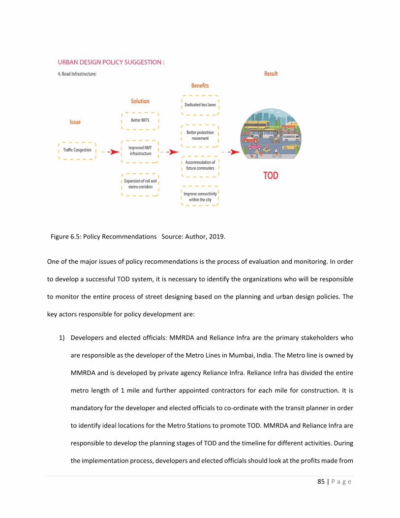
85 | P a g e
Figure 6.5: Policy Recommendations Source: Author, 2019.
One of the major issues of policy recommendations is the process of evaluation and monitoring. In order
to develop a successful TOD system, it is necessary to identify the organizations who will be responsible
to monitor the entire process of street designing based on the planning and urban design policies. The
key actors responsible for policy development are:
1) Developers and elected officials: MMRDA and Reliance Infra are the primary stakeholders who
are responsible as the developer of the Metro Lines in Mumbai, India. The Metro line is owned by
MMRDA and is developed by private agency Reliance Infra. Reliance Infra has divided the entire
metro length of 1 mile and further appointed contractors for each mile for construction. It is
mandatory for the developer and elected officials to co-ordinate with the transit planner in order
to identify ideal locations for the Metro Stations to promote TOD. MMRDA and Reliance Infra are
responsible to develop the planning stages of TOD and the timeline for different activities. During
the implementation process, developers and elected officials should look at the profits made from
86 | P a g e
the investments and understand the pattern to be followed for future investments. MMRDA looks
at the TOD for city as a whole and is responsible for obtaining financial benefits as the TOD
development will lead to increase in Land value and increased tax revenue.
2) Urban planners and designers: The urban planners and designers should ensure that the TOD
project leads to livable and walkable neighborhoods, economic well-being of the community,
diverse land-use, community development and pedestrian friendly street design. Urban planners
and designers develop master plans which corresponds to the population growth, ridership data
and transit needs.
3) Financiers: Financiers look after the funding of the Metro station for TOD development. The
financers should look after the revenue flows and profit returns from the investments made.
Financers can be both public and private agencies.
4) Public: The citizens of Mumbai, India are responsible in maintaining the street life. Waste
management issues, following the parking management rules and payment of parking fees, taking
acre of the ambience of the area and acting publicly responsible are the duties of an ideal citizen.
The citizens should make sure that the maintenance of walkable neighborhood is their duty.
Citizens should make less use of private transport whenever possible to promote pedestrian
activity in the neighborhood. Car-pooling options can be used in order to reduce the vehicular
congestion which will provide more space for street activities.
If the monitoring and evaluation shows progress in the development of TOD nodes in city of Mumbai, the
results will show mobility, economic environmental and social benefits.
1) Mobility benefits: Implementation of TOD nodes with positive results will provide mobility
benefits as people will prefer pedestrian modes over vehicular modes of transport. In terms of

87 | P a g e
walking distance to the Transit nodes will be reduced and people will prefer public transport over
private transport in Mumbai, India. A better pedestrian connectivity will improve access to jobs,
schools, colleges, and other amenities supported by a better access to public transportation,
walkable urban spaces, bicyclist infrastructure which will reduce the use of vehicular transport.
TOD can lead to increase in the use of public transport economies which will lead to improvement
in quality of services.
2) Economic benefits: TOD can encourage economic resilience as it helps in development of local
economic activity. The property values of the areas with better TOD will increase which will lead
to increase in housing and infrastructure development in Mumbai, India. TOD’s will promote
mixed-used development which will be easily accessible by the residents within half-mile distance
radius. As the transportation costs reduces, TOD’s can lead to other economic opportunities.
3) Environmental benefits: Less use of auto-mobiles and vehicles will lead to reduction in air
pollution, lower green house gases emissions and less energy consumption. The reduction of
auto-dependency will promote conservation of nature. Addition of landscaping elements like
trees and shrubs will provide fresh air and reduce pollution in the city.
4) Social Benefits: Neighborhood revitalization, social activities will increase due to successful TOD
system in the city. Walkable neighborhoods will provide accessibility to public spaces, parks,
community gathering areas and entertainment zones within the city. This will result in bringing
the people outside the house in a mixed-used neighborhood which will lead to mental and health
benefits. TOD’s will promote happiness due to increased interactions and physical activities like
bicycling, dog-walking and street activities.

88 | P a g e
Contribution and Future Research
Contribution
This paper contributes to the urban design and planning policy recommendations for streetscaping in city
of Mumbai. Findings of the study show the relationship between TOD and pedestrian connectivity. The
study focuses on the aim of Mumbai to develop a TOD system and helps to find solutions to existing
scenario by looking at one of the essential factors which is pedestrian connectivity. The goal of this
research paper is to provide street templates which can be a part of the of the street design manual for
Urban India. The study provides simple street design templates supported by plans and sections which
include street design elements like sidewalks, carriageways, Bus rapid transit lanes, vending facilities,
street furniture, car parking facilities and landscaping. The study suggests additions that can be made to
develop a better TOD system and encourage the use of public transport by prioritizing street
infrastructure. The paper identifies the existing metro station in Mumbai, India and analysis the existing
infrastructure in terms of roadways and transport. This study will help to determine the need of
considering the development of road infrastructure in terms of pedestrian streets and connectivity for the
upcoming metro stations in Mumbai, India. The results obtained from the analysis will set a benchmark
for street design guidelines for the metro lines which yet proposed and expected to be developed in
future.
The study also provides recommendations for the policies that needs to be considered as a planning
objective. The study suggests transport infrastructure development policies that should be a part of the
planning policy for Mumbai to have an efficient TOD system in the city. The paper explores the benefits
of the policies like connection to transit, restricted car use, parking policy and road infrastructure. The
study highlights the policies the ability of a better pedestrian connectivity to improve a strong and
89 | P a g e
successful TOD system in the city of Mumbai by the improvement in the policies related to street and
transport infrastructure.
Limitations and Future Research
The study focuses on two specific nodes mentioned in the Draft development Plan of Mumbai 2014-2034.
The study is limited to one node of existing metro line 1 and one node of proposed Metro line 2. To have
a better TOD system in Mumbai, all the major nodes mentioned in the Draft Development Plan of Mumbai
2014-2034 needs to be explored by using similar methodology. The paper used the methodology of
observation method to understand the level of pedestrian connectivity required to have an efficient TOD
system at selected nodes. The recommendations suggested in Chapter 4 of analysis in terms of street
design needs to be adjusted for other street design interventions in the city. In future, similar
methodology should be used to understand pedestrian connectivity which includes street design
elements, Bus rapid transit system and Non-motorized transport system. The study should look after
pedestrian catchment areas and intersection analysis. Pedestrian a catchment area includes analysis of
walkable zone within a half-mile radius of selected node while intersection analysis includes the
intersections of different types of road which looks after the dead ends that limits the pedestrian access.
A GIS based analysis identifies the intersections of different roads within selected buffer. It will help to
understand the street crossings that pedestrian use and are affected by vehicular traffic.
The study is limited to city of Mumbai and can be extended to other cities in India which are planning to
have Metro system in future. Currently 10 cities in India namely, Kolkata, Delhi, Chennai, Bengaluru,
Hyderabad, Jaipur, Gurgaon, Mumbai. Kochi and Lucknow have metro rail system which is working. The
cities like Pune, Kanpur, Surat, Coimbatore, Nagpur are planning to have metro line by the year 2025. A
study can be done similar to the areas explored in the paper to provide better urban design and planning
recommendations for the country in terms of pedestrian connectivity. There are also plans for
90 | P a g e
underground metro line system in Mumbai and other major cities in India. The study can be extended to
focus on the factors of light and ventilation, platform design, storage facilities supported with plans,
layouts and3-D views. The ITDP EPC A manual for Street design in urban India, identifies the elements that
needs to be considered for street design above the ground and a section can be added for design of public
spaces below the ground like metro stations. A separate manual can be made for design guidelines
templates which includes climate control requirements, lighting, buffer spaces, specific materials and
utility location which are not similar to streetscaping for metro stations above ground.
As the concept of carpooling is new in Indian cities, it demands a policy consideration as well. Most of the
dwellers of Mumbai are familiar with Carpooling and private providers like OLA and Uber. The city has
traditional bus stops, auto-rickshaw and taxi stands. Ola auto-rickshaw are recently launched in the city.
This means that there should be separate provision for OLA auto-rickshaw pickup and drop off stands.
Currently, the city does have a dedicated zone for private cabs which forces the pedestrians to come on
the road and access the vehicle. A pedestrian island should be created where commuters can access
private cabs or car-pooling facilities. The city needs to develop apps which will encourage carpooling
services in Mumbai and this will help to reduce the use of private vehicles thus, reducing traffic congestion
on the roads.
Transit Oriented Development (TOD) requires a commitment to nodes and a commitment to rail as its
core ingredients. TOD demands a strategic policy framework that asserts where nodes need to occur and
in the context of diversity of Land- Use, a policy planning base that requires development to occur at the
necessary density and design in each node, preferably by a state government development agency, a
public-private partnership mechanism that enables the rail to be built or refurbished through a linkage to
the nodes it will service and a metro station that is linked to the residential areas around which will help
to reduce car dependence and reduces travel time.
91 | P a g e
In conclusion, a fully designed complete street should improve pedestrian and cyclable connectivity in the
city which will have a significantly less use of vehicular transport. New urbanism, transit-oriented design
and traditional town planning have common transportation objectives that are reduce in the number of
motorized trips, non-motorized transport and reduce travel distance. New urbanists, Neo-Traditionalists
and other reform- minded designers argue for changing three dimensions or the 3D’s of built environment
– Density, Diversity and Design to achieve the objectives of transportation. Livability in today’s urban
streets is about a balance among all modes of travel.16 The day of the streets myopically oriented to serve
vehicle is fading into the past, while complete streets balancing the needs of all users are the future.17 In
future, we need should be able to solve the debate between auto-oriented design and transit-oriented
design by implementing street design and planning policies for a better pedestrian connections to transit
modes in Mumbai, India.
16 Travel demand and the 3Ds: Density, diversity, and design. 17 Travel demand and the 3Ds: Density, diversity, and design.
92 | P a g e
References:
1) Cervero, R., & Kockelman, K. (1997). Travel demand and the 3Ds: Density, diversity, and
design. Transportation Research Part D: Transport and Environment, 2(3), 199-219.
2) Construction Update, Edelweiss Aug 15
3) Construction Update, Edelweiss June 17
4) Curtis, C. (2008). “Planning for Sustainable Accessibility: The Implementation Challenge,”
Transport Policy.
5) Datamatics Global Services. (2019, February 08).Datamatics wins Automated fare collection
contract for Mumbai Metro Line 2A, 2B and 7.
6) Delhi Metro Rail Cooperation LTD, Retrieved from: http://www.delhimetrorail.com/
7) EPC (2012). Station Area Planning: A Guide to Planning and Implementing Transit Oriented
Development in Indian Cities, Environmental Planning Collaborative, Ahmedabad
8) ET online. (2009, Aug 04). Reliance Infra wins Rs. 11,000-cr Mumbai Metro -II project. Retrieved
from: "Reliance Infra wins Rs 11,000-cr Mumbai Metro-II project - Economic Times".
9) ET Online. (2018, October 30). 15 more cities will soon have metro rail in India: Check details
here. Retrieved from:
https://economictimes.indiatimes.com/industry/transportation/railways/15-more-cities-will-
soon-have-metro-network-union-minister-puri/articleshow/66419131.cms
10) Global street design Guide. Retrieved from: https://globaldesigningcities.org/publication/global-
street-design-guide/
11) India: Mumbai Metro Rail Systems Project, Mumbai Metropolitan Region Development
Authority, Government of India for the Asian Development Bank
12) Institutional and financial framework for implementing Metro Projects- MMRDA experience
13) ITDP EPC A manual for Street design in urban India.
93 | P a g e
14) Jog, S & Phadnis, A. (2012, December 18). Another R-Infra project heads for termination.
Retrived from : https://www.business-standard.com/article/companies/another-r-infra-project-
heads-for-termination-112121802022_1.html
15) Kondratieva,K. ( 2018, January 09).7 companies bag Mumbai Metro Contracts. Retrieved from:
https://www.thehindubusinessline.com/news/national/7-companies-bag-mumbai-metro-
contracts/article9799194.ece
Land-use Map, Ministry of Housing Affairs, Government of India. Retrieved from:
http://mohua.gov.in/
16) Line 1 (Mumbai Metro), (2018, December 18)
17) MCGM, (2011). Development Control Regulations (2014-2034) for Greater Mumbai, Mumbai,
India.
18) MCGM, (2011). Draft Development Plan (2014-2034) for Greater Mumbai. Mumbai, India.
19) Metro Projects: Mumbai Metro Train. (2009, August 04)
20) Mishra,S. (2017,November 27). Mumbai: MMRDA plans to integrate all Mumbai Metro lines
seamless commute. Retrieved from: https://www.freepressjournal.in/mumbai/mumbai-
mmrda-plans-to-integrate-all-metro-lines-for-seamless-commute/1177066
21) Mitigation Policy Packages for transport sector- Mumbai Metropolitan Region
22) NACTO. Urban Street Design Guide
23) Papa, E., & Bertolini, L. (2015). Accessibility and transit-oriented development in European
metropolitan areas. Journal of Transport Geography, 47, 70-83.
24) Park, S., Choi, K., & Lee, J. S. (2015). To walk or not to walk: Testing the effect of path walkability
on transit users' access mode choices to the station. International Journal of Sustainable
Transportation, 9(8), 529-541.
94 | P a g e
25) Press release (2019). Datamatics wins automatic fare collection for Metro Line 2A, 2B and
7.Retrieved from: https://www.datamatics.com/news-events/press-release/datamatics-wins-
automated-fare-collection-contract-mumbai-metro-line-2a-2b
26) Ranganathan, V. (2015, June15). Mumbai Metro- Ridership and service distribution reveals RTI.
Retrieved from: http://blog.onlinerti.com/2015/06/12/mumbai-metro-ridership-and-service-
distruption/
27) Reliance Mumbai Metro Facilities’ (2013).Retrieved from:
https://www.reliancemumbaimetro.com/web/reliance-mumbai-metro/facilities
28) Renne, J. L. (2016). Transit oriented development: making it happen. Routledge.
Retrieved from: http://articles.economictimes.indiatimes.com/2009-08-
04/news/27656838_1_metro-projects-mumbai-metro-metro-train
29) Schlossberg, M., & Brown, N. (2004). Comparing transit-oriented development sites by
walkability indicators. Transportation Research Record: Journal of the transportation research
board, (1887), 34-42.
30) Sen,S. (2013,Dec7). Metro dress rehearsals sees 7 trains on tracks. Retrieved from:
https://timesofindia.indiatimes.com/city/mumbai/Metro-dress-rehearsal-sees-7-trains-on-
tracks/articleshow/26982942.cms?referral=PM
31) Shirke, C., Joshi, G. J., Kandala, V., & Arkatkar, S. S. (2017). Transit Oriented Development and Its
Impact on Level of Service of Roads & METRO: A Case Study of Mumbai Metro Line-
I. Transportation research procedia, 25, 3035-3054.
32) Singh, G. (2019, March 02). ADB-Govt Sign US $926 M loan for Mumbai Metro Projects.
33) Singh, G. ADB-Govt sign US $ 926M Loan for Mumbai Metro Project. (2019). Retrieved from:
http://www.fiinews.com/adb-govt-sign-us926m-loan-mumbai-metro-projects/
34) Street Design Guidelines for Greater Mumbai.
95 | P a g e
35) Transit Street design Guide (2019).Retrieved from: https://nacto.org/publication/transit-street-
design-guide/
36) Vale, D. S. (2015). Transit-oriented development, integration of land use and transport, and
pedestrian accessibility: Combining node-place model with pedestrian shed ratio to evaluate
and classify station areas in Lisbon. Journal of transport geography, 45, 70-80.
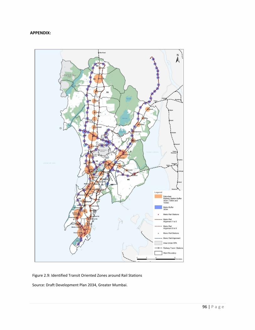
96 | P a g e
APPENDIX:
Figure 2.9: Identified Transit Oriented Zones around Rail Stations
Source: Draft Development Plan 2034, Greater Mumbai.
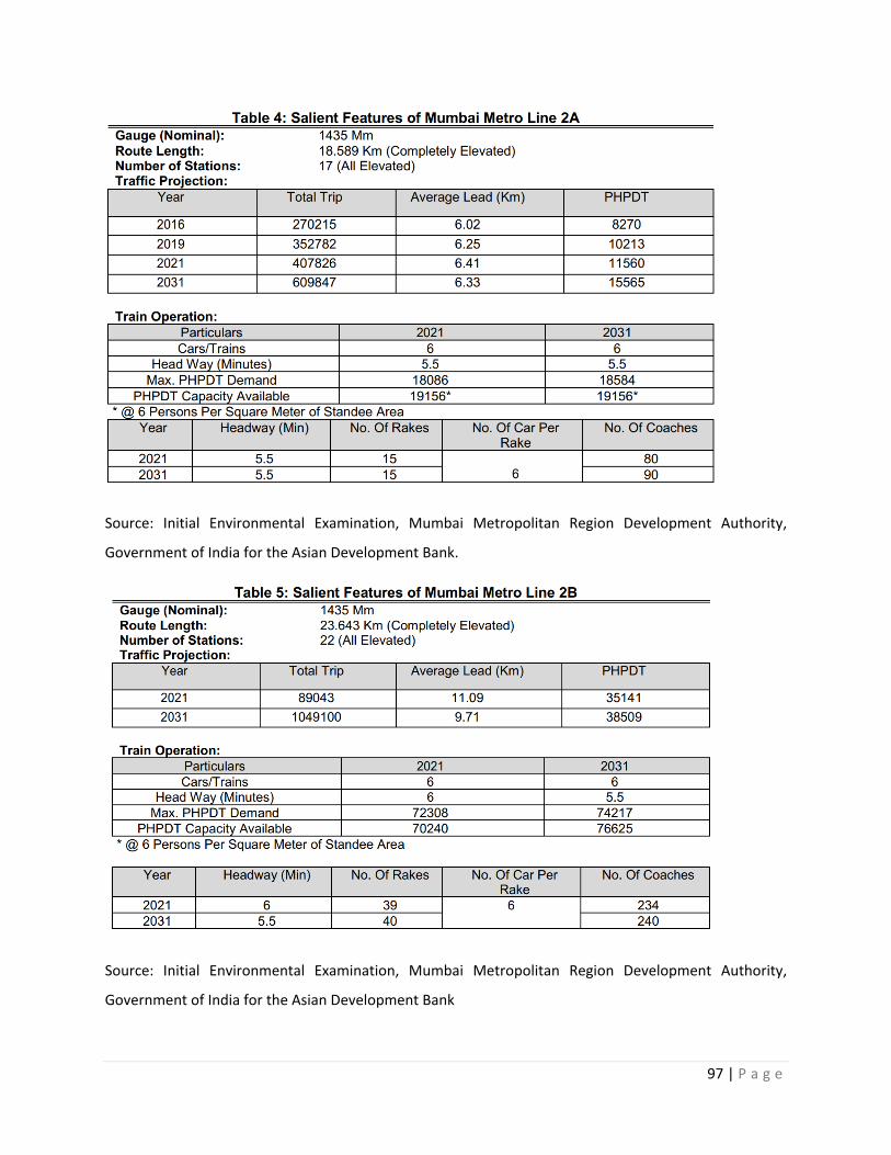
97 | P a g e
Source: Initial Environmental Examination, Mumbai Metropolitan Region Development Authority,
Government of India for the Asian Development Bank.
Source: Initial Environmental Examination, Mumbai Metropolitan Region Development Authority,
Government of India for the Asian Development Bank
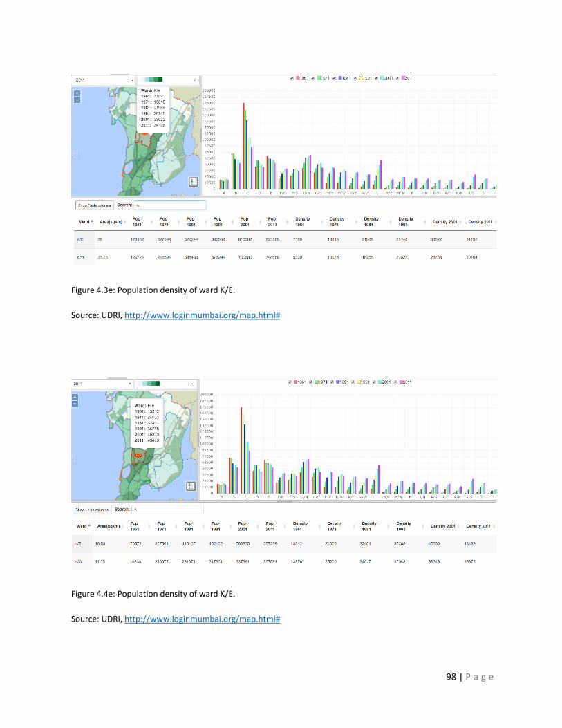
98 | P a g e
Figure 4.3e: Population density of ward K/E.
Source: UDRI, http://www.loginmumbai.org/map.html#
Figure 4.4e: Population density of ward K/E.
Source: UDRI, http://www.loginmumbai.org/map.html#
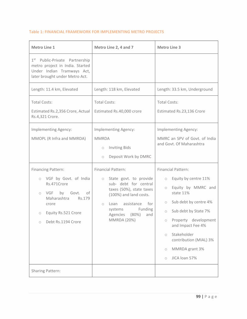
99 | P a g e
Table 1: FINANCIAL FRAMEWORK FOR IMPLEMENTING METRO PROJECTS
Metro Line 1 Metro Line 2, 4 and 7 Metro Line 3
1st Public-Private Partnership metro project in India. Started Under Indian Tramways Act, later brought under Metro Act.
Length: 11.4 km, Elevated Length: 118 km, Elevated Length: 33.5 km, Underground
Total Costs:
Estimated Rs.2,356 Crore, Actual Rs.4,321 Crore.
Total Costs:
Estimated Rs.40,000 crore
Total Costs:
Estimated Rs.23,136 Crore
Implementing Agency:
MMOPL (R Infra and MMRDA)
Implementing Agency:
MMRDA
o Inviting Bids
o Deposit Work by DMRC
Implementing Agency:
MMRC an SPV of Govt. of India and Govt. Of Maharashtra
Financing Pattern:
o VGF by Govt. of India Rs.471Crore
o VGF by Govt. of Maharashtra Rs.179 crore
o Equity Rs.521 Crore
o Debt Rs.1194 Crore
Financial Pattern:
o State govt. to provide sub- debt for central taxes (50%), state taxes (100%) and land costs.
o Loan assistance for systems Funding Agencies (80%) and MMRDA (20%)
Financial Pattern:
o Equity by centre 11%
o Equity by MMRC and state 11%
o Sub debt by centre 4%
o Sub debt by State 7%
o Property development and Impact Fee 4%
o Stakeholder contribution (MIAL) 3%
o MMRDA grant 3%
o JICA loan 57%
Sharing Pattern:
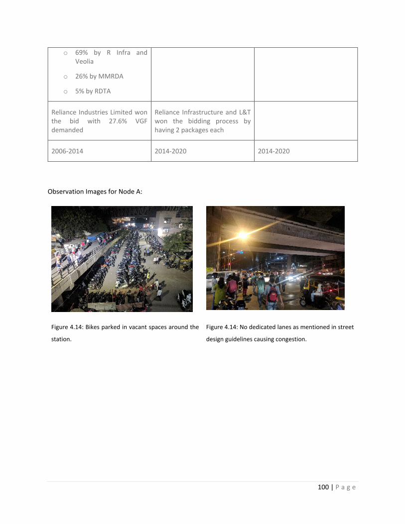
100 | P a g e
o 69% by R Infra and Veolia
o 26% by MMRDA
o 5% by RDTA
Reliance Industries Limited won the bid with 27.6% VGF demanded
Reliance Infrastructure and L&T won the bidding process by having 2 packages each
2006-2014 2014-2020 2014-2020
Observation Images for Node A:
Figure 4.14: Bikes parked in vacant spaces around the
station.
Figure 4.14: No dedicated lanes as mentioned in street
design guidelines causing congestion.
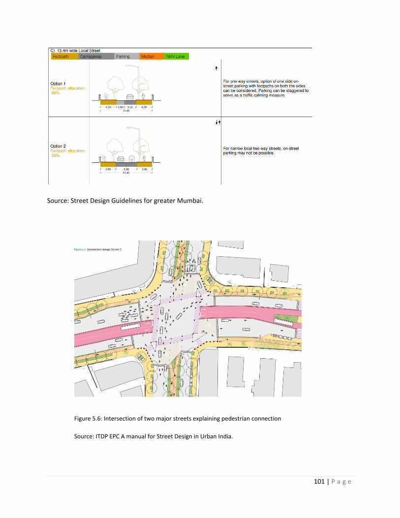
101 | P a g e
Source: Street Design Guidelines for greater Mumbai.
Figure 5.6: Intersection of two major streets explaining pedestrian connection
Source: ITDP EPC A manual for Street Design in Urban India.
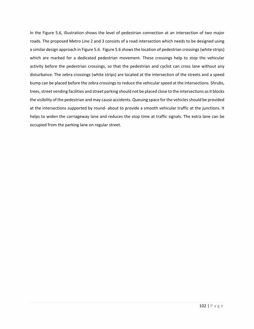
102 | P a g e
In the Figure 5.6, illustration shows the level of pedestrian connection at an intersection of two major
roads. The proposed Metro Line 2 and 3 consists of a road intersection which needs to be designed using
a similar design approach in Figure 5.6. Figure 5.6 shows the location of pedestrian crossings (white strips)
which are marked for a dedicated pedestrian movement. These crossings help to stop the vehicular
activity before the pedestrian crossings, so that the pedestrian and cyclist can cross lane without any
disturbance. The zebra crossings (white strips) are located at the intersection of the streets and a speed
bump can be placed before the zebra crossings to reduce the vehicular speed at the intersections. Shrubs,
trees, street vending facilities and street parking should not be placed close to the intersections as it blocks
the visibility of the pedestrian and may cause accidents. Queuing space for the vehicles should be provided
at the intersections supported by round- about to provide a smooth vehicular traffic at the junctions. It
helps to widen the carriageway lane and reduces the stop time at traffic signals. The extra lane can be
occupied from the parking lane on regular street.