conservation area character appraisal and …...railway, the victorian and edwardian villas and the...
TRANSCRIPT

Conservation Area Character Appraisal and Management Plan
Goathland November 2017

2
Conservation Area Appraisal and Management Plan for Goathland Conservation Area
2
Contents Summary 3
Introduction 8
Location and context 10
The History of Goathland 12
The ancient street plan, boundaries and open spaces 24
Archaeology 29
Vistas and views 29
The historic buildings of Goathland 33
The little details 44
Character Areas: 47
St. Mary's 47
Infills and Intakes 53
Victorian and Edwardian Village 58
NER Railway and Mill 64
Recommendations for future management 72
Conclusion 82
Bibliography and Acknowledgements 83

3
Conservation Area Appraisal and Management Plan for Goathland Conservation Area
3
Summary of Significance
Goathland is a village of moorland views and grassy open spaces of untamed pasture and boggy verges
crossed by ancient stone trods and tracks. These open spaces once separated the dispersed farms that
spread between the first village nucleus around the church originally founded in the 12th century, the
village pound nearby, and, a grouping of three farms and the mill to the north east, located by the river
and known to exist by the early 13th century.
This dispersed agricultural settlement pattern started to change in the 1860s as more intakes were filled
with villas and bungalows, constructed by the Victorian middle classes arriving by train and keen to visit
or stay and admire the moorland views and waterfalls. This created a new village core closer to the
station where hotels and shops were developed to serve visitors and residents and this, combined with
the later war memorial, has created a village green character and a tighter settlement pattern than seen
elsewhere in the village. There is a large number of high quality late 19th and early 20th century
architecture throughout the village, incorporating a wide range of revival styles, with a unique
concentration of buildings by the architect Walter Brierley.
The popularity of Goathland continued into the 20th century, however building styles became more
suburban and no longer reflected the distinctive architectural styles of the past. Despite the diversity of
building types, the whole village, with the exception of the railway, is unified by the grassy spaces and
moorland backdrop.
Traditional building materials were of timber and stone and in medieval times up to the 18th century,
heather thatch was used as the main roofing material. This changed from the 17th and 18th centuries to
red pantiles and they continue to dominate the village and appear plentiful in views from the
surrounding moors. Roofscapes cascade along undulating ground or back from the main farmhouse and
4
Conservation Area Appraisal and Management Plan for Goathland Conservation Area
4
are further broken by chimney stacks, water tabling and occasionally, stone kneelers. After the 1860s,
Welsh slate was imported, and this is the predominant roofing material at the station. Mock Tudor gables
became popular in the late Victorian and early Edwardian period and their bold black and white colours
dominate views within the village despite their relatively low numbers. In the 20th century some concrete
roof tiles have also been used but these are not characteristic.
Stone continues to be the main building type, but the way it was dressed changed from the coursed
roughly dressed stone of the 18th century to the rockface stone of the high Victorian period. At the
railway station, cast iron painted in NER livery is particularly distinctive. Render was reintroduced in the
early 20th century but is only characteristic along the Mill Green Way where brick and render is used.
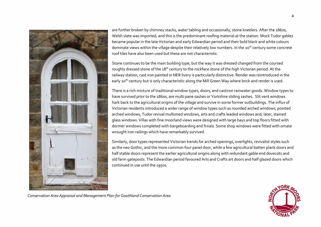
There is a rich mixture of traditional window types, doors, and castiron rainwater goods. Window types to
have survived prior to the 1860s, are multi pane sashes or Yorkshire sliding sashes. Slit vent windows
hark back to the agricultural origins of the village and survive in some former outbuildings. The influx of
Victorian residents introduced a wider range of window types such as rounded arched windows, pointed
arched windows, Tudor revival mullioned windows, arts and crafts leaded windows and, later, stained
glass windows. Villas with fine moorland views were designed with large bays and top floors fitted with
dormer windows completed with bargeboarding and finials. Some shop windows were fitted with ornate
wrought iron railings which have remarkably survived.
Similarly, door types represented Victorian trends for arched openings, overlights, revivalist styles such
as the neo Gothic, and the more common four panel door, while a few agricultural batten plank doors and
half stable doors represent the earlier agricultural origins along with redundant gable end dovecots and
old farm gateposts. The Edwardian period favoured Arts and Crafts art doors and half glazed doors which
continued in use until the 1950s.

5
Conservation Area Appraisal and Management Plan for Goathland Conservation Area
5
The earliest farms probably had no boundaries, and this is still the case at Chapel Houses (the former Cross Pipes Inn), but with the increase in private
ownership from the 16th century, but more particularly from the enclosures of the 18th century, boundaries to properties became more important. Today
they reflect agricultural origins with dry stone walls, one with a surviving sheep stoop, and some topped with hedging. Later domestic properties have
dwarf walls topped with ornate iron railings or mortared coped walls. The Victorians introduced highly dressed gateposts, sometimes with the name of the
new house carved on them. The 20th century saw the introduction of some mixed suburban wall types, rusticated boundary walls and picket fences, but
some new materials have detracted from the historic interest of the village.
Collectively, the settlement pattern and building types of the village tell the story of how Goathland evolved by
representing its earlier agricultural origins and its later popularity with the Victorian and Edwardian middle
classes. However, some suburban building types and landscaping, plus the loss of some traditional windows and
doors to be replaced with plastic, has diminished this architectural and historic interest. Only the North York
Moors Railway station area has conserved wholly its special interest and this is largely because the buildings are
listed and therefore protected from this erosion of character. Consideration should therefore be given to
withdrawing permitted development rights so that owners can be encouraged through the planning process and
grant assistance to replace or repair windows and doors in styles and materials that reflect the character of their
buildings. It is also recommended that the Conservation Area boundary be extended to include a sample of the
Whitby & Pickering Railway trackbed and the surviving cottages from the 1830s associated with it; these
remains are from the early pioneering days of the railway and are therefore nationally important and merit
cherishing.
Those elements of the Conservation Area which are most character-defining, and therefore of the greatest
significance are:
• Wide grassy verges and greens interspersed with stone trods and un-made tracks and stone steps
• Moorland views
• Dispersed settlement pattern - grazed intakes amongst farms and villas
• Evidence of a two-centred village (church and Victorian development)

6
Conservation Area Appraisal and Management Plan for Goathland Conservation Area
6
• Sandstone as the predominant building material
• Cascading pitched pantile rooflines, sometimes with water tabling and kneelers, but Welsh slate and crow stepped gables at the railway
• Traditional window and door types
• Agricultural references in a few buildings such as linear ranges, dovecots, slit vent windows as evidence of former agricultural use
• Victorian embellishments such as bargeboarding, finials, stone gateposts and wrought iron railings
• Late 19th and early 20th century revivalist styles of building including a concentration of high quality buildings designed by Brierley
• Edwardian shop fronts
• The riverside location of the mill
• The isolated position of the Abbot’s House Farm and the village pound
• The holloways
• Dry stone and mortared stone walls with and without hedging
Elements of less significance, but which still make a positive contribution are:
• Traditional lampposts
• Cast iron street signs
• Mock Tudor gables
• Public seating
• Datestones
• Sheep stoop
Future management in the village will therefore wish to consider cherishing features and buildings which represent the early agricultural origins, the early
railway, the Victorian and Edwardian villas and the wide untamed grassy spaces with stone trods. New development is most likely to fit in if it uses
cascading red pantile pitched roofs (but not in the railway station area), makes use of stone and timber in the design (but this does not preclude the use of
other modern materials depending on its location) and references either smaller portrait windows or Yorkshire sliding sashes of the earlier building stock
or more ornate windows of the 19th century building stock. Flat roofs and concrete are more likely to create a negative impact on the special interest of the

7
Conservation Area Appraisal and Management Plan for Goathland Conservation Area
7
Conservation Area. Views of the church tower should only be dominated by the moors themselves and boundary treatment will be important in helping
new development fit in. The village pound and the site of the Hermitage at Abbot’s Farm should always remain separate from the village and the
holloways that led from the moors to the inn and the church should be preserved.
8
Conservation Area Appraisal and Management Plan for Goathland Conservation Area
8
Introduction
The majority of the village of Goathland is a Conservation Area. Conservation Areas were first introduced in England in 1967 in recognition of the fact that
the quality of historic areas depends not only on the qualities of individual buildings but also on the historic layout and interrelationship of properties, the
use of characteristic building materials, the character of public spaces, the presence of trees and views between buildings and along streets.
These places are protected under the provision of section 69 of the Planning (Listed Buildings and Conservation Areas) Act 1990 which defines them as
areas ‘of special architectural or historic interest, the character and appearance of which it is desirable to preserve or enhance’.
There are over 9,800 Conservation Areas in England1 of which 42 are in the North York Moors National Park. Goathland was designated as a Conservation
Area in 1993.
Historic England recommends that such Conservation Areas should be reviewed periodically to assess and communicate why the Area is special and what
contributes towards its particular qualities; they also recommend that the boundary of the area designated should be reviewed and that guidelines are
produced to help with the Area’s long term management.
Conservation Areas give broader protection than listing individual buildings as features of historic, architectural and landscape interest are recognised as
part of its character. Conservation Area designation introduces controls over the way owners can alter or develop their properties. Owners of residential
properties often consider these controls to be beneficial because they also sustain and enhance the attractiveness and value of property within it. These
controls include:
• the requirement in legislation and national and local planning policies for new development to preserve and enhance special character;
• control over demolition of unlisted buildings
• control over works to trees
• fewer types of advertisements which can be displayed with deemed consent
• restriction on the types of development which can be carried out without the need for planning permission (permitted development rights)
1 https://historicengland.org.uk/listing/what-is-designation/local/conservation-areas/ [accessed 22.12.2016]

9
Conservation Area Appraisal and Management Plan for Goathland Conservation Area
9
Figure 1. Goathland Conservation Area boundary in blue, listed buildings in red and Tree Protection Orders outside the Conservation Area in green
© Crown copyright 2017. All rights reserved.
Licence number 100042279
10
Conservation Area Appraisal and Management Plan for Goathland Conservation Area
10
This report assesses those features and qualities, which give Goathland its own special interest and which can contribute towards justifying its designation.
It seeks to identify the character defining elements of the Conservation Area and describes the degrees of significance (considerable, some, limited or
none) that can be attached to those elements such as the street plan, the open spaces, the vistas and views and the historic buildings.
It then goes on to make recommendations on how to conserve and enhance those elements of significance and further recommendations to guide future
management decisions and development proposals.
However, no appraisal can ever be entirely comprehensive and the omission of any particular building, feature or space in the village, should not imply that
it is of no interest.
Location and Context
Goathland is situated 152m above sea level and lies in a green basin surrounded by thousands of acres of moorland which, combined with the open green
spaces of former ‘waste’, has been said to lend a bleak quality to the village. On the distant horizon, ancient ‘howes’ might be spotted where Bronze Age2
ancestors buried their dead in prominent landscape positions recently cleared of their woodlands. More recently, a possible Roman Road,3 now known as
Wade’s Causeway ran south west of Goathland and continued to be used by local communities long after. The moorland south west of the village still
retains a number of parallel holloways which are the fossilised remains of ancient tracks leading into the village; they head towards the site of the former
church and the inn. Most of these holloways are immediately outside the Conservation Area, although a small stretch near the village pound are included.
The origins of the village of Goathland are with a Hermitage which existed by c.1100 and located on land close to the Eller Beck and its tributaries where
fresh water was plentiful. The low-lying position would have created a sheltered environment compared to that found higher on the moors.
2 Approximately 2,500 B.C to 800 B.C 3 The Roman period is about AD 43 to AD 450, however the date of this particular road is uncertain

11
Conservation Area Appraisal and Management Plan for Goathland Conservation Area
11
“The surface is mainly moor; but includes the vale of Goathland, with some charming scenery, and several pretty cascades. The site of an ancient
British village is at Killing Pits. Hawks of extraordinary size anciently frequented the moors, and still are occasionally seen; and they were anciently in
special request for the king's use.” John Marius Wilson's Imperial Gazetteer of England and Wales 1870-2
The moors are an important context and setting for the village. Traditionally the moors provided peat and turf for fuel, heather for kindling and for thatch
and besom making, bracken and rushes were also harvested for thatch and bedding stock. The moors also provided foodstuffs such bilberries, cranberries
and whortle-berries, and sphagnum moss was collected for dressing wounds and for nurserymen for wrapping plants in more recent times. At Goathland
peat was gathered using kens, conical heaps 4-5 feet high built up like open brickwork (Hartley and Ingleby1972, 73). The moors were therefore the focus
of the historic economy of Goathland and today they continue to earn income through grouse shooting.
The deep forested valleys with picturesque waterfalls are now an important part of the local economy providing stunning scenery and attractive walks for
visitors, but in the past the timber was an important resource for the buildings of Goathland. Woodland would have been more extensive in medieval
times, but the woodland today is largely confined to the deep valleys where timber extraction was impractical or to more recent commercial forestry.
Much of the landscape closer to the village has been through a process of improvement resulting in their enclosure and the addition of lime and drainage
to create more productive land. In turn, a number of these fields have been developed in the 19th - 20th centuries. Some 18-19th century field boundaries
have been lost as fields have been enlarged, but there is very little evidence of ridge and furrow around the village suggesting that it has been mainly
pastoral with little arable production.
Figure 2. John Speed's 'The Theatre of the Empire of Great Britaine', published in 1611/12.

12
Conservation Area Appraisal and Management Plan for Goathland Conservation Area
12
The History of Goathland
“Goathland is a very small village in the moors with a station on the Pickering Valley line. The houses are all modern
and have largely increased of late years owing to the popularity of the district as a holiday resort. A modern farm-
house now represents the 'Abbot's House,' a former possession of Whitby Abbey. There is a Wesleyan chapel, and
public elementary schools were built here in 1875. The extreme limit of Goathland parish towards the east is marked by
Lilla Cross, a monolith some 7½ ft. high with a roughly cut head of Maltese form. It marks the junction of the
townships of Fylingdales, Goathland, Lockton and Allerston.” 4
The name Goathland first appears on documents dating to c.1110 when it was referred to as Godelandia and by 1252, it was shortened to Gotheland. The
meaning is not certain, but is possibly either Goda’s Land or good land. The latter seems unlikely given the bleak moorland surroundings, but in either case
the name is partly Scandinavian. An alternative explanation is that it refers to God’s Land and could relate to the hermitage founded to serve the poor in
‘Godelane’ and referred to in documents dating to between 1109-14.5 The settlement was not listed in the Domesday Book of 1086, so it appears that its
earliest origins must post date 1086 but be before 1114. These early documents also suggest that the surrounding Lordship of Pickering was designated as
‘forest’ by King Henry in the 12th century;6 this meant that special rules applied restricting what the land could be used for in order to create a hunting
ground suitable for the king and his barons. The Hermitage was made exempt from these rules and allowed to retain their arable and grazing land and to
use the forest to source timber, fuel and to graze their stock. The land (and the village) remained in the ownership of the king until Henry III gave it to his
son Edmund, the Earl of Lancaster; through him it remained in the ownership of the Duchy of Lancaster (Hollings 1990, 7).
4 'Parishes: Pickering', in A History of the County of York North Riding: Volume 2, ed. William Page (London, 1923), pp. 461-476. British History Online http://www.british-history.ac.uk/vch/yorks/north/vol2/pp461-476 [accessed 23 January 2017]. 5 Page 1923 refers to the documents being addressed to Archbishop Thomas who held that position between 1109-14, but other sources put the Hermitage at 1117. The documentation suggests that the Hermitage already existed and so could have lent its name to ‘God’s Land’. 6 Hollings 196?, Appendix I

13
Conservation Area Appraisal and Management Plan for Goathland Conservation Area
13
Historic documents suggest that the brothers at the Hermitage founded a chapel, called ‘St. Mary at Godeland’ in 1150 – this appears to have survived until
1821 when it was replaced with a new church on the same site. The church was located 1.5km to the west of the Hermitage, thus retaining the solitude of
the Hermitage, but creating a new village centre. The church remains the focal point of the south end of the dispersed village.
The Hermitage was subsequently put under the care of Whitby Abbey as it was struggling financially, and it was given more land so that the rent obtained
from it could be used to support the brothers. The Hermitage may have been converted into a grange for Whitby Abbey and was partly tenanted and
partly farmed directly for the Abbey from as early as 1336 (Hollings 1990, 11). On the 22nd December 1538 Henry Davell, Abbot of Whitby, leased to Robert
Cokerell of ' Godland' for eighty-one years at a yearly rent of 20s. 'one fermehold in Godland called the Abbot House.'7 Abbot’s House farm is now located
well outside the Conservation Area.
The rest of the village evolved from a series of farms cleared from the surrounding forest land so that by the 15th century, the general settlement pattern of
Goathland was set and would remain until the late 19th century. This clearance of land from the forest to create the farms resulted with a reduction in
available timber, but increased grazing land released by the Duchy of Lancaster (Hollings 1990, 34).
The Dissolution of Whitby Abbey in 1539, only one year after the Abbot’s House was rented to Robert Cockerell must have released any other monastic
holdings into new tenurial relationships which could result in greater investment in local farms and buildings. However most farms within the village did
not pass into private ownership until 1604 when King James I and VI leased Goteland which then passed through a series of sales resulting in twelve farms
being sold to occupying tenants. The farms now in private ownership were Sadler House, Pullen Hill House, Birk House, Goathland House, Goathland Mill,
Cow Wath, Thornhill, Partridge Hill, Allan Tofts Farm and Beckhole, while the remaining farms were let to the customary tenants. This triggered greater
investment in the farms and buildings leading to greater prosperity for some. It was also about this time that wool production increased and so a number
of houses had looms fitted to allow weaving to take place from home and exported out of the village and fulling mills were built on the Eller Beck and the
Murk Beck. However, some intake land between the farms had previously been common land and was now let to the nearby farms. A rent price hike
during the Commonwealth may have slowed up this process of improvement and prosperity.
In 1520, prior to the Dissolution, there were eight households in Goathland and by 1620 the numbers had increased to thirty-seven increasing to forty-
three by 1685 (Hollins 1990, 47). These figures suggest greater prosperity generally and an increase in building, but it is worth noting that two of the
7 ibid

14
Conservation Area Appraisal and Management Plan for Goathland Conservation Area
14
households in 1685 were excused paying the hearth tax because of poverty. The increase in outright ownership was the start of shifts in the social
character of the village with gentlemen farmers, yeomen, craftspeople, small holders and poorer labourers.
By 1615, the village had three inns. The Wayside Inn replaced the hospitality previously provided by The Hermitage near the Abbot’s House, the Chapel Inn
(later the Cross Pipes) was located near the church at the south end of the village and the Beckhole Inn (later The Lord Nelson) was located near Beckhole
outside the Conservation Area.
Church records show that by 1743 there were forty four families in the village8 and in that year the Abbot’s House was also rebuilt. A house was built on the
common near the Chapel for a homeless woman in 1739 and included some land; the house would remain in the ownership of the township specifically for
the poor, but has since been demolished. The church registers outline the main occupations of
Goathland residents from the 18th century onwards. The majority were farmers or yeomen,
but three other industries featured including fuller, bleacher and weaver pointing to the flax or
woollen industries. Collier as a profession features occasionally where coal was dug from the
surface above Water Ark and taken to Pickering to fuel lime kilns and returning with lime to
help improve the agricultural land. This was also part of the process of enclosing the land
around the village to improve the regular green rectangular fields that separated the village
from the open moorland today. Other occupations were typical of any pre-industrial village
and included inn-keeper, millers, blacksmith, joiner, cooper, shoemaker, tailor and
occasionally a school master, however at that time there was no official endowed school, but a
small school taught by a weaver who instructed the children in the Christian religion. The
combination of one profession alongside weaving was relatively common.9 The Swales family
were smiths at Goathland from the late 18th to the twentieth centuries; they travelled around
farms as far as Ravenscar and they had two forges in the village, one at each end.10
8 Hollings undated, 8 and Appendix XIII and Hollins 1990, 48 9 Hollings undated, 6-7 10 Hartley and Ingleby 1972, 113 and Hollings 1990, 55
Figure 3. The mill with 13th century origins, but now much modernised and extended and with a wholly different roof line. It had a water turbine before a fire left it burnt out in 1960; it has been renovated twice since as a domestic dwelling.

15
Conservation Area Appraisal and Management Plan for Goathland Conservation Area
15
A school house was built in 1808, paid for by public subscription and time in kind by local residents. A piece of common land was enclosed and let out in
order to raise money to pay for the Master’s salary and some school fees. This school was replaced by another in 1875 and the sun dial moved from the old
building to the new one.11 This is currently outside the Conservation Area.
The present day church was built in 1896 and replaced an earlier one that stood alongside it dating to 1821. This in turn was a replacement for the chapel
that was founded by the Hermitage brothers in the 12th century and was probably located on the site of the 1821 church. The present church was
constructed using stone freely given from Mallyan Spout quarry on the condition that the new church was located near its ancient site (there had earlier
been proposals to move the church to a more central position). The Duchy of Lancaster donated a piece of common ground next to the existing church for
the new one to be built. The older Georgian church was dismantled to provide the stone for the new church tower.12 The associated vicarage some
distance to the north west had been built in 1869 and subsequently became known as The Grange. This was more ostentatious than the church with neo
Gothic windows and doorways. The Church of England felt threatened by the growing popularity of non-conformism and was in a flurry of rebuilding and
constructing new churches in places that had previously had none in the late 19th century; the Rev. Hare’s desire for a new building was part of this trend.
Goathland’s new Primitive Methodist chapel was located in the crossroads to the north and was a small modest building with its gable facing the road.
By the 19th century the parish consisted of about 67 houses and the census returns from 1811 started at 270 people, gradually increasing to 381 by 1841. In
1840, White’s Trade directory described Goathland:
“Goadland, or Goathland, is a bleak township of high moorland hills, with 326 inhabitants, mostly residing in scattered cottages, in a deep and narrow
dale, from 9 to 14 miles N. by E. of Pickering. It has 11,030 acres of land, mostly waste, and belonging to Rd. Hill, Esq., and Mr Gowen Pearson, the
former of whom is lord of the manor, and the latter occupies his own estate. The other farm is occupied by Ralph Breckon. Near the foot of the dale is
“Godeland Chapel,” which was rebuilt in 1821, and is a curacy, valued at £58, in the patronage of the Dean of York, and incumbency of the Rev. B.
Richardson, of Egton.”
11 Hollings 1990, 61 12 http://www.goathlandstmary.com/history.html [accessed 010217]
16
Conservation Area Appraisal and Management Plan for Goathland Conservation Area
16
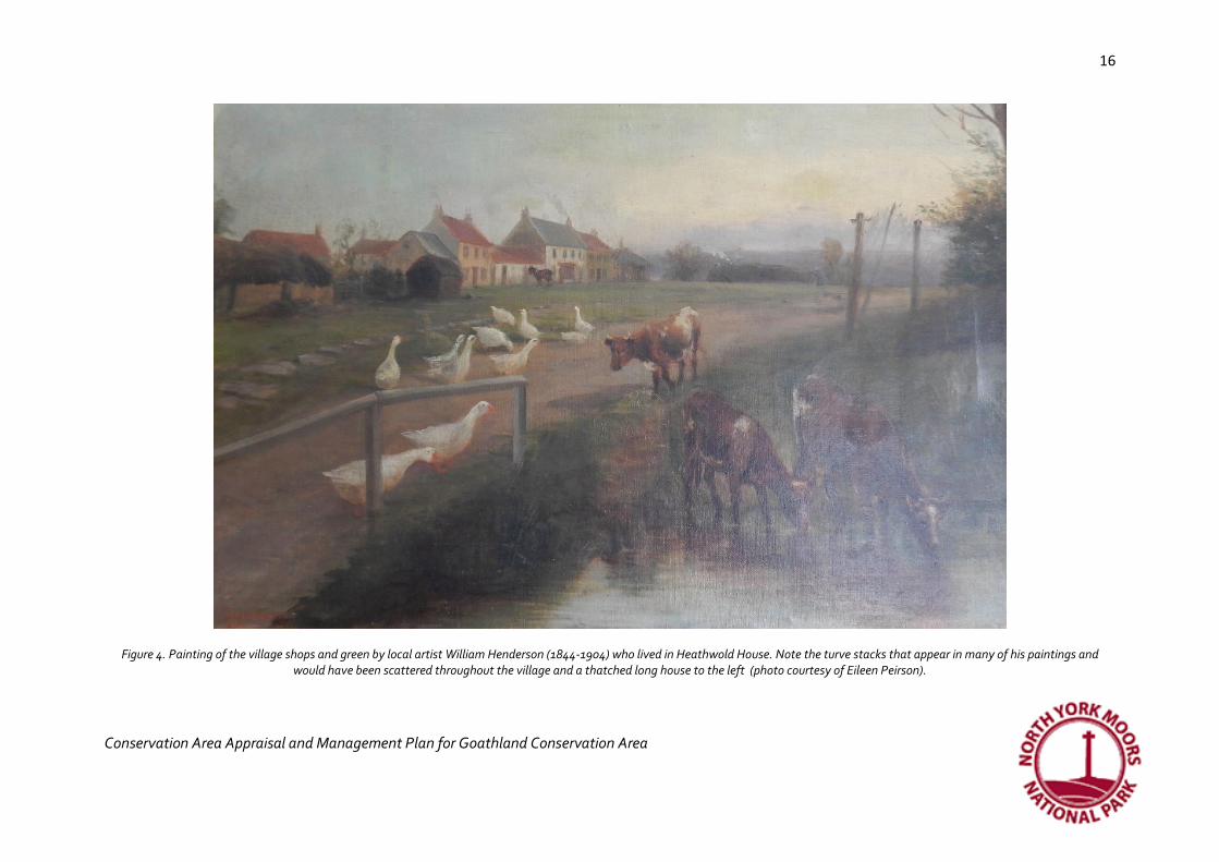
Figure 4. Painting of the village shops and green by local artist William Henderson (1844-1904) who lived in Heathwold House. Note the turve stacks that appear in many of his paintings and would have been scattered throughout the village and a thatched long house to the left (photo courtesy of Eileen Peirson).

17
Conservation Area Appraisal and Management Plan for Goathland Conservation Area
17
Then and now
Figure 5. Bank Top Cottage on the right was a crossing keeper’s cottage for the railway which crossed the road at this point. On the left, the Goathland Hotel built in 1877 (historic photo courtesy of Eileen Peirson).
The modest increase in numbers by 1841 may have been a result of the introduction of the railway, although the big increase in population and additional
building would follow after the line was improved in 1865. The railway was first opened at Goathland as part of the horse drawn Whitby and Pickering
Railway of 1836 where it used the Beck Hole incline to negotiate the steep hill. An early two-hole stone sleeper from this incline has since found its way to
the centre of the village near the Goathland Hotel and another has been moved to the present day Goathland Station. The railway subsequently became
part of the York & North Midland Railway and as part of that process it was turned into a twin track steam operated railway with associated buildings such
as Engine Sheds and a new station, all outside the Conservation Area. Bank Top House was the former Crossing Keeper’s Cottage and is inside the
Conservation Area, but much altered. The original Goathland station was located at the head of the incline (now a listed building), where there are still

18
Conservation Area Appraisal and Management Plan for Goathland Conservation Area
18
some York & North Midland cottages, together with a single Whitby & Pickering one. The York & North Midland replaced the Whitby & Pickering’s water
balance method of working the Beckhole Incline with stationary steam engine haulage. This engine was replaced (at least once) by the North Eastern
Railway (NER) but after the closure of the incline the engine was removed and the engine house demolished; leaving virtually no trace today. The NER
retained the old route (including the incline) intact until summer 1868 and today it is used as a public right of way.
The present day station (originally known as Goathland Mill) is on the deviation line opened by the North Eastern Railway in 1865 to avoid the Beck Hole
Incline. The new station buildings were to the design of the NER's architect Thomas Prosser. The collection of buildings is very little altered since they were
built – the last recorded change (apart from NYMR restoration) was in 1908.13 They now form a distinctive group of buildings, painted in NER colours and
huddled together in the valley bottom, contrasting with the dispersed pattern of settlement in the rest of the village.
The presence of the railway made Goathland more accessible to visitors, particularly from the 1860s; the picturesque Mallyan Spout waterfall being a
particularly attractive place to visit. Hotels were constructed at both ends of the village to accommodate visitors arriving by train or intending to view the
Mallyan Waterfall. The Goathland Hotel was built in 1877 and a Hydro was built later for health conscious visitors. In 1884 water was piped into the village
from a new reservoir supplied from three springs above Moss Slack. This was delivered to six stand pipes by the roadside until 1900 when water began to
be piped into village houses and the school yard. A golf course in 1890 was built on the wide grassy green at the north-west end of the village and the
Victorian and Edwardian middle classes had large houses constructed along some vacant intakes with all the architectural pretensions fashionable at the
time and very fine views of the moors. However most of the services for this influx of visitors and new residents were located at the north-west end near
the railway station and so had the effect of shifting the centre of the village from the church.
A number of houses were built in the 20th century in some of the remaining intakes between the farms; these houses could take advantage of the new
main electricity supply brought into the village in 1948. Although the railway was axed in 1965 it re-opened six years later as the North York Moors Historic
Railway and brought many tourists to the village. A car park was provided from 1966 and public conveniences built. Farmers still retain common rights to
graze stock in the fields in the village and up on the moors as they have done for centuries.
13 http://www.nymr.co.uk/Pages/FAQs/Category/history-of-the-railway [accessed 020217]

19
Conservation Area Appraisal and Management Plan for Goathland Conservation Area
19
Then and now
Figure 6. Left: The present-day church under construction on the right of the black and white photograph (with no tower yet) and the 1821 church on the left, shortly to be demolished to provide stone for the church tower.14 The original 12th century chapel was thought to be on the site of the 1821 church but occupied a smaller footprint (Hollings undated, 9). Right: the same view today; the churchyard and church now obscured by mature trees and the wider area urbanised with wider tarmacked roads and street signs. The churchyard wall may have been rebuilt on a slightly different alignment.
14 Photo from http://www.goathlandstmary.com/history.html [accessed 010217]

20
Conservation Area Appraisal and Management Plan for Goathland Conservation Area
20
Figure 7. The 1st edition Ordnance Survey map showing the village around 1849
21
Conservation Area Appraisal and Management Plan for Goathland Conservation Area
21
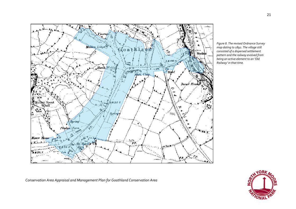
Figure 8. The revised Ordnance Survey map dating to 1892. The village still consisted of a dispersed settlement pattern and the railway evolved from being an active element to an ‘Old Railway’ in that time.

22
Conservation Area Appraisal and Management Plan for Goathland Conservation Area
22
Figure 9. The 3rd ed OS map (XLV. SE) surveyed in 1910. Plots were gradually filling along the main road which had also been turned into a golf course. The old railway was also now used as a road with development taking place alongside it.

23
Conservation Area Appraisal and Management Plan for Goathland Conservation Area
23
Figure 10. The OS map surveyed in 1950 showing development now beginning to fill the plots between the church and the crossroads at Brayton House. The last vacant plot north of the Hydro was in the process of construction.

24
Conservation Area Appraisal and Management Plan for Goathland Conservation Area
24
The Ancient Street Plan, Boundaries and Open Spaces
In a nutshell: grassy spaces, wide verges, unmade tracks, stone trods and stone flags, intakes, drystone wall
enclosures, and two historic cores
The Street Plan
The creation of the Hermitage in the 12th century was responsible for the settlement’s origins, but the nature of The Hermitage meant that it was always
isolated from secular life and so did not attract development around it. Instead it evolved into Abbot’s House Farm and remains well outside the village and
the Conservation Area even today. Because of its important role in the founding and possibly the naming of the village Abbot’s House Farm should be
considered to be part of the village’s historic interest and setting, but as a former Hermitage, set apart from the village boundary.
The village of Goathland grew up around the church to the south and the watermill to the north west. It was, until the mid-19th century, based on a
dispersed settlement pattern of a few farms scattered between the mill and the church along a ridge of drier ground. At the south end, the buildings
included the typical village requirements of a church, a farm, a village pound and by the late 19th century an inn and a scattering of farms along the road to
the north. The layout of the village does not appear to have been planned, but instead has evolved as additional intakes of common land were improved
and ultimately developed. The presence of the railway appears to have been responsible for a shift in the village towards the north east.
However, from the late 19th century, much of the new development was designed to fill available intakes and many faced west so that views of the moors
could be appreciated from the new villas and bungalows. The 20th century introduced some new styles of layout such as a curved grouping of houses north
of the church, but because they were well set back from the road, they have retained the distinctive character of open grassy spaces.
Considerable Significance:
• Separation from the Hermitage site
• Dispersed development
• Clustered buildings around the church and at the station

25
Conservation Area Appraisal and Management Plan for Goathland Conservation Area
25
• Undeveloped intakes
Green spaces and surface treatments
Pevsner in 1966 described Goathland as a ‘Friendly open village with houses along a Green of no special
shape’.15 The role of green spaces is important in defining the character of Goathland. The evolution from
dispersed farmsteads to village has been a slow one until the 20th century and consequently, there are
many open green spaces of rough pasture between houses and farms, each linked by rough tracks that
cut across the greens. Twentieth century development has sought to fill the gaps between the two
extreme ends of historic Goathland, but sufficient open space remains, along with traditional field
boundary walls, complete with at least one sheep stoop, to retain the broad character of dispersed
settlement that existed prior to these changes.
This is not a pretty managed village green, but a wide, wind-swept pasture, more agricultural than
residential in character. An approach to development which treats these spaces as infill, or the
resurfacing of these tracks in modern materials would alter the character of the village.
The stone trods that provided a firm surface for travelling between the village farms and the mill are an
important part of the village’s architectural and historic interest. The grassy surfaces on either side are
often boggy and the presence of the stone trods suggests that it was ever thus. The narrow nature of the
trods means that no carts could be used along their surface, but they were only suitable for foot traffic or
a single pony. The trods have been recently re-exposed along the west side of the main road, but are
close to disappearing beneath parts of the village green and are almost missing entirely nearer the
church greens. It is clear from historic photographs that many have been paved over.
15 Pevsner 1966, 171
Figure 11. Maintaining the stone trods is an ongoing task; this photo dating to the 1960s (photo courtesy of Eileen Peirson)

26
Conservation Area Appraisal and Management Plan for Goathland Conservation Area
26
Considerable significance:
• Wide grassy verges and greens
• Un-made tracks and stone trods
• Flags around farms and flags and setts at the railway station
No significance:
• Tarmac drives
Figure 12. Wide open grassy spaces are particularly distinctive of Goathland conservation area and unify the village, even where building types vary

27
Conservation Area Appraisal and Management Plan for Goathland Conservation Area
27
Boundaries
Stone walls with timber field gates form the boundaries along the main road and act as curtilage around farmsteads, although at the former Chapel
Houses, the buildings sit straight on to the surrounding moor. Along the west side of the main road, the wall retains its enclosure form as a dry stone wall
complete with now blocked sheep stoop(s). However, the lack of walls elsewhere is equally distinctive of the loosely knit appearance of the village.
Elsewhere, post and wire and post and rail fences retain the sheep and the agricultural character. The north end of the village also has some low drystone
walls, topped with hedging or trees and these too help to reflect a time that this land was pastoral. Some of these walls are almost entirely grassed over
and possess a great patina of age.
Figure 13. A variety of boundary types reflecting the history of Goathland. Left to right: an agricultural enclosure wall with blocked sheep stoop; a Victorian ornate wrought iron garden railing on a dwarf stone wall; an ostentatious gate pier at an entrance drive and railway angled picket fencing, typical of other NER stations
The Victorian period introduced typical Victorian style boundaries to the new villas; these were mostly mortared walls topped with ornate wrought
ironwork. Substantial stone gateposts were added to entrance points, sometimes with the name of the house carved on to them.

28
Conservation Area Appraisal and Management Plan for Goathland Conservation Area
28
The Victorian station buildings had mortared stone walls with elegant curved copes terminated with pyramidal coping stones. At both the railway station
lime cells and the mill, large shaped boulders were positioned on gateways to protect the stonework from vehicles damaging the walls as they turned into
the buildings. The restored station also has wooden picket fencing, some set on the diagonal and often used on other NER sites.
Some 20th century suburban development has made use of brick boundary walls, but these are not characteristic of the village.
Considerable significance:
• Dry stone walls (with or without hedges and moss) and trees
• Lack of enclosure at Chapel House
• Mortared dwarf walls with ornate iron railings or copes
• Stone gateposts (some with names carved on them)
• Dressed boulders on gatepost corners (to protect from turning vehicles)
Some significance:
• Sheep stoop
• NER picket fencing (station only)
• Post and wire fencing
No significance:
• Brick or concrete walls
Opportunities to conserve and enhance
• Tracks across the greens to houses should not be surfaced in urban or suburban materials, but retain their un-made appearance. Limestone chips or gravel as dual wheel tracks allow the grass to grow between and offer a potential solution
• Stone trods should be retained and managed to ensure that turf does not grow over them.
• Open grassy areas are an essential part of the character of the village (apart from around the railway station) and future development should

29
Conservation Area Appraisal and Management Plan for Goathland Conservation Area
29
seek to retain these and the largely dispersed settlement pattern
• Agricultural features such as stoops should be retained in the dry stone walls
• Stone flags around old farmsteads should be protected and old gateposts retained or reused
• The use of stone flags as a traditional surfacing material where required to protect the grassy verges, would not detract from historic character
• The choice of boundary types and materials will depend on the location and varies across the village. See the specific character areas for additional information.
• The separation between Abbot’s House and the rest of the village should be sustained to reflect the origins of the village as a hermitage
Archaeology
As the village has slowly evolved and remained sparsely occupied until the mid 19th century, the potential for buried archaeological remains is highest
around the pre 19th century farms and mill and at Abbot’s House farm outside the Conservation Area. The site of the former church is also of high
archaeological potential, but is now under the graveyard. Former field boundaries can be discerned from aerial photographs, but extant ancient field
systems are most visible outside the Conservation Area. The Conservation Area is therefore of limited archaeological interest.
Opportunities to conserve and enhance
• In line with National Planning Policy (2012), developments within the Conservation Area may need to be informed by archaeological work and in some cases, further archaeological excavation carried out before or during development.
• Similarly, developments affecting historic buildings may need to be informed by a Statement of Significance
Vistas and Views
In a nutshell: moorland views and backdrop, pantiles within trees, mock Tudor gables

30
Conservation Area Appraisal and Management Plan for Goathland Conservation Area
30
The surrounding moors play an important role in the character of the village and in the decision of people to come and live here, particularly from the late
19th century. They form a backdrop to almost every internal view in the village and external views looking in. The moors offer a magnificent backdrop to
the villas, particularly on the west and north sides of the village and to the church. The development along the east side of the main road by the Victorians
and Edwardians appears to have been chosen for the wide views across open moorland and houses were furnished with large bay windows to help
appreciate them. The moors also form a backdrop to views of the station and can be enhanced with the addition of steam from a passing train. The
undulating ground means that only the moorland itself dominates the church tower which sits in a basin. Views into the village from the surrounding
moorland approaches are predominantly of hedge lined pastures and trees interspersed with red pantile roofs and stark black and white mock Tudor
gables from Victorian and Edwardian villas.
The importance of views within the village can be seen in the large number of seats provided where views, mostly of the moors, can be found. The two
areas mostly photographed (and therefore valued) by visitors today are Mallyan Spout waterfall outside the Conservation Area and the station with the
combined picturesque qualities of steam trains and cascading waterfalls.
Considerable significance:
• Moorland views and backdrop
• Cascading pitched red pantiled rooflines nestled within trees
• The church tower dominated by moorland
• Steam trains and waterfalls
Some significance:
• Mock Tudor gables
Limited significance:
• Public seating of various types

31
Conservation Area Appraisal and Management Plan for Goathland Conservation Area
31
Figure 14. Left to right: Victorian villas were designed to face west towards the moors and were designed with large bay windows to appreciate the views. The moors provided the backdrop to the farms and later villas and hotel on the east side of the road. The church nestles into the sheltered bowl and as a result the moorland dominates the church tower.
Opportunities to conserve and enhance
• Any future changes within the village need to consider the impact on existing views out towards the moorland
• Red pantile should be considered for future roofing materials (excluding the station) so that views into the village continue to be a mix of green trees and red roofs
• No new building or structure should dominate the church tower
• The positioning of street signs needs to consider the impact on views
• The impact on any of the views shown in figure 15 should be carefully considered in any future development.

32
Conservation Area Appraisal and Management Plan for Goathland Conservation Area
32
Figure 15. Some of the most significant views towards, from and within the Conservation Area that merit conserving
© Crown copyright 2017. All rights reserved. Licence number 100042279

33
Conservation Area Appraisal and Management Plan for Goathland Conservation Area
33
The Historic Buildings of Goathland
In a nutshell: Modest, sturdy dwellings contrasting with Victorian neo Gothic and mock Tudor villas and bungalows.
Sandstone and pantile materials. 18th century farmsteads, railway architecture with crow stepped gables and NER
colours, 20th c suburbia. 1-2 storeys, ‘bulgy’ kneelers, chimney stacks, dovecotes, air vents, ball finials and
dovecotes.
There is very little evidence of the form of buildings in Goathland prior to the 19th century. In addition to the Hermitage, there are references to a mill in
1210 for grinding corn and it appears that there was also a church of St. Mary in the 12th century which later sat under the jurisdiction of Pickering parish.
The mill remains but is a much later structure nestled in the river valley, while the church has been rebuilt three times.
The earliest buildings in Goathland appear to have been made partly of locally sourced timber, usually oak to support the roof and sandstone walls; the
Hermitage was given thirty-six trees in 1494 from the surrounding forest for repairs and rebuilding which included three pairs of crucks16 for a new building
which was part of the grange. This was probably single storey and possibly a typical longhouse. Other examples of longhouses have been recorded at Over
Mortar Pits built in 1520 and Murk Side.17 At Thornhill Farm, a cruck possibly dating to 1672 is encased in a later stone building of 1699. The longhouse had
domestic accommodation at one end and pigs or cattle under the same roof at the other, separated by a partition wall. A fragmentary inventory dated
1672 for John Pearson of Goathland at Thornhill Farm, documents his house in 1672 as having a hall, kitchen, great and little parlours (possibly a single
subdivided room) and two upstairs chambers.18 Cottages were often made with crucks to support the building but in 1788, William Marshall recorded that
oak was no longer used in house building except for door and window lintels, wall plates and some few other purposes (Rural Economy of Yorkshire).
16 Y-shaped timbers used to support the roof internally 17 Hartley and Ingleby 1972, 11 18 Listed building description 1320/0/10013

34
Conservation Area Appraisal and Management Plan for Goathland Conservation Area
34
Figure 16. An early 20th century photograph of Heathwold House (formerly High Mortar Pit) with earlier thatched buildings surviving alongside. Heathwold House was the home of local artist William Henderson in the 1890s (photo courtesy of Eileen Peirson).

35
Conservation Area Appraisal and Management Plan for Goathland Conservation Area
35
Roofing materials would also be locally sourced and in Goathland, heather was used. By the 16th century the church (referred to as a chapel)19 was falling
into disrepair; the records stating that the “chapell lacked some reparacion in thatche…”.20 This suggests that thatch was the common roofing material at
least prior to the 16th century and presumably used heather from the surrounding common moorland. Cottages were described by W. Stonehouse in Tom
Keld’s Hole (1880) in the late 18th century as a “thatched, low-browed, whitewashed” inn formerly near Abbot’s House, Goathland, where “the furniture,
particularly a richly coloured oak bridewain, had been beeswaxed and rubbed to a high state of polish”.21 At Thornhill, a photograph dated 1868 shows the
building with a thatched roof that has a lower eaves line and a steeper pitch than the current roof 22 and photographs from the early 20th century show
houses in Goathland with their surviving predecessors still standing alongside them.
In addition to heather thatch, rye or wheat straw could be used or a combination. For example, the village poor house built in 1739 was a typical 30 ft long
house, one storey high, and a roof thatched with heather and straw.
From the mid-18th century old whitewashed, thatched houses began to be replaced by two-storied, modest sized, four square, Georgian style farmhouses,
most separate from the now extensive farm buildings. Red pantiles were introduced from c.1740 and gradually replaced the heather thatch. These were
imported from Whitby, where a tilery was subsequently established. Tiles were also produced near Pickering and later still (1850) from Loftus.23 Red
pantiles remain the distinctive roofing material of Goathland and make a colourful impact on distant views of the village.
Sandstone was obtained from the local quarries including one at Mallyan Spout. The stonework in these older properties was coursed and roughly dressed,
or occasionally with a more formal dressing pattern such as herringbone, with the highest quality dressing to the window and door openings. This was
distinctively different to later Victorian ways of dressing stonework which could be more ornate with tooled margins, or often with rock face finishes.
Hollings (1990, 36) portrays an evocative image of Goathland in the early 16th century:
19 It was later referred to as a ‘field church’ by which was meant it did not carry the rights of burial which only existed at Pickering church. However there were practical difficulties in getting the dead to Pickering over the moors and so permission was obtained in 1635 to bury the dead at Goathland chapel, although in reality burials must have had to take place there unofficially prior to that date (Hollings undated, Appendix XI) 20 Hollings undated, 3-4 21 Hartley and Ingleby1972, 11 22 Listed building description 1320/0/10013 23 Hartley and Ingleby1972, 6-7

36
Conservation Area Appraisal and Management Plan for Goathland Conservation Area
36
“…well defined paths trodden by friends and neighbours linked up the irregularly spaced houses. Except to church and mill
there was no great amount of traffic. Of the holdings little could be discerned, their heather thatched roofs so blending into
the earth that they were one with it, hummocks sprinkled over the moor. Only rising smoke with its sweet smell of burning
wood and turf betrayed them.”
New houses of stone were sometimes built alongside the old houses in the mid to late 17th century and then the old houses were turned into barns; this
process can be seen at Thorn Hill, Goathland 24 where a domestic house appears to have been converted into agricultural use very quickly, possibly
associated with the decline in fortune of the Pearson family.25 This house is over a kilometre south east of the Conservation Area, but this process of
converting domestic buildings into agricultural use almost certainly took place in the village too.
The building stock in Goathland has a long tradition of being modest and without architectural pretensions. In 1664 only one house in Goathland was
assessed as having more than one hearth; this was a house belonging to a gentleman who had two hearths.26 The church built in 1821 was also modest
with plain elevations and Pevsner (1966) described the present church as ‘Pleasant and unassuming’. The architect who designed the church specifically
sought to design the building to reflect the moorland environment:
"The qualities of simplicity, breadth and sturdiness were felt to be especially required for such a bleak moorland situation, and
were aimed at in the design". (Mr Walter H Brierley, Architect, York writing of his design for St. Mary’s)
24 Hartley and Ingleby1972, 4, 82 25 Listed building description 1320/0/10013 26 Thirsk 1984, 74
37
Conservation Area Appraisal and Management Plan for Goathland Conservation Area
37
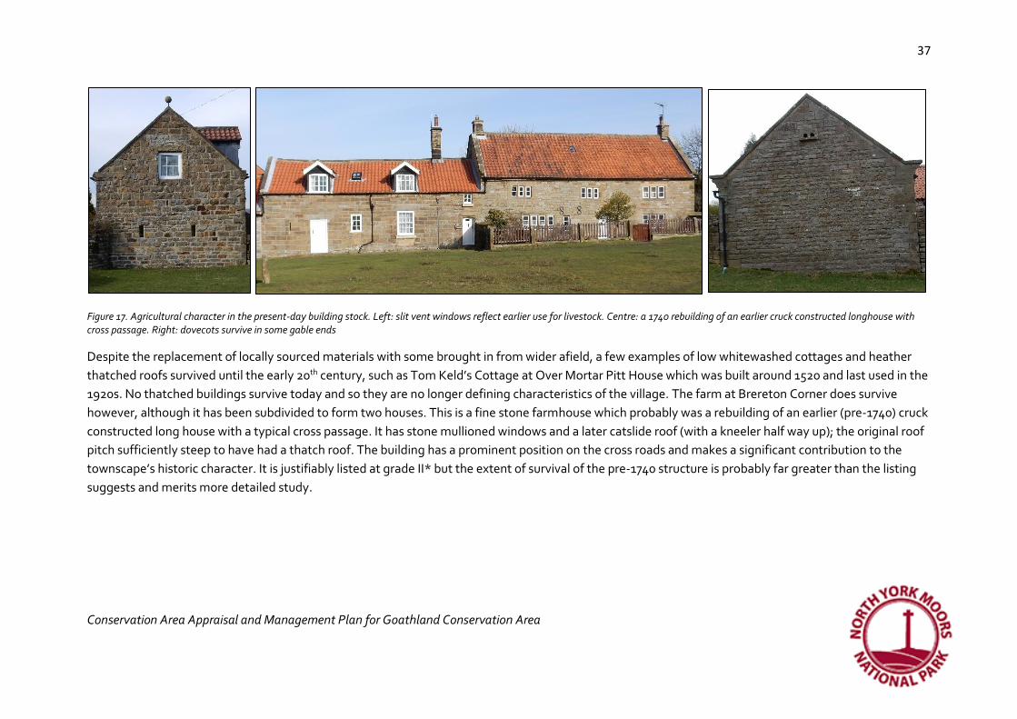
Figure 17. Agricultural character in the present-day building stock. Left: slit vent windows reflect earlier use for livestock. Centre: a 1740 rebuilding of an earlier cruck constructed longhouse with cross passage. Right: dovecots survive in some gable ends
Despite the replacement of locally sourced materials with some brought in from wider afield, a few examples of low whitewashed cottages and heather
thatched roofs survived until the early 20th century, such as Tom Keld’s Cottage at Over Mortar Pitt House which was built around 1520 and last used in the
1920s. No thatched buildings survive today and so they are no longer defining characteristics of the village. The farm at Brereton Corner does survive
however, although it has been subdivided to form two houses. This is a fine stone farmhouse which probably was a rebuilding of an earlier (pre-1740) cruck
constructed long house with a typical cross passage. It has stone mullioned windows and a later catslide roof (with a kneeler half way up); the original roof
pitch sufficiently steep to have had a thatch roof. The building has a prominent position on the cross roads and makes a significant contribution to the
townscape’s historic character. It is justifiably listed at grade II* but the extent of survival of the pre-1740 structure is probably far greater than the listing
suggests and merits more detailed study.

38
Conservation Area Appraisal and Management Plan for Goathland Conservation Area
38
Figure 18. A group of buildings formerly known as Chapel Houses (c.1855) and the Cross Pipes Inn (c.1909)
Other fragmentary remains or earlier buildings survive at
Manor House, predominantly 18th century, but a datestone
of 1668 found in the garden hints at an earlier building on
the site. An unlisted collection of buildings, formerly the
Cross Pipes Inn (in the mid-19th century), but retaining a
number of architectural features that may be earlier, may
merit listing. Sitting in a prominent cross roads location
with no boundaries and featuring blocked openings and
redundant architectural features plus distinctive 19th
century mullioned windows (referencing Tudor window
design), cascading levels of pitched red pantiled roof to the
rear with water tabling, it makes a strong contribution to
the historic character of the village, although one of the
buildings has suffered from modern window and door
detailing and a consequent loss of historic character. The use of flags for surfacing in the immediate environs also contributes towards the interest as do
the outbuildings which retain agricultural character.
The majority of buildings in Goathland are 19th and 20th century however. By the mid-19th century, the few buildings that existed were predominantly
farmsteads at Prudam Field, Wheat Hill Cottage, High Mortar Pit (now Rose Cottage?), Brayton and Waites. Some agricultural character survives in the
form of long ranges of buildings originally consisting of farmhouse and outbuildings, sometimes with slit vent windows and dovecotes in gable ends.

39
Conservation Area Appraisal and Management Plan for Goathland Conservation Area
39
Figure 19. Farm ranges still contribute towards the architectural character of the village, but window detailing is important in helping to conserve this without over domestication.
The Church, Manor House, Village Pound and the inn were located at the south end, and at the north, there was a small cluster of development based
around the Mill, the Railway and a Primitive Methodist Chapel built in 1861. As buildings were updated, extended or replaced, local materials would be
recycled. For example, the village Poor House had been rebuilt in 179927 but burnt down later. When the parish church was demolished to make way for a
new one finished in 1821, building materials not reused in the new church were recycled to rebuild the Poor House. Out of the salvaged materials, the
overseer John Collinson managed to scrape together enough stone and funds to build three houses for the poor. When the 1821 Church was replaced with
a larger one, its stone was used to make the new church tower. Before the railway brought in new building materials, it always made good economic sense
to reuse stone that had already been quarried and dressed. Consequently, some of the herringbone patterned stonework from the 1821 church also found
its way to Nesfield and Mulgrave Cottages designed by W. H. Brierley (who designed the church) for Mr M. McEacharn,28 but herringbone marked
stonework can be seen in other places, such as the boundary wall at the mill.
27 Hollings 1990, 50 28 Information from listed building description, LB 327577

40
Conservation Area Appraisal and Management Plan for Goathland Conservation Area
40
Figure 20. Nesfield and Mulgrave Cottages designed by Brierley c.1896
The opening of the railway in 1836 not only encouraged more building, but it made possible the importation of building materials from elsewhere and an
influx of building designs that came from national ideas of what the fashionable house should look like. However, it was not until the railway was extended
to its present position in 1864, that the real impact on the building type was felt. As the village became the focus of day trips and longer stays, there was a
demand for more buildings to provide hospitality, or retirement and second homes. This led to a distinctive shift in architectural styles, especially along the
north end of the village resulting in tall Victorian buildings ornamented with bargeboards and finials and sometimes referencing earlier architectural styles
such as Tudor and Gothic; the village’s modest architectural character was gradually diminished, but the architect who designed the new St. Mary’s Church
in 1898 still strove for simplicity. The new station had a coal and lime depot to deliver fuel to the Victorian homes that no longer used peat and the
limestone was required for new building as well as agricultural improvements.
41
Conservation Area Appraisal and Management Plan for Goathland Conservation Area
41
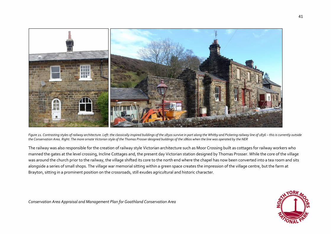
Figure 21. Contrasting styles of railway architecture. Left: the classically inspired buildings of the 1830s survive in part along the Whitby and Pickering railway line of 1836 – this is currently outside the Conservation Area. Right: The more ornate Victorian style of the Thomas Prosser designed buildings of the 1860s when the line was operated by the NER
The railway was also responsible for the creation of railway style Victorian architecture such as Moor Crossing built as cottages for railway workers who
manned the gates at the level crossing, Incline Cottages and, the present day Victorian station designed by Thomas Prosser. While the core of the village
was around the church prior to the railway, the village shifted its core to the north end where the chapel has now been converted into a tea room and sits
alongside a series of small shops. The village war memorial sitting within a green space creates the impression of the village centre, but the farm at
Brayton, sitting in a prominent position on the crossroads, still exudes agricultural and historic character.

42
Conservation Area Appraisal and Management Plan for Goathland Conservation Area
42
Walter Henry Brierley (1862–1926) was a York architect who practised in the city for 40 years. He joined the firm James Demaine when he came to York – this company had been established by the renowned 18th century architect John Carr who designed over 200 building mostly in Yorkshire and the north east. Brierley took over the practice in 1899 and by then he was referred to as "the Yorkshire Lutyens". He is also credited with being a leading exponent of the "Wrenaissance" style - incorporating elements of Christopher Wren. Brierley's works include civic buildings, churches, schools and private houses and are located mainly in York, North Yorkshire and the north of England. He was responsible for over 300 buildings between 1885 and the time of his death in 1926. Goathland is particularly rich in Brierley’s work and his architectural styles make a significant contribution to the Conservation Area. He enjoyed bringing together different styles such as Jacobean, Queen Anne, Vernacular and neo-Georgian, but his work was predominantly Arts and Crafts29 and good examples of all of his styles are to be found throughout the Conservation Area.
Buildings in Goathland by Brierley include:
• Church of St. Mary 1894-96. Listed grade II*
• Nesfield and Mulgrave Cottages. Listed grade II. Two houses. c.1896 (with later alteration and extension) for Mr M.McEacharn. Herringbone-tooled sandstone re-used from parish church of 1821, replaced 1894-96 by Church of St. Mary
• Brereton Lodge. Listed grade II. Shooting lodge, now house. c.1902 for W. Brooke
• The Mallan Hotel. Listed grade II. Formerly known as The Mallyon Spout Hotel. Date d 1892; part demolished, rebuilt and extended c.1935. By Demaine and Brierley for M.D.McEacharn
• Other buildings in the village may also be designed by Brierley and this merits further research
The Borthwick Institute in York holds an archive of the Atkinson Brierley architectural practice, a practice that lives on as Brierley Groom, the oldest architectural firm in the UK having continuously practised since 1750.
One of the most distinctive styles in the village is the late 19th and early 20th century Arts and Crafts buildings of which there are many. This was
particularly popular with Walter Brierley an architect who appears to have designed a number of the buildings (see insert above), but was also continued
along the Orchards where another house dating to 1897 was built for a German classical pianist Christian Gotlieb Padel and a later row of cottages built in
29 This was a movement which reacted against mass production and industrialisation and instead used traditional craftsmanship and revived medieval architectural styles.

43
Conservation Area Appraisal and Management Plan for Goathland Conservation Area
43
1921 each with a plot including an orchard. These houses stand out because of simple detail referencing earlier styles and the use of reproduction mullion
and transom windows, hand made iron door furnishings and leaded glass.
The twentieth century has done much to dilute the agricultural character and has introduced a variety of materials and suburban styles of housing, not all
of which make a positive contribution. However, the early 20th century semi-detached houses on Mill Green Way, mostly built by 1914, developed north of
the Hydro, retain some fine Edwardian features and create a homely scene of varied roof lines, and a combination of white render and red brick, all topped
with red pantiles and each with a view across a pasture field. Many traditional windows have been lost, but a few oriel windows on the gables cling on and
half glazed early to mid-20th century timber doors help to conserve historic character. Elsewhere, the mid-20th century developments have often resulted
in a loss of local distinctiveness.
Considerable significance:
• Pitched roofs and red pantiles, cascading rooflines and chimney stacks
• Predominant materials in sandstone and timber (also cast iron near the station)
• Farmhouses and outbuildings
• Dovecotes and slit vent windows
• Traditional window and door types
• Victorian and Edwardian villas and the contribution by Brierley
• Railway buildings
Limited significance:
• Recycled building materials
Opportunities to conserve and enhance
• New building stock should remain modest in scale and retain the dispersed settlement pattern

44
Conservation Area Appraisal and Management Plan for Goathland Conservation Area
44
• Sandstone, timber and pantile are the characteristic building materials that should be visible in any long view, although the use of more modern materials may be appropriate in development in more discreet locations.
• Pitched roofs are characteristic and flat roofs would be a negative feature
• The removal of permitted development rights (an Article 4 Direction) would help to conserve and enhance the special interest of the Conservation Area by restricting the use of plastic windows and doors and modern roofing materials
• Further research could take place into the contribution by Walter Brierley of the distinctive architectural style of the village
• See individual character areas for more detailed recommendations
The little details
In a nutshell…fingerposts and gateposts, memorial to war loss and seats with memorials. Railway heritage revived
and forgotten. Traditional lampposts and stone trods. Date stones and guard stones, sheep stoop and sheep grazing,
dovecots and weather vanes.
Historic and architectural interest is derived from small features that individually might make little impact, but collectively, contribute considerably to the
character of a village. These are the sorts of things that add local distinctiveness and texture to the built environment and, often, a sense of connection
with history – these can all too easily be overlooked, replaced, ‘improved’ or ignored, adding to a subtle sanitisation and erosion of local distinctiveness.
These are the sorts of things we do not always notice until they are gone.
One of the most prominent features is the war memorial near the shops which is based on the Lilla Cross which is located 5 miles away.30 This has taken on
the appearance, at a distance, of a market cross, set within a wide grassy, but boggy area. Traditional cast iron fingerposts also contribute towards the
historic character of the village as do the plentiful stone trods across the wide grassy spaces. These grassy spaces are also endowed with many public seats
of various designs and ages and often fixed with a commemorative plaque to late residents who previously enjoyed the views.
30 The Lilla Cross was allegedly a Bronze Age monolith turned into a Christian cross to commemorate the death of a 7th century thane, Lilla, who died trying to save the life of King Edwin (Peirson undated, 6)

45
Conservation Area Appraisal and Management Plan for Goathland Conservation Area
45
Much less visible is a scattering of other minor structures. A stone trough and another repaired in concrete adjacent are to be found near the car park and
an abandoned two-hole stone sleeper complete with chair31 near the Goathland Hotel is an unappreciated testament to the world’s early railway
technology. Throughout the village, several crudely dressed redundant stone gateposts are evidence of former agricultural land use.
Figure 22. Left to right: traditional cast iron finger posts occur throughout the village and reinforce historic character. Redundant farm gateposts and a two hole sleeper stone reference the agricultural origins of the village and the arrival of the pioneering Whitby and Pickering Railway in 1836. The later NER buildings are made distinctive by being painted in NER livery. The war memorial set within a wide grassy space helps to create a village green character
Only a few buildings have datestones and a few have ball finials added to their gates and boundaries. Victorian rooflines were endowed with detailing such
as finials and bargeboarding. They also introduced stone pillars with the names of their houses engraved on them and intricate iron railings that survived
the depredations of the Second World War.
The railway area has a far greater number of minor features that reinforce the station’s historic connections with the North Eastern Railway and this is
considered in more detail in the Railway Character Area.
31 The iron fixing to hold the metal rail in place on top of the stone sleeper

46
Conservation Area Appraisal and Management Plan for Goathland Conservation Area
46
Figure 23.Stone horse troughs at a prominent position next to the busy car park adds historic interest; the Reading Room represents the Victorian concerns for education; the village has many different seats available from which to appreciate the views. This Victorian type was designed to be sustainable by replacing the timber elements when required, but reusing the skeuomorphic iron framework. Many seats in the village are commemorative.
Considerable significance:
• War memorial
• Bargeboards and finials
• Gateposts and NER bollards
• Two-hole sleeper stone
• Cast iron signage at railway station
Some significance
• Datestones
• Cast iron fingerposts
• Horse troughs
• Traditional style lampposts
47
Conservation Area Appraisal and Management Plan for Goathland Conservation Area
47
Limited significance
• Public seating
• Wall mounted lamps
Opportunities to conserve and enhance
• The loss of minor historic features can cause harm to the historic interest of a Conservation Area and so they should be actively managed
• Victorian public seating was designed so that the iron elements could be reused when the timber elements became worn out. This sustainable approach to long term management should be adopted on Victorian seating
• Redundant gateposts have become characteristic and should be preserved
• Traditional street lighting and finger posts should be retained, but the lampposts are needing new paintwork
• The stone sleeper and chair is vulnerable to theft and could perhaps be better located near the railway where it can be included in interpretation
• The diverse range of designs of public seating is not harmful and any attempt to harmonise designs should be resisted
Character areas
St Mary’s Character Area
This character area consists of a cluster of buildings around the church representing the historic core of the village. The planform is of no particular layout
and has simply evolved over time around two farms, one of which has been an inn. Consequently, there is an attractive higgledy piggledy quality to this
area with pretty pitched pantile roofs of varying sizes and orientations enhanced with kneelers and water tabling. Views into this character area are of red
pantile roofs (some with weather vanes) shrouded by trees and stone wall boundaries, grassy spaces and grazing sheep, all with a backdrop of the moors.
Views of the church tower are shrouded by trees and it is set within a pretty tree and stone wall-lined graveyard on the site of the former church. The
church sits within a sheltered basin and so the moors form a backdrop to it and dominate it.

48
Conservation Area Appraisal and Management Plan for Goathland Conservation Area
48
Figure 24. St. Mary’s Character Area (in yellow)
© Crown copyright 2017. All rights reserved.
Licence number 100042279

49
Conservation Area Appraisal and Management Plan for Goathland Conservation Area
49
The stone walls of the square village pinfold sit on the village edge and boundaries are predominantly 18th century enclosure stone walls with one retaining
a sheep stoop. Wide open grassy spaces are grazed by sheep and crossed with un-made tracks and stone trods. Ancient holloways approach the village
from the west and head towards the church and the former Cross Pipes Inn.
The building character is predominantly modest – a modest church, modest farm buildings, modest houses but there is a splash of Victorian (neo
Elizabethan) grandeur in the hotel. Traditional small windows, multi pane sashes, Yorkshire sliding sashes and Victorian style four pane sashes contribute
to the historic and agricultural character as do vent windows and dovecots which contribute towards the agricultural character.
Buried archaeological remains are most likely to survive around the former Cross Pipes Inn, Church House Farm and the site of the former church in the
graveyard next to the present day one. It is also clear that the building fabric at the Cross Pipes Inn and Church House farm has evidence of earlier
alterations and buildings.
Figure 25. Left: a modern development references the historic character of this part of the village with cascading pitched rooflines of red pantile and water tabling, traditional window types and stone materials and so it fits in well with nearby historic buildings (centre). Right: the undulating landscape means that much of this character area sits within a sheltered bowl and views into it from the surrounding moors are of cascading pitched pantile roofs. While most buildings are only one or two storeys, the height of any new development should consider the perception of height based on its position within a hilly environment. This view was also used in the closing credits of a popular TV Series called Heartbeat filmed between 1992-2010 and set in the 1960s.

50
Conservation Area Appraisal and Management Plan for Goathland Conservation Area
50
Windows
Doors

51
Conservation Area Appraisal and Management Plan for Goathland Conservation Area
51
The little details
Considerable significance:
• Cascading red pitched pantile roofs
• Sandstone as the predominant building material
• Moorland views
• Wide grass verges, open spaces
• Stone trods and un-made tracks
• Stone boundaries
• Farm buildings, outbuildings, dovecote, gateposts
• Separation of pound and Hermitage site from village
• Traditional window types – sliding sashes, multi pane, Yorkshire and 4/4; Tudor revival mullion windows, arts and crafts lead casements
• Agricultural door types including batten and plank and stable door. Domestic doorways in neo Gothic and neo Tudor styles and four panels
• Holloways leading to church and inn

52
Conservation Area Appraisal and Management Plan for Goathland Conservation Area
52
Some significance:
• Cast iron fingerposts
• Trees in the churchyard
Limited significance:
• Public seating
Opportunities to conserve and enhance St. Mary’s Character Area
• Views of the surrounding moorland should be retained without obstruction
• The church tower should remain the tallest visible building in this character area
• Wide grass verges and characteristic open fields between buildings should be retained so that the dispersed character of the plan form is conserved.
• The loss of traditional stone boundaries and green verges should be resisted.
• Unmade tracks should be retained in order to conserve the agricultural character. Modern surface materials should be avoided
• Stone trods have become overgrown and are now missing from places – they could be re-exposed.
• Limit street signs, road markings, bins, and street furniture to reduce clutter, especially around the junctions, however retain the use of traditional cast iron finger posts
• The use of characteristic boundary treatments of stone can help new developments fit in.
• New development should avoid curving street patterns, but continue in clusters with varied roof lines and respect the essential character of the village with open grassy spaces
• Buildings should retain their modest agricultural character through the use of small windows and retention of agricultural details such as vent windows, dovecotes, stone gateposts and stable doors
• Roofs should use red pantiles and be pitched; the traditional building material is stone and timber
• Trees can be used around buildings to provide shelter
• A small number of modern plastic windows detract from historic and architectural interest

53
Conservation Area Appraisal and Management Plan for Goathland Conservation Area
53
• The pinfold should be retained and future changes should preserve the space between the pinfold and the village – it was designed to be apart from the village.
• The holloways should be conserved; they are an important part of the Conservation Area’s setting
Intakes and Infill Character Area (includes proposed extension to Conservation Area at Orchard Farm)
Figure 26. The Intakes and Infill Character Area (brown and proposed extension brown with blue outline)
© Crown copyright 2017. All rights
reserved. Licence number 100042279

54
Conservation Area Appraisal and Management Plan for Goathland Conservation Area
54
This character area consists of a few pre-19th century farms set within areas of intake which have subsequently been developed in the 19th and 20th
centuries. The building character is therefore more mixed reflecting architectural styles that encompass 17th century elements at Brereton House with its
massive external chimney stack and catslide roof; agricultural character such as the slit vented gable end of Wheat Hill; 19th century cottages and large
villas, often designed to revive medieval and Tudor building traditions with neo Gothic arches and Tudor doorways, and 20th century semi-detached
houses and bungalows. The previous modest building character of the village was diminished with the construction of the more ostentatious Victorian and
Edwardian villas which conveyed wealth and status as Goathland opened up to a new appreciative audience. However, the mix of building styles has led to
a creeping suburban character to the area which conflicts with the rural open spaces. Many of the 20th century houses have failed to reflect either local
vernacular building styles or the revived historical architectural styles of the Victorian and Edwardian era development and a range of modern building
materials have been introduced from brick to cement render and plastic windows.
While the building character is mixed, the unifying character of this area is that many of the intakes, particularly on the west side of the main road remain
as grassy open spaces and wide grassy verges with stone trods have survived the later development. Sheep graze the intakes and stone field walls, some
with gappy hedges atop, and redundant gateposts provide historic interest. The visitors’ car park has made use of an intake east of Brereton Lodge; the
boundary of the car park is formed by moss covered dry stone walls with mature trees growing on top. The Victorian and Edwardian development of this
area has also introduced fine stone gateposts, often with the name of the villa carved on to them and ornate wrought iron railings.
Windows
There are vast views from the villas on the east side of the main road across to the moors in the west and many of the houses have been designed to take
advantage of these views from large bay windows. There are a wide range of window types here from the pretty arched windows and fanlight of
Goathland House, to the pointed arched windows of Mallyan Lodge and the Grange. Arts and Crafts make a significant contribution here too with
revivalist window and door designs and ironmongery.

55
Conservation Area Appraisal and Management Plan for Goathland Conservation Area
55
Doors

56
Conservation Area Appraisal and Management Plan for Goathland Conservation Area
56
The little details
Considerable significance:
• Moorland views
• Intakes, pasture land and sheep between houses
• Stone boundaries with or without hedges
• Greens and verges with stone trods and un-made tracks
• Old stone gateposts
• Farmhouses, former farm buildings
• Chimney stacks, weather vanes, pitched roofs, mostly pantiles and Welsh slate
• Dormers with finials and bargeboards
• Influence of Walter Brierley
• Neo Tudor and neo Gothic windows and multi pane sashes, Arts and Crafts
• Ostentatious doors with large iron hinges (usually Arts and Crafts)
• Dwarf walls with iron rails
Some significance

57
Conservation Area Appraisal and Management Plan for Goathland Conservation Area
57
• Datestones
• Cast iron fingerposts
• Dovecotes
Limited significance
• Public seating
No significance or negative impact:
• Suburban character
• Buildings lacking local distinctiveness
• Plastic windows
• Tarmaced drives
• Cementitious pointing including ribbon pointing
Opportunities to conserve and enhance
• New development should avoid curving street patterns
• Wide grass verges and characteristic open fields between buildings should be retained so that the dispersed character of the plan form is conserved.
• Views towards the west across moorland should be retained
• The loss of traditional stone boundaries and green verges should be resisted. Where sheep stoops survive they should be retained
• Unmade tracks should be retained in order to conserve the agricultural character.
• Stone trods can be used where firmer surfaces are required. The stone trods on Darnholme Lane are loosening in places and are under appreciated features covered in mud and grass
• The use of characteristic boundary treatments can help new developments fit in.
• Trees can be used around buildings to provide shelter or to hide them from view
• The use of further suburban housing styles should be avoided

58
Conservation Area Appraisal and Management Plan for Goathland Conservation Area
58
• Some historic buildings have been repointed in the mid 20th century in cementitious ribbon pointing; this is damaging to the stonework and advice should be available to home owners on appropriate pointing methods and materials
• Some replacement pantiles are modern and smoother and more uniform in shape than traditional pantiles; therefore, as many pantiles as possible should be reused to help new ones blend in and handmade pantiles will make better replacements than machine-made ones. When replacing pantiles artificial and unconvincing pre-weathered varieties should be avoided as natural materials should weather naturally to acquire historic patina over time.
Victorian & Edwardian Village Character Area
This character area takes its distinctiveness from the Victorian and
Edwardian expansion of Goathland brought about by the growth of the
railway in the 1860s and is a present-day honeypot for day visitors. The
construction of a series of shops and the hotel was to serve the visitors
arriving by railway and the construction of the Primitive Methodists’
Chapel and Reading Room to serve the spiritual and educational needs of
the growing population. It is particularly rich in Victorian and Edwardian
villas with ostentatious designs that countered the earlier agricultural
simplicity of the buildings.
The area has continued to be popular and so the density of buildings is
higher here than in other parts of the village (excluding the railway area)
and the mix of architectural styles includes Victorian neo Gothic,
Edwardian and mid-20th century bungalows and semi-detached houses. It
has undergone rapid change in more recent decades and consequently it
has more modern replacements of windows and roofing materials and Figure 27. The Victorian & Edwardian Village character area (in purple)
© Crown copyright 2017. All rights
reserved. Licence number 100042279

59
Conservation Area Appraisal and Management Plan for Goathland Conservation Area
59
these can detract from the historic character of the village.
The earliest building appears to be Waites House, a farm which looks 18th century with later additions, but may have earlier fabric within; its windows are
typical Victorian style replacement four pane sashes.
The Victorian buildings are furnished with the fashions of the time including painted bargeboards to steeply pitched roofs, dormer windows, finials and as
with the rest of the village, splashes of brightly painted mock Tudor gables which continued in popularity in Edwardian times and sit in prominent positions
in views of the village. Ornate wrought iron window railings still survive on shop fronts and the wall fixed lanterns contribute towards historic character. A
few more ostentatious houses have grand stone gate posts; in one case, an old field boundary gatepost sits alongside the later Victorian one. Rustic
wooden gates on Mill Green Way including a garden gate into the Hydro, fit in well with the character of this quiet back lane. The Reading Room and
Methodist Chapel are modest. The Reading Room is a tiny brick building of 1894 and a modest batten plank door set within a later porch with barge
boarding. The building has been refenestrated and re reroofed, both in modern materials and so it has lost some of its historic charm. The chapel sits gable
end to the street front with historic window detailing and a ball finial that draws the eye upwards.
While the majority of Victorian buildings were constructed in stone, the Edwardian period generated a number of rendered properties such as the
sprawling Inn on the Moor and the row of semi-detached villas to the rear on Mill Green Way built in the first few decades of the 20th century with the last
house not constructed until about 1950. Here the mock Tudor theme and some Arts and Crafts continues but historic photographs show that these houses
were originally pebble dashed in natural browns, not the bright white of today. The plate glass windows to the shop fronts are also Edwardian at their
earliest, although some are clearly modern replacements. Scripps Funeral Services/ Aidensfield Garage has another type of historic charm; playing to the
popularity of the Heartbeat television series, it sits firmly within the 1960s. The late 20th century saw development making some attempt at reintroducing
stone as the main building materials, but as the design of the bungalows failed to reflect any other aspect of the village’s historic character, they have
instead introduced a suburban style that lacks local distinctiveness.
As with other parts of the village, although the building style is mixed and represents several phases in architectural fashions, it is the wide grass verges
and green spaces that unify the whole. Here some stone trods survive (there are none on Mill Green Way), but are gradually disappearing below the turf.
They have been supplemented with wider stone paving more suited to the large number of visitors in places (and has removed stone trods), but the
number of visitors is so high that where there are no wide pavements, the grassy verges and green are being eroded. The cast iron finger posts and
traditional street lights also help to unify the area and the parked cars from the 1960s prolong the popularity of the former television series Heartbeat.
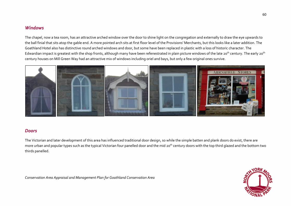
60
Conservation Area Appraisal and Management Plan for Goathland Conservation Area
60
Windows
The chapel, now a tea room, has an attractive arched window over the door to shine light on the congregation and externally to draw the eye upwards to
the ball finial that sits atop the gable end. A more pointed arch sits at first floor level of the Provisions’ Merchants, but this looks like a later addition. The
Goathland Hotel also has distinctive round arched windows and door, but some have been replaced in plastic with a loss of historic character. The
Edwardian impact is greatest with the shop fronts, although many have been refenestrated in plain picture windows of the late 20th century. The early 20th
century houses on Mill Green Way had an attractive mix of windows including oriel and bays, but only a few original ones survive.
Doors
The Victorian and later development of this area has influenced traditional door design, so while the simple batten and plank doors do exist, there are
more urban and popular types such as the typical Victorian four panelled door and the mid 20th century doors with the top third glazed and the bottom two
thirds panelled.

61
Conservation Area Appraisal and Management Plan for Goathland Conservation Area
61
The little details

62
Conservation Area Appraisal and Management Plan for Goathland Conservation Area
62
Considerable significance:
• Wide verges and greens
• Stone trods
• Former farm buildings in stone and red pantile
• Varied roof lines
• Victorian civic and commercial buildings – chapel, school, reading room
• Edwardian shop fronts
• Traditional windows, 2/2 pane sashes, arched windows, window iron railings, landscaped side hung casements, oriel windows
• Coursed, roughly dressed sandstone to pre-1860s buildings; rockface and margined sandstone to post 1860s buildings (up to 20th century)
Some significance:
• Old field boundaries, rustic gates and walls
• Mock Tudor gables
• Datestones
• Cast iron fingerposts
• Traditional street lights
• Wall hung lights
• Horse troughs
Limited significance:
• Associated with Heartbeat TV series
No significance or negative impact
• Plastic window replacements

63
Conservation Area Appraisal and Management Plan for Goathland Conservation Area
63
• Buildings that lack local distinctiveness
Opportunities to conserve and enhance
• New development should avoid curving street patterns.
• Styles of housing can reference Victorian and Edwardian architecture and range from single storey (with dormers if required) to two storeys (with dormers in some locations). Rooflines should be broken.
• Where agricultural character survives, it should be retained and can also be referenced in new development.
• Wide grass verges which now function as a village green, should be retained.
• The grass verges are being eroded by large visitor numbers, especially where there are no stone pavements
• The loss of traditional stone boundaries should be resisted.
• Unmade tracks should be retained in order to conserve the agricultural character.
• Stone trods are not being actively maintained and are becoming grown over
• The use of characteristic boundary treatments can help new developments fit in.
• Trees can be used around buildings to provide shelter or to hide them from view
• The use of further suburban housing styles should be avoided
• Stone is the main building material, although other materials can be used if limited to short distance views. The dressing details of the stone are important to help new development fit in
• There is a wealth of interesting window types; this could be reflected in new development where high quality window design could enhance the architectural interest

64
Conservation Area Appraisal and Management Plan for Goathland Conservation Area
64
NER Railway and Mill Character Area
The character of this area is dominated by the NER railway
station designed by Thomas Prosser, the North-East
Railway’s first permanent architect. The railway group is
managed by the Goathland Station Group of the North
Yorkshire Moors Railway and has been used as Aidensfield
Station on the long running television series Heartbeat and
as Hogsmeade in the Harry Potter films. Most of the
buildings on site are listed and associated structures are
likely to be considered as listed because they are within the
curtilage of the main station area.
The mill has much more ancient origins and clings to the side
of the river which once provided the power to grind local
cereals. It is now much altered and has lost some historic
interest through enlargement, replacement windows, doors
and reroofing, but still retains some historic and
architectural interest. Unlike the station, it uses the
Goathland traditional roofing material of red pantile, while
the station benefitted from the importation by rail of Welsh
slate for the roofs. Both groups of buildings at the railway
station and the mill are of the highest historic interest because they both strongly relate to how Goathland evolved over time.
Figure 28. The NER Railway and Mill Character Area in red

65
Conservation Area Appraisal and Management Plan for Goathland Conservation Area
65
Figure 29. The mill with replacement red pantile roof, windows and doors and extended. A mill has been on this site since the early 13th century, but was reduced to a shell in the 1960s and subsequently enlarged and altered.
© Crown copyright 2017. All rights
reserved. Licence number 100042279
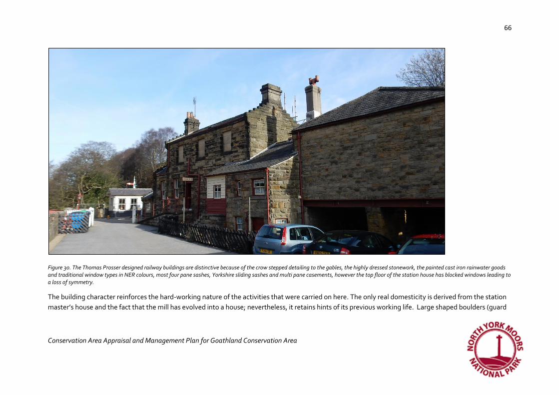
66
Conservation Area Appraisal and Management Plan for Goathland Conservation Area
66
Figure 30. The Thomas Prosser designed railway buildings are distinctive because of the crow stepped detailing to the gables, the highly dressed stonework, the painted cast iron rainwater goods and traditional window types in NER colours, most four pane sashes, Yorkshire sliding sashes and multi pane casements, however the top floor of the station house has blocked windows leading to a loss of symmetry.
The building character reinforces the hard-working nature of the activities that were carried on here. The only real domesticity is derived from the station
master’s house and the fact that the mill has evolved into a house; nevertheless, it retains hints of its previous working life. Large shaped boulders (guard
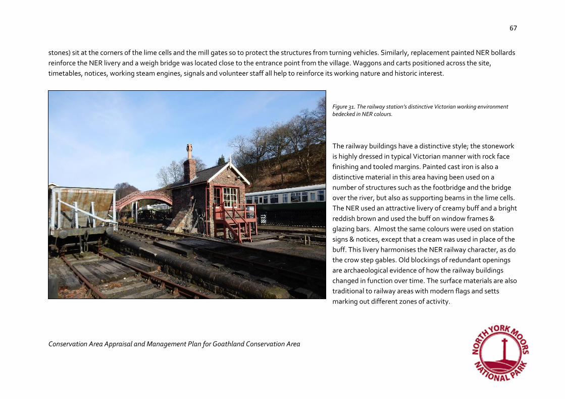
67
Conservation Area Appraisal and Management Plan for Goathland Conservation Area
67
stones) sit at the corners of the lime cells and the mill gates so to protect the structures from turning vehicles. Similarly, replacement painted NER bollards
reinforce the NER livery and a weigh bridge was located close to the entrance point from the village. Waggons and carts positioned across the site,
timetables, notices, working steam engines, signals and volunteer staff all help to reinforce its working nature and historic interest.
Figure 31. The railway station’s distinctive Victorian working environment bedecked in NER colours.
The railway buildings have a distinctive style; the stonework
is highly dressed in typical Victorian manner with rock face
finishing and tooled margins. Painted cast iron is also a
distinctive material in this area having been used on a
number of structures such as the footbridge and the bridge
over the river, but also as supporting beams in the lime cells.
The NER used an attractive livery of creamy buff and a bright
reddish brown and used the buff on window frames &
glazing bars. Almost the same colours were used on station
signs & notices, except that a cream was used in place of the
buff. This livery harmonises the NER railway character, as do
the crow step gables. Old blockings of redundant openings
are archaeological evidence of how the railway buildings
changed in function over time. The surface materials are also
traditional to railway areas with modern flags and setts
marking out different zones of activity.
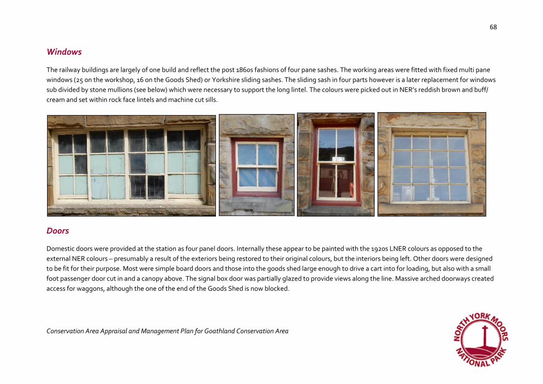
68
Conservation Area Appraisal and Management Plan for Goathland Conservation Area
68
Windows
The railway buildings are largely of one build and reflect the post 1860s fashions of four pane sashes. The working areas were fitted with fixed multi pane
windows (25 on the workshop, 16 on the Goods Shed) or Yorkshire sliding sashes. The sliding sash in four parts however is a later replacement for windows
sub divided by stone mullions (see below) which were necessary to support the long lintel. The colours were picked out in NER’s reddish brown and buff/
cream and set within rock face lintels and machine cut sills.
Doors
Domestic doors were provided at the station as four panel doors. Internally these appear to be painted with the 1920s LNER colours as opposed to the
external NER colours – presumably a result of the exteriors being restored to their original colours, but the interiors being left. Other doors were designed
to be fit for their purpose. Most were simple board doors and those into the goods shed large enough to drive a cart into for loading, but also with a small
foot passenger door cut in and a canopy above. The signal box door was partially glazed to provide views along the line. Massive arched doorways created
access for waggons, although the one of the end of the Goods Shed is now blocked.

69
Conservation Area Appraisal and Management Plan for Goathland Conservation Area
69
Figure 32. Internally the station has typical Victorian four panel doors. Externally the doors are key to the building’s function. Expanding double doors to the booking office to allow luggage through, and simple batten and plank doors for utility purposes, a blocked door in the side of the depot and large doors to allow access for carts with smaller cut out doors for foot traffic
The little details
Figure 33. A series of small architectural and historic features help to reinforce the working character of this area.

70
Conservation Area Appraisal and Management Plan for Goathland Conservation Area
70
Considerable significance:
• Nationally important collection of listed buildings at the station
• Uniformity of design and date at the station
• Blocked openings as archaeological evidence of change
• The use of NER livery throughout
• Steam, whistles, engine sounds
• The use of rockfaced stone with tooled margins on buildings
• Use of cast iron as a building material and for rainwater goods
• Industrial character
• Clock – the importance of time in rail travel
• Flags or setts as landscaping
• Waterside location of mill
Some significance:
• Dressed boulders as protection for gateposts and building corners
• Timetables, notices
Limited significance
• Associated with Hogsmeade Station in the Harry Potter films

71
Conservation Area Appraisal and Management Plan for Goathland Conservation Area
71
Figure 34. The modern shop at the station is a good example of how new buildings can reference existing character
Opportunities to conserve and enhance
• This is a high-density railway character area and so new development should only be permitted where it relates to the railway and references its style.
• New development in this area, or alterations to listed buildings, should be informed by a statement of significance
• The loss of traditional stone boundaries should be resisted.
• The conservation of cast iron rainwater goods, plaques, bridges and water tanks is essential in retaining the character of the station buildings
• The preservation of the station clock, original fixtures and bollards is also essential in protecting the significance of place
• When road surfaces are replaced at the station, tarmac should be gradually replaced with setts and flags

72
Conservation Area Appraisal and Management Plan for Goathland Conservation Area
72
• Future alterations at the mill could be informed by research into its evolution to help restore historic character.
• The gateposts and guard stone at the mill should be retained
Recommendations for future management
Recommended boundary changes
The Conservation Area Appraisal process is designed to review the boundaries of the Conservation Area. This will be done in consultation with the local
community, but two extensions are proposed, one is a minor extension at the Orchards and the other, which if accepted, would form another character
area as follows:
Proposed Whitby & Pickering Railway Character Area
This small character area is a proposed extension to the Conservation Area in order to
include a sample of the Whitby & Pickering Railway incline and buildings. The line was
powered by horse when it opened until it was absorbed into the York and North Midland
Railway in 1845 and was converted into a conventional double tracked steam-worked
railway. The engineer to the railway company was George Stephenson and the company
were considerably influenced by the opening of the Stockton & Darlington Railway in 1825
where Stephenson was also engineer. The incline runs through the village and to the south
east has been made into a track to Abbot’s Farm. Within the core of the village part of the
incline has been developed recently, but in this part of the village it survives well and is
currently used as a footpath. There are two groups of railway buildings associated with it.
One, Ash Tree Cottage, is a listed building (grade II) dating to 1836 with round arched
doorway and windows typical of the very earliest railway architecture. It is probably the
former Bank Top station. To the east, is a small terrace built by the railway company and
© Crown copyright 2017. All rights
reserved. Licence number 100042279
Figure 35. The proposed extension to the Conservation Area (in yellow)

73
Conservation Area Appraisal and Management Plan for Goathland Conservation Area
73
here too there are round arched windows and doors, although only one retains most of its original openings. Subsequent adaptation of the openings is
visible on the front elevation. Both sets of buildings face on to the incline, but with gardens in front. To the rear, there are yards and outbuildings which
front on to more of Goathland’s distinctive wide green verges.
The incline trackbed and the buildings have been included because they represent the pioneering days of the railway and such early structures, pre-dating
1840, are rare nationally. The two-hole stone sleeper positioned near the Goathland Hotel on the side of the incline may have come from this incline, but
no other stone sleepers are visible in the trackbed or reused in adjacent stone walls.
Windows, Doors and Little Details
Figure 36. The original station now hidden behind mature garden trees; the arched window possibly a ticket office window. Note also the arched doorways and high quality dressed stonework. Right: the central part of a small terrace shown as two terraced houses on maps dating to 1855 but possibly further divided or extended subsequently. The arched window on the right was originally a doorway. The top floor 8/8 sash window is original but the sash on the left is a replacement. Other parts of the terraced have had modern windows and doors inserted. These railway buildings are sufficiently early to pre-date the typical neo Gothic designs of the later Victorian railway buildings and instead reflect classical styles of architecture.

74
Conservation Area Appraisal and Management Plan for Goathland Conservation Area
74
Considerable significance
• Remains of the incline and archaeological evidence contained within it
• Two groups of early railway buildings of the highest level of historic interest
• Rounded arched openings, dressed ashlar stonework, original 8/8 sash windows, ticket office sash
• Uninterrupted views of and close association between the buildings and the incline
• Rear elevations looking out onto wide grass verges
Opportunities to conserve and enhance
• And future development or alterations to buildings outside the Conservation Area should better reflect the national importance of the historic buildings
• Replacement of modern plastic windows with traditional timber ones that reflect the original styles would enhance the Conservation Area
• The incline should remain undeveloped
• The railway terrace merits listing; the incline merits scheduling to reflect its early date and this area should be included within an extended Conservation Area
• New development in this area, or alterations to the historic buildings, should be informed by a statement of significance
• The conservation of cast iron rainwater goods is essential in retaining the character of the station buildings
Proposed extension - The Orchards
This is a small addition to the Conservation Area which currently stops short of the farm now known as Orchard Farm but which is on the site of, and
includes buildings from, Low Mortar Pit Farm. The farmhouse is on Ordnance Survey maps from the mid 19th century but is clearly much older being in a
style typical of the early to mid-18th century. The farm house encapsulates much that is typical of the architectural interest of the Conservation Area
including its origins as a series of dispersed farmsteads and the architectural style of pitched pantile roofs of varying heights, stone water tabling, chimney
stacks and stone construction.
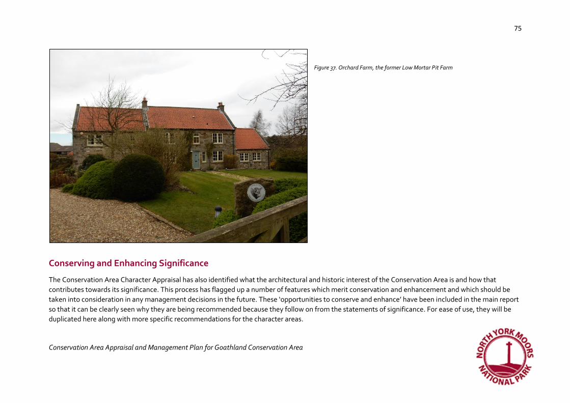
75
Conservation Area Appraisal and Management Plan for Goathland Conservation Area
75
Figure 37. Orchard Farm, the former Low Mortar Pit Farm
Conserving and Enhancing Significance
The Conservation Area Character Appraisal has also identified what the architectural and historic interest of the Conservation Area is and how that
contributes towards its significance. This process has flagged up a number of features which merit conservation and enhancement and which should be
taken into consideration in any management decisions in the future. These ‘opportunities to conserve and enhance’ have been included in the main report
so that it can be clearly seen why they are being recommended because they follow on from the statements of significance. For ease of use, they will be
duplicated here along with more specific recommendations for the character areas.

76
Conservation Area Appraisal and Management Plan for Goathland Conservation Area
76
Conserving and Enhancing the Street Plan, the Surfaces, Open Spaces and Boundaries of the Conservation Area • Tracks across the greens to houses should not be surfaced in urban or suburban materials, but retain their un-made appearance. Limestone chips
or gravel as dual wheel tracks allow the grass to grow between and offer a potential solution
• Stone trods should be retained and managed to ensure that turf does not grow over them.
• Open grassy areas are an essential part of the character of the village (apart from around the railway station) and future development should seek
to retain these and the largely dispersed settlement pattern
• Agricultural features such as stoops should be retained in the dry stone walls
• Stone flags around old farmsteads should be protected and old gateposts retained or reused
• The use of stone flags as a traditional surfacing material where required to protect the grassy verges, would not detract from historic character
• The choice of boundary types and materials will depend on the location and varies across the village. See the specific character areas for additional
information.
• The separation between Abbot’s House and the rest of the village should be sustained to reflect the origins of the village as a hermitage
Conserving and Enhancing the Archaeology of the Conservation Area
• In line with National Planning Policy (2012), developments within the Conservation Area may need to be informed by archaeological work and in
some cases, further archaeological excavation carried out before or during development.
• Similarly, developments affecting historic buildings may need to be informed by a Statement of Significance

77
Conservation Area Appraisal and Management Plan for Goathland Conservation Area
77
Conserving and Enhancing the Vistas and Views of the Conservation Area
Figure 38. Some of the most significant views towards, from and within the Conservation Area that merit conserving
• Any future changes within the village need to consider the impact on existing views out towards the moorland
© Crown copyright 2017. All rights reserved. Licence number 100042279

78
Conservation Area Appraisal and Management Plan for Goathland Conservation Area
78
• Red pantile should be considered for future roofing materials (excluding the station) so that views into the village continue to be a mix of green
trees and red roofs
• No new building or structure should dominate the church tower
• The positioning of street signs needs to consider the impact on views
• The impact on any of the views shown in figure 37 should be carefully considered in any future development.
Conserving and enhancing the Historic Buildings of Goathland
• New building stock should remain modest in scale and retain the dispersed settlement pattern
• Sandstone, timber and pantile are the characteristic building materials that should be visible in any long view, although the use of more modern
materials may be appropriate in development in more discreet locations.
• Pitched roofs are characteristic and flat roofs would be a negative feature
• The removal of permitted development rights (an Article 4 Direction) would help to conserve and enhance the special interest of the Conservation
Area by restricting the use of plastic windows and doors and modern roofing materials
• Further research could take place into the contribution by Walter Brierley of the distinctive architectural style of the village
Conserving and enhancing the little architectural and historic details
• The loss of minor historic features can cause harm to the historic interest of a Conservation Area and so they should be actively managed
• Victorian public seating was designed so that the iron elements could be reused when the timber elements became worn out. This sustainable
approach to long term management should be adopted on Victorian seating
• Redundant gateposts have become characteristic and should be preserved
• Traditional street lighting and finger posts should be retained, but the lampposts are needing new paintwork
• The stone sleeper and chair are vulnerable to theft and could perhaps be better located near the railway where it can be included in interpretation
• The diverse range of designs of public seating is not harmful and any attempt to harmonise designs should be resisted

79
Conservation Area Appraisal and Management Plan for Goathland Conservation Area
79
Management Recommendations for the Character Areas
St. Mary’s Character Area • Views of the surrounding moorland should be retained without obstruction
• The church tower should remain the tallest visible building in this character area
• Wide grass verges and characteristic open fields between buildings should be retained so that the dispersed character of the plan form is
conserved.
• The loss of traditional stone boundaries and green verges should be resisted.
• Unmade tracks should be retained in order to conserve the agricultural character. Modern surface materials should be avoided
• Stone trods have become overgrown and are now missing from places – they could be re-exposed.
• Limit street signs, road markings, bins, and street furniture to reduce clutter, especially around the junctions, however retain the use of traditional
cast iron finger posts
• The use of characteristic boundary treatments of stone can help new developments fit in.
• New development should avoid curving street patterns, but continue in clusters with varied roof lines and respect the essential character of the
village with open grassy spaces
• Buildings should retain their modest agricultural character through the use of small windows and retention of agricultural details such as vent
windows, dovecotes, stone gateposts and stable doors
• Roofs should use red pantiles and be pitched; the traditional building material is stone and timber
• Trees can be used around buildings to provide shelter
• A small number of modern plastic windows detract from historic and architectural interest
• The pinfold should be retained and future changes should preserve the space between the pinfold and the village – it was designed to be outside
the village.
• The holloways should be conserved and considered to be an important part of the Conservation Area’s setting
Intakes and Infill Character Area (includes proposed extension to include the Orchards)

80
Conservation Area Appraisal and Management Plan for Goathland Conservation Area
80
• New development should avoid curving street patterns
• Wide grass verges and characteristic open fields between buildings should be retained so that the dispersed character of the plan form is
conserved.
• Views towards the west across moorland should be retained
• The loss of traditional stone boundaries and green verges should be resisted. Where sheep stoops survive they should be retained
• Unmade tracks should be retained in order to conserve the agricultural character.
• Stone trods can be used where firmer surfaces are required. The stone trods on Darnholme Lane are loosening in places and are under appreciated
features covered in mud and grass
• The use of characteristic boundary treatments can help new developments fit in.
• Trees can be used around buildings to provide shelter or to hide them from view
• The use of further suburban housing styles should be avoided
• Some historic buildings have been repointed in the mid 20th century in cementitious ribbon pointing; this is damaging to the stonework and advice
should be available to home owners on appropriate pointing methods and materials
• Some replacement pantiles are modern and smoother and more uniform in shape than traditional pantiles; therefore, as many pantiles as possible
should be reused to help new ones blend in and handmade pantiles will make better replacements than machine-made ones. When replacing
pantiles artificial and unconvincing pre-weathered varieties should be avoided as natural materials should weather naturally to acquire historic
patina over time.
Victorian and Edwardian Village Character Area • New development should avoid curving street patterns.
• Styles of housing can reference Victorian and Edwardian architecture and range from single storey (with dormers if required) to two storeys (with
dormers in some locations). Rooflines should be broken.
• Where agricultural character survives, it should be retained and can also be referenced in new development.
• Wide grass verges which now function as a village green, should be retained.
• The grass verges are being eroded by large visitor numbers, especially where there are no stone pavements
81
Conservation Area Appraisal and Management Plan for Goathland Conservation Area
81
• The loss of traditional stone boundaries should be resisted.
• Unmade tracks should be retained in order to conserve the agricultural character.
• Stone trods are not being actively maintained and are becoming grown over
• The use of characteristic boundary treatments can help new developments fit in.
• Trees can be used around buildings to provide shelter or to hide them from view
• The use of further suburban housing styles should be avoided
• Stone is the main building material, although other materials can be used if limited to short distance views. The dressing details of the stone are
important to help new development fit in
• There is a wealth of interesting window types; this could be reflected in new development where high quality window design could enhance the
architectural interest
NER Railway Character Area • This is a high-density railway character area and so new development should only be permitted where it relates to the railway and references its
style.
• New development in this area, or alterations to listed buildings, should be informed by a statement of significance
• The loss of traditional stone boundaries should be resisted.
• The conservation of cast iron rainwater goods, plaques, bridges and water tanks is essential in retaining the character of the station buildings
• The preservation of the station clock, original fixtures and bollards is also essential in protecting the significance of place
• When road surfaces are replaced at the station, tarmac should be gradually replaced with setts and flags
• Future alterations at the mill could be informed by research into its evolution to help restore historic character.
• The gateposts and guard stone at the mill should be retained
Proposed Whitby & Pickering Railway Character Area • And future development or alterations to buildings outside the Conservation Area should better reflect the national importance of the historic
buildings

82
Conservation Area Appraisal and Management Plan for Goathland Conservation Area
82
• Replacement of modern plastic windows with traditional timber ones that reflect the original styles would enhance the Conservation Area
• The incline should remain undeveloped
• The railway terrace merits listing; the incline merits scheduling to reflect its early date and this area should be included within an extended
Conservation Area
• New development in this area, or alterations to the historic buildings, should be informed by a statement of significance
• The conservation of cast iron rainwater goods is essential in retaining the character of the station buildings
Conclusion
Goathland is a village of moorland views and grassy open spaces of untamed pasture and boggy verges crossed by ancient stone trods and tracks. It has its
origins in a medieval hamlet and later dispersed farmsteads. This dispersed agricultural settlement pattern started to change in the 1860s as more intakes
were filled with villas and bungalows constructed by the Victorian middle classes arriving by train and keen to visit or stay and admire the moorland views
and waterfalls. This created a new village core closer to the station where hotels and shops were developed to serve visitors and residents. There is a large
number of high quality late 19th and early 20th century architecture throughout the village, incorporating a wide range of revival styles, with a unique
concentration of buildings by the architect Walter Brierley. Collectively, this settlement pattern and building types of the village tell the story of how
Goathland evolved by representing its earlier agricultural origins and its later popularity with the Victorian and Edwardian middle classes.
However, some suburban building types and landscaping, plus the loss of some traditional windows and doors to be replaced with plastic, has diminished
this architectural and historic interest. Only the North York Moors Railway station area has conserved wholly its special interest and this is largely because
the buildings are listed and therefore protected from this erosion of character.
The appraisal recommends a number of measures designed to sustain and enhance the special interest of the Conservation Area including withdrawing
permitted development rights so that owners can be encouraged through the planning process and grant assistance to replace or repair windows and
doors in styles and materials that reflect the character of their buildings. It is also recommended that the Conservation Area boundary be extended to
include a sample of the Whitby & Pickering Railway trackbed and the surviving cottages from the 1830s associated with it; these remains are from the early

83
Conservation Area Appraisal and Management Plan for Goathland Conservation Area
83
pioneering days of the railway and are therefore nationally important and merit cherishing. Another proposed modest extension includes Orchard Farm
which has many of the distinctive architectural features associated with the rest of the Conservation Area.
Bibliography
Ekwall, E 1987 The Concise Oxford Dictionary of Place-names
Hartley, M and Ingleby, J 1972 Life in the Moorlands of North-East Yorkshire
Hare, Rev. E.B 1896 St. Mary’s Goathland (leaflet)
Hollings, A undated The History of Goathland Church
Hollings, A 1990 A History of Goathland
NYMNPA 2012 Walks Around Goathland
Peirson F. W. undated Local Guide. In and Around Goathland
Pevsner, N 1966 The Buildings of England. The North Riding
Thirsk, J 1984 Agrarian History of England and Wales: 1640-1750, Part 1
Acknowledgements:
Grateful thanks to Mrs Eileen Peirson for the use of her historic photographs and to John Bruce, Station Master at the Goathland Railway Station for a
guided tour and discussion about maintenance and early railways. Thank you also to Mrs Connie Wiggins, Clerk to Goathland Parish Council for making
introductions to Mrs Peirson and Mr Bruce.
Archaeo-Environment Ltd for North York Moors National Park Authority