conservation directory - environmentdata.org2905/obj/20001121.pdf · 2020-06-26 · 7.7 identifying...
TRANSCRIPT
NRA Notional Ptvers Authority Information Centre Head Office
j Oass No ..................... .....
lAccorton No .. ..
CONSERVATION
DIRECTORY
En v ir o n m e n t Ag e n c y
NATIONAL LIBRARY & INFORMATION SERVICE
HEAD OFFICE
Rio House, W aterside Drive, Aztec West, Almondsbury,
Bristol BS32 4UD
ENVIRONMENT AGENCY
FOREWORD
PURPOSE OF DIRECTORY
This Directory draws together, in one document, the relevant legislation, procedural guidance, contact addresses, technical references and other relevant information needed by NRA staff involved with conservation.
Part 1 provides guidance on conservation input to the NRA’s activities and includes sections on liaison procedures, species and habitat related issues, archaeology, environmental assessment and catchment management plans.
Part 2 sets out the key legislation which determines the NRA’s obligations toward conservation, including statutory instruments and European Directives. It also includes maps of areas designated for environmental purposes.
Part 3 provides a references list of guidance documents, technical publications and R & D outputs.
Part 4 contains addresses of relevant conservation organisations and an internal NRA staff framework for each Region.
The Directory is an internal guidance document and is designed so that individual sections can be updated, when necessary, without disruption to the overall structure.
National Rivers Authority
River House Waterside Drive Aztec West Almondsbury Bristol BS12 4UD Tel: 0454 624400 Fax: 624033
NRA CONSERVATION DIRECTORY
CONTENTSPAGE
Foreword PURPOSE OF DIRECTORY
PART 1: CONSERVATION IN THE NRA
1 CONSERVATION GUIDELINES 1-1
1.1 Preamble and Context 1-11.2 Statutory Duties and Obligations 1-11.3 Protecting and Enhancing Conservation Status 1-11.4 The NRA’s Conservation Strategy Aim 1-21.5 Strategic Conservation Objectives 1-2
2 SCOPE OF CONSERVATION DUTIES 2-1
2.1 Key Legislation 2-12.2 Internal Guidance 2-12.3 Guidance Relating to Archaeology and Cultural Heritage 2-2
3 LIAISON AND CONSULTATION 3-1
3.1 Internal Liaison 3-13.2 Procedures for External Liaison and Consultation 3-1
0 4 SURVEY PROCEDURES 4-1
4.1 Background 4-14.2 R & D Fellowship Methodologies for Optimising the Value of River
Corridor Survey Data (1993-1994) 4-34.3 River Habitat Survey 4-11
5 OPERATIONAL ACTIVITIES 5-1
5.1 Guidelines 5-1
6 NRA LANDHOLDINGS 6-1
6.1 Code of Practice on Conservation, Access and Recreation database 6-16.2 Species Protection 6-16.3 Archaeology 6-26.4 Architecture and Cultural Heritage 6-2
SPECIES AND HABITAT RELATED ISSUES 7-1
7.1 Otter Strategy 7-37.2 NRA Otter Management by Catchment 7-177.3 Guidelines on Procedures for Dealing with Dead Otters 7-197.4 Mink 7-257.5 NRA Statement on Fish-Eating Birds 7-297.6 Long-Term Waterways Bird Survey (WBS) Trends (1974-1993) 7-337.7 Identifying Freshwater Crayfish in Britain and Ireland 7-357.8 The NRA and Dragonfly Conservation 7-377.9 Phytophthora Root Disease of Common Alder 7-537.10 Native Trees and Shrubs in the British Isles 7-597.11 Pollarding Techniques 7-637.12 Procedure for Dealing With Dead Animals/Birds 7-677.13 MAFF Habitat Scheme Water Fringe Areas 7-717.14 Availability of Financial Support for Conservation-Related Activities 7-67
8 ARCHAEOLOGY. ARCHITECTURE AND CULTURAL HERITAGE 8-1
8.1 NRA and Archaeology8.2 Protecting Archaeological Sites8.3 Scope of Archaeological Duties8.4 Archaeological Assessment Flow Chart8.5 Liaison and Consultation
(a) Internal Liaison(b) Procedures for External Liaison and Consultation
8.6 Draft Brief for Field Archaeological Services8.7 Archaeological Database
9 ENVIRONMENTAL ASSESSMENT 9-1
9.1 Executive Group Paper 9-19.2 Construction of New Roads 9-5
8-18-28-38-48-38-38-5 %
8-11 8-13
iv

10 CATCHMENT MANAGEMENT PLANS
10.1 Conservation Issues in Catchment Management Plans10.2 Summary of Catchment Management Plans: Guidelines for Trusts10.3 Map of Catchments Within the NRA
10-1
10-110-7
10-11
v

PART 2: LEGISLATION AND DESIGNATIONS
11. LEGISLATION: A BRIEF OVERVIEW 11-1
11.1 ACTS OF PARLIAMENT 11-1
(a) WATER RESOURCES ACT 1991 11-1
Conservation in Relation to the NRA’s Functions 11-1General Conservation Duty 11-1Procedures in Special Areas 11-2Code of Practice 11 -2PIN on Conservation 11-3
(b) PLANNING LEGISLATION 11-8
Town & Country Planning Act 1990 11-8Planning & Compensation Act 1991 11-8Planning (Listed Buildings and Conservation Areas) Act 1990 11-8
(C) LEGISLATION RELATING TO CONSERVATION BODIES ANDAREAS ADMINISTERED BY THEM 11-8
National Parks and Access to the Countryside Act 1949 11-8Countryside Act 1968 11-9Protection of Wrecks Act 1973 11-9Ancient Monuments & Archaeological Areas Act 1979 11-9Wildlife & Countryside Act 1981 (as amended) 11-9National Heritage Act 1983 11-10Environmental Protection Act 1990 11-10
(d) OTHER RELEVANT CONSERVATION LEGISLATION 11-10
Coast Protection Act 1949 11-10Conservation of Seals Act 1970 11-10Badgers Act 1973 (as amended) 11-10Agriculture Act 1986 11-11Norfolk and Suffolk Broads Authority Act 1988 11-11Badgers Act 1991 11-11Land Drainage Act 1994 11-12

11.2 EUROPEAN LEGISLATIVE FRAMEWORK 11-15
(a) The NRA, Legislative Pathways, Influences and PressurePoints 11-15
(b) EC Directives and Associated Regulations 11-16(c) A Precis of Guidelines for EC Funding and the NRA with
particular regard given to FRCN Functions 11-17
11.3 STATUTORY INSTRUMENTS 11-21
(a) Environmental Assessment 11*21(b) Other Relevant Sis 11-21(c) The Habitats & Species Directive: Implications for NRA
Policy and Operational Activities 11-23
12 INTERNATIONAL AGREEMENTS AND CONVENTIONS 12-1
12.1 International Agreements and Conventions 12-112.2 The NRA and Biodiversity 12-3
13 ENVIRONMENTAL DESIGNATIONS 13-1
13.1 Designations 13-113.2 Areas of Outstanding Natural Beauty (AONBs) 13-513.3 Environmentally Sensitive Areas (ESAs) 13-613.4 Heritage Coasts 13-713.5 National Parks 13-8
i!
PART 3: GUIDANCE DOCUMENTS AND REFERENCES
14 GOVERNMENT GUIDANCE DOCUMENTS 14-1
14.1 DoE Planning Policy Guidance Notes (PPGs) 14-114.2 DoE Circulars 14-114.3 General Guidance 14-1
SELECTED REFERENCES 15-1
15.1 NRA Publications 15-1(a) National 15-1(b) Regional 15-5
15.2 Rivers, Lakes and Wetlands 15-1215.3 Coastal and Marine 15-1515.4 Landscape 15-1715.5 Geology and Geomorphology 15-1815.6 Plants 15-1915.7 Animals 15-2015.8 Environmental Impacts 15-2215.9 River Rehabilitation 15-2315.10 Planning 15-2415.11 Biodiversity and Sustainability 15-2515.12 Archaeology 15-2615.13 General 15-27
RESEARCH & DEVELOPMENT <R & D) PROJECTS 16-1
16.1 R & D Programme 1989-1994 16-1
viii
PART 4: ADDRESSES
17 CONSERVATION ORGANISATIONS: ADDRESSES 17-1
17.1 Landscape, Natural Beauty and Amenity 17-1
Countryside Commission 17-1Countryside Council for Wales 17-1Council for the Protection of Rural England 17-2Campaign for the Promotion of Rural Wales 17-2National Park Authorities 17-2The National Trust 17-2Landscape Institute 17-2MAFF 17-2Welsh Office 17-2Crown Estate Commissioners 17-3Rural Development Commission 17-3Heritage Coast Forum 17-3British Association of Landscape Industries 17-3
17.2 Nature Conservation 17-4
English Nature 17-4Countryside Council for Wales 17-4Joint Nature Conservation Committee 17-4RSPB 17-4British Trust for Ornithology 17-5RSNC: The Wildlife Trust Partnership (County Trusts) 17-5Biological Records Centre (local and regional centres) 17-7Pond Conservation Group 17-10Institute of Terrestrial Ecology (ITE) 17-11Institute of Freshwater Ecology 17-11The Forestry Authority 17-11Other groups 17-12
17.3 Geology and Geomorphology 17-15
English Nature (see page 17-4) 17-15Countryside Council for Wales (see page 17-1) 17-15Geological Society Conservation Committee 17-15RIGS Groups 17-15Local Geological Records Centre 17-17
17.4 Archaeology, Architecture and History 17-19
English Heritage 17-19Cadw 17-19Royal Commission on the Historical Monuments of England 17-19 Royal Commission on Ancient and Historical Monuments in Wales 17-19Department of the Environment 17-20Council for British Archaeology 17-20Science Museum 17-20County Sites and Monuments Records (England) 17-20Sites and Monuments Records (Wales) 17-23Welsh Trusts 17-23
17.5 Central Government Departments, Agencies and Statutory Bodies withResponsibilities and Interests in the Coastal Zone 17-25
Department of the Environment 17-25Department of National Heritage 17-25Department of Trade & Industry 17-25Department of Transport 17-25Home Office 17-25Ministry of Agriculture, Fisheries & Food 17-26Welsh Office 17-26Cadw 17-26Countryside Commission 17-26Countryside Council for Wales 17-26Crown Estate Commissioner 17-26English Heritage 17-27English Nature 17-27Health & Safety Executive 17-27HM Coastguard 17-27HM Inspectorate of Pollution 17-28
Joint Nature Conservation Committee 17-28 ^National Rivers Authority 17-28The National Trust 17-28Sports Council 17-28Regional Tourist Board 17-28Port/Harbour Authorities 17-29Royal Commission on the Historical Monuments of England 17-29Royal Commission on the Historical Monuments of Wales 17-29Water Companies 17-29Welsh Archaeological Trusts 17-29
x
18 NRA CONSERVATION STAFF 18-1
Head Office - Bristol 18-1Anglian Region 18-1North West Region 18-1Northumbria & Yorkshire 18-2Severn-Trent Region 18-2South Western Region 18-3Southern Region 18-3Thames Region 18-4Welsh Region 18-4
19 LIST OF ABBREVIATIONS AND ACRONYMS USED IN THISDOCUMENT 19-1
xi

1
PART 1: CONSERVATION IN THE NRA
1. CONSERVATION GUIDELINES
Preamble and Context
The National Rivers Authority is entrusted with conservation responsibilities in respect of wildlife, landscape and natural beauty, geological and physiographical features, buildings and other objects of archaeological, architectural or historic interest. These responsibilities relate to all inland and coastal waters, and to land associated with such waters in England and Wales.
Conservation can be defined as the protection and wise management of natural and man-made features to ensure that the resource will be made available for the benefit of future as well as present generations.
Statutory Duties and Obligations
Section 16 of the Water Resources Act 1991, imposes a duty to further conservation in respect of proposals relating to the NRA’s functions, to protect sites of conservation interest and to take account of the effects that any such proposals would have. The expression ’to further’ implies a positive obligation towards conservation. Section 2(2) of the Act imposes a general duty to promote conservation to the extent that the NRA deems desirable.
Practical guidance in respect of the NRA’s environmental duties is given in a Code of Practice on Conservation, Access and Recreation (hereafter referred to as the "Code of Practice") approved by the Minister under Section 18 of the Act. The NRA is also expected to follow the Conservation Guidelines for Drainage Authorities (MAFF, DoE and the Welsh Office).
Protecting and Enhancing Conservation Status
There is a rich variety of landscapes, habitats, wildlife and historical/archaeological features associated with the streams, rivers, ponds, lakes, wetlands, estuaries and coastal waters of England and Wales. This reflects a network of inland watercourses which totals more than 240,000 km in length and a coastline exceeding 4000 km.
Areas or sites of high conservation interest are currently protected by a variety of different designations. Rare plants and animals associated with the water environment are also specifically protected. However, a substantial proportion of the aquatic environment and associated lands has been subjected to a long history of modification associated with agricultural, industrial and residential development. River canalization, water pollution, drainage of wetlands and over-abstraction of water have all significantly reduced the conservation status of many sites. Consequently, there is a substantial opportunity for the NRA, in fulfilling its duty to further conservation, to rehabilitate degraded sites and to promote the re-creation of habitats previously damaged by environmentally-insensitive practices.
The opportunities for promoting conservation are considerable and many external organisations are actively collaborating with the NRA to protect and enhance the water environment and associated lands. Indeed partnership, in the form of pooled resources and expertise, is often the key to success when addressing a major challenge.
The NRA’s Conservation Strategy Aim
The NRA will conserve and enhance the wildlife, landscape and archaeological features associated with inland and coastal waters of England and Wales.
Strategic Conservation Objectives
In order to achieve its aim, the NRA will:
• assess and monitor the conservation status of inland and coastal waters and associated lands;
• ensure that the NRA’s regulatory, operational and advisory activities take full account of the need to sustain and further conservation;
• promote conservation to enhance the quality of the aquatic and related environment for the benefit of wildlife and people.
2. SCOPE OF CONSERVATION DUTIES
Key Legislation
Key conservation legislation directly relevant to the NRA includes:
• Water Resources Act, 1991, sections 2(2), 16, 17 and 18• Land Drainage Act, 1991, sections 12 and 13• Land Drainage Improvement Works (Assessment of Environmental Effects)
Regulations SI 1988 No 1217• Wildlife and Countryside Act, 1981 (as amended)• Town and Country Planning (Assessment of Environmental Effects)
Regulations SI 1988 No 1199• Town and Country Planning (Listed Buildings and Conservation Areas) Act,
1990• Ancient Monuments and Archaeological Areas Act, 1979.
However, there is a whole raft of legislation and associated technical guidance which impinges on the Authority’s activities and hence its duty to further conservation. This is outlined in Part 2.
Internal guidance
The NRA has a statutory duty to further conservation in all its regulatory, operational and advisory activities. Guidance on this is given in PIN CE/LL/001 (Section 11). The Authority also has a duty generally to promote conservation.
Conservation must be taken into account in proposals relating to all of the NRA’s regulatory, operational and advisory functions. In addition to flood defence, with which conservation has traditionally been associated, this requirement will include:
(a) determining the potential impact of applications for abstraction licences, discharge, land drainage and fisheries consents;
(b) commenting on planning applications, forestry planting grant and felling licence applications, and waste disposal site licence applications;
(c) appraising flood defence, land drainage, navigation and fisheries byelaws;
(d) commenting on capital and revenue works by non-flood defence functions such as water resource strategies, pollution clean ups etc.
Guidance Relating to Archaeology and Cultural Heritage
Department of the Environment 1990 PPG 16 : Archaeology and Planning
This emphasizes a number of basic principles : the importance government attaches to archaeological remains and their preservation; the need for archaeological implications of planning applications to be assessed before applications are
determined; the need wherever possible to preserve important remains threatened by development and the expectation, where preservation in situ is not possible, that developers should make adequate provision for archaeological excavation and recording. This has important for the Authority’s role as developer in terms of capital schemes
Department of the Environment 1990 PPG 20 : Coastal Planning
This has extended the interests of the Local Planning Authorities beyond the low- water mark, although their jurisdiction remains firmly terrestrial. It makes systematic reference to historic landscapes particular to coastal areas and notes that the coastal zone has a rich cultural heritage both above and below the low-water mark. Planning decisions are relevant to archaeology underwater, despite the lack of extensive jurisdiction, for several reasons. Planning decisions can affect areas of foreshore that contain remains submerged for much of the time. Planning Authorities also have direct jurisdiction over enclosed stretches of water and estuaries. Finally, they should take offshore impacts of onshore developments into account when making planning decisions. This has relevance to coastal works, long sea outfalls etc.
Codes of Practice
British Archaeologists and Developers Liaison Group 1988 Code of Practice.
Code of Practice on Conservation Access and Recreation - The Water Act (1989).
Draft Code of Practice for Seabed Developers (Nautical Archaeology Policy Committee) forthcoming.
Model briefs
These model briefs and standards have been produced by the archaeological bodies themselves, are designed for archaeologists as contractors, are easily accessible and therefore should be utilised by the NRA:
English Heritage 1991 The Management of Archaeological Projects IF A 1993 Code of ConductIFA 1993 Interim Standard for Archaeological Desk-Based AssessmentsIF A 1993 Interim Standard for Archaeological Field EvaluationsIFA 1993 Interim Standard for Archaeological Watching BriefsIFA 1991 Regulating Archaeological Work by Contract (Technical Paper No 8)IFA 1993 Environmental Assessment and Archaeology (Occasional Paper No 5)NAS 1992 Archaeology Underwater : The NAS Guide to Principles and Practice.
9 3. LIAISON AND CONSULTATION
3.1 Internal Liaison
3.2
3.2.1
Since the conservation duties of the NRA are applicable when it is formulating or considering proposals relating to all of its functions, effective internal liaison is essential.
This liaison must ensure that:
(a) appropriate conservation staff have input to all the NRA’s operational, regulatory and advisory activities;
(b) conservation staff are involved with proposals or applications at the earliest opportunity, in order to ensure effective discharge of the duty to further conservation;
(c) potential conflicts between conservation and other functions are resolved at the earliest opportunity;
(d) all relevant staff are aware of, or have access to information on, the location and significance of important areas for conservation. Ideally, a ’constraints map’ which indicates features of special importance should be readily available;
In addition, all staff and operatives should be made aware of the importance of conservation, and those whose activities couid affect conservation interests should be adequately trained and instructed.
Internal liaison is particularly important when assessing conservation implications of the large number of applications received from third parties. Any initial screening to select applications for more detailed examination should be carried out according to defined conservation-related procedures and criteria. Procedures should be based on best current practice and best available information until more detailed guidance in the form of separate PINs is issued.
Procedures for External Liaison and Consultation
Procedure in Special Areas
Under Section 17 of the Water Resources Act 1991, English Nature and the Countryside Council for Wales are obliged to inform the NRA of any land which, in their opinion, is both:
(a) of special nature conservation interest, and;
(b) may be affected by activities carried out or authorised by the NRA.
3-1
3.2.2
3.2.3
There is a similar obligation on National Parks Authorities and the Broads Authority in respect of land which they consider to be of particular importance.
In turn, the NRA must notify in advance the above bodies before carrying out or authorising any activities which appear likely to damage the special interest of the land in question.
This does not apply to an emergency, where notification must be given as soon as it is practicable after the action has been carried out.
NRA Operations
Consultation with the conservation bodies listed in Table 1, should cover:
(a) all major NRA projects. Early liaison, preferably at the option appraisal stage, is essential;
(b) regular liaison meetings to discuss the NRA’s work programme and to agree routine maintenance in advance. The frequency of such meetings should be determined by the extent of the programme(s), but at least annually in all cases;
(c) significant changes to the work programme, not covered at the regular meetings;
(d) in particular, all forms of work within SSSIs should be subject to early consultation with EN/CCW. This is in addition to the statutory requirement to consult on operations judged likely to damage the conservation interest of the site;
(e) notification of emergency works. This is a statutory requirement in some special areas, but out of courtesy notification should be extended to other bodies whose interests may have been affected;
(0 preparation of catchment management plans. Standard guidance is required from the national CMP group on the timing of consultations.
Consultation procedures should be periodically reviewed to check their effectiveness.
NRA Consents and Licences
There is a statutory requirement for NRA consents and licences to be referred to EN/CCW whenever SSSIs may be detrimentally affected by work being carried out inside or outside of the area. The following basic procedure should be followed with regard to SSSIs when consenting or licensing.
(a) In order to save time, details of sites unlikely to be affected by particular licensed or consented activities should be obtained from EN/CCW.
3-2
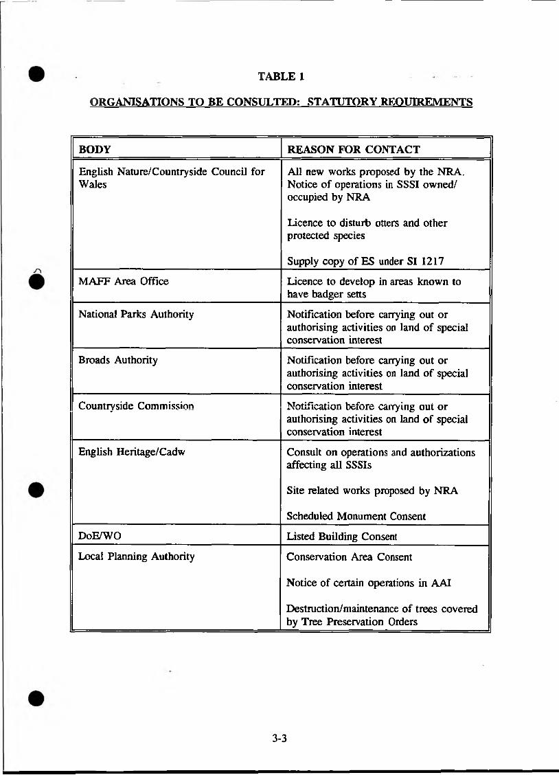
TABLE 1
ORGANISATIONS TO BE CONSULTED: STATUTORY REQUIREMENTS
BODY REASON FOR CONTACT
English Nature/Countryside Council for Wales
All new works proposed by the NRA. Notice of operations in SSSI owned/ occupied by NRA
Licence to disturb otters and other protected species
Supply copy of ES under SI 1217
MAFF Area Office Licence to develop in areas known to have badger setts
National Parks Authority Notification before carrying out or authorising activities on land of special conservation interest
Broads Authority Notification before carrying out or authorising activities on land of special conservation interest
Countryside Commission Notification before carrying out or authorising activities on land of special conservation interest
English Heritage/Cadw Consult on operations and authorizations affecting all SSSIs
Site related works proposed by NRA
Scheduled Monument Consent
DoE/WO Listed Building Consent
Local Planning Authority Conservation Area Consent
Notice of certain operations in AAI
Destruction/maintenance of trees covered by Tree Preservation Orders
3-3
(b) At the time of application (or earlier if there are preliminary discussions), EN/CCW should be informed of all proposals likely to damage SSSIs, and wherever possible supplied with relevant information, such as the nature of probable changes in the hydrological regime.
(c) Such proposals will include:
all proposals for activities to take place within SSSIs (irrespective of (a) above);
other proposals within the catchment area or agreed distance of SSSIs (except those in (a) above), depending on the nature of the consent or licence application;
any proposals outside these geographical limits where the NRA considers that there is still potential for damage (eg regional groundwater schemes).
(d) In the case of abstraction, there may be trials or tests preceding the granting (or otherwise) of a licence. In this case, there should be liaison with EN/CCW over the siting of boreholes and the inclusion of SSSIs in any monitoring.
(e) If an EN/CCW objection is likely, further liaison will be necessary and more research on possible environmental effects may also be required.
In addition to the above procedure, information should also be sought from EN/CCW on existing discharges and abstractions which may be affecting SSSIs and should therefore be reviewed.
Information should also be sought from EN/CCW when the NRA is asked to comment on planning and other applications within or near to SSSIs.
It is important to note that SSSIs are not the only sites of conservation significance that may be affected by operations authorised by the NRA. Ideally, all applications should be scrutinised for their proximity to important sites. These would include areas of conservation interest identified by the NRA’s own survey work. Recommended liaison contacts for specific sites and general consultation appear as Tables 2 and 3 respectively.

RECOMMENDED LIAISON WITH REGARD TO PARTICULAR SITES/AREAS
(IN ADDITION TO TABLE 1 REQUIREMENTS)
TABLE 2
TYPE OF AREA NAME OF ORGANISATION
Landscape, Natural Beauty and Amenity
National Park National Parks Authority
Norfolk & Suffolk Broads Broads Authority
AONB Local Planning Authority and CC
Heritage Coast Local Planning Authority and CC
Nature Conservation
SSSI (1) EN/CCW
Marine Nature Reserve (existing/proposed) EN/CCW
Marine Consultation Areas (2) EN/CCW
AoSP for Birds Local Planning Authority
LNR Local Planning Authority
County Wildlife Trust nature reserve County Wildlife Trusts
Other nature reserve Owner (eg RSPB, WWT)
SNCIs, prime sites LPA/County Trusts
ESAs, Nitrate Sensitive Areas MAFF
Geology and Geomorphology
SSSI EN/CCW
RIGS(3) Local RIGS group
Other geological site (4) Local Geological Record Centre
Archaeology, Architecture, and History
Conservation Area Local Planning Authority
Area of Archaeological Interest Local Planning Authority
Site of a SAM Local Planning Authority (English Heritage/Cadw
Unscheduled monument Holders of SMR RCHME/RCAHMW
Listed building Local Authority
Unlisted historic or architectural feature RCHME/RCAHMW
(1) Includes National Nature Reserves, Ramsar sites, Special Protection Areas,Biosphere Reserves, all examples of which are SSSIs; will also include Special Areas for Conservation under EC Habitats Directive.
(2) Only in Scotland at the present time the network considerably.
but there are recent proposals to expand
(3) Network of voluntary Regionally Important Geological/Geomorphological Sites broadly analogous to non-statutory wildlife sites.
(4) Records of sites collected under the National Scheme for Geological Site Documentation.
NB There are many other statutory or non-statutory areas identified on the basis of characteristics relating to conservation, usually of wildlife or of natural beauty (eg Local Authority country parks, National Trust landholdings). Consultation would be recommended for operations affecting any of these areas.
CONSERVATION ORGANISATIONS FOR GENERAL CONSULTATION
TABLE 3
Landscape, natural beauty and amenity
CC (including Heritage Coast Forum)CCWCouncil for the Protection of Rural England Campaign for the Promotion of Rural Wales
Nature conservation (national organisations)
EN/CCWJNCC (UK-wide and international issues)RSPB (bird conservation)British Trust for Ornithology (bird populations)Biological Records Centre (distribution data for animals and plants)RSNC (Conservation Department deals with otter conservation and other issues) Forestry Authority
Nature conservation (local organisation)
Local biological records centres (list Appendix B)County Wildlife Trusts (list Appendix B)Urban Wildlife Groups (information from RSNC)Natural History Societies - - -County Ornithological Societies
Geology and geomorphology
Geological Society Conservation Committee
Archaeology, architecture and history
County Archaeologists/Welsh Regional Trusts (= holders of SMRs, Appendix B) English Heritage/Cadw Council for British ArchaeologyWater Authorities Association Working Party on Industrial Archaeology
In addition, the Code of Practice recommends contact with the Science Museum, the Council for British Archaeology, and local historical/industrial archaeology societies before disposing of unwanted items of historical interest.
3-7
4. SURVEY PROCEDURES
Background
Effective conservation input depends on obtaining data and using information which adequately describes the resource. Standard methodology is paramount. For rivers this should be based on river corridor surveys (RCS), the basic method of which is described in Conservation Technical Handbook No.l. Landscape appraisal methodology is described in Handbook No.2 of the same series. In addition, aerial photographs and Phase 1 habitat survey information should be used at every available opportunity.
In specific cases, such as the need for environmental assessment of major new works, data gathering may need to be more extensive and/or more intensive than the standard RCS approach. Examples include biological surveys of adjoining wetlands, or detailed studies of the flora and fauna of particular habitats. Surveys for other features (eg plants, birds, fish, archaeology) and other inland and coastal waters should follow existing standard methods recommended by JNCC. Further details can be found in R & D Note 107 "Review of Conservation Survey Methodologies".
R & D FELLOWSHIP: METHODOLOGIES FOR OPTIMISING THE VALUE OF RIVER CORRIDOR SURVEY DATA
(1993 - 1994)
O
J Crompton jl)> August 1994
4-3
I INTRODUCTION
The two year Fellowship was undertaken by Geodata Institute, SouthamptonUniversity. The overall objective was to evaluate cuirent River Corridor Survey(RCS) methodologies with particular emphasis on their durability and utility* and todevelop GIS compatible methods for utilising the information.
This report summaries the outputs, conclusions and recommendations from theFellowship.
H THE FELLOWSHIP
The objects of the Fellowship were as listed:
1. Reviewed the international literature, and the evolution and current practice of RCS within NRA.
2. Examined and audited RCS for consistency of quality and accuracy of content
3. Developed a method for abstracting information from RCS maps to enable aggregation of information on a catchment basis, using GIS.
4. Tested the database methodology on the River. Stour catchment.
in CONCLUSIONS
The conclusions were:
1. RCS maps do provide a wealth of detailed information which is useful to the overall purposes of the NRA (e.g. identifying stretches of high value, considering enhancements and sensitivity to river maintenance). The overall quality of RCS has improved recently, probably due to the production of the Handbook and to the shift towards strategic survey.
c2. There are further improvements that can be made in their accuracy and use, to
support an understanding of the character of the river system. In hard copy form, RCS does not easily allow an overview or analysis of longer stretches of river.
3. Locational errors on field sketched maps are attributable to inaccuracies in the base maps and to inaccuracies in locating and recording features. Errors can be reduced to 2% by careful sequential regarding of features on undistorted, large scale maps, and the use of other techniques prior to survey, eg: aerial photos. This is well within the range of accuracy for other mapping techniques.
4-4

in CONCLUSIONS (cont/)
4. The balance between the utility and clarity of the map, and the geographical accuracy, together with cost implications, will need to be considered.
5. A six-point abundance scale can be used to extract semi-quantitative information from RCS, without conferring spurious accuracy on that information.
6. There is potential to integrate and analyse environmental information of this sort However, it is essential that the locational and other errors inherent in the source maps are recognised, quantified and allowed for in information extraction methodologies.
7. RCS are one of many sets of environmental information that are routinely recorded for the river environment The potential for data integration to give a fuller understanding of the river corridor environment is.enormous.
8. The Fellowship scheme is highly desirable both in assisting original academic research, focused on something "useful" for the NRA but less introspectively because the initial ideas and the approach are generated from outside the NRA (unlike R&D contracts).
IV PRODUCTS AND CIRCULATION
The documents produced from this research include:
R&D Project Record F3/1/WX Methodologies for optimising the valueof River Corridor Survey Data.
R&D Note 271 Methodologies for optimising the valueof River Corridor Survey Data.
R&D Note 273 A Context for Developing Methodologiesfor optimising the value of RCS Data.
A number of research papers have been produced based on the Fellowship. These arelisted in Appendix 1.
The documents are for use by NRA Regional Conservation Officers, but all materialhas been released to the Regions and is held in the public domain.
4-5
V UPTAKE/MANAGEMENT ISSUES
The following issues have been identified from the results of the Fellowship. (See also Appendix 2).
I. Future of Fellowship:
(i) continue Fellowship scheme (see Appendix 3).
(ii) maintain flexibility within scheme to allow independent pursuit of research within general stated aims.
Action: HO to note.
2. RCS Map Quality:
consistent recording of features and use of OS maps
clearer presentation/annotation
Action: Regions to note and act as appropriate. (Regional differences in river type and RCS use). HO' to add to revision of Handbook 1 once regions have reviewed. Training requirement.
3. Database for RCS
To consider potential uses of databases to quantify RCS data for use in catchment context.
Action: Further investigation to determine cost effectiveness ofquantifying data cover - abundance for database fields in field, or on as needs basis. Use of recording form? Update Handbook.
Further investigation by River Habitat Survey team leaders oh utility of RCS data in this scheme. Improve geomorphological content of RCS recording. Potential to use existing RCS data in RHS at least in short term.
Development of computer package to utilise RCS data on catchment scale.
4-6
V UPTAKE/MANAGEMENT ISSUES (cont/)
- Data visualisation and compatibility of NRA data sources.
Action: Further consideration of possibility of linking data collection across functions of NRA; at the least, data .sets should be compatible.
Following above, future research on developing catchment scale GIS to handle full range of environmental data.
1VTOK TA* V a % W A ' A * A V / i *
Conservation & Recreation Officer (South Wessex Area)
Revised 30 August 1994 following debate at Regional Conservation Officers’ "Ad Hoc" meeting 26 July 1994.
J :V>wcasNconserW nethodol.rpt
APPENDIX 1
PAPERS RELATED TO NRA FELLOWSHIP
Paper which refers to the work:-
A M Gumell, P Angold & K J Gregory (in press). Classification of river corridors: issues to be addressed in developing an operational methodology. Aquatic Conservation : Marine and Freshwater Ecosystems.
Papers documenting the working in detail:
P G Angold, A M Gumell & P J Edwards (submitted). Information from river corridor surveys. Being considered for publication by the Journal of Water and Environmental Management.
P G Angold, A M Gumell & P J Edwards (submitted). Locational errors in maps of environmental variables and their implications for information extraction. Being considered for publication by the Journal of Applied Ecology.
A M Gumell, P A Angold & P J Edwards (in preparation).Working title: River Corridor Surveys : Information Extraction, Aggregation and Visualisation.Outlet: not decided but possibly Applied Geography.Expected submission: late September 1994.
J .V>v/ensVoflservVnelhodol .rpt
APPENDIX 2
ADDITIONAL METHODS FOR IMPROVING RCS QUALITY
(Source: Lee Donaldson Associates, March 1994)
Lee Donaldson Associates, an independent firm of experienced RCS surveyors on contractto the Wessex Region, were asked to provide a second opinion on refinements to the RCSmethodology. Key points are listed below.
1. Use of experienced RCS staff and/or adequate training of experienced ecologists (minimum 5 days?).
2. Use of 1:2500 base maps, or 1:10000 blown up to 1:2500 scale if 1:2500 is unavailable. Require 1:10000 scale map to locate sections.
3. Adoption of standard scale of widening of channel on survey map. A log scale is suggested.
4. Standardising of section length/exchange of sample survey maps to improve quality control.
5. Improvement in cross sectional recording.
6. Redrawing maps in the office after field survey introduces further error (2 cms on the map = 50 metres on ground). Produce final inked map in field.
7. Place RCS map adjacent to a copy of the OS base map (1:2500) for ease of use as in Welsh Region.
8. Minimum resurvey/quality audit of 5% (5km per 100km).
J ̂ wcnsNcoaservNmclhodol.rpi
EXTRACT FROM LETTER FROM DR A GURNELL (24 FEBRUARY 1994)
RE: FUTURE OF FELLOWSHIP SCHEME
APPENDIX 3
"From my point of view the scheme has been very successful. It gave Peter Edwards and myself the opportunity to undertake some applied research, which was successful because of the full-funding of a post-doctoral fellow and the provision of a collaborative environment with the NRA, which enabled us to access a great deal of information and support that would not otherwise have been so readily available. Our particular project ran smoothly and produced the required results at a steady rate through the two years.
In a more general context, I think that the scheme is very beneficial to the "university" people who are involved, whether they be full-time academic staff or post-doctoral fellows because:
1. A fellowship is seen as being highly desirable in the academic context because it not only brings financial resource into the University, but it also supports original research and publications. This type of scheme is seen in a much more favourable academic light than a research contract, because it has a more open ended research aim and because publication of the results is not only possible, but is expected.
2. From the point of view of the fellow, it provides an opportunity for somebody just completing their PhD to establish themselves academically. They not only pursue a new, fully-funded research programme, but they have time to write-up papers from the PhD. This gives them a much better chance of gaining a permanent academic post than the majority of students who have just completed their PhD.
3. The nature of a NRA-sponsored fellowship is that it focuses research on something "useful". This hopefully provides the NRA with research results that it would not have gained from a normal R&D contract, because the initial ideas and the approach to the research are generated from outside of the NRA.
If the scheme is continued, then my only suggestion for modification would be to encourage the fellowships to be treated in an even more open-ended way than the one that 1 have just been involved in. We were fortunate that our original research schedule generated a successful piece of research, so that we could show at the end of the project that we had completed all the stages that were proposed at the outset. However, I think that this outcome is very unusual. Usually research evolves as it proceeds, and the end product rarely reflects the original objectives precisely. I, therefore, believe that these fellowships need to be treated in a far more relaxed and open-ended way than an R&D contract, for example. If great flexibility is not permitted, the NRA may not fully benefit from the skills and originality of the fellow and his/her academic supervisors".
J >owensNconscrvVnethodol_rpi
4-10

NRA
RIVER HABITAT SURVEY
A TECHNICAL COMMENTARY ON
THE REQUIREMENTS, APPROACH, OUTPUTS AND USES OF A SYSTEM TO
EVALUATE THE HABITATS OF RTVERS ON THE BASIS OF THEIR VALUE TO WILDLIFE
28 October 1994

CONTENTS
PAGE
1 PURPOSE 1
2 NEEDS AND REQUIREMENTS 1
2.1 Driving forces 12.2 Operational tools for site evaluation 22.3 Description and reporting 22.4 Conclusion 3
3 APPROACH 4
3.1 Project development 43.2 River types 53.3 Predictability of features: river channel typology 53.4 Habitat Quality Assessment 5
4 DATA COLLECTION AND MANAGEMENT 6
4.1 Background information 64.2 Field recording 64.3 Typing rivers 84.4 Channel typology 84.5 Evaluation of habitat quality 94.6 Habitat Quality Index 10
5 OUTPUTS AND USES 10
5.1 Deliverables 105.2 Examples of existing use 115.3 Potential use for water resources 11
6 SERCON, River Corridor Surveys and RHS 12
6.1 Background 126.2 SERCON 126.3 River Corridor Surveys 136.4 River Habitat Survey 136.5 Synergistic relationships 14
4-12
PAGE
7 LINKS WITH OTHER METHODS 15
7.1 RIVPACS 157.2 GQA (General Quality Assessment) 157.3 HABSCORE 157.4 EFIM/PHABSIM 167.4 Conclusion 16
8 TIMESCALES AND KEY TARGETS 16
8.1 Planning for future development 16
9 CONCLUSIONS - TECHNICAL ASPECTS 17
10 IMPLEMENTATION REQUIREMENTS 19
10.1 Technical requirements 19
11 COSTS 19
11.1 Development costs 1911.2 Consideration of implementation costs 1995-97 19
12 OPTIONS FOR EXTERNAL DEVELOPMENT AND IMPLEMENTATION 20
12.1 Option 1 -Do nothing 2012.2 Phased implementation 2112.3 Option 2 - Implementation on an operational basis only 2112.4 Option 3 - Implementation on an operational & monitoring basis 2212.5 Option 4 - Implement on a monitoring basis only 2312.6 Conclusion 23
13 CONSIDERATION OF IMPLEMENTATION MECHANISMS 23
14 RECOMMENDATIONS 24
15 IS REQUIREMENTS 25
16 COST OF RECOMMENDED OPTION 25
17 TIMETABLE FOR IMPLEMENTATION 25
ANNEX 1 RHS sheets and spot check key ANNEX 2 Draft implementation plan
4-13
RIVER HABITAT SURVEY
A TECHNICAL COMMENTARY ON THE REQUIREMENTS, APPROACH, OUTPUTS AND USES OF A SYSTEM TO EVALUATE THE HABITATS OF RIVERS ON THE BASIS OF THEIR VALUE TO WILDLIFE
1. PURPOSE
1.1 The purpose of this paper is to draw together in one document a summary description of the requirements for a system to describe and evaluate those physical features which contribute to the character of rivers, and how River Habitat Survey (RHS) can fulfil these requirements in a cost-effective manner.
1.2 In so doing, the precise role of RHS and its links with other methods is brought into focus.
1.3 It acts as the technical annex for a paper requesting Executive Group approval for further development and implementation of RHS.
2 NEEDS AND REQUIREMENTS
2.1 Driving forces
2.1.1 The NRA spends public money and has a duty to ensure that such money is spent wisely. "Value for money" is a key factor in the way the NRA conducts its business.
2.1.2 The NRA is charged with statutory duties "to further" and "generally promote" conservation. The exercise of these duties costs the Authority, and therefore the taxpayer and developers, in the order of £ 18m per year.
2.1.3 In carrying out its conservation duties, the NRA must be confident that advice regarding its consenting (regulatory) and operational activities is based on sound knowledge and that action (effort) is justified and closely reflects need.
2.1.4 Where resources are limited, the NRA must be confident that competing demands are objectively assessed and that priorities reflect actual rather than perceived need.
2.1.5 The NRA needs to be confident that its assessment methodologies for decision-making powers are based on sound criteria underpinned by good science.
2.1.6 This applies particularly to consideration of enhancement works where inappropriate action could represent a waste of resources.
4-14
0 2.2
2 .2.1
2.2.2
2.2.3
2.2.4
2.3
2.3.1
2.3.2
2.3.3
2.3.4
2.3.5
Operational tools for site evaluation
There is currently no mechanism for a fully comparative evaluation of all river habitats in a local, regional and national context.
Current survey effort is largely focused on main river sites, without due regard for headwaters and tributaries which can make a significant contribution to aquatic habitat richness, fish spawning areas and sources of invertebrate colonisation. At present the appraisal of river catchments is therefore biased towards the mainstream rivers.
There is currently no means for rapid data retrieval, and which enables intersite comparison to be carried out. A computer-based system is therefore an essential requirement for operational staff.
The NRA requires a robust habitat evaluation methodology for appraising the environmental impact of internal and external proposals.
Description and reporting
The NRA currently reports on water quality through published quinquennial surveys. Annual returns are also used for internal NRA purposes.
Physical features represent an equally important component in determining river character and ecology. An objective method for describing current state and changes over time is therefore required for both evaluation and monitoring purposes.
The principle aim of General Quality Assessment (GQA) is the ability to report upon the state of, and temporal and geographical trends in the change in river quality in the broadest sense. Physical structure is one of the primary components determining ecosystem quality, and requires a standard methodology comparable to those available to cover water quality and quantity.
The draft EC Directive on the Ecological Quality of Water requires a more holistic approach to assessing quality, taking account of "physical and chemical conditions” including the contribution made by the riparian zone.
Furthermore, the Directive states that "the national systems adopted by member states must be notified to the scientific community in each country and must provide the best possible guarantees as regards accuracy and comparability of data. In each case details of the systems used shall be published".
4-15
2 .3.6
2.3.7
2.3.8
2.4
2.4.1
2.4.2
2.4.3
2.4.4
2.4.5
2.4.6
2.4.7
The Government’s document "Biodiversity: the Action Plan" places significant emphasis on the need to evaluate, report and monitor biodiversity. The use of physical structure as a surrogate measure for biodiversity is likely to be an important aspect in this reporting, and rivers will represent a significant part of the freshwater component.
In establishing an Environment Agency for England and Wales (and for Scotland), the government is committed to reporting on the State of the Environment. This will need to link closely with the biodiversity action plan (2.3.6 above), so inter alia, the requirement for a sound methodology for evaluating river habitats is reinforced.
Current descriptions for "physical structure", one of the three key factors in catchment plans, are inadequate.
Conclusion
Currently, there is no adequate mechanism for a comparative assessment of the physical structure of rivers, putting sites into local, regional and national context.
The requirement for a method for evaluating physical structure of rivers is driven by (i) operational and regulatory needs of the NRA, (ii) EC directives,(iii) commitments to biodiversity and reporting on the state of the environment, and (iv) the need for a readily accessible database containing national inventory information.
Any methodology and supporting framework must fulfil these requirements, but also enable input to the NRA’s regulatory and operational activities in order to improve both strategic and site-based decisions on conservation matters notably through the environmental assessment process.
The Authority must have a technical audit ability whereby action and effort to protect or enhance sites is fully justified by a process of sound evaluation and within the context of national and regional priorities. Moreover, changes in the physical state of rivers can be used as one of the means by which the performance of the NRA may be assessed.
Any methodology must be nationally applicable and provide a standard module for both functional and cross-functional (eg catchment management plan) requirements.
Any methodology must take full account of processes acting at a catchment scale. That is, it must be based on best available information and underpinned by sound geomorphological principles.
The system which delivers the outputs must be data-based for input to the NRA’s Water Archive Monitoring System (WAMS).
4-16
3 APPROACH
3.1 Project development
3.1.1 RHS project development started in November 1992 and a methodology and working classification are due to be finalised by 31 March 1995, ready for implementation in 1995/96.
3.1.2 The approach has been designed to optimise data collection and management. Analysis of existing information such as SSSI water plant data and River Corridor Survey data (through an NRA R & D fellowship), has been progressed in parallel to field-testing techniques. This process has helped to identify which features to record, how best to record them, and where and when to collect data.
3.1.3 Analysis of an intensive transect-based survey conducted on the River Derwent, Cumbria in 1993 along with other field trials conducted during that summer indicated the optimum field sampling unit is 500m. This unit length is compatible with that already used for river corridor surveys.
3.1.4 The best way of recording for both accuracy and precision (repeatability) is the use of spot check transects taken at 10 equidistant points along the river, plus a "sweep up" inventory of features within the 500m length. The survey data can easily be computerised and background information collected is compatible with other methods such as RIVPACS.
3.1.5 To establish a national framework for an inventory of habitat data and a river typing based thereon, a survey of streams and rivers*in England and Wales, based on one 500m sample site in each 10 x 10km square (1523 sites in all) was conducted in May/June 1994. In addition, 30 sites in Scotland and 28 sites in Northern Ireland were also surveyed in order to test applicability of the method on a UK basis.
3.1.6 Only watercourses classified for water quality were used. The data have been computerised and this represents the basis for a first national database of river character for England and Wales. In addition, 26 "benchmark" sites were subjectively chosen by specialists to represent good examples of different river types in order to calibrate habitat quality.
3.1.7 The River Wyre catchment in North West Region was sampled in total so that both sampling strategy and the contribution of RHS outputs to catchment management plans could be assessed. A comparison of the effectiveness of alternative methods of data collection (eg RHS, river corridor surveys, aerial photographs) has also been undertaken as part of this exercise.
3.1.8 A very important aspect has been the close links maintained with the SERCON project development group to ensure compatibility and dovetailing of outputs. ..............
4-17
3 . 1.9
3.2
3.2.1
3.2.2
3.3
3.3.1
3.3.2
3.3.3
3.4
3.4.1
3.4.2
Another crucial aspect is the confidence with which the river channel typology and features makes geomorphological sense. A current national R & D project is providing the necessary geomorphological science and credibility to underpin RHS and is due to report in March 1995.
River types
Analyses of map-derived information and physical data collected by NCC as part of its macrophyte survey, as well as the 1994 RHS data, have produced the consistent conclusion that in the broadest sense (ie catchment, subcatchment scale) river character can be determined by three main factors, namely (i) size, (ii) slope, (iii) geology.
A working typology, based on "semi-natural" sites as determined by field surveyors has been developed but it needs to be refined further taking into consideration other factors such as the position of a site in the catchment which has major geomorphological significance, particularly since features in one 500m stretch may be influenced by processes acting upstream or downstream from the site.
Predictability of features: river channel typology
For operational purposes, river channel character at the reach scale (ie hundreds of metres) is the most important aspect to consider since included in each river type there may be distinct river channel types which reflect changes from headwaters to tidal limit.
It is clear from preliminary analysis of the 1994 RHS database that the presence and patterns of certain features occurring naturally within a 500m site can be broadly predicted using size (bankfull width), slope and geology factors. Substrate type and features such as shingle bars, riffles, pools and eroding cliffbanks reflect those key factors.
Using geomorphological principles, the degree of confidence in predicting physical features in each river type is being identified. A physical "model" for each (unmodified) river type can then be constructed.
Habitat Quality Assessment
The principle of Habitat Quality Assessment is the ability to compare the observed occurrence of features with these predicted for a particular river channel type. The deviation of observed features (caused for example by channel, bank or riparian corridor modifications) from that expected provides the basis for quality assessment.
Since modification can affect one or more components (channel, banks, riparian corridor), habitat quality needs to be able to discriminate the extent and location of modification.
4-18
0 3.4.3 Habitat quality can only be derived after careful analysis of the inventory data, ie the inventory data drives the river channel typing and habitat evaluation rather than vice versa.
4 DATA COLLECTION AND MANAGEMENT
4.1 Background information
4.1.1 The use of GIS at an appropriate scale and map-derived and other available information is crucial to RHS. It provides the necessary framework and context for river and river channel typing, thereby underpinning the predictive element upon which the assessment of habitat quality is based.
4.1.2 Background information for each 500m site includes altitude, slope, solid and drift geology, mean annual flow, baseflow index and distance from source. All can be derived from maps or other sources already available to the NRA.
4.2 Field recording
4.2.1 RHS sample sites are based on 500m lengths of river, comprising the channel, banks and riparian corridor land use to 50m either side. Features are recorded in a way to ensure maximum information content and accuracy without excessive time penalties (Annex 1).
4.2.2 500m is consistent with unit length currently used for river corridor surveys and aquatic macrophyte classifications. This will enable better use of each component and their conjunctive use and cross-validation.
4.2.3 Features that broadly characterise the site (eg valley form, land use, predominant channel form and flow type) are recorded to set the scene.
4.2.4 Attributes such as channel substrate type, presence of key habitat features, aquatic vegetation types and complexity of bank and riparian zone vegetation structure are recorded at ten equidistant "spot checks" along the 500m. The format is simple, with coded abbreviations for attributes entered into a matrix. Each spot check takes 1-2 minutes to complete.
4.2.5 The discipline of doing ten spot checks also improves accuracy of data capture since the observer does not have to remember or estimate the extent of features over long distances, a method which is notoriously inaccurate. Moreover, analysis of transect data from the River Derwent indicated that ten spot checks was effective for characterising the river in terms of physical features without incurring loss of information or excessive time penalty.
4-19
4.2.7
4.2.8
4.2.9
4.2.10
4.2.11
4.2.12
4.2.13
The "sweep-up" checklist of all relevant features within the 500m length ensures that the sampling technique does not omit anything that might occur between the spot checks. As part of this exercise the number of key features (eg riffles, point bars) is also recorded in a tally system. The extent of modifications is also recorded. Space is also provided for a brief descriptive sentence to provide a rapid thumb-nail sketch of the site.
Bankfull and water widths together with bankfull height and water depth are measured at one location within each site. The channel width: depth ratio, taken in the context of other physical features, provides extremely useful information about geomorphological processes acting on the site.
The RHS survey form is easy to use and requires little additional training (2-3 days) beyond that of a sound biological background and familiarity of rivers. It is amenable to rapid computerised input either through optical reading technique from hard copy or adaptation onto portable data-logging devices for use in the field.
The time taken to survey a 500m length of river varies according to the complexity of the site and ease of access, inherent factors which affect any type of river-based sampling. Simple sites may take as little as 35-40 minutes to complete, while: those of complex character and difficult access may take an hour or more. The mean time taken in 1994 was 57 minutes per site excluding travel.
Provided that the NRA lone worker policy is strictly followed, RHS can be carried out by one surveyor. However, a team of two surveyors does not double the resource requirement because improved efficiency can be achieved by one team member carrying out the "sweep up" exercise while the other concentrates on the spot checks. Additional information (eg water quality samples, species lists) can also be collected at the same time.
Repeatability of results is good. Inter-sampler variation has been found to be low. Moreover, experimental alteration of the positions of spot checks within the 500m still produces a consistent output in terms of assessing overall river character. However, duplicate sampling of randomly selected sites is still required to provide the necessary quality assurance and control.
The methodology is therefore simple, yet robust, requires little specialist training, is readily understandable and can be rapidly computerised.
The methodology records all the habitat features surveyed as part of standard River Corridor Surveys but in a manner which improves accuracy and in a rapidly retrievable form designed to provide analytical and evaluation outputs. When combined with river corridor survey mapping, the extra time involved would be no more than 15-20 minutes per 500m.
4-20
4.3.1 RHS provides a semi-quantitative framework for comparing physical (habitat) features of similar river types, thereby enabling quality on an observed versus predicted basis to be established. The key first step is being able to "type" (categorise) rivers on the basis of physical features. In short, like must be compared with like.
4.3.2 The only existing commonly-accepted conservation classification of river types is based on the NCC’s SSSI macrophyte community typology. However, this typology was based on subjectively selected sites. One important aspect of RHS was to establish a typology based on physical features collected from a representative sample of rivers and streams.
4.3.3 A typology has been developed by analysing the NCC data and defining rules for typing rivers based on physical features. This rule-based approach has then been tested on the ’semi-natural’ component of the 1994 RHS database and will need to be refined so that the levels of confidence for predicting features also relates to map-derived information.
4.3.4 RHS does not seek to invent another classification of river types. Instead physical determinands have been used to identify channel types of distinctly different but measurable character. These types will have predictable links with other systems such as the NCC types and RIVPACS. To be meaningful, each type must be distinctive from others and definable and predictable in geomorphological terms.
4.4 Channel typology
4.3 Typing rivers
4.4.1 Both river type and river channel type are primarily determined by key geomorphological factors. Analysis of map-derived and field survey data has confirmed the importance of local bed slope (gradient), size and geology.
4.4.2 Although rivers represent a continuum, the presence and combination of features in unmodified river channel types can be determined by a bed slope: bankfull width matrix approach. Location within the catchment is another important factor and an unmodified river will change its character predictably from headwater to mouth depending on changes in slope and geology.
4.4.3 A combined process and feature-based approach provides the necessary context for describing rivers in terms of use to other functions including flood defence, water resources, fisheries and water quality.
4-21

4.5 Evaluation of Habitat Quality
4.5.1 The 1994 RHS database contains a wealth of information that will take many months to process. However, initial scrutiny of selected features in both the spot check and sweep up inventory data of predominantly "semi-natural" sites has revealed a highly promising association which can relate features and combinations of features to certain types of river channel.
4.5.2 Each type of river should therefore have a predictable characteristic "fingerprint" of features and it should be feasible to construct a simple look-up table relating combinations of features to each river channel type. Naturally, many features are common to more than one type, but distinctive associations will be most important in discriminating between channel types.
4.5.3 In unmodified rivers, the predicted and observed set of channel features within a 500m length should largely coincide. However, there needs to be sufficient flexibility in the system to account for slight variations in the occurrence of (i) features which should always be present and (ii) those which are frequently or sometimes present. In particular, the system needs to account for scale problems encountered in larger rivers where 500m lengths will contain a smaller proportion of the total number of expected features.
4.5.4 Predictability is largely confined to features of the river channel and banks. However, the assessment of habitat quality in the river corridor as a whole has to take account of riparian land use as well. Land use and bankside tree cover are two important considerations in determining overall quality, features which may reflect the degree of modification to the channel and banks.
4.5.5 Several approaches to quality assessment can be adopted: two extremes might be (i) a simplistic assessment of modification (ie impact-derived) and (ii) a weighted ’totting-up’ approach of observed compared with predicted natural features (ie feature derived).
4.5.6 The impact-derived approach could give a rapid look-see impact assessment, generating a classification related to deviation from "semi-naturalness" or pristine condition. The feature-derived approach would provide a more robust assessment since the occurrence of observed features within a 500m length might indicate a response to modifications upstream or downstream of the site, an important aspect not addressed by the impact-derived approach.
4.5.7 RHS has been specifically designed to allow discrimination between features of the channel, banks and riparian corridor. Quality assessment needs to discriminate on the same scale, because one overall assessment may mask significant differences in the quality of channel and banks in particular.
4-22
0 4.6
4.6.1
4.6.2
4.6.3
4.6.4
4.6.5
5
5.1.1
5.1.2
5.1.3
Habitat Quality Index (HOD
The principle of Habitat Quality Indices (HQI) is based on comparing observed and predicted features. The ultimate aims of classification in terms of "excellent, good, fair or poor" will reflect the extent of habitat degradation and relative occurrence of the resource on a regional and national scale. The basis of classification can therefore be either statistical (eg quintiles) or subjectively rule-based.
Since it is based on an observed versus predicted approach, comparing like with like, HQI has to be determined from river typing. Its development and refinement is therefore dependent on a robust typology and careful analysis of inventory data in the national RHS database.
Once a general approach has been agreed, a crucial issue to address will be the statistical confidence of the respective ’classes’ and rules governing any movement between classes. One important aspect is that movement between classes (ie improvement or deterioration) must be determined by modifiable factors which can be expressed in terms of threshold exceedance.
In terms of reporting and data management, the ability for channel, banks and riparian corridor to be assessed separately will be crucial at the operational (reach) level, while CMPs will probably only require to differentiate the channel and bank components. National reporting will almost certainly need a simple overview based on one overall measure.
The existing 26 benchmark sites have a crucial role to play in calibrating and refining the HQI model. However, more benchmarks will be required in future to improve the calibration.
OUTPUTS AND USES
Deliverables
The key output will be a methodology, comprising field survey guidance and a rule-based system for typing river channel forms and establishing the HQI for any given site.
This will be supported by computer software tools for both typing and generation of HQI. A prototype is already under development and will be ready for use by April 1995.
Operational staff will have full access on a ’read-only’ basis of the 1994 RHS database which will enable them to put any site into regional or national context.
4-23
5.1.4
5.1.5
5.2
5.2.1
5.2.2
5.2.3
5.2.4
5.2.5
5.3
5.3.1
The system will be compatible with WAMS (Water Archive Monitoring System) being developed by the NRA. The IS business case appears as Appendix 2 to the main EG paper. In essence, the recommended option is to develop the RHS database prototype as a viable interim solution which can be quickly delivered while at the same time providing for integration with WAMS in the longer term.
Publication outputs will include a methodology manual, scientific papers and a state of the river environment report focusing on physical features.
Examples of existing use
RHS has already been used as part of baseline monitoring of 30 upland stream sites in Snowdonia National Park as part of an impact assessment project associated with proposals for ’run-of-river’ hydropower proposals. Snowdonia National Park has been given access to summary data from the RHS database.
An R & D project on the subject of invertebrates and exposed river sediments which recently commenced, has been able to tap immediately into the national database for overview information on the distribution and frequency of features such as point bars, mid-channel bars, exposed rocks etc. This represents a massive time-saving and cost compared with trawling through RCS maps in each Region.
RHS has been used in an MSc project by a postgraduate student at Lancaster University. The River Wyre catchment has been surveyed in full using RHS, and input for catchment management plans will be a key aspect of the MSc output.
Printouts of the distribution of three invasive weeds (Japanese Knotweed, Giant Hogweed and Himalayan Balsam) within the 1523 RHS sites were used by the NRA as poster display material at an Aquatic Weeds Conference in Dublin in September 1994.
Distribution maps of any feature recorded in the field can be printed out and this provides an extremely powerful, instantly accessible, tool for providing national and regional context.
Potential use for W ater Resources
The RHS morphological database represents a highly strategic source of physical habitat information. RHS data can feed into several techniques currently being developed to simplify instream methods to calibrate ecologically acceptable flows for water resources schemes.
4-24
Publication of the NRA’s Water Resources Strategy and its use of water transfers necessitates use of in stream methods to predict flows. The best way to extrapolate habitat hydraulics from these resource intensive site-based detailed methods to longer lengths of regulated rivers is via the existing RHS database or rapid RHS survey in the field.
The use of RHS therefore provides the potential for major efficiency savings in that simplified versions of instream methods (LF1M/PHABSIM) will be much cheaper than the current resource intensive requirements. Water Resources investment in RHS could therefore have major technical and cost- saving benefits.
SERCON. RIVER CORRIDOR SURVEYS AND RHS
Background
SERCON, RCS and RHS are, or are intended to be in the near future, employed to assist in the assessment of nature conservation value (and other interests too), and help set management priorities which lead to sensitive river corridor management.
Since the terms "assessment" and "management" can be used and interpreted in vastly different ways, confusion has arisen regarding SERCON, RCS and RHS. This centres primarily around whether one or other of the systems will duplicate information or replace one or both of the other systems. In essence they are all complementary, but work at different scales. The value of each individual system is enhanced for data gathered for the other two.
SERCON
SERCON (System for Evaluating Rivers for CONservation) essentially is a desk-based computer system which utilises existing habitat and species data for a multitude of river corridor attributes and applies classic conservation assessment criteria such as diversity, naturalness, representativeness, rarity, etc, in a more rigorous manner than has been done in the past.
When using SERCON it is impossible to generate a meaningful assessment without the type of outputs produced from RCS and/or RHS. For the assessment of many river corridor attributes SERCON thus depends on outputs from either RHS or RCS, unless data of a similar nature are to be provided by some other means.
Generally, SERCON is intended to work at a larger scale (catchment and subcatchment) than either RHS or RCS to provide an important overview of conservation interest in the broadest terms.
6.3 River Corridor Surveys (RCS)
6.3.1
6.3.2
6.3.3
6.3.4
6.4
6.4.1
6.4.2
6.4.3
6.4.4
RCS is principally a map-based system of surveying 500m lengths of river. It provides information about the relatively precise location of habitats and plant assemblages within river channels, margins, banks, riparian zones and corridor.
The system was developed over ten years ago when the prime requirement was to provide information for stretches of river where management work was proposed so that the most important habitat features and rare communities could be conserved and maximum benefit derived from the potential for enhancing degraded habitats.
Since that time, many thousands of kilometres of rivers in England and Wales have been surveyed using the method and the data used in a variety of ways, including auditing and post-project appraisal.
For these purposes, as with SERCON, interpretation of maps is not an ideal way of retrieving and analysing data or objectively comparing sites, even though valuable information is contained within them. For the most detailed site appraisal, and as a prescriptive (site-specific) management tool, RCS as a tried and tested methodology cannot be rivalled.
River Habitat Survey
RHS is not map-based, but provides information on the physical characteristics (and vegetation structure) of rivers, banks, riparian zones and floodplains in a form which can be statistically analysed, compared and readily retrieved.
Outputs thus should enable sites to be classified into ’types’ and then assessed for their relative habitat ’richness/value’. RHS survey can be executed more rapidly than RCS, and the outputs enable the physical and vegetation characteristics of intra-and inter-river sites to be compared more rigorously with one another and in time series as a performance monitor. Since it is also based on 500m sample units, RHS and RCS can be done together, providing a true river corridor survey and evaluation.
Analysis of the River Wyre catchment project indicates that the best strategic survey strategy to fulfil RHS for CMP requirements is to walk the river, completing one RHS sample in every four 500m lengths of channel (ie 25 % coverage), with a simple "sweep-up" of important features in between.
This level of RHS survey will produce an output of 6km river length per day, compared with a river corridor survey output of 1.6km. For strategic purposes therefore, RHS is four times as efficient in data capture compared with river corridor surveys but with the priceless bonus of rapid computerised data retrieval.
4-26
6.4.5 Part of the benefit of doing RHS at a 25 % coverage would be to highlight the requirement for more detailed survey (eg species surveys or river corridor mapping) on a "need to know” basis rather than the current blanket river corridor mapping approach.
6.4.6 Irrespective of potential modifications of any kind, RHS provides the best basis for a semi-quantitative habitat survey of river corridors. As such, it can be used more objectively and with less bias for comparative purposes.
6.4.7 Because of the site inventory, a database of river habitats will be derived which is comparable across England and Wales, irrespective of site. This can be enlarged on a UK or European scale.
6.4.8 RHS will assist in developing a better understanding of: (a) fluvial geomorphological links between riverine habitats and different river types, thus leading to a geomorphological classification of rivers; (b) what constitutes relative degrees of degradation within these types and what habitat features should be present and at what frequency, ie the basis of HQI; and (c) community/habitat relationships.
6.4.9 It is intended that a series of original scientific publications will result from the survey. The benefits of publication in promoting RHS and the NRA as a whole are enormous, particularly in the field of secondary and higher education.
6.4.10 RHS outputs will be readily available for inclusion in the NRA’s annual Code of Practice on Conservation, Access and Recreation publication, a statutory requirement under Section 17 of the Water Resources Act 1991.
6.4.11 Information from RHS, including photographs of each channel measurementsite, is being used as part of the channel typology R & D project. This will help to provide geomorphological credibility to RHS and provide improved guidance and training for surveyors in future.
6.5 Synergistic relationships
6.5.1 Provided data for RHS are gathered consistently, and the data gathering formsare made compatible with questions posed for many attributes within SERCON, it will provide much needed data for SERCON in its evaluation of conservation value of rivers.
6.5.2 SERCON too could be an immensely useful tool for RHS in developing thevalue of the outputs of the surveys and relating these better to the accepted conservation evaluation criteria and the information on biota that the NRA and other organisations hold.
4-27
6.5.3
7
7.1
7.1.1
7.1.2
7.2
7.2.1
7.2.2
7.3
7.3.1
7.3.2
The inventory enables RHS to provide the missing vital link between (i) the existing well tried, tested and accepted map-based river corridor survey method which develops site-specific management proposals and the larger (ii) reach comparisons to assess overall conservation ’value’ derived through SERCON.
LINKS WITH OTHER METHODS
RIVPACS
RTVPACS sampling collects broadly similar data for in-stream features but focuses on a smaller length of river, and the information used provides the basis for a predicted and observed comparison of aquatic invertebrate communities.
Much of the background information (altitude, slope etc) collected for RIVPACS and RHS is the same but since RHS is a more comprehensive assessment of the river corridor, the information is used for predictive and observed analysis of habitat structure in a broader context.
GOA (General Quality Assessment)
The NRA’s General Quality Assessment scheme will comprise four separate water quality measures, each providing a separate, but complementary ’window’ through which water quality is determined. The chemical component has been developed. Other components will be biology, nutrients and aesthetic quality.
RHS will be able to provide a "physical habitat" window for General Quality Assessment (GQA) to complement for chemical, biological, aesthetic and nutrient classifications, thereby completing the picture for describing the state of the river environment.
HABSCORE is a stream habitat assessment method which expresses habitat quality in terms of predicted fish populations based on empirical models derived for more than 600 sites in England and Wales.
The system applies to river sites that contain resident salmonids and which can be electrofished (ie < 15m channel width). Coarse fish models have not yet been developed. Habitat features included in the models combine catchment measurements based on transect surveys of sites 30- 100m in length.
4-28

1FIM/PHABSIM
IF1M and PHABSIM are acronyms for two types of hydraulic survey methods which model instream channel features at the microhabitat scale in relation to the flow requirements of certain invertebrate and fish species.
These methods for predicting plant and invertebrate species preferences for instream flow tend to be extremely resource intensive. However, RHS data can provide a potentially significant saving by providing data input to simplified versions of these methods (see Section 5.3).
Conclusion
RHS will not replace predictive tools such as RIVPACS and HABSCORE, but it can provide the necessary standard site-based modular approach to assessing river habitats.
A modular approach based on a standard habitat component can provide a sound basis for more specialist requirements. All sites can be assessed not only in relation to a nationally consistent methodology for river habitat, but also classified regarding specific aspects needed for example by fisheries (eg spawning gravels), flood defence (asset evaluation and the potential of the river reach for floodwater de-synchronisation), and water resources (flow levels, changes in velocity, depth etc).
Opportunities for optimising field surveys and production of catchment data with common features amongst RHS, HABSCORE, RIVPACS and the Fisheries Classification scheme will potentially yield significant efficiency savings in that the current practice of broadly similar surveys carried out by different functions will be minimised.
TIMESCALES AND KEY TARGETS
Planning for future development
Forward planning for RHS is based on three timescales: short, medium and long-term.
There is a short-term deadline (28 October 1994) in the form of an EG paper seeking approval of resources for development and implementation. The level of resources committed to RHS implementation will determine future R & D , training, support and promotion needs.
8.1.3
8.1.4
8.1.5
8 . 1.6
8.1.7
8.1.8
9
9.1
A medium-term timescale of 31 March 1995 represents the deadline for finalising the RHS methodology, so that it is ready for implementation in 1995/96. The current river channel typology will be refined in the light of further analysis of the 1994 database, map-derived information and geomorphological advice. This deadline is essential in terms of planning training for staff and contractors who will undertake RHS in 1995, provided implementation is approved.
A longer-term objective is ultimate refinement of methodologies to be combined into an overall conservation classification of rivers. By this time (1999-2000), there should be sufficient information to fulfil this requirement and establish an appropriate level of habitat-based monitoring. In this respect SERCON can be refined as RHS information accrues thereby improving its ability to provide a conservation classification in the broadest sense.
It may be feasible in the longer-term to phase in remote sensing techniques to enable a continuum-type monitoring approach, rather than a site-based subsampling technique, concentrating on specific ’macroscale’ indicators of vegetation and channel structure and artificial modifications. IFE will, for example, be analysing on a computerised comparative basis, information gain from RHS ground-truth and remote sensing including the River Wyre catchment.
The longer-term timescale also ties in with the first 3-year monitoring phase 1999-2001) for the EC Directive on Ecological Quality of Water. Indeed, the draft Directive specifically states that remote-sensing techniques can be used for monitoring in this context.
It is clear that there will be R & D requirements as development proceeds, particularly with respect to monitoring strategy, understanding species-habitat relationships and assessing the role of habitat structure in broader quality assessment, including water quality.
The key target is delivery of a working system for operational staff by 31 March 1995. A preliminary report on the 1994 data needs to be ready by mid-1995 and a habitat component for GQA reporting needs to be available in late 1996.
CONCLUSIONS - TECHNICAL ASPECTS
RHS will provide:
(a) a method for collecting and managing data to enable rivers to be typed and classified on the basis of physical features with particular reference to their value to wildlife against an expected background;
(b) the necessary context for classifying rivers at a catchment and national scale, and for the first time, a national inventory of habitat features;
4-30
(c) the necessary context for any 500m stretch of river, thereby enabling operational staff to (i) assess objectively the likely impact of any proposal to modify the site and (ii) identify how much effort to invest in protecting or rehabilitating sites;
(d) a catchment context in terms of habitat uniqueness/frequency which will enable the importance of specific features to be placed in an area, regional and national context, thereby determining priorities for protection and enhancement; and
(e) the necessary basis for determining appropriate enhancement and rehabilitation activities for specific river channel types.
Better informed decision-making is the main benefit of RHS since currently there is no objective means for advising NRA functions or external developers on the local, regional or national value of individual sites. It will also provide better information on the appropriateness of proposed enhancement works and river rehabilitation as part of pre-project evaluation.
RHS will provide a powerful tool, delivering a user-friendly inventory of river habitats, amenable to rapid data retrieval and interrogation and able to interpret scenarios of change in an environmental impact context.
RHS methodology is simple, robust, and has been field-tested to the satisfaction of surveyors. Further refinement is necessary, but these refinements are achievable within the necessary timescale (31 March 1995).
RHS will fulfil the original requirements which precipitated its development. It will be able to deliver both operational and reporting outputs of immediate use to NRA staff. Indeed it has already been used by operational staff and an outside organisation for this purpose.
RHS will, through local, regional and national comparisons, aid responses to internal and external proposals which might affect a river. Depending on what these are, RCS may be then required.
With the possible exception of small-scale works affecting an important local site, RHS should be more appropriate than RCS for strategic planning of works by all NRA functions and also for input to catchment management plans.
RHS is complementary to both RCS and SERCON. It is not designed nor intended to replace RCS, which was primarily designed to appraise stretches of river in a local context. RHS is a logical development of RCS. Indeed it was always intended that RCS should have a constituent checklist card for habitat features, but this was never successfully developed because of inherent difficulties in estimating abundance or extent over 500m lengths of river.

10 IMPLEMENTATION REQUIREMENTS
10.1 Technical requirements
RHS requires:
• a technical methodology manual, preferably in published form;
• associated computer software to enable operational staff to type sites and assess habitat quality in a regional and national context;
• coordination, in the form of (i) a national coordinator to determine precise site locations for the monitoring network and ensure that data are entered on a national database, (ii) regional coordinators with responsibility for quality assurance of RHS both internally and by contract staff for reactive survey work;
• maintenance and updating of the national database on a regular programmed basis; and
• training programmes to ensure quality control both in terms of field survey and computerisation/data management.
11 COSTS
11.1 Development costs
11.1.1 The original budget for the project (internal plus contracted-in services, but excluding R & D support) for the period 1 November 1992 - 31 March 1995 was £187k.
11.1.2 Development costs from project initiation to have been borne under four headers: (i) internal staff costs, (ii) contracted-in services (eg temporary staff for data input, (iii) R & D support, and (iv) other support (eg project board expenses, workshops etc).
11.1.3 This investment up to 31 March 1995 represents 6.7 NRA FTEs (equivalent to £150k), contracted-in services of £25k, R & D support of £80k, and other support at £5k.
11.2 Consideration of implementation costs 1995-97
11.2.1 There are two main areas of focus: (i) establishing a reference network whichbuilds on the existing 1523 sites, and (ii) operational use of RHS as a strategic survey method for CMPs and its use with reactive RCS.
W M.2.3 Costs will depend on the precise balance between the use of in-house staff and external contractors. However, certain fixed costs (eg database management/maintenance) also need to be taken into account.
11.2.4 NRA Regions have to resource national "must do" initiatives to full implementation. However, there is pressure to reduce resource commitments in 1995/96 compared with 1994/95.
11.2.5 Resource commitments to the project in 1994/95 were 0.45 FTE per Region, except for North West which also provided project support and coordination.
11.2.6 A reduction in Regional commitment by 50% would equate to 0.22 FTE, with North West continuing to provide coordinating support of an extra 0.22 FTE.
11.2.7 Since four RHS sites can be surveyed in a day, each Region will be asked to complete 80 monitoring network sites in 1995/96, and again in 1996/97 if implementation is approved.
11.2.8 If 1500 monitoring sites are to be completed in 1995/96 and a further 1500 sites in 1996/97 thereby providing over 4500 in total, the residual number of sites to be contracted out externally in each of the years is 860.
11.2.9 On the basis of contracted out work in 1994, the cost of background preparation, field survey and data input and analysis is equivalent to ca £100- £120 per site.
11.2.10 For comparison, other costs incurred by NRA monitoring activities include: water quality, £40m a year; fisheries monitoring, £5m a year; flood defence standards of service, £5m, then £500k a year. Development of nutrient and aesthetic components (including marine waters) for GQA is costing £570k.
11.2.11 The total planned cost of river corridor surveys nationally in 1995/96 is £628k, of which £287k is for "strategic" survey.
12 OPTIONS FOR FURTHER DEVELOPMENT AND IMPLEMENTATION
12.1 Option 1 - Do nothing
12.1.2 Development of the RHS methodology would continue until 31 March 1995and published thereafter as part of the NRA’s Conservation Technical Handbook Series. This methodology will therefore be available for use by in- house and external contractors from April 1995.
4-33

12.1.3
12 . 1.1
12.1.4
12.2
12.3
12.3.1
12.3.2
Information already gathered for the 1994 survey will be used as a publication "The state of rivers in England and Wales: a preliminary assessment of habitat structure". This will represent the first attempt at a national assessment of river character and as such provide invaluable data for internal staff as well as external organisations and educational establishments. The NRA is also duty bound by an EC Directive, to provide environmental information collated by means of public money.
Development of the RHS methodology without any implementation is not an acceptable option because (i) requirements for site evaluation and reporting (Section 2) will not be met, and (ii) investment of £260k in project development will have been wasted. Moreover, there is potential to waste money by continued use of river corridor surveys as a strategic tool without the advantage of the rapidly retrievable and analytical capability of RHS.
Publication of the method, results from the 1994 survey and applications will also appear in the scientific literature as part of an agreed programme of controlled release of information.
Phased implementation
RHS has two main uses and associated outputs: (i) an operational tool for site evaluation to aid decision-making at local level, and (ii) as a monitoring tool. It also forms a complementary role to current survey methods both within conservation and other functions. Three further options are therefore available.
Option 2 - Implementation on an operational basis only
This option would entail implementing RHS in an operational mode only, ie undertaking RHS with River Corridor Surveys only. This would satisfy the site evaluation requirements but only in that the national inventory database providing the context remained at 1523 sites. Future monitoring would be dependent on these original sites and statistical advice is that this number is insufficient as a representative baseline.
Since any phasing in of RHS must be done in a cost-neutral sense, current survey effort and resources would need to be redirected. River corridor surveys were designed specifically for reactive purposes so it would be logical to phase out strategic RCS and replace it with RHS. RHS would provide the "trigger" mechanism for determining whether any more detailed survey work was required. There is one caveat to this scenario. Both Thames and Anglian Regions have a substantial rolling programme of strategic river corridor surveys which are nearing completion and it would be pointless for this to be aborted so near to completion. However, RHS should be incorporated at the earliest opportunity and in any case implemented to new survey programmes.
4-34
12.3.3 All future strategic catchment scale surveys would be RHS based, with specialist mapping undertaken on a need to know basis. For those Regions which do not carry out strategic surveys, RHS for catchment planning purposes would be resourced on the basis of need. In essence, RHS is not replacing river corridor surveys but provides a rapid assessment method which can determine whether more detailed surveys are needed.
12.3.4 RHS for strategic catchment survey of rivers would be effective in terms of providing better context regarding headwaters and cost. The strategy requires 25 % coverage of river compared with 100% for the current mapping method. This means that in effect, four times the river length can be assessed for the same cost, (currently £300k per year) or a 75 % saving made for the same river length surveyed.
12.3.5 The disadvantage would be inability to monitor change other than with the 1523 sites established in 1994, and no objective basis for improving the methodology. Statistical advice is that at least 20 reference sites are needed an average (800km2) catchment (i.e. 4500 in England and Wales) to fulfil this need. Furthermore, since reference sites need to be randomly selected to avoid bias, reactive and strategic surveys could not contribute to the network.
12.4 Option 3 - Implement on an operational and monitoring basis
12.4.1 This option would represent Option 2 plus expanding the site reference network from 1523 to 4500 sites over two years, thereby establishing a statistically valid sample network and fulfilling all the criteria for project implementation.
12.4.2 By establishing a network of 4500 reference sites nationwide, the classification system itself could be improved. Furthermore, each reference site could be used to provide a nationally consistent description for catchment planning purposes.
12.4.3 The reference site network would also provide the framework for future monitoring on a longer timescale (5-10 years), to complement that for General Quality Assessment needs and the EC Directive on the Ecological Quality of Surface Waters. Only a subsample of the 4500 sites would be used for these purposes, so the resource commitment would not be excessive.
12.4.4 To apportion the resource burden to reflect national and regional needs and benefits, the bulk of work expanding the network of sites, including computerisation, would be contracted out as a national R & D project.
12.4.5 Each Region would retain in-house expertise by contributing 80 reference sites in 1995/96 and 1996/97, a resource commitment of 0.22 FTE or 50% of that in 1994/95 and as approved by EGPSG and EG.
4-35
12.5 Option 4 - Implement on a monitoring basis only
12.5.1
12.5.2
12.6
12.6.1
13.
13.4.1
13.4.2
13.4.3
13.4.4
13.4.5
Since the main objective of RHS is to provide a method for site evaluation for operational purposes, this option is not acceptable for the business requirements of the NRA’s conservation function.
Introducing RHS as a component of fisheries surveys would immediately provide context to the rolling programme of sampling. Another option would be to include RHS sampling at all existing biological sampling sites. The main disadvantage would be that the biological sampling sites are not representative of the RQO river network per se, but determined by river junctions and significant inputs of discharge. It would however provide an assessment of the inherent bias in the network of 6000 biological sites to be used for the 1995 survey.
Conclusion
On the basis of fulfilling the original objective, only Option 3 will meet the criteria for delivering an operational and monitoring tool to the required standard and timescale.
Consideration of implementation mechanisms
There ij an established principle that the bulk of nver corridor work is contracted out, while the NRA retains sufficient in-house expertise and experience to ensure quality control.
The specifications for river corridor survey work are based on an NRA published technical document. Similar principles extend to river landscape assessment. The same approach will be extended to RHS if implemented, with the specifications based on the method to be published as part of the same technical series.
Training will be required for both internal staff and contractors prior to implementation.
Since the site reference network of 4500 sites needs to be developed in order to refine the typology and evaluation, the source of funding for this work should logically be the national R & D budget. This can be considered justified expenditure of Grant-in-Aid money to support a keystone conservation business requirement benefitting national, regional and area levels.
However, in order to fulfil the need to retain in-house expertise, a reasonable proportion of RHS monitoring sites should be sampled by in-house staff. This will involve regional coordination and field visits, overseen by a national coordinator, a system which worked extremely well in 1994.
13.4.6 In order to spread the resource burden, it would be sensible to programmeand sample the reference network sites over two years, ie. 1995/96 and 1996/97. This would coincide with the GQA sampling timescale and the results would therefore contribute directly to the next NRA water/environmental quality reporting cycle.
13.4.7 The principle of contracting out is the same for reactive survey work. Theimplication would be a time penalty in the fieldwork. Training for contractors would also be essential. Due to the compatibility of RHS with RCS the time penalty would be small compared with the monumental missed opportunity and lack of context if a combined survey was not undertaken. Moreover, the extra investment would be within the margins of error in bidding for funds for reactive surveys (by definition not a precise art), but with significant added value in respect of outputs.
14 RECOMMENDATIONS
It is recommended that:
14.1 In line with corporate plan "must do" initiatives, RHS is resourced to full implementation during the period 1995/96 and 1996/97.
14.2 River Corridor Surveys should to continue in ail instances when physical works or other activities potentially have an impact on habitats and conservation value within river corridors and floodplains, but for every RCS length, an RHS data sheet should be completed.
14.3 RHS conducted for strategic/catchment purposes is used to determine if subsequent RCS or other specialist survey work is required.
14.4 Regions with a strategic rolling programme of RCS mapping nearing completion build in RHS at 25% level, but all new strategic work after 1996/97 should be RHS based.
14.5 Regions resource a small proportion of further development of RHS by contributing 80 sites to the network in 1995/96 and 1996/97 in order to retain in-house expertise.
14.6 North West Region continues to provide a national coordinating service.
14.7 RHS is phased in as standard habitat module survey for the NRA, withspecialist requirements (including RCS) acting as bolt-ons as appropriate. In addition and to be consistent all NRA funded surveys (eg otters, birds etc) to have RHS as a component.
14.8 The bulk of RHS work is contracted out.
14.9 RHS training, including computer database training, is provided for in-house staff and external contractors in good time for the 1995/96 season.
4-37

1-5 IS REQUIREMENTS
15.1 The IS Report on RHS recommends that the best option is to develop the existing stand-alone RHS working prototype software as a quickly deliverable interim measure with integration into WAMS in the longer-term.
15.2 The total IS-related cost of this option would be £73k of which £22k would be included in the R & D contract, £21k as a worst case scenario for upgrading existing hardware to the required specification, and £10k for integration with WAMS in 1996/97.
16 CQST OF RECOMMENDED OPTION
16.1 The total cost of Option 3 over two years (1995/96 and 1996/97) is estimated to be £405k - apportioned as: NRA staff time, £120k; R & D project, £200k;IS support, £50k; training requirements, £l5k, and publications, £20k.
16.2 The main tangible benefit is the hitherto unavailable capability of classifying sites on the basis of habitat features. The cost savings in terms of improved decision-making cannot be estimated but should provide for better value for money regarding the NRA’s annual £18m spend on conservation related activities.
16.3 There will be the potential for a 75 % cost saving on future strategic surveys for catchment plan purposes equivalent to £225k annually on current national spend. On a national basis the cost of implementation could be recovered within 2-3 years and significant savings made in the longer-term.
17 TIMETABLE FOR IMPLEMENTATION
17.1 Annex 2 provides a summary implementation plan from 1 April 1995 to 31March 1997.
4-38
5. OPERATIONAL ACTIVITIES
Guidelines
Recommendations in the Code of Practice and Conservation Guidelines for Drainage Authorities should be followed, and published technical manuals referred to where appropriate.
The procedures involved in project design and implementation should be outlined in all cases. The MAFF publication "Environmental Procedures for Inland Flood Defence Works'* should be followed. For coastal works, MAFF guidance is provided by "Coastal Defence and the Environment".
All NRA operational work should be conducted in sympathy with the environmental character and sensitivities of the area. Works should be designed and implemented in a way that minimises adverse impacts on localities, sites and features of conservation interest, if necessary by avoiding them completely. These include not only sites, localities and features given statutory protection, but others which may be important, such as County Wildlife Trust nature reserves, unscheduled ancient monuments, or unlisted historic buildings.
Both direct and indirect effects should be taken into account when evaluating the potential for adverse impacts. For instance, alterations to the water table can affect archaeological sites as well as wetland flora and fauna.
Every effort should be made to incorporate features that enhance the value of the site in terms of visual attractiveness, harmony with the landscape, and wildlife. This should include the use of native species in tree planting programmes.
Trees are important features both from a landscape and a nature conservation point of view. Wherever possible they should be retained, particularly if in a Conservation Area or covered by Tree Preservation Orders. Where appropriate, tree-planting should be encouraged.
Routine maintenance programmes should be regularly reviewed with conservation objectives in mind. These objectives should include preservation of archaeological sites and enhancement of natural beauty as well as nature conservation.
The effectiveness of conservation input in particular specific recommendations for achieving environmental objectives should, wherever possible, be monitored by postproject appraisal.
Wherever possible, operational work should be timed to minimise disturbance to breeding wildlife and to flowering or seed-setting in plants.

Because of possible adverse effects, the use of herbicides and other chemicals should be kept to a minimum, and should proceed in accordance with statutory requirements (SI 1986 No 1510 Control of Pesticides Regulations). Aquatic herbicides should only be used when control by mechanical means is not possible. Refer to "The Use of Herbicides In or Near Water" available from Water Quality.
6. NRA LANDHOLDINGS
Code of Practice on Conservation. Access and Recreation
Where the NRA owns land, site management plans, with conservation objectives, should be developed. Where the NRA owns or occupies an SSSI, a management plan should be agreed with EN/CCW. A management plan will be as long and detailed as necessary according to the type of site involved. The Countryside Management System (CMS) provides a relevant standard format. Tenants and licensees of land in NRA ownership should be required to exercise their rights in a way consistent with the conservation objectives in the management plan.
If NRA land or property is to be disposed of, existing or potential conservation interest should be drawn to the attention of relevant conservation organisations prior to any disposal action.
The NRA must conform to the Code of Practice on Conservation, Access and Recreation issued by the Department of Environment (DoE) Standing Committee, under section 18 of the Water Resources Act 1991. To meet the reporting requirements of the Code of Practice on Conservation, Access and Recreation the NRA must report annually on its Recreation and Conservation activities.
A National database has been compiled from information provided by the Regions on NRA owned or leased sites. This database provides National and Regional information; on the type of sites; whether they are used for conservation or recreation; what activities and facilities exist on these sites etc. The database also holds information on recreation and conservation projects either undertaken by the NRA or in conjunction with other organisations.
The "1993/94 Conservation, Access and Recreation Annual Report" has been produced and concentrates on a National overview of the NRA site data and includes examples of Regional projects.
This report breaks down the data into Regions and provides more specific site detail than the National report. Regional staffing structures, numbers of NRA projects including collaborative projects and Recreation & Conservation actual spends for 1993/94 are also included. This report is for internal distribution only.
Species Protection
All NRA staff should be aware of the legislation regarding specially protected plant and animal species under Schedules 5 and 8 of the Wildlife and Countryside Act 1981 (as amended). Damage or disturbance to these species or their habitats must be avoided. Special licences must be obtained through Species Protection Officers at EN/CCW via NRA Conservation Staff.
Archaeology
If impact on an important archaeological site is unavoidable, then full consideration should be given to conducting appropriate archaeological investigation. Alternatively, a qualified archaeologist could be invited to be present on a ’watching brief. The level of involvement should reflect the importance of the site.
Procedural arrangements should be established to call in local archaeologists should any artifacts be discovered by accident during the course of operational works. This is most likely to occur in urban areas, particularly in Areas of Archaeological Interest (AAIs).
Wherever possible, sufficient flexibility should be incorporated into NRA work programmes to allow the suspension of operations as a result of any major finds. In practice thorough consultation at an early stage in planning the works programme should make this unlikely.
The NRA should safeguard any artifacts found on NRA sites and ensure their conservation, publication and placement in museums where appropriate. Artifacts found on other land should be returned to the landowner.
For further details please see section 8.
Architecture and Cultural Heritage
All Listed Buildings for which the NRA has a responsibility should be maintained and repaired in accordance with an agreed management plan, involving outside bodies where appropriate.
Records should be kept of all buildings, features and items of historic interest (eg documents) in NRA ownership. These items should be preserved, publicised and/or made available for study purposes as appropriate.
Obsolete plant, machinery, items or features of historical or cultural interest should not be disposed of without contacting potential new keepers.
7. SPECIES AND HABITAT RELATED ISSUES
7.1 Otter Strategy 7-3
7.2 NRA Otter Management by Catchment 7-17
7.3 Guidelines on procedures for dealing with dead otters 7-19
7.4 Mink 7-25
7.5 NRA Statement on Fish-eating Birds 7-29
7.6 Long term Waterways Bird Survey (WBS) Trends (1974-1993) 7-33
7.7 Identifying Freshwater Crayfish in Britain and Ireland 7-35
7.8 The NRA and Dragonfly Conservation 7-37
7.9 Phytophthora Root Disease of Common Alder 7-53
7.10 Native Trees and Shrubs in the British Isles 7-59
7.11 Pollarding Techniques 7-63
7.12 Procedure for dealing with dead animals/birds _ 7-67
7.13 MAFF Habitat Scheme Water Fringe Areas 7-69
7.14 Grants Available for Conservation 7-71
7-1
NRA
OTTER CONSERVATION
IN ENGLAND AND WAIVES:
THE NRA’S CONTRIBUTION TO A
NATIONAL STRATEGY
FIRST EDITION
31 MARCH 1994
CONTENTS
Page
1. Overall objective 1
2. Specific objectives I
3. The NRA’s role in otter conservation 1
4. The need for a national strategy 2
5. Key players and responsibilities 3
6. Rationale 3
7. The general approach 4
8. The mechanics of implementation 4
9. Principal determining factors for management action 5
10. Criteria to determine management action 5
11. Management action 7
12. Major policy issues 9
13. National otter conservation plan 9
14. Exploiting opportunities 10
15. Gaps in knowledge 10
16. Promoting the strategy 11
17. Conclusion 11
Appendix Criteria for the reintroduction of species 12
Cover illustration by Gabrielle Bordewich
7-4
OTTER CONSERVATION IN ENGLAND AND WALES:
NATIONAL RIVERS AUTHORITY
THE NRA’S CONTRIBUTION TO A NATIONAL STRATEGY
FIRST EDITION
1. OVERALL OBJECTIVE
To contribute to otter conservation in the UK through implementation of an NRA otter strategy in England and Wales.
2. SPECIFIC OBJECTIVES
To provide a publicly available internal guidance document which identifies management actions and priorities to:
• protect existing otter populations;
• assist the recovery of otters through improvements in riverine habitats and water quality;
• contribute to the pooling of available resources and advice by all organisations with an interest or responsibility for otter conservation;
• raise awareness of otter conservation generally and the NRA’s role in particular.
3. THE NRA’S ROLE IN OTTER CONSERVATION
3.1 The NRA has a statutory duty to further conservation in carrying out all its regulatory, operational and advisory activities. It also has a duty generally to promote the conservation of flora and fauna of inland and coastal waters and land associated with them.
3.2 By implementing environmentally-sensitive flood defence techniques, improving water quality through pollution control measures and supporting collaborative projects with both statutory and voluntary nature conservation organisations, the NRA contributes significantly to otter conservation. Indeed, since being established in 1989, the NRA has invested a considerable amount of time, effort and financial resources toward otter conservation, mainly on a regional basis.
3.3 To ensure that otter conservation country-wide is achieved in the most effective manner, a national policy is required to ensure that resources are targeted in a manner which will produce the greatest chance of success.
3.4 On a national scale, resources can only be channelled effectively if agreed standard criteria which identify specific management actions are followed.
3.5 The NRA is not responsible for statutory habitat or species protection per se. This is the remit of English Nature and Countryside Council for Wales. However, the Authority through its river management activities has unparalleled opportunity, through integrated catchment planning, to further otter conservation objectives identified by relevant organisations with nature conservation responsibilities.
3.6 The Joint Nature Conservation Committee (JNCC) with its remit for coordinating nature conservation across the UK is the responsible organisation for producing a national otter strategy. The NRA will contribute to otter conservation in England and Wales by implementing its own strategy consistent with, and in support of, a national approach.
3.7 The NRA otter strategy is set out below and provides both a framework for internal guidance and a clear public statement on how the Authority will continue to promote otter conservation.
3.8 The strategy will be regularly reviewed, but ultimately implementation will depend on the availability of resources. In this respect, continued partnership with statutory and voluntary nature conservation organisations, for example that established with Otters and Rivers Project, will continue to be the key to success.
4 THE NEED FOR A NATIONAL STRATEGY
4.1 The otter population of Great Britain and Ireland is of international importance. The otter is a protected species and one which requires a national management plan under the EC Species & Habitat Directive.
4.2 After a significant decline in England and Wales, during the late 1950s, and a downward trend which continued into the 1970s, the otter is now starting to recolonise former haunts. A unified approach agreed by all interested parties will assist this recovery.
4.3 A national approach provides a guidance framework by identifying the most effective way to invest resources to benefit otter conservation. Doing nothing will perpetuate the current ad hoc approach, which although successful on a local or regional basis, has produced inconsistencies with respect to matching effort and need.
4.4 Clear strategic objectives are required for the NRA otter strategy to provide the basis for funding, national reporting and measurement of success.
4.5 A national approach is consistent with the objectives outlined in the NRA conservation strategy.
7-6

KEY PLAYERS AND RESPONSIBILITIES
The key players involved and their respective responsibilities in implementing a nationally consistent otter conservation strategy in England and Wales are:
• National Rivers Authority (NRA) : to continue to incorporate otter requirements into aspects of its operational work, particularly through catchment planning, to promote and undertake otter conservation work and to support relevant research;
• Joint Nature Conservation Committee (JNCC): to develop, oversee and monitor the effectiveness of a UK otter strategy;
• English Nature and Countryside Council for Wales (CCW): to continue to promote otter conservation as part of the Species Recovery Programme, and ensure that legislation protecting otters is effectively enforced;
• Vincent Wildlife Trust (VWT'): to continue to play a major role in otter conservation, notably through the national otter survey programme;
• voluntary groups such as RSNC, the Wildlife Trusts, Otters and Rivers Project, BTCV etc: to continue to provide advice, experience and willing labour input to otter projects and to promote otter conservation;
• local planning authorities: to continue to incorporate river corridor protection policies which benefit otter conservation into local plans;
o O - C>
© landowners and land managers: to protect and improve riverside and wetland habitats in such a way as to be beneficial to otters and other wildlife;
• members of the public who use rivers for recreation, including fishing: to continue to be"eyes and ears" on the river bank 'with respect to reporting environmental damage, including pollution.
Only by closely working together will all these key players contribute to the success of a national otter strategy.
RATIONALE
A national approach needs to be based on standard criteria and procedures which provide, within an overall framework, clear guidance and direction at regional and local level. In effect, management or other action will be determined by these criteria. National, regional and local catchment priorities can be more objectively identified. Without this guidance, effective targeting of available resources will not be fully achieved.
An important underlying principle is that river habitat enhancement measures undertaken as part of the NRA’s work, whether specifically for otters or not, will contribute to improved conditions for riverine wildlife in general. Consequently, the NRA otter strategy naturally builds on this ongoing activity. However, specific management for otters per se which incurs extra resources over and above general enhancement work needs to be targeted in areas where success is likely to be highest.
THE GENERAL APPROACH
A building block approach, based on best available information is needed to underpin the strategy. The approach firstly is to determine as far as practically possible:
• information on otter distribution;
• the general needs and requirements of otters in respect of water quality, habitat and food supply;
• the current status of factors potentially limiting otter populations, and
• likely future trends.
Only at this stage can: (i) effort needed to produce suitable conditions be assessed; (ii) priorities determined; and (iii) precise management action identified.
This sequence is crucial so that specific management action appropriate to the agreed priorities can be implemented. Monitoring management action and reviewing priorities is an essential part of the NRA strategy. In this respect, methods for assessing and monitoring limiting factors and an implementation programme need to be consistent with those across the whole of the UK.
THE MECHANICS OF IMPLEMENTATION
The first step is to establish and implement criteria for identifying management action. These criteria need to be consistent with a UK-wide otter conservation strategy. Following this:
• the approach needs to be promoted;
• actions need to be costed;
• performance needs to be measured and reported;
• the strategy needs to be regularly reviewed.
9. PRINCIPAL DETERMINING FACTORS FOR MANAGEMENT ACTION
9.1 The principal factors determining the criteria for management action are:
• otter distribution;
water quality and toxic pollution loading in fish;
habitat quality ;
food supply, principally fish;
level of disturbance, and
mortalities, notably those resulting from fyke nets and road traffic.
9.2 The first four factors in particular require information in the form of survey and monitoring. More importantly, water quality, habitat and food supply need to be better defined in terms of the otters’ requirements, that is, conditions suitable for supporting a sustainable population.
9.3 Assessing the difference between current habitat quality and food supply and that required by otters is relatively simple since dietary and habitat requirements are reasonably well known. However, otter requirements related to water quality, and the impact of toxic pollution loading in particular, are less clear, as is the impact of disturbance. Nevertheless, despite these constraints, the rationale of comparing current and suitable conditions provides a sound basis for determining management action.
9.4 A simple framework for this approach is illustrated by Table 1. Although precise requirements may be difficult to define, a general assessment of current and suitable conditions can be made provided that this process is based on best available information and consistent guidance is given on how to inteipret this information. Priorities can best be determined when this simple matrix is completed.
10. CRITERIA TO DETERMINE MANAGEMENT ACTION
10.1 The following sequence provides the necessary discipline for determining NRApriorities on a catchment basis.
STEP 1 Confirm what information on water quality, toxic pollutants, habitat availability, food supply and proximity of otter population is readily available.
STEP 2 If basic or fundamental information is lacking, plan appropriate survey/monitoring.
STEP 3 If the information base is adequate, Table 1 should be completed.
7-9

STEP 4 Identify priorities based on effort required to maintain/create suitable conditions for otters over and above that already planned as general river enhancement work.
STEP 5 Identify appropriate management action and where necessary draw up an otter action plan. Include relevant otter management action in catchment management plans.
10.2 The most effective overall strategy for ensuring a consistent approach is, in all cases, to obtain adequate information using agreed standard methodologies.
11. MANAGEMENT ACTION
11.1 The following approach provides clear guidance on overall management action and the investment of effort (see Table 2). It is clear that regular periodic review is essential because, as otters continue to recolonise, so the management action for particular areas will change. Overall management action categories are:
• monitor/protect stronghold: protect existing otter strongholds by (i) ensuring that current management practices maintain suitable conditions and (ii) low- level monitoring of otter distribution;
• monitor/encourage recolonisation: in areas near strongholds, protect and improve conditions specifically for otters (eg where appropriate, building artificial holts) over and above general river habitat enhancement works;
• monitor as resources allow: in areas remote from otter strongholds continue river enhancement works to improve conditions for wildlife generally, but where resources are limited, expend no special extra effort such as building artificial holts.
11.2 If there is evidence of an otter decline, then monitoring should be increased to ascertain probable factors, and action taken to rectify the situation.
11.3 Where available, detailed prescriptive actions such as those produced by Otter Project Officers will be the keystone to regional and catchment otter management plans. However, the national approach provides the necessary guidance on the appropriate management action and investment of effort (Table 2). Regional strategies will need to be consistent with this overall approach.
11.4 Overall management action, using one of the categories in Section 11.1 above needs to be clearly identified in catchment management plans.
12. MAJOR POLICY ISSUES
Otter guards and fyke nets
7-10
12.1 As part of its conservation responsibilities, current NRA advice is that otter guards are fitted to fyke nets in areas where byelaws which enforce this currently do not exist.
12.2 The NRA will, as part of its fisheries byelaws review, appraise regional policy requiring the fitting of otter guards to eel fyke nets, to provide national consistency.
Fish tissue and other analysis
12.3 It is widely agreed that fish tissue analysis provides the best way of determining the likely loading of toxic pollutants in top predators (including otters) in the aquatic environment. However, any analysis programme needs to be carefully planned, properly targeted and adequately resourced. Standard methodologies are an essential pre-requisite in this process.
12.4 The NRA currently monitors toxic chemicals in the water and certain dangerous substances in sediment at several hundred freshwater sites. Any monitoring of fish tissue needs to be fully justified in terms of needs and the effectiveness of follow-up action. In this respect, interpretation of analytical results is often very difficult. It is likely therefore that any monitoring effort will closely reflect regional requirements based on opportunities and needs. Furthermore, research is required to ascertain the effectiveness of sampling sediments, fish tissue and spraints.
12.5 Although the NRA has a role to play, MAFF is also an important player, notably through its coordinating role for the Working Party on Pesticide Residues (WPPR).
Otter releases
12.6 The NRA considers that the fundamental underlying principle is to allow natural recolonisation thereby maintaining the genetic integrity of otter stocks. As a result, the NRA cannot support any otter releases which do not conform strictly to the IUCN criteria and any UK criteria developed by JNCC for reintroductions (cf. Appendix). Furthermore, any proposed introductions should be preceded by liaison with NRA.
12.7 As part of the controlling framework for releases, the NRA will continue to press for the inclusion of otters under Schedule 9 of the Wildlife & Countryside Act 1981.
13. NATIONAL OTTER CONSERVATION PLAN
13.1 Using the approach and criteria in Sections 10 and 11, a provisional management action plan for otters for catchments in England and Wales needs to be prepared at the earliest opportunity.
13.2 As a first step, the overall management strategy for each catchment will be summarised as part of the NRA otter strategy.
7-11
14. EXPLOITING OPPORTUNITIES
14.1 A national NRA approach, by definition, provides a broad guidance framework, within the context of consistent criteria. There will be local variations on a catchment or reach scale. Each NRA region should, in association with relevant outside bodies, produce a regional otter strategy based on the national guidance criteria.
14.2 Opportunities for small scale projects (eg building artificial otter holts) should be taken up provided they are appropriate to the area and do not unnecessarily divert resources from other enhancement activities which would produce better results. This applies equally to NRA operational work and development by third parties in which the NRA is involved as a consenting authority or providing advice.
14.3 Since road deaths represent a significant mortality factor in certain areas, the NRA will encourage the incorporation of underpasses into new road schemes wherever appropriate.
14.4 Provided that brushwood can be disposed of satisfactorily as logpiles, this can be used as an opportunity to benefit other wildlife. These piles may then be occupied by otters at some point in the future.
14.5 There are major educational opportunities related to a national strategy, particularly with respect to reporting national status of the otter and measures to encourage its recovery.
15. GAPS IN KNOWLEDGE
15.1 There are still major uncertainties regarding the factors limiting the recovery of otters, particularly those associated with water pollution. A major gap in knowledge is the toxic pollutant loading in fish and the significance of this to otters. More data are required to refine the precise methods needed for monitoring. Monitoring pollutants either directly or through fish tissue analysis is therefore a key issue to be addressed.
15.2 Relevant R&D is required to provide the necessary information, particularly the most appropriate analytical techniques for assessing pollutant levels in fish tissue, water, and sediments. The NRA will, wherever justified, contribute to relevant research through its R & D programme.
15.3 Post-mortems and tissue analysis of dead otters provide valuable information on pollution loading. The NRA will press for the establishment of an independent, recognised national centre of expertise to achieve this as part of a UK-wide strategy.
16. PROMOTING THE STRATEGY
16.1 The NRA will include a summary statement of otter management action consistent with that set out in Section 11 in all its catchment management plans.
7-12
16.2 The strategy needs the full support of all the key partners identified in Section 5 and the NRA will continue to maintain close liaison with all relevant parties.
16.3 The NRA will continue to promote otter conservation publicly through publications such as Conservation Technical Handbook No. 3 (Otters & River Habitat Management) and leaflets produced internally or in collaboration with others.
16.4 The NRA will continue to support otter related projects in collaboration with key partners and commercial sponsors provided that the objectives are consistent with management actions determined by the criteria within the NRA strategy.
17. CONCLUSION
17.1 This strategy provides the necessary national NRA overview for a coherent approach to otter conservation. Ultimately, its success will be measured as part of a UK otter strategy, by the spread of the otter, which in turn depends upon appropriate management action on the ground at a catchment and reach scale.
FURTHER READING
See Part 3, section 15.
ABBREVIATIONS AND ACRONYMS
See Part 4, section 20.
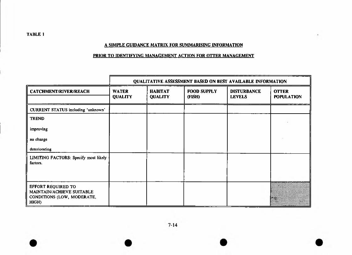
TABLE 1
A SIMPLE GUIDANCE MATRIX FOR SUMMARISING INFORMATION
PRIOR TO IDENTIFYING MANAGEMENT ACTION FOR OTTER MANAGEMENT
QUALITATIVE ASSESSMENT BASED ON BEST AVAILABLE INFORMATION
CATCHMENT/RIVER/REACH WATERQUALITY
HABITATQUALITY
FOOD SUPPLY (FISH)
DISTURBANCELEVELS
OTTERPOPULATION
CURRENT STATUS including ’unknown’
TREND
improving
no change
deteriorating
LIMITING FACTORS: Specify most likely factors.
EFFORT REQUIRED TO MAINTAIN/ACHIEVE SUITABLE CONDITIONS (LOW, MODERATE, HIGH)
•
I■Xv-V
■ ■ . . . , v ■:■. •••
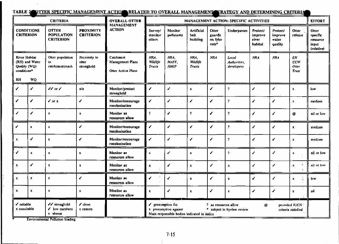
-TAPI IT c p p r i n c MANAGEMENT A P L A T E D TO OVERALL M ANAGEM ENUF" AND DETERMINING CRITERL
CRITERIA OVERALL OTTER MANAGEMENT ACTION: SPECIFIC ACTIVITIES EFFORT
CONDITIONSCRITERION
OTTERPOPULATIONCRITERION
PROXIMITYCRITERION
IVIAINAutMtIN 1ACTION Survey/
monitorotters
Monitorpollutants
Artificialholtbuilding
Otter guards on fyke nets*
Underpasses Protect/improveriverhabitat
Protect/improvewaterquality
Otterrelease
Otterspecificresourceinput(relative)
River Habitat (RH) and Water Quality (WQ) conditions*
RH WQ
Otter population incatch men!/reach
Proximity to otterstronghold
Catchment Management Plans
Otter Action Plans
NRA,WildlifeTrusts
NRA,MAFF,HMIP
NRA,WildlifeTrusts
NRA LocalAuthorities,developers
NRA NRA ENCCWOtterTrust
✓ / / / or / n/a Monitor/protectstronghold
✓ / X ✓ ? / / X low
/ / / or x ✓ Monitor/encouragerecolonisation
/ / ✓ / ? ✓ ✓ X medium
/ / X X Monitor as resources allow
? ✓ ? / ? / ✓ nil or low
✓ x X ✓ Monitor/encouragerecolonisation
✓ ✓ / / ? / ✓ X medium
X ✓ X / Monitor/encouragerecolonisation
/ / ✓ ✓ ? / / X medium
✓ X X X Monitor as resources allow
X ✓ X ✓ ? ✓ ✓ X nil or low
X / X X Monitor as resources allow
X ✓ X ✓ X ✓ ✓ X 0<1
nil or low
X X X / Monitor as resources allow
✓ / X ✓ X ✓ ✓ * <t low
X X X X Monitor as resources allow
X / X ✓ X ✓ ✓ X nil
/ suitable x unsuitable
X" H i 1
/ / stronghold / low numbers x absent
/ close x remote
/ presum x presumj Main resp(
ption for >tion against insible bodies ndicated in it
as resoun subject to
alics
:e8 allow byelaw review
providecriteria
d IUCN satisfied
Environmental Pollution loading
7-15
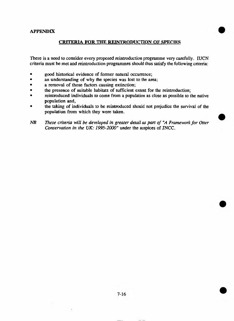
APPENDIX
CRITERIA FOR THE REINTRODUCTION OF SPECIES
There is a need to consider every proposed reintroduction programme very carefully. IUCN criteria must be met and reintroduction programmes should thus satisfy the following criteria:
• good historical evidence of former natural occurrence;• an understanding of why the species was lost to the area;• a removal of those factors causing extinction;• the presence of suitable habitats of sufficient extent for the reintroduction;• reintroduced individuals to come from a population as close as possible to the native
population and,• the taking of individuals to be reintroduced should not prejudice the survival of the
population from which they were taken.
NB These criteria will be developed in greater detail as part of "A Framework for Otter Conservation in the UK: 1995-2000" under the auspices of JNCC.

KEYMonitor/Protect Stronghold
Monitor/Encourage Recolonisation
Monitor as Resources Allow
hd. Catchment BoundaryFor key to numbers see separate sheet
NATIONAL RIVERS AUTHORITY Otter Management by Catchment
< 5
N R A
Welsh
Southern
South Western
Northumbria & Yorkshire
North West

7.3 Guidelines on Procedure for Dealing with Dead Otters
Regrettably most of us lucky enough to have otters on our patch are occasionally faced with the problem of dealing with dead otters.
Historically the costs associated with conducting post mortems and carrying out tissue analysis have been met by the Vincent Wildlife Trust. VWT have now withdrawn funding.
Turning a Loss into a Gain
The discovery of a dead otter provides us with a rare opportunity. It is a chance to obtain vital information on the levels of toxic pollution that the animal may have been exposed to during its lifetime and reveals a good deal of the animal’s basic biology. Currently little is known about otter mortality. It is therefore important we continue to collect this information, in order that we retain a national perspective, and can contribute to a central data base of dead otter statistics when this is set up.
Interim Arrangements
Pending arrangements for more permanent grant aid funding, Hazel Hansen (ex Monks Wood) has agreed to continue carrying out post mortems and arrange for chemical tissue analysis at ITE Monks Wood.
This has a number of advantages:
• Retains historical PM and analysis methodology - maintaining scope of comparative data;
• Provides a single point contact for both PM and chemical analysis;
• Hazel’s PM is far more detailed than a standard MAFF veterinary investigation.
Recording Data
Record information on the standard form (attached). These can be put on to local Wildlife Trust paper and should have your contact address added at the end. They are intended for use by the Wildlife Trusts’ staff, other agencies and the public. Send a copy to J and R Green, who collate road casualty data nationally. Address: Baijarg, Barrhill, Girvan, Ayrshire KA26 ORB, telephone: (046582 225).
7-19
Collection and Storage
Place the animal in a strong plastic bag - bin liners are ideal for this purpose, tied at the top. If the otter is smelling use two or more bags. Freeze the body as soon as possible (this prevents it deteriorating and kills any parasites) unless it will be dealt with within a fortnight, in which case it should be kept cool. Freeze inside the plastic bag to prevent freeze drying.
The bag should be clearly labelled to allow easy identification and reference when in cold storage. This is best achieved by placing a copy of the recorded information in a clear plastic bag and fixing it to the outside of the black plastic bag.
Do not freeze the animal stretched out - it makes storage and packaging more difficult. It is better to curl nose to tail if possible. If freezer space is a problem, local vets are usually helpful over freezer storage.
Dead otters go to Hazel Hansen who should be contacted on 073 129 478 in order to arrange for autopsy and chemical analysis.
Before sending the otter, telephone Hazel to make sure she is in to receive the package, this is important to ensure freezer space is available and to avoid the possibility of a decomposing otter sitting on the doorstep!
Package and Dispatch
It is important that the otter is well packed for dispatch. The otter in its tied plastic bag should be placed in a strong cardboard box (or plastic box) and packed around with newspaper or polystyrene chips to prevent it rolling around. This acts as insulation and helps keep the body frozen. The details of the animal should be with the body. Use packaging tape to reinforce the box.
Keep the body frozen until it is picked up by the carriers. Send the package express/next day delivery - most commercial carriers offer guaranteed 24-hour delivery over mainland UK. There is usually no need to tell the carrier personnel what is in the package.
Cost of transportation depends on the weight, but is usually about £15.00.
Results
Hazel carries out a detailed PM and (if requested) removes organs for chemical analysis. This latter work is carried out by ITE at Monks Wood. Copies of both PM and chemical analysis are usually received about 4-6 weeks later.
Costs
The total cost covering PM and tissue analysis is about £200 per animal, less if PM only is requested. The problem is WHO PAYS?
Since VWT have withdrawn funding, several NRA regions have met the full cost of this work. The NRA Regional ACRO (Area Conservation and Recreation Officer) is usually the best contact. The NRA have no statutory obligation to carry out this work. However, it is usually recognised as a rare opportunity to obtain valuable data on contamination burdens carried by fish.
General Notes
If illegal killing or poisoning is suspected then the police should be contacted. In these circumstances the ADAS Wildlife Biologist (via local MAFF Office) has a legal obligation to investigate the cause of death, and a full veterinary pathological examination should be requested. A possible drawback of this is the limited local specialised knowledge and the introduction of different PM and analysis methodologies. Clearly the individual circumstances (or difficulties in funding) will determine the best approach).
If they have not already been involved remember to notify agencies like other relevant Wildlife Trust Staff, EN, NRA, RSPCA of any dead otters. Similarly they should be aware that dead otters should undergo PM and tissue analysis and that the Wildlife Trust’s ORP has a standard procedure for handling this.
Reproduced front the Rtver Severn Otter Project
INFORMATION ON OTTER ROAD CASUALTIES
Your contact name and address/phone:
1. Date found, exact if possible, month is not:
2. Sex:
3. Source of information:
4. Weight (kg):
5. Length from nose to tail tip (cm):
6. Degree of tooth wear and general condition of the animal (fat/thin) condition of coat, scars etc):
7. Exact location, including grid reference:
8. Road type, classification number:
9. Number of animals involved:
10. Is this a known accident blackspot for otters?
11. Anything else of interest (small sketch map of site is useful, distance from nearest water course, where the body has been sent, who has been informed):
Thank you very much for your help.
Please return this form to:
Reproduced from the River Severn Otter ProjectRSNC, The WUdltfe Trusts Partnership and the Worcestershire Nature Conservation Trust ltd
7-23
7.4 Mink
1. Background
1.1 Following escapes or releases from fur farms, feral American mink (Mustela vison) are now established across most of mainland Britain, with the possible exceptions of Gwynedd and Northern Scotland. They have acquired a reputation of being a ferocious predator and a menace to the countryside. Given their close association with aquatic habitats, the NRA is often seen as the body which should "be doing something about them". Indeed, the NRA receives many enquiries from anglers, landowners and the general public regarding mink.
1.2 Concerns about mink relate primarily to the effects of their predation upon native animal species. This is particularly so in relation to waterfowl and small mammals; mink have been blamed, at least on circumstantial evidence, for local declines in moorhens and for the general decline across the country of water voles. There are also concerns about mink preying upon fish, and especially about the effects upon fish farms.
1.3 A recent report on the water vole in Britain (Strachan and Jefferies 1993) places much emphasis on a correlation between presence of mink and absence of water voles to explain the declines in the latter’s populations. It appears that the greater the mink population in an area, the greater the rate of loss of water vole sites in the last two decades.
1.4 However, Dunstone (1993), suggests that mink are not as much of a problem as originally thought, with a large proportion of their diet in Britain consisting of rabbits. In many areas, mink have probably reached an optimum population density and will not increase in numbers any further. Additionally, the suggestion of competition between otters and mink has been discounted; in fact, mink may be displaced by otters.
1.5 One further issue related to mink is that of mink-hunting. Following the banning of otter-hunting, some hunts moved on to the pursuit of mink. There is much concern that this activity causes disturbance to riverine habitats, especially significant where otters are beginning to recolonise. It is also a very inefficient method of control, particularly for a species which is readily trapped (though trapping tends to concentrate on the population of non-territorial individuals and thus probably has little effect in the long term).
1.6 The American mink is included on Schedule 9 of the Wildlife and Countryside Act 1981. This makes it an offence to release the species into the wild or allow it to escape into the wild. Any authorised person, as defined by Section 28 of that Act, can kill or take mink using any method not prohibited by the legislation.
7-25
The role of the NRA
Section 2(2) of the Water Resources Act 1991 gives the NRA a duty generally to promote the conservation of flora and fauna which are dependent on an aquatic environment.
If mink control is required, it is not a responsibility of the NRA. The Ministry of Agriculture Fisheries and Food’s position is that responsibility for the control of feral mink falls to those who benefit most from that control, ie the individual landowner/occupier. MAFF’s interest in feral mink extends to the damage they cause to agriculture through predation of small livestock and poultry, and to fisheries if this was proven; other concerns are a matter for the statutory nature conservation agencies.
MAFF’s former mink eradication programme, which required notification of sightings and lending traps to people wishing to control them, has been abandoned. However, ADAS continues to offer advice on control and on trap design.
The NRA’s position relates only to providing advice on measures to prevent significant damage to native wildlife at especially vulnerable sites:
• the NRA is not responsible for mink control; enquiries on control measures and impact on fisheries will be referred to MAFF;
the NRA will, where appropriate and in collaboration with other bodies, seek to prevent spread of mink to vulnerable off-shore islands;
the NRA will seek to discourage mink-hunting where otters may be disturbed and where damage is caused to wildlife generally; and
the NRA will, if appropriate, and in collaboration with other bodies support further research on the ecology and diet of feral mink and the feasibility of local control options.
Rationale
Mink are now so widespread that little can probably be done to control them generally. In most cases it is probably a question of letting populations settle down and reach an equilibrium.
At certain very vulnerable sites, such as wildfowl reserves, intensive local control of mink is probably necessary and effective providing it is carefully planned and humanely undertaken. Mink are readily caught in cage traps, which are available commercially.
7-26
3.3 Mink hunting is not an effective way of controlling mink populations, and the use of dogs potentially causes disturbance to riverine wildlife: In general, this practice is not conducive on rivers with special wildlife interest, and certainly not where otters are present.
3.4 If further research is required on the ecology of mink and on possible control measures, the NRA will consider supporting such work in collaboration with other interested parties.
4. Summary
4.1 The NRA accepts that there is circumstantial evidence that mink may have a detrimental effect upon populations of certain native animals, notably water voles and possibly some waterfowl. Mink may also cause problems at certain fish farms and hatcheries.
4.2 General control of mink is probably not possible, and thus a national mink management strategy is not appropriate. However, local control at vulnerable sites may be necessary.
4.4 The NRA does not have responsibility for control of mink, but is prepared to give general advice on the problem, referring those who wish to undertake control measures to MAFF.
Further Reading
See Part 3, section 15.
Abbreviations and Acronyms
See Part 4, section 19.
NRANRA STATEMENT ON FISH-EATING BIRDS
1.1 The NRA, faced with increasing concern and a growing volume of circumstantial evidence that fish-eating birds are causing serious damage to certain fisheries, has taken a number of initiatives with the object of assessing the significance and extent of what appears to be a growing problem and to seek ways of dealing with it.
1.2 As part of this process it has now published a Report it commissioned from the Institute of Terrestrial Ecology. This Report makes a valuable contribution to our knowledge of the subject, but because of the lack of controlled scientific experiments no firm conclusions can be drawn from it. The authors conclude that "There is no hard experimental evidence that fish-eating birds seriously damage fisheries, nor that licensed killing effectively prevents damage...The lack of such evidence does not necessarily mean that fish-eating birds do not have an effect, merely that to date the appropriate experiments have not been carried out". The authors believe that "The criteria for "serious damage" must involve measured losses". The authors do NOT dismiss anecdotal and circumstantial evidence, and they accept that cormorants could "well cause losses, particularly of stocked fish on small put-and-take fisheries, on larger stillwater sites and possibly rivers". But they suggest that "in most instances sawbills in England and Wales will prove to have little impact on fisheries". They recommend that controlled experiments should be carried out. They also recommend "That the current NRA position of not supporting licensed killing until serious damage has been established" should remain unchanged.
1.3 The NRA has taken note of that advice but in deciding its action in individual cases it will take account of all the evidence that becomes available, including that provided by anglers and owners and from other studies.
1.4 In addition to the work carried out by the Institute of Terrestrial Ecology the NRA has, since 1990, funded desk studies and field surveys of breeding and wintering numbers and population trends of cormorants and goosanders in its Northumbria, North West and Welsh Regions. These reports are publicly available.
7-29

1.5 The NRA is currently providing funding towards a research project on the impact of cormorants on the River Ribble being carried out by John Moores University of Liverpool in collaboration with the Authority. This project is assessing the impact of cormorants in terms of anglers’ perceptions, comparing the type and size of fish caught by birds and anglers, and investigating secondary effects such as scarring and behavioural changes of fish caused by cormorants. This work is already providing valuable evidence not just in relation to the legal definition o f serious damage" but in terms of more general impact on the maintenance, improvement and development of fisheries, and on anglers.
1.6 The NRA’s contribution to these surveys and R & D to date has been £58,000.
2.0 THE ROLE OF THE NRA
2.1 The NRA has both a duty to maintain, improve and develop fisheries and a duty to further conservation.
2.2 Cormorants and sawbills (goosanders and mergansers) are protected by law and may only be killed (under licence) in order to prevent "serious damage" to fisheries if alternative control measures are ineffective. Under current law, licensed killing can only be an aid to scaring and not as a means of culling the population.
2.3 The NRA has no legal powers to issue licences to control cormorant or sawbill- related predation. Any inquiries on this issue will continue to be forwarded to the Ministry of Agriculture, Fisheries & Food, or to the Welsh Office Agriculture Department as appropriate.
2.4 The NRA’s role is solely an advisory one with respect to licence applications. So that it can provide relevant advice the NRA has already invested considerable time, effort and money in determining numbers of birds and assessing impact. In all cases the NRA advice will be consistently based on the best available information both on fisheries and bird numbers, whether this information is obtained directly by the NRA or by others. Other bodies such as English Nature and the Countryside Council for Wales have a statutory role in providing advice.
2.5 There is a clear role for the NRA to advise anglers, and where appropriate MAFF and the Welsh Office, as to when and how fisheries should be safeguarded.
2.6 This involves the identification of criteria by which the impact of fish-eating birds on fish populations and/or fisheries can be assessed and the level at which such impacts could be deemed to be serious. Because the NRA has a conservation duty it also has to consider whether the conservation of fish-eating birds should take precedence in particular situations.
2.7 Clearly this is not a simple task and varies according to the species of fish-eating birds, the species of fish preyed upon, the type of fishery and the location. In particular the difference between stocked stillwaters and rivers is considerable.
7-30
2.8 The NRA’s advice on such matters must be based as far as is practicably possible on hard experimental evidence, but other evidence may be relevant. Some research has already been carried out but more is required. This will take time and resources. The NRA is now considering the specific recommendations of the Institute of Terrestrial Ecology and whether suitable R & D programmes could be developed, preferably in partnership with other interested organisations.
2.9 Anglers and owners could play a valuable role in contributing to this process and are invited to provide the NRA with any evidence they might have that cormorants are having a serious impact on their fishery/fish stock.
3. FUTURE MANAGEMENT STRATEGY
3.1 Shooting as an aid to scaring has not been proved to be effective in controlling cormorant numbers. Furthermore scaring, whether reinforced by shooting or not, inevitably shifts the problem elsewhere. Little is gained if cormorants simply move to another fishery and continue to cause damage.
3.2 The ultimate aim must be to achieve the proper balance between numbers of cormorants and safeguarding fisheries. If it becomes evident that these birds are having a significant impact, then this would almost certainly require the active management of the numbers of cormorants on a national, if not international, basis.
3.3 Consequently the NRA believes that in the long-term a national cormorant management strategy is required; and it recommends that planning for that strategy should begin now and involve all interested parties; namely the relevant Government Departments (the Department of the Environment, MAFF, the Welsh Office and the Scottish Office); the nature conservation agencies, and the NRA. An integrated approach underpinned by sound science is the core management philosophy of the NRA and this can provide the basis for a wider plan.
3.4 As part of an integrated strategy, full account will be taken of all other factors affecting water and habitat quality and biological processes. In this respect collaboration with fisheries and angling interests is essential.
3.5 The NRA will play its full role in funding relevant research which will provide the information needed for planning a management strategy, and will collaborate with MAFF and the nature conservation agencies accordingly. However, the various component items of work need to be identified in the near future. Recommendations from the Institute of Terrestrial Ecology review and the Ribble study are particularly pertinent in this respect, and the Ribble study provides a useful model which can be developed and refined elsewhere.
7-31
4.1 The NRA accepts that in certain situations there is strong circumstantial evidence that fish-eating birds can cause serious damage to fisheries. The NRA also acknowledges the considerable concern of anglers at the recent increase in both numbers and the distribution of cormorants.
4.2 The NRA intends to carry out further research itself and recommends that joint work should be undertaken with Government Departments and the relevant agencies to develop a national management strategy for cormorants.
4.3 The NRA considers that at present there is little need for a similar management strategy with respect to sawbill ducks.
4.4 In the meantime any action must be consistent with the existing legal framework. To this end the NRA’s position of not supporting killing unless and until serious damage to fisheries has been established and killing proved an effective means of preventing that damage, still holds. The NRA accepts that it may be possible to obtain adequate evidence on a case by case basis of individual fisheries and it will work positively with owners and anglers to establish the full facts in each situation. Where the damage is proved to be economically significant the NRA will support the granting of licences.
4. SUMMARY
APRIL 1994
7-32
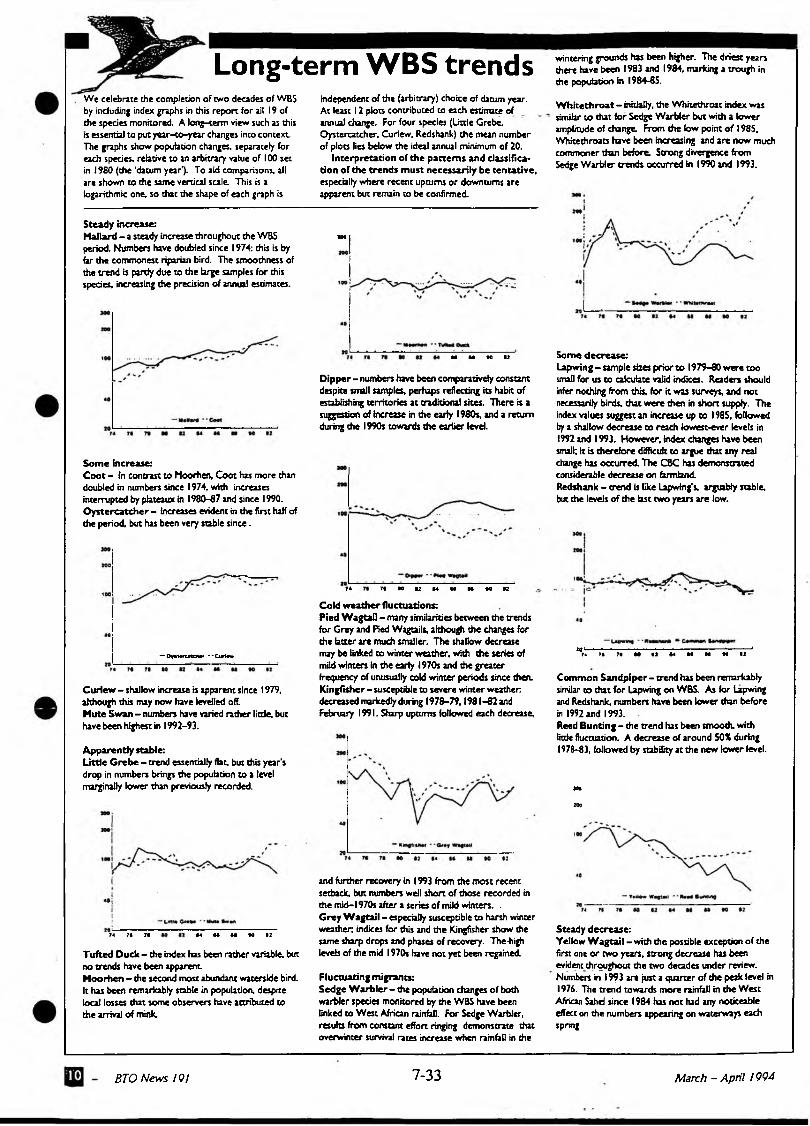
Long-term WBS trendsWe celebrate die completion of two decades of WBS by including index graphs in this report for ail 19 of the species monitored. A long-term view such as this « essential to put year-co-year changes into context The graphs show population changes, separately for each species, relative to an arbitrary value of 100 set in 1980 (the 'datum year*). To aid comparisons, all are shown to the same vertical scale. This is a logarithmic one, so that the shape of each graph is
independent of the (arbitrary) choice of datum year. At least 12 plots contributed to each estimate of annua] change. For four species (Litde Grebe. Oystercatcher, Curfew. Redshank) the mean number of plots lies below the ideal annual minimum of 20.
Interpretation of the patterns and classification of the trends m ust necessarily be tentative, especially where recent upturns or downturns are apparent but remain to be confirmed.
Steady increase:Mallard - a steady increase throughout the WBS imperiod. Numbers have doubled since 1974: this is by hr die commonest riparian bird. The smoothness of the trend is partly due to the large samples for this species, increasing the precision of annual estimates.
N U K 1}
Dipper - numbers have been comparatively constant despite small samples, perhaps reflecting its habit of establishing territories at traditional sites. There is a suggestion of increase in the early 1980s. and a return during the 1990s towards the earlier level.
Some increase:C oot - in contrast to Moorhen, Coot has more than doubled in numbers since 1974, with increases interrupted by plateaux in 1980-67 and since 1990. O ystercatcher - increases evident in the first half of the period, but has been very stable since.
-OrlMtMW --CtfMa
Curlew - shallow increase is apparent since 1979, although this may now have levelled off.Mute Swan - numbers have varied rather litde, but have been highest in 1992-93.
Apparently stable:Little Grebe - trend essentially flat, but this year’s drop in numbers brings the population to a level marginally lower than previously recorded.
74 7* 7| •4 U U 10 12Tufted Duck - che index has been rather variable, but no trends have been apparent.Moorhen - the second most abundant waterside bird. It has been remarkably stable in population, despite local losses that some observers have attributed to the arrival of mink.
74 71 M V M U H «0 taCold w eather fluctuations:Pied W agtail - many similarities between the trends for Grey and Red Wagtails, although the changes for the btcer are much smaller. The shallow decrease may be linked to winter weather, with the series of mild winters in the early 1970s and the greater frequency of unusually cold winter periods since then. Kingfisher - susceptible to severe winter weather, decreased markedly during 1978-79.1981 -82 and February 1991. Sharp upturns followed each decrease.
and further recovery in 1993 from the most recent setback, but numbers well short of those recorded in the mid-1970s after a series of mild winters. - Grey W agtail - especially susceptible to harsh winter weather; indices for this and the Kingfisher show the same sharp drops and phases of recovery. The-high levels of the mid 1970s have not yet been regained.
Fluctuating migrants:Sedge W arbler - the population changes of both warbler species monitored by the WBS have been linked to West African rainfall. For Sedge Warbler, results from constant effort ringing demonstrate that overwinter survival rates increase when rainfall in the
wintering grounds has been higher. The driest years there have been 1983 and 1984, marking a trough in the population in 1984-85.
W hite th roat — initially, the Whitethroat index was similar to that for Sedge Warbler but with a lower amplitude of change. From the low point of I98S, White throats have been increasing and are now much commoner than before. Strong divergence from Sedge Warbler trends occurred in 1990 and 1993.
Some decrease:Lapwing - sample sizes prior to 1979-80 were too small for us to calculate valid indices. Readers should infer nothing from this, for it was surveys, and not necessarily birds, that were then in short supply. The index values suggest an increase up to 1985, followed by a shallow decrease to reach lowest-ever levels in 1992 and 1993. However, index changes have been small; it is therefore difficult to argue (hat any real change has occurred. The CSC has demonstrated considerable decrease on farmland.Redshank - trend is tike Lapwing’s, arguably stable, but the levels of the last two years are low.
tt1- • » --------- -— ---1-----— ■ ■ 1K tl II U U U H N H II
Common Sandpiper - trend has been remarkably similar to that for Lapwing on WBS. As for Lapwing and Redshank, numbers have been lower than before in 1992 and 1993.Reed Bunting - the trend has been smooth, with link fluctuation. A decrease of around 50% during I97&-83, followed by stability at the new lower level.
fatm«
Steady decrease:Yellow W agtail - with the possible exception of the first one or two years, strong decrease has been evident throughout the two decades under review. Numbers in 1993 are fust a quarter of the peak level in 1976. The trend towards more rainfall in the West African Sahel since 1984 has not had any noticeable effect on the numbers appearing on waterways each spring.
BTO News 19! 7-33 March - April 1994

I D E N T I F Y I N G FRESHWATER CRAYFISH IN BRITAIN A N D I R E L A N DW h ite -c la w e d (native) (Austropotamobius pallipes)Size Seldom greater than 10 cm in body length.
Rostrum Sides smooth, converging towards base of smalltriangular apex ( V 1). Dorsal surface covered in fine mat of hairs. Median ridge discrete.
Body Smooth, but carapace with pitted appearance.Pale to dark brown or olive in colour. Single pair of post-orbital ridges with a spine ( / 2). Prominent spines on shoulders of carapace, just behind cervical groove ( V 3). These are present in juveniles as small projections.
Claws Top side rough. Underside dirty-white colour inadults, although in juveniles may be pink. More robust in males than females.
H abits/habitat Fairly docile. Occupies streams, rivers, lakes, reservoirs, water-filled quarries. Distribution - sec Figure 1. Underside of d aw
Signal (Pacifastacus leniusculus)Size
Rostrum
Body
Claws
H abits/habitat
May reach 15 cm in body length. Heavier than other species due to massive claws.
Sides smooth and more or less parallel. Median ridge smooth. Apex very pointed and prominent, sides sloping down to prominent shoulders (% 1) some way from tip.
Smooth, generally bluish-brown or reddish- brown, may be almost black in colour in some habitats. Two pairs of post-orbital ridges, first with spine ( V 2), although the second ridge may be insignificant.
Large, robust and smooth all over; red underneath. White to turqoise patch at joint of moveable and fixed finger ( -** 3) gives the signal crayfish its common name.
An aggressive, invasive North American species. Will burrow extensively into suitable substrates. Very good at climbing and escaping. Lives in same habitats as native species. Distribution widespread, particularly in south.
Underside of d aw
N a r r o w - c l a w e d (Turkish) (Astacus leptodactylus)Size
Rostrum
Body
Claws
H abits/habitat
Males often reaching 15 cm but may get larger.
Basal part with toothed margins ( / 1). Apex very pointed and prominent.
Pale yellow to greenish in colour. Sides of carapace rough. Two pairs of post-orbital ridges, both with spines ( / 2). Prominent tubercle on shoulder of carapace ( \ / 3).
Long and narrow. Longer than body in males. Rough on upper surface. Biting edges almost straight.
Fairly docile, especially males with large claws. Favours relatively still water as in lakes and canals.
Male narrow- clawed crayfish
Underside of claw
R ed s w a m p (Procambarus clarkii)Size May reach 15 cm in length.
Rostrum Similar to that of native crayfish but with edgesbelow apex thickened and turning inwards ( / 1).
Body Generally red to reddish-brown all over.Carapace rough. Branchio-cardiac grooves abutting in mid-line ( fl 2) (other species have space between).
C law s Red on both surfaces, covered in tubercles.Large spine on inner margin of carpus ( / 3).
H abits/habitat Aggressive. Wide tolerance of environmental conditions. Burrows. Prefers relatively still waters. Has been found in the wild in Britain, but not known if breeding. On sale in aquarist shops as “Red lobsters.”
Male red swamp crayfish
Upperside of claws
Underside of claw
O t h e r speciesThe only other foreign species of crayfish recorded from British waters is the noble crayfish, Astacus astacus, introduced from mainland Europe. Currently this is restricted to a few ^^josed ponds.
It is similar to the signal crayfish although less aggressive. There is no white patch on the upperside of the claw and the median ridge of the rostrum is strongly toothed.
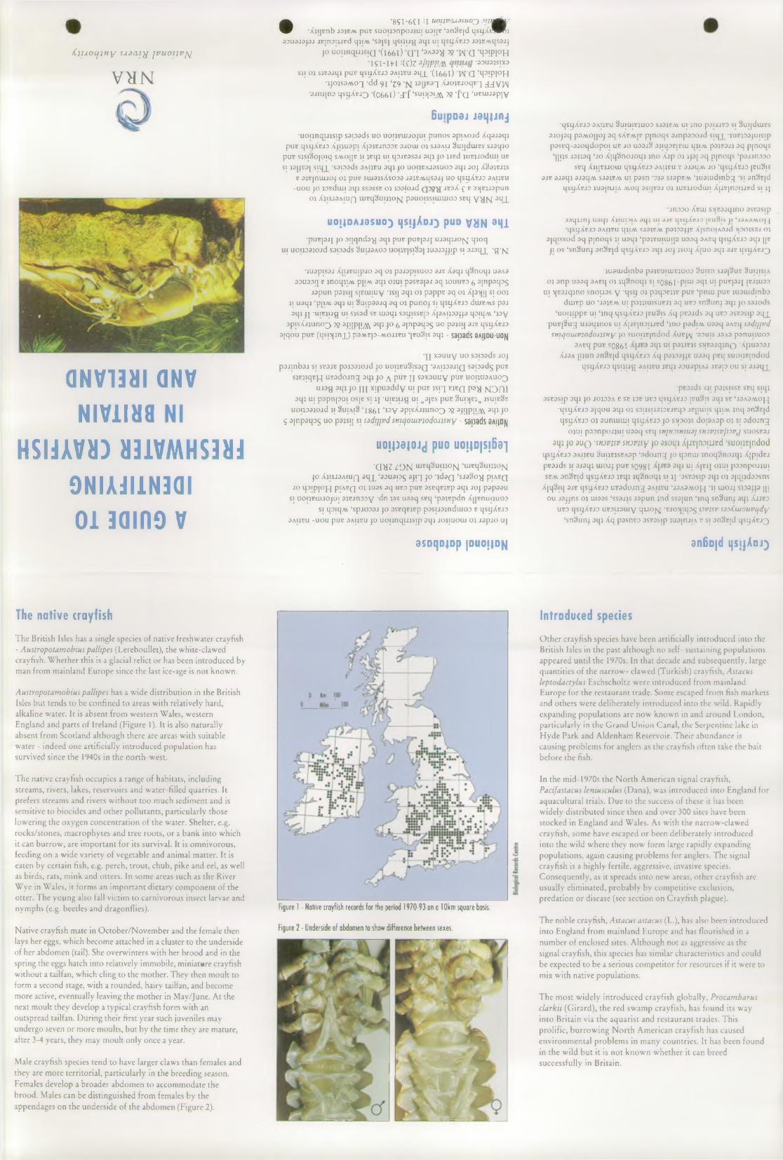
/C ju o c j j t ty sx a c it^ j v u o i j v jq
V t f N
G N V 1 3 H I O N V N I V 1 I H 8 Nl
H S N A V H ) » 3 1 V M H S 3 M J9 N I A J I 1 N 3 0 I 0 1 3QI R9 V
• '8 S I -6 C I : l u o ijv ru o su o j jt jtm k y
■ X ji jB n b jo jb a v p u t s u o i j D n p o j j u i u a i jB ‘ a n S c jd q s y X i ^ P R j 33U 3j a p j j B j n o i j j B d i |J im ‘ s s js j q s i j u g a q j u i q s y X B J D j 3iE A \q s 3J j
j o u o i j n q u j s i Q ( l 6 6 l j a i ‘ 3 A 3 3 ^ 72 W Q ‘ H 3! P I 0 H * I S W H :( e ) Z 3j'1Pm -33U31SIX3
s j i o j s jB 3j q j p u B q s y X B J D s a i jb u 3q jL *( 1 6 6 1 ) W G ‘ H 3! P 1 ° H • j j o j s a M o q d d 9i ‘39 j a y s ^ X jo jB J o q B q J J V W
■ 3 j m \ n o i ] s i j X e j 3 ( 0 6 6 1 ) -d f ‘ s u p P M k ^ f a ‘ r o u u a p j y
6 u ; p o d j j a i | | j n j
• u o i j n q u j s j p s s p s d s u o u o i j e i u j o j u i p u n o s s p iA O j d X q s j s q j p u t q s y X B J D X j u u a p i X p jB jn o D B 3j o u i o j s j3a i j S u i jd u iB S s j s q j o
p u B s js i § o [ o ; q s m o [ | j j ; jB q j u i q o js s s a j s q j j o u B d j u B j j o d u n u b s i j 3[ jB 3j s iq jL ‘ s a p o d s 3a i j b u a q j j o u o i j b a j s s u o o 3t j i j o j X S to jB J js
b a j B j n u u o j o j p u s s u i3js X s o D 3 J3jB A \.q s3J j u o q s y X B J D 3 a i jb u-UOU JO JDBdlUl 3l|J SS3SSB OJ JD 3(ojd JE3X £ B 35JBJJ3pun
o j X j i s j s a i u q u i E q § u i j j o { \ j p a u o is s i u n u o o s s q y g N a H X
UOIJDAJ0SUO) 1|S;jAdJ) puo VHN dHl• p u B p j j j o o q q n d a - g a q j p u B p u s p j j u j a q j j o j ^ j q j o q
u | u o i j o a i o i d s s p s d s S u i j s a o d u o i iB js iS b j j u a j s j j i p s i 3 J 3 q x ' g ’ M
• j u a p i s a j X j u u u i p j o a q o j p a ja p i s u o D o jb X a q j q S n o q j U 3A3 3D U3DIJ b j n o q j i M p jiA v 3q j o j u i p a s s s p j a q jo u u b d ^ 3 I n P 3 l P S
j s p u n p 3 js i j s p ? t u iu y * is i j 3 q i o j p s p p B s q o j X p ^ j i j s i o o j j i u a q j ‘ p | i M a q j u i 3 u i p a a j q a q o j p u n o j s i q s y X B J D d u iB A v s p 3 J a q j j j - u i B j u g u i s js a d sb u i a q j s a y is s B p X p A i j a a j j a q o iq A v ‘ j o y
3p i s X j j u n o ^ ) 39 3j i | p | i ^ o q j j o ^ 3{ n p a q :> s u o p o is i j o jb q s y X s jo 3j q o u p u B ( q s i ^ j n j J p a A iE p -A iO J J E U ‘ jb u S is a q j - S3D 3ds 8A I|D U -U 0fJ
I I x a u u y u o s s io a d s j o j p s j i n b s j s i s b s jb p a j D a j o j d j o u o i j b u § i s 3q 3a i j d 3j i q s a o a d g p u t
s m ; q B i q u u a d o j n g a q j j o \ p u c n s a x a u u y p u p u o i j u s a u o ^ u j a g a q j j o m x | p u a d d y u i p u t j s i q h b q p a -g |s [3 n i
a q j u i p a p n p u i o s p s i j i ' u r e j u g u i „ 3|^ s p u t § u i 5 j n M j s u i e 8eUOIJD3JOid JI §UIAI§ ‘1 8 6 1 ‘W V 3 p is X jJ u n 0 3 59 3J!IPjly5\ 3 q i JO
$ 3| n p 3q D 5 u o p a is f j s i sadtjjvdsntqomvjodoxisny - s0l )8ds SAjlD^J
uojpajojj puo uo;id|sj631
'Q > 1 3 Z 9 N u i E q 3 u i j j o ^ [ ‘ u i B q § u i j j o j y j j o X j i s a a A i u f i a q jL ‘ a o u a p ^ a j i q j o j d a Q ‘ s a a S o ^ i p iA E Q
j o q D i p j o ^ p iA B Q o j ju a s a q U B3 p u t a s B q B jB p a q j j o j p a p a a u s i u o u b u i j o j u i a jB j r iD D y - d n ja s u a a q s s q ‘ p o jB p d n X j j B n u i j u o D
SI ip iq A V ‘ s p j 0 3 3 j JO 3S B q B JB p p 3 S U 3 jn d u iO D B q s y X B J D o a i j b u - u o u p u B 3 a i j b u j o u o i j n q u j s | p a q j j o j i u o u i o j j a p j o u j
3 S D q D ( D p | D U 0 j | 0 N
•q S y X B J D 3 A IJB U § U IU IB J U O D SJ3JBAV U I JIJO pO IJJB O SI 8 u i |d u iB Sa j o j a q p o M O | | O j a q s X b m jb p j n o q s a jn p a D O j d s iq j^ - ju B j 3 3 ju |S i p p a s B q - a j o q d o p o i u b j o u o s jS D jiq ^ B jB u i q j i M p o jB 3 J j o q p j n o q s
‘ i p j s j a j j o q ‘ j o X j q S n o j o q j j n o X j p o j j j a j o q p j n o q s ‘ p o j j n a D o SBlj X J IJB JJO U I q S y X E J O 3A |JB U b 3 J3 1 J M j o ‘ q s y X B J D |B u 8is
3j b a j a q j 3J3qA v SJ3JBAV u i p a s n 3J3 s jo p B A v ‘ j u o u i d i n b ^ SI 3 n 9 B |d q s y X c jD j u a j t u i A M o q o s q v o j o j ju B j J o d u i i X iJ B jn D U J B d s i j j
•jnDDO Xbuj s>jB3jqino asBasipj o q u n j u s q j X jiu o ia a q j u i o jc q s i j X c j D p u S i s j i ‘jo a o a v o ^ •qsyXEJD 3AIJBU IJJIM SJOJBM pOJDOJJB X|SI!OIA3jd >J30JS3J o j
a jq i s s o d o q p jn o q s ji u o q j ‘ p o j c u i u u p u o o q 3ABq q s y X c j o o q j |[B j i o s ‘ s n S u n j a n S B jd qsyXBJO o q j j o j j s o q X j u o a q j ojb q s ijX E J^
• ju a u i d i n b o p o jB u iu iB ju o o 3 u i s n s jd | 3 u b 8u i j i s i a o j o n p u a o q 3A B q o j j q S n o q j s i SQ86l - p i u i a q j u i p u B p j j jb j ju o o
u i i j B 3 j q j n o s n o i js s y - q s y o j p s q ^ B j jB p u B ‘ p n u i p u B j u o u i d m b a d u iB p u o ‘J3JBAV u | p o j i j u is u B J j o q u b d s n 3 u n j 3 q j j o s s j o d s
‘ u o i j i p p B u i ‘ j n q q s y X B J D [b u S is X q p s a jd s a q u b d s s B o s ip 3 q j^ •p u B |8u g u j o q j n o s u i X j j B j n D i j j B d ‘ j n o p o d iA v u o o q OABq sadtjjvd
smqoiuvjodoxjsny j o s u o i j E j n d o d X u b j ^ -a o u is jo a o p o n u u u o D 3 A B q p u B S 0 8 6 1 3 q i U | p3JJBJS S > ( B 3 jq jn Q ’ X p U S D S J
X j 3a [ i j u n 3n § B |d q s y X B J D X q p 3j 33j j B U 33q p B q s u o i j B j n d o d q s y X B J D q s u u g 3A IJB U J B q j 3 3 U 3 p iA 3 J B O p O U SI 3 J 3 q j^
■ p B 3 jd s s j i p s js is s B SBq s i q j3 S B 3 S ip 3 q j JO JO JD 3A B SB JDB UBD q S ^ X B J D JBuSjS 3 q j SB ‘J3A 3A VO J^
•q s y X B J D 3| q o u 3q j o j s o ijs u D jD B J B q D j b j i u i i s q j i M j n q o n S B jd q s ijX B J D 01 s u n u i u i i q s y X B J D j o s ^ p o is d o p A 3 p 01 s i o d o j n g
o j u i p s D n p o j j u i U 33q SBq snjtvsniuaj srtjvjsvJpvj s u o s b s j aqj jo 3 u q 'Sttwjsv snDvjsy p asoqi X|jF|noiucd ‘suouEjndod
q s y X B J 3 3a i j b u S u i jB js B A a p ‘o d o j n g j o q o n u i j n o q S n o j q j X j p i d B j p B 3 jd s j i 3 J 3 q j u i o j j p u B S 0 9 8 1 3 q j u i X j b j j O J U I p s o n p o j j u i s b m s n ^ B jd q s y X B J D iB q i i q 3 n o q i s i i j -3 S B 3 S |p 3 q i 01 3 ( q n d 3 3 s n s
X jq S iq 3j b q s ijX B J D u B a d o j n g s a i jb u ‘j 3A3m o j - j j j u i o j j s iD 3j j 3 | [ | o u j a j j n s o j u i33s ‘ s s a j js j o p u n j n d s s a ju n ‘ j n q s n 3 u n j o q j X j j b d
u b d q s y X B J D u B D U 3 u i y q j j o j s j •B jo ^ j iq o g iovjsv sso/Ciuouvcjdy ‘ s n 3 u n j 3 q j X q p s s n B D 3 S B 3 s ip j u 3| n j | A b s; 3 n S B |d q s y X B J ^
anBo|d i| sijAdj)
The n a tiv e crayfish
The British Isles has a single species of native freshwater crayfish - Austropotamobius pallipes (Lereboullet), the white-clawed crayfish. Whether this is a glacial relict or has been introduced by man from mainland Europe since the last ice-age is not known.
Austropotamobius pallipes has a wide distribution in the British Isles but tends to be confined to areas with relatively hard, alkaline water. It is absent from western Wales, western England and parts of Ireland (Figure 1). It is also naturally absent from Scotland although there are areas with suitable water - indeed one artificially introduced population has survived since the 1940s in the north-west.
The native crayfish occupies a range of habitats, including streams, rivers, lakes, reservoirs and water-filled quarries. It prefers streams and rivers without too much sediment and is sensitive to biocides and other pollutants, particularly those lowering the oxygen concentration of the water. Shelter, e.g. rocks/stones, macrophytes and tree roots, or a bank into which it can burrow, are important for its survival. It is omnivorous, feeding on a wide variety of vegetable and animal matter. It is eaten by certain fish, e.g. perch, trout, chub, pike and eel, as well as birds, rats, mink and otters. In some areas such as the River Wye in Wales, it forms an important dietary component of the otter. The young also fall victim to carnivorous insect larvae and nymphs (e.g. beetles and dragonflies).
Native crayfish mate in October/November and the female then lays her eggs, which become attached in a cluster to the underside of her abdomen (tail). She overwinters with her brood and in the spring the eggs hatch into relatively immobile, miniature crayfish without a tailfan, which cling to the mother. They then moult to form a second stage, with a rounded, hairy tailfan, and become more active, eventually leaving the mother in May/June. At the next moult they develop a typical crayfish form with an outspread tailfan. During their first year such juveniles may undergo seven or more moults, but by the time they are mature, after 3-4 years, they may moult only once a year.
Male crayfish species tend to have larger claws than females and they are more territorial, particularly in the breeding season. Females develop a broader abdomen to accommodate the brood. Males can be distinguished from females by the appendages on the underside of the abdomen (Figure 2).
In troduced species
Figure 1 - Native crayfish records for the period 1 97 0 -9 3 on a 1 Okm square basis.
Figure 2 - Underside of abdomen to show difference between sexes.
Other crayfish species have been artificially introduced into the British Isles in the past although no self- sustaining populations appeared until the 1970s. In that decade and subsequently, large quantities of the narrow- clawed (Turkish) crayfish, Astacus leptodactylus Eschscholtz were introduced from mainland Europe for the restaurant trade. Some escaped from fish markets and others were deliberately introduced into the wild. Rapidly expanding populations are now known in and around London, particularly in the Grand Union Canal, the Serpentine lake in Hyde Park and Aldenham Reservoir. Their abundance is causing problems for anglers as the crayfish often take the bait before the fish.
In the mid-1970s the North American signal crayfish, Pacifastacus leniusculus (Dana), was introduced into England for aquacultural trials. Due to the success of these it has been widely distributed since then and over 300 sites have been stocked in England and Wales. As with the narrow-clawed crayfish, some have escaped or been deliberately introduced into the wild where they now form large rapidly expanding populations, again causing problems for anglers. The signal crayfish is a highly fertile, aggressive, invasive species. Consequently, as it spreads into new areas, other crayfish are usually eliminated, probably by competitive exclusion, predation or disease (see section on Crayfish plague).
The noble crayfish, Astacus astacus (L.), has also been introduced into England from mainland Europe and has flourished in a number of enclosed sites. Although not as aggressive as the signal crayfish, this species has similar characteristics and could be expected to be a serious competitor for resources if it were to mix with native populations.
The most widely introduced crayfish globally, Procambarus clarkii (Girard), the red swamp crayfish, has found its way into Britain via the aquarist and restaurant trades. This prolific, burrowing North American crayfish has caused environmental problems in many countries. It has been found in the wild but it is not known whether it can breed successfully in Britain.
7% 8 The NRA and Dragonfly Conservation
1. Introduction
1.1 Within the field of species conservation, a particular group of interest to the NRA is represented by the Odonata-dragonflies and darn selflies
1.2 Of the species of dragonflies (including damselflies) recorded from Britain, 41 are breeding or have bred in recent times (Appendix 1). Of these 3 have become extinct, whilst a further 4 are confined to Scotland, thus leaving 34 species of which the NRA needs to be aware. Dragonflies are a particularly important group in conservation terms: along with butterflies, they are the group of insects of which the general public are most greatly aware; being sensitive to water pollution, they are a useful group for monitoring the health of watercourses and wetlands, being sensitive to water pollution; and, as predators, they play a significant role in aquatic ecosystems.
2 Role of the NRA
2.1 NRA Operations and Authorisations
2.1.1 In considering any proposals related to its operational and regulatory activities, the NRA is under a statutory duty to further the conservation of flora and fauna. This means that the NRA needs to fully consider the implications of any proposed river management works or applications for authorisations (discharge consents, abstraction licences, land drainage consents, fisheries consents) to determine the potential impact on wildlife, including dragonfly populations in the area concerned. In practice, such assessments focusing on dragonflies will generally concentrate on the effects on wetland habitats, with the expectation that if the habitat is not threatened, then dragonflies will also be protected. However, there may be instances, especially where rare species are concerned, when the implications for dragonflies will be a critical factor in the NRA’s decision.
2.2 NRA Promotion of Conservation
2.2.1 In addition to the statutory responsibilities detailed above, the NRA has a general duty to promote the conservation of flora and fauna which are dependent on an aquatic environment. In promoting conservation, the NRA may undertake practical habitat creation projects (quite apart from the enhancement and mitigation works connected with the Authority’s own operations) which will directly benefit dragonfly populations- wetland creation or the digging of ponds, for example.
2.2.2 In other instances, the best way for the NRA to promote dragonfly conservation will be through collaboration with other bodies: assistance with the management of nature reserves, publication of literature and interpretive materials relating to dragonflies, etc. At a strategic level, has may include to collaborating with bodies such as the Joint Nature Conservation Committee and the British Dragoikfly Society to produce a national conservation strategy for dragonflies.
7-37
2.3 Catchment Management Plans
2.3.1 The preparation of catchment management plans will enable the presence of notable dragonfly species and the management required for their conservation to be highlighted, as well as the identification of key dragonfly sites amongst the other designated sites of the catchment concerned. The use of Water Quality Objectives to protect important populations of dragonflies also needs to be considered.
3 Legislation
3.1 Protected Species
3.1.1 One species of dragonfly, the Norfolk aeshna (Aeshna isosceles), is given full protection through being listed in Schedule 5 of the Wildlife and Countryside Act 1981. Coenagrion mercuriale is listed in Annex n of the EC Habitats Directive.
3.2 Sites of Special Scientific Interest
3.2.1 The 1989 Nature Conservancy Council publication "Guidelines for the Selection of Biological SSSIs" details a system of using dragonflies as indicators of potential Sites of Special Scientific Interest. This section is reproduced as Appendix 2. Essentially, a site of high ecological value may be indicated by the presence of one or more of a list of 15 uncommon species, or by the existence of an outstanding assemblage of different dragonfly species. As dragonfly diversity decreases from south to north in Britain, the definition of an outstanding assemblage varies from a minimum 17 species present in central southern England, to at least 9 species in Northumberland.
4 Conservation of River Species
4.1 Background
4.1.1 All British dragonflies have aquatic larvae and are sensitive to water pollution. Most species require static or nearly static water to breed in, but six British species are virtually confined to running water. Of these, Oxygastra curtisii was confined to the Moors River and River Tamar and is now extinct; Gomphus vulgarissimus and Libellula fulva are very local; Platycnemis pennipes is fairly widespread in the southern half of England but is locally threatened. Calopteryx virgo is abundant west of the line Mersey to Romney Marsh and Calopteryx splendens is abundant in much of lowland England and Wales. Both the Calopteryx species have interesting isolated populations outside their main ranges which require protection.
4.2 H abitat Requirements
7-38

4.2.1 The exact distribution of river species within a river system depends on substrate, rate of flow and fringing vegetation. Thus the distribution of species is patchy and small areas such as sheltered backwaters can be crucial. For exact localities the Biological Records Centre (BRC) at Monks Wood should be consulted. The Key Site Register for dragonflies will be particularly useful for this purpose.
4.2.2 Rivers, dykes and ditches in alluvial floodplains are important for many species of dragonflies. Three species, Coenagrion armatum, Coenagrion scitulum and Aeshna isosceles were/are confined to these waterbodies and most or many localities of Coenagrion pulchellum, Lestes dryas, Brachytron pratense and Sympetrum sanguineum also occur in floodplains. Alterations in the water regimes of these areas could have serious effects on dragonfly populations; for example, C.armatum and C. scitulum have been extinct since the 1950s, and L. dryas has become much rarer.
4.2.3 Some canals are rich in dragonfly species, but none is restricted solely to canals. Dragonfly populations in canals and navigable rivers can be extirpated or greatly reduced by increases in boat traffic, especially when it is fast moving.
4.2.4 Many of the rarer British species of dragonflies depend upon small pools and rivulets in acid heathlands. These are rarely affected by changes in the management or rivers nearby; however they can be very vulnerable to those water abstraction schemes in the vicinity which lower water tables.
4.3 Priority River Sites for Dragonfly Conservation
4.3.1 The NRA’s greatest direct influence on river dragonfly habitats is through flood defence maintenance operations, which have the potential to affect the dragonflies’ essential environmental requirements. It is vital that the Authority should be aware of those rivers which are of particular importance for dragonflies, in order that river management works are undertaken with particular care. Table 1 lists priority rivers, based upon the extent to which they support rare or local species; measures taken to conserve these species will support common species as well.
4.3.2 As well as rare species, there are rivers which are important as they hold populations of the common river/stream species (Calopteryx virgo and C.splendens) at the edge of their range. Notable amongst these are, for C. virgo, the mid-Colne and mid-Stour in Anglian Region, rivers rising in the Cumbrian mountains in North-West Region, and the upper Derwent in Northumbria/Yorkshire Region. For C.splendens, the streams between Carlisle and Silloth, in North-West Region, are significant.
4.3.3 Looking more broadly at river catchments, there are certain alluvial floodplains which are of particular significance for dragonfly communities including the river species. These are shown in Table 2.
7-39
5. Conservation of Wetland/Stillwater Species
5.1 Background
5.1.1 The majority of British dragonflies are dependent upon open water or wetland environments. Whilst the NRA’s direct influence upon such habitats may be less than upon rivers, the habitat requirements of dragonflies should be fully considered when determining authorisations, particularly abstraction licences and discharge consents. Opportunities of habitat restoration, particularly through water level management plans, will have major potential benefits for dragonflies.
5.2 Habitat Requirements
5.2.1 Certain general principles apply to the conservation of all wetland habitats. All dragonfly species are dependent both on the condition of their aquatic breeding site and on the nature of the surrounding area frequented by the adults; for larger species, the surrounding area may extend to a radius of a kilometre or more. Hydrological continuity of suitable conditions is critical. Wetland habitats are vulnerable to drainage, but if they are to support dragonflies, it is essential that breeding sites do not dry out. Equally, elimination of vegetation, or modification of the surrounding area used by adults can also result in elimination of the dragonfly fauna.
5.2.2 The majority of British dragonflies are to be found in lowland ponds, lakes and canals Warm, shallow acid ponds and lakes have the greatest diversity of species. Essential requirements include plenty of aquatic vegetation, a good fringe of emergent reeds and a sheltered situation. Dense shading of margins by trees will be detrimental though Somatochlora metallica does need some overhanging trees. Certain plant- dragonfly associations are evident: Erythromma najas with floating leaves of Potamogeton and water-lily, Sympetrum sanguine um often with bur-reed and reedmace.
5.2.3 Gravel pits, which have areas of bare sandy bottom and open sandy banks, are colonised with great success, notably by Orthetrwn cancellation, Enallagma cyathigerum and Aeshna mixta, providing the water is shallow near the banks. The adults sunbathe on the bare banks and paths. Similarly, the creation of new ponds on farms and nature reserves can be very beneficial to at least the more common dragonfly species.
5.2.4 Certain bog species breed in very small ponds or see pages, or even amongst the waterlogged Sphagnum mass at pond margins (such as Leucorrhinia dubia). Bulbous rush Juncus bulbosus can also form valuable aquatic vegetation in acid habitats.
5.3 Priority Wetland Sites for Conservation
The following are areas of general importance for dragonflies which could be seriously affected by changes in water regime or water quality:
7-40
Whole area (especially Breckland and other heathland areas of west Norfolk)
Shropshire and Cheshire meres and canals
Weald heathlands New Forest
Heathlands on Bagshot Beds Cornwall - mainly heathlands
Heathlands on Lower Greensand and Bagshot Beds Basingstoke Canal
Canals on English borderCoastal areas of West Wales including the whole of Anglesey
In recent years, the Odonata Recording Scheme has been running a key sites project to identify those sites of greatest importance which support large assemblages of breeding dragonflies. Nationally important sites include Thursley NNR in Surrey, which supports two-thirds of the British resident species. Information on these key sites should be available to the NRA from the Biological Records Centre.
6 Species Conservation for Dragonflies . . =
6.1 Red Data Book
6.1.1 "British Red Data Books 2 : Insects" gives details of six dragonflies. Three of these (Coenagrion armatum, C.scitulum and Oxygastra curtisii) are thought to be extinct, one (Aesna isosceles) is endangered and two (C.hastulatum and Lestes dryas) are categorised as vulnerable. Threats identified for the three surviving species include both drainage and pollution.
6.2 Species Recovery Programmes
6.2.1 The Norfolk aeshna is the only dragonfly species included in the 1990 NCC document "Recovery : A proposed programme for Britain’s protected species". The goal for the recovery programme is 10 sites holding self-sustaining populations for at least 10 consecutive years, backed by research into and implementation of site management measures for sites in Suffolk and Norfolk.
• Anglian
• Sevem-Trent/NW -
• Southern
• South Western
• Thames
• Welsh
5.4 Odonata Key Sites
7-41
6.2.2 "Biodiversity Challenge: an agenda for conservation in the UK", produced by a consortium of voluntary bodies in 1994, sets targets for seven dragonfly species, as follows:
Aeshna isosceles (Norfolk Aeshna) Maintain existing populations. Expand suitable areas of grazing marsh ditches by 50 %.
Coenagrion hastulatum (northern blue damselfly) Maintain all populations at current levels.
Coenagrion mercuriale (southern damselfly) A globally threatened species. Maintain all current UK populations. Found in the New Forest, Dorset and south Wales.
• Lestes dryas (scarce emerald damselfly) Feared extinct in 1970s, but has made a come back. Ensure continued existence on all optimum sites.
• Leucorrhina dubia (white-faced dragonfly) Maintain range in Scotland and populations on lowland bogs in England.
• Libellula Julva (scarce chaser dragonfly) Maintain populations of this scarce species of slow flowing rivers in southern and eastern England.
• Oxygastra curtissi (orange-spotted emerald) Extinct in Britain. A globally threatened species. Formerly found in the New Forest and Devon. Consider possibility of reintroduction.
6.2.3 It may be appropriate for the NRA to collaborate with other bodies in drawing up local recovery programmes for dragonfly species of particular Regional concern.
6.3 Reintroductions
6.3.1 Attempts may be made by the British Dragonfly Society to reintroduce extinct species from the continent in the future. The NRA may wish to assist with any such projects.
7 Research on Dragonfly Conservation
7.1 NRA R&D
7.1.1 The NRA R&D project 461, "Species Management in Aquatic Habitats”, has, in its first phase, highlighted seven dragonfly species as being of special concern to the NRA. These axe Aeshna isosceles, C.mercuriale, Cordulia aenea, Ischnura pumilio, Lestes dryas, Libellula Julva, and Somatochlora arctica. The intention is that later phases of the project should describe the distribution of these species, produce conservation guidelines and consider translocations as an option, as well as informing relevant managers of key sites and promoting habitat maintenance and creation.
7-42

7.1.2 In broad terms, it is known that (i) dragonflies cannot breed in grossly polluted water,(ii) some dragonflies species are more sensitive to pollution than others, and (iii) dragonflies are less sensitive than Plecoptera and Ephemeroptera. The main requirement is to determine the relative sensitivity of different species to different pollutants. R&D on the effects of water pollution on dragonflies will be considered.
7.2 Distribution and monitoring
7.2.1 A national recording scheme for the Odonata is co-ordinated by the Biological Records Centre at ITE Monks Wood. A national distribution atlas is to be published shortly. The NRA will give greater consideration as to how dragonfly records from conservation staff, biologists and others are fed into the national scheme.
7.2.2 A number of counties (eg Suffolk, Cheshire and Leicestershire) and similar areas have produced local dragonfly distribution atlases in recent years, generally combining dot-distribution maps and descriptive texts, sometimes including illustrations for identification purposes. Further details are available from the British Dragonfly Society.
7.2.3 A standardised monitoring scheme for dragonflies, similar to the national butterfly monitoring scheme, is being considered by the British Dragonfly Society. When the procedures have been defined the NRA might give support to such a project.
8 Publicity for Dragonfly Conservation
8.1 General
8.1.1 With the increasing interest in dragonflies recently, a number of steps have been taken in making the public more aware of the group and its need for conservation measures. Interpretation of wetland reserves generally now tends to include more information on dragonflies (RSPB, notably, are taking an interest in dragonflies on their reserves). The British Dragonfly Society has produced booklets: Dig a pond for dragonflies (1992) and Managing habitats for dragonflies (1993). The 1980 NCC leaflet on "The Conservation of Dragonflies" is shortly to be updated by EN/JNCC. WATCH has organised several projects which have involved observations of dragonflies by young people.
8.2 NRA involvement
8.2.1 The NRA has already assisted in publicising the conservation requirements of dragonflies, for example, through Thames Region sponsoring reserve interpretive boards for the British Dragonfly Society and Severn-Trent Region funding the Leicestershire atlas. Other such collaborative projects should be considered by NRA Regions, particularly interpretation at visitor centres and high-profile sites, as well as schemes which will encourage a greater interest in dragonflies by those willing to submit records to local biological records centres, since the acquisition of such information provides the basis for conservation action. NRA publications on dragonflies, either on a regional or national basis, might be considered.

Further Reading
See Part 3, section 15.
Abbreviations and Acronyms
See Part 4, section 19.
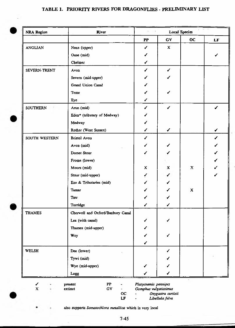
TABLE 1. PRIORITY RIVERS FOR DRAGONFLIES - PRELIMINARY LIST
NRA Region River ’ Local Species
PP GV OC LF
ANGLIAN Nene (upper) / X
Ouse (mid) ✓ ✓
Chelmer ✓
SEVERN-TRENT Avon / ✓
Severn (mid-upper) ✓ /
Grand Union Canal /
Teme / /
Eye ✓
SOUTHERN Arun (mid) / / ✓
Eden* (tributary of Medway) /
Medway /
Rother (West Sussex) / / ✓
SOUTH WESTERN Bristol Avon / ✓
Avon (mid) / / ✓
Dorset Stour / / ✓
Frome (lower) ✓
Moors (mid) X X X ✓
Stour (mid-upper) / ✓
Exe & Tributaries (mid) / ✓
Tamar / / X
Taw / ✓
Torridge ✓ ✓
THAMES Cherwell and Oxford/Banbury Canal
Lea (with canal) / /
Thames (mid-upper) ✓
Wey ✓ /
✓
WELSH Dee (lower) ✓
Tywi (mid) ✓
Wye (mid-upper) / /
Lugg / ✓
present PP - Platycnemis peruiipesextinct GV - Comphus vulgatissimus
OC - Oxygastra curtisiiLF - Libellula fulva
also supports Somatochlora metallica which is very local
/X
7-45
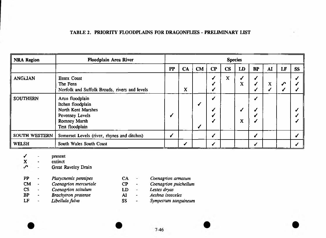
TABLE 2. PRIORITY FLOODPLAINS FOR DRAGONFLIES - PRELIMINARY LIST
NRA Region Floodplain Area River Species
PP CA CM CP CS LD BP AI LF SS
ANGLIAN Essex Coast / X ✓ / ✓The Fens / X ✓ X /" ✓Norfolk and Suffolk Broads, rivers and levels X / / / ✓ /
SOUTHERN Arun floodplain / ✓Itchen floodplain /North Kent Marshes / ✓ / ✓Pevensey Levels / ✓ / ✓Romney Marsh ✓ X ✓ ✓Test floodplain /
SOUTH WESTERN Somerset Levels (river, rhynes and ditches) / ✓ / /
WELSH South Wales South Coast ✓ ✓ ✓ ✓
/ - presentX - extinct
- Great Raveley Drain
PP - Platycnemis pennipes CA - Coenagrion armatumCM - Coenagrion mercuriale CP - Coenagrion pulchellumCS - Coenagrion scitulum LD - Lestes dryasBP - Brachytron pratense AI - Aeshna isoscelesLF - Libellula Julva SS - Sympetrum sanguineum
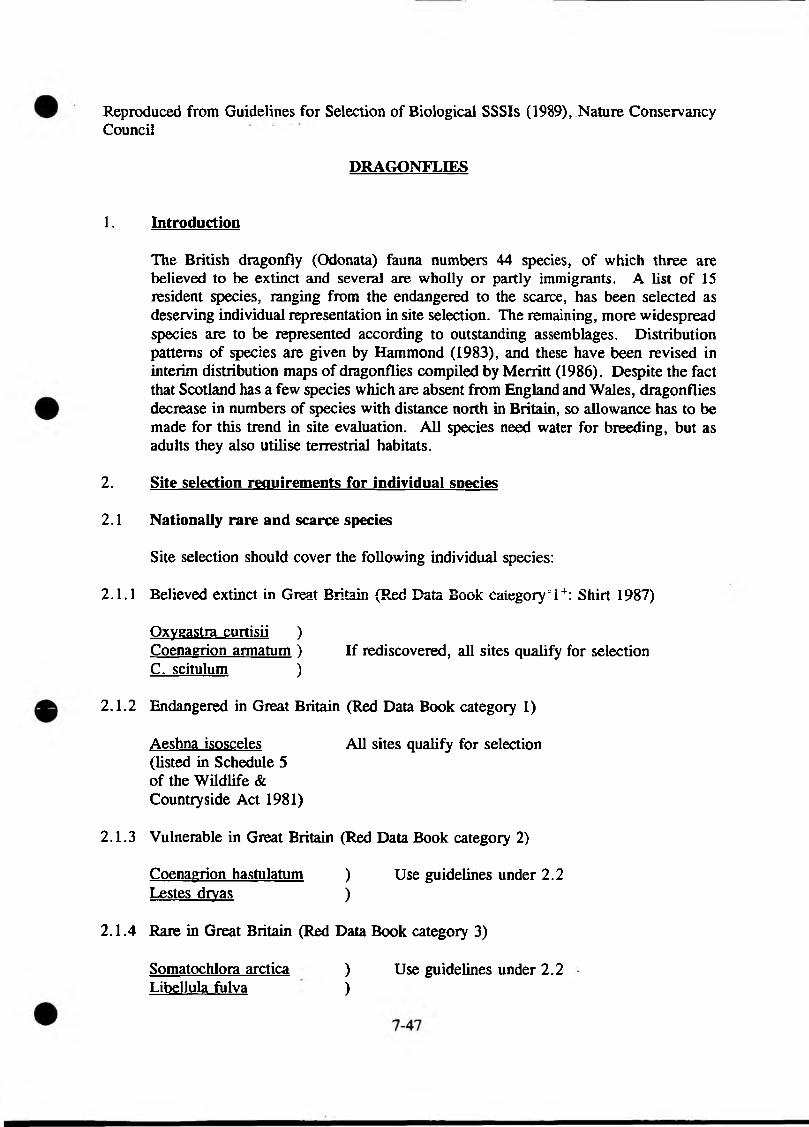
Reproduced from Guidelines for Selection of Biological SSSIs (1989), Nature Conservancy Council
DRAGONFLIES
1. Introduction
The British dragonfly (Odonata) fauna numbers 44 species, of which three are believed to be extinct and several are wholly or partly immigrants. A list of 15 resident species, ranging from the endangered to the scarce, has been selected as deserving individual representation in site selection. The remaining, more widespread species are to be represented according to outstanding assemblages. Distribution patterns of species are given by Hammond (1983), and these have been revised in interim distribution maps of dragonflies compiled by Merritt (1986). Despite the fact that Scotland has a few species which are absent from England and Wales, dragonflies decrease in numbers of species with distance north in Britain, so allowance has to be made for this trend in site evaluation. All species need water for breeding, but as adults they also utilise terrestrial habitats.
2. Site selection requirements for individual species
2.1 Nationally rare and scarce species
Site selection should cover the following individual species:
2.1.1 Believed extinct in Great Britain (Red Data Book category “ I +: Shirt 1987)
Oxygastra curtisii )Coenagrion armatum ) If rediscovered, all sites qualify for selection C. scitulum )
2.1.2 Endangered in Great Britain (Red Data Book category 1)
Aeshna isosceles All sites qualify for selection(listed in Schedule 5 of the Wildlife &Countryside Act 1981)
2.1.3 Vulnerable in Great Britain (Red Data Book category 2)
Coenagrion hastulatum ) Use guidelines under 2.2 Lestes dryas )
2.1.4 Rare in Great Britain (Red Data Book category 3)
Somatochlora arctica ) Use guidelines under 2.2Libellula fulva )
Coenagrion mercuriale ) Internationally endangered(see 2.1.6 and 2.2)
2.1.5 Nationally scarce (known or presumed to occur in 16-100 10km squares in Great Britain, but not RDB species).
Aeshna caerulea Brachvtron pratense Coenagrion pulchellum Cordulia aenea Ischnura pumilio Leucorrhinia dubia Somatochlora metallica Ceriagrion tenellum Gomphus vulgatissimus
Use guidelines under 2.2
Internationally vulnerable (see 2.1.6 and 2.2)
2.1.6 Threatened in Europe and breeding in Britain (Tol & Verdonk 1988)
Coenagrion mercuriale )(endangered in Europe )Gomphus vulgatissimus ) Use guidelines under 2.2(vulnerable in Europe) )
2.2 Guidelines for selection of sites for nationally rare and scarce species
2.2.1 The aim should be adequately to conserve strong populations of all nationally rare and scarce species present within each AOS. The number of sites chosen for each species will vary, but sites containing combinations of species are especially valuable.
2.2.2 A single internationally threatened, RDB category 2 or 3 nationally scarce species qualifies a site for selection if it contains:
(a) the largest or only population of this species in the AOS;
(b) a strong population of the species on a site which, although a good example of a habitat type, has not already been selected;
(c) a strong population of the species in an AOS supporting a substantial proportion of localities for the species; or
(d) a strong population on the edge of the species’ geographical range.
3. Outstanding assemblages
3.1 Figure 8 shows total numbers of all dragonfly species regarded as outstanding assemblages in different parts of Britain. All sites which reach or exceed the relevant qualifying number should be considered for selection.
7-48
4. Further guidelines for site selection
4.1 All records should be within three years of the selection data. Only confirmed breeding records should be considered. Transient populations should not be considered.
4.2 If possible, every breeding species firmly established within the AOS should be present in at least one SSSI.
4.3 In the definition of site boundaries, semi-natural terrestrial habitats used for feeding and resting should be included, as well as the breeding sites themselves. It may also be necessary to include part of the catchment in order to protect water quality or quantity.

Crown Copyright reserved.
F i g u r e 8 T o ta l n u m b e r s o f d ra g o n f ly s p e c ie s rega rded a s o u ts ta n d in g a ssem b lag es in d i f f e r e n t p a r t s o f B r i ta in
(N o te t h a t th e t o t a l n u m b e r o f s p e c ie s in S h e t la n d is to o sm all for th is c o n c e p t to be va lid .)
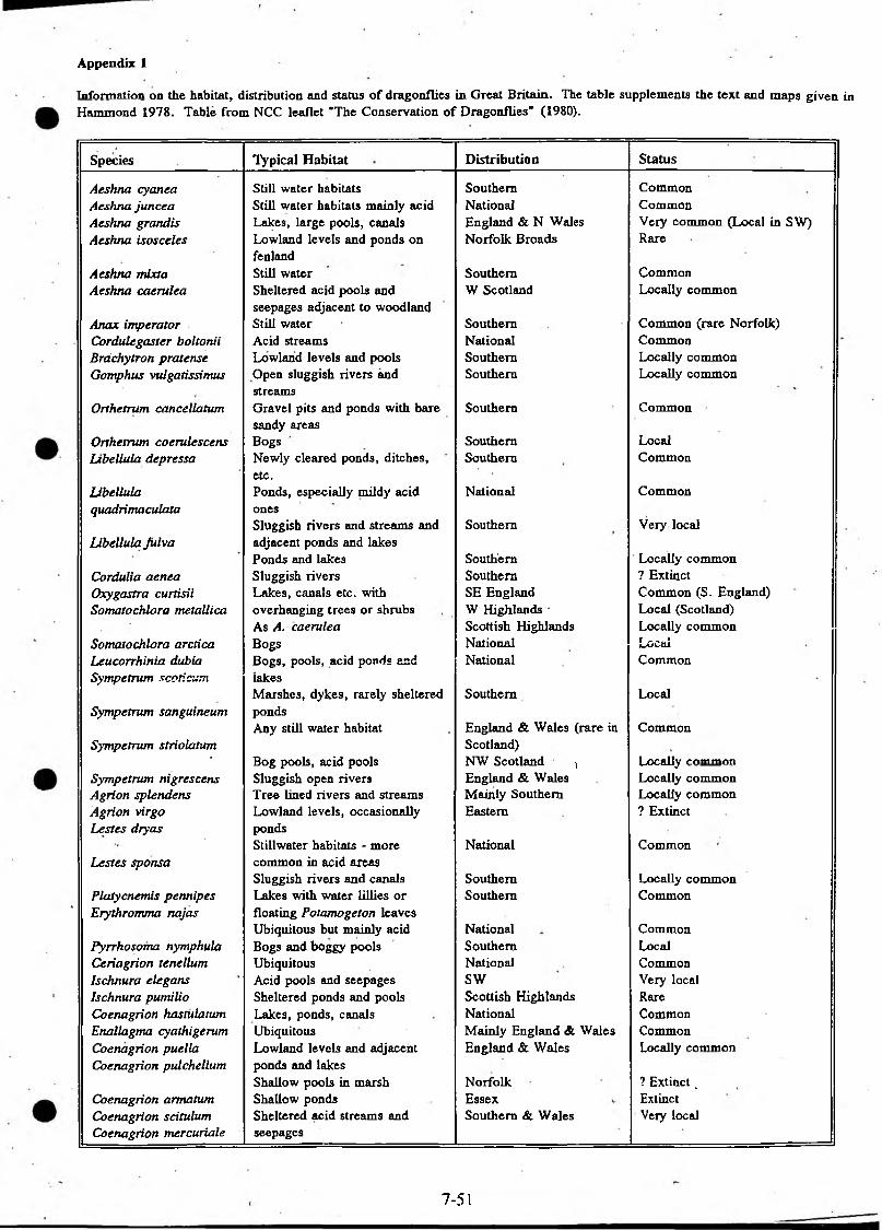
Appendix 1
Inform ation on the habitat, distribution and status of dragonflies in Great Britain. The table supplements the text and maps given in Hammond 1978. Table from NCC leaflet "The Conservation of Dragonflies" (1980).
Species Typical Habitat Distribution Status
Aeshna cyanea Still water habitats Southern CommonAeshna juncea Still water habitats mainly acid National CommonAeshna grandis Lakes, large pools, canals England & N Wales Veiy com m on (Local in SW)Aeshna isosceles Lowland levels and ponds on Norfolk Broads Rare
fenlandAeshna mixta Still water Southern CommonAeshna caerulea Sheltered acid pools and
seepages adjacent to woodlandW Scotland Locally common
Anax imperator Still water Southern Common (rare Norfolk)CorduUgaster boltonii Acid streams National CommonBrdchytfon pratense Lowland levels and pools Southern Locally commonGomphus vulgatissimus Open sluggish rivers and Southern Locally common
streamsOrthetrum cancellation Gravel pits and ponds with bare Southern Common
sandy areasOrthetrum coerulescens Bogs Southern LocalLibellula depressa Newly cleared ponds, ditches,
etc.Ponds, especially mildy acid
Southern Common
Ubellula National Commonquadrimaculata ones
Libellula JulvaSluggish rivers and streams and adjacent ponds and lakes
Southern Veiy local
Ponds and lakes Southern Locally commonCordulia aenea Sluggish rivers Southern ? ExtinctQxygastra curtisii Lakes, canals etc. with SE England Common (S. England)Somatochlora metallica overhanging trees or shrubs W Highlands - Local (Scotland)
As A. caerulea Scottish Highlands Locally commonSomatochlora arctica Bogs National LocalLeucorrhinia dubia Bogs, pools, acid ponds and National CommonSympetrum scoticum lakes
Marshes, dykes, rarely sheltered Southern LocalSympetrum sanguineum ponds
Any still water habitat England & Wales (rare in CommonSympetrum striolatum Scotland)
* Bog pools, acid pools NW Scotland > Locally commonSympetrum nigrescens Sluggish open rivers England & Wales Locally commonAgrion splendens Tree lined rivers and streams Mainly Southern Locally commonAgrion virgo Lowland levels, occasionally Eastern ? ExtinctLestes dryas ponds
Lestes sponsaStillwater habitats - more common in acid areas
National Common
Sluggish rivers and canals Southern Locally commonPlatycnemis pennipes Lakes with water lillies or Southern CommonErythromma najas floating Potamogeton leaves
Ubiquitous but mainly acid National CommonPyrrhosoma nymphula Bogs and boggy pools Southern LocalCeriagrion tenellum Ubiquitous National CommonIschnura elegans Acid pools and seepages SW Very localIschnura pumilio Sheltered ponds and pools Scottish Highlands RareCoenagrion hastulatum Lakes, ponds, canals National CommonEnallagma cyathigerum Ubiquitous Mainly England & Wales CommonCoenagrion puella Lowland levels and adjacent England & Wales Locally commonCoenagrion pulchellum ponds and lakes
Shallow pools in marsh Norfolk ? Extinct.Coenagrion armatum Shallow ponds Essex ExtinctCoenagrion scitulum Sheltered acid streams and Southern & Wales Very localCoenagrion mercuriale seepages
7-51
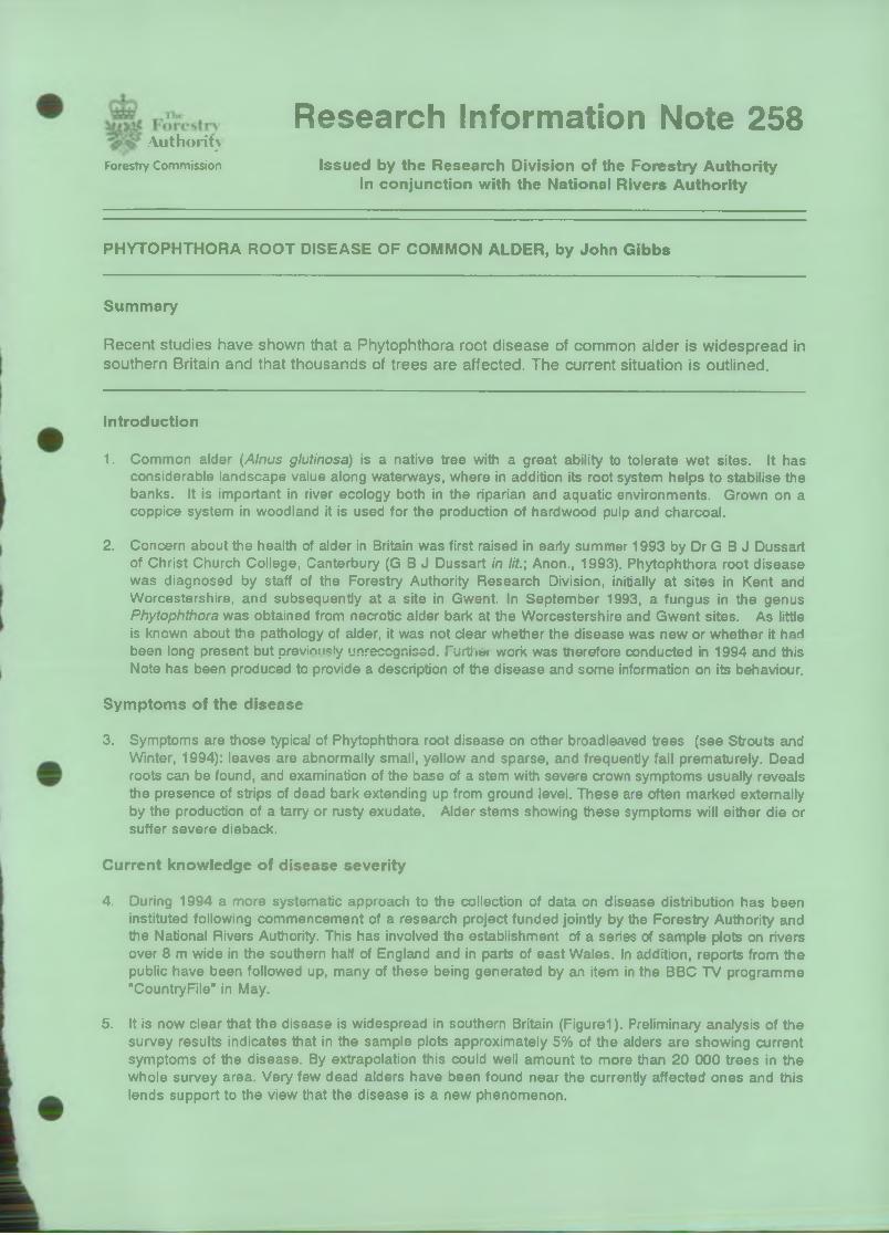
AuthorityResearch Information Note 258
Forestry Commission Issued by the Research Division of the Forestry Authority in conjunction with the National Rivers Authority
PHYTOPHTHORA ROOT DISEASE OF COMMON ALDER, by John Gibbs
Summary
Recent studies have shown that a Phytophthora root disease of common alder is widespread in southern Britain and that thousands of trees are affected. The current situation is outlined.
Introduction
1. Common alder (Alnus glutinosa) is a native tree with a great ability to tolerate wet sites. It has considerable landscape value along waterways, where in addition its root system helps to stabilise the banks. It is important in river ecology both in the riparian and aquatic environments. Grown on a coppice system in woodland it is used for the production of hardwood pulp and charcoal.
2. Concern about the health of alder in Britain was first raised in early summer 1993 by Dr G B J Dussart of Christ Church College, Canterbury (G B J Dussart in lit.', Anon., 1993). Phytophthora root disease was diagnosed by staff of the Forestry Authority Research Division, initially at sites in Kent and Worcestershire, and subsequently at a site in Gwent. In September 1993, a fungus in the genus Phytophthora was obtained from necrotic alder bark at the Worcestershire and Gwent sites. As little is known about the pathology of alder, it was not clear whether the disease was new or whether it had been long present but previously unrecognised. Further work was therefore conducted in 1994 and this Note has been produced to provide a description of the disease and some information on its behaviour.
Symptoms of the disease
3. Symptoms are those typical of Phytophthora root disease on other broadleaved trees (see Strouts and Winter, 1994): leaves are abnormally small, yellow and sparse, and frequently fall prematurely. Dead roots can be found, and examination of the base of a stem with severe crown symptoms usually reveals the presence of strips of dead bark extending up from ground level. These are often marked externally by the production of a tarry or rusty exudate. Alder stems showing these symptoms will either die or suffer severe dieback.
Current knowledge of disease severity
4. During 1994 a more systematic approach to the collection of data on disease distribution has been instituted following commencement of a research project funded jointly by the Forestry Authority and the National Rivers Authority. This has involved the establishment of a series of sample plots on rivers over 8 m wide in the southern half of England and in parts of east Wales. In addition, reports from the public have been followed up, many of these being generated by an item in the BBC TV programme "CountryFile" in May.
5. It is now clear that the disease is widespread in southern Britain (Figurel). Preliminary analysis of the survey results indicates that in the sample plots approximately 5% of the alders are showing current symptoms of the disease. By extrapolation this could well amount to more than 20 000 trees in the whole survey area. Very few dead alders have been found near the currently affected ones and this lends support to the view that the disease is a new phenomenon.

6. No quantitative data are available for smaller streams or for other types of alder site. However, observations would suggest that disease levels are very much lower. There are no records for Scotland where such damage to alder as has been investigated has proved to be due to other causes.
7. It is evident that a high proportion of the trees suffering from Phytophthora root disease are in close proximity to streams and rivers, often being located at intervals along substantial sections of bank. The disease has also been found in plantings of alder in sites subject to flooding from adjacent rivers on the banks of which signs of infection are present. However, some instances of disease have been found on sites not liable to flooding, as for example, in an orchard shelterbelt on sloping soil far from any stream. While most of the records are from common alder, instances of disease have also been found in grey alder (A incana) and Italian alder (A cordata).
Disease biology
8. The 'alder’ Phytophthora is a form of P. cambivora (Brasier et al., in preparation), a well-known pathogen which causes root and stem diseases of a wide range of tree species in this country and abroad. As yet very little is known about the biology of the alder P. cambivora although experiments have established its ability to invade and kill bark on the stems of common alder (Gibbs, in press). As with many other Phytophthora species, it produces water-borne spores and it seems certain that these are important in the infection process. A programme of detailed research is being initiated.
Future progress of the disease
9. Any comments on future disease progress must inevitably be very tentative. Although high river and ground water levels during the 1993/94 winter may well have been particularly favourable for infection, it seems probable that the disease will develop further in future years. The survey plots established in 1994 will provide a basis for monitoring future change.
Possibilities for control on affected sites
10. In none of the sites investigated so far has there been any case for attempting sanitation operations. Cutting the stems on affected root systems would not have any effect in eliminating the fungus. Stump removal would cause considerable bank erosion, and in any case, would be expected to leave significant parts of the diseased root system in the ground. Moreover, it is probable that some symptomless trees in the vicinity would have fungus-colonised roots capable of providing inoculum for further infection.
11. No chemical treatment of any kind can be recommended and indeed there seems to be no likelihood that any chemical could be found that would be suitable for use in a riparian setting. Other approaches to control must await research on the disease. For example, it is not yet known if any common alder are resistant to the disease.
Long distance dissemination of disease
12. While there is now circumstantial evidence from the data on disease distribution that the fungus can be disseminated in moving water, nothing is known about other mechanisms for long distance spread. By analogy with crayfish plague, another disease present on British rivers that is caused by a waterborne fungus (see Holdich and Reeve, 1991), it seems feasible that movement of the pathogen between river catchments could be facilitated by man. Activities such as inter-basin water transfer, movement of fish stocks and the use of contaminated fishing equipment could all be important Natural spread by wading birds, etc., also seems possible. In addition, although the disease has not been reported from nurseries, consideration of other Phytophthora root diseases suggests that carriage of infected plants and infested soil could be important. Investigation of the possible role of these processes is in progress.
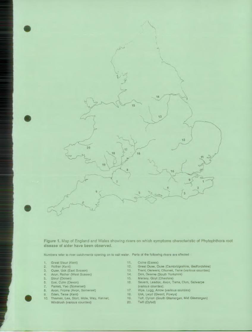
F ig u re 1. Map of England and Wales showing rivers on which symptoms characteristic of Phytophthora root disease of alder have been observed.
Numbers refer to river catchments opening on to salt water. Parts of the following rivers are affected :
1. Great Stour (Kent) 11. Colne (Essex)2. Rother (Kent) 12. Great Ouse, Ouse (Cambridgeshire, Bedfordshire)3. Ouse, Uck (East Sussex) 13. Trent, Derwent, Chumet, Tame (various counties)4. Arun, Rother (West Sussex) 14. Don, Deame (South Yorkshire)5. Stour (Dorset) 15. Mersey, Goyt (Cheshire)6. Exe, Culm (Devon) 16. Severn, Leadon, Avon, Teme, Clun, Salwarpe7. Parrett, Yeo (Somerset) (various counties).8. Avon, Frome (Avon, Somerset) 17. Wye, Lugg, Arrow (various counties)9. Eden, Teise (Kent) 18. Usk, Lwyd (Gwent, Powys)10. Thames, Lea, Stort, Mole, Way, Kennet, 19. Taff, Cynon (South Glamorgan, Mid Glamorgan)
Windrush (various counties) 20. Teifi (Dyfed)
The s itua tion abroad
13. The world scientific literature includes an enormous list of trees that can suffer from Phytophthora root diseases. However no reference has been found to any other cases of the disease on alder. It may well be that recognition of the current situation in Britain will prompt a more detailed investigation of diseased trees in this genus elsewhere.
References
ANON. (1993). Alder population hit by ‘mystery plague’. Farmer's Weekly, 18 June.
BRASIER, C.M., ROSE, J. and GIBBS, J.N. An unusual Phytophthora associated with widespread alder mortality in Britain. Plant Pathology, in preparation.
GIBBS, J.N. Phytophthora root disease of alder in Britain. EPPO Bulletin, in preparation.
HOLDICH, D.M. and REEVE, I.D. (1991). Distribution of freshwater crayfish in the British Isles, with particular reference to crayfish plague, alien introductions and water quality. Aquatic Conservation 1, 139-158.
STROUTS, R.G. and WINTER, T.G. (1994). Phytophthora root diseases. In: Diagnosis of ill-health in trees. HMSO, 197-199.
Issued by: November 1994Research Publications OfficerThe Forestry Authority, Research DivisionAlice Holt Lodge, WreccleshamFarnham, Surrey GU10 4LH
© Crown copyright 1994 ISSN 0267 2375
NOT TO BE REPRODUCED WITHOUT FORESTRY COMMISSION PERMISSION
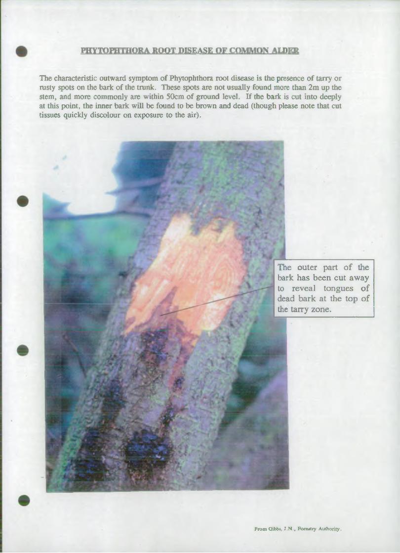
PHYTOPHTHORA ROOT DISEASE OF CQMMQN ALDER
The characteristic outward symptom of Phytophthora root disease is the presence of tarry or rusty spots on the bark of the trunk. These spots are not usually found more than 2m up the stem, and more commonly are within 50cm of ground level. If the bark is cut into deeply at this point, the inner bark will be found to be brown and dead (though please note that cut tissues quickly discolour on exposure to the air).
The outer part of the bark has been cut away to reveal tongues of dead bark at the top of the tarry zone.
From Gibbs, J.N ., Forestry Authority.

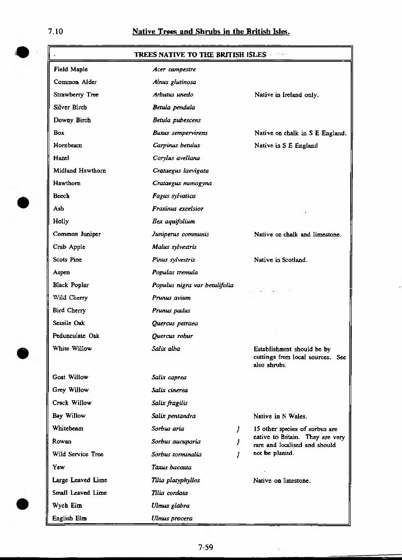
7.10 Native Trees and Shrubs In the British Isles.
TREES NATIVE TO THE BRITISH ISLES
Field Maple Acer campestre
Common Alder Alnus glutinosa
Strawberry Tree Arbutus unedo Native in Ireland only.
Silver Birch Betula pendula
Downy Birch Betula pubescens
Box Buxus sempervirens Native on chalk in S E England.
Hornbeam Carpinus betulus Native in S E England
Hazel Corylus avellana
Midland Hawthorn Crataegus laevigata
Hawthorn Crataegus monogyna
Beech Fagus sylvatica
Ash Fraxinus excelsior
Holly Ilex aquifolium
Common Juniper Juniperus communis Native on chalk and limestone.
Crab Apple Malus sylvestris
Scots Pine Pin us sylvestris Native in Scotland.
Aspen Populas tremula
Black Poplar Populus nigra var betulifolia
Wild Cherry Prunus avium
Bird Cherry Prunus padus
Sessile Oak Quercus petraea
Pedunculate Oak Quercus robur
White Willow Salix alba Establishment should be by cuttings from local sources. See also shrubs.
Goat Willow Salix caprea
Grey Willow Salix cinerea
Crack Willow Salix fragilis
Bay Willow Salix pentandra Native in N Wales.
Whitebeam
Rowan
Wild Service Tree
Sorbus aria }
Sorbus aucuparia }
Sorbus torminalia }
15 other species of sorbus are native to Britain. They are very rare and localised and should not be planted.
Yew Taxus baccata
Large Leaved Lime TUia platyphyllos Native on limestone.
Small Leaved Lime Tilia cordata
Wych Elm Ulmus glabra
English Elm Ulmus procera
7-59

SHRUBS NATIVE TO THE BRITISH ISLES
Barberry
Heather
Travellers Joy
Dogwood
Broom
Spurge laurel
Mezereon
Bell Heather
Cross Leaved Heath
Spindle
Alder Buckthorn
Petty Whin
Ivy
Sea Buckthorn
Wild Privet
Honeysuckle
Bog Myrtle
Blackthorn
Buckthorn
Black Currant
Red Currant
Gooseberry
Field Rose
Dog Rose
Bramble
Raspberry
Willows
Berberis vulgaris
Calluna vulgaris
Clematis vitalba
Comus sanguinea
Cytisus scoparius
Daphne laureola
Daphne mezereum
Erica cinerea
Erica tetralix
Euonymus europaeus
Frangula alnus
Genista anglica
Hedera helix
Hippophae rhamnoides
Ligustrum vulgare
Lonicera periclymenum
Myrica gale
Prunus spinosa
Rhamnus cat hurtica
Ribes nigrum
Ribes ruforum
Ribes uva-crispa
Rosa arvensis
Rosa canina sp
Rubus fruticosus spp
Rubus idaeus
Salix spp
Elder
Gorse
Western Gorse
Bilberry
Wayfaring tree
Guelder Rose
Sambucus nigra
Ulex europaeus
Ulex gallii
Vaccinium myrtillus
Viburnum lantana
Viburnum opulus
Should not be planted because of wheat-rust
Climber
Rare
Dry heaths
Wet heaths
Rare
Climber - should not generally be planted
Coastal - should not generally be planted
Wet peat soils only
Calcareous soils only
Other rare Ribes species omitted
Other dog rose species omitted
Other rare Rubus spp omitted
Several species of shrub willows occur in Britain. Establishment should be by cuttings from local sources.
Acid soils only
Southern Britain only
7-60
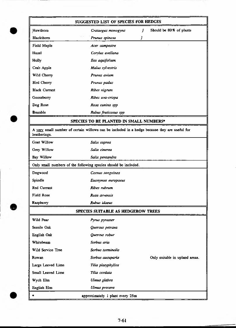
SUGGESTED LIST OF SPECIES FOR HEDGES
Hawthorn Crataegus monogyna } Should be 80% of plants
Blackthorn Prunus spinosa }
Field Maple Acer campestre
Hazel Corylus avellana
Holly Rex aquifolium
Crab Apple Mai us sylvestris
Wild Cherry Prunus avium
Bird Cherry Prunus padus
Black Currant Ribes nigrum
Gooseberry Ribes uva-crispa
Dog Rose Rosa canina spp
Bramble Rubus fruticosus spp
SPECIES TO BE PLANTED IN SMALL NUMBERS*
A very small number of certain willows can be included in a hedge because they are useful for heatherings.
Goat Willow Salix caprea
Grey Willow Salix cinerea
Bay Willow Salix pentandra
Only small numbers of the following species should be included.
Dogwood Comus san guinea
Spindle Euonymus europaeus
Red Currant Ribes rubrum
Field Rose Rosa arvensis
Raspberry Rubus idaeus
SPECIES SUITABLE AS HEDGEROW TREES
Wild Pear Pyrus pyraster
Sessile Oak Quercus petraea
English Oak Quercus robur
White beam Sorbus aria
Wild Service Tree Sorbus torminalis
Rowan Sorbus aucuparia Only suitable in upland areas.
Large Leaved Lime Tdia platyphyllos
Small Leaved Lime Tilia cordata
Wych Elm Ulnuts glabra
English Elm Ulmus procera
* approximately 1 plant every 25m
7-61
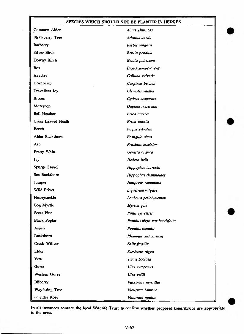
SPECIES WHICH SHOULD NOT BE PLANTED IN HEDGES
Common Alder Alnus glutinosa
Strawberry Tree Arbutus unedo
Barberry Berbis vulgaris
Silver Birch Betula pendula
Downy Birch Betula pubescens
Box Buxus sempervirens
Heather Calluna vulgaris
Hornbeam Carpinus betulus
Travellers Joy Clematis vitalba
Broom Cytisus scoparius
Mezereon Daphne mezereum
Bell Heather Erica cinerea
Cross Leaved Heath Erica tetralix
Beech Fagus sylvatica
Alder Buckthorn Frangula alnus
Ash Fraxinus excelsior
Pretty Whin Genista anglica
Ivy Hedera helix
Spurge Laurel Hippopkae laureola
Sea Buckthorn Hippophae rhamnoides
Juniper Juniperus communis
Wild Privet Ligustrum vulgare
Honeysuckle Lonicer a periclymenum
Bog Myrtle Myrica gale
Scots Pine Pinus sylvestris
Black Poplar Populus nigra var betulifolia
Aspen Populus tremula
Buckthorn Rhamnus cathcarticus
Crack Willow Salix fragilis
Elder Sambucus nigra
Yew Taxus baccata
Gorse Ulex europaeus
Western Gorse Ulex gallii
Bilberry Vaccinium myrtill us
Wayfaring Tree Viburnum lantana
Guelder Rose Viburnum opulus
In all instances contact the local Wildlife Trust to confirm whether proposed trees/shrubs are appropriate to the area.
7-62
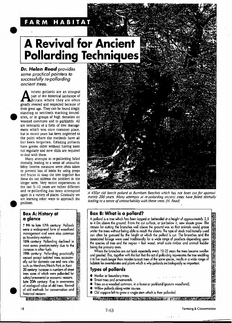
F A R M H A B I T A T
A Revival for Ancient Pollarding Techniques
Dr. Helen Read provides some practical pointers to successfully re-pollarding ancient trees.
Ancient pollards are an integral part of the historical landscape of Britain w here they are often
greatly revered and respected because of their great age. They can be found singly, standing as sentinels marking boundaries, or in groups of high densities on wooded commons and in parklands. All are remnants of a form of tree management which was once common place, but in recent years has been negiected to the point where the methods have all but been forgotten. Existing pollards have grown older without having been cut regularly and new skills are required to deal with them.
Many attempts at re-pollarding failed dismally, leading to a sense of untoucha- bility. Interim measures were often taken to prevent loss of limbs by using props and braces to strap the tree together but these do not address the problem in the longer term. Very recent experiences in the last 5-10 years are rather different and re-pollarding has been attempted again in a variety of places. Gradually we are learning other ways to approach the problem.
Box A; History at a glance? 9th to late 17th century: Pollards were a widespread form of woodland management and were also common as boundary markers.18th century: Pollarding declined in most areas predominately due to the increase in other fuels.19th century: Pollarding practically ceased except isolated trees occasionally cut for domestic use and rare sites such as Mersham/Hatch Park in Kent. 20 century: Increase in numbers of street trees some of which were pollarded for safety/ornamental or economic reasons. Late 20th century: Rise in awareness of ecological value of old trees. Revival of old methods for conservation and historical reasons.
A 450yr old beech pollard at Burnham Beeches which has not been cut fo r approximately 200 years. Many attempts at re-pollarding ancient trees have failed dismally leading to a sense o f untouchability with these trees. (H. Read)
Box B: What is a pollard?A pollard is a tree which has been lopped or beheaded at a height of approximately 2.5 to 4.0m above the ground. From the cut surface, or just below it, new snoots grow. The reason for cutting the branches well above the around was so that animals could graze under the trees without being able to reach the shoots. The type of stock traditionally used can often be guessed by the height at which the pollard is cut. The branches and the associated foliage were used traditionally for a wide range of products dependina upon the species of tree and the region - fuel wood, small scale timber and animal ladder being the primary ones.
andive much longer than maiden (uncut) trees of the same species, results in a wide range
ing rejuvenates the tree enablingWhere the branches are cut back repeatedly every 10-25 years the trees become swollen
and anarled. This, together with the fact that the act of pollard it to five much longer than maiden (uncut) trees of the same sf habitats for invertebrates and plants which is why pollards are biologically so important.
Types of pollards• Marker or boundary trees. ...............• Street trees and ornamentals.• Trees on a wooded common, in a forest or parkland (pasture woodland).• Willow pollards along water courses.• Old coppice left to grow a single stem which is then pollarded.
18 7-6 3 Farming & Conservation
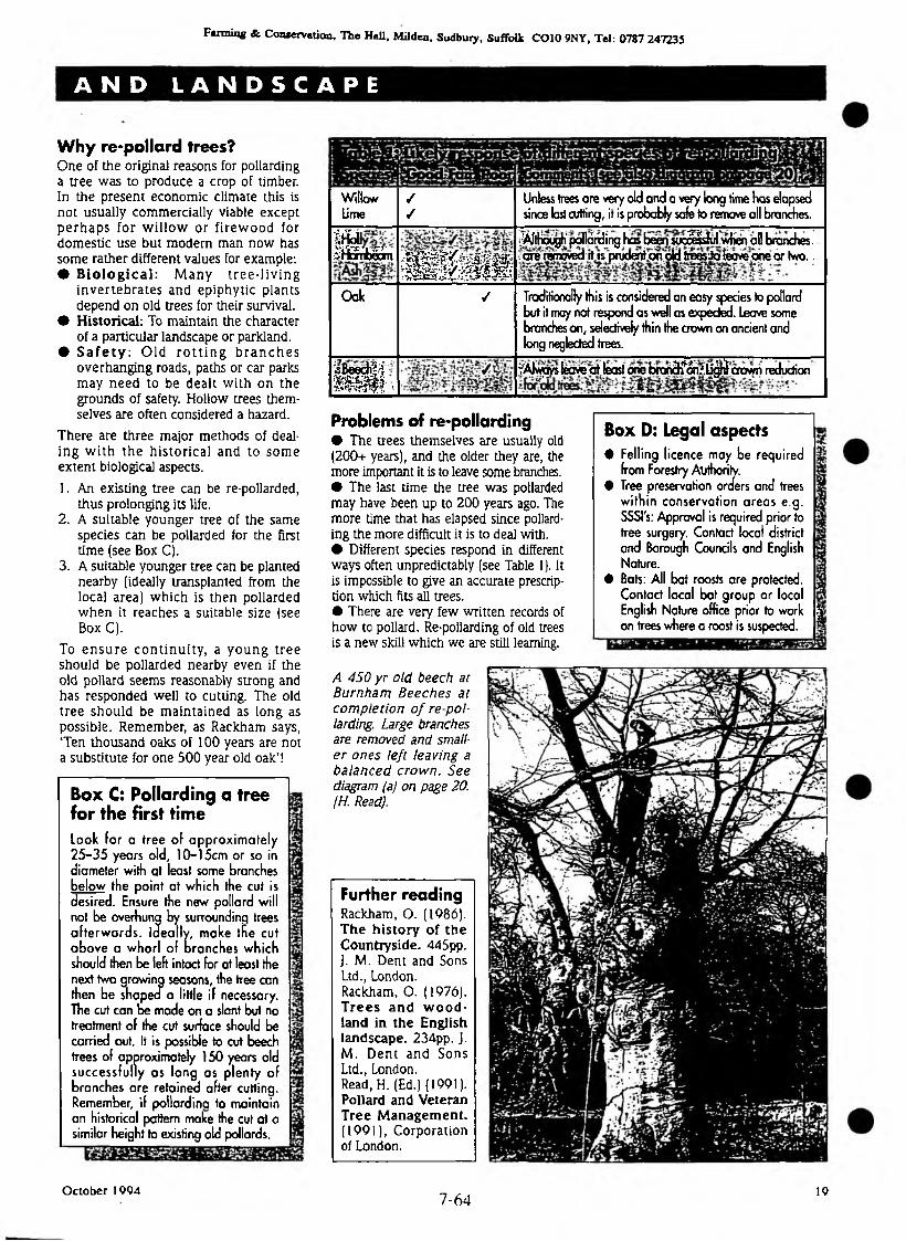
Fanning & Conservation, The Hall, Mildea, Sudbury, Suffolk CO 10 9NY, Tel: 0787 247235
A N D L A N D S C A P E
Why re-pollard trees?One of the original reasons for pollarding a tree was to produce a crop of timber. In the present economic climate this is not usually commercially viable except p e rh ap s for w illow or firew ood for domestic use but modern man now has some rather different values for example:• Biological: M any tre e -liv in g
inverteb ra tes and epiphytic plants depend on old trees for their survival.
• Historical: To maintain the character of a particular landscape or parkland.
• Sa fe ty : O ld r o t t in g b ra n c h e s overhanging roads, paths or car parks may need to be dealt w ith on the grounds of safety. Hollow trees themselves are often considered a hazard.
There are three major methods of dealing w ith th e h isto rica l and to som e extent biological aspects.
1. An existing tree can be re-pollarded, thus prolonging its life.
2. A suitable younger tree of the same species can be pollarded for the first time (see Box C).
3. A suitable younger tree can be planted nearby (ideally transplanted from the local area) which is then pollarded w hen it reaches a suitable size (see Box C).
To e n su re co n tin u ity , a young tree should be pollarded nearby even if the old pollard seems reasonably strong and has responded well to cutting. The old tree should be m aintained as long as possible. Remember, as Rackham says, T en thousand oaks of 100 years are not a substitute for one 500 year old oak’!
Box C: Pollarding a tree for the first timelo o k fo r a tree o f approxim ate ly 25-35 years old, 10-15cm or so in diameter with at least some branches below the point at which the cut is desired. Ensure the new pollard will not be overhung by surrounding trees a fte rw ards. Ideally, make the cut above a whorl of branches which should then be left intad for at least the next two growing seasons, the tree can then be shaped a little if necessary. The cut can be made on a slant but no treatment of the cut surface should be carried out. It is possible to cut beech trees of approximately 150 years old successfully as long as plenty o f branches are retained after cutting. Remember, if pollardina to maintain an historical pattern make the cut at a similar height to existing old pollards.
WillowLime
✓✓
Unless trees are very old and a very long time has elapsed since last cutting, it is probably safe to remove all branches.
m sm m n
i n * ®^AltHoogJi" polldrdi ng has beetm tc^^ulwhen ai) branches. .are removed it is prudent .on old treesJateave one or two..
Oak / Traditionally this is considered an easy species to pollard but it may not respond as well as expected. Leave some branches on, selectively thin the crown on ancient and long neglected trees.
iB eecK h
m m -?Alwq«iecraaf leastorVebra^% i?Uncrown reduction
Problems of re-pollarding• The trees themselves are usually old (200+ years), and the older they are, the more important it is to leave some branches.• The last time the tree was pollarded may have been up to 200 years ago. The more time that has elapsed since pollarding the more difficult it is to deal with.• Different species respond in different ways often unpredictably (see Table 1). It is impossible to give an accurate prescription which fits all trees.• There are very few written records of how to pollard. Re-pollarding of old trees is a new skill which we are still learning.
A 450 yr old beech at Burnham B eeches at com pletion o f re po llarding. Large branches are removed and smaller ones left leaving a balanced crown. See diagram (a) on page 20. (H. Read).
Box D: Legal aspects• Felling licence may be required
from Forestry Authority.• Tree preservation orders and trees
w ith in conservation areas e.g. SSSI's: Approval is required prior to tree surgery. Contact local district and Borough Councils and English Nature.
• Bats: All bat roosts are protected. Contact local bat group or local English Nature office prior to work | on trees where a roost is suspected.
Further readingRackham, O. (1986). The history of the Countryside. 445pp. J. M. Dent and Sons Ltd., London. Rackham, O. (1976). Trees and w o o d land in the English landscape. 234pp. J. M. D ent and Sons Ltd., London.Read, H. (Ed.) (1991). Pollard and Veteran Tree Management. (1991), Corporation of London.
October 19047 -6 4
19
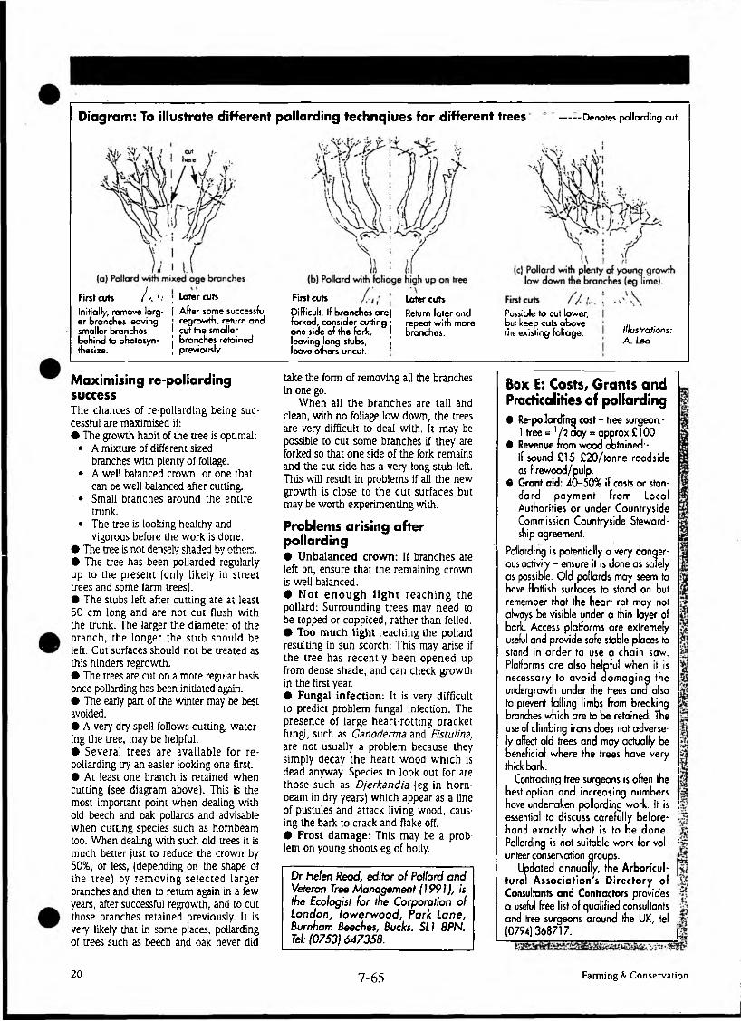
Diagram: To illustrate different pollarding technqiues for different trees ■Denotes pollarding cut
/ a '<First cuts
Initially, remove larger branches leaving smaller branches behind to photosyn- thesize.
; Later cuts
[ After some successful j regrowth, return and I cut the smaller j branches retained | previously.
First cuts
Difficult. If branches arej forked, consider cutting j one side of the fork, I leaving long stubs, | leave others uncut.
Later cuts
Return later and repeat with more branches.
Possible to cut lower, but keep cuts above the existing foliage. Illustrations:
A. Lea
Maximising re-pollarding successThe chances of re-pollarding being successful are maximised if:• The growth habit of the tree is optimal:
• A mixture of different sized branches with plenty of foliage.
• A well balanced crown, or one that can be well balanced after cutting.
• Small branches around the entire trunk.
• The tree is looking healthy and vigorous before the work is done.
• The tree is not densely shaded by others.• The tree has been pollarded regularly up to the present (only likely in street trees and some farm trees).• The stubs left after cutting are at least 50 cm long and are not cut flush with the trunk. The larger the diameter of the branch, the longer the stub should be left. Cut surfaces should not be treated as this hinders regrowth.• The trees are cut on a more regular basis once pollarding has been initiated again.• The early part of the winter may be best avoided.• A very dry spell follows cutting, watering the tree, may be helpful.• Several trees are available for re- pollarding try an easier looking one first.• At least one branch is retained when cutting (see diagram above). This is the most important point when dealing with old beech and oak pollards and advisable when cutting species such as hornbeam too. When dealing with such old trees it is much better just to reduce the crown by 50%, or less, (depending on the shape of the tree) by rem oving selected larger branches and then to return again in a few years, after successful regrowth, and to cut those branches retained previously. It is very likely that in some places, pollarding of trees such as beech and oak never did
take the form of removing all the branches in one go.
When all the branches are tall and clean, with no foliage low down, the trees are very difficult to deal with. It may be possible to cut some branches if they are forked so that one side of the fork remains and the cut side has a very long stub left. This will result in problems if all the new growth is close to the cu t surfaces but may be worth experimenting with.
Problems arising after pollarding• U nbalanced crow n: If branches are left on, ensure that the remaining crown is well balanced.• N o t e n o u g h l ig h t rea ch in g the pollard: Surrounding trees may need to be topped or coppiced, rather than felled.• Too m uch light reaching the pollard resulting in sun scorch: This may arise if the tree has recently been opened up from dense shade, and can check growth in the first year.• Fungal infection: It is very difficult to predict problem fungal infection. The presence of large heart-rotting bracket fungi, such as Ganoderma and Fistulina, are not usually a problem because they simply decay the heart wood w hich is dead anyway. Species to look out for are those such as Djerkandia (eg in hornbeam in dry years) which appear as a line of pustules and attack living wood, causing the bark to crack and flake off.• F rost dam age: This may be a problem on young shoots eg of holly.
Dr Helen Read, editor of Pollard and Veteran Tree Management (1991), is the Ecologist for the Corporation of London, Towerwood, Park Lane, Burnham Beeches, Bucks. SL1 8PN. Tel: (0753) 647358.
Box E: Costs, Grants and Practicalities of pollarding• Re-pollarding cost - tree surgeon: -
1 tree = V 2 aay = approx.£100• Revenue from wood obtained:-
If sound £ 15—£20/tonne roadside as firewood/pulp.
6 Grant aid: 40-50% if costs or stan- dard payment from Local Authorities or under Countryside Commission Countryside Stewardship agreement.
Pollarding is potentially a very dangerous activity - ensure it is done as safely as possible. Old pollards may seem to have flattish surfaces to stand on but remember that the heart rot may not always be visible under a thin layer of bark. Access platforms are extremely useful and provide safe stable places to stand in order to use a chain saw. Platforms are also helpful when it is necessary to avoid damaging the undergrowth under the trees ana also to prevent falling limbs from breaking branches which are to be retained. The use of climbing irons does not adversely affect old trees and may actually be beneficial where the trees have very thick bark.
Contracting tree surgeons is often the best option and increasing numbers have undertaken pollarding work. It is essential to discuss carefully beforehand exactly what is to be done. Pollarding is not suitable work for volunteer conservation groups.
Updated annually, the Arboricul- tural Association's D irectory of Consultants and Contractors provides o useful free list of qualified consultants and tree surgeons around the UK, tel (0794)368717. ^
20 7-65 Farming & Conservation
7.12 Procedure for Pealing with Dead AnimaLs/Birds
The corpses of certain species of animals and birds (see list below) are required for research, principally into the level of pesticides in the environment, all specimens sent to analysis will be given a post mortem examination to determine the cause of death followed by tissue analysis for pesticides.
Specimens should be put in a plastic bag, chilled or frozen, then posted first class in a jiffy bag or insulated box labelled "biological specimens - urgent".
Please include a note of:
(i) your name and address;(ii) location (include 6 figure grid reference) at which specimen was found;(iii) circumstances;(iv) cause of death (if known).
Then send to the address listed below:
Bam Owl } Great Crested Grebe }Heron }Kestrel }Kingfisher }Long Eared Owl }Merlin }Peregrine Falcon }Sparrowhawk }
To: Mrs Anne AsherMonkswood Experimental StationAbbots RiptonHuntingdon
Tel: 048 73 381
PEI 7 2LS
Polecats (not required from Wales) - To: Local County Museummammals curator
Otters Contact Area Conservation & Recreation staff.
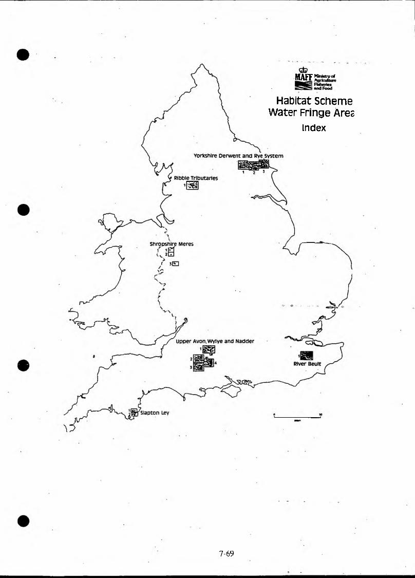
MAFF £23:1
Habitat scheme Water Fringe Ares
index
7 -6 9

7.14 . Availability of Financial Support for Conservation-Related Activities
Organisation/Scheme 1 2 3 4 5 CommentsRiver Land Land Habitat AccessUse Use scape
NRA/IDBsFunctional Powers only * Other objectives may be supported in conjunctionConservation duties with river use(not grant-aiding body)
MAFFFarm and Conservation Grant * *ESA * * * In designated areas onlySet-Aside ★Extensification * * * Reduced stocking ratesFarm Woodlands * 1 HA minimumFarm Diversification * Non-agricultural use
COUNTRYSIDE COMMISSIONCountryside Premium * * * * On set-aside land.
In designated counties only. (7 No. - all in NRAAnglian Region
Countiyside Stewardship * * * Specified landscapes only (includes river valleys)Landscape Conservation * * Includes woods < .25 Ha
COUNTRYSIDE COUNCIL FORWALESTir Cymen * ★ * + * Equivalent to Countryside Stewardship
ENGLISH NATUREProject Grants * * * Public Bodies are eligible SSSIs only. LimitedWildlife Enhancement ♦ * application at present
LOCAL GOVERNMENTL G Act 77 S. 137 * * * Genera] Powers - mainly TcsW & C Act 81 S.39 * * * General Powers - DCs & CCsN Pdrks & Countryside S.89 * * * Land restoration powersN Parks & Countryside S. 64 * Access to countryside
8. ARCHAEOLOGY. ARCHITECTURE AND CULTURAL HERITAGE
8.1 NRA and Archaeology
Under Section 16(1) of the Water Resources Act, the NRA is entrusted with the protection, enhancement and wise management of archaeological features. These responsibilities relate to all inland and coastal waters and to land associated with such waters in England and Wales.
These statutory duties are in place due to the wide range of activities which the NRA undertakes and their potential impact on archaeology.
There are very few areas where the presence of archaeology can be totally ruled out. "If you don’t look for archaeology..... you won’t find it.”
However by following simple guidance, knowing who to consult and when, and ensuring archaeology is given equal weighting to nature conservation, archaeology can also be fully safeguarded.
8.1.1 What is Archaeology?
Archaeology refers to mans past activities within the landscape. It is difficult to arrive at a single definition for archaeology due to the subjects breadth and depth. There is a wide range of archaeology and different types often overlap, therefore you should be aware of the following:-
marine
inter-tidal
freshwater
evidence on the sea bed including wrecks.
evidence found in the area between high and low water including beaches, mud-flats and estuarine areas, eg abandoned coastal defence systems, submerged forests etc.
evidence found in lakes and rivers, eg crannogs, log boats, fish weirs
wetlands
dryland
environmental
evidence found in the waterlogged conditions associated with marshes, bogs and fens eg trackways, organic material, preserved settlements
evidence found as above ground features, eg earthworks, built structures, standing stones
evidence as seen in aerial photographs eg crop marks
evidence of past environments identified through pollen, invertebrates, soil profiles etc
8-1
historic archaeology of land form, land cover and land-use egindustrial landscape, relict medieval, picturesque
8.2 Protecting Archaeological Sites
Current archaeological records for England and Wales amount to 660,000 sites and monuments, of which 15,600 are scheduled and therefore of national importance. These records relate to known archaeological sites. It is the unknown resource which is at greatest risk, the vast majority being associated with wetland areas. Therefore rivers and wetlands must be viewed as areas of POTENTIAL archaeological importance.
Water power and water transport were important ingredients of the Industrial Revolution and there are large numbers of features listed for archaeological or historical interest associated industrial archaeology. Others, although not scheduled or listed, are still of considerable industrial significance in the locality. Associated with rivers and waterways, it is likely that the Authoritys work will have an impact on these sites, therefore conservation staff should be aware that these sites are of equal importance to those sites of more conventional archaeological interest.
Practically every aspect of the work carried out by the Authority has a potential impact on archaeology eg the installation of a fish pass may restore or destroy an archaeological feature, the alleviation or re-distribution of water to maintain and raise water levels, may protect sites by maintaining the water level, but fluctuations in water level, changes in water quality and sedimentation patterns may damage sites. For the full extent of impacts that the Authority’s work might have on archaeology see R & D Project Record 506/1/W
Each site is unique and ideally should be preserved, however this is not always feasible, and it must be accepted that minimal damage may be done. In extreme circumstances a site may be totally destroyed, but only after it has been fully recorded. The key question is where and how to strike the right balance.
8.2.1 Aim
The NRA is therefore entrusted with the protection, enhancement and wise management of archaeological features. These responsibilities relate to all inland and coastal waters in England and Wales.
8.2.2 Strategic Archaeological Objectives
In order to achieve its aim, the NRA will:-
• ensure that the NRA’s regulatory, operational and advisory activities take full account of the need to protect archaeological sites and remains
• promote awareness of its duty to archaeology within the Authority
* promote the NRA and its work as an Authority within the archaeological community
Scope of Archaeological Duties
Key archaeological legislation relevant to the NRA includes
* Ancient Monuments and Archaeological Areas Act 1979
* National Heritage Act 1983
* Planning (Listed Buildings and Conservation Areas) Act 1990
* Protection of Wrecks Act 1973
* Water Resources Act Section 16 (1)
There are also orders, circulars, Codes of Practice and guidance relevant to the Authority’s activities and duties to protect archaeology available. These are outlined in Part 2.
As with our conservation role (see Conservation Duties section) archaeology must be taken into account in proposals relating to all of the NRA’s regulatory, operational and advisory functions.
Archaeological Assessment Flow Chart
See page 8-4. <= - *
Liaison and Consultation
Internal Liaison
All conservation staff should now be aware that archaeological considerations should be given an equal weighting to those of nature conservation, therefore effective internal liaison is essential and the guidelines for conservation (see Conservation section ) apply equally but with the following additional considerations:-
* All other staff and operatives should be made aware of the importance of archaeology.
* We do not have in-house archaeologists therefore conservation staff although having access to archaeological data and do not have the expertise to take decisions with regard to archaeology. Do consult your County or Trust Archaeologist for advice. Consideration could also be given to the contracting in the services of a retained archaeologist.
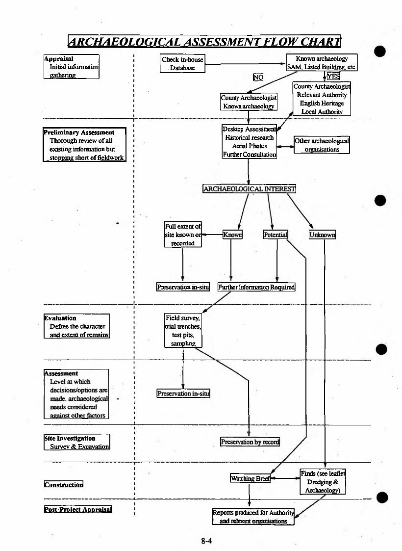
ARCHAEOLOGICAL ASSESSM ENT FLOW CHARTAppraisal i
i Check in-house Known archaeologyInitial informatior 1
1 Database SAM, Listed Building, etc.gathering 11 m ^ I lY p
County Archaeologist Known archaeology
x& /
County Archaeologist Relevant Authority English Heritage Local Authority
Preliminary Assessment Thorough review of all existing information but stopping short of fieldwoik
Desktop Assessme; Historical research
Aerial Photos Further Consultation
Other archaeological organisations
Full extent of site known or
recorded
Preservation in-situ Further Information Required
Evaluation i Field survey,Define the character i trial trenches,and extent of remains i test pits,
i sampling
Site InvestigationSurvey & Excavation
IConstructioiJWatching Brief)*
Finds (see leaflet Dredging &
Archaeology)
frost-Proiect Appraisal Reports produced for Authority and relevant nrparri rations
• On some occasions there is potential conflict between protecting archaeology at the expense of nature conservation and vice versa.
• On some occasions there is potential conflict between promoting water based recreation at the expense of protecting archaeological features eg water ski-ing
• All conservation staff should have at a minimum, information relating to SAM’s and access to other relevant data.
(b) Procedures for External Liaison and Consultation
Procedures with regard to designated sites/areas
There are a variety of archaeological and historic site designations, offering differing degrees of protection, some of which are site specific, others applying to landscapes.
The NRA must notify in advance relevant bodies before carrying out, or authorising any activities which are likely to have an impact on a designated site or area eg SAM or Conservation Area.
The relevant organisation must be consulted at the earliest possible stage, in particular all forms of work involving consultation with English Heritage should allow for a prolonged response time.
As much information as possible should be provided, preferably illustrated with a 1:10,000 plan. This saves time for us and them.
Similarly the NRA must notify in advance the relevant organisation of any activities which may have a direct or indirect impact on designated sites which incorporate archaeological/historical features, eg AONB’s, National Parks, Special Landscape Areas
This does not apply in an emergency where notification must be given as soon as it is practicable after the action has been taken.
Table 1 lists site designations and associated organisations.Table 2 lists available databasesTable 3 is a simple checklist of who to consult with, and in what situation, and covers most eventualities.The full range of archaeological organisations with addresses are found in Section2
8-5
NRA Operations - Archaeological Guidelines
These guidelines can provide only a suggested method of working and not a set of national procedures. As a result of the working parties undertaken during Phase 2 of the Project, it became obvious that due external influences, independent working methods and procedures have evolved in the Region. Allowances have therefore been made for this with the following flow chart indicating a general procedure which can be integrated into existing Regional procedures. This also allows for archaeological variations in terms of type of archaeology encountered, organisations involved and scale of works .
To ensure best practice for archaeological assessment with regard to our operations the following must be considered:-
• All archaeological activity resulting from NRA work is the responsibility of the NRA
• Archaeology must be given equal consideration to that of nature conservation and landscape
• Consultation must take place at the earliest possible stage and carry on throughout the work
• County Archaeologists are the NRA’s link with the archaeological community and therefore the first point of contact
• Archaeologists must be provided with as much information as possible, preferably illustrated with a 1:10,000 plan. This saves time for us and them.
• When important remains are known to exist, or when archaeologists have good reason to believe they exist, this MUST be recognised and appropriate action taken.
• Preservation of archaeological sites/remains ’in situ’ is the ideal objective and designs should take this into account eg a Flood Defence embankment on top of remains is preferable to a wall, the foundations of which would cause damage.
• Excavation means the total destruction of evidence. It is expensive and time consuming and must be viewed as a last resort. If this action is absolutely necessary the site must be preserved by recording, which must be timetabled to take place prior to construction.
• Outside contractors should be fully briefed on procedures they should follow with regard to archaeology and these should become part of the contract
• Watching briefs - a timetable of work must be agreed and contractors alerted to possible delays. '
• A draft brief for field archaeological services is included in Section 2.This may not be suitable for all occasions - additional or alternative guidance is available from the IF A and ACAO (see guidance list)Whilst we should ensure that we follow best practice to protect archaeology by complying with the requests of archaeological consultants, the question as to what is reasonable, practicable and financially acceptable may warrant the obtaining of a second opinion to ascertain the validity of those requests.
Archaeological Consultants and Contractors
County Archaeologists must be viewed as the first point of contact, but there are situations where archaeological assessment must be undertaken by other archaeologists. In these situations comparison of cost and quality is difficult although there is general agreement on best practice. The following must be considered during tendering:-
Recognised membership of the IFA or recommendation by a County Archaeologist.
Experience - relevant to the project and locality eg an industrial archaeologist would be inappropriate for work on a wetland.
Knowledge of the NRA and working methods.
An individual will only have a certain level of knowledge and facilities therefore they should have access to good contacts, specialist advice and facilities.
• Insurance - Professional Indemnity and Public Liability must be obtained to an adequate level
• Quality Assurance - few archaeological consultancies or contractors have applied for BS 5750 therefore to achieve consistent work of the highest quality consider the employment of an in-house or retained archaeologist
Archaeological Techniques
To investigate the presence of archaeological remains in an area several methodsof fieldwork can be carried out either selectively or together:
Fieldwalking - methodical walking along recently ploughed fields collecting and plotting artifacts. Analysis of the material found and its distribution can indicate areas of settlement, burials or industrial activities.
8-7
Geophysical Surveys - sensitive electrical surveys used to locate buried features and designed to suit the scale of the project and the type of features suspected.
Aerial Photographs - features already noted are mapped and can also prove an analysis of land-use over the past 50 years which may not only explain the presence or absence of archaeological features but also be of assistance to other environmental disciplines. Sometimes additional aerial photography may be considered and various forms of heat sensitive film used.
Environmental sampling - auguring or test pits can recover environmental indicators such as pollen, beetles etc as well as identifying deposits which may mask buried features.
Historical research - detailed analysis of historical documents and maps can assist in interpreting identified archaeological remains
Test pits - excavation of small holes down to bedrock usually done at regular intervals in areas of grassland, not available for fieldwalking. This process, with total or sample sieving of all soil, is designed to find artifacts and environmental information.
Trial excavations - excavations of trenches to test the depth of stratification, and extent and survival of features on known archaeological sites.
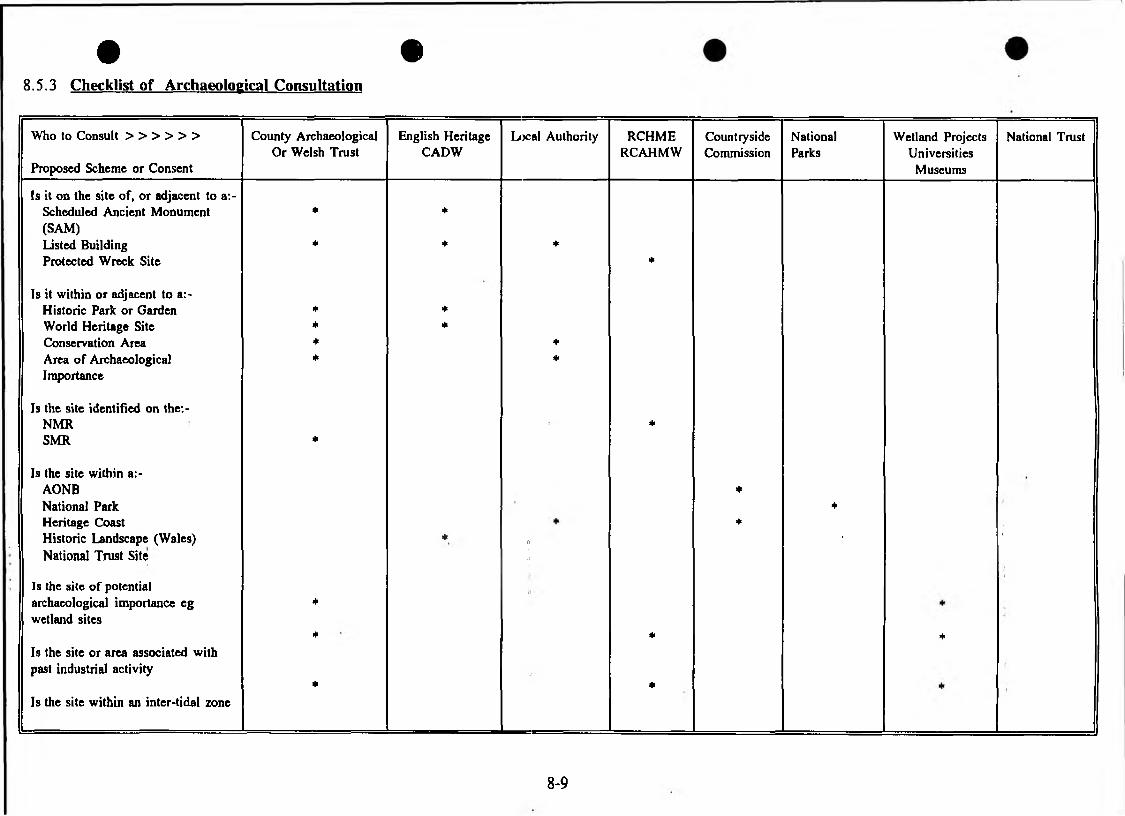
• •8.5.3 Checklist of Archaeological Consultation
Who to Consult > > > > > >
Proposed Scheme or Consent
County Archaeological Or Welsh Trust
English Heritage CADW
Local Authority RCHMERCAHMW
CountrysideCommission
NationalParks
Wetland Projects Universities
Museums
National Trust
Is it on the site of, or adjacent to a:-Scheduled Ancient Monument * *(SAM)Listed Building * * *Protected Wreck Site *
Is it within or adjacent to a:-Historic Park or Garden * *World Heritage Site * *Conservation Area * *Area of Archaeological * *Importance
Is the site identified on the:-NMR *SMR *
Is the site within a:-AONB *National Park *Heritage Coast *Historic Landscape (Wales) * 0 1 "National Trust Site 5
Is the site of potentialarchaeological importance eg *wetland sites
* * *Is the site or area associated withpast industrial activity
* *Is the site within an inter-tidal zone
8-9
8.5.3 Checklist of Archaeological Consultation (cont)
Who to Consult > > > > > >
Proposed Scheme or Consent
County Archaeological Or Welsh Trust
English Heritage CADW
Local Authority RCHMERCAHMW
CountrysideCommission
NationalParks
Wetland Projects Universities Museums
National Trust
Does the scheme require planning permission
*
Is it a big or extensive scheme or development
★
Will it disturb the ground or will banks be re-profiled
Is there dredging involved +
Will it affect the water table * *
Are there associated discharges eg: long distance outfalls
* * *
Will it involve spoil disposal or borrow pits
★
Will it involve heavy machinery or tyred vehicles
★
Will it involve tree planting *
Will it have an impact on an existing structure/feature
Will it increase public access/useage *
8-10

8.6 Draft brief for Field Archaeological Services
1.0 Description of work
1.1 [for example] the Archaeological Contractor (hereafter referred to as the Contractor) shall provide all services necessary to record remains and features uncovered in the course of construction o f ...................
1.2 [for example] The Contractor shall excavate trial pits and trenches in an archaeological manner to record remains and features in advance of the main construction works.
1.3 The position of all trial pits, trenches or excavations will be agreed before commencement with the Resident Engineer/Project Manager.
1.4 A report of the investigation suitable for publication shall be produced.
2.0 Personnel
2.1 The supervision of the investigation and recording of remains and features shall be undertaken by a Member or Associate of IFA.
2.2 A suitably qualified member of the Contractor’s staff shall be present during all excavation work.
3.0 Attendance
3.1 The Contractor’s staff shall report to the Resident Engineer upon arrival on site to confirm the operations for the day. The Contractor’s staff shall also inform the Resident Engineer when they leave site each day.
4.0 Notification of Finds
4.1 If any feature or remains are discovered, the Contractor shall inform the Resident Engineer/Project Manager immediately. The Contractor shall also inform the County Archaeologist.
4.2 No information regarding the site for finds shall be released to third parties without the prior consent of the Project Manager and the Landowner. The Authority will not unreasonably withhold approval.
Recording
Archaeological features and finds shall be recorded using English Heritage style context recording forms or equivalent.
All trenches, trial pits, features and finds shall be photographed in detail using both 35mm film and 35mm colour slides.
All trenches, trial pits, features and finds shall be plotted in place at scales between 1:10 and 1:1000 as is appropriate. This information shall then be plotted onto an Ordnance Survey base map at 1:500 or 1:2500 scale.
Reporting
Within one month of the completion of the investigation, a factual, archive report shall be produced. Copies shall be submitted to the Project Manager and the County Archaeologist.
The Contractor shall expect to produce a comprehensive report, suitable for publication, if the investigation yields substantial archaeological information. The timetable for this report shall be agreed with the Project Manager.
General
Whilst undertaking the watching brief, the Contractor shall take care not to disrupt the working of the Engineering Contractor. The Contractor shall have no powers to instruct the Engineering Contractor except through the Resident Engineer/Project Manager.
If any waterlogged features or finds are discovered, they shall be safeguarded as specified in the English Heritage guidelines for waterlogged sites and finds, with which the Contractor shall be familiar.
Providing the Landowner is in agreement, any finds shall be deposited in a registered museum. The Contractor shall agree with the County Archaeologist at which museum finds shall be deposited. The contractor shall make all necessary arrangements for depositing finds, which shall be boxed and catalogued in accordance with the requirements of the museum. A copy of the site archive report shall also be deposited with the museum.
Information regarding designated archaeological sites can be obtained from the following databases:
The Royal Commission on the Historical Monuments of Englands task is to compile, access and make available the National Record of Englands Ancient Monuments and Historic Buildings, this is known as the NATIONAL MONUMENTS RECORD which comprises of:
The National Archaeological Record (NAR) . ,The National Buildings Record (NBR)National Library of Air Photographs (NLAP)The National Monuments Record - Maritime
The Royal Commission on the Historical Monuments of England also holds archival collections, including maps.
The Royal Commission on Ancient and Historical Monuments in Wales performs the same function in Wales.
All County/Metropolitan Councils in England and Archaeological Trusts in Wales maintain a SITES AND MONUMENTS RECORD (SMR). Its principal purpose is to supply Local Planning Authorities with information on the location and importance of archaeological sites within their administered areas. The SMR is primarily archaeological records, map and text based. A number also contain information on historic buildings, whether listed or not. Some SMRs also record natural elements of the historic landscape e.g. ancient hedges and woodland.
A database of LISTED BUILDINGS is held by District Councils, County Councils or Archaeological Trusts.
English Heritage holds and maintains the database of all SCHEDULED ANCIENT MONUMENTS in England, a register of HISTORIC PARKS AND GARDENS and the SMR for Greater London.
CADW performs a similar function in Wales.
Other archaeological information is held by the following organisations:National Parks Countryside Commission National TrustUniversities/Archaeological Projects Local and National Museums Local and National Libraries
It must be noted that any database can never be complete.
8.7 Archaeological Database
8-13

0 9. ENVIRONMENTAL ASSESSMENT
9.1 Executive Group Paper - Environmental Assessment (EA)
1. PURPOSE
1.1 The purpose of this paper is to:
obtain the Executive Group’s support for the need for good practice on Environmental Assessment (EA) for both NRA projects and external projects by developers. (Note projects include proposals for abstraction licences, discharge and land-drainage consents etc.)
obtain the Executive Group’s support for the adoption of guidelines for EA for internal projects;
obtain Executive Group’s support for the testing of guidelines on EA for external projects.
obtain the Executive Group’s support for the recommended management of EAs within the NRA.
2. BACKGROUND
2.1 Environmental Assessment applied at project level is a process intended to ensure that environmental impacts of schemes are identified prior to the work being carried out, so that proposals can be modified or managed in such a way that adverse impacts can be avoided or minimised.
2.2 EC and UK legislation requires EAs to be carried out on schemes which could have significant environmental impacts and requires formal Environmental Statements (ES) to be produced. On small projects which do not have significant impacts, informal EAs are acceptable.
2.3 As a promoter of schemes, the NRA is required to cany out EAs, and as a Licensing Authority and Statutory Consultee, the NRA is able to request ’reasonable’ infonnation from developers in the form of EAs.
2.4 Currently, there is no standard framework for EA within the NRA as a whole. This has produced inconsistencies in approach towards internally and externally generated projects.
2.5 R & D projects have been carried out in the NRA, and these have shown that improvements are necessary in the way EAs are handled on both internal and external projects. In general, they are too restrictive in scope, too reactive, unstructured and poorly documented.
(i)
(ii)
(iii)
(iv)
9-1
3. PROPOSALS FOR THE MANAGEMENT OF EA ACTIVITIES IN THE NRA
3.1 The requirement for EAs could occur in all NRA core functions, but they are mainly relevant to Flood Defence and Water Resources. However, this potential need in other functions must be catered for in the management arrangements for EA within the NRA. Many staff need to be aware of the requirement for EAs for NRA projects and of how these should be carried out. NRA staff dealing with external projects need to be able to advise developers of the information they need to provide in the form of EAs. This would save time and effort for both the NRA and the developers.
3.2 There is a need for a nominated officer in each region to act as a focal point for EA work and who has the responsibility for being aware of the procedures and requirements for EAs, and disseminating this information to other regional staff where necessary. The designation and location of this EA coordinating officer will vary from region to region, but an existing officer in FRCN would be the most appropriate. The Conservation Officer at Head Office would be the national focal point for this subject.
3.3 An overall framework for the EA of NRA projects, based substantially on the results of R & D Note 52, is being prepared as an EA handbook, and will be ready by June 1993. This handbook will be distributed to appropriate staff and should form the basis of EAs for NRA projects.
3.4 R & D Note 76 is intended as an interim handbook for EAs on external developments. The proposed Phase II of the R & D project, successfully tendered for by WRc, will test the use of the handbook in at least 4 regions, and then refine the guidelines for 1994/5. It outlines good practice of EA, the legal requirements, and provides a range of useful guidance material. It is estimated that the resource implications for each region involved in the trial would be 75 man-days for 10 EAs. The cost of this phase of the R & D is £5OK.
3.5 Use of the output from R & D Notes 52 and 76 will help ensure consistency of approach and appropriate standards for EAs.
3.6 The various staff involved in EA work will need appropriate training. The Head of Training will need to be involved to determine the most effective way of achieving this.
3.7 The R & D work is currently managed through a multi-functional Steering Group, chaired by the Director of Water Management, with Andrew Brookes of Thames Region as R & D Project Leader. This arrangement should continue.
4. CONCLUSIONS AND RECOMMENDATIONS
4.1 EA should be seen as integral to the work of the NRA and not as an ’add-on’.
9-2
4.2 It is essential that the NRA follows good practice for EAs for both internal and external projects.
4.3 Each region should identify an EA nominated officer. RGMs are asked to support this proposal and send nominations to the Director of Water Management.
4.4 The forthcoming EA handbook, based on the findings of R & D Note 52, should be used as the basis for EAs on NRA internal projects. This will be available from June 1993. The Executive Group is asked to support this recommendation.
4.5 Training will be necessary for staff involved in EA work. EG is asked to support the development of a suitable training plan by the Head of Training and the R & D Project Leader.
4.6 R & D Note 76 is an interim handbook for use by NRA staff in dealing with external projects. This should be tested in at least 4 regions and include some abstraction licence applications to ensure the final handbook on external projects adequately covers this aspect. The Executive Group is asked to support this recommendation. Nominations for the regions to test the Guidance Note are requested.
4.7 The Executive Group is asked to support the continued management of EA work in the NRA by the Steering Group chaired by the Director of Water Management.
Dr C J SwinnertonDirector of Water Management
ref. 3assess.pap
9.2 Construction of New Roads or Widening of Existing Roads
CONSERVATION CONSIDERATIONS
Guidance on Environmental Assessment in the NRA will be available in 1995/96.Procedures on for example road development will be addressed in which following thepoints should be considered:
1. New culverts on watercourses should be as short as possible. Culverts only for access if possible.
2. Where adjacent flood arches are not provided, culverts over streams should be slightly larger than required for flood water to allow for ledges approximately 500mm wide and 300mm above normal water level. These should be provided as "otter ledges". They should also link to the banks up and downstream to provide badger undeipasses.
3. Culverts should be put in below existing bed level to allow for bed formation within the culvert.
4. There should be no deepening or widening of streams up and downstream of culverts.
5. Any river/stream diversions should contain features (meanders, pools, riffles and other features) and the opportunity should be taken to create these where previously straightened streams are affected by new roads.
6. Any lost habitat should be replaced as part of the mitigation measures. The creation of wetland areas within the flood plan should be encouraged.
7. Artificial bank re-enforcement should be avoided if possible. Where absolutely necessary, bioengineering techniques should be used if at all possible. Where hard engineering is unavoidable it must be kept to a minimum, screened with willows and/or reeds and/or covered with soil and seeded. Flood defence consents to deal with "knock-on" erosion caused by hard engineering works will normally be opposed in Conservation and/or Recreation grounds.
8. Artificial lining of new ditches should be avoided where possible.
9. Balancing ponds should be encouraged where possible. These should usually be the "inverted sombrero" shape ie a small deep pond and wide shallows/floodable areas.
9-5

Where material has to be " won" or stored/tipped locally, the location of borrowpits and storage areas should be decided prior to the commencement of the work to avoid sensitive areas. Where this is not possible all sensitive sites nearby, usually including all wet hollows, should be identified not excluded from the working area.
The provision of holes and/or ledges under bridges for use as nesting sites should be encouraged.
Where possible the provision of artificial otter holts should be encouraged.
Where bridges have sufficient clearance (normally > 2.1m) consideration should be given to the provision of pedestrian undeipasses.

10. CATCHMENT MANAGEMENT PLANS
10.1 Conservation Issues in Catchment Management Plans (CMFs)c
PURPOSE
The purpose of this brief paper is to provide NRA staff involved in catchment management plans with a checklist of items to ensure that conservation issues, namely (i) the location of sites of special importance, (ii) impacts and trends affecting conservation interest, (ii) opportunities for enhancement and (iv) key conservation objectives are included in CMPs.
It is not intended for the checklist to be included in CMPs per se because as its name suggests its role is for quality checking.
However, the checklist does provide the basic framework for a "Conservation Facts and Figures" for each catchment which could be used as a stand-alone summary for internal use and in response to external enquiries.
Further refinement of the checklist will be required and suggestions for improvements should be forwarded to Bristol.
10-1
CONSERVATION ISSUES IN CATCHMENT MANAGEMENT PLANS A CHECKLIST FOR NRA STAFF
A. CONTEXT
Al. National (International) Context
A 1.1 UK Biodiversity Action Plan Target(s) Affecting Catchment {state as appropriate)
A1.2 Importance of Catchment Nationally (key words only)
•
B. STATUS«
Bl. Overview of Catchment
B l.l Brief Descriptive Sentence (major characteristics eg landuse, landscape scale)
•
B2. Summary of Features of Special Interest
B2.1 Designated Sites associated with inland and coastal water and associated land
• River SSSI length (km) • Area of Outstanding Natural Beauty (km2)
• Wetland SSSI area (ha) • Marine Nature Reserve (number)
• Coastal/estuary SSSI area (ha) • Protected Wrecks (number) 4• Heritage Coast length (km) • Environmentally Sensitive Areas area (km2)
• Areas of Archaeological Importance (number)
• Special Areas of Conservation (number)
• Scheduled Ancient Monuments (number) • Special Protection Areas (number)
• National Park area (km2) • Ramsar sites (number)
B2.2 Other Categories
Sites of Nature Conservation Interest (number)
English Nature Natural Area(s) (names)
1 0 - 2
B2.3 Species of special wildlife interest
• Internationally/nationally rare species (names)
• Regionally rare species (names)
B2.4 Features of special archaeological interest in floodplain/coastal fringe
m Nationally important
• Regionally important
B2.5 Classification categories
• SERCON scores • SSSI river types
• RHS habitat quality indices * River landscape categories
C. IMPACTS AND TRENDS
Cl. Main Issues Affecting Conservation Interest
C l.l Key issues indicate order of importance (- nil)
Water quality □ • Development pressure □Water abstraction □ • Recreation pressure □Habitat loss □ • Invasive/alien species □Land use change □ • Mining □Culverting □
C1.2 Key issues trends in status and pressures (+ improvement; 0 neutral; - deterioration)
• Water quality ED • Development pressure □• Water quantity D • Recreation pressure □
• Habitat quality O • Invasive/alien species O• Land use change □
C2. Potential Conflicts List key areas o f potential conflict
10-3
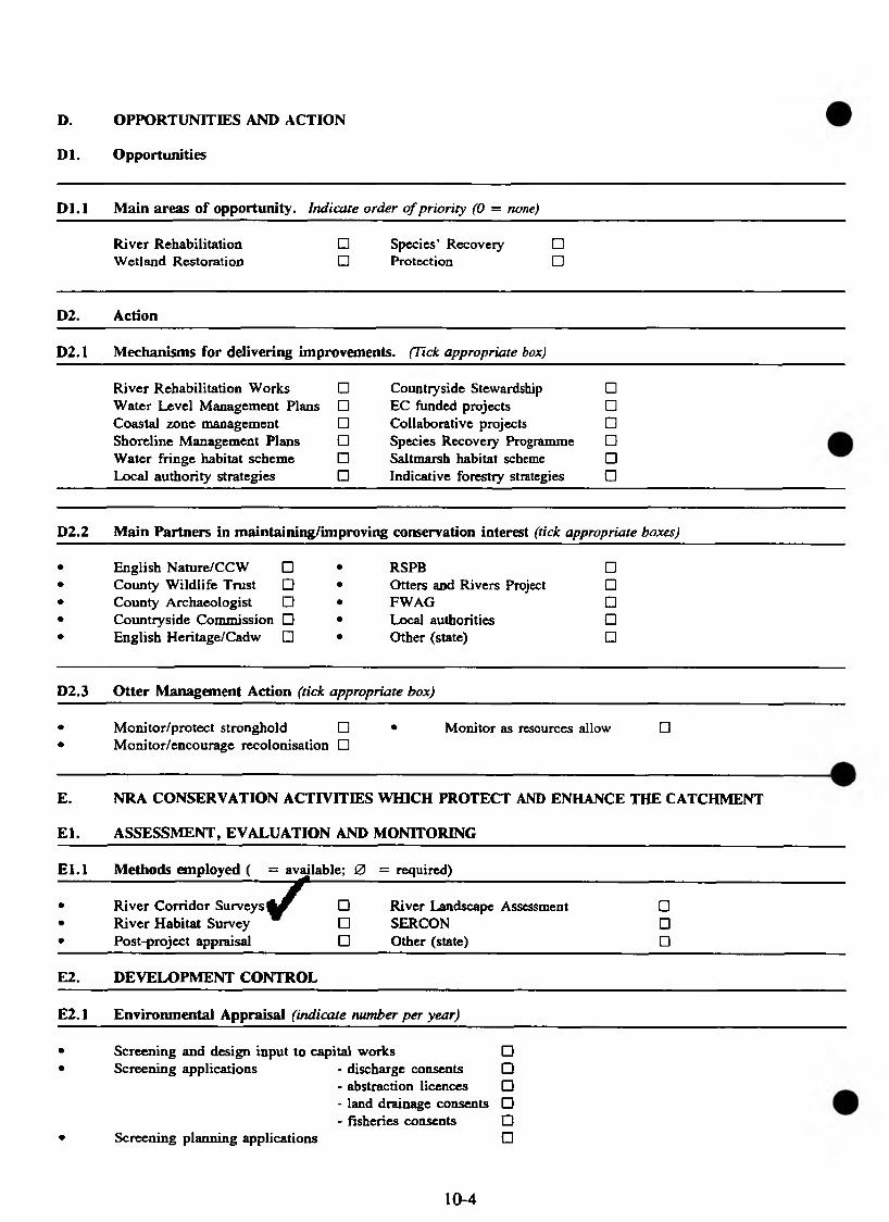
D. OPPORTUNITIES AND ACTION
D l. Opportunities
D l.l Main areas of opportunity. Indicate order o f priority (0 = none)
River Rehabilitation Wetland Restoration
□ Species’ Recovery □□ Protection □
D2. Action
D2.1 Mechanisms for delivering improvements. (Tick appropriate box)
River Rehabilitation Works □ Countryside Stewardship □Water Level Management Plans □ EC funded projects □Coastal zone management □ Collaborative projects □Shoreline Management Plans □ Species Recovery Programme □Water fringe habitat scheme □ Saltmarsh habitat scheme □Local authority strategies □ Indicative forestry strategies □
D2.2 Main Partners in maintaining/improving conservation interest (tick appropriate boxes)
English Nature/CCW □ County Wildlife Trust □ County Archaeologist □ Countryside Commission □ English Heritage/Cadw □
RSPB □Otters and Rivers Project □FWAG DLocal authorities □Other (state) □
D2.3 Otter Management Action (tick appropriate box)
• Monitor/protect stronghold □ • Monitor as resources allow □• Monitor/encourage recolonisation □
E. NRA CONSERVATION ACTIVITIES WHICH PROTECT AND ENHANCE THE CATCHMENT
E l. ASSESSMENT, EVALUATION AND MONITORING
E l.l Methods employed ( = available; 0 = required)
r• River Corridor Surveys □ River Landscape Assessment □• River Habitat Survey □ SERCON □• Post-project appraisal □ Other (state) □
E2. DEVELOPMENT CONTROL
E2.1 Environmental Appraisal (indicate number per year)
• Screening and design input to capital works □• Screening applications - discharge consents □
- abstraction licences □- land drainage consents □- fisheries consents □
• Screening planning applications □
10-4

E3. PROMOTION
E3.1 Collaborative projects (list title and collaborative partners)
•••
F MATCHING EFFORT WITH NEED
FI. PRIORITY PLANNING
F l.l the top three conservation objectives in the catchment (list)
•••
G. WHO TO CONTACT (names)
Area FRCN Managers Area Conservation Officer Landscape Architect Environmental Assessment Contact
10-5

Royal Society for Nature C onservation
The Green. W itham Park Waterside South
Lincoln LN5 7JR Tel: (0 5 2 2 ) S 4 4 4 0 0
Fax: <0522) 5 1 1 6 1 6
June 1994
SUMMARY OF
CA TCHMENT MAN A GEMENT PLANS:
GUIDELINES FOR WILDLIFE TRUSTS
10-7
Puttina I l in ln l l t P on the mao
P a t r o n m R h T h * o f W a l a a K G * T G C B
P r e s i d e n t S i r O a v i O * t t « n 0 0 r o u g n C V O C 8 E f R S
C h i e f E x e c u t i v e r s C o r j y

■ The Wildlife Trusts fully support the NRA in its catchment management planning programme and will urge others to do likewise
■ CMPs should guide the work of all bodies with an influence over the water environment
■ The CMP process must be a duty of the new Environment Agency and should become UK-wide
■ Trusts welcome the earliest consultation possible over plans
Potential of the CMP process
■ Should provide a framework for conserving and enhancing wetland biodiversity and therefore help deliver the UK's commitment to the Government's UK Biodiversity Action Plan
■ Should achieve(i) the sustainable use of water resources(ii) ecologically appropriate statutory water quality objectives(iii) environmentally sensitive land management
■ should enable the NRA to play a greater role in the planning system
■ should allow sensible development of priorities, focus of work and maximise input into strategies for habitats and species leg Otters)
■ will provide a better future for all wildlife including ourselves
Fulfilling the potential
In order to fulfil its potential, the CMP process must be both visionary and practical. Conserving and enhancing the biodiversity resource is crucial not only to benefit wildlife for its own sake, but to help improve and indicate the health of our own environment.
Managed sustainably and holisticaily, catchments can provide many of the benefits essential to the survival of people and wildlife such as plentiful and clean water, food, pleasing places to live and enjoy.
The plans themselves need to look further than the river corridor to the whole catchment. The biodiversity/wildlife resource should be an integral part of the plan. The importance of maintaining and enhancing biodiversity in terms of wildlife, water quality, water resources, fisheries, flood defence, recreation and navigation should be emphasised throughout. This will help reconcile potential differences between functions and user groups. Good cross referencing in each function will help achieve this integration, with consideration of the impacts of* or on, other functions, particularly on the biodiversity resource.
Wildlife Trusts' view of the Catchment Management Plan (CMP) process
10-8
There should be a commitment to setting biodiversity targets. - Wherever knowledge of the resource permits, precise targets should be set in the first CMP. For example, targets for otters, breeding birds and certain habitats, eg culm grasslands, could be set for specific catchments from now. If setting detailed targets within the first plan is unrealistic, particularly since detailed national targets have yet to be identified, there should be a commitment to investigation to determine specific targets.
The "Issues and Options" section in any Plan is the most important because programmes not included (however generally) will not attract time or money in NRA five-year work programmes. It is therefore highly desirable to secure the inclusion in all appropriate plans of as many as possible of the main concepts summarised below.
1 Issue : Water Quality - threat of eutrophication
Option (a): Monitor for phosphate in sewage works' discharges, especially in SSSI rivers; and negotiate additional phosphate-stripping with water company.
Option (b): Monitor for biological indicators, to cross-check chemical quality data.
2 Issue : Water Quality - diffuse source pollution
Option : Explore creation of riparian bio-buffers extensively farmed in sensitive stretches, with MAFF, FWAG, CLA/NFU.
3 Issue : Water Resources - impacts of over-abstraction
Option (a) : Establish and enforce statutory minimum flows
Option (b) : Promote leakage-control and metering, as essential tools of demand management, {costs being met by savings on future capital works to develop or transport additional resources).
Option (c) : Develop a programme of demand-managemnet, to flatten demand curve before it reaches supply constraint.
Option (d) : Monitor wetland SSSIs/nature reserves for damage from over-abstraction or low flows; and act to reduce abstraction, or re-engineer river (if canalised) to retain adequate water level.
Option (e) : Promote extensive farming methods, with less intensive land-drainage, where aquifer recharge could be enhanced. (FWAG, MAFF)
Option (f) : Review procedures for handling abstraction applications, to ensure all are considered publicly in light of total permitted abstractions.
4 Issue : Land Use - degradation of riverine environment from earlier flood defence works and dredaina ......................
Potion : Undertake restoration schemes where feasible; re-engineering trapezoidal sections, re-creating meanders and riffles etc; notably around wetland SSSIs/nature reserves.
10-9
Option : Develop long-term policies to reduce siltation, based on land-use changes and riparian bio-buffers (MAFF/FWAG/NFU/CLA)
5 Issue : Land Use - siltation
6 Issue - Biodiversity
Option (a): Conserve, enhance or rehabilitate all identified valuable wetland and riverine sites;
Option (b): Increase total wetland resource over five years by ... ha; Individual habitats x, y, 2 by .... and species a, b, c, by ....
Potion (c): Develop action plans for key habitats and species, in context of national and regional strategy:
Potion (d): Introduce water level management plans in all appropriate designated sites;
Option (e): Create "necklace" of habitat enhancement measures meanwhile (on appropriate rivers) for otters; kingfishers, sand martins; water voles.
7 Issue : Flood Defence - cost effectiveness of maintenance
Potion : Review needed for maintenance of agricultural landrdrainage schemes in view of costs, economic COBA in current production-reducing CAP, and possiblity of flood storage on flood-plain as cheaper alternative to urban flood defences, offering wider benefits.
8 Issue : Plannino - inappropriate development
Pption (a): Object to all further development in floodplain; .
Potion (b): Require all major developers to propose environmentally acceptable solution to problem of additional water resource demand;
Potion (c): Require major developers (eg car parks) to provide compensatory flood storage at least equivalent to that which they have destroyed.
Pption (d): Require major developers for inessential purposes (eg golf courses) to be hydrologically self-sufficient in summer from on-site storage..
9 Prime Multi-Functional Issue - riparian bio-buffers
Potion : (cf 2 ,4 ,5 ,6 (e), 7 above)
To seek throughout catchment appropriate areas for creation of buffer strips, giving benefits to: water quality; biodiversity; landscape; amenity; water resources. (MAFF, FWAG, CLA, NFU).
June 1994 10-10
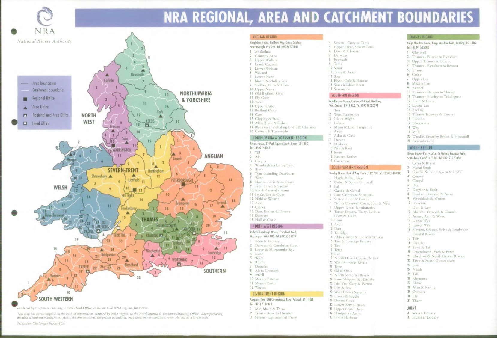
NRA REGIONAL, AREA AND CATCHMENT BOUNDARIESi NRANational Rivers Authority
A re a boundaries
Catchm ent boundaries
Regional Office
A Area Office
□ Regional and Area Office
□ H ead Office
NORTHUMBRIA & YORKSHIRE
A N G LIA N REGION TH AM ES REGION
SOUTHERN
SOUTH WESTERNProduced by Corporate Planning, Bristol Head Office, in liaison with NRA regions, June 1994.
This map has been compiled on the detailed catchment management pla
Printed on Challenger Velvet TCF.
Kingfisher House, Goldhay Way, Orton Goldhay, Peterborough PE2 OZR. Tel: (0733) 3718111 Ancholme2 Grimsby Area3 Upper Witham4 Louth Coastal5 Lower Witham6 Welland7 Lower Nene8 N orth Norfolk rivers9 Stiffkey, Burn 8c Glaven10 Upper Nene11 Old Bedford River12 Ely Ouse13 Yare14 Upper Ouse15 Bedford Ouse16 Cam17 Gipping 8c Stour18 Aide, Blyth & Deben19 Blackwater including Colne 8c C helm er20 Crouch 8c Thameside
N O R TH UM B R IA & YORKSHIRE REGIONRivers House, 21 Pork Square South, Leeds LSI 2QG Tel: (0 5 3 2 ) 4401911 Till2 A i n3 Coquet4 Wansbeck including Lyne5 Blyth6 Tyne including Ouseburn7 Wear8 Northum bria Area Coast9 Tees, Leven & Skerne10 Esk 8c Coastal streams11 Swale, Ure & Ouse12 Nidd 8c Wharfe13 Aire14 Calder15 Don, Rother 8c Dearne16 Derwent17 Hull & Coast
NORTH W EST REGION
This map has been compiled on the basis o f information supplied by NRA regions to the Northumbria & Yorkshire Drawing Office. When preparing detailed catchment management plans for some locations, the precise boundaries may show minor variations when plotted on a larger scale.
Richard Fairclough House, Knutsford Rood,Warrington WA4 1HG. Tel: (0 9 2 5 ) 539991 Eden 8c Estuary2 Derwent 8c Cumbrian Coast3 Leven 8c Morecombe Bay4 Lune5 Wyre6 Ribble7 Douglas8 Alt & Crossens9 Irwell10 Mersey Estuary11 Mersey Basin12 Weaver
SEVERN-TRENT REGIONSapphire East, 550 Streetsbrook Rood, Solihull B91 1 Q T Tel: (0 2 1 ) 7 1123241 Idle, Maun & Tome2 Trent - Dove to Hum ber3 Severn - Upstream of Pern’
4 Severn - Perry to Teme5 Upper Trent, Sow 8c Penk6 Dove 8c Churnet7 Derwent8 Erewash9 Teme10 Stour11 Tame & Anker12 Soar13 Blyth, Cole 8c Bourne14 Warwickshire Avon15 Severnside
SO UTH ER N REGIONGuildbourne House, Chatsworth Road, Worthing, West Sussex BN11 1LD. Tel: (0903) 8206921 Test2 West Hampshire3 Isle of Wight4 Itchen5 Meon 8 c East Hampshire6 A run7 Adur 8 c Ouse8 Darent9 Medway10 N orth Kent11 Stour12 Eastern Rother13 Cuckmere
S O U TH W ESTERN REGIONManley House, Kestrel Way, Exeter, EX2 7LQ. Tel: (0 3 9 2 ) 4 44000
Havle 8c Red River Cober 8 c South Cornwall FalGannel 8 c CamelParr, Crinnis 8c St AusttlJSeaton, Looe 8c FoweyN orth Cornwall Coast, Strat 8c NeetUpper Tamar & tributariesTamar Estuary, Tavey, Lynher,Plym & Yealm
0 Erme1 Avon2 Dart3 Torridge4 Abbey River 8 c Clovelly Stream5 Taw 8 c Torridge Estuary6 Taw7 Teign8 Exe9 N orth Devon Coastal 8 c Lyn
20 West Somerset Rivers21 Tone22 Sid 8 c O tter23 N orth Somerset Rivers24 Brue, Sheppey 8 c Hartlake25 Isle, Yeo, Cary & Parrett26 Lim 8 c Axe27 West Dorset Streams28 Frome 8c Piddle29 Dorset Stour30 Lower Bristol Avon31 Upper Bristol Avon32 Hampshire Avon33 Poole Harbour
Kings M eadow House, Kings Meadow Rood, Reading RG1 8DQ Tel: (0 7 3 4 ) 53 50 0 01 Cherwell2 Thames - Buscot to Eynsham3 Upper Thames to Buscot4 Thames - Eynsham to Benson5 Thame6 Colne7 Upper Lee8 Middle Lee9 Kennet10 Thames - Benson to Hurley11 Thames - Hurley to Teddington12 Brent & Crane13 Lower Lee14 Roding15 Thames Tideway 8c Estuary16 Loddon17 Blackwater18 Wey19 Mole20 Wandle, Beverley Brook 8c Hogsmill21 Ravensbourne
WELSH REGIONRivers House/Plas-yr-Afon, St Mellons Business Park,St Mellons, Cardiff CF3 0LT. Tel: (0 2 2 2 ) 7700881 Cefni 8 c Braint2 Menai Strait3 Gwrfai, Seiont, Ogwen 8c Llyfni4 Conwy5 Ciwyd6 Dee7 Dw yfor 8 c Erch8 Glaslyn, Dwyryd 8 c Artro9 Mawddach 8 c Wnion10 Dysynni11 Dyfi 8 c Leri12 Rheidol, Ystwyth 8 c Clarach13 Aeron, Arth 8 c Wyre14 U pper Wye15 Lower Wye16 Nevern, Gwaun, Solva 8c Pembroke
Coastal Rivers17 Teifi18 Cleddau19 Tywi 8 c Taf20 Gwendraeth, Fach 8 c Fawr21 Llwchwr 8 c N orth Gower Rivers22 Tawe 8 c South Gower rivers23 Usk24 Neath25 Taff26 Rhymney27 Ebbw28 Afan 8 c Kenfig29 Ogmore30 Ely31 Thaw
JO IN TA Severn EstuaryB H um ber Estuary


PART 2: LEGISLATION AND DESIGNATIONS
11. LEGISLATION: A BRIEF OVERVIEW
11.1 ACTS OF PARLIAMENT
(a) WATER RESOURCES ACT 1991
Conservation In relation to the NRA’s functions
Under Section 16 of the Water Resources Act 1991, and Section 12 of the Land Drainage Act 1991, the NRA is obliged, in formulating or considering any proposals relating to any of its functions, to:
(i) further the conservation and enhancement of natural beauty and the conservation of flora, fauna and geological and physiographical (landform) features of special interest;
(ii) have regard to the desirability of protecting and conserving buildings,sites and objects of archaeological, architectural or historic interest;
(iii) take into account the effect which the proposals would have on the beauty or amenity of any rural or urban area or on any such flora, fauna, features, buildings, sites or objects.
These duties only apply so far as may be consistent with the" purposes of any enactment (a single section of an Act) relating to the functions of the NRA. In other words, the NRA’s powers under this section must be exercised so as to achieve improvement in terms of conservation, while being used consistently with achievement of the purposes (eg flood defence) for which those powers are granted.
General conservation duty
In addition to the above, Section 2(2) of the Water Resources Act 1991 makes it a duty of the NRA, to such extent as it considers desirable, generally to promote:
(i) the conservation and enhancement of the natural beauty and amenity of inland and coastal waters and of land associated with such waters;
(ii) the conservation of flora and fauna which are dependent on an aquatic environment.
1 1 -1

Procedures in special areas
Under Section 17 of the Water Resources Act 1991, English Nature and the Countryside Council for Wales are obliged to inform the NRA of any land which, in their opinion, is both:
(i) of special interest by reason of its flora, fauna or geographical or physiological features, and;
(ii) may be affected by activities carried out or authorised by the NRA.
There is a similar obligation on National Parks Authorities and the Broads Authority in respect of land which they consider to be of special interest.
In turn, the NRA must notify in advance the above bodies before carrying out or authorising any activities which appear likely to damage the special interest of the land in question.
This does not apply to an emergency, where notification must be given as soon as it is practicable after the action has been initiated.
Code of Practice
Section 18 of the Water Resources Act 1991 refers to a Code of Practice giving practical guidance on conservation to the NRA and other relevant bodies. A contravention of this Code does not in itself constitute an offence under the provisions of the Act.
The Code of Practice on Conservation, Access and Recreation was issued under the provisions of the 1989 Water Act. Not all parts of the Code apply to the NRA, but three of the sections are relevant to conservation.
Section I deals with general policies and procedures for river basin management, including conservation.
Section n details recommendations for conserving and enhancing the environment in terms of landscape, wildlife, and the man-made heritage.
Section V makes recommendations for special sites and areas: SSSIs, National Parks, AONBs, ESAs, SAMs, and Listed Buildings.
PIN on Conservation
See overleaf
1 1 - 2

NRA POLICE IMPLEMENTATION NOTE
THE APPLICATION OF THE AUTHORITY’S CONSERVATION DUTIES UNDER S16 OF THE WATER RESOURCES ACT 1991
CE/LL/001
1. Introduction
1.1 Approach
Section 16(1) of the Water Resources Act 1991 (previously Section 8(1) of the Water Act 1989) requires the NRA to adopt a new approach when :
preparing any proposals relating to all o f its functions which are likely to have an effect on the water environment;
considering any proposal, whatever its origin, where the NRA has a role to play as consenting or approving authority and in certain circumstances as consultee.
This new approach involves an assessment of the effect of a proposal on the environment.
1.2 Application
With regard to the NRA’s own proposals, this new approach should be applied whilst the proposal is being formulated. With regard to other parties’ proposals, it may often be that a proposal has to be considered, and hence approved or rejected, as submitted. However, wherever possible the NRA should seek to participate in the formulation of a proposal in order to ensure that its impact upon the water environment is adequately addressed at the earliest possible stage.
2. What Constitutes ”A Proposal"
2.1 Definition
So far as the NRA is concerned, a proposal includes
a proposal by the NRA relating to its own functions, e.g. flood defence works.
VERSION 1JANUARY 1992
APPLICATION OF CONSERVATION DUTIES11-3 CE/LL/001
a proposal put forward by any person (including a water undertaker, sewage undertaker and Internal Drainage Board) in which the NRA has a role to play, whether advisory or regulatory e.g. land development proposals and proposals in connection with discharge consents, or abstraction licences.
2.2 Application to Other Bodies
The new approach must also be adopted by the other bodies concerned with water, sewerage and land drainage functions as well as by the NRA. It is also applicable to the Secretary of State and the Director General of Water Services in relation to their functions including any proposals which may be put forward by the NRA itself.
3. The Environmental Duties in S16 of the 1991 Act
There are three duties which arise when the NRA is formulating its own proposals or considering proposals from other parties. These are
to TAKE INTO ACCOUNT any effect which proposals would have on the beauty or amenity of any rural or urban area or on any flora, fauna and geological or physiographical features of special interest and on buildings, sites and objects or archaeological, architectural or historic interest.
to HAVE REGARD to the desirability of protecting and conserving buildings, sites and objects or archaeological, architectural or historic interest.
[This latter duty imposes a more positive requirement than the former, involving consideration whether, and if so, how such places or objects should be protected and conserved and will usually call for specialist advice]
to EXERCISE ANY POWER conferred on it (so far as may be consistent with the purposes of any enactment relating to the NRA functions) with respect to the proposals AS TO FURTHER the conservation and enhancement of natural beauty and the conservation of flora, fauna and geological and physiographical features of special interest.
This is the most active duty and is the one likely to create the best opportunities for enhancing the conservation values of water and associated land under NRA control but raises difficult issues. The guidelines are therefore directed mainly towards the application of this duty, which is referred to throughout as the "new conservation duty".
VERSION IJANUARY 1992
APPLICATION OF CONSERVATION DUTIES11-4 CE/LL/001
It is noted that the duty is qualified by the words "so far as may be consistent with the purposes of any enactment". A single section of an act of Parliament is an enactment. The general purpose of a particular section is usually reasonably clear. For example, the general purpose of Section 23 of the Land Drainage Act 1991 is to provide the means of controlling the erection of certain structures in a non-main river. The means of control is to require the consent of the drainage authority to be obtained before any such action is begun. It follows that a secondary or subsidiary purpose of the enactment is to permit actions whose obstructive effect on the flow of a watercourse are, or can be made, acceptable in land drainage terms.
So the requirement that the new conservation duty places on the NRA, often applied by individual officers, is to exercise the NRA’s powers so as to achieve improvement in terms of conservation whilst recognising that the power has to be used consistently with achievement of the objectives (i.e. the purposes) for which the power is granted. The balancing exercise involved may not always be an easy one and the following guidelines may help.
4. The Application of the New Conservation Duty
4.1 Purpose
The general purpose of the particular legislation under which the proposal comes forward should be kept in mind throughout consideration of the proposal. There may be one or more subsidiary purposes also to be identified and kept in mind.
• o ̂o « c> ® o ' * - :
4.2 Refusal
If a proposal is inadequate or unsatisfactory in the context in which it is put forward then the most suitable course may be to refuse Consent or authorisation or to reject it without going on to consider the application of the new conservation duty.
4.3 Test
The new conservation duty can first be applied by asking "HOW DOES THIS PROPOSAL AFFECT CONSERVATION?".
This may be difficult to establish and work may need to be done in discovering or calculating the answer. The applicant will clearly have a role to play, in either providing additional information or undertaking or funding the necessary investigative work.
4.4 Categorisation
Once a provisional answer to the question of application has -been- reached it should be possible broadly to categorise the likely conservation effects as beneficial, neutral or harmful.
VERSION 1JANUARY 1992
APPLICATION OF CONSERVATION DUTIES11-5 C E/LL/001
4.5 Beneficial Effects
Where the conservation effects are beneficial the new conservation duty will be fulfilled if the proposal goes ahead in the manner proposed. Any later variations of a proposal should be similarly assessed.
4.6 Harmful Effects
Where the effects on conservation are harmful there is obvious reason to query the proposal and indeed it may later be appropriate to reject it. There will, however, be cases where the proposal is of such significance in terms of a function of the NRA e.g. water resources, that the proposal ought, if at all possible, to be modified rather than refused. In these, and sometimes in other less sensitive cases, it will be necessary to identify the damaging features of the proposal and to raise the question whether such features need take the form in which they are proposed. Generally in these circumstances modifications should be sought on the basis that the unmodified proposal would not be acceptable.
4.7 Neutral Effects
Where the effect of a proposal is broadly neutral the desirable objective is to have some further input of conservation benefit brought into it so that the exercise of the power to consent or to approve is no longer held back by the new conservation duty. How substantial this input should be is a matter of judgement in each individual case.
4.8 Consequences of Failure to Satisfy
A proposal which fails to satisfy the new conservation duty and is incapable of further modification or substitution to meet it may well be one that is inadequate to secure its particular objective in a reasonable way. In other words the application of the new conservation duty might formalise what might otherwise be a "gut feeling" about the unsatisfactory nature of such a proposal.
There may be cases where the benefit of a proposal to flood defence, water resources, or some other function is so great that its failure to fulfil all the requirements of the new conservation duty, after all reasonable modifications have been considered, may be accepted.
If the proposal is environmentally damaging and is one that has no significance for any NRA function (for example in an extraneous land development proposal) then consent or authorisation will have to be refused. This may be the only way to secure modification if the project is not then abandoned.
VERSION 1JANUARY 1992
APPLICATION OF CONSERVATION DUTIES11-6 CE/LL/001
The words of the new conservation duty express no obvious quantitative test. No answer appears to have to be given to the questions to what extent conservation must be benefited or "furthered" by a proposal. However, the whole basis of the concept of furthering or advancing conservation lies in its quantitative element. It is therefore important to have regard to the scale of the project when considering the benefits to conservation that it is expected to bring. There should be some element of proportionality. It is necessary to consider the overall consequences of a proposal in the context of the river catchment in order to assess its likely quantitative effects. This will be required even though it involves asking the applicant for more information than he may have expected to provide. An early warning to the applicant of the likelihood of such a request might help him.
THE CONSERVATION DUTIES OUTLINE HEREIN APPLY TO THE AUTHORITY IN THE EXERCISE OF ALL ITS FUNCTIONS AND NOT JUST THOSE RELATING TO LAND DRAINAGE.
5. Making a Quantitative Judgement
CE/LU001 JANUARY 1992
VERSION 1JANUARY 1992 11-7
APPLICATION OF CONSERVATION DUTIESCE/LL/OO1
Local planning is governed by the Town and Country Planning Act 1990, which sets down procedures for the preparation of statutory Structure Plans and Local Plans, which include conservation-related elements. The NRA is a statutory consultee. In providing advice the Authority is bound by its duty to further conservation.
(b) PLANNING LEGISLATION
Town & Country Planning Act 1990
This Act empowers local planning authorities to formulate Tree Preservation Orders for amenity purposes. In Conservation Areas, all trees may be so protected. Local authority permission must be sought before works affecting these trees are carried out, but the NRA can avoid seeking such permission if the works are for operational purposes.
Planning (Listed Buildings and Conservation Areas) Act 1990
This Act provides for the maintenance of lists of buildings of special interest (Listed Buildings), for which local authority consent is required for any works potentially detrimental to their character. It also provides for designation of Conservation Areas (CAs) by local planning authorities. Within these areas, planning controls are stricter and all buildings and trees are protected, so demolition requires a special consent (Conservation Area Consent).
Planning and Compensation Act 1991
This Act requires development plans to include policies on the conservation of natural beauty and amenity. By replacing a general presumption in favour of development with a presumption in favour of development as defined in the development plan, it has greatly strengthened development control by local authorities.
(c) LEGISLATION RELATING TO CONSERVATION BODIES AND AREAS ADMINISTERED BY THEM
The responsibilities and functions of statutory conservation organisations, namely the NCC (and its successor bodies), the Countryside Commission, the National Parks Authorities and the Broads Authority, are set out in several acts which date from 1949.
National Parks and Access to the Countryside Act 1949
Establishment of National Paries, NNRs, and SSSIs. Local authorities empowered to create Local Nature Reserves (LNRs).
11-8
Duty imposed on government departments and public bodies with respect to conservation of natural beauty and amenity. Establishment of Countryside Commission. Provision for SSSI management by NCC.
Protection of Wrecks Act 1973
This Act established restricted areas around shipwrecks of historical, archaeological and artistic importance. The consent of the Department of National Heritage is required to survey or excavate these sites. Forms and advice is also available from ADU.
Ancient Monuments and Archaeological Areas Act 1979
This Act provides for the compilation and maintenance of a schedule of Ancient Monuments. Special consent (Scheduled Monument Consent) is required from DoE/WO (in consultation with English Heritage/Cadw) before any potentially damaging works are carried out.
Wildlife and Countryside Act 1981 (as amended)
The Wildlife and Countryside Act 1981, as amended, provides the cornerstone for nature conservation legislation. In addition to detailing procedures with regard to Sites of Special Scientific Interest (SSSIs), this Act gives protection to certain species. Much of this protection is contained in the Schedules to the Act, which are periodically updated.
T ̂ o •••••• v e- ® o C- <:> ^
Special protection, including protection from disturbance when breeding or sheltering, is given to certain plant and animal species under Schedules 5 and 8. These schedules include riverine and aquatic species.
Also provides general species protection as follows:
all birds (with stated exceptions) together with their nests and eggs are protected from injury or destruction;
there is a general prohibition to uproot any wild plant unless authorised;
Schedule 1 offers certain bird species protection from disturbance. The Kingfisher is included in this Schedule;
Schedule 5 offers special protection (including protection from disturbance) to certain animals (other than birds), insects and places used by them for shelter or protection. This Schedule includes the Otter, Water Shrew, Water Vole, Natterer’s and Daubenton’s Bats, Great Crested Newt, Swallowtail Butterfly and the Fen Raft Spider;
Countryside Act 1968
11-9
Schedule 8 offers special protection to certain plants, including several rare aquatic and wetland species.
Geological SSSIs are covered by legislation applying to SSSIs in general.
The 1985 amendment reaffirms and strengthens SSSI legislation and makes provision for the establishment of Marine Nature Reserves and Areas of Special Protection (replacing Bird Sanctuaries as defined by the Birds Protection Act 1954).
Planning authorities can designate Areas of Archaeological Importance (AAIs), within which six weeks’ notice must be given of any proposals to disturb the ground, tip on it, or flood it. Development may then be delayed pending archaeological excavation. Five AAIs have been designated under the Act, all are historic town centres.
National Heritage Act 1983
Establishment of the Historic Buildings and Monuments Commission for England (English Heritage) and its Welsh equivalent, Cadw: Welsh Historic Monuments. Amendment of parts of the Ancient Monuments and Archaeological Areas Act 1979.
Environmental Protection Act 1990
The Environmental Protection Act 1990 established 3 conservation councils and the JNCC to replace the NCC.
(d) OTHER RELEVANT CONSERVATION LEGISLATION
Coast Protection Act 1949
Grant aid from MAFF/WO for coastal protection works; NCC (now EN/CCW) a statutory consultee.
Conservation of Seals Act 1970
Protection of Grey and Common Seals during close seasons.
Badgers Act 1973 (as amended)
Protection of badgers from killing or ill treatment.
11-10
Agriculture Act 1986
Implementation of EC Directive 797/85/EEC, setting up ESAs and introducing payment for fanners willing to maintain or introduce environmentally beneficial farming practices. Specification of conservation responsibilities of Agriculture Minister.
Norfolk and Suffolk Broads Authority Act 1988
Establishment of the Broads Authority, with functions similar to those of the National Park Authorities.
Badgers Act 1991
This extends the protection given by the Badgers Act (1973). In particular, bodies undertaking developments in areas known to have badger setts must first obtain a licence from EN or CCW. MAFF/WO AD is the licensing authority for disturbance to badger setts as a result of flood defence works.
Land Drainage Act 1994
An Act to amend the Land Drainage Act 1991 in relation to the functions of the internal drainage boards and local authorities.
ELIZABETH U c. 25
Land Drainage Act 19941994 CHAPTER 25
An Act to amend the Land Drainage Act 1991 in relation to the functions of internal drainage boards and local authorities.
[21st July 1994]
Be i t e n a c t e d by the Queen’s most Excellent Majesty, by and with the advice and consent of the Lords Spiritual and Temporal, and Commons, in this present Parliament assembled, and by the authority of the same, as follows:—
1. After section 61 of the Land Drainage Act 1991 there shall be inserted—
“P art IVAD u t ie s w it h r e s p e c t t o t h e e n v ir o n m e n t a n d rec r ea tio n
Duties in 61 A.—(1) It shall be the duty of an internal drainagerelation to board, of each of the Ministers and of the NRA, in drainage boards, formulating or considering any proposals relating to any
functions of such a board—(a) so far as may be consistent—
(i) with the purposes of any enactment relating to the functions of such a board; and
(ii) in the case of the Secretary of State, with his duties under section 2 of the Water Industry Act 1991,
so to exercise any power conferred with respect to the proposals on the board, that Minister or, as the case may be, the NRA as to further the conservation and enhancement of natural beauty and the conservation of flora, fauna and geological or physiographical features of special interest;
Duties with respect to the environment. 1991 c. 59.
1991 c. 56.
1 1 - 1 2
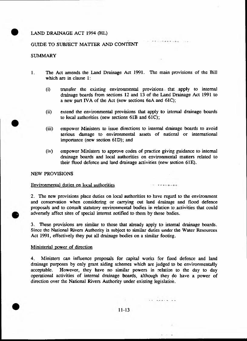
LAND DRAINAGE ACT 1994 (HL)
GUIDE TO SUBJECT MATTER AND CONTENT
SUMMARY
1. The Act amends the Land Drainage Act 1991. The main provisions of the Billwhich are in clause 1:
(i) transfer the existing environmental provisions * that apply to internal drainage boards from sections 12 and 13 of the Land Drainage Act 1991 to a new part IVA of the Act (new sections 6aA and 61C);
(ii) extend the environmental provisions that apply to internal drainage boards to local authorities (new sections 61B and 61C);
(iii) empower Ministers to issue directions to internal drainage boards to avoid serious damage to environmental assets of national or international importance (new section 61D); and
(iv) empower Ministers to approve codes of practice giving guidance to internal drainage boards and local authorities on environmental matters related to their flood defence and land drainage activities (new section 6IE).
NEW PROVISIONS
Environmental duties on local authorities ̂o o
2. The new provisions place duties on local authorities to have regard to the environment and conservation when considering or carrying out land drainage and flood defence proposals and to consult statutory environmental bodies in relation to activities that could adversely affect sites of special interest notified to them by those bodies.
3. These provisions are similar to those that already apply to internal drainage boards. Since the National Rivers Authority is subject to similar duties under the Water Resources Act 1991, effectively they put all drainage bodies on a similar footing.
Ministerial power of direction
4. Ministers can influence proposals for capital works for flood defence and land drainage purposes by only grant aiding schemes which are judged to be environmentally acceptable. However, they have no similar powers in relation to the day to day operational activities of internal drainage boards, although they do have a power of direction over the National Rivers Authority under existing legislation.

5. The new provision allows the relevant Minister - defined in the 1991 Act as the Minister of Agriculture, Fisheries and Food or the Secretary of State (for Wales) - to direct the activities of an internal drainage board if it is considered that destruction or serious damage to an environmental asset of national or international importance would otherwise result. Except in an emergency, the Minister will have to consult the internal drainage board before issuing a direction.
Codes of practice on environmental matters
6. The new provision enables Ministers to issue codes of practice to internal drainage boards and local authorities giving guidance on how to discharge their environmental duties when carrying out flood defence and land drainage activities. Ministers are already empowered to issue such codes to the National Rivers Authority under the Water Resources Act 1991.
7. The codes are to be subject to consultation with interested bodies, including the National Rivers Authority and statutory environmental bodies. Minister will approve codes by order subject to negative resolution procedure.
MISCELLANEOUS MATTERS
8. Sections 12 and 13 of the Land Drainage Act 1991 will be repealed (clause 2) as the provisions will be transferred to new sections 61A and 61C.
9. Like the 1991 Act, the provisions in the Act will apply only in England and Wales.
Source: Ministry of Agriculture Fisheries and Food
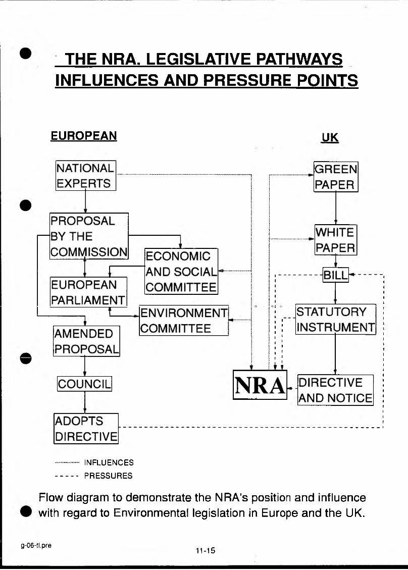
THE NRA. LEGISLATIVE PATHWAYS INFLUENCES AND PRESSURE POINTS
EUROPEAN UK
INFLUENCESPRESSURES
Flow diagram to demonstrate the NRA's position and influence with regard to Environmental legislation in Europe and the UK.
g-06-tl.pre11-15
EC DIRECTIVES AND ASSOCIATED REGULATIONS
Regulation 797/85/EEC on Improving the Efficiency of Agricultural Structures. Introduction of the concept of ESAs (Article 19).
Directive 79/409/EEC on the Conservation of Wild Birds. Amongst other protection measures, the establishment of SPAs to conserve habitats of rare or vulnerable species and regularly occurring migratory species. In the UK (not Northern Ireland), these are already notified as SSSIs under the Wildlife and Countryside Act 1981.
Directive 85/337/EEC on the Assessment of the Effects of Certain Public and Private Projects on the Environment. Establishment of methodology, scope and application of EA procedures for development projects.
Directive 90/313/EEC on the Freedom of Access to Information on the Environment. Environmental information collected by public authorities to be freely available.
Directive 91/271/EEC concerning Urban Waste Water Treatment. Requirement for more stringent waste water treatment in ’sensitive areas’. These have not yet been defined in the UK but may include some SSSIs and other conservation areas.
Directive 92/432/EEC on the Conservation of Natural and Semi-natural Habitats and of Wild Fauna and Flora. Introduction of special conservation measures for habitats of certain types and harbouring certain rare species. Also a more general requirement to maintain rare species and protect threatened habitats.
Draft Directive on Ecological Quality of Surface Waters. Will oblige Member States to draw up programmes for the assessment of all surface waters (including coastal waters) and their maintenance at or improvement to specified quality levels.
(c) A PRECIS OFGUIDELINES FOR EC FUNDING AND THE NRA
WITH PARTICULAR REGARD GIVEN TO FRCN FUNCTIONS
NRA AS A REGIONAL PARTNER
EC funding is based on the principle of partnership and the NRA can make a positive contribution to a regional strategy to regenerate a depressed area. Coordinating committees and specialist working groups have been set up in many authorities to unite public and private interest and define priorities. These committees need experts from organisations like the NRA, particularly in view of the importance now attached to the environment and the principle of sustainable development in the new Structural Fund regulations covering the period 1994-1999.
As an NDPB, the NRA has the right to make direct applications for Structural Funding via the Department of Environment without loss of its grant-in-aid.
NRA projects could benefit under the following criteria:
environmental improvement projects to attract tourism: promotion of recreational water activities or river restoration projects.rural development projects: nature conservation and groundwater protection schemes.
THE NRA: FINANCIAL BENEFITS
The principle of "additionally" applies to ail EC funding.—-This means that EC governments are obliged by EC law to match the amount of EC funding "in addition" to their national budgets. In practice, however, some national governments like the UK Treasury, have used EC funding as a way of topping up national budgets as opposed to offering "additional" expenditure. Local authorities have been forced to cut back public spending on other expenditure in order to take up EC funding which should have been matched by the UK Treasury. NDPBs like the NRA have also been prevented from taking full advantage of EC funding without concern over loss of their G.I.A.
There has been a recent change in Government rules relating to additionally. Since 1993/94, additionally applies to grant from the ERDF because a decision has been taken that government funds will not be reduced when grant is received. However, in the cases of LIFE and other funds, the arrangements have not been changed - when EC Grant is received, government funds are reduced.
COORDINATION OF EC R&D AND LIFE FUNDING:
With thousands of competing organisations from the twelve EC countries, only a few applications involving the NRA are likely to be successful and these must be therefore prioritised via the R&D function in Head Office and the NRA regional contact points.
COORDINATION OF STRUCTURAL FUNDS
As Structural Funds are only awarded to eligible UK areas, the applications will be made on a NRA regional basis via the appointed regional coordinator, the Regional Finance Managers and the Finance Directorate in Head Office.
For every ECU received, the NRA has to put in a contribution from its GIA or from its own resources and proposed projects will need financial approval before the application is made.
The DoE has also made clear that a forecast of ERDF grant will need to be included in the PES round and the NRA corporate plans and that any EC funds received will need to be recorded in the NDPB’s accounts. If the NRA receives more than its forecast, the NRA may be asked to provide PES cover from its resources.
A national coordination framework was agreed by the Executive Group and a more detailed framework will be available to Regional Finance Managers from Nigel Reader, Finance Director.
NATIONAL COORDINATORS OF EC FUNDING
Overall Coordination & Advice
EC R&D Coordination & NRA regional R&D Contact Points
Structural Funds Head Office Coordinator & appointed regional contact points & regional finance managers
Caroline Hager European Affairs Officer Ext. 710 5031
Gareth Llewellyn R&D Planning Officer Ext. 710 4323
Sue SlackOperations Coordinator
STRUCTURAL FUNDS AND THE ENVIRONMENT
Environment Projects
ERDF funds have contributed to schemes which "improve the image and the attractiveness of a region". Such "environmental" schemes have focused on building renovations and landscaping improvements in derelict areas aimed to attract tourism and encourage economic regeneration as opposed to measures to combat river pollution and clean up abandoned mines! Improving sewerage systems are also classified as "environmental" projects and the bulk of these ERDF funds flow to aid Southern Europe and Ireland. The ERDF has also co-funded environmental improvements on inland waterways for recreational purposes.
11-18
The European Agricultural Guarantee and Guidance Fund, another "structural fund", plays a major role in the protection of the environment in Objective 5 b areas, i.e. areas affected by structural changes in rural communities - mainly Cornwall, Devon, Scotland and Wales. Schemes which may be funded under the EAGGF include restoration of important landscapes, renovation of drainage systems, and the maintenance of the countryside etc.
COMMUNITY INITIATIVES
There are around 17 Community initiative programmes, of which several include actions designed to protect the environment, such as ENVLREG, RECHAR, LEADER, STRIDE. Further details are available on request to the European Affairs Officer.
GLOSSARY
EAGGF European Agricultural Guidance FundENVIREG Regional Environment FundsERDF European Regional Development FundLIFE Financial Instrument for the EnvironmentLEADER Links between action for the development of the rural economyRECHAR Reconversion of mining areasSTRIDE Science and Technology for Regional Innovation and Development in
Europe
11-19

11.3. STATUTORY INSTRUMENTS (SIsl
Environmental Assessment
EC Directive 85/337/EEC on the Assessment of the Effects of Certain Public and Private Projects on the Environment has been implemented in the UK by a number of Statutory Instruments, of which the most important for the NRA are:
SI 1988 No 1217 The Land Drainage Improvement Works (Assessment of Environmental Effects) Regulations 1988. The UK Regulations which give effect to Directive 85/337/EEC with respect to improvements to land drainage and flood defence works, which as permitted development do not require planning permission. Copies of ESs produced under these regulations must be sent to CC and EN/CCW. The Schedule to the regulations specifies the type of information required in an EA: this includes a description of likely significant effects on flora, fauna, landscape and the cultural heritage and appropriate mitigation and enhancement features.
SI 1988 No 1199 The Town and Country Planning (Assessment of Environmental Effects) Regulations 1988. The UK Regulations which give effect to Directive 85/337/EEC with respect to projects requiring planning permission.
Other relevant Sis:
SI 1981 No xxxx Ancient Monuments (Application for Scheduled Monuments Consent) Regulations 1981. Form of application for consent to carry out works on scheduled monuments.
SI 1986 No 1510 Control of Pesticides Regulations 1986. Made under Food and Environment Protection Act 1985. Protection of the aquatic environment from use and storage of pesticides (including herbicides).
SI 1988 No 1813 Town and Country Planning General Development Order 1988 [as amended]. Planning authorities required to consult EN/CCW before granting permission for land development within an SSSI or in any consultation area around an SSSI defined by EN/CCW. Also required to consult with certain conservation bodies when considering planning applications.
SI 1989 No 424 Harbour Works (Assessment of Environmental Effects) (No 2) Regulations. Implementation of Directive 85/337/EEC for harbour works below medium low water, for which planning consents are not needed, including works under the Coastal Protection Act 1949.

SI 1994 No 2716 Wildlife Countryside. The Conservation (Natural Habitats, &c) Regulations. Implementation of Directive 92/43/EEC(c) on the conservation of natural habitats and of wild fauna and flora. (Referred to as the Habitats Directive - see page 11-21).
NRA
THE HABITATS ANT) SPECIES DIRECTIVE
AN ASSESSMENT OF THE POTENTIAL IMPLICATIONS OF THE CONSERVATION (NATURAL HABITATS & c) REGULATIONS 1994 FOR NRA POLICY AND OPERATIONAL ACTIVITIES
Version 2 11 October 1994 Not for citation
CONTENTS
PAGE
Executive Summary ii
1. Purpose 1
2. Structure of the Paper 1
3. Background 1
4. Scope and timetable 2
5. Site selection and consultation 2
6. Timing of protection 4
7. Requirements for the NRA 4
8. An overview of implications for the NRA 5
9. Generic aspects of the Regulations: NRA interpretation of undefined terms 8
10. Specific aspect of the Regulations which have potential implications forthe NRA 10
11. Conclusions 16
Appendix 1 Background to the Directive 18Appendix 2 Questions and Answers: planning 22
Abbreviations and acronyms
See Part 4 section 19
EXECUTIVE SUMMARY
1. Implementation of the Habitats Directive through The Conservation (Natural Habitats & c) Regulations 1994 is the most significant piece of nature conservation legislation since the Wildlife & Countryside Act 1981.
2. Initial scrutiny of the Regulations has highlighted significant impacts on procedures and operational activities of the NRA and, in turn, the Environment Agency.
3. Full implications will not be determined until precise site details are known. In the meantime it is essential that the NRA prepares the ground for internal guidance for its staff.
4. It is clear that this internal guidance must be preceded by close liaison with government departments, notably DoE, MAFF and the Welsh Office as well as English Nature and the Countryside Council for Wales.
5. A first step will be to harmonise the NRA’s own initial interpretation of the Regulations with those of DoE, MAFF, WO, EN and CCW. There are a number of areas where clarification is required.
6. The main area of potential concern is the precise role of English Nature/CCW in advising and influencing the NRA viz a viz controlling activities notably consenting procedures.
7. The scope of this influence is important, particularly with respect to assessing the extent and impact of activities originating outside designated sites. Rsvi^wincW k VA V t? V VU W & Ub A W ■ A V AW f AAA^
existing decisions and consents represents a major source for uncertainty, particularly since revocation of licences could give rise to compensation claims.
8. One or more memorandums of understanding between the NRA and English Nature and CCW are required so that responsibilities, procedures and lines of communication at both national and area level are clearly set out.
1. PURPOSE
1.1 The purpose of this paper is to (i) summarise the mechanisms for implementation of the Habitats Directive and (ii) assess policy and operational implications so that the NRA can fulfil its commitments as a competent Authority.
1.2 In so doing, it provides (i) a first step in identifying potential resource implications and (ii) the basis for internal guidance needed for compliance with the Statutory Instrument(s) which implement the Directive.

STRUCTURE OF THE PAPER
In order to provide structure, the paper comprises (i) an overview encompassing generic issues, including the timetable for consultation, the NRA’s own interpretation of terms undefined in the draft regulations and key areas of impact, and (ii) specific issues related to individual Regulations, highlighting functional interest or concerns where appropriate.
BACKGROUND
The EC Habitats Directive was endorsed in May 1992 and draft domestic legislation The Conservation (Natural Habitats & c) 1994 were approved by the House of Commons in July 1994. House of Lords approval is expected in mid- October and the Regulations should become law by the end of that month.
The draft Regulations have been published and include (i) explanatory notes, (ii) compliance cost assessment, (iii) a list of special protection areas (SPAs) designated under the EC Birds Directive, (iv) flow diagrams explaining considerations of development proposals affecting SPAs and SACs, and (iv) the context of permitted development rights and protected areas.
All relevant NRA staff must have ready access to a copy of the Regulations when they finally become law.
Further regulations regarding consenting activities within SPAs and SACs will be laid before Parliament in the autumn.
Planning Policy Guidance (PPG) Note 20 "Nature conservation" will be published soon after the Regulations become law.
The Regulations only provide the legal framework for implementation of the Directive. Competent authorities such as the NRA will have to ensure that both policy and operational activities comply with both the letter and the spirit of the law.
SCOPE AND TIMETABLE
A brief resume of the purpose and scope of the Directive appears in Appendices 1 and 2. The main points are that a network of sites, comprising Special Protection Areas (SPAs) designated under the Birds Directive, and Special Areas of Conservation (SACs) designated under the Habitats Directive will together form "Natura 2000”, equivalent to the very best areas for conservation in Europe.
Protection of these sites (both SPAs and SACs) needs to be enforced through domestic Regulations. The need to maintain (or in some cases) restore favourable conservation status will have significant implications for the NRA as a competent authority.
Any plan or project which is likely to have a significant affect on the site may only be permitted if the "competent national _authority" has. ascertained, after consulting with English Nature/CCW that the proposal will not affect the integrity of the site.
Developments which would have a significant adverse impact may only be permitted if there are overriding reasons of public interest, provided that there is no alternative and that ’compensatory measures’ are taken.
For all but priority habitats or species, reasons of public interest include overriding social or economic considerations. For priority sites overriding public interest is limited to issues of public health and safety.
The timetable for designation is as follows:
• 5 June 1995: a list of proposed SACs has to be submitted to Brussels by the UK Government for approval;
• 5 June 1998: the Government has to agree with the EC on precise sites (Sites of Community Importance or SCIs);
• 5 June 1998: full protection of sites, designations begin;
• 5 June 2004: latest date by which SCIs are to be designated as SACs.
SITE SELECTION AND CONSULTATION
Site selection for proposed SACs has been coordinated by the Joint Nature Conservation Committee (JNCC) acting on behalf of DoH, and the Scottish and Welsh Offices.
Selection criteria have been based on both habitat and species appearing in Annexes I and n of the Directive. The procedure has taken a pragmatic approach of nominating sites with multiple interest, ie a primary example of a nominated Annex I or II feature, plus the occurrence of other habitats or species appearing elsewhere in the Directive.
The draft list is with government. It is a UK list so in some instances, the primary candidate site for certain species may not occur in England or Wales.
The list is confidential for a number of reasons, not least the insistence by government that owners should be the first to be consulted rather than other parties.
5.5
5.6
5.7
5.8
5.9
5.10
5.11
5.12
5.13
5.14
5.15
Notwithstanding this, the NRA has recently been given access to the list of proposed sites for England in order to provide advice on (i) the scientific basis for site selection, particularly with respect to fisheries matters, (ii) the location of alternative sites if necessary and (iii) any significant planned proposal or activity that may adversely affect any of the sites. An initial reaction has been relayed to DoE. A similar list of Welsh sites is awaited.
All SPAs and proposed SACs are already known. Unless there are good reasons all SACs will be within existing or proposed Sites of Special Scientific Interest (SSSIs).
Government have indicated that owners and occupiers will be consulted when the proposed list of sites has been agreed. In England, DoE will use English Nature as agents for this consultation process.
Each owner and occupier will receive a letter from English Nature, a ministerial letter, an information pamphlet explaining the implications of SAC designation plus a two-page summary rationale for designation and associated boundary map.
The NRA has requested that it receives the two-page summary sheets and boundary maps for each proposed SAC as soon as possible after the respective owners and occupiers are consulted.
A complication in this process is that Welsh sites may not have received approval from the Secretary of State until after the consultation process has begun for English sites.
Moreover, the consultation process is likely to be extremely flexible, reflecting priority and non priority SACs. It is possible that a first tranche of consultation is restricted to priority sites if only because Brussels is likely to approve priority sites rapidly.
Initial scrutiny of the proposed SAC list for England, indicates that there will be ten priority sites of direct relevance to NRA (see Table 1 on page 6)
Until site details are known in more detail, it is difficult for the NRA to comment on implications other than in broadly generic terms (see Section 10).
Schemes of management need to be in place for each SAC by the year 2004. This will be achieved in England by the current English Nature programme for implementing action plans in all SSSIs by the year 2000.
There is no SSSI framework for the designation of marine sites. Indeed, confusion is added by the fact that coastal SSSIs are designated down to low water mark while marine nature reserves are designated up to the high water mark.
11-28

5.16 Moreover, there is no single competent authority for marine sites. Consequently, consultation for marine sites in English jurisdiction will be a joint effort between English Nature and MAFF.
6. TIMING OF PROTECTION
6.1 The Conservation (Natural Habitats & c) Regulations 1994 are likely to become law at the end of October. Immediately thereupon, all existing Special Protection Areas (currently numbering 84 in the UK) will be protected by these Regulations. As further sites (including extensions to existing SPAs) are confirmed, each will automatically receive full protection on the day of designation.
6.2 Designated SACs, SCIs and SPAs will be made land charges. Owners and occupiers will be formally told once their land is placed on a Register of European Sites.
6.3 It is highly unlikely that all SACs will be designated en bloc. A drip-feed approach starting with priority habitats will be the most practical way forward. However, consultation will always precede designation.
7. REQUIREMENTS FOR THE NRA
7.1 All relevant NRA staff must be fully conversant with the implications of the Regulations and to this end internal guidance will be needed by early 1995.
7.2 This guidance must be consistent with any interpretation of the Regulations made by DoE, MAFF, Welsh Office, English Nature and CCW.
7.3 One or more memorandums of understanding between the NRA and English Nature and CCW need to be agreed so that procedures are clear to all parties concerned. In particular, ground rules regarding liaison on consents is essential.
7.4 In terms of catchment plan priorities, AMP3 discussions and planning major flood and sea defence programmes, it is vital for the NRA to fully understand the implications of SPA and SAC designation on a site-by-site basis. This clearly requires liaison between relevant competent authorities as well as English Nature and CCW.
7.5 Resource requirements for any change in existing practice (eg reviewing existing consents) will need to be estimated on at least an area-level basis at the earliest opportunity.
7.6 Although resource implications will be site-specific it is likely that the major burden will be caused by (i) increased liaison/contacts/meetings, (i) reviewing existing consents and (iii) environmental assessment and associated environmental data gathering.
11-29
Unless there is government-level strategic coordination of the plethora of environmental initiatives/schemes (eg ESAs, Agri-environment habitat improvement, Countryside Stewardship, nitrate vulnerable zones, Sensitive Areas (Eutrophic) etc), effort is not likely to be focused as effectively on SACs and SPAs as it could be.
To clarify this it would be helpful to the NRA and doubtless to other competent authorities, if a simple strategic framework document was produced by DoE/MAFF/WO indicating how resources were being channelled effectively into SAC and SPA protection.
Without this framework, there is a danger than competing demands between catchments may unintentionally distort the NRA’s considerable responsibilities and obligations under the Habitat Directive.
AN OVERVIEW OF IMPLICATIONS
A simplified list of habitats and species designated in the Directive over which the NRA has some or considerable influence appears in Table 1, along with the number of candidate SAC sites for each category in England.
The precise definitions of some habitats are extremely complicated and precise implications will only be determined by site boundaries and current NRA influences affecting the site.
The NRA is already duty bound under Section 17 of the Water Resources Act 1991 to inform English Nature or CCW of any proposals which it considers might adversely affect an SSSI.
Although this duty is unaffected by the Directive, it is clear that ground rules will need to be agreed regarding criteria for assessing impact arising from proposals within and beyond the limits of SACs. This is particularly important because there should be clear understanding of why SACs have been designated and what potentially damaging operations will be applicable for each site.
As at present, the difficulty will be in assessing the likely impact of a proposals (eg abstraction licence of discharge consent application) outside the boundary of the SAC.
Table 1 A very simplified overview of habitats and species represented on the proposed list of SACs which are of particular interest to the NRA.
1. Habitats 2. Species
1.1 Coastal - heath- dunes- lagoons- estuaries- mudflats/sandflats- large shallow
inlets and bays- marshes
Damselfly (Coenagrion mercuriale)Atlantic stream crayfishCrested newtSpined loachAllis shadTwaite shadSea lampreyRiver lamprey
1.2 Rivers - floating Ranunculus vegetation
Stream lamprey Salmon Bullhead Otter
1.3 Lakes - dystrophic- oligotrophic
1.4 Wetlands - Alkaline fens
The number of proposed sites for England, in broad categories are: coastal, 18; rivers, 9; lakes, 4; and wetlands, 6.
NB The number of sites containing priority habitats of relevance to flood and coastal defence in England is 10, all of which are coastal.
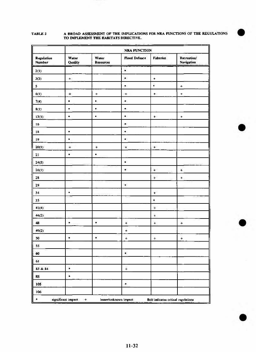
TABLE 2 A BROAD ASSESSMENT OF THE IMPLICATIONS FOR NRA FUNCTIONS OF THE REGULATIONS TO IMPLEMENT THE HABITATS DIRECTIVE.
NRA FUNCTION
RegulationNumber
WaterQuality
WaterResources
Flood Defence Fisheries Recreation/Navigation
2(1) •
3(3) + * +
5 * * +
6(1) + + + +
7(4) * * *
8(1) * * *
13(1) * * * + +
16 *
18 * *
19 * m
20(1) + + +
21 ♦ *
24(5) *
26(1) * + +
28 + +
29 ♦
34 ♦ +
35 *
41(4) +
44(2) +
48 * * + + +
49(2) +
50 • * + + +
55
60 *
61
83 & 84 * +
85 *
105 *
106
* significant impact + lesser/unknown impact Bold indicates critical regulations
11-32
8.6 There may be significant implications for compensation claims if traditional abstraction rights are affected by the Regulations.
8.7 Those Regulations which are likely to have implications for the NRA are summarised in Table 2. Broad generic issues are covered in Section 9, while function-specific matters are highlighted in Section 10.
9. GENERIC ASPECTS OF THE REGULATIONS: NRA INTERPRETATION OF UNDEFINED TERMS
9.1 Key aspects which required clarification include (i) "occupier", (ii) "emergency", (iii) landward extent of "marine", permitted development viz a viz flood defence works and (v) "consents".
9.2 NRA legal advice is as follows. The meaning of words or phrases in an Act, Order or Regulation may vary accordingly to the purpose of the legislation. If there is no definition contained in the legislation itself or there are no court cases in which the wording has been considered, then the word or phrase must be given its ordinary and natural meaning. In these circumstances it is accepted judicial practice to refer to the definition in the Oxford dictionary.
9.2.1 Occupier
There is no general definition given although Regulation 2 extends the definition (whatever it is) to include, "persons having any right of hunting, shooting, fishing or taking game or fish".
In planning legislation an occupier is defined to mean someone who has sufficient degree of control over the state of the premises or of the activities carried out upon them. However, for the purpose of the Regulations, occupier is used in a context which suggests that it requires the person to have some interest in the land, for example, under a licence, lease or tenancy arrangement. This interpretation is supported by the case of Southern Water v Nature Conservancy Council ,a brief outline of which is attached as Appendix 3.
9.2.2 Emergency
There is no definition in the Regulations nor in the majority of other legislation where the word appears (eg Section 89 of the Water Resources Act 1991).
Generally an emergency is taken to mean a sudden or unexpected event, one which could not be foreseen or guarded against and which would involve some threat to persons or property.
11-33
In a case involving Road Traffic legislation, the Court held that whilst an element of suddenness was not essential it was necessary to show that the circumstances giving rise to the incident could not have been reasonably foreseen.
Attempts to define "emergency" for the purpose of Water pic discharge consents proved unsuccessful, resulting in the view that it was better not to attempt a precise definition but to consider each occurrence on its facts.
Landward extent of "marine"
Regulation 2 defmes "marine area" as "any land covered (continually or intermittently) by tidal waters or any part of the sea in or adjacent to Great Britain up to the seaward limit of territorial waters".
Therefore a "marine area" would extend landward to the freshwater limit. The freshwater limit being the actual rather than that shown on the freshwater limit maps under the Water Resources Act 1991. The definition is therefore different to the definitions of "relevant territorial waters", "coastal waters" and "inland freshwater" contained in the Water Resources Act 1991.
Note: There is a possible complication here because the NRA definitions of freshwater limits are determined by chloride concentrations and marked on maps lodged in 1989 under the 1989 Water Act. Consequently, the tidal limit in strict terms (ie where the water ceases to show diurnal height fluctuations) could be many miles upstream from the freshwater limit as defined by the Act.
Permitted development
Permitted developments are those allowed under Schedule 2 of the Town & Country Planning General Development Order 1988. The most relevant to the NRA being Part 15 of a copy of which is attached as Appendix 4.
Consents
The word "consent" is used in two main contexts: firstly, when referring to consent granted under the Regulations themselves; and secondly, when referring generally to "consents, permissions or other authorisations" given by a "competent Authority" (Regulation 50).
"Competent Authority" is defined by Regulation 6 and would include the NRA. When used in the latter context, consent will cover all the NRA’s consents ie abstraction licences, discharge consents, land drainage consents etc.

0 10. SPECIFIC ASPECTS OF THE REGULATIONS WHICH HAVEPOTENTIAL IMPLICATIONS FOR THE NRA
10.1 Regulation 2(1) Interpretation and application
The key issue is whether or not the NRA is classified as an "occupier" when carrying out operational work. Clear guidance is that the NRA is not an occupier in this context (see Section 9.2.1).
10.2 Regulation 3(3) Implementation of the Directive
This effectively underlines the NRA’s Section 16 conservation duty in marine areas, particularly with regard to discharge consents and also consideration of marine aggregate dredging for beach recharge material. In some instances this may mean that due to cost of transporting material, environmentally-friendly schemes (eg beach recharge) will not be economically feasible. This potential conflict is important to bear in mind.
10.3 Regulation 5 Relevant authorities in relation to marine areas and European marine sites
This confirms that the NRA is a relevant Authority for marine areas in relation to its functions. Particular reference is made to navigation authorities and sea fisheries committees. The NRA has responded positively to a MAFF consultation document requesting comments on proposals to give Sea Fisheries Committees and the NRA a power to make fisheries byelaws for environmental purposes. Indeed, the NRA will explore possibilities of extending this power to inland waters.
10.4 Regulation 6(1) Competent authorities generally
The NRA is a competent authority as defined by 6(1).
10.5 Regulation 7(4) Selection of sites...
The timetable and consultation details are of crucial importance in terms of catchment management plan priorities, shoreline management plans, and all regulatory and operational activities of the NRA which influence the selected sites.
10.6 Regulation 8(1) Designation of special areas of conservation
The timetable is critical with regard to Regulations applying immediately to any site upon designation. The priority order for designation will be all important in planning resource requirements.
F U N C T I O NINTEREST
FD
WQ,FD
All
F
Ail
Ail
All
11-35
10.7
10.8
10.9
10.10
10.11
It is intended that consultation on sites proposed for selection will take All place (see Section 5.7). However, there is considerable uncertainty as to the precise amount of forewarning. In any event the NRA could be notified as a landowner, or shortly afterwards as a "relevant authority" under 13(l)(c), once a site had been designated and entered on the Register of European Sites.
Regulation 16 Management agreements
This allows for English Nature/CCW to impose a management FD agreement. Where the NRA has influence on the site (eg water level control) liaison will be crucial. Memorandum of understanding (MOU) required.
Regulation 18 Notification of potentially damaging operations
Potentially damaging operations may include those over which the NRA All has direct or indirect control. Liaison is crucial and any MOU must cover this aspect.
Regulation 19 Restriction on carrying out operations specified in notifications
Regulation 13(1) Notice to landowners, relevant authorities etc
Since the NRA is not an "occupier”, it is incumbent upon the owner to FD notify English Nature/CCW of any intention to carry out any operation specified in a notification. This may include changing water levels, byelaws etc, for which the NRA is the competent authority. Again, any MOU would have to cover this aspect.
Regulation 19(4) refers to "emergency operation". NRA interpretation FD of this clause is that it allows for remedial action to take place in response to a sudden or unforeseen event and this may include operations notified as potentially damaging so long as English Nature/CCW are informed as soon as practically possible after commencement of the operation. Again, another issue for the MOU.
Regulation 20(1) Supplementary provisions as to consents
English Nature/CCW will have the power to assess the implications of All any application for a consent (this to include discharge, abstraction, fisheries, land drainage consents but also drought orders, operating agreements etc) which in its opinion may adversely affect the conservation status of the site. This is a critical issue for any MOU since an assessment of impact requires technical expertise and robust criteria against which the application is to be evaluated.
11-36
Regulation 21 Provision as to existing notices and consents
This allows English Nature/CCW to review existing consents with regard to the applicability of their effort on the conservation status of the site. An equally important issue as 10.11 above.
Regulation 24(5) Supplementary provisions as to consents
These supplementary provisions relate only to consents required in relation to areas where a special nature conservation order has been made in respect of any land within a .European site, specifying potentially damaging operations. The work may only be carried out with written consent from English Nature/CCW and in accordance with the terms of the management agreement.
The definition of ’’overriding public interest" is crucial. The NRA cannot assume that flood and sea defence will be defined as such. Guidance from MAFF is essential so that guidance is unambiguous, even if it means drawing up ground rules for different types of site. The difference between priority and non-priority sites and definitions of "public health and safety" for the former need to be clarified in any guidance. If it includes essential flood and coastal defence works, "call-in" by the Secretary of State will be inevitable.
Regulation 26(i) Restoration where order contravened
Presumably any damage done as a result of an illegal operation will need to be put right and paid for by the person(s) responsible for the action.
Regulation 28 Power to make byelaws
In making byelaws to protect a site, English Nature/CCW could restrict activities such as boating and angling. Furthermore, under Regulation 28(3)(b) "...prohibit or restrict the killing... or disturbance of living creatures" could prevent flood defence activities such as weed control and controlling burrowing rabbits in floodbanks. A further interpretation of damage to vegetation could encompass eutrophication effects of nutrient input to rivers. This is another issue for an MOU.
Regulation 28(4) potentially extends the restriction aspect of byelaws to areas surrounding or adjoining the site. Liaison with the NRA on this is vital before byelaws are made by English Nature/CCW.
10.16 Regulation 29 Byelaws: limitation on effect
This relates to National Parks and limits restrictions imposed by byelaws regarding public rights of way, statutory undertakers and internal drainage boards. Clarification of this regulation with regard to the NRA may be needed.
10.17 Regulation 34 Management scheme for European marine sites
The NRA will need to be fully aware of proposed management schemes in relation to all its responsibilities and activities in the marine environment, particularly in relation to flood and coastal defence.
10.18 Regulation 35 Direction to establish or amend management scheme
The relevant Minister is able to direct the relevant authorities including the NRA in its capacity as a Sea Fisheries Committee, to establish a management scheme for a European marine site. Detailed guidance will be required if this direction is given, and resource implications in drawing up a scheme may be considerable.
10.19 Regulation 414) Prohibition of certain methods of taking or killing wild animals
This confirms that taking fish by poison or explosives is illegal!
10.20 Regulation 44(2Mg) Grant of licences for certain purposes
In respect of the Minister giving approval for licences to take animals or birds in order to prevent serious damage to... fisheries, the Regulation appears to clarify more stringently the criteria for consenting. This is particularly pertinent to fish-eating birds in SPAs and SACs, an issue upon which the NRA may be asked for advice.
10.21 Regulation 48 Assessment of implications for European site
Regulation 48(1) requires that the competent authority (eg the NRA) considers the implications of any application for consent or operation in the light of the conservation objectives of the site, while 48(3) requires consultation with English Nature/CCW. This reinforces the current Section 16 and 17 duties under the Water Resources Act 1991. The regulation is a powerful mechanism for ensuring that all competent authorities are aware of the conservation objectives of the site and are charged with not undertaking or not consenting any operation that will adversely affect the conservation interest of the site.
R ,FD
WQ,FD
F
Ail
11-38

1 0 .2 2
10.23
10.24
10.25
Regulation 48(2) allows for the competent authority to ask the applicant All for information to make an assessment of the impact of the consent.This confirms current NRA powers under the Water Resources Act 1991 to request information from applicants..
Regulation 49 Considerations of overriding public interest
Definitions of the various categories representing overriding public FD interest are vague, perhaps intentionally so. It is clear that priority SACs cannot be damaged for reasons of a social or economic nature.However, the issue of essential flood and sea defence works needs to be clarified in this context. MAFF will need to provide clear guidance.
Regulation 50 Review of existing decisions and consents
The requirement to review and "affirm, modify or revoke" all existing WQ, decisions and consents for designated SPAs and SACs is of major WR significance, since the Regulations will apply immediately to all existing SPAs and those SPAs and SACs as soon as they are designated in future. This may be a key issue regarding resource requirements.Moreover, for water resources it raises the issue of compensation and replacing the source if revocation of abstraction licences is identified.
The requirement to make any review or amendments to consents "as WQ, soon as reasonably practicable" will presumably allow the NRA to WR make variations within its statutory time limits. The alternative would be for the Secretary of State to make directions for variation with regard, for example, discharge consents. ^
Regulation 52 Coordination where more than one competent authority is involved
This allows the Secretary of State to provide guidance regarding All Regulations 48-51 viz a viz the conclusions of more than one competent authority in assessing the impact of a proposal on a European site.This guidance would presumably need one or more memorandums of understanding between relevant competent authorities.
Regulation 55 Planning permission: duty to review
This clarifies that Regulations 50 and 51 (requirement to review certain FD decisions and consents) do apply to any planning permission and that a review of permission may take place if construction is not yet complete.
10.26 Regulation 60 General development orders
Many operations carried out by the NRA are classified as permitted FD development (Appendix 4). If this is the case, then all such drainage works in SPAs and SACs will need planning permission as well as MAFF approval. If this is a correct interpretation, then there will be major implications and potentially all general development orders will need to be checked to verify whether operations are permitted development. This is a crucial issue which may need independent legal advice, since consent will only be provided after the local planning authority is satisfied that the operation will not affect the integrity of the site.
10.27 Regulation 61 General development orders: opinion of appropriate nature conservation body
This provides powers to English Nature/CCW to be statutory consultees FD where a general development order applies, and to request further information about the impacts of the development.
10.28 Regulation 83 Authorisation under Part I of the Environmental Protection Act 1990. and
Regulation 84 Licences under Part II of the Environmental Protection Act 1990
The Regulations apply to both the granting and of authorisations under WQ, the IPC regime and also the Waste Management Licensing regime. FD Consideration of the effects on a European site would apply to the NRA consultee role in both. The NRA sometimes has to apply for Food & Environmental Protection Act licences for flood defence works and the potential impact of these regulations should be borne in mind.
10.29 Regulation 85 Discharge consents under water pollution legislation
This indicates that the requirements to consider impacts on European WQ sites (Regulations 48 and 49) and the need to review existing decisions and consents (Regulations 50 and 51) extends to discharge consents issued by the NRA. The potential resource implications could be considerable.
11-40
10.30 Regulation 105 Powers of drainage authorities
This is potentially a very important Regulation in terms of flood defence and water level management in SPAs and SACs. It implies that the drainage authority (eg NRA) can carry out any operation with the consent of English Nature/CCW even if this is at variance with its "normal" flood defence remit. Clarification and guidance is needed from MAFF not least the links with water level management plans and Grant-in-Aid eligibility for such works.
10.31 Regulation 106 Offences bv bodies corporate & c
This allows for responsible officers of bodies corporate to be liable for punishment for acts of neglect!
11. CONCLUSIONS
11.1 The Conservation (Natural Habitats ) Regulations 1994 represent the most significant nature conservation legislation since the Wildlife & Countryside Act 1981.
11.2 Internal guidance for NRA staff will need to be produced and this guidance should reflect unambiguously the Authority’s commitments and obligations.
11.3 Unequivocal guidance from DoE, MAFF and Welsh Office is required regarding interpretation of several of the Regulations, notably the review of existing decisions and consents and a number of important issues which affect flood and sea defence works.
11.4 The precise role of English Nature/CCW needs to be spelt out in simple terms so that procedures and liaison links can be itemised in one or more memorandums of understanding between these agencies and the NRA.
11.5 Specific resource and other implications cannot be fully determined until site details are known, but the potential for increased resource commitments is most acute for the water quality, flood defence, and water resources functions.
FD
!
All
11-41
APPENDIX 1
1.1 W hat is the Habitats Directive?
A Directive is a piece of European Union legislation, negotiated and agreed by the UK Government. It specifies objectives to be achieved, but it is left to the Member States of the Union to introduce the legal and administrative measures necessary to implement it. The Directive required Member States to introduce the necessary measures by 5 June 1994.
The aim of ‘Council Directive 92/43/EEC on the conservation of natural habitats and of wild fauna and flora’, known as the "Habitats Directive", is to contribute towards ensuring biodiversity through the conservation of natural habitats and of wild fauna and flora in the European Territory of the Member States. Member States are required to ensure "favourable conservation status" for specified plants and animals and to prevent deterioration of their natural habitats.
The Directive envisages measures for the designation, protection and management of a series of sites of European importance (Natura 2000 sites), measures to protect certain species and wider countryside measures.
1.2 W hat are the Regulations?
On 4 July 1994, the UK Government laid before Parliament The Conservation (Natural Habitats & c) 1994 Regulations. The Regulations embody the key provisions of the Habitats Directive in UK law as part of the action to implement the Directive. The Regulations alone will not fully deliver the requirements of the Directive; they need to be supplemented by positive management of sites and the wider countryside.
The Regulations also apply to sites designated as Special Protection Areas (SPAs) under the earlier 1979 Directive on the Conservation of Wild Birds, giving their protection full statutory backing in UK Law.
1.3 W hat are the benefits of the Regulations?
The Directive requires the assessment of the impacts of plans or projects on protected areas. There is a general duty to avoid any significant deterioration of habitats and the disturbance of species of European importance. Any plan or project which is likely to have a significant effect on the site may only be permitted if the ‘competent national authority’ - such as a planning authority in England or the Secretary of State (if it is called in), has ascertained after consulting English Nature/CCW that the project will not affect the integrity of the site.
1. BACKGROUND TO THE DIRECTIVE

Developments which would have a significant adverse effect may be permitted if there are over-riding reasons of public interest, provided that there is no alternative and that ‘compensatory measures’ are taken. For most Special Areas of Conservation (SACs) (and all SPAs), reasons of public interest explicitly include over-riding social or economic considerations. For a few SACs with priority habitats or species, such as active raised bogs, over-riding public interest is limited to issues of public health and safety.
1.4 What habitats and species are covered?
Those listed in the Annexes I and n to the Directive.
A few habitats and one species in England is afforded ‘priority’ status which requires the strongest protection from development. SPAs are designated for rare birds listed in Annex I to the Birds Directive, and migratory birds.
1.5 What designations are involved?
1. By 5 June 1995, the Government has to send to Brussels a ‘National List’ of sites. This listing is not a designation. EN is giving advice to the Government, through JNCC, on the list of candidate sites. The draft list is confidential, at this stage.
2. By 5 June 1998, the Government has to agree with the European Commission a list of ‘Sites of Community Importance’ (SCI), drawn from the National List. Once a site is agreed as an SCI, the Directive requires it to be protected from damaging operations. By 5 June 2004 at the latest, each SCI must be designated by the Government as a Special Area of Conservation (‘SAC’). Once a site is an SAC, the Directive requires the necessary site management to be put in place. It is expected that in the UK, SAC designation will be achieved either at the same time or shortly after the European Union and the UK Government have agreed that a site is on the list of "Sites of Community Importance" (i.e. June 1998).
3. The Regulations also apply to sites designated as Special Protection Areas under the 1979 Directive on the Conservation of Wild Birds. 45 such sites have already been designated in England. The level of protection for SPAs is made much more explicit in the Regulations, but is actually about the same or could be slightly weaker than that which currently applies. Although there are new explicit assessment requirements, the Habitats Directive and the Regulations will permit SPAs to be damaged for overriding reasons of economic or social interest. At present, SPAs may only be allowed to deteriorate or suffer damage for reasons of public health and safety.
SPAs and SACs will together form a European Union series of nature conservation sites called ‘Natura 2000’.
11-43
How are SACs being selected?
Terrestrial SACs are being selected by applying the criteria in the Directive and identifying the best sites which host the relevant habitats and species in Great Britain. Specialists in the three nature conservation agencies are cooperating, through the JNCC, to draw up a GB list for recommendation to Government. All sites will be SSSIs.
What about consultation with owners and occupiers?
Both EN and the Department of the Environment are committed to consultation with owners and occupiers over the proposed site designations. It is likely that EN will act as agents for the Department in discussions with owners and occupiers, and will provide advice but, as with SPAs, all decisions on designation will rest with the Department.
Details of effects of new Regulations
i) ‘Competent Authorities’
The Regulations impose a duty on all ‘Competent Authorities’ to apply the tests contained in the Directive - assessments of significant effect, effect on site integrity, absence of alternatives and compensatory measures - before approving any plan or project which may affect a European site. ‘Competent Authorities’ include Ministers, Government Departments, ‘public or statutory undertakers’, public bodies or anyone holding a public office. This is a very significant new measure requiring the protection of European Sites to be fully taken into account in the decisions of all public bodies. There are also duties on competent authorities to review decisions affecting European Sites.
ii) Register
Designated SACs, SCIs and SPAs will be made land charges. In addition, the Government will establish a Register of European Sites, on which SAC, SCI and SPA details will be recorded. Owners and occupiers will be formally told once their land is placed on this Register. This duty rests not with the Department of the Environment, but with EN. Designations Team will be reviewing with the Department how we can minimise the disruption likely to be caused by informing the owners and occupiers of the 45 existing SPAs. This statutory procedure is in addition to statutory SSSI notification (which will already have taken place).

iii) Species
The Directive also includes measures for the protection of species. The Regulations have made a few changes to the existing provisions of the Wildlife and Countryside Act. The prohibition against ‘intentional’ killing or disturbance is replaced by a prohibition against ‘deliberate’ killing or disturbance. Protection for breeding sites or resting places has been strengthened. Any damage to such sites, not merely intentional damage, will now be illegal. The defence of ‘incidental result of a lawful operation’ remains, however. The incidental capture and killing of other cetaceans in nets has not been addressed by the regulations.
Other measures necessary to implement the Directive
In summary, positive management; wider countryside measures; appropriate and accurate environmental assessments; and of course, favourable decisions by ‘competent authorities’.
APPENDIX 2
QUESTIONS AND ANSWERS: PLANNING
Q l. What do the regulations mean for planning applications in SAC and SPA?
A l. There must be a very careful assessment of any development proposal. The planning authority must make an ‘appropriate’ assessment of any proposal which is likely to have a significant effect on a ‘European’ site (ie SAC or SPA) and consider the implications for the site in view of that site’s conservation objective. In doing so they must consult with English Nature and have regard to any regard to any representations made as a result.
If the proposal is likely to have a significant effect on the site then the LPA can agree to the proposal only if it will not affect the integrity of the site, or if there are imperative reasons of over-riding public interest. They may, if appropriate, take the opinion of the general public in assessing effects on a site’s integrity. [It would be expected that "call-in" (Secretary of State) if the over-riding public interest argument was to be involved.]
Q2. What is a ‘significant effect’?
A2. These words are not defined in the regulations, but the spirit of the Directive is that activities which will prejudice the favourable conservation status of the site or lead to deterioration in its support of listed habitats or species must be avoided. These effects can be from the proposal on it’s own or in combination with others.
Q3. WTiat is the integrity of a site?
A3. The forthcoming PPG on nature conservation will contain detailed guidance on procedures stemming from the new regulations. It defines the integrity of a site as "the coherence of its ecological structure and function across its whole area, that enables it to sustain the habitat, complex of habitats and/or the levels of population of the species for which it was designated’.
Q4. What does ‘over-riding public interest’ mean?
A4. Where the site concerned hosts a priority natural habitat type or a priority species, ‘reasons of over-riding public interest’ mean reasons relating to human health, public safety or beneficial consequences of primary importance to the environment; or other reasons which in the opinion of the European Commission are imperative reasons of over-riding public interest.
THE CONSERVATION (NATURAL HABITATS & C) REGULATIONS
11-46

The regulations provide the LPA to obtain, via the Secretary of State for the Environment, an opinion from the European Commission in such cases and, in any case, the LPA must inform the Secretary of State where they propose to permit a development in such circumstances.
If the site does not host a priority natural habitat or species ‘over-riding public interests’ may include reasons of a social or economic nature which would need to be sufficient to override the ecological importance of the designation.
Where a development is allowed to go ahead on this basis despite negative implications for the site, the Secretary of State must ensure that compensatory measures are taken to ensure the overall coherence of Natura 2000 (ie the network of SAC and SPA).
Q5. Do the regulations have anything to say about existing planning permissions on European sites?
A5. When the Regulations come into effect, the LPA will have a duty to review any decision which has been made prior to that date, where the development has not been completed or where the development has not been started within specified timescales. This regulation applies also to planning permissions deemed to have been given under various other enactments. The LPA will apply the same criteria noted above as to significant effects on a site and harm to the site’s integrity.
In reviewing the decision the LPA may consider whether adverse effects could be overcome by a SI06 planning obligation.
If the effects cannot be so overcome the LPA shall use existing powers in the Town and Country Planning Act 1990 to revoke or modify the planning permission or to require the discontinuance of a use of land.
Q6. What about compensation where a planning permission is revoked or modified.
A6. The Town and Country Planning legislation requires compensation to be paid by the LPA, but has provisions whereby a contribution may be made by the Secretary of State in certain circumstances. The Habitats & C Regulations do not in themselves alter this position.
Q7. Is there any effect on planning permission given by a General Development Order (‘permitted development rights*)?
A7. The Regulations say that a permitted development right shall not be used if it is likely to have a significant effect on a European site unless the developer receives written approval from the LPA.
11-47

The developer may ask English Nature for an opinion as to whether carrying out the pdr will have a significant effect on the site. If English Nature say it will not, then the pdr may be carried out.
The developer may also apply in writing to the LPA for their approval of a pdr. The LPA will make an assessment of the implications of the development for the site and may only approve the development if it will not adversely affect the site’s integrity.
11-48

12. INTERNATIONAL AGREEMENTS AND CONVENTIONS
12.1 International Agreements and Conventions
The ’Ramsar* Convention, known more as formally as the Convention on Wetlands of International Importance, especially as Waterfowl Habitat, came into force in 1975. It is a world-wide convention but has had a positive impact on the conservation of wetlands in many European countries, 24 of which are contracting parties. One of the main commitments made by the contracting parties is to designate suitable wetlands within their territory for inclusion in a list of wetlands of international importance which is maintained by the Ramsar Bureau. They must also formulate and implement their planning procedures so as to promote the conservation of the wetlands inscribed in the list and, as far as possible, the wise use of wetlands in their territory.
The ’World Heritage’ Convention, or the Convention concerning the protection of the World Cultural and Natural Heritage, entered into force in 1975. Over 80 countries are now contracting parties to the convention, the objective of which is the protection of natural and cultural areas of "outstanding universal value”. These areas are selected by the World Heritage Committee and make up the World Heritage List or, for seriously threatened sites, the List of World Heritage in Danger. Each contracting party is obliged to take all possible measures to protect the sites included in the lists, and support for these efforts is available through the World Heritage Fund, to which all parties contribute. However, because the convention aims to protect only the exceptionally valuable areas, its broad value for nature conservation will always be limited.
Biosphere Reserves. First promoted by UNESCO in 1974 as a worldwide network of sites protected for the purpose of conservation and exchange of scientific information. All the 13 British Biosphere Reserves (designated in 1976 and 1977) are also NNRs.
The Bern Convention, or the Convention on the Conservation of European Wildlife and Natural Habitats, came into effect in June 1982. The Convention was developed by the Council of Europe and now includes 25 contracting parties including most Western European countries, the European Community, Bulgaria and two West African countries - Burkina Faso and Senegal. In addition to the principle aim of ensuring the conservation of flora, fauna and their habitats, the convention seeks to encourage cooperation between contracting parties and to direct particular attention to endangered and vulnerable species, including migratory species. The species requiring either "strict protection" or protection are listed in three annexes. There is a standing committee with responsibility for monitoring the application of the convention which meets regularly and organises studies and seminars, as well as adopting recommendations on particular species and individual habitats of conservation importance.
12-1
The Bonn Convention, or the Convention on the Conservation of Migratory Species of Wild Animals, entered into force in November 1983. The convention arose from one of the recommendations of the Action Plan adopted at the UN Conference on the Human Environment in Stockholm in 1972. One aim of the convention is to provide strict protection for a number of listed migratory species in danger of extinction in all or a large part of their range. There are firm conservation obligations on the contracting parties which are considered to fall into the range of the species concerned. The second main objective is to persuade the "range states" to conclude formal agreements for the conservation and management of a second group of migratory species with an unfavourable conservation status which need or would benefit from international agreement. This group of species is listed in a second appendix. However, such agreements have proved difficult to negotiate and progress has been slow.
12-2
12.2 The NRA and Biodiversity
1 CONTEXT: THE RIO CONVENTION ON BIOLOGICAL DIVERSITY
1.1 THE CONVENTION
1.1.1 The United Nations Convention on Biological Diversity, which the UK signed in 1992, requires, among other things, action to:
• promote the protection of ecosystems, natural habitats and the maintenance of viable populations of species;
• develop or maintain legislation for the protection of threatened species;
• promote understanding of the issues involved in conserving biological diversity;
• establish protected areas and develop guidelines for their selection and management;
• promote relevant research;
• monitor important components of biological diversity.
1.2 THE UK GOVERNMENT’S ACTION PLAN
1.2.1 Article 6A of the Convention requires each contracting party to develop national strategies for the conservation and sustainable use of biological diversity. The Government has responded to this challenge by publishing in 1994 Biodiversity, The UK Action Plan, which lays down the following broad objectives for conserving biological diversity within the UK:
"To conserve and where practicable to enhance:
the overall populations and natural ranges of native species and the quality and range of wildlife habitats and ecosystems;
internationally important and threatened species, habitats and ecosystems;
species, habitats and natural and managed ecosystems that are characteristic of local areas;
the biodiversity of natural and semi-natural habitats where this has diminished over recent past decades.
12-3
To increase public awareness of, and involvement in, conserving biodiversity.
To contribute to the conservation of biodiversity on a European and global scale."
1.2.2 The Government’s targets for the next 20 years which will contribute to the achievement of these objectives, and which are particularly relevant to the conservation of dragonflies are:
• preparation and implementation of action plans for threatened species, including those listed in annexes to international agreements to which the UK is a party;
• updating and publicising guidelines on species translocation, reestablishments, introductions and re-stocking;
• continuation of advice to farmers to help them to identify and adopt environmentally beneficial management practices, which will conserve and where practicable, enhance wildlife habitats on their land;
• legal protection for threatened species;
• designation and management of protected areas;
• helping to ensure a sound scientific basis for conservation in Europe.
1.2.3 The NRA is represented on the Government’s Biodiversity Steering Group, formed to take this Action Plan forward. Targets will be announced in late 1995.
»
12-4
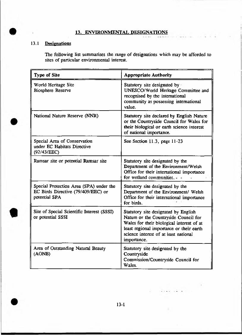
13. ENVIRONMENTAL DESIGNATIONS
13.1 Designations
The following list summarises the range of designations which may be afforded to sites of particular environmental interest.
Type of Site Appropriate Authority
World Heritage Site Biosphere Reserve
Statutory site designated by UNESCO/World Heritage Committee and recognised by the international community as possessing international value.
National Nature Reserve (NNR) Statutory site declared by English Nature or the Countryside Council for Wales for their biological or earth science interest of national importance.
Special Area of Conservation under EC Habitats Directive (92/43/EEC)
See Section 11.3, page 11-23
Ramsar site or potential Ramsar site Statutory site designated by the Department of the Environment/Welsh Office for their international importance for wetland communities. - --
Special Protection Area (SPA) under the EC Birds Directive (79/409/EEC) or potential SPA
Statutory site designated by the Department of the Environment/ Welsh Office for their international importance for birds.
Site of Special Scientific Interest (SSSI) or potential SSSI
Statutory site designated by English Nature or the Countryside Council for Wales for their biological interest of at least regional importance or their earth science interest of at least national importance.
Area of Outstanding Natural Beauty (AONB)
Statutory site designated by the CountrysideCommission/Countryside Council for Wales.
13-1
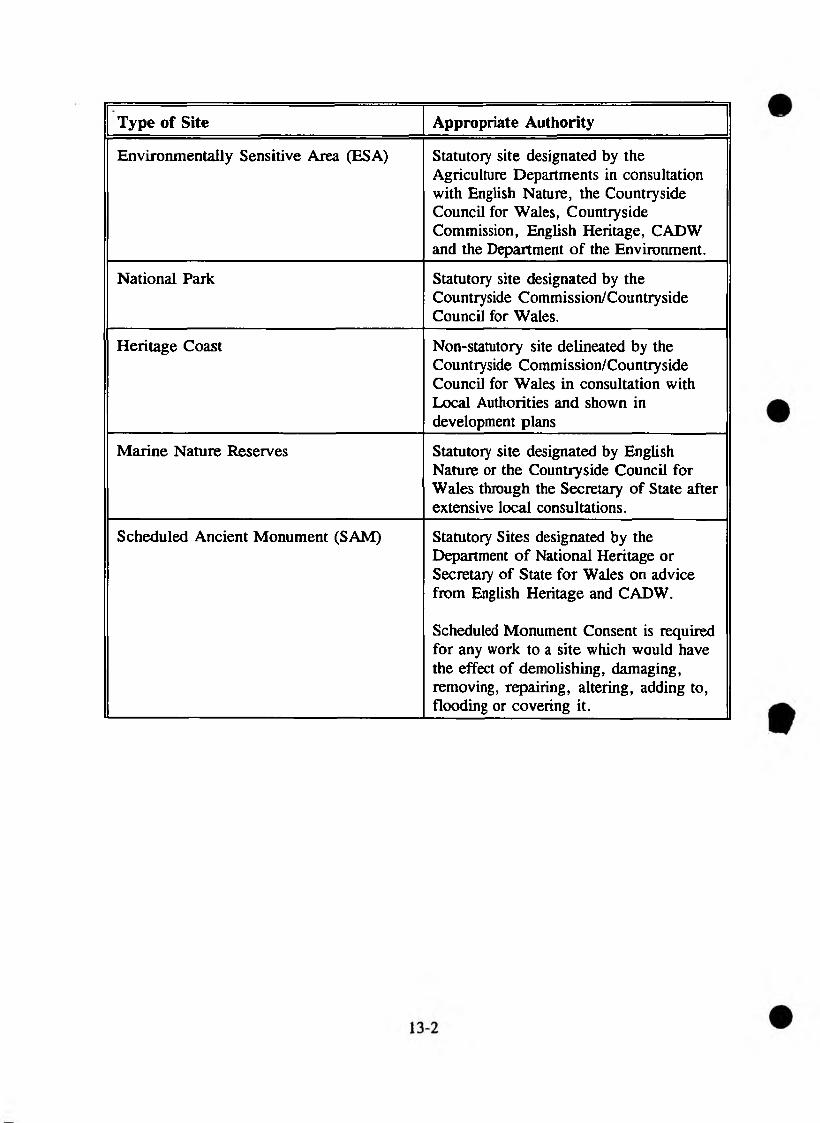
Type of Site Appropriate Authority
Environmentally Sensitive Area (ESA) Statutory site designated by the Agriculture Departments in consultation with English Nature, the Countryside Council for Wales, Countryside Commission, English Heritage, CADW and the Department of the Environment.
National Park Statutory site designated by the Countryside Commission/Countryside Council for Wales.
Heritage Coast Non-statutory site delineated by the Countryside Commission/Countryside Council for Wales in consultation with Local Authorities and shown in development plans
Marine Nature Reserves Statutory site designated by English Nature or the Countryside Council for Wales through the Secretary of State after extensive local consultations.
Scheduled Ancient Monument (SAM) Statutory Sites designated by the Department of National Heritage or Secretary of State for Wales on advice from English Heritage and CADW.
Scheduled Monument Consent is required for any work to a site which would have the effect of demolishing, damaging, removing, repairing, altering, adding to, flooding or covering it.
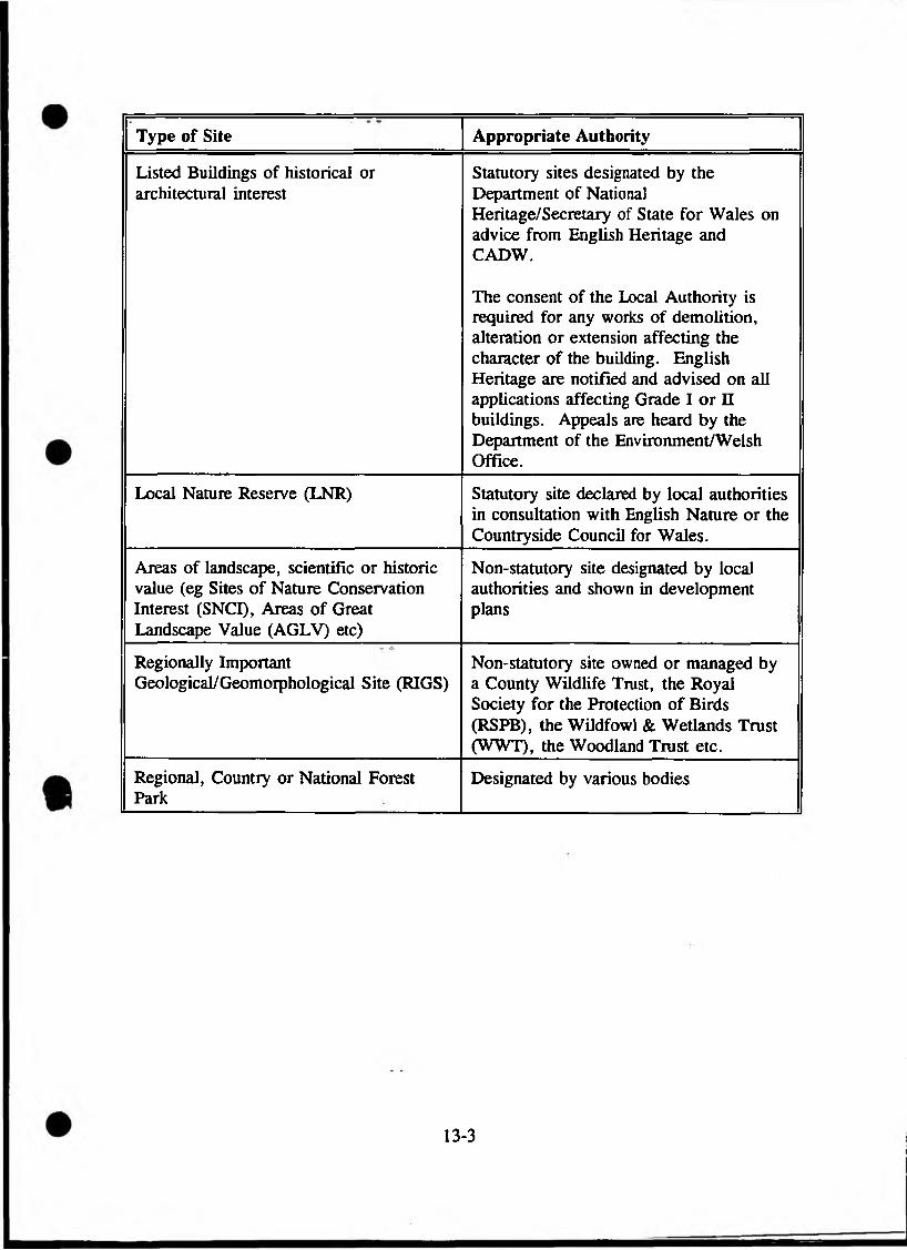
Type of Site Appropriate Authority
Listed Buildings of historical or architectural interest
Statutory sites designated by the Department of National Heritage/Secretary of State for Wales on advice from English Heritage and CADW.
The consent of the Local Authority is required for any works of demolition, alteration or extension affecting the character of the building. English Heritage are notified and advised on all applications affecting Grade I or n buildings. Appeals are heard by the Department of the Environment/Welsh Office.
Local Nature Reserve (LNR) Statutory site declared by local authorities in consultation with English Nature or the Countryside Council for Wales.
Areas of landscape, scientific or historic value (eg Sites of Nature Conservation Interest (SNCI), Areas of Great Landscape Value (AGLV) etc)
Non-statutory site designated by local authorities and shown in development plans
Regionally Important Geological/Geomorphological Site (RIGS)
Non-statutory site owned or managed by a County Wildlife Trust, the Royal Society for the Protection of Birds (RSPB), the Wildfowl & Wetlands Trust (WWT), the Woodland Trust etc.
Regional, Country or National Forest Park
Designated by various bodies--------------------------------------------------------- ---- ------------ ---
13-3
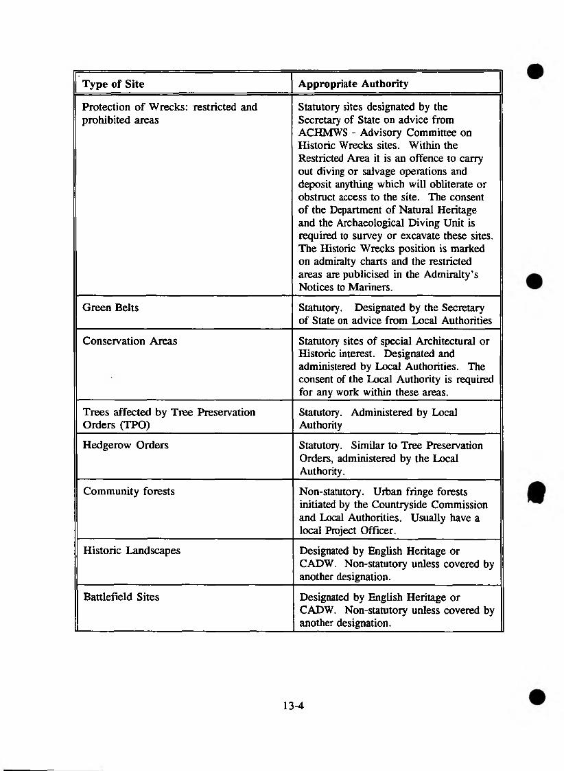
Type of Site Appropriate Authority
Protection of Wrecks: restricted and prohibited areas
Statutory sites designated by the Secretary of State on advice from ACHMWS - Advisory Committee on Historic Wrecks sites. Within the Restricted Area it is an offence to carry out diving or salvage operations and deposit anything which will obliterate or obstruct access to the site. The consent of the Department of Natural Heritage and the Archaeological Diving Unit is required to survey or excavate these sites. The Historic Wrecks position is marked on admiralty charts and the restricted areas are publicised in the Admiralty’s Notices to Mariners.
Green Belts Statutory. Designated by the Secretary of State on advice from Local Authorities
Conservation Areas Statutory sites of special Architectural or Historic interest. Designated and administered by Local Authorities. The consent of the Local Authority is required for any work within these areas.
Trees affected by Tree Preservation Orders (TPO)
Statutory. Administered by Local Authority
Hedgerow Orders Statutory. Similar to Tree Preservation Orders, administered by the Local Authority.
Community forests Non-statutory. Urban fringe forests initiated by the Countryside Commission and Local Authorities. Usually have a local Project Officer.
Historic Landscapes Designated by English Heritage or CADW. Non-statutory unless covered by another designation.
Battlefield Sites Designated by English Heritage or CADW. Non-statutory unless covered by another designation.
13-4
Type of Site Appropriate Authority
Historic Parks and Gardens Non-statutory sites designated by English Heritage and CADW. The register of these sites is at present available for England but in preparation in Wales.
National Trust Properties Non-statutory unless covered by another designation. Many are grouped within Historic Landscapes.
Nature Reserve Non-statutory site owned or managed by a County Wildlife Trust, the Royal Society for the Protection of Birds (RSPB), the Wildfowl and Wetlands Trust (WWT), the Woodland Trust etc.
Country Park Statutory sites designated by the Countryside Commission/Countryside Council for Wales.
SINCs Variously known as Sites of Importance for nature Conservation, SNCIs, Prime Sites, etc, in different counties, these are non-statutory nature conservation sites generally of county or regional importance, often regarded as the next level down from SSSIs (though some may be of equal value to SSSIs). Registers of SINCs are usually held either by County Councils or County Wildlife Trusts.
Others: *
Footpath or other public access route or right of way.Area of amenity, recreational or tourist value.
It is important to note that because a site has not been scheduled or listed, this does not mean it is unimportant, merely that there are large numbers of sites awaiting designation. For this reason, in the case of archaeology, Sites and Monuments Records and National Monuments Records should be checked.
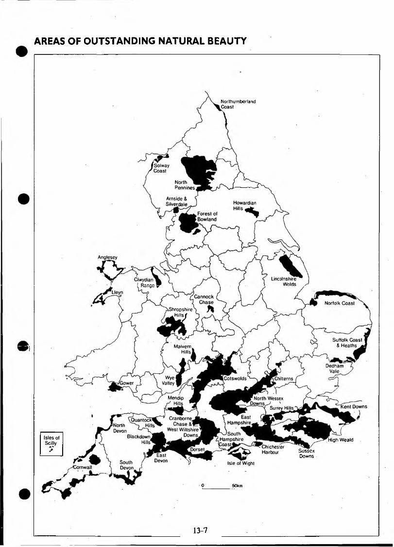
AREAS OF OUTSTANDING NATURAL BEAUTY
NorthumberlandCoast
High Weald
SussexDowns
13-7
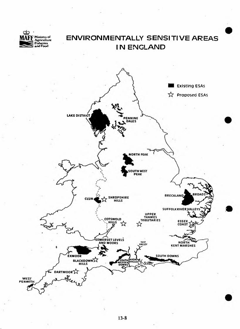
Q© *M A F F Ministry of
*• Agriculture Fisheries and Food
ENVIRONMENTALLY S E N S IT IV E A R E A SIN ENGLAND
LAKE DISTRICT
■ Existing ESAs
Proposed ESAs
WESTPENWITH
13-8
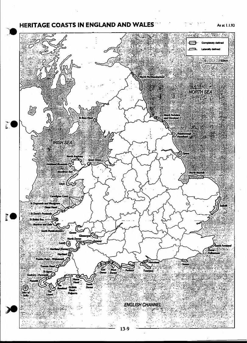
HERITAGE COASTS IN ENGLAND AND WALES As at 1.1.93
, .~I----- ------ -------------------------------- U.:i
13-9
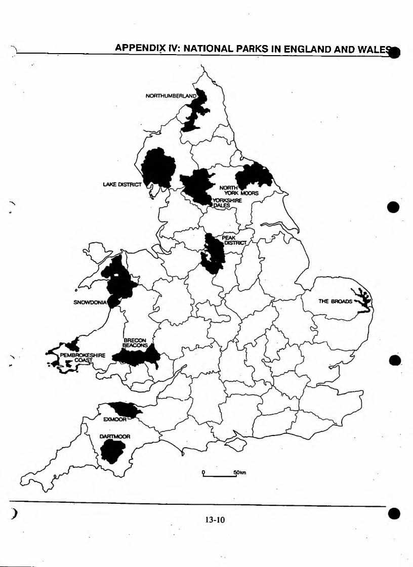
APPENDIX IV: NATIONAL PARKS IN ENGLAND AND WALE^fc

___ _____ _

PART 3: GUIDANCE DOCUMENTS AND REFERENCES
14. GOVERNMENT GUIDANCE DOCUMENTS
14.1 DOE PLANNING POLICY GUIDANCE NOTES (PPGs)
PPGs are aimed primarily at planning authorities, although they contain much relevant information on legislation and policies.
PPG 7. The countryside and the rural economy.
PPG 12. Development Plans and Regional Planning Guidance.
PPG 16. Archaeology and Planning, (separate WO version for Wales)
PPG 17. Sport and recreation, (includes guidance on the interaction of nature conservation with sport and recreational issues)
PPG 20. Coastal Planning.
PPG Nature Conservation (In draft, expected December 1994)
PPG Tourism. (In draft.)
14.2 DOE CIRCULARS
DoE Circular 8/87 (1987). Historic buildings and Conservation Areas - policy and procedures (WO Circular 61/81).
DoE Circular 27/87 (1987). Nature conservation (WO Circular 52/87) This will shortly be superseded by a Policy Planning Guidance note on Nature Conservation (see C2.3).
DoE Circular 15/88 (1988). Environmental Assessment (WO Circular 23/88)
DoE Circular 30/92 (1992). Development and Flood Risk Areas (MAFF Circular FD 1/92; WO Circular 68/92).
14.3 GENERAL GUIDANCE
DoE/MAFF (1982). Code of Guidance for Sites of Special Scientific Interest.
MAFF (1985). Guidelines for the Use of Herbicides on Weeds in or Near Watercourses and Lakes. MAFF Booklet 2078.
14-1

DoE (1988). The Green Belts.
DoE/MAFF/WO (1989). The Water Act 1989: Code of Practice on conservation, access and recreation. 39pp
DoE/WO (1989). Environmental Assessment: a guide to the procedures. 64pp
MAFF/DoE/WO (1991). Conservation Guidelines for Drainage Authorities.
DoE (1991). Fit for the Future - a statement by the government on policies for the National Parks.
DoE (1991). Policy Appraisal and the Environment: a guide for government departments. 67pp
MAFF/English Nature/NRA (1992). Environmental procedures for inland flood defence works. A guide for senior managers and decision makers in the National Rivers Authority, Internal Drainage Boards and Local Authorities. 17pp
MAFF/WO (1993). Strategy for Flood and Coastal Defence. MAFF publications. PB 1471.
MAFF (1993). Flood and Coastal Defence, Project Appraisal Guidance Notes. 63pp
MAFF (1993). Coastal Defence and the Environment. A guide to good practice. 156pp
MAFF (1993). Coastal Defence and the Environment. A strategic guide for managers and decision-makers in the National Rivers Authority, local authorities and other bodies with coastal responsibilities. 17pp
MAFF (1994). Water Level Management Plans. A procedural guide for operating authorities. 23pp.
15. SELECTED REFERENCES
15.1 NRA Publications
(a) NATIONAL PUBLICATIONS
Books
Howaith, W. The Law of the National Rivers Authority. (Obtainable from the Centre for Law in Rural Areas, University College of Wales Aberystwyth, Dyfed).
NRA publications available free of charge
Corporate Plan 1994/95
Corporate Plan Summary 1994/95
Annual Report 1993/94
NRA Corporate Strategy
NRA Water Quality Strategy
NRA Water Resources Strategy
NRA Flood Defence Strategy
NRA Fisheries Strategy
NRA Recreation Strategy * ° ' v °
NRA Conservation Strategy
NRA Navigation Strategy
NRA R & D Strategy
Encapsulated card - standard symbols for use in river corridor surveys
Guidance for the Control of Invasive Plants near Watercourses
A Guide to Identifying Freshwater Crayfish in Britain & Ireland
Guidance Notes for Local Planning Authorities on the methods of protecting the water environment through development plans
Groundwater Vulnerability Map Leaflet
Blue Green Algae Leaflet
R & D List of Outputs
NRA Customer Charter
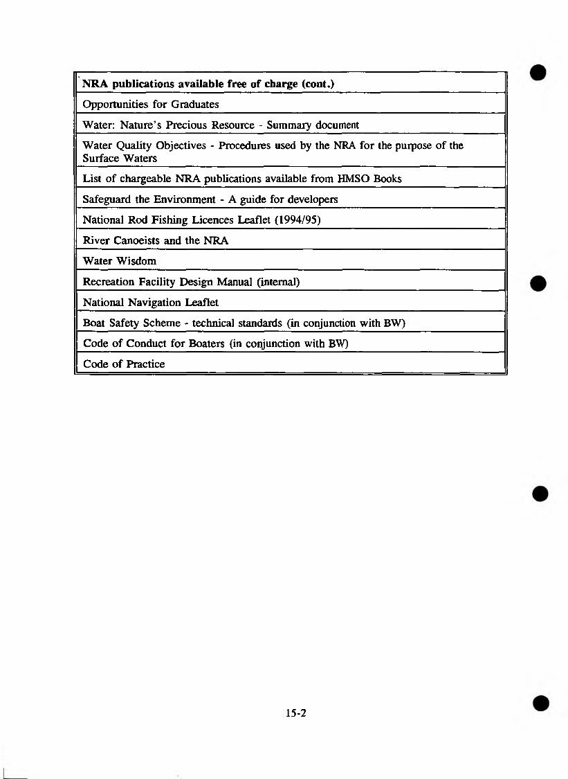
NRA publications available free of charge (cont.)
Opportunities for Graduates
Water: Nature’s Precious Resource - Summary document
Water Quality Objectives - Procedures used by the NRA for the purpose of the Surface Waters
List of chargeable NRA publications available from HMSO Books
Safeguard the Environment - A guide for developers
National Rod Fishing Licences Leaflet (1994/95)
River Canoeists and the NRA
Water Wisdom
Recreation Facility Design Manual (internal)
National Navigation Leaflet
Boat Safety Scheme - technical standards (in conjunction with BW)
Code of Conduct for Boaters (in conjunction with BW)
Code of Practice
15-2

NRA PUBLICATIONS AVAILABLE FROM HMSO
PUBLICATION PRICE
Toxic Blue Green Algae: The report of the NRA (WQS 2) £15.00
Bathing Water Quality in England and Wales 1990 (WQS 3) £10.00
The Quality of Rivers, Canals and Estuaries in England & Wales (WQS 4) £5.00
Influence of Agriculture on the Quality of Natural Waters in England & Wales (WQS 6)
£10.00
Bathing Water Quality in England and Wales 1991 (WQS 8) £3.00
Water Pollution Incidents in England and Wales 1991 (WQS 9) £4.00
Discharges of Waste Under the EC Titanium Dioxide Directives (WQS 10) £5.00
Bathing Water Quality in England & Wales 1992 (WQS 11) £3.00
Quality of the Humber Estuary 1980 - 1990 (WQS 12) £5.00
Water Pollution Incidents in England & Wales 1992 (WQS 13) £4.50
Abandoned Mines and The Water Environment (WQS 14) £7.95
Contaminated Land and The Water Environment (WQS 15) £7.95
Implementation of the EC Shellfish Waters Directive (WQS 16) £7.95
Discharge Consents and Compliance (WQS 17) £7.95
Bathing Water Quality in England and Wales - 1993 (WQS 18) £7.95
The Quality of Rivers and Canals in England and Wales - 1990 to 1992 (WQS 19)
£11.95
Implementation of the EC Freshwater Fish Directive (WQS 20) - (Available from November)
£9.95
Water Pollution Incidents in England and Wales - 1993 (WQS 21) £5.50
Fisheries Technical Report 1 - Sea Trout in England and Wales £6.00
Fisheries Technical Report 2 - Sea Trout Catch Statistics £6.00
Fisheries Technical Report 3 - Sea Trout Literature Review £6.00
Fisheries Technical Report 4 - Sea Trout Gene Banks £6.00
Fisheries Statistics 1990 £6.00
Fisheries Statistics 1992 £8.95
River Corridor Surveys - Conservation technical handbook 1. £10.00
River Landscape Assessment - Conservation technical handbook 2 £6.00
Otters and River Habitat Management - Conservation technical handbook 3 £5.00
Groundwater Protection Policy Document (including vulnerability map) £15.00
Groundwater Vulnerability Map - Sheet 13 - Humber Estuary £9.95
Groundwater Vulnerability Map - Sheet 16 - West Cheshire £9.95
15-3
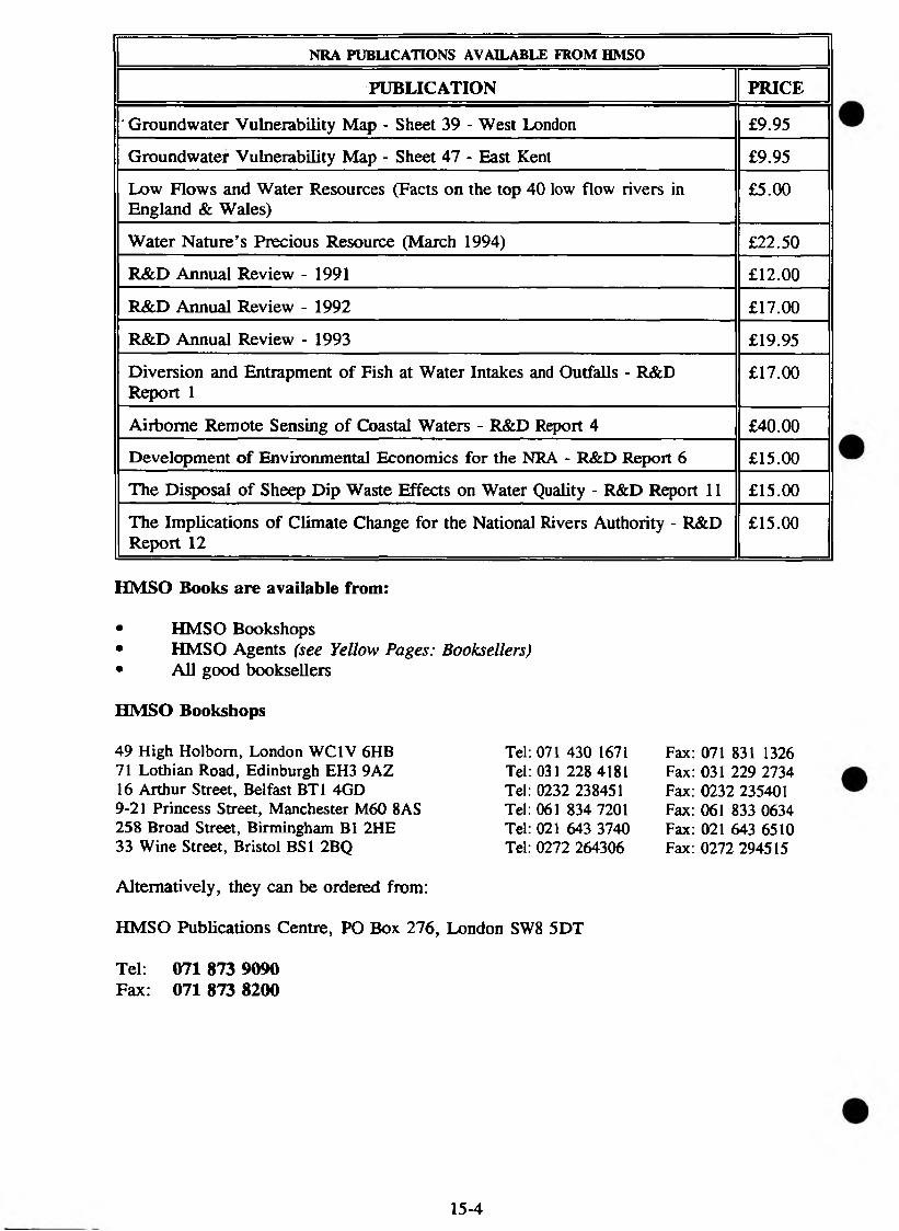
NRA PUBLICATIONS AVAILABLE FROM HMSO
PUBLICATION PRICE
' Groundwater Vulnerability Map - Sheet 39 - West London £9.95
Groundwater Vulnerability Map - Sheet 47 - East Kent £9.95
Low Flows and Water Resources (Facts on the top 40 low flow rivers in England & Wales)
£5.00
Water Nature’s Precious Resource (March 1994) £22.50
R&D Annual Review - 1991 £12.00
R&D Annual Review - 1992 £17.00
R&D Annual Review - 1993 £19.95
Diversion and Entrapment of Fish at Water Intakes and Outfalls - R&D Report 1
£17.00
Airborne Remote Sensing of Coastal Waters - R&D Report 4 £40.00
Development of Environmental Economics for the NRA - R&D Report 6 £15.00
The Disposal of Sheep Dip Waste Effects on Water Quality - R&D Report 11 £15.00
The Implications of Climate Change for the National Rivers Authority - R&D Report 12
£15.00
HMSO Books are available from:
• HMSO Bookshops• HMSO Agents (see Yellow Pages: Booksellers)• All good booksellers
HMSO Bookshops
Fax: 071 831 1326 Fax: 031 229 2734 Fax: 0232 235401 Fax: 061 833 0634 Fax: 021 643 6510 Fax: 0272 294515
Alternatively, they can be ordered from:
HMSO Publications Centre, PO Box 276, London SW8 5DT
Tel: 071 873 9090 Fax: 071 873 8200
49 High Holbom, London WC1V 6HB 71 Lothian Road, Edinburgh EH3 9AZ 16 Arthur Street, Belfast BT1 4GD 9-21 Princess Street, Manchester M60 8AS 258 Broad Street, Birmingham B1 2HE 33 Wine Street, Bristol BS1 2BQ
Tel: 071 430 1671 Tel: 031 228 4181 Tel: 0232 238451 Tel: 061 834 7201 Tel: 021 643 3740 Tel: 0272 264306
15-4
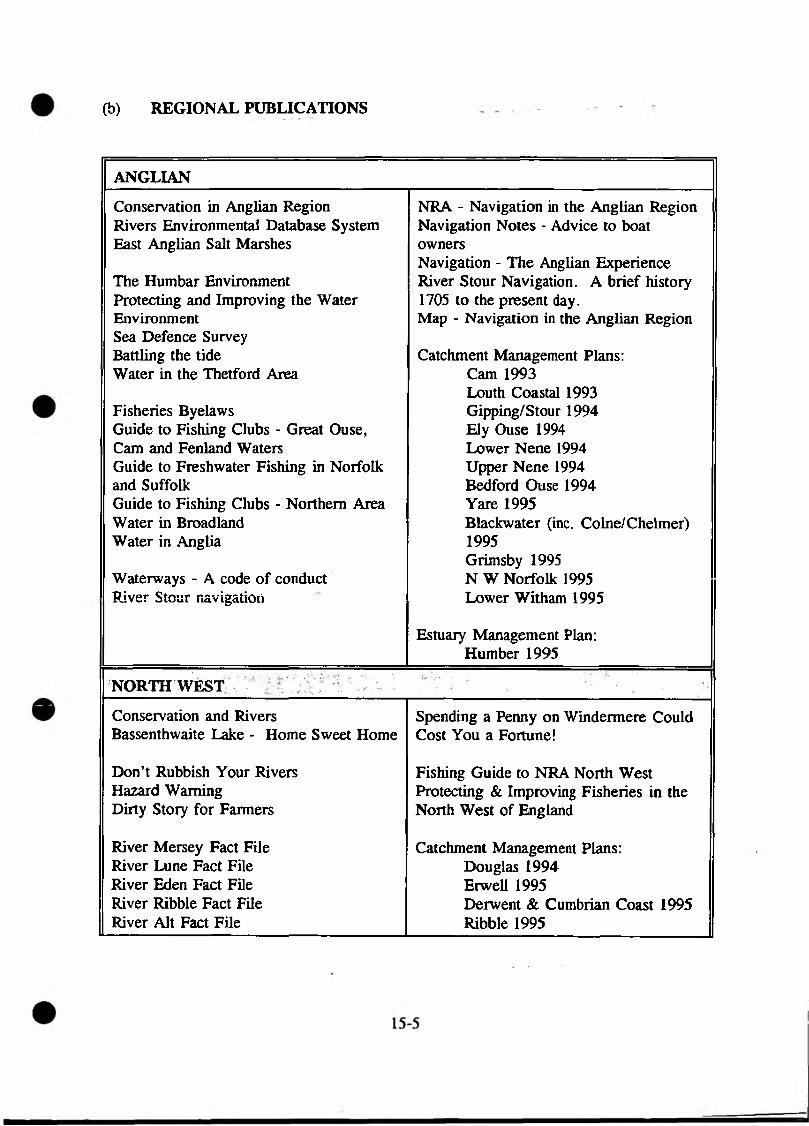
(b) REGIONAL PUBLICATIONS
ANGLIAN
Conservation in Anglian Region Rivers Environmental Database System East Anglian Salt Marshes
The Humbar EnvironmentProtecting and Improving the WaterEnvironmentSea Defence SurveyBattling the tideWater in the Thetford Area
Fisheries ByelawsGuide to Fishing Clubs - Great Ouse, Cam and Fenland Waters Guide to Freshwater Fishing in Norfolk and SuffolkGuide to Fishing Clubs - Northern Area Water in Broadland Water in Anglia
Waterways - A code of conduct River Stour navigation
NRA - Navigation in the Anglian Region Navigation Notes - Advice to boat ownersNavigation - The Anglian Experience River Stour Navigation. A brief history 1705 to the present day.Map - Navigation in the Anglian Region
Catchment Management Plans:Cam 1993 Louth Coastal 1993 Gipping/Stour 1994 Ely Ouse 1994 Lower Nene 1994 Upper Nene 1994 Bedford Ouse 1994 Yare 1995Blackwater (inc. Colne/Chelmer) 1995Grimsby 1995 N W Norfolk 1995 Lower Witham 1995
Estuary Management Plan:Humber 1995
NORTHWEST
Conservation and Rivers Bassenthwaite Lake - Home Sweet Home
Don’t Rubbish Your Rivers Hazard Warning Dirty Story for Farmers
River Mersey Fact File River Lune Fact File River Eden Fact File River Ribble Fact File River Alt Fact File
Spending a Penny on Windermere Could Cost You a Fortune!
Fishing Guide to NRA North West Protecting & Improving Fisheries in the North West of England
Catchment Management Plans:Douglas 1994 Erwell 1995Derwent & Cumbrian Coast 1995 Ribble 1995

NORTHUMBRIA & YORKSHIRE
Conservation Canoeists’ Access hotline cardWater Weed Control - take care toprotect the aquatic environment Catchment Management Plans:FWAG/NRA River Corridor Project Aire 1993Flyer Derwent 1994Pond Booklet Calder 1994Ure/Swale Conservation Documents Tees 1994Floodbanks in Flower Tyne/Ousebum 1995Farm Pollution Kills River Life Couqet 1995
Wear 1995River Wharfe Don/Rother 1995River Aire Hull & Coast 1995River Rother Ouse/Ure/Swale 1995River Don Blyth Area Coast 1995River Calder Nidd/Wharfe 1995River Deame Wansbeck 1995River Derwent Ain 1995
Angling Guide - Northumbria only Estuary Management Plan:Kielder Salmon Hatchery Humber 1995Buyer Beware Poached SalmonKeld Head hatcheryAngling Clubs in YorkshireRiver Angling in YorkshireStillwater Angling in YorkshireNRA Yorkshire’s Catch - FRCNMagazineRod Fishing Byelaws - Northumbria &Yorkshire
15-6

SEVERN-TRENT
Provision and Maintenance of Nest and Roosting Sites on River Bridges Coed Cymru and Riverside Trees Operations and Protected Species The Water Environment - Our Cultural HeritageOur Cultural Heritage ( in conjunction with English Heritage)Dredging and Archaeology River Severn Otters Project - bringing otters back to our rivers Water PlantsConservation Designations
The River Severn The Trent Aegir The Severn Bore
Navigation in the Severn-Trent Region NRA Recreation Sites
Fish and Fisheries Biology Monitoring and Control of Fish Stocks Construction and Desilting of Stillwaters Environment of Fish Fisheries Habitat Improvement Management of Specialist Stillwater Coarse FisheriesManagement of Stillwater Trout Fisheries Trout FarmingPredator and Pest Control in Fisheries Useful Information for Angling Clubs Fishing Guide 1994/95 Fishing News - magazine Angling Contest Waters
Catchment Management Plans:Stour 1993 Blythe, Cole 1994 Avon 1994Severn - upper reaches 1995 Dove 1995 Erewash 1995Severn - lower reaches 1995
15-7
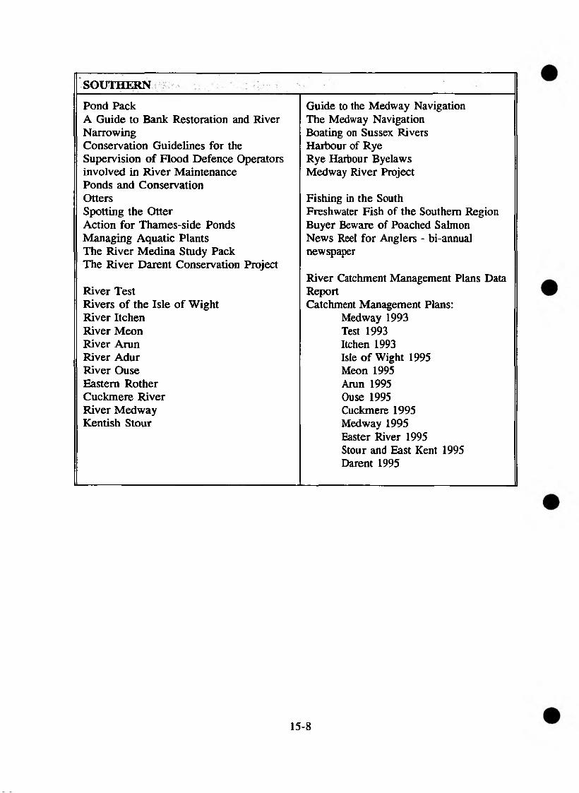
SOUTHERN
Pond PackA Guide to Bank Restoration and River NarrowingConservation Guidelines for the Supervision of Flood Defence Operators involved in River Maintenance Ponds and Conservation OttersSpotting the OtterAction for Thames-side PondsManaging Aquatic PlantsThe River Medina Study PackThe River Darent Conservation Project
River TestRivers of the Isle of WightRiver ItchenRiver MeonRiver ArunRiver AdurRiver OuseEastern RotherCuckmere RiverRiver MedwayKentish Stour
Guide to the Medway Navigation The Medway Navigation Boating on Sussex Rivers Harbour of Rye Rye Harbour Byelaws Medway River Project
Fishing in the SouthFreshwater Fish of the Southern RegionBuyer Beware of Poached SalmonNews Reel for Anglers - bi-annualnewspaper
River Catchment Management Plans Data ReportCatchment Management Plans:
Medway 1993Test 1993Itchen 1993Isle of Wight 1995Meon 1995Arun 1995Ouse 1995Cuckmere 1995Medway 1995Easter River 1995Stour and East Kent 1995Darent 1995
15-8
SOUTH WESTERN
Rivers Information - ConservationPollardingPond PackRiver Corridor SurveysWildlife Along RiversSomerset Levels and Moors Water LevelManagement and Nature ConservationSomerset Levels and Moors Water LevelManagement StrategyConservation Legislation and the Law(internal guidance)Aquatic Plans and their identification Glossary of Conservation Designations and Organisations within Wessex Region Herbicides and their use in the Wessex Region of the NRA (internal guidance) The Establishment and Management of Species of Rich Grassland Contact List of Conservation OrganisationsGeneral Advice on Timber Treatment for Wessex Region NRA Staff (internal guidance)Requirements for Breeding Waders Design of Wader Scrapes and Coastal PoolsCreation and Management of Reed Beds Otters and their Conservation
River Pack River Tone
Rivers Information - Recreation Rivers Information - River Canoeing Code
The Guide to Angling in South West England 1992/93 (published by Westcountry Tourist Board in cooperation with the NRA)Salmon/Sea Trout Fishing 1992 Fishing 1993 (North Devon)NRA Exe Fishery - fishing permit and regulationsNRA Lyn - Brown trout fishing permit and regulationsNRA Lyn - Salmon and Sea trout fishing permit and regulations Angling Guides: Avon and Dorset, Somerset, and Bristol Avon Buyer Beware Leaflet
Catchment Management Plans:Torridge 1994 Hampshire Avon 1994 Taw 1995/6 Exe 1995/96Abbey River/Clovelly Stream 1995/6Tone 1995/96 Frame & Piddle 1995/96 Pool Harbour 1995/96
Estuary Management Plan:Torridge 1994/95
THAMES
Fact File 3/7 - Conservation River Thames HandbookDredging and Archaeology Cruising on the River Thames - APinkhill Meadow Nature Reserve Boating Guide
Thames Launch Safety SpecificationRiver Blackwater Locks and Weirs on the River Thames -River Colne how do they work?River Cherwell Navigation Levels of ServiceRiver Chess Power Operation of Locks on the RiverRiver Kennet ThamesRiver Lee Enjoying the Waterside, Amenity &River Lodden recreation in the NRA Thames RegionRiver Pang The Thames Barrier, The Eigth WonderRiver Mimram of the WorldRiver Mole Thames Path - National Trail - CCRiver Ray (Wilts) Hurley WalksRiver Roding Abingdon Riverside WalkRiver Thame Annual Navigation NewsletterRiver Wey River Wye
Fact File 6/7 - Recreation
South London’s Urban Rivers Fact File 1/7 - FisheriesThe Tidal Thames Angling Guide
Fisheries Byelaws 1978Guide to River Thames - Lock and Weirfishing
Catchment Management Plans: Blackwater 1994 Kennet 1994 Chirwell 1994/95 Lower Lee 1994/95 Middle Lee, Rib, Ash & Stort 1994/95The Mole 1994/95 Upper Thame to Buscot 1994/95 Wandle, Beverley Brook & Hogsmill 1995
WELSH . . . . o, •
Conservation & Rivers 2. Spring Salmon - A review ofWater Plants - their function and control factors affecting the abundanceConservation and Recreation: The Wye and catch of spring salmon fromChallenge the river Wye and elsewhere, andGlas-y-Dorlan newspaper proposals for stock maintenance
and enhancement.Llyn Brianne Acid Water Projects 3. Resident Brown Trout - ARiver Ebbw management strategy,River Ogmore implementation and progress
report.Canoeists Guide to the River Wye 4. Welsh rivers - stocking and takingAccess on the River Usk, Sennybridge to stock - proceedings of the jointUsk NRA Welsh Region/WSTAARiver Wye Handbook seminar.River Wye Code of Conduct 5. Dee Stock Assessment AnnualCalendar of Major Events on the River Report 1992.Wye
Catchment Management Plans:Predator and Pest Control in Fisheries Safeguarding the future of yourJuvenile Salmonid Monitoring Programme rivers.ReportRewards for Tagged Fish Catchment Management Plans:Buyer Beware of Poached Salmon Conwy 1994/95Rod Fishing Byelaws Upper Wye 1995River Wye Angling Guide Ely 1995 o , . =Angling Guide for the Rivers Dee and Clwyd 1995Clwyd 1992/93 Ogmore 1995Fisheries Technical Reports: Cleddau 19951. Usk Salmon - Recommendations Tawe 1995
for Action Taf 1995Tywi 1995Wye 1995/96Dee 1995/96
Estuary Management Plan:Menai Strait 1994/95
15-11
1-5.2 Rivers. Lakes and Wetlands
Baines, C. & Smart, J. (1984). A Guide to Habitat Creation (Ecology Handbook No2). Greater London Council.
Boon, P.J. & Calow P, Petts G E (eds) (1992). River Conservation and Management. John Wiley & Sons, Chichester.
Boon, P.J. (1988). The impact of river regulation on invertebrate communities in the UK. Regulated Rivers: Research and Management 2:389-409.
British Trust for Conservation Volunteers (1981). Waterways and Wetlands: A Practical Handbook (revised edition).
Brookes, A. (1988). Channelized rivers. Perspectives for ecological management. John Wiley & Sons, Chichester.
Brooks, A. (1981). Waterways and Wetlands: A Practical Conservation Handbook. British Trust for Conservation Volunteers.
Burgess, N. D. & HIRONS, G.J.M. (1990). Techniques of Hydrological management at Coastal Lagoons and Lowland Wet Grasslands on RSPB Reserves. Management Case Study, RSPB, Sandy.
Calow, P. & Petts, G.E. (eds) (1994). The River Handbook, Volume 1 - Hydrological and Physical Chemical Characteristics. Also Volume 2 - Hydrological & Ecological Principles. Blackwell Scientific Publications.
Falconer, R.A. & Goodwin, P. (eds) (1994). Wetland Management. Proceedings of the internal conference organised by the Institution of Civil Engineers and held in London on 2-3 June 1994. Thomas Telford, London.
Gardiner, J.L. (ed) (1991). River Projects and Conservation. A Manual for Holistic Appraisal. John Wiley & Sons, Chichester
Gilman, K. (1994), Hydrology of Freshwater Wetlands. Institute of Hydrology report series, Wiley.
Green, R. E. (1986). The Management of Lowland Wet Grassland for Breeding Waders. RSPB, Sandy.
Haslam, S.M. & Wolseley, P.A. (1981). River vegetation: its identification, assessment and management. Cambridge University Press.
Hellawell, J.M. (1978). Biological Surveillance of Rivers - a Biological Monitoring Handbook. Water Research Centre, Medmenham. 332pp.
He 11awell, J.M. (1986). Biological Indicators of Freshwater Pollution and Environmental Management. Elsevier Applied Science, London and New York. 546pp.
Holmes, N. & Newbold, C. (1984). River Plant Communities - Reflectors of Water and Substrate Chemistry. Focus on Conservation No. 9 Nature Conservancy Council, UK, 73pp.
Hynes, H.B.N. (1972). The Ecology of Running Waters. University Press, Liverpool.
Institution of Water & Environmental Management (1989). Water Practice Manual No.8. Chapters 7 and 8 - Maintenance and General Operations and Nature Conservation.
Kirby, P. (1992). Habitat Management for Invertebrates: a Practical Handbook. Joint Nature Conservation Committee, Peterborough & RSPB, Sandy.
Johnson, R.R. & McCormick, J.F. (1979). Strategies for the protection and management of floodplain wetlands and other riparian ecosystems. USD A Forest Services. General Technical Report No4.wol2 Washington USA
Lewis, G. & Williams, G. (1984). Rivers and Wildlife Handbook - a guide to practices which further the conservation of wildlife on rivers. RSPB/RSNC. (A second edition is due to be published in 1993.)
Macan, T.T. (1974). Freshwater Ecology, 2nd edition. Longman, London.
Macan, T.T. & Worthington, E.B. (1974). Life in Lakes and Rivers, 3rd ed. Collins (New Naturalist Series), London.
National Research Council (1994). Restoration of Aquatic Ecosystems: Science, Technology & Public Policy. National Academic Press, Washington DC.
Nature Conservancy Council. British Red Data Book Series.
Nature Conservancy Council (1991). Nature Conservation and pollution from farm wastes.
Newbold, C. et al (1983). Nature conservation and river engineering. NCC, Peterborough.
Newbold, C. et al (1989). Nature conservation and the management of drainage channels. NCC/Association of Drainage Authorities
Probert, C. (1989). Pearls in the Landscape - the conservation and management of ponds. Farming Press Books, Ipswich.
15-13
Rowell, T.A. (1988). Peat land Management Handbook. Nature Conservancy Council, Peterborough.
RSPB/NRA/RSNC (1994). The New Rivers & Wildlife Handbook.
RSNC (1991). O tter conservation in practice. A report to WRc on behalf of the NRA.
Tickner, M.B. & Evans, C.E. (1991). The Management of Lowland Wet Grasslands on RSPB Reserves. Management Case Study, RSPB, Sandy.
Whitton, B.A. (1975) (Ed). River Ecology, Studies in Ecology, Vol 2. Blackwell Scientific Publications, London.
Whitten, A.J. (1990). Recovery: a proposed programme for Britain’s protected species. NCC CSD Report No 1089.
Wildfowl & Wetlands Trust (1994). Wetlands, Industry & Wildlife. A manual of principles and practices. ISBN 0900806 18 4.
15.3 Coastal and Marine Areas
Barnes, R.S.K. (1988). The Coastal Lagoons of Britain: an overview. Nature Conservancy Council, CSD Report, No 933
Carter, R.W.G. (1988). Coastal Environments: An Introduction to the Physical, Ecological and Cultural Systems of Coastlines. (ISBN 0 12 1618555 2.)
Countryside Commission (1991). Heritage Coast: Policies and priorities (CCP 305).
Countryside Commission (due August 1992). Gazetteer of Heritage Coasts. (Will give technical information on sites).
Countryside Commission (1992). Heritage Coast: Policies and Priorities (CCP 397).
Davidson, N.C. et al (1991). Nature Conservation and estuaries in Great Britain. NCC, Peterborough.
Davies, J., Bennett, T.L., Connor, D.W., Hiscock, K. & Mills, D.J.L. (1990). A catalogue of coastal SSSI’s with additional notes from published marine biological information. Volume 1, England. Nature Conservancy Council, CSD Report No 1022.
Davies, J. & Mills, D.J.L. (1990). A catalogue of coastal SSSI’s with additional notes from published marine biological information. Volume 3. Wales Nature Conservancy Council CSD Report No 1024.
Doody, P. (1985). Sand Dunes and their Management NCC (Focus on Nature Conservation No 13).
Downie, A.J. & Davies, L.M. (1991). Synopsis of survey data held by the Marine Nature Conservation Review: a contribution to the Great Britain Nature Conservation Resource Survey. Joint Nature Conservation Committee Report No 13.
Eno, N.C. (1992). Marine Conservation Handbook. English Nature, Peterborough.
Gubbay, S. (1988). A coastal directory for marine nature conservation. Marine Conservation Society. (Gives a provisional list of sites, to be expanded by the JNCC’s Marine Conservation Review.)
Heritage Coast Forum (1991). Heritage Coast Directory. (Details relevant contact points for liaison within each Heritage Coast site).
Hiscock, K. (1990). Marine Nature Conservation Review: methods. Nature Conservancy Council CSD Report No 1072.
Joint Nature Conservation Committee (1992). Directory of the North Sa coastal margin, (draft) 418pp.
Mason, C.F. (1983). Saltmarsh Ecology. Blackie & Sons. Glasgow (Chapman and Hall, London, distributor).
Nature Conservancy Council (1989). Legislative responsibilities in the marine environment.
Rothwell, P. & Housden, S. (1990). Turning the Tide - A Future for Estuaries. RSPB.
Sheader, M. & Sheader, A. (1989). The Coastal Saline Ponds of England and Wales: an overview. Nature Conservancy Council. CSD Report No 1009.
Smith, B.P. & Laffoley, D. (1992). A Directory of saline lagoons and lagoon like habitats in England. English Nature, Peterborough 245pp.
15.4 Landscape
Bradshaw, A.D., Goode, D.A. & Thorp, E.H.P. (1986). Ecology in Design and Landscape. Blackwell Scientific, Oxford.
British Trust for Conservation Volunteers (1992). Trees and aftercare.
Council for the Protection of Rural England (1994). Leisure Landscapes. Leisure, culture and the English Countryside: challenges and conflicts.
Countryside Commission (1983). Areas of Outstanding Natural Beauty: a policy statement.
Country Commission (198*). Landscape appraisal in the water industry.
Countryside Commission (1987). Landscape assessment: A Countryside Commission approach (CCD 18).
Countryside Commission (1987). Changing river landscapes: a study of river valley landscapes (CCP 238).
Countryside Commission (1988). The water industry in the countryside (CCP 239).
Countryside Commission (1989). Directory of Areas of Outstanding Natural Beauty.
Countryside Commission (1991). The Treatment of Landscape and Countryside Recreation Issues. CCP 326. ISBN 0 86170 271 9. . .
Countryside Commission (1992). Protected landscapes in the UK (CCP 362). (Details all Heritage Coasts, National Parks, AONBs)
Countryside Commission (1993). Landscape Assessment Guidance.
Countryside Commission (1994). The New Map of England - A Celebration of the South Western Landscapes. Countryside Commission, Cheltenham ccp 444.
English Nature (1993). Strategy for the 1990s: Natural Areas; Setting Nature Conservation Objectives. Consultation Paper. English Nature, Peterborough.
New Map Consortium (1993/94). New Map of England - Pilot Project. Technical Reports I, 2 and 3. Countryside Commission, Cheltenham.
15.5 Geology and Geomorphologv
Brookes, A. (1988). Channelised Rivers: Perspectives for Environmental Management. John Wiley & Sons, Chichester. 326pp
Nature Conservancy Council (1990). Earth science conservation in Great Britain. A strategy. (Appendices bound separately as: ’A handbook of earth science conservation techniques’.)
Newson, M.D. (1986). River basin engineering - fluvial geomorphology. Journal of the Institution of Water Engineers and Scientists. 40:307-324.
Newson, M.D. (1992b). River conservation and catchment management: a UK perspective. In P.J. Boon, P. Calow & G.E. Petts (eds), River Conservation and Management. John Wiley & Sons, Chichester. pp385-406.
15.6 Plants
DoE (1987). Methods for the Use of Aquatic Macrophytes for Assessing Water Quality 1985086. Methods for the Examination of Waters and Associated Materials. HMSO, London.
Haslam, S.M. (1978). River Plants: the Microphytic Vegetation of Watercourses.Cambridge University Press.
Haslam, S.M. (1981). River Vegetation: its Identification, Assessment and Management. A Field Guide to the Microphytic Vegetation of British Watercourses.Cambridge University Press.
Haslam, S.M. (1982). Vegetation in British Rivers. 2 Vols. Nature Conservancy Council, London.
Holmes, N.T.H. (1983). Typing Rivers According to their Microphytic Flora. Focus on Nature Conservation No.4 NCC, Peterborough.
Holmes, N.T.H. (1990). British Rivers, A Working Classification. British Wildlife. BW Publishing, Rotharweek, Hants.
Keebler Martin. Concise British Flora in Colour.
Kent, D.H. List of Vascular Plants of the British Isles. Botanical Society of the British Isles, London 1992. • ’ ' °
Page, C.N. (1982). The Ferns of Britain and Ireland. Cambridge University Press, Cambridge.
Palmer, M. & Newbold, C. (1983). Wetland and Riparian Plants in Great Britain. An assessment of their Status and Distribution in Relation to Water Authority, River Purification Board and Scottish Islands Areas. Focus on Nature Conservation No. 1 NCC, Peterborough.
Pening, F.H. & Farrell, L. (1977). British Red Data Book, 1. Vascular Plants. Society for the Promotion of Nature Conservation, Lincoln. 2nd ed. (1983).
Rich, T.C.G. (1991). Crucifers of Great Britain and Ireland. Botanical Society of the British Isles, London.
Slater, F.M., Curry, P. & Chadwell, C. (1987). A Practical approach to the evaluation of the conservation status of vegetation in river corridors in Wales, UK. Biological Conservation 40(1), pp 53-68.

Tutin, T.G. et al (eds) (1964-1980). Flora Europaea, 1-5. Cambridge University Press, Cambridge.
15-20
L

15.7 Animals
Armitage, P.D., Gunn, RJ.M ., Furse, M.T., Wright, J.F. & Moss, D. (1987). The use of Predation to Assess Macro-invertebrate Response to River Regulation.Hydrobiologia 144: 25-32.
Birks, J. (1990). Feral Mink and Nature Conservation. British Wildlife, 1(6), 313-323.
British Dragonfly Society (1992). Dig a pond for dragonflies. BDS:
British Dragonfly Society (1993). Managing habitats for dragonflies. BDS.
Corbet, G.B. & Harris S (1991). The Handbook of British Mammals. Blackwell Scientific Publications, London. 2nd ed.
Dunstone, N. (1993). The Mink. Poyser.
English Nature 1991/92/93. Facts about amphibians. Peterborough.
English Nature 1991/92/93. Facts about Great Crested Newts. Peterborough.
English Nature 1991/92/93. Facts about reptiles. Peterborough.
Eaton, J.W., Best, M. A., Staples, J. A. & O’Hara, K. (1992). Grass Carp for Aquatic Weed Control - a User’s Manual. R & D . Note 53. National Rivers Authority, Bristol.
Fraser, D. (1993). British Reptiles and Amphibians in Britain. Collins New Naturalist No. 69, London.
Hammond, C.O. (1983). The Dragonflies of Great Britain & Ireland, 2nd ed. Harley Books, Colchester.
MAFF (1984). Fish Pass Design-criteria for the design and approval of fish passes and other structures to facilitate the passage of migratory fish species in rivers.Fisheries Research Technical Report. No 78.
Macan, T.T. (1959). A Guide to Freshwater Invertebrate Animals. Longman, London.
Maitland, P.S. & Campbell, R.N. (1992). Freshwater Fishes. Collins New Naturalist, No. 75, London.
Mason, C.F. & MacDonald, S.M. (1986). Otters: Ecology and Conservation. CUP.
Moss, D., Furse, M. T., Wright, J. F. & Armitage, P.D. (1987). The prediction of the macro-invertebrate fauna of unpolluted running-water sites in great britain using environmental data. Freshwater Biology 18(l):41-52.
Nature Conservancy Council (1980). The conservation of dragonflies. NCC, Peterborough.
Nature Conservancy Council (1989). Guidelines for the selection of biological SSSIs. NCC, Peterborough.
Nature Conservancy Council (1990). Protecting Internationally Important Bird Sites. NCC.
Owen, M., Atkinson-Willis G.L. & Salmon, D.G. (1986). Wildfowl in Great Britain. Cambridge University Press, Cambridge.
RSNC (1980). Focus on otters - a guide to their natural history and conservation. RSNC.
Sargent, G. (1991). The importance of riverine habitats to bats in County Durham. MSc, University of Durham.
Smith, H. & Drewry, I. (1990). Other conservation in practice. A report to the Water Research Centre.
Stebbings, R. E. & Jefferies, D.J. (1982). Focus on bats: their conservation and the law. Nature Conservancy Council, Peterborough.
Strachan, R. & D.J. Jefferies (1993). The Water Vole Arvicola terrestris in Britain 1989-1990: its distribution and changing status. Vincent Wildlife Trust, 136pp.
Taylor, K. (1982). Waterway, Bird Survey Instructions. British Trust for Ornithology, Tring.
Wright, J.F., Moss, D., Armitage, P.D. & Furse, M.T. (1984). A preliminary classification of running-water sites in Great Britain Based on macro-invertebrate species and the predition of community type using environmental data. Freshwater Biology 14:221-256.
Wright, J.F., Blackburn, J.H., Westlake, D.F., Furse, M.T & Armitage, P.D. (1991). Anticipating the consequences of river management for the conservation of macroinvertebrates. In: River Conservation and Management. P Boon, G Petts and P Calow (eds). John Wiley & Sons Ltd.
Zedja, J. & Zapletel, M. (1969). Habitat requirements of the water vole (Arvicola terrestris Linn). Zoologicke Listy 18(3):225-238.
1-5.8 Environmental Impacts
Boon, P.J. (1991). Environmental impact assessment and the water industry: implications for nature conservation. Journal of the Institute of Water & Environmental Management 5, 194-205.
Boon, P.J. (1988). The impact of river regulation on invertebrate communities in the UK. Regulated Rivers: Research and Management 2:389-409.
Brooker, M.P. (1974). The risk of deoxygenation of water in herbicide applications for aquatic weed control. Journal of the Institute of Water Engineers 28:206-210.
Brooker, M.P. (1975). The ecological effects of the use of aquatic herbicides in Essex. Surveyor 145:25-27.
English Nature (1994). Nature Conservation Guidelines for Renewable Energy Projects.
English Nature (1994). Nature Conservation in Environmental Assessment.
English Nature (1994). Roads and Nature Conservation. Guidance on impacts, mitigation and enhancement.
Hynes, H.B.N. (1960). The Biology of Polluted Waters. University Press, Liverpool, pp 202.
Institute of Environmental Assessment (1993). Guidelines to the Ecological input to Environmental assessments in the UK. (In draft.)
Newbold, C. (1976). Herbicides in aquatic systems. Biological Conservation 7:97-118.
Pearson, R.G. & Jones, N.V. (1975). The effects of dredging operations on the benthic community of a chalk stream. Biological Conservation 8:273-278.
Pearson, R.G. & Jones, N.V. (1978). The effects of weed-cutting on the macroinvertebrate fauna of a canalised section of the river Hull, a northern English chalk stream. Journal of Environmental Management 7:91-97.
Petts, G.E. & Armitage, P.D. (1991). The Effects of abstractions from rivers on benthic macro-invertebrates. Report produced for the Nature Conservancy Council.
1-5.9 River rehabilitation
Brookes, A. (1987). Restoring the sinuosity of artificially straightened stream channels. Environmental Geology and Water Science. 10:33-41
Brookes, A. (1990). Restoration and enhancement of engineered river channels: some European experiences. Regulated River: Research and Management. 5:45-56.
Brookes, A. (1992b). Recovery and restoration of some engineered British River Channels. In P.J. Boon, P. Calow & G.E. Petts (eds) River Conservation and Management, John Wiley & Son, Chichester. 337*352.
Gore, J.A. (1985) (Ed). The Restoration of Rivers and Streams: Theories and Experience. Butterworth, An Ann Arbor Science Book.
Swales, S. (1989). The use of in-stream habitat methodology in mitigating the adverse effects of river regulation on fisheries. In: Gore, A.J. & Petts, G.E. (eds). Alternatives in Regulated River Management.

15.10 Planning
English Heritage et al. (1993). Conservation Issues in Strategic Plans. CCP 420. EN/EN/CC.
Slater, S. et al. (1993). Landuse Planning and the Water Sector: A Review of Development Plans and Catchment Management Plans. Working paper No. 24. Department of Town & Country Planning, University of Newcastle-Upon-Tyne
1-5.11 Biodiversity and sustainability
DoE (1993). Agenda 21 Document - Action Plan for the Next Century. HMSO.
DoE, RSNC, RSPB, WWF and Plantlife (1994). Butterfly Conservation. Biodiversity challenge: an agenda for conservation action in the UK. RSPB.
DoE (1994). Biodiversity: The Action Plan. London, HMSO.
DoE (1994). Sustainable Development - the UK Strategy. CM 2426. HMSO.
Friends of the Earth (1993). Nothing Ventured Nothing Gained. FoE’s response to the draft UK Strategy for Sustainable Development. ° Friends of the Earth, London.
o
Coles, J.M. 1986. In Situ Archaeological Conservation, 32-55. "The preservation of archaeological sites by environmental intervention". H Hodges (ed).
Coles, J. M. & Goodbum, D.M. (eds), 1991. Wet Site Excavation and Survey. WARP occ. pap. 5.
Darvil], T. (1987). Ancient monuments in the countryside - an archaeological management review. English Heritage Archaeological Report 5.
Frere, S.S. & St Joseph, J.K. (1983). Roman Britain from the air. Cambridge University Press.
Riley, D. (1987). Air photography and archaeology. Duckworth.
Wilson, D.R. (1982). Air photo interpretation for the archaeologist. Batsford.
1-5.12 Archaeology
15-27
V
1-5.13 General
Nature Conservancy Council (1984). Nature Conservation in Great Britain.
Cowell, S. (1991). Who’s Who in the Environment - Wales. The Environment Council. (Addresses and telephone numbers of conservation organisations.)
Cowell, S. et al (1992). Who’s Who in the Environment - England. The Environment Council Information Programme. (Addresses and telephone numbers of conservation organisations.)
Pritchard, D.E., Housden, S.D., Mudge, G.P., Galbrath, C.A. & Pienkowski, M.W., (eds) (1991). Important Bird Areas in the UK including the Channel Islands and the Isle of Man. Published by RSPB. (Important Bird Areas includes sites designated or identified for designation as special Protection Areas under European Community Directive 79/409 on the Conservation of Wild Birds. Many of these will also be designated or candidate Wetlands of International Importance under the Ramsar Convention. They are given effect through sympathetic land management, with core areas notified as Sites of Special Scientific Interest.)
Ratcliffe, D.A. (1977). A Nature Conservation Review. Cambridge University Press.2 volumes.
Royal Commission on Environmental Pollution (1991). Freshwater Quality HMSO, London.
15-28

16.1 THE NRA’S RESEARCH & DEVELOPMENT PROGRAMME 1989-1994
16. R & D _ _ _
insert to follow
16-1


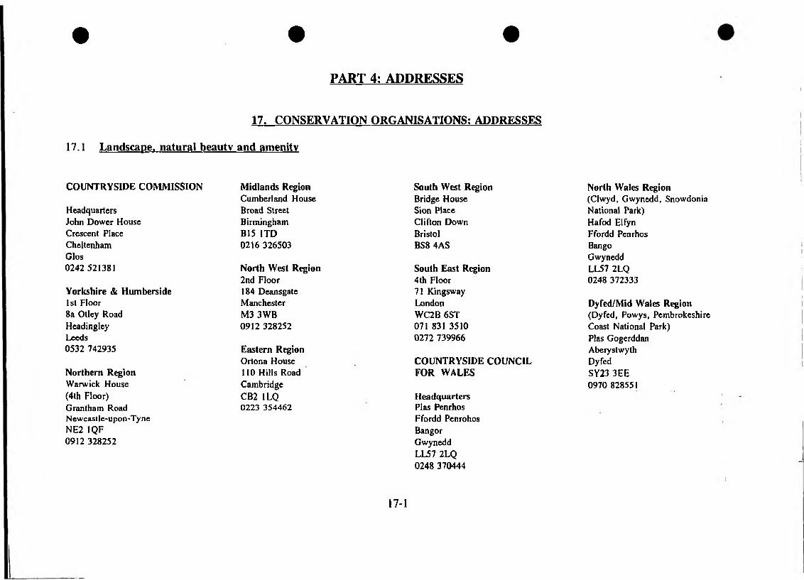
• • •
PART 4: ADDRESSES
17. CONSERVATION ORGANISATIONS: ADDRESSES
17.1 Landscape, natural beauty and amenity
COUNTRYSIDE COMMISSION Midlands Region South West RegionCumberland House Bridge House
Headquarters Broad Street Sion PlaceJohn Dower House Birmingham Clifton DownCrescent Place B15 1TD BristolCheltenham 0216 326503 BS8 4ASGlos0242 521381 North West Region South East Region
2nd Floor 4th FloorYorkshire & Humberside 184 Deansgate 71 Kingsway1st Floor Manchester London8a Otley Road M3 3WB WC2B 6STHeadingley 0912 328252 071 831 3510Leeds 0272 7399660532 742935 Eastern Region
Ortona House COUNTRYSIDE COUNCILNorthern Region 110 Hills Road FOR WALESWarwick House Cambridge(4th Floor) CB2 1LQ HeadquartersGrantham Road 0223 354462 Plas PenrhosNewcastle-upon-Tyne Ffordd PenrohosNE2 1QF Bangor0912 328252 Gwynedd
LL57 2LQ 0248 370444
North Wales Region (Clwyd, Gwynedd, Snowdonia National Park)Hafod Elfyn Ffordd Penrhos Bango Gwynedd LL57 2LQ 0248 372333
Dyfed/Mid Wales Region (Dyfed, Powys, Pembrokeshire Coast National Park)Plas Gogerddan Aberystwyth Dyfed SY23 3EE 0970 828551
17-1
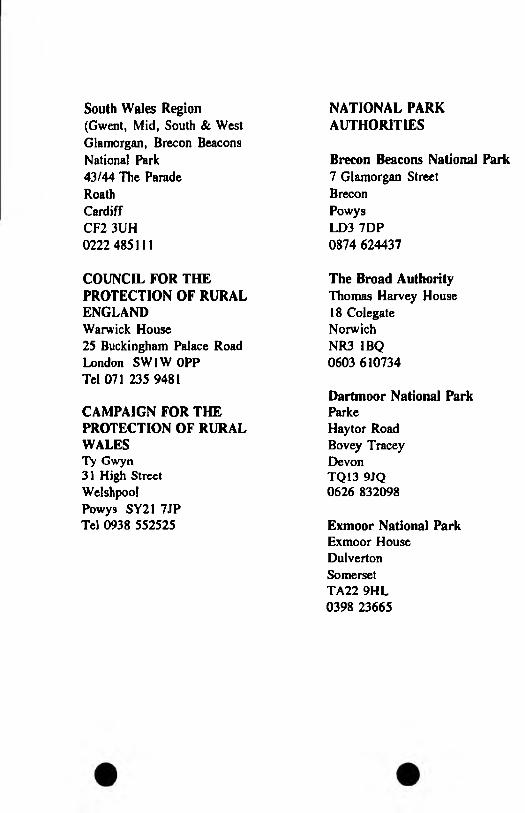
South Wales Region(Gwent, Mid, South & WestGlamorgan, Brecon BeaconsNational Park43/44 The ParadeRoathCardiffCF2 3UH0222 485111
COUNCIL FOR THE PROTECTION OF RURAL ENGLAND Warwick House 25 Buckingham Palace Road London SW1W OPP Tel 071 235 9481
CAMPAIGN FOR THE PROTECTION OF RURAL WALESTy Gwyn31 High Street Welshpool Powys SY21 7JP Tel 0938 552525
NATIONAL PARK AUTHORITIES
Brecon Beacons National Park7 Glamorgan StreetBreconPowysLD3 7DP0874 624437
The Broad AuthorityThomas Harvey House18 Colegate Norwich NR3 1BQ 0603 610734
Dartmoor National Park ParkeHaytor Road Bovey Tracey Devon TQ13 9JQ 0626 832098
Exmoor National ParkExmoor House Dulverton Somerset TA22 9HL 0398 23665
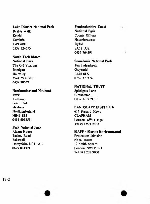
Lake District National ParkBusher WalkKendalCumbriaLA9 4RH0539 724555
North York Moors National ParkThe Old Vicarage Bondgate Helmsley York Y06 5BP 0439 70657
Northumberland National ParkEastbum South Park Hexham Northumberland NE46 IBS 0434 605555
Peak National ParkAldem House Baslow Road BakewellDerbyshire DE4 1AE 0629 814321
Pembrokeshire Coast National ParkCounty Offices Haverfordwest Dyfed SA61 1QZ 0437 764591
Snowdonia National ParkPenrhydeudraeth Gwynedd LL48 6LS 0766 770274
NATIONAL TRUST Spitalgate Lane Cirencester Glos GL7 2DE
LANDSCAPE INSTITUTE 617 Barnard Mews CLAPHAM London SW11 1QU Tel 071 976 6433
MAFF - Marine Environmental Protection DivisionNobel House 17 Smith Square London SW1P 3RJ Tel 071 238 3000
17-2
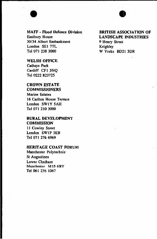
MAFF - Flood Defence DivisionEastbury House30/34 Albert EmbankmentLondon SE1 7TLTel 071 238 3000
WELSH OFFICE Cathays Park Cardiff CF1 3NQ Tel 0222 823725
CROWN ESTATE COMMISSIONERSMarine Estates 16 Carlton House Terrace London SW1Y 5 AH Tel 071 210 3000
RURAL DEVELOPMENT COMMISSION11 Cowley Street London SW1P 3EB Tel 071 276 6969
HERITAGE COAST FORUM Manchester Polytechnic St Augustines Lower Chatham Manchester M15 6BY Tel 061 236 1067
BRITISH ASSOCIATION OF LANDSCAPE INDUSTRIES9 Henry Street KeighleyW Yorks BD21 3DR

17-3

17.2 NATURE CONSERVATION
ENGLISH NATURE Headquarters Northminster House PeterboroughCambridgeshire PEI 1UA Tel 0733 340345
English Nature: Regional Offices
EAST REGION(Beds, Cambs, Essex, Herts,Leics, Lines, Norfolk, Notts, Northants, Suffolk)Ham Lane Orton Waterville PeterboroughCambridgeshire PE2 6UR Tel 0733 391100
NORTH EAST REGION (Cleveland, Durham, Humberside, North Yorks, North York Moors National Park, Yorkshire Dales National Park, Northumberland, Tyne and Wear)Archbold House Archbold Terrace Newcastle upon Tyne NE2 1 EG Tel 0912 816316/7
NORTH WEST REGION (Cumbria, Greater Manchester, Lancs, Lake District National Park, Merseyside, South Yorks, West Yorks)BlackwellBowness-on-Windermere Cumbria LA23 3JR Tel 0539 454286
SOUTHERN REGION (Berks, Bucks, Hants, Isle of Wight, Oxon, Wilts)Foxhold House Thomfold Road Crookham Common Newbury Berks RG1 8EL Tel 0635 268881
SOUTH EAST REGION (East Sussex, Greater London, Kent, Surrey, West Sussex)The Countryside Management CentreCold Harbour FarmWyeAshfordKent TN25 5DB Tel 0233 812525
SOUTH WEST REGION(Avon, Cornwall, Devon,Dartmoor National Park, Dorset,Isles of Scilly, Somerset)RoughmoorBishop's HullTauntonSomerset TA1 5AA Tel 0823 283211
WEST MIDLANDS REGION (Cheshire, Derbyshire, Glos, Hereford & Worcs, Peak District National Park, Shropshire, Staffs, Warwickshire, West Midlands) Attingham Park Shrewsbury Shropshire SY4 4TW Tel 0743 77611
COUNTRYSIDE COUNCIL FOR WALES (see 17-1)
JOINT NATURECONSERVATIONCOMMITTEEMonkstone House City Road Peterborough Cambridgeshire PEI 1JY Tel 0733 62626
ROYAL SOCIETY FOR THE PROTECTION OF BIRDSHeadquarters The Lodge SandyBeds SG19 2DL Tel 0767 680551
Royal Society for the Protection of Birds: Regional Offices
EAST ANGUA 97 Yarmouth Road Thorpe St Andrew Norwich NR7 0HF Tel 0603 700880
EAST MIDLANDS The LawnUnion Road Lincoln LN1 3BU Tel 0522 535596
MIDLANDS 44 Friar Street Droitwich Spa Worcs WR9 8ED Tel 0905 770581
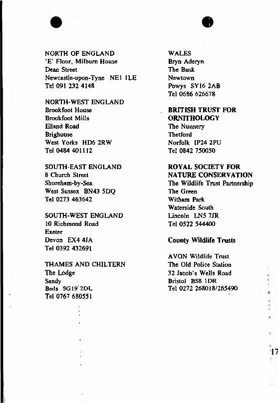
NORTH OF ENGLAND ’E’ Floor, Milbum House Dean StreetNewcastle-upon-Tyne NE1 1LE Tel 091 232 4148
NORTH-WEST ENGLAND Brook foot House Brookfoot Mills Elland Road BrighouseWest Yorks HD6 2RW Tel 0484 401112
SOUTH-EAST ENGLAND8 Church Street Shoreham-by-Sea West Sussex BN43 5DQ Tel 0273 463642
SOUTH-WEST ENGLAND10 Richmond Road ExeterDevon EX4 4JA Tel 0392 432691
THAMES AND CHILTERNThe LodgeSandyBeds SG19 2DL Tel 0767 680551
WALES Biyn Aderyn The Bank Newtown Powys SY16 2AB Tel 0686 626678
BRITISH TRUST FOR ORNITHOLOGYThe Nunnery ThetfordNorfolk IP24 2PU Tel 0842 750050
ROYAL SOCIETY FOR NATURE CONSERVATION The Wildlife Trust Partnership The Green Witham Park Waterside South Lincoln LN5 7JR Tel 0522 544400
County Wildlife Trusts
AVON Wildlife Trust The Old Police Station32 Jacob’s Wells Road Bristol BS8 1DR Tel 0272 268018/265490
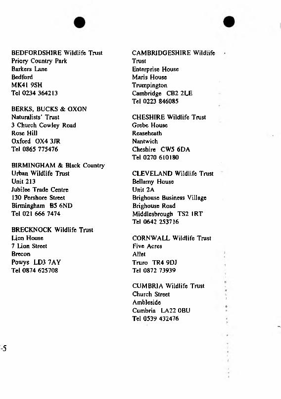
BEDFORDSHIRE Wildlife TrustPriory Country ParkBarkers LaneBedfordMK41 9SHTel 0234 364213
BERKS, BUCKS & OXON Naturalists' Trust3 Church Cowley Road Rose Hill Oxford 0X4 3JR Tel 0865 775476
BIRMINGHAM & Black Countiy Urban Wildlife Trust Unit 213Jubilee Trade Centre 130 Pershore Street Birmingham B5 6ND Tel 021 666 7474
BRECKNOCK Wildlife Trust Lion House 7 Lion Street BreconPowys LD3 7AY Tel 0874 625708
CAMBRIDGESHIRE Wildlife TrustEnterprise House Maris House Trumpington Cambridge CB2 2LE Tel 0223 846085
CHESHIRE Wildlife Trust Grebe House Reaseheath NantwichCheshire CW5 6DA Tel 0270 610180
CLEVELAND Wildlife Trust Bellamy House Unit 2ABrighouse Business Village Brighouse Road Middlesbrough TS2 IRT Tel 0642 253716
CORNWALL Wildlife TrustFive AcresAlletTruro TR4 9DJ Tel 0872 73939
CUMBRIA Wildlife Trust Church Street AmblesideCumbria LA 22 OBU Tel 0539 432476
-5

DERBYSHIRE Wildlife Trust Elvaston Castle Country Park Derby DE7 3EP Tel 0332 756610
DEVON Wildlife Trust 188 Sidwell Street ExeterDevon EX4 6RD Tel 0392 79244
DORSET Trust for Nature Conservation Half Moon House15 North Square Dorchester DTI 1HY Tel 0305 264620
DURHAM Wildlife Trust Low Barns Nature Reserve Witton-le-Wear Nr Bishop Auckland Co Durham DL14 0AG Tel 0388 88728
DYFED Wildlife Trust7 Market Street Haverfordwest Dyfed SA61 INF Tel 0437 765462
ESSEX Wildlife TrustFingringhoe Wick Nature ReserveFingringhoeColchesterEssex C05 7DNTel 0206 729678
GLAMORGAN Wildlife Trust Nature Centre Fountain Road TonduMid Glamorgan CF32 0EH Tel 0656 724100
GLOUCESTERSHIRE Wildlife TrustDulverton Building Robinswood Hill Country Park Reservoir Road Gloucester GL4 9SX Tel 0452 383333
GWENT Wildlife Trust16 White Swan Court Church Street Monmouth Gwent NP5 3BR Tel 0600 715501
HANTS & ISLE OF WIGHT Wildlife Trust71 Tlie Hundred RomseyHants S05 8BZ Tel 0794 513786
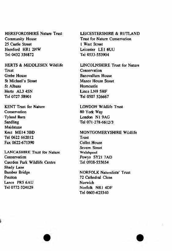
HEREFORDSHIRE Nature Trust Community House 25 Castle Street Hereford HR1 2NW Tel 0432 356872
HERTS & MIDDLESEX Wildlife TrustGrebe House St Michael’s Street St Albans Herts AL3 4SN Tel 0727 58901
KENT Trust for NatureConservationTyland BarnSandlingMaidstoneKent ME14 3BDTel 0622 662012Fax 0622-671390
LANCASHIRE Trust for Nature ConservationCuerden Park Wildlife Centre Shady Lane Bamber Bridge PrestonLancs PR5 6AU Tel 0772-324129
LEICESTERSHIRE & RUTLAND Trust for Nature Conservation 1 West Street Leicester LEI 6UU Tel 0533-553904
UNCOLNSHIRE Trust for NatureConservationBanovallum HouseManor House StreetHomcastleLines LN9 5HFTel 0507 526667
LONDON Wildlife Trust 80 York Way London N1 9AG Tel 071-278-6612/3
MONTGOMERYSHIRE Wildlife TrustCollot House Severn Street W elshpool Powys SY21 7AD Tel 0938-555654
NORFOLK Naturalists' Trust72 Cathedral Close NorwichNorfolk NR1 4DF Tel 0603-625540
NORTHAMPTONSHIRE Wildlife TrustLings House Billing Lings Northampton NN3 4BE Tel 0604-405285
NORTHUMBERLAND Wildlife TrustHancock Museum Barras BridgeNewcastle-upon-Tyne NE2 4PT Tel 091-232-0038
NORTH WALES Wildlife Trust '376 High StreetBangorGwynedd LL57 1YE Tel 0248 351541
NOTTINGHAMSHIRE Wildlife Trust310 Sneinton Dale Nottingham NG3 7DN Tel 0602 588242
RADNORSHIRE Wildlife Trust1 Gwalia AnnexeIthon RoadLlandrindod WellsPowys LD1 6ASTel 0597 823298
SHROPSHIRE Wildlife Trust 167 Frankwell Shrewsbury Shropshire SY3 8LG Tel 0743 241691
SOMERSET Wildlife TrustFyne CourtBroomfieldBridgwaterSomerset TA5 2EQTel 0823 451587/8
STAFFORDSHIRE Wildlife TrustCoutts HouseSandonStaffs ST18 0DN Tel 0889 7534
SUFFOLK Wildlife TrustBrooke HouseThe GreenAshbockingNr IpswichSuffolkIP6 9JYTel 0473 890089
SURREY Wildlife Trust Powell Corderoy Annexe Longfield Road DorkingSurrey RH4 3DF Tel 0306 743404
SUSSEX Wildlife Trust Woods Mill Shoreham Road HenfieldWest Sussex BN5 9SD Tel 0273 492630
WARWICKSHIRE Nature Conservation Trust Brandon Marsh Nature Centre Brandon Lane Coventry CV3 3GW Tel 0203 302912
WILTSHIRE Wildlife Trust19 High StreetDevizesWiltshire SN10 1AT Tel 0380 725670
WORCESTERSHIRE Nature Conservation Trust Lower Smite Farm Smite Hill HindlipWorcs WR3 8SZ Tel 0905 754919
YORKSHIRE Wildlife Trust 10 Toft Green York YOl IJT Tel 0904 659570
BIOLOGICAL RECORDS CENTRENERC Institute of Terrestrial EcologyMonks Wood Experimental StationAbbots RiptonHuntingdonCambs PE17 2LSTel 0487 3381
Local Biological Records Centres
Bedfordshire Biological Records, CentreBedford Museum Castle Lane Bedford MK40 3KD Tel 0234 353323
Bedfordshire Wildlife TrustPriory Country ParkBarkers LaneBedfordMK41 9SHTel 0234 364213
Berkshire Biological Records ? CentreReading Museum and Art Gallery Blag rave StreetReading RG1 1QH ;;Tel 0734 55911 ext 2242 >
Bolton Environmental Records CentreBolton Museum and Art GalleryLe Mans CrescentBoltonLancs BLI 1SE Tel 0204 22311 ext 379
Bristol Regional Environmental Records CentreCity of Bristol Museum and ArtGalleryQueens RoadBristol BS8 1RLTel 0272 295771 ext 215
Buckinghamshire Environmental Records CentreBuckinghamshire County MuseumChurch StreetAylesburyBucks HP20 2QPTel 0296 88849
Cambridgeshire Wildlife TrustEnterprise HouseMaris LaneTrumpingtonCambridgeCB2 2LE
Colchester and Essex Museum Museum Resource Centre14 Ryegate Road Colchester Essex COl 2YW Tel 0206 712481
Cornish Biological Records UnitTrevithick CentreTrevenson RoadPoolRedruthCornwall TR15 3 PL Tel 0209 710424
Derby Museum and Art GalleryDepartment of Natural HistoryThe StrandDerby DEI IBSTel 0332 31111 ext 782
Doncaster Biological Records CentreDoncaster Museum and Art Gallery Chequer Road Doncaster DW1 2AE Tel 0302 734287
Tel 0223 846085
Dorset Environmental Records CentreCoiliton House Annexe Glyde Path Road Dorchester Dorset DTI 1XJ Tel 0305 20428
Epping Forest Conservation CentreHigh BeachLoughtonEssex IC10 3AFTel 081 508 7714
Essex Biological Records CentrePassmore Edwards MuseumMuseum Nature ReserveNorman RoadEast HamLondon E6 4HNTel 081 470 4525
Exeter Biological Records Centre Royal Albert Memorial Museum Queen Street Exeter EX4 3RX Tel 0392 56724
Gloucestershire Trust for NatureConservationChurch HouseStandishStonehouseGloucester GL10 3EU Tel 0453 822761
Gwent Biological Records Centre Newport Museum and Art Gallery John Frost Square NewportGwent NP9 1HZ Tel 0633 840064
Hampshire County Museum ServiceNew Chilcomb House Chilcomb Lane Bar End WinchesterHampshire S023 8RD Tel 0962 66242
Hancock Museum The UniversityNewcastle-upon-Tyne NE2 4PT Tel 0912 322359
Local Biological Records Centrescont.
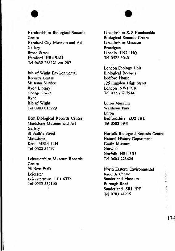
Herefordshire Biological Records CentreHereford City Museum and ArtGalleryBroad StreetHereford HR4 9AUTel 0432 268121 ext 207
Isle of Wight EnvironmentalRecords CentreMuseum ServiceRyde LibraryGeorge StreetRydeIsle of Wight Tel 0983 615229
Kent Biological Records Centre Maidstone Museum and Art GallerySt Faith's Street Maidstone Kent MEM 1LH Tel 0622 54497
Leicestershire Museum Records Centre96 New Walk LeicesterLeicestershire LE1 6TD Tel 0533 55,4100
Lincolnshire & S Humberside Biological Records Centre Lincolnshire Museum Broadgate Lincoln LN2 1HQ Tel 0522 30401
London Ecology Unit Biological Records Bedford House 125 Camden High Street London NW1 7JR Tel 071 267 7944
Luton Museum Wardown Park LutonBedfordshire LU2 7HL Tel 0582 3941
Norfolk Biological Records Centre Natural Histoty Department Castle Museum NorwichNorfolk NR1 3JU Tel 0603 223624
North Eastern Environmental Records Centre Sunderland Museum Borough Road Sunderland SRI 1PF Tel 0783 41235
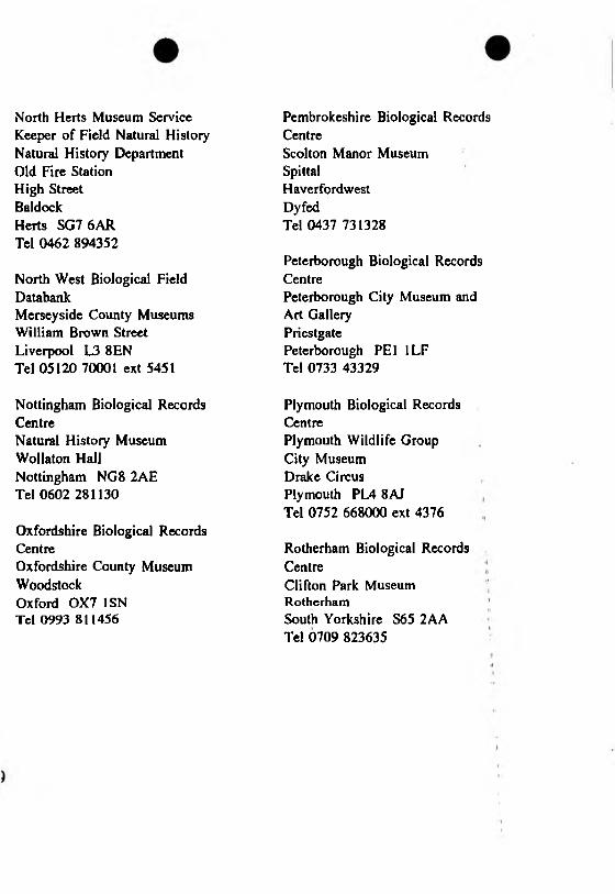
North Herts Museum Service Keeper of Field Natural History Natural History Department Old Fire Station High Street BaldockHerts SG7 6AR Tel 0462 894352
North West Biological Field DatabankMerseyside County Museums William Brown Street Liverpool L3 8EN Tel 05120 70001 ext 5451
Nottingham Biological Records CentreNatural History Museum Wollaton Hall Nottingham NG8 2AE Tel 0602 281130
Oxfordshire Biological Records CentreOxfordshire County Museum Woodstock Oxford OX7 1SN Tel 0993 811456
Pembrokeshire Biological Records CentreScolton Manor Museum SpittalHaverfordwestDyfedTel 0437 731328
Peterborough Biological Records CentrePeterborough City Museum andArt GalleryPriestgatePeterborough PEI ILF Tel 0733 43329
Plymouth Biological Records CentrePlymouth Wildlife Group City Museum Drake Circus Plymouth PL4 8AJ Tel 0752 668000 ext 4376
Rotherham Biological Records CentreClifton Park Museum RotherhamSouth Yorkshire S65 2AA Tel 0709 823635
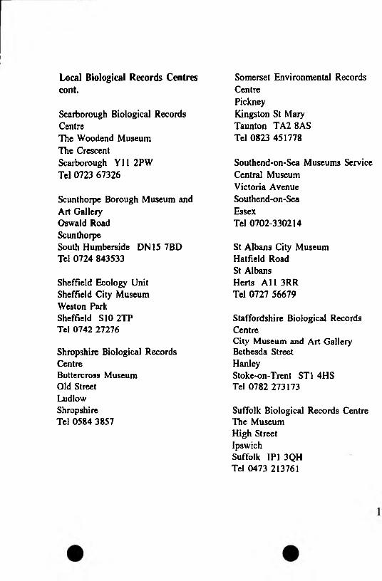
Scarborough Biological Records CentreThe Woodend Museum The Crescent Scarborough Y112PW Tel 0723 67326
Scunthorpe Borough Museum and Art Gallery Oswald Road ScunthorpeSouth Humberside DN15 7BD Tel 0724 843533
Sheffield Ecology Unit Sheffield City Museum Weston Park Sheffield S10 2TP Tel 0742 27276
Shropshire Biological Records CentreButtercross Museum Old Street Ludlow Shropshire Tel 0584 3857
Local Biological Records Centrescont.
Somerset Environmental RecordsCentrePickneyKingston St Mary Taunton TA2 8AS Tel 0823 451778
Southend-on-Sea Museums ServiceCentral MuseumVictoria AvenueSouthend-on-SeaEssexTel 0702-330214
St Albans City Museum Hatfield Road St Albans Herts Al 1 3RR Tel 0727 56679
Staffordshire Biological Records CentreCity Museum and Art GalleryBethesda StreetHanleyStoke-on-Trent ST1 4HS Tel 0782 273173
Suffolk Biological Records Centre The Museum High Street IpswichSuffolk IP1 3QH Tel 0473 213761
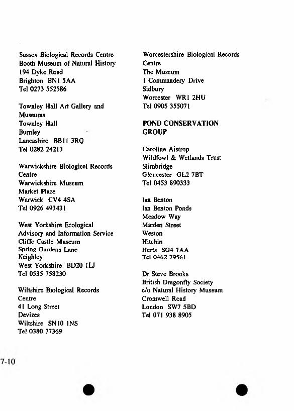
Sussex Biological Records Centre Booth Museum of Natural History 194 Dyke Road Brighton BN1 SAA Tel 0273 552586
Townley Hall Art Gallery andMuseumsTownley HallBurnleyLancashire BB11 3RQ Tel 0282 24213
Warwickshire Biological Records CentreWarwickshire Museum Market Place Warwick CV4 4SA Tel 0926 493431
West Yorkshire Ecological Advisory and Information Service Cliffe Castle Museum Spring Gardens Lane KeighleyWest Yorkshire BD20 1U Tel 0535 758230
Wiltshire Biological Records Centre41 Long Street DevizesWiltshire SN10 INS Tel 0380 77369
Worcestershire Biological Records CentreThe Museum1 Commandeiy Drive SidburyWorcester WR1 2HU Tel 0905 355071
POND CONSERVATION GROUP
Caroline Aistrop Wildfowl & Wetlands Trust SlimbridgeGloucester GL2 7BT Tel 0453 890333
Ian Benton Ian Benton Ponds Meadow Way Maiden Street Weston HitchinHerts SG4 7AA Tel 0462 79561
Dr Steve BrooksBritish Dragonfly Societycfo Natural History MuseumCromwell RoadLondon SW7 5BDTel 071 938 8905
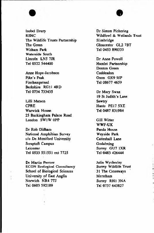
Isobel Drury RSNCThe Wildlife Trusts PartnershipThe GreenWitham ParkWaterside SouthLincoln LN5 7JRTel 0522 544400
Anne Hope-Jacobson Pike’s Peak Finchampstead Berkshire RG11 4RD Tel 0734 733435
Lilli Matson CPREWarwick House 25 Buckingham Palace Road London SW1W OPP
Dr Rob Oldham National Amphibian Survey c/o De Montford University Scraptoft Campus LeicesterTel 0533 551551 ext 7725
Dr Martin Perrow ECON Ecological Consultancy School of Biological Sciences University of East Anglia Norwich NR4 7TJ Tel 0603 592189
Dr Simon Pickering Wildfowl & Wetlands Trust SlimbridgeGloucester GL2 7BT Tel 0453 890333
Dr Anne Powell Hamlet Partnership Denton Green Cuddesdon Oxon OX9 9JP Tel 08677 4659
Dr Mary Swan 19 St Judith’s Lane SawtryHants PE17 5XE Tel 0487 831984
Gill Witter WWF-UK Panda House Weyside Park Catteshall Lane Godalming Surrey GU7 1XR Tel 0483 426444
Julia Wycherley Surrey Wildlife Trust 31 The Crossways M erst ham Surrey RH1 3NA Tel 0737 643827
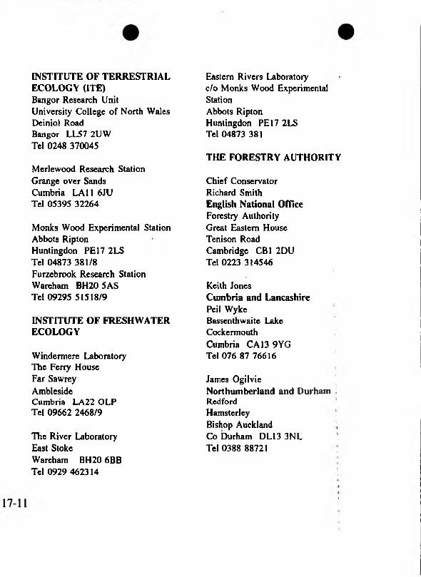
INSTITUTE OF TERRESTRIAL ECOLOGY (HE)Bangor Research UnitUniversity College of North WalesDeiniol RoadBangor LL57 2UWTel 0248 370045
Merlewood Research Station Grange over Sands Cumbria LAI 1 6JU Tel 05395 32264
Monks Wood Experimental StationAbbots RiptonHuntingdon PE 17 2LSTel 04873 381/8Furzebrook Research StationWareham BH20 5ASTel 09295 51518/9
INSTITUTE OF FRESHWATER ECOLOGY
Windermere Laboratory The Ferry House Far Sawrey AmblesideCumbria LA22 OLP Tel 09662 2468/9
The River Laboratory East StokeWareham BH20 6BB Tel 0929 462314
Eastern Rivers Laboratory c/o Monks Wood Experimental StationAbbots Ripton Huntingdon PE 17 2LS Tel 04873 381
THE FORESTRY AUTHORITY
Chief Conservator Richard Smith English National Office Forestry Authority Great Eastern House Tenison Road Cambridge CB1 2DU Tel 0223 314546
Keith JonesCumbria and LancashirePei I WykeBassenthwaite LakeCockermouthCumbria CA13 9YGTel 076 87 76616 '
James OgilvieNorthumberland and DurhamRed fordHamsterley ,Bishop Auckland Co Durham DL13 3NL Tel 0388 88721

Roger Hurst Greater Yorkshire Wheldrake Lane Crockley Hill York YOl 4SG Tel 0904 448778
Huw Davies West Midlands Rydal House Colton Road RugelyStaffs WS15 3HF Tel 0889 585222
Peter Webb East Midlands Willingham Road Market Rasen Lines LN8 3RQ Tel 0673 843461
Bill Heslegrave Wye and Avon Bank House Bank Street ColefordGlos GL16 8BA Tel 0594 810983
Ron MelvilleThe Thames and ChilternsThe Old BamUpper Wingbury FarmWingraveAylesburyBucks HP22 4RFTel 0296 681181
Mark Pritchard East Anglia Santon Downham BrandonSuffolk IP27 OTJ Tel 0842 815544
Ken Buswell The West Country The Castle Mamhead ExeterDevon EX6 8HD Tel 0626 890666
Alan BettsHampshire and West DownsAlice HoltWreccleshamFamhamSurrey GU10 4LF Tel 0420 2337
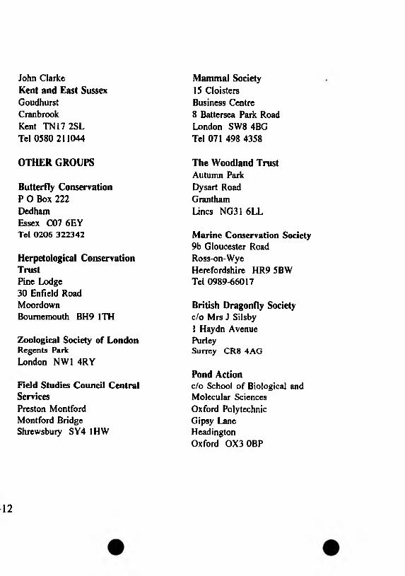
John ClarkeKent and East SussexGoudhurstCranbrookKent TN17 2SLTel 0580 211044
OTHER GROUPS
Butterfly Conservation P O Box 222 DedhamEssex C07 6EY Tel 0206 322342
Herpetological Conservation TrustPine Lodge 30 Enfield Road MoordownBournemouth BH9 1TH
Zoological Society of London Regents Park London NW1 4RY
Field Studies Council Central ServicesPreston Montford Montford Bridge Shrewsbury SY4 1HW
Mammal Society15 Cloisters Business Centre8 Battersea Park Road London SW8 4BG Tel 071 498 4358
The Woodland Trust Autumn Park Dysart Road Grantham Lines NG31 6LL
Marine Conservation Society 9b Gloucester Road Ross-on-Wye Herefordshire HR9 5BW Tel 0989-66017
British Dragonfly Societyc/o Mrs J Silsbyi Haydn Avenue PurleySurrey CR8 4AG
Pond Actionc/o School of Biological and Molecular Sciences Oxford Polytechnic Gipsy Lane Headington Oxford OX3 0BP
12
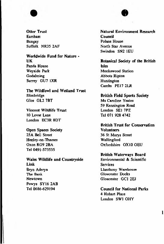
Otter TrustEarshamBungaySuffolk NR35 2AF
Worldwide Fund for Nature *UKPanda House Weyside Park Godalming Surrey GU7 1XR
The Wildfowl and Wetland TrustSlimbridge Glos GL2 7BT
Vincent Wildlife Trust10 Lovat Lane London EC3R 8DT
Open Spaces Society 25A Bell Street Henley-on-TTiames Oxon RG9 2BA Tel 0491-573535
Wales Wildlife and Countryside LinkBiyn Aderyn The Bank NewtownPowys SY16 2AB Tel 0686-629194
Natural Environment Research CouncilPolans House North Star Avenue Swindon SN2 1EU
Botanical Society of the British IslesMonkswood Station Abbots Ripton Huntington Cambs PE17 2LR
British Field Sports Society Ms Caroline Yeates 59 Kennington Road London SE1 7PZ Tel 071 928 4742
British Trust for Conservation Volunteers36 St Maiys Street WallingfordOxfordshire 0X10 OEU
British Waterways Board Environmental & Scientific ServicesLlanthony Warehouse Gloucester Docks Gloucester GC1 2EJ
Council for National Parks4 Hobart Place London SW1 OHY
1
Fauna & Flora Preservation Society1 Kensington Gore London SW7 2AR
Friends of the Earth26-28 Underwood Street London N1 7JQ
Plymouth Marine Laboratories Citadel Hill Plymouth Devon PL1 2PB
Institute of Freshwater Ecology The Ferry House Far Sawrey AmblesideCumbria LA22 OLP
International Dolphin WatchParklands North Ferriby Humberside HUH 3ET
International Waterfowl and Wetland Research Bureau SlimbridgeGloucestershire GL2 7BX
Joint Committee for the Conservation of British Insects c/o World Conservation Monitoring Centre 219 Huntingdon Road Cambridge CB3 ODL
Kew Gardens 47 Kew Green KewRichmond Surrey TW9 3AB
British Ecological Society - Conservation Ecology Group c/o George Peterken English Nature Northminster House Peterborough PEI IUA
British Ecological Society - MiresResearch GroupDr BD WheelerDepartment of Animal & PlantSciencesUniversity of Sheffield Western Bank Sheffield S10 2TN
7-13
British Ecological Society - Aquatic Ecology Group Dr J H R Gee Department of Zoology University College of Wales Aberystwyth Wales SY23 3DA
Royal Entomological Society 41 Queens Gate London SW7 5HU
Trust for Urban Conservation PO Box 514 London SE16 1AG
Urban Wildlife Group11 Albert Street Birmingham B4 7UA
Water Research Centre Medmenham Laboratory Henley Road Medmenham MarlowBucks SL7 2HD
Whale & Dolphin Conservation Society19A James Street BathAvon BA1 2BT
Freshwater Biology AssociationThe Ferry HouseAmblesideCumbria LA22 OLP
British Bryological Society Botany Department Liverpool Museum William Brown Street Liverpool L3 8EN
British Lichen Society Department of Botany Natural History Museum Cromwell Road London SW7 5BD Tel 071 938 8852
Game Conservancy Council Burgate Manor Fordingbridge Hants SP6 1EF
FWAGNational Agricultural CentreStoneleighKenilworthWarwicks CV8 2RX
Woodland TrustAutumn ParkGranthamLines NG31 6LL
17-14
• •
17.3 GEOLOGY AND GEOMORPHOLOGY
ENGLISH NATURE (see page 17-3)
COUNTRYSIDE COUNCIL FOR WALES (see page 17-1)
GEOLOGICAL SOCIETYCONSERVATIONCOMMITTEEBurlington House PiccadillyLondon W1V 9AG Tel 071 434 9298
RIGS GROUPS
AVONPeter Crowther Bristol Museum Tel 0272 223592
BEDFORDSHIRE Rosemary Brind Bedford Museum Tel 0234 353323
BERKSHIRE David WardReading Geological Society Tel 0344 483563
BUCKINGHAMSHIRE Kate RowlandBuckinghamshire County Museum Tel 0296 696012
CAMBRIDGESHIRE Pat Marson Anglia Polytechnic Tel 0223 63271
CHESHIRE David Harpley Cheshire Conservation Trust Tel 0606 781868
CORNWALL Colin Bristow Camborne School of Mines Tel 0726 812252
CUMBRIAPeter Bullard oCumbria Wildlife Trust <>Tel 05394 32476 o
uDERBYSHIRE IPat Brassley IDerbyshire Wildlife Trust
DEVONAlison Cox & Peter Chamberlain Devon Wildlife Trust Tel 0392 79244
DORSET Richard SunyDorset Environmental Records CentreTel 0305 20428
ESSEX Mike Harley English Nature Peterborough Tel 0733 318303
GLOUCESTERSHIRE Gloucestershire Trust for Nature Conservation Tel 0453 822761
GREATER MANCHESTER Carol Davenport Greater Manchester Countryside UnitTel 061 344 3100
HAMPSHIRETony CrossHampshire County Museum ServiceTel 0962 846304
HERTFORDSHIRE David Curry Museum of St Albans Tel 0727 56679
NORTH HUMBERSIDE Mick Stanley Hull City Museums Tel 0482 593904
ISLE OF WIGHT !Stephen HuttMuseum of Isle of Wight Geology Tel 0983 404344
KENTAlasdair Bruce .Kent RIGS Coordinator Tel 0843 295852
17-15

LANCASHIRE Steve Thompson Clitheroe Castle Museum Tel 0200 24635
LEICESTERSHIRE Gill Weightman Leicestershire Museum Tel 0533 473080
LINCOLNSHIRE/SOUTHHUMBERSIDEDavid RobinsonLincolnshire Trust for NatureConservationTel 0507 602019
MERSEYSIDE John Handley Groundwork Trust Tel 0744 39396
WEST MIDLANDS Alan CutlerBlack Country Geological Society Tel 0384 71146
NORFOLK Jackie LewisNorfolk Naturalists’ Trust Tel 0603 625540
NORTHAMPTONSHIRE Northamptonshire Wildlife Trust Tel 0604 405285
NORTHUMBERLAND, DURHAM, CLEVELAND, TYNE & WEAR George Fenwick Sunderland Polytechnic Tel 091 515 2742
NOTTINGHAMSHIRE Norman LewisNottinghamshire Wildlife Trust Tel 0602 588242
OXFORDSHIRE Alan Childs Oxford Polytechnic Tel 0865 819617
POWYSDuncan Hawley Brecknock Wildlife Trust Tel 0874 625708
SHEFFIELD Derek Whiteley Sheffield City Museum Tel 0742 768588
SHROPSHIRE John TuckerShropshire Wildlife Trust Tel 0743 241691

SOMERSET Bill ButcherSomerset Environmental Records CentreTel 0823 451778
STAFFORDSHIRE Don Steward Stoke City Museum Tel 0782 202173
SUFFOLK Bob Markham Ipswich MuseumsTel 0473 213761
SURREY Diana HawkesHaslemere Educational Museum Tel 0428 642112
SUSSEX John Cooper Booth Museum Tel 0273 552586
WARWICKSHIRE John Crossling Warwickshire Museum Tel 0926 412500
WILTSHIRE Gilbert Green Chairman RIGS Group c/o Wiltshire Wildlife Trust
Tel 0380 725670
NORTH YORKSHIRE Stephen Warburton Yorkshire Wildlife Trust Tel 0904 659570
WEST YORKSHIREJeff LunnEnglish NatureWakefieldTel 0924 387010
NB Information on new groups from Mike Harley, English Nature (see ESSEX) or Stuart Campbell, CCW (Headquarters).
LOCAL GEOLOGICAL RECORDS CENTRES
AVON, SOMERSET,GLOUCESTERSHIRE,WILTSHIREMuseum and Art GalleryQueens RoadBristol BS8 1RL
16
BERKSHIRE Museum and Art Gallery Blagrave Street Reading RG1 1QH
BOLTONMuseum and Art Gallery Le Mans Crescent Bolton BL1 1SE
BRADFORD (West Yorkshire) Cliffe Castle Museum Spring Gardens Lane Keighley BD20 6LH
BUCKINGHAMSHIRE County Museum Church Street Aylesbury HP20 2QP
CAMBRIDGESHIRE Geology Section Anglia College of Higher Education East RoadCambridge CB1 1PT
CLEVELAND County Museum Service Cleveland Gallery Victoria Road Middlesborough TS1 3QS
CUMBRIA Planning Department County Offices Kendal LA9 4RQ
DERBYSHIRE Museum and Art Gallery The Strand Derby DEI IBS
DEVON (East)Museum and Art Galleiy Queen Street Exeter EX4 3RX
DEVON (West)Museum and Art Gallery Drake Circus Plymouth PL4 8AJ
DONCASTER Museum and Art Gallery Chequer Road Doncaster DN1 2AE
DORSET County Museum High Street Dorchester DTI 1XA
DUDLEYMuseum and Art Gallery St James’s Road Dudley DY1 1HU
LOCAL GEOLOGICAL RECORDS CENTRE CONT.
ESSEXPassmore Edwards MuseumRomford RoadStratfordLondon E15 4LZ
FOREST OF DEANRoyal Forest of Dean Centre forEnvironmental StudiesMitcheldeanGloucester GL17 OHA
HAMPSHIRE County Museum Service Chilcomb House Chilcomb Lane Bar EndWinchester S023 8RD
HERTFORDSHIRE City Museum Hatfield Road St Albans AL1 3RR
HUMBERSIDE (South), LINCOLNSHIRE (North) Museum and Art Gallery Oswald Road Scunthorpe DN15 7BD
ISLE OF WIGHTMuseum of Isle of Wight GeologyHigh StreetSandown P036 8AF
KENT (East)City Museums High Street Canterbury CTI 2JE
KIRKLEES (West Yorkshire) Tolson Memorial Museum Ravensknowle Park Huddersfield HD5 8DJ
LANCASHIRE Clitheroe Museum Castle Hill Clitheroe BB7 1BA
LEEDS (West Yorkshire)City Museum Municipal Buildings Leeds LSI 3AA
LEICESTERSHIRE Leicestershire Museums 96 New Walk Leicester LEI 6TD
MANCHESTER Manchester Museum The University Manchester MI3 9PL

MERSEYSIDE, CHESHIRE, CLWYD, LANCASHIRE (parts) Merseyside County Museum William Brown Street Liverpool L3 8EN
NORFOLKCounty Museum Service Castle Museum Norwich NR1 3JTJ
NORTHUMBERLAND (North) Hancock Museum The UniversityNewcastle-upon-Tyne NE2 4PT
NORTHUMBERLAND (South), DURHAMMuseum and Art Gallery Borough Road Sunderland SR1 1PP
NOTTINGHAMSHIRE Natural History Museum Wollaton Hall Nottingham NG8 2AE
PETERBOROUGH Museum and Art Gallery PriestgatePeterborough PEI ILF
POWYSBrecknock Wildlife Trust Lion House Lion Yard Brecon LD3 7AY
SHEFFIELD City Museum Weston Park Sheffield S10 2TP
SHROPSHIRE County Museum Service Old Street Ludlow SY8 1NW
SOMERSETSomerset Environmental RecordsCentrePickneyKingston St Mary Taunton TA2 8AS
STAFFORDSHIRECity Museum and Art GalleryBethesda StreetHanleyStoke on Trent ST1 3DW
SUFFOLKMuseum and Art Gallery High Street Ipswich IP1 3QH
SURREYHaslemere Educational Museum 78 High Street Haslemere GU27 2LA
SUSSEX Booth Museum 194 Dyke Road Brighton BN1 SAA
WARWICKSHIRE Warwickshire Museums Market Place Warwick CV34 4SA
YORKSHIRE (East), HUMBERSIDE (North)Hull City Museums and Art Galleries83 Alfred Gelder Street Hull HU1 1EP
YORKSHIRE (North)The Yorkshire Museum Museum Gardens York YOl 2DR
NB Information on new centres from Mick Stanley, Co-ordinator National Scheme for Geological Site Documentation, Hull City Museums and Art Galleries (0482-593904).
8
17.4 ARCHAEOLOGY.
ENGLISH HERITAGE Fortress House 23 Savile Row London W1X 1AB Tel 071 973 3000
CADW(Welsh Historic Monuments)Brunei House2 Fitzalan Road Cardiff CF2 1UY Tel 0222 465511
ROYAL COMMISSION ON THE HISTORICAL MONUMENTS OF ENGLANDFortress House 23 Savile Row London W1X 1AB Tel 071 973 3500
ASHFORD Orchard House Tannery Lane Ashford TN23 1PL Tel 0233 630979
CAMBRIDGE The Lodge Anstey Hall Maris Lane Trumpington Cambridge CB2 2LE Tel 0223 841210
EXETER Rose Duryard Lower Arygll Road Exeter EX4 4PB Tel 0392 213338
KEELERooms 18 - 18A Chancellor’s Building University of Keele Newcastle Upon Tyne STS 5BG Tel 0782 632118
LONDON(Collections Management Unit) Government Buildings Bromyard Avenue ActonLondon W3 7XY Tel 081 743 051
ARCHITECTURE AND HISTORY
LONDON(Head Office & National Buildings Records)Fortress House 23 Savile Row London W1X 2JQ Tel 071 973 3500
LONDON(Survey of London & Publications) Newlands House 37-40 Berners Street London W1P 4BP
NEWCASTLE UPON TYNE Line Building Haymarket Lane The UniversityNewcastle Upon Tyne NE1 7RU
SAUSBURY Rougement Rougement Close
0 Salisbury SP1 1LY0 Tel 0722 3280910$ SOUTHAMPTON
(National Archaeological Record)Green LaneMaybushSouthampton SOI 9FP
c Tel 0703 780966
SWINDON(Air Photography & Threatened Buildings)Alexander House19 Fleming Way Swindon SN1 2NG Tel 0793 414100
YORKShelley House Acomb Road York Y02 4HB Tel 0904 784411
ROYAL COMMISSION ONANCIENT AND HISTORICALMONUMENTS IN WALESCrown BuildingsPlas CrugAberystwythDyfed SY23 2HPTel 0970 624381
DEPARTMENT OF THE ENVIRONMENTHeritage Division Room C9/10A2 Marsham Street London SW1P 3EB Tel 071 276 4725
17-19
COUNCIL FOR BRITISH ARCHAEOLOGYBowes Morrell House11 Walmgate YorkYOI 2UA Tel 0904 671417
SCIENCE MUSEUM Exhibition Road London SW7 2DD Tel 071 938 8000
COUNTY COUNCIL SITES AND OTHER LOCAL AUTHORITIES SITES AND MONUMENTS RECORD (ENGLAND)
AVONPlanning Department Avon County Council PO Box 46 Middlegate Whitefriars Lewins Mead Bristol BS99 7EU Tel 0272 226528
BEDFORDSHIRE Planning Department Bedfordshire County Council County Hall Bedford MK42 9AP Tel 0234 63222 ext 2071
BERKSHIREDept of Highways and PlanningBerkshire County CouncilShire HallShin field ParkReading RG2 9XGTel 0734 875444 ext 4936
BUCKINGHAMSHIRE County Museum Technical Centre Tring Road HaltonAylesbury HP22 5PJ Tel 0296 696012
CAMBRIDGESHIRE Dept of Lands and Buildings Cambridgeshire County Council Shire Hall Castle HillCambridge CB3 0AP Tel 0223 317111 ext 3312
CHESHIRE Planning Department Cheshire County Council Commerce House Hunter Street Chester CHI 1SN Tel 0244 603160
CLEVELAND Cleveland Archaeology PO Box 41 Southlands Centre Ormesby Road Middlesbrough TS3 OYZ Tel 0642 327583 ext 223
CORNWALL & ISLES OF SCILLYCornwall Committee forArchaeologyOld County HallStation RoadTruro TR1 3 EXTel 0872 74282 ext 3602/3/4
CUMBRIA Planning Department Cumbria County Council County Offices Kendal LA9 4RQ Tel 0539 21000 ext 4378
DERBYSHIRE Planning Department Derbyshire County Council County Offices Matlock DE4 3AG Tel 0629 580000 ext 7125
DEVONProperty Department Devon County Council County Hall Exeter EX2 4QQ Tel 0392 272266
DORSETPlanning Department Dorset County Council County Hall Dorchester DTI 1XJ Tel 0305 251000 ext 4277
DURHAMThe Antiquities Department The Bowes Museum Barnard Castle Durham DL12 8NP Tel 0833 690107
EAST SUSSEX Planning Department East Sussex County Council Southover House Southover Road Lewes BN7 1YA Tel 0273 481608
ESSEXPlanning Department Essex County Council Globe House New StreetChelmsford CM1 ILF Tel 0245 352232 ext 307
GLOUCESTERSHIRE Planning Department Gloucestershire County Council Shire HallGloucester GL1 2TN Tel 0452 425683
GREATER LONDON The London Division English Heritage Chesham House 30 Warwick Street London W1R 6AB Tel 071 973 3732
GREATER MANCHESTER Greater Manchester Archaeology UnitUniversity of Manchester Oxford Road Manchester M13 9PD Tel 0612 752315
HAMPSHIRE Planning Department Hampshire County Council The CastleWinchester S023 8UE Tel 0962 846735/6/7
HEREFORD AND WORCESTERArchaeology SectionHereford & Worcs County CouncilCranham SchoolTetbury DriveWamdonWorcester WR4 9LS Tel 0905 58608
HERTFORDSHIRE Planning Department Hertfordshire County Council County Hall Hertford SG13 8DN Tel 0992 555244
HUMBERSIDE Property Services Dept Humberside County Council Archaeology Unit County Hall Beverley HU17 9BA Tel 0482 868770
17
ISLE OF WIGHTCounty Archaeological CentreClatterford School61 Clatterford RoadCarisbrookeNewport P030 1NZTel 0983 529963
KENTCounty Planning DepartmentKent County CouncilSpringfieldMaidstoneKent ME14 2LXTel 0622 671411
LANCASHIRE Lancaster University Archaeological Unit University of Lancaster Physics Building BailriggLancaster LAI 4YB Tel 0524 65201 ext 4385
LEICESTERSHIRE County Museum Service Jewry Wall Museum St Nicholas Circle Leicester LEI 7BY Tel 0533 554100 ext 3023
UNCOLNSHIRE City and County Museum12 Friars Lane Lincoln LN2 SAL Tel 0522 530401
MERSEYSIDE Archaeological Survey of Merseyside Liverpool Museum William Brown Street Liverpool L3 8EN Tel 051 207 0001 ext 260
NORFOLKNorfolk Archaeological Unit Union House Gressenhall Dereham NR20 4DR Tel 0362 860528
NORTH YORKSHIRE Planning Department North Yorkshire County Council County HallNorthallerton DL7 8AQ Tel 0609 780780 ext 2330
21

NORTHAMPTONSHIRE County Secretary’s Department Northamptonshire County Council Bolton House Wootton Hall Park Mere WayNorthampton NN4 9BE Tel 0604 700493
NORTHUMBERLAND Planning Department Northumberland County Council County Hall Morpeth NE61 2EF Tel 0670 514343 ext 3516
NOTTINGHAMSHIRE Planning and Transportation DepartmentNottingham County Council Trent Bridge House Fox Road West Bridgford Nottingham NG2 6BJ Tel 0602 823823 ext 4546
OXFORDSHIREDepartment of Museum ServicesCounty MuseumFletcher’s HouseWoodstock OX7 1SNTel 0993 811456
PEAK PARKPeak Park Joint Planning Board Aldem House Baslow Road BakewellDerbyshire DE4 1AE Tel 062981 4321
SHROPSHIRE Cultural Services Department Winston Churchill Building Radbrook Centre Radbrook Road Shrewsbury SY3 9BJ
SOMERSET Planning Department Somerset County Council County Hall Taunton TA1 4DY Tel 0823 333451 ext 5426
SOUTH YORKSHIREArchaeology SectionSouth Yorkshire ArchaeologicalServicesLibrariesMuseums and Arts Building Ellin Street Sheffield SI 4PL Tel 0742 734210
STAFFORDSHIRE Planning Department Staffordshire County Council Martin Street Stafford ST16 2LE Tel 0785 223121 ext 7283
SUFFOLK Archaeological Unit Suffolk County Council Shire HallBury St Edmunds IP33 1RX Tel 0284 763141 ext 2023
SURREYPlanning Department Surrey County Council County HallKingston on Thames KT1 2DT Tel 081 541 9457
TYNE & WEAR Environment Design Section Planning Department Newcastle City Council Civic Centre Barras BridgeNewcastle upon Tyne NE1 8PH Tel 0912 816714
WARWICKSHIRE County Museum Warwickshire County Council Market Hall Warwick CV34 4SA Tel 0926 412734
WEST MIDLANDS West Midlands SMR Joint Data Team Radciiffe House Blenheim Court SolihullWest Midlands B91 2AA Tel 021 704 6930
WEST SUSSEX Planning Department West Sussex County Council County Hall Tower Street Chichester P019 IRL Tel 0243 777100
WEST YORKSHIREWest Yorkshire ArchaeologyService14 St John's North Wakefield WF1 3QA Tel 0924 290900
■22
WILTSHIRELibrary and Museum Service Wiltshire County Council County Hall Bythesea Road Trowbridge BAH 8BS Tel 0225 753641 ext 2743
SITES AND MONUMENTS RECORDS (WALES)
Clwyd Archaeology Service Clwyd County Council Shire Hall MoldClwyd CH7 6NG Tel 0352 2121
Welsh Trusts
Clwyd/Powys Archaeology Trust7 A Church StreetWelshpoolPowysSY21 7DL0938 553670
Dyfed Archaeology TrustThe Old Palace Abergwili ,Carmarthen Dyfed SA31 2JG 0267 231667

Glamorgan/GwentArchaeology Trust Ltd Ferryside Warehouse Bath Lane Swansea SA11RD 0792 655028
Gwynedd Archaeology Trust LtdGarth RoadBangorLL58 2SE0248 352535
NB Copies of the Clwyd SMR are held at the Clwyd Archaeology Service and at the Clwyd/Powys Archaeology Trust.
17-23ii

1-7.5 Central Government Departments. Agencies and Statutory Bodies with Responsibilities and Interests in the Coastal Zone
Central Government Departments
Department of the Environment General policy responsibility for environmental matters! Responsibility for town and country planning, which regulates the development and use of land in the public interest and for landscape and wildlife conservation.
Department of National Heritage General policy responsibility for the heritage including listed buildings, scheduled monuments and historic wreck sites; sport and recreation policy including water sports in particular and coastal recreation in general. Policy responsibility for domestic and inward tourism, including interests in seaside resorts and waterfront areas.
Department of Trade and Industry Planning matters affecting both public and private sector mdustnes; the exploitation of industrial mineral resources; the exploitation of coal resources; the licensing of oil and gas exploration and production; and the development of coastal power stations.
Department of Transport All aspects of marine safety, including safety of navigation throughout UK waters. Responsibility for harbour authorities.
Home Office Development in the vicinity of penal establishments, and civil defence. Responsible for byelaws in England and Wales.

Ministry for Agriculture, Fisheries & Food
A number of responsibilities related to the coast-line including fisheries management and regulatory powers over the disposal of wastes at sea. Developments below the high water mark require a licence from MAFF under Part II of the Flood and Environmental Protection Act 1985. Policy responsibility for flood defence and coast protection in England.
Ministry of Defence Matters likely to have a bearing on their land holdings, especially if in active use.
Welsh Office General policy responsibility for environmental matters. Responsibility for town and country planning, which regulates the development and use of land in the public interest; for landscape and wildlife conservation, and for flood defence and coast protection in Wales.
Other Bodies
Cadw The duties are the same as English Heritage but are applied to Wales and the Secretary of State for Wales.
Countryside Commission The Countryside Commission advises the Government and other organisations on countryside matters. It has played an important role in the recognition of historic landscapes. It has special responsibility for designating National Parks, Areas of Outstanding Natural Beauty, Heritage Coast, long-distance footpaths and bridleways and holds information on these. In Wales this function is carried out by the Countryside Council for Wales.
Countryside Council for Wales As above.
Crown Estate Commissioners Landlords of much of the foreshore and seabed with responsibilities to maintain and enhance the value of the estate and the return obtained from it, but with due regard to the requirements of good management.
17-26

English Heritage English Heritage has nationalresponsibilities and duties laid down inthe 1983 Heritage Act.
The general duties are:-
a) to secure the preservation of ancient monuments;
b) to promote the public's enjoyment and knowledge of ancient monuments;
It’s specific duties are:-
a) to provide the Secretary of State with advice in relation to the scheduling of ancient monuments;
b) to provide the Secretary of State with advice in relation to applications for scheduled monuments consent;
c) to provide financial assistance towards the upkeep of ancient monuments;
d) to carry out and commission archaeological surveys, excavations and other research, (discretionary)
English Nature Tne statutoiy adviser to the Government on nature conservation in England, responsible for promoting the conservation of England’s wildlife and natural features. Its work includes the selection, establishment and management of National Nature Reserves and Marine Nature Reserves; the identification and notification os Sites of Special Scientific Interest; the provision of advice about nature conservation; and the support and conduct of research relevant to these functions.
Health and Safety Executive (HSE) All significant matters relating to health and safety, including developments at or near to a harbour area.
HM Coastguard Coast and Marine Rescue, management of foreshore and marine areas. Responsibility for items washed up on the shore including wrecks, cetacea, etc.-
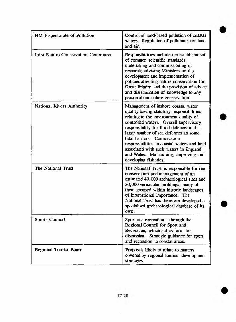
HM Inspectorate of Pollution Control of land-based pollution of coastal waters. Regulation of pollutants for land and air.
Joint Nature Conservation Committee Responsibilities include the establishment of common scientific standards; undertaking and commissioning of research; advising Ministers on the development and implementation of policies affecting nature conservation for Great Britain; and the provision of advice and dissemination of knowledge to any person about nature conservation.
National Rivers Authority Management of inshore coastal water quality having statutory responsibilities relating to the environment quality of controlled waters. Overall supervisory responsibility for flood defence, and a large number of sea defences an some tidal barriers. Conservation responsibilities in coastal waters and land associated with such waters in England and Wales. Maintaining, improving and developing fisheries.
The National Trust The National Trust is responsible for the conservation and management of an estimated 40,000 archaeological sites and 20,000 vernacular buildings, many of them grouped within historic landscapes of international importance. The National Trust has therefore developed a specialised archaeological database of its own.
Sports Council Sport and recreation - through the Regional Council for Sport and Recreation, which act as form for discussion. Strategic guidance for sport and recreation in coastal areas.
Regional Tourist Board Proposals likely to relate to matters covered by regional tourism development strategies.
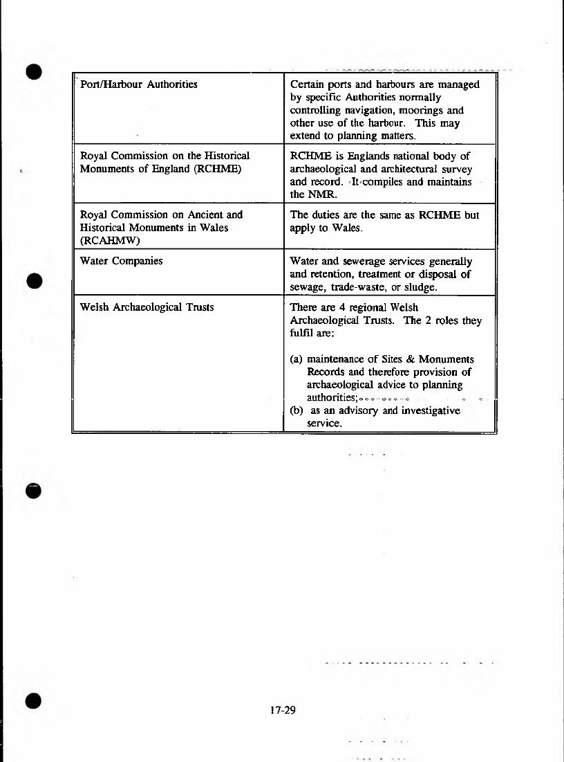
Port/Haibour Authorities Certain ports and harbours are managed by specific Authorities normally controlling navigation, moorings and other use of the harbour. This may extend to planning matters.
Royal Commission on the Historical Monuments of England (RCHME)
RCHME is Englands national body of archaeological and architectural survey and record. It compiles and maintains the NMR.
Royal Commission on Ancient and Historical Monuments in Wales (RCAHMW)
The duties are the same as RCHME but apply to Wales.
Water Companies Water and sewerage services generally and retention, treatment or disposal of sewage, trade-waste, or sludge.
Welsh Archaeological Trusts There are 4 regional Welsh Archaeological Trusts. The 2 roles they fulfil are:
(a) maintenance of Sites & Monuments Records and therefore provision of archaeological advice to planning authorities; o o
(b) as an advisory and investigative service.
17-29

18. NRA CONSERVATION STAFF
HEAD OFFICE
David Jordan Paul Raven Cath Beaver
Head of FRCNConservation OfficerTechnical Assistant (secondment)
ANGLIAN •
Peterborough Peter Barham
Claire Redmond Andrew Heaton Sandy Rowden Gary Murphy Gerard Stewart
Regional Conservation, Recreation & Navigation Manager Regional Conservation Officer Conservation Officer (secondment) Conservation Officer (secondment) Conservation Assistant Conservation Assistant
Eastern - Ipswich Jon Wortley Andrea Meachan Merle Leeds
Area FRCN Manager Conservation Officer Conservation Officer
Central - Brampton John Adams Geraldine Daly Richard Green
Area FRCN Manager Conservation Officer Assistant Conservation Officer
Northern - Lincoln Irven Forbes Mark Tartellin Emma Tidmarsh Candy Avill
Area FRCN Officer Conservation Officer Assistant Conservation Officer FRCN Technical Assistant
NORTH WEST REGION
Warrington Mark Diamond
Peter Fox Elaine Fisher
Gillian Mackley
Principal - Fisheries, Recreation, Conservation & Biology Senior Scientist (Ecology)Senior Scientist (Aquatic Ecology) (Landscape, Recreation & Heritage Officer)
South - Sale Pam Nolan David Holland Sam Jarvis Karen Williams Tim Pickering Jill Guthrie Cathy Beeching Judith Bennet Mark Wiseman
Senior EcologistSenior EcologistEcologistEcologistEcologistEcologistEcologistEcologistEcological Assistant
18-1

Central - Preston Ed Mycock Neil Guthrie Kathryn Edwards Amanda Elliott Sarah Peet Liz Green Louise McGurk Joanne Lambert Judith Whalley
Senior EcologistSenior EcologistEcologistEcologistEcologistEcologistEcologistEcologistEcological Assistant
North - Carlisle Steve Gamer Senior EcologistRay Prigg Senior EcologistLiz Oliver EcologistDavid Scott EcologistNeil Coates Ecological AssistantAnnette Jackson Ecological Assistant
Kendall Brian Ingersent EcologistKaren Rouen Ecologist
NORTHUMBIOA ^ YORKSHIRE
Headquarters - Steve Bailey FRCN CoordinatorLeeds Simon Keys FRCN Officer (Conservation)
Olympia House - Leeds John Pygott Ecology & Recreation ManagerArlene Brookes Senior EcologistCaroline Essery EcologistAmanda Best Ecologist
Coverdale House - Martin Fuller Senior EcologistYork Anne Sansom Ecologist
Roger Martin EcologistEleanor Robinson Ecologist
Eldon House - Geoffrey Williams Ecology & Recreation ManagerNewcastle Colin Blundel Senior Ecologist
Alistair Laverty Ecologist
^ V i E ^ TRENT if ■ % : ■■■■: ■■ -v ̂ . .v
Solihull Dr Phil Hickley Regional FRCN ManagerDavid Hickie Regional Environmental Assessment
CoordinatorAndrew Heaton Conservation OfficerHelena Tompkins Technical Support OfficerYvonne Wooding Technical Support OfficerPat Hayes Project Officer
Lower Severn - Bob Bishop Area Conservation & Recreation OfficerTewkesbury Assistant Area Conservation &
Rachael Hill
Liz Galloway
Recreation Officer Senior Landscape Architect
18-2

Upper Severn - Shrewsbuiy
Alan Jones Gill Evans
Marianne Le Ray
Area Conservation & Recreation Officer Assistant Area Conservation & Recreation Officer Area Landscape Architect
Lower Trent - Nottingham
Valerie Holt
Paul Green Penny Thorpe
Area Conservation & Recreation Officer Assistant Area Conservation & Recreation Officer Area Landscape Architect
Upper Trent -Lichfield Andrew Crawford
Kate Cox
Kate Watson
Area Conservation & Recreation Officer Assistant Area Conservation & Recreation Officer Area Landscape Architect
SOUTH - WESTERN •.
Devon area - Exeter Stuart Bray Lyn Jenkins Peter Nicholson Nigel Reader Mike Williams
FRCN Manager Regional Conservation Officer Conservation Officer FRCN ManagerArea Conservation & Recreation Officer
North Wessex - Bridgwater
Dr Roger Meny Ann Skinner Stuart Moodie Andrew Baines
Area FRCN Manager Area Conservation & Recreation Officer Conservation & Recreation Assistant Conservation & Recreation Assistant
South Wessex - Blandford
Dr Graham Lightfoot Judith Crompton Kim Thirl by
Area FRCN ManagerArea Conservation & Recreation OfficerConservation & Recreation Assistant . '
Cornwall area - Bodmin
Brian Letts Sonia Thurley
Area FRCN ManagerArea Conservation & Recreation Officer
SOUTHERN
Worthing Dr A G Owen Jane Cecil
Regional FRCN Manager Regional Conservation, Recreation & Navigation Coordinator
Sussex - Worthing Ian Johnson Caryl Hart
Phil Griffiths
Area FRCN Manager Area Conservation & Recreation Officer Assistant Conservation & Recreation Officer
Hampshire Isle of Wight - Winchester
Robin Crawshaw Matthew Carter
Area FRCN ManagerArea Conservation & Recreation Officer
18-3

Kent - East Mailing John Morgan Robert Pilcher
Chris Dyson
Jason Chambers
Brian Smith
Simon Holdsworth
Area FRCN Manager Area Conservation & Recreation Officer Asst Area Conservation & Recreation OfficerAsst Area Conservation & Recreation OfficerProject Manager, Medway River Project Project Officer, Medway River Project
THAMES
Reading John Banks
Alastair Driver Lesley Sproat Frances Bayley Richard Copas Richard Hellier Kevin Patrick Suzanne Chisnell Andrew Brookes Sue Reed
Regional Fisheries & Conservation ManagerRegional Conservation Manager Conservation Officer (Capital Schemes) Conservation Officer (Surveys)Regional Landscape Architect Landscape Architect Landscape Architect Landscape Architect Environmental Assessment Officer Assistant Environmental Assessment Officer
West Area - Wallingford
John Sutton Graham Scholey
Area Fisheries & Conservation Manager Area Conservation Officer
South-East Area - Guildford
Alan Butterworth David Webb
Area Fisheries & Conservation Manager Area Conservation Officer
North-East Area - Rickmansworth
John Reeves Chris Catling
Area Fisheries & Conservation Manager Area Conservation Officer
W ELSH
St Mellons Warwick Ayton Richard Howell Cath Beaver
Regional FRCN Officer Conservation & Recreation Officer Conservation Assistant
South East John Gregory David Bunt Teg Jones Chris Formaggia
Area FRCN Manager District FRCN Manager F & C Resources Officer Conservation Assistant
Monmouth Paul Hilder District FRCN Manager
North - Caernarfon Mike Harcup Richard Brassington Bryan Jones Carri Lane
Area FRCN Manager District FRCN Manager F & C Resources Officer Conservation Assistant
Mold Brian Hodgson District FRCN Manager
18-4

South West - Swansea Andy Schofield Liz Roblin Mair Rees
District FRCN Manager F & C Resources Officer Conservation Assistant
Haverfordwest Paul Varallo Dave Gardner
Area FRCN Manager District FRCN Manager
18-5

18-6

■19- 1.1ST OF ABBREVIATIONS AND ACRONYMS USED IN THE DOCUMENT
AAI Area of Archaeological ImportanceAONB Area of Outstanding Natural BeautyAoSP Area of Special Protection for BirdsBTO British Trust for OrnithologyCA Conservation AreaCC Countryside CommissionCCW Countryside Council for WalesCMP Catchment Management PlanDoE Department of the EnvironmentEA Environmental AssessmentEC European CommunityEH English HeritageEN English NatureEQO Environmental Quality ObjectiveES Environmental StatementESA Environmentally Sensitive AreaFTE Full Time EquivalentGQA General Quality AssessmentHMIP Her Majesty’s Inspectorate of PollutionHQI Habitat Quality IndexIFE Institute of Freshwater EcologyIFIM Incremental Flow Instream MethodologyIPC Integrated Pollution controlIUCN International Union for the Conservation of NatureJNCC Joint Nature Conservation CommitteeLNR Local Nature ReserveMAFF Ministry of Agriculture, Fisheries and FoodMOU Memorandum of UnderstandingNCC Nature Conservancy CouncilNNR National Nature ReserveNRA National Rivers AuthorityOARP Otters and Rivers ProjectPHABSIM Physical Habitat SimulationPIN Policy Implementation NoteRCAHMW Royal Commission on Ancient and Historical Monuments in WalesRCHME Royal Commission on the Historical Monuments of EnglandRCS River Corridor SurveyRHS River Habitat SurveyRIGS Regionally Important Geological/Geomorphological SiteRIVPACS River Invertebrate Prediction and Classification SystemRQO River Quality ObjectiveRSNC Royal Society for Nature Conservation (The Wildlife Trusts
Partnership)RSPB Royal Society for the Protection of BirdsSAC Special Area of Conservation

$AM Scheduled Ancient Monument5 0 Site of Community Interest: (precursor to SAC) SEftCON System for Evaluating Rivers for Conservation51 Statutory Instrument
Sites and Monuments Record SlSOt Site of National Consolation InterestSPA Special Protection. Areas* (piids)SSSI Site of Special Scientist InterestSWQO Statutory W a^r Quality ObjectiveVWT Vincent W iiaufeTm st^;WAMS Water Archive Monitoring' SystemWO Welsh. OfficeWWT Wildfowl' and Wetlands Trust
WQ) Water QualityWE' Water ResourcesFD> Flo$& Defence______________________ ___ - ,F FisheriesR RecreationC ConservationN* NavigationAll All functions