consultation process and contacts - fampofampo.org/pdf/safety_and_security_plan.pdf ·...
TRANSCRIPT

FAMPO Safety & Security Element of the
2040 Metropolitan Transportation Plan
Fayetteville Area Metropolitan Planning Organization
Continuing · Comprehensive · Cooperative · Transportation Planning
April 16, 2014


Table of Contents
Introduction ........................................................................................................................ 1
Current Safety Conditions ................................................................................................... 1
Accident Data ...................................................................................................................... 1
County Profiles .................................................................................................................... 5
Safety Planning ................................................................................................................... 9
Crash Reduction Strategies ............................................................................................... 11
Alternative Transportation Methods ................................................................................ 12
Engineering Improvements ............................................................................................... 13
Enforcement ..................................................................................................................... 14
Emergency Medical Response .......................................................................................... 14
Education .......................................................................................................................... 14
Graduated Licensing Program ................................................................................................... 14
Safe Routes to School ................................................................................................................ 15
Newsletter ................................................................................................................................. 15
Security Planning............................................................................................................... 15
Emergency Operations Plan (EOP) ............................................................................................ 15
Fort Bragg Military Reservation................................................................................................. 16
Fayetteville Regional Airport ..................................................................................................... 17
Fayetteville Area System of Transit (FAST) ................................................................................ 17
FAMPO’s Continuing Operations ...................................................................................... 17
Summary ........................................................................................................................... 18
Appendix A. - 2011 Crash Cost Estimates For North Carolina .......................................... 19
Appendix B. - 2012 Crash Data (Statewide) ...................................................................... 24
Appendix C. - 2012 Seat Belts (Statewide) ....................................................................... 25
Appendix D. – 2009-2012 County Rankings (Statewide) .................................................. 26
Appendix F. – Active Spot Safety Projects ........................................................................ 28
Appendix G. – FEMA Letter ............................................................................................... 29


1
Introduction
The purpose of the Safety & Security Plan is to promote coordinated planning efforts to address safety and security issues in the Fayetteville Area Metropolitan Planning Organization (FAMPO) area. It is critical to prepare for response to sudden incidents that breach safety and security on a large scale, whether through natural disaster or acts of terrorism. The Safety & Security Plan includes a summary on the Emergency Operations Plan for Cumberland County, Fort Bragg physical security, Fayetteville Regional Airport, and Fayetteville Area System of Transit (FAST).
Current Safety Conditions
When addressing highway safety, practitioners have the tendency to refer to vehicular traffic related incidents, which have higher reporting and documentation available than non-vehicular ones. However, with a true multi-modal system we are compelled to address safety, actual or user perceived, relating to bicycle and pedestrian, vehicular, freight and transit modes, and special needs areas as in school zones, young drivers education, aggressive or impaired driving, and aging driver population. Local public involvement has shown concern for safety projects in the FAMPO area by highlighting dangerous roadways and intersections for pedestrians, bicyclists and motorists as well. The new SPOT project ranking system also incorporates safety scoring in the consideration of project prioritization. Based on the quantified safety score in the SPOT prioritization process, public involvement and the data in this plan, FAMPO incorporates safety issues in multiple levels of the decision making process. This report will use currently available data to give a safety profile of the FAMPO metropolitan area. Also, it will describe current and proposed statewide and local safety and security effort through a partnership of education, design, enforcement and emergency management.
Accident Data
In order to successfully produce a plan with treatments that can be implemented at a reasonable cost, accurate accident data needs to be analyzed at different levels of geography. The North Carolina Department of Transportation (NCDOT) Traffic Safety Unit implements and evaluates safety and traffic operational strategies to reduce crashes on North Carolina roadways. This Unit shares a wealth of information that can be used by state and local professionals to conduct spot analysis and systems projects planning and programming. The Traffic Safety Unit includes the Traffic Safety Systems Section, the Mobility and Safety Field Operations Section, and the Mobility and Safety Information Section.

2
The Transportation Mobility and Safety Division and the NCDOT Executive Committee for Highway Safety have collaborated with the NCDOT - State Road Management Unit - Mapping Section to develop and produce County Crash Distribution Profile Maps for North Carolina. Exhibit _ - NC Total Reported Fatal Motor Vehicle Crashes (Jan 1, 2005 – Dec 31, 2009) shows the total number of reported fatal crashes. The red zones, which are the most severe, had a range of 120 and higher fatalities; the orange zones had the second highest number of fatalities and ranged from 80 to 119; the yellow zones had 40 to 79 fatalities; and the green zones had the least number of fatalities that ranged from 1 to 39. Cumberland County and Robeson County are in the red zone. Cumberland County shows 242 reported fatal crashes, while Robeson County shows 266. Harnett County appears in an orange zone with a total of 109 reported fatal crashes, while Hoke County shows 49 reported fatalities and appears in a yellow zone.
Source: http://www.ncdot.gov/travel/statemapping/default.html
EXHIBIT_ - NC TOTAL REPORTED FATAL MOTOR VEHICLE CRASHES (JAN 1, 2005 – DEC 31, 2009)
3
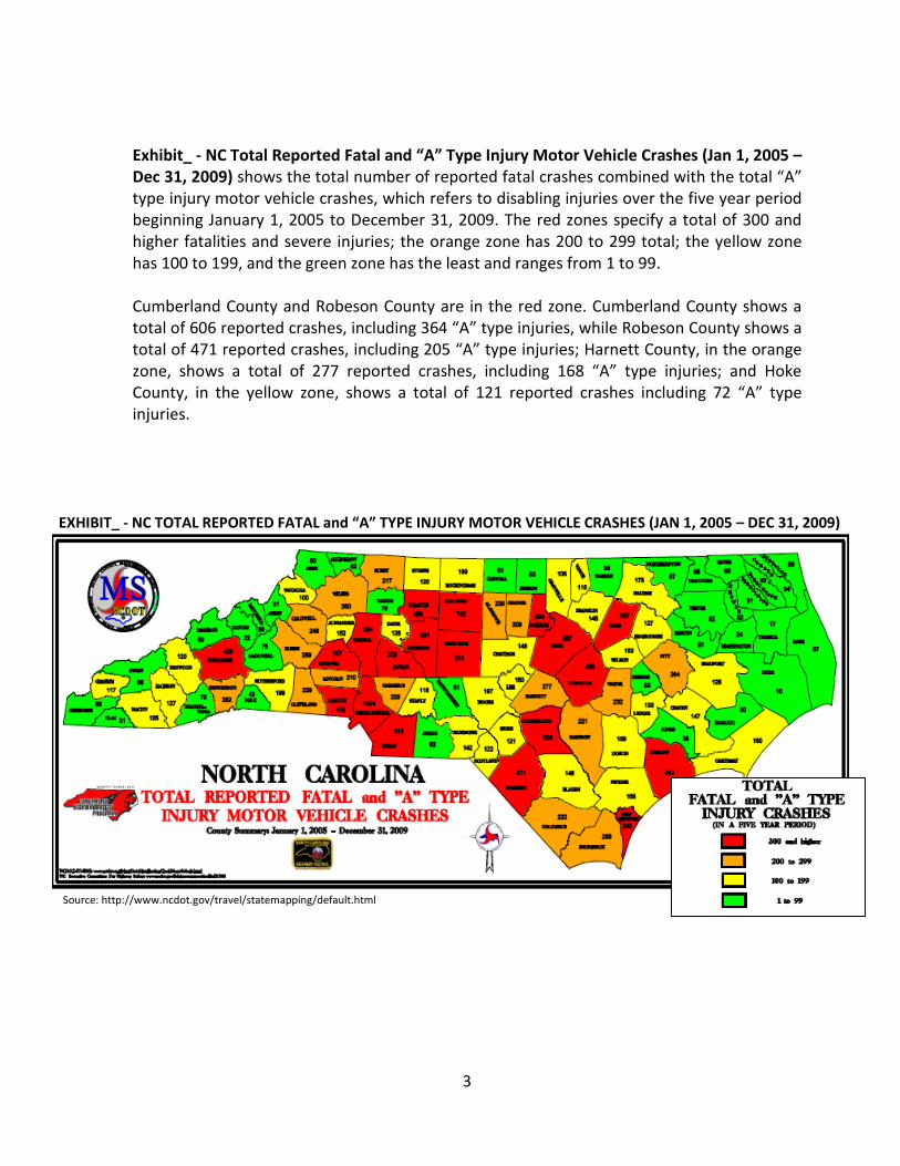
Exhibit_ - NC Total Reported Fatal and “A” Type Injury Motor Vehicle Crashes (Jan 1, 2005 – Dec 31, 2009) shows the total number of reported fatal crashes combined with the total “A” type injury motor vehicle crashes, which refers to disabling injuries over the five year period beginning January 1, 2005 to December 31, 2009. The red zones specify a total of 300 and higher fatalities and severe injuries; the orange zone has 200 to 299 total; the yellow zone has 100 to 199, and the green zone has the least and ranges from 1 to 99. Cumberland County and Robeson County are in the red zone. Cumberland County shows a total of 606 reported crashes, including 364 “A” type injuries, while Robeson County shows a total of 471 reported crashes, including 205 “A” type injuries; Harnett County, in the orange zone, shows a total of 277 reported crashes, including 168 “A” type injuries; and Hoke County, in the yellow zone, shows a total of 121 reported crashes including 72 “A” type injuries.
EXHIBIT_ - NC TOTAL REPORTED FATAL and “A” TYPE INJURY MOTOR VEHICLE CRASHES (JAN 1, 2005 – DEC 31, 2009)
Source: http://www.ncdot.gov/travel/statemapping/default.html

4
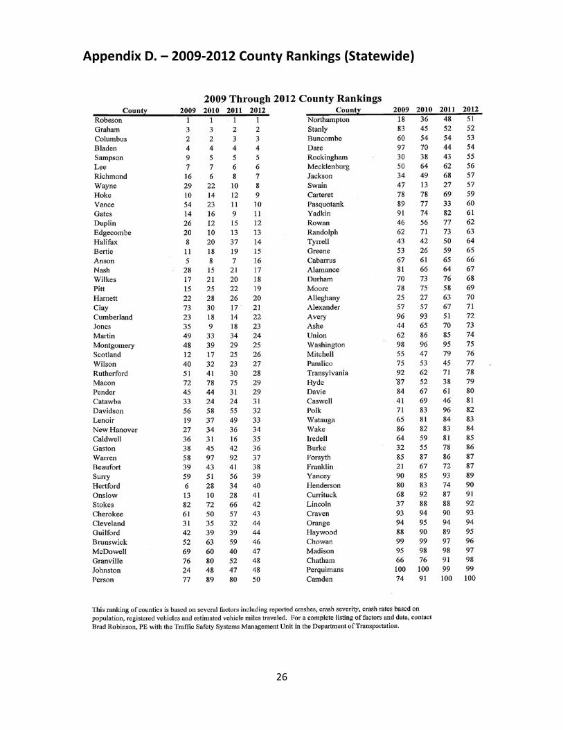
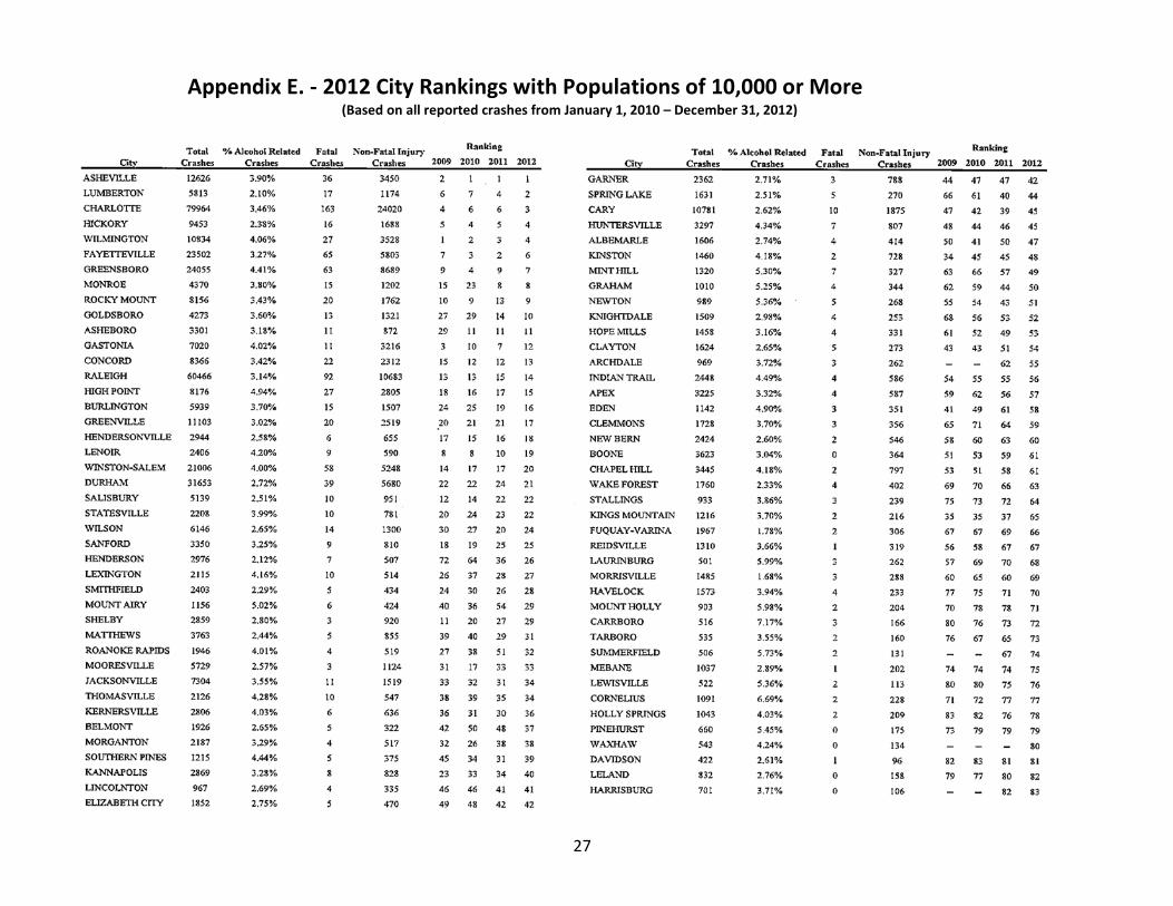
The accident data below is provided by the NCDOT’s Traffic Safety Unit. The 2012 Ranking of Cities with Populations of 10,000 or More, is based on several factors including all reported crashes, crash severity, and crash rates (determined by population) from January 1, 2010 through December 31, 2012. The rankings of counties are based on several factors including reported crashes, crash severity, crash rates based on population, registered vehicles, and estimated vehicle miles traveled. The rating is better as the number increases. As seen in Exhibit_ - 2010 - 2012 County Rankings, Cumberland County ranked No. 18 in 2010. The rating declined to No. 14 in 2011, but improved to No. 22 in 2012. Harnett County ranked No. 28 in 2010. The rating declined to No. 26 in 2011 and further declined to No. 20 in 2012. Hoke County ranked No. 14 in 2010. There was a decline to No. 12 in 2011, followed by another decline to No. 9 in 2012. Robeson County ranked No. 1 in 2010 and remained unchanged in 2011 and 2012.
EXHIBIT_ - 2010 – 2012 COUNTY RANKINGS County 2010 2011 2012
Cumberland 18 14 22 Harnett 28 26 20
Hoke 14 12 9 Robeson 1 1 1
Source: https://connect.ncdot.gov/resources/safety/Pages/Crash-Data.aspx The chart shows that the City of Fayetteville moved from a ranking of No. 3 in 2010 to No. 2 in 2011 to No. 6 in 2012; the Town of Hope Mills moved from No. 52 to No. 49 to No. 53; and the Town of Spring Lake moved from No. 61 to No. 40 to No. 44. Improvements are noted from 2011 to 2012.
EXHIBIT_ - 2012 RANKING of CITIES with POPULATIONS of 10,000 or MORE
City Total Crashes
Fatal Crashes
Non-Fatal Injury
Ranking 2010 2011 2012
Fayetteville 23,502 65 5,803 3 2 6 Hope Mills 1,458 4 331 52 49 53 Spring Lake 1,631 5 270 61 40 44
Source: https://connect.ncdot.gov/resources/safety/Pages/Crash-Data.aspx

5
County Profiles
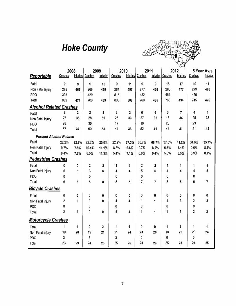
The following NC Department of Transportation profiles provide detailed accident data for Cumberland, Harnett, Hoke and Robeson Counties. See Appendix A for other statewide crash data.

6
7

8

9
Safety Planning
In 2003 North Carolina found that regardless of the continuous enhancements that had been made in the area of highway safety, there was still a need to better address the issues. As a response to further reduce fatalities and better coordinate with agencies outside of NCDOT, the North Carolina Executive Committee for Highway Safety (ECHS) was formed to identify, prioritize, promote and support all emphasis areas in the AASHTO Strategic Highway Safety Plan (SHSP). The ECHS is comprised of experts in all disciplines related to highway safety. In 2006 North Carolina also completed its Strategic Highway Safety Plan, as required by SAFETEA-LU and based on AASHTO’s SHSP, and updated it in 2007 to better address North Carolina needs. The NC SHSP’s mission statement, as developed by the ECHS is: Establish highway safety goals and objectives and prioritize, implement and evaluate coordinated, multi-disciplinary policies and programs to reduce fatalities, injuries and economic losses related to crashes. The original goal of the NC SHSP was to “Reduce the fatality rate to 1.0 fatalities/100MVM (Million Vehicle Miles) by 2008”. In 2006 the fatality rate for North Carolina was 1.54/100 MVM, making it impossible to reach the original SHSP goal. The slow reduction in rate is due, in part, to the exponential increase in VMTs (the rate has potentially doubled since 1985) compared to population change. The new goal included in the 2008 HSIP is to reduce annual fatality rates by 2.5% a year for the next 20 years. NCDOT’s Highway Safety Improvement Program (HSIP) is also updated annually and is available online at: https://connect.ncdot.gov/resources/safety/Pages/default.aspx FAMPO’s safety goals are in line with the NCDOT and prospective projects will be identified through the NCDOT Division office and the state HSIP.

10
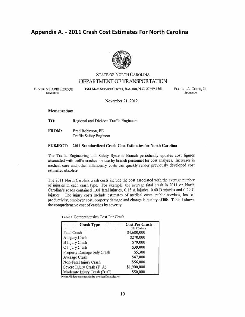
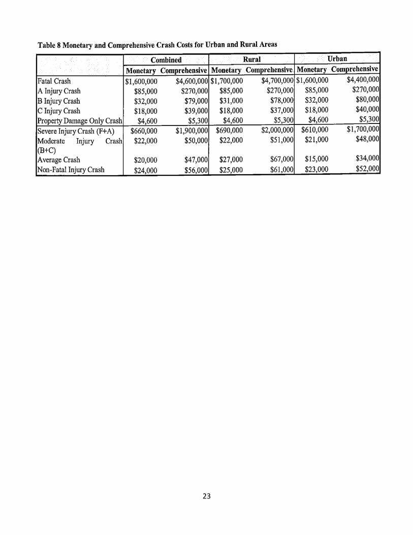
Studies compiled by NCDOT’s Traffic Safety Unit show that the cost of accidents in North Carolina, not only have severe impacts on quality of life of its citizens, but also an average cost of $4,600,000.00 per fatality (Appendix A). As transportation funds diminish and construction costs escalate, the need to maintain and optimize the existing infrastructure and to reduce crash rates becomes paramount in the management of transportation resources. By applying the four E’s (Engineering, Enforcement, Emergency Medical Response, Education) in the implementation of our Safety Plan we will reduce accident rates, increase capacity and extend the life of our existing infrastructure. Safety projects will also enhance local congestion management programs, reducing accident potential, managing access onto our roads, reducing conflict points at intersections and providing for alternate modes of transportation. The Safe Routes To School (SRTS) Program will also aid in providing additional resources to enhance safety at or around primary schools, making it easier for pupils to bike or walk to school, reducing the number of parents who currently drive their children. The safety and security of the population we serve is paramount in the development and maintenance of the transportation infrastructure, as indicated in the MPO’s planning factor “Increase the safety of the transportation system for motorized and non-motorized users”. Because of the need for improved safety for all users and the our citizens, FAMPO will adopt the state’s SHSP goals of accident reduction and will use recommended strategies to attain it. Additional information is included in the Congestion Management Process, which also describes the use of ITS in reducing congestion and increasing safety throughout the metropolitan area. During the development of the Highway Plan, several safety issues were evaluated, including ways to improve the current infrastructure while providing a safer environment for non-motorized traffic. The same can be said for the Metropolitan Transportation Improvement Program, where for a number of years prior to SAFETEA-LU, accident data was used as one of the major evaluation criteria, and will continue to be one. FAMPO’s policy is to request that every proposed road project (new construction as well as widening) be evaluated for an urban boulevard type cross section, with a landscaped center median and bicycle and pedestrian facilities. Divided roads have been proven to be safer than facilities with center turning lanes, by limiting conflict points with oncoming traffic, while providing a safety net for non-motorized traffic when crossing. The center median construction on Bragg Boulevard (NC 24-87 in Spring Lake), is an example of the type of safety enhancing projects FAMPO is in the process of implementing. This project includes the construction of a raised median at the location of the current center turning lane and was constructed in conjunction with an enhancement project, which included the construction of bicycle and pedestrian facilities along the route. The MPO is currently coordinating with NCDOT in exploring several candidates for this type of safety improvement.

11
The Congestion Management Program, Bicycle and Pedestrian Plan and the Waterway Plan also address safety and projects designed to provide a better and safer environment for all users of MPO facilities.
Crash Reduction Strategies
As stated in the AASHTO and NCDOT’s SHSP, by applying the principles of the “Four E’s” in safety planning process, the number of fatalities and serious injuries in the FAMPO area should diminish. One of the current issues that may delay reaching state and national goal in crash rate reduction is the fact that Vehicle Miles Traveled (VMTs) are still increasing, even if at a lower rate than in previous years. Higher VMTs equal more opportunities for vehicular/modal conflicts. It becomes a necessity to review a variety of strategies to accomplish our goal to significantly reduce fatalities and severe injuries on our roads (For examples, see chart below). Many forms of Transportation Demand Management (TDM) employed in congestion reduction and for air quality improvement can also be used in making our road system safer for all citizens.
Treatments with AMFs that have a Level of Predictive Certainty of High or Medium-High Type of Treatment Treatment Level of Predictive Certainty Intersection Treatments Install a roundabout High Add exclusive left-turn lane High Add exclusive right-turn lane High Install a traffic signal High Remove a traffic signal High
Modify signal change interval Medium-High
Convert to all-way stop control Medium-High
Convert stop-control to yield-control Medium-High
Install red-light cameras High
Roadway Segment Treatments Narrow lane widths to add lanes Medium-High
Add passing lanes (two-lane roads) Medium -High
Add two-way left-turn lane (TWLTL) Medium-High
Increase lane width Medium-High
Change shoulder width and/or type Medium-High
Flatten horizontal curve Medium-High
Improve curve superelevation Medium-High
Add shoulder rumble strip Medium-High
Add centerline rumble strips Medium-High
Install/upgrade guardrail Medium-High
Miscellaneous Treatments Install raised medians at crosswalks Medium-High Source: http://www.hsrc.unc.edu/safety_info/traffic_operations/crash_reduction_factors.cfm

12
According to an interim report published in November 2005, of the 100 treatments reviewed, 23 were found to have credible Accident Modification Factors (AMFs) available. For an AMF to be deemed “credible,” researchers required that the estimate have a high or mid-high level of predictive certainty. A critical factor in determining this credibility was the scientific rigor of the methodology used in the study in which the AMF was developed. For more information, please view the NCHRP Research Results Digest 299.
Alternative Transportation Methods
Alternative transportation methods provide the means for people to reduce the use of single-occupancy vehicles, thus lowering the number of vehicles on the roadways, reducing VMTs, traffic congestion and accident potential. The annual FAMPO Vehicle Occupancy Rate (VOR) report for 2013 shows that ridesharing is steady in this area, but that it still needs to improve. With a VOR rate of 1.06 for the Fort Bragg Survey area and 1.14 for the Central Business District Survey area, we can clearly see that car-pooling can be enhanced, even if these numbers are still above the National average of 1.07. Even with the cost of gasoline no longer in the $4.00/gal. range and the current recession, coupled with national disasters that have disrupted the flow of fuel in the Southeastern United States, the increase in the use of alternate modes of transportation is still increasing. Other transportation methods being proposed for the FAMPO area include ridesharing and van-pooling which have a similar effect on VMTs as transit usage. Transit usage in the nation has been steadily increasing, providing local transit agencies with the opportunity to expand their client base. The Fayetteville Area System of Transit (FAST) is the only form of public transportation currently available to the general public. It operates only within the municipal boundaries and offers minimal service for the area making it a less attractive mode of transportation. However, with the opening of the new FAST multimodal center in 2015 and major upgrades to the entire system and service area, it will become a more attractive mode of transportation. More detailed information can be found in FAMPO’s Transit Plan. An expanded bicycle and pedestrian network can also decrease conflict between vehicles and pedestrian/non-motorized transport. As part of the Safe Routes to School program, improvements surrounding primary schools will allow children to reach their destination in a safe manner, while helping to reduce congestion and improve air quality by removing parental vehicles for trips of less than two miles. In 2010, FAMPO, in cooperation with the City of Fayetteville Engineers and the Mid-Carolina Rural Planning Organization, commissioned Stewart to conduct a Bicycle and Pedestrian Connectivity Study to identify local roads to be used as connections between the current and proposed bicycle routes and selected destinations. The Fayetteville Walks & Bikes, FAMPO’s Bicycle and Pedestrian Connectivity Study, addressed the need for a connectivity system. The Report included all of Cumberland, and portions of Hoke and Harnett Counties.

13
Engineering Improvements
National and international studies have shown that reasonably priced road improvements can dramatically increase safety on many urban corridors. Even though the Two Way Turn Lane (TWTL, also known as suicide lane) is still a recommended treatment to increase safety along rural roads, it has been proven to be a safety hazard on urban thoroughfares. Replacement of a TWTL with a physical center median can help decrease overall accident rates. The current MTIP includes several projects that will retrofit thoroughfares with center medians. If no additional right-of-way is required, the cost of these projects can be contained, while the safety and capacity benefits outweigh the price of construction. A 2001 study of 23 US intersections by the Institute for Highway reported that converting intersections from traffic signals or stop signs to modern roundabouts reduced injury crashes by 80% and all crashes by 40%. Because modern roundabouts improve the efficiency of traffic flow, they also reduce vehicle emissions and fuel consumption. Studies have found that constructing modern roundabouts in place of traffic signals can reduce fuel consumption by approximately 30 percent. The installation of center medians and roundabouts also increase safety for non-motorized vehicles and pedestrians, while improving quality of life and maintaining a sense of place. Several alternative intersection designs and treatments also improve safety and signal installation, signal timing changes, can also be employed to decrease crash rates. The NCDOT Traffic Services units published a North Carolina Project Development Crash Reduction Factor Information, Revised May 13, 2007, which gives additional information on treatments and crash rates decrease (Appendix A). FAMPO will continue to evaluate corridors and, when possible, request roundabouts as part of intersection improvements and the retrofitting of center turn lanes into center medians to meet the state goal of accident reduction rates for both motorized and non-motorized users.

14
Enforcement
There is a statewide effort in increasing enforcement of current traffic laws. The City of Fayetteville has instituted a civilian traffic investigation unit to manage minor accidents, allowing police officers to dedicate their time to other matters. Speed enforcement cameras could also be employed as they have been proven to be effective both in the United States and in Europe. The state of North Carolina has several on-going programs that enhance enforcement and education such as Click-it or Ticket (see Appendix C.), Car seat enforcement, etc.)
Emergency Medical Response
The Federal Emergency Management Agency (FEMA) requires all jurisdictions to be in compliance with federal hazard mitigation standards by updating every five years. As part of this plan, FAMPO has reviewed the Hazard Mitigation Plan Update that was jointly developed by local jurisdictions; Emergency Services; and the Cumberland County Joint Planning Board, FAMPO’s Lead Planning Agency. One of the main purposes of the Hazard Mitigation Plan Update is to “protect the health, safety, and economic security of County residents by reducing the impacts of natural hazards….” The Update was approved in October 25, 2011 and is approved through October 25, 2016. The Update can be reviewed at the Cumberland County Emergency Services Department, Cumberland County Planning Department, City of Fayetteville, Town Hall in Hope Mills, Spring Lake, Eastover, Stedman, Wade, Falcon, Godwin, and Linden, and online at http://co.cumberland.nc.us/planning.aspx. (See Appendix G. – FEMA Letter)
Education
Graduated Licensing Program
North Carolina has a graduated licensing program designed for beginning drivers starting at age 15, but less than 18 years of age. Level 1 of the program is the Limited Learner Permit, which requires six months of practice and allows for driving between 5 AM and 9 PM while accompanied by a supervising driver. Level 2 is the Limited Provisional License, which allows unsupervised driving between 5 AM and 9 PM or while driving directly to and from work, or any volunteer fire, rescue, or emergency medical service. You can allow no more than one passenger under age 21 to ride in the vehicle while driving unsupervised. The age requirement for Level 2 is 16, but less than 18 years old; you must pass a road test, have proof of insurance, and have no convictions for moving violations, seat belts, or mobile phone use in the preceding six months. Level 3, Full Provisional License, is the final stage of the program. It allows for unsupervised driving at any time. You must maintain a Limited Provisional License for six months and have no convictions for moving violations, seat belts, or mobile phone use in the preceding six months.

15
Levels 1, 2, and 3 prohibit the use of mobile phones or other additional technology associated with a mobile phone while operating a motor vehicle on public vehicular areas.
Safe Routes to School
The North Carolina Department of Transportation Safe Routes to School (SRTS) is a federally funded program designed to encourage children to walk and bike to school while making walking and biking safer and more appealing transportation options. The SRTS program develops and implements projects and activities focused on improving safety and air quality by reducing traffic, fuel consumption, and air pollution in the vicinity of schools; educates communities on the advantages of walking and biking; and considers infrastructure enhancements to help create safer physical environments for walking and biking. Teaching our children how to use a bicycle or how to walk to and from school are valuable skills that can be accomplished through the “Walk to School Day,” “The Walking School Bus,” or other SRTS training programs.
Newsletter
The FAMPO newsletter (electronic or hard copy) is currently distributed via subscription and through the web site. It is an additional tool FAMPO employs for informational and educational purposes. The Fayetteville Observer, the largest area newspaper, has been a great partner in identifying transportation projects every day in the Local Section with information on delays, projected work schedules, and anticipated completion dates. Security Planning Emergency Operations Plan (EOP)
The Cumberland County Emergency Operations Plan (EOP) has been developed to address multiple hazards, which threaten a jurisdiction. It “predetermines actions that are to be taken by the governmental agencies and private organizations of Cumberland County to reduce the vulnerabilities of people and property to disaster and establish capabilities to respond effectively to the actual occurrence of a disaster. It also identifies the critical/vital facilities that must be managed during a disaster.” Through use of a functional format, the document encourages an Integrated Emergency Management System (lEMS) approach to disasters; and fosters prompt, efficient and coordinated response operations by elements of the emergency organization. IEMS requires a system wide integration of skills, people and resources as well as the utilization of a County Emergency Operation Center. This Plan also recognizes Incident Command as an appropriate management system to be applied to all Cumberland County emergency/disaster situations, when required. This document presents a basic plan, which serves as a summary document to the support sections. These sections define who will do what and when in an emergency situation. Defining the roles of each response agency reduces the confusion, chaos and conflict during emergencies and significantly decreases vulnerability of the public and their property to hazardous threats.

16
Cumberland County has adopted the National Incident Management System (NIMS) approach as well, to incorporate the elements of NIMS essential to efficient management of emergencies and disasters that will involve local, state and federal response agencies. The federal government places criteria for all emergency plans. The purpose of the Homeland Security Presidential Directive #5 (HSPD-5) is “to enhance the ability of the United States to manage domestic incidents by establishing a single, comprehensive national incident management system.” The HSPD-5 states it is "To prevent, prepare for, respond to, and recover from terrorist attacks, major disasters, and other emergencies, the United States Government shall establish a single, comprehensive approach to domestic incident management. The objective of the United States Government is to ensure that all levels of government across the Nation have the capability to work efficiently and effectively together, using a national approach to domestic incident management. In these efforts, with regard to domestic incidents, the United States Government treats crisis management and consequence management as a single, integrated function, rather than as two separate functions." The EOP is housed in the Emergency Services Department, currently located in the Cumberland County Law Enforcement Center. This Plan meets the requirements of FEMA planning guidance, CPG 1-8, CPG 1-8A, NRT-1 and the legal responsibilities identified in North Carolina General Statutes, Chapter 166-A. It provides all the necessary elements to ensure that local government can fulfill its legal responsibilities for emergency preparedness. Although the plan is a realistic reflection of the way emergency response will be carried out when an event occurs, it does not define how each agency should perform its tasks. The agency’s Standard Operating Guidelines contains detailed emergency performance procedures. (Reference: Cumberland County, North Carolina Emergency Operations Plan, August 12, 2012)
Fort Bragg Military Reservation
FAMPO includes, among its jurisdictions, Fort Bragg Military Reservation and Pope Army Air Field. Fort Bragg is the most populous military base in the nation and home of the XVIII Airborne Corps, the 82nd Airborne Division, the U.S. Army Special Operations Command and is known as the “Home of the Airborne and Special Operations Forces”. Because of the 2005 Base Realignment and Closures (BRAC), the U.S. Forces Command and the U.S. Army Reserve Command, previously located in Atlanta GA, relocated its headquarters at Fort Bragg in 2011, making this area particularly sensitive to security. The security on Fort Bragg Military Installation is too complex and sensitive in nature to be included in this plan. The physical security of the base has been a topic of planning and discussion with the MPO since prior to the 2001 events. On September 12, 2001, all major roads converging into the military reservation became congested due to the closing of access points to maintain post security. The collaborative effort in transportation planning and management became even more crucial. Since 2001, ongoing collaborative efforts have resulted in several major highway projects. This will enhance the physical security of Fort Bragg, while maintaining

17
connections with adjoining areas. Bragg Boulevard is undergoing significant changes; first, to widen and build a median in the pursuit of consistency from one end of the corridor to the other; second, the northern end will some day in the near future be restricted only to military-related use as part of a security improvement at Fort Bragg. Public traffic will be detoured and diverted onto Interstate 295 and Murchison Road to bypass Fort Bragg. In an effort to improve security upon entering onto Fort Bragg, new procedures that include criminal background checks for visitors were implemented in November 2013. Fort Bragg has several Access Control Points (ACPs) that require identification to gain entrance. All visitors and commercial vehicles without proper identification must obtain a pass to gain entry on post. The new procedures also require that visitors be photographed and fingerprinted prior to obtaining a pass. Fayetteville Regional Airport
The Fayetteville Regional Airport (FAY) follows guidelines set by the Federal Aviation Administration (FAA). FAY’s Airport Security Program (ASP) and Federal Aviation Regulation (FAR) Part 139 provides guidance for emergencies initiated by criminal activity or threats. Security issues related to air travel have changed considerably since September 2001, and will continue to evolve as new procedures and technology are incorporated to improving airport security.
Fayetteville Area System of Transit (FAST) In July 2012, the Federal Transit Administration (FTA) awarded a grant to the City of Fayetteville to build a transit transfer center. The Fayetteville Area System of Transit (FAST) celebrated the groundbreaking on November 20, 2013, for the new Multimodal Transit Center, which is scheduled to open in mid-2015. It will serve as the area’s central hub of the fixed route system where passengers can await the arrival of buses and where system information, passes, and transfer passes can be obtained. The Center will improve safety and security for passengers by providing a safe indoor environment while waiting for transportation. FAST began purchasing Global Positioning System and Automatic Vehicle Locators for its fixed route and paratransit vehicles in 2009. Today, the vehicles are equipped with scheduling and routing software. Also, all buses are equipped with video surveillance systems.
FAMPO’s Continuing Operations
During the development of the Cumberland County Multi-Jurisdictional Hazard Mitigation Plan, Cumberland County Emergency 911 office geo-coded, among a long list of facilities, all “critical facilities” and “hazardous materials” locations, providing FAMPO with critical security information. The MPO office requires that, as part of the services provided, it continues to operate in case of emergency. FAMPO resides within the
18
Cumberland County Planning and Inspections Department, which is covered by the County’s Continuing Operations Plan (CoOP). In addition, FAMPO’s website is maintained by an external provider, all data is housed off-site (to include Exponare, the MPO’s major visualization and public information tool) and staff can remotely access it.
Summary
By maintaining a strong relationship with our partners in safety and security, NCDOT, local jurisdictions, our citizen stakeholders, and the emergency management community, FAMPO strives to improve on current trends to make our infrastructure safer and more secure for the area citizens. We will continue to work together to provide an environment conducive to multi-modalism, while protecting and preserving the lives of our citizens, increasing quality of life, and providing a sense of place.
19
Appendix A. - 2011 Crash Cost Estimates For North Carolina

20

21

22
23

24
Appendix B. - 2012 Crash Data (Statewide)
Contributing Circumstances

25
Appendix C. - 2012 Seat Belts (Statewide)
Belt Use by Injury Level & Seating Position
26
Appendix D. – 2009-2012 County Rankings (Statewide)
27
Appendix E. - 2012 City Rankings with Populations of 10,000 or More (Based on all reported crashes from January 1, 2010 – December 31, 2012)

28
Appendix F. – Active Spot Safety Projects
The Spot Safety Program is used to develop smaller improvement projects to address safety, potential safety, and operational issues. For a complete list of safety projects, please visit www.fampo.org. NOTES:
(1) Is the project State or Federally funded? One way to tell is to look at the TIP No. shown below. If TIP No. starts with SS, PS, RS, or US, it is STATE funded. If TIP No. starts with SF, SI, or W it is FEDERALLY funded.
(2) If project is Federally funded – Division sends Programmatic Categorical Exclusion Document and Line Item Estimate to Project Management (Trish Pollard) PRIOR to authorizing/starting construction. If project is in an MPO, MPO approval is also required PRIOR to authorizing/starting construction. If project is in an RPO, RPO approval is not necessary.
(3) For federally funded projects, follow let list dates to know approved date to construct project. For state funded projects, construct as soon as feasible.
(4) As of 7/1/2012 - For Spot Safety projects, "Total Allocation" may be less than the original amount requested. Starting with the 7/12/2012 Board meeting, we have reduced the amounts we are requesting the Board to approve by 20%. We will increase the amount to the original estimate in a future Board agenda if it is needed without further justification from the Division or RTE. Contact your RTE or Cindy Millikin if you have any questions.
(5) NEW NOTE - As of 1/1/2014 - W-projects are now included in the Project Status update report (at the end). RTEs will now be performing Final Inspections on W-projects as well as Spot Safety projects. Once the Final Inspection is received, the project will be removed from the Project Status report. (No Final Inspection is needed for W-projects that have been completed prior to 7/1/2013. Just let us know the Project Completion Date and the W-project will be removed from the status report.)

DIVISION 06
ALL SAFETY PROJECTS FEBRUARY 2014
Date of Last
Status Update
Board Approval
Date
PE WBS Element
Const. WBS
Element
Est. % Com- plete
Est. Let or Completion
Date
Description of Location
Project Improvement Description
Total Allocation
Project Status (When Complete, Give Completion Date)
Contact Person and Phone No. County File No. B/C TIP No.
29
11/25/2013 Cumberland
06-11- 16574
US 401/Pamalee Drive, from Commonwealth Drive westward for approximately 0.2 mile, in the City of Fayetteville
Install drop inlets along curved/sag section of Pamalee Drive, and install a driveway drop inlet at the intersection with Commonwealth, to improve drainage.
239
$51,000
4/5/2012
43503.1.1
43503.3.1
SS-
4906BJ
60% W ork should
be complete by 1/15/14.
Richie Hines: (910) 486-1496.
Plans by Division. To be let March 2013 in order to include Resurfacing. To be combined with SS-4906BI. Concrete work to be done uner Misc - Concrete contract. Concrete work began on 7/8/13. Awaiting pre-fab drop inlet. Work should be complete by 1/15/14.
11/25/2013 Cumberland
06-12- 19412
US 401 (Pamalee Drive/Country Club Drive) at NC 210 (Murchison Road).
Construct marked crosswalks on all four legs of the intersection and revise the signal to include pedestrian signal heads and push buttons. Also revise two existing mid-block crosswalks near intersection.
44 $60,000
10/4/2012
43641.1.1
43641.3.1
SS-
4906BO
99% Scott Pridgen:
(910) 437-2611.
Project complete. Awaiting final inspection.
3/27/2013 Cumberland
06-12- 21194
I-295 at I-95 NB ramps, SB ramps, and US 13 merge.
Close the median opening at the I-95 NB ramps. Construct a bulb-out for u-turns at the end of the concrete island where the roadway transitions from four-lane I-295 to two- lane US 13. Extend accel lane taper on I-295 at the I-95 SB off-ramp.
63.4
$80,000
1/10/2013
43699.1.1
43699.3.1
SS-
4906BR
10% Scott Pridgen:
(910) 437-2611.
Plans by Division.ROW plans est. 11/15/13. Est. let is 5/15/14.
11/25/2013
Harnett
06-11- 12859
SR 1718 (Dunn- Erwin Rd) at Powell Avenue, in the Town of Dunn
Change lane marking pattern from 4 lanes to an offset left turn lane and one through lane in each direction. Project includes resurfacing to improve marking visibility, addition of a signal head for the left turn lane, and relocation of the through heads.
3.32
$173,000
10/6/2011
43397.1.1
43397.3.1
SS-
4906BA
50% Richie Hines:
(910) 486-1496.
Paving complete. W orking to revise temporary markings and install new pavement markings. Signal work to be done by State forces as soon as paving is complete.

DIVISION 06
ALL SAFETY PROJECTS FEBRUARY 2014
Date of Last
Status Update
Board Approval
Date
PE WBS Element
Const. WBS
Element
Est. % Com- plete
Est. Let or Completion
Date
Description of Location
Project Improvement Description
Total Allocation
Project Status (When Complete, Give Completion Date)
Contact Person and Phone No. County File No. B/C TIP No.
30
11/25/201 3
Harnett 06-11- 12988
US 401 (Main St) intersections at NC 27 and SR 2016 (McNeil), in the Town of Lillington
Signalize intersection of Main St at NC 27. Close W McNeil leg. Combine new signal with the signal at McNeil, and operate as one signal.
1.36 $225,000 10/6/2011 43401.1.1 43401.3.1 SS- 4906BC
90% Scott Pridgen: (910) 437-2611.
Project work complete. Awaiting power to signal to be turned on.
11/25/201
3
Harnett
06-12- 17308
US 421 (Cumberland Street) at Dunn-Erwin Rd / Broad Street, in the Town of Dunn. [Signal Inv. 06-0130]
Upgrade existing signal geometry from a skewed placement to a traditional boxed intersection, utilizing metal strain poles.
3.54
$91,600
1/10/2013
43698.1.1
43698.3.1
SS-
4906BQ
40% Frank W est:
(910) 486-1452.
Signal Plan received. Signal pole is ordered. Utility adjustments underway.
11/25/201
3
Harnett
06-13- 24553
Bridges 1 and 151 on SR 1415 (Rawls Church Rd); and
Install approach and trailing guardrail for each bridge. PLEASE NOTE the details
11.1
$162,400
10/3/2013
43924.1.
FD1
43924.3.1
SS-
4906BT
10% Richie Hines:
(910) 486-1496.
Plans by Division. District and Bridge Depts. To meet and set schedule.
Bridges 133 and 134 for each bridge location may on SR 1722 vary slightly. Details can be
found on the cost estimate sheet for each individual bridge.
Robeson
06-13- 26081
SR 1945 (Meadow Road) at SR 1984 (Linkhaw Road) and SR 1003 (Chicken Road) at SR 1339 (Deep Branch Road).
Convert both intersections to an all-way stop condition.
311
$8,000
1/9/2014
43984.1.
FD1
43984.3.1
SS-
4906BU
10% Frank W est:
(910) 486-1452.
No plans needed.
8/9/2012 Cumberland
06-12- 19886
SR 2238 (Sand Hill Road) at SR 2252
Install a traffic signal, construct a right turn lane on
1.01
$342,000
45336.1.2
1
45336.3.2
1
W -5206U
Plans needed from Signal Design and Division. 6/25/12: Approved
(Chicken Foot Road). Chicken Foot Road, lengthen the right turn lane on Sandhills Road, and connect to new developer funded signal at SR 2242 (Braxton Road) approximately 400 feet east. SELECTED FOR HRRR FUNDS.
by Kevin Lacy in statewide W - project selection meeting. 7/11/12: Requested structure to be set up in SAP and PE funds to be authorized. Requested April 2013 ROW /Utilities let date, and April 2014 Construction let date. REQUESTED HRRR FUNDS. 8/9/12: Notified RTE and Division that PE funds were approved.
4/27/2011
Harnett
06-11- 11740
SR 1790 (McKay Avenue/Chicken Farm Rd), reverse curve located south of Dunn between SR 1844 and SR 1780.
Realign curve.
0 $775,000
45336.1.1
2
45336.3.1
2
W -5206L
3/21/11: Approved by Kevin Lacy (based on B/C being at least as high as those chosen recently (above 3.5) for a Divisionwide W - project. Requested RTE to send me a let date so that I can get it added to the SAP Divisionwide structure. 4/27/11: Requested project to be set up in SAP with HRRR funds, PE funds to be set up, ROW /Utilities let date of September 2012 and Construction let date of September 2013.

DIVISION 06
ALL SAFETY PROJECTS FEBRUARY 2014
Date of Last
Status Update
Board Approval
Date
PE WBS Element
Const. WBS
Element
Est. % Com- plete
Est. Let or Completion
Date
Description of Location
Project Improvement Description
Total Allocation
Project Status (When Complete, Give Completion Date)
Contact Person and Phone No. County File No. B/C TIP No.
31
8/9/2012 Harnett 06-12- 19348
NC 27 reverse curve located west of SR 1210 toward NC 87.
W edging and overlay reverse curve.
14.0 $410,000 45336.1.2 2
45336.3.2 2
W -5206V Plans by Division. 6/25/12: Approved by Kevin Lacy in statewide W -project selection meeting. 7/11/12: Requested structure to be set up in SAP and PE funds to be authorized. Requested July 2013 ROW /Utilities let date, and July 2014 Construction let date. REQUESTED HRRR FUNDS. 8/9/12: Notified RTE and Division that PE funds were approved.
9/26/2011
Robeson
06-11- 13697
NC 211 at SR 1001 (Shannon Road)
Construct left and right turn lanes, improve intersection skew, and widen inside paved shoulder by 2 feet.
17.0
$490,000
45336.1.1
4
45336.3.1
4
W -5206N
9/26/11: Approved by Kevin Lacy (based on B/C being at least as high as those chosen during last selection (above 3.5) for a Divisionwide W -project. Requested project to be set up in SAP with HRRR funds, PE funds to be set up, ROW /Utilities let date of January 2013 and Construction let date of January 2014.
9/26/2011
Robeson
06-11- 13365
NC 71 culvert within a curve located between SR 1316 and SR 1317.
Replace existing culvert, wedge curve, widen shoulders/pavement, and install guardrail along culvert.
13.6
$745,000
45336.1.1
5
45336.3.1
5
W -5206O
9/26/11: Approved by Kevin Lacy (based on B/C being at least as high as those chosen during last selection (above 3.5) for a Divisionwide W -project. Requested project to be set up in SAP with HRRR funds, PE funds to be set up, ROW /Utilities let date of November 2012 and Construction let date of November 2013.
12/14/201
2
Robeson
06-12- 21192
SR 1774 from SR 1318 to SR 1505
2' Symettrical widening
13.8
$700,000
45336.1.2
5
45336.3.2
5
W -5206Y
Plans by Division. 9/24/12: Approved by Kevin Lacy in statewide W -project selection meeting. 12/14/12: Requested structure to be set up in SAP and PE funds to be authorized. Requested HRRR funds. Requested Jan. 2014 ROW date and Jan. 2015 Construction let date.
10/30/200
9
Bladen
06-06-
201
NC 87 at SR 1700 (Mercer Mill Road) and SR 1145 (MLK) at NC 87.
Construct directional crossovers and/or offsets with appropriate median U-turns.
13 $1,290,000
41168.1.1
41168.3.1
W -5002
Kevin Lacy has approved this >$1M project to go on the On Hold list. To be included in the Spring 2006 draft T IP. 3/21/07: Included in approved T IP on 3/1/07. Scheduled for ROW FFY 07, Construction FFY 08. 10/30/09: Per SAP's Long Text, project was complete 8/1/09.
DIVISION 06
ALL SAFETY PROJECTS FEBRUARY 2014
Date of Last
Status Update
Board Approval
Date
PE WBS Element
Const. WBS
Element
Est. % Com- plete
Est. Let or Completion
Date
Description of Location
Project Improvement Description
Total Allocation
Project Status (When Complete, Give Completion Date)
Contact Person and Phone No. County File No. B/C TIP No.
32
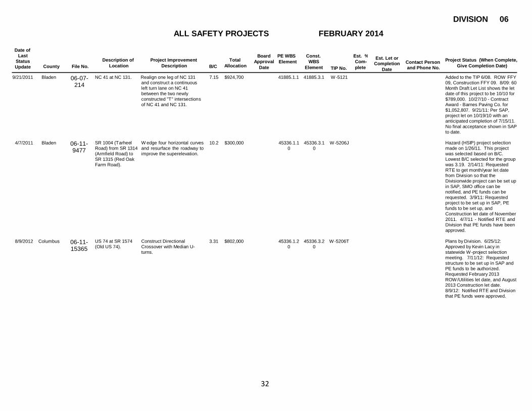
9/21/2011 Bladen 06-07- 214
NC 41 at NC 131. Realign one leg of NC 131 and construct a continuous left turn lane on NC 41 between the two newly constructed "T" intersections of NC 41 and NC 131.
7.15 $924,700 41885.1.1 41885.3.1 W -5121 Added to the TIP 6/08. ROW FFY 09, Construction FFY 09. 8/09: 60 Month Draft Let List shows the let date of this project to be 10/10 for $789,000. 10/27/10 - Contract Award - Barnes Paving Co. for $1,052,807. 9/21/11: Per SAP, project let on 10/19/10 with an anticipated completion of 7/15/11. No final acceptance shown in SAP to date.
4/7/2011
Bladen
06-11- 9477
SR 1004 (Tarheel Road) from SR 1314 (Armfield Road) to SR 1315 (Red Oak Farm Road).
W edge four horizontal curves and resurface the roadway to improve the superelevation.
10.2
$300,000
45336.1.1
0
45336.3.1
0
W -5206J
Hazard (HSIP) project selection made on 1/26/11. This project was selected based on B/C. Lowest B/C selected for the group was 3.19. 2/14/11: Requested RTE to get month/year let date from Division so that the Divisionwide project can be set up in SAP, SMO office can be notified, and PE funds can be requested. 3/9/11: Requested project to be set up in SAP, PE funds to be set up, and Construction let date of November 2011. 4/7/11 - Notified RTE and Division that PE funds have been approved.
8/9/2012
Columbus
06-11- 15365
US 74 at SR 1574 (Old US 74).
Construct Directional Crossover with Median U- turns.
3.31
$802,000
45336.1.2
0
45336.3.2
0
W -5206T
Plans by Division. 6/25/12: Approved by Kevin Lacy in statewide W -project selection meeting. 7/11/12: Requested structure to be set up in SAP and PE funds to be authorized. Requested February 2013 ROW /Utilities let date, and August 2013 Construction let date. 8/9/12: Notified RTE and Division that PE funds were approved.

DIVISION 06
ALL SAFETY PROJECTS FEBRUARY 2014
Date of Last
Status Update
Board Approval
Date
PE WBS Element
Const. WBS
Element
Est. % Com- plete
Est. Let or Completion
Date
Description of Location
Project Improvement Description
Total Allocation
Project Status (When Complete, Give Completion Date)
Contact Person and Phone No. County File No. B/C TIP No.
33
11/20/201 3
Columbus 06-13- 24885
US 74 at SR 1574 (Old US 74)
Construct an overpass. 5.36 $4,015,000 43741.1. FS1
43741.3.F S1
W -5518 Plans needed. 9/4/13 - Requested T IP amendment for October 2013 (handout) and November 2013 (approval). ROW 2/2015; CON 2/2016. Once approved, W-5206T needs to be deleted and PE funds taken down. Request FHW A approval of funds since new W -project will be overpass. 9/20/13 - Per Ray McIntyre, this project will be on October 2013 Handout for Information and scheduled for November 2013 TIP amendment approval. 11/8/13 - Requested PE funds. 11/20/13 - Notified Division and Region that PE funds have
11/18/201
3
Columbus
06-13- 24883
US 74 at SR 1001 (Hallsboro Road)
Construct a diamond interchange.
5.04
$0 W -TBD 6-
21-13
Plans needed. 6/21/13 - Approved by Kevin Lacy in statewide W -project selection meeting. 9/4/13 - Per Ray McIntyre, we still need to discuss companion funding in further detail with Kevin. He'll do that soon and hopefully be able to amend this project to the TIP in Oct./Nov. 2013. 11/14/13 - Per Ray McIntyre, the official rule for supplemental safety funding to fund through HSIP process instead of SPOT process is 33%. This project is at 26%. RTE David Phipps is looking at alternatives.
10/30/200 Cumberland
06-00-
US 13 from east of I- Construct paved shoulders
5.46
$1,115,000
41174.1.1
41174.3.1
W -5001
Kevin Lacy has approved this
9 231 95 to the Sampson County line.
and turn lanes at various intersections.
>$1M project to go on the On Hold list. To be included in the Spring 2006 draft T IP. 1/5/07: ROW added for $100,000 for FFY 07. Construction decreased by $100,000 to $1,015,000. 3/21/07: Included in approved TIP on 3/1/07. Scheduled for ROW FFY 08, Construction FFY 08. 10/30/09: Per SAP expenditures and Long T ext, project was let in June 2009 and is Under Construction.
DIVISION 06
ALL SAFETY PROJECTS FEBRUARY 2014
Date of Last
Status Update
Board Approval
Date
PE WBS Element
Const. WBS
Element
Est. % Com- plete
Est. Let or Completion
Date
Description of Location
Project Improvement Description
Total Allocation
Project Status (When Complete, Give Completion Date)
Contact Person and Phone No. County File No. B/C TIP No.
34
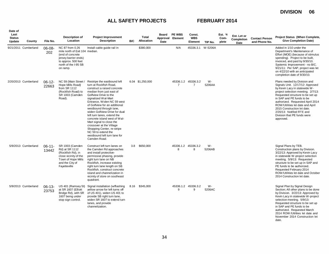
5/9/2013 Cumberland 06-11- SR 1003 (Camden Construct left turn lanes on 3.8 $650,000 45336.1.2 45336.3.2 W - Signal Plans by TEB.
Rd) at SR 1112 the Camden Rd approaches 8 8 5206AB Construction plans by Division.
(Rockfish Rd), in and install protective- 3/22/13: Approved by Kevin Lacy
close vicinity of the permissive phasing, provide in statewide W -project selection
Town of Hope Mills right turn lane on NB meeting. 5/9/13: Requested
and the City of Rockfish, increase existing structure to be set up in SAP and
Fayetteville right turn lane length on SB PE funds to be authorized.
Rockfish, construct concrete Requested February 2014
island and channelization in ROW /Utilities let date and October
vicinity of store on southeast 2014 Construction let date.
quadrant.
9/21/2011 Cumberland 06-08- NC 87 from 0.26 Install cable guide rail in $380,000 N/A 45336.3.1 W -5206A Added in 1/10 under the
202 mile north of Exit 104 median. (end of concrete jersey barrier ends) to approx. 500 feet north of the I-95 SB on ramp.
Department's Maintenance of Effort (MOE) (because of stimulus spending). Project to be built, invoiced, and paid by 9/30/10. Systemic Improvement - no B/C. 9/21/11: Per SAP, project was let on 4/22/10 with an anticipated completion date of 9/30/10.
2/20/2013 Cumberland
06-12- 22663
NC 59 (Main Street / Hope Mills Road) from SR 1112 (Rockfish Road) to SR 1003 (Camden Road).
Restripe the eastbound left turn at Rockfish Road, construct a raised concrete median from just east of Golfview Drive to the signalized W al-Mart Entrance, W iden NC 59 west of Golfview for an additional westbound through lane, widen Golfview Drive for dual left turn lanes, extend the concrete island west of Wal- Mart signal to close the crossover at the Village Shopping Center, re-stripe NC 59 to extend the westbound left turn lane for Camden Road.
6.04
$1,250,000
45336.1.2
7
45336.3.2
7
W -
5206AA
Plans needed by Division and Signals Unit. 12/17/12: Approved by Kevin Lacy in statewide W - project selection meeting. 2/7/13: Requested structure to be set up in SAP and PE funds to be authorized. Requested April 2014 ROW /Utilities let date and April 2015 Construction let date. 2/20/13: Notified RTE and Division that PE funds were approved.
13442
5/9/2013 Cumberland 06-13- 23753
US 401 (Ramsey St) at SR 1607 (Elliott Bridge Rd), with SR 1607 being under stop sign control.
Signal installation (w/flashing yellow arrow for left turns off of US 401), widen US 401 to provide SB right turn lane, widen SR 1607 to extend turn lanes, and provide channelization.
8.16 $345,000 45336.1.2 9
45336.3.2 9
W - 5206AC
Signal Plan by Signal Design Section; All other plans to be done by Division. 3/22/13: Approved by Kevin Lacy in statewide W -project selection meeting. 5/9/13: Requested structure to be set up in SAP and PE funds to be authorized. Requested March 2014 ROW /Utilities let date and November 2014 Construction let date.

DIVISION 06
ALL SAFETY PROJECTS FEBRUARY 2014
Date of Last
Status Update
Board Approval
Date
PE WBS Element
Const. WBS
Element
Est. % Com- plete
Est. Let or Completion
Date
Description of Location
Project Improvement Description
Total Allocation
Project Status (When Complete, Give Completion Date)
Contact Person and Phone No. County File No. B/C TIP No.
35
8/19/2013 Cumberland 06-10- 7788
SR 1104 (Strickland Bridge Road) from SR 1105 (Graham Road) to a point just south of Brookmere Place. NOTE - LOOK AT W ITHOUT COMPANION FUNDS of $150K - B/C is 4.2.
Construct a left turn lane on SR 1104 at SR 1105, and grade/wedge curved section in the vicinity of Brookmere Place, in the City of Fayetteville.
4.2 $355,000 45336.1. FD30
45336.3.F D30
W - 5206AD
Plans by Division. 8/19/13: Requested structure to be set up in SAP and PE funds to be authorized. Requested July 2014 ROW /Utilities let date and July 2015 Construction let date.
8/19/2013 Cumberland 06-13- 24625
SR 1104 (Strickland Bridge Road), from
Construct left turn lanes on Strickland Bridge Rd at SR
11.7 $515,000 45336.1. FD31
45336.3.F D31
W - 5206AE
Plans by Division. 8/19/13: Requested structure to be set up
the southern 4029 (Kerfield), SR 1109 in SAP and PE funds to be
intersection of SR (Dundle), and SR 3089 authorized. Requested August
3365 (Hackney (Ridge Manor). Provide two 2014 ROW /Utilities let date and
Loop) to just south of foot symmetrical widening on August 2015 Construction let date.
SR 1109 (Dundle Strickland Bridge Road Rd), in the City of throughout the project limits.
Fayetteville. Improve the skew angle of
the stop condition at Dundle
Rd.
8/19/2013 Cumberland 06-13- 24709
SR 1400 (Cliffdale Road) at McPherson Church Road, in the City of Fayetteville.
W iden the W B leg of Cliffdale Road to provide an additional thru lane (new lane pattern: left/thru/thru-right). W iden the NB leg of McPherson Church Rd to provide a right turn lane. Add pedestrian signals to each leg of the intersection.
7.91 $305,000 45336.1. FD32
45336.3.F D32
W - 5206AF
Plans needed by Division and Signals. 8/19/13: Requested structure to be set up in SAP and PE funds to be authorized. Requested September 2014 ROW /Utilities let date and September 2015 Construction let date. 8/22/13 - Anna Twohig changed the CON let date to 12/2014 per Jerry Bradley's request.
8/28/2013 Cumberland
06-13- 24623
SR 1403 (Reilly Road) from SR 1400 (Cliffdale Road) to
Signalize the intersection at Jeffrey Drive. Install a signalized directional
10.4
$1,370,000
45336.1.
FD34
45336.3.F
D34
W -
5206AH
Signal plans to be done by Signals Section. All other plans to be done by Division. 8/28/13:
W illowbrook/Kimridg crossover at Requested structure to be set up e in Fayetteville. GlenAllen/Northumberland.
Install Pedestrian facilities. Construct raised median throughout section.
in SAP and PE funds to be authorized. Requested July 2014 ROW /Utilities let date and July 2015 Construction let date. 9/24/13 - Notified RTE and Division that PE funds were released and available.
12/9/2013 Cumberland
06-13- 25312
SR 1007 (All American) from the Santa Fe interchange to the Morganton Rd Interchange in Fayetteville.
Mill, wedge, resurface, and re- install all existing traffic control, to include rumblestrips.
4.31
$1,015,000
45336.1.
FS37
45336.3.F
S37
W -
5206AK
Plans by Division. 9/23/13 - Approved by Kevin Lacy in statewide W -project selection meeting.
DIVISION 06
ALL SAFETY PROJECTS FEBRUARY 2014
Date of Last
Status Update
Board Approval
Date
PE WBS Element
Const. WBS
Element
Est. % Com- plete
Est. Let or Completion
Date
Description of Location
Project Improvement Description
Total Allocation
Project Status (When Complete, Give Completion Date)
Contact Person and Phone No. County File No. B/C TIP No.
36
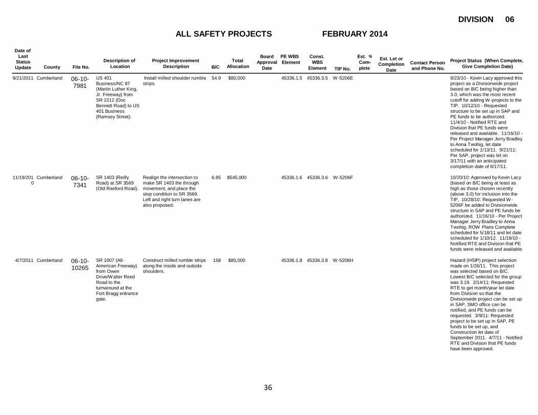
9/21/2011 Cumberland 06-10- 7981
US 401 Business/NC 87 (Martin Luther King, Jr. Freeway) from SR 2212 (Doc Bennett Road) to US 401 Business (Ramsey Street).
Install milled shoulder rumble strips.
54.9 $80,000 45336.1.5 45336.3.5 W -5206E 9/23/10 - Kevin Lacy approved this project as a Divisionwide project based on B/C being higher than 3.0, which was the most recent cutoff for adding W -projects to the TIP. 10/12/10 - Requested structure to be set up in SAP and PE funds to be authorized. 11/4/10 - Notified RTE and Division that PE funds were released and available. 11/16/10 - Per Project Manager Jerry Bradley to Anna Twohig, let date scheduled for 1/13/11. 9/21/11: Per SAP, project was let on 3/17/11 with an anticipated completion date of 6/17/11.
11/19/201 Cumberland
0
06-10- 7341
SR 1403 (Reilly Road) at SR 3569 (Old Raeford Road).
Realign the intersection to make SR 1403 the through movement, and place the stop condition to SR 3569. Left and right turn lanes are also proposed.
6.85
$545,000
45336.1.6
45336.3.6
W -5206F
10/20/10: Approved by Kevin Lacy (based on B/C being at least as high as those chosen recently (above 3.0) for inclusion into the TIP. 10/28/10: Requested W - 5206F be added to Divisionwide structure in SAP and PE funds be authorized. 11/16/10 - Per Project Manager Jerry Bradley to Anna Twohig, ROW Plans Complete scheduled for 5/18/11 and let date scheduled for 1/10/12. 11/19/10 - Notified RT E and Division that PE funds were released and available.
4/7/2011 Cumberland
06-10- 10265
SR 1007 (All- American Freeway) from Owen Drive/W alter Reed Road to the turnaround at the Fort Bragg entrance gate.
Construct milled rumble strips along the inside and outside shoulders.
158
$85,000
45336.1.8
45336.3.8
W -5206H
Hazard (HSIP) project selection made on 1/26/11. This project was selected based on B/C. Lowest B/C selected for the group was 3.19. 2/14/11: Requested RTE to get month/year let date from Division so that the Divisionwide project can be set up in SAP, SMO office can be notified, and PE funds can be requested. 3/9/11: Requested project to be set up in SAP, PE funds to be set up, and Construction let date of September 2011. 4/7/11 - Notified RTE and Division that PE funds have been approved.

DIVISION 06
ALL SAFETY PROJECTS FEBRUARY 2014
Date of Last
Status Update
Board Approval
Date
PE WBS Element
Const. WBS
Element
Est. % Com- plete
Est. Let or Completion
Date
Description of Location
Project Improvement Description
Total Allocation
Project Status (When Complete, Give Completion Date)
Contact Person and Phone No. County File No. B/C TIP No.
37
8/26/2011 Cumberland 06-11- SR 1409 (71st W iden SR 1409 for left turn 27.1 $350,000 45336.1.1 45336.3.1 W -5206M 8/15/11: Approved by Kevin Lacy
School Rd) at SR lane, clear sight distance 3 3 (based on B/C being at least as
1410 (Old Bunce) , in triangle, and improve super high as those chosen during last
the City of along curve selection (above 3.5) for a
Fayetteville Divisionwide W -project.
Requested project to be set up in SAP, PE funds to be set up, ROW /Utilities let date of October 2012 and Construction let date of October 2013. 8/26/11: Notified RTE and Division that PE funds were approved.
4/7/2011 Cumberland 06-11- 10479
SR 1141 (Cumberland Road) at SR 1169 (Camden Road).
Construct a single-lane roundabout and realign the east leg of Cumberland Road.
15.9 $855,000 45336.1.9 45336.3.9 W -5206I Hazard (HSIP) project selection made on 1/26/11. This project was selected based on B/C. Lowest B/C selected for the group was 3.19. 2/14/11: Requested RTE to get month/year let date from Division so that the Divisionwide project can be set up in SAP, SMO office can be notified, and PE funds can be requested. 3/9/11: Requested project to be set up in SAP, PE funds to be set up, ROW /Utilities let date of September 2012, and Construction let date of September 2013. 4/7/11 - Notified RTE and Division that PE funds have been approved.
5/13/2011 Cumberland
06-11- 11728
SR 1003 (Camden Rd) from SR 1112 (Rockfish Rd) to the Hoke Co. line.
W edging and resurfacing in curves, widen roadway 2' each side (to provide paved shoulders), and construct left turn lane at SR 3690 (Jack Britt School Rd)
0 $1,050,000
45336.3.1
1
45336.3.1
1
W -5206K
3/21/11: Approved by Kevin Lacy (based on B/C being at least as high as those chosen recently (above 3.5) for a Divisionwide W - project. Requested RTE to send me a let date so that I can get it added to the SAP Divisionwide structure. 4/27/11: Requested project to be set up in SAP, PE funds to be set up, ROW /Utilities let date of September 2012 and Construction let date of September 2013. 5/13/11 - Notified RT E and Division that PE funds have been approved.
13055

DIVISION 06
ALL SAFETY PROJECTS FEBRUARY 2014
Date of Last
Status Update
Board Approval
Date
PE WBS Element
Const. WBS
Element
Est. % Com- plete
Est. Let or Completion
Date
Description of Location
Project Improvement Description
Total Allocation
Project Status (When Complete, Give Completion Date)
Contact Person and Phone No. County File No. B/C TIP No.
38
10/18/201 Cumberland 2
06-12- 22499
NC 210 (Murchison Road) in the vicinity of Stadium Drive near FSU.
Install an actuated pedestrian traffic signal.
0.76 $87,500 45336.1.2 3
45336.3.2 3
W -5206W Signal plans needed. 10/9/12 - Kevin Lacy approved this project based on the large number of FSU students crossing mid-block and because pedestrian crashes are a focus area for NC as identified by FHW A. 10/9/12 - Requested structure be set up in SAP and PE funds be authorized. Still waiting on let dates from Division. 10/18/12 - Notified RTE and Division that PE funds were approved.
12/14/201 Cumberland
2
06-12- 20340
US 301 at SR 1121 / SR 2243 (McDonald/Roslin Farm Rd)
Construct left turn lanes on both approaches of US 301
11.4
$390,000
45336.1.2
4
45336.3.2
3
W -5206X
Plans by Division. 9/24/12: Approved by Kevin Lacy in statewide W -project selection meeting. 12/14/12: Requested structure to be set up in SAP and PE funds to be authorized. Requested Feb. 2014 ROW date and Feb. 2015 Construction let date.
2/20/2013 Cumberland
06-12- 21763
SR 1103 (Galatia Church Rd) at SR 1102 (Gillis Hill Rd). SR 1103 (Galatia Church Rd) at SR 1112 (Stoney Point Rd). SR 1112 (Stoney Point Rd) at SR 1102 (Gillis Hill).
Close and Cul-de-sac Galatia Church at Gillis Hill. Improve skew at the intersection of Galatia Church at Stoney Point Rd. Add left turn lanes on Stoney Point at Gillis Hill, and right turn lanes on all approaches (to enable this intersection to handle the increase in traffic that will result from closing Galatia Church at Gillis Hill).
12.4
$950,000
45336.1.2
6
45336.3.2
6
W -5206Z
Plans by Division, signal plan revision by Signals & Geometrics. 12/17/12: Approved by Kevin Lacy in statewide W -project selection meeting. 2/7/13: Requested structure to be set up in SAP and PE funds to be authorized. Requested February 2014 ROW /Utilities let date and February 2015 Construction let date. 2/20/13: Notified RTE and Division that PE funds were approved.
11/4/2010 Cumberland
06-10-
NC 24-210 (Grove
Construct a raised median
26.1
$1,966,500
45428.1.1
45428.3.1
W -5335
7/12/10 - Kevin Lacy approved this
7213 Street) from Ramsey with fencing along Grove project based on B/C being higher Street/Green Street to the Cape Fear River Bridge and I- 95 Business/US 301 (N. Eastern Blvd.) from NC 24-210 to Person Street.
Street and N. Eastern Blvd. and provide upgraded pedestrian accommodations along both streets.
than 3.0, which was the most recent cutoff for adding W -projects to the TIP. 9/2/10: Amended to the 2009-2015 STIP. ROW FFY 12, Construction FFY 12. 10/7/10: Requested PE funds. 11/4/10: Notified RT E and Division that PE funds have been approved.
DIVISION 06
ALL SAFETY PROJECTS FEBRUARY 2014
Date of Last
Status Update
Board Approval
Date
PE WBS Element
Const. WBS
Element
Est. % Com- plete
Est. Let or Completion
Date
Description of Location
Project Improvement Description
Total Allocation
Project Status (When Complete, Give Completion Date)
Contact Person and Phone No. County File No. B/C TIP No.
39
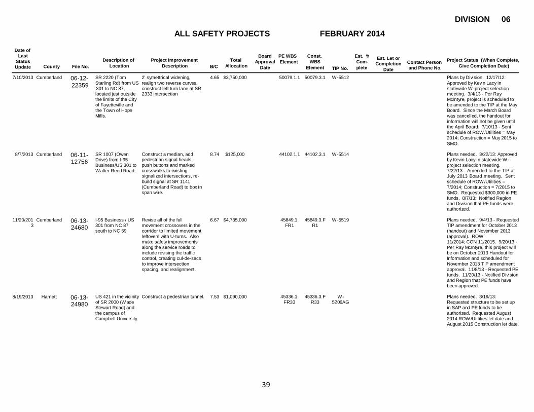
7/10/2013 Cumberland 06-12- SR 2220 (Tom 2' symettrical widening, 4.65 $3,750,000 50079.1.1 50079.3.1 W -5512 Plans by Division. 12/17/12:
22359 Starling Rd) from US realign two reverse curves, Approved by Kevin Lacy in 301 to NC 87, located just outside the limits of the City of Fayetteville and the Town of Hope Mills.
construct left turn lane at SR 2333 intersection
statewide W -project selection meeting. 3/4/13 - Per Ray McIntyre, project is scheduled to be amended to the TIP at the May Board. Since the March Board was cancelled, the handout for information will not be given until the April Board. 7/10/13 - Sent schedule of ROW /Utilities = May 2014; Construction = May 2015 to SMO.
8/7/2013 Cumberland
06-11- 12756
SR 1007 (Owen Drive) from I-95 Business/US 301 to W alter Reed Road.
Construct a median, add pedestrian signal heads, push buttons and marked crosswalks to existing signalized intersections, re- build signal at SR 1141 (Cumberland Road) to box in span wire.
8.74
$125,000
44102.1.1
44102.3.1
W -5514
Plans needed. 3/22/13: Approved by Kevin Lacy in statewide W - project selection meeting. 7/22/13 - Amended to the TIP at July 2013 Board meeting. Sent schedule of ROW /Utilities = 7/2014; Construction = 7/2015 to SMO. Requested $300,000 in PE funds. 8/7/13: Notified Region and Division that PE funds were authorized.
11/20/201 Cumberland
3
06-13- 24680
I-95 Business / US 301 from NC 87 south to NC 59
Revise all of the full movement crossovers in the corridor to limited movement leftovers with U-turns. Also make safety improvements along the service roads to include revising the traffic control, creating cul-de-sacs to improve intersection spacing, and realignment.
6.67
$4,735,000
45849.1.
FR1
45849.3.F
R1
W -5519
Plans needed. 9/4/13 - Requested T IP amendment for October 2013 (handout) and November 2013 (approval). ROW 11/2014; CON 11/2015. 9/20/13 - Per Ray McIntyre, this project will be on October 2013 Handout for Information and scheduled for November 2013 TIP amendment approval. 11/8/13 - Requested PE funds. 11/20/13 - Notified Division and Region that PE funds have been approved.
8/19/2013
Harnett
06-13- 24980
US 421 in the vicinity Construct a pedestrian tunnel. of SR 2000 (W ade Stewart Road) and the campus of Campbell University.
7.53
$1,090,000
45336.1.
FR33
45336.3.F
R33
W -
5206AG
Plans needed. 8/19/13: Requested structure to be set up in SAP and PE funds to be authorized. Requested August 2014 ROW /Utilities let date and August 2015 Construction let date.

DIVISION 06
ALL SAFETY PROJECTS FEBRUARY 2014
Date of Last
Status Update
Board Approval
Date
PE WBS Element
Const. WBS
Element
Est. % Com- plete
Est. Let or Completion
Date
Description of Location
Project Improvement Description
Total Allocation
Project Status (When Complete, Give Completion Date)
Contact Person and Phone No. County File No. B/C TIP No.
40
9/21/2011 Harnett 06-10- 7028
NC 87 at H. M. Cagle Dr./Food Lion Entrance/Linden Oak Subdivision Entrance near Spring Lake.
Install a signalized superstreet with directional left turns and median U- turns. 7/28/10 - Notified RTE and Project Mgr. that PE funds had been released and were available.
3.11 $1,150,000 45336.1.2 45336.3.2 W -5206B 6/30/10 - Kevin Lacy approved this project as a Divisionwide project based on B/C being higher than 3.0, which was the most recent cutoff for adding W -projects to the TIP. Requested structure to be set up in SAP and PE funds authorized. Requested a ROW /Utilities let date of 7/10 and Construction let date of 9/10 based on the Division's estimate. 9/21/11: Per SAP, project was let on 10/19/10 with an anticipated completion date of 5/27/11.
11/19/201
0
Harnett
06-10- 7735
NC 27 in the vicinity of SR 1285 and SR 1209 (Barbecue Church Road).
Remove SR 1285 entirely, relocate/realign SR 1209 at NC 27, and widen NC 27 to provide a left turn lane.
5.35
$580,000
45336.1.7
45336.3.7
W -5206G
10/20/10: Approved by Kevin Lacy (based on B/C being at least as high as those chosen recently (above 3.0) for inclusion into the TIP. 10/28/10: Requested W - 5206G be added to Divisionwide structure in SAP and PE funds be authorized. 11/16/10 - Per Project Manager Jerry Bradley to Anna Twohig, ROW Plans Complete scheduled for 5/8/11 and let date scheduled for 12/6/11. 11/19/10 - Notified RT E and Division that PE funds were released and available.
6/22/2012
Harnett
06-11- 14603
NC 210 from SR 2047 to SR 2048.
W iden to three lanes, and construct 2' paved shoulders.
3.64
$995,000
45336.1.1
7
45336.3.1
7
W -5206Q
3/9/12: Approved by Kevin Lacy in statewide W -project selection meeting. 6/1/12: Requested structure to be set up in SAP and PE funds to be authorized. Requested November 2013 ROW and Utilities let date and November 2014 Construction let date. 6/22/12: Notified RTE and Division that PE funds were approved.
8/4/2011
Harnett
06-11- 10474
SR 1719 (Powell Avenue) at SR 1725 (Ashe Avenue).
Construct a single-lane roundabout with a northbound right turn slip lane. An additional $200,000 in funding needed for this project is being provided by the City of Dunn.
3.39
$575,000
45473.1.1
45473.3.1
W -5501
Hazard (HSIP) project selection made on 1/26/11. This project was selected based on B/C. Lowest B/C selected for the group was 3.19. 2/14/11: Requested RTE to get month/year let date from Division. 4/11/11: Per SAP schedule, ROW FFY 12, CON FFY 13. 7/8/11: Board approved TIP on 7/7/11. Requested PE funds. 8/4/11: Notified RTE and PM that PE funds have been approved.

DIVISION 06
ALL SAFETY PROJECTS FEBRUARY 2014
Date of Last
Status Update
Board Approval
Date
PE WBS Element
Const. WBS
Element
Est. % Com- plete
Est. Let or Completion
Date
Description of Location
Project Improvement Description
Total Allocation
Project Status (When Complete, Give Completion Date)
Contact Person and Phone No. County File No. B/C TIP No.
41
9/21/2011 Robeson 06-09- 207
SR 1515 (St. Anna Road) at SR 1563 (Union Chapel
Construct a left turn lane on the eastbound SR 1563 approach and a right turn lane on the westbound SR 1515 approach.
9.83 $387,000 45263.1.1 45263.3.1 W -5139 Amended to the TIP in 8/09. ROW FFY 10. Construction FFY 11. 8/6/09: PE funds requested. RTEs notified of W -numbers, amendment to TIP, and that PE has been requested. 8/28/09: PE funds approved. RTEs notified and asked to pass information onto Division. 9/21/11: Per SAP, project let on 8/31/11 with anticipated completion date of 4/15/12.
8/28/2009
Robeson
06-08-
223
SR 1515 (St. Anna Road) at SR 1540 (Sally's Road).
Realign SR 1515 to provide a continuous movement, and realign SR 1540 to tie into SR 1515 with SR 1540 being under STOP sign control.
8.67
$390,000 45264.1.1 W -5140
Amended to the TIP in 8/09. ROW FFY 10. Construction FFY 11. 8/6/09: PE funds requested. RTEs notified of W -numbers, amendment to TIP, and that PE has been requested. 8/28/09: PE funds approved. RTEs notified and asked to pass information onto Division.
9/21/2011
Robeson
06-08-
221
SR 1339 (Deep Branch Road) from NC 711 to NC 710.
Construct 2' paved shoulders along both sides of roadway. (Length = 10.2 miles.)
8.29
$930,000
45265.1.1
45265.3.1
W -5141
Amended to the TIP in 8/09. Construction FFY 11. 8/6/09: PE funds requested. RTEs notified of W -numbers, amendment to TIP, and that PE has been requested. 8/28/09: PE funds approved. RTEs notified and asked to pass information onto Division. 9/21/11: Per SAP, project let on 1/13/11 with anticipated completion date of 6/30/11.
10/13/201
0
Robeson
06-10- 7725
NC 72 curves located south of Lumberton. Curve 1 - Approx. 1.1 mile south of SR 2225 towards US 74. Curve 2 - At SR 2114. Curve 3 - At SR 2202.
Construct wedging, add 2' paved shoulders, and resurface approx. 1400' on both sides of roadway at each location.
15.8
$502,000
45336.1.4
45336.3.4
W -5206D
8/26/10 - Kevin Lacy approved this project as a Divisionwide project based on B/C being higher than 3.0, which was the most recent cutoff for adding W -projects to the TIP. 9/16/10 - Requested structure to be set up in SAP and requested ROW/Utilities and Construction let dates from the Division. 9/29/10 - Notified RTE and Project Mgr. that PE funds were released and available. 10/4/10 - Program Mgr. Jerry Bradley sent email to Anna Twohig stating that no ROW /Utilities was necessary (but to keep the WBS just in case) and the Construction let date should

DIVISION 06
ALL SAFETY PROJECTS FEBRUARY 2014
Date of Last
Status Update
Board Approval
Date
PE WBS Element
Const. WBS
Element
Est. % Com- plete
Est. Let or Completion
Date
Description of Location
Project Improvement Description
Total Allocation
Project Status (When Complete, Give Completion Date)
Contact Person and Phone No. County File No. B/C TIP No.
42
4/8/2013 Robeson 06-12- 19888
US 74 from 0.50 miles east of NC 41 to the Columbus County Line. Bridge over NC 71 and bridge over R/R tracks near SR 1393.
Install cable guiderail; extend bridge approach guardrail and extend existing cable guiderail to eliminate gaps.
14.3 $700,000 45336.1.1 8
45336.3.1 8
W -5206R Plans by Division. 6/25/12: Approved by Kevin Lacy in statewide W -project selection meeting. 7/11/12: Requested structure to be set up in SAP and PE funds to be authorized. Requested October 2012 Construction let date. 8/9/12: Notified RT E and Division that PE funds were approved. 4/8/13 - Field inspection made, but not all work complete (gap needs to be closed).
9/9/2010
Robeson
06-08-
225
SR 1997 (Fayetteville Road/Pine Street) southbound at NC 211 (Roberts Avenue) in Lumberton.
W iden southbound SR 1997 to provide dual left turn lanes.
3.34
$360,000
46252.1.1
46252.3.1
W -5327
8/5/10: Amended to the 2009- 2015 STIP. ROW FFY 12, Construction FFY 12. 9/9/10: Notified RT Es, PMs, and DEs that PE funds were approved.
Robeson
06-11- 13085
SR 1529 (Mt Olive Church Rd) from US 301 to NC 211.
Construct 2' paved shoulders along section, wedging in the curve at church (near bridges 299 & 300).
4.81
$1,350,000
45537.1.1
45537.3.1
W -5507
Plans by Division. 11/3/11: Amended to the TIP for CON FFY 12. 1/31/12: Sent in 1st Schedule Change form and requested Jerry Bradley to send in Baseline and 2nd Schedule Change form (since the Division requested ROW and a CON schedule change right after the project was amended to the TIP.) ROW is 10/12 (FFY 13) and CON is 10/13 (FFY 14).
Cumberland 06- 13- NC 24-NC 87 (Bragg Construct raised median on 16.7 $0 W -TBD- Plans by Division, with Signal
26 850 Blvd) from W inston Bragg Blvd from Glenville 12-19-13 Plans by T raffic Systems
Ave to MLK W B Ave to MLK; and Rowan from Operation Unit. 12/19/13 -
ramps; and NC 24- Ray to Ramsey. Approved by Kevin Lacy in
NC 210 (Rowan St) Recommend directional statewide W -project selection
Between Ray Ave crossovers at Glenville, meeting. Need Let date from
and Ramsey St W estmont, and Filter Plant. Division in order to set up project.
[30000024/NC 24: Close existing crossover at MP 11.79 - 13.25 W inston. Upgrade existing
(1.46 mile); and signal at Ames St to include
13.98 - 14.19 (0.21 "Time of Day" FYA phasing
mile)] for EB Bragg, additional thru
head (each dir) Bragg Blvd,
and FYA for SB Ames St.
Pedestrian improvements at
Pearl and at MLK, to include
crosswalk and pedheads.
Remove existing out-dated
flasher at W estmont.

DIVISION 06
ALL SAFETY PROJECTS FEBRUARY 2014
Date of Last
Status Update
Board Approval
Date
PE WBS Element
Const. WBS
Element
Est. % Com- plete
Est. Let or Completion
Date
Description of Location
Project Improvement Description
Total Allocation
Project Status (When Complete, Give Completion Date)
Contact Person and Phone No. County File No. B/C TIP No.
43
11/5/2013 Divisionwide 06-13- xxx
Division 6 LANE DEPARTURE SYSTEMIC
$875,000 36283.6.5 45336.1.F D35
W -5206AI PE funds given under 36283.6.5 on 9/9/13. Requested project to
IMPROVEMENTS USING be set up in SAP on 11/5/13.
PAVEMENT MARKINGS (MULTIPLE LOCATIONS
IDENTIFIED THROUGHOUT
DIVISION 6 FOR SAFETY
IMPROVEMENTS USING
PAVEMENT MARKINGS)
11/21/201 3
Harnett 06-13- 25381
NC 210 at SR 2215 (Harnett Central Road), SR 2215 from NC 210 to Harnett Central Middle School Driveway.
W iden SR 2215 to provide a left turn lane throughout the project section, signalize the intersection of NC 210 at SR 2215.
10.9 $365,000 45336.1. FR36
45336.3.F R36
W - 5206AJ
Plans needed by Division and Signal Unit. 9/23/13: Approved by Kevin Lacy in statewide W -project selection meeting. 11/18/13: Requested structure to be set up in SAP and PE funds to be authorized. Requested July 2014 ROW /Utilities let date and March 2015 Construction let date. 11/21/13 - Notified RTE and Project Mgr. that PE funds were released and available.
Robeson
06-13- 27052
SR 1004 (Tarheel Road) - section between SR 1971 and SR 1972, section just east of SR 1969 and Bridges 46 and 50
Install approach and trailing guardrail for bridges 46 and 50. Improve superelevation in two curves.
34.6
$0 W -TBD-
12-19-13
Plans needed by Division. 12/19/13 - Approved by Kevin Lacy in statewide W -project selection meeting. Need Let date from Division in order to set up project.

44
Appendix G. – FEMA Letter
45


Safety & Security Plan written by the
Fayetteville Area Metropolitan Planning Organization
in cooperation with the
North Carolina DOT Transportation Planning Branch,
Mid-Carolina Rural Transportation Planning Organization,
Transportation Policy Board,
Transportation Technical Coordinating Committee and the
Citizen Advisory Committee
Deloma West, Principal Planner, FAMPO
This Safety & Security Plan was partially funded by grants from
The Federal Highway Administration and
The Federal Transit Administration

Historic Courthouse 130 Gillespie Street
Fayetteville, NC 28301
[email protected] Telephone: (910) 678-7628
Fax: (910) 678-7638
www.fampo.org
FAMPO
Fayetteville Area Metropolitan Planning Organization