contact information mining records curator...
TRANSCRIPT

The following file is part of the
Arizona Department of Mines and Mineral Resources Mining Collection
ACCESS STATEMENT
These digitized collections are accessible for purposes of education and research. We have indicated what we know about copyright and rights of privacy, publicity, or trademark. Due to the nature of archival collections, we are not always able to identify this information. We are eager to hear from any rights owners, so that we may obtain accurate information. Upon request, we will remove material from public view while we address a rights issue.
CONSTRAINTS STATEMENT
The Arizona Geological Survey does not claim to control all rights for all materials in its collection. These rights include, but are not limited to: copyright, privacy rights, and cultural protection rights. The User hereby assumes all responsibility for obtaining any rights to use the material in excess of “fair use.”
The Survey makes no intellectual property claims to the products created by individual authors in the manuscript collections, except when the author deeded those rights to the Survey or when those authors were employed by the State of Arizona and created intellectual products as a function of their official duties. The Survey does maintain property rights to the physical and digital representations of the works.
QUALITY STATEMENT
The Arizona Geological Survey is not responsible for the accuracy of the records, information, or opinions that may be contained in the files. The Survey collects, catalogs, and archives data on mineral properties regardless of its views of the veracity or accuracy of those data.
CONTACT INFORMATION Mining Records Curator
Arizona Geological Survey 1520 West Adams St.
Phoenix, AZ 85007 602-771-1601
http://www.azgs.az.gov [email protected]

02/26/90
ARIZONA DEPARTMENT OF MINES AND MINERAL RESOURCES FILE DATA
PRIMARY NAME : AINSWORTH MINE
ALTERNATE NAMES : OREGON GROUP COCHISE COCH ISE -BULLION KING AINSWORTH
COCHISE COUNTY MILS NUMBER: 16
LOCATION : TOWNSHIP 17 S RANGE 31 E SECTION 5 QUARTER NE LATITUDE: N 31DEG 58MIN 40SEC LONGITUDE : W 109DEG IIMIN 17SEC TOPO MAP NAME: PORTAL - 7.5 MIN
CURRENT STATUS : PAST PRODUCER
COMMODITY : ZINC LEAD COPPER SILVER GOLD LODE TUNGSTEN MOLYBDENUM
BIBLIOGRAPHY: KEITH, S.B., 1973, AZBM BULL . 187, P. 53 ADMMR AINSWORTH MINE FILE USBM 1949 MINERALS YEARBOOK USBM RI 5650, P 15, 16

COCHISE - Table Record:
~ONT ~ONT1
Page 1

AINSWORTH MINE
Cochi se County MILS Index #16
Portal 15 ' Topo ( i nc l uded i n f ile)
COCHISE COUNTY CALIFORNIA DI ST . Tl7S R31E Sec. 5
AEC 172-478 P. 23 - King Ainswor th (old Cochi se) No urani um samples
ABM Bull . 187 , p. 18 , 30
;r :::r ~

UNITED STATES 'S-", DEPART MENT OF THE INTERIOR
-Yo.., GEOLOGICAL SUR VEY

,- '
AINSWORTH MINE COCHISE COUNTY
Mr . Emil Schaaf, attended conference, Wilcox County Offices , 4- 7- 66 . He wants engineer t o visit his mine in future . Formerly Cochise mine in S5, T17S , R31E , Portal Quad.rangle. GWI 4- 7- 66
Mr. Emil Schaaf at Willcox , reported that he was working on a deal involving bis Ainsworth pr operty . GWI WR 9- 17 - 66
Conference with Emil Schaaf , owner of the Copper Hill group . Assessment work only on property. GWI WR 1- 13 - 68
Had a field interview wi th Virgil Owens , Willcox, part owner of the Ainsworth . GWI WR 10- 11 - 69
Visited the Ainsworth mine - no one around . GWI WR 2 - 7- 70
Visited Ainsworth mine - no activity . GWI WR 10- 10- 70
Mine visit - King Ainsworth mine . GWI WR 6-7-71
Field 1n terv . Mr . E. Schaaf owner of the King Ainsworth group . GW1 WR 2/8/72
Field intevriew with Virgil Owens of Willcox . Mr . Owens has a property in New Mex ico near the Phelps Dodge new smel t er and sa i d that he would like to find somebody to take a look at it so I told him that when I have the chance , I would give this information to the Phelps Dodge Exploration Department as I had other things to discus s with him . GWI WR
10/3/72
Field interview with Virgil Owens also of Willcox reports that he did not do assessment work at the Ainsworth area . GI WR 3- 27-74
No activity , looked at quartzite bed with t hought of a silica supply. WR G1 5 - 13-77

DEPARTMENT OF MINERAL RESOURCES STATE OF ARIZONA
FIELD ENGINEERS REPORT
Copper Hill Group Date November 23, 1964
District California (Chiricahua) District - Engineer Axel L. Johnson Cochise County
Subject: Field Engineer's Report. Information from E.F. Schaaf
References: Report of July 11, 1962
Number of Claims: Same as last report (July 11, 1962)
Owners: Same as last report (July 11, 1962)
Principal Minerals: Same as last report (July 11, 1962)
Present Mining Activity: None at present. Mr. Schaaf is looking for a drill to purchase for the purpose of putting down additional drill holes on the property.
Geology: Same as last report. In addition, Mr. Schaaf reports an outcrop of Bolsa Quartzite, running E & W for a distance of 1900 ft.
Ore Values: Recent samples taken show following values: -(1) In an open cut on the quartzite outcrop assays run 1.4% to 14.6% copper. (2) In an open trench on the limestone-andesite porpbyry contact assays ran:
(a) 1.8% copper; 2.5% zinc; 64.4% silica (b) 3.04% copper; 0.1% zinc; 15.6% silica
Review of Recent erations: 1 No additional work was done in the iron (limonite) outcrop.(See report of 1/11/62 -
under "New Workings.") (2) The open trench cut on the limestone-andesite porphyry contact was extended an
additional 27 ft. The mineralization was 6t ft. wide and ran as shown above under "Ore Values" (2)
(3) Two open cuts were made in tbe Bolsa Quartzite viz: (a) 50 ft. long x 12 ft. wide x 12 ft. deep (b) 30 ft. long x 8 ft. wide x 6t ft. deep - assaying as shown under
"Ore Values" (1) (4) Diamond drilling was done near the old 340 ft. vertical shaft (Ainsworth shaft)
on contract. After drilling one bole to a depth of 68 ft., the contractor was forced to discontinue the work, because his drill was too small, according to Mr. Schaaf.
Proposed Plans: The owners plan to diamond drill or churn drill with their own drill rig, which they plan to purchase.
Mr. Schaaf asked the field engineer about the Hossfeld Prospecting Drill (churn drill), which drills 1-3/4" to 2-5/8 11 holes a maximum distance of 110 ft. Field engineer suggested that a wagon drill might be better, but Mr. Schaaf said they bad only an 85# compressor, which is too small for a wagon drill.

© @
STATE OF ARIZONA
DEPARTMENT OF MINERAL RESOURCES
'f: • xel JH John on • O. Doy. '"047
Tuceon, Arizo
Dear Axel:
MINERAL BUILDING, FAIRGROUNDS
PHOENIX 7 . ARIZONA
~10
July 26, 1962
'ou" : ,'+2, W. li. ' .i.1 ?n ,t a1 were. gr nc .. A .a pl'.11. in \"y F..F loan of $3,000 to unwater and r blUUt rki of th ~ sha":t.t loc't cl in 5 .cUo.s ~ .and), T 11 S., • 31~. A 00« job as ~ bu .. it appeAr d ·h3t. th\.!y l-ad u of 1 "4 ab ut: t .1 1 3. ;ity f or ..I."hl ill' 300 leV' 1 \oJ &l map d o1n~ 'pied and tll fO •. h)
and hort. so ill f rtt· '1.' loan was not: f: Q
'l"hh mine was (P't' .3 cth rs which appl1l>d f01.·· •• ·.C. 10 n •• Tw ",ere tu:n',d down an' ,,u t·> ~ no l' .or.~ rtf .. ' t h.1 fI n ~\.4 to th') lhi " • ich u t} for t.he Ki b llli'H!. • \'i,hon, ~., aJ. ollIs... de th_ King a:. pLication. !tls gr d!.n~ pp reaLly' pent' cl upon .' t b.lp eltl!r ulci i" 48 pr mi for its ui11ciouB ore.
The or'pinal applir.at~on was £0 a ~10)O'O 104n. It W48 t rued down. Th company the 'lut a 174 ft. raite to he8urf C~, which dio no\: <Usdo,a ore wide nou , to s ~e~ and opened a £ w n t faces on tha lor 1 v 1 fro which they line,' ai,- ut 35 tons ot' 0·. AS . ~le of this Ct ssayed 3.35 p reent copp ~ d ~.Q O\UlC • of .11v r per ton. The, "n l' 8 mpled only that: part of .!'t. 0' zone c.onl1dct' d Qr. by h appUc tad t k flv
1.. The. t08et r ~th four fo r pI ta en for th first application pve the followtnS " ight d aver ea: iath 33 inche., 8U vel' 1. 06 ounce. per ton and copper 2.75 pOl' c.ent. The 1 ngth of. tbia ore sbowing va. given "0 SO feet.
As you know, w cannot r lease the r . orts e were ivan. TIl y can only bo cxa tned here d n tes de. The ap can o~ly b traced without names and wo are too 'ho t:~handed to cleo ::h,.- _1.:. her~ now. H1' .. 241,*. h vas on vacation t rrow and 1 h ve 1. fficiel.1 ti for tll thin I mu t do.
'aclo8 d i. a photocopy of a pag frena h !f:ll'l' ndbook, 1931. witb item l' gardina Ainsworth Copper Co. 1/ aucc s.or to tina Copp r Co ~» and. Cochi •• Cou.olldat d C01'P r Co. nog Cop" s organ! ed in 917. th6 .ame 1nte"e.ta ha died both ing Coppe~ Qd Ainewortb Copp.r. A 1931 r ort ention. 0 producti l ) or work bJ tn 14:ter 'but Y' that 'Itho Tre 8ury
vein of leaci-ainc ore B t d by 1 a. It.inc late 1926." the property

.. D .. .~ .... v vu ......... ..
7-26 .. 62
• d to a Corotlsdlo op r Corp. tn 1 29. te r orteen, .. omed to tAl' ov: r a 8e and option of the At swortb Copper Co. r petrt),. It 1s not ntioned in til 1931 Min 8 !t;)gi't rand
AinftlOrth COpp8t' 18 t' d inactf. 10. latt r evid ntly r in dormant nd I £1 d r cord of acti·ity at tl ro ortie lfttil 1. H. .liho c Ttl el ims :1 ntly W J: \lnpatent ad
have p ,.ed into th r h4 de.
Tber 1. con idol" i JOre dw.f cun get o· r to look
ill:! info . twn in th tit.
filea 1£ .r.
'\.? ....""
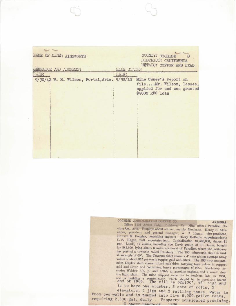
NAMli! OF lIDtBl1 AINSWORTH
~OR AND ~umItEss: D~\.T.m : D..:.\'IE :
~~ OOUNTY: COmilSE S DISTRIO'r:- CALIFORNIA MS'rALSf COPPER AND .LEAD .
J •
9/30/4~ W. H. Wilson, Portal,Ariz.; 9/30742' ~ne Owner's report on file ••• • Mr. Wilson, lessee, applied for and was granted $5000 REG loan
COCHISE c5UiifSisoOiL~mm-OOlm]floo.- AJUZONA.. Office: 1 ~114 Arrott ill.he Pit! I, .' . .hne office: Paradise, Co-
chil'e Co., Ariz. Employs about 50 men, mainly Mexicans. Henry F. Alexander, president and general manager; W. C. Hagan, vice-president; Howard H. Douglas, consulting engineer ; Harry Holbum, superintendent; C. R. Hagan, mill ;;uperin~lldellt. Capitalir.ation 11,500,000, shares $1 pal'. L'.l.nds, 17 claims, including the Da.vis group of 13 claims, bought for $82,500, lying about 6 miles northea8t of Paradise, where the company lias piatt!'d a townsite called Pittsburg. The 150' Ai.nsworth shaft is sunk at an angle of 60°. The Treasure shaft shows a 4' vein givjng average assay values of about S75 per ton in copper, gold and silver. The 180' tWo.compo.rtmimt Duplex Rhaft ~hows mixed sulphides, carrying high values in copper, jl;old and silver, and containing heavy parcentages of zinc. Machinery indudes Webber 5-h. p. and ISO-h. p. gasoline engines. and a "mall p~ tric light plant. The mine shipped wme ore to ;;rneltcrs, lat.(- in 1904, and is building a concentra.tor, which sho).lld he in oper..ltion before ~nd of 1906 . The mi ll is 62xlOO' , 45' high and is t o have one c rusher , 3 sets of rolls , 3 el evat ors , 2 jigs and 2 settl i ng tanks . Wat e r i s
from two wells and is pumped into f ive 6 , 000- gall on tanks , requir ing 2 , 500 gal. da i ly . Property conside r ed promising.
l~~~3Andbook 1006

Ilnsworth
Your n~ e end dd~es
d,erd Sm.itb., haa be n turn1l"hed to -
.0. P.ox 1923. PhoeniX. -ri. .. OrlEl ,
who no '. t in ul ry fo'" the SfJ'!le ,i tb r~fere:lc e to mining p~perty l1sted' t~ the Dep rent or inera1 Resource .

.July 26, 1942
MEMORANDUM AINSWORTH MINE (King Copper Co.)
To: From:
Director, Dept. Mineral Resources George .A.. Ballarn
j Wal ter Wilson ;'· owner of this property, · has applIed for a $5000 r~eliminary development loan with which he ~rOr08~a to llnwat~~ the Kine; shaft, rp-tirober , and clean- out a ' crosscut on the 200 level, continuing to drive it about 100 ft to intersect zinc beds. These beds, lying at about 400, have been stoped fro~ a tunnel in the uppe~ levels. Wilsons pr6posed development will eiv~ him anoth~r ~no ft. backs in eood Ol"~ zone.

Mine
District
Subject:
DEPARTMENT OF MINERAL RESOURCES STATE OF ARIZONA
FIELD ENGINEERS REPORT
• Copper Hill Group (Formerly called Cochise Mines) (has also been called Ainsworth ¥dne )
Cali fornia (Chiricahua) DistrictCochise County
Date
Engineer
July 11, 1962
Axel L. Johnson
Field Engineer's Report. Information from E. F. Schaaf
Location Sections 4, S, 8 & 9 - T17S - R3lE. Take Highway #86 east from Willcox. Turn right (south) 2 miles east of San Simon, continuing for 17 miles. Turn left and take road marked liTo Portal" and continue for 4 miles. Turn right at red streamer on bush and sign "Private Road-Keep Out". Dri've about 2 miles on newly graded mine road to the property.
Number of Claims 67 unpatented claims on Federal land outside the National Forest. These include the following groups-Copper" Hill, Copper"Glance, Nickett and Explorer.
Owners E. F. Schaaf, Box 2178, Willcox, Ari z. (718 w. Stewart St.) Mrs. E. F. Schaaf (Address above) Virgil Owens, Farmers Pump Co., Willcox, Ariz.
Principal Minerals , Copper, Lead, Zinc, Gold, Silver.
Present }lining Activity Constructing and repairing roads. Worh~ng in open cut, stockpiling a small amount of ore.
Geology & Mineralization Most of the country rock is dark gray limestone, which in several pl aces, shows f aulting, fissuring and alteration. This massive bed of limestone has been intruded by an andesite dyke, from 60 to 100 ft. in thickness, striking almost due E. and W., and dipping 600 to 700 to the north. A number of narrow quartzite beds are also found within the limestone formation. A mineralized zone, containing copper, lead and z.inc from 2 to S ft. in width, is found on the contact between the limestone and the andesite. Also mineralization is found along faults and fissures in the limestone rock, and in the quartzite beds.
Ore Values Assays taken on the limestone-andesite contact r un from 3 to 9% copper, 9 to 13% l ead and about 6% zinc, with traces of silver and gold.
Milling and Marketing There is no mill on the property. A mill should be considered if enough milling grade ore is found to justify the cost of installation. Direct shipping ore has to be trucked about 2S miles to San Simon for shipment to the smelter . The ramp and spur at San Simon would have to be repaired before shipments can be made from this point.
Past History
(1) Mine was once called Cochise Mines, and was for a time called Ainsworth Mine, a Mr. Ainsworth being one of the former owners.
(2) Some of the old workings were reported to have been made from 1890-1900.
(3) The 340 ft. vertical shaft (item 1) was reported to have been sunk from 1900-1906.
Page 1
I(

Page 2
Copper Hill Group California (Chiricahua) Dist., Cochise Co. Axel L. Johnson
(4) Cochise Hining Co. is reported to have conducted a stock promotion deal in 1916 to 1918, selling 1,000,000 shares of stock at $1.00 par. Company worked in the 850 ft. tunnel (item 2) and also in the 340 ft. shaft (item 1).
Recent History
(1) Present owners relocated 33 claims in Sees. 8 and 9 in 1957, allow'ed them to lapse, and picked them up again. in 1959.
(2) Present owners located an additional 34 claims i n Sees. 4 and 5 in 1960 and 1961.
(3) Road building ioTas started in 1960 and continued i n 1961 and 1962. About 6! miles of good road has now been built.
(4) A geological report and a map of the property was made by Leonard C. Clark, registered engineer, Tucson, Ariz. (date of map July 25, 1961)
Old Mine Workings
(1) 1 vertical shaft - 340 ft. deep, accessible to a depth of 280 ft . on dewatering, and B. O. below 280 ft. Water level now 100 ft. below' the collar. Shaft dump contains mixed oxides and sulfides of lead, copper and zinc. The ore in the dump evidently has been oxidized since the shaft lvas sunk about 1903. The ore removed from the shaft is reported to have been found in quartzite beds in the limestone formation.
(2) 1 adit-850 ft. long, striking almost due E & -II'J, driven by Cochise JVti.ning Co. in 1916 to 1918. The adit went in fol lowing a small are vein in black lime the. vein dipping 600 to 700 to the north. There were a few short cross cuts from the adit, and a few stopes above same . About 500 tons of ore, grossing $45,000, was reported to have been shipped from the largest stope about 100 ft. from the portal . Not enough ore r emains in thi s adit to warrant any future mining operations.
(3) 1 vertical shaft-500 ft. deep, filled with water up to 100 ft. from the surface. Mine dump shows no are but an abundance of sandstone and quartzite.
(4) 1 adit about 250 ft. long on west slope of mountain. Inaccessible. Dump shows some copper mineralization and iron pyrites.
(5) Small adit with estimated length of 50 ft. Inaccessible. Thi s was driven across a quartzite bed. Dump shows fairly good indications of copper with traces of gold.

..
Page 3
Copper Hill Group California (Chiricahua) Dist., Cochise Co. Axel 1. Johnson
(6) A large number of additional old workings, mostly caved and i naccessible.
New Mine Workings (1) 1 open cut made in an iron (limonite) out crop. The limonite shows no copper ore , but there are small veins containing copper oxides surrounding the iron outcrop. More exploration work, preferably drilling, is required.
(2) An open trench cut on the contact between the limestone and the andesite. This cut is about 6 ft. wide and 18 ft . deep, exposing the contact. The contact strikes due E & Wand dips 600to 700 to the north. Ydneralization is about 3 ft. wide near the surface and widens to about 5} ft. at a depth of 18 fto I~nerals are chalcopyrite, bornite, galena and sphalerite. Assays on samples taken run 3 to 9% copper, 9 to 13% lead and about 6% zinc.
Stockpiles :Hr. Schaaf has the following ore stockpiles:
(1 ) 20 tons of mixed oxides and sulfides dug from the 340 ft. shaft dump.
(2 ) 10 tons of mixed oxi des and sulfides also dug from the same du..rnp.
(3) 5 tons of sulfides from the 850 ft. adit.
(4) 2 tons of ore from the iron outcrop.
(5) 10 tons of sulfide ore from the limestone-andesite contact.
Proposed Plans Mr. Schaaf plans on working the 340 ft. shaft dump and providing a mill for milling the ore. This might present s ome problems as the dump is partly oxidized.
He also plans on doing additional exploration work at the i r on outcrop and on the andesite-limestone contact in order to develop enough tonnage of ore for a profitable mining and milling operation.
"
Jt1r'1 I-~ I "l. A t n cp~ ~ ~. , ,\~ J..).I..J /~ __ , ' t ~~of ~ ~ 7Jf::~ ·
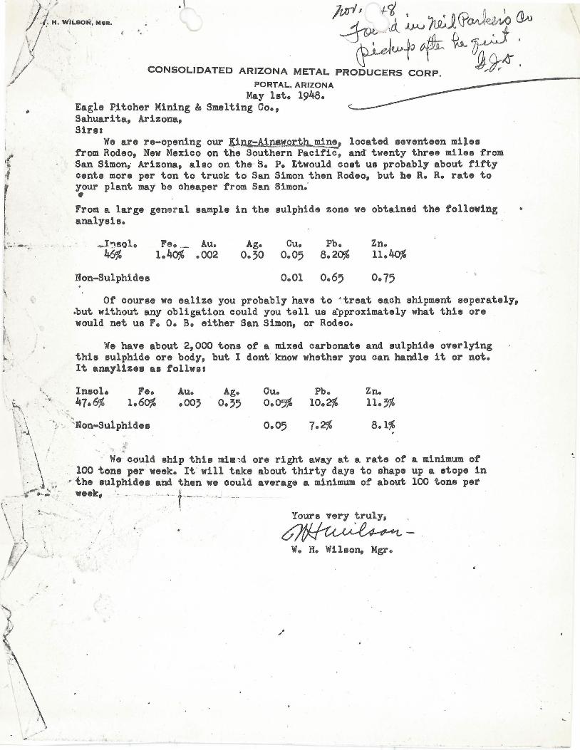
CONSOLIDATED ARIZONA METAL PRODUCERS CORP, ~,.9-; PORTAL, ARIZONA -------
- -~ ,
":"
May lat. 1948. Eagle P,ltcher Mining Ie Smelting Co., Sahuarita, Arizona, Sirss
We are re-opening our !l~~-Ai~~~~~ne, located seventeen miles from Rodeo, New Mexico on the Southern Pacific, an~ twenty three miles from San Simon,' Arizona, alao on the S. P. Ltwould cost us probably about fifty centa more per ton to truck to San Simon then Rodeo, but he R. R. rate to your plant may be cheaper from San Simon.' • From a large general sample in the sulphide zone we obtained the following analysis.
_I~8ol. Fe. ,_ Au. Ag. Cu. Pb. Zn. 46% 1.40% .002 O.~O 0.05 8.20% ll.40%
Non-Sulphides 0.01 0. 65 0.75 . ,
Of' course we eaUze you probably have to~treat each shipment seperately, ~ut without any obligation could you tell us approximately what thia ore would net U8 F. O. B. either San Simon, or Rodeo.
w. have about 2,000 tons of a mixed carbonate and sulphide overlying this sulphide ore body, but I dont know whether you can handle it or not. It anaylize. as tollws.
Fe. Cu. 1.60% 0.05%
Pb. 10.2%
Zn. 11.~% t\ ' "
\'..;_\' "f' '.' ~Non-Sulphldes ~ f
0·°5 7.2% 8.1%
'\ W. could ship this mi.:")d ore right away at a rate of a minimum of 100 toni per week. It' will take about thirty days to shape up a stope in
• , ~ t ' ,- the sulphides and then we oould average a minimum of about 100 tons pet - -'t""'~:: : w.ek, . - " , '. t,.--~ , '---- --..
!. -...... 't' .• Yours very ~ruly,
W. H. Wilson, Mgr.
'-

Memo.
Ainsworth Mine Coohise County
Arizona
The Ainsworth property is located about 1 mile southeast of the Harris GroUp of. Mines, and the formation, and deposits, are probably an extension of the Harris Group. Highway from Rodeo, N.M. approaohes the mine -- last mile of road to mine, from highway, good desert road. Distanoe to Rodeo about 14 miles.
Formation. Limestone, quartzite, porphyry. Porphy intrusions and footwall.
Development. One ~OO-ft shaft, with short drifts (Ainsworth shaft), one 200'
shaft (Wilson) and adit tunnel on strike of vein about 800 feet in length.
The strike of the vein -- quartzite and quartzite, 1n limestone, with limestone hangin~ wall and porphy1\probably diorite) foot wall -- northwestsouthea~d dip southwest at about ~oo from horizontal.
The Ainsworth shaft, separated by several hundred feet,are on same vein formation, but the Wilson shaft to southwest sunk in hanging wall aaa probably did not reach vein. Shafts inaocessible -- 500-ft adit in good shape.
The vein, as exposed in 500-ft adit, is very uniform and persistent in strike and d1p, but t~ times very narrow. Where stoped to the surfaoefor a':lout ~O feet along strike,'en8inging on tunnel level at about 500' from portal of adit, it shows a width of from ~' to 5'. The ore shoot rakes to the northwest and but little mineralization shows in ·the adit beyond the end of the ~OOI stoped ground. Winzes sunk from adit level show downwardoontinuation of ore under stoped area. Ore in shoot from a short distanoe above ad it level to surfaoe mainly in oarbonate (lead and zino) form; on level of adit, and below, ore becomes base (sulphides of lead and zinc and small amount copper).
Samples.
Sample No.
1.
2.
Desoription
Disseminated lead-zinc-oopper-iron sulphides; selected from dump at collar ~OO-' shaft, from Dr. bottom shaft Bedded base ore, about IBn thick, in
Gold Silver Oz. Ozs.
PerTon PerTon
Tr. 1.90
incline winze below stoped ground, BOOL O.BO adit level workings ,,- Tr.
~. Oxidized (oarbonate) lead-zlncore in place, tunnel level about ~OOi from portal -- stoped to surface Tr. 0.40
Lead Zinc Copper % % %
Not lB.60 Det'd 1.08
20000 27.90 -.-7.aO ·:· 19l~ -.--

Ainsworth Mine, FHL, #2, 6/17/~8.
In event of operation of the Hilltop mine, or other properties in the distriot, the Ainsworth should be given further consideration. Indications are favorable for finding a worth-while deposit of bedded base ores with deeper work from the 800 1 adit 1eve1,- and sample results of ore found on dump of the ~OO-ft shaft indicate good lead-zinc ~howing in the short drift driven from bottom of the shaft. Mr. Epley, who was at one time foreman on the Ainsworth,ls authority for statement regarding ore occurrence in the ~OO-ft shaft drift.
The Ainsworth control holding is held by the Basset Lumber Co., (or by the manager of the lumber company whose name I cannot now recall) in Douglas, and the prpoerty can be acquired on practically nown-quoted"
terms. .
The mineralization showing on the surface of the Ainsworth is strong, and the vein evidently persistent for several hundred feet. I do not feel, however, that the proper!l/88Rsr3ered alone for a large tonnage production.
. . ~~<-~ .... . ;:;.::n: -Tucson, Arizona, June 17, 19~8. Ainsworth visited Maroh ~O, 19~8.
/

EXCERPr FROM LET'l'ER F. H. LERCllliN. · 4/l/~8
"Looked the Harris (Epley-Pederson) Property and the Ainsworth (adjoining) over Wednesday. Nothing startling $500.00 is plenty high for 1/2 interest 1n the Harris Broup- and Ainsworth "interesting" and worth further attontion - nothing startling, however,-narrow bedded deposits carbonate of lead and zinc.
FHL.
( I
/
.-
r f
./~ . ..,..

Mine Ainsworth
I
L.,.E:PARTMENT OF MINERAL RESO~.{CES STATE OF ARIZONA
FIELD ENGINEERS REPORT
Date Jan. 1, 1955
Subject:
California Mining Dist., Cochise Co. f Engineer Axel L_. Johnson
Present Status. Information from Frank L. Higgins, Willcox, Ariz.
District
Location Near Paradise.
M3tals Copper, Lead • ..J OJ
Owner Frank Nolan, San Simon, Ariz. Purchased on tax sale.
Present Status Mine is idle.
NOLAN, FRANK ( Owner) San Simon, Arizona
MINE: AJAX, Calif. Mining Dist., Cochise Co. - Near Paradise.
MINE: AINSWORTH, It 11 It " II 1-1955
IVED f{1 r::

..JEPARTMENT OF MINERAL RESOIlRCES STATE OF ARIZONA
FIELD ENGINEERS REPORT
Mine Ainswo .. :th Date Jan. 1, 1955
District California lining Dist. J Cochise Co . Engineer Axel 1 0 Johnson
Subject: Inforna'l.ion froM Frank L. Higgins, illcox, iz.
Location Neai~ I aradise .
1etals Co_ per, Lead .
Owner Frank rolan, San SiJ on, Ariz . ~urchased on tax sali3 .
Present status

6-803 (January 1952)
U NITED STATES DEPARTMENT OF THE INTERIOR
BUREAU OF MINES
SUMMARY REPORT OF MINERALS EXAMINATION
, o/~
State __ __ ~~_'_~ ~ ______________ county- ---- -G-(;-I:-~ ... :"?.,-"'::.> __________ ______________ Mineral products ____ :_~ _______ ~_F.; __ ~ ____ ~ __ _ ;IVY "" .... • ,J'~ <... .. ___ 1',(J. • J ( , , .
Name 0 f prope rty 0 r depos i t __ ._! ............ 1. ------. . ...•• .. ...•. . ..•• -. . .•. -. . . -· - -T- --~-- - - - - . . . . .... _. ______________ .. __ . _________ ... __ __ __ •.• • <oot 1<:. •
Da te examined ___ .2 _t~! __ ~ ___ __ Engineer----k-.-J~- :- --... ---- - -~---- - -- - - - - ~ --- __ ____ Da te of this report __ i __ l/J§ .. _ ~ _____ .. _ ) - '" . , Reason for examina tion __ ~_e.::'. _____ ~ __ :_ ______ ____ . ____ .• _______ ,, _. /.L __ ~~:: ___________________________ :-_________ _ ___ -(,:_1'.. . ______ ,/ ______ _ : .t.:~ __ ~_~ __ . __ ••
I ~ll-J h. ? 0 -,
Engineer accompanied by __ _ .Ll.Q ___ tr-Y_~ ____________ ___ . ____ . _________ Address _____ _____ ______ ___ ____________ . _______________________ ---..
Extent of property-.----------.. --~~-~------------/- - ---~----~-q"_~_d?~!.!._ . __ ... __ .. _. __ . ____ m . ________________ m _____ • •
Own e r .... _ .. .J_ -.F _ .. ' - L~)t'::: .... 4 ______ . __ .. __ ... _ .. __ . ____ . __________ .. _.: .. ___ ....... _Add re s s __ _ .!::. .. _. _._ ~ _ t ..... -. ----_ -___ -.. _._.: ...... -._ -. -.- -"
Leased or optioned to_. _____ r] __ f): ____ . __ (~~ ___ _______ __ _ ._. ______ Address ________ _________ __ ___ ____ : ___________ . _____________ ______ ..
Loca tion of property (be specific) ____ -1.:._ .. __ . ___ .: ... ______ . ___ ~ ____ T _ .. _ /..?..~ . ! __ , ______ I~ ___ ,_. _____ ._: .... : .. ___ ..... _. __ . __ . ____ .
/ "l:2 _t.: .~- - .:? ,.f. __ . __ ___ __ ..... ~._. _1Z-4- :----~- !.~-- :-------------_. ______________ . ___ . ___ :_~ _______ : ____ :_L_tA ___ ~ _~ _____ ::.! __ t2Y.. ___ ____ ___ __ _ . ___ .•••• _._
~ . f ... /' . fa .~t Type of deposit
l and mineralogy ' (br~f deSC r iPtiOn) __________ fC:~v_r~~---~-L1-L----- - -------"~ -1. - ___ . __ ....
~;;~~;;:~:=::, : +:=~::-::::~ - :4J=T~:::;;:::~~ _~~' :.-t:'::g;: ~:;~:_~:;--r---v---d. ),,' )} -iJ- Q 0...; • .! ~ (I t. l(1 -..J. ) ~ f r (' 1 C ~ -' "I ,..,. "<.. ,. v
Known dimensions of e deposi t ~1... ~ t.-<-~ Length-.-..... ---............... W ld th __ ... __ . __ ... ___ ______ ._._Depth_._. __ . _____ __________ ____ __ .... __
AJ -0 / . At t it ude 0 f the deposit ( strike , dip , etc . ) ._. __ _ L I::'._ .. __ 6.. ____ !:Y. _____ ~: ________ ,, ___ !:.-:::t:. _____ / __________ ______ .•
_. __ i-..9.. __ ~_ ... __ .c=-:::.~._ ! .• _ .. __ ._ •. _ .. .'_. __________ . _________ _____ _ .• _. ___ ._. ______________ ... _ .. __________________ __ ___ ______________ ~_. __ •• _____ __ _ • __ ._. _____ . ___ _
Possible extensions ; correlation of known ShOWingS--------~j.-j _. ____ ~~_.o;( ____ __ ________ •• --- - ---------------. __
Mine workings (brief description or attach map or sketch) (indicate whether accessable) _____ _ • f '.j. ..
...]/f- Q 1-, ~ o../1..t!...; ~ .-L t- ,/' l "'--' rC -I:' f, ,4:.. /< , .-.... -.-.. --- . ----------.- - -- -- --. -~ - - .- - --------------- - ------------------------- - ----- - ------ - ---- - ------------------------------------ - --------------- - _.- -_ .--_._----------- - --
. \
1..-0<1 t;L , t? ,-", I' ,&..-v1 i' A'./( (t .. ii),)----;:: ~-; - ' "J~ -;;,- - ·-;;r--· - ---;S-i-;:,--e--~- - -· --i------- · - -:;.,- - --·~;CC----------------------- i ---------- - - - ----------- ------ ---- .---.----- ---- --.. -. (over )

Mining and milling equipment on property _______ L _' ____ ____ ________ : ______________ ______ ______ ____ ______ __________ ___ ______ ___ _____ ________ _
Pas t production (i f any) ____ __ !.1-:1_'c. ~:::::_.C ... _:_ .. _c ___ ,_.:. __ :_._. ___ ._ •........•.... _ ...... _ ..........•.••••.• ____ ...... ___ . ____ . __ ...... _______ . __ _
Presen t rate 0 f production (i f any) .... .......... ~ . __ .. _ ... ---- ___ . __ _____ _ . _____________ -........... _ ............. ____ .................. _ ...... .
Sampling (desc r ibe brie fly, or attach sketch) .... _. ____ ..... ___ _____ .... ..- j •• __ ~~~ ___ ~ _~ __ : __ ___ ••••• _ ••• __ _ -:~=::. _ ..... _. " C ) \t{t ,e " .' '/) , , 4' ",-' / . " /(-r, <,_ ')-J . """ _! -,. L-' (j,-J... l" _ .... _ .. _ ...... __ ....... - _ ....... .. - .... - .. - ........ ... r.. .. .. _ ...... _ ... ___ ___ ___ ~ _ .. _ .... .... ........ .. w .. . _ ........ .. ...... ..................... . .. ........ .... .. ........ _ .. - ........ - .. .. _ ......... _ ...... .. - - .. - __ .. .... -_ - __ .. - _________ _ ___ _ .. _____ :- _____ - - .. ____ -oo _ .... .. __ _
(; C' I ' - j , l 7* •• :-/. .~ ;'. '. : :: .l •...... " ~ " '. '." "" .......... -' ..... : '; .... ! ." •.. . . : ••• : •••.. .' • .• .• . . ••••• d . .::!!: ,<:-. ;;~ •• .••.•. , .. : ...• ~ _ ....•.••••.• ' ..•• ~::" .• !. '::':: .f~.. . ....... -' .-....... .
"'If/' /.7r ...... Tentative Estimate of Reserves
(Subje~t to revision when assays are received or after engineering calcul~t~ons) ---.- ~~. -- ~-.... -"" .~ I' I
Measurable ___ __ ____ ___________ __ . __ . ____ ____ .. ___ ,. ___ _____ _______ tons._ .... __ . __ . ____ . __ . __ . __________ . ____ .. ___ . __ .. __ .. Grade_._. ___ .. ___ ._._._ ... ___ . ___ .... __ ., r
Indica ted ________ ____ . ______ . ___ . ______ _________________ ________ __ _ tons ___________ ______ _________ _______ _ . _______ ___ _______ Grade __ __ ____________ __ _______ ________ _
I I . In fer red __ ____ _ V ___________ ___________________________________ ____ tons __ . ___ ____ __ ______ ________ ____ ___________ ___ ___ _____ Grade ____ __ __ ______ __ __ . _________ ... __ _
Mining method (actual 0 r sugges ted) _. _____ . ____ ____ . ___ ______ ________ ._. __ . ______ ___ ___ ______ ._. __ __ _ . ______ . ________ . ___________________ __ . ____ _
Milling or processing method (actual or suggested) ______ L_: ___ ~ _____ :_. __ .. __________ . _______ ______ .... _ ... _. ___ . ___ ... ______ ..
Pro c e s sing t es t s sugges t ed ......... l __ __ .-?::~: .. _ ... _ •.. ~ .. _ .... _.'._ ..... _ ........... _ ...... _ .. ___ ....... _ ..... _._ ......................... __ ._ ... _ .... _.
T t t· - 1' " d d .. I. "- (1 fl 1 ;1 /. .,'. ~ i . '. l/ U j t' en a ~ 'Ie conc us~on an ec~slon· _._:)L __ ~- · ___ .. : ~ __ ._7. -L .• L- l~-0-. -- -tt:. - --,----- ____ __ _ __ "" .. :c-__ _ ,_; _____ . ___ ._' __ . _____ __ .. __ . _____ ___ _ _ '. I ,
'! / ' / ' \; '-_"d-::1:~;(.0:: .... -_._:b:1' ___ I~ ._\. _ :;!:-~ ~ - :!--b--:'>--- .J.. -. _)_- -- ___ _ a~---~-1 -~1- iL.;;~ __ : ___ _ r./:\l .. -;:,;:.0-.-----I-:: . : :~ ____ ::~, ____ .!.:0.~_!.:.. ~ ~._. ____ ~ .. : ..
, '! 1', , . '
) " . ___ .. __ __ A __ ~~..r:',- _ -_--- _?L-:L - .L(~~-- - --,2: - ---- :-'_ l ~~~~·_-I_._: o: _____ .L~_~ _______ ~ _ :~ _ f __ ~ _ .:_:- _ ~_ .. _____ ,~ = :: __ :'· __ ! ____ 1:. __ .. _________ __________ · __ ~ ________ _________ .. .:. ........ t ____ .. _____ ..........
To be accompanied by brief let ter giving examining engineer's general impression of the deposi t, his impression of the owner , and any other confidential information he may care to submit . Refer to any known prior exa~inations and reports. May be executed in pencil . Should be mailed within 24 hours after examination is completed.
Send original and one copy to Washington Office.

DEPARTMENT OF MINERAL RESOURCES STATE o'F ARIZONA
OWNERS MINE REPORT
Date August lOth, 1939
Mine v Ainsworth.
District California Mining District . Location Cochise County, Arizona.
/ Former name King Copner Company
4 miles N.~. of Paradise, Arizona
Owner AinsVlorth Copper Company Address Douglas, Arizona
Operator No one. Address
President Albert Stacy Gen. Mgr. 'Robert f\.. Wehr.
Mine Supt.
I Mill Supt.
Principal Metals vCopper and Lead Men Employed None
Production Rate None Mill : Type & Cap. None
Power: Amt. & Type None
Operations: Present None
Operations Planned None
Number Claims. Title. etc. 63 Unpatented
Description: Topog. & Geog. Located on the east foot hills of the Chiricahua mountains where Turkey creek enters the ,-Jan Simon valley; easily accessable by good, graded road.
Mine Workings: Amt. & Condition ~ui te El. large amount of work has been done on the pronerty, including tunnels and shafts. The Ainsworth shaft is 320 feet deep with drifts and cross-cuts at the 300 level. There are several shafts 100 or more feet deep and a '700 foot tunnel. There is a good showing of are in all vTOrkings.
(over)

,-- ... . ., , ' ...
Geology & Mineralization See copy of Botsford report on the property •
Ore: Positive & Probable, Ore Dumps, Tailings
Mine, Mill Equipment & Flow Sheet All sold to pay debts.
Road Conditions, Route Good : About 6 miles north of Portal on Hilltop and San Simon road. There is a graded road to the property from the Hilltop road and a car or truck can be driven to the principal workings on the property.
Water Supply Good : From well at Turkey Creek and from Ainsworth shaft .
, Brief History Some work was done on the claims in the early 1880's by George Kinedon. Later some of the claims were O1,'med by ' Henry Morgan, of 'Willcox and' O. C. Davis who shipped several c arloads of ore and sold their claims for 090,000. 00 cash. The buyers organized a company and equipped the property with machinery and then disagreed among themsel ves and did ver;J little mining. Lauer King Copper Co. was organized by creditors and in 192q the creditors of i <Jng Cop:r,>er Co . organized Ainsworth Copper Col, present owners. SpeCIal Problems, Reports FIlecf
Remarks All geological and engineering reports on the property have been very favorable.
If property for sale: Price, terms and address to negotiate.
Property is for saJe. Address Albert Stacy, Douglas, Arizona
Signed .. ....... ... .......... ... .................. ... ........... .... ... ........ ....... .... .
Use additional sheets if necessary.