contact telephone field data collection guide for … data collection guide for watershed studies...
TRANSCRIPT

Field Data
Collection Guide
for Watershed
Studies
Anne Arundel County
Department of Public Works
Bureau of Engineering
Watershed, Ecosystem, and Restoration Services Division
2012
Contact Telephone
Emergency/Police/Fire/Ambulance 911
Poison Control Center (800) 222-1222
National Response Center (800) 424-8802


i
Notes Purpose
This Field Data Collection Guide for Watershed Studies documents data
collection protocols, procedures, and assessment and scoring guidance
for watershed studies conducted by Anne Arundel County’s Watershed,
Ecosystem, and Restoration Services Division. This guide is intended for
use by future field assessment teams to help ensure consistent data
collection throughout all of the County’s watershed assessments.
ii
TABLE OF CONTENTS
Field Task Overview ..................................................................... 1
Stream Reaches ........................................................................... 2
Stream Layer Verification ............................................................... 2
Stream Character Type ................................................................... 3
Stream Reach Breaks ...................................................................... 3
Physical Habitat Assessment ........................................................ 4
Data Collection Procedures ............................................................ 4
Photo Tips ....................................................................................... 4
MPHI Parameter Scoring Guide ...................................................... 5
Additional Physical Habitat Assessment Data ................................ 6
Stream Geomorphology (Rosgen) ................................................. 7
Data Collection Procedures ............................................................ 7
Photo Tips ....................................................................................... 7
Manning’s Roughness Parameter Scoring Guide ........................... 8
Rosgen Classification .................................................................... 11
Additional Geomorphic Assessment Data .................................... 12
Infrastructure Inventory ............................................................. 13
General Data Collection Procedures ............................................ 13
Deficient Buffer ............................................................................ 14
Crossing ........................................................................................ 16
Dumpsite ...................................................................................... 18
Erosion .......................................................................................... 20
Head Cut ....................................................................................... 23
Obstruction ................................................................................... 24
Pipe and Ditch ............................................................................... 25
Utility ............................................................................................ 27
Other Impact ................................................................................ 28
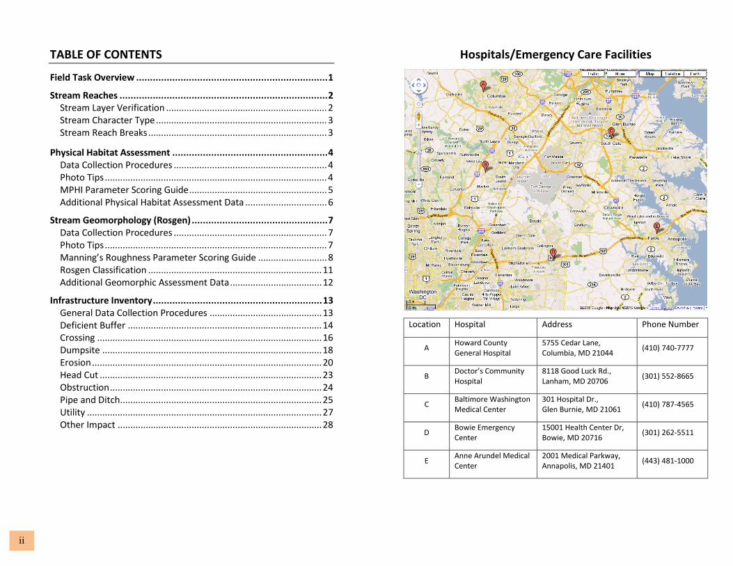
Hospitals/Emergency Care Facilities
Location Hospital Address Phone Number
A Howard County
General Hospital
5755 Cedar Lane,
Columbia, MD 21044 (410) 740-7777
B Doctor’s Community
Hospital
8118 Good Luck Rd.,
Lanham, MD 20706 (301) 552-8665
C Baltimore Washington
Medical Center
301 Hospital Dr.,
Glen Burnie, MD 21061 (410) 787-4565
D Bowie Emergency
Center
15001 Health Center Dr,
Bowie, MD 20716 (301) 262-5511
E Anne Arundel Medical
Center
2001 Medical Parkway,
Annapolis, MD 21401 (443) 481-1000

Oth
er
l U
tili
ty l
Pip
e &
Dit
ch l
Ob
stru
ctio
n l
He
ad
Cu
t l
Ero
sio
n l
Du
mp
site
l C
ross
ing
l B
uff
er
Ro
sge
n
Ha
bit
at
St
rea
m
In
tro
.
1
Intro
Strea
m H
ab
itat R
osg
en
Bu
ffer l C
rossin
g l D
um
psite
l Ero
sion
l He
ad
Cu
t l Ob
structio
n l P
ipe
& D
itch l U
tility l Oth
er.
28
OTHER IMPACT
Scoring Guide
• Note and photograph any other issues that should be brought to
County’s attention (e.g., erosion and sediment control violations).
FIELD TASK OVERVIEW
This is a summary of the primary tasks associated with the field data
collection for the County’s watershed studies. Each task is discussed in
more detail in the sections that follow.
Stream Reaches..
• Verify actual position and alignment of all channels represented on
the County’s planimetric Stream GIS layer, other perennial streams
encountered in the field, or other non-perennial channels
connected to a storm drain outfall in the County’s GIS Outfall layer.
• Mark with a Confluence point and perform no further assessment
on those intermittent/ephemeral channels that do not meet the
criteria above.
• Break the stream layer into reaches based on flow type and other
considerations.
Physical Habitat Assessment..
• Provide basic data and a photo for each stream reach regardless of
flow type.
• Perform full physical habitat assessments on perennial reaches only.
• Perform rapid assessments on in-line wetlands
Stream Geomorphology (Rosgen)..
• Place Rosgen point and take photo for each stream reach regardless
of flow type.
• Perform geomorphology/Rosgen assessments only on single-
threaded reaches regardless of flow type.
Infrastructure Inventory..
• Perform inventory assessment and take photo for each
infrastructure type encountered within each reach regardless of
flow type.
• Place multiple points when an inventory point crosses a reach break.

27 2
Oth
er
l U
tili
ty l
Pip
e &
Dit
ch l
Ob
stru
ctio
n l
He
ad
Cu
t l
Ero
sio
n l
Du
mp
site
l C
ross
ing
l B
uff
er
Ro
sge
n
Ha
bit
at
St
rea
m
In
tro
. In
tro Stre
am
Ha
bita
t Ro
sge
n B
uffe
r l Cro
ssing
l Du
mp
site l E
rosio
n l H
ea
d C
ut l O
bstru
ction
l Pip
e &
Ditch
l Utility l O
the
r.
STREAM REACHES
Stream Layer Verification
UTILITY
Scoring Guide
• Impact Score
o Extreme (20): Line is leaking.
o Severe (10): Exposed line causing a significant erosion and/or
obstruction OR potential to burst/leak appears high.
o Moderate (5): Half exposed line causing moderate erosion.
o Minor (2): Line is partially visible however mostly buried in stream
bed, little if any erosion.
Photo Tips
Include location of utility relative to stream and/or banks. Use
additional photos as necessary to capture any erosion or other impacts.
Additional Information
• Bank side (right or left) is determined by looking upstream.
Th
e d
ecisio
n tre
e b
elo
w sh
ou
ld b
e u
sed
to g
uid
e w
he
the
r or n
ot stre
am
verifica
tion
an
d su
bse
qu
en
t asse
ssme
nt
are
req
uire
d fo
r a p
articu
lar ch
an
ne
l.

3 26
Oth
er
l U
tili
ty l
Pip
e &
Dit
ch l
Ob
stru
ctio
n l
He
ad
Cu
t l
Ero
sio
n l
Du
mp
site
l C
ross
ing
l B
uff
er
Ro
sge
n
Ha
bit
at
St
rea
m
In
tro
. In
tro Stre
am
Ha
bita
t Ro
sge
n B
uffe
r l Cro
ssing
l Du
mp
site l E
rosio
n l H
ea
d C
ut l O
bstru
ction
l Pip
e &
Ditch
l Utility l O
the
r.
Additional Information
• Bank side (right or left) is determined by looking upstream.
• Record either pipe diameter (in inches) or ditch width (in feet)
depending on whether the inventory point is a pipe or ditch.
• In general, record only pipe outfalls that are encountered within
the 100 ft. stream buffer. Outfall drainage channels longer than
100 ft. will need to be treated as an assessment reach, for which
the four primary tasks described in this guide on page 1 will
need to be conducted.
• Standing water in a downstream channel should not be used as
a surrogate for discharge quality parameters when no flow is
present. Poor quality standing water should be noted however
in the Comments field.
Stream Character Types
Channels that require assessment according to the stream layer
verification decision tree (previous page) should be assessed and
assigned one of the following stream character types:
• Perennial - Continuous flow year round during years of normal rainfall
• Intermittent - Flow ceases for weeks or months each year
• Ephemeral - Flows for only hours or days following a rain event
• Underground
• Wetland/marsh
• Pond/lake
• Floodway
• Stormwater management (SWM)
• Pipe
• Ditch
Stream Reach Breaks
Channels should be broken into reaches based on the following
criteria:
• Changes in flow type
• Changes in physical habitat
• Major changes in riparian buffer
• Changes in stream geomorphology
• Major culverts or bridges

25 4
Oth
er
l U
tili
ty l
Pip
e &
Dit
ch l
Ob
stru
ctio
n l
He
ad
Cu
t l
Ero
sio
n l
Du
mp
site
l C
ross
ing
l B
uff
er
Ro
sge
n
Ha
bit
at
St
rea
m
In
tro
. In
tro Stre
am
Ha
bita
t Ro
sge
n B
uffe
r l Cro
ssing
l Du
mp
site l E
rosio
n l H
ea
d C
ut l O
bstru
ction
l Pip
e &
Ditch
l Utility l O
the
r.
PHYSICAL HABITAT ASSESSMENT
Data Collection Procedures
• Provide basic data and at least one representative photo for
each reach regardless of flow type. Basic data includes: date
assessed, assessor, past weather, current weather, presence of
flow, whether a physical habitat assessment and infrastructure
assessment were performed, and if not, why not.
• Perform full physical habitat assessments only on perennial
reaches that are greater than 75 meters.
• Select representative 75 meter reach to perform assessment.
• Collect MPHI scoring parameters.
• Collect additional information contained in the County SAT
database (Stream Characteristics table).
• When a wetland is identified, see wetland rapid assessment field
guide.
Photo Tips
Take photo within channel facing upstream, if possible. Photo
should capture channel cross section and floodplain (see below)
and should be representative of entire reach.
PIPE AND DITCH
Scoring Guide
• Impact Score
o Severe (10): Pipe or ditch causing a significant erosion
problem to stream bank or stream and/or discharge is
coming from pipe that may not be stormwater.
o Moderate (5): Pipe or ditch is causing moderate erosion
problem and should be fixed, it may worsen if left
unattended.
o Minor (0): Pipe or ditch is not causing erosion problem and
no discharge is occurring.
Photo Tips
Context is important, do not zoom in on pipe opening, include flow
path out of pipe and erosion, if present.

24
5
Oth
er
l U
tili
ty l
Pip
e &
Dit
ch l
Ob
stru
ctio
n l
He
ad
Cu
t l
Ero
sio
n l
Du
mp
site
l C
ross
ing
l B
uff
er
Ro
sge
n
Ha
bit
at
St
rea
m
In
tro
. In
tro Stre
am
Ha
bita
t Ro
sge
n B
uffe
r l Cro
ssing
l Du
mp
site l E
rosio
n l H
ea
d C
ut l O
bstru
ction
l Pip
e &
Ditch
l Utility l O
the
r.
OBSTRUCTION
Scoring Guide
• Impact Score
o Severe (10): Blockage causing significant erosion
problem and/or potential for flooding. Stream usually
almost totally blocked (>75%).
o Moderate (5): Blockage is causing moderate erosion
and could cause flooding. Stream partially blocked,
but obstruction should probably be removed, because
problem could worsen.
o Minor (2): Blockage is causing some erosion problems
but does have potential to worsen and probably
should be looked at or monitored.
Photo Tips
Take photo that Includes full extent of obstruction, if possible.
Highlight erosion if present in additional photos.
MPHI Parameter Scoring Guide
• In-stream Habitat
o Optimal (16-20): Greater than 50% of a variety of cobble,
boulder, submerged logs, undercut banks, snags, root
wads, aquatic plants or other stable habitat.
o Sub-Optimal (11-15): 30-50% stable habitat. Adequate.
o Marginal (6-10): 10-30% mix of stable habitat. Less than
desirable.
o Poor (0-5): <10% stable habitat. Lack of habitat is obvious.
• Epifaunal Substrate
o Optimal (16-20): Preferred substrate abundant, stable, and
at full colonization potential (riffles well developed and
dominated by cobble; woody debris prevalent, not new,
and not transient.
o Sub-Optimal (11-15): Abundance of cobble with gravel
and/or boulders common; or woody debris, aquatic
vegetation, undercut banks, or other productive surfaces
common but not prevalent/suited for full colonization.
o Marginal (6-10): Large boulders and/or bedrock prevalent;
cobble, woody debris, or other preferred surfaces
uncommon.
o Poor (0-5): Stable substrate lacking; sedimentation or
flocculent material covering >75% surface.

6
23
Oth
er
l U
tili
ty l
Pip
e &
Dit
ch l
Ob
stru
ctio
n l
He
ad
Cu
t l
Ero
sio
n l
Du
mp
site
l C
ross
ing
l B
uff
er
Ro
sge
n
Ha
bit
at
St
rea
m
In
tro
. In
tro Stre
am
Ha
bita
t Ro
sge
n B
uffe
r l Cro
ssing
l Du
mp
site l E
rosio
n l H
ea
d C
ut l O
bstru
ction
l Pip
e &
Ditch
l Utility
l Oth
er.
MPHI Parameter Scoring Guide (continued)
• Woody Debris and Root Wads
o Count woody debris >10 cm diameter, more than 1.5 m long
o Count root wads on live trees with DBH of at least 15 cm
o Only count those found in wetted (or likely to become wetted)
portion of stream
• Bank Stability
o Linear % erosion of both banks of the stream
o Severity = None, Minimal, Moderate, or Severe
• Remoteness
o Distance to nearest road (meters)
• Shading
o Estimate of degree and duration of shading during summer
o 0%: Fully exposed to sunlight all day in summer
o 100%: Fully and densely shaded all day in summer
Additional Physical Habitat Assessment Data
• Water clarity and odor
• Sediment odor
• Fish presence and size
• Aquatic plant presence, type, and location
• Algae (slime, floating, and filamentous) presence and color
• Bacteria presence and type
• Dominant land use
• Dominant riparian vegetation type and width
• Maximum depth
HEAD CUT
Scoring Guide
• Height of the head cut (in feet) is measured from channel
bottom to channel bottom.
Photo Tips
Take photo facing upstream from bank or instream. Include
background height reference, if possible.
Additional Information
• Consecutive head cuts that are within 5 to 10 feet of each other
may be aggregated into a single point.

7 22
Oth
er
l U
tili
ty l
Pip
e &
Dit
ch l
Ob
stru
ctio
n l
He
ad
Cu
t l
Ero
sio
n l
Du
mp
site
l C
ross
ing
l B
uff
er
Ro
sge
n
Ha
bit
at
St
rea
m
In
tro
. In
tro Stre
am
Ha
bita
t Ro
sge
n B
uffe
r l Cro
ssing
l Du
mp
site l E
rosio
n l H
ea
d C
ut l O
bstru
ction
l Pip
e &
Ditch
l Utility l O
the
r.
Additional Information
• Bank side (right or left) is determined by looking upstream.
• Linear footage of erosion should be reported as the
longitudinal distance along the stream. Erosion reported on
both sides of the stream should be measured as the average
distance on both sides of the stream (e.g., the erosion
should not be doubled if it appears on both sides of the
stream; if there is 20 ft of erosion on the right bank and 40 ft
of erosion on the left bank, it should be recorded as 30 ft on
both banks).
• Discrete areas of erosion along a reach may be aggregated
into a single point as long as the characteristics and impacts
are identical.
• Bank height and bankfull height should be measured to
channel bottom not water surface.
• Place multiple points when erosion crosses a reach break
(e.g., erosion that spans two or more reaches).
STREAM GEOMORPHOLOGY (ROSGEN)
Data Collection Procedures
• Place Rosgen point and take at least one representative photo
for each reach regardless of flow type.
• Collect data for Manning’s roughness calculation, Rosgen
classification, and other geomorphic assessments for all
perennial, intermittent, and ephemeral reaches.
• Place point at representative location in channel (preferably
riffle).
Photo Tips
Take photo from top of stream banks, if possible. Photo should
capture channel cross section at a riffle as well as connection with
floodplain.

8
21
Oth
er
l U
tili
ty l
Pip
e &
Dit
ch l
Ob
stru
ctio
n l
He
ad
Cu
t l
Ero
sio
n l
Du
mp
site
l C
ross
ing
l B
uff
er
R
osg
en
H
ab
ita
t
Stre
am
I
ntr
o.
Intro
Strea
m H
ab
itat R
osg
en
Bu
ffer l C
rossin
g l D
um
psite
l Ero
sion
l He
ad
Cu
t l Ob
structio
n l P
ipe
& D
itch l U
tility l Oth
er.
Manning’s Roughness Parameter Scoring Guide
• Dominant and Subdominant Bed Material
o Clay/Silt (<0.08mm)
o Fine Sand (0.08-1mm)
o Coarse Sand (1-2mm)
o Gravel (2-64mm)
o Cobble (64-256mm)
o Boulder (>256mm)
• Surface Irregularities
o Smooth: Compares to the smoothest channel attainable given a
bed material.
o Minor: Compares to a carefully degraded channel in good condition
but having slightly eroded or scoured side slopes.
o Moderate: Compares to dredged channels having moderate to
considerable bed roughness and moderately sloughed or eroded
side slopes.
o Severe: Badly sloughed or scalloped banks or natural streams;
badly eroded or sloughed sides of canals or drainage channels;
unshaped jagged, and irregular surfaces of channel.
• Channel Shape and Size Variation
o Gradual: Size and shape of channel cross sections change gradually.
o Alternating Occasionally: Lange and small cross sections alternate
occasionally or the shifts in main flow occasionally shift from one
side to another because of the changes in cross sectional shape.
o Alternating Frequently: Large and small cross sections alternate
frequently or the main flow frequently shifts from side to side
because of the changes in cross sectional shape.
Photo Tips
Take photos that capture bank(s) with erosion in context of the stream.
Also include area upstream or downstream of immediate erosion, if
possible.

9 20
Oth
er
l U
tili
ty l
Pip
e &
Dit
ch l
Ob
stru
ctio
n l
He
ad
Cu
t l
Ero
sio
n l
Du
mp
site
l C
ross
ing
l B
uff
er
Ro
sge
n
Ha
bit
at
St
rea
m
In
tro
. In
tro Stre
am
Ha
bita
t Ro
sge
n B
uffe
r l Cro
ssing
l Du
mp
site l E
rosio
n l H
ea
d C
ut l O
bstru
ction
l Pip
e &
Ditch
l Utility l O
the
r.
EROSION
Scoring Guide
• Impact Score
o Extreme (10): Impending threat to structures or infrastructure.
o Severe (7): Large area of erosion that is damaging property and
causing obvious instream degradation. Eroding bank is generally
5 ft. or greater in height.
o Moderate (5): Moderate area of erosion that may be damaging
property and causing some instream degradation. Eroding bank
is generally 2-3 ft. or greater in height.
o Minor (is not recorded, scored or photographed): Minor area of
erosion, low threat to property, and no noticeable instream
degradation.
• Restoration Potential
o High: Potential project is of good size, would not involve
easements in residential yards, involves minimal number of
property owners, appears to have good access, and would
provide good benefit to stream.
o Moderate: Potential project is of good or fair size, involves just a
few property owners, may include but is not confined to small
residential yards, appears to have good access, and would
benefit stream.
o Low: Potential project is small OR is confined to small residential
yards, appears to have access issues OR is not critical for
character of stream.
Manning’s Roughness Parameter Scoring Guide
(continued)
• Obstructions
o Negligible: A few scattered obstructions, which include debris
deposits, stumps, exposed roots, logs, piers, or isolated
boulders, that occupy less than 5 percent of the cross-
sectional area.
o Minor: Obstructions occupy 5 percent to 15 percent of the
cross-sectional area, and the spacing between obstructions is
such that the sphere of influence around one obstruction
does not extend to the sphere of influence around another
obstruction. Smaller adjustments are used for curved,
smooth-surfaced objects than are used for sharp-edged
angular objects.
o Appreciable: Obstructions occupy from 15 percent to 50
percent of the cross-sectional area, or the space between
obstructions is small enough to cause the effects of several
obstructions to be additive, thereby blocking an equivalent
part of a cross section.
o Severe: Obstructions occupy more than 50 percent of the
cross-sectional area, or the space between obstructions is
small enough to cause turbulence across most of the cross
section.
• Meander
o Minor: Ratio of the channel length to valley length is 1.0 to
1.2.
o Appreciable: Ratio of the channel length to valley length is 1.2
to 1.5.
o Severe: Ratio of the channel length to valley length is greater
than 1.5.

19 10
Oth
er
l U
tili
ty l
Pip
e &
Dit
ch l
Ob
stru
ctio
n l
He
ad
Cu
t l
Ero
sio
n l
Du
mp
site
l C
ross
ing
l B
uff
er
R
osg
en
H
ab
ita
t
Stre
am
I
ntr
o.
Intro
Strea
m H
ab
itat R
osg
en
Bu
ffer l C
rossin
g l D
um
psite
l Ero
sion
l He
ad
Cu
t l Ob
structio
n l P
ipe
& D
itch l U
tility l Oth
er.
Manning’s Roughness Parameter Scoring Guide
(continued)
• Vegetation
o Small: Dense growths of flexible turf grass, such as Bermuda,
or weeds growing where the average depth of flow is at least
two times the height of the vegetation; supple tree seedlings
such as willow, cottonwood, arrowhead, or salt cedar growing
where the average depth of flow is at least three times the
height of the vegetation.
o Medium: Turf grass growing where the average depth of flow
is from one to two times the height of the vegetation;
moderately dense stemy grass, weeds, or tree seedlings
growing where the average depth of flow is from two to three
times the height of the vegetation; brushy, moderately dense
vegetation, similar to 1-to-2-year-old willow trees in the
dormant season, growing along the banks, and no significant
vegetation is evident along the channel bottoms where the
hydraulic radius exceeds 2 ft.
o Large: Turf grass growing where the average depth of flow is
about equal to the height of the vegetation; 8-to-10-years-old
willow or cottonwood trees intergrown with some weeds and
brush (none of the vegetation in foliage) where the hydraulic
radius exceeds 2 ft.; bushy willows about 1 year old
intergrown with some weeds along side slopes (all vegetation
in full foliage), and no significant vegetation exists along
channel bottoms where the hydraulic radius is greater than 2
ft.
o Very Large: Turf grass growing where the average depth of
flow is less than half the height of the vegetation; bushy
willow trees about 1 year old intergrown with weeds along
side slopes (all vegetation in full foliage), or dense cattails
growing along channel bottom; trees intergrow with weeds
and brush (all vegetation in full foliage).
Additional Information
• When estimating the volume of material at the dumpsite, this
value must be a compacted volume. Estimates of volume should
ignore void space and account only for the volume of physical
materials that compromise the objects.
• Bank side (right or left) is determined by looking upstream.
• In general, record only dumpsites encountered within the 100 ft.
stream buffer.
• In the cleanup comments, consider the ease of access, the
weight or bulk of the items, and any potential hazards to
cleanup crews.

11 18
Oth
er
l U
tili
ty l
Pip
e &
Dit
ch l
Ob
stru
ctio
n l
He
ad
Cu
t l
Ero
sio
n l
Du
mp
site
l C
ross
ing
l B
uff
er
Ro
sge
n
Ha
bit
at
St
rea
m
In
tro
. In
tro Stre
am
Ha
bita
t Ro
sge
n B
uffe
r l Cro
ssing
l Du
mp
site l E
rosio
n l H
ea
d C
ut l O
bstru
ction
l Pip
e &
Ditch
l Utility l O
the
r.
DUMPSITE
Scoring Guide
• Impact Score
o Severe (10): Active and/or threatening. Material may be considered
toxic or threatening to environment (concrete, petroleum, empty
55 gallon drums) or site is large (>2,500 sq. ft.).
o Moderate (5): Dumpsite (<2,500 sq. ft.) containing non-toxic
material, does not appear to be used often, however clean-up
would definitely be a benefit.
o Minor (1): Dumpsite appears small (<100 sq. ft.) and material stable
(will not likely be transported downstream by high water). Not high
priority.
Photo Tips
Take photo that captures context of dumpsite relative to the stream, if
possible. Take additional photos that capture the largest impact items.
Rosgen Classification
Perform quick estimate of Rosgen Level I classification using the
following chart.

17 12
Oth
er
l U
tili
ty l
Pip
e &
Dit
ch l
Ob
stru
ctio
n l
He
ad
Cu
t l
Ero
sio
n l
Du
mp
site
l C
ross
ing
l B
uff
er
R
osg
en
H
ab
ita
t
Stre
am
I
ntr
o.
Intro
Strea
m H
ab
itat R
osg
en
Bu
ffer l C
rossin
g l D
um
psite
l Ero
sion
l He
ad
Cu
t l Ob
structio
n l P
ipe
& D
itch l U
tility l Oth
er.
Additional Geomorphic Assessment Data
• Overall Channel Condition
[Poor conditions (1) to Good conditions (10)]
o 1: Channel is actively down cutting or widening; >50% of the
reach altered and/or unstable.
o 2, 3, or 4: Altered channel; <50% of the reach altered (riprap,
channelization, etc) and/or unstable.
o 5, 6, 7, 8, or 9: Channel largely stable. Evidence or past channel
alteration, but with significant recovery of channel and banks.
o 10: Natural channel. No evidence of significant lateral or bed
adjustment.
• Channel Incision
[Poor conditions (1) to Good conditions (10)]
o 1: Channel significantly incised.
o 2 or 3: Majority of channel moderately and/or significantly incised.
o 4, 5, or 6: Portions of channel moderately incised.
o 7, 8, or 9: Channel largely connected with floodplain, except
locally where past channel alteration has occurred.
o 10: Channel connected to floodplain.
Photo Tips
Take photos at both the upstream and downstream ends of the
crossing. If possible, take photos from within stream channel. Photo
should provide appropriate context and include the crossing structure
as well as the stream bed and banks. Include all barrels in single photo,
if possible. Highlight erosion or sediment or debris deposition, if
present, in additional photos, if needed.
Additional Information
• Foot bridges and bridges that span a stream without culverts should
be assigned a barrel quantity of zero (0).
• Crossing diameter is in feet.
• In the event multiple barrels are present, the reported diameter
should be the average of all barrels or crossing structures.
• Bed erosion height is measured from the structure invert to the
bottom of the eroded stream bed.

13 16
Oth
er
l U
tili
ty l
Pip
e &
Dit
ch l
Ob
stru
ctio
n l
He
ad
Cu
t l
Ero
sio
n l
Du
mp
site
l C
ross
ing
l B
uff
er
Ro
sge
n
Ha
bit
at
St
rea
m
In
tro
. In
tro Stre
am
Ha
bita
t Ro
sge
n B
uffe
r l Cro
ssing
l Du
mp
site l E
rosio
n l H
ea
d C
ut l O
bstru
ction
l Pip
e &
Ditch
l Utility l O
the
r.
CROSSING
Scoring Guide
• Impact Score
o Extreme (10): Condition of debris, sediment or erosion poses
immediate threat to structural stability of road or other
structure. Major repair will be needed if problem is not
addressed.
o Severe (7): Condition probably poses threat to road or other
structure. Problem should be addressed to avoid bigger
problem in future.
o Moderate (5): Condition does not appear to pose threat to
road or other structure, but should be addressed to enhance
stream integrity and future stability of structure.
o Minor (2): Condition is noticeable but may not warrant repair.
INFRASTRUCTURE INVENTORY
General Data Collection Procedures
• Collect characteristics and impact data for the following features
encountered in each reach regardless of perenniality:
o Deficient Buffers
o Crossings
o Dumpsites
o Erosion
o Head Cuts
o Obstructions
o Pipes and Ditches
o Utilities
o Other Impacts
• Record each observed instance encountered in the field with the
following exceptions:
o Discrete areas of erosion along a reach may be aggregated
into a single point as long as the characteristics and impacts
are identical.
o Consecutive head cuts that are within 5 to 10 feet of each
other may be aggregated into a single point.
• Place point at center of each feature.
• Take at least one representative photo.
• Place multiple points when an inventory feature crosses a reach
break (e.g., deficient buffer or erosion that spans two or more
reaches).

15 14
Oth
er
l U
tili
ty l
Pip
e &
Dit
ch l
Ob
stru
ctio
n l
He
ad
Cu
t l
Ero
sio
n l
Du
mp
site
l C
ross
ing
l B
uff
er
Ro
sge
n
Ha
bit
at
St
rea
m
In
tro
. In
tro Stre
am
Ha
bita
t Ro
sge
n B
uffe
r l Cro
ssing
l Du
mp
site l E
rosio
n l H
ea
d C
ut l O
bstru
ction
l Pip
e &
Ditch
l Utility l O
the
r.
DEFICIENT BUFFER
Scoring Guide
• Impact Score
o Extreme (10): Impervious/commercial area in close proximity
to stream, banks may be modified or engineered. Stream
character such as (bank/bed stability, sediment deposition,
and/or shading) is obviously degraded by adjacent use.
o Severe (7): Some impervious and/or just turf up to the bank,
very little vegetation aside from turf within 25 ft. zone, stream
character probably degraded by adjacent uses.
o Moderate (5): Encroachment mostly from residential uses and
yard; some vegetation within 25 ft. zone, but very little other
than turf within remainder of 100 ft. zone; stream character
may be changed slightly by adjacent use.
o Minor (is not recorded, scored or photographed): Vegetated
buffer primarily intact within 100 ft. of stream.
• Restoration Potential
o High: Potential project is of good size, would not involve
easements in residential yards, involves minimal number of
property owners, appears to have good access, and would
provide good benefit to stream.
o Moderate: Potential project is of good or fair size, involves
just a few property owners, may include but is not confined to
small residential yards, appears to have good access, and
would benefit stream.
o Low: Potential project is small OR is confined to small
residential yards, appears to have access issues OR is not
critical for character of stream.
Photo Tips
Take photo that captures the buffer deficiency’s proximity to the stream,
if possible (e.g., stream channel in the foreground). Also ensure that the
buffer type is discernible.
Additional Information
• Bank side (right or left) is determined by looking upstream.
• Record only buffer deficiencies within 100 ft. of stream
channel.
• Linear footage of the buffer deficiency should be reported
as the longitudinal distance along the stream. A deficiency
reported on both sides of the stream should be measured
as the average distance on both sides of the stream (e.g.,
the deficiency should not be doubled if it appears on both
sides of the stream; if there is 20 ft of deficiency on the
right bank and 40 ft of buffer deficiency on the left bank, it
should be recorded as 30 ft on both banks).