contents outline of incident 1 - atsb.gov.au · pdf filecontents outline of incident ..... 1...
TRANSCRIPT

_ i _
CONTENTS
Outline of Incident ................................................ 1
Chart ... Route of RIVER EMBLEY ..................................... 2
Authority to Conduct Investigation ................................. 3
Persons Interviewed and Sources of Information ..................... 4
Preamble ........................................................... 6
Scale drawing of RIVER EMBLEY ...................................... 7
The Ship ........................................................... 8
Navigation in Torres Strait ........................................ 9
Chart of Torres Strait ............................................. 11
Previous Casualties ................................................ 10
Sequence of Events ................................................. 12
Observations ....................................................... 19
Seabed Profile Diagram ............................................. 25
Conclusions ........................................................ 28
Attachments1. Chart of Alert Patches (From Aus 293) . . . . . . . . . . . . . . . . . . . . . . . . . . . 30
2. Survey plan showing extent of rock outcrop of Alert Patches..... 31
3. Chart extract from chart Aus 293 in use aboard RIVER EMBLEY.... 32
4. Pilot's Passage Plan . . . . . . . . . . . . . . . . . . . . . . . . . . . . . . . . . . . . . . . . . . . . 33
5. Tidal height recording sheet . . . . . . . . . . . . . . . . . . . . . . . . . . . . . . . . . . . . 34
6. Details of RIVER EMBLEY . . . . . . . . . . . . . . . . . . . . . . . . . . . . . . . . . . . . . . . . . 35
Appendices
1 ......... Warnings and Notices .................................... 37
2 ......... Depths and Underkeel Clearance.......................... 41
3......... Squat ................................................... 42
4......... Tidal Information and Gauges ............................ 56
..................Leading Lights .......................................... 57
Herald and Alert Patches Light Buoys .................... 58
CSS06D0423

- 1 -
OUTLINE OF INCIDENT
Shortly before 1700 hours Eastern Standard Time on 9 May 1987 the Australian
flag bulk carrier RIVER EMBLEY, on passage from Weipa to Gladstone, grounded
momentarily south of Alert Patches Buoy in the eastern approaches to the
Prince of Wales Channel, Torres Strait. The vessel sustained damage forward
and commenced to flood the forepeak and No 1 void space. The reported
position of the grounding was not immediately fixed but was subsequently
deduced by ship staff.
The ship, loaded with bauxite, proceeded to a safe anchorage. The flooding
forward stabilised and temporary repair work was effected to allow the ship to
proceed to Gladstone to discharge, thence to Singapore for repair.
No injury was sustained by any individual. No pollution resulted.
CSS06D0423

G U L F O F P A P U A
RC AREA O f TY
\ 1551
.
ROUTE OF RIVER EMBLEY
0o THROUGH NORTH QUEENSLAND
WATERS
Q U E E N S L A N D
TRACK OF RIVER EMBLEY

- 3 -
AUTHORITY TO CONDUCT INVESTIGATION
On 11 May 1987 , Director, Ship Operations, of the
Federal Department of Transport's Central Office, Canberra, was appointed
under Section 377A of the Navigation Act 1912 to make a Preliminary
Investigation into the circumstances of the grounding of the Australian
Registered ship RIVER EMBLEY in the vicinity of Latitude 10 degrees 29 minutesSouth, Longitude 142 degrees 21 minutes East on 9th day of May 1987 and in
particular
the factors which caused or contributed to the grounding
the actions taken by the Master and Crew to protect life, property
and the environment after the grounding.
CSS0600423

- 4 -
PERSONS INTERVIEWED AND SOURCES OF INFORMATION
The following crew members were interviewed on 19 and 20 May 1987 at Gladstone
Chief Engineer
2nd Engineer
3rd Engineer
On 21 May 1987 at Sydney
Pilot
Master
Chief Mate
2nd Mate
3rd Mate
Certificate of Competency as
Master of a Foreign Going
Steam Ship
Certificate of Competency as
Master of a Foreign Going
Steam Ship
Master Class 1
Master Class 1
Engineer Class 1 (Steam and
Motor)
Engineer Class 1 (Steam and
Motor)
Engineer Class 1 (Steam
Ship)
Queensland Coast and Torres
Strait Pilotage Service,
Certificate of Competency as
Master of a Foreign Going
Steam Ship
On 19 April 1988 at Gladstone
Helmsman Able Seaman
Discussion and correspondence were also undertaken with the Hydrographer RAN
and his staff. Position checks and checks of water depth were initiated and
undertaken on 27 May by HMAS BENDIGO with Commander of the
Hydrographer's staff aboard. The results were processed and telexed to the
investigating officer on 5 June.
An independent assessment of the effects of shallow water and the phenomenon
of squat was commissioned on 26 May from AMC Search Ltd, Launceston.
The records of proceedings of the Maritime Services Advisory Committee
Navigational Safety, and the records of the Navigational Aids Branch of the
Department of Transport were also extensively consulted.
The Department of Earth Sciences, Flinders University was consulted on tidal
data.
The Australian Institute of Marine Science was approached for information on
water density in Torres Strait.
CSSO600423

- 5 -
The Meteorological Records Office provided data on weather conditions, at
Thursday Island for the period 26 April to 9 May.
The Australian National Line management answered specific questions by
correspondence and furnished other details relevant to the investigation.
CSS06D0423

- 6 -
PREAMBLE
The report is based on the documents and other material collected from the
RIVER EMBLEY, from interviews, statements and the sources detailed on pages 4
and 5.
Background material used by the Investigating Officer relevant to the
investigation is contained in the appendices to this report.
All times are given in Eastern Standard Time.
The units of measurement as stated in source documents are used in the
report. Where these are quoted in Imperial Measurement' the Metric
equivalent follows in parentheses. Distances are stated in nautical miles or
cables* as appropriate.
* CABLE A nautical unit of measurement, 0.1 of a sea mile (185.lm).
CSSO600423


- 8 -
THE SHIP
The Australian National Line ship RIVER EMBLEY is a bulk carrier on charter to
the Queensland Alumina Company. It is 255 metres in length, with a beam of
35.5 metres, and has a capacity of 76305 tonnes of cargo, bunkers, water and
stores at a maximum summer draught of 12.325 metres. Specific details of the
vessel are at Attachment 6.
The vessel had current survey certificates in respect of Safety Construction,
Safety Equipment, Radio and Load Line Certificates.
The vessel was equipped with modern navigational aids including a Tokyo Kerki
Auto Pilot PR-500 and gyro, two Sperry Radars (1x3 cm, 1x10 cm), Furuno
Doppler log, Simrad I.R 201 echo sounder and Decca 054 Satellite Navigator.
All equipment was in proper working order.
The RIVER EMBLEY is propelled by steam turbine powered by coal-firedboilers. The ship was specifically designed for the route between Weipa on
the Western side of the Cape York Peninsula and Gladstone, where the ship is
able to take on sufficient coal bunkers for the round trip to Weipa.
CSS0600423
- 9 -
NAVIGATION IN TORRES STRAIT
General
Torres Strait is that stretch of water between Cape York Peninsular and Papua
New Guinea. The area is the site of islands and reefs and is generallyshallow. Only one commercial route has been proved to date, via Gannet
Passage and the Prince of Wales Channel, taking ships immediately north of
Goods, Hammond and Wednesday Islands, into the inner route of the Great
Barrier Reef or into the Coral Sea via the Great North East Channel. The
route is an important commercial shipping route, saving some 600 miles over
alternative routes between Singapore and Brisbane and some 2000 miles between
Weipa and Gladstone. The size of ship using this route is restricted by
draught by reason of the limited depth of water available.
CSS0600423

‘APE
Island
5 5 ’ 5 ’ LU

- 11 -
Previous Casualties
The grounding of the RIVER EMBLEY is the fourth such incident to have occurred
at the eastern extremity of Prince of Wales Channel since 1970.
The Liberian tanker OCEANIC GRANDEUR of 58062 deadweight tons grounded in
Torres Strait on 3 March 1970 with a cargo of crude oil. The vessel was under
pilotage and drawing 38ft 08in (11.783m). Substantial pollution resulted.
The ship was found to have struck a rock pinnacle that was not charted.
Subsequently the rock was located and a safe depth over the rock of 12 metres
was achieved by blasting. This rock is now known as "O.G." rock.
On 18 August 1985 the Liberian cargo ship MARITIME GARDENIA grounded on Alert
Patches. The ship was proceeding without a pilot at an approximate draught of
8 metres. The ship grounded on charted shallows. Human error of judgement in
navigation was cited as the cause of the grounding. No pollution resulted.
On 24 July 1986 the Liberian Tanker MOBIL ENDEAVOUR grounded south of AlertPatches. The ship was proceeding to the Great North East Channel without a
pilot and had a static draught of approximately 11.8 metres. The ship,
navigating under the specific orders of the Master, left the port hand buoy to
the starboard (south) side of the ship and grounded in an area known to have a
minimum chart datum of 11 metres. The report on the incident concluded that
the Master was responsible and his navigation was deficient. The ship's
owners suspended the Master without pay for 6 months and the Liberian
Authorities suspended his certificate for a similar period. No pollution
resulted, largely because the tanker was of modern design having a double
bottom, or skin. The Master's decision to pass to the North and the wrong
side of Alert Patches buoy was the main cause of the grounding.
This casualty coincided with a discrepancy between the height of tidepredicted and the broadcast height of tide at Ince Point. On 21 August 1986
the Hydrographer RAN checked and confirmed that the tide gauge was operating
correctly and was based on the correct chart datum.
CSS0600423

- 12 -
SEQUENCE OF EVENTS
On 3 May 1987 the RIVER EMBLEY sailed from Gladstone to Weipa in ballast, with33 crew and a pilot of the Queensland Coast and Torres Strait Pilot Service.
The RIVER EMBLEY was commanded by Captain Captain has served
on ANL ships for twenty years and has held command for the last eight years.
In that time he has undertaken many voyages through the inner route of the
Great Barrier Reef. He had been in command of the RIVER EMBLEY for about one
year at the time of the incident.
The Pilot, Captain has 25 years sea service including three
years in command and four years in ship management. He joined the Queensland
Coast and Torres Strait Pilot Service in 1968. In the last two years he
estimated that he had piloted 23 ships with a draught in excess of 11.3
metres, this number being approximately one quarter of his quota of ships forthis period. In total he had piloted the RIVER EMBLEY on eleven round
voyages, four at maximum draught. The Pilot had charge of the navigationbetween Gladstone and Booby Island at the western approaches to the Torres
Strait.
The voyaqe throuqh the inner route of the Great Barrier Reef to Booby Island
and thence to Weipa passed without incident.
The RIVER EMBLEY arrived at Weipa in the earl
Master and Pilot both stated that during the
east bound transit of the Gannet Passage and
together form the commercial shipping route t
Pilot produced a plan of this section of the
y hours of 8 May 1987. The
day in Weipa they discussed thePrince of Wales Channel which
hrough the Torres Strait. The
voyage and this was approved bythe Master. The Master stated that he made a voyage plan but did not record
it in writing as he considered the Pilot's plan to be quite adequate and
correct. The Pilot's plan consisted of details of times between the various
way points on the transit., the underkeel clearance required, shown as 1.0metres and 1.22 metres on the plan; minimum depth required, the minimum tidal
parameters and total transit times (Attachment 4). The Master stated that an
allowance of about 1 metre was made for squat at a speed of 10 knots. He also
said he was aware that tables were available showing squat values, however as
these tables were calculated for restricted water depths of 15 metres they
were in his opinion irrelevant to the conditions under which his ship
operated. It was stated by the Pilot that the option of anchoring, shouldthere be insufficient water, was discussed and it was agreed that should it be
necessary, the deep water anchorage west of Goods Island would be used. The
plan made no reference to courses or alter course positions.
Loading in Weipa was completed at 2130 8 May 1987. An obstruction of the
channel to Weipa restricted the loading of the RIVER EMBLEY to 61630 tonnes of
bauxite, some 15,000 tonnes below full capacity. The vessel also carried 2556tonnes of consumable coal bunkers, residual ash, fresh water and stores. An
independent draught survey was undertaken to establish the quantity of bauxiteshipped. A final draught of 10.97 metres forward and 11.09 metres aft, giving
a mean draught of 11.04 metres, was established by the draught surveyor.These draught readings were recorded in water of density 1018.5. The ChiefMate (the Mate) stated that the ship's draught in normal salt water (1025)
would be decreased by 0.07m (7 cm) making the draught 10.90m forward and
11.02m aft and a mean draught of 10.96m. The draught survey record sheet also
CSS0600423

- 13 -
shows that the port midships draught exceeded the starboard midship draught by0.04 metres (4 cm). This resultant list was not discernible with the naked
eye and did not increase the draught to any significant degree.
An element of the draught survey was to sound all tank spaces. The survey
confirmed that only minor residual water was left in ballast tanks and these
were effectively empty.
The RIVER EMBLEY sailed from Weipa at 0248 hours 9 May. The ship cleared the
fairway buoy by 0430 and according to the bridge log book set course at
maximum engine revolutions for Booby Island, a distance of 151 miles.
The Ship's Tank Sounding book shows that tanks were sounded routinely at 0700
on the morning of 9 May. The ballast tanks and the void spaces dere shown as
empty and in the same state as at the time of the draught survey. There is no
indication that the state of these spaces changed at any time prior to the
grounding.
Records show that from 0800 hrs on 9 May, the transmissions from the
broadcasting tide gauge at Booby Island were monitored every half hour until
1430. (Attachment 5).
During the morning the Mate was engaged in repairing number 2 cargo hatch,
and the Master, recognising the extended hours of duty undertaken by the Mateduring loading, undertook to keep the 1600-2000 hour watch later that day, a
practice stated to be normal under the circumstances of the ship's schedule.
At 1418 the engine room telegraph movement recorder shows a movement of "stand
by". This would have reduced the engine revolutions. Control of the main
engine was thereafter under the control of bridge personnel. Majoralterations in engine revolutions could be made by moving the telegraphsetting, small alterations by using a control knob mounted on the telegraph
handle.
A little before 1430 the Pilot, Captain assumed charge of the
navigation with the 2nd Mate as officer of the watch. The automatic steering
was disengaged and the ship was put into hand steering. The deck log book
entry records that at 1430 the ship passed the Western buoy at the entrance to
Gannet Passage at a speed stated by the Master to be about 6 knots. At this
time the predicted and actual tide gauge readings broadcast from Ince Pointwere also recorded and showed a reading 0.39m below predicted height. Ince
Point tidal readings had been identified on the passage plan as providing thecritical datum for depths in the area of Nardana Patches and the Pullar
Rock. According to predictions in the Australian National Tide Tables thetidal stream was running in an Easterly direction. At 1443 the ship passed
the East buoy and the ship, steering 088°(T) was again put on automatic
steering, with the stand-by helmsman readily available. Between East Gannet
buoy and Harrison Rock the ship made good a speed of 11.82 knots with
telegraph on 'Stand-by . At 1500 the Ince Point tide gauge was broadcasting
0.42 metres below predicted height. The Thursday Island weather report for
this time was of an easterly breeze at eleven knots, barometric pressure
1010.0 and falling, with 16 miles visibility.
At 1550 with Harrison Rock buoy abeam the ship's position was entered in the
deck log book and on the chart and passage commenced through the Prince Of
Wales Channel. The ship was again placed in hand steering and course altered
CSSO600423

- 14 -
to 055°(T). At 1600 the helmsman was relieved, the Master rel ieved the 2ndMate and assumed the duties of the Officer of the watch. The enginerevolutions were reduced to 47 rpm approximately. The conditi ons noted in thedeck log book were of cloudy, fine and clear weather, barometric pressure was
1009.5mb, wind NE'ly 3. The reading on the ship's log was entered as
'172'.The broadcast height of tide at Ince Point was 0.4 metre, 0.47 below the
predicted height of 0.87m.
In compiling his voyage plan the Pilot tabulated the minimum depth he required
for the transit as being 12.0 metres in Gannet Passage and 12.22 metres in
Prince of Wales Channel. These depths made allowance for under keel clearance
of 1 metre in Gannet Passage and 1.22 metres in Prince of Wales Channel based
on a maximum draught of 11.0 metres as advised by the Master. The predicted
and broadcast height for Booby Island tide gauge was 2.5 metres, 0.6 metres
above the minimum required under his plan. No record was made of the
broadcast height of tide at either Goods Island or Turtle Head tide gauges,
but based on predicted heights there was between 0.64 and 0.58 of a metre of
water more than the minimum.
The Ince Point Tide Gauge was broadcasting a height of 0.4m above datum, just
.08m (8 cm) above the minimum required and some 0.47 metres below predictedheight of 0.87m. During the period 1550 to 1620 the maximum effect of the
east going tidal stream would have been experienced.
At 1607 the ship began to shape a course of 097°(T) and, according to the deck
log book, passed Hammond Rock to starboard at 1612 at a distance of 0.4 miles
(4 cables). The time of passing the buoy was recorded in the deck log bookand on the chart. At approximately 1618 the telegraph recorder roll shows a
movement of full ahead as being rung on the telegraph and at about this time
the ship commenced an alteration of some 25° to a course of 072°(T). At 1622
the ship passed Nardana Patches buoy at 0.2 miles (2 cables) which again was
recorded in the deck log book and on the chart.
At 1629 the speed was increased to navigation full ahead and the Master stated
that at about 1630 he rang the engine room to inform them that the ship would
be passing Ince Point, the position used for ringing "full away", at 1642,
and that the programme for increasing the ship's speed could be commenced.The ringing of "full away" signified that the ship was clear of the
significant constraints of the Prince of Wales Channel and had entered the
less restricted passage of the Inner Route where constant need for engine
movements were not anticipated. The tide gauge reading broadcast from Ince
Point remained at 0.4 metres (0.4m approx below the predicted height for this_. . .lian National ride
gauge readings were
1631 the RIVER
East Strait Island
1635.
time. Low water at Ince Point as predicted by the Austra
Tables was at 1630 at a height of 0.8m). No further tide
recorded on board. The tidal flow was minimal. At about
EMBLEY started to alter to 090°(T) to bring the ship ontoleading lights and the vessel settled on course at about
At 1642 the Master fixed the ship's position on the chart
178" x 0.6 miles and entered the position and log reading
with Ince Point Lt
of '180' in the deck
log book. Both the Master and the Pilot stated that the vessel was just southof the East Strait Island leading lights. The Master stated that he forgot to
ring 'full away' at this point despite a specific note inked on the chart that
the engine room should be advised (Attachment 3). The ship's enginerevolutions were at this time being increased slowly from 55 rpm. The weather
remained fine and clear with an easterly breeze of force 3-4.
CSSO6DO423

- 15 -
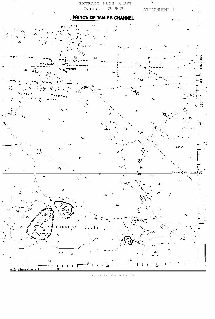
The RIVER EMBLEY would have cleared O.G. Rock, some 2 miles or 10 minutes
beyond Ince Point. O.G. Rock in position 10° 29.95' South 142°20.68' East has
a chart datum of 12 metres and lies 0.1 miles (1 cable) south of the line of
the East Strait Island leading lights. Relatively deep draught ships must
bass north of this obstruction before openinq the leads to the south to clear
the shoal area close north of the line of the lead i ng lights 0.33 of a mile
(3.3 cables) beyond O.G. Rock (Attachment 1).
Between 1418 and 1645 hours the Chief Engineer and
engine room whilst the ship was in stand by condit
stated that at 1642 all the necessary readings had
performance log, in anticipation of 'full away' be
3rd Engineer were in the
on. The Chief Engineer
been taken for the ANL
ng rung as advised by the
Master at 1630. He stated the main engine was turning approximately 55 rpm and
the ship's log recorder showed a speed of 12 knots. The Chief Engineer leftthe engine room at 1645. The Chief Engineer further estimated that by 1656 the
engine would be turning 60 rpm.
A little before 1654 the 3rd Engineer had phoned the bridge and reminded the
Master that full away had not been rung at 1642. This was then done and the
engine movement print out records full away at 1654.5. The Master stated that
he then fixed the ship's position with a bearing from East Strait Island leads
and a distance from Ince Point. This position was marked from Alert Patches
buoy. The Master moved from the chart table to the engine room telegraphs
just to port of the centre line. The Pilot was just to starboard of the
steering console, both maintained that the ship had set slightly to the south
of the leading lights. The helmsman however maintained that, without the use
of binoculars, the leading lights appeared to be in line.
During the watch both the Pilot and Master stated that they engaged in
conversation, mostly inconsequential, remarking upon the good weather andvisibility conditions they enjoyed. Both men stated that their conversation
did not distract them from their duties.
At approximately 1656 the Master, Pilot and Helmsman felt the ship shudder.
The Master described two such sensations a few seconds apart while the
helmsman recalled that he had no doubt that the ship had touched bottom. The
Pilot stated that he did not immediately associate the shudder with contact
with the sea floor, but took it to be the action of the sea of the side of the
ship and regarded it as not unusual. At this time or immediately after the
Pilot ordered an alternation of course to 120°(T). Both the Master and Pilotmaintained that the ship was marginally south of the East Strait Island
leading the lights, while the helmsman's recollection was that, to the naked
eye, the lights were in line. The Master estimated the ship's speed at this
time to be 10.4 knots.
The contact was felt elsewhere in the ship. The Mate, 2nd Mate, ChiefEngineer and 2nd Engineer were in the Officer's smokeroom. They variously
described a sensation of one or two distinct bumps. The officers went to thegames room to look aft at the ship's wake for any mud disturbed from the sea
bed but could not see any. The Mate stated that he saw a buoy just forward of
the beam on the starboard side and this was later established as Herald
Patches buoy. He looked at his watch which read 1657. The 3rd Mate stated
that he was in his cabin and felt a bump at approximately 1655.
After 'full away' was rung at 1654.5 the 3rd Engineer, on duty in the Engine
CSS06D0423

- 16 -
Room left the Engine Room Control room to carry out maintenance work in themachinery spaces. He was on the 'stoker flat' when the Master phoned toenquire whether he had felt a "bump" The 3rd Engineer stated that he had not.
There were no ships in the immediate vicinity of the eastern approaches to the
Prince of Wales Channel at the time of the incident to restrict the RIVER
EMBLEY'S passage.
AFTER THE GROUNDING
The statements made by the various personnel as they refer to the time
immediately after 1656 differ slightly but the following sequence of events
would appear to be substantially accurate.
Almost immediately after 1656 the 3rd Mate went to the bridge. He confirmedthat he had felt the ship bump a few moments before. The Master instructed
the 3rd Mate to assist the Pilot and asked the Pilot to take the vessel to a
safe anchorage. The Master left the bridge and went to the officers smokeroom
where he spoke with the Chief Engineer. Both the Chief Engineer and 2nd Mate
expressed an opinion that the ship had trimmed by the head. The ChiefEngineer left to check the engine room and steering machinery. The Second
Engineer had preceded him and the watertight integrity of the engine room was
checked. The Master returned to the bridge.
The Mate went straight to the bridge and he stated he noticed that the ship
appeared to be trimming by the head. He compared the forward and after echosounder readings and confirmed that the forward transducer showed four metres
less water under the keel than the after transducer. He stated that he went
directly to the Ballast Control room where he activated the ballast controlboard and tank pneumercator. He noted that the fore
was indicating 4000 cu metres and all other readings
"zero". This information was passed to the bridge.the 2nd Mate and the ballast pumps were brought into
the water from the forepeak.
peak tank pneumercator
were shown to be at
The Mate was joined byuse to attempt to pump
On receiving the Mate's report at about 1703 that the fore peak had 4,000 cu
metres of water the speed of the ship was progressively reduced. At this time
the Master made a public address announcement to the crew, calling all hands
to emergency stations whilst assuring them that there was no immediate
danger. The ship's position was fixed at 1710 as 094°(T)x4.73 miles from Ince
Point light. At 1718 a message was passed via Thursday Island Radio to the
Federal Sea Safety and Surveillance Centre stating that the RIVER EMBLEYtouched bottom at 0658 GMT (1658 Eastern Standard Time) in position 10°29.86'S 142° 21.11'E in the vicinity of Alert Patches Buoy, Prince of Wales
Channel, Torres Strait. A similar message was sent to the Australian National
Line.
The vessel anchored at 1726 with East Strait Island Light Beacon bearing
066°(T) by 2.6m.
The ballast pumps were unable to reduce the level of water to the forepeak
tank. The Mate went to check the void spaces forward as these could not be
monitored from the control room. It was established that number 1 void space
was also taking water, but other spaces appeared dry. The Master considered
that the ship was in no immediate danger. The depth of water around the ship
CSSO600423

- 17 -
was checked to ensure the ship would remain safely afloat.
It was later established that number 1 and number 2 port ballast tanks hadalso been breached, but the inflow of water was relatively minor and the
ship's ballast pumps were able to control it. The situation stabilised withthe ship floating at a forward draught of 14.8 metres and an after draught of
9.52 metres. All soundings and tank spaces were frequently monitored to
ensure that the ship remained in a safe condition.
Representatives of the owners and salvage experts boarded the ship after noon
on Sunday 10 May. On the 11, 12 and 13 May divers using video equipmentconfirmed that the forepeak and number one void space had been damaged. Three
separate parallel splits in the hull varying from 10 to 14 metres in length
and between 40mm and 2OOmm in width were reported aligned fore and aft. Thedamage extended athwartships about 11 metres. The inboard split was found to
be close to the line of the keel on the starboard side and the outboard split
9 metres from the keel on the port side. The latter damage extended into
number 1 and 2 port ballast tanks.
It was decided that external repairs were not practical owing to the extent of
the damage and the limited time that divers could work in the strong tides of
the area. All openings to the spaces were sealed and the spaces pressurised
with compressed air using ship's equipment. Spare compressors were availablefrom ashore, but were not needed.
By 2000 hours on 13 May the ship's draught had been reduced to 11.4 metresforward and 11.2 metres aft. The ship remained at anchor while the Master,
salvage operators, company officials and classification society surveyors
satisfied themselves that the pressurised spaces could maintain the air
pressure.
At noon on 14 May all parties were satisfied that the ship could proceed
safely to Gladstone. The classification society gave conditional approval for
the ship to resume the voyage and the vessel sailed for Gladstone under thecommand of the Master, with Captain as Pilot in charge of the
navigation.
All bunker ash, ship rubbish and garbage was retained on board. No pollution
occurred as a result of the grounding nor from the subsequent operations.
The RIVER EMBLEY arrived at Gladstone in the early afternoon of 18 May 1987.
The Preliminary Investigation commenced at Gladstone on 18 May.
On 26 May AMC Search Ltd of Launceston was commissioned by the Federal
Department of Transport to undertake a preliminary analysis of the effect of
shallow water upon a ship of the RIVER EMBLEY'S size and draught in open seaconditions by estimating the sinkage anticipated based on existing vessels ofsimilar form. Based on work by I.W. Dand, the report concludes that such a
ship drawing 10.94 metres at a speed of 12.2 knots could ground in 13 metres
of water. (Appendix 3)
On 27 May the patrol boat HMAS BENDIGO with a Commander of the Hydrographic
Service RAN aboard, undertook a check on the position of Alert Patches Buoy
and also took check soundings in the area where the RIVER EMBLEY was believed
to have touched bottom. Alert Patches buoy was found to be 120 metres northof the charted position of 10° 29.8'5 142° 142° 21.06'E.
CSSO600423

- 18 -
Check soundings were also taken which defined the southern extreme of the rockoutcrop of Alert Patches at a depth of 12.5 metres (+/- 0.4m) below chart
datum. The outcrop extends approximately 50 metres south of the line of the
East Strait leading lights and indicated no change in charted depth from the
HMAS FLINDERS survey of 1974/76.
The possibility of changes in water density in the area, through the outflow
of the Fly River, was canvassed with the Australian Institute of Maritime
Studies. The advice received was that it was improbable that water density at
Alert Patches would be affected. This was supported by density samples taken
by the staff of the lighthouse tender Cape Moreton in June, which recorded
densities in the general area of Torres Strait as 1025 or slightly more.
CSS06D0423

- 19 -
OBSERVATIONS
There would appear to be a number of possible explanations for the ground
of the RIVER EMBLEY
ing
the Pilot and Master were mistaken in their position relative to theEast Strait Island leading lights and were north of the leading lineand in an area of shoal water
the ship's maximum static draught was greater than ll.Om at the timeof grounding
an area of unknown shoal water, or isolated bommies exist that have
not been detected by hydrographic survey, and/or the chart is
otherwise inaccurate
the general sea level was below the 'normal sea level
insufficient allowance was made for underkeel clearance, or in some
other way the passage plan mutually agreed by the Pilot and master
was deficient
a combination of two or more of these factors.
From statements made by those interviewed and from information contained in
bar records and accounts there is no evidence that either Captain or
Captain were unfit to undertake their duties.
Ships Position
The time and position of alteration on to East Strait Island lead lights atabout 1632 was not noted on the chart or in the deck log book. The accuracy
of the positions throughout the passage are hard to assess from examination of
the ship's chart. Under pilotage it is common practice for such positions to
indicate the time of passing relevant features, rather than fixing the
position more accurately.
The 1655 position was stated by the Master to have been taken as a bearingfrom East Strait Island leading lights and a distance from Ince point
(Attachment 3). The position however was entered in the deck log book as
Alert Patches buoy 026° x 0.15'. A bearing and distance from the buoy as
recorded in the log book, with the buoy 120 metres north of its chartedposition as reported by HMAS BENDIGO, would have put the ship north of the
line of the East Strait Island leading lights. Both the Master and Pilot were
adamant that the East Strait Island leading lights were open and the ship wasto the south of the line; while the helmsman's recollection, when interviewed
in April 1988, was that to the naked eye the lights were in line. The pilot
stated that the lights were in line at 1635 and that by 1642 a southerly set
had placed the ship south of the leads. Apart from the entry in the deck log
book there is no evidence that the ship was north of the line of the leading
lights.
While it may be accepted that the ship was on or marginally south of theleading line, the easterly component of
uncertain. It is important to consider
length and the distance from the bridge
CSS06D0423
the position of grounding isthe time taken to travel one ship's
to the bow. The ship travelling at

- 20 -
12 knots covers 370.6 metres per minute or one ship's length of 255 metres in
42 seconds. The bow is 195 metres from the bridge, a relative time of 32
seconds. In confined waters such considerations are important factors in
altering course and remaining in navigable water.
It is not possible to determine absolutely whether the order to alter course
from 090°(T) was given before or after the ship grounded. The Pilot
maintained that the order to alter was made before and this is consistent with
the Master's statement and recollection at interview. The helmsman in a
written statement made on 10 May 1987, the day after the grounding, stated theorder was given after he felt the ship ground.
Ship's Speed
The Master estimated the ship's speed at 10.4 knots at the time of the
grounding. This estimate coincides with the distance recorded on the chart
between 1642 and 1655. However, the Chief Engineer's observations of the
ship's speed and revolutions turned at 1642 are consistent with the speeds
calculated from the ship's log, course recorder and charted positions from the
time of entering Gannet Passage. The distance from the entrance to Gannet
Passage to Alert Patches is 29 miles. The ship would require a speed of 12
knots to cover this distance in the 2 hours 25 minutes recorded. The transit
of Gannet Passage was completed at an average speed of 11.55 knots and the13.8 miles from Harrison Rock to the 1655 position gives a speed of 12.55
knots. Similarly the distance between 1622 and the position at 1710, taken by
the 3rd Officer is 9.23 miles giving an average speed of 11.5 knots in a
period when the revolutions were rapidly decreased from 1703.
These speeds are based on distance recorded over the ground. The speed
through the water, however, would have been less due to the east going tidal
stream. This stream would have been weak in Gannet Passage at a maximum
between 1550 and 1620. Thereafter the effect would decrease on a slackening
rate in the relatively more open water. The Pilot assessed the effect as
negligible at 1700 hours. While, however, the effect of the tidal stream
diminished the ship's speed was progressively increased from about 1629 when
"NAV F-Ahd" was rung and the vessel cleared the area considered by the Pilot
to be critical to underkeel clearance.
Ships Drauqht
The ship sailed from Weipa with a draught corrected for a salt water density
(1025 SG) of 10.9m Forward and 11.02m Aft. This draught was confirmed by an
independent draught survey.
The Mate estimated the draught at the time of grounding as 10.95 metres
forward and 10.89 metres aft assuming normal sea water density. Check
calculations allowing for 105 tonnes (net 95 tonnes allowing for ashresidue) being consumed 104 metres aft of midships and 25 tonnes of fresh
water being consumed 118.65 metres aft of midships suggests this estimation to
be substantially correct and that the ship was probably trimmed marginally by
the head. (Check calculations give 10.97m forward and 10.91m aft).
There is no evidence to suggest that anything happened nor that any operation
was undertaken which would have increased the RIVER EMBLEY'S static draught
between departure Weipa on 9 May and the time of the grounding. The tank
sounding book entry of 0700 9 May 1987 shows that all ballast tanks and void
CSS0600423

- 21 -
spaces were effectively empty.
Chart Information
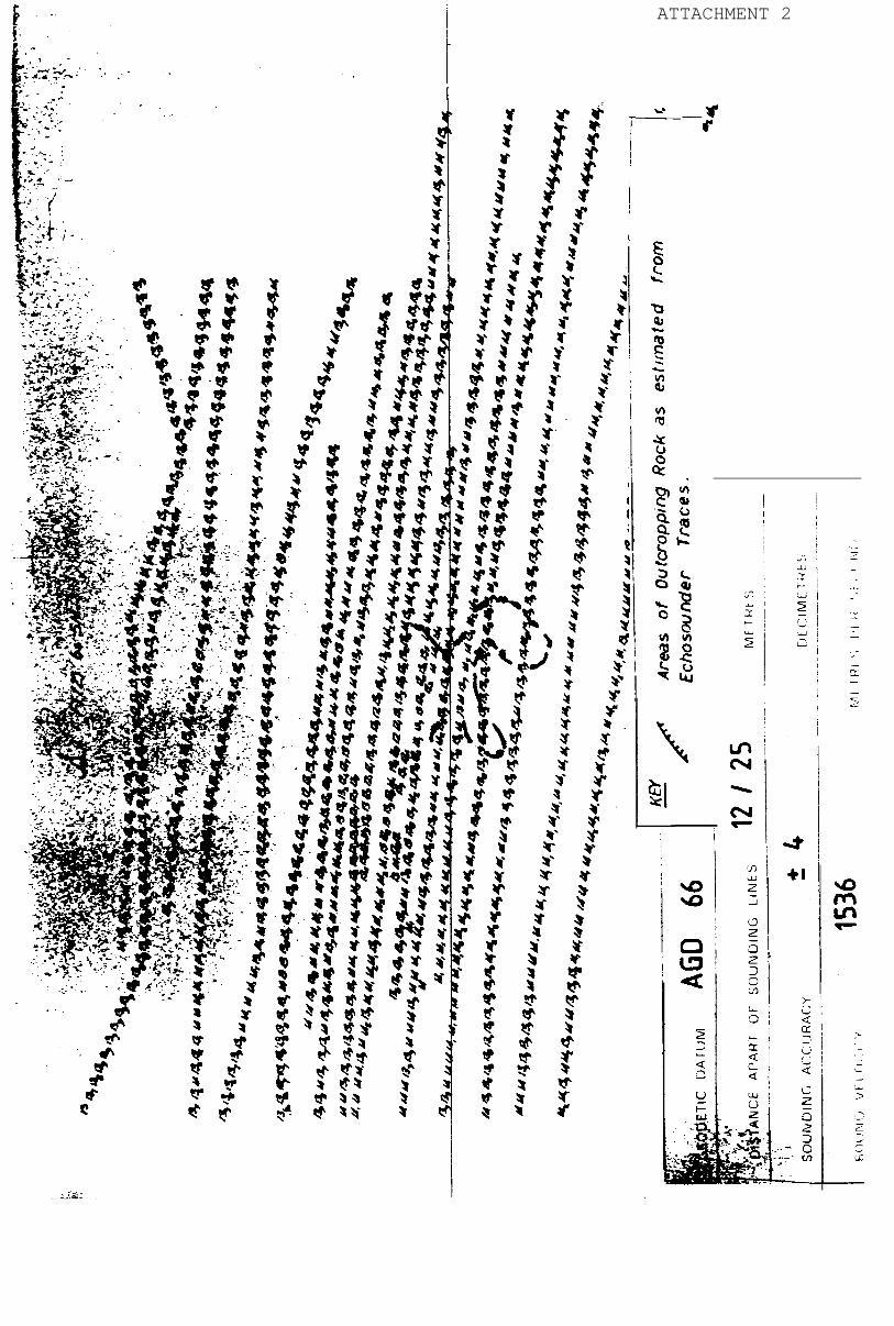
The charted depths in Torres Strait have been subject to extensive survey.
The international standard of accuracy for soundings in waters of the 0 to 30
metre range is 20.3 metres. While much of the Torres Strait area is charted
to this accuracy, the Hydrographer in letters to the Marine Board of
Queensland dated 23 April 1981 and 16 April 1987 stated that errors in charted
depths may be as much as 0.5 metres. Additionally Chart Aus 293 carries a
note below the title:
CAUTION - SAND WAVES
Herald and Alert Patches are sand wave formations which cause variations
in charted depths. The sand waves trend S.E. from Herald Patches and
N.E. from Alert Patches. In addition, rocky outcrops occur in the channel
between the patches.
Surveys in 1971, 1974, 1976 and subsequently May 1987 show shoal water to the
north of the line of the East Strait Island Leading lights with soundings of
11 and 12 metres. Depths to the south of the leads were found to be 13 metres
or more, though close south of the line intermediate depths were found. The
spaces between the lines of soundings were 30 metres or less.
Tidal Information
Predicted times of low water for the tide gauges in Gannet Passage and Prince
of Wales Channel are taken from the Australian National Tide Tables and hourly
predictions taken from the Torres Strait Tide Tables, published by the
Department of Transport. It should be noted that the Torres Strait Tables do
not necessarily indicate the lowest water available. The predictions for
9 May 1987 are as follows.
National T.T. Torres T.T.
Low Water Low Water
Critical
Depths
'I Port" Time Ht m. Time Ht m. Area DatumBooby Is 1817 1900 1.52 Gannet Ent 10.1Goods Is 1822 1800 1.48 Sund Rf 11.2Turle Hd 1727 1:o 1700 1.01 Pullar Rk 11.6I n c Pt* 1630 0.9 1700 0.76 O.G. Rock 11.9Twin Is** 1633 0.6 1700 0.62
* Standard Port...Thursday Is.
** No broadcasting tide gauge.
The broadcasting tide gauges also record tidal information hourly. The record
is maintained on battery backed random access memory cards. Information from
these cards is transferred to a computer in the Department of Transport and
Communications. The Booby Island records are supplemented by a pen and ink
trace.
When the tidal information from Ince Point was examined it was found that the
recorder had malfunctioned and the data was corrupted, it was thereforeimportant to establish the reliability of broadcast data from Ince Point.
CSS06D0423

- 22 -
These records and weather data for the preceding fortnight were sent to
Professor of the School of Earth Sciences, Flinders University for
a preliminary study.
Professor drew attention to the International Sea Level Pilot Project
based in Hawaii. A report of sea levels for the month of May in Torres Strait
area indicated that levels were 0.15m to 0.20m below normal levels.
Further the School of Earth Sciences reported that over the critical hours of
1600 and 1700 the heights of actual tide at
Booby Island was within reasonable tolerance of the predicted height
to be considered accurate
Goods Island was in excess of predicted height
Turtle Head was 0.3m below predicted height
From this information it would appear reasonable to assume that the Ince Point
Tide gauge was broadcasting correctly and the water depth was 0.5m below that
predicted.
Based on these figures and the relative closeness of Ince Point to Twin Island
it may be assumed that the height of tide at Twin Island was also in the
region of 0.5m below predicted height and that the actual height of tide at
Alert Patches can be extrapolated on a linear basis between the two
stations. It may therefore be assumed that the depth of water at Alert
Patches was in the region of 0.3m above datum, making a depth at the 13.5m
datum south of the East Strait Island leading lights of 13.8m (Attachment 1).
Under Keel Clearance
The Pilot's passage plan (Attachment 4) consisted of times between the various
way points, the minimum depth required at any part of the passage, the minimum
rise of tide required and the tidal 'window' for the transit on 9 May. Theplan shows that, allowing an underkeel clearance of 1 metre based on static
draught, the passage of the Western entrance to Gannet Passage had to be
completed by 1630 hours or the ship would have been delayed until 2100 hours
that night. The plan also shows that the minimum under keel clearance was
calculated on a static draught making an allowance of 1.22 metres for thetransit of the Prince of Wales Channel. It should be noted that the preamble
to the Torres Strait Tide Tables under 'Pilotage service advice' states:
"2. The pilot service will accept vessels for pilotage with draughts not
exceeding 12.2 metres provided that an underkeel clearance of at least 1metre is maintained in Gannet Passage. Depending on weather and sea
conditions the underkeel clearance may be increased at the pilot's
discretion. In Prince of Wales Channel, 1 metre underkeel clearance will
be maintained in vessels with draughts up to 11.89 metres, thereafter 10
per cent of the draught up to draughts of 12.2 metres. Tidal heights maydiffer from predicted heights owing to meteorological and other factors."
The requirement to maintain the respective underkeel clearance at all times is
established Department of Transport and Communications policy and is well
documented.
CSSO600423

- 23 -
The Queensland Coast and Torres Strait Pilot Service, while being aware of the
Department's policy, apparently regard such guidelines as not being in keeping
with international practice of using static underkeel clearances nor that of
the Department of Harbours and Marine, Queensland, for all their ports. In
discussions with the pilots it was stated that they maintain a safe underkeel
clearance having regard to all external factors (tidal conditions, weather,
movement and the like) by careful control of the ship's speed.
The word "maintained" is therefore not used in the Annual Notice to Mariners
Number 23, Queensland Coast and Torres Strait Pilot service - Draught
Limitation and Advice, issued under the authority of the Department of
Harbours and Marine and the Pilot Service. (See Appendix I).The various factors that have an effect on under keel clearance are referred
to in the Torres Strait Tide Tables.
"When planning for the voyage, account should be taken of a number of
uncertainties or inaccuracies which, if cumulative, could have a
considerable effect on the underkeel clearance. These may occur in:
(a) ship's draught as a result of movement in a seaway
(b) ship's draught as read or calculated
(c) tidal predictions
(d) charted depths
(e) the calculation of squat(f) the height of the sea level, through varying meteorological
conditions."
With reference to the above factors;
(a) It was stated by the Master and Pilot that the sea was calm and that nopitch or roll was observed. It should be noted, however, given the ratio
of the depth of water to the length and breadth of the ship the slightest
movement would affect the underkeel clearance and a pitch of 0.325 of a
degree as measured from the bridge front would cause the bow to sink 1.2
metres. (See scale drawing page 6)
(b) A maximum draught of 11.00 metres was used as the basis for thistransit. It is probable that the deepest static draught was 10.97
metres, being the forward draught. It is therefore accepted that the
actual draught was marginally less than the 11 metres static draught used
by the pilot.
(c) The tidal predictions contained in the Torres Strait tide tables are
stated to be correct to within 0.2 metres allowing for normal
meteorological conditions. The predictions were compared to the actual
height as broadcast by the tide gauges. (See "Tidal Information", page
20).
(d) Chart AUS 293 indicates a 10.8 metre "less water reported" close north of
the line of the East Strait Island leading lights and depths of 13.6
metres to the south of the line. The intermediate depth of 12.5 metres as
surveyed by HMAS FLINDERS and confirmed by HMAS BENDIGO is not shown.
Chart AUS 293 is produced to a scale of 1:37,500 while the survey sheets
are drawn to 1:2,500. From the chart information it would be reasonable
to assume a progressive deepening between the 10.8 metres and 13.6 metres.
CSSO600423

- 24 -
(e) Squat is a function of the ship's displacement, length, beam, draught,water density and of ships speed through the water. Expert opinion as to
the extent of squat or sinkage in the water differs. There are twooperating situations where squat is critical, these are:
i) in an enclosed channel and;
ii) in the open sea but with limited underkeel clearance; as
experienced by the RIVER EMBLEY.
The RIVER EMBLEY has a block co-efficient of 0.846. The variable and
critical factor was that of speed. (See "Ships' Position" page 18) A
further factor in the phenomenon of squat is that of the actual underkeel
clearance. This is
It is apparent that
metres was made for
effect of increased
expressed as a ratio of water depth to draught (H/T).
while an allowance for under keel clearance of 1.22
passage through the Prince of Wales Channel, the
speed on the ship's squat was not calculated.
Passing reference is made to squat in the "Australian National Line
Navigation and Bridge Organisation Manual, Voyage Planning 5.1(g). There
is no mention of the phenomenon of squat in the Company's Operating Manual
and there is no advice on the calculation of squat. The Master stated
that there are no specific Company instructions and that he made an
allowance of approximately 1 metre for a speed of 10 knots. The Company
had, however issued the ship with details, including 'sinkage' tables, of
a series of shallow water tests, completed in June 1981, by the
Netherlands Ship Model Basin, Wagenngen (Appendix 3). These tests
included the effects of squat of varying speeds at a draught of 12.2
metres.
The minimum depth of water simulated in these tests was 15 metres giving a
static underkeel clearance of 2.8 metres. In scale propulsion tests the
maximum sinkage forward at 10.4 knots was 0.8 metres and at 12 knots 1
metre, giving H/T as 1.15 and 1.13 respectively.
The ship grounded in an area where water depths are recorded as
approximately 13.5 metres giving a static under keel clearance of 2.6metres. This is a similar relative clearance as used in the tank test forthe ship at 12.2 metres draught in 15 metres of water. The H/T factor is
similar in both instances and it would have been reasonable to use the
tables at least where the charted depth is 13.6 metres or more. The
Master's stated reservation regarding the use of the tables appears to bebased on the fact that for much of the Gannet Passage and Prince of Wales
Channel the clearance is significantly less than 2.6 metres.
A formula that may be used in such open water situations has beendeveloped by Professor for ships with limited under keel
clearance. According to this formula, for a ship of block co-efficient
0.846, a speed of 10.4 knots would have the effect of increasing the
forward draught by 0.92 metres to a calculated draught of 11.89 metres.At 12 knots the draught would be increased by 1.22 metres to a calculated
draught of 12.19 metres.
CSS0600423

SE
AB
ED
BA
SE
D
ON
S
CA
LE
O
F
TIM
E
OF
WA
LES
S
PE
ED
sta
tk
_
__
_
_
. .
. .
. .
. .
of
- 26 -
AMC Search Ltd was commissioned to undertake a preliminary study of the
phenomenon of squat as it might affect the RIVER EMBLEY in areas of
reduced depth of water under the following terms:
"Estimate sinkage anticipated based on existing data for similar
formed vessels over range of depth/draft ratios and speeds
estimated load condition."at
The report (contained in Appendix 3) shows that the estimated speed t 0
cause grounding in 12.5 metres of water is 11.2 knots and in 13 metres of
water is 12.2 knots.
Of the three methods considered in this report the tank tests on scale
models must be preferred. Both the Barras and Dand methods are calculated
for general categories of a ship rather than one specific hull form. It
must be recognised however that both the tank test results and the Barras
formula do not take into account the interaction of the sea bed when the
water depth is less than H/T - 1.10. The effect of an irregular sea bed
is also not addressed in these methods. The question is also raised as towhy the ship did not ground earlier in the shallower water of the Gannet
Passage or Prince of Wales Channel. The diagram of sea bed profile
illustrates the theoretical clearance based on Barras, Dand and the
Netherland Ship Model Basin.
(f) The Meteorological conditions at Thursday Island were not those
associated with producing a negative tidal surge as outlined in the
preface to the Torres Strait Tide Tables (Appendix 7).
The Australian Pilot Volume 111 publishes a climatic table for Thursday
Island based on observations of between 15 and 50 years. For the month of
May:
Pressure at Wind Direction Mean Wind
Mean sea level Percentage Frequency 7 Speed (Knots)
mb N NE E SE S SW N NW CALM
1010 1 1 14 80 3 0.5 0 0 0.5 8.5
Details of weather observations from Thursday Island supplied by theMeterological Office for the 26 April to 9 May 1987 inclusive and
involving 59 observations at set times in the-day show an average pressure
of lOll.3mb, wind from between 11°(T) and 150°(T) (98% of all
observations), and a mean wind speed for the period of 15 knots.
The weather conditions during the fourteen day period therefore were
apparently not those that would give rise to a significant effect on
predicted tidal data.
Passage Plan
The Australian National Line "Navigation and Bridge Organisation Manual"
the
under
5. "General Instructions 5.1" gives guidance on passage planning. As stated
earlier the Master accepted the Pilot's voyage plan as adequate and, in hisopinion, this was in accordance with company requirements. It should be
noted, however, that the wheel over, or course alteration positions, appear to
have been left to the pilot and the ship's staff would have had only a general
knowledge of optimum alter course positions and course to be steered. The
CSS06D0423

- 27 -
Pilot was navigating by land marks and the Master stated that he (the
Master) did not know what these were. Thus when the ship cleared O.G. rockthe Master could only check the position by visual or radar bearing. Novisual position check was made until the ship was 2.2 cables clear of 0.G
rock.
The voyage plan was not fully in accordance with detailed recommendations in
the Australian Annual Summary of Notices to Mariners No.22 and there is every
indication that the conning and conduct of the ship was, for all practical
considerations, left solely in the Pilot's hands.
At interview Captain stated that prior to November 1986, when Alert
Patches buoy was positioned south of its present position, close south of the
line of the East Strait Island leading lights, it was his practice to alter
course to the South some 3 or 4 cables from the buoy. This position coincideswith the bridge of a ship being abeam of O.G. Rock. He went on to state that
the buoy was only a guide and other marks, the East Strait Island leads andTuesday Islet No 1, as clearing marks*, were available. Alert Patches buoy
was altered in character and repositioned in November 1986, from position
10°29.9'S 142°21.O'E to 10°29.80'S 142°21.06'E (see Appendix 6). Prior toNovember 1986 the buoy, in its former position, would have obstructed thefairway in the vicinity of where the grounding took place, and ships would
have been effectively forced south of this area.
Chart Corrections
The chart in use, AUS 293, was properly corrected to date. The "Less Water
Reported" close north of the leading line (Corr 86/539), the general direction
of buoyage for the chart, the amendment to the East Strait leading line (Corr
86/539), and the establishment of the isolated danger buoy together with the
withdrawal of the port hand buoy (Corr 86/633) were all satisfactorily
completed. It should be noted however that in amending the East Strait
leading line by extending the pecked portion of the line to west of O.G. rock
there is no practical differentiation between a leading line marking lights in
line and a "recommended track not defined by fixed marks", as defined by
"Symbols and Abbreviations used on Admiralty Charts", p21.
Ingress of Water
The rapidity with which the forepeak filled appears consistent with the
dimensions of the breaches in the hull.
* CLEARING MARKS Two or more navigation marks or land features in
juxtaposition that indicate that a vessel is clear of a
danger.
CSS0600423

- 28 -
CONCLUSION
I find that:
1.
2.
3.
4.
5.
6.
7.
8.
The RIVER EMBLEY touched bottom on the southern extreme of
outcrop of Alert Patches in a water depth of approximately
the rock
12.8m (12.5m
sounding + tide height). The ship was approximately 90 metres south ofknown shoal water of 10.8 m marginally south of the line of the East
Strait Island leading lights in approximate latitude 10 degrees 29.88
minutes South and between longitude co-ordinates 142 degrees 21.07 minutes
East and 142 degrees 21.35 minutes East.
The Ince Point tide gauge was operating properly. The general sea level
was below the predicted level. At Alert Patches the height of tide was in
the region of 0.5m below the predicted height.
The full nature of the phenomenon of squat is not fully understood,
particularly where the sea bed is irregular and uneven. By reason of the
ship's speed the maximum draught forward was probably about 12.1 metres,
based on the Netherlands Ship Model Basin Report and the Barras model, butmay have been in the region of 13 metres as suggested by the preliminary
study undertaken by the AMC Search Ltd.
From the basic information carried on the RIVER EMBLEY in the form of
charts, tide tables and the Netherlands Ship Model Basin report, the
course taken by the ship was apparently safe. Full account and allowance
however was not made of other factors as listed 5 to 8 below.
The passage plan agreed by the Master, was not fully in accordance with
that advised in the Annual Summary of Notice to Mariners Number 22. No
courses or optimum speeds were noted and the plan did not apparently
extend beyond Ince Point. The advice issued by the Department of
Transport as regards the need to maintain (when making way) underkeelclearance of 10% of draught was apparently ignored. The Master knew only
in general terms at which point the Pilot intended to alter course. In
such confined waters such a general knowledge is not satisfactory.
The ship should have maintained a reduced speed of not more than 10 knots
through the water in view of the Ince Point height of tide being only
0.08m (8 cm) above that considered as the minimum necessary for safe
passage between Nardana Patches and Ince Point. The RIVER EMBLEY was
effectively a ship at maximum draught for the passage between NardanaPatches and the eastern exit from the Prince of Wales Channel.
It would have been more prudent, in the light of reported shoal water
south of Alert Patches and 5 above, for the Pilot to have altered to a
more southerly course as soon as the RIVER EMBLEY was able to safely clear
O.G. Rock and follow a course close to Herald Patches buoy, being the
course more usually followed by the pilot.
It can be argued that had the Alert Patches buoy not been moved but hadremained on the line of the East Strait Leading lights the Pilot would
have altered course, in accordance with his stated normal practice, when
off O.G. Rock. It must be taken into account, however, that shoal water
was known to exist close north of the East Strait Island leading lights in
the vicinity of Alert Patches., the decision to move the buoy was taken in
CSSO6DO423

- 29 -
full consultation with the Queensland Coast and Torres Strait Pilot
Service and the shipping industry, and the new position of the buoy was
properly promulgated and duly corrected on the ship's chart.
It is generally accepted by mariners and is prudent practice to exercise
care in fixing any position in relation to a floating aid. Alert Patches
buoy was reported to be I20 metres north of its charted position. It is
not clear whether the buoy was laid in this position or whether before
or after 9 May it drifted off station. There are no generally accepted
international standards of accuracy required for the positioning of
buoys. The positional accuracy that needs to be achieved in buoy laying
must be related to the hazard involved and the amount of sea room
available.
In the circumstances I do not consider that the apparent position of Alert
Patches buoy on 9 May 1987, in relation to its charted position, was a
contributing factor to the grounding.
9. The Hydrographic survey of the area has been extensive and is accurate
within the operational limits of such surveys. The Hydrographer is onrecord as detailing the limits of the accuracy of the charts of the area
and the chart also contains warnings of isolated outcrops of rock between
ipa the RIVER EMBLEY was,
sounding lines.
10. Upon departure We
11. The action of the
seamanlike.
Master and crew after the grounding was correct and
n all respects, seaworthy.
I have carefully considered whether the investigation indicates any degree of
negligence or error of judgement. I have concluded that given the benefits of
hindsight and access to sources of information not readily available to the
parties involved, their action did not amount to negligence or, despite the
seriousness of the casualty, to an error of judgement that should attract
specific criticism in these findings. The detailed inquiries undertaken
clearly point to the need for more careful voyage planning in future,
particularly for passages in restricted or partially restricted waters and for
full account to be taken of the effects of squat.
CSS06D0423
EXTRACT F R O M CHART
Aus 293 ATTACHMENT 1
Alert Rk
‘35
‘36
‘37
‘35 \
\
11,
‘36 \
‘ 4 2
‘36 1’ 3 ”
c s‘
\ \
\
134
11
Sh
T U E S D A Y
125
11 “ 3 ‘43
22’ 23’ 7
0’ from 21’
New Edition 30th April, 1983
ATTACHMENT 2

R k
12. _
_. 13.
Pearl
58 37 I
“ J
Il.
I S L E T S

ATTACHMENT 4
,

THE A U S T R A L I A N NATIONAL LINE ATTACHMENT 5
PORT. . . . . . . . . . . a...... . . . . _ _ _ _

- 35 -
ATTACHMENT 6
"RIVER EMBLEY"
Class and Type:Official Number:
Home Port:
Call Sign:
Builders:
Date Launched:Date Commissioned:
Length Overall:
Length betweenPerpendiculars
Breadth:
Depth:Load Draught: (Summer Freeboard)
Load Displacement:
T.P.C. (Loaded):
Deadweight:Net Tonnage:
Gross Tonnage:
Machinery:
Propeller:Power Maximum:
Power Service:
Service R.P.M.Service Speed:
(ballast)Bunker Capacity:
Type of Fuel:Daily Sea Consumption: (typical)
Steam Bulk Carrier
850352
SydneyVJRY
Mitsubishi Heavy Industries
Nagasaki Shipyard, Japan
6th November 1982
15th June 1983
255m
248m
35.35m (moulded)
18.3 (moulded)
12.325 m94,455 Tonnes
80.4
76,305 Tonnes
16,346
51,035One Mitsubishi MS-21-2 Steam Turbine
Two Mitsubishi C.E. VZM-9S Coal-fired
BoilersOne highly skewed, fixed pitch
14,000 kW
9,500 kW (loaded), 8,000kW (ballast)
72 (loaded), 70 (ballast)
14.0 Knots
14.5 Knots
3,670 TonnesCoal at 5525 k.cal/kg
220 Tonnes (loaded), 200 Tonnes
(ballast)
80 Tonnes
33Daily Port Consumption: (typical)
Complement:
CSSO600423

- 36 -
APPENDICES
CSS0600423
- 37 -
Appendix 1
Warnings and Notices
Warnings of navigational hazards are, in the first instance, broadcast by
radio to ships in the form of an "Auscoast".* These are withdrawn when the
hazard is removed or confirmed by Australian Notice to Mariners. Three
notices of direct relevance to the Torres Strait are promulgated each year in
the Annual Summary of Australian Notices to Mariners. These are:
Notice No 18 - Under Keel Clearance - Reliance on Charts and
Predicted Tides
Notice No 22 - Navigation in the Great Barrier Reef
Notice No 23 - Queensland Coast and Torres Strait Pilot Service
Ships transitting Torres Strait are limited to a maximum draught of 12.2
metres. This permits ships with this draught to transit Torres Strait at a
certain time on each day of the year, providing the predicted height** of
tides are achieved, allowing the underkeel clearance detailed in Notice to
Mariners No 23. This maximum draught was increased in August 1981 from a
maximum of 11.9 metres.
* AUSCOAST A radio navigational warning issued by the Federal Sea
Safety and Surveillance Centre through a coast radiostation.
** PREDICTED HEIGHT An estimation of a tide which can be made years in
OF TIDE advance and includes astronomical and seasonal
parameters.
CSSO600423

18. UNDER-KEEL CLEARANCE - Reliance on Charts and Predicted Tides
1 The limitations of hydrographic surveys are discussed at length in the Muriner’sHandbook (NP 100) 5rh Edition, 1979, also describes the danger of negative tidalsurges. These, and other factors affecting tide levels, are further described in theintroduction to the Australian National Tide Tables..
2. It has become increasingly evident that economic pressures are causing marinersto navigate through waters of barely adequate depth, under-keel clearance beingfinely assessed from the charted depths and predicted tide levels.3. It cannot be too strongly emphasised that even charts based on modern surveysmay not show all sea-bed obstructions or the shoalest depths and actual tide levelsmay be appreciably lower than those predicted.4. Hydrographic surveys have inherent technical limitations, due partly, in off-shore areas, to uncertainties in the tidal reductions. Furthermore, in some areas theshape and hence the depth of the sea-bed is constantly changing. Nautical charts canseldom, therefore, be absolutely reliable in their representation of depth - andwhen tidal predictions are applied to the chart as if they were actual tide levels, theuncertainties are clearly compounded.5. Prudent mariners allow for navigational uncertainties by preserving adequateclearance, both horizontally and vertically.RAN Hydrographic Service. (AH56/116)

22. NAVIGATION IN THE GREAT BARRIER REEF
The Great Barrier Reef Marine Park1. The Great Barrier Reef, the world’s largest living coral reef system, has beenplaced on the World Heritage List. In order toprotect the marine life of the area, theAustralian Government has declared most of the waters of the region to be sectionsof the Great Barrier Reef Marine Park.2 Activities in the Marine Park are regulated by zoning plans which define thepurposes for which the various zones may be entered. Copies of the zoning plansmay be obtained from:
The Great Barrier Reef Marine Park A.lthorityP.O. Box 1379TOWNSVILLE, QLD. 4810
3. The International Maritime Organization (IMO) has accepted the area of theCapricorn and Bunker groups of islands and reefs in the southern part of the GreatBarrier Reef as an Area to be Avoided. Its limits are shown on appropriate charts.
Passage Planning4. As for all passages, a detailed navigational plan for the passage through thewaters of the Great Barrier Reef and Torres Strait should be prepared before thepassage is commenced, following the principles of .-l Guide lo the Planning andConduct of Sea Passages (Her Majesty’s Stationery Office and available throughchart agents) or a similar guide.
5. The passage through these waters involves navigation through confined watersfor a long period, the particularly restricted area being about 500 miles in length. Asit is not possible for the master to be in sole charge of the navigation for this period.the officers of the watch also must be familiar with the navigational plan andcapable of following it in the master’s absence from :he bridge.
Two-way Route6. Between Low Islets (16° 23' S. 145° 33' E) and Booby Island (10° 36' S. 141°55' E) a two-way route has been established for use by ships of medium draught.Details of this route and explanatory notes are giLen on the appropriate large-scalenavigational charts.
Pilotage7. Notice No. 23 gives details of pilotage services available for the Great BarrierReef, Torres Strait and Greit North East Channel and Hydrographers Passage. InFebruary 1986 the Maritime Safety Committee of IMO issued MSC/Circ. 430recommending that ships of 100 metres in length and over and all loaded oil tankers,chemlcal tankers or liquefied gas carriers irrespective of size use the pilotage serviceprovided by the Queensland Coast and Torres Strait Pilot Service when navigatingin the Torres Strait and inner route of the Great Barrier Reef area between BoobyIsland (IO”36 ' S. 141°54' E) and Latitude 16°40' S or through the Great North EastChannel, or Hydrographers Passage.
8. The Federal Department of Transport further recommends that masters notfamiliar with other areas of the Great Barrier Reef or the entrances Palm Passageand Grafton Passage also use the Pilot Service.
Transport, Canberra. (AH 70/116, 56/116, 571116, 581116)

- 41 -
Appendix 2
Depths and Underkeel Clearance
The part of the passage regarded as the most critical lies between the
entrance to Gannet Passage, where there is maximum depth at chart datum* of
lOm, and throughout the Gannet Passage and Prince of Wales Channel as far as
Ince Point where depths of between llm and 12m are extensive. Soundings inthe area of Alert Patches north of the leading line from East Strait Island
leading lights ** have also shown there to be water in the region of llm.
To make the passage, therefore, ships drawing over 9 metres are dependent on a
tidal window to navigate Torres Strait. In essence a ship is required to
maintain an underkeel clearance of 1 metre in Gannet Passage and maintain at
least 1.22 metres thereafter. To achieve this clearance it is necessary for
deep draught ships to proceed at reduced speed in areas of restricted depth.
The slower speed of the ship through the water reduces the phenomena of
"squat".
* CHART DATUM
** LEADING LIGHTS
The level to which soundings are reduced for the
preparation of a chart. It approximates to the sealevel at normal low water spring tides.Lights at different elevations so situated as to
define a leading line when brought into transit.
CSS0600423
- 42 -
Appendix 3
Squat
The term squat refers to the tendency of a ship to sink lower in the water
and change trim with an increase of forward speed. Squat therefore reduces
the static underkeel clearance. The phenomenon of squat is experienced by all
ships but is critical where ships are navigating in areas of shallow water.
Squat is a function of the ship's block coefficient* and speed. The factor of
underkeel clearance as expressed by a factor of depth of water divided by
ship's draught is also relevant. The RIVER EMBLEY at 11 metres static draughtwould have experienced a factor of 1.23. Using a simple formula developed byProfessor Barras, or graphs developed by other authorities, an approximation
of the deepest draught underway can be assessed.
The preface to the Torres Strait Tide Tables advises that the pilot service
will accept for pilotage vessels with draughts not exceeding 12.2 metresprovided that an underkeel clearance of at least 1 metre is maintained in
Gannet Passage, thereafter 10 percent of draught. Based on predicted tidal
height, ships at this draught are able to transit the Strait at some time
during any day in the year. The term 'maintain an underkeel clearance' refers
to the need to make allowance for squat and all other factors affectingdraught in addition to the static draught to ensure the 1 metre and 10 percent
clearances is maintained at all times throughout the passage.
The Australian National Line based assessment of squat on tests carried out bythe Netherlands Ship Model Basin, Wagenngen. The closest model was for the
ship drawing 12.2 metres of water at 15 metres static draught. The
depth/static draught (H/T) factor of 1.23 is the same as that relevant to the
RIVER EMBLEY on 9 May. For the purposes of this investigation, the propulsion
test curve for the bow is considered relevant.
* BLOCK COEFFICIENT The factor relating the volume of a ship s hull tothat of a box of the same overall dimensions. It is
defined as :
Displacement
Water density x LBP x Breadth Moulded x draught
CB (River Embley) = 83150 = 0.846
1.025 x 248 x 35.35 x 10.94
CSS0600423

23. AUSTRALIA - QUEENSLAND - Queensland Coast and Torres Strait PilotService - Draught Limitation and Service Advice.
I. The Queensland Coast and Torres Strait Pilot Service will pilot vessels throughGannet Passage and Prince of Wales Channel, Torres Strait with a maximumdraught of 12.2 metres.1I.. The minimum underkeel clearances are:
(a) Gannet Passage - 1.0 metre.
(b) Prince of Wales Channel - 1.0 metre for vessels Hith a draught of 11.89metres or less: 10% of draught for vessels with a draught exceeding 11.89metres.
3. The draught limitation of 12.2 mrtres applies only to Lessels entering or leavingthe Great Barrier Reef Inner Route by say of Torres Strait or the Great North EastChonnel.4. Vessels entering or IeaLing the Inner Route by way of Grafton, Palm and
Hydrographers Passages are restricted only by any draught limitation at theAustralian port of arrival or departure.
55 . Pilot Advice - Torres Strait.( a ) South and East Bound.
(i)
(ii)
(iii)
Pilots board 3.5 miles West of Booby Island or 2.5 miles West ofGoods Island. Vessels requiring pilots should give 4 to 5 days notIce LOTORRES SYDNEY advising E.T.A., at Booby or Goods pilot station, maximum draught and desrlnarion.Confirmation or adjustment of the E.T.A. should be sent direct to TORIND TLX 48822, THURSDAY ISLAND - 24 and 6 hours priorto arrlval, giving local time which is GMT + 10 hours.Pilot Station - Call sign Reef Pilots maintains watch on VHF Channel 16. Pilot launches maintain UHF iiatch on Channel 16 when onstation.All ships traversing the pllotage district should maintain a continuousVHF watch on Channel 16.
(b) North and West Bound.(i)
Ii)
(iii)
If in an Australian port , advise T O R R E S S Y D N E Y o f p i l o t a g e requirements, giving as much notice as posslbie.If from an overseas port, advise T O R R E S SYDNEY 4-5 days inadvance of pilotage requirements, stating E.T.A. (name of boardingplace). maximum draught and destination. Confirm or adjust E.T.A.48 and I2 hours before arrival to TORRES SYDNEY.Pilot can board at any port in New South Wales and Queensland or:
O f f Po r t Moresby - Basilisk Beacon for the Great North Eas tChannel - launch service.Off Point Cartwright (Brisbane Pilot Station) - launch service.Off North Point Gladstone (23° 44'.0 S, 151° 21'.5 E) - launchservice or helicopter land-on operation.Off Cairns fairway (16° 49' S, 145° 50' E) - launch service orhelicopter land-on operation.Any other port or place by arrangement with TORRES SYDNEY.
6. Pilotage Advice - Reef Entrances.
(a) Grafton Passage pilot ground off Euston Reef (16° 39' S, 146° 14' E) -launch service or helicopter land-on operation.
(b) Palm Passage pilot ground off Pith Reef (18° 13' S, 147° 07' E ) -helicopter land-on launch service or operation.
(c) Hydrographers Passage pilot ground off Blossom Bank (19° 47' S, 150°24' E) - helicopter land-on operation.
7. Pilotage requirements should be advised to TORRES SYDNEY similarly toinstructions in 4(b)(i) and (ii), except where special instructions may be given byTORRES SYDNEY.
8. Federal DepartmeW of Transport Recommendation on Pilotage.Refer -
(a) Nolice No. 22. (b) Federal Department of Transport Hydrographers Passage Sailing Direc-
tions - Second Edition November 1985 Sec. 1:11 and Chapter 3.
Harbours and Marine, Brisbane.Queensland Coast and Torres Strait Pilot Service. (AH 70/116)

C
SINKAGE
SHIP MODEL 5007
D R A F T 12.20 m
PROPULSION TEST No. 9924
- - - Restistance TEST No. 99 19
SPEED OF SHIP IN KNOTS
DIAGRAM No. M 5807 - 2

- 44 -
BARRAS FORMULA
The formula developed by Professor G.B. Barras is based on 300 measure of
various vessels in trim conditions from that of even keel to being the
stern. The formula for open still water conditions with a depth/draught ratio
of between 1.10 and 1.20 is:
Maximum squat = x ships's speed in knots in still water)
Given a block coefficient (CB) of 0.846 the maximum squat would therefore be:
i at 12 knots
S = x 0.846 = 1.22 metres
100
ii at 12.5 knots
S = x 0.846 = 1.32 metres
100
AMC STUDY
The AMC study is based on existing data for similar formed vessels and is not
intended to be a full and complete study of the sinkage of the RIVER EMBLEY.
The method used was originally developed for large tanker-like forms. British
Maritime Technology uses this method finding it applicable to ships with lower
block coefficients than large tankers.
CSS06D0423

- 45 -
A PRELIMINARY STUDY OF THE
SQUAT OF A 248 METRE LONG VESSEL
IN SHALLOW WATER
(by AMC Search Ltd Launceston
- commissioned by Department of
Transport 26 May 1987)
JUNE 1987
CSSO600423

- 46 -
INTRODUCTION
When a surface ship is underway the total pressure on its hull is altered due
to the effect of the dynamic pressure caused by its motion. In addition to
causing drag the change in pressure provides a trimming moment and a heave
force which collectively affect the running trim of the vessel. For a
conventional displacement craft this results in an increased draft and,
generally, an increased trim by the head.
The presence of any restriction to the flow will result in an increased flow
velocity and hence a lower dynamic pressure. In practice, this occurs when a
vessel travels in shallow water and the resulting increase in sinkage and trim
is known as SQUAT.
In order to investigate the anticipated sinkage for a 248m long vesseltravelling at an approximately level draft of 10.94m a preliminary study was
undertaken utilising the method developed by Dand (Reference 1) for similar
hull forms. It must be emphasised that this is a preliminary study only,
based on existing data for constant vessel speed and water depth. The effect
of varying water depth is known to adversely affect the dynamic draft and to
take this into account, model experiments would be required.
METHOD
The bow sinkage and stern sinkage values against speed were obtained for the
water depths 11.5 15m at half metre intervals. In all cases the stern hadless sinkage than the bow and since it would therefore not ground until after
the bow the sinkage of the stern was not considered further.
From the sinkage at the bow in the different conditions the Bow Underkeel
Clearance was obtained. (Figures l-8).
Using Figures l-8, it was possible to estimate the speed at which grounding
would occur for each water depth and this was plotted in Figure 9 as the speed
for grouding against water depth.
CONCLUSION
The estimated speed required to cause grounding is plotted in Figure 9 against
water depth using the method given in Reference 1.
It is emphasised that this is estimated from existing data and that for an
accurate prediction model tests should be carried out using the correct hull
form.
If it were intended to operate a vessel of this size in condition which would
approach those shown as causing grouding in Figure 9 then it is strongly
recommended that a further study involving model tests be carried out.
REFERENCE
1 Dand, I.W., Estimatinq the bow and stern sinkage of a ship underway in
shallow water, The Naval Architect, January 1973.
CSS06D0423

X
Figure

X
KEY
/REM
AR
KS c
lea
ran
ce
at
bo
w
de
pth
X
X
X
02
46
812
Sp
ee
d
x b
.n.8
.

2 1 1 0
X
X
KE
Y/R
EM
AR
KS
I clearance
at bow (minimum)
Water depth
X
X
02
46
1012
Speed

X
0
Figure 4

Figure 5

2.5
XX
X
X
KE
Y/R
EM
AR
KS
Un
de
rke
el
cle
ara
nc
eet
b
ow
(m
inim
um
)
W
ate
r d
ep
th
X
24
610
12
Sp
ee
d

4 3 2
.
0
X
KE
Y/R
EM
AR
KS cl
eara
nce
at b
ow
(m
inim
um
)
X
X
X
W
ater
d
epth
02
46
1012
Sp
ee
d

X
Figure

13 12 10
KEY
/REM
ARK
S
Est
imat
ed s
peed
to
cau
se
grou
nd
ing.
S
tati
c
dr
aft
2

Appendix 4
Tidal Information and Gauges
To aid the ship master and pilots navigating the Torres Strait the Department
of Transport issues annually the Torres Strait Tide Tables giving hourly
predictions for every day of the year at specific locations in the Torres
Strait and Great North East Channel. The locations relevant to this
investigation are Booby Island, Goods Island, Turtle Head and Ince Point. Inconjunction with the tidal predictions contained in the tables, transmitting
tide gauges have been established at Booby Island, Goods Island, Turtle Head
and Ince Point which broadcast the actual height of tide* at four or fiveminute intervals.
At Booby Island the tidal height is transmitted through the radio beacon on a
frequency of 320 kHz. The transmission sequence is as follows:
(i) Identificat ion Signal (morse VND)
(ii) Booby Island Tide Information
3 minutes
2 minutes
During transmission of Booby Island tide information, the word TIDE is sent
twice, in slow morse, followed by a dot for each metre of tide, a space, then
followed by a second series of dots representing tenths of a metre. Zero is
represented by a morse dash. The transmitted values represent the measured
tide height above Chart Datum (see Table of Datums). The complete signal is
repeated every 5 minutes.
The other tide gauges each transmit on a discrete frequency in the VHF
Maritime Radio Band. The tide information is updated at approximately 4
minute intervals and the format is similar to that used at Booby Island.
Goods Island tide gauge broadcasts on VHF Channel 86 (161.925 MHz) and uses
the identification signal GD in morse.
Turtle Head tide gauge broadcasts on VHF Channel 87 (161.975 MHz) and uses theidentification signal TH in morse.
Ince Point tide gauge broadcasts on VHF Channel 88 (162.025 MHz) from Millman
Hill on Thursday Island and uses the identification signal IP in morse.
Should there be insufficient water to proceed two anchorages are recommended,
one off Booby Island and one off Goods Island.
For the purposes of this investigation the Ince Point Gauge is regarded as the
critical gauge. Following the grounding of the MOBIL ENDEAVOUR on
24 July 1986 Commanding Officer, HMAS BETAND, was ordered to confirm that the
gauge was working correctly and that it was operating from the correct datum
point. This task was completed on 21 August and the gauge was found to be
functioning correctly and that the datum point was also correct.
* HEIGHT OF TIDE The vertical distance at any instance between sea
level and chart datum.
ASS03D0423

- 57 -
Appendix 5
Leading Lights
Of relevance to this investigation are the East Strait Island leading lights,
which when brought into transit lead between Herald and Alert Patches on a
line 090°(T). The leading line shown on chart AUS 293 merges into the
recommended track for the Great North East Channel.
The International Hydrographic Organization publication 'Chart Specifications
of the IHO' describes Leading and Clearing Lines at section 433. At section
433.3 it states "Leading Lines shall have the part of the track which may be
followed shown by a bold continuous line and the remainder (up to the rear
mark) shown by a dashed or dotted line, preferably the former". The pictorial
representation of leading lights and the limits are illustrated in the
publication 5011 Symbols and Abbreviations used on Admiralty Charts issued by
the Hydrographer Royal Navy. The significance of the dotted or pecked lines
and the distinction between the variation in these lines are not detailed.
CSSO600423

- 58 -
Appendix 6
Herald and Alert Patches Light Buoys
Herald Patches light buoy is an IALA 'A' Cardinal East buoy marking the Herald
Patches which lie to the west of the buoy. It is a black buoy with a broad
yellow band.
Alert Patches buoy was established in 1970 as a port hand lateral mark
exhibiting a red flashing light, as a consequence of the grounding of the
OCEANIC GRANDEUR. Two buoys were laid at this time, one on O.G. rock and the
other on a ".... 5 fathom 5 feet patch which lies in the track marked by the
East Strait Island Leading Lights". (From the Statement to the House of
Representatives by the Hon. , MP, Minister for Shipping and
Transport of 9 April 1970 on the grounding of the OCEANIC GRANDEUR.) The buoy
on O.G. rock was subsequently removed when the rock was reduced and the
clearance increased to 12 metre. Ships proceeding through the Prince of Wales
Channel were therefore required to leave Alert Patches buoy to the north.
A 5 fathom 5 feet (10.7m) patch referred to by the Minister was based on
wartime surveys. No 10.7 metre sounding was found on the line of the East
Strait leads by the surveys of 1971, 1974, 1976 and 1987, but water with a
general depth of 11 metres was established close north.
Between 1970 and 1984 Alert Patches buoy had a chartered position of 10°
29.85'S, 142° 21.05'E placing the buoy on or close north of the East Strait
Island leading lights. There was however a tendency for the buoy to drift
slightly off its position. Correspondence between the Queensland Coast and
Torres Strait Pilot Service and the Department of Transport indicates that the
pilots favoured the repositioning of the buoy some 200 feet (61 metres) south
of its charted position. The buoy was therefore repositioned in 10° 29.9'S,
142° 21.05'E in July 1984.
On 20 November 1985 a meeting was held between the Department of Transport and
the Queensland Coast and Torres Strait Pilot Service to review the navigation
aids in the Great Barrier Reef Inner Route. Discussion on Alert Patches buoy
was summarised in the report of the meeting:
"Alert Patches Buoy Position (AUS 293)
Pilot Service Opinion
For 12.2 metre draught vessels the danger is an 11 metre patch south of
Alert Patches proper. (This 12.2 metre draught needs to be borne in mind
when considering dangers to be marked in many places along the TWR) [Two
Way Route]. The use of coloured lighted buoys is generally not preferred
due to the low intensity/short range available. These buoys rapidly lose
conspicuity in poor visibility conditions. In general the whitecardinal/safe water/ isolated danger marks are preferred.
The preferred mark for Alert Patches is therefore an isolated danger mark
on the IIm patch. This will be a group 2 character, ....
CSSO6DO423

- 59 -
Decision
Establish an isolated danger mark in Lat 10° 29.8' S Long 142° 21'.06E onthe IIm patch south of Alert Patches. Character GFI 2 in 8 seconds."
At the meeting of the Maritime Services Advisory Committee - Navigational
Safety of 16 April 1986 (made up of members from the shipping industry and the
Department), representatives from the Queensland Coast and Torres Strait Pilot
Service, and the Marine Board of Queensland, confirmed the report and the
Committee endorsed the decision to relocate the buoy without discussion. The
buoy was repositioned in early November 1986 and the change promulgated by
Australian Notice to Mariners 633/86.
Between 1970 and November 1986 ships navigating in the area would therefore
have not passed over or immediately adjacent to the position of the port hand
buoy, or remained on the line of East Strait Island leading lights in the
immediate area of the buoy. The area would have been left to the north of
ships using the area.
CSS06D0423

- 60 -
Appendix 7
Meteoroloqical effects
Easterly winds with velocities exceeding 25 knots produce positive surges
(i.e. higher sea levels) at Frederick Point and Twin Island, and negative
surges (lower sea levels) at Turtle Head, Goods Island and Booby Island.
Westerly winds have the reverse effect. Winds with east-west components ofless than 25 knots have a negligible effect.
The highest recorded surge in a 14-month period increased the height of sea
level at Booby Island by 74 centimetres. At the time a low of 988.8 mbs was
situated in the vicinity of Cooktown, giving rise to strong westerly winds in
Torres Strait.
At Booby Island the largest recorded negative surge in the 14-month period was
-40 centimetres. This surge, which occurred during a period of calm
weather, was unexplained in terms of prevailing meteorological conditions.
CSSO6DO423