context ,site analysis and design - … · site analysis information shall generally take the form...
TRANSCRIPT
CONTEXT, SITE ANALYSIS AND DESIGN
Site analysis and a guide to core controls for all development
PART B

BLUE MOUNTAINS DCP 2015PART B | PAGE 22
PART B | PAGE 23BLUE MOUNTAINS DCP 2015
ContentsPART B1 SITE AND CONTEXT ANALYSIS 25
B1.1. Site Analysis of Opportunities and Constraints 28
B1.2. Context Analysis 34
PART B2 BUILDING ENVELOPE 35
B2.1. Building Height 38
B2.2. Floor Space Ratio 39
B2.3. Setbacks & articulation 40
B2.3.1. Setbacks 40
B2.3.2. Building articulation – residential development 44
B2.3.3. Building articulation – industrial development 45
B2.3.4. Exceptions to setbacks 46
B2.3.5. SetbackfromaClassifiedRoad 47
B2.4. Site Coverage and Pervious Area 48
PART B3 CHARACTER AND DESIGN 51
B3.1. Character considerations within precincts 54
B3.1.1. Urban design 54
B3.1.2. Infilldevelopment 56
B3.1.3. Infillshopfrontbuildings 58
B3.1.4. Medium-density residential development 61
B3.2. Single dwelling design considerations 65
B3.2.1. Context considerations 66
B3.2.2. Sitingandsitedesign 68
B3.2.3. Buildingscale,formsandarticulation 71
B3.2.4. Roofforms 73
B3.2.5. Materials,details,finishesandcolours 75

BLUE MOUNTAINS DCP 2015PART B | PAGE 24

PART B1 SITE AND CONTEXT
ANALYSIS
Part
B1:
Sit
e an
d C
onte
xt A
naly
sis
BLUE MOUNTAINS DCP 2015PART B1 | PAGE 26
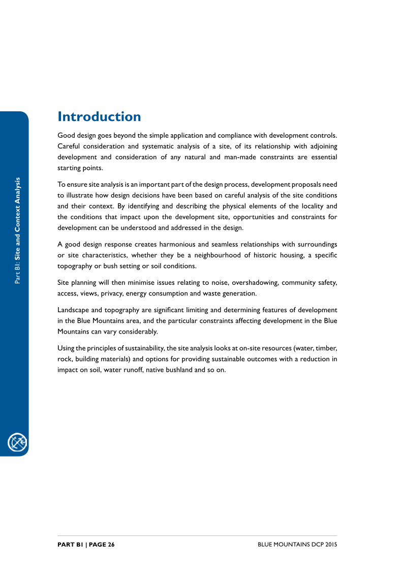
IntroductionGooddesigngoesbeyondthesimpleapplicationandcompliancewithdevelopmentcontrols.Careful consideration and systematic analysis of a site, of its relationship with adjoiningdevelopment and consideration of any natural and man-made constraints are essential starting points.
Toensuresiteanalysisisanimportantpartofthedesignprocess,developmentproposalsneedtoillustratehowdesigndecisionshavebeenbasedoncarefulanalysisofthesiteconditionsand their context. By identifying and describing the physical elements of the locality andthe conditions that impact upon the development site, opportunities and constraints fordevelopmentcanbeunderstoodandaddressedinthedesign.
Agooddesignresponsecreatesharmoniousandseamlessrelationshipswithsurroundingsor site characteristics, whether they be a neighbourhood of historic housing, a specifictopographyorbushsettingorsoilconditions.
Siteplanningwillthenminimiseissuesrelatingtonoise,overshadowing,communitysafety,access,views,privacy,energyconsumptionandwastegeneration.
LandscapeandtopographyaresignificantlimitinganddeterminingfeaturesofdevelopmentintheBlueMountainsarea,andtheparticularconstraintsaffectingdevelopmentintheBlueMountains can vary considerably.
Usingtheprinciplesofsustainability,thesiteanalysislooksaton-siteresources(water,timber,rock,buildingmaterials)andoptionsforprovidingsustainableoutcomeswithareductioninimpactonsoil,waterrunoff,nativebushlandandsoon.
Part
B1:
Sit
e an
d C
onte
xt A
naly
sis
PART B1 | PAGE 27BLUE MOUNTAINS DCP 2015
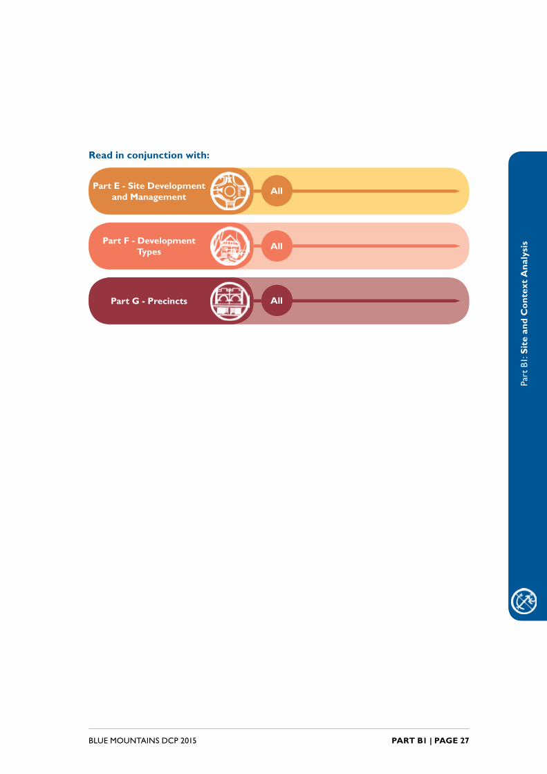
Read in conjunction with:
Part E - Site Development and Management
All
Part F - Development Types All
Part G - Precincts All

Part
B1:
Sit
e an
d C
onte
xt A
naly
sis
BLUE MOUNTAINS DCP 2015PART B1.1 | PAGE 28
B1.1. Site Analysis of Opportunities and Constraints
Explanation
Asafirststepinpreparingforadevelopment,asiteanalysisistobeundertaken.
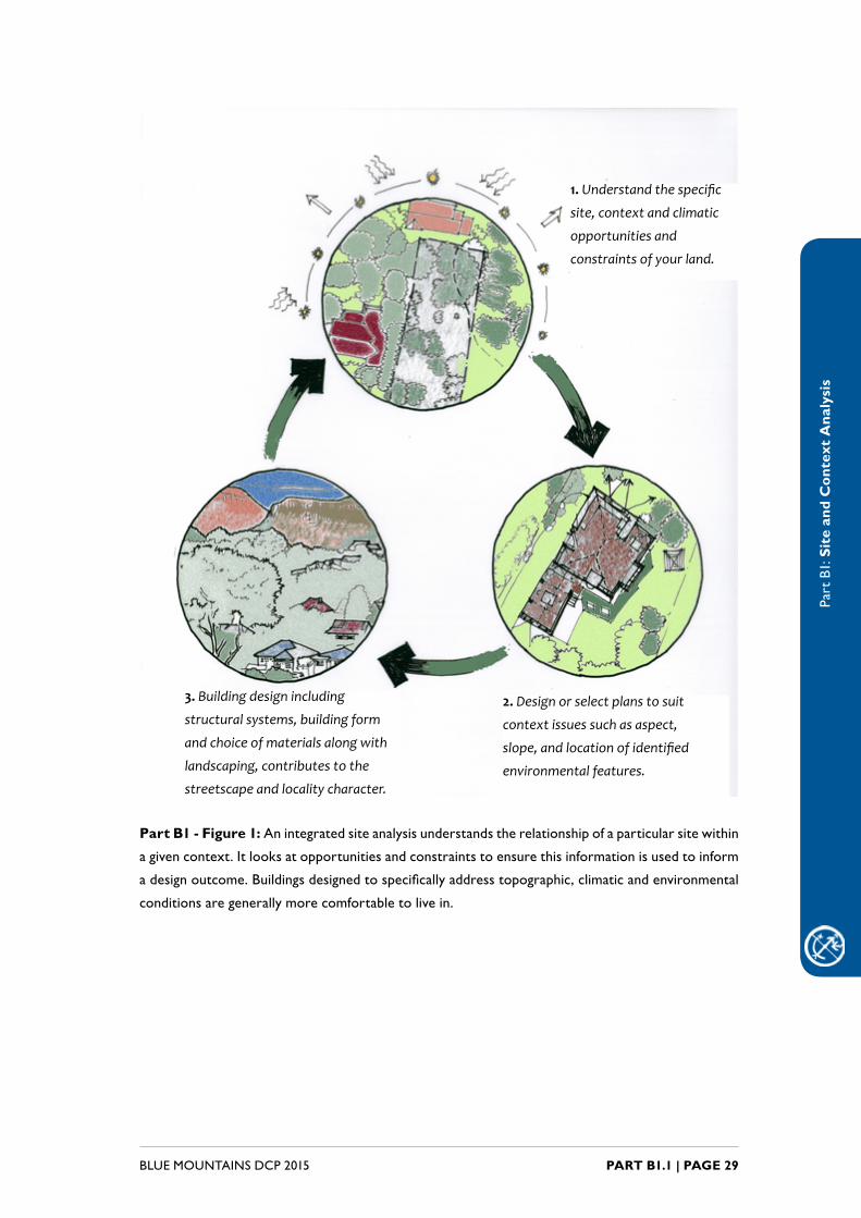
An integrated site analysis understands the relationship of a particular sitewithinagivencontext.Itlooksatopportunitiesandconstraintstoensurethisinformationisusedtoinformadesignoutcome.Buildingsdesignedtospecificallyaddresstopographicandclimaticconsiderationsaregenerallymorecomfortableto live in.
Appropriate site planning and building design can also minimise issues relating toenvironmentalimpact,overshadowingandsolaraccess,privacyandamenity,vehicularaccess,wastegenerationandcommunitysafety.
TheEnvironmental Planning and Assessment Regulation 2000, underSchedule1,requirescertaininformationtobeincludedinanydevelopmentapplication.Therequirementsincludebutarenotlimitedtoasiteplanoftheland,asketchofthedevelopmentandastatementofenvironmentaleffects.Refertotheregulationsforfurtherinformation.
Thesiteanalysisplanshouldidentifythekeyopportunitiesandconstraintsofthesite,takingintoaccounttheplanningcontrolswithinBlueMountainsLocalEnvironmentalPlan2015(LEP2015)andthisDCP,withparticularreferenceto:
• Zoning(identifiedonLEP 2015 Land Zoning Map)
• Protectedareas(identifiedonLEP 2015 maps)
• Bushfireproneland(identifiedonCouncil’sbushfirepronelandmap).
• Heritagelisting(identifiedontheLEP 2015 Heritage Map).
• PeriodHousingAreasandprecincts(identifiedonLEP 2015 Built Character Map)
Council’s pre-lodgement service provides the opportunity for applicants to discuss
conceptdesignswithCouncilonceacontextand/orsiteanalysishasbeencarriedout.
Part
B1:
Sit
e an
d C
onte
xt A
naly
sis
PART B1.1 | PAGE 29BLUE MOUNTAINS DCP 2015
3. Building design including
structural systems, building form
and choice of materials along with
landscaping, contributes to the
streetscape and locality character.
1. Understand the specific
site, context and climatic
opportunities and
constraints of your land.
2. Design or select plans to suit
context issues such as aspect,
slope, and location of identified
environmental features.
Part B1 - Figure 1:Anintegratedsiteanalysisunderstandstherelationshipofaparticularsitewithin
agivencontext.Itlooksatopportunitiesandconstraintstoensurethisinformationisusedtoinform
adesignoutcome.Buildingsdesignedtospecificallyaddresstopographic,climaticandenvironmental
conditions are generally more comfortable to live in.

Part
B1:
Sit
e an
d C
onte
xt A
naly
sis
BLUE MOUNTAINS DCP 2015PART B1.1 | PAGE 30
Objectives
Theobjectivesofundertakingasiteanalysisareto:
O1. identify the opportunities and constraints of a development site tocreate a site responsive application, and
O2. enable the most appropriate siting of a development through theidentificationofprotectedareasandenvironmentallysensitivelandd,and
O3. reduce adverse amenity impacts such as overshadowing, loss ofprivacy,viewsorsolaraccess,andimprovesustainabilityoutcomesofdevelopment, during its construction and operation, and
O4. determinethemostappropriateformintermsofbulkandscalethatasite can accommodate.
Controls
C1. A site analysis plan is generally required with any developmentapplication that includes a new building or external alterations toexistingbuildings.Forminorapplicationswherethelandhasminimalconstraintsortheproposalisforminimalexternalchanges,aseparatedrawingorplanmaynotbenecessary,andthesiteanalysisinformationcan be incorporated onto the site plan. It may also be necessaryto incorporate relevant written discussion into the statement ofenvironmental effects.
C2. Site analysis information shall generally take the form of a scaledplandrawing.Thesiteanalysisplan istomapbasicsite featuresandinformation, and any additional mapped features. Refer to Part I1.1.1 in Part I Submission Requirements for details of site analysis features.
Note: An indicative building envelope or potential development space can be
dottedontothesiteanalysisplanonceallconstraintshavebeenidentified.
Part
B1:
Sit
e an
d C
onte
xt A
naly
sis
PART B1.1 | PAGE 31BLUE MOUNTAINS DCP 2015
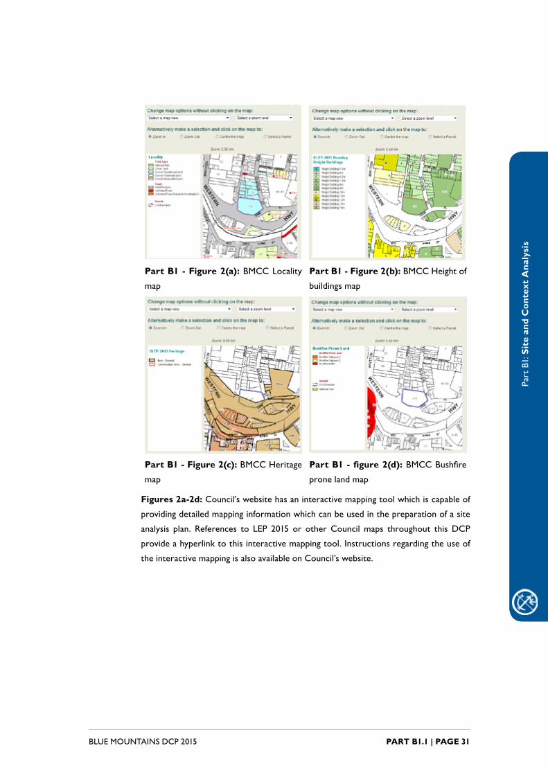
Part B1 - Figure 2(a): BMCC Locality
map
Part B1 - Figure 2(b): BMCCHeightof
buildings map
Part B1 - Figure 2(c): BMCC Heritage
map
Part B1 - figure 2(d):BMCCBushfire
prone land map
Figures 2a-2d: Council’swebsitehasaninteractivemappingtoolwhichiscapableof
providingdetailedmappinginformationwhichcanbeusedinthepreparationofasite
analysis plan. References to LEP 2015 or otherCouncilmaps throughout thisDCP
provideahyperlinktothisinteractivemappingtool.Instructionsregardingtheuseof
theinteractivemappingisalsoavailableonCouncil’swebsite.
Part
B1:
Sit
e an
d C
onte
xt A
naly
sis
BLUE MOUNTAINS DCP 2015PART B1.1 | PAGE 32
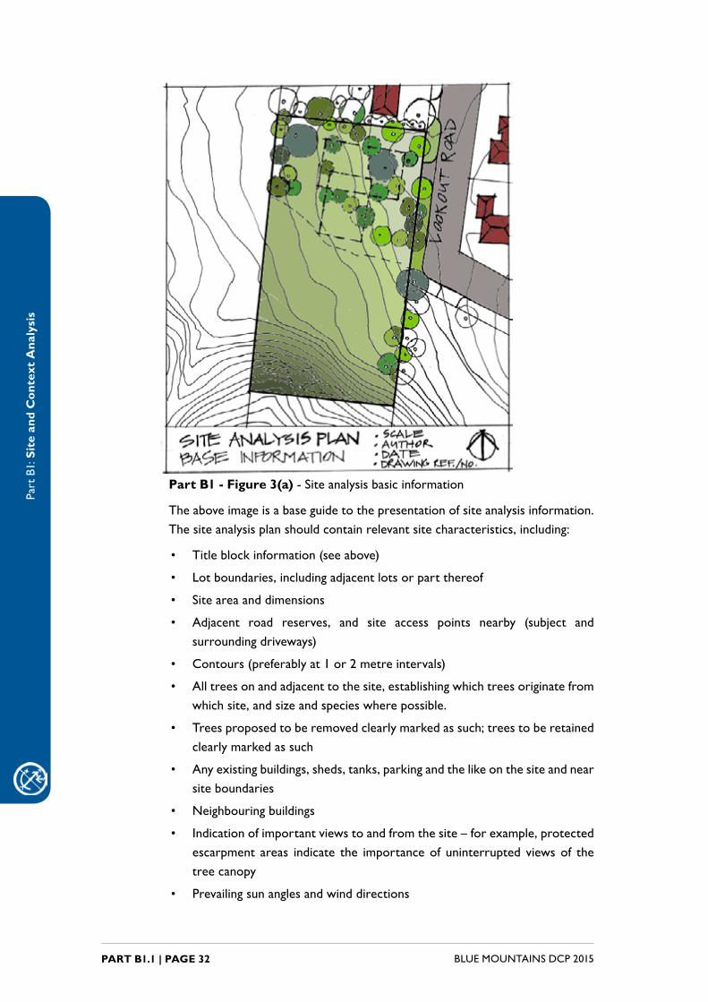
Part B1 - Figure 3(a) - Site analysis basic information
Theaboveimageisabaseguidetothepresentationofsiteanalysisinformation.Thesiteanalysisplanshouldcontainrelevantsitecharacteristics,including:
• Titleblockinformation(seeabove)
• Lotboundaries,includingadjacentlotsorpartthereof
• Site area and dimensions
• Adjacent road reserves, and site access points nearby (subject andsurroundingdriveways)
• Contours(preferablyat1or2metreintervals)
• Alltreesonandadjacenttothesite,establishingwhichtreesoriginatefromwhichsite,andsizeandspecieswherepossible.
• Treesproposedtoberemovedclearlymarkedassuch;treestoberetainedclearlymarkedassuch
• Anyexistingbuildings,sheds,tanks,parkingandthelikeonthesiteandnearsite boundaries
• Neighbouringbuildings
• Indicationofimportantviewstoandfromthesite–forexample,protectedescarpment areas indicate the importanceof uninterrupted viewsof thetree canopy
• Prevailingsunanglesandwinddirections

Part
B1:
Sit
e an
d C
onte
xt A
naly
sis
PART B1.1 | PAGE 33BLUE MOUNTAINS DCP 2015
• PotentialAssetProtectionZones(APZs)canbeshownifrelevant
• Requiredsetbacksfromfront,sideandrearboundariescanbeshown
• Anotionaldevelopmentspaceafterallsiteconstraintshavebeenidentifiedand considered
Refer to Part I1.1.1 of Part I – Submission Requirements for full details.
Zone E1 National Parks and Reserves from the LEP 2015 Zoning Map
Protected area - escarpment area from the LEP 2015 Scenic Landscape Values Map
Zone E4 Environmental Living from the LEP 2015 Zoning Map
Protected area - ecological buffer area from the LEP 2015 Biodiversity Natural Resources Map (note: extends into slope constraint area)
Zone E2 Environmental Protection from the LEP 2015 Zoning Map
PartB1-Figure3(b)-Siteanalysiszoninginformation
PartB1-Figure3(c)-Siteanalysisprotectedareas
PartB1-Figure3(d)-Siteanalysisheritageinformation
Protected area - slope constraint area area from the LEP 2015 Land Natural Resources Map
Heritage listed properties in the vicinity of the site from the LEP 2015 Heritage Map

Part
B1:
Sit
e an
d C
onte
xt A
naly
sis
BLUE MOUNTAINS DCP 2015PART B1.2 | PAGE 34
B1.2. Context Analysis
Explanation
FordevelopmentwithinPeriodHousingAreasanassessmentoftheprevailingcharacteristics of an area within which the development is located and theidentification of streetscape character values is required (refer to Part D2PeriodHousingofthisDCP).
Thistypeofassessmentmayalsoberequired for largescaledevelopmentorsmallerdevelopmentswheretheproposalwouldhaveasignificantimpactonthestreetscapeandlocality.Thelevelofanalysiswillvarydependingonthescaleoftheproposal,andmayinclude:
(a) local analysis (the local context around the site including local servicesandinfrastructure,localenvironmentalissues,andthelocalbuiltformandlandscapecontextofthesite);and
(b) regionalanalysis(theregionalcontextinrelationtonearesturbancentres,majorservicesandinfrastructure,andbroadenvironmentalcatchments).
Thecontextanalysiscanbuildupontheinformationincludedinthesiteanalysis.Aseparateplan,orthepreparationofwhollyseparateinformationmaynotberequired.
Note: Council’swebsitehasaninteractivemappingtoolwhichiscapableofproviding
detailedmappinginformationwhichcanbeusedinthepreparationofacontextanalysis
plan. Instructions regarding the use of the interactive mapping is also available on
Council’swebsite.
Control
C1. AcontextanalysisisgenerallyrequiredforworkswithinPeriodHousingAreas,andforlarge,complexand/orhighlysignificantapplications.ForminorapplicationswithinPeriodHousingAreas,(suchasnon-visibleworkstotherearonly),afullcontextanalysismaynotberequired,andadditionalwritten discussion on context, streetscape and charactercanbeincorporatedintothestatementofenvironmentaleffects.
RefertothesubmissionrequirementsforcontextanalysisinPartISubmission
Requirements.

PART B2 BUILDING ENVELOPE
Part
B2:
Bui
ldin
g E
nvel
ope
BLUE MOUNTAINS DCP 2015PART B2 | PAGE 36
IntroductionAbuildingenvelopeisathreedimensionalspaceonanallotmentoflandthatprescribesthelimitsofwheredevelopmentcanoccur.Thecoreelementswhichincombinationdefineabuildingenvelopeare:
• buildingheight;
• floorspaceratio(FSR);
• setbacks;and
• site coverage and landscaped area.
The controls for each of these elements are primarily based on the zoning of the land.However,therearealsoprecinctsinanumberofBlueMountainsvillagesthataresubjecttospecificbuildingenvelopecontrols.Thesecontrolsareintendedtoreflectthedevelopmentpotentialofanareaandrespondtoestablishedvillagecharacter.
Theintentionofthispartistoprovidethecorebuildingenvelopecontrolsforalltypesofdevelopment,beforemovingintotheotherpartsoftheDCP.
ForLEPbasedcontrolsanddevelopmentwithinPrecincts,thispartprovidesdirectiontotherelevantpartoftheDCPortheLEPasnecessary.

Part
B2:
Bui
ldin
g E
nvel
ope
PART B2 | PAGE 37BLUE MOUNTAINS DCP 2015
Read in conjunction with:
Part E - Site Development and Management
All
Part F - Development Types All
Part G - Precincts All
Part
B2:
Bui
ldin
g E
nvel
ope
BLUE MOUNTAINS DCP 2015PART B2.1 | PAGE 38
B2.1. BuildingHeight
Explanation
Buildingheightmeanstheverticaldistancebetweengroundlevelandthehighestpointonthebuilding.Theheightofadwellinginfluencesthescaleandbulkofadevelopmentwhichinturnhasimplicationsforstreetscapecharacter.Buildingheightcontrolsapplyinallzones.
Objectives
O1. Toensurethattheheightofdevelopmentisnotexcessiveandrelateswelltothelocalcontext.
Controls
C1. Theheight of a building is not to exceed themaximumheight of abuildingsetbyLEP2015clause4.3(Heightofbuildings)andtheHeight of Buildings Map.

Part
B2:
Bui
ldin
g E
nvel
ope
PART B2.2 | PAGE 39BLUE MOUNTAINS DCP 2015
B2.2. Floor Space Ratio
Explanation
Thefloorspaceratio(FSR)ofbuildingsistheratioofthegrossfloorareaofallbuildingswithinasitetothesitearea.FSRcontrolsseektoregulatebulkandscale of buildings and prevent over development of a site. FSR controls apply in allzones.
Objectives
O1. Toensuredevelopmentiscompatiblewiththebulk,scaleandcharacterof existing and future surrounding development and is appropriate to thesite.
Controls
C1. ThefloorspaceratioofadevelopmentisnottoexceedthemaximumfloorspaceratiosetbyLEP2015clause4.4(Floorspaceratio)andtheFloor Space Ratio Map.

Part
B2:
Bui
ldin
g E
nvel
ope
BLUE MOUNTAINS DCP 2015PART B2.3 | PAGE 40
B2.3. Setbacks & articulation
B2.3.1. Setbacks
Explanation
Setbacksdefinethefootprintofabuildingbyestablishinglimitationsondistancesbetweentheouterwallsofthebuildingandthefront,sideandrearpropertyboundaries.Setbackcontrolsseektomaintainorestablishappropriatebuildinglines and to ensure adequate building separation to provide for access and landscaping and to preserve amenity.
Objectives
O1. Toensurethatthebulkandscaleofdevelopmentisconsistentwiththeexistingstreetscapeofthelocalityand,whereappropriate,promotesa prominent landscape setting.
O2. To ensure that overshadowing of adjoining buildings and impact onsolaraccesstothosebuildingsisminimised.
O3. To ensure that the design and location of buildings responds toindividual site constraints and minimises site disturbance and clearing of vegetation.
Controls
C1. For land within ZoneRU2 Rural Landscape or RU4 Primary Production Small Lots,buildingsetbackswillbesubjecttoameritbased assessment.
C2. ForlandwithinZoneR1 General ResidentialandwithinaPrecinctidentifiedontheLEP 2015 Built Character Map, building setbacks are tocomplywiththerelevantcontrolscontainedwithinPartGLocalityManagement.
C3. ForlandwithinZoneR2 Low Density Residential:
(a) themaximumwidthacrossanallotmentofanybuildingthathasastreetfrontageisnottobegreaterthan80%ofthegreatestwidthoftheallotmentatanyonepoint,and
(b) frontbuildingsetbackistobewithin20%oftheaveragesetbackofbuildingson immediatelyadjoiningallotments inestablishedareasor,where therearenobuildingson theseallotments, aminimumof8mfromtheprimaryroadfrontage,and

Part
B2:
Bui
ldin
g E
nvel
ope
PART B2.3 | PAGE 41BLUE MOUNTAINS DCP 2015
(c) inthecaseofcornerlots,buildingsetbackfromthesecondaryfrontage is to be a minimum of 3m, and
(d) inthecaseofhatchetshapedlots,buildingsetbackfromtherearboundaryofthelotinfrontistobeaminimumof9m,and
Note: Garages, car ports and the like are permitted within the building
setbackprescribedbyC3(d).
(e) setback from side and rear boundaries is to be a minimum of 1m.
C4. ForlandwithinZoneR3 Medium Density Residential andwithina Precinct identified on the LEP 2015 Built Character Map, building setbacks are to complywith the relevant controls containedwithinPart G Locality Management.
C5. ForlandwithinZoneR3 Medium Density ResidentialnotwithinaPrecinct:
(a) frontbuildingsetbackistobewithin20%oftheaveragesetbackofbuildingson immediatelyadjoiningallotments inestablishedareasor,where therearenobuildingson theseallotments, aminimumof8mfromtheprimaryroadfrontage,and
(b) inthecaseofcornerlots,buildingsetbackfromthesecondaryfrontage is to be a minimum of 3m, and
(c) inthecaseofhatchetshapedlots,buildingsetbackfromtherearboundaryofthelotinfrontistobeaminimumof9m,and
Note: Garages, car ports and the like are permitted within the building
setbackprescribedbyC3(d).
(d) setback from side boundaries is to be a minimum of 2m.
C6. For land within Zone B1 Neighbourhood Centre and withina Precinct identified on the LEP 2015 Built Character Map, building setbacks are to complywith the relevant controls containedwithinPart G Locality Management.
C7. For land within Zone B1 Neighbourhood Centre not within aprecinct:
(a) frontbuildingsetbackistobewithin20%oftheaveragesetbackofbuildingsonimmediatelyadjoiningallotments,and
(b) sideandrearbuildingsetbackswillbesubjecttoameritbasedassessment.
Part
B2:
Bui
ldin
g E
nvel
ope
BLUE MOUNTAINS DCP 2015PART B2.3 | PAGE 42
C8. For land within Zone B2 Local Centre and within a PrecinctidentifiedontheLEP 2015 Built Character Map, building setbacks are tocomplywiththerelevantcontrolscontainedwithinPartGLocalityManagement.
C9. ForlandwithinZone B7 Business Park:
(a) setbackfromtheprimaryfrontboundaryistobeaminimumof2m and a maximum of 4m and be landscaped, and
(b) sideandrearbuildingsetbackswillbesubjecttoameritbasedassessment.
C10. For land within Zone IN1 General Industrial or IN2 Light Industrial:
(a) setbackfromtheprimaryfrontboundaryistobeaminimumof4mandamaximumof8mandbelandscaped,and
(b) sideandrearbuildingsetbackswillbesubjecttoameritbasedassessment.
C11. For land withinZone RE1 Public Recreation, setback from theprimaryfrontboundaryistobeaminimumof8mfromaroadreserve.
C12. ForlandwithinZone RE2 Private Recreation andwithinaPrecinctidentifiedontheLEP 2015 Built Character Map, building setbacks are tocomplywiththerelevantcontrolscontainedwithinPartGLocalityManagement.
C13. ForlandwithinZone RE2 Private RecreationnotwithinaPrecinct,setback from the primary front boundary is to be 8m from a roadreserve.
C14. Forlandconsistingoforincludinganareaoflessthan4,000m2withinZone E3 Environmental Management or E4 Environmental Living:
(a) frontbuildingsetbackistobewithin20%oftheaveragesetbackofbuildingson immediatelyadjoiningallotments inestablishedareasor,where therearenobuildingson theseallotments, aminimumof8mfromtheprimaryroadfrontage,and
(b) inthecaseofcornerlots,buildingsetbackfromthesecondaryfrontage is to be a minimum of 3m, and
(c) inthecaseofhatchetshapedlots,buildingsetbackfromtherearboundaryofthelotinfrontistobeaminimumof9m,and
Part
B2:
Bui
ldin
g E
nvel
ope
PART B2.3 | PAGE 43BLUE MOUNTAINS DCP 2015
Note:Garages,carportsandthelikearepermittedwithinthebuilding
setbackprescribedbyC14(c)
(d) setback from side and rear boundaries is to be a minimum of 1m.
Note:clause4.4B(Principaldevelopmentarea)ofLEP2015appliestoland
consisting of or including an area ofmore than 4,000m2 within ZoneE3
Environmental Management or E4 Environmental Living.
Part
B2:
Bui
ldin
g E
nvel
ope
BLUE MOUNTAINS DCP 2015PART B2.3 | PAGE 44
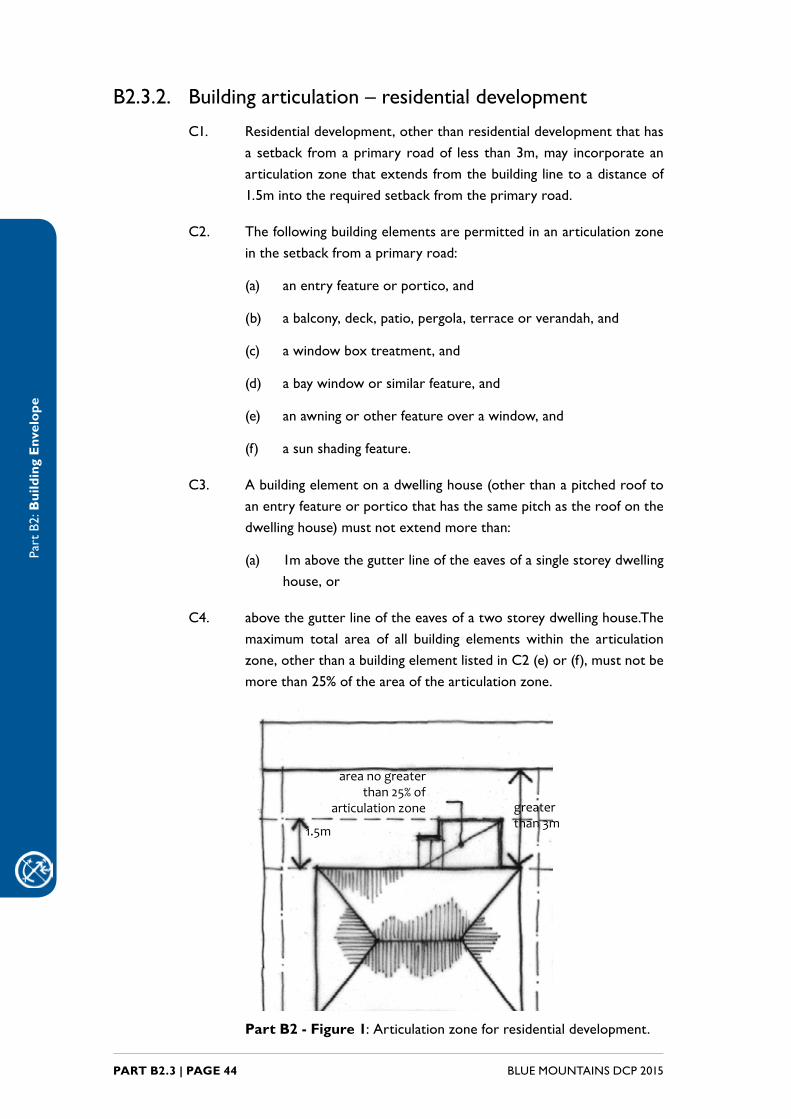
B2.3.2. Building articulation – residential development
C1. Residentialdevelopment,otherthanresidentialdevelopmentthathasasetback fromaprimaryroadof less than3m,may incorporateanarticulationzonethatextendsfromthebuildinglinetoadistanceof1.5mintotherequiredsetbackfromtheprimaryroad.
C2. Thefollowingbuildingelementsarepermittedinanarticulationzoneinthesetbackfromaprimaryroad:
(a) an entry feature or portico, and
(b) abalcony,deck,patio,pergola,terraceorverandah,and
(c) awindowboxtreatment,and
(d) abaywindoworsimilarfeature,and
(e) anawningorotherfeatureoverawindow,and
(f) asunshadingfeature.
C3. Abuildingelementonadwellinghouse(otherthanapitchedrooftoanentryfeatureorporticothathasthesamepitchastheroofonthedwellinghouse)mustnotextendmorethan:
(a) 1mabovethegutterlineoftheeavesofasinglestoreydwellinghouse,or
C4. abovethegutterlineoftheeavesofatwostoreydwellinghouse.Themaximum total area of all building elementswithin the articulationzone,otherthanabuildingelementlistedinC2(e)or(f),mustnotbemorethan25%oftheareaofthearticulationzone.
area no greater than 25% of
articulation zone greater than 3m1.5m
Part B2 - Figure 1:Articulationzoneforresidentialdevelopment.
Part
B2:
Bui
ldin
g E
nvel
ope
PART B2.3 | PAGE 45BLUE MOUNTAINS DCP 2015
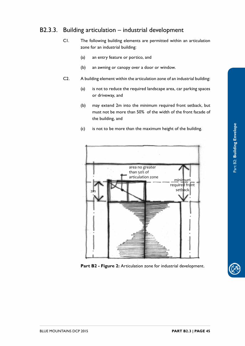
B2.3.3. Building articulation – industrial development
C1. The followingbuildingelementsarepermittedwithinanarticulationzoneforanindustrialbuilding:
(a) an entry feature or portico, and
(b) anawningorcanopyoveradoororwindow.
C2. Abuildingelementwithinthearticulationzoneofanindustrialbuilding:
(a) isnottoreducetherequiredlandscapearea,carparkingspacesordriveway,and
(b) mayextend2mintotheminimumrequired frontsetback,butmustnotbemorethan50%ofthewidthofthefrontfacadeofthebuilding,and
(c) isnottobemorethanthemaximumheightofthebuilding.
area no greater than 50% of articulation zone
2m
minimum required front
setback
Part B2 - Figure 2:Articulationzoneforindustrialdevelopment.

Part
B2:
Bui
ldin
g E
nvel
ope
BLUE MOUNTAINS DCP 2015PART B2.3 | PAGE 46
B2.3.4. Exceptions to setbacks
C1. Councilmaypermitdevelopmentthatdoesnotcomplywithsetbackrequirementstoaminorextentwhereitissatisfiedthat:
(a) thefailuretocomplyenablesthedevelopmenttobetterachievethezoneobjectivesandotherprovisionsapplicabletotheland,and
(b) any decrease in setback will improve the protection ofenvironmentally sensitive land by the relocation of buildingswithinthesite,and
(c) theproposeddevelopmentincorporatesadesignthatminimisesitsapparentbulkwhenviewedfromaroad.
C2. Council may permit development that does not comply with theminimumsetback:
(a) fromaprimarystreetfrontage,wherethedevelopmentinvolvesminoralterationsoradditionsandisconsistentwiththefrontbuildingsetbackestablishedbytheexistingbuilding;or
(b) fromasideboundary,orasecondarystreetfrontage,wherethedevelopment involvesminoralterationsoradditions(includingtheerectionofanoutbuilding)andislocatedalongorwithinalineprojectedfromthewallofanexistingbuilding.
C3. A greater front, side or rear setback may be required for development withinthevicinityofaheritage item inordertomaintainthevisualsettingoftheheritageitem.Thisistobedeterminedonasitebysitebasis.
Note: Council may require a Heritage Impact Statement (HIS)todemonstrate
thattheproposeddevelopmentwillnotadverselyimpactthesignificanceof
theaffecteditem.RefertoPartD1ofthisDCPforfurtherinformation.
C4. Sideandrearsetbacksdonotapplyto:
(a) any aerial, antenna, awning, eave, flue, chimney, pipe, coolingorheatingappliance,anyrainwatertankoranyotherstructureassociatedwiththeprovisionofautilityserviceifitislocatedatleast450millimetresfromtherelevantboundary,and
(b) any fence, fascia, gutter, downpipe, light fitting, electricity orgasmeter,driveway,pathwayorpavingifitislocatedwithinanyrequiredsetbackareatotherelevantboundary.

Part
B2:
Bui
ldin
g E
nvel
ope
PART B2.3 | PAGE 47BLUE MOUNTAINS DCP 2015
C5. Thesetbackfromaroaddoesnotapplyto:
(a) adriveway,fence,pathway,pavingorretainingwall,or
(b) thearticulationzoneandanybuildingelementthatispermittedwithinthatzone.
B2.3.5. SetbackfromaClassifiedRoad
C1. WherelandadjoinsaClassifiedRoad,otherthanaTouristRoad,thesetbackofanybuildingsfromthealignmentorproposedalignmentoftheroadistocomplywithPart B2 - Table 1.
Note:ClassifiedRoadhasthesamemeaningasintheRoadsAct1993and
includestheGreatWesternHighway,HawkesburyRoad,DarlingCauseway
andBell’sLineofRoad.
Part B2 - Table 1:SetbackfromClassifiedRoads.
Zone Setback
E3 Environmental Management 30m
Anyotherzone 18m
C2. CouncilmayconsenttodevelopmentthatdoesnotcomplywithC1onlyifitissatisfiedthattheexistingdevelopmentonthelandorthephysicalorfunctionalcircumstancesofthelandwouldwarrantalessersetback,andthiswouldnotresultinthecreationofatraffichazard.
Part
B2:
Bui
ldin
g E
nvel
ope
BLUE MOUNTAINS DCP 2015PART B2.4 | PAGE 48
B2.4. Site Coverage and Pervious Area
Explanation
Sitecoverageisexpressedasapercentageofthetotalsiteareaandreferstotheareaofasitethatisbebuiltupon.Sitecoveragecontrolsworkinconjunctionwith floor space ratio and setbacks to manage the extent of developmentpermittedon a site and to ensure the retentionof pervious and landscapedareas. Pervious area controls are also expressed as a percentage of total site area.Perviousareasfacilitateinfiltrationofstormwaterwhichinturnhelpstoprotectcatchmenthealth.
Note 1: In LEP 2015 site coveragemeans the proportion of a site area covered by
buildings.However,thefollowingarenot includedforthepurposeofcalculatingsite
coverage:
• anybasement;and
• anypartofanawningthatisoutsidetheouterwallsofabuilding;and
• anyeaves;and
• unenclosedbalconies,decks,pergolasandthelike.
Note 2: For the purpose of calculating site coverage, reference in the LEP 2015
definitionto‘buildings’isconsideredtoincludebuildingsancillarytothemainbuilding,
andtheareaofanydriveway,parkingfacilityandtenniscourt.Referenceto‘unenclosed
balconies,decks,pergolasandthelike’isconsideredtoincludeswimmingpoolsorspas,
accessramps,andpathwaysorpavings.
Note 3: Perviousareameanstheproportionofasiteareathatiscapableofabsorption
and infiltration of stormwater and excludes hard areas except for water tanks,
unenclosedareasofspaceddeckingandswimmingpools.
Note 4:Wheresingledwellingsordualoccupancydevelopmentsexceedthemaximum
site coverage or have less than the required minimum pervious area, additional
stormwaterqualitymeasuresaretobeprovided.RefertoPartC6.1Control9ofthis
DCP.
Objectives
O1. To limit the extent of development and ensure the retention ofperviousareasthataidestormwatermanagement.
Controls
C1. For land within ZoneRU2 Rural Landscape or RU4 Primary Production Small Lots:
(a) The maximum site cover for buildings, including buildingsancillarytothemainbuilding,istobe:
Part
B2:
Bui
ldin
g E
nvel
ope
PART B2.4 | PAGE 49BLUE MOUNTAINS DCP 2015
i. 40%ofthetotalallotmentareaor160m2,whicheverisgreater,forallotmentslessthan1,000m2, or
ii. 300m2 plus10%ofanyamountbywhichtheallotmentarea exceeds 1000m2, for allotments of 1,000m2 or more butlessthan2,000m2, or
iii. 400m2plus5%ofanyamountbywhichtheallotmentarea exceeds 2000m2, up to a maximum total building site cover of 2500m2, for allotments 2000m2 or greater.
C2. ForlandwithinZoneR1 General ResidentialandwithinaPrecinctidentifiedon theLEP 2015 Built Character Map, maximum site cover andminimumperviousareaaretocomplywiththerelevantcontrolscontainedwithinPartGLocalityManagement.
C3. ForlandwithinZoneR2 Low Density Residential:
(a) themaximumsitecoverforbuildings,includingbuildingsancillarytothemainbuilding,is40%ofthetotalallotmentareaor160m2, whicheverisgreater,and
(b) theminimumareatoberetainedasperviousareais40%ofthetotal allotment area.
C4. ForlandwithinZoneR3 Medium Density ResidentialandwithinaPrecinct identifiedon theLEP 2015 Built Character Map, maximum sitecoverandminimumperviousareaaretocomplywiththerelevantcontrolscontainedwithinPartGLocalityManagement.
C5. For land within ZoneR3 Medium Density Residential and not withinaPrecinct:
(a) themaximumsitecoverforbuildings,includingbuildingsancillarytothemainbuilding,is40%ofthetotalallotmentareaor160m2, whicheverisgreater,and
(b) theminimumareatoberetainedasperviousareais40%ofthetotal allotment area.
C6. For land within Zone B1 Neighbourhood Centre and within aPrecinctidentifiedontheLEP 2015 Built Character Map, maximum site cover andminimum pervious area are to complywith the relevantcontrolscontainedwithinPartGLocalityManagement.
C7. ForlandwithinZoneB2 Local Centre andwithinaPrecinctidentifiedontheLEP 2015 Built Character Map, maximum site cover and minimum perviousareaistocomplywiththerelevantcontrolscontainedwithinPart G Locality Management.
Part
B2:
Bui
ldin
g E
nvel
ope
BLUE MOUNTAINS DCP 2015PART B2.4 | PAGE 50
C8. For landwithinZoneB7 Business Park theminimum area to beretainedasperviousareais20%ofthetotalallotmentarea.
C9. ForlandwithinZoneIN1 General Industrial theminimumareatoberetainedasperviousareais20%ofthetotalallotmentarea.
C10. ForlandwithinZoneIN2 Light Industrialtheminimumareatoberetainedasperviousareais30%ofthetotalallotmentarea.
C11. ForlandwithinZoneRE2 Private RecreationandwithinaPrecinctidentifiedon theLEP 2015 Built Character Map, maximum site cover andminimumperviousareaaretocomplywiththerelevantcontrolscontainedwithinPartGLocalityManagement.
C12. For land within ZoneRE2 Private Recreation and not within aPrecinct:
(a) for any allotment having an area of less than 1,000m2, themaximumsitecoverforbuildingsandbuildingsancillarytothemainbuildingis30%or160m2whicheverisgreater;or
(b) for any allotment having an area of 1,000m2 or greater, themaximumsitecoverforbuildingsandbuildingsancillarytothemainbuildingis:
i. 300m2;and
ii. anadditionalamountequivalentto10%oftheamountbywhichthesiteareaexceeds1,000m2, but not exceeding 100m2;and
(c) theminimumareatoberetainedasperviousareais60%ofthetotal allotment area.
C13. ForlandwithinZoneE3 Environmental Management, site cover controls are prescribed in LEP 2015 clause 4.4A (Site coverage andlandscaped area).
C14. For land within Zone E4 Environmental Living, site cover and pervious areacontrols areprescribed inLEP2015clause4.4A (Sitecoverage and landscaped area).

PART B3 CHARACTER AND
DESIGN
Part
B3:
Cha
ract
er a
nd D
esig
n
BLUE MOUNTAINS DCP 2015PART B3 | PAGE 52
IntroductionTheBlueMountainsurbanenvironmentsarelow-keyandlow-scalecomparedtothehighdensitylivingoflargecities.Despitethis,urbandesignissuesarestillofcriticalimportanceintowncentres,specificallyidentifiedprecinctsandalsoordinaryneighbourhoods,andensurethat neighbourhood character and heritage considerations are respected and enhancedthroughnewdevelopment.Thecharacteroftheenvironmentisequallyrelevanteverywhere,notjustinretainingorimprovingafewselect‘special’areasthatalreadyhavehighamenityvalues.
Thecreationof attractive streetenvironmentscanhelp toslowtraffic, foster theuseofstreets as places for social interaction between pedestrians and residents, and promotepedestrian and cyclist activity.
Neighbourhood character is not limited to the prevailing architectural style or era ofdevelopment.Thelayoutandformoftheareaiscritical,asistherelationshipofthenaturalenvironmentandtopographyinthepublicandprivatedomaintobuiltforms.Settings,vistas,sensorydelightandasenseofplacecanbecreatedthroughthoughtfulurbandesignresponses.
Part B3.1 part applies to land identified as within a heavy blue line and with a precinct reference on
the LEP 2015 Built Character Map.
Part B3.2 applies to all development of low-density residential dwellings, in particular free-standing
single dwellings.
Part
B3:
Cha
ract
er a
nd D
esig
n
PART B3 | PAGE 53BLUE MOUNTAINS DCP 2015
Read in conjunction with:
Part G - Precincts All
Part D - Heritage Management D1 D2

Part
B3:
Cha
ract
er a
nd D
esig
n
BLUE MOUNTAINS DCP 2015PART B3.1 | PAGE 54
B3.1. CharacterconsiderationswithinprecinctsThispartappliestodevelopmentintowncentresandsurroundingareasidentifiedasprecinctsareasontheLEP 2015 Built Character Map.TheprimarycontrolsfortheseareasarewithinPartGLocalityManagementofthisDCP.
This section provides further guidelines to supplement the specific controlswithinPartG.Thisincludesconsiderationsforurbandesign,infilldevelopment,designofshopfrontbuildingsandmedium-densityresidentialdevelopment.
B3.1.1. Urban design
Explanation
Underclause6.19(Designexcellence)ofLEP2015,Councilmusthaveregardtoparticularurbandesignmattersinassessingdevelopmentapplicationswithinspecificprecincts.TheseprecinctsarethelandidentifiedasedgedbyaheavybluelineontheLEP 2015 Built Character Map.
Part G Precincts of this DCP sets out specific controls for each individualprecinct.TheurbandesignprinciplesofthispartmaybeusedintheassessmentofdevelopmentswiththespecificprecinctsofPartG.
ThesecontrolsapplytozonesB1,B2,R1andR3,wherecharacterconsiderationsapply to a village setting.
Objectives
O1. Toachieveexcellenceinurbandesignandinfilldevelopment.
O2. To identify key components of urban design to be considered and addressed in development proposals.
O3. Toretainandenhancetheuniquequalitiesofneighbourhoodcharacterandcontext,byrespondingtotheessentialelementsthatmakeupthecharacterofthesurroundingareaandthedesiredfuturecharacter.
Controls
C1. Significant development within the identified precincts, whereimpacting upon significant public domain spaces,major roads, towncentresandsignificantstreetscapes,istodemonstrateconsiderationofthefollowingurbandesignprinciples:
(a) structure and connections: organise places that areconsistentwith or improve the urban structure and arewellconnected, and
Part
B3:
Cha
ract
er a
nd D
esig
n
PART B3.1 | PAGE 55BLUE MOUNTAINS DCP 2015
(b) accessibility: provide ease, safety and choice of access forall people, and allow for the smooth movement of vehicles,pedestrians and bicycles, and
(c) complementary mix of use and types: maintain and create a complementary mix of uses and types of buildings and spaces, and
(d) appropriate density: provide appropriate density, with thehighest density focused on commercial centres and publictransportnodeswhereaccessibilityisthegreatest,and
(e) urban form: clearly define public and private space, createspaces that are appropriate to the hierarchy, function andcharacter of places, and reduceopportunities for undesirableactivities, and
(f) legibility:helppeopletounderstandplacesandfindtheirwayaround, and
(g) activation: stimulate activity and a sense of vitality in public places, and
(h) sense of place and character in street and townscapes: recognise, conserve and enhance the characteristics that giveplacesavalued identityandcreatehighqualityanddistinctivestreetscapesandtownscapes,and
(i) settings:provideintegratedlandscaping,water,nativebushland,interpretivedevices and signage toenhancepublic spaces andplaces of cultural interest and tourism sites, and
(j) vistas: enhance vistas and street views that reveal thetopography,andtherelationshipbetweentheurbanenvironmentand important natural elements, and
(k) sensory pleasure: create places that engage the senses anddelightthemind.
C2. Forlargedevelopmentproposals,Councilmayrequirephotomontagesor perspectives that demonstrate the impact of the proposeddevelopmentonexistingviewsofthepropertyfromthepublicdomainor other place identified byCouncil. Amodelmay be required formajordevelopment,particularlyifinfilldevelopmentisproposed.
C3. Ifalargerscaleddevelopmentisproposed(forexample,whereseverallotsaretobeamalgamatedandthesiteredeveloped),additionalsite-specificcontrolsmayberequiredtoaddressthespecificissuesrelevanttothesiteanditssetting.

Part
B3:
Cha
ract
er a
nd D
esig
n
BLUE MOUNTAINS DCP 2015PART B3.1 | PAGE 56
B3.1.2. InfilldevelopmentThe use of land within existing urban areas, whether vacant land or landcontainingolderbuildingsoruses,istermedinfilldevelopment.
Opportunities for infill development provide the chance for the continuingenrichmentofurbanareasandthecreationofadditionalhousingthroughurbanconsolidation.Theadditionofnewbuiltformsisanexpressionofcontemporarylifeandhasthepotentialtocreatedialoguewitholderbuildingsandstyles inthevicinity.
Councildoesnotnecessarilyadvocatethereplicationofhistoricalarchitecturalstylesforinfilldevelopment.Acontemporarydesignapproachwhichrespectsthehistoriccontextandachievesacohesiverelationshipbetweentheexistingandnewfabricisrequired.
ThissectionappliestoinfilldevelopmentonlandwithinthespecificprecinctsinPartGPrecinctsofthisDCP.TheprimarycontrolsfortheseareasarewithinPartGPrecinctsofthisDCP.ThesecontrolsapplytozonesB1,B2,R1andR3,wherecharacterconsiderationsapplytoavillagesetting.
Inheritageconservationareasandforheritageitems,thecriteriaandcontrolsfor infill development aremore stringent than forother areas.Refer toPart D1.9.8 Infill development.
Landscaping required to accompany development is discussed in detail in Part C3 Landscaping.
Objectives
O1. Toensureinfilldevelopmentachievesacohesiverelationshipbetweennewandexistingurbanfabricandwhererelevant,retainsandenhancesculturalsignificance.
O2. To ensure the design of infill development responds respectfullyand sensitively to significant contextual indicators and incorporatesinnovative design responses.
O3. To ensure the façade of buildings are articulated to address thestreetscape and reinforce the architectural character of the villagecentre streets.
O4. To encourage infill development that demonstrates a high qualitycontemporarydesignresponsewhererespectforandsympathywithsurrounding development can be demonstrated.
Controls
C1. Designers of infill development are required to provide a detailedsite and context analysis. Refer to Part B1 Site Analysis and Part I for submissionrequirements.Forsingledwellingsthisinformationcanbeincludedinthestatementofenvironmentaleffects.

Part
B3:
Cha
ract
er a
nd D
esig
n
PART B3.1 | PAGE 57BLUE MOUNTAINS DCP 2015
C2. Infilldevelopmentistoreferenceestablishedaspectsofthecharacterof thearea, including,floor levels, solid tovoidratiosofelevations,fenestrationpatterns,coursinglinesandanyothersignificantdetailsofneighbouringbuildings.Historicdetailingisnottobeimitated.Referto Part B3 - Figure 1.
(a) Original historic gable treatment and simplified gable treatment
(b) Original historic fence treatment and simplified rendered brick fence
(c) Original historic picket fencing and simplified timber picket fence
(d) Original historic verandah treatment and simplified timber verandah details
Part B3 - Figure 1:Simplifieddetailingforinfilldevelopment.
Part
B3:
Cha
ract
er a
nd D
esig
n
BLUE MOUNTAINS DCP 2015PART B3.1 | PAGE 58
C3. Theestablishedorientationpatternofthestreetscapeandneighbouringbuildingsisgenerallytobeadoptedbynewdevelopment.
C4. Buildings are to formally address the street with entrances andwindows.Verandahsandbalconiescanalsobeappropriateelements.
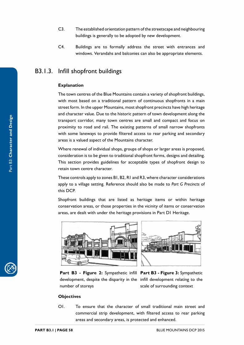
B3.1.3. Infillshopfrontbuildings
Explanation
ThetowncentresoftheBlueMountainscontainavarietyofshopfrontbuildings,withmostbasedona traditionalpatternof continuous shopfronts in amainstreetform.IntheupperMountains,mostshopfrontprecinctshavehighheritageandcharactervalue.Duetothehistoricpatternoftowndevelopmentalongthetransport corridor,many town centres are small and compact and focus onproximity to road and rail.Theexistingpatternsof small narrow shopfrontswithsome lanewaystoprovidefilteredaccesstorearparkingandsecondaryareasisavaluedaspectoftheMountainscharacter.
Whererenewalofindividualshops,groupsofshopsorlargerareasisproposed,considerationistobegiventotraditionalshopfrontforms,designsanddetailing.This section provides guidelines for acceptable types of shopfront design toretaintowncentrecharacter.
ThesecontrolsapplytozonesB1,B2,R1andR3,wherecharacterconsiderationsapplytoavillagesetting.ReferenceshouldalsobemadetoPart G Precincts of thisDCP.
Shopfront buildings that are listed as heritage items or within heritageconservationareas,orthosepropertiesinthevicinityofitemsorconservationareas,aredealtwithundertheheritageprovisionsinPartD1Heritage.
Part B3 - Figure 2: Sympathetic infilldevelopment,despitethedisparityinthenumber of storeys
Part B3 - Figure 3: Sympatheticinfilldevelopment relating to thescale of surrounding context
Objectives
O1. To ensure that the character of small traditional main street andcommercial strip development, with filtered access to rear parkingareasandsecondaryareas,isprotectedandenhanced.

Part
B3:
Cha
ract
er a
nd D
esig
n
PART B3.1 | PAGE 59BLUE MOUNTAINS DCP 2015
O2. To encourage high quality contemporary shopfronts in appropriatelocations and where respect for and sympathy with surroundingdevelopment can be demonstrated.
Controls
C1. Proposals for infill development within the vicinity of significanttraditionalshopfrontbuildingsarerequiredtodemonstrateadequateconsiderationoftheimpactsuponthosetraditionalshopfrontbuildings.
Note: Refer to Part D1.9.7 Traditional shopfront buildings where heritage
considerations apply.
C2. Redevelopmentofsitesonwhichsignificantandcontributorybuildingsarelocatedaretoretainandimprovetheexistingstreetpresentation.
C3. Shopfrontbuildingsaregenerallytocontainthefollowing:
(a) vertically-proportioneddoorsandwindows,and
(b) glazedshopfrontstoallgroundfloorretailareas,and
(c) astallboardbelowtheglazingatleast400mmhigh,and
(d) a recessed and generally splayed entry, and
(e) continuoussuspendedmetalawningsfrontingmainstreets,and
(f) ahighsolidtovoidratioaboveawninglevel,and
(g) parapetsorpedimentsabovetheupperlevel,and
(h) cornicesorcoursinglinesbelowtheparapet.
hamper
awning
french
doors
recessed
entry area
tiled floor
glazed
display
window
stallboard
Part B3 - Figure 4:Traditionalshopfrontelements

Part
B3:
Cha
ract
er a
nd D
esig
n
BLUE MOUNTAINS DCP 2015PART B3.1 | PAGE 60
C4. Buildingsoncornersitesaretoincorporatesplayedcornersandotherelementstoarticulatecorners.Each frontageofacornerbuilding istopresentasamainstreet frontage,withsuspendedmetalawningscontinuingaroundeachcorner.
Part B3 - Figure 5: Traditionalshopfrontaddressingacorner
C5. Balconies,ifprovidedshouldberecessedtominimisethevisualimpactonthestreetscape.
C6. Separate the street address for retail uses from residential andcommercialuseswithineachbuilding.
C7. Whenpitchedroofsareproposed,slopesorpitchesshouldmatchtheexistingpitchedroofsofthearea.
C8. Historicdetailsarenottobeslavishly imitated.RefertoPart B3 - Figure 4.
Part B3 - Figure 6: Simplification of original historic shopfrontdetailingprovidescontextualfitfornewdevelopment.

Part
B3:
Cha
ract
er a
nd D
esig
n
PART B3.1 | PAGE 61BLUE MOUNTAINS DCP 2015
C9. Incorporateliftoverrunsandserviceplantequipmentintothedesignoftheroofandreducetheirvisibility.
C10. Avoidatticwindowsanddormersintheroof.
C11. Highlyreflectivefinishesandcurtainwallglazingarenot likelytobesupportedabovethegroundfloor.
C12. Thefollowingwallmaterialsarepreferred:
(a) brickwithrenderpaintedapalecolour,and
(b) plainglasswindowswithtimberorthinsteel/metalframes,and
(c) timberjoineryandsignage.
C13. Thefollowingmaterialsareincompatiblewiththedesiredcharacteroftowncentres:
(a) largewalltiles,and
(b) fibre-cementsheeting,and
(c) concrete blocks, and
(d) curtainwallsystems,and
(e) reflectiveortintedglass.
C14. Use colour schemes compatible with surroundings structures andavoidcorporatecolourschemes.
B3.1.4. Medium-density residential development
Explanation
Some older lots within the Blue Mountains, mostly close to town centres,may be appropriate for urban renewal in the form of new medium-densitydevelopment.Thesetypesofdevelopmentscanhaveasignificantimpactuponstreetscapeandcharactervalues,andcandeterminethedevelopingcharacterof areas undergoing transition. Proper integration of these types of newdevelopmentintotraditionallylow-densityneighbourhoodsiscriticaltoensurethe streetscape retains coherence and a pleasing and attractive pedestrian-friendly environment. Design issues relating to the scale, forms, roof forms,materials,detailing,coloursandlandscapingconceptaredealtwithinthispart.
ThesecontrolsapplytozonesB1,B2,R1andR3,wherecharacterconsiderationsapply to a village setting.
Part
B3:
Cha
ract
er a
nd D
esig
n
BLUE MOUNTAINS DCP 2015PART B3.1 | PAGE 62
Note: Reference should be made to the additional provisions for medium-density
development in Part F1 Residential Development.
Objectives
O1. To ensure that medium-density residential development adequatelyconsidersthescale,forms,roofforms,materials,detailing,coloursandlandscapingofnewdevelopments.
Controls
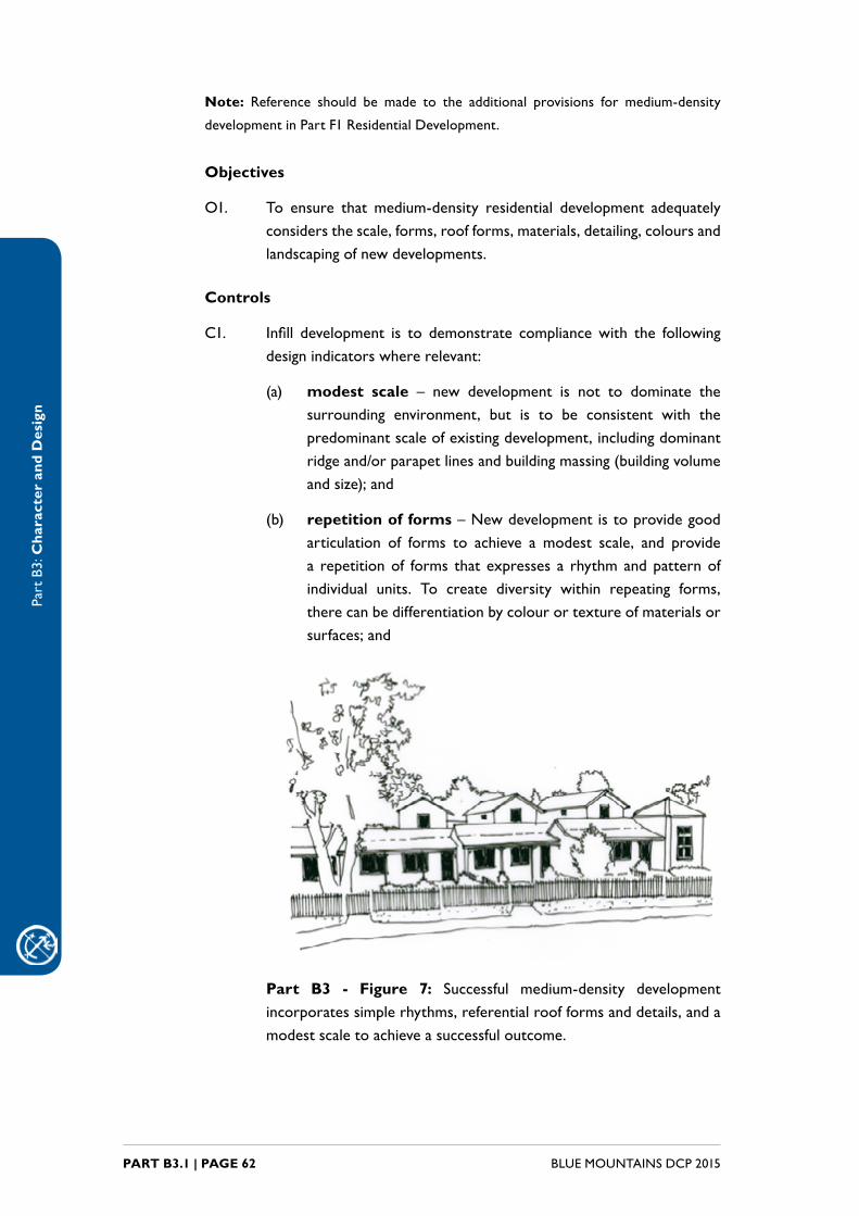
C1. Infill development is to demonstrate compliancewith the followingdesignindicatorswhererelevant:
(a) modest scale – new development is not to dominate thesurrounding environment, but is to be consistent with thepredominant scale of existing development, including dominant ridgeand/orparapetlinesandbuildingmassing(buildingvolumeandsize);and
(b) repetition of forms–Newdevelopmentistoprovidegoodarticulation of forms to achieve a modest scale, and providea repetitionof forms that expresses a rhythmandpatternofindividual units. To create diversity within repeating forms,therecanbedifferentiationbycolourortextureofmaterialsorsurfaces;and
Part B3 - Figure 7: Successful medium-density development incorporatessimplerhythms,referentialroofformsanddetails,andamodestscaletoachieveasuccessfuloutcome.

Part
B3:
Cha
ract
er a
nd D
esig
n
PART B3.1 | PAGE 63BLUE MOUNTAINS DCP 2015
(c) traditional roof forms–newdevelopmentinolderareascanrelate to existing development byusing traditional forms, themost significantbeinggabledand/orhippedroof formswithapitchofapproximately35degrees,andskillionverandahformstothefrontandsideelevations;and
(d) quality materials – new development should whereverpossible be constructed of quality materials, including highqualitydry-pressedbricks,corrugatedmetalroofing,terracottaroof tiles, stone, render and solid timber. The materials andfinishes should relate to the surrounding established context,andbeusedinappropriatelocationsandproportions;and
(e) simple detailing without overt imitation – the use ofverandahswithpostsorpiers,vertically-proportionedwindows,awningstowindows,andarticulated fencingthatfiltersviews;and
(f) traditional colours – colour schemes are to be generallyfromanaturaland/orhistoricpalette,whetherstrongheritagecoloursormutedbushlandtonesasappropriate.Intenseand/orexcessivelybrightcoloursaretobeavoided;and
(g) landscaping – landscaping is to soften the edges of newdevelopment, frame primary elevations and provide visual layers throughthoughtfully-placedplantings.
Part B3 - Figure 8: An original building on a large lot can provide room for medium-density housing development to the rear whilstretainingthecharacteroftheexistingstreetscape.
Part
B3:
Cha
ract
er a
nd D
esig
n
BLUE MOUNTAINS DCP 2015PART B3.1 | PAGE 64
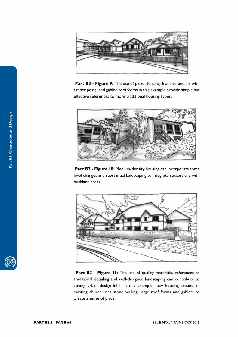
Part B3 - Figure 9:Theuseofpicketfencing,frontverandahswithtimberposts,andgabledroofformsinthisexampleprovidesimplebuteffectivereferencestomoretraditionalhousingtypes.
Part B3 - Figure 10:Medium-densityhousingcanincorporatesomelevelchangesandsubstantiallandscapingtointegratesuccessfullywithbushlandareas.
Part B3 - Figure 11: The use of qualitymaterials, references totraditional detailing andwell-designed landscaping can contribute tostrong urban design infill. In this example, new housing around anexisting church uses stonewalling, large roof forms and gablets tocreate a sense of place.
Part
B3:
Cha
ract
er a
nd D
esig
n
PART B3.2 | PAGE 65BLUE MOUNTAINS DCP 2015
B3.2. Singledwellingdesignconsiderations
Introduction
Highqualitysite-specificandcontextualdesignofindividualsitesunderpinstheprovisionofhighqualitydesirableenvironmentsforliving,workingandenjoyment.Itallowsneighbourhoodstobereadandunderstoodcoherentlyandcreatesasenseofplaceandidentity.Gooddesignenhancesandstrengthenscommunityrelationships, and provides safe and sometimes beautiful environments. Itpreservesthequalitiesoftheenvironmentthatarevaluableandenhancesthosequalities.
Specificsiteplanningandgooddesignwillbuildonthesiteanalysisandincludethe considerations set out below to achieve high-quality buildings that fitharmoniouslywithsurroundingdevelopmentandtheenvironment.
Thispart applies to all newbuildings and significant alterations andadditionstoexistingbuildingswithintheLGA;however,thecontrolsaremostapplicableto free-standing residential dwelling development in the R2 Low DensityResidential,E2EnvironmentalConservation,andE4EnvironmentalLivingzones.
This part also applies to the design of new buildings in a bushland setting,where contextual fit with the natural environment is desirable in order tosympatheticallyintegratenewdevelopmentintoapredominantlybushsetting.This is particularly relevant in the E2 Environmental Conservation and E4EnvironmentalLivingzones.
Considerations of building height and floor space ratio are covered by theprovisionsofLEP2015, and these twovariables, inconjunctionwith the sitecoverageandsetbackrequirementsofPartB2BuildingEnvelopeofthisDCP,canbemanipulatedat thedesignstage toprovideabuildingenvelope that isrespectfultowardssurroundingdevelopmentandisresponsivetositeconditions.
For residential designs, LEP 2015 requires the consideration of residentialcharacter.Clause6.17(Considerationofcharacterandlandscape)ofLEP2015hasobjectivesandcontrolsforresidentialdesigninresidentialandenvironmentalzones.Itrequiresconsiderationofissuessuchasscaleandmassingofbuildings,materials, colours and finishes, building form and design, siting, setting andneighbourhoodamenity.Thissectionexpandsupontheconsiderationofthesematters.
Where a design deviates from the following controls, justification is to beprovidedwith the application to support theproposed changes. ProvisionofsupportingdocumentationwillnotnecessarilyguaranteesupportfromCouncilfortheproposeddeviation.
Note 1: Reference should be made to the additional provisions for low-density
development in Part F1 Residential Development.
Part
B3:
Cha
ract
er a
nd D
esig
n
BLUE MOUNTAINS DCP 2015PART B3.2 | PAGE 66
Note 2: Buildingsthatareheritageitems,withinheritageconservationareasorwithin
Period Housing areas have additional context and character requirements, and are
guidedbytheprovisionsofPartDHeritageManagementofthisDCP.Buildingswithin
specificprecinctsareguidedbytheprovisionsofPartGPrecinctsofthisDCP.
Note 3: Forlandscapingcontrolsandguidelines,refertoPartC3Landscapingofthis
DCP .
B3.2.1. Context considerations
Explanation
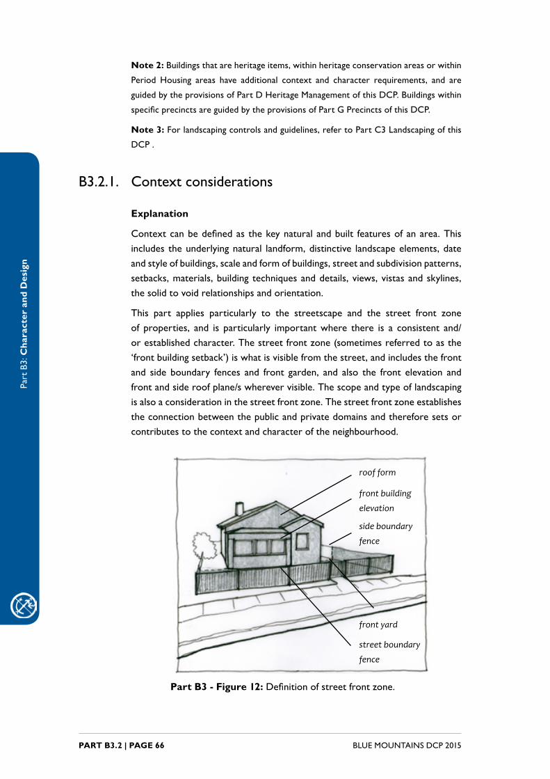
Contextcanbedefinedas thekeynaturalandbuilt featuresofanarea.Thisincludes theunderlyingnatural landform,distinctive landscapeelements,dateand style of buildings, scale and form of buildings, street and subdivision patterns, setbacks,materials,buildingtechniquesanddetails,views,vistasandskylines,thesolidtovoidrelationshipsandorientation.
This part applies particularly to the streetscape and the street front zoneof properties, and is particularly importantwhere there is a consistent and/orestablishedcharacter.Thestreetfrontzone(sometimesreferredtoasthe‘frontbuildingsetback’)iswhatisvisiblefromthestreet,andincludesthefrontand side boundary fences and front garden, and also the front elevation andfrontandsideroofplane/swherevervisible.Thescopeandtypeoflandscapingisalsoaconsiderationinthestreetfrontzone.Thestreetfrontzoneestablishestheconnectionbetweenthepublicandprivatedomainsandthereforesetsorcontributestothecontextandcharacteroftheneighbourhood.
roof form
front building
elevation
side boundary
fence
front yard
street boundary
fence
Part B3 - Figure 12:Definitionofstreetfrontzone.
Part
B3:
Cha
ract
er a
nd D
esig
n
PART B3.2 | PAGE 67BLUE MOUNTAINS DCP 2015
Designconsiderationsapplytoallsites;however,factorssuchasthevisibilityofabuildingfromthestreet,andthebuildingsize,sitingandlotsizeallcontributetotheimpactofabuildingonitscontext.
ThissectionappliestozonesR2,E2andE4,whereconsiderationsapplytoalow-density,mixedcharacterand/orasloping,bushlandsetting.
Objectives
O1. To ensure that new development is responsive and sympathetic tothe surrounding context in scale, massing, orientation, siting, form,construction and materials.
O2. To retain, conserve and enhance the setting and character ofstreetscapes and the contribution of significant natural and culturalfeatures.
O3. To ensure that new development emphasises the street and publicdomain as a vibrant, safe and attractive place for activity and community interaction.
O4. To encourage contemporary architectural expression that is alsosensitivetothenaturalandbuiltsetting.
O5. To respect and reinforce established bushland character throughsensitivedesign,andtopromotecontemporarydesignthathasagoodcontextualfitwithanestablishedbushlandsetting.
Controls
C1. Developmentproposalsaretoidentifylocalcharacterconsiderationsanddemonstratehownewbuildingswillrespondandcontributetothequalityandidentityofthearea.Forsingledwellingsthis informationcanbeincludedinthestatementofenvironmentaleffects.
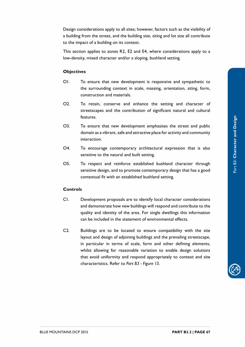
C2. Buildings are to be located to ensure compatibility with the sitelayoutanddesignofadjoiningbuildingsandtheprevailingstreetscape,in particular in terms of scale, form and other defining elements,whilst allowing for reasonable variation to enable design solutionsthatavoiduniformityandrespondappropriately tocontextandsitecharacteristics.RefertoPart B3 - Figure 13.
Part
B3:
Cha
ract
er a
nd D
esig
n
BLUE MOUNTAINS DCP 2015PART B3.2 | PAGE 68
Part B3 - Figure 13:Contextualfitwithinanexistingstreetscape.
C3. Newdevelopmentistominimisevisualimpactsuponbushlandsettings,includingscenicdrives, theBlueMountainsNationalParkandothersignificantelementsthroughtheuseofdesign,coloursandmaterialswhichpreserveimportantnaturalandculturalsettings.
C4. Newdevelopmentistoprovidelegibility,bycreatingplacesandspacesthat can be easily and positively remembered by people. This canincludethecreationofarchitecturalelements,paths,andlandscapingthathaveadistinctiveness.Thoseelementsaretocontributetotheoverallimpressionoftheurbanenvironment.
C5. Buildingsaretoformallyaddressthestreet,streetcorners,parksandopen spaces and shared driveways through the visually harmoniousplacementofwindows,doors,verandahs,porchesandorentryareasto improve streetscape, access and passive surveillance.
B3.2.2. Siting and site design
Explanation
Sitingisthelocationandorientationofthebuilding.Appropriatesitingwilltakeinto account factors both internal and external to the site: the specific siteconstraintsandopportunities,andtherelationshipofthebuildingtosurroundingbuildings and building patterns.
Sloping land iscommon intheBlueMountains,withsteeplysloping landof1in5orhigherusuallyseverelyconstrained,withsiteaccessproblems,erosionpotential,firehazards,winds,developmentvisibility,sitedisturbanceandcostsgreatly increased.
Thedesigncontrolsbelowrequireadequateconsiderationofsomeofthebasicdesignissuesrelatedtositingofstructures,andcompatibilitywiththeclausesofLEP2015identifiedinthenotebelow.

Part
B3:
Cha
ract
er a
nd D
esig
n
PART B3.2 | PAGE 69BLUE MOUNTAINS DCP 2015
ThissectionappliestozonesR2,E2andE4,whereconsiderationsapplytoalow-density,mixedcharacterand/orasloping,bushlandsetting.
Note 1: Properties that are considered slope constrained, at risk of landslide, or
proposals thatrequireearthworkswillneedtoconsiderclauses6.4 (Protectedarea
–slopeconstraintarea),6.5(Protectedarea–landsliderisk)and6.14(Earthworks)of
LEP2015.Theseclausesseektoidentifyandprotectareaswheretopographyandslope
make development unsuitable. Properties affected by thismapping can be identified
throughtheLEP2015maps.
Note 2:Forlandscapingcontrolsandguidelines,refertoPartC3Landscapingofthis
DCP.
Objectives
O1. Toensurethatbuildingsaresitedtofitharmoniouslywiththeexistingtopographyandtominimisevisualimpactsuponnaturalsettings.
O2. To ensure that the siting of buildings considers significant siteconstraintssuchasslope,andminimisessitedisturbance.
O3. Toensurethatthesitingofbuildingsavoidsovershadowingofadjoiningbuildingsandthatadverseimpactstothesolaraccesstolivingareasandprivateopenspaceofadjoiningbuildingsareminimised.
Note: Amenity of residential building is covered in detail in Part F1 Residential
DevelopmentofthisDCP.
Controls
C1. Developmentsitinganddesignistorespectandenhancethenaturallandscapeattributesthatcontributetothecharacteranddistinctsenseofplaceofthestreetscapeandneighbourhood,including:
(a) prominence of ridgelines, and
(b) landmarks, and
(c) topography,and
(d) views,vistasandoutlooks,and
(e) waterways,and
(f) vegetation.
C2. Buildings,particularlyinbushlandsettings,aretobelocatedtominimiseadversephysicalandvisualimpactsonthesite.

Part
B3:
Cha
ract
er a
nd D
esig
n
BLUE MOUNTAINS DCP 2015PART B3.2 | PAGE 70
Slope controls
C3. Developmentisencouragedtofollowtheslopeofthesiteandreducetheneedforsignificantcutandfillthroughsplitleveldesign.
Part B3 - Figure 14:Designonslopingsites is torespond to thetopography.
C4. Developmentonlandsteeperthan1in5istousesplitleveldesignandraisedfloorconstructionwithaprotectedunderfloorwherepossible.
C5. Slabongroundconstructionisnottobeusedonslopessteeperthan1in10.Split-levelslabongroundconstructionmaybeacceptablewhereslabsfollowgroundlevels.
Site disturbance controls
C6. Buildings are to be sited and designed to keep site disturbance to a minimum.This includes changes in natural ground level, removal ofnaturaltopographicalfeaturesandvegetationanddisruptionofnaturalwaterrun-off.
C7. Cutandfillistobeminimisedasfaraspossibleandbecontainedwithinthebuildingfootprintwhereconditionsallow.Cutandfillisgenerallytobelimitedtoamaximumof1minheightanddepthunlesscontainedwithinorretainedbythewallsofthebuilding footprint,particularlywherethereispotentialforadverseenvironmentalimpactsorimpactsuponadjoiningproperties.
C8. Roadsandpathsaretofollowthelandformwherepossible.

Part
B3:
Cha
ract
er a
nd D
esig
n
PART B3.2 | PAGE 71BLUE MOUNTAINS DCP 2015
B3.2.3. Building scale, forms and articulation
Explanation
Thescaleofabuildingisitsrelativesizecomparedtootherelementssuchasthestreet,surroundingbuildingsandthehumanscale.Abuildinghasanoverallscale,andcanalsoincorporateelementsthatgiveadeliberateperceptionofscale,inordertoreduceperceptionofheightandbulkandtorelatetothehumanscale.
Formincludestheoverallshape,volumeandarrangementofitsparts.Theformofthebuildingwilldictatetoalargedegreethepresentationandappearanceofthebuildingfromthestreet,aswellastheabilitytointegratewithsurroundingdevelopment.Form,alongwithappropriatescale,isamajordeterminantofhighqualitydesignandtheprotectionandenhancementofstreetscapequalities.
Residentialbuildingsaregenerallyincreasinginsize,andthedesireforamenityand facilities is expanding. These factors are creating a slow but inexorablechangeinthecharacter,constructionandsizeofnewresidentialbuildings.
ThissectionappliestozonesR2,E2andE4,whereconsiderationsapplytoalow-density,mixedcharacterand/orasloping,bushlandsetting.
Objectives
O1. Toensurethatbuilding formsprovideapresentationappropriatetothesurroundingneighbourhoodandimmediateneighboursintermsofvisual appearance and amenity.
O2. Toensurethatnewformspreserveandenhancesitecharacteristics,siteconstraintsandneighbourhoodamenity.
O3. Toensurethatbuilding formsprovide forqualitydesignofbuildingsand quality external and internal spaces.
O4. Toensurethatnewbuildingformsallowedundermaximumfloorspaceratioandbuildingheightcontrolsdonotinhibitproperconsiderationofotherrelevantobjectivesandcontrols.
Controls
C1. Provideanappropriatebulkandscaletosuitthescaleofthestreetand the surrounding buildings. Building design should recognise thepredominantscale(height,bulk,densityetc.)ofthesettingandrespondsympathetically.Theimpactofaninappropriatelyscaledbuildingcannotbe compensated for by building form, design or detailing.
Part
B3:
Cha
ract
er a
nd D
esig
n
BLUE MOUNTAINS DCP 2015PART B3.2 | PAGE 72
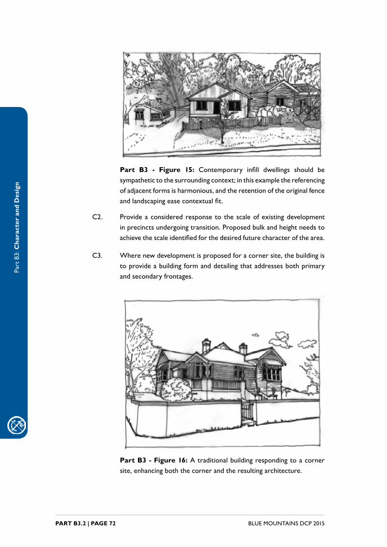
Part B3 - Figure 15: Contemporary infill dwellings should besympathetictothesurroundingcontext;inthisexamplethereferencingofadjacentformsisharmonious,andtheretentionoftheoriginalfenceandlandscapingeasecontextualfit.
C2. Provideaconsideredresponse to thescaleofexistingdevelopmentinprecinctsundergoingtransition.Proposedbulkandheightneedstoachievethescaleidentifiedforthedesiredfuturecharacterofthearea.
C3. Wherenewdevelopmentisproposedforacornersite,thebuildingistoprovideabuildingformanddetailingthataddressesbothprimaryand secondary frontages.
Part B3 - Figure 16: A traditional building responding to a corner site,enhancingboththecornerandtheresultingarchitecture.

Part
B3:
Cha
ract
er a
nd D
esig
n
PART B3.2 | PAGE 73BLUE MOUNTAINS DCP 2015
C4. Development is to retain the detached dwelling character of lotsthroughfilteredviewsdownsideboundariesinlow-densityresidentialareas.
Building articulation
C5. Designistoseekafine-grainedandarticulatedarchitecturalexpression.Excessively long roof forms, roof ridges, and unbroken unarticulated wallsaretobeeliminated.Floorplansaretobearticulatedsuchthatanywallorroofplaneisnottobelongerthan15metreswithoutbeingarticulatedbytheintersectionofotherformsand/ordetails.
Alterations and additions
C6. Additionstoanexistingbuildingaregenerallytobe:
(a) locatedtotherearorsideoftheexistingbuildingwhenviewedfromthestreetfrontzone,and
(b) notvisibleovertheroofridgeoftheprimarybuilding,and
(c) compatiblewiththeexistingbuildinginregardstobulkandscale,roof forms and materials.
average eye height from the opposite side of the street preferred
height of additions
maximum height of additions
existing line of site
main existing roof ridgeline
Part B3 - Figure 17: Acceptable envelope for rear alterations and additions.
B3.2.4. Roof forms
Explanation
Roof formsvarywith the layoutof thebuilding. The layoutof thebuilding’sinteriorandexternalwallsdeterminetheultimateformoftheroof;theinterior,walls,floorlevels,openingsandroofmustfunctionharmoniouslytocreatethemost functional and pleasing internal and external forms.
ThissectionappliestozonesR2,E2andE4,whereconsiderationsapplytoalow-density,mixedcharacterand/orasloping,bushlandsetting.

Part
B3:
Cha
ract
er a
nd D
esig
n
BLUE MOUNTAINS DCP 2015PART B3.2 | PAGE 74
Objectives
O1. Toensurethatthedesignofroofformsmaximisesthepotential forfunctional internal layouts and building envelopes.
O2. To ensure that the design of roof forms is compatible with thesurroundingstreetscapewheredesirable.
O3. Toensurethatroofdesignsinbushlandsettingsarecompatiblewithslopingtopography.
Controls
C1. Roof formsshouldcomplement thebuildingenvelope,providegoodfunctionalityandpresentwelltothestreet.
Part B3 - Figure 18: Atypical roof forms in the BlueMountains:singleskillionroofs,flatroofsandcurvedroofs.

Part
B3:
Cha
ract
er a
nd D
esig
n
PART B3.2 | PAGE 75BLUE MOUNTAINS DCP 2015
C2. Inbushlandsettings,rooflinesshouldfollowslopesandbebelowtheestablishedtreecanopywhereverpossible.
C3. Proposalswithearth-coveredroofswillrequirespecialistinformationtobesubmittedforassessmentandwillbeconsideredonmerit.
B3.2.5. Materials,details,finishesandcolours
Explanation
Awidevarietyofbuildingmaterials,detailsandtechniquesareusedintheBlueMountains, particularly in low-density residential zones associatedwith latersubdivisions.Accompanyingthesematerials,detailsandtechniquesisabuildingstockofsimilardiversityinage,sizeandstyle.Thisiscommensuratewiththeongoing redevelopment of older properties and the expanding developmentpressuresfromtheSydneyplains.Buildingstyleoptionsareappliedtobuildinglayouts to reproduce a vast array of historic styles and contemporary takesonthosestyles.ThisdiversityisexpectedtocontinueoutsideofheritageandPeriod Housing areas.
Contemporarydesigns,materialsandtechniquesarealsoapparentwithinthehousing stock. There is an increasing interest and importance placed uponsustainability, and this has affected the procurement of new materials andrecycling of old building materials. Sustainable forestry practices, reduction in theuseoftoxicchemicals,andthereuseofsalvagedbuildingmaterialsareallpracticesthatpositivelycontributetosustainability.
ThissectionappliestozonesR2,E2andE4,whereconsiderationsapplytoalow-density,mixedcharacterand/orasloping,bushlandsetting.
Objectives
O1. To encourage choice of materials, details and finishes that aresympathetictoandharmoniouswiththeexistingcontext.
O2. Toencouragequalitycontemporarydesignthroughsimpledetailingofbuildings.
O3. Toencourageapplicantstoconsiderthenatureofthebuildingmaterials,theflowsofenergy,andmaterialsrequiredforthelifeoftheproject.
O4. Toensurethatintheconsiderationofdevelopmentproposals,adequateconsiderationisgiventothelifecyclecostsofthematerialsbeingused,theultimatedispositionofthesiteandthematerials,andwaysinwhichtheseenvironmentalimpactscanbereducedormitigated.
Part
B3:
Cha
ract
er a
nd D
esig
n
BLUE MOUNTAINS DCP 2015PART B3.2 | PAGE 76
Controls
C1. Materials and details are to be a pleasing and balanced composition of buildingelements,textures,materialsandcoloursandreflecttheuse,internaldesignandstructureofthedevelopment.
C2. The use of off-the-shelf or distinctive historic decorative featuresappliedtonewbuildingsisdiscouraged.
C3. Inbushlandsettings,buildingmaterials,finishesandexternalcoloursaretousenaturalmutedearthtonesoflowreflectivequalitytoblendinwithbushland.Coloursincludeochres,browns,olives,andgreys.
C4. Façadesorroofsarenottoincorporatelargeareasofhighlyreflectivematerials.
C5. Avoid expanses of any single material.
C6. Theuseofrecyclableandreusablematerialsistobeencouragedandmaximisedwheneverpossible.
C7. Building applicationsusing strawbales,mudbrick, recycled shippingcontainersandotheralternativebuildingmaterialsandtechniqueswilllikely require specialist information to be submitted for assessment andwillbeconsideredonmeritandsitesuitability.