continuing the geography journey - squarespace · show care and concern for living things and the...
TRANSCRIPT
Geography Journey Continuing the
All Saints C of E Primary School
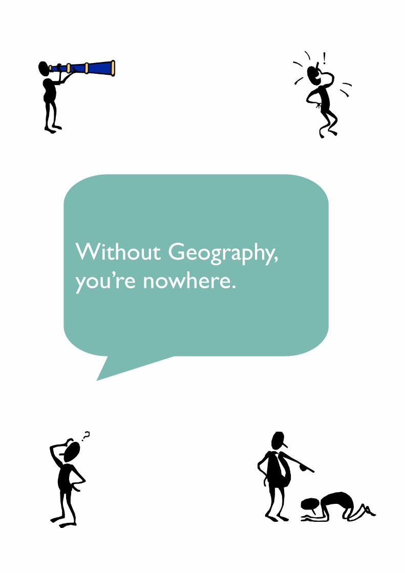
Without Geography,
you’re nowhere.
Geography
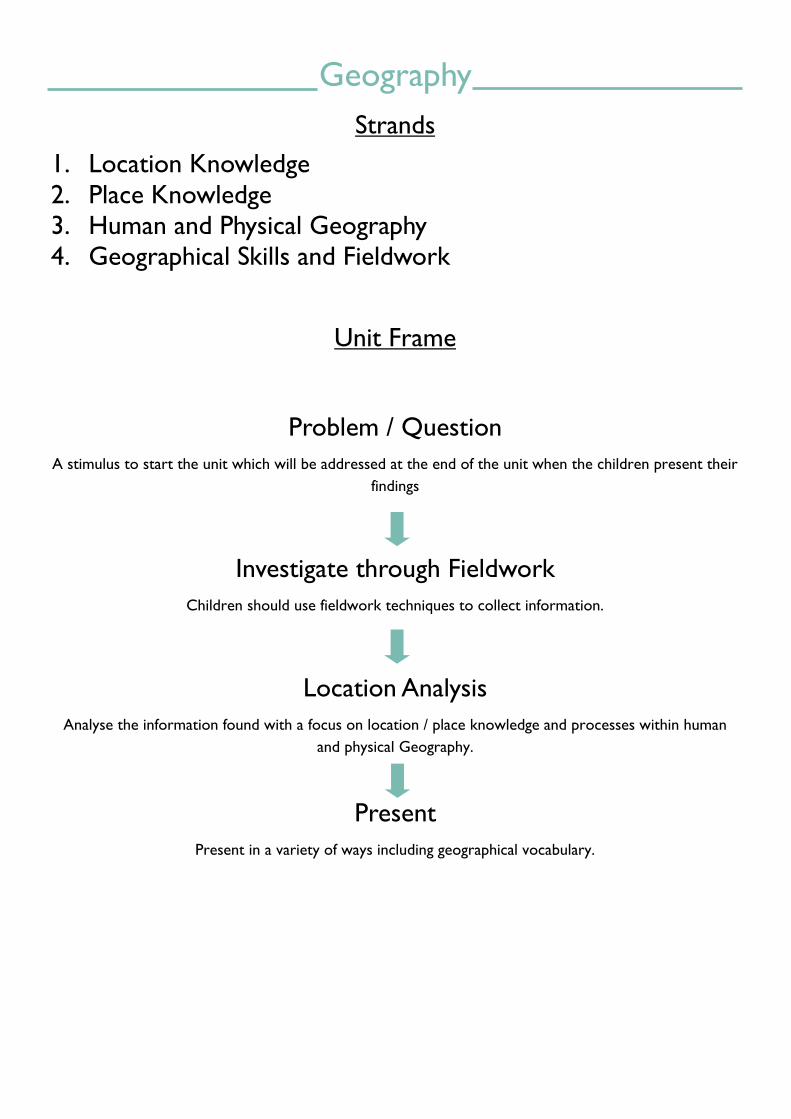
Strands
1. Location Knowledge
2. Place Knowledge
3. Human and Physical Geography
4. Geographical Skills and Fieldwork
Unit Frame
Problem / Question
A stimulus to start the unit which will be addressed at the end of the unit when the children present their
findings
Investigate through Fieldwork
Children should use fieldwork techniques to collect information.
Location Analysis
Analyse the information found with a focus on location / place knowledge and processes within human
and physical Geography.
Present
Present in a variety of ways including geographical vocabulary.
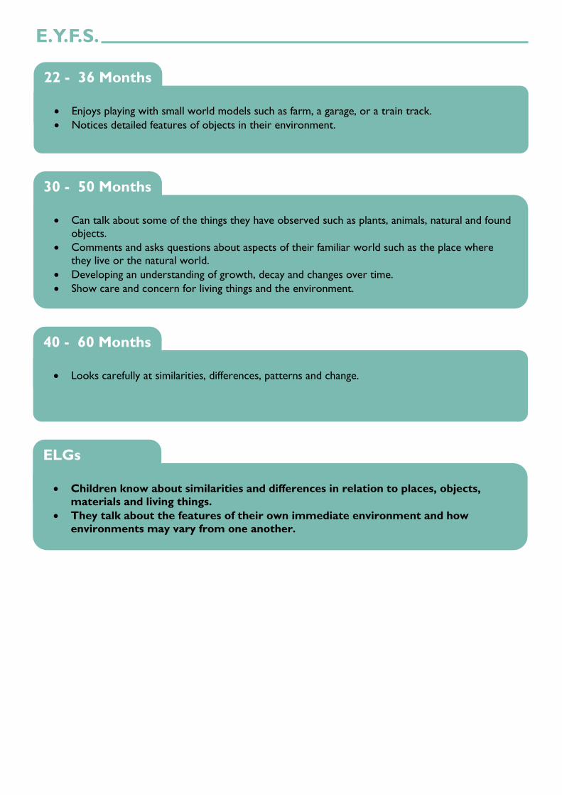
E.Y.F.S.
Enjoys playing with small world models such as farm, a garage, or a train track.
Notices detailed features of objects in their environment.
22 - 36 Months
Can talk about some of the things they have observed such as plants, animals, natural and found
objects.
Comments and asks questions about aspects of their familiar world such as the place where
they live or the natural world.
Developing an understanding of growth, decay and changes over time.
Show care and concern for living things and the environment.
30 - 50 Months
Looks carefully at similarities, differences, patterns and change.
40 - 60 Months
Children know about similarities and differences in relation to places, objects,
materials and living things.
They talk about the features of their own immediate environment and how
environments may vary from one another.
ELGs

P Levels
Pupils consolidate a sense of place and direction [for example, they can follow set routes around
familiar places].
They show their awareness (through gestures, signs, symbols or words) of significant differences between specific physical/natural and human/made features of places [for example,
‘cars here’ on a noisy street, ‘cars gone’ in the park].
They can answer simple questions about places and people [for example, ‘Who can help us?’]
They start to sort and classify objects in terms of simple features or properties [for example,
pebbles or rocks found on a local walk, according to colour or size].
P5
Pupils understand the differences between the physical/natural and human/made features of places.
They use pictures or symbols to show familiar places and what they are for, such as making
simple plans and maps of familiar areas.
They use pictures or symbols to show familiar places and what they are for, such as making
simple plans and maps of familiar areas.
P6
Pupils communicate their preferences about the physical/natural and human/made features of
places.
They begin to use symbols to represent direction, and can represent and record key features of a place using models or symbols.
They are aware of their role in caring for their own environment [for example, watering plants
in the classroom or garden, picking up litter].
P7
Pupils recognise the physical/natural and human / made features of places [for example, identifying
buildings and their uses].
They use simple geographical language to communicate their ideas about various locations, functions and roles.
They use resources given to them and their own observations to respond to simple questions
about places and people.
They recognise simple symbols or representations on maps and plans.
They show some understanding of environmental awareness and how it relates to
their own lives and they express their views on features of the environment which they find
attractive or unattractive.
P8

Location Knowledge
Name, locate and identify significant features of the local area.
Name, locate and identify characteristics of the four countries and capital cities of the UK and
its surrounding seas.
Name and locate the world’s seven continents and five oceans.
YEARS 1 & 2
Name and locate counties and cities of the UK.
Name and identify, geographical regions in the UK and know:
their identifying human and physical characteristics;
key topographical features (including hills, mountains, coasts and rivers);
land use patterns.
Understand how some of the above aspects have changed over time.
YEARS 3 & 4

P.S.H.E. LANGUAGE MATHEMATICS RESOURCE
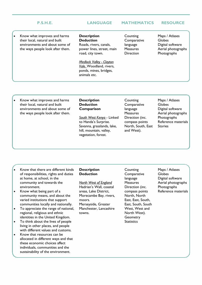
Know what improves and harms
their local, natural and built
environments and about some of
the ways people look after them.
Description
Newton Heath and
features inc. houses,
church, shops, canal, road,
school, bridge, park etc.
Manchester and features
inc. rivers, canals, railways,
stadiums, shops, parks,
museums, theatres etc.
England, Scotland, Wales,
Northern Ireland.
London, Edinburgh,
Cardiff, Belfast.
Country
English Channel, North
Sea, Irish Sea, Atlantic
Ocean.
Africa, Antarctica, Asia,
Australia, Europe, North
America, South America.
Pacific Ocean, Atlantic
Ocean, Indian Ocean,
Arctic Ocean, Southern
Ocean.
Counting
Comparative
language
Measures
Direction (inc.
compass points
North, South, East
and West).
Maps / Atlases
Globes
Digital software
Aerial photographs
Photographs
Know that there are different kinds
of responsibilities, rights and duties
at home, at school, in the
community and towards the
environment.
Know what being part of a
community means, and about the
varied institutions that support
communities locally and nationally.
To appreciate the range of national,
regional, religious and ethnic
identities in the United Kingdom.
To think about the lives of people
living in other places, and people
with different values and customs.
Know that resources can be
allocated in different ways and that
these economic choices affect
individuals, communities and the
sustainability of the environment.
Description
Comparison
Scotland - Cairngorms,
Edinburgh, Glasgow.
Northern Ireland
Belfast, Giants Causeway.
Northern England -
Northumberland,
Tyneside, Lake District,
Yorkshire Dales, Greater
Manchester, Liverpool,
West Yorkshire.
Midlands - Peak District,
West Midlands.
Wales - Snowdonia ,
Pembrokeshire Coast,
Cardiff.
Southern England - Bristol,
Norfolk Broads, Greater
London, Dartmoor, New
Forest, Dorset Coast.
Terms e.g. Coast, sand
dune, headland, bay, cliff,
channel, estuary, gorge,
peak, summit, valley.
Counting
Comparative
language
Measures
Direction (inc.
compass points
North, North
East, East, South,
East, South, South
West, West and
North West).
Geometry
Statistics
Maps / Atlases
Globes
Digital software
Aerial photographs
Photographs
Reference materials

Identify the position and significance of:
latitude and longitude;
Equator, Tropic of Cancer and Tropic of Capricorn;
Northern and Southern Hemisphere;
Arctic and Antarctic Circles;
Prime/Greenwich Meridian and time zones (inc. day and night).
YEARS 5 & 6
Location Knowledge
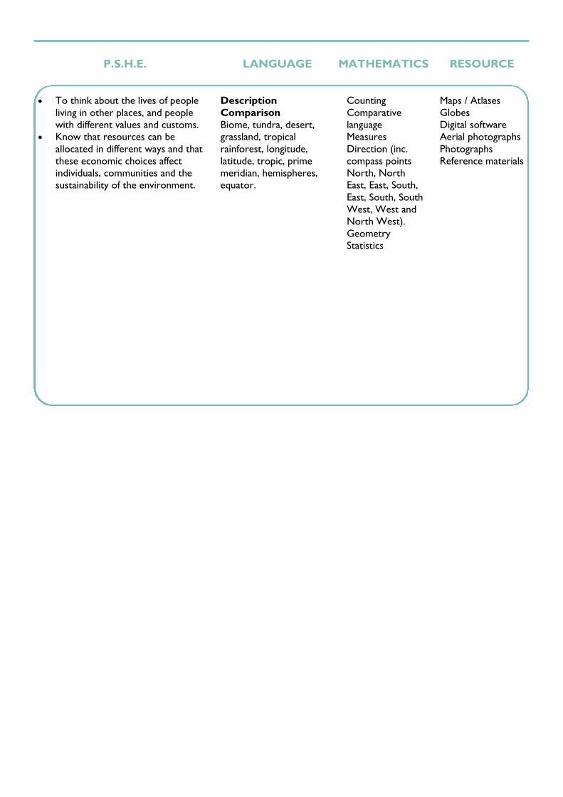
P.S.H.E. LANGUAGE MATHEMATICS RESOURCE
To think about the lives of people
living in other places, and people
with different values and customs.
Know that resources can be
allocated in different ways and that
these economic choices affect
individuals, communities and the
sustainability of the environment.
Description
Comparison
Biome, tundra, desert,
grassland, tropical
rainforest, longitude,
latitude, tropic, prime
meridian, hemispheres,
equator.
Counting
Comparative
language
Measures
Direction (inc.
compass points
North, North
East, East, South,
East, South, South
West, West and
North West).
Geometry
Statistics
Maps / Atlases
Globes
Digital software
Aerial photographs
Photographs
Reference materials

Place Knowledge
Understand a small area of the UK and know:
The physical features it has.
The difference people have made to it.
YEAR 1
Understand a small area of non-European country and know:
The key physical features.
The difference people have made to it.
Similarities/differences to a place studied in the UK.
YEAR 2
Study the human and physical geography of a region of the UK.
YEAR 3
P.S.H.E. LANGUAGE MATHEMATICS RESOURCE
Know what improves and harms
their local, natural and built
environments and about some of
the ways people look after them.
Description
Deduction
Roads, rivers, canals,
power lines, street, main
road, city town.
Medlock Valley - Clayton
Vale. Woodland, rivers,
ponds, mines, bridges,
animals etc.
Counting
Comparative
language
Measures
Direction
Maps / Atlases
Globes
Digital software
Aerial photographs
Photographs
Know what improves and harms
their local, natural and built
environments and about some of
the ways people look after them.
Description
Deduction
Comparison
South West Kenya - Linked
to Handa’s Surprise.
Savanna, grasslands, lake,
hill, mountain, valley,
vegetation, forest.
Counting
Comparative
language
Measures
Direction (inc.
compass points
North, South, East
and West).
Maps / Atlases
Globes
Digital software
Aerial photographs
Photographs
Reference materials
Stories
Know that there are different kinds
of responsibilities, rights and duties
at home, at school, in the
community and towards the
environment.
Know what being part of a
community means, and about the
varied institutions that support
communities locally and nationally.
To appreciate the range of national,
regional, religious and ethnic
identities in the United Kingdom.
To think about the lives of people
living in other places, and people
with different values and customs.
Know that resources can be
allocated in different ways and that
these economic choices affect
individuals, communities and the
sustainability of the environment.
Description
Deduction
North West of England
Hadrian’s Wall, coastal
areas, Lake District,
Morecambe Bay, rivers,
moors.
Merseyside, Greater
Manchester, Lancashire
towns.
Counting
Comparative
language
Measures
Direction (inc.
compass points
North, North
East, East, South,
East, South, South
West, West and
North West).
Geometry
Statistics
Maps / Atlases
Globes
Digital software
Aerial photographs
Photographs
Reference materials

Place Knowledge
Study the human and physical geography of a region of a European country.
Recognise the similarities/differences with a region in the UK.
YEAR 4
Study the human and physical geography of a region of North America.
Compare the North American region to those in a European region and the UK.
YEAR 5

P.S.H.E. LANGUAGE MATHEMATICS RESOURCE
Know that there are different kinds
of responsibilities, rights and duties
at home, at school, in the
community and towards the
environment.
Know what being part of a
community means, and about the
varied institutions that support
communities locally and nationally.
To think about the lives of people
living in other places, and people
with different values and customs.
Know that resources can be
allocated in different ways and that
these economic choices affect
individuals, communities and the
sustainability of the environment.
Description
Comparison
Sicily, Italy
Mount Etna, Strait of
Messina, Aeolian Islands,
coastal areas, Nebrodi
Mountains Regional Park,
rivers, agricultural lands,
Palermo, Catania, Messina,
Taormina (including
Roman legacy).
Erosion, deposition,
transportation.
Compared with Y3 UK
region.
Counting
Comparative
language
Measures
Direction (inc.
compass points
North, North
East, East, South,
East, South, South
West, West and
North West).
Geometry
Statistics
Maps / Atlases
Globes
Digital software
Aerial photographs
Photographs
Reference materials
Know that there are different kinds
of responsibilities, rights and duties
at home, at school, in the
community and towards the
environment.
Know what being part of a
community means, and about the
varied institutions that support
communities locally and nationally.
To think about the lives of people
living in other places, and people
with different values and customs.
Know that resources can be
allocated in different ways and that
these economic choices affect
individuals, communities and the
sustainability of the environment.
Comparison
Opinion
Arizona and Nevada USA
Grand Canyon, Mojave
Desert, Lake Tahoe,
Colorado River,
Monument Valley, Meteor
Crater.
Las Vegas, Indian
Reservations, Phoenix.
Trade link, ethical.
Compare with Y3 UK
region and Y4 European
region.
Counting
Comparative
language
Measures
Direction (inc.
compass points
North, North
East, East, South,
East, South, South
West, West and
North West).
Geometry
Statistics
Maps / Atlases
Globes
Digital software
Aerial photographs
Photographs
Reference materials

Place Knowledge
Study the human and physical geography of a region of South America.
Compare the South American region to those in North America, a European region and a
region in the UK.
YEAR 6

P.S.H.E. LANGUAGE MATHEMATICS RESOURCE
Know that there are different kinds
of responsibilities, rights and duties
at home, at school, in the
community and towards the
environment.
Know what being part of a
community means, and about the
varied institutions that support
communities locally and nationally.
To think about the lives of people
living in other places, and people
with different values and customs.
Know that resources can be
allocated in different ways and that
these economic choices affect
individuals, communities and the
sustainability of the environment.
Comparison
Opinion
Hypothesis
Evaluation
Andes, Peru
Andes mountain range,
Amazon rainforest, Manu
National Park,
Lima, Machu Picchu,
Cusco.
Natural disaster,
population, tourist,
landmarks.
Compared with Y5 North
America region, Y4
European region and Y3
UK region.
Counting
Comparative
language
Measures
Direction (inc.
compass points
North, North
East, East, South,
East, South, South
West, West and
North West).
Geometry
Statistics
Maps / Atlases
Globes
Digital software
Aerial photographs
Photographs
Reference materials

Human and Physical Geography
Identify seasonal and daily weather patterns in the UK.
Use geographical vocabulary to refer to: beach, cliff, coast, forest, hill, mountain and sea.
Describe the human features of an area including: factory, farm, house, office, port, harbour
and shop.
YEAR 1
Identify the location of hot and cold areas of the world in relation to the Equator and the
North and South Poles.
Use geographical vocab to refer to: ocean, river, soil, valley, vegetation, season and weather.
Describe the human features of an area including: city, town and village.
YEAR 2
Describe and understand the key features of a climate zone.
Describe and understand the key features of a mountain.
Understand the distribution of natural resources within the UK, including: energy, food,
minerals and water.
YEAR 3
Describe and understand the key features of a river.
Describe and understand the key features of a volcano.
Understand the distribution of natural resources within Europe, including: energy, food,
minerals and water.
Understand the important trade links with Europe.
YEAR 4
P.S.H.E. LANGUAGE MATHEMATICS RESOURCE
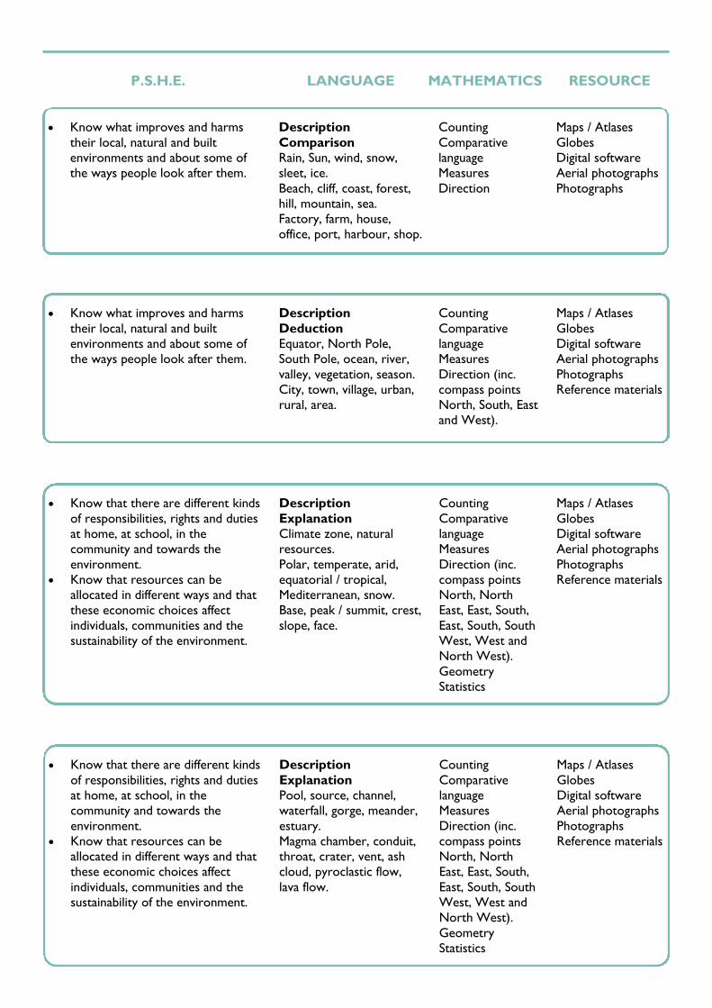
Know what improves and harms
their local, natural and built
environments and about some of
the ways people look after them.
Description
Comparison
Rain, Sun, wind, snow,
sleet, ice.
Beach, cliff, coast, forest,
hill, mountain, sea.
Factory, farm, house,
office, port, harbour, shop.
Counting
Comparative
language
Measures
Direction
Maps / Atlases
Globes
Digital software
Aerial photographs
Photographs
Know what improves and harms
their local, natural and built
environments and about some of
the ways people look after them.
Description
Deduction
Equator, North Pole,
South Pole, ocean, river,
valley, vegetation, season.
City, town, village, urban,
rural, area.
Counting
Comparative
language
Measures
Direction (inc.
compass points
North, South, East
and West).
Maps / Atlases
Globes
Digital software
Aerial photographs
Photographs
Reference materials
Know that there are different kinds
of responsibilities, rights and duties
at home, at school, in the
community and towards the
environment.
Know that resources can be
allocated in different ways and that
these economic choices affect
individuals, communities and the
sustainability of the environment.
Description
Explanation
Climate zone, natural
resources.
Polar, temperate, arid,
equatorial / tropical,
Mediterranean, snow.
Base, peak / summit, crest,
slope, face.
Counting
Comparative
language
Measures
Direction (inc.
compass points
North, North
East, East, South,
East, South, South
West, West and
North West).
Geometry
Statistics
Maps / Atlases
Globes
Digital software
Aerial photographs
Photographs
Reference materials
Know that there are different kinds
of responsibilities, rights and duties
at home, at school, in the
community and towards the
environment.
Know that resources can be
allocated in different ways and that
these economic choices affect
individuals, communities and the
sustainability of the environment.
Description
Explanation
Pool, source, channel,
waterfall, gorge, meander,
estuary.
Magma chamber, conduit,
throat, crater, vent, ash
cloud, pyroclastic flow,
lava flow.
Counting
Comparative
language
Measures
Direction (inc.
compass points
North, North
East, East, South,
East, South, South
West, West and
North West).
Geometry
Statistics
Maps / Atlases
Globes
Digital software
Aerial photographs
Photographs
Reference materials

Human and Physical Geography
Describe and understand the key features of a biome.
Describe and understand the key features of an earthquake.
Understand the distribution of natural resources within North America, including: energy, food,
minerals and water.
Understand the important trade links with North America.
YEAR 5
Describe and understand the key features of a vegetation belt.
Describe and understand the key features of the water cycle.
Understand the distribution of natural resources within South America, including: energy, food,
minerals and water.
Understand the important trade links with South America.
YEAR 6

P.S.H.E. LANGUAGE MATHEMATICS RESOURCE
Know that there are different kinds
of responsibilities, rights and duties
at home, at school, in the
community and towards the
environment.
Know that resources can be
allocated in different ways and that
these economic choices affect
individuals, communities and the
sustainability of the environment.
Description
Explanation
Desert, rainforest, climate,
ice sheet, forest.
Tectonic plates, faults,
plate boundaries,
convergent, divergent,
strike-slip, epicentre,
tremors, magnitude.
Counting
Comparative
language
Measures
Direction (inc.
compass points
North, North
East, East, South,
East, South, South
West, West and
North West).
Geometry
Statistics
Maps / Atlases
Globes
Digital software
Aerial photographs
Photographs
Reference materials
Know that there are different kinds
of responsibilities, rights and duties
at home, at school, in the
community and towards the
environment.
Know that resources can be
allocated in different ways and that
these economic choices affect
individuals, communities and the
sustainability of the environment.
Description
Explanation
Comparison
Tropical rainforest,
deciduous forest,
evergreen forest,
temperate grassland,
tropical grasslands
(savanna), arctic tundra,
alpine tundra, desert
(including Antarctic
Desert), ice sheet.
Evaporation, condensation,
precipitation,
transpiration, purification,
runoff (surface and
underground.
Counting
Comparative
language
Measures
Direction (inc.
compass points
North, North
East, East, South,
East, South, South
West, West and
North West).
Geometry
Statistics
Maps / Atlases
Globes
Digital software
Aerial photographs
Photographs
Reference materials
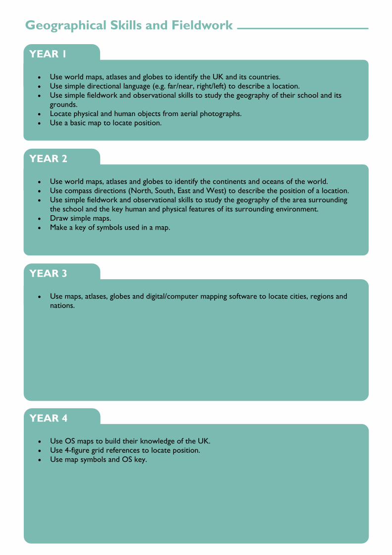
Geographical Skills and Fieldwork
Use world maps, atlases and globes to identify the UK and its countries.
Use simple directional language (e.g. far/near, right/left) to describe a location.
Use simple fieldwork and observational skills to study the geography of their school and its
grounds.
Locate physical and human objects from aerial photographs.
Use a basic map to locate position.
YEAR 1
Use world maps, atlases and globes to identify the continents and oceans of the world.
Use compass directions (North, South, East and West) to describe the position of a location.
Use simple fieldwork and observational skills to study the geography of the area surrounding
the school and the key human and physical features of its surrounding environment.
Draw simple maps.
Make a key of symbols used in a map.
YEAR 2
Use maps, atlases, globes and digital/computer mapping software to locate cities, regions and
nations.
YEAR 3
Use OS maps to build their knowledge of the UK.
Use 4-figure grid references to locate position.
Use map symbols and OS key.
YEAR 4

P.S.H.E. LANGUAGE MATHEMATICS RESOURCE
Know what improves and harms
their local, natural and built
environments and about some of
the ways people look after them.
Description
Map, atlas, globe.
Right, left, far, near.
Position / location.
Label, aerial photograph.
Counting
Comparative
language
Measures
Direction
Maps / Atlases
Globes
Digital software
Aerial photographs
Photographs
Cameras / iPads
Know what improves and harms
their local, natural and built
environments and about some of
the ways people look after them.
Description
North America, South
America, Europe, Asia,
Africa, Australia,
Antarctica.
Map, feature, key.
Counting
Comparative
language
Measures
Direction (inc.
compass points
North, South, East
and West).
Maps / Atlases
Globes
Digital software
Aerial photographs
Photographs
Compass
Measuring
equipment
Cameras / iPads
Know what being part of a
community means, and about the
varied institutions that support
communities locally and nationally.
Description
Urban, rural, city,
population.
Counting
Comparative
language
Measures
Direction (inc.
compass points
North, North
East, East, South,
East, South, South
West, West and
North West).
Geometry
Statistics
Maps / Atlases
Globes
Digital software
Aerial photographs
Photographs
Compass
Measuring
equipment
Cameras / iPads
Know what being part of a
community means, and about the
varied institutions that support
communities locally and nationally.
Description
Deduction
OS map, key, grid, square,
symbol, grid reference.
Counting
Comparative
language
Measures
Direction (inc.
compass points
North, North
East, East, South,
East, South, South
West, West and
North West).
Geometry
Statistics
Maps / Atlases
Globes
Digital software
Aerial photographs
Photographs
Compass
Measuring
equipment
Cameras / iPads
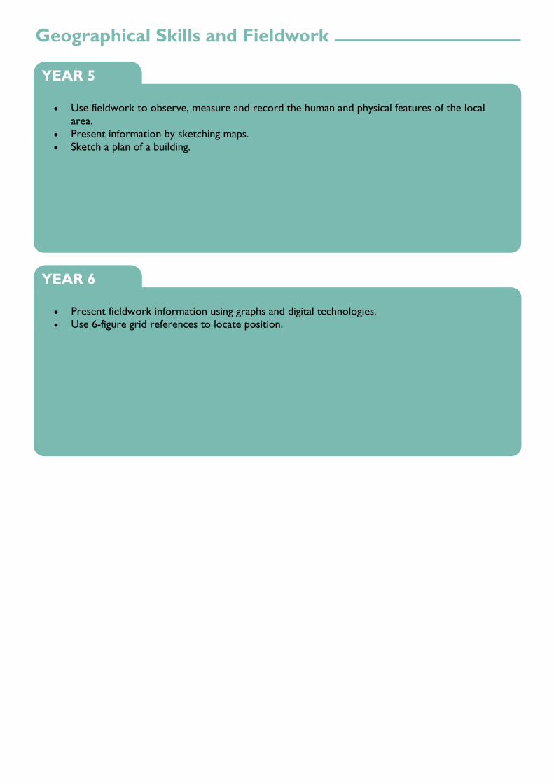
Geographical Skills and Fieldwork
Use fieldwork to observe, measure and record the human and physical features of the local
area.
Present information by sketching maps.
Sketch a plan of a building.
YEAR 5
Present fieldwork information using graphs and digital technologies.
Use 6-figure grid references to locate position.
YEAR 6

P.S.H.E. LANGUAGE MATHEMATICS RESOURCE
Know what being part of a
community means, and about the
varied institutions that support
communities locally and nationally.
Description
Deduction
Comparison
Explanation
Observation, human,
physical, local, regional,
national, international,
global.
Birds-eye view.
Counting
Comparative
language
Measures
Direction (inc.
compass points
North, North
East, East, South,
East, South, South
West, West and
North West).
Geometry
Statistics
Maps / Atlases
Globes
Digital software
Aerial photographs
Photographs
Compass
Measuring
equipment
Cameras / iPads
Know what being part of a
community means, and about the
varied institutions that support
communities locally and nationally.
Hypothesis
Explanation
Comparative
language
Measures
Direction (inc.
compass points
North, North
East, East, South,
East, South, South
West, West and
North West).
Geometry
Statistics
Grid references
Maps / Atlases
Globes
Digital software
Aerial photographs
Photographs
Compass
Measuring
equipment
Cameras / iPads

All Saints C of E Primary School
© 2017