controls and evolution of facies patterns in the upper ... et al... · small-scaled geological...
TRANSCRIPT

Controls and evolution of facies patterns in the Upper
Barremian–Albian Levant Platform in North Sinai and
North Israel
MARTINA BACHMANN*, JOCHEN KUSS & JENS LEHMANN
Department of Geosciences, Bremen University, P.O. Box 330440, 28334 Bremen, Germany
*Corresponding author (e-mail: [email protected])
Abstract: The Upper Barremian–Albian Levant Platform was studied in North Sinai and Israel(Galilee and Golan Heights) by bio- and lithostratigraphy, facies analyses, and sequence stratigra-phy. Integrating shallow-marine benthic foraminifera (mainly orbitolines), ammonite, and stableisotope data resulted in a detailed stratigraphic chart. Transects across the shallow shelf in bothregions are based on facies analysis and form the basis for depositional models. In both transectsfive platform stages (PS I–V) were identified, which differ significantly in their stratigraphic archi-tecture, mainly controlled by local tectonics, climate and second-order sea-level changes. In NorthSinai, a transition from a shallow-shelf that is structured by sub-basins through a homoclinal rampinto a flat toped platform is recognized, while the sections in North Israel show a transition from ahomoclinal ramp into a fringing platform. Local normal faults influenced the depositional architec-ture of the Upper Barremian–Lower Aptian strata in North Sinai and were attributed to syn-riftextensional tectonics. Four second-order sequence boundaries were identified, bounding Mid-Cretaceous Levant depositional sequences. These well-dated second-order sequence boundariesare MCL-1 (Late Barremian), MCL-2 (earliest Late Aptian), MCL-3 (Lower Albian), and MCL-4(Late Albian). The sea-level history of the Levant Platform reflects the Late Aptian–Albianglobal long-term transgression, while the second-order sea-level changes show good correlationwith those described from the Arabian plate.
The Late Barremian–Albian Levant Platform is anideal case study for studying platform developmentin a setting of global long-term sea-level change,climate variation, and geodynamics. The platformwas located at the northern rim of the NorthAfrican/Arabian plate and the southern border ofthe Tethyan Ocean, respectively (Fig. 1a). Extend-ing from southern Lebanon to northern Egyptthe Levant Platform strikes out in a narrow stripeparallel to the recent coastline (Saint-Marc 1974;Braun & Hirsch 1994; Kuss & Bachmann 1996;Rosenfeld et al. 1998). Its central part was studiedin Israel (Galilee and Golan Heights) and its south-western part in North Sinai, both characterizedby good exposures (Fig. 1b, c). During the LateBarremian–Albian about 500 m of shallow marinedeposits accumulated on the Levant Platform.
During the Mesozoic, the region was character-ized by extensional and compressive tectonicalprocesses related to the opening and closure ofthe Neotethys (e.g. Keeley 1994; Hirsch et al.1995; Stampfli & Borel 2002; and other papersin this volume) forming the main tectonical struc-tures such as the Syrian Arc fold belts and theDead Sea Transform (DST). However, the analysedinterval represents a consistent platform suc-cession deposited since the Late Barremian. Thisinterval has been interpreted to be deposited in apost-extensional setting during mid-Cretaceous
transgression and indicating relative tectonicalquiescence before the onset of Late Cretaceouscompression (Moustafa & Khalil 1990; Hirschet al. 1995; Kuss & Bachmann 1996).
Most former studies concentrate on small areasand/or selected stratigraphical or palaeontologicalparameters. Litho- and biostratigraphical conceptsof the Lower Cretaceous of Galilee and the GolanHeights are summarized in Rosenfeld & Hirsch(2005) and Bachmann & Hirsch (2006); tectonicconcepts are summarized in Flexer et al. (2005)and Gilat (2005). Stratigraphical subdivisions ofthe Lower Cretaceous of the Sinai, are mainlybased on Said (1971) and Bartov & Steinitz(1977). Younger interpretations include facies, stra-tigraphic and sedimentological data (Aboul Elaet al. 1991; Askalany & Abu-Zeid 1994; Bachmann& Kuss 1998; El-Araby 1999; Steuber & Bachmann2002; Bachmann et al. 2003). Only few studiesdocument marine Barremian–Lower Aptian sedi-ments in North Sinai (Arkin et al. 1975; Morsi2006; Abu-Zied 2007, 2008).
In the present paper, we summarize various stra-tigraphical data with respect to a consistent corre-lation of various lithological units in the area andadd new data from the Barremian–Lower Aptiansuccession of North Sinai. The methodologyincludes bio- and isotope stratigraphy, the interpret-ation of sedimentological structures in the field,
From: Homberg, C. & Bachmann, M. (eds) Evolution of the Levant Margin and Western Arabia Platform sincethe Mesozoic. Geological Society, London, Special Publications, 341, 99–131.DOI: 10.1144/SP341.6 0305-8719/10/$15.00 # The Geological Society of London 2010.

small-scaled geological mapping, and microfaciesanalysis. Our interpretations are focused on faciesreconstructions and long-term, second-order, sea-level changes within a high-resolution stratigraphi-cal frame. Moreover, we estimated the climaticand tectonic influences on the sedimentation. Thedata allow us to reconstruct and interpret thevarying Late Barremian–Albian shelf geometry,as well as the timing and interpretation of the plat-form development. In this respect syn-depositionaltectonical processes were determined, which werepreviously unknown.
These data are interpreted, allowing the detailedtiming of the Late Barremian–Albian succession.This results in an evaluation of the facies,long-term local and regional second-order sea-levelchanges, and climate framework, characterizingthe complex sedimentary system of the LevantPlatform. Furthermore, the data allow us tothe reconstruct and interpret the varying LateBarremian–Albian shelf geometry. In this respect,
the paper is a review. Together with new data,especially from the Barremian–Lower Aptian suc-cession of North Sinai, the dataset allows theinterpretation of the platform development.
Most former studies concentrate on small areasand/or selected stratigraphical or palaeontologicalparameters. Litho- and biostratigraphic conceptsof the Lower Cretaceous period of Galilee and theGolan Heights are summarized in Rosenfeld &Hirsch (2005) and Bachmann & Hirsch (2006),tectonic concepts are summarized in Flexer et al.(2005) and Gilat (2005).
Stratigraphic subdivisions of the Lower Cretac-eous of the Sinai are mainly based on Said (1971)and Bartov & Steinitz (1977). Younger interpret-ations include (Aboul Ela et al. 1991; Askalany &Abu-Zeid 1994; Bachmann & Kuss 1998; El-Araby1999; Steuber & Bachmann 2002; Bachmannet al. 2003). Only few studies document marineBarremian–Lower Aptian sediments in North Sinai(Arkin et al. 1975; Morsi 2006; Abu-Zied 2007).
Fig. 1. Location of the study area. (a) Tectonic map, simplified after Garfunkel (1998) with the location, the two studyareas in North Sinai and northern Israel (Galilee and Golan Heights) straddling the DST fault. (b) Aptian–Albianpalaeoenvironmental map of the Levant Platform, modified from Rosenfeld et al. (1998) and supplemented by resultsfrom North Sinai indicating the extension of the shallow platform facies belts. (c) Gebel (mountains) examined in NorthSinai indicated on a satellite map. ‘B’ indicates the tectonically restored position of the Golan Heights section B, whenassumed the lateral movement of 100 km as indicated, for example by Garfunkel & Ben-Avraham (1996).
M. BACHMANN ET AL.100

Geological framework
The Levant Platform developed at the northernpassive continental margin of the African–Arabian plate close to the plate boundary with theAnatolian plate. The tectonical pattern in theEastern Mediterranean Levantine region has impor-tant influence on the Cretaceous platform develop-ment characterized by this position at the triplejunction of the African, Arabian, and Anatolianplates (Flexer et al. 2005). The Early Mesozoicopening of the Neotethys generated an east–weststriking rift system with subsiding areas and thuscreated the Levant Basin at the northeastern edgeof the African–Arabian plate (Keeley 1994; Hirschet al. 1995; Garfunkel 1998; Flexer et al. 2005).The shallow-marine Levant Platform formed at thesoutheastern passive margin of the Levant Basintrending in a narrow strip parallel to the Mediterra-nean coastline from Lebanon and Syria throughIsrael to North Sinai, Egypt (Garfunkel 1998). Thebreakup of the Levant Platform commenced withthe Late Coniacian–Palaeogene inversion of exten-sional faults (Flexer et al. 2005).
In northern Israel, the initial ramp geometry of theEarly Cretaceous Levant Platform developed into aflat-topped platform in the Early Aptian (Bachmann& Hirsch 2006). In the Albian it is saddled by theformation of fringing rudist-reefs at the shelfbreak (Sass & Bein 1982; Ross 1992). In NorthSinai, the initial Upper Barremian–Lower Aptianplatform is not yet analysed. The Upper Aptian–Lower Albian platform geometry is described as adistally steepened ramp (Bachmann & Kuss 1998).The region in between North Sinai and northernIsrael is described as a gradual shallow–deep tran-sition (Rosenfeld et al. 1998) known only from thesubsurface (Rosenfeld & Hirsch 2005).
The investigated sections and
lithostratigraphical concepts
In northern Israel/Galilee and the Golan Heights,most outcrops are located along strike–slip faultsorientated parallel to the DST fault and in asym-metric Syrian Arc anticlinal structures (Flexeret al. 2005; Gilat 2005). In North Sinai, severalanticlinal Syrian Arc structures form good outcropconditions (Moustafa & Khalil 1990).
Owing to the regional differentiated nomencla-ture, with a high number of units, members and for-mations, we compile standard sections for the twoplatform edges composed from several sections inboth regions (Fig. 1).Galilee/Golan. We follow the lithostratigraphicalsubdivisions of the Cretaceous succession in theGolan Heights and Galilee established by Eliezri
(1965) and modified by Rosenfeld et al. (1995),while additionally distinguishing a new member(Fig. 2). The terrestrial sandstones at the base ofthe succession are known as the Hatira Formationand occur in the subsurface of northern Israel(Rosenfeld et al. 1998). The overlying marine suc-cession is subdivided into five formations: NabiSaid (ooid-rich limestones), Ein el Assad (lime-stones and subordinated marlstones), Hidra (sand-stones, marlstones, and few limestone beds), Rama(limestones and marlstones), and Yagur (limestonesand dolomites) (Fig. 2). The studied succession is440 m thick; the standard section is based on threesections studied in Galilee (Har Ramin, Ramaand Ein Netofa) and one on the Golan Heights(Ein Quniya) (Bachmann & Hirsch 2006), (Fig. 1).Hence outcrops of marine Lower Cretaceous sedi-ments are generally rare in Galilee and the GolanHeights, two sections (Har Ramin/Galilee and EinQuniya/Golan Heights) comprise the entire 440 mthick Upper Barremian–Albian succession. Weath-ering profiles, bedding surfaces, sedimentary struc-tures, stratigraphical, and facies interpretation aredescribed in Bachmann & Hirsch (2006).
North Sinai. We use the lithostratigraphical subdi-vision of the Upper Barremian–Albian successionof North Sinai of Said (1971), applied in currentgeological maps (Fig. 2). The platform successionstarts above terrestrial sandstones (Malha For-mation) with a limestone, dolomite, and marlstonealternation characterized by detrital influence(lower Rizan Aneiza Formation). Sandstone, marl-stone, limestone, and dolomite alternations withdeltaic influence above represent the upper RizanAneiza Formation; the subsequent succession oflimestones and dolomitic marlstones without con-siderable siliclastic input was related to the HalalFormation. The thickness of individual sectionsvaries greatly, depending on their palaeogeographi-cal position. From south to north, the thickness ofthe lower part of the Rizan Aneiza Formationvaries from 0 to 170 m and from 120 to 250 m forthe upper part of the Rizan Aneiza Formation. Thelower Halal Formation studied at Gebel Mansourreaches 220 m.
The Upper Barremian–Upper Albian successionof North Sinai was studied in five anticlinal struc-tures, comprising the following Gebels: Amrar,Rizan Aneiza, Raghawi, Mansoura, and southeast-ern Maghara (Fig. 1c). Within this frame, theRaghawi section (A) describes a proximal settingof the lower Rizan Aneiza Formation (UpperBarremian–lower Upper Aptian) (Fig. 2), whilethe Amrar section (GA) shows a more distalexpression of the same interval. One Rizan Aneizasection (D) includes the Lower/Upper Aptianboundary, while the eastern Maghara section
BARREMIAN–ALBIAN LEVANT PLATFORM EVOLUTION 101

Hidra Fm
Bar
rem
ian
Apt
i an
Alb
ian
Upp
erLo
wer
Mid
dle
L ow
erU
pper
Low
er C
reta
ceou
s
Pl-CdP. lenticularis C. decipiens
PlP. lenticularis
Pc-OlP. cormyi
O.(M.) lotzei
OpO. (M.) parva
Ot-Op O.(M.) texanaO. (M.) parva
Os
O. (M.) subconcava
E. c
haro
llais
iP.
lent
icul
a ris
C. d
ecip
iens
P. c
orm
yiP.
wie
nan d
s iO
. (M
.) lo
tzei
O. (
M.)
par
vaO
. (M
. ) t e
xan a O. (
M.)
sub
conc
ava
P. in
frac
reta
c ea
FO P. l.
FO P. c.
FO O. (M.) p.
FO O. (M.) t.
FO O. (M.) s.
local LO C. d .local FO P. i.
Par
ades
hay e
site
s cf
. gr a
ndis
Het
eroc
eras
cou
lleti
C. (
Epi
chel
oni c
eras
) t s
c her
nysc
hew
i
Che
lon i
cera
s (C
.) c
o rnu
elia
num
C. (
C.)
cf.
q uad
rar iu
m
vandenheckii
satousi
feraudianus
giraudi
sarasini
waagenoides
tuarkyricus
weissi
deshayesi
furcata
subnodoso-costatum
melchioris
nolani
tardefurcate
mammillatum
jacobi
nodosocostatum
dentatus
loricatus
lautus
P infracretacea, C. sugdeni, A. podolica, H. dinarica
E. charollaisi
T. marsicana
P. wienandsi, H. dinarica,P infracretacea
oa2
oa4
oa1
C. pavonia
E. plicatius periadriaticA. dardeiE. murgendsis
oa3
Galil
ee
Ra
gh
aw
i
Riz
an
An
eiz
a
Am
r ar
Go
l an
/ E
in Q
ui n
y a s
ect
ion
Geb
el M
asou
ra
Tim
e (M
a)S
erie
s
Sta
ge
Sub
stag
e Largerbenthic
foraminifers
European ammonite
zonesFO / LO
Name
LFB(
foraminifer biozones)Larger benthic
AmmonitesNorthern Sinai
FormationsGalilee/
Golan Heights
FormationsSinai
Range of sections
Range of sections
Thierry et al. 1998
Accompanyingorganisms
Hatira Fm
Malha Fm
Unit 0
Rizan Aneiza
Nabi Said Fm
Ein El Assad Fm
Hidra Fm
Unit AHalal Fm.
Unit ARizan
Aneiza Fm.
Rama Fm
Talm
e Y
afe
Fm
(b a
sin) Yagur Fm
E W N SMansourRaghawiAmrarGolanGalileeoffshore
Aco
nec e
ras
nisu
s
Kut
atis
site
s bi
fur c
atu s
Cos
tidis
cus
rect
icos
tatu
s
Rama FmLimestine Mb
Car
mel
ree
fs
Fm.
Fig. 2. Biostratigraphic subdivision of the Upper Barremian–Albian ranges of the LFBs, timing of the lithostratigraphical formations and members and ranges of the sections.The ranges of the most important benthic foraminifers and the ammonites are compiled from several authors (see text) and arranged in the chronostratigraphic framework of Ogget al. (2004). Accompanying organisms are taken from Bachmann & Hirsch (2006) and Bachmann et al. (2003). ‘oa’ refers on ostracod assemblages observed in North Sinai(Bachmann et al. 2003).
M.
BA
CH
MA
NN
ET
AL
.102

(MgE) completes the Lower–Middle Albian suc-cession (upper Rizan Aneiza Formation) to the SE.
These sections are summarized and span a40 km wide transect from the distal Amrar anticlinein the NW to the proximal Maghara structure inthe SE (Fig. 1c). Eight sections from the upperRizan Aneiza and lower Halal formations (UpperAptian–Albian) were presented in former pub-lications (Bachmann & Kuss 1998; Bachmannet al. 2003); three of them are added in thiswork (Fig. 1c) to illustrate facies and sequencestratigraphy.
Methods
For the North Sinai sections, weathering profiles,bedding surfaces, sedimentary structures, and faciescharacteristics are documented. Sample distancesof the limestone intervals are usually less than 1 mand may be higher in the marlstone and sandstone-dominated intervals. Stratigraphy and facies wereanalysed by using field data, thin sections, ammonitefindings and washed samples, and stable isotopesanalyses required powdered samples.
Biostratigraphy. Biostratigraphy is based on benthicforaminifers (mainly orbitolinids) and ammonites.The orbitolinid distribution (taxonomy accordingto Schroeder 1975) allows the definition of sixlarger benthic foraminifera biozones (LFBs), ofwhich five are originally defined on the first occur-rence and/or last occurrence (FO/LO) of the epon-ymous species in the Galilee/Golan area (Fig. 2,Bachmann & Hirsch 2006). We compare our biostra-tigraphic data with those of the northern Tethys(Schroeder & Neumann 1985; Arnaud-Vanneau1998; Arnaud et al. 1998; Bernaus et al. 2002;Schroeder et al. 2002; Conrad et al. 2004) and theMiddle East (Saint-Marc 1974; Simmons & Hart1987; Simmons 1994; Simmons et al. 2000), andintegrate the LFBs with the chronostratigraphy ofHardenbol et al. (1998a, b) and Ogg et al. (2004)also considering calcareous algae following Bach-mann & Hirsch (2006).
Ammonites from nearly all sections in NorthSinai are determined and allow comparison withthe Tethyan ammonite zonation (e.g. Rawsonet al. 1999; Garcıa-Mondejar 2009) and to correlatethe LFBs with the ammonite range charts. The stra-tigraphical framework of the Upper Aptian–Albiansuccession additionally comprises the ranges ofostracods and rudists and is supported by graphicalcorrelation (Bachmann et al. 2003).
Stable isotopes. A total of 69 bulk rock sampleswere analysed for carbon isotopes from the UpperBarremian–Lower Aptian of section A (Fig. 1c),North Sinai. To avoid diagenetic alteration, allsamples were selected from the micritic parts of
the limestones. The stable isotope compositionwas measured using a Finigan mass spectrometerat Research Center Ocean Margins (RCOM)Bremen. The results are expressed in the commond-notation in per mille relative to PDB (PeeDeebelemnite) standard.
Facies analysis. The thin-section analysis includesthe determination of the relative abundance ofskeletal and non-skeletal components, matrixcomposition as well as grain size. We distinguishbetween abundant, common, and rare occurrenceof the components. Microfacies types (MFT) weredistinguished according to their texture, matrix,and components, added to data observed alreadyin the field such as lithology, bedding patterns terri-genous input, and abundance of ferruginous ooidsand macrofossils. The microfacies types are sum-marized in facies zones (FZ), which include micro-facies types occurring in similar environments.
Palaeoenvironment reconstruction and sequencestratigraphical interpretation. Within the strati-graphic framework, the combination of small-scalemapping, log-correlation, and microfacies data(including a review of further data) results in palaeo-environmental maps of North Sinai to northernIsrael for five time slices. Despite the limitednumber of sections, the general platform geometriescould be reconstructed. The stratigraphical corre-lation of all sections within the two analysed depo-sitional areas allows the interpretation of theplatform architecture as a function of accommo-dation, sediment supply, and production. Lateraland vertical facies changes reflect water-depth andpalaeoenvironment variations, which were com-pared between the Galilee/Golan Heights andSinai and are interpreted in considering sea-levelhistory and tectonic development. Second-ordersequences are reflected by lateral and verticalfacies distribution patterns. Sequence stratigraphi-cal terminology as originally developed for third-order sequences (Vail et al. 1991) is used hereinfor the second-order cycles. Our tectonic interpret-ations benefit from the models given by Moustafa(2010).
Stratigraphy
The stratigraphical subdivision is focused onbiostratigraphy supplemented by stratigraphicalinterpretations of d13-C curves. Biostratigraphyof the Upper Barremian–Lower Aptian from north-ern Sinai on ammonites and orbitolinids is inte-grated with carbon isotope measurements,summarized in Figure 2. This chart allows the com-parison of the studied shoal-water environmentswith stratigraphical subdivisions of basinal settingsand platform settings. Subdivision of the Upper
BARREMIAN–ALBIAN LEVANT PLATFORM EVOLUTION 103

Aptian–Albian is based on orbitolinids, ostracods,rudists and ammonites, data based mainly onBachmann et al. (2003). The stratigraphical inter-pretation of the sections is shown in Figure 3a, b.
Benthic organisms
The abundant orbitolinids in all sections and theirwide range of habitats (lagoonal to deeper platformareas, e.g. Pittet et al. 2002) allow the subdivision ofthe Upper Barremian–Middle Albian succession intofive larger benthic foraminifer biozones (LFBs).From base to top these are: Pl–Cd Palorbitolinalenticularis–Choffatella decipiens, Pl P. lenticu-laris, Pc–Ol Praeorbitolina cormyi–Orbitolina(Mesorbitolina) lotzei, Op O. (M.) parva, Ot–OpO. (M.) texana–O. (M.) parva in the GolanHeights/Galilee area (Bachmann & Hirsch 2006).The occurrence of Eopalorbitolina charollaisi,which is not younger than Late Barremian (Clavelet al. 1995; Arnaud et al. 1998; Conrad et al.2004), in North Sinai (Amrar section) and Galilee(Ein Netofa area), confirms the Late Barremianage for the LFB Pl–Cd. This stratigraphical frameis extended by a sixth LFB (Os) occurring inNorth Sinai, which is characterized by the firstoccurrence (FO) of O. (M.) subconcava (Fig. 2).LFB (Os) ranges from uppermost Aptian to Albianand coincides with the FO of O. (M.) subconcavain the latest Aptian of the Tethyan realm (Castroet al. 2001; Schroeder & Neumann 1985) and inthe Middle East (Simmons et al. 2000). The upperboundary of LFB (Os) is placed at the FO of Orbito-lina (C.) corbarica in North Sinai (Bachmann et al.2003), coinciding with the Albian/Cenomanianboundary. The orbitolinid-distribution of the UpperBarremian–Lower Aptian sections in Sinai is pre-sented in Figure 3. Ranges of the LFBs for GolanHeights–Galilee and the younger sediments ofSinai are shown in Figs 3 and 4.
Ammonites
Ammonites were sampled in North Sinai, at GebelRaghawi (section A) and three sections 3 kmeast and west of section A (R1, K and JJ, Fig. 1c),which can be directly correlated by characteristicmarker beds. Additionally, a few ammonites weresampled in the Rizan Aneiza area.
The Upper Barremian–Lower Aptian of thesesections contains rare heteromorph ammonites,including heteroceratids. One of these, Kutatissitesbifurcatus (section R), is an index species for theUpper Barremian, but it ranges into the LowerAptian (Aguado & Company 1997). Heterocerascoulleti, occurring at Gebel Raghawi, is knownfrom the Upper Barremian of southern France(Delanoy 1997; Delanoy & Ebbo 2000). This
species occurs first in the uppermost Hemihoplitesferaudianus Zone and ranges up to the lower Imer-ites giraudi Zone (middle Late Barremian, Fig. 2)(Delanoy 1997).
Cheloniceras (Cheloniceras) and deshayesitidsare the most common ammonites of the LowerAptian in North Sinai. Cheloniceras (C.) cornuelia-num and Cheloniceras (C.) cf. quadrarium (sectionJJ, Raghawi,) are widely distributed taxa. C. (C.)cornuelianum is known from the Boreal of southernEngland (Casey 1962) and from Spain, Colombia,Texas, Georgia and Turkmenistan. C. (C.) quadrar-ium is known from southern England and Colombia(Kotetishvili 1970; Young 1974; Lillo Bevia 1975;Sharikadze et al. 2004). These cheloniceratids indi-cate the Deshayesites deshayesi and Tropaeumbowerbanki zones of the Boreal zonation [sensuCasey et al. (1998), the T. bowerbanki Zone, corre-sponding to the D. furcata zone in the present paper,late Early Aptian, Fig. 2]. In the same intervalPseudohaploceras matheroni occurs, that is of limi-ted use for biostratigraphy. The base of the UpperAptian is characterized by an Aconeceras nisusfound at northern Raghawi (sections R and A), aspecies that is also common in Russia and northernGermany (Kemper 1995; Mikhailova & Bara-boshkin 2002). A. nisus is accompanied by Cheloni-ceras (Epicheloniceras) tschernyschewi, which isdescribed from the Boreal in the equivalent of theCheloniceras (Epicheloniceras) subnodosocostatumzone (early Late Aptian, Fig. 2).
Stable isotopes
Carbon isotope values vary between –1.0‰ and3.5‰ (Fig. 3). While the Upper Barremian–lowermost Aptian values display a graduallyincrease from 0.5 to 3.0‰ (interrupted by a smalldrop only), the upper part of the Lower Aptian suc-cession is characterized by a distinct drop (to –1‰),a subsequent increase (to 3.5‰), and a drop (to 1‰)of the d13C values until the Lower/Upper Aptianboundary (Fig. 3). Although, the measured datashow general lighter values than those frompelagic sections (e.g. Menegatti et al. 1998;Luciani et al. 2001; Weissert & Erba 2004) orshallow platform sections (e.g. Strasser et al.2001; Wissler et al. 2003) in the northern Tethys,the general trend of our data is similar. The absolutevalues fit well to measurements from the southernTethys (e.g. Oman: Immenhauser et al. 2005;Tunisia: Heldt et al. 2008) or the Pacific (Jenkyns& Wilson 1999; Price 2003).
Menegatti et al. (1998) divided the Cismoncarbon isotope stratigraphy curve for the Upper Bar-remian and the Aptian in eight segments (C1–C8),widely used for subdividing Barremian–Aptiancarbon isotope curves (e.g. de Gea et al. 2003;
M. BACHMANN ET AL.104

Fig. 3. Sections A (Gebel Raghawi), D (Rizan Aneiza), and GA (Gebel Amrar) reflect a transect across the UpperBarremian–Lower Aptian shallow shelf in North Sinai. The sections include lithology, d-13C isotope bulk rock values,the occurrence of biostratigraphic marker fossils, and the facies interpretation.
BARREMIAN–ALBIAN LEVANT PLATFORM EVOLUTION 105

Fig. 3. (Continued)
M. BACHMANN ET AL.106
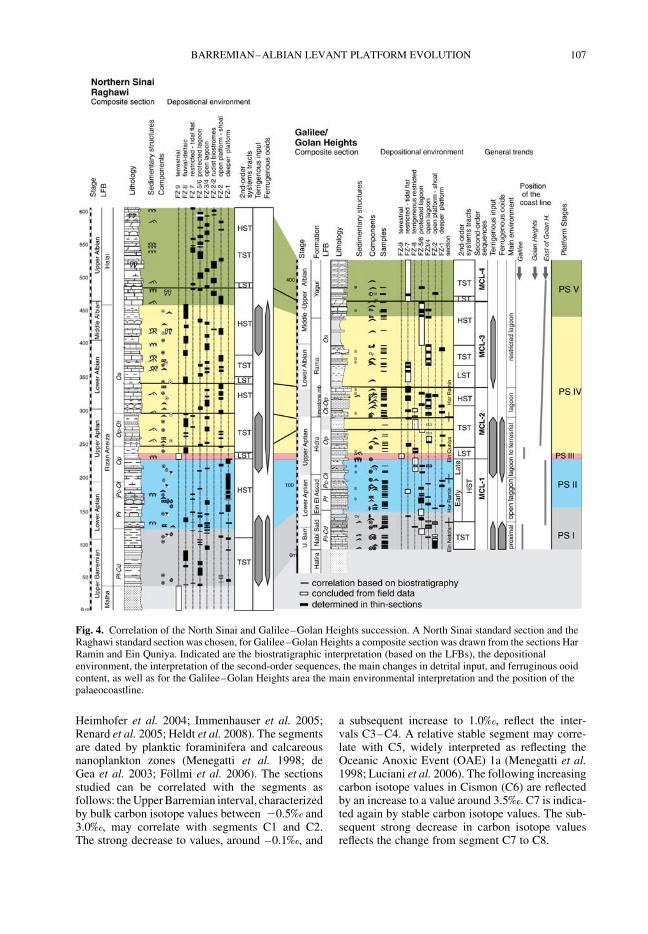
Heimhofer et al. 2004; Immenhauser et al. 2005;Renard et al. 2005; Heldt et al. 2008). The segmentsare dated by planktic foraminifera and calcareousnanoplankton zones (Menegatti et al. 1998; deGea et al. 2003; Follmi et al. 2006). The sectionsstudied can be correlated with the segments asfollows: the Upper Barremian interval, characterizedby bulk carbon isotope values between 20.5‰ and3.0‰, may correlate with segments C1 and C2.The strong decrease to values, around –0.1‰, and
a subsequent increase to 1.0‰, reflect the inter-vals C3–C4. A relative stable segment may corre-late with C5, widely interpreted as reflecting theOceanic Anoxic Event (OAE) 1a (Menegatti et al.1998; Luciani et al. 2006). The following increasingcarbon isotope values in Cismon (C6) are reflectedby an increase to a value around 3.5‰. C7 is indica-ted again by stable carbon isotope values. The sub-sequent strong decrease in carbon isotope valuesreflects the change from segment C7 to C8.
Fig. 4. Correlation of the North Sinai and Galilee–Golan Heights succession. A North Sinai standard section and theRaghawi standard section was chosen, for Galilee–Golan Heights a composite section was drawn from the sections HarRamin and Ein Quniya. Indicated are the biostratigraphic interpretation (based on the LFBs), the depositionalenvironment, the interpretation of the second-order sequences, the main changes in detrital input, and ferruginous ooidcontent, as well as for the Galilee–Golan Heights area the main environmental interpretation and the position of thepalaeocoastline.
BARREMIAN–ALBIAN LEVANT PLATFORM EVOLUTION 107

The Barremian/Aptian boundary in North Sinaicoincides with a negative carbon isotope peakbetween C1 and C2 at 115 m (Raghawi section A,Fig. 3a), which correlates with an interval aroundthe Barremian/Aptian boundary of Moullade et al.(1998) and Godet et al. (2006). Follmi et al.(2006) interpreted this peak as marking theBarremian/Aptian boundary. The equivalent of anOAE 1a is located at 160 to 175 m in the Raghawisection, which is in the Middle L. cabri/deshayesizone according to Ogg (2004). The Lower/UpperAptian boundary is suggested in a position justbelow the C7–C8 interval boundary around 200 min the same section (Fig. 3a).
Stratigraphical interpretation and
correlation of the sections
All data on stratigraphy are summarized in theregional correlation for the southern Levant Plat-form (Fig. 4). The first marine sediments are datedas Late Barremian by Kutatissites bifurcatus andHeteroceras coulleti at the lower part of Raghawisections A, K and R in North Sinai and by Eopalor-bitolina charollaizi in the Amrar section (GA, NorthSinai) and Ein Netofa section (Galilee). The occur-rence of P. lenticularis and C. decipiens in all sec-tions indicate LFB Pl–Cd. The Barremian/Aptianboundary is characterized by the FO of the LowerAptian index species Triploporella marsicana(Masse 1998) in Galilee/Golan Heights and is cor-related with an interval above the last occurrenceof H. couleti and K. bifurcatus in North Sinai. Theboundary is possibly located at the negativecarbon isotope peak at 115 m (Raghawi section A).This interpretation coincides widely with that ofAbu-Zied (2007), based on small benthic andplanktic foraminifers for the Raghawi area.
The occurrence of P. lenticularis, C. decipiens,P. cormyi, P. wienandsi and O. (M.) lotzei allowsthe subdivision of the Lower Aptian into the LFBsPl and Pc–Ol in both areas (Figs 3 & 4). WhileLFB Pl comprises the basal Lower Aptian, LFBPc–Ol widely coincides with the negative isotopeinterval marking the OAE 1a in the upper LowerAptian.
In North Sinai, the Lower/Upper Aptian bound-ary is indicated by the FO of A. nisus [C. (E.) sub-nodosocostatum ammonite zone] and a decrease ofd13C values (Raghawi, section A, Fig. 3). This is35 m below the boundary defined by Abu-Zied(2007) on the base of planktic foraminifers andsuggested by Morsi (2006) on the base of ostracods.The upper part of the basal Upper Aptian C. (E.) sub-nodosocostatum ammonite zone furthermore com-prises the FO of O. (M.) parva (e.g. Rizan Aneizasections D and RN) and C. (E.) tschernyschewi(Fig.3). In theRaghawiarea,LFBOp–Ot is indicated
only a few metres above the FO of O. (M.) parva(Fig. 3) indicating a late FO of O. (M.) parva incomparison to other studies (Lower/Upper Aptianboundary according to Arnaud-Vanneau 1998).
In Galilee/Golan Heights, the Lower/UpperAptian boundary is suggested to be 40 m belowthe FO of O. (M.) parva, according sequence strati-graphical and lithological correlations with NorthSinai.
The correlation of the Upper Aptian–Albiansuccession between both areas is more difficultbecause of the rare biostratigraphical markers inthe Galilee–Golan Heights region, while the NorthSinai succession is quite well dated. The Aptian/Albian boundary in North Sinai is marked by twodistinct ostracod assemblages and confirmed bygraphic correlation (Bachmann et al. 2003). Thisboundary was interpreted to be within the Lime-stone Member (lower Rama formation) in theGolan Heights (Bachmann & Hirsch 2006). Basedon the correlation of second-order sequencesbetween Sinai and the Golan Heights (presented inthis paper, Fig. 4) the boundary is expected to belocated lower in the section, around the boundaryHidra/Rama Formation, which is conformedto ostracod data from Rosenfeld et al. (1995). InNorth Sinai, the Early/Middle Albian boundaryis placed above the FO of Eoradiolites liratus(occurring since the latest Early Albian, Steuber &Bachmann 2002), by graphic correlation and theFO of Desmoceras (D.) latidorsatum (Bachmannet al. 2003), which first appears in the Late Albian(Gale et al. 1996). The Middle/Late Albian bound-ary is characterized by the LO of O. (M.) parvaand the FO of N. simplex (Bachmann et al. 2003).Biostratigraphical data on the upper part of thesuccession in Golan–Galilee are generally rareand is based on ostracod assemblages or rarefindings of the ammonite Knemiceras in Galilee(Rosenberg 1960; Rosenfeld et al. 1995).
Platform development
Facies zones: platform environments
The classification of facies zones (FZs) and theinterpretation of the depositional environments aresummarized in Figure 5, following the classificationgiven by Bachmann & Hirsch (2006, Galilee–Golan Heights) and Bachmann & Kuss (1998,Sinai). The FZs range from deeper open platformto terrestrial and siliciclastic-influenced restrictedplatform. Nearly every FZ contains more than onefacies type reflecting similar environments ofdeposition. Facies interpretations involve the com-parison with other Barremian–Albian Tethyanplatforms (Arnaud-Vanneau & Arnaud 1990; Masse1993; Masse et al. 1995; Husinec 2001; Bernaus
M. BACHMANN ET AL.108

Fig. 5. Facies classification and interpretation on the base of components, composition and sedimentary structures.
BA
RR
EM
IAN
–A
LB
IAN
LE
VA
NT
PL
AT
FO
RM
EV
OL
UT
ION
109

Fig. 5. (Continued)
M.
BA
CH
MA
NN
ET
AL
.110
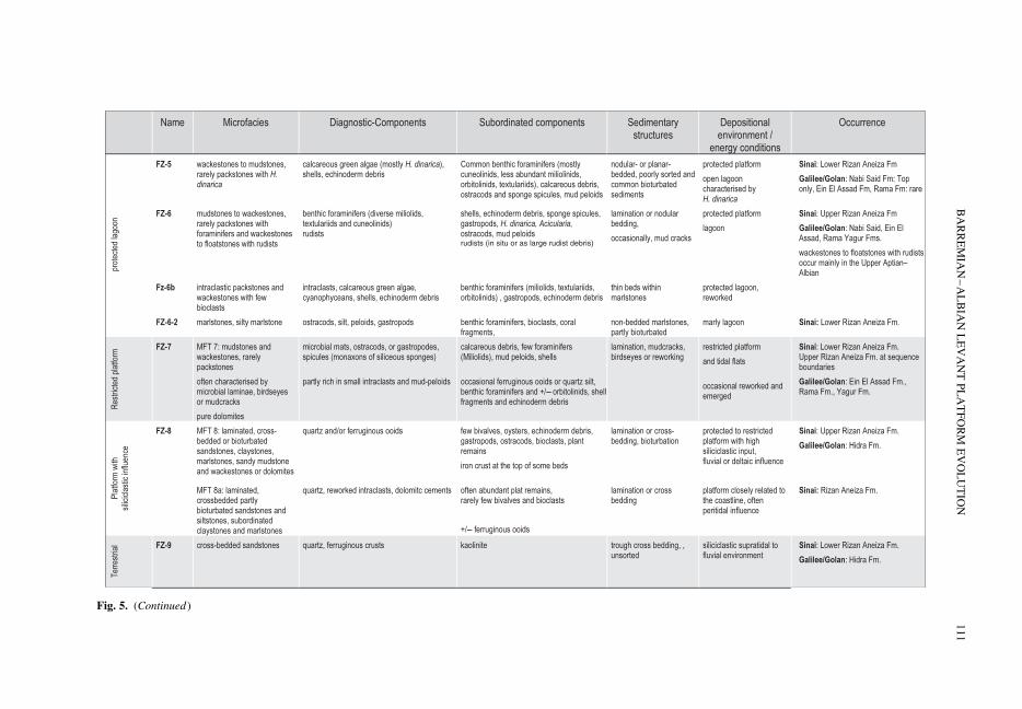
Fig. 5. (Continued)
BA
RR
EM
IAN
–A
LB
IAN
LE
VA
NT
PL
AT
FO
RM
EV
OL
UT
ION
111

et al. 2003; Masse et al. 2003), and particularly withthose in the southern Tethys (Pittet et al. 2002; VanBuchem et al. 2002; Immenhauser et al. 2005).
Most FZs occur in both study areas and at differ-ent stratigraphical levels. Their distribution is indi-cated for three Upper Barremian–Aptian sections:section A (Fig. 6e & f) (supplemented by datafrom the sections K and R), sections GA and D(Figs 1c, 3a, b & 6d). To investigate the lateral faciesvariations in North Sinai during the Upper Aptian–Lower Albian (Fig. 7) sections D and MgE areadded to data by Bachmann & Kuss (1998) andBachmann et al. (2003). For the Galilee–GolanHeights the facies description summarizes data pre-sented in Bachmann & Hirsch (2006).
Two standard sections illustrate the facies vari-ations between the platform settings at Sinai andGalilee–Golan Heights (Fig. 4). General trends forterrigenous input, formation of ferruginous ooids,main carbonatic components, and grain diversityare added. Lateral variations of FZs are recognizedwhen correlating the different sections and allowan interpretation of the platform geometry for bothareas studied during several time slices. Verticalvariations indicate the changes of the platformenvironment associated with varying external andinternal parameters (e.g. climate, sea-level change,sediment accumulation).
The distribution of FZs characterizes majorlithological, facies, and environment changes,leading to a subdivision of five PS (PS I to V)within the evolution of the Levant Platform. ThesePS are decoupled from the definition offormations. Facies development is described separ-ately for both study areas, to focus on the regionalgeometric patterns.
The North Sinai platform stages
PS I. PS I comprises the first Lower Cretaceousmarine sediments and is characterized by lime-stones, marlstones, and siliciclastics deposited invarying depositional environments reaching fromterrestrial to deeper marine.
PS I comprises the lowermost Rizan Aneiza For-mation (Upper Barremian–basal Lower Aptian,LBFs Pl–Cd, and lower Pl).
An alternation of marl, siltstone, dolomite, andlimestone belonging to various FZs (FZ 1 to 8,Fig. 5) in the northern sections A (Raghawi, 85 mthickness) and GA (Amrar, 95 m thickness, Figs 3& 7) is interfingering with terrestrial sandstones(Malha Formation, FZ 9) 5 km south of Raghawi(Mansoura area – Fig. 1c).
At section A (Figs 1c & 3a) PS I is dominatedby protected lagoonal environments, characterizedby bioclastic wacke and packstones, with benthicforaminifers, shell and echinoderm debris and
oncoids (FZ 6), partly rich in orbitolinids andcyanophyceans. These limestones alternate withmarlstones, silty marlstones, and siltstones con-taining few autochthonous benthic foraminifers,ostracods, small solitary coral colonies, echinodermdebris, and further bioclasts (FZ 6-2) that are indi-cating a varying terrestrial input. Several levelscontain ferruginous ooids. In the lower part, inter-calated peritidal to coastal sandstones and silt-stones (FZ 8a) indicate two regressive events. Inthe same interval, ammonite-bearing marlstonesindicate a sporadic influence of open-marine con-ditions. Among those ammonites are several phyllo-ceratids (e.g. Euphylloceras aff. inflatum), whichare interpreted as reflecting deeper-marine con-ditions (Westermann 1996). Intercalations ofoolithic, intraclastic and bioclastic grainstones(FZ 2) mark the repeated influence of shallowsubtidal, high-energy conditions. Upward increas-ing, intercalated limestones rich in oncoids (FZ 3,mainly MFT 3a) reflect increasing open platformshallow subtidal conditions. In the uppermostpart of PS I frequent intercalated dolomites(early diagenetic dolomite formation), are suggestedas representing short events of emergence. Theupper boundary of PS I is settled at the point ofincreasing carbonate content and marked bythe last occurrence of the ferruginous ooids andthe first occurrence of dasycladacean-rich openlagoons (FZ 4) above.
At section GA (Figs 1c & 3a) the successionis dominated by oncoid-rich limestones of FZ 3,showing a trend to more open lagoonal/platformconditions. Siliciclastic input is less frequent andof finer grain size, while ferruginous ooids occuronly rarely. Deeper platform environments (FZ 1),comparable to the ammonite bearing beds atsection A, occur only in the upper part of PS I atsection GA.
About 5 km towards the south, terrestrialsediments characterize PS I and indicate that thecoastline was located north of the Gebel Mansour(Fig. 8a, f). The proximal position of section A isreflected by intercalated coastal sediments andhigh contents of clay and ferruginous ooids.Further north, at the distal section GA, the open-marine facies lacks coastal influence. However,depositional environments are partly shallowerthan in the proximal SW, suggesting deposition ona submarine high, separating the protected area atsection A from open-marine environment. Theopen-marine deeper environments are expected tobe in a close position to the study area because ofthe occurrence of phylloceratids.
PS II. During PS II open platform environmentsin the north are interfingering with terrestrial sedi-ments in the south.
M. BACHMANN ET AL.112

The main part of the Lower Aptian sedimentsand the first metres of the lowermost Upper Aptian(lower LFB Op-zone/lower C. (E.) subnodosocos-tatum zone), belong to PS II.
Marine limestones, marlstones, siltstones, andsandstones of PS II crop out at section GA (90 mthickness, Fig. 3b) and at section A (110 m thick-ness, Figs 3a & 6e, f), while at Gebel Mansourfurther to the south, only terrestrial siliciclasticsoccur. PS II starts with shallow-subtidal open-marine environments containing diverse bioclastsand dasycladaceans (section A, FZs 3 and 4).Intercalated near-shore sandstones (FZ 8) and aremarkable red-brownish dolomite horizon (earlydiagenetic dolomite formation, Fig. 6e) are sug-gested as representing events of regression andemergence. Above, marlstones containing someammonites (FZ 1) are overlain by limestones richin calcareous algae (FZ 4), limestones with diversebiota and planktic foraminifers (FZ 1a) and lime-stones characterized by high amounts of orbitolinids(FZ 1b). About 40 m of marlstones with corals atthe base and ammonites and planktic foraminifers(FZ 1) are marked by upward decreasing carbonatecontent. About 4 m of intercalated grainstones withferruginous ooids (FZ 2), indicate a short event ofshoaling. Maximal 10 m of marly claystones of FZ1 form the top of this interval. The upper boundaryof PS II is formed by an erosional unconformity,which cuts into the upper marly claystone atsection A and into the ferruginous-ooid intervalbelow E of the section A. At Gebel Amrar lime-stones deposited in high-energy shoal environmentsdominate the lower part of PS II, while silty marls ofopen-marine and lagoonal environments (FZ 1 and6-2) occur in the upper part.
Generally PS II is characterized by subtidalopen-platform environments with upward increas-ing influence of open-marine conditions. Thecoarse grained terrestrial input is strongly reducedin the upper part and ferruginous ooids are missinguntil a short shoaling interval, allowing the depo-sition of near coast sediments with ferruginousooids, at Gebel Raghawi.
Its southward proximal regional extension isvery similar to PS I. Terrestrial sediments crop outin the entire southern region and indicate a widelyunchanged position of the coastline between thenorthern Raghawi and Mansour area (Fig. 1). Theonly exception is one marly bed with corals,which was observed in a single locality at southernGebel Maghara close to section A (Fig. 7).Because of the erosive nature of PS III above, anow eroded uppermost part of PS II, rangingfurther to the south, cannot be excluded. The depo-sition of high-energy shoals at section GA withdeeper sediments behind makes the existence of abarrier in that area highly probable.
PS III. Sandstones deposited in terrestrial andcoastal environments characterize PS III.
This interval is attributed to the lowermostUpper Aptian (subnodocostatum zone; Fig. 2).
At section A (most proximal section) the intervalconsists of only 10 m of caolinitic quartzose sand-stones (Fig. 6e), which are interpreted as terrestrialdeposits (FZ 9). The erosional base of the successioncuts into different levels of the underlying succes-sion. At section D (Fig. 1c) 40 m of coastal silici-clastic sediments (FZ 8a) mark that interval, whichare two times interrupted by lagoonal and shoaloriginated carbonates (FZ 4 and 2). At section GAthe interval is formed of 10 m of tidal flat dolomites(Fig. 3b).
Compared to PS I and II, the coastline moved tothe north and was now located between sections Aand GA, close to sections RN and D (Fig. 1).Section A comprises the terrestrial realm, while sec-tions RN and D indicate a near shore position. Themore distal section GA was also partly emerged,but not affected by siliciclastic deposition, speakingfor a local high/swell (Figs 7 & 8a).
PS IV. Shallow subtidal marine limestones, deltaicsiliciclastics, and a southward transgression markthis platform stage.
PS IV comprises the upper Rizan AneizaFormation, which was deposited during theLate Aptian until the end of the Middle Albian(Bachmann et al. 2003).
Marine sediments of this interval were documen-ted from sections D (Fig. 3a) and RN (240 m,Fig. 7), section R (225 m, Fig. 4), sections ME andM (190 m, Figs 7 & 6h), and section MgE (140 m,Fig. 7). In the northern and central distal sections,the marine sedimentation starts in the upperC. (E.) subnodocostatum zone (sections C, RN andR), while in the proximal southeastern area thefirst marine sediments are dated as Lower Albian(sections M, ME; Bachmann et al. 2003; andsection MgE, Fig. 7). At the northern section RNmarlstone–limestone alternations of the shallow-subtidal FZ 3 to protected lagoon FZ 6 with someintercalated small-scaled rudist biostromes (FZ2-2), bioclastic to oolithic shoals (FZ 2), and somemeters of open-marine sediments (FZ 1) prevail.The Raghawi–Mansour area was characterized bya delta system with sandstones, siltstones, and marl-stones of FZ 8, prograding repeatedly into the areastudied and alternating with shallow subtidal, open-marine (FZ 3), and lagoonal sediments (FZs 4, 6and 7; Bachmann & Kuss, 1998) and furthermorehigh energy shoals (FZ 2, Fig. 5). The amount andfrequency of fine and coarse grained siliciclasticintercalations increase to the SE until theydominate the succession at section MgE (Fig. 7).Up to 4 m thick rudist biostromes (FZ 2-2) with
BARREMIAN–ALBIAN LEVANT PLATFORM EVOLUTION 113
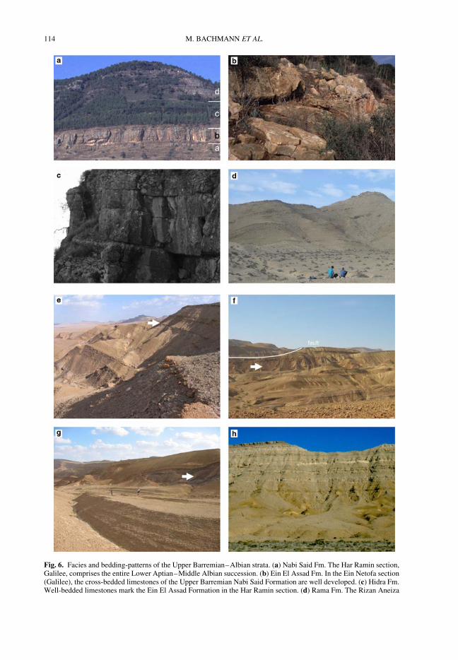
Fig. 6. Facies and bedding-patterns of the Upper Barremian–Albian strata. (a) Nabi Said Fm. The Har Ramin section,Galilee, comprises the entire Lower Aptian–Middle Albian succession. (b) Ein El Assad Fm. In the Ein Netofa section(Galilee), the cross-bedded limestones of the Upper Barremian Nabi Said Formation are well developed. (c) Hidra Fm.Well-bedded limestones mark the Ein El Assad Formation in the Har Ramin section. (d) Rama Fm. The Rizan Aneiza
M. BACHMANN ET AL.114

lateral extensions of tens of metres are intercalatedin the succession at sections RN, D, A and ME(Figs 7 & 6h). At section A, an up to 4 m-thickcoral biostrome (FZ 2-2a) is intercalated in thelower part of PS IV, while the entire succession ismarked by high amounts of ferruginous ooids,which decrease in frequency and amounts distally(section RN, Fig. 7). Intercalated emergence
horizons are common and marked by rhizolithes orferruginous crusts that can be correlated over largeareas in the region (Bachmann & Kuss 1998). Thefacies evolution of PS IV reflects third-order sea-level changes (Bachmann & Kuss 1998).
All the described sections of PS IV follow aproximal–distal transect across the shallow shelf(Fig. 8). A retrogradation of facies belts and
Fig. 6. (Continued) Formation at its type-locality is characterized by marly and sandy limestones (section D). (e) Lowerpart of the Raghawi Section A: coastal sandstones marlstones, and upward increasing dolomites and limestone mark theUpper Barremian and Lower Aptian platform stages PS I and PS II (Rizan Aneiza Formation, Gebel Raghawi). Thearrow indicates a prominent dolomitic horizon 150 m above the base of the section, which is interpreted as emergencesurface. (f) At northern Gebel Raghawi the entire Barremian–Middle Albian succession crops out and is bounded in itsupper part by a major reverse fault. The arrow indicates the terrestrial sandstones of PS II shortly above the Lower–Upper Aptian boundary. The succession above the sandstone shows the Upper–Middle Albian PS IV marked byincreasing limestone content (Upper Rizan Aneiza Fm). (g) The figure comprises nodular limestones, marlstone, and thesandstone (arrow) of the uppermost Lower Aptian to lowermost Upper Apian. (h) The Upper Aptian to LowerCenomanian succession at Gebel Mansoura is characterized by deltaic sediments in its lower part and pure limestoneswith huge rudist biostromes (arrow) in the upper part.
Fig. 7. Correlation of the sections in North Sinai summarizing new and known sections (Bachmann et al. 2003). Thesections are correlated along marker horizons, sequence boundaries, and the biostratigraphic frame. Platform stages areindicated by different colours. The location of the sections is shown on the small map.
BARREMIAN–ALBIAN LEVANT PLATFORM EVOLUTION 115

Fig. 8. Schematic transect through the North Sinai shallow shelf displays the Late Barremian–Aptian evolutionand involves the factors extension along normal faults and sea level change (a–e). Palaeoenvironmental maps indicatethe lateral extension of facies zones (f–h). (a, b) PS I and PS II are characterized by increasing sea level. (f) The southerncoastline was located at the Raghawi–Mansoura normal fault, with a possible short-termed southward transgression
M. BACHMANN ET AL.116
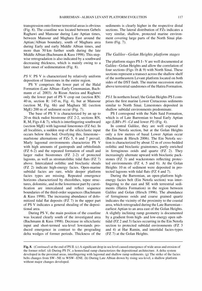
transgression onto former terrestrial areas is obvious(Fig. 8). The coastline was located between GebelsRaghawi and Mansour during Late Aptian times,between Mansour and Maghara East around theAptian/Albian boundary, south of Maghara areaduring Early and early Middle Albian times, andmore than 50 km further south during the lateMiddle Albian (Bachmann & Kuss 1998). This step-wise retrogradation is also indicated by a southwarddecreasing thickness, which is mainly owing to alater onset of sedimentation (Fig. 8).
PS V. PS V is characterized by relatively uniformdeposition of limestones in the entire region.
PS V comprises the lower part of the HalalFormation (Late Albian–Early Cenomanian, Bach-mann et al. 2003). At Rizan Aneiza and Raghawionly the lower part of PS V crop out (section RN:40 m, section R: 145 m, Fig. 4), but at Mansour(section M, Fig. 6h) and Maghara SE (sectionMgE) 200 m of sediment occur (Fig. 7).
The base of PS V is characterized by an up to20 m thick rudist biostrome (FZ 2-2, sections RN,R, M, Figs 4 & 7), which is interfingering southward(section MgE) with lagoonal limestones (FZ 6a). Inall localities, a sudden stop of the siliciclastic inputoccurs below this bed. Overlying this, limestone–marlstone alternations of FZs 5, 6 and 7 prevail.Marly lagoonal environments characterize PS Vwith high amounts of gastropods and orbitolinids(FZ 6-2) and the repeated formation of small andlarger rudist biostromes (FZ 2-2) of protectedlagoons, as well as stromatolithic tidal flats (FZ 7)above. Intercalated oolithic and bioclastic shoals(FZ 2) indicate high-energy facies. Open-marinesubtidal facies are rare, while deeper platformfacies types are missing. Repeated emergencehorizons characterized by rhizolithes, tepee struc-tures, dolomitic, and in the lowermost part by carsti-fication are intercalated and reflect sequenceboundaries of the third-order sequences (Bachmann& Kuss 1998). The increasing abundance of dolo-mitized tidal flat deposits (FZ 7) in the upper partof PS V indicates a general shoaling of the deposi-tional area.
During PS V, the main position of the coastlinewas located clearly south of the investigated area(Bachmann & Kuss 1998). Decrease in siliciclasticinput and short-termed sea-level lowstands pro-duced emergence in contrast to the progradingdelta wedges of former periods. Thickness of the
sediments is clearly higher in the respective distalsections. The lateral distribution of FZs indicates avery similar, shallow, protected marine environ-ment covering large parts of the North Sinai plat-form (Fig. 7).
The Galilee–Golan Heights platform stages
The platform stages PS I–V are well documented atGalilee–Golan Heights and allow the correlation offour sections (Figs 1b & 9) with North Sinai. Thesesections represent a transect across the shallow shelfof the northeastern Levant platform located on bothsides of the DST fault. The marine succession startsabove terrestrial sandstones of the Hatira Formation.
PS I. In northern Israel/the Golan Heights PS I com-prises the first marine Lower Cretaceous sedimentssimilar to North Sinai. Limestones deposited inshallow subtidal environments predominate.
PS I correspond with the Nabi Said Formation,which is of Late Barremian to basal Early Aptianage (LBFs Pl–Cd and lower Pl) (Fig. 4).
In central Galilee, they are well exposed inthe Ein Netofa section, but at the Golan Heightsonly a few metres of basal Lower Aptian occur(Bachmann & Hirsch 2006). The Ein Netofa sec-tion is characterized by about 32 m of cross-beddedoolithic and bioclastic grainstones, partly enrichedin ferruginous ooids and quartz (FZ 2). Theyincreasingly alternate upward with bioclastic pack-stones (FZ 3) and wackestones reflecting protec-ted environments (FZ 4, 5 and 6). At the GolanHeights 10 m of sediment were deposited in pro-tected lagoons with tidal flats (FZ 4 and 7).
During the Barremian, an open-platform high-energy facies belt (Ein Netofa section) was inter-fingering to the east and SE with terrestrial sedi-ments (Hatira Formation) in the region betweenGalilee and Golan (Hirsch 1996). The abundanceof ferruginous ooids and coarse grained quartzindicates the vicinity of the proximity to the coastalarea, which retrograded during the Late Barremian–earliest Aptian to an area east of the Golan Heights.A slightly inclining ramp geometry is documentedby a gradient from high- and low-energy open sub-tidal (FZ 2 and 3) facies occurring in the Ein Netofasection to protected subtidal environments (FZ 3and 4) at Har Ramin, and intertidal facies-types(FZ 7) at the Golan Heights.
Fig. 8. (Continued) at the end of PS II. (c) A significant drop in sea level caused emergence of wide areas and erosion ofthe former relief. (d) During PS IV, a homoclinal ramp characterizes the depositional architecture. A delta systemdeveloped in the proximal areas, interfingering with lagoonal and shallow ramp sediments. (g) The strike of the faciesbelts changes from SW–NE to WSW–ENE. (h) During Late Albian drown by rising sea-level, a shallow platformwithout major changes developed.
BARREMIAN–ALBIAN LEVANT PLATFORM EVOLUTION 117
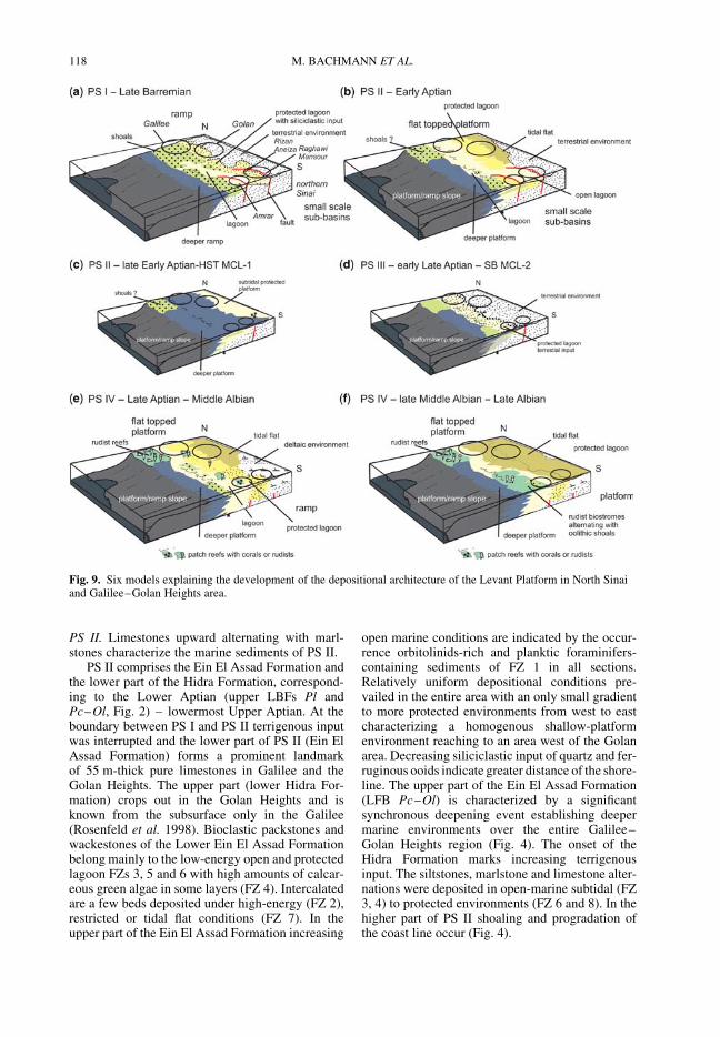
PS II. Limestones upward alternating with marl-stones characterize the marine sediments of PS II.
PS II comprises the Ein El Assad Formation andthe lower part of the Hidra Formation, correspond-ing to the Lower Aptian (upper LBFs Pl andPc–Ol, Fig. 2) – lowermost Upper Aptian. At theboundary between PS I and PS II terrigenous inputwas interrupted and the lower part of PS II (Ein ElAssad Formation) forms a prominent landmarkof 55 m-thick pure limestones in Galilee and theGolan Heights. The upper part (lower Hidra For-mation) crops out in the Golan Heights and isknown from the subsurface only in the Galilee(Rosenfeld et al. 1998). Bioclastic packstones andwackestones of the Lower Ein El Assad Formationbelong mainly to the low-energy open and protectedlagoon FZs 3, 5 and 6 with high amounts of calcar-eous green algae in some layers (FZ 4). Intercalatedare a few beds deposited under high-energy (FZ 2),restricted or tidal flat conditions (FZ 7). In theupper part of the Ein El Assad Formation increasing
open marine conditions are indicated by the occur-rence orbitolinids-rich and planktic foraminifers-containing sediments of FZ 1 in all sections.Relatively uniform depositional conditions pre-vailed in the entire area with an only small gradientto more protected environments from west to eastcharacterizing a homogenous shallow-platformenvironment reaching to an area west of the Golanarea. Decreasing siliciclastic input of quartz and fer-ruginous ooids indicate greater distance of the shore-line. The upper part of the Ein El Assad Formation(LFB Pc–Ol) is characterized by a significantsynchronous deepening event establishing deepermarine environments over the entire Galilee–Golan Heights region (Fig. 4). The onset of theHidra Formation marks increasing terrigenousinput. The siltstones, marlstone and limestone alter-nations were deposited in open-marine subtidal (FZ3, 4) to protected environments (FZ 6 and 8). In thehigher part of PS II shoaling and progradation ofthe coast line occur (Fig. 4).
Fig. 9. Six models explaining the development of the depositional architecture of the Levant Platform in North Sinaiand Galilee–Golan Heights area.
M. BACHMANN ET AL.118

PS III. Siliciclastic sediments characterize PS III innorthern Israel.
PS III comprises 5 m of the middle part of theHidra Formation, marked by fluvial sandstones ofFZ 9 that can be not dated exactly. The underlyingPS II extends at least into the late Early Aptianand the overlaying PS VI is clearly related to thelower Upper Aptian. Thus, PS III is not older thanlate Early Aptian and not younger than early LateAptian. PS III represents an important emergencehorizon. A terrestrial facies can be proved fromthe Golan Heights, documenting the progradationof the coast line. Rosenfeld et al. (1998) describedsimilar siliciclastic sediments of the Hidra For-mation from the subsurface of the Galilee area,however without emergence. They describe a brack-ish facies from the Middle Hidra Formation indicat-ing at least a near coast position for that region.
PS IV. PS IV comprises about an 150 m thick suc-cession of marine marlstones and limestones.
It corresponds to the Upper Aptian to MiddleAlbian (LBFs Op and Ot, possibly Os) RamaFormation and is documented from the GolanHeights (Ein Quniya section) and from Galilee(Har Ramin section, Fig. 6a). The 45 m-thick lime-stone member forming the base of the lowerRama Formation (35 m at the Golan Heights) ischaracterized by often nodular bedded limestonedeposited in the various FZs, reaching from open-marine deeper platform (FZ 1; only at Har Ramin)to tidal flat sediments (FZ 7) with a maximumoccurrence of the open-marine shallow platformenvironments (FZ 3). Terrestrial input is low andrarely ferruginous ooids occur. The upper part ofthe Rama Formation is composed of limestone–marlstone alternations, mainly deposited in pro-tected environments (FZs 5, 6 and 7) in Galileeand the Golan. Open lagoonal environments(FZ 3) occur only at Har Ramin. Slightly highersiliciclastic input of sand and marlstones occurs inthe Lower Albian.
During deposition of the Rama Formation, themarine facies belt reaches again to an area signifi-cantly west of the Golan area. However, siliciclasticinput of quartz and ferruginous ooids is still obvious.The facies indicates that a low-energy lagoon domi-nated the entire Formation, reaching from GolanHeights to Galilee, and limited to the west by fring-ing rudist bioherms at the Carmel area in the westernGalilee (described by Sass & Bein 1982), and to theeast by terrestrial deposits in Jordan.
PS V. PS V includes dolomites of the Yagur For-mation and was analysed only at Har Ramin(Galilee), where pure dolomites reflect protectedlagoon (FZ 6) and tidal flat deposition (FZ 7).According to Rosenfeld et al. (1998) a late Middle
Albian can be assumed. Similar sediments aredescribed from cores in Galilee, from the Golan(Hirsch 1996), and from southern Israel (Rosenfeldet al. 1998; Rosenfeld & Hirsch 2005) indicating anenlarged shallow platform covering Israel.
Structural control on the Late Barremian–
Albian deposits of the Levant Platform
The North Sinai record. Deposition of Early Cretac-eous strata took place between Late Jurassic exten-sional and Late Cretaceous compressional tectonics.While the Late Jurassic extension resulted in predo-minantly NW dipping extensional normal faults(Moustafa & Khalil 1990; Garfunkel 1998), theLate Cretaceous compressional stage resulted inthree fold ranges in North Sinai, owing to the inver-sion of the former extensional faults. The interpret-ation of the Late Barremian–Albian sedimentaryrecord and the arrangement of facies belts in thepalaeogeographical maps allow the reconstructionof extensional movements along these faults duringEarly Cretaceous times. Facies zones are generallyorientated in WSW–ENE trending belts parallel tothese major extensional faults (Figs 8 & 9).
The prominent anticlinal structure of GebelMaghara lies at the northernmost fold range, inbetween east–NE elongated belts of right-steppingen-echelon folds, interpreted as representing thestrike–slip rejuvenation of deep-seated earlierextensional faults (Moustafa & Khalil 1990).
Those reverse faults were observed at GebelAmrar and Gebel Raghawi (Fig. 8g; compareMoustafa 2010), where abrupt facies and thicknesschanges of Early Cretaceous sediments acrossthese faults indicate their importance duringearlier extensional stages and might have beenactive until the early Late Aptian. The southernSW–NE trending fault (Raghawi–Mansour fault)separates the Raghawi and the Mansour areaswith its lateral elongation further NE, at RizanAneiza. The Amrar section (Fig. 8f ) is located at asecond extensional SW–NE trending fault, againrejuvenated during the Upper Cretaceous com-pression (Amrar fold belt sensu, Moustafa &Khalil 1990). Two similar sets of faults with verticalmovement were also described by Moustafa (2010).
The following sedimentological and stratigra-phical observations suggest a structural control onEarly Cretaceous deposition along normal faults ofNorth Sinai.
(1) The Upper Barremian to lower Upper Aptian(PS I–II) sections at the neighbouring GebelsRaghawi and Mansour (located c. 5 kmapart) show significantly different sedimentaryenvironments (Fig. 7). In the Mansour area,sedimentation took place under terrestrial
BARREMIAN–ALBIAN LEVANT PLATFORM EVOLUTION 119
conditions, while more than 240 m of marlyand limy sediments were deposited in marineenvironments at Gebel Raghawi. To interpretthis record we either have to assume aprimary, very steep, declining coast (with ver-tical differences of more than 200 m along a5 km horizontal distance), or more probable,an active normal fault that resulted in highersubsidence rates in the northern areas. At theend of PS II (latest Early Aptian and earliestLate Aptian) water-depth at the GebelRaghawi area increased significantly in con-trast to still terrestrial environments at GebelMansour, and may thus reflect different sub-sidence owing to syndepositional tectonicactivities along a normal fault. (Alternativeinterpretations of deposition and later erosionof marine sediments at Gebel Mansour seemunlikely because of missing reworking hor-izons). Our facies data hint on a SE–NW strik-ing normal fault active during the LateBarremian–earliest Late Aptian (and reacti-vated in Late Cretaceous times), whichcaused the different depositional environments(Fig. 8f ).
(2) At Gebel Amrar, further to the NW, shallowmarine Upper Barremian–lower UpperAptian deposits indicate a swell, which maybe correlated with another active normalfault belonging to the Amrar fold belt (Mous-tafa & Khalil 1990).
During PS III (early Late Aptian) terrestrial sedi-mentation occurred in the entire northern Sinai,which was accompanied by erosion in the southernsections (Fig. 8c). During PS IV (latest Aptian–Middle Albian) stepwise encroaching of themarine sediments from north–NW to south–SEindicates a slightly dipping ramp (Fig. 8d).Uniform sediments at Raghawi and Mansourcharacterize the next stage (PS V), with some bedstraceable for long distances (Fig. 8e). This meansthat the Raghawi–Mansour fault was active onlyuntil the end of the Early Aptian, possibly until theearliest Late Aptian. During the younger stages(PS III) erosion and deposition reduced the formerelevation gradient along the normal faults, untilmore homogenous depositional environmentsbecame obvious during PS IV (Fig. 8).
The sedimentological and stratigraphical datasuggest extensional tectonical activity during theBarremian–Early Aptian, which is younger thandescribed before (Garfunkel 1998; Moustafa &Khalil 1990; Moustafa et al. 1990). Only since theLate Aptian, subsequent to tectonical activity, astepwise retrogradation took place and the faciesdevelopment was controlled only by global sea-level change and supraregional tectonics.
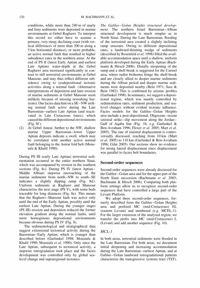
The Galilee–Golan Heights structural develop-ment. The northern Israel Barremian–Albianstructural development is much simpler as inNorth Sinai. During the Late Barremian, floodingof the terrestrial area created a slightly incliningramp structure. Owing to different depositionalrates, a landward-thinning wedge of sediments(described by Rosenfeld et al. 1998) filled the avail-able accommodation space until a shallow, uniformplatform developed during the Early Aptian (Bach-mann & Hirsch 2006). Distally steepening of theramp and a shelf break is suggested for the Carmelarea, where rudist bioherms fringe the shelf-breakand are closely allied to deeper marine sedimentsduring the Albian period and deeper marine sedi-ments were deposited nearby (Bein 1971; Sass &Bein 1982). This is confirmed by seismic profiles(Garfunkel 1998). In summary, we suggest a deposi-tional regime, which was mainly controlled bysedimentation rates, sediment production, and sea-level changes without evident tectonic influence.Facies models for the Galilee–Golan Heightsarea include a post-depositional, Oligocene–recentsinistral strike–slip movement along the Jordan–Gulf of Aqaba line (Fig. 1b, e.g. Garfunkel &Ben-Avraham 1996; Flexer et al. 2005; Mart et al.2005). The rate of sinistral displacement is contro-versially discussed, reaching from 10 km (Martet al. 2005) to 110 km (Garfunkel & Ben-Avraham1996; Gilat 2005). Our sections show no evidencefor strong lateral displacement since displacementwas parallel to facies belt boundaries.
Second-order sequences
Second-order sequences were already discussed forthe Galilee–Golan area and for the upper part of theNorth Sinai succession (Bachmann et al. 2003;Bachmann & Hirsch 2006). Comparing both plat-form settings allow us to recognize second-ordersequences that have controlled a large part of theLevant Platform.
We adopt three second-order sequences, for-merly described from the Galilee–Golan Heightsarea and prefixed MC (mid-Cretaceous) EL(eastern Levant) and numbered (e.g. MCEL-1).For the larger extension of the analysed region, wetransfer the prefix into MC (mid-Cretaceous) L(Levant) and add another sequence (Fig. 10).
MCL-1
In both areas, terrestrial sediments were flooded inthe Late Barremian. For both areas, we documentinitial deepening and increasing accommodationduring the Late Barremian–earliest Aptian, and atGalilee–Golan landward retrogradational patternscharacterize the transgressive systems tract (TST).
M. BACHMANN ET AL.120
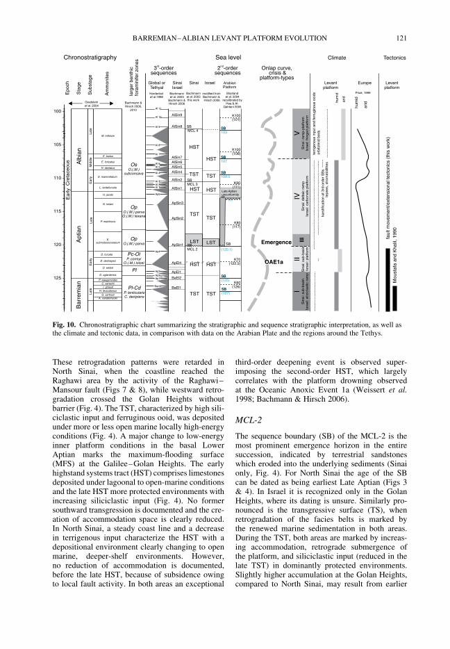
These retrogradation patterns were retarded inNorth Sinai, when the coastline reached theRaghawi area by the activity of the Raghawi–Mansour fault (Figs 7 & 8), while westward retro-gradation crossed the Golan Heights withoutbarrier (Fig. 4). The TST, characterized by high sili-ciclastic input and ferruginous ooid, was depositedunder more or less open marine locally high-energyconditions (Fig. 4). A major change to low-energyinner platform conditions in the basal LowerAptian marks the maximum-flooding surface(MFS) at the Galilee–Golan Heights. The earlyhighstand systems tract (HST) comprises limestonesdeposited under lagoonal to open-marine conditionsand the late HST more protected environments withincreasing siliciclastic input (Fig. 4). No formersouthward transgression is documented and the cre-ation of accommodation space is clearly reduced.In North Sinai, a steady coast line and a decreasein terrigenous input characterize the HST with adepositional environment clearly changing to openmarine, deeper-shelf environments. However,no reduction of accommodation is documented,before the late HST, because of subsidence owingto local fault activity. In both areas an exceptional
third-order deepening event is observed super-imposing the second-order HST, which largelycorrelates with the platform drowning observedat the Oceanic Anoxic Event 1a (Weissert et al.1998; Bachmann & Hirsch 2006).
MCL-2
The sequence boundary (SB) of the MCL-2 is themost prominent emergence horizon in the entiresuccession, indicated by terrestrial sandstoneswhich eroded into the underlying sediments (Sinaionly, Fig. 4). For North Sinai the age of the SBcan be dated as being earliest Late Aptian (Figs 3& 4). In Israel it is recognized only in the GolanHeights, where its dating is unsure. Similarly pro-nounced is the transgressive surface (TS), whenretrogradation of the facies belts is marked bythe renewed marine sedimentation in both areas.During the TST, both areas are marked by increas-ing accommodation, retrograde submergence ofthe platform, and siliciclastic input (reduced in thelate TST) in dominantly protected environments.Slightly higher accumulation at the Golan Heights,compared to North Sinai, may result from earlier
SB109.5
SB107
SB103
SB113
(120.1)
SB (125)
SB (127)
Chronostratigraphy Sea level
Sta
ge
Sub
stag
e
mes
Am
onit
105
100
110
115
120
125
Bar
rem
ian
Apt
ian
L at e
Ea r
lyM
iddl
eLa
te
Alb
ian
I. giraudi H. feraudianus
G. sartousi A. vandenheckii
C. sarasiniP. waagenoides
D. oglanlensis
D. weissi
D. deshayesi
D. furcata
E. subnodosocostatum
P. melchioris
N. nolani
H. jacobi
Al 9
Al 10
Al 11
Al 8
Al 7
Al 6 Al 5
Al 4
Al 3 Al 2 Al 1
Ap6
Ap4
Ap3
Ap2 Ap1
Barr6
age
bnt
lr
re
hic
fa
ii e
rz
nor
mn
f
oes
L. tardefurcata
D. mammillatum
H. dentatus
E. loricatus
E. lautus
M. inflatum
poc
E
hE
ae
au
rly
Cr
tce
os
nd2 -order sequences
rd3 -order sequences
modified from Bachmann & Hirsch 2006
Bachmann et al. 2003this work
SB
SB
SB
Sharland et al. 2004
recalibrated by Haq & Al-
Qahtani 2005
Hardenbolet al.1998
Bachmannet al. 2003
Bachmann & Hirsch 2006Bachmann &
Hirsch 2006,2010
OAE1a
Emergence III
Climate Tectonics
TST
LST
TST
LST
HST
TST
HST
HST
TST
HST
HST
HST
TSTTST
Pl-CdP. lenticularisC. decipiens
Pc-OlP. cormyi
O.(.M.) lotzei
OpO.(.M.) parva
OpO.(.M.) parvaO.(.M.) texana
OsO.(.M.)
subconcava
Pl
Gradsteinet al. 2004
SBMCL 3
SBMCL 2
SB MCL 4
II
Sin
ai:
Isra
el: p
latfo
rmsu
b-ba
s in
IV
Sin
ai: d
elta
ic r
amp
Isr a
el: c
arb o
nate
pla
tform
V
Sin
ai: r
amp -
plat
form
Isra
el: f
ringe
d pl
atfo
rm
I S
inai
: I s
rae l
: sili
cicl
ast ic
ram
psu
b-ba
sin
hum
id
K70(122.5)
K60(126)
Mou
staf
a an
d K
halil
, 199
0 f a
ult m
ovem
e nt/e
x te n
sion
al te
cton
ics
(thi
s w
ork)
terr
igen
ous
inpu
t and
ferr
ugin
ous
ooid
s
hum
i d
ari d
Late Aptian unconformity
K80(117)
SB
SB
SB
K90(111)
K100(106)
K100(101)
ApSin2
ApSin1
BaEl1
BaEl2
ApEl1
ApEl4
ApSin3
AlSin1
AlSin2
AlSin4AlSin5AlSin6AlSin7
AlSin8
AlSin9
SinaiIsrael
Israel Arabian Platform
Levant platform
Levant platform
EuropeSinaiGlobal orTethyal
Onlap curve, crisis &
platform-types
kars
tific
ati o
n at
3rd
-ord
e r S
Bs
orb i
toli n
id b
eds
tepe
es, s
trom
atol
ithes
arid
Price, 1999
SB
Ear
lyLa
te
Fig. 10. Chronostratigraphic chart summarizing the stratigraphic and sequence stratigraphic interpretation, as well asthe climate and tectonic data, in comparison with data on the Arabian Plate and the regions around the Tethys.
BARREMIAN–ALBIAN LEVANT PLATFORM EVOLUTION 121

onset of the marine deposition. While at North Sinaithe TS is dated as early Late Aptian [C. (E.) subno-dosocostatum zone], the age is not confirmed yet forthe Golan Heights. The basal Upper Aptian MFS isdocumented in the Golan area by the deepestenvironment in the study area, indicated by asudden reduction in terrigenous input and followedby HST carbonates. The mfs in the North Sinai isinterpreted as lying at a surface of re-establishmentof carbonate dominated sediments (Raghawi andRizan Aneiza sections), which coincides with adecrease of the southward transgression, indicatedby interfingering of high-energy shoals at Raghawiwith sediments of the proximal delta at GebelMansour.
The depositional rate of MCL-2 is slightlyreduced compared to MCL-1, while the observedtransgression to the south, especially at NorthSinai, is much greater (Fig. 8g). However, observeddepositional environments, which are generallycharacterized by shallower water-depth duringMCL-2 indicates a general lower accommodationincrease than before.
MCL-3
The Lower Albian SB MCL-3 is clearly defined atthe Golan Heights (Ein Quniya section) and atGalilee (Har Ramin section) by a facies changefrom open marine to restricted environments(Fig. 4). At North Sinai, it is interpreted as lyingbelow a distinct zone of delta progradation. TheLST is indicated by terrigenous delta-influencedsediments in the northern distal sections and bycoarse-grained sand dominated delta sediments inthe proximal section M. The TSs are marked inboth areas by deepening of the environment andby a clear trend to high-energy setting in the individ-ual sections indicating increasing accommodation(Fig. 4). In North Sinai, prominent transgressionduring the TST results in submergence of thesouthern and eastern part of the Maghara area(section MgE, Fig. 8h). At Galilee the MFS is indi-cated by a significant change from open marine toprotected environments under constant accommo-dation. At North Sinai, a change from consequenttransgression to a succession with higher-frequencyfacies changes may result from reduced accommo-dation and mark the late Early Albian MFS. TheHST in both areas is characterized by repeated sili-ciclastic input, but also by the development of rudistbiostromes (North Sinai) or rudist debris fearingsediments (Galilee–Golan Heights).
MCL-4
The SB MCL-4 is marked by emergence in NorthSinai and by facies change at Galilee (Fig. 4). The
Late Albian age confirmed at North Sinai may cor-relate with Galilee, where an accurate dating of theSB is not possible. In both areas, the LST containsfew beds of intertidal dolomite. While only fewintercalations of protected and open platform sedi-ments mark the TST at Galilee, a succession withshoals, protected lagoons, and rudist biostromesdominate the TST at North Sinai. In the latter areathe maximum flooding is characterized by the estab-lishment of tidal flat sediments on large parts of theplatform in the uppermost Upper Aptian. The upper-most part of the sequence is present in the Mansournorth sections only; here the subsequent SB is ofEarly Cenomanian age.
Discussion
Platform development – geometry and facies devel-opment as a consequence of tectonics, siliciclasticinput, production, and sea-level change.
The five platform-stages (I–V) reflect differentdepositional environments, accumulation patterns,and platform geometries (Fig. 9). We observe sig-nificant variations in one or more of the followingparameters: tectonical activity, siliciclastic input(driven by climate and tectonics), carbonate pro-duction, and second-order sea-level. To chart thedepositional models for the Levant Platform stages(Fig. 9) published subsurface data were incorpor-ated, spanning the region between Galilee–GolanHeights and North Sinai.
PS I: Late Barremian–earliest Early Aptian. In bothareas siliciclastic influenced carbonate sedimentscharacterize the near shore environments, richin ferruginous ooids and quartz (Fig. 9a). Marlysediments, with upward increasing carbonatecontent, are described from the central Israel hingebelt. A shallow water depositional environmentwas defined on the base of ostracod assemblages,with intercalated fresh-water signals, observed incentral and northern Israel (Rosenfeld et al. 1998).
A strongly increasing sea level (TST MCL-1)resulted in transgression. Different subsidence,basic geometric regimes, and tectonical influenceresulted in different depositional regimes in Sinaiand Israel. At North Sinai, low-energy sub-basinsdeveloped between active normal faults, whichcaused enhanced subsidence rates, a stable coastline, and phases of higher siliciclastic input owingto higher-frequency sea-level changes. Sedimento-logical and tectonical data additionally indicate theexistence of a swell in the northernmost part of theSinai (Gebel Ambra region, Fig. 8) causing a low-energy depositional regime south of the swell withshallow and deeper lagoonal environments inter-rupted by sporadical coastal progradation. Those
M. BACHMANN ET AL.122

features result in small-scaled variation of the sedi-mentation rates, with high sediment accumulation infront of the normal fault at Gebel Raghawi and lowin the area south. We suggest a shelf break situatedonly a few kilometres north of the studied area,possibly linked with normal faults further north.This fits with deeper marine marls characterizingthe offshore area only 20 km north of the studiedsections at Rizan Aneiza (Martinotti 1993) andthe occurrence of phylloceratid ammonites in theLower Aptian sediments probably suggesting thatdeeper marine conditions were present in an areaclose to the studied ramp sediments (Lehmannet al. 2007). However, an odd taphonomic historyhas been suggested for this group of ammonites,with surfacing and floating of shells first that is fol-lowed by resinking by cameral puncture, and there-fore a substantiation of an autochthonous origin canbe complex (Maeda & Seilacher 1996). In northernIsrael–Galilee, sediments form an eastward thin-ning wedge (Rosenfeld et al. 1998; Rosenfeld &Hirsch 2005), with more restricted environmentsin the eastern part (Fig. 9a). There is no sign ofactive faulting and sea-level rise result in gradualflooding of the former terrestrial sediments, witha coastline moving from the Galilee to east ofthe Golan Heights (Bachmann & Hirsch 2006).At Galilee a thick succession of high-energygrainstones indicate increasing accommodation.Gradual transgression and the landward increasingprotection of the environments suggest a shallowramp geometry with a huge high-energy faciesbelt. During the entire succession a continuousinput of detrital components and ferruginous ooidsindicates a humid weathering regime, confirmedby the intercalations of freshwater ostracod assem-blages (Rosenfeld et al. 1998).
PS II: Early Aptian–earliest Late Albian. Duringthe Early Aptian (HST MCL-1) both platformareas pass through significant changes; coarse-grained siliciclastic input is reduced, and thuscarbonate dominates the submerged part of theplatform (Fig. 9b). In the Galilee–Golan Heightsand North Sinai, low-energy environments rich incalcareous algae and bioclasts occur. In theGalilee–Golan Heights, only slight lateral faciesvariations in large parts of the proximal platformindicate a large extension of the low-energy open-platform facies belt with similar water depths.Thus, flat-topped platform geometry was suggestedto form homogenous shallow platform environ-ments at the beginning of PS II. The seawardmargin of this platform is not exposed in thestudied area and rudist fringing reefs found in theCarmel area (30 km west of Galilee sections) weredocumented from younger successions only (Bein1971; Sass & Bein 1982).
In North Sinai no change of the depositionalgeometry occurs compared to PS I. The Mansour–Raghawi fault and the Gebel Amrar swell controlledthe depositional processes within the small sub-basin. In between Sinai and Galilee the subsurfacedescriptions indicate a transitional zone, without amajor shelf break (Rosenfeld et al. 1998).
Deepening in the late Early Aptian starts with asuccession of orbitolinid beds, followed by open-marine, deeper platform, marly sediments in bothareas (Fig. 9c). This deepening causes a short-termed southward transgression exceeding theMansour–Raghawi fault until the southwesternMaghara area and may reach into southern Negev(southern Israel), where short-termed marine trans-gressions is known from the Lower Aptian(Deshayesites deshayesi and D. forbesi ammonitezones) dated by fossils and radiometric ages of anoverlying basalt (Gvirtzman et al. 1996).
PS III: Earliest Late Aptian. This short-termed plat-form stage marks a major break in the North Sinaidepositional geometry, but is characterized by short-termed emergence in the Galilee–Golan Heightsonly (Fig. 9d). At North Sinai, the fault controlleddifferential subsidence patterns terminated and thesub-basins were filled with near shore and erosionaldeposits. Moreover, terrestrial (Raghawi), marinesandstones (Rizan Aneiza), and dolomites (Amrar)correlate with a major second-order lowstand.Regression is also marked by a northward move-ment of the coastline to an area in betweenRaghawi and Amrar (Fig. 9d). Erosional unconfor-mities observed at Gebel Raghawi are possiblyowing to denudation of the relief around thenormal fault (Fig. 8) and may have shapedthe initial stage of a low dipping ramp geometry(observed in the subsequent platform stages).Fluvial sandstones deposited at the Golan Heightsindicate a major regression in the northeasternpart of the study area. However, erosion was notobserved and the geometry persisted homogenous.Altogether PS III presents a stage characterized bya widely emerged platform with distinct regression.
PS IV: Late Aptian–Middle Albian. The LateAptian–Middle Albian PS IV comprises second-order sequence MCL-2 and the LST and TST ofMCL-3, in both areas characterized by temporarilydetrital influenced carbonate production. The plat-form was widely submerged and a gradual trans-gression marked the entire area (Fig. 9e).
At North Sinai, the transgression submerged theRizan Aneiza, Amrar, Raghawi, and Mansourregions during Late Aptian and the southeasternpart of the Maghara area during the Lower Albian(Fig. 7). First marine sediments occur 20 km southof Maghara at the end of PS IV (Bachmann et al.
BARREMIAN–ALBIAN LEVANT PLATFORM EVOLUTION 123

2003). A broad delta system developed, whichstrongly influenced the depositional processesat Mansour and Maghara SE area interfingeringwith marine marl and limestones around GebelRaghawi, while Rizan Aneiza was only slightlyinfluenced by siliciclastic deltaics (Fig. 8g). Anorth dipping ramp geometry is indicated byincreasing thickness of open marine sedimentswith rudist patch reef, oolithic shoals, and lagoonalsediments towards the north. This gradient was con-siderably developed at the end of PS IV, whenmid-ramp environments at Rizan Aneiza graduallypassed into lagoons at Raghawi. The dipping direc-tion changed from NW during PS I–III to N (NNW)during PS IV, triggered by the deltaic input from thesouthern direction. The ramp can be subdivided inthree main facies belts: a southern deltaic deposi-tional facies (Mansour and Maghara SE), ashallow protected subtidal facies (Raghawi), andan open subtidal facies with rudist patch reefs inthe north (Rizan Aneiza, Fig. 8g). Those faciesbelts prograded and retrograded following higherfrequency sea-level changes. The extensive silici-clastic input in the delta realm caused higher sedi-mentation rates in the proximal parts of ramp.Only in the upper PS IV did the depocentre movetowards north–NW, when the proximal platformwas emerged during the third-order LSTs of theearly second-order HST of MCL-3 and sedimen-tation rates increased in the more distal parts ofthe platform.
At Galilee–Golan Heights the entire platformwas submerged since the Late Aptian. Marine sedi-mentation in the adjacent Jordan is not older thanlatest Albian (e.g. Schulze et al. 2004), which indi-cates that the coastline was close to the GolanHeights. Rudist fringing reefs were established atthe shelf hinge (Bein 1971; Sass & Bein 1982).Ross (1992) pointed out that the back reef gravelmay have formed a major hydrologic barrier,while Bein & Weiler (1976) documented thelower slope nature of muddy sediments depositedin close vicinity to the fringing reefs at the Carmelarea. Homogenous flat-topped platform geometryand a strong decrease in hydrologic energy in theproximal platform areas resulted in a shallow lagoo-nal inner platform environment that varied littleover a large area. Sedimentation rates were verysimilar in the inner platform area, comprisingGalilee and the Golan Heights. In the area inbetween Sinai and northern Israel, a facies estab-lished similar to the northern region (Rosenfeld &Hirsch 2005).
PS V: Late Albian. PS V is characterized by gradualchange of the platform geometry at Sinai and con-stant filling of the accommodation at Galilee andGolan Heights (Fig. 9f ). PS V comprises the last
herein studied second-order sequence. In bothareas sediments of the protected inner platformarea with strong reduced siliciclastic amounts areprevailing. Crucial for the development of NorthSinai was the dislocation of the rising sea-level.The sedimentation rates increased in the moredistal sections resulting in filling of distal accommo-dation. A very homogenous flat-topped platformdeveloped. During the Late Albian this platformextended southwardly to an area 100 km south ofMaghara (Bachmann & Kuss 1998). Within thislarge extended platform, a succession of rudistbiostromes, alternating with protected lagoonaland algal-laminate dominated tidal flats, weredeposited resulting from higher frequency sea-levelchanges. Deposition of grainstones and oolithicfacies was restricted to short intervals at GebelRaghawi, indicating the low-energy dominanceduring that interval and suggesting a shelf break inan area further north.
In Galilee, dolomites representing tidal flatsand lagoon prevail, which are also describedfrom the Golan Heights and from Judea inbetween Galilee and North Sinai (Rosenfeld &Hirsch 2005).
The Upper Albian distribution of facies beltsindicates a large extended homogenous, very shal-low, platform without major changes in facies rea-ching from northern Israel and the Golan Heightsto North Sinai. A continuously increasing sea-levelresulted in high accumulation rates and southwardtransgression. However, platform growth kept upwith the sea-level rise and shallow-water, and inter-tidal deposition continued.
External controlling factors
As external factors controlling the sedimentationpatterns on the carbonate platform we considerclimate and global sea-level changes. Imprints ofthose changes should occur at both platform areasstudied, independent from different tectonicalregimes, and are comparable to similar changesobserved on other Tethyan platforms (Fig. 10).
Second-order sea-level change and its influence onthe formation of the platform stages. Second-ordersea-level changes highly influenced the Levant plat-form development by controlling the accommo-dation and the centres of deposition. During theLate Barremian–Early Aptian a second-order TSTcreated the accommodation to start up the marinesedimentation. Reduced accommodation duringsecond-order HST resulted in distal dislocation ofthe depocentre and thus controlled the replacementof the ramp by flat topped platform architecture inGalilee–Golan Heights. Erosion during the earlyLate Aptian LST (SB MCL-2) influenced the ramp
M. BACHMANN ET AL.124

geometry in North Sinai, while reduced accommo-dation during MCL-3 HST and MCL-4 LST initiallyinduced the distal dislocation of the depocentre andthe change from ramp to platform architecture inNorth Sinai.
A comparison of global sequences with that ofthe Arabian plate origin is shown in Figure 10.Data are constrained by the stratigraphical frameslightly clouded by the use of different time scalesin the several studies. The southern Arabian plateexhibit similar features concerning the widespreadcontinental siliciclastic sediments flooded duringthe Late Barremian, and marine sedimentationduring Aptian–Albian times (Haq & Al-Qahtani2005; Sharland et al. 2001, Fig. 10). The earlyLate Aptian sequence boundary (MCL-2) coincideswith prominent sequence boundaries observed atvarious localities of the Arabian plate (VanBuchem et al. 2002; Greselle & Pittet 2005; Haq& Al-Qahtani 2005). A second match with theArabian plate feature is observed for the LateAptian SB MCL-4, while SB MCL-3 is youngerthan that observed on the southern Arabian plate(Greselle & Pittet 2005; Haq & Al-Qahtani 2005).Some further second-order SBs observed on thesouthern Arabian plate by Greselle & Pittet (2005)or Haq & Al-Qahtani (2005) coincides with SBsregarded as a higher frequency in origin in NorthSinai, because they are not clearly indicated atGalilee–Golan Heights. Important differences tothe southern Arabian plate were observed in theUpper Aptian succession. While a Late Aptianunconformity is documented from several platforms(Van Buchem et al. 2002; Haq & Al-Qahtani 2005),continuous marine sedimentation took place inthe Levant Platform at the northern edge of theArabian plate.
Comparing the sea-level changes with patternssupposed to be global, similarities are much lessobvious. However, the transgression characterizingthe Upper Aptian–Albian Levant succession coin-cides with the long-term global transgressionpointed out by Hardenbol et al. (1998), while thelower part of the succession falls into a global sea-level minimum. This agrees with transgressions ofsmaller amplitude during that time interval on theLevant Platform. Additionally SB MCL-2 possiblycorrelates with Ap 4 defined by Hardenbol et al.(1998) and with a few time-equivalent exceptionalSBs in the northern Tethyan realm, like the Alpinemountains (e.g. Roter Sattel, Strasser et al. 2001),while other areas are characterized by transgressionor high stand during the same time.
Altogether, the sea-level history of the LevantPlatform reflects the Late Aptian–Albian globallong-term transgression and the second-order sea-level changes are highly correlated with that oneobserved on the Arabian plate.
Climate. The composition of the siliciclastic inputand the formation of ferruginous ooids allow theinterpretation of general climate conditions inthe study area (Fig. 10). The Upper Barremian–Albian succession comprises two intervals withcoarse grained siliciclastic input and occurrence offerruginous ooids, one reaches from the Late Barre-mian to the earliest Aptian (PS I) and the secondcomprises the Late Aptian until the mid-Albian(PS IV). Within these parts of the successionmarly facies dominates and carbonatic samplesoften show a marly matrix. These intervalswere interpreted as indicating humid conditions(Bachmann & Hirsch 2006; Bachmann & Kuss1998) in concordance with Mucke (2000), whodemonstrated that lateritic weathering in the hinter-land was producing the protoliths for Upper Creta-ceous oolithic ironstones. Those interpretationsare underlined by the common occurrence of plantremains in the succession of PS I at GebelRaghawi and by the formation of the pronounceddelta system and carstification horizons in NorthSinai during PS IV. Orbitolinid-rich facies types,associated with abundant calcareous algae andechinoderms and argillaceous muddy limestones,are common in PS IV. Those facies types aretypically interpreted as reflecting mesotrophic con-ditions (Van Buchem et al. 2001; Pittet et al.2002), which may reflect nutrient input owing toweathering and humid conditions.
Two intervals are characterized by reduced sili-ciclastic input and the absence of the ferruginousooids (Early Aptian/PS II and the Late Albian/PSV). Such a reduced siliciclastic input can resultfrom reduced sediment supply owing to less inten-sive weathering or from an increasing distance ofthe delivery area. For PS II, the steady coast linebetween Mansour and Raghawi during lower PS IIargues for a climate origin of the reduction of detri-tal input. The Late Albian (PS V) of reduced silici-clastic input is accompanied by an increase of rudistand miliolid dominated pure limestones in NorthSinai. Those facies types are commonly interpretedas reflecting oligotrophic conditions (Van Buchemet al. 2002), which fit well with the observed trans-gressional, less humid system.
Changing third-order low stand features accom-pany humid and less humid phases. LSTs arecharacterized by detrital input during the humidphases and by emergence and dolomitizationduring the less humid periods (Bachmann & Kuss1998).
Our data fit with the general ideas of Price (1999)and Hillgartner et al. (2003) for the Oman, whoindicated a small trend to humidity in the LateBarremian–Early Aptian. However, the position ofthe Levant Platform near the equator may have trig-gered humidity in northeastern Africa, while more
BARREMIAN–ALBIAN LEVANT PLATFORM EVOLUTION 125
arid conditions influence the northern Tethyanmargin during the Barremian–earliest Aptian.
Tectonics. Tectonical activity played an importantrole, especially during the initial phase of the plat-form development in North Sinai (Fig. 10). Ourdata suggest that during the Late Barremian–EarlyAptian, extensional normal faults influenced theNorth Sinai environment and result in the formationof sub-basins, while at the same time a slightlydipping ramp, without fault segmentation, isrecorded in northern Israel. The Late Aptian–Albian distribution of the facies belts in NorthSinai indicates a uniform deepening in a NWdirection and confirms that sedimentation geometrywas orientated parallel to SW–NE striking normalfaults pointed out by Moustafa & Khalil (1990).Pre-deposition extensional tectonics creating normalfaults are described from the Levant margin offshoreIsrael as well as from northern Sinai until themid-Jurassic (Moustafa & Khalil 1990; Garfunkel2004; Gardosh & Druckman 2006). In North Sinai,a set of extensional basins was created from whichthe Maghara area represents the northernmost pointthat was located onshore (Moustafa 2010). Exten-sional tectonics at the North African–Arabiancontinental margin are interpreted as reflectingdivergent movement between the Afro-Arabianand the Eurasian plate, which led to the Mesozoicto Middle Jurassic opening of the Neotethys(Stampfli et al. 2001). Our data indicate thatextensional faults were active until the late EarlyAptian in North Sinai and may represent a LowerCretaceous syn-rift stage according Guiraud et al.(2005), who observed continental rifts alongthe African–Arabian Tethyan margin in the LateBerriasian–earliest Aptian.
Conclusions
During the Late Barremian–Albian, the southernLevant Platform was studied in the two regions:northern Israel (Galilee–Golan Heights) and NorthSinai. Facies, stratigraphy and stable isotopes ofseveral sections were studied, to reconstruct trans-ects across the shallow shelf. In conclusion weestablish depositional models and discuss the con-trolling factors for the shallow water deposition.
We combined biostratigraphy on the base ofbenthic foraminifers, mainly orbitolinids, andammonites with stable isotope data, which allowus to date the shallow water strata and allcontrolling factors in detail. The depositionalarchitecture was controlled by local tectonics,climate, and second-order sea-level changes affect-ing the sedimentation patterns. Four second-order sequence boundaries were identified in theLevant area (MCL-1–MCL-4). They partly
correlate with those observed on the Arabian plate(Haq & Al-Qahtani 2005; Sharland et al. 2001),suggesting a regional control. Until the late EarlyAptian, the North Sinai was influenced by normalfault development, while the Galilee area–GolanHeights exhibit continuous sedimentation withouttectonical influence.
Both regional transects reveal five platformstages (PS I–V) that differs with respect to platformarchitecture, siliciclastic input, and response tosea-level changes.
PS I (Late Barremian–earliest Aptian). The UpperBarremian marine sediments transgraded on ter-restrial deposits. In northern Israel a homogenousramp existed, while North Sinai was subdividedin SW–NE striking sub-basins, marginallybounded by active normal faults. Open marinehigh-energy sedimentation and continuous trans-gression characterized the Galilee–GolanHeights area during the TST of MCL-1, whilenear coast siliciclastic and protected lagoonalcarbonates alternate with deeper marine sedi-ments in North Sinai.
PS II (Early Aptian–earliest Late Aptian). Duringthe HST of MCL-1, continuous filling of theaccommodation resulted in shallow marine pro-tected facies belts marking flat-topped platformarchitecture at northern Israel. Owing to highersubsidence around normal faults, sub-basindevelopment kept on in North Sinai. The sedi-mentation was characterized by protected–partly deeper–subtidal environment withinthese sub-basins, separated from eachother byshallower swells. Significant reduction of detritalinput in both areas may result from changingweathering regimes.
PS III (early Late Aptian). During the LST ofMCL-2 the tectonical activity terminated result-ing in reorganization of the North Sinai platform.The former fault-controlled sub-basins becameinactive and were covered by a shallow ramparchitecture that controlled the depositional pro-cesses of the western Levant Platform. Emer-gence was evidenced from North Sinai tonorthern Israel indicating an extended platformsystem.
PS IV (Late Aptian–Middle Albian). A stable plat-form architecture, marked by a homoclinal rampin North Sinai and a flat-topped platformin Galilee–Golan Heights, was sandwichedbetween transgressive surface MCL-2 and theend of TST of MCL-3. In the North Sinai abroad delta system with high siliciclastic inputwas deposited, interfingering in the north withcarbonate ramp deposits. High accumulationrates on parts of the ramp resulted in slightchanges of the dipping direction. Simultaneously,
M. BACHMANN ET AL.126

a less siliciclastic input and inner platform sedi-ments are characterized in the Galilee–GolanHeights region.
PS V (Late Albian and younger). During HST ofMCL-3 and TST of MCL-4 pure limestones anddolomites were accommodated in North Sinai,during the ongoing transgression a flat toppedplatform was established here as well as in north-ern Israel.
Our data indicate that extensional faults controlledsedimentation until the late Early Aptian, whichis significantly younger than observed before(Moustafa & Khalil 1990; Garfunkel 2004;Gardosh & Druckman 2006). They may representa syn-rift stage according to Guiraud et al. (2005).
Concerning the climate history, we point out thatthe larger input of detrital sediment, including ferru-ginous ooids, indicates an increased humidity owingto an accelerated continental weathering, particu-larly in the Late Barremian–Early Aptian.
We are indebted to F. Hirsch (Jerusalem) and R. Stein(Bremerhaven) for discussions on the Lower Cretaceousof Israel, respectively geochemical data. We are especiallythankful for J. Thielemann (Bremen) and M. Heldt(Hannover) for assistance in the field, many successfuldiscussions, and providing valuable data of theirtheses. A. R. Moustafa (Cairo) helped with discussingthe tectonical background of the working-areas. Technicalsupport by M. Krogmann (Bremen) is appreciated for pre-paring a part of the ammonite fauna. We thank the tworeviewers M. Simmons and R. Scott for helpful andinstructive discussions and comments. We appreciatefinancial support by the German Science Foundation andthe VW foundation.
References
Aboul Ela, N. M., Abdel Gawad, G. L. & Aly, M. F.1991. Albian fauna of Gabal Manzour, Maghara area,north Sinai, Egypt. Journal of African Earth Sciences,13, 201–220.
Abu-Zied, R. H. 2007. Palaeoenvironmental significanceof Early Cretaceous foraminifera from northernSinai, Egypt. Cretaceous Research, 28, 765–784.
Abu-Zied, R. H. 2008. Lithostratigraphy and bio-stratigraphy of some Lower Cretaceous outcropsfrom Northern Sinai, Egypt. Cretaceous Research,29, 603–624.
Aguado, R. & Company, M. 1997. Biostratigraphicevents at the Barremian/Aptian boundary in theBetic Cordillera, southern Spain. CretaceousResearch, 18, 309–329.
Arkin, Y., Bartov, Y. & Goldberg, M. 1975. TheGeology of Rizan Aneiza, Northern Sinai. InternalReport, No. MM 2/75, 1–19.
Arnaud-Vanneau, A. 1998. (Coord. L. Cret.). Largerbenthic foraminifera. In: Hardenbol, J., Jacquin,T., Farley, M. B., de Graciansky, P.-C. & Vail, P.(eds) Cretaceous Biochronostratigraphy, chart 5.
Arnaud-Vanneau, A. & Arnaud, H. 1990. Hauterivianto Lower Aptian carbonate shelf sedimentation andsequence stratigraphy in the Jura and northern Subal-pine chains (southeastern France and Swiss Jura).Special Publication, International Association of Sedi-mentologists, 9, 203–233.
Arnaud, H., Arnaud-Vanneau, A. et al. 1998. Repar-tition stratigraphique des orbitolinides de la plate-forme urgonienne subalpine et jurassienne (SE de laFrance). Geologie Alpine, 74, 3–89.
Askalany, M. M. & Abu-Zeid, K. A. 1994. Contributionto the geology of El-Amrar and Rizan Aneiza areas,Northern Sinai (Egypt). Bulletin of the Faculty ofSciences Assiut University, 23, 81–99.
Bachmann, M., Bassiouni, M. A. A. & Kuss, J.2003. Timing of mid-Cretaceous carbonate platformdepositional cycles, northern Sinai, Egypt. Palaeo-geography, Palaeoclimatology, Palaeoecology, 200,131–162.
Bachmann, M. & Hirsch, F. 2006. Lower Cretaceouscarbonate platform of the eastern Levant (Galileeand the Golan Heights) – stratigraphy and second-order sea-level change. Cretaceous Research, 27,487–512.
Bachmann, M. & Kuss, J. 1998. The Middle Cretaceouscarbonate ramp of the northern Sinai: sequencestratigraphy and facies distribution. In: Wright,V. P. & Burchette, T. P. (eds) Carbonate Ramps.Geological Society, London, Special Publications,149, 253–280.
Bartov, Y. & Steinitz, G. 1977. The Judea and MountScopus Groups in the Negev and Sinai with TrendSurface Analysis of the thickness data. Israel Journalof Earth Science, 28, 119–148.
Bein, A. 1971. Rudist reef complexes (Albian to Cenoma-nian) in the Carmel and the coastal plain, Israel. Geo-logical Survey of Israel Report. 86.
Bein, A. & Weiler, Y. 1976. The Cretaceous TalmeYafe formation: a contour current shaped sedimen-tary prism of calcareous detritus at the continentalmargin of the Arabian Craton. Sedimentology, 23,511–532.
Bernaus, J. M., Arnaud-Vanneau, A. & Caus, E. 2002.Stratigraphic distribution of Valanginian-Early Aptianshallow-water benthic foraminifera and algae, anddepositional sequences of a carbonate platform in atectonically-controlled basin: the Organya Basin,Pyrenees, Spain. Cretaceous Research, 23, 25–36.
Bernaus, J. M., Josep, M., Arnaud-Vanneau, A. &Caus, E. 2003. Carbonate platform sequence stratigra-phy in a rapidly subsiding area; the late Barremian-early Aptian of the Organya Basin, Spanish Pyrenees.Sedimentary Geology, 159, 177–201.
Braun, M. & Hirsch, F. 1994. Mid Cretaceous (Albian–Cenomanian) carbonate platforms in Israel. Cuadernosde Geologıa Iberıa, 18, 59–81.
Casey, R. 1962. A monograph of the Ammonoidea of theLower Greensand. Part IV. PalaeontographicalSociety Monographs, 116, 217–288.
Casey, R., Bayliss, H. M. & Simpson, M. 1998. Obser-vations on the lithostratigraphy and ammonite succes-sion of the Aptian (Lower Cretaceous) LowerGreensand of Chale Bay, Isle of Wight, UK. Creta-ceous Research, 19, 511–535.
BARREMIAN–ALBIAN LEVANT PLATFORM EVOLUTION 127

Castro, J. M., Company, M., de Gea, G. A. & Aguado,R. 2001. Biostratigraphy of the Aptian-Middle Ceno-manian platform to basin domain in the PrebeticZone of Alicante, SE Spain: calibration betweenshallow water nectonic and pelagic scales. CretaceousResearch, 22, 145–156.
Clavel, B., Charollais, J., Schroeder, R. &Busnardo, R. 1995. Reflexions sur la biostratigraphiedu Cretace inferieur et sur sa complementariteavec l’analyse sequentielle: exemple de l’Urgonienjurassien et subalpin. Bulletin de la Societe Geologiquede France, Huitieme Series, 166, 663–680.
Conrad, M. A., Schroeder, R., Clavel, B., Charol-
lais, J., Busnardo, R., Cherchi, A. & Decrouez,D. 2004. Dating the Lower Cretaceous in theOrganya section (Catalan Pyrenees, NE Spain): a rein-terpretation. Cretaceous Research, 25, 35–41.
De Gea, G. A., Castro, J. M., Aguado, R., Ruiz, P. A. &Company, M. 2003. Lower Aptian carbon isotope stra-tigraphy from distal carbonate shelf setting: the Causection, Prebetic zone, SE Spain. Palaeogeography,Palaeoclimatology, Palaeoecology, 200, 207–219.
Delanoy, G. 1997. Biostratigraphie des faunes d’Ammo-nites a la limite Barremien-Aptien dans la regiond’Angles-Barreme-Castellane. Etude particuliere dela famille des Heteroceratina Spath, 1922 (Ancylocer-atina, Ammonoidea). Annales du Museum d’HistoireNaturelle de Nice, 12, 1–270.
Delanoy, G. & Ebbo, L. 2000. Une nouvelle especed’Heteroceras: H. mascarelli sp. nov. (Ancyloceratina,Ammonoidea) dans le Barremien du Sud-Est de laFrance. Annales du Museum d’histoire Naturelle deNice, 15, 1–17.
El-Araby, A.-M. 1999. Facies analysis and sequence stra-tigraphy of the Late Aptian–Albian Risan Aneiza For-amtion in northern Sinai, Egypt. Egyptian Journal ofGeology, 43, 151–180.
Eliezri, I. Z. 1965. The Geology of the Beit-Jann region(Galilee, Israel). Israel Journal of Earth Science, 14,51–66.
Flexer, A., Hirsch, F. & Hall, S. H. 2005. TectonicEvolution of Israel. In: Hall, J. K. et al. (eds) Geo-logical Framework of the Levant. Volume II: TheLevantine Basin and Israel. Jerusalem: HistoricalProductions–Hall, 523–538.
Follmi, K. B., Godet, A., Bodin, S. & Linder, P. 2006.Interactions between environmental change andshallow water carbonate buildup along the northernTethyan margin and their impact on the Early Creta-ceous carbon isotope record. Paleoceanography, 21,1–16.
Gale, A. S., Kennedy, W. J., Burnett, J. A., Caron, M.& Kidd, B. E. 1996. The Late Albian to Early Cenoma-nian succession at Mont Risou near Rosans (Drome,SE France): an integrated study (ammonites, inocera-mids, planktonic foraminifera, nannofossils, oxygenand carbon isotopes). Cretaceous Research, 17,515–606.
Gardosh, M. A. & Druckman, Y. 2006. Seismic strati-graphy, structure and tectonic evolution of the Levan-tine Basin, offshore Israel. In: Robertson, A. H. F. &Mountrakis, D. (eds) Tectonic Development of theEastern Mediterranean Region. Geological Society,London, Special Publications, 260, 201–227.
Garcıa-Mondejar, J., Owen, H. G., Raisossadat, S. N.,Millan, M. I. & Fernandez-Mendiola, M. A. 2009.The Early Aptian of Aralar (northern Spain): strati-graphy, sedimentology, ammonite biozonation, andOAE1. Cretaceous Research, 30, 434–464.
Garfunkel, Z. 1998. Constraints on the origin and historyof the Eastern Mediterranean basin. Tectonophysics,298, 5–35.
Garfunkel, Z. 2004. Origin of the Eastern Mediterraneanbasin: a reevaluation. Tectonophysics, 391, 11–34.
Garfunkel, Z. & Ben-Avraham, Z. 1996. Thestructure of the Dead Sea basin. Tectonophysics, 266,155–176.
Gilat, A. 2005. Strike-slip faulting west of the DeadSea Escarpment. In: Hall, J. K., Krasheninnikov,V. A., Hirsch, F., Benjamini, Ch. & Flexer, A.(eds) Geological Framework of the Levant. VolumeII: The Levantine Basin and Israel. Jerusalem: Histori-cal Productions-Hall, 515–522.
Godet, A., Bodin, S. et al. 2006. Evolution of the marinestable carbon-isotope record during the early Cretac-eous: a focus on the late Hauterivian and Barremianin the Tethyan realm. Earth and Planetary ScienceLetters, 242, 254–271.
Greselle, B. & Pittet, B. 2005. Fringing carbonateplatforms at the Arabian Plate margin in northernOman during the Late Aptian–Middle Albian: evi-dence for high-amplitude sea-level changes. Sedimen-tary Geology, 175, 367–390.
Guiraud, R., Bosworth, W., Thierry, J. & Delplan-
que, A. 2005. Phanerozoic geological evolution ofNorthern and Central Africa: an overview. Journal ofAfrican Earth Sciences, 43, 83–143.
Gvirtzman, G., Weissbrod, T., Baer, G. & Brenner,G. J. 1996. The age of the Aptian stage and its magneticevents: new Ar–Ar ages and palaeomagnetic data fromthe Negev, Israel. Cretaceous Research, 17, 293–310.
Haq, B. U. & Al-Qahtani, A. M. 2005. Phanerozoiccycles of sea-level change on the Arabian Platform.GeoArabia, 10, 127–160.
Hardenbol, J., Jacquin, T., Farley, M. B., de Gra-
ciansky, P. C. & Vail, P. R. 1998a. Mesozoic andCenozoic sequence chronostratigraphic framework ofEuropean basins. In: de Graciansky, P. C., Harden-
bol, J., Jaquin, T. & Vail, P. R. (eds) Mesozoic andCenozoic Sequence Stratigraphy of European Basins.Society for Sedimentary Geology (SEPM), Tulsa,3–13.
Hardenbol, J., Thiery, J., Farley, M. B., Thierry, J.,de Graciansky, P.-C. & Vail, P. R. 1998b. Cretac-eous sequence chronostratigraphy – Mesozoic andCenozoic sequence chronostratigraphical frameworkof European basins. In: de Graciansky, P.-C., Hard-
enbol, J., Jaquin, T. & Vail, P. R. (eds) Mesozoic andCenozoic Sequence Stratigraphy of European Basins.Society for Sedimentary Geology (SEPM), Tulsa,Chart 5.
Heimhofer, U., Hochuli, P. A., Herrle, J. O., Andersen,N. & Weissert, H. 2004. Absence of major vegetationand palaeoatmospheric pCO2 changes associated withoceanic anoxic event 1a (early Aptian, SE France).Earth and Planetary Science Letters, 223, 303–318.
Heldt, M., Bachmann, M. & Lehmann, J. 2008. Micro-facies, biostratigraphy, and geochemistry of the
M. BACHMANN ET AL.128
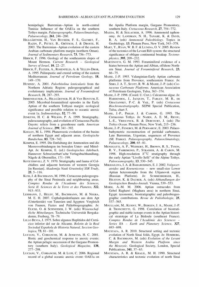
hemipelagic Barremian–Aptian in north-centralTunisia: Influence of the OAE1a on the southernTethys margin. Palaeogeography, Palaeoclimatology,Palaeoecology, 261, 246–260.
Hillgartner, H., Van Buchem, F. S., Gaumet, F.,Razin, P., Pittet, B., Grotsch, J. & Droste, H.2003. The Barremian–Aptian evolution of the easternArabian carbonate platform margin (northern Oman).Journal of Sedimentary Research, 73, 756–773.
Hirsch, F. 1996. Geology of the southeastern slopes ofMount Hermon. Current Research – GeologicalSurvey of Israel, 10, 22–27.
Hirsch, F., Flexer, A., Rosenfeld, A. & Yellin-Dror,A. 1995. Palinspastic and crustal setting of the easternMediterranean. Journal of Petroleum Geology, 18,149–170.
Husinec, A. 2001. Palorbitolina lenticularis from theNorthern Adriatic Region: paleogeographical andevolutionary implications. Journal of ForaminiferalResearch, 31, 287–293.
Immenhauser, A., Hillgartner, H. & Van Bentum, E.2005. Microbial-foraminiferal episodes in the EarlyAptian of the southern Tethyan margin: ecologicalsignificance and possible relation to oceanic anoxicevent 1a. Sedimentology, 52, 77–99.
Jenkyns, H. C. & Wilson, P. A. 1999. Stratigraphy,paleoceanography, and evolution of Cretaceous PacificGuyots: relicts from a greenhouse earth. AmericanJournal of Science, 299, 341–392.
Keeley, M. L. 1994. Phanerozoic evolution of the basinsof northern Egypt and adjacent areas. GeologischeRundschau, 83, 728–742.
Kemper, E. 1995. Die Entfaltung der Ammoniten und dieMeeresverbindungen im borealen Unter- und Mittel-Apt. In: Kemper, E. (ed.) Geologisches Jahrbuch.Hannover: Schweizerbart’sche Verlagsbuchhandlung,Nagele & Obermiller, 171–199.
Kotetishvili, Z. V. 1970. Stratigraphy and fauna of Col-chidites and adjacent horizons of western Georgia[in Russian]. Akademija Nauk Grusinskoj SSR Trudy,25, 5–116.
Kuss, J. & Bachmann, M. 1996. Cretaceous paleogeogra-phy of the Sinai Peninsula and neighbouring areas.Comptes Rendus de l’Academie des Sciences,Serie II. Sciences de la Terre et des Planetes, 322,915–933.
Lehmann, J., Heldt, M., Bachmann, M. & Negra,M. E. H. 2007. Cephalopodenfaunen aus dem Apt(Unterkreide) von Tunesien und Agypten: Vergleichvon Faunen, Fazies und Palaobiogeographie. In:Elicki, O. & Schneider, J. W. (eds) Wissenschaf-tliche Mitteilungen. Technische Universitat Bergaka-demie, Freiberg, 78–79.
Lillo Bevia, J. 1975. Sobre algunos Hoplitidos del Creta-cico inferior del sur de Alicante. Boletin de la RealSociedad Espanola de Historia Natural, Seccion Geo-logica, 73, 81–101.
Luciani, V., Cobianchi, M. & Jenkyns, H. C. 2001.Biotic and geochemical response to anoxic events:the Aptian pelagic succession of the Gargano Promon-tory (southern Italy). Geological Magazine, 138,277–298.
Luciani, V., Cobianchi, M. & Lupi, C. 2006. Regionalrecord of a global oceanic anoxic event: OAE1a on
the Apulia Platform margin, Gargano Promontory,southern Italy. Cretaceous Research, 27, 754–772.
Maeda, H. & Seilacher, A. 1996. Ammonoid taphon-omy. In: Landman, N. H., Tanabe, K. & Davis,R. A. (eds) Ammonoid Paleobiology. Topics inGeobiology, 13, Plenum Press, New York, 543–578.
Mart, Y., Ryan, W. B. F. & Lunina, O. V. 2005. Reviewof the tectonics of the Levant Rift system: the structuralsignificance of oblique continental breakup. Tectono-physics, 395, 209–232.
Martinotti, G. M. 1993. Foraminiferal evidence of ahiatus between the Aptian and Albian, offshore North-ern Sinai. Journal of Foraminiferal Research, 23,66–75.
Masse, J.-P. 1993. Valanginian-Early Aptian carbonateplatforms from Provence, southeastern France. In:Simo, J. A. T., Scott, R. W. & Masse, J.-P. (eds) Cre-taceous Carbonate Platforms. American Associationof Petroleum Geologists, Tulsa, 363–374.
Masse, J.-P. 1998. (Coord. U. Cret.). Calcareous algae. In:Hardenbol, J., Jacquin, T., Farley, M. B., de
Graciansky, P.-C. & Vail, P. (eds) CretaceousBiochronostratigraphy. SEPM Special Publication,Tulsa, chart 5.
Masse, J.-P., Philip, J. & Camoin, G. 1995. TheCretaceous Tethys. In: Nairn, A. E. M., Ricou,L.-E., Vrielynck, B. & Dercourt, J. (eds) TheTethys Ocean. Plenum Press, New York, 215–236.
Masse, J.-P., Fenerci, M. & Pernarcic, E. 2003. Palaeo-bathymetric reconstruction of peritidal carbonates,Late Barremian, Urgonian, sequences of Provence(SE France). Palaeogeography, Palaeoclimatology,Palaeoecology, 200, 65–81.
Menegatti, A. P., Weissert, H., Brown, R. S., Tyson,R. V., Farrimond, P., Strasser, A. & Caron, M.1998. High-resolution d13C stratigraphy throughthe early Aptian “Livello Selli” of the Alpine Tethys.Paleoceanography, 13, 530–545.
Mikhailova, I. A. & Baraboshkin, E. J. 2002. Volgocer-atoides and Koeneniceras – new small-size LowerAptian heteromorphs from the Ulijanovsk region(Russian Platform). In: Summesberger, H.,Hilston, K. & Daurer, A. (eds) Abhandlungen derGeologischen Bundes-Anstalt. Vienna, 539–553.
Morsi, A.-M. M. 2006. Aptian ostracodes fromGebel Raghawi (Maghara area) in northern Sinai,Egypt: taxonomic, biostratigraphic and paleobiogeo-graphic contributions. Revue de Paleobiologie, 25,537–565.
Moullade, M., Kuhnt, W., Bergen, J. A., Masse, J.-P.& Tronchetti, G. 1998. Correlation of biostrati-graphic and stable isotope events in the Aptian histori-cal stratotype of La Bedoule (southeast France).Comptes Rendus de l’Academie des Sciences –Series IIA – Earth and Planetary Science, 327,693–698.
Moustafa, A. R. 2010. Structural setting and tectonicevolution of North Sinai folds, Egypt. In: Homberg,C. & Bachmann, M. (eds) Evolution of the LevantMargin and Western Arabia Platform sincethe Mesozoic. Geological Society, London, SpecialPublications, 341, 37–63.
Moustafa, A. R. & Khalil, M. H. 1990. Structuralcharacteristics and tectonic evolution of north Sinai
BARREMIAN–ALBIAN LEVANT PLATFORM EVOLUTION 129
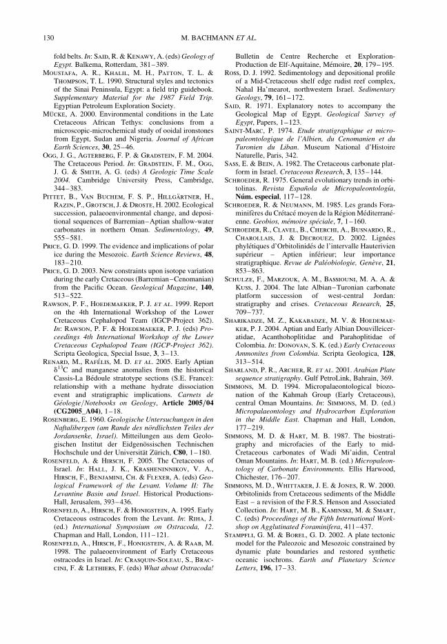
fold belts. In: Said, R. & Kenawy, A. (eds) Geology ofEgypt. Balkema, Rotterdam, 381–389.
Moustafa, A. R., Khalil, M. H., Patton, T. L. &Thompson, T. L. 1990. Structural styles and tectonicsof the Sinai Peninsula, Egypt: a field trip guidebook.Supplementary Material for the 1987 Field Trip.Egyptian Petroleum Exploration Society.
Mucke, A. 2000. Environmental conditions in the LateCretaceous African Tethys: conclusions from amicroscopic-microchemical study of ooidal ironstonesfrom Egypt, Sudan and Nigeria. Journal of AfricanEarth Sciences, 30, 25–46.
Ogg, J. G., Agterberg, F. P. & Gradstein, F. M. 2004.The Cretaceous Period. In: Gradstein, F. M., Ogg,J. G. & Smith, A. G. (eds) A Geologic Time Scale2004. Cambridge University Press, Cambridge,344–383.
Pittet, B., Van Buchem, F. S. P., Hillgartner, H.,Razin, P., Grotsch, J. & Droste, H. 2002. Ecologicalsuccession, palaeoenvironmental change, and deposi-tional sequences of Barremian–Aptian shallow-watercarbonates in northern Oman. Sedimentology, 49,555–581.
Price, G. D. 1999. The evidence and implications of polarice during the Mesozoic. Earth Science Reviews, 48,183–210.
Price, G. D. 2003. New constraints upon isotope variationduring the early Cretaceous (Barremian–Cenomanian)from the Pacific Ocean. Geological Magazine, 140,513–522.
Rawson, P. F., Hoedemaeker, P. J. et al. 1999. Reporton the 4th International Workshop of the LowerCretaceous Cephalopod Team (IGCP-Project 362).In: Rawson, P. F. & Hoedemaeker, P. J. (eds) Pro-ceedings 4th International Workshop of the LowerCretaceous Cephalopod Team (IGCP-Project 362).Scripta Geologica, Special Issue, 3, 3–13.
Renard, M., Rafelis, M. D. et al. 2005. Early Aptiand13C and manganese anomalies from the historicalCassis-La Bedoule stratotype sections (S.E. France):relationship with a methane hydrate dissociationevent and stratigraphic implications. Carnets deGeologie/Notebooks on Geology, Article 2005/04(CG2005_A04), 1–18.
Rosenberg, E. 1960. Geologische Untersuchungen in denNaftalibergen (am Rande des nordlichsten Teiles derJordansenke, Israel). Mitteilungen aus dem Geolo-gischen Institut der Eidgenossischen TechnischenHochschule und der Universitat Zurich, C80, 1–180.
Rosenfeld, A. & Hirsch, F. 2005. The Cretaceous ofIsrael. In: Hall, J. K., Krasheninnikov, V. A.,Hirsch, F., Benjamini, Ch. & Flexer, A. (eds) Geo-logical Framework of the Levant. Volume II: TheLevantine Basin and Israel. Historical Productions-Hall, Jerusalem, 393–436.
Rosenfeld, A., Hirsch, F. & Honigstein, A. 1995. EarlyCretaceous ostracodes from the Levant. In: Riha, J.(ed.) International Symposium on Ostracoda, 12.Chapman and Hall, London, 111–121.
Rosenfeld, A., Hirsch, F., Honigstein, A. & Raab, M.1998. The palaeoenvironment of Early Cretaceousostracodes in Israel. In: Crasquin-Soleau, S., Brac-
cini, F. & Lethiers, F. (eds) What about Ostracoda!
Bulletin de Centre Recherche et Exploration-Production de Elf-Aquitaine, Memoire, 20, 179–195.
Ross, D. J. 1992. Sedimentology and depositional profileof a Mid-Cretaceous shelf edge rudist reef complex,Nahal Ha’mearot, northwestern Israel. SedimentaryGeology, 79, 161–172.
Said, R. 1971. Explanatory notes to accompany theGeological Map of Egypt. Geological Survey ofEgypt, Papers, 1–123.
Saint-Marc, P. 1974. Etude stratigraphique et micro-paleontologique de l’Albien, du Cenomanien et duTuronien du Liban. Museum National d’HistoireNaturelle, Paris, 342.
Sass, E. & Bein, A. 1982. The Cretaceous carbonate plat-form in Israel. Cretaceous Research, 3, 135–144.
Schroeder, R. 1975. General evolutionary trends in orbi-tolinas. Revista Espanola de Micropaleontologıa,Num. especial, 117–128.
Schroeder, R. & Neumann, M. 1985. Les grands Fora-miniferes du Cretace moyen de la Region Mediterrane-enne. Geobios, memoire speciale, 7, 1–160.
Schroeder, R., Clavel, B., Cherchi, A., Busnardo, R.,Charollais, J. & Decrouez, D. 2002. Ligneesphyletiques d’Orbitolinides de l’intervalle Hauteriviensuperieur – Aptien inferieur; leur importancestratigraphique. Revue de Paleobiologie, Geneve, 21,853–863.
Schulze, F., Marzouk, A. M., Bassiouni, M. A. A. &Kuss, J. 2004. The late Albian–Turonian carbonateplatform succession of west-central Jordan:stratigraphy and crises. Cretaceous Research, 25,709–737.
Sharikadze, M. Z., Kakabadze, M. V. & Hoedemae-
ker, P. J. 2004. Aptian and Early Albian Douvilleicer-atidae, Acanthohoplitidae and Parahoplitidae ofColombia. In: Donovan, S. K. (ed.) Early CretaceousAmmonites from Colombia. Scripta Geologica, 128,313–514.
Sharland, P. R., Archer, R. et al. 2001. Arabian Platesequence stratigraphy. Gulf PetroLink, Bahrain, 369.
Simmons, M. D. 1994. Micropalaeontological biozo-nation of the Kahmah Group (Early Cretaceous),central Oman Mountains. In: Simmons, M. D. (ed.)Micropalaeontology and Hydrocarbon Explorationin the Middle East. Chapman and Hall, London,177–219.
Simmons, M. D. & Hart, M. B. 1987. The biostrati-graphy and microfacies of the Early to mid-Cretaceous carbonates of Wadi Mi’aidin, CentralOman Mountains. In: Hart, M. B. (ed.) Micropaleon-tology of Carbonate Environments. Ellis Harwood,Chichester, 176–207.
Simmons, M. D., Whittaker, J. E. & Jones, R. W. 2000.Orbitolinids from Cretaceous sediments of the MiddleEast – a revision of the F.R.S. Henson and AssociatedCollection. In: Hart, M. B., Kaminski, M. & Smart,C. (eds) Proceedings of the Fifth International Work-shop on Agglutinated Foraminifera, 411–437.
Stampfli, G. M. & Borel, G. D. 2002. A plate tectonicmodel for the Paleozoic and Mesozoic constrained bydynamic plate boundaries and restored syntheticoceanic isochrons. Earth and Planetary ScienceLetters, 196, 17–33.
M. BACHMANN ET AL.130

Stampfli, G. M., Borel, G., Cavazza, W., Mosar, J. &Ziegler, P. 2001. The Paleotectonic Atlas of the Peri-tethyan Domain. European Geophysical Society.CD-ROM, realized by Electronic Publishing & Con-sulting, Berlin.
Steuber, T. & Bachmann, M. 2002. Upper Aptian –Albian rudist bivalves from Northern Sinai, Egypt.Palaeontology, 45, 725–749.
Strasser, A., Caron, M. & Gjermeni, M. 2001. TheAptian, Albian and Cenomanian of Roter Sattel,Romandes Prealps, Switzerland: a high-resolutionrecord of oceanographic changes. CretaceousResearch, 22, 173–199.
Vail, P. R., Audemard, F., Bowman, S. A., Eisner, P. N.& Perez-Cruz, C. 1991. The stratigraphic signaturesof tectonics, eustasy and sedimentology – an over-view. In: Einsele, G., Ricken, W. & Seilacher, A.(eds) Cycles and Events in Stratigraphy. Springer,Berlin, Heidelberg, 617–659.
Van Buchem, F., Casanova, J. et al. 2001. SouthernTethys platform evolution and chemostratigraphyduring the Middle Cretaceous (Southeastern ArabianPlate, N. Oman and U.A.E.). In: Wortmann, U. &Funk, H.-P. (eds) IAS-2001, 21st Meeting, Davos,Abstracts, 167.
Van Buchem, F. S. P., Pittet, B. et al. 2002.High-resolution sequence stratigraphic architecture ofBarremian/Aptian carbonate systems in NorthernOman and the United Arab Emirates (Kharaib andShuaiba Formations). GeoArabia, 7, 461–500.
Weissert, H. & Erba, E. 2004. Volcanism, CO2
and palaeoclimate: a Late Jurassic-Early Cretaceouscarbon and oxygen isotope record. Journal of theGeological Society, London, 161, 695–702.
Weissert, H., Lini, A., Follmi, K. B. & Kuhn, O. 1998.Correlation of Early Cretaceous carbon isotope strati-graphy and platform drowning events: a possiblelink? Palaeogeography, Palaeoclimatology, Palaeo-ecology, 137, 189–203.
Westermann, G. E. G. 1996. Ammonoid life and habit.In: Landman, N. H., Tanabe, K. & Davis, R. A.(eds) Ammonoid Paleobiology. Topics in Geobiology.New York: Plenum Press, 607–707.
Wissler, L., Funk, H. & Weissert, H. 2003. Responseof Early Cretaceous carbonate platforms to changes inatmospheric carbon dioxide levels. Palaeogeography,Palaeoclimatology, Palaeoecology, 200, 187–205.
Young, K. 1974. Lower Albian and Aptian (Cretaceous)ammonites of Texas. Geoscience and Man, 3,175–228.
BARREMIAN–ALBIAN LEVANT PLATFORM EVOLUTION 131