conus - civil air patrol national headquarters · afnorth air support handbook 1 january 2009 18...
TRANSCRIPT

AFNORTH AIR SUPPORT HANDBOOK 1 January 2009
18
Joint / Combined
DCA Forces
CDRNORAD-NORTHCOM
CONUS–VIPR
AIR DEFENSE
and Maritime Warning
NJ-3 NC-J3
US-ONLY
FULL SPECTRUM OPS
and Civil Support
Joint
Air Forces
USAF
Forces
CONR-1 AF (AFNORTH)DESIGNATED
COMAFFOR-JFACC-AADC-SCA-COM
USAF
DCA Forces
DoDC2 Relationships
FORCE PROVIDERSTHRU JFCOM
FORCE PROVIDERSTHRU CSAF
1
CFACC JFACCUS-CANADA US
Combined Air and Space Operations Center (CAOC). The Air and Space Operations Center executes combined NORAD air missions in accordance with the bi-lateral Canada-US NORAD Agreements. The CAOC has five standard and one special division supporting its mission of air, space and cyber domain execution:
AMD Air Mobility Division COD Combat Operations Division CPD Combat Plans Division IRD Intelligence, Surveillance and Reconnaissance
Division MSD Mission Support Division SRD Strategy Division
CAOC Information Operations (IO) activities are supported by the Utah ANG 101st Information Operations Flight.

AFNORTH AIR SUPPORT HANDBOOK 1 January 2009
33
Chapter 5 Search and Rescue (SAR)
Air Force Rescue Coordination Center (AFRCC). The United States Air Force is designated by the National Search and Rescue Plan (NSP) as the Search and Rescue (SAR) Coordinator for the U.S. aeronautical Search and Rescue Region (SRR) corresponding to the continental U.S. other than Alaska. The Secretary of the Air Force (SecAF) has delegated this responsibility through HQ ACC/CC to 1 AF/CC. The AFRCC coordinates federal
search and rescue (SAR) services ensuring timely and effective lifesaving operations. Additionally, the AFRCC conducts advanced SAR planning instruction through the National SAR School to federal, state, and local agencies as well as volunteer SAR organizations and controllers. The AFRCC is an active duty squadron integrated into the 601st Air and Space Operations Center at Tyndall Air Force, FL. The AFRCC is responsible for coordinating all federal inland commercial, military, and interstate aeronautical SAR in the contiguous U.S., and assists Mexico and
Canada, if requested. The responsibilities include
Initiating searches for missing/overdue aircraft (e.g. all DOD, commercial and interstate aircraft or intra-state aircraft if requested by the state).
Managing all inland emergency beacon searches: 121.5, 243.0 and 406 MHz Emergency Locator Transmitters (ELTS) on
AFNORTH AIR SUPPORT HANDBOOK 1 January 2009
34
aircraft, Emergency Position-Indicating Radio Beacons (EPIRBs) for maritime environment, and Personal Locator Beacons (PLBs) that are used in all environments (e.g. hikers, mountain climbers, anyone who has the capability of getting lost could use a PLB).
Brokering federal assets to support state and local SAR operations (e.g. missing person searches, MEDEVAC, organ transport, transport of ground search and rescue units and special capabilities).
AFRCC is the world-wide tertiary Combat Survivor Evader Locator (CSEL) Support Center for global alerts and Primary support Center USNORTHCOM CSEL alerts.
National Search and Rescue Plan (NSP). It is the policy of the signatory federal agencies to provide a National Search and Rescue Plan for the United States for coordinating search and rescue (SAR) services to meet domestic needs and international commitments. Implementing guidance for this Plan is provided in the International Aeronautical and Maritime Search and Rescue (IAMSAR) Manual and the National Search and Rescue Supplement (NSS) and supporting Addenda. The NSP describes the U.S. SAR organization, key authorities and their responsibilities, primary principles and policies within the SAR system. The NSP is solely intended to provide internal guidance to all signatory federal agencies. State organizations retain established SAR responsibilities within their boundaries for incidents primarily local or intrastate in character. As such, the AFRCC maintains Memoranda of Agreement (MOA) between each state Governor and 1 AF/CC that establish SAR responsibilities between the designated Inland SAR Coordinator and each state. A Memoranda of Understanding (MOU) exists between the Governor‘s designated State SAR Coordinator and AFRCC/CC (SAR Mission Coordinator) on how the SAR responsibilities are conducted in each individual state. Joint Personnel Recovery Center (JPRC). IAW OPORD 08-01, CDRUSNORTHCOM designated the JFACC as ―The Supported PR Commander‖ and establishes the NORTHCOM JPRC in the 601st Air and Space Operations Center to plan and execute joint DOD (Title 10)

AFNORTH AIR SUPPORT HANDBOOK 1 January 2009
35
Personnel Recovery (PR) for NORTHCOM‘s AOR and Defense Support to Civil Authorities (DSCA) in support of state Catastrophic Incident SAR (CIS) operations. The JPRC plans, coordinates, and executes joint CIS missions, coordinates CIS procedures published in the air tasking order (ATO) and special instructions (SPINS), reviews theater plans, and coordinates joint training and exercises. Emergency Support Function #9 (ESF #9). DHS/FEMA activates ESF #9 ―Search and Rescue‖ when an incident is anticipated or occurs that may result in a request for a unified Federal SAR response to an impacted area. DOD is one of the four primary federal partners for ESF #9. Following a Presidential disaster declaration, the designated lead primary agency for ESF #9 coordinates federal SAR response
with Federal, State, Tribal, Territorial, and locally designated SAR authorities to integrate Federal SAR resources to support the requesting state.
Global Area Reference System (GARS). GARS is a standardized area reference system used across DOD and Civil Air Patrol (CAP) which can be used to de-conflict deliberate SAR operations. It is based on the standard latitude (LAT) and longitude (LONG) system to provide an integrated common frame of reference for joint force situational awareness to facilitate air-to-ground coordination, de-confliction, integration, and synchronization. This area reference system provides a common language between the components and simplifies communications. It is important to note that GARS is primarily designed as a battle-space management tool and not to be used for navigation or targeting. GARS Design. GARS divides the surface of the earth into 30-minute

AFNORTH AIR SUPPORT HANDBOOK 1 January 2009
36
by 30-minute cells. Each cell is identified by a five-character designator, e.g. 006AG. The first three characters designate a 30-minute wide longitudinal band. Beginning with the 180-degree meridian and proceeding eastward, the bands are numbered from 001 to 720, so that 180 E to 179 30‘W is band 001; 179 30‘W to 179 00‘W is band 002; and so on.
AA
AB
AC
AD
AE
AF
AG
AH
001 002 003 004 005 006 007 008 009
006AG3
1 2 3
4 5 6
7 8 9
3
1 2
4
Origin Point180 E/W & 90S
006AG
Cell to Quadrant to Keypad yields 5 min x 5 min cell; takes advantage of existing 1:100K and 1:50K charts
Current 1:50,000 chart has symbology “+” to denote5 x 5 keypads
Each Quadrant Can Be Further Sub-divided Into Nine 5 min X 5 minKeypads
Each Cell Is Sub-Divided Into Four15 min X 15 min Quadrants1:50,000 charts = 15 min x 15 min
Each Cell Is 30 min x 30 min1:100,000 charts = 30 min x 30 min
Global Area Reference System (GARS)
The fourth and fifth characters designate a 30-minute wide latitudinal band. Beginning at the south pole and proceeding northward, the bands are lettered from AA to QZ (omitting I and O) so that 90 00‘S to 89 30‘S is band AA; 89 30‘S to 89 00‘S is band AB; and so on. The 30-minute cell is further divided into four 15-minute by 15-minute quadrants. Quadrants are numbered sequentially, from west to east, starting with the northernmost band. Specifically, the northwest quadrant is ―1‖; the northeast quadrant is ―2‖; the southwest quadrant is ―3‖; the southeast quadrant is ―4‖. Each quadrant is identified by a

AFNORTH AIR SUPPORT HANDBOOK 1 January 2009
37
six-character designation, e.g. 006AG3. The first five characters comprise the 30-minute cell designation. The sixth character is the quadrant number. Each 15-minute quadrant is divided into nine 5-minute by 5-minute areas. The areas are numbered sequentially, from west to east, starting with the northernmost band. The graphical representation of a 15-minute quadrant with numbered 5-minute by 5-minute areas resembles a telephone keypad. Each 5-minute by 5-minute area, or keypad ―key‖ is identified by a seven-character designation. The first six characters comprise the 15-minute quadrant designation. The seventh character is the keypad ―key‖ number, e.g. 006AG39. Additional information and GARS grids can be downloaded from the National Geospatial Intelligence Agency (NGIA) WEB link at http://earth-info.nga.mil/GandG/coordsys/grids/gars.html. The AFRCC and JPRC are available for SAR planning support advice and assistance, as required.
AFNORTH AIR SUPPORT HANDBOOK 1 January 2009
38
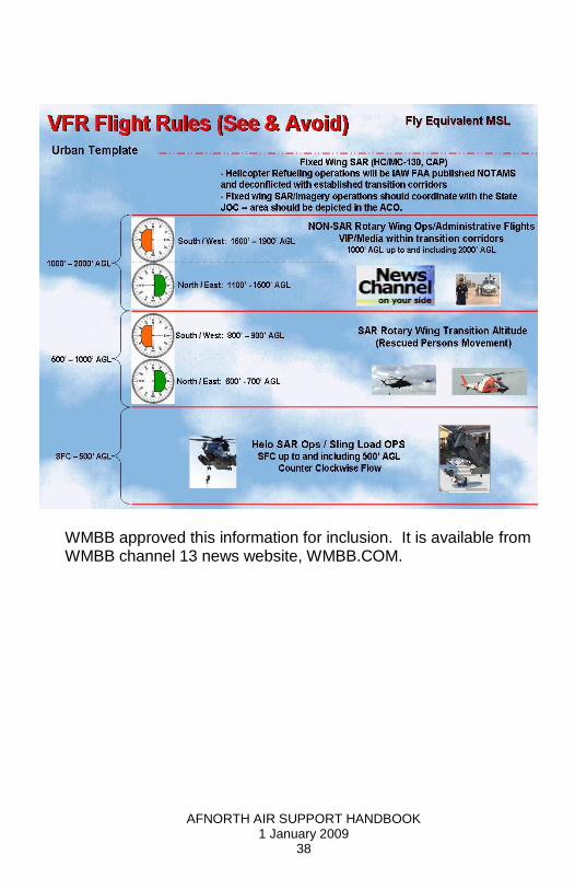
WMBB approved this information for inclusion. It is available from WMBB channel 13 news website, WMBB.COM.
AFNORTH AIR SUPPORT HANDBOOK 1 January 2009
39
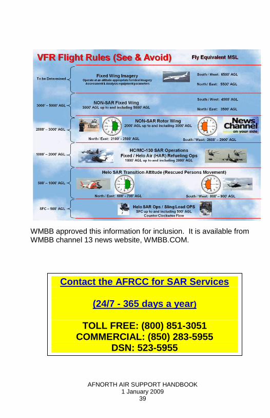
WMBB approved this information for inclusion. It is available from WMBB channel 13 news website, WMBB.COM.
Contact the AFRCC for SAR Services
(24/7 - 365 days a year)
TOLL FREE: (800) 851-3051
COMMERCIAL: (850) 283-5955 DSN: 523-5955
AFNORTH AIR SUPPORT HANDBOOK 1 January 2009
40
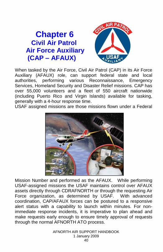
Chapter 6 Civil Air Patrol
Air Force Auxiliary (CAP – AFAUX)
When tasked by the Air Force, Civil Air Patrol (CAP) in its Air Force Auxiliary (AFAUX) role, can support federal state and local authorities, performing various Reconnaissance, Emergency Services, Homeland Security and Disaster Relief missions. CAP has over 55,000 volunteers and a fleet of 550 aircraft nationwide (including Puerto Rico and Virgin Islands) available for tasking, generally with a 4-hour response time. USAF assigned missions are those missions flown under a Federal
Mission Number and performed as the AFAUX. While performing USAF-assigned missions the USAF maintains control over AFAUX assets directly through CDRAFNORTH or through the requesting Air Force organization, as determined by USAF. With advanced coordination, CAP/AFAUX forces can be postured to a responsive alert status with a capability to launch within minutes. For non-immediate response incidents, it is imperative to plan ahead and make requests early enough to ensure timely approval of requests through the normal AFNORTH ATO process.
AFNORTH AIR SUPPORT HANDBOOK 1 January 2009
41
CAP / AFAUX Capabilities
Aerial Imaging. Provides the ability to image, transmit and download high resolution digital photos from airborne platforms via e-mail. Provides short notice, in-flight disaster and damage assessment as well as ongoing visual reconnaissance. Airborne Visual Reconnaissance. Conducts visual airborne reconnaissance of isolated locations, border and coastal areas, ports and harbors and critical infrastructure, including nuclear power plants, gas pipelines, and reservoirs, etc. to help identify suspicious activity. Satellite Link Airborne Dynamic Re-tasking. Satellite links provide the ability to contact aircraft in order to re-task/request different photo orientation or mission changes. Light Air Transport / Air Taxi. Provides transport of human blood or organs, equipment, passengers, or search dog teams to austere/remote airfields. Air and Ground Fleet Availability. Fleet of over 550 aircraft, 940 ground vehicles and trained crews available for search and rescue. Communications Support. An extensive communications network provides VHF and HF capability as well as aerial communications relay platforms. The network includes over 5,000 fixed land VHF radio stations and 10,000 mobile radios, as well as a nationwide HF network. Personnel. A cadre of 650+ Chaplains are available for weekly religious services or general support. Trained ground crews to provide damage assessment and mitigation, disaster recovery and limited security to augment civil and military authorities. Law Enforcement Support. Ability to take law enforcement or VIP personnel aloft for visual reconnaissance of areas of interest when legal requirements are met. Sensor Adaptability. Capable (with sufficient advanced coordination) of
AFNORTH AIR SUPPORT HANDBOOK 1 January 2009
42
carrying various customer-supplied sensor packages aloft.
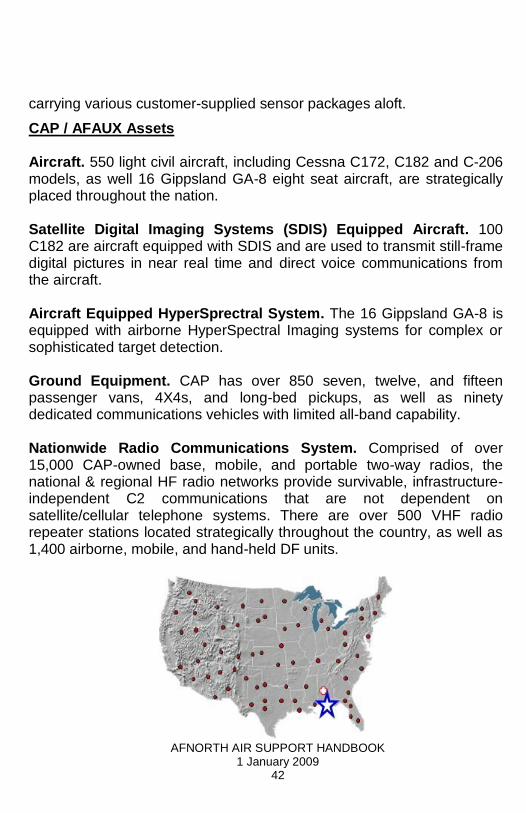
CAP / AFAUX Assets Aircraft. 550 light civil aircraft, including Cessna C172, C182 and C-206 models, as well 16 Gippsland GA-8 eight seat aircraft, are strategically placed throughout the nation. Satellite Digital Imaging Systems (SDIS) Equipped Aircraft. 100 C182 are aircraft equipped with SDIS and are used to transmit still-frame digital pictures in near real time and direct voice communications from the aircraft. Aircraft Equipped HyperSprectral System. The 16 Gippsland GA-8 is equipped with airborne HyperSpectral Imaging systems for complex or sophisticated target detection. Ground Equipment. CAP has over 850 seven, twelve, and fifteen passenger vans, 4X4s, and long-bed pickups, as well as ninety dedicated communications vehicles with limited all-band capability. Nationwide Radio Communications System. Comprised of over 15,000 CAP-owned base, mobile, and portable two-way radios, the national & regional HF radio networks provide survivable, infrastructure-independent C2 communications that are not dependent on satellite/cellular telephone systems. There are over 500 VHF radio repeater stations located strategically throughout the country, as well as 1,400 airborne, mobile, and hand-held DF units.

AFNORTH AIR SUPPORT HANDBOOK 1 January 2009
43
CAP/AFAUX Aircraft Platforms Gippsland GA-8 (18) Cessna 206 (22) Cessna 182 (262)

AFNORTH AIR SUPPORT HANDBOOK 1 January 2009
44
Cessna 172 (262) Sensor Descriptions. Direction Finder (DF). The DF is designed to locate Emergency Locator Beacons (ELT) on downed aircraft or Emergency Position Indicating Radio Beacons (EPIRB) from ships in distress. It can receive emergency signals on 121.5 MHz (old civil frequency), 243 MHz (old military frequency), and 406 MHz (new universal freq). Satellite Digital Imaging System (SDIS). Point -to -multi -point transmission of aerial digital photography is delivered in-flight via satellite communications. An SDIS functional unit is comprised of an aircraft equipped with a photo window, a digital camera, laptop computer, aircraft satellite telephone equipment and a trained three-person crew. Since images are sent directly to customer‘s computer, no specialized ground equipment is needed. A photo is attached to a standard MS Outlook e-mail, allowing for text information to accompany photo -e.g. latitude/longitude coordinates, time stamp, site identification, conditions, and other descriptive text. The near real-time nature of SDIS images has proven effective in SAR; disaster response and damage assessment; environmental impact damage, destruction appraisal, and tracking; and facility security reconnaissance, among many other tasks.
AFNORTH AIR SUPPORT HANDBOOK 1 January 2009
45
Airborne Real-Time Cueing HyperSpectral Enhanced Reconnaissance (ARCHER). ARCHER is the most sophisticated unclassified HyperSpectral imaging system available. It has direct applications for Search and Rescue; Counterdrug; Disaster Relief and Impact Assessment; and Homeland Security. ARCHER is a non-invasive reflected light technology that uses three separate methods for target identification: Spectral signature matching: Evaluates reflected light against a library of spectral signatures to identify Specifically-targeted objects. Anomaly detection: Compares reflected light against a continuously calculated background spectrum. Anomalies are flagged as potential targets for further evaluation. Change detection: Executes a pixel-by-pixel comparison of current image against ground conditions that were obtained in a previous mission over the same area. Scene changes are identified, and new, moved or departed targets are highlighted for evaluation. Command and Control / Legal Status. The same legal authorities that govern the use of Air Force assets generally apply to the use of CAP when acting in its capacity as the Air Force Auxiliary. All USAF-assigned missions will be flown under military command and control, generally at the operational (JFACC/CFACC) level. Posse Comitatus Act. Unless otherwise authorized by law, the Air Force Auxiliary may not directly participate in civilian law enforcement activities, including, but not limited to: arrest or detention procedures; interdiction of a vehicle, vessel, or aircraft; surveillance or pursuit of individuals or search or seizure.
AFNORTH AIR SUPPORT HANDBOOK 1 January 2009
46
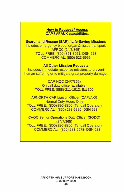
How to Request / Access CAP / AFAUX capabilities.
Search and Rescue (SAR) / Life-Saving Missions Includes emergency blood, organ & tissue transport.
AFRCC (24/7/365) TOLL FREE: (800) 851-3051, DSN 523
COMMERCIAL: (850) 523-5955
All Other Mission Requests Includes immediate response missions to prevent
human suffering or to mitigate great property damage.
CAP-NOC (24/7/365) On call duty officer available.
TOLL FREE: (888)-211-1812, Ext 300
AFNORTH CAP Liaison Officer (CAPLNO) Normal Duty Hours Only
TOLL FREE: (800) 896-8806 (Tyndall Operator) COMMERCIAL: (850) 283-5880, DSN 523
CAOC Senior Operations Duty Officer (SODO)
(24/7/365) TOLL FREE: (800) 896-8806 (Tyndall Operator)
COMMERCIAL: (850) 283-5573, DSN 523

AFNORTH AIR SUPPORT HANDBOOK 1 January 2009
47
Chapter 7 Incident Awareness and Assessment
(IAA)
Authorities
Natural or man-made disasters and special events can temporarily overwhelm local, tribal, state and non-military federal responders. The Department of Defense (DOD) has a long history of supporting civil authorities in the wake of catastrophic events. When directed by the President (POTUS) or the Secretary of Defense (SecDef), United States Northern Command (USNORTHCOM) and service components will respond quickly and effectively to the requests of civil authorities to save lives, prevent human suffering, and mitigate great property damage. The Joint Strategic Capabilities Plan 2006 (JSCP) directed CDRUSNORTHCOM to prepare a plan to support the employment of Title 10 DOD forces providing DSCA in accordance with (IAW) the National Response Framework (NRF), applicable federal law, DOD Directives (DODD), and other policy guidance including those hazards defined by the 15 National Planning Scenarios that are not addressed by other JSCP tasked plans. DSCA is a subset of DOD civil support that is performed within the parameters of the NRF. CDR1AF (AFNORTH) CONPLAN 3501-08 supports CDRUSNORTHCOM CONPLAN 3501-08.
Incident Awareness and Assessments (IAA) Defined
IAA is similar to DOD‘s definition of Intelligence Surveillance and Reconnaissance (ISR). However, ISR is conducted outside the United States over foreign territory or within the United States during Homeland Defense events, while IAA is conducted within the United States in support of Defense Support of Civil Authorities operations. The change in title is necessary to make it clear that DOD does not collect Intelligence on US persons. IAA operations focus on providing timely and usable information to all levels of command and to local, State, Civil, and Federal leaders in order to save lives, reduce human suffering and protect property. The
AFNORTH AIR SUPPORT HANDBOOK 1 January 2009
48
three mission sets of IAA are Broad Area Coverage (BAC), Damage Assessment (DA), and Situational Awareness (SA). Similar to ISR in the HD mission, IAA capabilities include Electro-Optical (EO), Infra-red (IR), Synthetic Aperture Radar (SAR), Multi-spectral/Hyper-spectral (MSI/HSI), and Full Motion Video (FMV).
AFNORTH’s tasks in support of IAA include:
Assist USNORTHCOM in identifying, sourcing, sustaining and employing airborne IAA assets. Additionally, if the DSCA situation will require dynamic movement and tactical control of airborne assets, AFNORTH will also assist USNORTHCOM in identifying the need for a Dynamic Ground Control capability (like a Joint Terminal Attack Controller (JTAC)).
AFNORTH will execute Collection Operations Management (COM) for assigned airborne IAA through the AFNORTH AOC (601 IRD).
AFNORTH (601 IRD) will coordinate and integrate DOD IAA collection efforts with non-DOD federal, state government, local government, and non-government airborne collection assets to increase efficiencies. This effort is greatly facilitated when all parties elect to participate in the Contingency Response Air Support Schedule (CRASS) process.
Roles and Responsibilities
U.S. Northern Command (USNORTHCOM). USNORTHCOM plans, organizes and executes homeland defense and civil support missions, but has few permanently assigned forces. The command is assigned forces whenever necessary to execute missions, as ordered by the president and secretary of defense. USNORTHCOM‘s civil support mission includes domestic disaster relief operations that occur during natural or man-made disasters (e.g. fires, hurricanes, floods and earthquakes). Support also includes counter-drug operations and managing the

AFNORTH AIR SUPPORT HANDBOOK 1 January 2009
49
consequences of a terrorist event employing a weapon of mass destruction. The command provides assistance to a Primary Agency when tasked by DOD. Per the Posse Comitatus Act, Title 10 military forces can provide civil support, but cannot become directly involved in law enforcement.
In providing civil support, USNORTHCOM generally operates through established Joint Task Forces subordinate to the command. An emergency must exceed the capabilities of local, state and federal agencies before USNORTHCOM becomes involved. In most cases, support will be limited, localized and specific. When the scope of the disaster is reduced to the point that the Primary Agency can again assume full control and management without military assistance, USNORTHCOM will execute its exit strategy and redeploy DOD forces.
Mission Sets
Broad-Area Coverage (BAC). BAC refers to the collection effort aimed at collecting imagery of a large swath of territory, with the view of determining the full extent of destruction or, if executed in advance of an incident, the pre-disaster state of an area. The following graphic depicts the scale.
Broad Area Coverage Scale
AFNORTH AIR SUPPORT HANDBOOK 1 January 2009
50
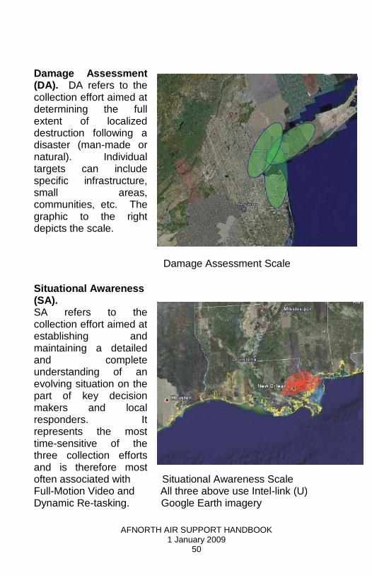
Damage Assessment (DA). DA refers to the collection effort aimed at determining the full extent of localized destruction following a disaster (man-made or natural). Individual targets can include specific infrastructure, small areas, communities, etc. The graphic to the right depicts the scale.
Damage Assessment Scale
Situational Awareness (SA). SA refers to the collection effort aimed at establishing and maintaining a detailed and complete understanding of an evolving situation on the part of key decision makers and local responders. It represents the most time-sensitive of the three collection efforts and is therefore most often associated with Situational Awareness Scale Full-Motion Video and All three above use Intel-link (U) Dynamic Re-tasking. Google Earth imagery
AFNORTH AIR SUPPORT HANDBOOK 1 January 2009
51
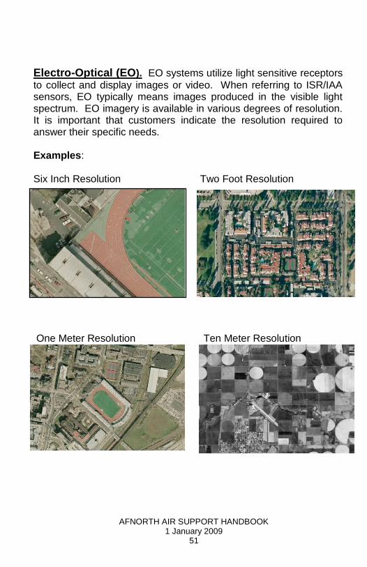
Electro-Optical (EO). EO systems utilize light sensitive receptors
to collect and display images or video. When referring to ISR/IAA sensors, EO typically means images produced in the visible light spectrum. EO imagery is available in various degrees of resolution. It is important that customers indicate the resolution required to answer their specific needs. Examples:
Six Inch Resolution Two Foot Resolution
One Meter Resolution Ten Meter Resolution

AFNORTH AIR SUPPORT HANDBOOK 1 January 2009
52
Infra-red (IR). IR systems are sensitive to the infrared portion of the
electromagnetic spectrum. In order to produce a differentiated image they rely on heat gradients, i.e., varied infrared energy reflected or produced by adjacent objects. Sometimes referred to as Thermal Imaging, IR is most useful during hours of darkness, but can be used effectively during daylight hours as well. Examples of IR Imagery
Synthetic Aperture Radar. Synthetic-aperture radar (SAR) is a
form of radar in which the large, highly-directional rotating antenna used by conventional radar is replaced with many low-directivity small stationary antennas scattered near or around the target area. The many echo waveforms received at the different antenna positions are post-processed to resolve the target. SAR can only be implemented by moving one or more antennas over relatively immobile targets, by placing multiple stationary antennas over a relatively large area, or combinations thereof. SAR has seen wide applications in remote sensing and mapping.

AFNORTH AIR SUPPORT HANDBOOK 1 January 2009
53
Examples of SAR Imagery
Full-Motion Video (FMV). FMV refers to live, real-time streaming video collected primarily for the immediate situational awareness of key decision makers. It includes any live video across the electro-magnetic spectrum, but normally it will be EO or IR. Its main uses include:
Search and Rescue Lines of Communication (LOC) Analysis Initial Damage Assessment (DA) Fire Perimeter Identification Situational Awareness (SA)

AFNORTH AIR SUPPORT HANDBOOK 1 January 2009
54
FMV Taken of Gulf Coast Oil Platform Venting Gas after 2008 hurricane season
Multi-Spectral/Hyper-Spectral (MSI/HSI). MSI and HSI use
many bands within the Infrared, Visible and Ultraviolet portions of the electro-magnetic spectrum to provide composite images produced by interpreting several layers of information. They are particularly useful at identifying chemicals, locating camouflaged objects, and providing change and anomaly detection. MSI/HSI systems are passive and require a light source to operate, making them less useful during hours of darkness. This type of imagery normally requires a trained analyst to interpret. Customers should consider this factor when requesting this type of imagery to ensure that the proper support personnel are
included for the tasked asset. Examples of MSI/HSI
AFNORTH AIR SUPPORT HANDBOOK 1 January 2009
55
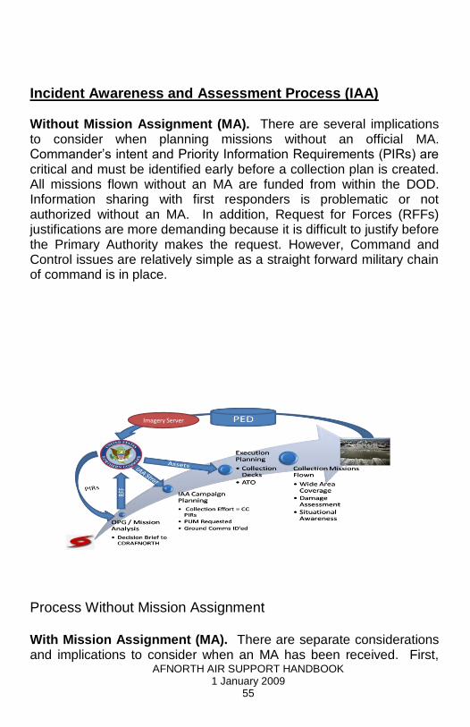
Incident Awareness and Assessment Process (IAA) Without Mission Assignment (MA). There are several implications to consider when planning missions without an official MA. Commander‘s intent and Priority Information Requirements (PIRs) are critical and must be identified early before a collection plan is created. All missions flown without an MA are funded from within the DOD. Information sharing with first responders is problematic or not authorized without an MA. In addition, Request for Forces (RFFs) justifications are more demanding because it is difficult to justify before the Primary Authority makes the request. However, Command and Control issues are relatively simple as a straight forward military chain of command is in place.
Imagery Server
Process Without Mission Assignment With Mission Assignment (MA). There are separate considerations and implications to consider when an MA has been received. First,
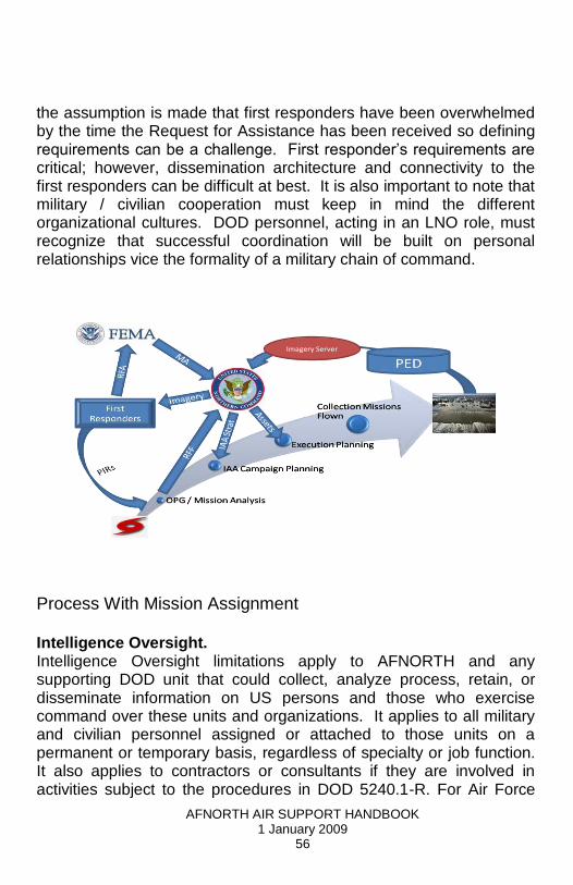
AFNORTH AIR SUPPORT HANDBOOK 1 January 2009
56
the assumption is made that first responders have been overwhelmed by the time the Request for Assistance has been received so defining requirements can be a challenge. First responder‘s requirements are critical; however, dissemination architecture and connectivity to the first responders can be difficult at best. It is also important to note that military / civilian cooperation must keep in mind the different organizational cultures. DOD personnel, acting in an LNO role, must recognize that successful coordination will be built on personal relationships vice the formality of a military chain of command.
Imagery Server
Process With Mission Assignment Intelligence Oversight. Intelligence Oversight limitations apply to AFNORTH and any supporting DOD unit that could collect, analyze process, retain, or disseminate information on US persons and those who exercise command over these units and organizations. It applies to all military and civilian personnel assigned or attached to those units on a permanent or temporary basis, regardless of specialty or job function. It also applies to contractors or consultants if they are involved in activities subject to the procedures in DOD 5240.1-R. For Air Force
AFNORTH AIR SUPPORT HANDBOOK 1 January 2009
57
Reserve Command, this AFI applies to Traditional Reservists, Air Reserve Technicians, Individual Mobilization Augmentees, and other Air Force Reserve Command members assigned or attached to intelligence units and staffs who are performing intelligence-related activities. For the Air National Guard (ANG), it applies to all ANG members in a Title 10 or Title 32 status assigned or attached to intelligence units or staffs who are performing intelligence-related activities. Proper Use Memorandum (PUM) When it is required for aerial intelligence collection within the USNORTHCOM AOR, J23M (Requirements Branch) drafts a Domestic Imagery Request (DIR) or PUM. The PUM clearly describes the boundaries and limits under which IC personnel will be conducting operations in support of the DSCA mission. When it is determined that domestic imagery is required to satisfy an intelligence need or to support a designated Local Field Activity (LFA), the requesting command or component notifies the USNORTHCOM J23M, the JIOC-N Operations Officer (J23DO), or Knowledge Management Branch (J22S), and the Geospatial Intelligence (GEOINT) Operations Team for coordination. Notification will be followed-up by a written request, preferably through COLISEUM. Current DOD guidance (DIA/CLM-1/R 282305Z NOV 01) allows individual services and Commands to approve ―domestic airborne reconnaissance‖ (manned and unmanned) imagery proper use memorandum for both military and private property. This guidance delegates to the Services and Commands the responsibility to review DOD 5240.1-R for compliance and encourages legal review by the servicing legal office. Unresolved issues are to be referred to Service or DOD General Council for determination. In some cases, a locally drafted and locally held PUM is sufficient to meet requirements. AFNORTH/A2 and JA will work with USNORTHCOM/J23M and JA to ensure that the appropriate legal documents are drafted and approved. The AFNORTH A2 Intelligence Oversight Monitor in coordination with the AFNORTH/JA will coordinate with USNORTHCOM/J23M and ensure that the appropriate documentation is approved prior to conducting IAA operations within the CONUS.

AFNORTH AIR SUPPORT HANDBOOK 1 January 2009
58
Plan Mission. In order to plan an effective mission AFNORTH IAA Planners need a detailed understanding of the requirement(s). An IAA request (shown below) form will initiate this process and help planners determine the proper platform, product and dissemination strategy.
IAA Request for Support IAA Synchronization Matrix (Sync Matrix). AFNORTH (601 IRD) collection planners produce a Synch Matrix in order to ensure that all tasked assets are de-conflicted, both from one another and from other government agency assets The effect of the Synch Matrix is unified effort despite not having a unified chain of command or unified air tasking order (ATO). The Synch Matrix on the following page was produced during the 2008 Gulf Coast hurricane season and is provided as an example.

AFNORTH AIR SUPPORT HANDBOOK 1 January 2009
59
Collection Deck. To task a platform, the AFNORTH (601 IRD) produces detailed collection plans. They include a Microsoft Excel spreadsheet identifying the specific collection points or the parameters of a directed search area. In addition, a Microsoft PowerPoint slide is produced to graphically depict the overall day‘s collection activity. An example is provided on the next page.
Mission Execution. Title 10 missions are formally tasked through the ATO process. The ATO directs a subordinate flying unit to execute the IAA missions. It contains the following details:
Mission number Flight details Take off Time Time on Station Etc
AFNORTH AIR SUPPORT HANDBOOK 1 January 2009
60
The Reconnaissance, Surveillance, Target Acquisition Annex (RSTA) provides amplifying information to the aircrew and directs the format and content of the Post Mission Summary (described later in this volume). The RSTA Annex also provides detailed instruction for Processing, Analysis and Distribution (PAD) requirements. Dynamic Re-tasking. Dynamic Re-tasking allows for the collection of time-sensitive IAA. The Chief of Combat Ops (CCO) within the AFNORTH Combat Ops Division (COD) determines if an asset can be re-tasked. The CCO does this on recommendation from the Senior Intelligence Duty Officer (SIDO) and the decision is subsequently relayed to the platform through the controlling Sector. Dissemination. Dissemination is based on user needs as determined by the IAA Request Form. Every effort is made to ensure the final product is unclassified and in a usable format. The most common form of dissemination used is the Imagery and FMV access portals as listed below. Pull – Posted to website(s). Typically the United States Geological Survey (USGS) will host the majority of the imagery products on their Hazard Data Distribution System (HDDS) server. In addition, material may be posted to the Homeland Security Information Network (HSIN), and the USNORTHCOM Imagery/FMV server aka the Disaster Imagery Management Server (DIMS). Push – Customers can specify whether they need products e-mailed or mailed directly to them. For example Civil Air Patrol has the capability to email imagery directly to a customer while airborne via a satellite telephone. (Note: The satellite Constellation used for this capability is degrading and is occasionally intermittent). Live Feed – Live feeds are accessed through a FMV portal or directly down-linked to the customer. Primary FMV customers will be collocated with a communications package (i.e. ROVER, DRAGOON, etc) that will allow them to have an immediate direct FMV feed while in the field. Additionally, FMV feeds will be pushed to the FMV server at NORTHCOM for the benefit of the remainder of the IAA community.

AFNORTH AIR SUPPORT HANDBOOK 1 January 2009
61
Unclassified Imagery Access Portals United States Geological Survey Hazard Data Distribution System Open Access: http://hdds.usgs.gov/hdds Restricted Access:
http://edcftp.cr.usgs.gov/disaster_restricted/200808_Hurricane_Ike/data Official Users with Need to Know may contact the AFNORTH
(601 IRD) PED Team for log in information. NORTHCOM Disaster Imagery Management System (CAC Access required for the portal, User Name and Password required for the server)
https://operations.noradnorthcom.mil/sites/NNCJ2/NNCJ22/DSCA/DIMS/default.aspx Department of Homeland Security’s Homeland Security Information Network (HSIN) (Registration Required)
https://government.hsin.gov/default.aspx TAGSWeb (Classified USN Global Hawk Imagery)
http://www.ghmd.navair.navy.smil.mil/GHMD_Web Contact the AFNORTH (601 IRD) PED Team via SIPRNET for
log in information 601aocisrdunitsupport@
afnorth.af.smil.mil
Feedback. In order to ensure that customer requirements are satisfied it is essential to collect post mission feedback from both crew as well as the customer. Crew feedback will be in the form of a post mission summary as defined in the RSTA Annex to the Air Tasking Order (ATO). Customer feedback is sought through various Liaison officers (LNOs) either in person or through telephone and e-mail exchanges to determine whether requirements were

AFNORTH AIR SUPPORT HANDBOOK 1 January 2009
62
satisfied. This information is then used to determine the need for follow-on missions.
Assessments. The majority of operational efficiency is measured using operational metrics. Examples of information traditionally included in operational metrics are: IAA missions scheduled vs. missions flown, IAA sensor and communication link operational rates, imagery target deck collection rates (imagery targets tasked vs. imagery targets collected), ad hoc or dynamic re-tasking satisfaction rates (requested vs. successfully tasked, timeliness of collection and reporting, etc.) and on-station, in time, full mission, no problems (platform, sensor, links and crew). The assessment process is used to evaluate the overall effectiveness of the IAA campaign. The process seeks to: Evaluate the effectiveness and efficiency of operations in achieving
JFACC/CFACC objectives Evaluate the effectiveness of JFACC/CFACC objectives in supporting
CFC/JFC objectives Recommend changes in weight, priorities or phasing efforts Provide predictive evaluation/assessment Data is collected and analyzed after every IAA mission as the latest information is integrated into the cumulative totals. Additionally, an overall assessment is accomplished upon the completion of the contingency. Lessons Learned are captured in order to improve current processes and amend doctrine as required. The following table is an example of recently collected assessment totals. Collectively, the Feedback and Assessments process ensures IAA assets are employed as efficiently and effectively as possible. Ground Architecture The basic architecture for the reception and transmission of FMV is the same regardless of platform used. It should also be noted that ANG forces utilizing the RC-26B aircraft are equipped with the Dragoon system, providing much higher video resolution and greater signal range than that available with the USA/USAF ROVER system.

AFNORTH AIR SUPPORT HANDBOOK 1 January 2009
63
The IAA platform transmits the video image from its sensor, normally via a C-band Omni-directional antenna. This restricts reception range to approximately 15 NM. ROVER receives the signal on the ground and reproduces the video on a ruggedized laptop system. Advanced ROVER systems are able to rebroadcast FMV via standard Ethernet links to other laptops/computer terminals, to a Personal Data Assistant (PDA), or to a satellite backhaul. Reception by ROVER can be severely degraded by mountainous terrain, weather, frequency interference and other similar factors. Field use during DSCA scenarios typically result in ROVERs attempting to receive at ranges far greater than in wartime, overseas operations. What was designed to ―see over the next hill‖ is being used to provide awareness over city sized areas. It is not uncommon for ROVERs employed in this manner to have great difficulty in maintaining signal reception from the collection platform

AFNORTH AIR SUPPORT HANDBOOK 1 January 2009
64
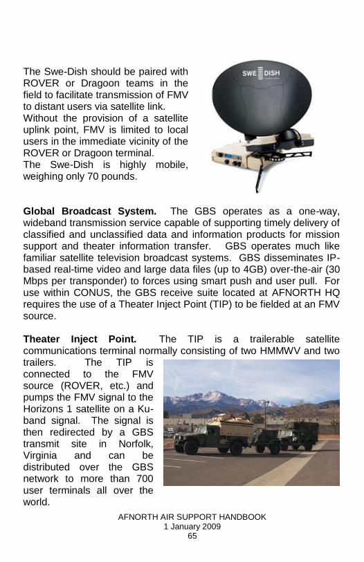
Note: The HMMVV depicted represents a generic vehicle for ROVER mobility. The ROVER itself is depicted on the previous page. Full Motion Video is provided to the on-site user at the ROVER terminal. If FMV is desired at a more distant location, a Swe-Dish or similar uplink terminal is used to convert and relay the signal through a DISA Teleport Step Site, then over leased landlines to the NORAD/USNORTHCOM FMV server. By this point image degradation will be evident. Other users may view the FMV via NIPR connection, but with a further reduction in image clarity. FMV can also be disseminated via the Global Broadcast System (GBS). Swe-Dish. One of the more important components in the Sensor-ROVER-FMV construct is the satellite inject point that provides the FMV signal to HHQ for dissemination via Web. The most common and most mobile option is the TSC-68 Swe-Dish.
AFNORTH AIR SUPPORT HANDBOOK 1 January 2009
65
The Swe-Dish should be paired with ROVER or Dragoon teams in the field to facilitate transmission of FMV to distant users via satellite link. Without the provision of a satellite uplink point, FMV is limited to local users in the immediate vicinity of the ROVER or Dragoon terminal. The Swe-Dish is highly mobile, weighing only 70 pounds.
Global Broadcast System. The GBS operates as a one-way, wideband transmission service capable of supporting timely delivery of classified and unclassified data and information products for mission support and theater information transfer. GBS operates much like familiar satellite television broadcast systems. GBS disseminates IP-based real-time video and large data files (up to 4GB) over-the-air (30 Mbps per transponder) to forces using smart push and user pull. For use within CONUS, the GBS receive suite located at AFNORTH HQ requires the use of a Theater Inject Point (TIP) to be fielded at an FMV source.
Theater Inject Point. The TIP is a trailerable satellite communications terminal normally consisting of two HMMWV and two trailers. The TIP is connected to the FMV source (ROVER, etc.) and pumps the FMV signal to the Horizons 1 satellite on a Ku-band signal. The signal is then redirected by a GBS transmit site in Norfolk, Virginia and can be distributed over the GBS network to more than 700 user terminals all over the world.

AFNORTH AIR SUPPORT HANDBOOK 1 January 2009
66
USN/USA TCDL. The Navy and Army use the Tactical Common Data Link (TCDL) for the majority of their FMV efforts. TCDL is a FMV link similar to the system used by ROVER, but it provides a greater extended range of transmission. TCDL links can operate at ranges of 100-150 NM as opposed to the short 15 NM range of a ROVER system. TCDL is a full duplex system allowing bi-directional information exchange over the link. TCDL transmissions are normally equipped with an encryption system that prevents reception by a ROVER system. In order for ROVER gear to acquire and receive signals, the TCDL must be reconfigured to transmit in an unencrypted mode acceptable to ROVER. The availability of TCDL ground packages are severely limited due to operations overseas. TCDL weighs approximately 2,200 pounds, requiring a large truck to move the system from point-to-point. In order to provide the FMV signal to distant users, TCDL must be linked to a Swe-Dish or other suitable satellite uplink system.

AFNORTH AIR SUPPORT HANDBOOK 1 January 2009
67
Associated Costs Table

AFNORTH AIR SUPPORT HANDBOOK 1 January 2009
68
Preferred Assets Table