convention on the prohibition of the use, …httpassets... · convention on the prohibition of the...
TRANSCRIPT

1
CONVENTION ON THE PROHIBITION OF THE USE, STOCKPILING, PRODUCTION AND TRANSFER OF
ANTI-PERSONNEL MINES AND ON THEIR DESTRUCTION
Report for Article 7
The Republic of South Sudan Transparency Report on Article 7 1 January 2015 — 31 December 2015
Contact person: Mr Jurkuch Barach Jurkuch
South Sudan National Mine Action Authority
Form A National implementation measures

2
No additional legal, administrative and other measures were taken during the previous calendar year to
prevent and suppress any activity prohibited under the Convention.
Form B Stockpiled anti-personnel mines
Not applicable.
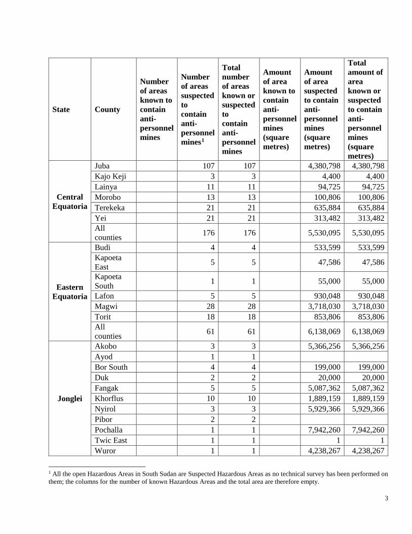
Form C Location of mined areas as of 31 December 2015
As of 31 December 2015, a total of 303 areas are suspected to contain anti-personnel (AP) mines and a
reported 98,403,022 square metres throughout South Sudan require clearance, as shown in Table 1,
below.
The slow progress in the national clearance plan for South Sudan is most likely due ot the lack of access
and continued insecurity in some parts of South Sudan, as well as the emerging need to clear explosive
ordnance disposal (EOD) spot tasks to support humanitarian work in conflict affected areas since the
conflict which began in 2013. Further focus on clearance is needed for South Sudan to meet the
obligations of the Ottawa Treaty.
Table 1. Summary of areas known, or suspected to contain anti-personnel mines, as of 31 December 2015
3
State County
Number of areas known to contain anti-personnel mines
Number of areas suspected to contain anti-personnel mines1
Total number of areas known or suspected to contain anti-personnel mines
Amount of area known to contain anti-personnel mines (square metres)
Amount of area suspected to contain anti-personnel mines (square metres)
Total amount of area known or suspected to contain anti-personnel mines (square metres)
Central Equatoria
Juba 107 107 4,380,798 4,380,798 Kajo Keji 3 3 4,400 4,400 Lainya 11 11 94,725 94,725 Morobo 13 13 100,806 100,806 Terekeka 21 21 635,884 635,884 Yei 21 21 313,482 313,482 All counties 176 176 5,530,095 5,530,095
Eastern Equatoria
Budi 4 4 533,599 533,599 Kapoeta East 5 5 47,586 47,586
Kapoeta South 1 1 55,000 55,000
Lafon 5 5 930,048 930,048 Magwi 28 28 3,718,030 3,718,030 Torit 18 18 853,806 853,806 All counties 61 61 6,138,069 6,138,069
Jonglei
Akobo 3 3 5,366,256 5,366,256 Ayod 1 1 Bor South 4 4 199,000 199,000 Duk 2 2 20,000 20,000 Fangak 5 5 5,087,362 5,087,362 Khorflus 10 10 1,889,159 1,889,159 Nyirol 3 3 5,929,366 5,929,366 Pibor 2 2 Pochalla 1 1 7,942,260 7,942,260 Twic East 1 1 1 1 Wuror 1 1 4,238,267 4,238,267
1 All the open Hazardous Areas in South Sudan are Suspected Hazardous Areas as no technical survey has been performed on them; the columns for the number of known Hazardous Areas and the total area are therefore empty.

4
All counties 33 33 30,671,671 30,671,671
Lakes
Cueibet 1 1 21,000 21,000 Rumbek East 1 1 12,037 12,037
Wulu 1 1 2,500 2,500 All counties 3 3 35,537 35,537
Northern Bahr El Ghazal
Aweil South 1 1
Aweil West 1 1 80,100 80,100
All counties 2 2 80,100 80,100
Unity
Abiemnom 1 1 13,252,144 13,252,144 Rubkona 3 3 16 16 All counties 4 4 13,252,160 13,252,160
Upper Nile
Fashoda 1 1 16,385 16,385 Longochuk 1 1 4 4 Maiwut 2 2 39,155,231 39,155,231 Malakal 1 1 Melut 1 1 253 252 Panyikang 2 2 1,540 1,540 All counties 8 8 39,173,413 39,173,412
Western Bahr El Ghazal
Jur River 1 1 Wau 2 2 2,827,433 2,827,433 All counties 3 3 2,827,433 2,827,433
Western Equatoria
Maridi 2 2 38,600 38,600 Mundri East 10 10 505,945 505,945
Mvolo 1 1 150,000 150,000 All counties 13 13 694,545 694,545
All States 303 303 98,403,022 98,403,022

5
Map 1: Locations of Known, or Suspected Anti-Personnel Mines, as of 31 December 2015

6
Map 2: Locations of Known and Suspected Hazards, as of 31 December 2015
NOTE: There are 903 suspected hazards including AP mines in South Sudan.

7
Form D Anti-Personnel Mines retained or transferred
The Republic of South Sudan does not retain or transfer anti-personnel mines for permitted purposes.
Form E Status of programmes for conversion or de-commissioning of AP mine production
facilities
Not applicable.
Form F Status of programmes for destruction of AP mines
All identified and discovered stockpiles of anti-personnel mines are destroyed utilizing the relevant
procedures outlined in the South Sudan National Technical Standards and Guidelines (NTSGs), by the
implementing partners on the ground. This activity is recorded for future information within the
Information Management System for Mine Action (IMSMA) database, including details of the types,
location, etc.
2. Status of programmes for destruction of AP mines in mined areas (Article 5)
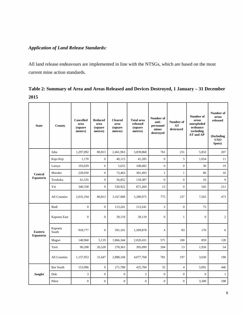
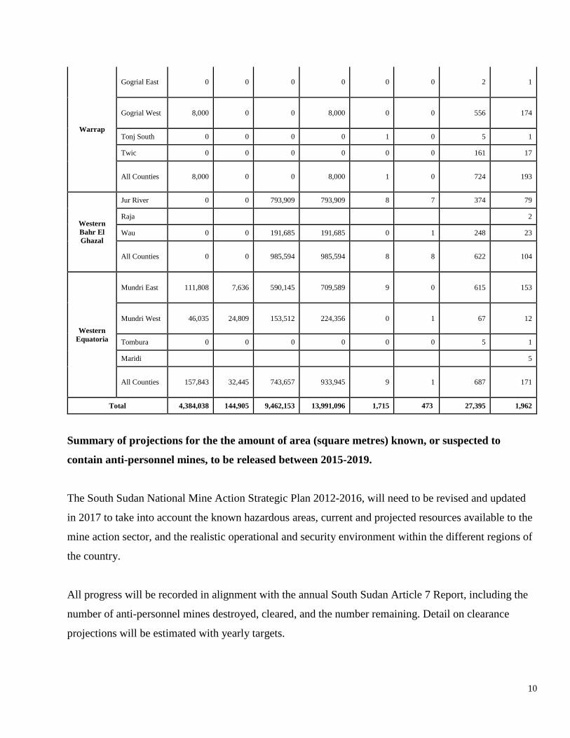
From 1 January to 31 December 2015, a total of of 1,715 anti-personnel mines were destroyed; 27,395
unexploded ordnance (UXO) destroyed (including anti-tank mines); 13,991,096 square metres released;
1,130,074 square metres cancelled; 1,962 areas released; and 9,462,153 square metres cleared
throughout South Sudan, as reported in Table 2, below.
The 13,991,096 square metres released includes all explosive ordnance disposal, battle area clearance
(sub-surface and surface), battle areas released, cancelled, manual mine clearance, mechanical clearance,
explosive detection dogs, and mined areas released and canelled by Non-Technical Survey.
8
Application of Land Release Standards:
All land release endeavours are implemented in line with the NTSGs, which are based on the most
current mine action standards.
Table 2: Summary of Area and Areas Released and Devices Destroyed, 1 January – 31 December
2015
State County
Cancelled area
(square meters)
Reduced area
(square metres)
Cleared area
(square metres)
Total area released (square metres)
Number of anti-
personnel mines
destroyed
Number of AT
destroyed
Number of areas
unexploded ordnance excluding
AT and AP
Number of areas
released
(Including UXO
Spots)
Central Equatoria
Juba 1,297,092 80,813 2,461,963 3,839,868 761 231 5,832 207
Kajo Keji 1,170 0 40,115 41,285 0 5 1,054 11
Lainya 103,029 0 5,653 108,682 0 0 30 19
Morobo 229,030 0 72,463 301,493 1 1 86 16
Terekeka 61,535 0 56,852 118,387 0 0 16 9
Yei 340,338 0 530,922 871,260 13 0 545 211
All Counties 2,032,194 80,813 3,167,968 5,280,975 775 237 7,563 473
Eastern Equatoria
Budi 0 0 113,241 113,241 2 0 75
Kapoeta East 0 0 39,119 39,119 0 1 0 2
Kapoeta South 918,777 0 591,101 1,509,878 4 83 170 6
Magwi 148,968 5,119 1,866,344 2,020,431 571 100 859 128
Torit 90,208 26,528 278,363 395,099 204 13 1,926 54
All Counties 1,157,953 31,647 2,888,168 4,077,768 781 197 3,030 190
Jonglei
Bor South 153,996 0 271,788 425,784 35 4 5,091 446
Duk 3 0 0 3 0 0 0 1
Pibor 0 0 0 0 0 0 3,300 198

9
Pochalla 1 0 3,914 3,915 0 0 3,079 14
Twic East 612,260 0 0 612,260 0 0 36 19
All Counties 766,260 0 275,702 1,041,962 35 4 11,506 678
Lakes
Rumbek Centre 0 0 113,813 113,813 0 0 2 0
Rumbek East 0 0 0 0 0 0 44 0
Awerial 0 0 0 0 0 0 0 1
Yiro West 0 0 2,116 2,116 0 0 0 1
All Counties 0 0 115,929 115,929 0 0 46 2
Northern Bahr El Ghazal
Aweil East 0 0 371,379 371,379 0 0 155 6
Aweil West 0 0 0 0 0 0 1 1
Aweil Centre 1
All Counties 0 0 371,379 371,379 0 0 156 8
Unity
Abinmnom 250,000 0 9 250,009 0 0 6 3
Guit 0 0 0 0 0 0 1 1
Koch 0 0 25,034 25,034 1 3 4 1
Leer 0 0 0 0 0 0 7 2
Mayendit 0 0 0 0 0 0 1
Mayom 0 0 264,453 264,453 105 11 540 15
Pariang 0 0 0 0 0 0 10 1
Rubkona 11,788 0 182,542 194,330 0 3 1,049 64
All Counties 261,788 0 472,038 733,826 106 17 1,618 87
Upper Nile
Maban 0 0 3,832 3,832 0 0 3
Malakal 0 0 384,281 384,281 0 9 1,329 33
Manyo 0 0 0 0 0 0 5
Melut 0 0 53,605 53,605 0 0 25 22
Panyikang 0 0 0 0 0 0 79
Renk 0 0 0 0 0 0 2 1
All Counties 0 0 441,718 441,718 0 9 1,443 56
10
Warrap
Gogrial East 0 0 0 0 0 0 2 1
Gogrial West 8,000 0 0 8,000 0 0 556 174
Tonj South 0 0 0 0 1 0 5 1
Twic 0 0 0 0 0 0 161 17
All Counties 8,000 0 0 8,000 1 0 724 193
Western Bahr El Ghazal
Jur River 0 0 793,909 793,909 8 7 374 79
Raja 2
Wau 0 0 191,685 191,685 0 1 248 23
All Counties 0 0 985,594 985,594 8 8 622 104
Western Equatoria
Mundri East 111,808 7,636 590,145 709,589 9 0 615 153
Mundri West 46,035 24,809 153,512 224,356 0 1 67 12
Tombura 0 0 0 0 0 0 5 1
Maridi 5
All Counties 157,843 32,445 743,657 933,945 9 1 687 171
Total 4,384,038 144,905 9,462,153 13,991,096 1,715 473 27,395 1,962
Summary of projections for the the amount of area (square metres) known, or suspected to
contain anti-personnel mines, to be released between 2015-2019.
The South Sudan National Mine Action Strategic Plan 2012-2016, will need to be revised and updated
in 2017 to take into account the known hazardous areas, current and projected resources available to the
mine action sector, and the realistic operational and security environment within the different regions of
the country.
All progress will be recorded in alignment with the annual South Sudan Article 7 Report, including the
number of anti-personnel mines destroyed, cleared, and the number remaining. Detail on clearance
projections will be estimated with yearly targets.

11
Form G Anti-personnel mines destroyed after entry into force
Article 4
Not applicable.
Form H Technical characteristics of each type produced/ owned, or possessed
Already reported.
Form I Measures to provide warning to the population
All suspected hazards are surveyed and marked by mine risk education (MRE) teams or clearance teams
with international signs and are located in the map and recorded in IMSMA. While a Landmine Impact
Survey was completed in 2008, as well as other surveys covering smaller areas within South Sudan
since then, the current extent of contamination is unknown, particularly in the Greater Upper Nile region
(inclusive of Jonglei, Upper Nile and Unity), which was most affected by the conflict that commenced in
December 2013. Even with the signing of the Agreement on Resolution of Conflict in South Sudan
(ARCSS) in August 2015, residual fighting in that region, as well as sporadically in the rest of the
country, has meant insecurity and lack of access for mine action teams to implement survey and
clearance. It is expected that when the security conditions improve and permit, survey of the Greater
Upper Nile region, and other areas affected by the conflict, will need to be conducted.
However, through non-technical and technical survey, land has been either cancelled or prioritized for
clearance. All cleared minefields are marked “cleared” in the map to promote activities such as
livelihoods (land cultivation, markets, etc.), infrastructural development, road construction, etc.
Throughout South Sudan, MRE targets civilians at the community level by age and gender; specifically,
locations of internally displaced persons (IDPs)and returnees, as well as schools are prioritized. The
12
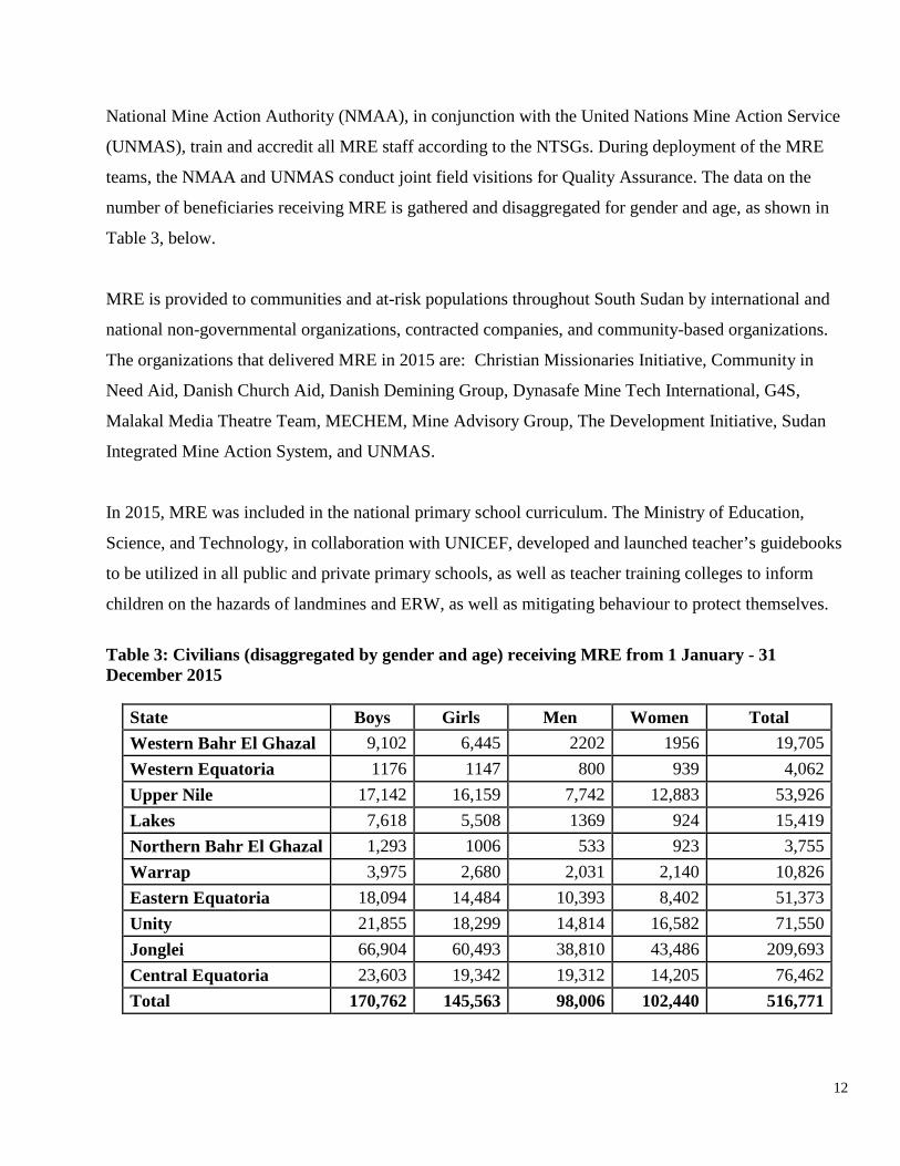
National Mine Action Authority (NMAA), in conjunction with the United Nations Mine Action Service
(UNMAS), train and accredit all MRE staff according to the NTSGs. During deployment of the MRE
teams, the NMAA and UNMAS conduct joint field visitions for Quality Assurance. The data on the
number of beneficiaries receiving MRE is gathered and disaggregated for gender and age, as shown in
Table 3, below.
MRE is provided to communities and at-risk populations throughout South Sudan by international and
national non-governmental organizations, contracted companies, and community-based organizations.
The organizations that delivered MRE in 2015 are: Christian Missionaries Initiative, Community in
Need Aid, Danish Church Aid, Danish Demining Group, Dynasafe Mine Tech International, G4S,
Malakal Media Theatre Team, MECHEM, Mine Advisory Group, The Development Initiative, Sudan
Integrated Mine Action System, and UNMAS.
In 2015, MRE was included in the national primary school curriculum. The Ministry of Education,
Science, and Technology, in collaboration with UNICEF, developed and launched teacher’s guidebooks
to be utilized in all public and private primary schools, as well as teacher training colleges to inform
children on the hazards of landmines and ERW, as well as mitigating behaviour to protect themselves.
Table 3: Civilians (disaggregated by gender and age) receiving MRE from 1 January - 31 December 2015
State Boys Girls Men Women Total Western Bahr El Ghazal 9,102 6,445 2202 1956 19,705 Western Equatoria 1176 1147 800 939 4,062 Upper Nile 17,142 16,159 7,742 12,883 53,926 Lakes 7,618 5,508 1369 924 15,419 Northern Bahr El Ghazal 1,293 1006 533 923 3,755 Warrap 3,975 2,680 2,031 2,140 10,826 Eastern Equatoria 18,094 14,484 10,393 8,402 51,373 Unity 21,855 18,299 14,814 16,582 71,550 Jonglei 66,904 60,493 38,810 43,486 209,693 Central Equatoria 23,603 19,342 19,312 14,205 76,462 Total 170,762 145,563 98,006 102,440 516,771

13
ACHIEVEMENTS
A total of 516,771 people in South Sudan received MRE in 2015, an increase of 200 per cent on the
previous reporting year. Primarily, this was due to the embedding of Community Liaison Teams with
clearance teams in order to directly engage with the local community and deliver MRE. Special focus
was also made to target girls for MRE. Furthermore, UNICEF integrated MRE into child protection
activities throughout South Sudan.
Form J Other relevant matters
From 1 January to 31 December 2015, there were 75 recorded new victims of anti-personnel mines and
ERW in eight areas. Fifty-eight people were injured and 18 were killed, as shown in the table below.
This increase in accidents from 2014 was most likely due to population movement; MRE was increased
accordingly.
The NMAA, the Ministry of Gender, Child, and Social Welfare, the Ministry of Health, civil society
organizations, the ICRC, UNMAS, Handicap International, and the Victim Assistance Disability
Organization work together to deliver medical, physical rehabilitation, psychological support, and socio-
economic services to mine victims and other persons with disabilities. A coordination forum is chaired
by the Director General for Victim Assistance, Ministry of Gender and co-chaired by the Director of
Victim Assistance, NMAA. Despite these interventions, there has been no nationwide needs assessment
conducted for victims in South Sudan.
CHALLENGES
A primary challenge has been the lack of funding to support projects targeting, specifically, landmine/
ERW victims and people with disabilities, in general, as it is not a priority of donors. Victim Assistance
is also outside the mandate for UNMAS in South Sudan. Furthermore, during the reporting period, the
14
Parliament did not sign the draft national disability policy to protect the rights of all persons with
disability. South Sudan has challenges that hinders the implementation of the Maputo Action Plan.
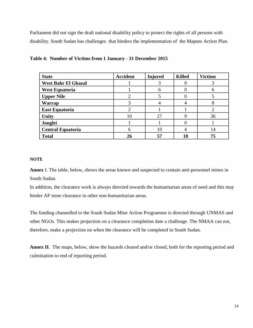
Table 4: Number of Victims from 1 January - 31 December 2015
State Accident Injured Killed Victims West Bahr El Ghazal 1 3 0 3 West Equatoria 1 6 0 6 Upper Nile 2 5 0 5 Warrap 3 4 4 8 East Equatoria 2 1 1 2 Unity 10 27 9 36 Jonglei 1 1 0 1 Central Equatoria 6 10 4 14 Total 26 57 18 75
NOTE Annex I. The table, below, shows the areas known and suspected to contain anti-personnel mines in
South Sudan.
In addition, the clearance work is always directed towards the humanitarian areas of need and this may
hinder AP mine clearance in other non-humanitarian areas.
The funding channelled to the South Sudan Mine Action Programme is directed through UNMAS and
other NGOs. This makes projection on a clearance completion date a challenge. The NMAA can not,
therefore, make a projection on when the clearance will be completed in South Sudan.
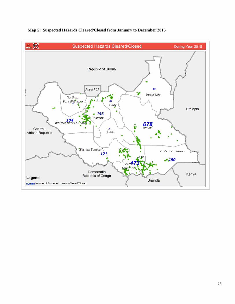
Annex II. The maps, below, show the hazards cleared and/or closed, both for the reporting period and
culmination to end of reporting period.
15
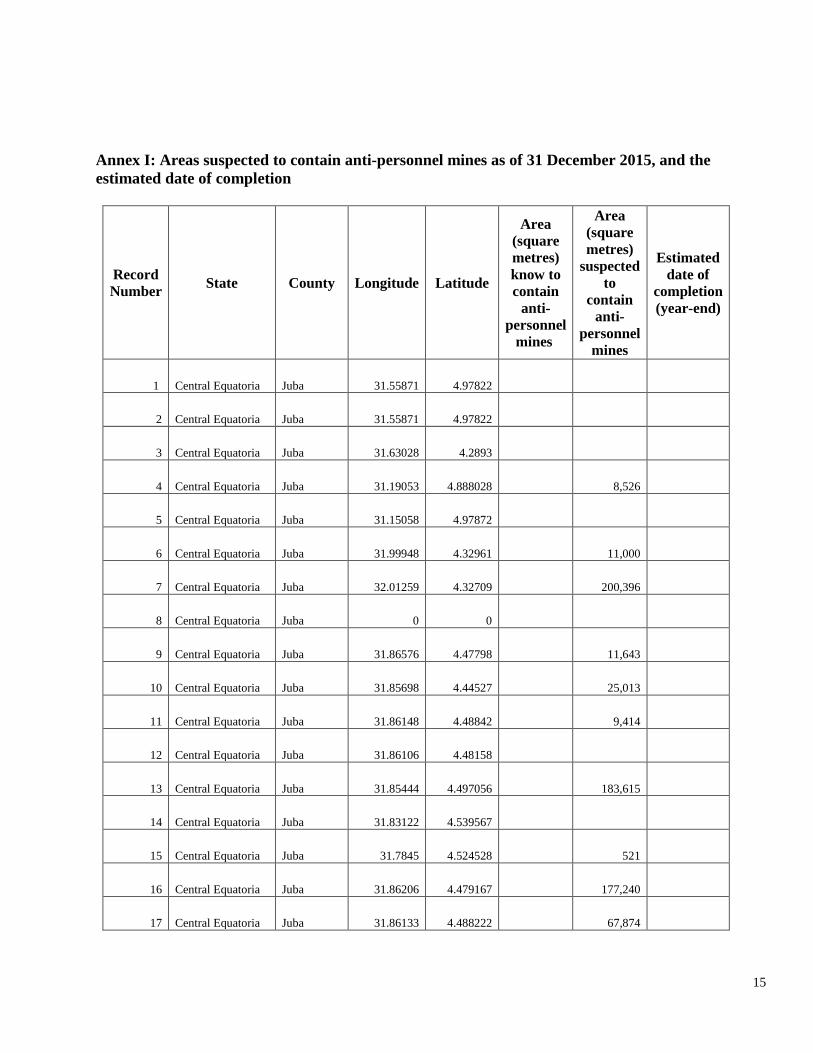
Annex I: Areas suspected to contain anti-personnel mines as of 31 December 2015, and the estimated date of completion
Record Number State County Longitude Latitude
Area (square metres) know to contain
anti-personnel
mines
Area (square metres)
suspected to
contain anti-
personnel mines
Estimated date of
completion (year-end)
1 Central Equatoria Juba 31.55871 4.97822
2 Central Equatoria Juba 31.55871 4.97822
3 Central Equatoria Juba 31.63028 4.2893
4 Central Equatoria Juba 31.19053 4.888028 8,526
5 Central Equatoria Juba 31.15058 4.97872
6 Central Equatoria Juba 31.99948 4.32961 11,000
7 Central Equatoria Juba 32.01259 4.32709 200,396
8 Central Equatoria Juba 0 0
9 Central Equatoria Juba 31.86576 4.47798 11,643
10 Central Equatoria Juba 31.85698 4.44527 25,013
11 Central Equatoria Juba 31.86148 4.48842 9,414
12 Central Equatoria Juba 31.86106 4.48158
13 Central Equatoria Juba 31.85444 4.497056 183,615
14 Central Equatoria Juba 31.83122 4.539567
15 Central Equatoria Juba 31.7845 4.524528 521
16 Central Equatoria Juba 31.86206 4.479167 177,240
17 Central Equatoria Juba 31.86133 4.488222 67,874
16
18 Central Equatoria Juba 31.76768 4.69534 3,873
19 Central Equatoria Juba 31.77701 4.69954
20 Central Equatoria Juba 31.70478 4.69188
21 Central Equatoria Juba 31.85394 4.69122 10,000
22 Central Equatoria Juba 31.85859 4.68995 11,700
23 Central Equatoria Juba 31.77751 4.70275
24 Central Equatoria Juba 31.39469 4.66725 33,555
25 Central Equatoria Juba 31.65208 4.232556 1,257
26 Central Equatoria Juba 31.61184 4.71102 18,387
27 Central Equatoria Juba 31.61184 4.71102 440
28 Central Equatoria Juba 31.61165 4.771163
29 Central Equatoria Juba 31.60214 4.73822 9,695
30 Central Equatoria Juba 32.003 4.181555 45,600
31 Central Equatoria Juba 32.00064 4.20052 7,350
32 Central Equatoria Juba 31.70097 4.120861 2,500
33 Central Equatoria Juba 31.63427 4.19797
34 Central Equatoria Juba 31.64559 4.21792 32,554
35 Central Equatoria Juba 31.73178 4.08441 756,630
36 Central Equatoria Juba 31.73178 4.08441 264,972
37 Central Equatoria Juba 31.72398 4.081604 236,098
38 Central Equatoria Juba 31.73179 4.0844 85,024
39 Central Equatoria Juba 31.7021 4.12316 24,000
40 Central Equatoria Juba 31.70244 4.12184 94,200
41 Central Equatoria Juba 31.70249 4.12272 78,000
42 Central Equatoria Juba 31.62297 4.29482 17,900

17
43 Central Equatoria Juba 31.95412 4.074 2,596
44 Central Equatoria Juba 31.9562 4.673511 72,720
45 Central Equatoria Juba 31.98269 4.688949
46 Central Equatoria Juba 31.98269 4.688949
47 Central Equatoria Juba 31.98269 4.688949
48 Central Equatoria Juba 31.98269 4.688949
49 Central Equatoria Juba 31.96034 4.69371
50 Central Equatoria Juba 32.98256 4.68901 8,250
51 Central Equatoria Juba 32.04061 4.67224 2,928
52 Central Equatoria Juba 32.04061 4.67224 22,291
53 Central Equatoria Juba 32.08868 4.654881
54 Central Equatoria Juba 32.08868 4.654881
55 Central Equatoria Juba 32.07762 4.64264
56 Central Equatoria Juba 31.96296 4.693
57 Central Equatoria Juba 32.08799 4.653939 3,441
58 Central Equatoria Juba 32.08056 4.645278 62,832
59 Central Equatoria Juba 31.91749 4.70509 19,000
60 Central Equatoria Juba 31.92192 4.70411 10,305
61 Central Equatoria Juba 31.94484 4.71228 158,000
62 Central Equatoria Juba 30.11964 5.461389 107,917
63 Central Equatoria Juba 31.02402 5.292083 400
64 Central Equatoria Juba 31.55786 4.8302
65 Central Equatoria Juba 31.55786 4.8302
66 Central Equatoria Juba 31.55786 4.8302
67 Central Equatoria Juba 31.08545 5.016991 2,244
68 Central Equatoria Juba 31.82584 4.540639 100,000
69 Central Equatoria Juba 31.85394 4.498472 36,782
70 Central Equatoria Juba 31.70464 4.69114 7,024
71 Central Equatoria Juba 31.99792 4.209679 46,800
72 Central Equatoria Juba 31.99594 4.213221 70,400
73 Central Equatoria Juba 31.63543 4.201282 100,000

18
74 Central Equatoria Juba 31.64572 4.217853 45,000
75 Central Equatoria Juba 31.70259 4.119715 10,505
76 Central Equatoria Juba 31.42145 4.07171 13,000
77 Central Equatoria Juba 31.62489 4.29358 55,100
78 Central Equatoria Juba 31.62463 4.29385 11,999
79 Central Equatoria Juba 31.96371 4.96034 51,528
80 Central Equatoria Juba 31.98269 4.688949 100,000
81 Central Equatoria Juba 32.08868 4.654881
82 Central Equatoria Juba 32.08106 4.643972 17,684
83 Central Equatoria Juba 31.43816 4.22902 25,379
84 Central Equatoria Juba 0 0
85 Central Equatoria Juba 31.55786 4.8302
86 Central Equatoria Juba 31.55786 4.8302
87 Central Equatoria Juba 30.94229 4.841495 19,500
88 Central Equatoria Juba 31.86642 4.408087 80,000
89 Central Equatoria Juba 32.00689 4.296572 240,000
90 Central Equatoria Juba 31.84009 4.534447 80,000
91 Central Equatoria Juba 31.84169 4.532774 120,000
92 Central Equatoria Juba 31.86202 4.479275 104,000
93 Central Equatoria Juba 31.74578 4.62704 21,420
94 Central Equatoria Juba 31.65098 4.2307 60,000
95 Central Equatoria Juba 31.70068 4.11932 25,079
96 Central Equatoria Juba 31.71148 4.08181
97 Central Equatoria Juba 31.70074 4.12529
98 Central Equatoria Juba 31.59855 4.320878 9,750
99 Central Equatoria Juba 31.96231 4.693539 6,000
100 Central Equatoria Juba 32.07644 4.632778
101 Central Equatoria Juba 32.00819 4.683917 15,000
102 Central Equatoria Juba 0 0
103 Central Equatoria Juba 31.70228 4.122389 4,500
104 Central Equatoria Juba 31.6997 4.2594
105 Central Equatoria Juba 31.98269 4.688949
106 Central Equatoria Juba 31.92543 4.70045 1
107 Central Equatoria Juba 31.43816 4.22902 2,446
108 Central Equatoria Kajo Keji 31.69089 3.853917 3,500
109 Central Equatoria Kajo Keji 31.50532 4.006952 900
110 Central Equatoria Kajo Keji 31.51226 4.09255
111 Central Equatoria Lainya 30.98364 4.243944 6,153
112 Central Equatoria Lainya 30.96801 4.23283 14,148
113 Central Equatoria Lainya 30.96004 4.223892
114 Central Equatoria Lainya 30.96186 4.226583 7,056

19
115 Central Equatoria Lainya 30.97189 4.236333 11,719
116 Central Equatoria Lainya 30.95367 4.132833 10,350
117 Central Equatoria Lainya 30.94263 4.142493 25,000
118 Central Equatoria Lainya 31.08333 4.333333
119 Central Equatoria Lainya 30.81161 4.134361
120 Central Equatoria Lainya 30.82067 4.14289 4,908
121 Central Equatoria Lainya 30.97921 4.23675 15,391
122 Central Equatoria Morobo 30.88164 3.652583 83,741
123 Central Equatoria Morobo 30.86428 3.50354 8,464
124 Central Equatoria Morobo 30.86361 3.743528 758
125 Central Equatoria Morobo 30.79104 3.688883
126 Central Equatoria Morobo 30.79109 3.692508
127 Central Equatoria Morobo 30.80442 3.735583
128 Central Equatoria Morobo 30.8617 3.74504
129 Central Equatoria Morobo 30.78284 3.66976 7,840
130 Central Equatoria Morobo 30.77507 3.687197
131 Central Equatoria Morobo 30.72494 3.65942
132 Central Equatoria Morobo 30.79363 3.692778
133 Central Equatoria Morobo 30.78878 3.68675
134 Central Equatoria Morobo 0 0 3
135 Central Equatoria Terekeka 31.72452 5.193986 60,000
136 Central Equatoria Terekeka 31.07597 5.65175 2,400
137 Central Equatoria Terekeka 30.48472 5.810926 82,500
138 Central Equatoria Terekeka 31.01937 5.285738 35,000
139 Central Equatoria Terekeka 31.04656 5.31767 8,781
140 Central Equatoria Terekeka 31.02372 5.632389 1,885
141 Central Equatoria Terekeka 31.06364 5.659806
142 Central Equatoria Terekeka 31.07784 5.691998 12,760
143 Central Equatoria Terekeka 31.21189 5.633111 8,100
144 Central Equatoria Terekeka 31.05469 5.703528 5,655
145 Central Equatoria Terekeka 31.15058 5.633389 3,142
146 Central Equatoria Terekeka 31.15058 5.633389
147 Central Equatoria Terekeka 31.15058 5.633389
148 Central Equatoria Terekeka 31.15058 5.633389 14,294
149 Central Equatoria Terekeka 31.15058 5.633389 12,723
150 Central Equatoria Terekeka 31.04447 5.38685
151 Central Equatoria Terekeka 31.08303 5.571748 131,052
152 Central Equatoria Terekeka 31.05015 5.34195 100
153 Central Equatoria Terekeka 31.02346 5.29272 14,472
154 Central Equatoria Terekeka 31.11992 5.461861 243,000
155 Central Equatoria Terekeka 31.08924 5.37819 20

20
156 Central Equatoria Yei 30.60259 4.126565 12,895
157 Central Equatoria Yei 30.64288 4.11597 43,511
158 Central Equatoria Yei 30.74962 4.12633 4,539
159 Central Equatoria Yei 30.69349 4.08098 2,401
160 Central Equatoria Yei 30.74541 4.12777 4,539
161 Central Equatoria Yei 30.72468 4.10277 58,000
162 Central Equatoria Yei 30.61654 4.12444 80,417
163 Central Equatoria Yei 30.61252 4.0518 26,792
164 Central Equatoria Yei 31.99074 3.77709 2,474
165 Central Equatoria Yei 30.6537 4.10815 7,862
166 Central Equatoria Yei 30.74855 4.02305 1,225
167 Central Equatoria Yei 30.69751 4.07795 20,699
168 Central Equatoria Yei 30.73123 4.0264 4,464
169 Central Equatoria Yei 30.74607 3.954492 2,683
170 Central Equatoria Yei 30.79992 3.82239 2,542
171 Central Equatoria Yei 30.64471 5.44871 10,120
172 Central Equatoria Yei 30.78453 3.78502 4,475
173 Central Equatoria Yei 30.94167 4.142417 9,000
174 Central Equatoria Yei 30.75294 3.95201 8,800
175 Central Equatoria Yei 30.70967 4.10295 4,919
176 Central Equatoria Yei 30.74184 3.88545 1,125
177 East Equatoria Budi 33.48596 4.2279 500,000
178 East Equatoria Budi 33.49786 4.253344
179 East Equatoria Budi 33.49786 4.253344
180 East Equatoria Budi 33.3486 4.38268 33,599
181 East Equatoria Kapoeta East 33.50293 4.2599 11,250
182 East Equatoria Kapoeta East 33.51088 4.248981 11,197
183 East Equatoria Kapoeta East 33.50293 4.2599 5,000
184 East Equatoria Kapoeta East 33.51097 4.240981 17,312
185 East Equatoria Kapoeta East 33.89842 4.624861 2,827
186 East Equatoria Kapoeta South 33.6614 4.75334 55,000
187 East Equatoria Lafon 32.93016 4.53479 83,835
188 East Equatoria Lafon 32.4722 5.02845 458,431
189 East Equatoria Lafon 32.47051 5.025317 175,304
190 East Equatoria Lafon 32.47051 5.025317 101,555
191 East Equatoria Lafon 32.47051 5.025317 110,923
192 East Equatoria Magwi 31.86681 4.407833 45,765
193 East Equatoria Magwi 31.91563 3.93382 44,846
194 East Equatoria Magwi 31.99273 3.74441 100,589

21
195 East Equatoria Magwi 31.99273 3.74441 32,693
196 East Equatoria Magwi 31.99273 3.74441 67,812
197 East Equatoria Magwi 31.99273 3.74441 53,993
198 East Equatoria Magwi 31.99838 3.7243 7,200
199 East Equatoria Magwi 32.1902 4.28147 400
200 East Equatoria Magwi 31.99611 4.21156 10,074
201 East Equatoria Magwi 31.99173 4.12959
202 East Equatoria Magwi 31.99815 4.14038 2,130
203 East Equatoria Magwi 31.9768 4.10307 5,093
204 East Equatoria Magwi 32.07415 4.05236 15,548
205 East Equatoria Magwi 32.00497 4.162472
206 East Equatoria Magwi 0 0
207 East Equatoria Magwi 32.03715 3.59897 69,350
208 East Equatoria Magwi 31.99273 3.74441 40,318
209 East Equatoria Magwi 31.99128 4.12742
210 East Equatoria Magwi 32.50731 3.81254 144,302
211 East Equatoria Magwi 32.00605 4.17571
212 East Equatoria Magwi 32.2644 3.8386
213 East Equatoria Magwi 32.51156 3.76733
214 East Equatoria Magwi 32.53778 3.95302
215 East Equatoria Magwi 32.22208 4.21923
216 East Equatoria Magwi 31.9814 4.023008 2,860,000
217 East Equatoria Magwi 32.51308 3.76831 217,904
218 East Equatoria Magwi 32.00908 4.276722 13
219 East Equatoria Magwi 32.51967 3.768389
220 East Equatoria Torit 32.48197 4.403662 0
221 East Equatoria Torit 32.64698 4.31989 29,515
222 East Equatoria Torit 32.37709 4.22503 47,970
223 East Equatoria Torit 32.3775 4.22465 21,653
224 East Equatoria Torit 32.49123 4.38643 7,448
225 East Equatoria Torit 0 0
226 East Equatoria Torit 32.47997 4.65453
227 East Equatoria Torit 32.48049 4.6532 2,500
228 East Equatoria Torit 32.6516 4.64782
229 East Equatoria Torit 32.29993 4.49854
230 East Equatoria Torit 0 0
231 East Equatoria Torit 32.74146 4.48599 233,600
232 East Equatoria Torit 32.7434 4.48653
233 East Equatoria Torit 32.65389 4.654167
234 East Equatoria Torit 32.50532 4.41609
235 East Equatoria Torit 32.50375 4.415917

22
236 East Equatoria Torit 32.19234 4.56889 500,000
237 East Equatoria Torit 32.56687 4.42214 11,120
238 Jonglei Akobo 32.99999 7.932986 1,978,079
239 Jonglei Akobo 32.28006 8.178219 3,388,152
240 Jonglei Akobo 33.00464 7.785028 25
241 Jonglei Ayod 31.43333 8.116667
242 Jonglei Bor South 31.5725 6.257139 39,000
243 Jonglei Bor South 31.58641 6.387674 125,000
244 Jonglei Bor South 31.71373 6.20173 35,000
245 Jonglei Bor South 31.73194 5.892222
246 Jonglei Duk 31.41506 7.459764 20,000
247 Jonglei Duk 31.41667 7.461111
248 Jonglei Fangak 31.15858 9.408694 812,181
249 Jonglei Fangak 31.1561 9.40905 20,000
250 Jonglei Fangak 30.88446 9.069444 3,526,564
251 Jonglei Fangak 31.15089 9.411361 18,382
252 Jonglei Fangak 31.15542 9.407306 710,235
253 Jonglei Khorflus 31.15139 9.410556
254 Jonglei Khorflus 31.2121 9.171833 850,000
255 Jonglei Khorflus 31.76603 8.99329 220,000
256 Jonglei Khorflus 31.49831 9.143 139,650
257 Jonglei Khorflus 31.73892 9.0959 274,000
258 Jonglei Khorflus 31.77379 8.96962 135,000
259 Jonglei Khorflus 31.40944 9.290278
260 Jonglei Khorflus 31.58606 9.313556 20,509
261 Jonglei Khorflus 31.55278 9.361111 250,000
262 Jonglei Khorflus 31.15556 9.410556
263 Jonglei Nyirol 32.14975 8.179611
264 Jonglei Nyirol 32.12079 8.179653 5,866,366
265 Jonglei Nyirol 32.15514 8.17889 63,000
266 Jonglei Pibor 34.46388 6.168067
267 Jonglei Pibor 33.11066 6.77836
268 Jonglei Pochalla 34.08452 7.167261 7,942,260
269 Jonglei Twic East 31.40503 7.164167 1
270 Jonglei Wuror 31.87719 7.903636 4,238,267
271 Lakes Cueibet 29.18198 7.03163 21,000
272 Lakes Rumbek East 29.74584 6.72286 12,037
273 Lakes Wulu 29.52572 6.058222 2,500
274 North Bahr El Ghazal
Aweil South 30.48384 6.544528

23
275 North Bahr El Ghazal Aweil West 27.36764 8.77434 80,100
276 Unity Abiemnom 28.91592 9.332589 13,252,144
277 Unity Rubkona 29.78476 9.23557 4
278 Unity Rubkona 29.76582 9.234682 12
279 Unity Rubkona 28.95172 9.122639
280 Upper Nile Fashoda 31.88864 9.86742 16,385
281 Upper Nile Longochuk 33.97303 9.209897 4
282 Upper Nile Maiwut 33.57133 8.500686 4,683,615
283 Upper Nile Maiwut 33.78335 8.383342 34,471,616
284 Upper Nile Malakal 31.66926 9.490263
285 Upper Nile Melut 32.26661 10.31228 253
286 Upper Nile Panyikang 31.54353 9.36647 1,427
287 Upper Nile Panyikang 31.3891 9.33 113
288 West Bahr El Ghazal Jur River 28.00983 7.50428
289 West Bahr El Ghazal Wau 27.94263 6.8033 2,827,433
290 West Bahr El Ghazal Wau 27.94278 6.803318
291 West Equatoria Maridi 29.47838 4.923359 38,600
292 West Equatoria Maridi 29.495 4.924722
293 West Equatoria Mundri East 30.44625 5.33996 2
294 West Equatoria Mundri East 30.72247 5.51356 5,006
295 West Equatoria Mundri East 30.507 5.222795 63,000
296 West Equatoria Mundri East 30.72247 5.51356 2,000
297 West Equatoria Mundri East 30.75377 5.51666 100,400
298 West Equatoria Mundri East 30.72528 5.513056 95,450
299 West Equatoria Mundri East 30.44849 5.34607 8,986
300 West Equatoria Mundri East 30.86269 5.53425 108,707
301 West Equatoria Mundri East 30.72542 5.512944 61,197
302 West Equatoria Mundri East 30.72542 5.512944 61,197
303 West Equatoria Mvolo 30.03547 6.085929 150,000
Total 98,403,022

24
Annex II: Maps of Hazards Cleared/Closed in South Sudan Map 3: Suspected AP Hazards Cleared/Closed from January to December 2015

25
Map 4: AP Suspected Hazards Cleared/Closed as of December 2015
26
Map 5: Suspected Hazards Cleared/Closed from January to December 2015

27
Map 6: Suspected Hazards Cleared/Closed as of December 2015