conway branch railroad line feasibility study - nh.gov · conway branch railroad line feasibility...
TRANSCRIPT
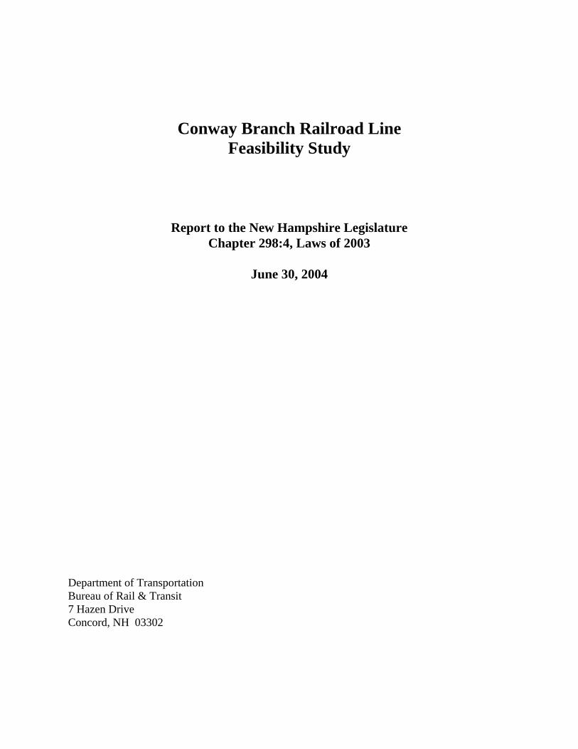
Conway Branch Railroad Line Feasibility Study
Report to the New Hampshire Legislature Chapter 298:4, Laws of 2003
June 30, 2004
Department of Transportation Bureau of Rail & Transit 7 Hazen Drive Concord, NH 03302
1
Conway Branch Feasibility Study 1 PURPOSE This report is intended to provide an overview of the cost and feasibility of restoring rail service on the Conway Branch railroad line between Ossipee and Conway. The New Hampshire legislature enacted a bill in 2003 (Chapter 298:4) requiring the Department of Transportation to conduct this study and report to the legislature by June 30, 2004. The Department’s Bureau of Rail and Transit has evaluated the physical condition of the corridor and discussed the cost and feasibility of making the necessary physical improvements with the two railroads operating on the corridor (the New Hampshire Northcoast and Conway Scenic Railroads) and with other interested parties. This report presents cost information for each of the physical components of the rail infrastructure, and for two levels of rehabilitation: one to meet minimum standards and one that would sustain rail service for the long term. With regard to the feasibility of restoring rail service, time and available resources did not permit a detailed evaluation of potential shippers and volumes of freight for freight rail, or ridership projections on a passenger service. Instead, the report presents a general discussion of potential freight shipping on the line and of the different types of passenger operations that could be considered for the Conway Branch. 2 HISTORY OF THE CONWAY BRANCH Several railroad histories describe the formation and construction of the Conway Branch rail line, most recently The Rail Lines of Northern New England (Robert M. Lindsell, Branch Line Press, 2000). After several attempts to form railroad companies and construct the southern segments of this line, the Portsmouth, Great Falls, and Conway Railroad was chartered in 1865. Construction of the line was completed to West Ossipee in 1871 and to North Conway in 1872. Initially, the line initiated at Jewett in Maine, through Salmon Falls to Somersworth. This alignment was replaced by the current line from Rollinsford to Somersworth. Passenger service from Boston to the new North Conway station began in 1872. A connection with the Portland & Ogdensburg Railroad (later Maine Central’s Mountain Division) at Intervale was made in 1875. The Portsmouth, Great Falls and Conway was part of the Eastern Railroad, which merged with the Boston and Maine Railroad in 1890. The railroad served manufacturing plants in several communities and lumber mills and sand and gravel operations in the Conway area. Freight service north of Ossipee ended in 1972. During the 1980s, the Boston Sand & Gravel Co. initiated service on the line for its subsidiary, Ossipee Aggregates by a new railroad, the New Hampshire Northcoast. This included the purchase of the line from Rochester to Ossipee and a major rehabilitation project that was partly funded by the state of New Hampshire through capital budget appropriations, federal Local Rail Freight Assistance funds, and the state’s revolving loan program for short line railroads. In 1994, the New Hampshire Northcoast purchased the balance of the line from Rollinsford to Rochester from the B&M. The rehabilitation of the Conway Branch to Ossipee was a major undertaking, involving a large investment by the New Hampshire Northcoast and expenditure of $989,000 in state capital budget funds, $656,000 in LRFA funds (with railroad matching funds), and $606,000 in
2revolving loan funds now being repaid by the railroad. The railroad’s ability to handle heavy loads of sand and gravel has removed approximately 30,000 trucks per year from the highway system between Ossipee and Boston. The Boston and Maine and its predecessors operated passenger service on the Conway Branch from 1872 to 1961. The Interstate Commerce Commission approved abandonment of the line from Mt. Whittier (West Ossipee) to Intervale in 1972. Abandonment, a process now handled by the federal Surface Transportation Board, the successor to the ICC, relieves a railroad of its obligation to provide freight service to a shipper. In 1974, the railroad corridor within the town of Conway was sold to the Conway Scenic Railroad. Efforts to preserve the Conway Branch as a railroad corridor have included the purchase of most of the line within the town of Madison by the town in 1987, and its subsequent sale to the state in 1995. The state of New Hampshire purchased the balance of the line owned by the Boston & Maine in 2001. Today, the New Hampshire Northcoast owns the railroad corridor from its junction with the B&M main line in Rollinsford to Route 28 in Ossipee, the state owns it from that point to the Albany-Conway town line, and the Conway Scenic owns the balance of the corridor in the town of Conway to Intervale. Some property ownership issues remain with the inactive corridor; these are discussed in Section 5 below. 3 EXISTING CONDITIONS This report presents the conditions of and cost to repair the physical components of the Conway Branch for active rail service. It provides an estimate for brush clearing and weed control, improvements to cut and embankment sections, culverts and drainage, and highway grade crossings that would be required to allow any level of rail service. With regard to bridge repairs, replacement of ties, and replacement of steel rail, the report provides two scenarios for reactivation of the line. Phase 1 (or startup) would bring the line up to FRA Class I standards to begin operations. Phase 2 could be accomplished at startup to bring the line up to Class II standards, but at any rate would be required within five years of beginning operations to provide a structurally sound railroad infrastructure. The FRA standards allow the following train speeds for these two classes of track: Class I 10 mph freight 15 mph passenger Class II 25 mph freight 30 mph passenger The rail corridor runs from Route 28 in Ossipee, where a highway overpass crosses the railroad, to Conway Village, where the active rail operation of the Conway Scenic Railroad has its southern terminus at the former freight house on West Main Street. This is a distance of approximately 22 miles. The state’s ownership, from Route 28 to the Albany-Conway town line, is 21 miles. See the corridor map in the back of this report.
3.1 BRUSH & WEED CONTROL The brush and trees along the railroad line have been cut back to just off the end of the ties by the Department of Resources and Economic Development’s Trails Bureau over the last few years. While this has kept the brush and trees from covering the rail, additional clearing would be required on almost all of the railroad corridor to provide adequate clearances to run trains and to remove the tree canopy over the tracks. The trees and brush should be cut back a minimum of 12’ from the nearest rail to ensure adequate clearance for the train and railroad workers walking
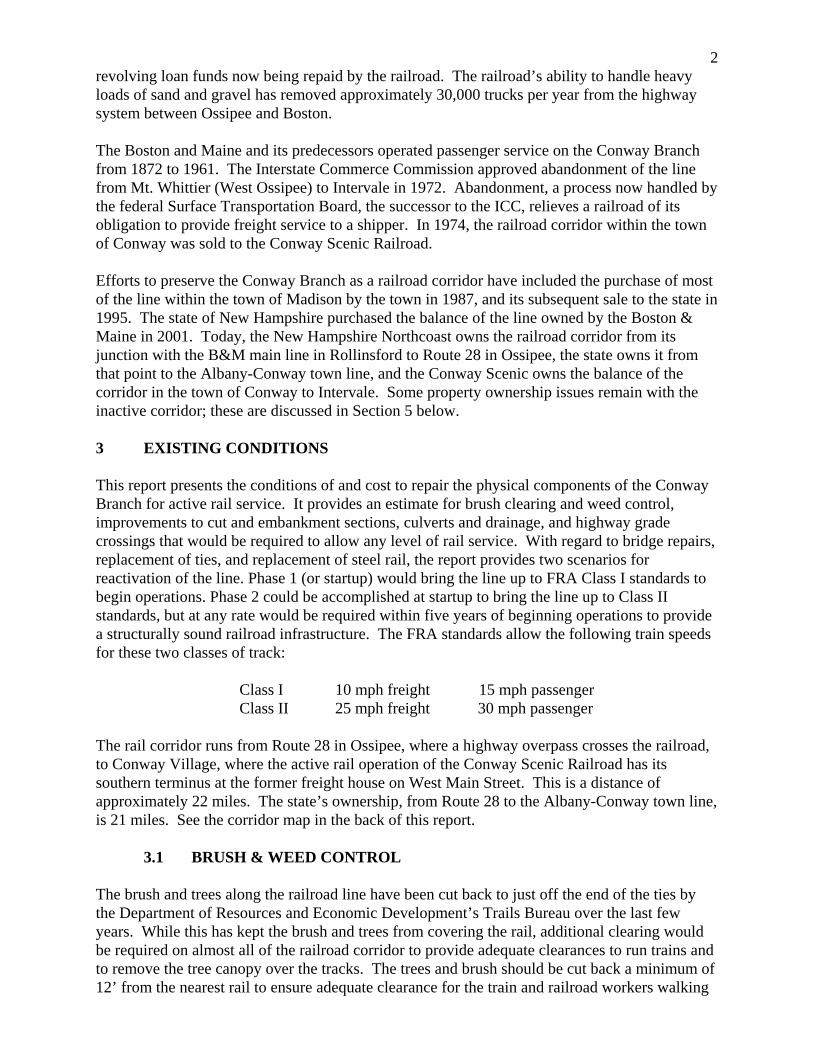
3beside the train. Additional trees should be cut or limbed to remove the canopy over the tracks so the sun can keep the track structure dried out, thus extending its life span. The estimated cost to clear the 22- mile railroad corridor is $60,000.
Fig. 1: Tree growth on Conway Branch corridor
There is significant weed growth in most areas of the railbed, especially in the wet areas. Weed control spraying would be required in all areas of the line to kill off and control the weed growth. Since weed control spraying in the wet areas is restricted and these are the areas of heaviest weed growth, it would be necessary to remove the contaminated ballast in some areas and replace it with new, clean fractured-rock ballast. The cost of this ballast replacement is included in Ballast & Surfacing, Section 3.4 of this report. The estimated cost of several annual weed control and sprout retardant sprayings on the entire corridor prior to startup is $20,000.
3.2 EMBANKMENTS & CUTS The embankments, or fill sections, and cuts are generally in good condition with good ground cover and soil stabilization. The exceptions are approximately 12 areas that have been washed out at culverts and bridges due to blockages, mostly caused by beaver activity. All of these areas would require the placing of new fill material brought to the site to rebuild the embankment. The estimated cost to reconstruct the washouts in the embankments at the culverts, stone box culverts and bridges is $50,000. The other area of concern is a shallow 500’ long ditch at approximately MP 113.00 that is close to the tracks and has running water all year long. The water erodes the ballast material at the ends of the ties, in turn weakening the track structure. The reason the ditch is shallow and so close to the tracks is because of the ledge in the adjacent slope. It appears there have been several washouts in this section of the track over the years. The ledge should be blasted and removed so the ditchline can be deepened and moved away from the tracks. The estimated cost of this ledge removal is $80,000; this work does not have to be completed before service is restored, but it should be completed within five years to eliminate the ongoing maintenance problem.
3.3 CULVERTS & DRAINAGE The drainage on this segment of the line includes approximately 10 pipe culverts and 32 stone box culverts. The drainage structures are generally in good condition, except that six stone culverts require repairs because some of the slabs have shifted. The large stone box culvert at MP 126.45 has several collapsed slabs on the west side inlet caused by a backhoe that dislodged
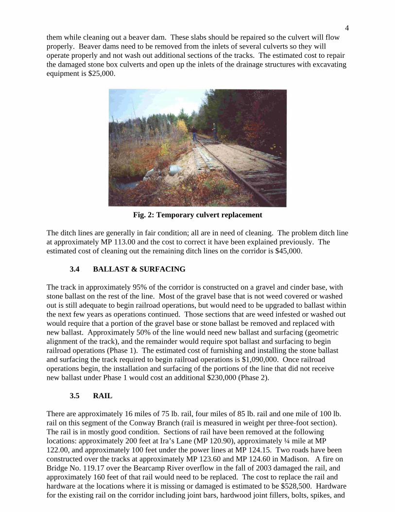
4them while cleaning out a beaver dam. These slabs should be repaired so the culvert will flow properly. Beaver dams need to be removed from the inlets of several culverts so they will operate properly and not wash out additional sections of the tracks. The estimated cost to repair the damaged stone box culverts and open up the inlets of the drainage structures with excavating equipment is $25,000.
Fig. 2: Temporary culvert replacement
The ditch lines are generally in fair condition; all are in need of cleaning. The problem ditch line at approximately MP 113.00 and the cost to correct it have been explained previously. The estimated cost of cleaning out the remaining ditch lines on the corridor is $45,000.
3.4 BALLAST & SURFACING The track in approximately 95% of the corridor is constructed on a gravel and cinder base, with stone ballast on the rest of the line. Most of the gravel base that is not weed covered or washed out is still adequate to begin railroad operations, but would need to be upgraded to ballast within the next few years as operations continued. Those sections that are weed infested or washed out would require that a portion of the gravel base or stone ballast be removed and replaced with new ballast. Approximately 50% of the line would need new ballast and surfacing (geometric alignment of the track), and the remainder would require spot ballast and surfacing to begin railroad operations (Phase 1). The estimated cost of furnishing and installing the stone ballast and surfacing the track required to begin railroad operations is $1,090,000. Once railroad operations begin, the installation and surfacing of the portions of the line that did not receive new ballast under Phase 1 would cost an additional $230,000 (Phase 2).
3.5 RAIL There are approximately 16 miles of 75 lb. rail, four miles of 85 lb. rail and one mile of 100 lb. rail on this segment of the Conway Branch (rail is measured in weight per three-foot section). The rail is in mostly good condition. Sections of rail have been removed at the following locations: approximately 200 feet at Ira’s Lane (MP 120.90), approximately ¼ mile at MP 122.00, and approximately 100 feet under the power lines at MP 124.15. Two roads have been constructed over the tracks at approximately MP 123.60 and MP 124.60 in Madison. A fire on Bridge No. 119.17 over the Bearcamp River overflow in the fall of 2003 damaged the rail, and approximately 160 feet of that rail would need to be replaced. The cost to replace the rail and hardware at the locations where it is missing or damaged is estimated to be $528,500. Hardware for the existing rail on the corridor including joint bars, hardwood joint fillers, bolts, spikes, and
5rail anchors would also need to be replaced in many locations, at an estimated cost of $100,000. These improvements, costing a total of $628,500, would provide for Class I service (Phase 1) on the line. During the first five years of operation, an estimated $143,000 would be needed to replace broken rails or other components to maintain service. Heavier-weight rail on the corridor would be required for regular freight operations involving heavy cars, or to comply with FRA standards that would allow higher track speeds, especially for passenger operations. The cost to install 115 lb. rail with new hardware on the entire line is estimated to be $11,000,000 at current prices. This could be done in increments of one to five miles once the line is in operation. It must be noted that steel prices have been rising dramatically in the past year and may remain volatile.
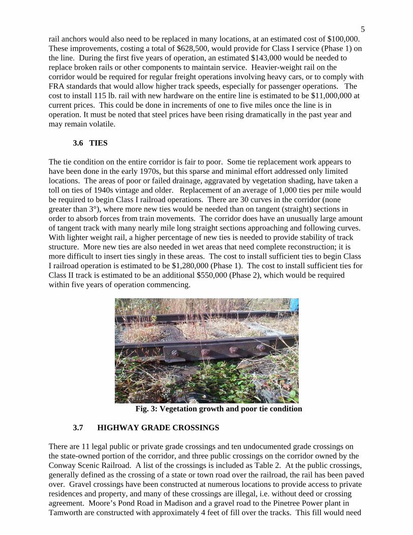
3.6 TIES The tie condition on the entire corridor is fair to poor. Some tie replacement work appears to have been done in the early 1970s, but this sparse and minimal effort addressed only limited locations. The areas of poor or failed drainage, aggravated by vegetation shading, have taken a toll on ties of 1940s vintage and older. Replacement of an average of 1,000 ties per mile would be required to begin Class I railroad operations. There are 30 curves in the corridor (none greater than 3°), where more new ties would be needed than on tangent (straight) sections in order to absorb forces from train movements. The corridor does have an unusually large amount of tangent track with many nearly mile long straight sections approaching and following curves. With lighter weight rail, a higher percentage of new ties is needed to provide stability of track structure. More new ties are also needed in wet areas that need complete reconstruction; it is more difficult to insert ties singly in these areas. The cost to install sufficient ties to begin Class I railroad operation is estimated to be $1,280,000 (Phase 1). The cost to install sufficient ties for Class II track is estimated to be an additional $550,000 (Phase 2), which would be required within five years of operation commencing.
Fig. 3: Vegetation growth and poor tie condition
3.7 HIGHWAY GRADE CROSSINGS
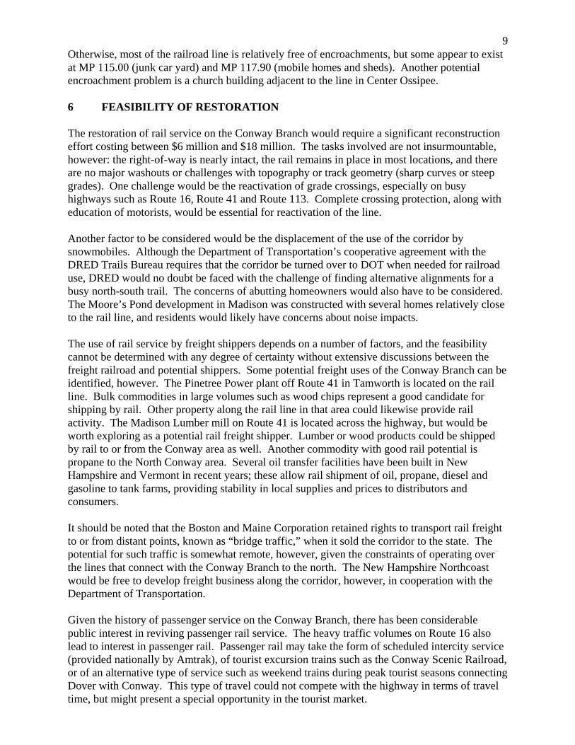
There are 11 legal public or private grade crossings and ten undocumented grade crossings on the state-owned portion of the corridor, and three public crossings on the corridor owned by the Conway Scenic Railroad. A list of the crossings is included as Table 2. At the public crossings, generally defined as the crossing of a state or town road over the railroad, the rail has been paved over. Gravel crossings have been constructed at numerous locations to provide access to private residences and property, and many of these crossings are illegal, i.e. without deed or crossing agreement. Moore’s Pond Road in Madison and a gravel road to the Pinetree Power plant in Tamworth are constructed with approximately 4 feet of fill over the tracks. This fill would need
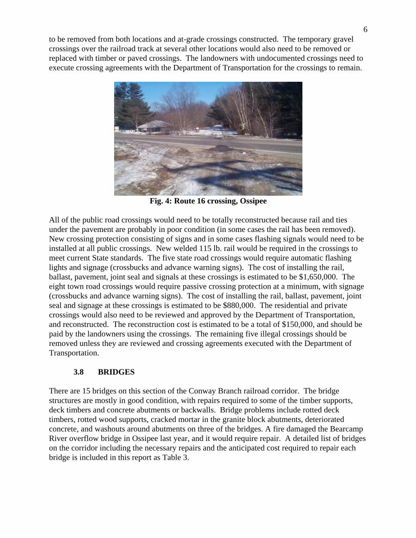
6to be removed from both locations and at-grade crossings constructed. The temporary gravel crossings over the railroad track at several other locations would also need to be removed or replaced with timber or paved crossings. The landowners with undocumented crossings need to execute crossing agreements with the Department of Transportation for the crossings to remain.
Fig. 4: Route 16 crossing, Ossipee
All of the public road crossings would need to be totally reconstructed because rail and ties under the pavement are probably in poor condition (in some cases the rail has been removed). New crossing protection consisting of signs and in some cases flashing signals would need to be installed at all public crossings. New welded 115 lb. rail would be required in the crossings to meet current State standards. The five state road crossings would require automatic flashing lights and signage (crossbucks and advance warning signs). The cost of installing the rail, ballast, pavement, joint seal and signals at these crossings is estimated to be $1,650,000. The eight town road crossings would require passive crossing protection at a minimum, with signage (crossbucks and advance warning signs). The cost of installing the rail, ballast, pavement, joint seal and signage at these crossings is estimated to be $880,000. The residential and private crossings would also need to be reviewed and approved by the Department of Transportation, and reconstructed. The reconstruction cost is estimated to be a total of $150,000, and should be paid by the landowners using the crossings. The remaining five illegal crossings should be removed unless they are reviewed and crossing agreements executed with the Department of Transportation.
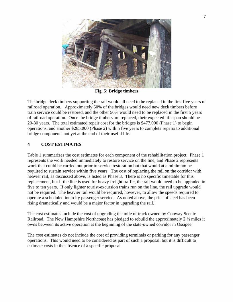
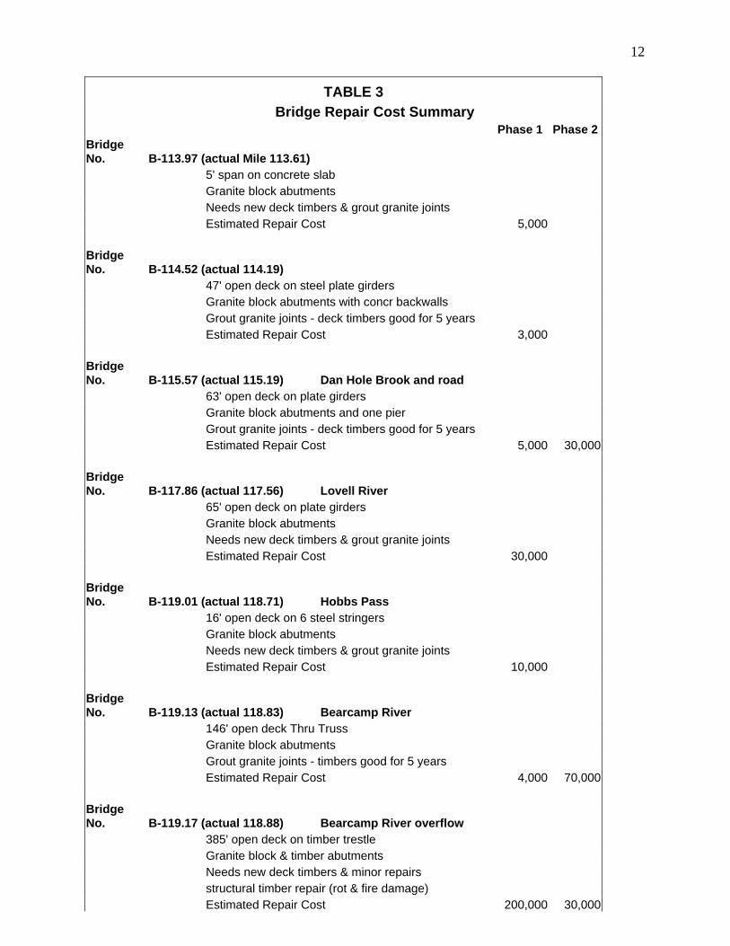
3.8 BRIDGES There are 15 bridges on this section of the Conway Branch railroad corridor. The bridge structures are mostly in good condition, with repairs required to some of the timber supports, deck timbers and concrete abutments or backwalls. Bridge problems include rotted deck timbers, rotted wood supports, cracked mortar in the granite block abutments, deteriorated concrete, and washouts around abutments on three of the bridges. A fire damaged the Bearcamp River overflow bridge in Ossipee last year, and it would require repair. A detailed list of bridges on the corridor including the necessary repairs and the anticipated cost required to repair each bridge is included in this report as Table 3.
7
Fig. 5: Bridge timbers
The bridge deck timbers supporting the rail would all need to be replaced in the first five years of railroad operation. Approximately 50% of the bridges would need new deck timbers before train service could be restored, and the other 50% would need to be replaced in the first 5 years of railroad operation. Once the bridge timbers are replaced, their expected life span should be 20-30 years. The total estimated repair cost for the bridges is $477,000 (Phase 1) to begin operations, and another $285,000 (Phase 2) within five years to complete repairs to additional bridge components not yet at the end of their useful life. 4 COST ESTIMATES Table 1 summarizes the cost estimates for each component of the rehabilitation project. Phase 1 represents the work needed immediately to restore service on the line, and Phase 2 represents work that could be carried out prior to service restoration but that would at a minimum be required to sustain service within five years. The cost of replacing the rail on the corridor with heavier rail, as discussed above, is listed as Phase 3. There is no specific timetable for this replacement, but if the line is used for heavy freight traffic, the rail would need to be upgraded in five to ten years. If only lighter tourist-excursion trains run on the line, the rail upgrade would not be required. The heavier rail would be required, however, to allow the speeds required to operate a scheduled intercity passenger service. As noted above, the price of steel has been rising dramatically and would be a major factor in upgrading the rail. The cost estimates include the cost of upgrading the mile of track owned by Conway Scenic Railroad. The New Hampshire Northcoast has pledged to rebuild the approximately 2 ½ miles it owns between its active operation at the beginning of the state-owned corridor in Ossipee. The cost estimates do not include the cost of providing terminals or parking for any passenger operations. This would need to be considered as part of such a proposal, but it is difficult to estimate costs in the absence of a specific proposal.
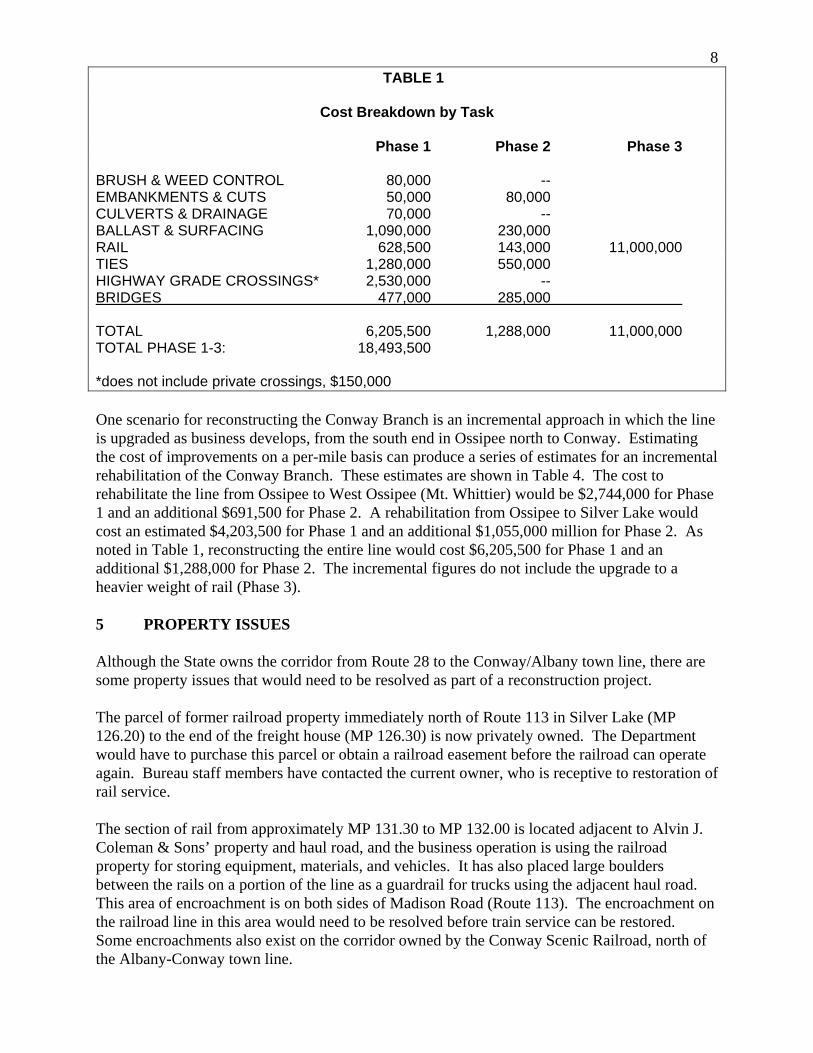
8 TABLE 1
Cost Breakdown by Task
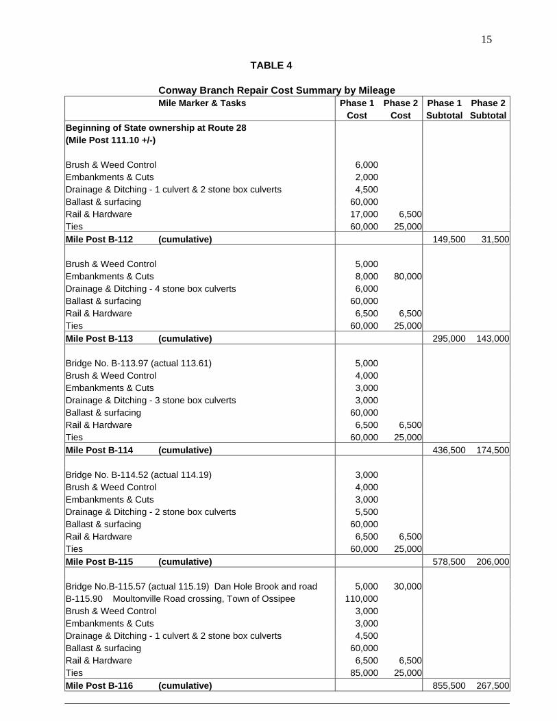
Phase 1 Phase 2 Phase 3 BRUSH & WEED CONTROL 80,000 -- EMBANKMENTS & CUTS 50,000 80,000 CULVERTS & DRAINAGE 70,000 -- BALLAST & SURFACING 1,090,000 230,000 RAIL 628,500 143,000 11,000,000 TIES 1,280,000 550,000 HIGHWAY GRADE CROSSINGS* 2,530,000 -- BRIDGES 477,000 285,000 TOTAL 6,205,500 1,288,000 11,000,000 TOTAL PHASE 1-3: 18,493,500 *does not include private crossings, $150,000 One scenario for reconstructing the Conway Branch is an incremental approach in which the line is upgraded as business develops, from the south end in Ossipee north to Conway. Estimating the cost of improvements on a per-mile basis can produce a series of estimates for an incremental rehabilitation of the Conway Branch. These estimates are shown in Table 4. The cost to rehabilitate the line from Ossipee to West Ossipee (Mt. Whittier) would be $2,744,000 for Phase 1 and an additional $691,500 for Phase 2. A rehabilitation from Ossipee to Silver Lake would cost an estimated $4,203,500 for Phase 1 and an additional $1,055,000 million for Phase 2. As noted in Table 1, reconstructing the entire line would cost $6,205,500 for Phase 1 and an additional $1,288,000 for Phase 2. The incremental figures do not include the upgrade to a heavier weight of rail (Phase 3). 5 PROPERTY ISSUES Although the State owns the corridor from Route 28 to the Conway/Albany town line, there are some property issues that would need to be resolved as part of a reconstruction project. The parcel of former railroad property immediately north of Route 113 in Silver Lake (MP 126.20) to the end of the freight house (MP 126.30) is now privately owned. The Department would have to purchase this parcel or obtain a railroad easement before the railroad can operate again. Bureau staff members have contacted the current owner, who is receptive to restoration of rail service. The section of rail from approximately MP 131.30 to MP 132.00 is located adjacent to Alvin J. Coleman & Sons’ property and haul road, and the business operation is using the railroad property for storing equipment, materials, and vehicles. It has also placed large boulders between the rails on a portion of the line as a guardrail for trucks using the adjacent haul road. This area of encroachment is on both sides of Madison Road (Route 113). The encroachment on the railroad line in this area would need to be resolved before train service can be restored. Some encroachments also exist on the corridor owned by the Conway Scenic Railroad, north of the Albany-Conway town line.
9Otherwise, most of the railroad line is relatively free of encroachments, but some appear to exist at MP 115.00 (junk car yard) and MP 117.90 (mobile homes and sheds). Another potential encroachment problem is a church building adjacent to the line in Center Ossipee. 6 FEASIBILITY OF RESTORATION The restoration of rail service on the Conway Branch would require a significant reconstruction effort costing between $6 million and $18 million. The tasks involved are not insurmountable, however: the right-of-way is nearly intact, the rail remains in place in most locations, and there are no major washouts or challenges with topography or track geometry (sharp curves or steep grades). One challenge would be the reactivation of grade crossings, especially on busy highways such as Route 16, Route 41 and Route 113. Complete crossing protection, along with education of motorists, would be essential for reactivation of the line. Another factor to be considered would be the displacement of the use of the corridor by snowmobiles. Although the Department of Transportation’s cooperative agreement with the DRED Trails Bureau requires that the corridor be turned over to DOT when needed for railroad use, DRED would no doubt be faced with the challenge of finding alternative alignments for a busy north-south trail. The concerns of abutting homeowners would also have to be considered. The Moore’s Pond development in Madison was constructed with several homes relatively close to the rail line, and residents would likely have concerns about noise impacts. The use of rail service by freight shippers depends on a number of factors, and the feasibility cannot be determined with any degree of certainty without extensive discussions between the freight railroad and potential shippers. Some potential freight uses of the Conway Branch can be identified, however. The Pinetree Power plant off Route 41 in Tamworth is located on the rail line. Bulk commodities in large volumes such as wood chips represent a good candidate for shipping by rail. Other property along the rail line in that area could likewise provide rail activity. The Madison Lumber mill on Route 41 is located across the highway, but would be worth exploring as a potential rail freight shipper. Lumber or wood products could be shipped by rail to or from the Conway area as well. Another commodity with good rail potential is propane to the North Conway area. Several oil transfer facilities have been built in New Hampshire and Vermont in recent years; these allow rail shipment of oil, propane, diesel and gasoline to tank farms, providing stability in local supplies and prices to distributors and consumers. It should be noted that the Boston and Maine Corporation retained rights to transport rail freight to or from distant points, known as “bridge traffic,” when it sold the corridor to the state. The potential for such traffic is somewhat remote, however, given the constraints of operating over the lines that connect with the Conway Branch to the north. The New Hampshire Northcoast would be free to develop freight business along the corridor, however, in cooperation with the Department of Transportation. Given the history of passenger service on the Conway Branch, there has been considerable public interest in reviving passenger rail service. The heavy traffic volumes on Route 16 also lead to interest in passenger rail. Passenger rail may take the form of scheduled intercity service (provided nationally by Amtrak), of tourist excursion trains such as the Conway Scenic Railroad, or of an alternative type of service such as weekend trains during peak tourist seasons connecting Dover with Conway. This type of travel could not compete with the highway in terms of travel time, but might present a special opportunity in the tourist market.
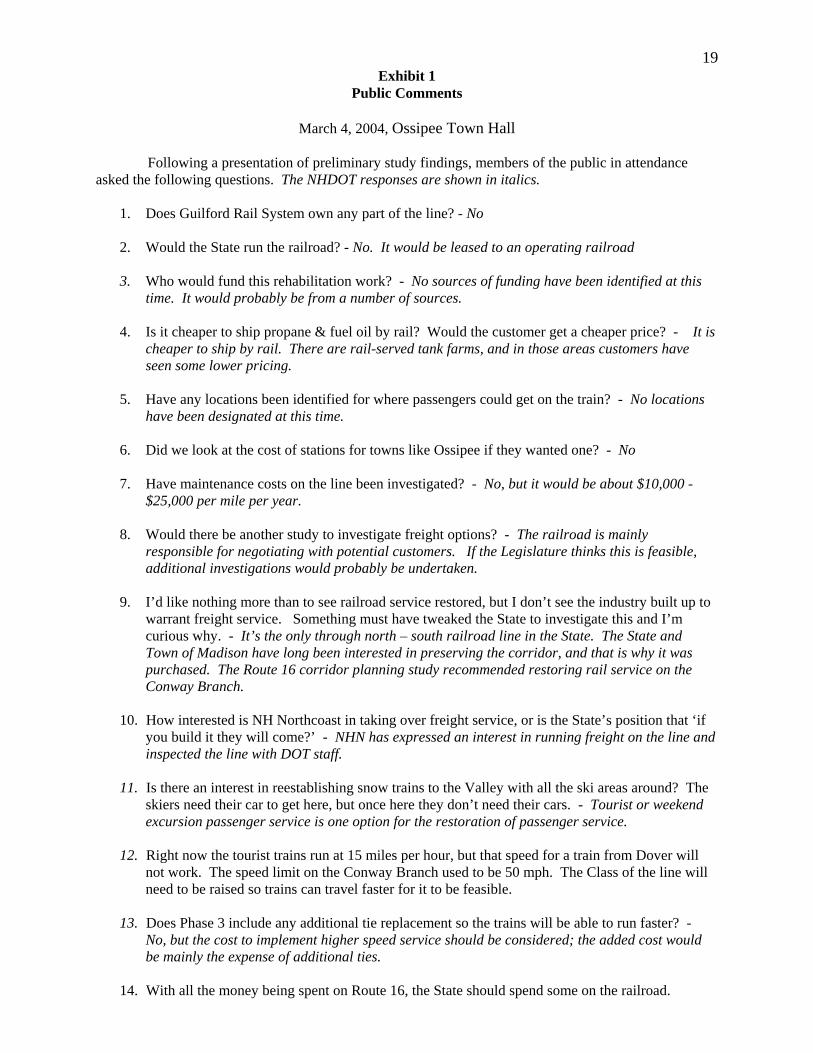
10The high traffic volumes on Route 16, together with the tourist nature of many of the highway users, would create some demand for passenger rail service. It is difficult to predict how successful such a service would be and what it would require in financial support, however. The Amtrak Downeaster operates four daily round trips to Portland, has been successful in generating public interest, and met its ridership projections at startup. The Route 16 corridor is not comparable to I-95, however, in its volume of traffic, and the Downeaster serves a much larger market that also supports extensive intercity bus service. Initiation of Amtrak service requires a sponsoring state to negotiate the payment of the cost of the service to Amtrak. It would likely also require the state to purchase equipment (locomotive and passenger coaches) for use in the service, at a substantial additional cost. Other issues to be considered with initiating passenger service include the provision of terminal facilities with sufficient parking (not currently available at the North Conway station). If it provides an alternative to driving on Route 16, the service could be considered a success. A source of funds for financial support would have to be identified, however. 7 PUBLIC COMMENT The Department of Transportation held a public informational meeting on March 4, 2004 in Ossipee. About 75 people attended to hear a presentation on the study, ask questions, and provide comments on the possible restoration of rail service on the Conway Branch. A summary of the questions asked and responses given is included as Exhibit 1. In addition to comments received at the meeting, the Department received letters from the Ossipee Board of Selectmen and Ossipee Planning Board expressing support for the rehabilitation of the Conway Branch. The president of the Moore’s Pond Association wrote on behalf of the association expressing opposition. The Department also received detailed comments from the Conway Scenic Railroad, most of which have been incorporated into this report.
11
TABLE 2
CONWAY BRANCH CROSSING LIST
REGISTERED GRADE CROSSINGS MILE POST NAME or ROAD AAR-DOT# PUBLIC/PRIVATE 1) B-112.31 Polly’s 054258S Private Ossipee 2) B-115.90 Moultonville Rd 054260T Town Ossipee 3) B-118.60 Main St. (Rt. 16) 054261A State Ossipee 4) B-119.43 Hobbs, Abbott or Nichols Rd. 054262G Town Ossipee 5) B-120.82 Residence (Ira Lane) 054263N Private Ossipee 6) B-121.62 Freedom Rd (Rt. 41) 054265C State Ossipee 7) B-125.68 Rt. 41 400705V State Madison 8) B-126.19 Rt. 113 (Silver Lake) 400706C State Madison 9) B-129.28 Boulder Rd. 400707J Town Madison 10) B-131.84 Madison Rd. (Rt. 113) 400708R State Albany 11) B-132.13 Colbath’s 400709X Town Albany 12) B-132.51 West Main St. 903636F Town Conway 13) B-132.79 Bald Hill 903635Y Town Conway 14) B-133.00 North Road Town Conway
OTHER UNDOCUMENTED GRADE GROSSINGS 1) B-116.40 ATV/REC Ossipee 2) B-117.80 Residence Ossipee 3) B-119.80 ATV/REC Ossipee 4) B-122.80 Power plant (Gravel) Tamworth Fill over Tracks 5) B-123.20 Residence Tamworth 6) B-124.10 Moore’s Pond Rd. Madison Fill over Tracks 7) B-124.60 Unknown Madison 8) B-125.10 Unknown (Gravel) Madison 9) B-127.10 Unknown (Gravel) Madison 10) B-130.20 Pike’s Pit Madison
12
TABLE 3
Bridge Repair Cost Summary Phase 1 Phase 2Bridge No. B-113.97 (actual Mile 113.61) 5' span on concrete slab Granite block abutments Needs new deck timbers & grout granite joints Estimated Repair Cost 5,000 Bridge No. B-114.52 (actual 114.19) 47' open deck on steel plate girders Granite block abutments with concr backwalls Grout granite joints - deck timbers good for 5 years Estimated Repair Cost 3,000 Bridge No. B-115.57 (actual 115.19) Dan Hole Brook and road 63' open deck on plate girders Granite block abutments and one pier Grout granite joints - deck timbers good for 5 years Estimated Repair Cost 5,000 30,000 Bridge No. B-117.86 (actual 117.56) Lovell River 65' open deck on plate girders Granite block abutments Needs new deck timbers & grout granite joints Estimated Repair Cost 30,000 Bridge No. B-119.01 (actual 118.71) Hobbs Pass 16' open deck on 6 steel stringers Granite block abutments Needs new deck timbers & grout granite joints Estimated Repair Cost 10,000 Bridge No. B-119.13 (actual 118.83) Bearcamp River 146' open deck Thru Truss Granite block abutments Grout granite joints - timbers good for 5 years Estimated Repair Cost 4,000 70,000 Bridge No. B-119.17 (actual 118.88) Bearcamp River overflow 385' open deck on timber trestle Granite block & timber abutments Needs new deck timbers & minor repairs structural timber repair (rot & fire damage) Estimated Repair Cost 200,000 30,000
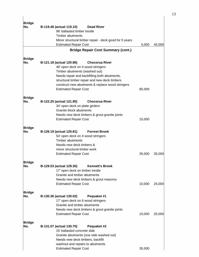
13 Bridge No. B-119.46 (actual 119.10) Dead River 96' ballasted timber trestle Timber abutments Minor structural timber repair - deck good for 5 years Estimated Repair Cost 5,000 45,000
Bridge Repair Cost Summary (cont.) Bridge No. B-121.18 (actual 120.86) Chocorua River 49' open deck on 4 wood stringers Timber abutments (washed out) Needs repair and backfilling both abutments, structural timber repair and new deck timbers construct new abutments & replace wood stringers Estimated Repair Cost 85,000 Bridge No. B-122.25 (actual 121.90) Chocorua River 34' open deck on plate girders Granite block abutments Needs new deck timbers & grout granite joints Estimated Repair Cost 15,000 Bridge No. B-126.19 (actual 125.81) Forrest Brook 54' open deck on 4 wood stringers Timber abutments Needs new deck timbers & minor structural timber work Estimated Repair Cost 35,000 35,000 Bridge No. B-129.53 (actual 129.30) Kennett's Brook 17' open deck on timber trestle Granite and timber abutments Needs new deck timbers & grout masonry Estimated Repair Cost 10,000 25,000 Bridge No. B-130.36 (actual 130.02) Pequaket #1 17' open deck on 6 wood stringers Granite and timber abutments Needs new deck timbers & grout granite joints Estimated Repair Cost 10,000 25,000 Bridge No. B-131.07 (actual 130.70) Pequaket #2 15' ballasted concrete slab Granite abutments (one side washed out) Needs new deck timbers, backfill washout and repairs to abutments Estimated Repair Cost 35,000
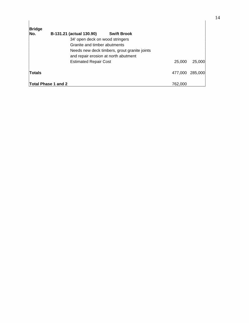
14 Bridge No. B-131.21 (actual 130.90) Swift Brook 34' open deck on wood stringers Granite and timber abutments Needs new deck timbers, grout granite joints and repair erosion at north abutment Estimated Repair Cost 25,000 25,000 Totals 477,000 285,000 Total Phase 1 and 2 762,000
15
TABLE 4 Conway Branch Repair Cost Summary by Mileage Mile Marker & Tasks Phase 1 Phase 2 Phase 1 Phase 2 Cost Cost Subtotal SubtotalBeginning of State ownership at Route 28 (Mile Post 111.10 +/-) Brush & Weed Control 6,000 Embankments & Cuts 2,000 Drainage & Ditching - 1 culvert & 2 stone box culverts 4,500 Ballast & surfacing 60,000 Rail & Hardware 17,000 6,500 Ties 60,000 25,000 Mile Post B-112 (cumulative) 149,500 31,500 Brush & Weed Control 5,000 Embankments & Cuts 8,000 80,000 Drainage & Ditching - 4 stone box culverts 6,000 Ballast & surfacing 60,000 Rail & Hardware 6,500 6,500 Ties 60,000 25,000 Mile Post B-113 (cumulative) 295,000 143,000 Bridge No. B-113.97 (actual 113.61) 5,000 Brush & Weed Control 4,000 Embankments & Cuts 3,000 Drainage & Ditching - 3 stone box culverts 3,000 Ballast & surfacing 60,000 Rail & Hardware 6,500 6,500 Ties 60,000 25,000 Mile Post B-114 (cumulative) 436,500 174,500 Bridge No. B-114.52 (actual 114.19) 3,000 Brush & Weed Control 4,000 Embankments & Cuts 3,000 Drainage & Ditching - 2 stone box culverts 5,500 Ballast & surfacing 60,000 Rail & Hardware 6,500 6,500 Ties 60,000 25,000 Mile Post B-115 (cumulative) 578,500 206,000 Bridge No.B-115.57 (actual 115.19) Dan Hole Brook and road 5,000 30,000 B-115.90 Moultonville Road crossing, Town of Ossipee 110,000 Brush & Weed Control 3,000 Embankments & Cuts 3,000 Drainage & Ditching - 1 culvert & 2 stone box culverts 4,500 Ballast & surfacing 60,000 Rail & Hardware 6,500 6,500 Ties 85,000 25,000 Mile Post B-116 (cumulative) 855,500 267,500
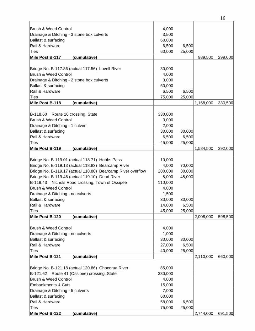
16 Brush & Weed Control 4,000 Drainage & Ditching - 3 stone box culverts 3,500 Ballast & surfacing 60,000 Rail & Hardware 6,500 6,500 Ties 60,000 25,000 Mile Post B-117 (cumulative) 989,500 299,000 Bridge No. B-117.86 (actual 117.56) Lovell River 30,000 Brush & Weed Control 4,000 Drainage & Ditching - 2 stone box culverts 3,000 Ballast & surfacing 60,000 Rail & Hardware 6,500 6,500 Ties 75,000 25,000 Mile Post B-118 (cumulative) 1,168,000 330,500 B-118.60 Route 16 crossing, State 330,000 Brush & Weed Control 3,000 Drainage & Ditching - 1 culvert 2,000 Ballast & surfacing 30,000 30,000 Rail & Hardware 6,500 6,500 Ties 45,000 25,000 Mile Post B-119 (cumulative) 1,584,500 392,000 Bridge No. B-119.01 (actual 118.71) Hobbs Pass 10,000 Bridge No. B-119.13 (actual 118.83) Bearcamp River 4,000 70,000 Bridge No. B-119.17 (actual 118.88) Bearcamp River overflow 200,000 30,000 Bridge No. B-119.46 (actual 119.10) Dead River 5,000 45,000 B-119.43 Nichols Road crossing, Town of Ossipee 110,000 Brush & Weed Control 4,000 Drainage & Ditching - no culverts 1,500 Ballast & surfacing 30,000 30,000 Rail & Hardware 14,000 6,500 Ties 45,000 25,000 Mile Post B-120 (cumulative) 2,008,000 598,500 Brush & Weed Control 4,000 Drainage & Ditching - no culverts 1,000 Ballast & surfacing 30,000 30,000 Rail & Hardware 27,000 6,500 Ties 40,000 25,000 Mile Post B-121 (cumulative) 2,110,000 660,000 Bridge No. B-121.18 (actual 120.86) Chocorua River 85,000 B-121.62 Route 41 (Ossipee) crossing, State 330,000 Brush & Weed Control 4,000 Embankments & Cuts 15,000 Drainage & Ditching - 5 culverts 7,000 Ballast & surfacing 60,000 Rail & Hardware 58,000 6,500 Ties 75,000 25,000 Mile Post B-122 (cumulative) 2,744,000 691,500
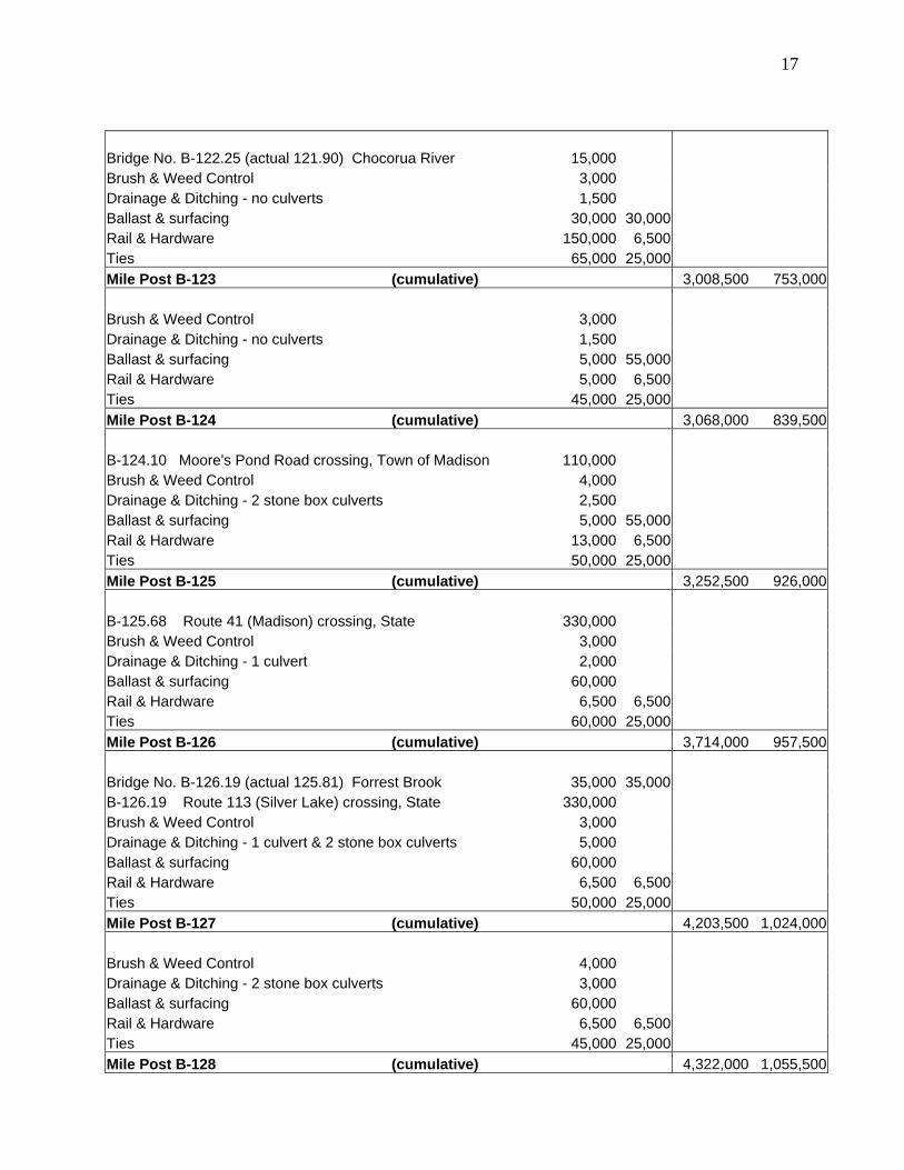
17 Bridge No. B-122.25 (actual 121.90) Chocorua River 15,000 Brush & Weed Control 3,000 Drainage & Ditching - no culverts 1,500 Ballast & surfacing 30,000 30,000 Rail & Hardware 150,000 6,500 Ties 65,000 25,000 Mile Post B-123 (cumulative) 3,008,500 753,000 Brush & Weed Control 3,000 Drainage & Ditching - no culverts 1,500 Ballast & surfacing 5,000 55,000 Rail & Hardware 5,000 6,500 Ties 45,000 25,000 Mile Post B-124 (cumulative) 3,068,000 839,500 B-124.10 Moore's Pond Road crossing, Town of Madison 110,000 Brush & Weed Control 4,000 Drainage & Ditching - 2 stone box culverts 2,500 Ballast & surfacing 5,000 55,000 Rail & Hardware 13,000 6,500 Ties 50,000 25,000 Mile Post B-125 (cumulative) 3,252,500 926,000 B-125.68 Route 41 (Madison) crossing, State 330,000 Brush & Weed Control 3,000 Drainage & Ditching - 1 culvert 2,000 Ballast & surfacing 60,000 Rail & Hardware 6,500 6,500 Ties 60,000 25,000 Mile Post B-126 (cumulative) 3,714,000 957,500 Bridge No. B-126.19 (actual 125.81) Forrest Brook 35,000 35,000 B-126.19 Route 113 (Silver Lake) crossing, State 330,000 Brush & Weed Control 3,000 Drainage & Ditching - 1 culvert & 2 stone box culverts 5,000 Ballast & surfacing 60,000 Rail & Hardware 6,500 6,500 Ties 50,000 25,000 Mile Post B-127 (cumulative) 4,203,500 1,024,000 Brush & Weed Control 4,000 Drainage & Ditching - 2 stone box culverts 3,000 Ballast & surfacing 60,000 Rail & Hardware 6,500 6,500 Ties 45,000 25,000 Mile Post B-128 (cumulative) 4,322,000 1,055,500
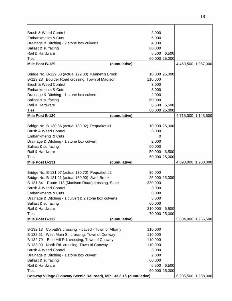
18 Brush & Weed Control 3,000 Embankments & Cuts 5,000 Drainage & Ditching - 2 stone box culverts 4,000 Ballast & surfacing 60,000 Rail & Hardware 6,500 6,500 Ties 60,000 25,000 Mile Post B-129 (cumulative) 4,460,500 1,087,000 Bridge No. B-129.53 (actual 129.30) Kennett's Brook 10,000 25,000 B-129.28 Boulder Road crossing, Town of Madison 110,000 Brush & Weed Control 3,000 Embankments & Cuts 3,000 Drainage & Ditching - 1 stone box culvert 2,000 Ballast & surfacing 60,000 Rail & Hardware 6,500 6,500 Ties 60,000 25,000 Mile Post B-130 (cumulative) 4,715,000 1,143,500 Bridge No. B-130.36 (actual 130.02) Pequaket #1 10,000 25,000 Brush & Weed Control 3,000 Embankments & Cuts 0 Drainage & Ditching - 1 stone box culvert 2,000 Ballast & surfacing 60,000 Rail & Hardware 50,000 6,500 Ties 50,000 25,000 Mile Post B-131 (cumulative) 4,890,000 1,200,000 Bridge No. B-131.07 (actual 130.70) Pequaket #2 35,000 Bridge No. B-131.21 (actual 130.90) Swift Brook 25,000 25,000 B-131.84 Route 113 (Madison Road) crossing, State 330,000 Brush & Weed Control 3,000 Embankments & Cuts 8,000 Drainage & Ditching - 1 culvert & 2 stone box culverts 3,000 Ballast & surfacing 60,000 Rail & Hardware 210,000 6,500 Ties 70,000 25,000 Mile Post B-132 (cumulative) 5,634,000 1,256,500 B-132.13 Colbath's crossing - paved - Town of Albany 110,000 B-132.51 West Main St. crossing, Town of Conway 110,000 B-132.79 Bald Hill Rd. crossing, Town of Conway 110,000 B-133.00 North Rd. crossing, Town of Conway 110,000 Brush & Weed Control 3,000 Drainage & Ditching - 1 stone box culvert 2,000 Ballast & surfacing 60,000 Rail & Hardware 6,500 6,500 Ties 60,000 25,000 Conway Village (Conway Scenic Railroad), MP 133.3 +/- (cumulative) 6,205,500 1,288,000
19Exhibit 1
Public Comments
March 4, 2004, Ossipee Town Hall Following a presentation of preliminary study findings, members of the public in attendance asked the following questions. The NHDOT responses are shown in italics.
1. Does Guilford Rail System own any part of the line? - No 2. Would the State run the railroad? - No. It would be leased to an operating railroad
3. Who would fund this rehabilitation work? - No sources of funding have been identified at this
time. It would probably be from a number of sources.
4. Is it cheaper to ship propane & fuel oil by rail? Would the customer get a cheaper price? - It is cheaper to ship by rail. There are rail-served tank farms, and in those areas customers have seen some lower pricing.
5. Have any locations been identified for where passengers could get on the train? - No locations
have been designated at this time.
6. Did we look at the cost of stations for towns like Ossipee if they wanted one? - No
7. Have maintenance costs on the line been investigated? - No, but it would be about $10,000 - $25,000 per mile per year.
8. Would there be another study to investigate freight options? - The railroad is mainly
responsible for negotiating with potential customers. If the Legislature thinks this is feasible, additional investigations would probably be undertaken.
9. I’d like nothing more than to see railroad service restored, but I don’t see the industry built up to
warrant freight service. Something must have tweaked the State to investigate this and I’m curious why. - It’s the only through north – south railroad line in the State. The State and Town of Madison have long been interested in preserving the corridor, and that is why it was purchased. The Route 16 corridor planning study recommended restoring rail service on the Conway Branch.
10. How interested is NH Northcoast in taking over freight service, or is the State’s position that ‘if
you build it they will come?’ - NHN has expressed an interest in running freight on the line and inspected the line with DOT staff.
11. Is there an interest in reestablishing snow trains to the Valley with all the ski areas around? The skiers need their car to get here, but once here they don’t need their cars. - Tourist or weekend excursion passenger service is one option for the restoration of passenger service.
12. Right now the tourist trains run at 15 miles per hour, but that speed for a train from Dover will not work. The speed limit on the Conway Branch used to be 50 mph. The Class of the line will need to be raised so trains can travel faster for it to be feasible.
13. Does Phase 3 include any additional tie replacement so the trains will be able to run faster? - No, but the cost to implement higher speed service should be considered; the added cost would be mainly the expense of additional ties.
14. With all the money being spent on Route 16, the State should spend some on the railroad.
2015. David Campbell (NH Northcoast) – NHN is very happy the State acquired the corridor. It is
much more cost effective to ship propane by rail. NHN owns 42 miles of track from Ossipee to Dover and the track is Class II. NHN would upgrade their track just south of the State portion in Ossipee if the State’s portion were developed.
16. What is the potential of other materials being shipped by rail? - [David Campbell of NH
Northcoast responded]: NHN has moved gravel, telephone poles, steel and propane. NHN connects with Guilford in Dover and in turn to larger Class I railroads; our rate is a very small component of the total cost to the shipper. Propane is the second largest commodity on NHN’s line behind gravel.
17. Moving freight and people on the road is much more expensive than by train. As energy supplies
diminish, the cost of moving by rail will be more attractive. - It will require a shift in thinking to get people to use the rail instead of the road. Traditionally in the US the freight rail mode is privately funded and managed, while other modes are considered a public responsibility.
18. It will give us the opportunity to look at how we want to travel. It will give us options.
19. It’s not just the State making decisions of rail versus road. You need to contact your Senators,
Reps and Governor to let them know how you feel.
20. I want to commend Rail & Transit for putting this presentation together. I see it as a big economic boost for this area. Conway Scenic has done a good job keeping up their line.
21. I’m encouraged to see the numbers. I believe that it’s doable. The traffic is increasing about 2%
a year. It would be good to take cars and trucks off the road.
22. You will be submitting this to the Legislature in June. With your optimistic eye, what do you see will happen to this? - It’s hard to put a timetable on it. The funding issues will take some time to resolve. The actual construction would take one or two years once funding was in place.
23. I have a comment about the bus service in this area (Gorham). Concord Trailways isn’t
advertising at all. When was the last time you heard a commercial on WPKQ? If Concord Trailways would get back to marketing I know they could be running full buses to Boston.
24. [Senator Joe Kenney] – I attached an amendment to a bill for the feasibility study. The idea was
to introduce a movement to get people passionate about restoring other modes of transportation. There is an interest in bringing rail back to the State. Once the report comes out in June, we will start looking at how we can put this project together. We need Selectmen, Chambers of Commerce, Economic Development groups, everyone to write the State about the desire to restore rail service.
25. I wanted to recognize that the snowmobile clubs and the Cotton Valley Railroad have cleared the
brush along the line to keep it open which probably allowed your Hi-rail to get through.
26. It’s important to keep this rail corridor maintained. In 25 years you won’t be able to move on Route 16 because of the traffic. I don’t see any way to get passenger service on the line now. The line needs to be upgraded to run passengers. When I was young, trains were the school bus from Intervale to Conway. I don’t know what the speed of the train was, but it was fast. The Conway Scenic RR runs on the line now and the speed is very slow, which is ok for freight or tourists, but not good for passenger service.
27. The line should be maintained so it doesn’t cost even more to restore service when it is needed.
28. I think that industry decreased because of the transportation problems. Opening this line back up
will help this area. Tourism is ok, but industry is important.
21
29. As a ballpark figure, what is the number of trucks per rail car? - The gravel train took about 30,000 trucks off of Route 16 last year, about three trucks per rail car.
30. Has anyone studied how this will affect people living on the tracks? - We did not study that, but
environmental effects such as noise would be looked at in an environmental assessment if one were conducted.
31. If potential customers on the line wanted service, would it be their cost to build the sidings? -
Yes. They would have to work with the railroad to construct the sidings.