copernicus global land operations cryosphere and water
TRANSCRIPT

Copernicus Global Land Operations – Lot 2 Date Issued: 10.07.2020 Issue: I2.11
Copernicus Global Land Operations
“Cryosphere and Water” ”CGLOPS-2”
Framework Service Contract N° 199496 (JRC)
PRODUCT USER MANUAL
LAKE AND RIVER WATER LEVEL
300M
VERSION 2.1
Issue I2.11
Organization name of lead contractor for this deliverable: CLS
Book Captain: N. Taburet (CLS)
Contributing Authors: L. Zawadzki (CLS), S. Calmant
(IRD/LEGOS), J-F. Crétaux
(CNES/LEGOS), F. Mercier(CLS), M.
Vayre (CLS), N. Taburet (CLS)

Copernicus Global Land Operations – Lot 2 Date Issued: 10.07.2020 Issue: I2.11
Document-No. CGLOPS2_PUM_LakeAndRiverWaterLevel300m-V2.1
© C-GLOPS Lot2 consortium
Issue: I2.11 Date: 10.07.2020 Page: 2 of 41

Copernicus Global Land Operations – Lot 2 Date Issued: 10.07.2020 Issue: I2.11
Document-No. CGLOPS2_PUM_LakeAndRiverWaterLevel300m-V2.1
© C-GLOPS Lot2 consortium
Issue: I2.11 Date: 10.07.2020 Page: 3 of 41
Dissemination Level PU Public X
PP Restricted to other programme participants (including the Commission Services)
RE Restricted to a group specified by the consortium (including the Commission Services)
CO Confidential, only for members of the consortium (including the Commission Services)
Copernicus Global Land Operations – Lot 2 Date Issued: 10.07.2020 Issue: I2.11
Document-No. CGLOPS2_PUM_LakeAndRiverWaterLevel300m-V2.1
© C-GLOPS Lot2 consortium
Issue: I2.11 Date: 10.07.2020 Page: 4 of 41
Document Release Sheet
Book captain: Nicolas Taburet Sign Date
Approval: Sign Date
Endorsement: Mark Dowell Sign Date
Distribution: Public

Copernicus Global Land Operations – Lot 2 Date Issued: 10.07.2020 Issue: I2.11
Document-No. CGLOPS2_PUM_LakeAndRiverWaterLevel300m-V2.1
© C-GLOPS Lot2 consortium
Issue: I2.11 Date: 10.07.2020 Page: 5 of 41
Change Record
Issue/Rev Date Page(s) Description of Change Release
1.00 24.02.2017 All Creation of the document V1
1.01 21.04.2017 All Modification after Review #1 V1
1.02 23.05.2017 All Modification of the document after final
teleconference of review #1 from Spacebel V1
1.03 05.09.2017 24-31 Change of data format: ascii to GeoJSON V1
2.00 30.10.2017 All Modification for V2 of the products (integration
of Sentinel-3A) V2
2.02 22.12.2017 All Minor Corrections V2
2.03 20.06.2018 All Modifications to account for reviewers’
comments V2
2.04 22.10.2019 All Minor corrections + update to account for river
extended dataset V2
2.05 10.03.2020 All Minor phrasing corrections after reviewers’
comments V2
2.10 25.02.2020 All Modification in river product names + integration
of Sentinel-3B in the river products. V2.1
2.11 10.07.2020 All Minor corrections after reviewers’ feedback V2.1

Copernicus Global Land Operations – Lot 2 Date Issued: 10.07.2020 Issue: I2.11
Document-No. CGLOPS2_PUM_LakeAndRiverWaterLevel300m-V2.1
© C-GLOPS Lot2 consortium
Issue: I2.11 Date: 10.07.2020 Page: 6 of 41
TABLE OF CONTENTS
1 Background of the document ............................................................................................. 11
1.1 Executive Summary ............................................................................................................... 11
1.2 Scope and Objectives............................................................................................................. 12
1.3 Content of the document....................................................................................................... 12
1.4 Related documents ............................................................................................................... 12
1.4.1 Applicable documents ................................................................................................................................ 12
1.4.2 Input ............................................................................................................................................................ 12
1.4.3 Output ......................................................................................................................................................... 13
2 Review of Users Requirements ........................................................................................... 14
3 Algorithm .......................................................................................................................... 16
3.1 Overview .............................................................................................................................. 16
3.2 The retrieval Methodology .................................................................................................... 16
3.2.1 Background ................................................................................................................................................. 16
3.2.2 Processing ................................................................................................................................................... 20
3.3 Limitations of the Product ..................................................................................................... 25
3.4 Differences with the previous version .................................................................................... 26
3.5 V2 to V2.1 ............................................................................................................................. 26
3.6 V1 to V2 ................................................................................................................................ 26
4 Product Description ........................................................................................................... 27
4.1 File Naming ........................................................................................................................... 27
4.1.1 Lake products .............................................................................................................................................. 27
4.1.2 River products ............................................................................................................................................. 27
4.2 File Format ............................................................................................................................ 28
4.3 Product Content .................................................................................................................... 28
4.3.1 Data File ...................................................................................................................................................... 28
4.3.2 Quicklook .................................................................................................................................................... 32
4.4 Product Characteristics .......................................................................................................... 37
4.4.1 Projection and Grid Information ................................................................................................................. 37
4.4.2 Spatial Information ..................................................................................................................................... 37
4.4.3 Temporal Information ................................................................................................................................. 37
4.4.4 Data Policies ................................................................................................................................................ 38

Copernicus Global Land Operations – Lot 2 Date Issued: 10.07.2020 Issue: I2.11
Document-No. CGLOPS2_PUM_LakeAndRiverWaterLevel300m-V2.1
© C-GLOPS Lot2 consortium
Issue: I2.11 Date: 10.07.2020 Page: 7 of 41
4.4.5 Contacts ...................................................................................................................................................... 38
5 Validation ......................................................................................................................... 39
6 References ........................................................................................................................ 40
6.1 Lakes..................................................................................................................................... 40
6.2 Rivers .................................................................................................................................... 40

Copernicus Global Land Operations – Lot 2 Date Issued: 10.07.2020 Issue: I2.11
Document-No. CGLOPS2_PUM_LakeAndRiverWaterLevel300m-V2.1
© C-GLOPS Lot2 consortium
Issue: I2.11 Date: 10.07.2020 Page: 8 of 41
List of Figures
Figure 1: Altimetry principle (Credit CNES) .................................................................................. 17
Figure 2: The radar altimeter receives the reflected echo, which varies in intensity over time. When
the surface is flat (left), the reflected echo amplitude increases sharply from the moment the
radar signal hits the surface. Over rough surfaces (right), the echo strikes the crest of one wave
and then a series of crests which cause the reflected echo amplitude to increase more gradually.
The slope of the curve representing the reflected power amplitude over time is proportional to
wave height. (Credits CNES) ................................................................................................. 18
Figure 3: Jason-3 (red), Sentinel-3A (blue) and Sentinel-3B (green) passes over the Amazon. The
satellites overfly each pass once every cycle (every 10 days for Jason-3, 27 days for S3A&B).
Note that in between those passes, no measurements are made by these satellites. ............ 19
Figure 4 : Concept of definition of a virtual station (Sentinel-3A over the Loire river). Each point
represents a 20Hz measurement. The measurements that are aligned belong to one satellite
pass over the river, those points are separated by 0.05 seconds. The different ‘lines’ are
associated to the pass of the satellite at different cycles. Each pass is separated by 27 days.
The track slightly shifts from one pass to another (satellite control ensures this across track drift
remains smaller than 1km). .................................................................................................... 23
Figure 5 : Yearly filtering from Bercher 2008. Top panel: raw high rate (HR) measurements. Middle
panel: application of the selection climatological corridor (details in ATBD). Bottom panel:
accepted HR measurements from which the mean value is computed at each time step. ...... 25
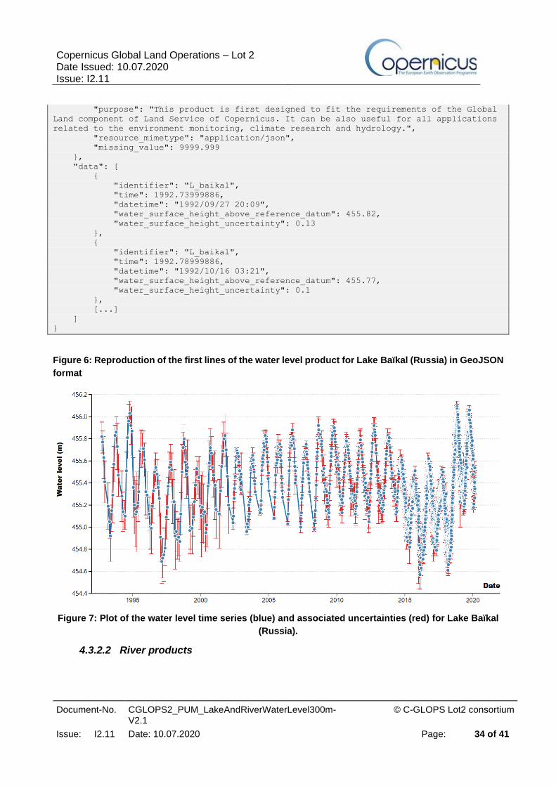
Figure 6: Reproduction of the first lines of the water level product for Lake Baïkal (Russia) in
GeoJSON format ................................................................................................................... 34
Figure 7: Plot of the water level time series (blue) and associated uncertainties (red) for Lake Baïkal
(Russia). ................................................................................................................................ 34
Figure 8: Reproduction of the first lines of the water level product for one given Virtual Station over
the Nile river, with header and part of the data lines. .............................................................. 36
Figure 9: Plot of the water level time series corresponding to the data file presented in the previous
figure...................................................................................................................................... 36

Copernicus Global Land Operations – Lot 2 Date Issued: 10.07.2020 Issue: I2.11
Document-No. CGLOPS2_PUM_LakeAndRiverWaterLevel300m-V2.1
© C-GLOPS Lot2 consortium
Issue: I2.11 Date: 10.07.2020 Page: 9 of 41
List of Tables
Table 1: User Requirements for Water Level as described in ULG-CGL-TS-002 .......................... 15

Copernicus Global Land Operations – Lot 2 Date Issued: 10.07.2020 Issue: I2.11
Document-No. CGLOPS2_PUM_LakeAndRiverWaterLevel300m-V2.1
© C-GLOPS Lot2 consortium
Issue: I2.11 Date: 10.07.2020 Page: 10 of 41
List of Acronyms
C-GLOPS Copernicus Global Land Operations
ECV Essential Climate Variable
FTP File Transfer Protocol
GDR Geophysical Data Records
HR
IGDR
J2
J3
NRT
NTC
High Rate
Interim Geophysical Data Record
Jason-2
Jason-3
Near Real Time
Non Time Critical
PUM
Probability Distribution Function
Product User Manual
QAR
S3A
S3B
STC
Quality Assessment Report
Sentinel-3A
Sentinel-3B
Short Time Critical
VS Virtual Station
WGS84 World Geodetic System 1984
WSH Water Surface Height

Copernicus Global Land Operations – Lot 2 Date Issued: 10.07.2020 Issue: I2.11
Document-No. CGLOPS2_PUM_LakeAndRiverWaterLevel300m-V2.1
© C-GLOPS Lot2 consortium
Issue: I2.11 Date: 10.07.2020 Page: 11 of 41
1 BACKGROUND OF THE DOCUMENT
1.1 EXECUTIVE SUMMARY
The Copernicus Global Land Service is a component of the Copernicus Land service and is
operational since January 2013, providing a series of bio-geophysical products describing the status
and the evolution of the land surface at global scale. Production and delivery of the parameters are
to take place in a timely manner and are complemented by the constitution of long-term time series.
The Service consists of i) a production component providing the bio-physical variables; ii) an
algorithm maintenance and evolution component implementing the adjustments needed to the
processing chains; iii) a data distribution and user interface activity managing the website and the
dissemination of products over the web (FTP) and through EUMETCAST.
Among the “Cryosphere and Water” thematic area of the Copernicus Global Land Service, this
document describes the Water Level (ECV T.1.2) products as observed over lakes and rivers
from satellite altimeters such as Jason-3, Sentinel-3A and Sentinel-3B for near real-time products.
Only open water rivers and lakes are considered at the moment, as the radar return echo is
contaminated by vegetation.
The water level products thus aim at providing users with worldwide historical and near-real-time
water level time series on inland water targets located beneath satellites tracks. Satellite altimetry
measurements homogeneously cover all continents between the maximum latitudes reached by
each satellite (66° for Jason and 81° for Sentinel-3) and are currently only being possible at nadir.
Hence the ground coverage is that of the nadir of the altimeter constellation used. Future missions
with wide-swath altimetry technology, such as SWOT, will allow increasing the spatial coverage of
inland waters.
The lake and river water level products are generated daily, within 1.5 days after data acquisition by
the satellites. The temporal repeatability for each product is also strongly dependant on the orbital
characteristics of the altimeters: for river products, the stations are covered once per satellite cycle
(10 days for Jason and 27 days for the Sentinel-3). As for the lakes, the larger their surface allows
them to be overflown by several satellite passes, the smaller is the time between two revisits.
This Product User Manual (PUM) is a self-contained document which provides the necessary
information on how to use the Water Level products in an efficient and reliable way.
Copernicus Global Land Operations – Lot 2 Date Issued: 10.07.2020 Issue: I2.11
Document-No. CGLOPS2_PUM_LakeAndRiverWaterLevel300m-V2.1
© C-GLOPS Lot2 consortium
Issue: I2.11 Date: 10.07.2020 Page: 12 of 41
1.2 SCOPE AND OBJECTIVES
The Product User Manual (PUM) is the primary document that users should read before handling
the products. It gives an overview of the product characteristics, in terms of algorithm, technical
characteristics, and main validation results.
1.3 CONTENT OF THE DOCUMENT
This document is structured as follows:
• Chapter 2 recalls the users’ requirements, and the expected performance
• Chapter 3 summarizes the retrieval methodology
• Chapter 4 describes the technical properties of the product
• Chapter 5 summarizes the results of the quality assessment
1.4 RELATED DOCUMENTS
1.4.1 Applicable documents
AD1: Annex I – Technical Specifications JRC/IPR/2015/H.5/0026/OC to Contract Notice 2015/S 151-
277962 of 7th August 2015
AD2: Appendix 1 – Copernicus Global land Component Product and Service Detailed Technical
requirements to Technical Annex to Contract Notice 2015/S 151-277962 of 7th August 2015
1.4.2 Input
Document ID Descriptor
CGLOPS2_SSD Service Specifications of the Global Component
of the Copernicus Land Service.
CGL-TS-002_user_requirements User Requirements of the Global Component of
the Copernicus Land Service "Cryosphere and
Water"
CGLOPS2_ATBD_LakeAndRiverWater
Level300m-V2.1
Algorithm Theoretical Basis Document for 300m
Lake and River Water Level Version 2.1 product
CGLOPS2_QAR_LakeAndRiverWaterL
evel300m-V2.1
Report describing the results of the scientific
quality assessment of the 300m Lake and River
Water Level Version 2.1 product

Copernicus Global Land Operations – Lot 2 Date Issued: 10.07.2020 Issue: I2.11
Document-No. CGLOPS2_PUM_LakeAndRiverWaterLevel300m-V2.1
© C-GLOPS Lot2 consortium
Issue: I2.11 Date: 10.07.2020 Page: 13 of 41
1.4.3 Output
Document ID Descriptor
CGLOPS2_PUM_LakeAndRiverWaterLevel300m-
V2.1
Product User Manual summarizing all
information about the 300m Lake and
River Water Level Version 2.1 product

Copernicus Global Land Operations – Lot 2 Date Issued: 10.07.2020 Issue: I2.11
Document-No. CGLOPS2_PUM_LakeAndRiverWaterLevel300m-V2.1
© C-GLOPS Lot2 consortium
Issue: I2.11 Date: 10.07.2020 Page: 14 of 41
2 REVIEW OF USERS REQUIREMENTS
• Definition:
o The Water Level is the measure of the absolute height of the reflecting water surface
beneath the satellite with respect to a vertical datum (geoid) and expressed in cm.
Water Level (Lakes and Rivers)
Content of the data set (01)
PR-PS-0101 Content of main
data file
▪ The data file shall contain the following information on separate layers:
- WL value with associated flags
- A measure of the uncertainty
PR-PS-0102 Flags The product shall contain the following flags:
▪ Current C-GLOPS flags ([RD05]) ▪ Water/no water ▪ Seasonal/permanent water body
PR-PS-0103 Information on
synthesis product
Synthesis product shall contain the following per-pixel
information: date of acquisition or number of pixels used in
compositing, depending on method
Spatio-Temporal Features (02)
PR-PS-0201 Geographic
Coordinates -
Projection System
The product shall be distributed in the following projection:
▪ Geographic Lat/Lon - WGS1984 ▪ EASE-Grid 2.0
PR-PS-0202 Spatial coverage The product shall be distributed globally based on a
harmonized identification of lakes and rivers for all the
lakes/rivers products
▪ Lakes area:
- Target = 1 km x 1 km ▪ Rivers width:
- Threshold = 500 m
- Target = 100 m
PR-PS-0203 Spatial resolution Non gridded product, does not apply
PR-PS-0204 Spatial data
selection
The portal shall allow selection of ROI by shapefile,
coordinates and bounding box
PR-PS-0205 Temporal coverage Times series of 10 years minimum are required

Copernicus Global Land Operations – Lot 2 Date Issued: 10.07.2020 Issue: I2.11
Document-No. CGLOPS2_PUM_LakeAndRiverWaterLevel300m-V2.1
© C-GLOPS Lot2 consortium
Issue: I2.11 Date: 10.07.2020 Page: 15 of 41
Water Level (Lakes and Rivers)
PR-PS-0206 Generation
frequency/
synthesis period
▪ A monthly composite of the product shall be distributed
▪ A 10-day composite of the product shall be distributed ▪ A daily product should be distributed (especially for
rivers)
PR-PS-0207 Geometry accuracy 1/3 pixel
PR-PS-0208 Coordinate position The coordinate reference shall be the pixel centre
Distribution (03)
PR-PS-0301 Format The product should be distributed in different convenient
formats that are supported by most of the remote sensing
and GIS tools: GeoTiff, NetCDF, ENVI, HDF5
PR-PS-0302 Access ▪ Free and open access by FTP to all registered users via the Global Land service portal (http://land.copernicus.eu/global/)
▪ https access
PR-PS-0303 Type of service NRT and offline
PR-PS-0304 Timeliness All the near real time (NRT) products shall be disseminated
within a period after the end of the synthesis period:
▪ monthly product: 1 week (threshold) ▪ 10-day: 3 days ▪ Daily (target): 1 to 2 hours
PR-PS-0305 Automated
acquisition
The user shall be allowed to subscribe for an automated
NRT data acquisition
Accuracy (04)
PR-PS-0401 Threshold ▪ 15 to 20 cm for high water ▪ 10 to 15 cm for low water (highest and lowest third
in the levels in the timeseries)
PR-PS-0402 Target ▪ 1 to 5 cm
Table 1: User Requirements for Water Level as described in ULG-CGL-TS-002

Copernicus Global Land Operations – Lot 2 Date Issued: 10.07.2020 Issue: I2.11
Document-No. CGLOPS2_PUM_LakeAndRiverWaterLevel300m-V2.1
© C-GLOPS Lot2 consortium
Issue: I2.11 Date: 10.07.2020 Page: 16 of 41
3 ALGORITHM
3.1 OVERVIEW
Hydrological information is traditionally obtained via ground-based observation systems and
networks that suffer from well-known inherent problems: high cost, sparse coverage (often limited to
political local/national instead of geographical/hydrological boundaries), slow dissemination of data,
heterogeneous temporal coverage, destruction of the stations during floods, absence of stations in
remote areas, absence of management strategy, etc.
Although originally conceived to study open ocean processes, radar altimeter satellites (Topex
Poseidon then Jason-1 as well as Envisat) have proven valuable in acquiring numerous useful
measurements over inner seas, lakes, rivers and wetlands. These measurements on water level
height from satellite altimeters can complement ground-based observations systems and potentially
provide a major improvement in the field of continental hydrology, due to the global coverage (limited
to Earth’s portion at nadir of the orbital ground tracks), regular temporal sampling (Jason-3 has a
repeat cycle of 10 days, Sentinel-3A and Sentinel-3B have a cycle of 27 days) and short delivery
delays (the water level products are available within 1.5 days after data acquisition).
Early studies rapidly demonstrated the great potential of satellite altimetry to monitor the water
level over large continental water bodies such as the Caspian Sea, the East African lakes (Birkett,
1995; Birkett at al, 1998; Mercier et al., 2002) or the Amazon River (De Oliveira et al, 2001). However,
these studies also showed the radar echoes returned by inland waters can strongly differ from those
returned by the ocean, because of the contamination of the signal by reflections over emerged lands,
thus potentially altering the accuracy of the height retrievals. This emphasized the need for dedicated
selection criteria of the measurements to identify those associated to water targets, as well as
specific processing of the radar echoes (waveforms retracking) acquired over continental waters.
However, the recognition, by the hydrological community, of the quality of altimetry
measurements over inland waters is increasing. New altimeter sensors are currently being designed
following the requirements expressed by hydrologists for scientific use but also for water resource
management operational services that are emerging.
3.2 THE RETRIEVAL METHODOLOGY
3.2.1 Background
3.2.1.1 Satellite Radar Altimetry
Radar altimetry from space consists of vertical range measurements between the satellite and water
level. The difference between the satellite altitude above a reference surface (usually a conventional

Copernicus Global Land Operations – Lot 2 Date Issued: 10.07.2020 Issue: I2.11
Document-No. CGLOPS2_PUM_LakeAndRiverWaterLevel300m-V2.1
© C-GLOPS Lot2 consortium
Issue: I2.11 Date: 10.07.2020 Page: 17 of 41
ellipsoid), determined through precise orbit computation, and satellite-water surface distance,
provides measurements of the water level above the reference (Figure 1).
Figure 1: Altimetry principle (Credit CNES)
The radar altimeter emits pulses towards the Earth's surface. The time which elapses from the
transmission of a pulse to the reception of its echo reflected off the Earth's surface is proportional to
the satellite's altitude.
Ku band (13.6 GHz) is the most frequently used frequency (used for Jason-3, Sentinel-3A&B). It is
the best compromise between the capabilities of the technology (relating to power emitted), the
available bandwidth (determined by international regulations for specific applications), sensitivity to
atmospheric and ionospheric perturbations. Perturbations due to water vapor in the troposphere and
ionospheric electrons are accounted for by model estimates of the delay they induce on the
propagation of the radar wave. These corrections are on the order of a few centimeters.
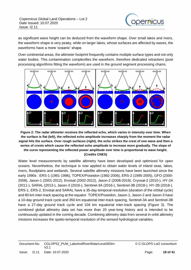
The magnitude and shape of the echoes (waveforms) also depend on the characteristics of the
reflecting surface (Figure 2). The range (satellite-surface distance) is proportional to the time the
radar pulse took to travel both ways from the satellite to the surface and is deduced from the position
of the leading edge (the rising slope of the waveform as seen in Figure 2). Other parameters such
Copernicus Global Land Operations – Lot 2 Date Issued: 10.07.2020 Issue: I2.11
Document-No. CGLOPS2_PUM_LakeAndRiverWaterLevel300m-V2.1
© C-GLOPS Lot2 consortium
Issue: I2.11 Date: 10.07.2020 Page: 18 of 41
as significant wave height can be deduced from the waveform shape. Over small lakes and rivers,
the waveform shape is very peaky, while on larger lakes, whose surfaces are affected by waves, the
waveforms have a more ‘oceanic’ shape.
Over continental areas, the altimeter footprint frequently contains multiple surface types and not only
water bodies. This contamination complexifies the waveform, therefore dedicated retrackers (post
processing algorithms fitting the waveform) are used in the ground segment processing chains.
Figure 2: The radar altimeter receives the reflected echo, which varies in intensity over time. When
the surface is flat (left), the reflected echo amplitude increases sharply from the moment the radar
signal hits the surface. Over rough surfaces (right), the echo strikes the crest of one wave and then a
series of crests which cause the reflected echo amplitude to increase more gradually. The slope of
the curve representing the reflected power amplitude over time is proportional to wave height.
(Credits CNES)
Water level measurements by satellite altimetry have been developed and optimized for open
oceans. Nevertheless, the technique is now applied to obtain water levels of inland seas, lakes,
rivers, floodplains and wetlands. Several satellite altimetry missions have been launched since the
early 1990s : ERS-1 (1991-1996), TOPEX/Poseidon (1992-2006), ERS-2 (1995-2005), GFO (2000-
2008), Jason-1 (2001-2012), Envisat (2002-2012), Jason-2 (2008-2019), Cryosat-2 (2010-), HY-2A
(2011-), SARAL (2013-), Jason-3 (2016-), Sentinel-3A (2016-), Sentinel-3B (2018-), HY-2B (2018-).
ERS-1, ERS-2, Envisat and SARAL have a 35-day temporal resolution (duration of the orbital cycle)
and 80 km inter-track spacing at the equator. TOPEX/Poseidon, Jason-1, Jason-2 and Jason-3 have
a 10-day ground track cycle and 350 km equatorial inter-track spacing, Sentinel-3A and Sentinel-3B
have a 27-day ground track cycle and 104 km equatorial inter-track spacing (Figure 3). The
combined global altimetry data set has more than 20 year-long history and is intended to be
continuously updated in the coming decade. Combining altimetry data from several in-orbit altimetry
missions increases the spatio-temporal resolution of the sensed hydrological variables.

Copernicus Global Land Operations – Lot 2 Date Issued: 10.07.2020 Issue: I2.11
Document-No. CGLOPS2_PUM_LakeAndRiverWaterLevel300m-V2.1
© C-GLOPS Lot2 consortium
Issue: I2.11 Date: 10.07.2020 Page: 19 of 41
Figure 3: Jason-3 (red), Sentinel-3A (blue) and Sentinel-3B (green) passes over the Amazon. The
satellites overfly each pass once every cycle (every 10 days for Jason-3, 27 days for S3A&B). Note
that in between those passes, no measurements are made by these satellites.
3.2.1.2 Vocabulary
‘Orbit’ is one revolution around the Earth by the satellite.
A satellite ‘Pass’ is half a revolution of the Earth by the satellite from one extreme latitude to the
opposite extreme latitude.
‘Repeat Cycle’ is the time period that elapses until the satellite flies over the same location again.
‘Range’ is the satellite-to-surface pseudo distance given from the 2 ways travel time of the radar
pulse from the satellite to the reflecting water body
‘Retracking’ is the algorithm which computes the altimetric parameters (range, backscatter
coefficient...) from the radar echoes
‘Altitude’ is considered as the height over the reference ellipsoid
‘Mean Profile’ is an average over several years of the surface heights with respect to geoid,
computed following the satellite’s repetitive tracks.
3.2.1.3 Computing surface height
For all satellites, the following operation is done:
‘Surface Height = Altitude – Corrected_range’

Copernicus Global Land Operations – Lot 2 Date Issued: 10.07.2020 Issue: I2.11
Document-No. CGLOPS2_PUM_LakeAndRiverWaterLevel300m-V2.1
© C-GLOPS Lot2 consortium
Issue: I2.11 Date: 10.07.2020 Page: 20 of 41
With:
Corrected_range = Range + Wet_tropo + Dry_ tropo + Iono + Polar tide + Solid Earth Tide “Wet_tropo” is a correction to account for the delay of the radar signal due to cloud liquid water and water vapour in the atmosphere “Dry_tropo” is a correction to account for the delay of the radar signal due to the dry gas component of the atmosphere. “Iono” is a correction to account for the delay of the radar signal due the electron content of the ionosphere. “Polar Tide” and “Solid Earth Tide” are two corrections that account for the temporal deformation of the Earth’s surface. All these corrections are provided within the input data (L2 products).
Finally, the water surface height is expressed with respect to the geoid:
‘Water Surface Height = Surface Height – geoid’
The geoid value considered here is extracted from a mean profile file over large lakes or is computed
from a geoid model in the case of rivers.
3.2.2 Processing
3.2.2.1 Lake Water Level products
Altimetry missions used are repetitive, i.e. the satellite overflies the same point at a given time interval
(10 days for the Jason satellites, 27 days for the Sentinel-3 satellites). The satellite usually does not
deviate from more than +/- 1 km across its track.
A given lake can be over flown by several satellites, with potentially several ground tracks, depending
on its surface area. In this case, each valid transect (lake crossing) is used to compute the water
level time series, hence time series over lakes contain more than a point per satellite cycle.
94 lakes are operationally monitored. 33 lakes are updated with Jason-3 data, 9 with Sentinel-3 data
and 52 with both Jason-3 and Sentinel-3 data. Several passes can be used to derive the lakes’ WSH
timeseries according to their surface areas. The term “lakes” refers to lakes or reservoirs.
3.2.2.1.1 Input data
The lake level measurements in the time series for periods prior to Jason-3 and S3A&B are based
on merged TOPEX/Poseidon, Jason-1, Jason-2, Envisat, SARAL/AltiKa, IceSat and GFO data
provided by ESA, NASA and CNES data centers. Operational updates include Jason-3 and Sentinel-

Copernicus Global Land Operations – Lot 2 Date Issued: 10.07.2020 Issue: I2.11
Document-No. CGLOPS2_PUM_LakeAndRiverWaterLevel300m-V2.1
© C-GLOPS Lot2 consortium
Issue: I2.11 Date: 10.07.2020 Page: 21 of 41
3A&B respectively provided by CNES data center and Copernicus Scientific Hub. The chain requires
the following input data:
• Altimetry data consist in Short Time Critical (STC) and Non Time Critical (NTC) data, they are respectively available about 2/3 days and 1 month after measurements acquisition. We advise the user that NTC and STC nomenclature are used for S3 data (since these data are provided by ESA/Eumetsat), these denominations correspond respectively to GDR and IGDR for Jason3 (data provided by CNES, hence CNES nomenclature is used). These 2 types of files both include the altimetric measurements as well as the necessary corrections for their exploitation (orbit, atmospheric corrections…). NTC/GDR data were used for time series initialization, but STC/IGDR data are now used for operational processing since the purpose of the Copernicus service is to provide operational water level estimates within 3 days after data acquisition. The main differences between GDR and IGDR data reside in the orbit and radiometer derived values (GDR benefit from more precise orbit values as well as more recent radiometer calibrations). Differences between these corrections are of the order of a few cm.
• Mean along-track profile over the lakes
• Location information, including missions and track number for all the processed lakes
3.2.2.1.2 Method
Agencies provide altimeter L2 products in 20Hz and 1Hz formats (number of provided measurements
per second, the 1Hz files being created by averaging over the 20Hz measurements). The altimeter
range measurements used for lakes consist of 1 Hz IGDR and GDR data for the largest lakes
(Argentino, Caspian, Kara Bogaz Gol, Kariba, Lagoa do Patos, Malawi, Michigan, Nicaragua,
Ontario, Rukwa, Superior, Tana, Tanganika, Tharthar, Vanerm, Victoria and Zeyskoye) and 20 Hz
data for smaller ones. All classical corrections (orbit, ionospheric and tropospheric corrections, polar
and solid Earth tides) are applied. Depending on the size of the lake, the satellite data may be
averaged over very long distances. It is thus necessary to correct for the slope of the geoid (or
equivalently, the mean lake level). Because the reference geoid provided with the altimetry
measurements (e.g., EGM96 for T/P data or EGM2008 for Sentinel-3A&B) may not be accurate
enough, we have computed a mean lake level, averaging over time the altimetry measurements
themselves. Such mean lake level surface along each satellite track across the lake provides a better
estimate of the model geoid. Mean profiles are therefore used for lake water level computations
which are then referenced with respect to this estimate of the geoid. If different satellites cover the
same lake, the lake level is computed in a 3-step process. Each satellite data are processed
independently. Potential radar instrument biases between different satellites are removed using T/P
data as reference (see ATBD).
3.2.2.1.2.1 First step: extraction of input data
• Input data (either IGDR or GDR) are read,
• using lake files (names, pass numbers, satellite names, bias to apply, retracking model used, pass segments over the lakes) the data over each given lake are extracted.

Copernicus Global Land Operations – Lot 2 Date Issued: 10.07.2020 Issue: I2.11
Document-No. CGLOPS2_PUM_LakeAndRiverWaterLevel300m-V2.1
© C-GLOPS Lot2 consortium
Issue: I2.11 Date: 10.07.2020 Page: 22 of 41
For Jason-3 and Sentinel-3, (I)GDR provides high-resolution (20Hz) data for the altimetric range and
altitude as well as 1-Hz averaged data. The corrections are provided at 1Hz, which is sufficient. For
the biggest lakes, the data used are preferably the 1-Hz data with the range derived from ocean
retracking. This retracking method is suited to fit the Brownian waveform shape induced by waves
over lakes of several kilometers, as for the oceans. As for the small lakes, the high-resolution data
and the Ice1 retracking are used. On small water targets the wind effect is much lower and doesn’t
create significant waves, hence the waveform is peakier and better fitted by the so called Ice1
retracker.
An editing is then applied to remove erroneous measurements. It consists in using thresholds on the
values of the backscattering coefficient and altimetric corrections as well as validity flags provided in
the L2 input products.
3.2.2.1.2.2 Second step: lake level computation and filtering
Once the relevant data are extracted and edited, mean profiles over the given passes are selected,
to compute the surface height (see section 3.2.1.3). The mean profile is subtracted from the surface
height computed in step 1.
Standard deviation and median values are computed. If a value is over 1.5 times the median, it is
removed. Standard deviation and median values are re-computed, and measurements are removed
when over twice the standard deviation. Four such iterations are done to remove abnormal points
(“outliers”).
3.2.2.1.2.3 Third step: output data
The final operation is the formatting of the data in GEOjson format.
3.2.2.2 River products
Radar echoes over land surfaces are hampered by interfering reflections due to water, vegetation
and topography. Consequently, waveforms (e.g., the power distribution of the radar echo within the
range window) may not have the simple broad peaked shape seen over ocean surfaces, but can be
complex, multi-peaked, preventing from precise determination of the altimetric height. Even when
topography is smooth, problems may arise from the retracking of complex waveforms, that present
several peaks due to the presence of vegetation canopy, water from wetlands, floodplains, tributaries
that are situated around the main river. In other cases, elevated topography sometimes prevents the
altimeter to lock on the water surface, leading to a lower number of valid data than over smoother
areas. The time series available in Copernicus Global Land are constructed over targets that were
selected as good reflectors of the radar signal, meaning that they are not covered by vegetation and
present a minimum width of the order of 300m. The series are based on Jason-3 and Sentinel-3A&B
I-GDRs. The basic data used for rivers are the 20 Hz data (“high rate” data).

Copernicus Global Land Operations – Lot 2 Date Issued: 10.07.2020 Issue: I2.11
Document-No. CGLOPS2_PUM_LakeAndRiverWaterLevel300m-V2.1
© C-GLOPS Lot2 consortium
Issue: I2.11 Date: 10.07.2020 Page: 23 of 41
Virtual stations correspond to the intersection of the satellite theoretical ground track with the river
(see Figure 4). Virtual stations are defined to provide river water level time series. Virtual stations
are monomission, their position is fixed and their timeseries will contain one data point per satellite
cycle. To select the measurements associated to a station, a rectangular “window” (hereafter
polygon file) is used to account for all available along track high rate altimetry data over the river
area over the pass of the satellite for each cycle. The coordinate of the virtual station is defined as
the intersection of the satellite theoretical ground track and rivers centerlines. After rigorous data
editing, all valid high rate data over a transect of a given cycle are averaged. The average therefore
concerns data separated by less than a second and acquired by a single instrument. At least two
high rate data are needed for averaging otherwise no mean height is provided. Scattering of high
rate data with respect to the mean height defines the uncertainty associated with that mean height.
Figure 4 : Concept of definition of a virtual station (Sentinel-3A over the Loire river). Each point
represents a 20Hz measurement. The measurements that are aligned belong to one satellite pass
over the river, those points are separated by 0.05 seconds. The different ‘lines’ are associated to the
pass of the satellite at different cycles. Each pass is separated by 27 days. The track slightly shifts
from one pass to another (satellite control ensures this across track drift remains smaller than 1km).
The water level time series is operationally updated less than 1.5 working days after the availability
of the input altimetry data, for some virtual stations on rivers.

Copernicus Global Land Operations – Lot 2 Date Issued: 10.07.2020 Issue: I2.11
Document-No. CGLOPS2_PUM_LakeAndRiverWaterLevel300m-V2.1
© C-GLOPS Lot2 consortium
Issue: I2.11 Date: 10.07.2020 Page: 24 of 41
3.2.2.2.1 Input data
Past river levels are based on TOPEX/Poseidon, Jason-2, Envisat and SARAL/AltiKa data provided
by ESA, NASA and CNES data centers. Operational updates include Jason-3, Sentinel-3A and
Sentinel-3B data provided by CNES and ESA data centres.
• Altimetry GDR and IGDR data (IGDR for short-time critical processing), with the included corrections.
• A file with the track number to process for each virtual station.
3.2.2.2.2 Method
3.2.2.2.2.1 First step: extraction and editing of input data
• Input data (either IGDR or GDR) are read,
• using virtual station polygon files, the necessary data (date, location, reference surface, corrections) over each given virtual station are extracted.
• An editing is then applied to remove erroneous measurements. It consists in using thresholds on the values of the backscattering coefficient and altimetric corrections as well as validity flags provided in the L2 input products. This editing depends on the mission.
For all missions, high-rate (10, 20 and 40Hz depending on the mission) range and altitude data are
used. The altimetric corrections used to compute the water surface height with those high-resolution
data are the 1-Hz averaged ones (because not all corrections are provided at high rate), interpolated
at the dates of the high rate data. Only the repetitive orbits are used so that the station is over flown
at regular intervals by the altimeter, hence the data acquired during the drifting phases are not used.
3.2.2.2.2.2 Second step: data selection
The polygon file for each virtual station is used for data selection: an algorithm is then applied to
decide if a measurement is (or is not) within the polygon.
3.2.2.2.2.3 Third step: validation and output data
The third and final step is to compute the mean, validate and produce the output data.
The mean water level processing includes
• outlier rejection. An estimation of the mean as well as standard deviation of the water surface height time series are provided for each station in a parameter file. High-rate measurements (20Hz for Jason-3 and Sentinel-3A&B) with values outside mean +/- 3 sigma are identified as outliers. A sigma0 (backscatter coefficient) based criteria is also implemented in order to only consider data points associated with water.
• Climatology filtering: This is based on rejecting the high-rate water surface height estimates with values outside of a climatological corridor computed from the existing points of the timeseries (Figure 5, middle panel), see ATBD for details.
• The mean of the accepted high-rate measurements is computed over the transect to provide one value of water surface height. This value is the one provided in the time series. The

Copernicus Global Land Operations – Lot 2 Date Issued: 10.07.2020 Issue: I2.11
Document-No. CGLOPS2_PUM_LakeAndRiverWaterLevel300m-V2.1
© C-GLOPS Lot2 consortium
Issue: I2.11 Date: 10.07.2020 Page: 25 of 41
associated standard deviation of the HR points at each time step is also computed and provided: it is an estimate of the uncertainty (with limitations when few high-rate measurements are available, in other words when the river is narrow).
• WGS84 ellipsoid correction: all altimetry satellites orbits are not referenced with respect to the same ellipsoid (e.g. Jason missions are referenced with respect to TOPEX/Poseidon ellipsoid while Envisat, SARAL and Sentinel-3 orbits are referenced to WGS84). This step is meant to use the WGS84 ellipsoid as reference for all virtual stations water level timeseries.
Figure 5 : Yearly filtering from Bercher 2008. Top panel: raw high rate (HR) measurements. Middle
panel: application of the selection climatological corridor (details in ATBD). Bottom panel: accepted
HR measurements from which the mean value is computed at each time step.
3.3 LIMITATIONS OF THE PRODUCT
The lake and river processing chains, initially developed at LEGOS, are based on the use of altimetry
measurements from the CTOH database (Centre for Topography studies of the Ocean and
Hydrosphere, LEGOS), including for Envisat GDRs. This CTOH expert database includes in addition
some enhanced corrections that are not present in the operational L2 data sets provided by

Copernicus Global Land Operations – Lot 2 Date Issued: 10.07.2020 Issue: I2.11
Document-No. CGLOPS2_PUM_LakeAndRiverWaterLevel300m-V2.1
© C-GLOPS Lot2 consortium
Issue: I2.11 Date: 10.07.2020 Page: 26 of 41
institutional suppliers (AVISO, ESA), such as for the wet and dry tropospheric as well as for the
ionospheric corrections. As the operational version of HydroWeb/HYSOPE, that serves Copernicus
Global Land, is using the operational L2 input data from the agencies, the altimetric corrections used
by default in the processing chain are the model values included in the operational input L2 products.
On the other hand, a module for calculating the height of the geoid has been developed in the
operational chain, starting from a grid provided by the LEGOS.
3.4 DIFFERENCES WITH THE PREVIOUS VERSION
3.5 V2 TO V2.1
The evolution from v2.0 to v2.1 consisted in integrating the Sentinel-3B mission in operational mode.
Stations associated with this mission and also with the already used Sentinel-3A and Jason-3
mission were defined at positions between those and the satellites theoretical ground tracks. Only
the high quality timeseries were selected for operations. This results in the addition of more than
8000 Virtual Stations, increasing the total number of operated VS to more than 10000. 30 new lakes
are also included in this release.
3.6 V1 TO V2
V2 includes the Sentinel-3A mission in operational mode whereas V1 only included Jason-3. The
number of Jason-3 stations was also increased. Refined centrelines were computed, and new
stations defined at positions between those and the satellites theoretical ground tracks. This results
in the addition of more than 1000 Virtual Stations and the increase of lakes time resolution. No
additional lakes have been implemented yet, waiting for feedback on the product quality and stability.

Copernicus Global Land Operations – Lot 2 Date Issued: 10.07.2020 Issue: I2.11
Document-No. CGLOPS2_PUM_LakeAndRiverWaterLevel300m-V2.1
© C-GLOPS Lot2 consortium
Issue: I2.11 Date: 10.07.2020 Page: 27 of 41
4 PRODUCT DESCRIPTION
4.1 FILE NAMING
4.1.1 Lake products
Files are named:
c_gls_WL_<date>_<lakename>_ALTI_v<x.x.x>.json
Where
<lakename> is the name of the lake, <date> the date in format yyyymmddhhmm of the last
measurement in the timeseries and <x.x.x> references the version of the product.
4.1.2 River products
Virtual stations file names have evolved since v2.1. They are named:
c_gls_WL_<date>_<ID>_ALTI_v<x.x.x>.json
Where:
<date> is the date of the last measurement in the timeseries in format yyyymmddhhmm
<ID> is the virtual station identifier. It consists in a 13 digits integer.
<x.x.x> is the product version number. The first digit refers to major version of the products.
The second digit refers to minor version changes. The third one is implemented in case of
reprocessings.
The “_” delimiters remain the same as in previous versions. Only the ID identifier has evolved.
Prior to v2.1 the identifier consisted of sub expressions as follows: ID=basinshortname-
rivershortname-missionshortname-track-numberontrack
<basinshortname> was a three-character code name for the hydrological basin (from the
name in English, using Global Runoff Data Center database as a reference)
<rivershortname> was a three character code name for the river (it can be identical to the
basin code name) ; local names are preferred wherever possible (a choice might be done if
the river is shared by several different countries)
<missionshortname> was the short name of the satellite mission (3 characters), among:
Code mission full name
JA3 Jason-3
S3A Sentinel-3A

Copernicus Global Land Operations – Lot 2 Date Issued: 10.07.2020 Issue: I2.11
Document-No. CGLOPS2_PUM_LakeAndRiverWaterLevel300m-V2.1
© C-GLOPS Lot2 consortium
Issue: I2.11 Date: 10.07.2020 Page: 28 of 41
<track>: was the track (half orbit) number; depends on the mission
<numberontrack>: was the number of the virtual station along the given track, on 2 digits. It
is useful when a river is intersected by the same satellite track at several different positions.
This previous naming relied on the accuracy of metadata, in particular river names, whose
orthograph can vary among the different languages, or could even be affected in the case that the
river’s name in the metadata had to be corrected. The new nomenclature with a unique and lifetime
fixed numerical identifier solves this issue.
4.2 FILE FORMAT
The actual format is GeoJSON.
4.3 PRODUCT CONTENT
Files include:
• A tag properties containing the metadata of the product
• A tag geometry containing the location of the measurements
• A tag data containing the data object (see 4.3.1.1.3) for each requested measured date
4.3.1 Data File
4.3.1.1 Lake products
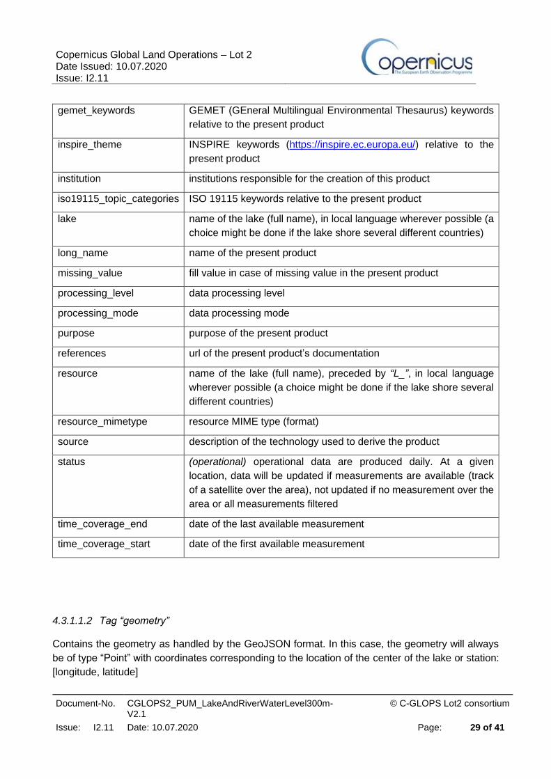
4.3.1.1.1 Tag “properties” with descriptive metadata
This tag contains all the descriptive metadata including:
archive_facility institution responsible for product archive
Basin hydrological basin or catchment name (full name), in English
comment specific additional characteristics of the basin, lake, and product
contacts helpdesk, accountable and owner contacts
copyright copernicus copyright
country names (full name) of the countries where the lake is located (several
names possible, separated by &)
Credit credit for present product
gcmd_keywords NASA GCMD keywords relative to the present product
Copernicus Global Land Operations – Lot 2 Date Issued: 10.07.2020 Issue: I2.11
Document-No. CGLOPS2_PUM_LakeAndRiverWaterLevel300m-V2.1
© C-GLOPS Lot2 consortium
Issue: I2.11 Date: 10.07.2020 Page: 29 of 41
gemet_keywords GEMET (GEneral Multilingual Environmental Thesaurus) keywords
relative to the present product
inspire_theme INSPIRE keywords (https://inspire.ec.europa.eu/) relative to the
present product
institution institutions responsible for the creation of this product
iso19115_topic_categories ISO 19115 keywords relative to the present product
lake name of the lake (full name), in local language wherever possible (a
choice might be done if the lake shore several different countries)
long_name name of the present product
missing_value fill value in case of missing value in the present product
processing_level data processing level
processing_mode data processing mode
purpose purpose of the present product
references url of the present product’s documentation
resource name of the lake (full name), preceded by “L_”, in local language
wherever possible (a choice might be done if the lake shore several
different countries)
resource_mimetype resource MIME type (format)
source description of the technology used to derive the product
status (operational) operational data are produced daily. At a given
location, data will be updated if measurements are available (track
of a satellite over the area), not updated if no measurement over the
area or all measurements filtered
time_coverage_end date of the last available measurement
time_coverage_start date of the first available measurement
4.3.1.1.2 Tag “geometry”
Contains the geometry as handled by the GeoJSON format. In this case, the geometry will always
be of type “Point” with coordinates corresponding to the location of the center of the lake or station:
[longitude, latitude]

Copernicus Global Land Operations – Lot 2 Date Issued: 10.07.2020 Issue: I2.11
Document-No. CGLOPS2_PUM_LakeAndRiverWaterLevel300m-V2.1
© C-GLOPS Lot2 consortium
Issue: I2.11 Date: 10.07.2020 Page: 30 of 41
4.3.1.1.3 Data
The data is provided as objects for each time step. The object contains 5 tags:
Datetime Measure date in yyyy/mm/dd hh:mm format
Identifier Identifier of the lake
Time measure date in decimal year
water_surface_height_above_reference_datum water Surface height above surface of reference in meters
water_surface_height_uncertainty standard deviation from height of high frequency measurements used in the estimation
4.3.1.2 River products
4.3.1.2.1 Tag “properties” with descriptive metadata
This tag contains all the descriptive metadata including:
archive_facility institution responsible for product archive
Basin hydrological basin or catchment name (full name), in
English
Comment specific additional characteristics of the basin, river,
and product
Contacts helpdesk, accountable and owner contacts
Copyright copernicus copyright
Country names (full name) of the countries where the river is
located (several names possible, separated by &)
Credit credit for present product
gcmd_keywords NASA GCMD keywords relative to the present
product
gemet_keywords GEMET (GEneral Multilingual Environmental
Thesaurus) keywords relative to the present product

Copernicus Global Land Operations – Lot 2 Date Issued: 10.07.2020 Issue: I2.11
Document-No. CGLOPS2_PUM_LakeAndRiverWaterLevel300m-V2.1
© C-GLOPS Lot2 consortium
Issue: I2.11 Date: 10.07.2020 Page: 31 of 41
inspire_theme INSPIRE keywords (https://inspire.ec.europa.eu/)
relative to the present product
institution institutions responsible for the creation of this product
iso19115_topic_categories ISO 19115 keywords relative to the present product
Lake Name of the lake
long_name name of the present product
missing_value fill value in case of missing value in the present
product
Platform name of the altimetry satellite platform used in the
present product
processing_level data processing level
processing_mode data processing mode
Purpose purpose of the present product
references url of the present product’s documentation
Resource name of the river (full name), preceded by “R_”, in
local language wherever possible (a choice might be
done if the river shore several different countries)
resource_mimetype resource MIME type (format)
River name of the river (full name), in local language
wherever possible (a choice might be done if the river
crosses several different countries)
satellite_pass_number number of the altimetry satellite pass over the virtual
station
Source description of the technology used to derive the
product, “Derived from satellite altimetry”
Status (operational) operational data are produced daily. At a
given location, data will be updated if measurements
are available (track of a satellite over the area), not
updated if there are no measurements over the area
or all measurements are filtered
time_coverage_end date of the last available measurement
time_coverage_start date of the first available measurement

Copernicus Global Land Operations – Lot 2 Date Issued: 10.07.2020 Issue: I2.11
Document-No. CGLOPS2_PUM_LakeAndRiverWaterLevel300m-V2.1
© C-GLOPS Lot2 consortium
Issue: I2.11 Date: 10.07.2020 Page: 32 of 41
water_surface_reference_datum_altitude altitude of the water surface reference (geoid) model
in meter
water_surface_reference_name name of the water surface reference (geoid) model
4.3.1.2.2 Tag “geometry”
Contains the geometry as handled by the GeoJSON format. In this case, the geometry will always
be of type “Point” with coordinates corresponding to the location of the virtual station: [longitude,
latitude]
4.3.1.2.3 Data
The data is provided as objects for each time step. The object contains 7 tags:
datetime Measure date in yyyy/mm/dd hh:mm format
identifier Identifier of the virtual station
number_of_observations Number of high frequency measurements used for the computation of water_surface_height_above_reference_datum and water_surface_height_uncertainty
satellite_cycle_number number of the altimetry satellite cycle
time measure date in decimal year
water_surface_height_above_reference_datum
water surface height above surface of reference in meters
water_surface_height_uncertainty standard deviation from height of high frequency measurements used in the estimation
4.3.2 Quicklook
4.3.2.1 Lakes products
The two figures below illustrate the content of the data file for Lake Baïkal (Russia). Note that the
time series has been computed since late 1992, starting with TOPEX/Poseidon until to 2002, with
Jason-1 between 2002 and 2008, Jason-2 between 2008 and 2016, Jason-3 since October 2016
and both Jason-3 and Sentinel-3A since June 2016.

Copernicus Global Land Operations – Lot 2 Date Issued: 10.07.2020 Issue: I2.11
Document-No. CGLOPS2_PUM_LakeAndRiverWaterLevel300m-V2.1
© C-GLOPS Lot2 consortium
Issue: I2.11 Date: 10.07.2020 Page: 33 of 41
{
"type": "Feature",
"geometry": {
"type": "Point",
"coordinates": [
108.17,
53.58
]
},
"properties": {
"resource": "L_baikal",
"basin": "Yenisei",
"lake": "baikal",
"country": "Russia",
"institution": "LEGOS, CLS, CNES",
"source": "Derived from satellite altimetry",
"references": "http://land.copernicus.eu/global/products/wl",
"archive_facility": "CLS",
"time_coverage_start": "1992-09-27 20:09:00",
"time_coverage_end": "2019-10-27 03:35:00",
"updated": "2019-10-29T00:37:02Z",
"long_name": "Lake and River Water Level",
"processing_level": "LEVEL3B",
"processing_mode": "Near Real Time",
"status": "operational",
"copyright": "Copernicus Service Information 2017",
"comment": "#\n# Length: 600 km\n# width: 70 km\n# maximum of depth: 1741 m\n#
Mean area: 31500 km2\n# Catchment area: 560000 km2\n# Mean volume: 23000 km3\n#\n#
Water height from satellite altimetry:\n# topex / poseidon track number: 62 138 214 36
79\n# jason track number: 62 138 214 36 79\n# jason2 track
number: 62 138 214 36 79\n# jason3 track number: 62 138 214 36 79\n#
sentinel3A track number: 8 77 122 191 305 419 436 533 550 619 647 664 733\n#\n#
corrections applied: Solid Earth tide, pole tide, ionospheric delay\n# wet and dry
tropospheric delay, altimeter biaises\n#\n# surface of reference: GGMO2C; high resolution
global gravity model\n# developped to degree and order 200 at CSR\n# Center for Space
research, university of Texas, austin, USA\n# ref: Tapley B, Ries J, Bettatpur S, et al.,
(2005),\n# GGM02 - an improved Earth Gravity field from GRACE, J.geod. 79: 467-478\n#\n#
first date 1992 09 27 yr month day 20 hours 09 minutes\n# last date 2019 10 27 yr month
day 03 hours 35 minutes\n#\n# Data Description\n# time = Decimal year\n#
water_surface_height_above_reference_datum = height above surface of reference in
meters\n# water_surface_height_uncertainty = standard deviation from height in
meters\n#\n# The water level, surface and volume algorithm developed at Legos, Toulouse,
France\n#\n# citation: Cretaux J-F., Jelinski W., Calmant S., et al., 2011.\n# SOLS: A
lake database to monitor in the Near Real Time water level\n# and storage variations from
remote sensing data, Advances in space Research, 47, 1497-1507\n#\n# Timeseries specified
by LEGOS and computed by CLS on behalf of CNES and Copernicus Global Land\n#\n",
"contacts": "Helpdesk: http://land.copernicus.eu/global/contactpage \n
Accountable contact: European Commission DG Joint Research Centre
[email protected] \n Owner contact: European Commission DG Internal
Market, Industry, Entrepreneurship and SMEs [email protected]",
"inspire_theme": "Hydrography",
"gemet_keywords": "water level, water management, hydrometry, hydrology, climate,
seasonal variation, environmental data, environmental monitoring, monitoring, remote
sensing",
"gcmd_keywords": "TERRESTRIAL HYDROSPHERE, SURFACE WATER",
"iso19115_topic_categories": "elevation,inlandWaters",
"credit": "Lake and River Water Level products are generated by the Global Land
Service of Copernicus, the Earth Observation Programme of the European Commission and the
Theia-land program supported by CNES. The research leading to the current version of the
product has received funding from CNES, LEGOS, IRD and CLS.",
Copernicus Global Land Operations – Lot 2 Date Issued: 10.07.2020 Issue: I2.11
Document-No. CGLOPS2_PUM_LakeAndRiverWaterLevel300m-V2.1
© C-GLOPS Lot2 consortium
Issue: I2.11 Date: 10.07.2020 Page: 34 of 41
"purpose": "This product is first designed to fit the requirements of the Global
Land component of Land Service of Copernicus. It can be also useful for all applications
related to the environment monitoring, climate research and hydrology.",
"resource_mimetype": "application/json",
"missing_value": 9999.999
},
"data": [
{
"identifier": "L_baikal",
"time": 1992.73999886,
"datetime": "1992/09/27 20:09",
"water_surface_height_above_reference_datum": 455.82,
"water_surface_height_uncertainty": 0.13
},
{
"identifier": "L_baikal",
"time": 1992.78999886,
"datetime": "1992/10/16 03:21",
"water_surface_height_above_reference_datum": 455.77,
"water_surface_height_uncertainty": 0.1
},
[...]
]
}
Figure 6: Reproduction of the first lines of the water level product for Lake Baïkal (Russia) in GeoJSON
format
Figure 7: Plot of the water level time series (blue) and associated uncertainties (red) for Lake Baïkal
(Russia).
4.3.2.2 River products

Copernicus Global Land Operations – Lot 2 Date Issued: 10.07.2020 Issue: I2.11
Document-No. CGLOPS2_PUM_LakeAndRiverWaterLevel300m-V2.1
© C-GLOPS Lot2 consortium
Issue: I2.11 Date: 10.07.2020 Page: 35 of 41
The two figures below show an example of the content of a data file on a Virtual Station on the
Danube river along with its graphical representation.
{
"type": "Feature",
"geometry": {
"type": "Point",
"coordinates": [
20.629982,
44.792598
]
},
"properties": {
"resource": "0000000004517",
"basin": "Danube",
"river": "Danube",
"country": "Serbia",
"satellite_pass_number": "27",
"institution": "LEGOS, CLS, CNES",
"source": "Derived from satellite altimetry",
"references": "http://land.copernicus.eu/global/products/wl",
"archive_facility": "CLS",
"time_coverage_start": "2016-06-29 20:02:00",
"time_coverage_end": "2019-10-27 20:03:00",
"updated": "2019-10-29T00:37:41Z",
"platform": "SENTINEL3A",
"long_name": "Lake and River Water Level",
"processing_level": "LEVEL3B",
"processing_mode": "Near Real Time",
"status": "operational",
"copyright": "Copernicus Service Information 2017",
"comment": "#\n# Timeseries specified by LEGOS and computed by CLS on behalf of
CNES and Copernicus Global Land\n# water height from satellite altimetry : s3a Track
0027\n# Applied corrections : solid earth tide, pole tide, ionospheric delay\n#
wet and dry tropospheric delay\n# The heights are computed above a geoid given in the
header (ref, ref_value (m))\n# The bias between the altimetry missions (using OCOG
retracking) and the WGS84 ellipsoid are indicative:\n# ENVISAT : 1.04 m\n# JASON-2 :
0.563 m\n# SARAL : 0.25 m\n# Distance to the sea : tbd\n# Appliedbias for Jason2 : -0.0
m\n# Data Description\n# time = Decimal year\n#
water_surface_height_above_reference_datum = height above surface of reference in
meters\n# water_surface_height_uncertainty = standard deviation from height in meters\n#
number_of_observations = number of high frequency measurements to compute the height\n#
satellite_cycle_number = satellite cycle number\n#\n# undef values=999.999\n#\n",
"contacts": "Helpdesk: http://land.copernicus.eu/global/contactpage \n
Accountable contact: European Commission DG Joint Research Centre
[email protected] \n Owner contact: European Commission DG Internal
Market, Industry, Entrepreneurship and SMEs [email protected]",
"inspire_theme": "Hydrography",
"gemet_keywords": "water level, water management, hydrometry, hydrology, climate,
seasonal variation, environmental data, environmental monitoring, monitoring, remote
sensing",
"gcmd_keywords": "TERRESTRIAL HYDROSPHERE, SURFACE WATER",
"iso19115_topic_categories": "elevation,inlandWaters",
"credit": "Lake and River Water Level products are generated by the Global Land
Service of Copernicus, the Earth Observation Programme of the European Commission and the
Theia-land program supported by CNES. The research leading to the current version of the
product has received funding from CNES, LEGOS, IRD and CLS.",
"purpose": "This product is first designed to fit the requirements of the Global
Land component of Land Service of Copernicus. It can be also useful for all applications
related to the environment monitoring, climate research and hydrology.",
"resource_mimetype": "application/json",

Copernicus Global Land Operations – Lot 2 Date Issued: 10.07.2020 Issue: I2.11
Document-No. CGLOPS2_PUM_LakeAndRiverWaterLevel300m-V2.1
© C-GLOPS Lot2 consortium
Issue: I2.11 Date: 10.07.2020 Page: 36 of 41
"water_surface_reference_name": "EGM2008",
"water_surface_reference_datum_altitude": 44.2622,
"missing_value": 9999.999
},
"data": [
{
"identifier": "0000000004517",
"time": 2016.49408394,
"datetime": "2016/06/29 20:02",
"water_surface_height_above_reference_datum": 70.4953,
"water_surface_height_uncertainty": 0.1022,
"number_of_observations": 3,
"satellite_cycle_number": 6
},
{
"identifier": "0000000004517",
"time": 2016.64162492,
"datetime": "2016/08/22 20:02",
"water_surface_height_above_reference_datum": 69.8728,
"water_surface_height_uncertainty": 0.1052,
"number_of_observations": 2,
"satellite_cycle_number": 8
},
[...]
]
}
Figure 8: Reproduction of the first lines of the water level product for one given Virtual Station over
the Nile river, with header and part of the data lines.
Figure 9: Plot of the water level time series corresponding to the data file presented in the previous
figure.

Copernicus Global Land Operations – Lot 2 Date Issued: 10.07.2020 Issue: I2.11
Document-No. CGLOPS2_PUM_LakeAndRiverWaterLevel300m-V2.1
© C-GLOPS Lot2 consortium
Issue: I2.11 Date: 10.07.2020 Page: 37 of 41
4.4 PRODUCT CHARACTERISTICS
4.4.1 Projection and Grid Information
Longitude and Latitude values are expressed with respect to the WGS84 ellipsoid.
Water level values are geoidal heights expressed with respect to EGM2008 model, unless stated
different in the header of the product.
4.4.2 Spatial Information
As described above, the water level heights can only be measured right below the satellite’s orbital
ground tracks (nadir), if favorable measurement conditions are encountered (good reflected radar
signal, low contamination from other echogenic sources, see §3.2.2.2 River products). It is
unfortunately not always possible to retrieve valuable measurements at each crossing between
hydrographic networks and satellites ground tracks.
In addition, given the inclination of the orbit of some altimetry missions, such as Jason-3 that is
limited to +/- 66° in latitude, some targets in the Arctic region are not overflown.
The ground track coverage of all altimetry missions can be found on AVISO website:
http://www.aviso.altimetry.fr/en/data/tools/pass-locator.html.
As an example, the offset between 2 ground tracks at the Equator is 315 km for Jason-3 tracks (10-
days revisit time) , 80 km for Envisat/Saral (35-days revisit time) and 104 km for Sentinel-3 (27-days
revisit time).
4.4.3 Temporal Information
For Virtual Stations, the revisit time corresponds to the duration of the orbital cycle of the considered
satellite: 10 days for Jason-3, 27 days for Sentinel-3A and Sentinel-3B.
Lake level time series may be updated more frequently in case there are several orbital ground
tracks of a given satellite that cross the lake, or if several satellites fly over the lake.
Nominally, the water level time series, either lakes or rivers, are updated within 2 days after
acquisition of measurements by the operational satellite(s).

Copernicus Global Land Operations – Lot 2 Date Issued: 10.07.2020 Issue: I2.11
Document-No. CGLOPS2_PUM_LakeAndRiverWaterLevel300m-V2.1
© C-GLOPS Lot2 consortium
Issue: I2.11 Date: 10.07.2020 Page: 38 of 41
4.4.4 Data Policies
Any use of the RiverAndLakeWaterLevel product assumes the obligation to include in any publication or communication using these products the following citation: “The product was extracted from land service of Copernicus, the Earth Observation program of the European Commission. The research leading to the current version of the product has received funding from various European Commission Research and Technical Development programs. The product is based on THEIA HYDROWEB products specified by LEGOS and operated by CLS on behalf of CNES.” The user accepts to inform Copernicus about the outcome of the use of the above-mentioned
products and to send a copy of any publication that uses these products to the support contact below.
4.4.5 Contacts
More information and documentation about the product is available from the Copernicus Global Land
Service web site at https://land.copernicus.eu/global/products/wl
For support, the Help Desk service staff are the primary point of contact:
https://land.copernicus.eu/global/contact
Accountable contact:
European Commission, Directorate-General Joint Research Centre, Italy
Email address: [email protected]

Copernicus Global Land Operations – Lot 2 Date Issued: 10.07.2020 Issue: I2.11
Document-No. CGLOPS2_PUM_LakeAndRiverWaterLevel300m-V2.1
© C-GLOPS Lot2 consortium
Issue: I2.11 Date: 10.07.2020 Page: 39 of 41
5 VALIDATION
Based on the user requirements issued in Section 2, the quality of the products may be assessed
as overall satisfactory. More than 10000 virtual stations are already fully operational. As detailed in
the Quality Assessment Report document, the quantity and global quality of the products has
improved (more targets, smaller dispersion of the measurements) thanks to the integration of the
Sentinel-3A mission in the V2 and then Sentinel-3B in the V2.1 of the products, with respect to
previous V1 (deprecated, not available for diffusion anymore).
As detailed in the QAR, absolute validation metrics show that the measurements accuracy is of the
order of 10-15cm, depending on the hydrological basins. The mean percentage of provided
measurements in the timeseries relative to the number of satellite passes (completeness) per basin
is higher than 95%. Some stations over the Congo basin present a lower percentage of available
measurements since they were used as calibration areas for Jason-3. Correlations between stations
situated on a same river were also assessed. The correlations are very good (R²>0.8) over the
Amazon and African basins. Correlations are smaller over more anthropized basins. Relative
validation metrics with respect to a DEM or In Situ measurements (e.g. GRDC database) confirm
these results.
Lake time series quality is also assessed using both absolute (comparisons within the product) and
relative (comparison to other satellite and in situ products) validation metrics. Correlation coefficient
with both external altimetry datasets or In-Situ datasets are very high (>0.9 most of the time). The
RMS is of the order of 10-20 cm for most lakes. We nevertheless point out that absolute reference
can be questioned on some lakes either in the C-GLOPS or the comparison datasets.

Copernicus Global Land Operations – Lot 2 Date Issued: 10.07.2020 Issue: I2.11
Document-No. CGLOPS2_PUM_LakeAndRiverWaterLevel300m-V2.1
© C-GLOPS Lot2 consortium
Issue: I2.11 Date: 10.07.2020 Page: 40 of 41
6 REFERENCES
6.1 LAKES
SOLS: A Lake database to monitor in Near Real Time water level and storage variations from remote
sensing data, J. Adv. Space Res. Vol 47, 9, 1497-1507, doi:10.1016/j.asr.2011.01.004, 2011 Crétaux
J-F , W. Jelinski , S. Calmant , A. Kouraev , V. Vuglinski , M. Bergé Nguyen , M-C. Gennero, F. Nino,
R. Abarca Del Rio , A. Cazenave , P. Maisongrande
Lake studies from satellite altimetry, C R Geoscience, Vol 338, 14-15, 1098-1112, doi:
10.1016/J.cre.2006.08.002, 2006 Crétaux J-F and C. Birkett
A new Global Lakes Database for a remote sensing programme studying climatically sensitive lakes,
J. Great Lakes Res., 21 (3), 307-318. Birkett, C.M., Mason, I.M., 1995.
Lake volume monitoring from space. Surveys in Geophysics, 37(2), 269-305. Crétaux, J. F., Abarca-
del-Río, R., Berge-Nguyen, M., Arsen, A., Drolon, V., Clos, G., & Maisongrande, P., 2016.
6.2 RIVERS
Bercher 2008. PHD Thesis. Precision of satellite altimetry over rivers : development of a standard method to quantify the quality of hydrological altimetry products and their applications. Written in French EGM2008 Citation: The development and evaluation of the Earth Gravitational Model 2008
(EGM2008) - Nikolaos K. Pavlis, Simon A. Holmes, Steve C. Kenyon, John K. Factor; Journal of
Geophysical Research: Solid Earth (1978-2012) Volume 117, Issue B4, April 2012
Frappart F., Calmant S., Cauhopé M., Seyler F., Cazenave A. (2006). Preliminary results of
ENVISAT RA-2 derived water levels validation over the Amazon basin, Remote Sensing of
Environment, 100(2), 252-264, doi:10.1016/j.rse.2005.10.027.
Santos da Silva J., S. Calmant, O. Rotuono Filho, F. Seyler, G. Cochonneau, E. Roux, J. W.
Mansour, Water Levels in the Amazon basin derived from the ERS-2 and ENVISAT Radar Altimetry
Missions, Remote Sensing of the Environment, doi:10.1016/j.rse.2010.04.020, 2010
Citation for data on specific watersheds:
Congo Basin:
Becker, M., J. Santos da Silva, S. Calmant, V. Robinet, L. Linguet et F. Seyler, Water level
fluctuations in the Congo Basin Derived from ENVISAT satellite altimetry, Remote Sensing, 6,
doi:10.3390/rs60x000x, 2014

Copernicus Global Land Operations – Lot 2 Date Issued: 10.07.2020 Issue: I2.11
Document-No. CGLOPS2_PUM_LakeAndRiverWaterLevel300m-V2.1
© C-GLOPS Lot2 consortium
Issue: I2.11 Date: 10.07.2020 Page: 41 of 41
Gange basin
Pandrey, R. K., J-F Crétaux, M Bergé-Nguyen, V. Mani Tiwari, V. Drolon, F. Papa and S. Calmant,
Water level estimation by remote sensing for 2008 Flooding of the Kosi River, IJRS, 35:2, 424-440,
doi:10.1080/01431161.2013.870678, 2014
Papa, F., F. Frappart, Y. Malbeteau, M. Shamsudduha, V. Venugopal, M. Sekhar, G. Ramillien, C.
Prigent, P. Aires, R. K. Pandey, S. Bala, S. Calmant, Satellite-derived Surface and Sub-surface
Storage in the Ganges-Brahmaputra River Basin, Journal of Hydrology, regional studies,
doi:10,1016/j.ejrh,2015,03,004 2014.
Orinoco :
Frappart, F., F. Papa, Y. Malbeteau, J-G Leon, G. Ramillien, C. Prigent, L. Seoane, F. Seyler, S.
Calmant, Surface freshwater storage variations in the Orinoco floodplains using multi-satellite
observations, Remote Sensing, 7,89-110, doi:10,3390/rs70100089, 2015.
Other basins :
Santos da Silva, J., F. Seyler, S. Calmant, O. Correa Rotunno Filho, G. Cochonneau et W.J. Mansur,
Water level dynamics of Amazon wetlands at the watershed scale by satellite altimetry, Int. J. Of
Remote Sensing, 33:11, 3323-3353, doi 10.1080/01431161.2010.531914, 2012
Citation for empirical mean altimetric biases over rivers :
Calmant, S., J. Santos da Silva, D. Medeiros Moreira, F. Seyler, C.K. Shum, J-F. Crétaux, G.
Gabalda, Detection of Envisat RA2 / ICE-1 retracked Radar Altimetry Bias Over the Amazon Basin
Rivers using GPS, Advances in Space Research, doi: 10.1016/j.asr.2012.07.033, 2012.
Seyler, F., S. Calmant, J. Santos da Silva, D. Medeiros Moreira, F. Mercier, CK Shum, From
TOPEX/Poseidon to Jason-2/OSTM in the Amazon basin, Advances in Space Research, doi:
10.1016/j.asr.2012.11.002, 2012