copies of this publication are available from the ministry … · 2005-07-07 · michipicoten post...
TRANSCRIPT


Copies of this publication are available from the Ministry of Natural Resources offices at the following locations:
Ontario Parks Park Superintendent Northeast Zone Office Lake Superior Provincial Park 199 Larch St., Suite 404 P.O. Box 267 Sudbury, ON Wawa, ON P3E 5P9 P0S 1K0 Tel: (705) 564 3165 Tel: (705) 856 2284
Wawa District Office Sault Ste. Marie District Office Hwy 101, PO Box 1160 64 Church St. Wawa, ON Sault Ste. Marie, ON P0S 1K0 P6A 3H3 Tel: (705) 856 2396 Tel: (705) 949 1231
This publication is also available on-line at: www.ontarioparks.com
© 2004 Queen’s Printer of Ontario Printed in Ontario, Canada
Cover Photo: Michipicoten Island – North Shore Inset Photo: Michipicoten Post – Driftwood Beach
51905 (0.15 k P.R., 26 07 04) ISBN 0-7794-6544-X
Cette publication est également disponsible en français


ii
Michipicoten Post and Michipicoten Island Provincial Parks Management Planning ~ Background Information
Table of Contents
1.0 INTRODUCTION ....................................................................................................................11.1 Michipicoten Post.......................................................................................................................... 11.2 Michipicoten Island ....................................................................................................................... 11.3 Purpose of a Management Plan?................................................................................................. 1
2.0 REGIONAL CONTEXT ...........................................................................................................12.1 Michipicoten Post.......................................................................................................................... 12.2 Michipicoten Island ....................................................................................................................... 1
3.0 PLANNING AREA ..................................................................................................................13.1 Land Use and Tenure................................................................................................................... 1
3.1.1 Michipicoten Post ............................................................................................................ 13.1.2 Michipicoten Island .......................................................................................................... 3
3.2 Existing Park Development .......................................................................................................... 33.2.1 Michipicoten Post ............................................................................................................ 33.2.2 Michipicoten Island .......................................................................................................... 6
3.3 Access/Transportation Routes ..................................................................................................... 63.3.1 Michipicoten Post ............................................................................................................ 63.3.2 Michipicoten Island .......................................................................................................... 6
4.0 SOCIAL AND ECONOMIC CONTEXT...................................................................................6
5.0 INVENTORY AND EVALUATION OF NATURAL AND CULTURAL RESOURCES ............ 65.1 Climate.......................................................................................................................................... 6
5.1.1 Michipicoten Post ............................................................................................................ 75.1.2 Michipicoten Island .......................................................................................................... 7
5.2 Geology ........................................................................................................................................ 75.2.1 Bedrock geology.............................................................................................................. 7
5.2.1.1 Michipicoten Post ............................................................................................... 75.2.1.2 Michipicoten Island............................................................................................. 7
5.2.2 Geomorphology............................................................................................................... 95.2.2.1 Michipicoten Post ............................................................................................... 95.2.2.2 Michipicoten Island............................................................................................. 9
5.2.3 Economic Geology ........................................................................................................ 105.2.3.1 Michipicoten Post ............................................................................................. 105.2.3.2 Michipicoten Island........................................................................................... 10
5.3 Life Science Features................................................................................................................. 105.3.1 Flora .............................................................................................................................. 10
5.3.1.1 Michipicoten Post ............................................................................................. 105.3.1.2 Michipicoten Island........................................................................................... 10
5.3.2 Fauna ............................................................................................................................ 125.3.2.1 Michipicoten Post ............................................................................................. 125.3.2.2 Michipicoten Island........................................................................................... 15
5.3.3 Aquatic Resources ........................................................................................................ 155.3.3.1 Michipicoten Post ............................................................................................. 155.3.3.2 Michipicoten Island........................................................................................... 16
5.4 Cultural Resources ..................................................................................................................... 165.4.1 Michipicoten Post .......................................................................................................... 165.4.2 Michipicoten Island ........................................................................................................ 17
6.0 RECREATION ...................................................................................................................... 186.1 Michipicoten Post........................................................................................................................ 186.2 Michipicoten Island ..................................................................................................................... 19
7.0 MARKET ANALYSIS ........................................................................................................... 19
iii
Michipicoten Post and Michipicoten Island Provincial Parks Management Planning ~ Background Information
Table of Contents (cont'd)
8.0 CONSTRAINT AND CAPABILITY ANALYSIS .................................................................... 198.1 Michipicoten Post........................................................................................................................ 208.2 Michipicoten Island ..................................................................................................................... 20
9.0 Your Personal Invitation….. .............................................................................................. 20
Table of Figures
Figure 1: Regional Context Map .................................................................................................................. 2Figure 2: Michipicoten Post Boundary Map................................................................................................. 4Figure 3: Michipicoten Island Boundary Map............................................................................................... 5 Figure 4: Geological Provinces of Ontario ................................................................................................... 7Figure 5: Bedrock Geology of Michipicoten Island Provincial Park ............................................................. 8Figure 6: Michipicoten Post Vegetation Communities ............................................................................... 11Figure 7: Vegetation Communities of Michipicoten Island......................................................................... 13Figure 8: Significant Features of Michipicoten Island ................................................................................ 14

1
Michipicoten Post and Michipicoten Island Provincial Parks Management Planning ~ Background Information
1.0 INTRODUCTION
The background information document is a synthesis of what is known about Michipicoten Post and Michipicoten Island Provincial Parks. Ontario Parks compiled this information after reviewing published literature, natural and cultural heritage assessments, files, resource information and had discussions with persons knowledgeable about these significant protected areas. Readers may be aware of additional information that can be incorporated into the background document or they may be able to further clarify what has been presented here.
1.1 Michipicoten Post Michipicoten Post Provincial Park was originally established as Michipicoten Wilderness area under Ontario’s Wilderness Areas Act in May of 1971 for the purpose of natural and heritage resource protection. At the time, historical class parks were not a component of the parks system. Wilderness areas, however, encompassed a wide range of protected areas including those of historical importance. In 1982 there was interest in regulating the Wilderness Area as an historical provincial park as the designation of wilderness area seemed redundant after the new wilderness classifications of provincial parks. Along with the new designation, 65 hectares were added. Michipicoten Wilderness Area was regulated as an historical provincial park in June of 1982 (Ontario Regulation 429/82). An Interim Management Statement (IMS) was approved in May of 1986. It provided a recommendation for the renaming of Michipicoten to Michipicoten Post to prevent confusion with Michipicoten Island Provincial Park and to better represent the park’s cultural values. The post has been managed in accordance with the 1986 IMS.
1.2 Michipicoten Island Michipicoten Island was regulated as a Provincial Park in 1985 under the Provincial Parks Act (Ontario Regulation 45/85). It is classified as a natural environment park. An Interim Management Statement was approved in 1986 and the park has been managed accordingly since.
1.3 Purpose of a Management Plan?
Management plans are developed in accordance with Ontario Parks’ policy. They identify how individual parks contribute to the achievement of the Ontario Parks system objectives (protection, heritage appreciation, recreation, and tourism) and
provide direction for integrating and sustaining those contributions.
Michipicoten Post and Michipicoten Island Provincial Parks have existed since the mid 1980’s. Park management has been limited to Interim Management Statements and the parks currently do not have management plans.
Michipicoten Post and Michipicoten Island Provincial Parks are located within the Great Lakes Heritage Coast (GLHC) Signature Site as identified in Ontario’s Living Legacy Land Use Strategy (OMNR 1999). The Great Lakes Heritage Coast is a magnificent sweep of shoreline stretching from Port Severn on eastern Georgian Bay to Pigeon River on western Lake Superior. A project to bring further definition to the GLHC concept, including the identification of new tourism opportunities, was launched in January 2000.
2.0 REGIONAL CONTEXT
2.1 Michipicoten Post The post is situated at the mouth of the Michipicoten River on the eastern shore of Lake Superior (Figure 1). It is located approximately eight kilometres southwest of the town of Wawa, 230 kilometres northwest of Sault Ste. Marie and approximately seven kilometres north of Lake Superior Provincial Park.
2.2 Michipicoten Island Michipicoten Island is the third largest island in Lake Superior. It is located in the lake’s northeastern corner approximately 65 kilometres southwest of the town of Wawa (Figure 1). The shortest crossing between the island and mainland is approximately 16 kilometres. The Lake Superior Highlands Conservation Reserve occupies this area of the mainland.
3.0 PLANNING AREA 3.1 Land Use and Tenure
3.1.1 Michipicoten Post Michipicoten Post Provincial Park is located in the northern portion of Rabazo Township within the territorial district of Algoma. The park encompasses 289 hectares of Crown land. The park’s boundaries are provided by natural features, the Trans Canada Highway (Highway 17) and private land holdings (Figure 2). The western boundary includes a one-and-one half (1.5)

2
Michipicoten Post and Michipicoten Island Provincial Parks Management Planning ~ Background Information
Figure 1: Regional Context Map
3
Michipicoten Post and Michipicoten Island Provincial Parks Management Planning ~ Background Information
kilometre stretch of sandy beach running north- south along Lake Superior, plus the waters and islands within 200 metres of the shoreline. The northwestern corner of the park is located at the mouth of the Michipicoten River opening into Michipicoten Bay. The Michipicoten River and two parcels of land present the northern and most of the eastern boundary. The Trans Canada Highway completes the remaining eastern edge. Patented (private) lands and a distinct ridge mark the park’s southern limits.
A section of one trap line extends into the northwestern portion of the park covering approximately 130 hectares. As determined by Provincial Park Policy commercial fur harvesting will be permitted to continue indefinitely in Michipicoten Post Provincial Park, except in nature reserve and wilderness zones where this activity will be phased out by December 2009 (OMNR, 2000). The bear management area boundaries in the Wawa District have recently been redefined. There are no bear management areas within the park.
The remnants of an old tourist attraction, known as Fort Friendship, occur on private land adjacent to the park. The Fort was built in the 1970’s and it is no longer in operation. It is in poor condition and should be considered a safety concern for Park visitors.
The park shares the Michipicoten River with the Municipality of Michipicoten Township and private landowners on the north side of the river. The Harry McCluskie Municipal Marina is located approximately 40 metres across the river from the northeastern corner of the post. A small hydroelectric power generating station is operated by the Great Lakes Power Corporation on the Magpie River just northeast of the park. Private lands and Crown land make up the land immediately south of the park. The South Michipicoten River – Superior Shoreline Forest and Conservation Reserves comprise the land east of the park and an area south of the park. Lake Superior Provincial Park is located south of and adjacent to these reserves.
3.1.2 Michipicoten Island Michipicoten Island Provincial Park is located within the territorial district of Thunder Bay, containing 36,740 hectares. Michipicoten Island is approximately 26 kilometres in length, east to west, and 10 kilometres at its widest point, north to south. The park’s boundary encircles Michipicoten Island extending two-and-one half kilometres (2.5 km) to include all shoals and islands (Figure 3).
A commercial outpost camp is currently located on the shore of Michi Lake. The camp is accessed by Floatplane.
There are several private and federal government land holdings located within, but excluded from, Michipicoten Island Provincial Park:
¶ Nine private land holdings in Quebec Harbour; ¶ Four private land holdings elsewhere on the
island: one on the northern shore near Bonner Head, one on the old Philipps Mine site (north-western corner of the island) and two locations on the eastern shores of the island);
¶ Department of Fisheries and Oceans properties: i) Two lighthouses, one at Point Maurepas and
one on Davieaux Island, ii) One light beacon on West End Island located
near the southwest corner of Michipicoten Island,
iii) Two sets of range lights within Quebec Harbour; and,
¶ One mining lease recently reverted to the Crown (2002) and has been removed from staking (2003). This land will be added to the existing park.
These properties, being excluded from the park boundary, are not subject to provincial park policies.
3.2 Existing Park Development
3.2.1 Michipicoten Post Current development within the park consists of: ¶ A parking lot 50 metres east of Driftwood Beach; ¶ A short section of road enters the park boundary
just east of Driftwood Beach parking lot and provides access to the parking lot;
¶ Two privies, located just west of the parking lot, receive limited maintenance;
¶ The Voyageur Trail enters the park from the south and extends to the park’s access road just south of the former tourist attraction known as Fort Friendship; and,
¶ A second trail leads from the Driftwood Beach parking lot to Driftwood Beach.
Development associated with and adjacent to the park includes a picnic area adjacent to the Trans Canada Highway and the Michipicoten River and a Historic Sites Plaque noting the “Route to the West”.
Secondary trails exist in the park in the forested area that extends along Driftwood Beach. One of

4
Figure 2: Michipicoten Post Boundary Map

5
Figure 3: Michipicoten Island Boundary Map

6
Michipicoten Post and Michipicoten Island Provincial Parks Management Planning ~ Background Information
the trails connects the Voyageur Trail to the south end of Driftwood Beach. A second trail runs south through the coastal forest starting from the Driftwood Beach parking lot trail. This trail exhibits evidence of motorized activity.
3.2.2 Michipicoten Island Michipicoten Island does not have public facilities nor has any infrastructure been developed to date.
3.3 Access/Transportation Routes
3.3.1 Michipicoten Post Michipicoten Post can be accessed using an unpaved road and by the water of Lake Superior and the Michipicoten River. The unpaved road extends two kilometres west from the Trans Canada Highway to the Driftwood Beach day-use parking lot.
The major transportation routes providing access to the general area include the Trans Canada Highway, Highway 101 and Lake Superior. Boaters, canoeists and kayakers can access the park from Lake Superior, along Driftwood Beach, and from the more sheltered Michipicoten River.
3.3.2 Michipicoten Island The Michipicoten area is the most popular access point for Michipicoten Island. The island is approximately 50 kilometres southwest from the Michipicoten shoreline. Park visitors currently reach the island by water using private watercraft or by employing the services of local commercial fishing tugs.
Quebec Harbour, located on the island’s south shore, is well known as a refuge during Lake Superior storms and is marked on the Great Lakes Yachting Charts.
The island can also be accessed from the air by floatplane and helicopter. Several of the island’s inland lakes, as well as Quebec Harbour, are large enough for a floatplane to manoeuvre. There are two helipads within the park, adjacent to the lighthouses at Point Maurepas and on Davieaux Island.
4.0 SOCIAL AND ECONOMIC CONTEXT
Michipicoten Post and popular access points for Michipicoten Island occur along the eastern shore of Lake Superior within the Township of Michipicoten. The township is composed of the
town of Wawa, the Michipicoten First Nation, the Mission and the surrounding area.
The most recent Canadian Census (2001) recorded the population for Wawa and area, as 3,668. In 1993 the town had reached a peak population of 4,470 but has declined steadily. This declining population trend is consistent with most northern Ontario communities as younger members of the population leave for larger population centres for education and employment (Township of Michipicoten Community Development Office, 2002).
The Michipicoten First Nation has total of 614 members. Seventy members currently live on the Gros Cap Indian Reserve. The remaining 544 members live off the reserve.
As with many other northern communities the Michipicoten area is supported by the forestry, mining and tourism industries. The major employers for the township include the provincial and municipal governments, healthcare and education agencies and the forestry industry (TMCDO, 2002).
Recreation in the area is unlimited and incorporates the areas natural landscape features. There are trail networks for snowmobiles, skiing and hiking while several lakes provide opportunities for swimming, boating, fishing and other water-based recreation. Various provincial parks and conservation reserves also provide recreational opportunities within the general vicinity of Michipicoten Township.
5.0 INVENTORY AND EVALUATION OF NATURAL AND CULTURAL RESOURCES 5.1 Climate
Michipicoten Post and Michipicoten Island are located in the Superior Climatic Region (Chapman and Thomas, 1968; Noble, 1984). They share similar weather due to their relative proximity within eastern Lake Superior. Their climate can be classified as modified continental as a result of the influence from the Great Lakes and Hudson Bay. Lake Superior’s moderating influence results in cooler spring and summer temperatures, later occurrences of frost in the fall and milder winter temperatures as compared to areas further inland. Sporadic and unpredictable weather conditions can create problems for travel and recreation within the area. Fog and heavy rains during the spring, summer and fall months and strong winds, snow squalls and icy conditions during the winter

7
Michipicoten Post and Michipicoten Island Provincial Parks Management Planning ~ Background Information
months warrant consideration when preparing trips to the area.
5.1.1 Michipicoten Post Michipicoten Post is subject to high levels of precipitation year round with 727.4 millimetres of rain and 328.6 centimetres of snowfall for a total of 1,002.2 millimetres annually. Summer temperatures peak in July and August with an average temperature around 14.9°C. The lowest yearly temperatures occur in January with an average of -14.8°C (Environment Canada, 2002).
5.1.2 Michipicoten Island The moderating influence of Lake Superior is even more evident for Michipicoten Island. The island experiences less annual precipitation than does Michipicoten Post. Its summer and winter temperatures are marginally cooler and warmer (respectively) than those experienced at the post and locations further inland from Lake Superior.
5.2 Geology
The geology in the region of eastern Lake Superior is characterised by Early and Late Precambrian bedrock of the Canadian Shield. The Early Precambrian bedrock consists of felsic igneous and metamorphic rocks. It outcrops extensively, producing very rugged terrain patterns described as strongly broken. The Late Precambrian bedrock is represented by the Upper and Middle Keweenawan sedimentary and volcanic exposures on Michipicoten Island and Mamainse Point. Rugged bedrock hills are common and are often more than 60 metres in height.
The Canadian Shield is composed of seven geological provinces (Figure 4). Eastern Lake Superior represents two of these geological provinces, the Superior Province and the Southern province.
5.2.1 Bedrock geology
5.2.1.1 Michipicoten PostMichipicoten Post is located in the Wawa Subprovince of the Superior Province. The rocks underlying the park are associated with the Michipicoten Segment of the Catfish Assemblage of the Michipicoten Greenstone Belt. The Catfish Assemblage is the most prominent assemblage
within the Michipicoten and neighbouring greenstone belts. The assemblage is composed of two parts. The lower portion consists of massive and pillowed magnesium and iron-rich tholeiitic flows. The upper portion consists of intermediate to felsic volcanic rocks (Williams et. al, 1991).
5.2.1.2 Michipicoten IslandMichipicoten Island Provincial Park is located in the Southern Province. Michipicoten Island represents two sequences of the Southern Province known as the Middle and Upper Keweenawan Supergroups.
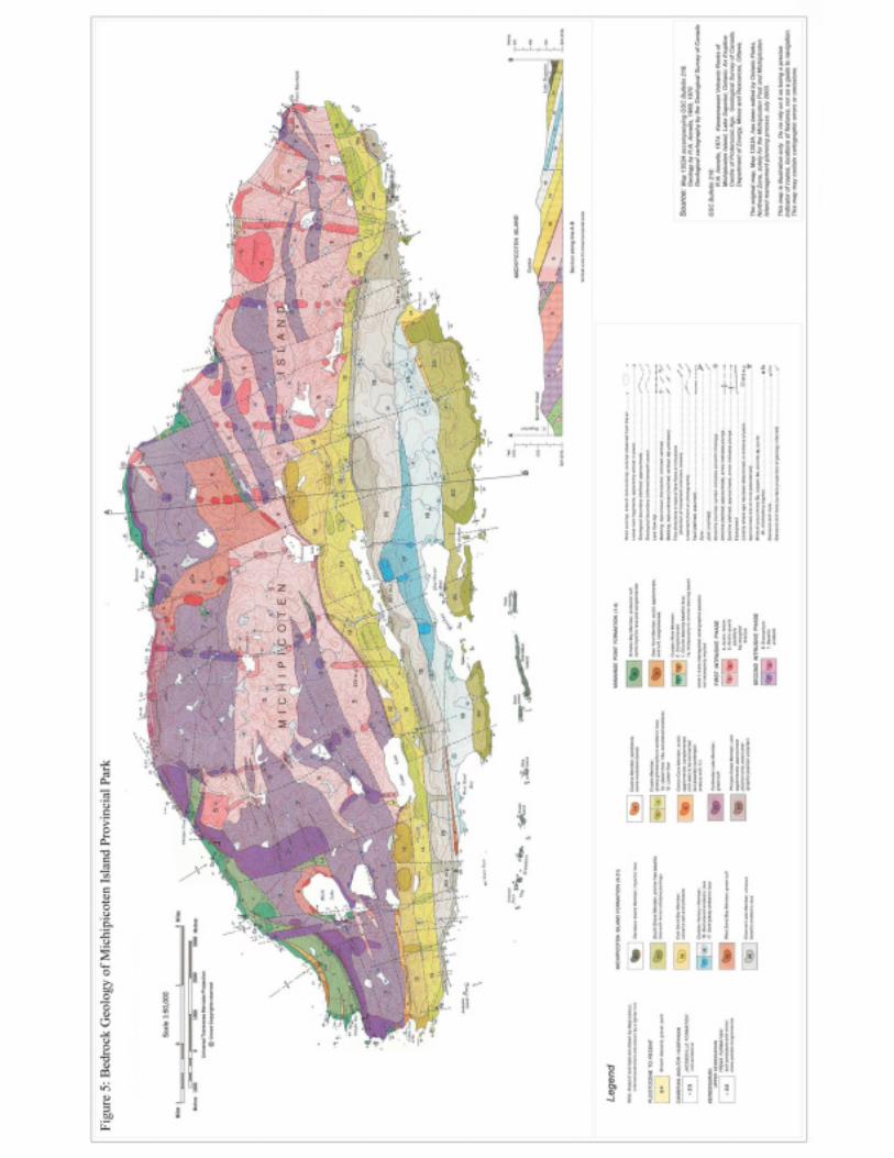
Michipicoten Island along with the Lake Superior basin began to take form during the Mesoproterozoic Period approximately 1.1 to 1.09 billion years ago. During this period tectonic forces slowly ripped apart the North American continent to form the Midcontinental Rift. The volcanic and sedimentary rocks that formed at the time of rifting belong to the Middle Keweenawan Supergroup. This Supergroup is represented within the park by the Mamainse Point and Michipicoten Island Formations separated by two intrusive episodes. The two formations and intrusive phases consist of a total of 21 distinct flow episodes (Figure 5).
8
Figu
re 5
: B
edro
ck G
eolo
gy o
f Mic
hipi
cote
n Is
land
Pro
vinc
ial P
ark
9
Michipicoten Post and Michipicoten Island Provincial Parks Management Planning ~ Background Information
These stratigraphic units are provincially significant.
Regional sedimentation (Neoproterozoic Era) followed the volcanism of the Middle Keweenawan Supergroup to form the Upper Keweenawan Supergroup. The sedimentary rocks of this supergroup are divided into the Oronto and Jacobsville Groups. These groups are poorly represented in the park.
The rocks underlying Michipicoten Island have a total stratigraphical thickness of 4,230 metres. with an estimated 2,180 metres of volcanic rocks, 1,640 metres of minor interflow volcaniclastic and sedimentary rocks and 410 metres of intrusive rocks. The island has a general composition of basalt, andesite and rhyolite flows, volcaniclastic rocks with minor intercalated sandstone and conglomerate with concordant intrusions of fine-grained andesite, felsite and quartz porphyry.
5.2.2 Geomorphology
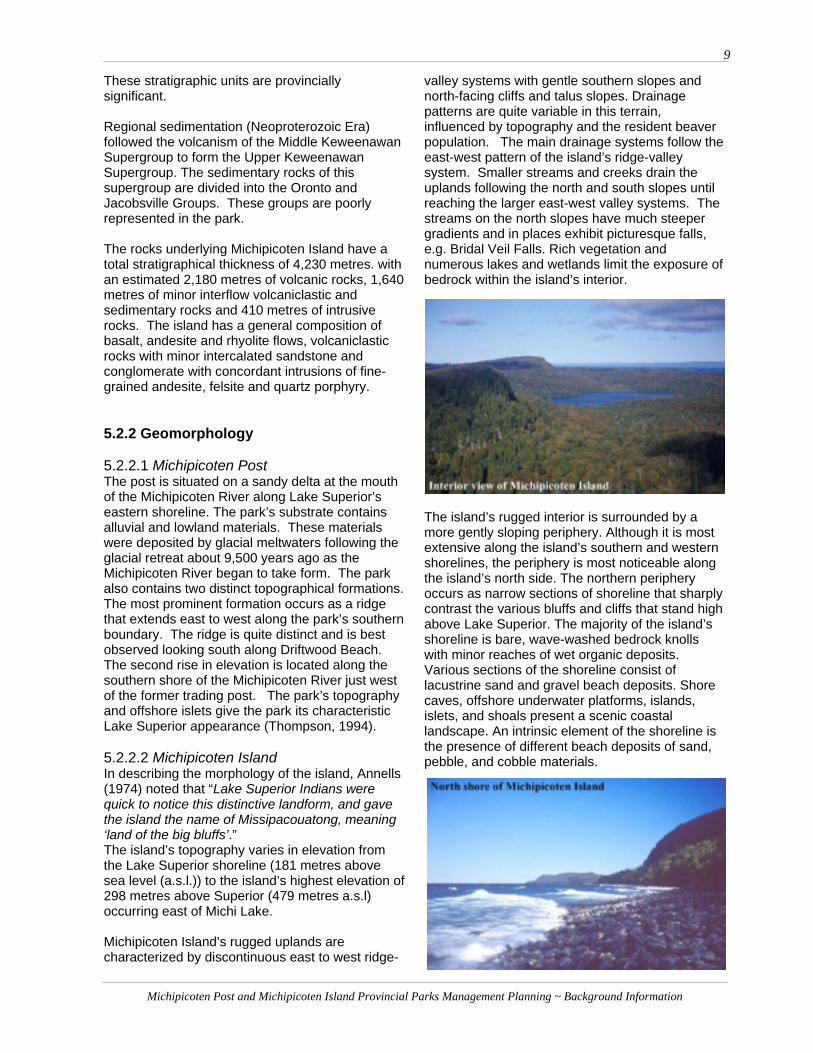
5.2.2.1 Michipicoten PostThe post is situated on a sandy delta at the mouth of the Michipicoten River along Lake Superior’s eastern shoreline. The park’s substrate contains alluvial and lowland materials. These materials were deposited by glacial meltwaters following the glacial retreat about 9,500 years ago as the Michipicoten River began to take form. The park also contains two distinct topographical formations. The most prominent formation occurs as a ridge that extends east to west along the park’s southern boundary. The ridge is quite distinct and is best observed looking south along Driftwood Beach. The second rise in elevation is located along the southern shore of the Michipicoten River just west of the former trading post. The park’s topography and offshore islets give the park its characteristic Lake Superior appearance (Thompson, 1994).
5.2.2.2 Michipicoten Island In describing the morphology of the island, Annells (1974) noted that “Lake Superior Indians were quick to notice this distinctive landform, and gave the island the name of Missipacouatong, meaning ‘land of the big bluffs’.”The island’s topography varies in elevation from the Lake Superior shoreline (181 metres above sea level (a.s.l.)) to the island’s highest elevation of 298 metres above Superior (479 metres a.s.l) occurring east of Michi Lake.
Michipicoten Island’s rugged uplands are characterized by discontinuous east to west ridge-
valley systems with gentle southern slopes and north-facing cliffs and talus slopes. Drainage patterns are quite variable in this terrain, influenced by topography and the resident beaver population. The main drainage systems follow the east-west pattern of the island’s ridge-valley system. Smaller streams and creeks drain the uplands following the north and south slopes until reaching the larger east-west valley systems. The streams on the north slopes have much steeper gradients and in places exhibit picturesque falls, e.g. Bridal Veil Falls. Rich vegetation and numerous lakes and wetlands limit the exposure of bedrock within the island’s interior.
The island’s rugged interior is surrounded by a more gently sloping periphery. Although it is most extensive along the island’s southern and western shorelines, the periphery is most noticeable along the island’s north side. The northern periphery occurs as narrow sections of shoreline that sharply contrast the various bluffs and cliffs that stand high above Lake Superior. The majority of the island’s shoreline is bare, wave-washed bedrock knolls with minor reaches of wet organic deposits. Various sections of the shoreline consist of lacustrine sand and gravel beach deposits. Shore caves, offshore underwater platforms, islands, islets, and shoals present a scenic coastal landscape. An intrinsic element of the shoreline is the presence of different beach deposits of sand, pebble, and cobble materials.

10
Michipicoten Post and Michipicoten Island Provincial Parks Management Planning ~ Background Information
Following the regional sedimentation responsible for forming the Upper Keweenawan Supergroup, Michipicoten Island’s landscape has been modified by weathering, erosion and glaciation. The last glacial episode withdrew from the island approximately 10,000 years ago. The retreat of the Marquette re-advance left Michipicoten Island submerged beneath the waters of glacial Lake Minong until its initial emergence around 9,500 years ago. The water levels in the Lake Superior basin have since fallen, establishing Michipicoten Island’s present shoreline approximately 2,000 years ago.
The presence of esker ridges, moulded landforms and scoured rock provides a history of glacial activity within the park. Glacial deposits tend to be shallow water-modified sandy tills providing a thin discontinuous veneer on the island’s bedrock. Many of the island’s valleys were filled with sands and gravels as they served as channels for glacial meltwater.
Evidence of shore erosion from past lake levels is well preserved on the island with the presence of raised beach ridges (paleobeaches) and raised shore caves. The highest paleobeaches, associated with glacial Lake Minong, are present at an elevation of 303 metres. The paleobeaches are considered regionally significant. Future studies may determine them to be provincially significant. These elevated shore caves and a shore arch are considered provincially significant. The shore caves and shore stacks associated with the current shoreline are considered locally significant for their interpretative value (Frey and Duba, 2001).
5.2.3 Economic Geology
5.2.3.1 Michipicoten PostSilver has been discovered at the western edge of the park’s southern boundary south of the ridge
formation. The park’s mineral potential is considered low.
5.2.3.2 Michipicoten Island Copper discovery includes occurrences at the western end of the island and at Bonner Bay. The remaining copper mining potential of the island is considered low.
5.3 Life Science Features 5.3.1 Flora
The Michipicoten Post and Michipicoten Island Provincial Parks are located in the northwestern section of Ecoregion 4E within Ecodistrict 4E-1 (Hills 1959). The parks are also located on the northwestern boundary of the Algoma Forest section of the Great Lakes-St. Lawrence (GLSL) Forest Region (Rowe 1972). The Algoma Forest section is situated just south of the Boreal Forest Region and contains both GLSL and Boreal forest species.
The Algoma Forest section is characterised by mixed forestlands of balsam fir (Abies balsamea),sugar maple (Acer saccharum), yellow birch (Betula alleghaniensis), white spruce (Piceaglauca) and eastern white cedar (Thujaoccidentalis) (Thompson, 1994).
5.3.1.1 Michipicoten PostThe vegetation of Michipicoten Post Provincial Park is characteristic of the northern portion of the Algoma Forest unit where balsam fir, white birch, white spruce and black spruce (Picea mariana) are present.
A total of 170 taxa, including 23 subspecies, have been reported for the park to date (Thompson, 1994). Twenty-one species were determined to be alien species from Europe and Asia. Two native plant species in the area were determined to be provincially significant. Six species were determined to be regionally significant. Further fieldwork concerning floral species is required. Five vegetation communities have been identified within the park (Figure 6) (Thompson, 1995).
5.3.1.2 Michipicoten IslandMichipicoten Island is primarily covered (approximately 87 percent) in forest communities (Noble, 1984). The remainder of the island contains numerous water bodies, non-forested wetland communities, sand beaches, talus slopes, and rock outcrops. Representative vegetation communities of the GLSL Forest Region are predominantly found on upper and middle portions

11
Figure 6: Michipicoten Post Vegetation Communities

12
Michipicoten Post and Michipicoten Island Provincial Parks Management Planning ~ Background Information
of warm south-facing slopes. Conversely, representative Boreal Forest communities have an affinity for cooler, wet, low-lying depressions, the Lake Superior shoreline, and the steep north-facing slopes that characterise the north side of the island. Michipicoten Island’s varying topography provides habitat opportunities for both southern and northern vegetative species in relatively close proximity. The island is home to both arctic-alpine species and more typical southern species like sugar maple.
Past studies conducted on the island have identified 10 provincially significant plant species and 53 species that are regionally significant. Many of the park’s significant species are either arctic-alpines or occur at their geographical range limits.
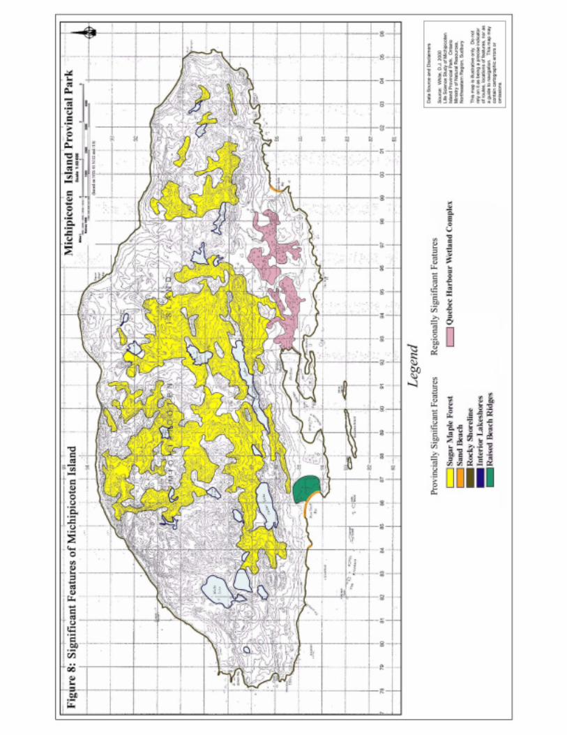
Fifteen distinct vegetation community types have been identified within the park (Figure 7). Five communities have been identified as provincially significant (Figure 8). East Sand Bay and West Sand Bay are provincially significant due to the presence of provincially rare sand beach communities. The island’s Interior Lake Shorelinesare provincially significant due to the presence of lakes of little disturbance on an isolated island exposed to the climatic influence of Lake Superior. The island’s Rocky Shoreline habitats are considered provincially significant as they support many provincially and regionally significant plants. The old growth Sugar Maple Forests are considered provincially significant due to their extensive presence and limited disturbance at the northern edge of their range (White, 2000).
One wetland complex has been identified as regionally significant (Figure 8). The Quebec Harbour Wetland Complex contains a variety of wetland communities and is the most extensive and diverse wetland area on the island. Considering the island’s isolation and climatic
influence associated with Lake Superior it may prove to be provincially significant (White, 2000).
5.3.2 Fauna
Faunal studies of the Michipicoten Post and Michipicoten Island Provincial Parks have been limited and of short duration. The studies have not occurred during breeding or migratory seasons. Additional surveys, conducted at the appropriate time of the year, would add considerably to the knowledge of the fauna of the two parks.
5.3.2.1 Michipicoten Post Thirty-eight (38) bird species have been recorded. Four species were year round residents while the remaining species were migratory birds. The post is a migratory stop over for waterfowl and other bird species during the spring and fall. Bald eagles (Haliaeetus leucocephalus) can be found at the mouth of the Michipicoten River during the fall salmon spawning season. Perching birds are the post’s most conspicuous fauna.
Mammalian species, or evidence of, observed in the park include the American porcupine (Erethizon dorsatum), American red squirrel (Tamiasciurus hudsonicus), eastern chipmunk

13
Figu
re 7
: V
eget
atio
n C
omm
uniti
es o
f Mic
hipi
cote
n Is
land
14
Figu
re 8
: Si
gnifi
cant
Fea
ture
s of M
ichi
pico
ten
Isla
nd
15
Michipicoten Post and Michipicoten Island Provincial Parks Management Planning ~ Background Information
(Tamias striatus), moose (Alces alces), red fox (Vulpes vulpes), snowshoe hare (Lepus americanus), deer mouse (Peromyscus maniculatus) and a variety of other small mammals. Reptiles and amphibians are poorly represented in the park’s faunal records. The wood frog (Rana sylvatica) is the only herptofaunal species recorded for the post.
5.3.2.2 Michipicoten Island There is a notable absence of moose, deer, bear and wolves on the island and an interesting abundance of beaver and woodland caribou.
There are no provincially significant breeding birds recorded for the park. The Canada goose is known to breed within the park and is considered regionally significant. Sandhill cranes and bald eagles have been observed on the island but the breeding status of either species has yet to be confirmed. Breeding bald eagles would be considered provincially significant while breeding sandhill cranes would be considered regionally significant. The small offshore islets serve as nesting areas for herring gulls and a small great blue heronry.
The island’s mammalian population consists of woodland caribou (Rangifer tarandus caribou),beaver (Castor canadensis), red fox (Vulpes vulpes) and a variety of smaller species.
In May of 2000, Woodland caribou were listed as nationally threatened by COSEWIC (Committee on the Status of Endangered Wildlife in Canada). The Ontario Ministry of Natural Resources intends to list forest-dwelling woodland caribou as provincially threatened. This species is currently listed as endangered in Ontario. A recovery strategy has been initiated and a recovery plan is currently being developed. The recovery planning process followed in Ontario is consistent with guidelines developed by the national recovery program, Recovery of Nationally Endangered Wildlife (RENEW) (OMNR, 2003).
Woodland caribou were originally native to the island but due to the pressures from hunting the
population was wiped out by the 1880’s. In 1981, a single caribou was observed on the island. Eight additional caribou were moved to Michipicoten Island from the Slate Islands located near Terrace Bay (Eason, 1982). The population, due to the absence of predators (wolves), has thrived and the numbers are estimated to be over 200 (G. Eason, pers. com., 2002). This caribou population is one of the most southern communities in Ontario.
The beaver population on the island is also thriving due to the lack of natural predators. This population is considered to have one of the highest densities in the Wawa District (OMNR, 2002). As a result, a large area of the island has been modified through flooding.
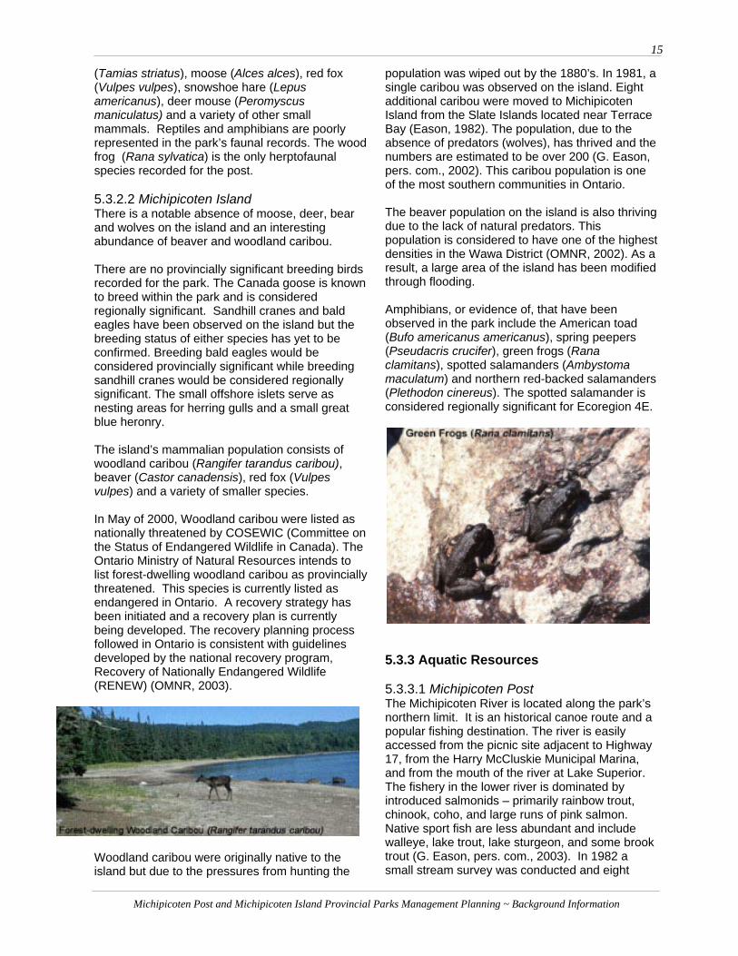
Amphibians, or evidence of, that have been observed in the park include the American toad (Bufo americanus americanus), spring peepers (Pseudacris crucifer), green frogs (Rana clamitans), spotted salamanders (Ambystoma maculatum) and northern red-backed salamanders (Plethodon cinereus). The spotted salamander is considered regionally significant for Ecoregion 4E.
5.3.3 Aquatic Resources
5.3.3.1 Michipicoten PostThe Michipicoten River is located along the park’s northern limit. It is an historical canoe route and a popular fishing destination. The river is easily accessed from the picnic site adjacent to Highway 17, from the Harry McCluskie Municipal Marina, and from the mouth of the river at Lake Superior. The fishery in the lower river is dominated by introduced salmonids – primarily rainbow trout, chinook, coho, and large runs of pink salmon. Native sport fish are less abundant and include walleye, lake trout, lake sturgeon, and some brook trout (G. Eason, pers. com., 2003). In 1982 a small stream survey was conducted and eight

16
Michipicoten Post and Michipicoten Island Provincial Parks Management Planning ~ Background Information
small fish collection sites were sampled. The sites were spread between the river mouth and Scott Falls which is the first barrier to fish migration on the river (Pellegrini, 2002). The species collected included common white sucker, ninespine stickleback, yellow perch and walleye. Additional surveys have been carried out since the 1982 survey applying various sampling techniques.
Several projects related to aquatic resources are currently underway or are planned for the Michipicoten River. A water management plan is being prepared for the entire Michipicoten system. The main focus of the plan in the lower reach of the river is to increase the minimum flow out of the lowest hydro dam. A fall aerial count of the spawning run of chinook salmon has also been conducted on the river since the 1980’s. The run peaked in the mid 1980’s at about 10,000 fish and is now about 300 to 500 fish (G. Eason, pers. com., 2003).
There are presently four power dams and four storage dams on the Michipicoten River system and three power dams and one storage dam on the Magpie River operated by Great Lakes Power Generation.
5.3.3.2 Michipicoten Island Lake Superior encompasses just under half of the park’s 36,470 hectares. The waters of Lake Superior are used for recreation, travel and commercial fishing. Quebec Harbour, previously known as Refuge Harbour, is well known as a place of refuge during long trips and rough lake conditions.
There are known lake trout spawning beds and a fishery consisting of lake trout, coho and chinook salmon, herring and whitefish within the Lake Superior portion of the park. Popular sport fishing areas occur all along the southern and southwestern shore of the island. The pygmy whitefish is a provincially rare species that inhabits the waters in eastern Lake Superior, surrounding the island (Petzold, 2003).
Michipicoten Island has more than 20 inland lakes. These lakes have seen few visitors and provide potential research opportunities based on a minimal level of disturbance combined with the climatic influence of Lake Superior.
A wilderness fishing operation operates on Michi Lake. The operation accesses the lake by floatplane and has a land use permit for a location on the northwest shore of Michi Lake.
5.4 Cultural Resources
“From records of early European travellers on Lake Superior, it is documented that the Michipicoten Ojibway were an isolated band who seemed to be the only major inhabitants between Agawa Bay and the Pukaskwa River. Michipicoten, with its large river mouth delta, afforded a central meeting place for summer settlement. Pukaskwa pits and pictographs are a reflection of the Ojibway’s response to the power and mystery of Lake Superior. Many of the names given to bays, islands and unique geological features survived as testament to the many native myths and legends that explain their origins” (Rowe, J., 2001).
5.4.1 Michipicoten Post The history of human activity within Ontario has been divided into 13 theme segments. One of the targets for Ontario Parks is to represent all 13 themes within the framework of historical provincial parks and historical and wilderness zones within other class parks. Michipicoten Post and the surrounding area represent nine of these themes (OMNR, date unkown).
Prehistory Four Aboriginal settlement sites have been identified within the general vicinity of Michipicoten Post Provincial Park. One of the sites was located on the south shore off the Michipicoten River, within the park. Settlement in the area was determined to have begun as early as 1165 BC. The sites contained remnants of ceramics associated with the Laurel Culture. The pre-Woodland people predominantly inhabited Northern Ontario from between 800 BC to 500 BC to about 1,000 AD (Rowe, J., 2001). After 1000 AD, the Woodland Culture of Southern Ontario began to influence the Algonkian way of life in Northern Ontario through trade (Macleod, 1972). Since the 16tth century the Ojibway of the area

17
Michipicoten Post and Michipicoten Island Provincial Parks Management Planning ~ Background Information
have represented this Algonkian culture (Macleod, 1972).
The people of Michipicoten were generally nomadic in nature. They depended on the natural resources of the rugged shield country. In the warm months, they gathered in the sheltered coves and river mouths of the Lake Superior shoreline along Michipicoten Bay. These sites provided an abundant supply of food and were ideal for transportation, communication and trade along the water routes with neighbouring bands. They would move inland during the winter and set up camp along inland lakes and waterways (Rowe, J., 2001).
History Etienne Brule, between 1617 and 1622, was the first European to explore the Lake Superior region and make contact with the Ojibway of Michipicoten. As a result of Brule’s travels, Michipicoten appeared on Samuel de Champlain’s map of 1632 of explored areas of the New World. Michipicoten is one of the oldest, original place names on the map of Ontario.
The Michipicoten Post was established as early as 1714 by the French. It was built as one of the ‘postes du nord’, along with Fort Kaministikwia (Fort William) and Nipigon Post, in order to protect the trading routes around Lake Superior. Between 1714 and 1904 trading posts in the area were operated by the French, independent traders, the Northwest Trading Company and finally the Hudson’s Bay Company. The park is important provincially because it represents all of the periods and rivalries of the fur trade (Macleod, 1972).
The Hudson’s Bay Company operated from the Michipicoten Post from 1825 to 1904, with a brief cessation in operations between 1895 and 1898. In 1827 Michipicoten Post replaced Fort William as the administrative headquarters of the Lake Superior District. It operated as district headquarters until 1887. From 1825 to 1863 Michipicoten Post was an important distribution centre for both the northern and eastern trade routes.
The local Ojibway trapped and provided furs to the post for almost 180 years. The presence of the local Ojibway band was instrumental in the establishment of a productive and lengthy fur-trading industry in the Michipicoten area. (Rowe, J., 2001).
As one of the main centres of northern Ontario, Michipicoten Post provided a variety of services in
addition to its fur trade responsibilities. The post provided mail service, supported missionary work, and provided supplies and equipment for survey and exploration crews (Weiler, 1973). When the Robinson-Superior Treaty was signed in 1850, Michipicoten Post was responsible for distributing the annual annuities to the local Indians (Losey, 1999). Ontario’s first Mining Recorder’s office was opened at Michipicoten Post in response to the discovery of gold in the Wawa area in 1897. (Weiler, 1973).
5.4.2 Michipicoten Island Pre-history Three archaeological sites have been recorded for Michipicoten Island. These sites are known as the Red Cap site, the Desperation site, and the Caribou Cave site. Only two days of site surveying were completed for Michipicoten Island. The island has the potential for 40 or more aboriginal sites, including the potential for Aboriginal copper mines (Conway, 1983).
History There are various native legends depicting the island as a place of mysterious wonders, beasts and spirits. Some of the island’s legends were recorded as early as the 1600’s (Conway, 1983). Indian lore of the island described it as a forbidding place where persons found shiny rocks on the beaches. The legends usually spoke of death and misfortune associated with travel to the island.
MinesMichipicoten Island has a long history of copper exploration, dating from the prehistoric discovery of native copper to modern interest beginning in the 1840’s. Mining on the island began in the 1850’s with the established of the Quebec and Bonner mines. A third mine site, known as the Philipps Mine, was established and operated between 1875 and 1880. Mining attempts occurred intermittently

18
Michipicoten Post and Michipicoten Island Provincial Parks Management Planning ~ Background Information
until 1907 while mineral exploration around the island continued into the mid 1960’s. Although similar geological formations in Michigan have proved to be rich in copper deposits, mining on Michipicoten Island has never provided significant yields of copper.
Remnants of the Quebec Mine include building foundations, head frames, metallic debris and machinery. Openings to mine shafts, hidden in the underbrush and flooded with water, present a hazard to unwary visitors. Evidence of the other sites is difficult to find due to the island’s dense vegetation and their small-scale operation. The mining activity around the island has provided various place names including Quebec Harbour (formerly Refuge Harbour), Bonner Bay, Bonner Head and Philipps Creek (Whyte, 2001).
Lighthouses The first lighthouses on and around Michipicoten Island were built in 1872. They were located on Agate Island and on Purvis Point within Quebec Harbour. Today there are two lighthouses
operating within the park. The East End Light, also known as the Michipicoten Light Station, was built at Point Maurepas in 1911. The light tower’s six flying buttresses style structure represents a short-lived experiment in lighthouse design in Canada. The Davieaux Light was built on Long Island, later renamed Davieaux Island, in 1918. The East End Light and the Davieaux Light were automated in 1983 and 1997 respectively. The East End Light has been designated a heritage structure by the Department of Fisheries and Oceans.
Shipwrecks The island’s rugged coastline and shoals together with Lake Superior’s unforgiving nature have resulted in numerous shipwrecks. The remains of five ships can be found around the island. Three of the vessels sit in the shallow waters of Quebec
Harbour. Two ships rest in the waters west of Michipicoten Island.
Commercial Fishing Commercial Fishing from the island began in 1839 by the Hudson’s Bay Company. The fishing operations were subsequently taken over by various companies starting in 1860 with Alfred Booth of the Booth Packing Company of Chicago, then in 1934 by Purvis and Son, and lastly by Ferroclad Fisheries in 1959 (Whyte, 2001).
6.0 RECREATION
6.1 Michipicoten Post Michipicoten Post Provincial Park provides a variety of recreational opportunities including hiking, picnicking, nature viewing, cross-country skiing, snowshoeing, canoeing and kayaking, camping, berry picking and sport fishing. The majority of park use occurs in the areas of Driftwood Beach, the adjacent coastal forest and the waters of Lake Superior. The former Hudson’s Bay Company trading post offers further recreational potential for the park.
The sandy beach community along Driftwood Beach has been determined to be the most sensitive feature to recreation use. This community is fairly sensitive to recreational use and the area is well used by park visitors. The beach and coastal forest currently experience significant levels of use by All-Terrain Vehicles and other off-road vehicles. Camping activities occur along the beach and in the adjacent forest. Temporary fire pits and garbage are often left behind. Relic hunting in and around the area of the former trading post has degraded the integrity of the park environment and has resulted in the removal of historical items from the park.

19
Michipicoten Post and Michipicoten Island Provincial Parks Management Planning ~ Background Information
6.2 Michipicoten Island Michipicoten Island Provincial Park provides a variety of recreational opportunities in a remote wilderness environment. Visitors to the park enjoy picturesque landscapes, islands and shorelines as they circumnavigate Michipicoten Island and the nearby islands. Kayaking, canoeing and boating are popular recreational activities, providing the main methods of transportation within the park. The park’s scenic landscape and shoreline features offer unlimited opportunities for exploration and photography. Several shipwrecks in the park provide the potential for scuba diving and snorkelling. Park visitors currently enjoy sport fishing on Lake Superior and Michi Lake. A commercial outpost camp provides access to sport fishing on Michi Lake.
The most unique recreation features on the island were determined to be the sand beaches, the lighthouses and Quebec Harbour. The park’s sand beach communities are considered to be the most sensitive features to recreation use. The rarity of these sand beaches within the park makes them destination points for park users. These communities, like other popular recreation areas in the park, are home to significant and sensitive species. Information pertaining to the park’s important features should be made available to park visitors. The availability of this information will help protect the park’s sensitive features while increasing its recreational potential.
Local tug services can provide transportation to the park. Local outfitters provide gear and guiding services for excursions to Michipicoten Island.
7.0 MARKET ANALYSIS
Park use is relatively low for both Michipicoten Post and for Michipicoten Island Provincial Parks. The post is mainly used by the local residents for various day-use activities. Trips to Michipicoten
Island are planned in advance and last for several days. There have been no park visitor surveys completed to date and there is little information pertaining to park use or park visitors for either park. Market studies have been conducted for Michipicoten Post and Wawa by the Economic Planning Group of Canada (EPG) and the Wawa Tourism Commission (WTC) respectively. The primary market for the parks includes residents living within a one hour drive of Wawa, tourists overnighting within a one hour drive and tourists travelling through the Wawa area by car. On average, overnight visitors stay a little more than five nights. Visitors usually travelled with an average group size of three to four persons. Both length of stay and group size indicators were higher than provincial averages at the time. The majority of travellers (73 percent) arrive by vehicle along either Highway 17 or Highway 101. Other travellers arrive by train, boat, plane and bike.
The most popular activity is sightseeing while fishing, wildlife viewing, ecotouring, hiking and shopping are among the most popular activities in the area. It is interesting to note that over five percent of visitors are interested in historical sights. There are three provincial parks and two conservation areas within the Wawa area. Lake Superior Provincial Park is the closest to Michipicoten Post, located 15 kilometres to the south, and provides overnight camping opportunities. The post can provide visitors additional recreation opportunities associated with its historical post, the Voyageur Trail, Driftwood Beach, the Michipicoten River and the park’s scenic landscapes.
Visitors to Michipicoten Island will most likely require lodging before and after their island expedition due to unpredictable weather and for organizing trip details. Some of the island visitors may wish to remain in the Wawa area to explore other recreational opportunities before moving on. Michipicoten Post and Lake Superior Provincial Parks can provide additional recreational opportunities while the latter can also provide camping facilities.
8.0 CONSTRAINT AND CAPABILITY ANALYSIS
The constraints and capabilities of a park must be considered in order to offer recreational opportunities while, at the same time, protecting the natural and cultural resources of an area. Constraint and capability analyses consider the information available in earth science, life science,
20
Michipicoten Post and Michipicoten Island Provincial Parks Management Planning ~ Background Information
cultural information studies and recreation assessments for a park and provide guidance for the management of recreation and resource protection.
8.1 Michipicoten Post Park use currently focuses around Driftwood Beach and the adjacent shoreline forest community. Significant and sensitive plant species inhabit these communities. Driftwood Beach and the forest community currently show signs of use and degradation caused by recreation (e.g. removal of plant cover). Activities that degrade park values such as off-road vehicle use should be prevented.
Relic hunters, on occasion, have removed historic artefacts from the site of the former Hudson’s Bay Company trading post. Information, identifying the provincial park and its values, should be made available at the historic site and at other potential points of access to the park.
The management planning process may determine that some level of development is appropriate for the park. Development within the park should take into consideration the park’s values and level of visitor use.
8.2 Michipicoten Island Recreation within the park is focused on the various shorelines along Lake Superior. Significant species inhabit many of these shoreline areas including the highly popular sandy beach sites. Although they may provide opportunities for interpretation, these species should be viewed as a potential constraint to recreation.
Management decisions should also take into consideration the recreation carrying capacity of the park. The recreation carrying capacity refers to the level of use that will adequately protect the park environment while providing high quality recreational experiences. With an increase in use there is the potential for overcrowding at key points along the island’s shoreline such as sandy beaches and protected bays. This would not only result in the deterioration of a true wilderness experience but also increase the risk of harm to the park’s significant and sensitive features.
The common occurrence of rough lake conditions on Lake Superior provides another constraint to park recreation. Travel to and from the park can be limited by poor lake conditions. Travelling within the park during rough conditions could be dangerous, especially when travelling by canoe or kayak.
The management planning process may determine that some level of development is appropriate for the park. Development within the park should take into consideration the park’s values and level of visitor use.
9.0 Your Personal Invitation…..
As someone with an interest in the long-term management of Michipicoten Post and Michipicoten Island Provincial Parks, you are invited to participate in the management planning for these parks. We hope that the background information presented in this document has enhanced your understanding of the features and values of each park. We welcome any comments, concerns or suggestions you may have regarding the contents of this document. Please take a few moments to fill out the comment form and return it to the Ontario Parks, Northeast Zone office.
Please direct all questions and comments to:
Mike Pym Michipicoten Post and Michipicoten Island Management Planning Ontario Parks 199 Larch St., Suite 404 Sudbury, ON P3C 2A7 Tel: (705) 564 3165 Fax: (705) 564 3171

21
Michipicoten Post and Michipicoten Island Provincial Parks Management Planning ~ Background Information
10.0 REFERENCES
Annells, R.N. 1974. Keweenawan Volcanic Rocks of Michipicoten Island, Lake Superior, Ontario: An Eruptive Centre of Proterozoic Age, Geological Survey of Canada, Bulletin 218, Department of Energy, Mines and Resources Canada.
Brown, C. 2000. The Illustrated History of Canada. Key Porter Books. Toronto, Ontario.
Chapman, L.J. and M.K. Thomas 1968. The Climate of Northern Ontario. Dept. of Transport, Meteorological Branch, Toronto, ON.
Conway, Thor 1983. Memo from Thor Conway to Will Kershaw. OMNR
Dawson, K.C.A. 1988. Michipicoten area archaeological survey.
Department of Energy, Mines and Resources (DEMR), 1973.The National Atlas of Canada, 4th
Edition.
Eason, G. 1982. Caribou management proposal, Wawa District. Ontario Ministry of Natural Resources.
Eason, Gord. 2002,2003. Personal communication. Area Biologist, Wawa/White River, OMNR.
Engelbert, P. 1987. Submerged Cultural Resources on Michipicoten Island: A Preliminary Study. Marine Heritage Conservation Unit, Heritage Branch, Ontario Ministry of Culture and Communications, March 1990.
Environment Canada. 2002. Canadian Climate Normals. The Meteorological society of Canada. http://www.msc-smc.ec.ca
Forma, G. 1971. Michipicoten Archaeology: Investigations at the Hudson’s Bay Company Fur Trading Post. Ontario Department of Lands and Forests.
Frey, E.D and D. Duba 2001. Michipicoten Island Provincial Park Earth Science Inventory Report. Ontario Parks, OMNR.
Hedlin Menzies & Associates LTD. 1974. North Shore Lake superior Recreation Study, Volume 1: Physical and Economic Studies. Toronto, Ontario.
Hills, G.A. 1959. A Ready Reference to the Description of the Land of Ontario and its Productivity. Ontario Dept. of Lands and Forests.
Johnson, L and S. Ryan. 2002. The Trail: A Work Plan for Wawa’s Tourism Industry. Wawa Tourism Commission.
Kershaw, Will 2002,2003. Personal communication. Senior Management Planner, Ontario Parks, Northeast Zone.
Kor, Phil 2003. Personal communication. Senior Conservation Geologist, Planning and Research Section. Ontario Parks, Peterborough.
Losey, E.B. 1999. Let them Be Remembered: The Story of the Fur trade Forts. Vantage Press, New York.
MacLeod, D. 1972. Michipicoten: Its Historical Importance. Ontario Department of Lands and Forests, Parks and Recreation Branch.
Michipicoten Heritage Committee (MHC). 1992. Michipicoten Memories. Wawa, ON.
Morris, Ed 2002,2003. Personal communication. OLL Biologist, Ontario Parks, Northeast Zone.
Noble, T.W. 1983. Life Science Inventory Check-sheet, Michipicoten Post Provincial Park. OMNR.
Noble, T.W. 1984. Life Science Inventory: Life Science Inventory Check-sheet, Michipicoten Island. OMNR Northeast Region.
OMNR. Unknown. Wawa District. Michipicoten Historical Provincial Park Meets and Bounds Description. Park Files, from the SE054A Rev. 72
OMNR 1983. District Land Use Guidelines (DLUG): Wawa.
OMNR 1986. Michipicoten Island Provincial Park Interim Management Statement.
OMNR 1986. Michipicoten Post Provincial Park Interim Management Statement.
OMNR 1992. Ontario Provincial Parks: Planning and Management Policies.
OMNR 1994. Ontario Provincial Parks Management Planning Manual.
OMNR 1999. Ontario’s Living Legacy Land Use Strategy. Queen’s Printer for Ontario.

22
Michipicoten Post and Michipicoten Island Provincial Parks Management Planning ~ Background Information
OMNR 2000. Ontario Provincial Park Policy as Amended by the Ontario’s Living Legacy Land Use Strategy.
OMNR 2000. The Great Lakes Heritage Coast, A Discussion Paper. Queen’s Printer for Ontario.
OMNR 2001. OLL Implementation Database: Michipicoten Post Provincial Park.
OMNR 2001. OLL Implementation Database: Michipicoten Island Provincial Park.
OMNR 2001. The Great Lakes Heritage Coast, Charting the Course. Queen’s Printer for Ontario.
OMNR 2003. Recreation Inventory Report: Michipicoten Island Provincial Park.
OMNR 2003. Recreation Inventory Report: Michipicoten Post Provincial Park.
OMNR 2003. Woodland Caribou Recovery Note.
OMNR 2004. Crown Land Use Policy Atlas.
Pellegrini, M. 2003. Personal communication. Magpie Nagagami Biologist, Wawa, OMNR.
Pellegrini, M. 2002. Memo from Marcel Pellegrini to Tim Kingshott. OMNR
Petzold, M. 2003. Personal Communication. Fisheries Biologist, Sault Ste. Marie, OMNR.
Pye, E.G. 1997. Roadside Geology of Ontario: North Shore of Lake Superior. Rock On Series 2, p. 3-11 & p.101 – 117. MNDM, Ontario GEOservices Centre.
Rowe, J. 2001. Michipicoten River Watershed Report. Ontario Ministry of Natural Resources.
Rowe, J. 2002. Michipicoten Harbour, Heritage Report for Superior East Community Futures Development Corporation.
Rowe, J.S. 1972. Forest Regions of Canada,Publication No. 1300, 172 pp. Canadian Forestry Service, Ottawa.
Shchepanek, M.J. 1971. Trading Posts of the Moose-Michipicoten trade route, Canadian Geographic Journal.
Statistics Canada 2002. Community Profiles.http://www.statcan.ca
The Economic Planning Group of Canada and the Proctor and Redfern Group, July 1990. Michipicoten Post Study: Final Report. OMNR.
Thompson, J.E. 1994. Life Science and Human History Features of Michipicoten Post Provincial Park. OMNR.
Thompson, J.E. 1995. Park Notes: Michipicoten Post Provincial Park. Vol. 1, No 1. OMNR.
Thurston, P.C. 1991. Archean Geology of Ontario, Introduction; in Geology of Ontario, Ontario Geological Survey, Special Volume 4, Part 1, p. 73-81.
Township of Michipicoten Community Development Office. 2002. Township of Michipicoten: Community Profile. The Corporation of the Township of Michipicoten, Wawa ON.
Weiler, J. 1973. Michipicoten, Hudson’s Bay Company Post 1821-1904. Historical Sites Branch, Research Report 3.
Wells, David. 2002, 2003. Personal Communication. Naturally Superior Adventures, Wawa, ON.
White, D.J. 2000. Life Science Study of Michipicoten Island Provincial Park. Ontario Ministry of Natural Resources, Northeastern Region, Sudbury
Whyte, D.C. 2001. An introduction to Michipicoten Island: Lake superior’s Wild Heart. Jackson’s Point, Ontario, Canada.
Williams, H.R., G.M. Stott, K.B. Heather, T.L. Muir and R.P. Sage. 1991. Wawa Subprovince; inGeology of Ontario, Ontario Geological Survey, Special Volume 4, Part 1, p. 485-539.
Wilson, Ann. 2002, 2003. Personal communication. OGS Resident Geologist, Timmins, MNDM.

COMMENT SHEET Michipicoten Post and Michipicoten Island Background Information
Public input on any aspect of the planning process for Michipicoten Post and Michipicoten Island Provincial Parks is welcome and will be considered during the management planning process. Thank you for taking the time to complete this comment sheet.
Please direct questions and comments to: Mike Pym, Project Management Planner Michipicoten Provincial Parks Ontario Parks – NE Zone Office 199 Larch Street, Suite 404 Sudbury, Ontario P3E 5P9
Phone (705) 564–3170 Fax: (705) 564–3171 Email: [email protected]
Name: ________________________________________________________________________
Mailing Address: ________________________________________________________________________
________________________________________________________________________
Phone # : ________________________________________________________________________
Please check the appropriate box below.
Please add my name to the mailing list Please remove my name from the mailing list
Please keep my name on the mailing list.
Please check the appropriate box below.
Please send future correspondence in English. Please send future correspondence in English.
Comments (if possible, please refer to a specific part of the document you wish to comment on):

Note: The Ministry of Natural Resources is collecting comments and information regarding the Michipicoten Post and Michipicoten Island Background Information document under the authority of the Provincial Parks Act to assist in making decisions and determining further public consultation needs. Comments and opinions will be kept on file for use during the planning period and may be included in study documentation, which may be available for public review.
Under the Freedom of Information and Protection of Privacy Act (1987), personal information will remain confidential unless prior consent is obtained. However, this information may also be used by the Ministry of Natural Resources to seek public input on other resource management surveys and projects. For further information on this Act, please contact: Carole Trepanier, Sudbury District MNR at: 705-564-7488.

51905 (0.15 k P.R., 26 07 04) ISBN 0-7794-6544-X