copperstone resources ab memo report resource …
TRANSCRIPT

COPPERSTONE RESOURCES AB
MEMO REPORT
RESOURCE STATEMENT
FOR THE
GRANLIDEN/SVARTLIDEN
COPPER DEPOSITS
NORRBOTTEN
SWEDEN
Effective Date: 20th
December 2018
Prepared By
Micon International Co Limited
Suite 10 Keswick Hall, Norwich, NR4 6TJ, United Kingdom
20th
December 2018

Copperstone Resources AB
Page
Granliden/Svartliden Copper Project December 2018 i
Table of Contents
1.0 MICON MEMO REPORT .......................................................................................... 1 1.1 INTRODUCTION ...................................................................................................... 1 1.2 MINERAL RESOURCES .......................................................................................... 4
2.0 EXPLORATION TARGET POTENTIAL ................................................................ 8
3.0 RECOMMENDATIONS .............................................................................................. 9
4.0 DATE AND SIGNATURE PAGE ............................................................................. 10
5.0 APPENDIX 1 – LIST OF DRILL HOLES INCLUDED IN
ESTIMATE ................................................................................................................. 11
6.0 APPENDIX 2 - PERC CODE TABLE 1................................................................... 13

Copperstone Resources AB
Page
Granliden/Svartliden Copper Project December 2018 ii
List of Tables
Table 1.1: Modelling Parameters ................................................................................................ 5
Table 1.2: Block Model Origins ................................................................................................. 5
Table 1.3: Optimisation Parameters ............................................................................................ 6
Table 1.4: Copperstone Inferred Resources ................................................................................ 7
List of Figures
Figure 1.1: Location of the Copperstone Licence Boundaries ................................................... 1
Figure 1.2: Location of the Copperstone Licence Boundaries ................................................... 3
Figure 1.3: Plan Map of Drilling and Wireframes ...................................................................... 4
Figure 1.4: Cross-Section through the Granliden Deposit .......................................................... 5
Figure 1.5: Copperstone Resources within Optimised Pit Shells ............................................... 6
Figure 2.1: Isometric View of Exploration Target Potential Wireframes .................................. 8

Copperstone Resources AB
Granliden/Svartliden Copper Project December 2018 1
1.0 MICON MEMO REPORT
1.1 INTRODUCTION
At the request of Copperstone Resources AB (“Copperstone” or the “Client”), Dr R Bernau
MAusIMM(CP) of Micon International Co Ltd visited the Copperstone project from the
29th
October to the 1st November 2018 and reviewed the geology, mineralisation, visited the
sample preparation laboratory, in addition to inspecting several drill hole collars.
The Granliden/Svartliden copper deposits are located near Arvidsjaur in Norrbotten County,
Sweden. Figure 1.1 illustrates the location of the Copperstone Project.
Figure 1.1: Location of the Copperstone Licence Boundaries

Copperstone Resources AB
Granliden/Svartliden Copper Project December 2018 2
The objective of the work was to prepare a PERC Compliant Mineral Resource Statement for
the Granliden/Svartliden copper deposits that incorporates the results of the latest drilling and
geological interpretation. The Client deliverables include updated wireframes, selected pit
shells to define the base of the resource, a PERC Compliant Mineral Resource Statement for
the Granliden/Svartliden copper deposits and an accompanying summary report in the form
of PERC Table 1.
Micon understands that at the time of reporting Copperstone Resources AB do not hold the
permits for the Mineral Resources reported in this statement. However, under the PERC code
(2017), resources maybe reported as long as the ‘security of the tenure held at the time of
reporting or which is reasonably expected to be granted in the future along with any known
impediments to obtaining the right to operate in the area’ (page 62 of PERC code). Micon
considers Copperstone to meet this requirement based on the following information:
Copperstone owns the following exploitation concessions: Svartliden k No.1 (36 ha)
valid until December 2025 and Eva k No. 1 (34 ha) valid until November 2042.
Copperstone also owns the following exploration permits: Sandberget 200 (19 ha) and
Sandberget 300 (19 ha) both valid until October 2022. On 28th
September 2018,
Copperstone applied for two new exploration permits: Sandberget 400 (535 ha) which
forms a roughly 1 km buffer zone around the recently awarded Eva k No.1
exploitation concession, and Sandberget 500 (7,641 ha) which contains all the above.
Sandberget 500 application excludes a small nature reserve that is not affecting the
area of exploration. The company has good relations with the local Sami Village
(Mausjaur) and the local forestry company (Sveaskog) that is the major landowner of
the area under exploration. In November 2018 the Inspector of Mines approved
dispensation from 1 year prohibition for S400 and S500 and the two applications are
currently being processed. It is reasonable to assume that Copperstone will receive
the two applied exploration permits in early 2019.
Figure 1.2 illustrates the location of the Copperstone licence boundaries.

Copperstone Resources AB
Granliden/Svartliden Copper Project December 2018 3
Figure 1.2: Location of the Copperstone Licence Boundaries

Copperstone Resources AB
Granliden/Svartliden Copper Project December 2018 4
1.2 MINERAL RESOURCES
Micon modelled the mineralisation at Granliden and Svartliden using Surpac 6.9 software,
based on the interpretation provided by the Copperstone geologists and using a 0.135%
copper cut-off. The wireframes allowed up to 10 m of internal waste and all unsampled
intervals were given a ½ detection limits value of 0.0005 for all metals. Figure 1.3 shows a
plan map of the drilling and wireframes.
Figure 1.3: Plan Map of Drilling and Wireframes
Figure 1.4 illustrates a cross-section through the Granliden Deposit
Svartliden
Granliden
Granliden
South
A
B

Copperstone Resources AB
Granliden/Svartliden Copper Project December 2018 5
Figure 1.4: Cross-Section through the Granliden Deposit
(Looking East)
An outlier analysis was conducted for each element interpolated (Cu, Ag, Au and Zn).
Top-cuts of 3.69%, 102 g/t, 0.9 g/t and 5.85% were applied respectively. Samples were
composite to 2 m lengths. In addition sulphur was estimated in order to calculate the density
for each block.
Micon examined the variography of the deposits, but there was not enough data to create
quality variograms for each domain. The global variography of all mineralised samples
suggested a range of 65 m with a 20% nugget value. This supports the use of the Inverse
Distance Weighted to Power 3 (IDW3) estimation technique. A multi-pass approach was
applied with ranges of 65 m, 130 m, and 195 m for the estimation ellipsoid. The modelling
parameters are outlined in Table 1.1.
Table 1.1: Modelling Parameters
Estimation
Method
Run
Number
Ellipsoid
Parameters Number
of
Octants
Min
Number of
Composites
per
Ellipsoid
Max
Number of
Composites
per Ellipsoid
Min Number of
Drill Holes per
Ellipsoid
Max Number
of Drill Holes
per Ellipsoid
Min
Number of
Composites
per Drill
Hole
Max
Number of
Composites
per Drill
Hole
1st
Axis
2nd
Axis
3rd
Axis
IDW3
1 65 65 16.3 8 12 15 4 5 1 3
2 130 130 43.3 8 9 15 3 5 1 3
3 195 195 97.5 8 3 15 1 5 1 3
The block model utilises 10 m by 10 m by 10 m blocks and was sub-blocked to 2.5 m by
2.5 m by 2.5 m blocks for accuracy on the volume of the mineralised material. However, the
sub-blocks all have the same grade as the parent blocks (Table 1.2).
Table 1.2: Block Model Origins
Parameter Easting
(m)
Northing
(m)
Elevation
(m)
Origin 70,4000 7,247,000 -250
Parent Block Size 10 10 10
Sub-Block-Size 2.5 2.5 2.5
A B
Copperstone Resources AB
Granliden/Svartliden Copper Project December 2018 6
The relationship between iron, sulphur and density were examined and sulphur was found to
provide the most accurate regression line with an R2 value of 91%. For waste rocks a value
of 2.7 t/m3 was used.
SG = (Sulphur x 0.0339) + 2.7227
At Granliden the average density from the Svartliden mineralisation of 2.97 t/m3 was used
due to lower than expected results in this area.
The model is all classified as Inferred based on the continuity of the mineralisation and the
drill spacing. Any blocks within wireframes that did not meet the criteria needed for
estimation are not included in the resources.
Micon conducted a pit optimisation study using Whittle software. The optimisation
parameters are presented in Table 1.3.
Table 1.3: Optimisation Parameters
Type Parameter
Processing and G&A US$4/t
Mining Ore/Waste US$1.5/t
Copper Recovery 95%
Pit Slope 55º
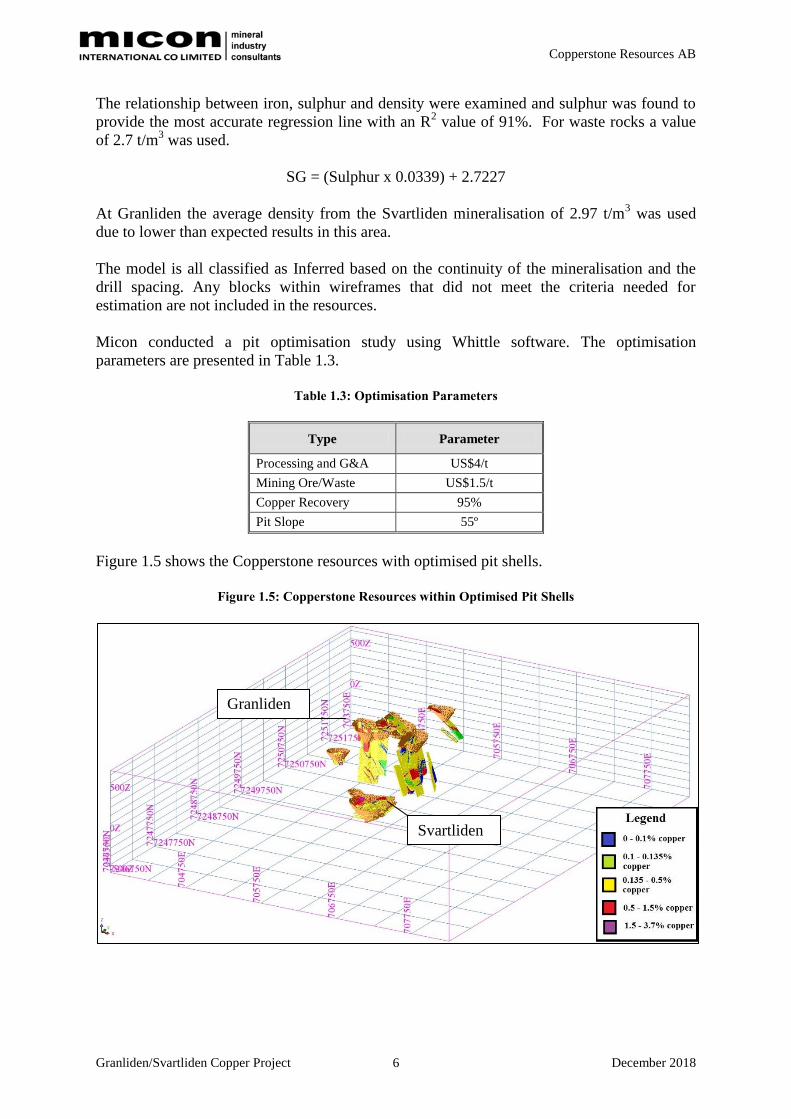
Figure 1.5 shows the Copperstone resources with optimised pit shells.
Figure 1.5: Copperstone Resources within Optimised Pit Shells
Granliden
Svartliden

Copperstone Resources AB
Granliden/Svartliden Copper Project December 2018 7
Table 1.4 contains the Copperstone Inferred Resources.
Table 1.4: Copperstone Inferred Resources
In Pit Resources with 0.1%
Copper Mining Cut-Off Applied
Tonnage
(Mt)
SG
(t/m3)
Cu
(%)
Ag
(g/t)
Au
(g/t)
Zn
(%)
Cu
Metal
(kt)
Ag
Metal
(koz)
Au
Metal
(koz)
Zn
Metal
(kt)
Granliden Inferred Resource 16.92 3.0 0.44 3.65 0.07 - 74.9 2,000 36.4 -
Svartliden Inferred Resource 9.43 3.0 0.42 9.76 0.12 0.34 39.1 3,000 35.2 32.4
Total Inferred Resources 26.35 3.0 0.43 5.90 0.08 0.12 114.0 5,000 71.60 32.4
Notes:
1. There are reasonable prospects for eventual economic extraction under assumptions of a copper price of US$6,200/t; with
employment of conventional open-pit mining methods, and processing costs (including G & A) of US$4/tonne. Mining
costs are assumed at US$1.5/t ore/waste.
2. Optimised pit shell includes a 5% allowance for hangingwall and footwall contact boundary loss and dilution as well as a
mining recovery of 95%. A processing metal recovery of 95% is also assumed and pit slopes are set to 55º with a strip ratio
of 4.71. These have not been applied to the reported mineral resources.
3. All resources are compliant with the PERC Code (2017).
4. Mineral resources are reported inclusive of mineral reserves.
5. Rounding as required by reporting guidelines may result in apparent summation differences between tonnes, grade and
contained metal content.

Copperstone Resources AB
Granliden/Svartliden Copper Project December 2018 8
2.0 EXPLORATION TARGET POTENTIAL
Micon considered the exploration target potential for Granliden. A wireframe model
inclusive of the Inferred Resources was constructed with a tonnage of 235 Mt. Micon
considers the exploration target potential for the Copperstone Project to be in the range of
150 Mt to 210 Mt in the areas with existing drilling, in addition to the Inferred Resource.
This material is likely to range in grade from 0.25% copper to 0.45% copper. These
estimated numbers represent exploration targets and the potential quantity and grade is
conceptual in nature and it is uncertain if further exploration will result in the estimation of a
Mineral Resource.
Figure 2.1 presents an isometric view of the exploration target potential wireframes.
Figure 2.1: Isometric View of Exploration Target Potential Wireframes
Copperstone Resources AB
Granliden/Svartliden Copper Project December 2018 9
3.0 RECOMMENDATIONS
1 Micon recommends twinning selected drill holes for verification purposes at
Granliden and Svartliden.
2 Micon recommends limiting the 2019 drilling to a maximum depth of 350 m in order
to target material with potential for extraction by open pit mining methods.
3 Micon recommends assaying unsampled intervals that fall within the current
wireframes.
4 Micon recommends infill drilling at Granliden East.
5 New drilling targets must also be identified to expand the resources at Granliden.

Copperstone Resources AB
Granliden/Svartliden Copper Project December 2018 10
4.0 DATE AND SIGNATURE PAGE
As author of this report entitled “Memo Report Resource Statement for the Granliden/Svartliden
Copper Deposits, Norrbotten County , Sweden”, dated 20th December 2018 (“Memo Report”), I,
Robin James Bernau, do hereby certify that:
1. I am employed as a Senior Geologist by, and carried out this assignment for, Micon
International Co Limited, Suite 10, Keswick Hall, Norwich, United Kingdom. tel. 0044(1603)
501 501, e-mail [email protected];
2. I hold the following academic qualification:
M.Geol. Applied Geology University of Leicester, United Kingdom, 2003;
Ph.D. Geology University of Southampton, United Kingdom, 2007;
3. I am a member of the Australasian Institute of Mining and Metallurgy (AusIMM) and a
Chartered Professional (CP), Membership No. 314651.
4. I have worked as a geologist in the minerals industry for 14 years in the mining industry in
Africa, Europe and United Kingdom;
5. I do, by reason of education, experience and professional registration, fulfil the requirements of
a Qualified Person as defined by the PERC Code (2017);
6. I visited the property that is the subject of this Technical Report from 29th October to the
1st November 2018;
7. I am responsible for the preparation of this Memo Report;
8. I am independent of Copperstone Resources AB, their directors, senior management, and other
advisers, I have had no previous involvement with the property;
9. I have read the PERC Code (2017) and this report for which I am responsible have been
prepared in compliance with the instrument;
10. As of the date of this certificate to the best of my knowledge, information and belief, this
Memo Report for which I am responsible contains all scientific and technical information that
is required to be disclosed to make this report not misleading.
Dated this 20th day of December 2018
Dr Robin J Bernau, M.Geol., Ph.D., AUSIMM(CP), (#314651)
Senior Geologist,
Micon International Co Limited

Copperstone Resources AB
Granliden/Svartliden Copper Project December 2018 11
5.0 APPENDIX 1 – LIST OF DRILL HOLES INCLUDED IN ESTIMATE
Hole ID Easting Northing Elevation Azimuth Dip Max
Depth Company Project Mineralisation Depths (m)
BH1 706,407 7,248,309 425 142 -50 67.9 Boliden Svartliden Project 44 - 62.34;
BH3 706,280 7,248,294 424 223 -50 139.1 Boliden Svartliden Project 79 - 111.5; 132.55 - 139.07;
BH4 706,264 7,248,166 424 160 -50 111.1 Boliden Svartliden Project 37.15 - 70.35; 97.1 - 103.8;
BH5 706,254 7,248,263 426 222 -50 109.1 Boliden Svartliden Project 24.2 - 54.4; 82.4 - 105.8;
BH7 706,167 7,248,226 429 38 -46 84.2 Boliden Svartliden Project 40.35 - 84.15;
BH8 706,244 7,248,193 424 69 -50 115.0 Boliden Svartliden Project 99.02 - 105.72;
BH9 705,922 7,248,369 444 96 -50 98.8 Boliden Svartliden Project 63.05 - 70.26;
BH11 706,444 7,248,329 426 140 -45 82.9 Boliden Svartliden Project 10.5 - 50.84; 67.61 - 82.86;
BH12 706,496 7,248,357 420 140 -46 60.5 Boliden Svartliden Project 6.4 - 21.06;
BH13 706,533 7,248,374 416 139 -50 61.0 Boliden Svartliden Project 15.7 - 22.12;
BH14 706,230 7,248,143 426 158 -50 127.9 Boliden Svartliden Project 102.81 - 127.9;
BH15 706,268 7,248,157 424 86 -50 76.1 Boliden Svartliden Project 35.04 - 76.13;
BH16 706,197 7,248,237 429 49 -50 66.6 Boliden Svartliden Project 24.33 - 66.56;
BH17 706,233 7,248,213 426 33 -45 70.9 Boliden Svartliden Project 32.5 - 42.74; 59.27 - 70.91;
BH18 706,101 7,248,272 435 39 -50 118.6 Boliden Svartliden Project 96.15 - 103.4;
BH19 706,124 7,248,164 430 34 -50 201.4 Boliden Svartliden Project 66.75 - 79.5;
BH25 706,200 7,248,152 426 28 -58 174.7 Boliden Svartliden Project 45.85 - 56.25; 133.21 - 153.2;
BH26 706,418 7,248,359 423 134 -48 199.8 Boliden Svartliden Project 33.6 - 52.1; 60.1 - 67.3; 89.06 -
117.9; 182 - 199.8;
BH28 705,259 7,249,401 435 156 -50 145.3 Boliden Central Project 53.08 - 66.59; 94.1 - 110.25;
BH29 705,258 7,249,431 435 154 -57 197.2 Boliden Central Project 107.68 - 113.68; 128.82 - 197.17;
BH30 705,230 7,249,377 436 147 -61 126.1 Boliden Central Project 58.14 - 126.1;
BH31 705,294 7,249,422 434 142 -50 103.0 Boliden Central Project 52.7 - 62.4;
BH47 705,441 7,250,126 484 177 -50 103.1 Boliden Granliden Hill 19.2 - 45.35;
BH52 705,206 7,249,361 436 147 -49 103.0 Boliden Central Project 60.65 - 71.05;
BH53 705,196 7,249,359 436 177 -46 101.5 Boliden Central Project 75.7 - 101.5;
BH56 705,283 7,249,453 434 144 -58 130.3 Boliden Central Project 114.85 - 130.3;
BH63 705,158 7,250,197 504 182 -50 80.0 Boliden Granliden Hill 38.8 - 49.05;
BH64 705,375 7,250,294 488 178 -50 100.0 Boliden Granliden Hill 12.65 - 30.35; 48 - 100;
BH65 705,534 7,250,319 472 174 -46 80.5 Boliden Granliden Hill 20 - 80.5;
BH77 705,946 7,248,723 423 180 -50 81.2 Boliden Central Project 45.85 - 81.2;
BH78 705,984 7,248,784 418 180 -50 158.7 Boliden Central Project 45.75 - 51.05;
BH81 705,335 7,250,303 491 178 -50 101.9 Boliden Granliden Hill 55.85 - 61.9;
BH85 705,395 7,250,289 486 185 -45 101.5 Boliden Granliden Hill 32.2 - 79.5;
BH86 705,427 7,250,248 485 174 -44 93.3 Boliden Granliden Hill 72 - 82;
BH87 705,435 7,250,306 482 182 -50 105.0 Boliden Granliden Hill 11.65 - 75.15;
BH88 705,336 7,250,273 492 178 -50 106.6 Boliden Granliden Hill 31.4 - 51.5; 82.9 - 106.6;
BH89 705,381 7,250,104 487 178 -47 97.9 Boliden Granliden Hill 28 - 71.5;
BH91 705,474 7,250,317 477 177 -44 100.1 Boliden Granliden Hill 10 - 68; 86 - 94;
BH92 705,374 7,250,324 488 183 -46 202.7 Boliden Granliden Hill 14 - 19; 45.7 - 120.95; 185.3 -
202.7;
BH93 705,296 7,250,261 497 176 -45 109.9 Boliden Granliden Hill 22 - 72;
BH97 705,355 7,250,303 490 182 -58 180.8 Boliden Granliden Hill 19.3 - 46.55; 63.75 - 88.6;
BH101 705,219 7,250,169 502 178 -43 121.9 Boliden Granliden Hill 26 - 121.9;
BH102 705,098 7,250,215 506 183 -44 152.4 Boliden Granliden Hill 46 - 66;
BH104 705,129 7,250,186 506 185 -47 81.1 Boliden Granliden Hill 15 - 81.11;
COS04201 705,253 7,250,062 488 358 -50 101.0 Lundin Granliden Hill 12.3 - 44.2; 81.95 - 101.01;
COS04202 705,543 7,250,370 471 159 -27 142.7 Lundin Granliden Hill 45.05 - 142.7;
COS04203 705,340 7,250,503 504 179 -49 150.0 Lundin Granliden Hill 20.1 - 74.22;
COS04205 705,856 7,249,804 446 179 -55 131.6 Lundin Granliden Hill 23.9 - 33.4; 115.4 - 121.8;
COS04206 706,100 7,248,384 433 180 -53 121.8 Lundin Svartliden Project 84.85 - 121.8;
COS04207 706,310 7,248,038 420 0 -52 269.7 Lundin Svartliden Project 140.1 - 153.1; 220.55 - 243.5;
COS04208 706,610 7,247,992 413 3 -51 67.4 Lundin Svartliden Project 27.05 - 67.35;
COS04209 706,608 7,248,072 421 178 -53 181.8 Lundin Svartliden Project 33.1 - 80;
COS04210 706,604 7,247,793 404 359 -55 110.3 Lundin Eva Project 16.7 - 32.5;
COS05212 706,606 7,248,136 431 180 -52 131.5 Lundin Svartliden Project 9.1 - 39.85; 77.3 - 85;
COS05214 706,530 7,247,719 400 359 -50 109.9 Lundin Eva Project 18.2 - 41.75;
COS05215 705,254 7,250,037 486 359 -55 80.3 Lundin Granliden Hill 18.65 - 62.6;
COS05216 705,255 7,250,012 483 359 -55 65.4 Lundin Granliden Hill 13.65 - 34.55; 41.4 - 49.2;
COS05217 705,252 7,250,087 494 1 -39 82.5 Lundin Granliden Hill 7.6 - 48; 65.25 - 82.5;
COS05218 705,542 7,250,395 474 184 -52 100.8 Lundin Granliden Hill 39.4 - 46.4; 77.2 - 100.8;
COS05219 705,303 7,250,057 491 1 -52 62.4 Lundin Granliden Hill 7.3 - 62.4;
COS05220 705,204 7,250,054 480 359 -55 59.2 Lundin Granliden Hill 27.6 - 59.2;
COS05221 705,493 7,250,369 479 198 -44 76.8 Lundin Granliden Hill 14.6 - 76.8;
COS05222 706,529 7,247,612 396 359 -50 107.0 Lundin Eva Project 30.8 - 107;
COS05223 706,526 7,247,551 384 4 -51 152.2 Lundin Eva Project 38.82 - 52.05; 102.85 - 111.3;
COS05224 706,527 7,247,502 380 359 -50 190.6 Lundin Eva Project 60.46 - 69.95;
COS05225 706,532 7,247,670 396 359 -50 140.0 Lundin Eva Project 21.25 - 47.95;
COS05226 706,533 7,247,222 374 359 -90 341.6 Lundin Eva Project 207 - 212.1;
COS05228 706,529 7,247,451 379 355 -51 191.0 Lundin Eva Project 82.17 - 110.67;
COS05230 706,531 7,247,401 378 356 -59 203.0 Lundin Eva Project 85.7 - 111.65;
COS05233 706,581 7,247,402 377 360 -74 137.1 Lundin Eva Project 87.74 - 117.9;
COS05234 706,583 7,247,351 377 358 -75 133.4 Lundin Eva Project 95.6 - 108.3;
COS05235 706,629 7,247,403 377 2 -74 203.2 Lundin Eva Project 125.55 - 147.35;
COS05239 706,630 7,247,353 377 4 -73 215.1 Lundin Eva Project 153.65 - 215.1;
COS05240 706,480 7,247,448 379 342 -68 125.2 Lundin Eva Project 70.75 - 92.73;

Copperstone Resources AB
Granliden/Svartliden Copper Project December 2018 12
Appendix 1. List of Drill Holes included in Estimate (continued)
Hole ID Easting Northing Elevation Azimuth Dip Max
Depth Company Project Mineralisation Depths (m)
COS05243 706,680 7,247,305 377 355 -75 239.7 Lundin Eva Project 140.6 - 146.25; 163.63 - 175.9;
195.9 - 239.7;
COS05246 706,576 7,247,673 396 359 -75 82.6 Lundin Eva Project 15.2 - 34.95;
COS05248 706,477 7,247,499 380 354 -74 116.1 Lundin Eva Project 73.17 - 103.15;
COS05249 706,576 7,247,551 386 353 -75 92.9 Lundin Eva Project 60.3 - 65.9;
COS05250 706,476 7,247,549 382 350 -75 116.7 Lundin Eva Project 56.45 - 116.7;
COS05252 706,473 7,247,609 387 359 -75 121.8 Lundin Eva Project 16.2 - 67.25;
COS05253 706,580 7,247,449 379 2 -72 125.9 Lundin Eva Project 85.85 - 98;
COS05254 706,471 7,247,658 390 341 -69 83.1 Lundin Eva Project 12.1 - 17.18; 31.35 - 37.7;
COS05255 706,426 7,247,521 382 357 -71 110.3 Lundin Eva Project 23.88 - 41.85; 62.15 - 87.9;
COS05256 706,423 7,247,569 388 359 -75 72.8 Lundin Eva Project 23.8 - 57.1;
COS05259 706,576 7,247,697 397 359 -75 68.8 Lundin Eva Project 20 - 68.8;
COS05261 706,570 7,247,710 397 354 -75 80.2 Lundin Eva Project 15.7 - 34.1;
COS05267 706,624 7,247,725 400 359 -75 59.8 Lundin Eva Project 24.1 - 29.13;
COS05271 706,605 7,248,166 435 1 -57 154.7 Lundin Svartliden Project 58.9 - 77.5;
COS05277 706,557 7,248,100 416 355 -77 72.7 Lundin Svartliden Project 18.7 - 25.6;
COS05278 706,404 7,248,210 421 2 -74 248.5 Lundin Svartliden Project 64.75 - 73.55; 174.4 - 208.5;
COS05280 705,284 7,249,025 428 183 -60 107.2 Lundin Central Project 32.55 - 41.7;
COS05282 706,407 7,248,111 421 353 -74 226.1 Lundin Svartliden Project 73.9 - 89.7; 120.7 - 126; 146.2 -
151.85;
COS05283 706,410 7,248,011 417 16 -72 299.3 Lundin Svartliden Project 69.55 - 117.8; 150.05 - 165.2;
201.5 - 235.55;
COS05284 706,399 7,248,377 416 170 -80 248.8 Lundin Svartliden Project 222.15 - 248.8;
COS05285 706,413 7,247,911 409 351 -74 237.1 Lundin Svartliden Project 191.5 - 202.23;
COS05288 706,021 7,247,710 397 359 -75 241.7 Lundin Svartliden Project 191.3 - 205;
COS05289 706,511 7,247,979 416 356 -53 238.2 Lundin Svartliden Project 28 - 74.75; 162.95 - 222.7;
COS06302 706,461 7,247,308 376 45 -75 118.6 Lundin Eva Project 57.9 - 63.65;
COS06311 706,199 7,248,404 428 179 -63 250.3 Lundin Svartliden Project 110.35 - 119.9;
COS06314 706,153 7,247,933 415 359 -58 219.8 Lundin Svartliden Project 27.4 - 36.6;
COS06316 706,506 7,248,123 418 358 -58 221.4 Lundin Svartliden Project 24.1 - 48.15; 83.8 - 151.9;
COS06318 706,480 7,248,168 420 358 -48 142.6 Lundin Svartliden Project 94 - 107.65;
COS06321 706,055 7,250,247 420 175 -75 461.6 Lundin Granliden Hill 439.6 - 461.6;
COS06330 705,261 7,250,073 490 226 -59 251.2 Lundin Granliden Hill 42.8 - 49.6; 90.1 - 102.45;
COS06331 706,055 7,249,897 426 264 -70 370.1 Lundin Granliden Hill 258.3 - 267.7; 290.6 - 370.1;
COS07334 706,054 7,250,446 418 229 -65 456.9 Lundin Granliden Hill 390 - 395.1;
COS07335 705,519 7,251,154 429 180 -65 205.0 Lundin Granliden Hill 21.4 - 31.25;
COS07336 705,717 7,251,282 421 185 -65 391.5 Lundin Granliden Hill 193 - 223; 295 - 309; 329 - 335;
351 - 373;
COS07339 706,410 7,248,011 417 91 -55 226.9 Lundin Svartliden Project 64.9 - 70.45; 122 - 133; 151 -
161; 165 - 177.9;
COS15340 705,402 7,250,260 488 316 -50 165.1 Copperstone Granliden Hill 18 - 31; 53 - 78; 121 - 162;
COS15341 705,447 7,250,283 483 307 -50 154.0 Copperstone Granliden Hill 10 - 39;
COS15342 705,353 7,250,241 492 312 -48 150.0 Copperstone Granliden Hill 32 - 83;
COS15343 705,292 7,249,337 436 291 -50 150.0 Copperstone Central Project 13 - 33; 57 - 68;
COS15344 705,349 7,249,367 435 288 -50 152.0 Copperstone Central Project 71 - 79;
COS15345 705,337 7,249,318 438 291 -60 182.5 Copperstone Central Project 62 - 100;
COS15346 705,288 7,249,281 437 292 -50 151.1 Copperstone Central Project 59 - 65;
COS15347 706,275 7,248,191 425 312 -50 160.0 Copperstone Svartliden Project 73 - 78.9;
COS15348 706,276 7,248,190 425 29 -50 135.5 Copperstone Svartliden Project 24 - 59.1;
COS16349 706,556 7,248,060 414 118 -45 150.0 Copperstone Svartliden Project 27.2 - 86;
COS16350 706,465 7,248,092 420 112 -45 211.3 Copperstone Svartliden Project 43 - 50; 82.1 - 114.2;
COS16351 706,401 7,248,116 421 112 -45 180.7 Copperstone Svartliden Project 33 - 45.1; 110.55 - 122;
COS16352 706,345 7,248,136 422 112 -45 299.5 Copperstone Svartliden Project 169 - 213; 238.5 - 245;
COS17353 706,604 7,247,813 405 20 -70 1166.0 Copperstone Eva Project 768 - 782; 794 - 801;
COS17355 706,626 7,247,817 406 200 -85 864.0 Copperstone Eva Project 13 - 19;
COS18358 705,293 7,249,687 435 - -55 843.0 Copperstone Granliden Hill 674 - 687.5;
COS18359 705,847 7,250,062 446 270 -55 878.0 Copperstone Granliden Hill 65 - 85; 559 - 583; 744 - 826;
COS18360 706,115 7,250,050 424 270 -60 802.7 Copperstone Granliden Hill 376 - 425; 465 - 483; 547 -
556.25; 579 - 595;
COS18361 705,613 7,250,077 464 270 -55 785.7 Copperstone Granliden Hill 20.15 - 42; 124 - 130; 222 -
274.5; 462 - 484; 763 - 775;
COS18362 705,785 7,249,867 450 90 -70 803.5 Copperstone Granliden Hill 57.3 - 70.55; 105.6 - 125; 289 -
341; 394 - 402; 505.2 - 525;
COS18363 706,004 7,249,858 434 270 -70 768.1 Copperstone Granliden Hill 448 - 460;
COS18364 706,011 7,250,262 423 270 -60 663.8 Copperstone Granliden Hill 315 - 354; 382 - 418;

Copperstone Resources AB
Granliden/Svartliden Copper Project December 2018 13
6.0 APPENDIX 2 - PERC CODE TABLE 1
PERC Code, 2017 Edition – Table 1 Part 1 – General
Assessment Criteria Explanation Commentary
Purpose of Report
(i) The report should include a title page and
Table of Contents, including figures and tables.
(ii)State for whom the report was prepared,
whether it was intended as a full or partial
evaluation or other purpose, what work was
conducted, effective date of report, and what
work remains to be done.
(iii)The Competent Person should state whether
the document is PERC compliant. If a reporting
standard or code, other than PERC has been
used, The Competent Person should include an
explanation of the difference.
This Memo Report includes a title page and Table of
Contents and includes figures and tables.
This report was completed for Copperstone
Resources AB.
The effective date of this report is 20th
December
2018.
This report is PERC compliant.
Project Outline Brief description of scope of project (i.e. whether
in preliminary sampling, advanced exploration,
conceptual, pre-feasibility, or feasibility phase,
Life of Mine plan for an ongoing mining
operation or closure). This should include a
description of the geological setting, deposit
type, commodity, project area, background, and
business arrangement.
Brief description of key technical factors that
have been considered.
Brief description of mining, processing and other
key technical factors.
The objective of the work was to prepare a PERC
Compliant Mineral Resource Statement for the
Granliden/Svartliden copper deposits that
incorporates the results of the latest drilling and
geological interpretation.
History (i) State historical background to the project
and/or adjacent areas concerned, including
known results of previous exploration and/or
mining activities (type, quantity and development
work), prior ownership and changes thereto.
(ii) Reference all information used from other
sources.
(i) Discuss known or existing historical Mineral
Resource estimates and reconciliations of
reported resources/ reserves and actual
production for past and current operations,
including the reliability of these and how they
relate to the PERC Standard.
(ii) Previous successes or failures should be
referred to transparently with reasons why the
project should now be considered potentially
economic.
(i) Discuss known or existing historical Mineral
Reserve estimates and performance statistics to
actual production for past and current
operations, including the reliability of these and
how they relate to the PERC Standard.
The Granliden/Svartliden project is only at the
exploration stage.
Drilling on the property commenced in 1952 by
Boliden Mining AB. Records show that only a single
drill hole was placed adjacent to two very old surface
trenches. There is no information for these two
trenches. One trench did not reach sub-outcrop below
the till.
From 1971 until 1978, Boliden Mining AB then
drilled a total of 109 AQ cored drill holes across the
property (approximately 12,168m). Drill holes were
concentrated on Svartliden k No.1 (called
“Svartliden” by Copperstone), Sandberget 200 (called
“Granliden South” by Copperstone) and Sandberget
300 (called “Granliden Hill” by Copperstone).
A total of 53 of these Boliden drill holes have been
re-logged and sampled by Copperstone.
From 1998 North Atlantic Natural Resources
(NANR) was established as a listed JV Company
between Lundin Mining AB and Boliden Mining AB.
From 1998 until 2004 NANR carried out significant
airborne and ground geophysics.
From 2004 until 2007 NANR drilled a further 138
drill holes (21,717 m) from 2004 until 2007. Much of
this drilling was positioned on shallow magnetic
anomalies and also led to the discovery of the Eva
massive sulphide occurrence south of Svartliden k
No.1.

Copperstone Resources AB
Granliden/Svartliden Copper Project December 2018 14
Assessment Criteria Explanation Commentary
Since Oct 2015 until present Copperstone has drilled
a total of 26 drill holes (12,469 m).
In 2015, a total of 9 inclined drill holes (1,400 m) to a
maximum drilled length of 150 m were completed on
Sandberget 200, 300 and Svartliden k No.1.
In 2016 a further 4 drill holes (840 m) were
completed on Svartliden k No.1 (fence line F1).
In 2017 a fan of three (3) deep drill holes (total
2,611 m) were drilled between Svartliden and Eva
mineralisation in order to probe for a causative
intrusive.
In 2018 Copperstone completed 10 deep drill holes
(7,615 m) around the Granliden area to test magnetic
and conductive geophysical anomalies and to start
creating a broad grid to define the lateral extent of
chalcopyrite mineralisation.
Key Plan, Maps and
Diagrams
(i) Include and reference a location or index map
and more detailed maps showing all important
features described in the text, including all
relevant cadastral and other infrastructure
features. If adjacent or nearby properties have
an important bearing to the report, then their
location and common mineralised structures
should be included on the maps. Reference all
information used from other sources. All maps,
plans and sections noted in this checklist, should
be legible, and include a legend, coordinates,
coordinate system,, scale bar and north arrow.
(ii) Diagrams or illustrations should be legible,
annotated and explained where necessary
Plans, maps and diagrams have been included in this
Memo Report.
Project Location
and Description
(i) Description of location (country, province,
and closest town/city, coordinate systems and
ranges, etc.).
(ii) In respect of each property, diagrams, maps
and plans should be supplied demonstrating the
location of prospecting/mining rights, any
historical and current workings, any exploration,
and all principal geological features.
The Granliden/Svartliden copper deposits are located
near Arvidsjaur in Norrbotten County, Sweden.
The project is only at the exploration stage.
Topography and
Climate
(i) All relevant issues relating to the mineral
project, such as the topography and climate,
noting any conditions that may affect possible
mining activities should be stated.
(ii) A general topo-cadastral map should be
available to support the above statement.
(i) Topo-cadastral map in sufficient detail to
support the assessment of eventual economics.
Known associated climatic risks should be
stated.
(i) Detailed topo-cadastral map. Where
applicable aerial surveys should be checked with
ground controls and surveys, particularly in
areas of rugged terrain, dense vegetation and/or
high altitude.
The topography is relatively flat and boggy
morphology. The elevation in the property area varies
between 425 m and 510 m above sea level.
Arvidsjaur has a subarctic climate which borders on a
continental climate with short, mild to warm
summers and long, cold, snowy winters.
Copperstone Resources AB
Granliden/Svartliden Copper Project December 2018 15
Assessment Criteria Explanation Commentary
Geology Description of the nature, detail, and reliability
of geological information (rock types, structure,
alteration, mineralisation, and relation to known
mineralised zones, etc.). Description of
geophysical and geochemical data. Reliable
geological maps and cross sections should exist
to support interpretations.
The Copperstone exploration project is situated to the
north of the famous mining district of the Skellefte-
field and within the Norrbotten province of northern
Sweden.
Regional geology consists of deformed and
metamorphosed palaeo-Proterozoic felsic to mafic
volcanics, subordinate volcanoclastic sediments of
the Skellefteå Group intruded by a wide range of
granitic intrusives related to the 1.8 Ga to 1.7 Ga
Sveccofenian orogenic event.
On a district scale the property is bound to the east by
the zoned Jörn batholith, to the south by the Gallejaur
granite-gabbro complex and to the north by sub-aerial
volcanics of the Arvidsjaur Group.
The dominant structural trend in the region is a
broadly defined WNW-ESE trending brittle s-c shear
fabric.
The property geology consists of southwest dipping
(10º to 40º) stratigraphy ranging from lower siliceous
pyroclastics (vitric tuff), overlain by 1 m to 10 m
thick stacked turbidite flows with discontinuous
lacustrinal mudstones and siltstones, and capped by
amygdaloidal andesitic lava flows. Southwards the
lava flows are overlain by crystal and vitric
pyroclastic tuff units. These units are thought to
represent intra-caldera deposits.
The meta-volcanic sequence is highly altered on a
broad scale with distinct sericite alteration (phyllic)
and chlorite-epidote-carbonate alteration zones
(propylitic). The cause for this alteration is not
understood yet.
Most copper mineralisation is associated with the
more altered geology.
Geophysical mapping of conductor zones has
identified a general boundary between the two
alteration styles, often demarcated by a local
abundance of pyrrhotite.
Property intrusives include a host of pre-, syn- and
post-alteration mafic sills /dykes, and a less altered
equigranular to weakly porphyritic calc-alkaline,
magnetite-bearing granitoid stock. This stock is
spatially related to the Granliden mineralisation and
forms an obvious magnetic body. The body is zoned
with possible fractionation leading to coarser grained
potassic zones.
Hematite alteration is common and there is no
mineralisation found within the body.
Irregular shaped bodies of coarse volcanoclastic
breccias are present in the Svartliden area, and could
be formed due to hydrothermal processes within the
most intense zones of phyllic alteration.
Mineralogy Describe the mineralogy of the deposit including
the distribution, quantity and other
characteristics of the important minerals.
Includes minor and gangue minerals where these
will have an effect on the processing steps.
Mineralisation styles on the property are complex and
range from thick lode-style bodies of massive pyrite
to discontinuous veins, veinlets of quartz-
chalcopyrite (sub mm to rarely >300 mm). The
former is interpreted to be of meteoric origins and
Copperstone Resources AB
Granliden/Svartliden Copper Project December 2018 16
Assessment Criteria Explanation Commentary
Should indicate the variability of each important
mineral within the deposit.
early stage, often crosscut by younger unmineralised
mafic dykes. The latter is generally broad stockwork
zones of steep veining probably of magmatic origin,
of varying orientations and little to no pyrite present.
Arsenopyrite is ubiquitous and generally related to
elevated gold mineralisation. Localised spots of
bornite have also been found.
Pathfinder elements to copper mineralisation are
generally arsenic, antimony, cobalt, indium, tin,
selenium and tellurium.
Copper mineralisation is the primary metal of interest
at Granliden and copper-zinc mineralisation at
Svartliden.
Besides the recently discovered granite stock at
Granliden, other magnetic anomalies that trend
roughly north-south across the property represent the
pyrrhotite boundary common between phyllic and
propylitic styles of alteration.
At present Copperstone believes that the
mineralisation style is of hydrothermal origins and
related to emplacement of felsic stocks along
regionally important structural discontinuities. At this
stage the company has referred to this type as
“porphyry-style”. Significant work is still required to
prove the style an origin of mineralisation.
Mineral rights and
land ownership
Type, reference name/number, location and
ownership including agreements or material
issues with third parties such as joint ventures,
partnerships, historical sites, wilderness or
national park and environmental settings. In
particular the security of the tenure held at the
time of reporting along with any known
impediments to obtaining a licence to operate in
the area. Location plans of mineral rights and
titles. It is not expected that the description of
mineral title in a technical report should be a
legal opinion, but should be a brief and clear
description of such title as understood by the
author.
At the time of reporting Copperstone Resources AB
owns the following exploitation concessions:
Svartliden k No.1 (36 ha) valid until December 2025
and Eva k No. 1 (34 ha) valid until November 2042.
The Company also owns the following exploration
permits: Sandberget 200 (19 ha) and Sandberget 300
(19 ha) both valid until October 2022. On 28th
September 2018 the Company applied for two new
exploration permits: Sandberget 400 (535 ha) which
forms a roughly 1 km buffer zone around the recently
awarded Eva k No.1 exploitation concession, and
Sandberget 500 (7,641 ha) which contains all the
above.
Sandberget 500 application excludes a small nature
reserve that is not affecting the area of exploration.
The company has good relations with the local Sami
Village (Mausjaur) and the local forestry company
(Sveaskog) that is the major landowner of the area
under exploration.
In November 2018 the Inspector of Mines approved
dispensation from 1 year prohibition for S400 and
S500 and the two applications are currently being
processed.
It is reasonable to assume that Copperstone will
receive the two applied exploration permits in early
2019.
All existing concessions, permits and applications
will form a contiguous block.
There are no exploration / mining neighbours.

Copperstone Resources AB
Granliden/Svartliden Copper Project December 2018 17
Assessment Criteria Explanation Commentary
Legal Aspects and
Tenure
The legal tenure should be verified to the
satisfaction of the Competent Person, including a
description of:
(i) The nature of the issuer’s rights (e.g.
prospecting and/or mining) and the right to use
the surface of the properties to which these rights
relate;
(ii) The principal terms and conditions of all
existing agreements, and details of those still to
be obtained, (such as, but not limited to,
concessions, partnerships, joint ventures, access
rights, leases, historical and cultural sites,
wilderness or national park and environmental
settings, royalties, consents, permission, permits
or authorizations;
(iii) The security of the tenure held at the time of
reporting or which is reasonably expected to be
granted in the future along with any known
impediments to obtaining the right to operate in
the area; and,
(iv) A statement of any legal proceedings that
may have an influence on the rights to prospect
for minerals, or an appropriate negative
statement.
Micon understands that at the time of reporting
Copperstone Resources AB do not hold the permits
for the Mineral Resources reported in this statement.
However, under the PERC code (2017), resources
maybe reported as long as the ‘security of the tenure
held at the time of reporting or which is reasonably
expected to be granted in the future along with any
known impediments to obtaining the right to operate
in the area. Micon considers Copperstone to meet
this requirement.
Micon has not undertaken any legal due diligence of
the asset portfolio associated with the Granliden /
Svartliden copper project and does not present any
legal opinion regarding the corresponding ownership
or title.
See also ‘Mineral rights and land ownership’.
Licences and
Permits
The status of titles and approvals critical to the
economic viability of the project, such as mining
leases, development permits, discharge permits
and governmental approval. Description of the
environment and of anticipated liabilities.
Location plans for mineral rights and titles.
At the time of reporting Copperstone Resources AB
owns the following exploitation concessions:
Svartliden k No.1 (36 ha) valid until December 2025;
and,
Eva k No. 1 (34 ha) valid until November 2042.
The Company also owns the following exploration
permits:
Sandberget 200 (19 ha); and,
Sandberget 300 (19 ha)
Both valid until October 2022.
Personal
introduction into
projects and
verification of the
data
(i) Date of visit(s)
(i) Meetings with key persons responsible for the
project which is being reported upon, defining
their responsible fields and experience relevant
to the project.
(ii) Visit to project area resulting in a report
itemising significant observations
(iv) What parts of the project were available for
personal verification.
(v) List of data used or cited in preparation of the
Public Report.
A site visit by Micon CP, Dr Bernau was undertaken
on 31st October 2018.

Copperstone Resources AB
Granliden/Svartliden Copper Project December 2018 18
PERC Code, 2017 Edition – Table 1 Part 2 - Sampling Techniques and Data
Assessment Criteria Explanation Commentary
Type(s) of sampling
The type of sampling and its location, which will
give rise to the results being reported, should be
stated. Types of sampling include stream
sediment, soil and heavy mineral concentrate
samples, trenching and pitting, rock chip and
channel sampling, drilling, auger etc. Examples
of locations include old workings, mine dumps
etc. Wherever possible the spacing of such
samples should be stated, and locations shown
on coordinated maps, plans and sections at
suitable scales.
All samples for assay have been derived from solid
drill core. There is no other form of sampling
throughout the history of exploration on this
property.
Exploration has been carried out by Boliden Mining
AB (1952-1978), Lundin Mining AB / North
Atlantic Natural Resources AB (1998-2007) and
Copperstone Resources AB, formerly Kopparberg
Mineral AB (2012 to present).
For Copperstone exploration activities, all core
boxes were delivered by the Drill Contractor to a
secure Copperstone Site Office 1km from the drill
site. Before transport to Malå, preliminary
inspection and basic logging is carried out by
Copperstone personnel.
Core was logged in detail at the Copperstone
Facility in Malå before zones for sampling were
selected. Once sampling zones were identified and
ticketed core boxes are then collected for laboratory
analysis.
Logging included core recovery, RQD and
magnetic susceptibility.
Sampling was based on half-core samples, with
sampling range taken well beyond the visual zones
of mineralisation.
Where historic drilling had limited sampling,
extensive infill sampling has been carried out by
Copperstone to ensure all zones of mineralisation
have been fully sampled.
Drilling techniques Drilling techniques may include core, reverse
circulation, percussion, rotary auger, down-the-
hole hammer, etc. These should be stated and
details (e.g. core diameter) provided. Measures
taken to maximise sample recovery and ensure
representative nature of the samples should be
stated.
Inclined diamond core drilling of various core
diameters ranging from Boliden (35.5 mm AQ2),
NANR (40.7 mm BQ2) and Copperstone (50.6 mm
NQ2).
Select drill holes (64) from NANR and CS drill
campaigns were probed (2013-2017) with a down-
hole Optical Televiewer system (OPTV) to generate
planar structural data. Inhole magnetic susceptibility
and Induced Polarisation data was also gathered at
the same time.
Drill sample
recovery
Whether sample recoveries have been properly
recorded and results assessed should be
disclosed. In particular the report should state
whether a relationship exists between sample
recovery and grade or quality and sample bias
(e.g. preferential loss/gain of fine/coarse
material).
Most drill core samples for the entire project are
available and have been re-logged to check geology
and historic sampling intervals. During logging core
recovery was recorded. In general quality of drill
core is high (>95% recovery) with insignificant core
loss zones. All logging records have been captured
electronically and entered into a relational database.
There is no relationship between sample recovery
and grade.

Copperstone Resources AB
Granliden/Svartliden Copper Project December 2018 19
Assessment Criteria Explanation Commentary
Logging Whether samples have been logged to a level of
detail to support appropriate Mineral Resource
estimation, mining studies and metallurgical
studies should be confirmed, and whether
logging is qualitative or quantitative in nature
should be stated. Core (or trench, channel etc.)
photography should be included.
All drill cores available have been geologically
logged and summarised to form a coherent
classification of all lithotypes encountered.
13 drill holes (2017-2018 drill campaigns) have
been geotechnically logged to a record RQD values.
Geological logging has been linked to sample
geochemistry and plotted to check correct usage of
lithotype terminology.
All drill core boxes have been photographed.
For all Boliden and NANR drill holes, Copperstone
has all original detailed geological logs and related
assay reports.
Other sampling
techniques
Nature and quality of sampling (e.g. cut
channels, random chips etc.) and measures taken
to ensure sample representativity should be
stated. The precise location and unique
numbering of each sample should be provided by
reference to a coordinate system (which should
be stated).
Not applicable.
Sub-sampling
techniques and
sample preparation
For sampling from core, whether cut or sawn or
whether quarter, half or all core has been taken
in the course of sampling should be stated. If
non-core, whether riffled, tube sampled, rotary
split etc. and whether split wet or dry. For all
sample types, the nature, quality and
appropriateness of the sample preparation
technique should be described, together with
quality control procedures adopted for all sub-
sampling stages to maximise representativity of
samples.
Measures taken to ensure that the sampling is
representative of the in-situ material collected
should be stated. Whether sample sizes are
appropriate to the grain size of the material
being sampled should be described. A statement
as to the security measures taken to ensure
sample integrity is recommended
Boliden (1971-1978) carried out sampling by hand
splitting of drill core. NANR (2004-2007) and
Copperstone Resources (2015-2018) used standard
longitudinal diamond sawing.
Boliden and NANR carried out sample preparation
at their own facilities to industry standards at that
time.
All Copperstone sample preparation (sawing,
drying, crushing 70% <2 mm, splitting and
pulverizing 85% >75 µm) has been carried out at
ALS Minerals Laboratories, an accredited
laboratory based in Malå.
QAQC samples have been inserted by NANR, CS
and ALS (internal).
QAQC includes duplicates and blanks by NANR,
and duplicates, blanks and standards by CS inserted
at regular intervals in the sample order. No QAQC
samples were inserted by Boliden but check testing
with QAQC has been carried out by both NANR
and CS on Boliden drill cores.
Assay data and
laboratory
investigation
The nature, quality and appropriateness of the
assaying and laboratory procedures used and
whether the technique is considered partial or
total should be stated. Attention should also be
given to how presented assay results express the
assumed extractable content of the element.
Sample preparation and assaying may be carried
out by internal or independent laboratories. The
laboratories actually used for this work should
be identified in any report. In any case, there
should be consideration given to the
accreditation of the laboratory (e.g. ISO
standards awarded such as ISO 9000:2001 and
ISO 17025) and to the actual procedures used at
all stages of sample preparation and analysis,
including the use of randomisation, internal and
Sample analysis by Copperstone: 4-acid digestion
followed by ICP finish (ME-MS61) for 49 elements,
including Ag, Cu and Zn. All samples with greater
than 10,000 ppm (1%) Cu and / or Zn are re-run with
4-acid digestion and then ICP-AES finish (Cu-OG62
and Zn-OG62) with results reported in percentage.
Gold values are determined with a 30 g fire assay
fusion with AAS finish (Au-AA23).
Sample analysis by NANR: ME-ICP61a for Au-
AA23 for gold. For Zn >1% ZN-AA62 and Cu >1%
Cu-AA05 Ag >500 ppm Ag-AA62 Au >10 ppm Au-
GRA21.
No XRF or other geophysical tools have been used to
derive any assay values.
Boliden: No QAQC samples submitted. NANR used
blanks and duplicates on both re-assay of Boliden

Copperstone Resources AB
Granliden/Svartliden Copper Project December 2018 20
Assessment Criteria Explanation Commentary
external standard samples, and blanks, as well as
monitoring procedures for systematic bias. In
particular, it should be noted whether analyses of
samples within the set used to support the
resource estimate have been replicated
independently in other laboratories.
For assaying on large sample sets for mineral
resource estimation, it is often appropriate to use
5 – 10 % of the samples for control purposes,
depending on the circumstances. Report the
methods of verification of assaying
drill cores and their own drill cores. Copperstone has
used blanks, standards and duplicates (1:20) for all
assay work. All QAQC records have been captured
into the database and have been examined using
appropriate graphing procedures.
All results are deemed to be acceptable in both
accuracy and precision.
Verification of
results
The verification of selected intersections by
either independent or alternative personnel is
recommended as is the use of twinned holes (a
hole as near as possible to a pre-existing hole to
make sure that it has the correct position and
geological interpretation), deflections or
duplicate samples.
Copperstone has checked all significant intercepts of
Boliden and NANR drill holes both through logging
of actual core and cross-checking old assay
certificates with database entries.
There are no twinned drill holes.
Copperstone has a general exploration protocol.
Primary data (logging information, laboratory
reports) is captured by an independent database
manager into an Access database stored on a
dedicated computer with a separate secure off-site
back-up.
Data location A statement is required regarding the accuracy
and quality of surveys used to locate drill holes
(collar and down-hole surveys), trenches, mine
workings and other locations. Quality and
adequacy of topographic control should be
described, and locality plans provided.
All collars have been physically found in the forest
and resurveyed by an Independent Contractor on
behalf of CS (collar XYZ, azimuth and dip) in
SWEREF 99TM.
Survey was carried out using an RTK-GPS survey
tool.
Copperstone acquired a detailed DTM for the
property.
Data density and
distribution
Data density for reporting of Exploration Results
should be described.
A statement should be included as to whether the
data density and distribution are sufficient to
establish the degree of geological and grade or
quality continuity appropriate for the Mineral
Resource and Mineral Reserve estimation
procedure and classifications applied, and
whether sample compositing has been applied.
Whether the orientation of sampling achieves
unbiased sampling of possible structures and the
extent to which this is known, considering the
deposit type should be stated
The data spacing is highly variable zones drilled at
25 m and other areas drilled on 200 m lines.
The data spacing is considered to be sufficient for
Inferred Resources.
No sample compositing undertaken before assaying.
2 m composites used during resource estimation.
Reporting Archives Documentation of primary data, data entry
procedures, data verification, data storage
(physical and electronic) for preparing the report
should be provided.
All original Boliden and NANR drill core samples
are stored at the SGU facility in Malå. All drilling
by Copperstone is stored firstly on site in a locked
fenced area and then transported to the Company’s
secure core logging / office in Malå. CS delivered
all samples directly to ALS prep lab less than 1km
away in Malå. At all times core and samples are
secure.
Audits or reviews The results of any audits or reviews of sampling
techniques and data should be presented and
discussed.
ALS prep lab was audited during site visit by Micon
CP. No issues identified that would have a material
effect on the resource.
Copperstone Resources AB
Granliden/Svartliden Copper Project December 2018 21
PERC Code, 2017 Edition – Table 1 Part 3 - Reporting of Exploration Results
Criteria Explanation Commentary
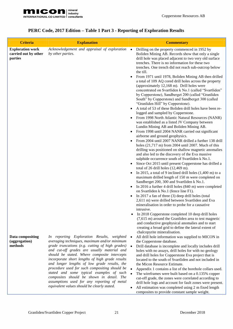
Exploration work
carried out by other
parties
Acknowledgement and appraisal of exploration
by other parties. Drilling on the property commenced in 1952 by
Boliden Mining AB. Records show that only a single
drill hole was placed adjacent to two very old surface
trenches. There is no information for these two
trenches. One trench did not reach sub-outcrop below
the till.
From 1971 until 1978, Boliden Mining AB then drilled
a total of 109 AQ cored drill holes across the property
(approximately 12,168 m). Drill holes were
concentrated on Svartliden k No.1 (called “Svartliden”
by Copperstone), Sandberget 200 (called “Granliden
South” by Copperstone) and Sandberget 300 (called
“Granliden Hill” by Copperstone).
A total of 53 of these Boliden drill holes have been re-
logged and sampled by Copperstone.
From 1998 North Atlantic Natural Resources (NANR)
was established as a listed JV Company between
Lundin Mining AB and Boliden Mining AB.
From 1998 until 2004 NANR carried out significant
airborne and ground geophysics.
From 2004 until 2007 NANR drilled a further 138 drill
holes (21,717 m) from 2004 until 2007. Much of this
drilling was positioned on shallow magnetic anomalies
and also led to the discovery of the Eva massive
sulphide occurrence south of Svartliden k No.1.
Since Oct 2015 until present Copperstone has drilled a
total of 26 drill holes (12,469 m).
In 2015, a total of 9 inclined drill holes (1,400 m) to a
maximum drilled length of 150 m were completed on
Sandberget 200, 300 and Svartliden k No.1.
In 2016 a further 4 drill holes (840 m) were completed
on Svartliden k No.1 (fence line F1).
In 2017 a fan of three (3) deep drill holes (total
2,611 m) were drilled between Svartliden and Eva
mineralisation in order to probe for a causative
intrusive.
In 2018 Copperstone completed 10 deep drill holes
(7,615 m) around the Granliden area to test magnetic
and conductive geophysical anomalies and to start
creating a broad grid to define the lateral extent of
chalcopyrite mineralisation.
Data compositing
(aggregation)
methods
In reporting Exploration Results, weighted
averaging techniques, maximum and/or minimum
grade truncations (e.g. cutting of high grades)
and cut-off grades are usually material and
should be stated. Where composite intercepts
incorporate short lengths of high grade results
and longer lengths of low grade results, the
procedure used for such compositing should be
stated and some typical examples of such
composites should be shown in detail. The
assumptions used for any reporting of metal
equivalent values should be clearly stated.
All drill hole information was supplied to MICON in
the Copperstone database.
Drill database is incomplete and locally includes drill
holes with no assays, drill holes for with no geology
and drill holes for Copperstone Eva project that is
located to the south of Svartliden and not included in
the Micon Resource Estimate.
Appendix 1 contains a list of the borehole collars used.
The wireframes were built based on a 0.135% copper
cut-off grade, the zones were correlated according to
drill hole logs and account for fault zones were present.
All estimation was completed using 2 m fixed length
composites to provide constant sample weight.

Copperstone Resources AB
Granliden/Svartliden Copper Project December 2018 22
Criteria Explanation Commentary
Relationship
between
mineralisation
widths and intercept
lengths
These relationships are particularly important in
the reporting of Exploration Results. If the
geometry of the mineralisation with respect to
the drill hole angle is known, its nature should be
reported. If it is not known and only the down-
hole lengths are reported, there should be a clear
statement to this effect (e.g. ‘down-hole length,
true width not known’).
Relationship between drill holes and mineralisation is
not known in most cases.
Some downhole orientation surveys have been carried
out.
Optical televiewer footage has been generated in parts
or all of 53 drill holes. Footage has been examined in
WellCAD software to generate structural data used for
building of wireframe interpretations supplied by
Copperstone.
Diagrams Where possible, maps, plans and sections (with
scales) and tabulations of intercepts should be
included for any material discovery being
reported in order to increase the clarity of the
reports
All boreholes intersecting the mineralisation were used
in the resource estimate (see Appendix 1).
Balanced reporting Where comprehensive reporting of all
Exploration Results is not practicable, the
summary description must include representative
reporting of both low and high grades and
intersections in order to avoid creating
unrealistic expectations.
Not applicable.
Other substantive
exploration data
Other exploration data, if meaningful and
material, should be reported including (but not
limited to): geological observations; geophysical
survey results; geochemical survey results; bulk
samples – size and method of treatment;
metallurgical test results; bulk density,
groundwater, geotechnical and rock
characteristics; moisture content; potential
deleterious or contaminating substances.
During the period of land tenure by Boliden Mining
AB, historical records show the following geophysical
fieldwork was carried out.
1928 – TURAM and magnetics. Date is unsure
1968 – Airborne EM and magnetics
1969 – SR and magnetics
1971 - Mise a la Masse, gravity, and ground HLEM
(Slingram)
1976 – VLF and Induced Polarisation (IP)
Copperstone does not have any records of these
geophysical surveys. It is obvious that sulphide
mineralisation found on the three areas of concentrated
Boliden drilling must have been located with these
geophysical survey results.
NANR carried out the following geophysical surveys.
1997 – Airborne EM (GEOTEM) and magnetics
1998 – Ground follow-up of the GEOTEM with HLEM
(Max-Min) and magnetics. Specifically, followed up
promising targets.
In addition, there are 5 ground EM surveys numbered
TEM 1,2,3,4 and 6. These surveys appear to date back
to 2005. Reference has been found to a system called
EMIGMA which may well have been what was used
for these surveys.
A series of gradient array IP surveys were also
undertaken in over a large area in 2005, or around then.
Dipole spacing was 50 m, with 25 m station spacing.
This is a quick reconnaissance IP technique which does
not see very deep, perhaps 30 m, so anything at depth
will have been missed. The survey covers much the
same area as the ground EM, but extends further to the
west over Granliden and to the west of Eva, and even
further north.
NANR drilled many of the geophysical anomalies
without much direct success, mainly due to the local
abundance of pyrrhotite perhaps.
Copperstone Resources AB
Granliden/Svartliden Copper Project December 2018 23
Criteria Explanation Commentary
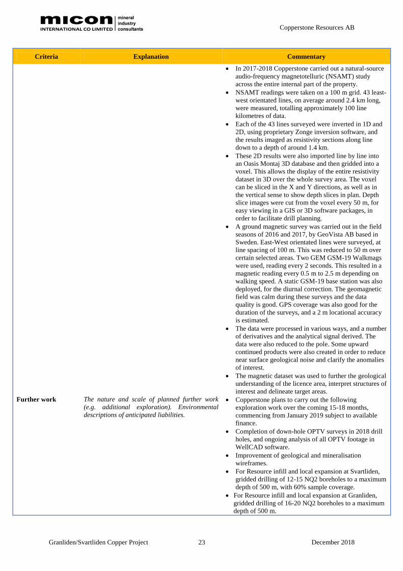
In 2017-2018 Copperstone carried out a natural-source
audio-frequency magnetotelluric (NSAMT) study
across the entire internal part of the property.
NSAMT readings were taken on a 100 m grid. 43 least-
west orientated lines, on average around 2.4 km long,
were measured, totalling approximately 100 line
kilometres of data.
Each of the 43 lines surveyed were inverted in 1D and
2D, using proprietary Zonge inversion software, and
the results imaged as resistivity sections along line
down to a depth of around 1.4 km.
These 2D results were also imported line by line into
an Oasis Montaj 3D database and then gridded into a
voxel. This allows the display of the entire resistivity
dataset in 3D over the whole survey area. The voxel
can be sliced in the X and Y directions, as well as in
the vertical sense to show depth slices in plan. Depth
slice images were cut from the voxel every 50 m, for
easy viewing in a GIS or 3D software packages, in
order to facilitate drill planning.
A ground magnetic survey was carried out in the field
seasons of 2016 and 2017, by GeoVista AB based in
Sweden. East-West orientated lines were surveyed, at
line spacing of 100 m. This was reduced to 50 m over
certain selected areas. Two GEM GSM-19 Walkmags
were used, reading every 2 seconds. This resulted in a
magnetic reading every 0.5 m to 2.5 m depending on
walking speed. A static GSM-19 base station was also
deployed, for the diurnal correction. The geomagnetic
field was calm during these surveys and the data
quality is good. GPS coverage was also good for the
duration of the surveys, and a 2 m locational accuracy
is estimated.
The data were processed in various ways, and a number
of derivatives and the analytical signal derived. The
data were also reduced to the pole. Some upward
continued products were also created in order to reduce
near surface geological noise and clarify the anomalies
of interest.
The magnetic dataset was used to further the geological
understanding of the licence area, interpret structures of
interest and delineate target areas.
Further work The nature and scale of planned further work
(e.g. additional exploration). Environmental
descriptions of anticipated liabilities.
Copperstone plans to carry out the following
exploration work over the coming 15-18 months,
commencing from January 2019 subject to available
finance.
Completion of down-hole OPTV surveys in 2018 drill
holes, and ongoing analysis of all OPTV footage in
WellCAD software.
Improvement of geological and mineralisation
wireframes.
For Resource infill and local expansion at Svartliden,
gridded drilling of 12-15 NQ2 boreholes to a maximum
depth of 500 m, with 60% sample coverage.
For Resource infill and local expansion at Granliden,
gridded drilling of 16-20 NQ2 boreholes to a maximum
depth of 500 m.

Copperstone Resources AB
Granliden/Svartliden Copper Project December 2018 24
Criteria Explanation Commentary
Drilling of 20 m x 800 m exploratory holes to the north
and south of Granliden to define the broader geology,
extent of mineralisation and scope of Exploration
Target.
Expansion and development of the Malå core logging
facility to handle up to 30,000 m of new drill cores.
To build a more comprehensive 3D geological model
and to understand the nature and style of this base-
precious metal system.

Copperstone Resources AB
Granliden/Svartliden Copper Project December 2018 25
PERC Code, 2017 Edition – Table 1 Part 4 - Estimation and Reporting of Mineral
Resources and Mineral Reserves
Criteria Explanation Commentary
Database integrity Measures taken to ensure that data has not
been corrupted by, for example, transcription
or keying errors, between its initial collection
and its use for Mineral Resource estimation
purposes. Data verification and/or validation
procedures used.
Data validated by automatic validation, and visual
inspection of graphical logs, plans and sections. All
errors are resolved.
Geological
interpretation
Description of geological model and inferences
made from this model. Discussion of sufficiency
of data density to assure continuity of
mineralisation and provide an adequate
database for the estimation procedure used.
Discussion of alternative interpretations and
their potential impact on the estimation
The Granliden mineralisation includes east-west
striking steeply dipping ore bodies; north-south
striking steeply dipping ore bodies and shallowly
northeast dipping orebodies.
The Svartliden mineralisation forms irregular tabular
orebodies that broadly dip to the northwest by 15º to
45º.
There is a small uncertainty in orebody geometry
locally due to drill hole spacing.
This is a limiting factor and is reflected in the Inferred
Resource category.
Plans and sections have been provided in attached
memo report.
Estimation and
modelling techniques
The nature and appropriateness of the
estimation techniques applied and key
assumptions, including treatment of extreme
grade values, domaining, compositing
(including by length and/or density),
interpolation parameters, maximum distance of
projection from data points, and the proportion
of the estimate that is extrapolated.
Interpolation means estimation which is
supported by surrounding sample data.
Extrapolation means estimation which extends
beyond the spatial limits of the sample data. .
The availability of check estimates, previous
estimates and/or mine production records and
whether the Mineral Resource estimate takes
appropriate account of such data. The
assumptions made regarding recovery of by-
products and other minerals that will affect
processing of the ore. In the case of block
model interpolation, the block size in relation to
the average sample spacing and the search
employed. Any assumptions behind modelling of
selective mining units (e.g. non-linear kriging).
The process of validation, the checking process
used, the comparison of model data to drill hole
data, and use of reconciliation data if available.
Detailed description of the method used and the
assumptions made to estimate tonnages and
grades (section, polygon, inverse distance,
geostatistical, or other method). Description of
how the geological interpretation was used to
control the resource estimates. Discussion of
basis for using or not using grade cutting or
capping. If a computer method was chosen,
description of programmes and parameters
Outlier analysis using probability plots was conducted
for Cu, Zn, Ag and Au with samples capped at 3.69%,
5.85%, 102 g/t and 0.90 g/t respectively.
Estimation was done into 10 m x 10 m x10 m blocks
by Inverse Distance (ID3) using variogram derived
parameters. Equal width 2m composites were
estimated into mineralised domains using hard
boundaries to prevent grade smearing.
Density was calculated for each block based on the
correlation of sulphur and density results, using the
following formula:
SG = (Sulphur x 0.0339) + 2.7227
At Svartliden sulphur was estimated for each block
and then the density was calculated and applied to the
blocks. At Granliden the average Svartliden grade of
2.97 t/m3 was applied to each block. A waste density
of 2.7 t/m3 was used
Estimation validation done by visual inspection of
estimates on section and creation of comparison swath
plots between informing composites and block
estimates.
No production data or previous estimates available for
comparison.
Copperstone Resources AB
Granliden/Svartliden Copper Project December 2018 26
Criteria Explanation Commentary
used. Geostatistical methods are extremely
varied and should be described in detail. The
method chosen should be justified. The
geostatistical parameters, including the
variogram, and their compatibility with the
geological interpretation should be discussed.
Experience gained in applying geostatistics to
similar deposits should be taken into account.
The extent and variability of the Mineral
Resource expressed as length (along strike or
otherwise), plan width, and depth below surface
to the upper and lower limits of the Mineral
Resource.
All metals (or other components) to be treated
should be shown, even those rejected as waste.
A statement that there are no other deleterious
elements requiring removal should be included.
Metal equivalents or
other combined
representation of
multiple components
The following minimum information should
accompany any report which includes reference
to metal equivalents (or other component
equivalents) in order to conform with these
principles. It is necessary to identify:
individual assays for all metals included in
the metal equivalent calculation;
assumed commodity prices for all metals.
(Companies should disclose the actual
assumed prices. It is not sufficient to refer
to a spot price without disclosing the price
used in calculating the metal equivalent);
assumed metallurgical recoveries for all
metals and the basis on which the assumed
recoveries are derived (metallurgical test
work, detailed mineralogy, similar deposits,
etc.);
a clear statement that it is the company’s
opinion that all the elements included in the
metal equivalents calculation have a
reasonable potential to be recovered; and,
the calculation formula.
In most circumstances the metal chosen for
reporting on an equivalent basis should be the
one that contributes most to the metal
equivalent calculation. If this is not the case, a
clear explanation of the logic of choosing
another metal must be included in the report.
Estimates of metallurgical recoveries for each
metal are particularly important. For many
projects at the Exploration Results stage,
metallurgical recovery information may not be
available or able to be estimated with
reasonable confidence.
Overall metal recoveries are usually calculated
from a mass balance based on the flowsheet.
This should have been demonstrated by the
testwork and shown to be relevant to the ore
body under consideration and not just the
sample treated.
Not applicable.

Copperstone Resources AB
Granliden/Svartliden Copper Project December 2018 27
Criteria Explanation Commentary
Cut-off grades or
parameters
The basis of the cut-off grades or quality
parameters applied, including the basis, if
appropriate, of equivalent metal formulae. The
cut-off parameter may be economic value per
block rather than grade.
The mining cut off grade of 0.1% Cu was selected on
knowledge of similar operations and tested with a
conceptual pit optimisation.
Tonnage Factor/In-
situ Bulk Density
Whether assumed or determined. If assumed,
the basis for the assumptions. If determined, the
method used, the frequency of the
measurements, the nature, size and
representativeness of the samples.
Tonnage reported on a dry basis.
Bulk density measured on diamond core using wax
sealed samples, using Archimedes’ method.
Sulphur and density show a positive correlation.
Sulphur is estimated for each block and then the
density is calculated for this on a block by block
basis.
Mining factors or
assumptions
The mining method proposed and its suitability
for the style of mineralisation, including
minimum mining dimensions and internal (or, if
applicable, external) mining dilution by waste
rock. It may not always be possible to make
detailed assumptions regarding mining factors
when estimating Mineral Resources. In order to
demonstrate realistic prospects for eventual
economic extraction, basic assumptions are
necessary. Examples include access issues
(shafts, declines etc.), geotechnical parameters
(pit slopes, stope dimensions etc.),
infrastructure requirements and estimated
mining costs.
All assumptions should be clearly stated.
The method and assumptions used to convert
the Mineral Resource to a Mineral Reserve (i.e.
either by application of appropriate factors by
optimisation or by preliminary or detailed
design). The choice of, the nature and the
appropriateness of the selected mining methods
and other mining parameters including
associated design issues such as pre-strip,
access, etc. The assumptions made regarding
geotechnical parameters and hydrogeological
regime (e.g. pit slopes, stope sizes, dewatering
methods and requirements, etc.), grade control
and pre-production drilling. The major
assumptions made and Mineral Resource model
used for pit optimisation (if appropriate). The
mining dilution factors, mining recovery
factors, and minimum mining widths used and
the infrastructure requirements of the selected
mining methods. Where available, the historic
reliability of the performance parameters.
A conceptual open pit optimisation was done using a
Cu price of US$6,200/t, and conventional open pit
mining and processing methods. 5% dilution and 95%
mining recovery was applied. An assumed mining
cost of US$1.5/t for ore and waste. Pit slopes of 55º
were applied.
Metallurgical factors
or assumptions
The metallurgical process proposed and the
appropriateness of that process to the style of
mineralisation. It may not always be possible to
make detailed assumptions regarding
metallurgical treatment processes when
reporting Mineral Resources. In order to
demonstrate realistic prospects for eventual
economic extraction, basic assumptions are
Cost assumptions applied include combined
processing and G&A of US$4/t and a copper
processing recovery of 95%.

Copperstone Resources AB
Granliden/Svartliden Copper Project December 2018 28
Criteria Explanation Commentary
necessary. Examples include the extent of
metallurgical test work, recovery factors,
allowances for by-product credits or deleterious
elements, infrastructure requirements and
estimated processing costs. All assumptions
should be clearly stated. A full definition of the
minerals or at least the assays is required to
ensure that the process is suitable and that any
contaminants / pollutants / possible by-products
are recognised and suitable process steps
included in the flowsheet.
The flowsheet proposed and the
appropriateness of these processes to the
mineralisation of the deposit. Whether the
process is well-tested technology used on
minerals of this type before or novel in nature.
The nature, amount and representativeness of
test work undertaken. The existence of any bulk
sample or pilot scale test work and the degree
to which such samples and test results are
representative of the ore body as a whole. The
metallurgical recovery and upgrading factors
used and how these relate to those determined
in the test work. Any assumptions or allowances
made for deleterious elements or variability in
the ore feed to the process should be stated. The
environmental and health and safety risks
associated with each section of the flowsheet
should be noted with those sections dealing with
hazardous materials or operations covered in
more detail. The tonnages and grades reported
for Mineral Reserves should state clearly
whether these are in respect of material
delivered to the plant or after recovery.
Comment on suitability of existing plant and
equipment for use in the proposed process.
Mineral Resource
estimate for
conversion to Mineral
Reserves
Description of the Mineral Resource estimate
used as a basis for the conversion to a Mineral
Reserve. Clear statement as to whether the
Mineral Resources are reported additional to,
or inclusive of, the Mineral Reserves.
Explain the type and level of study to be
undertaken to enable mineral resources to be
converted to mineral reserves. The standards do
not require the reporting of a final or
‘bankable’ feasibility study, but they require
studies to at least a ‘pre-feasibility’ level,
including a mine plan that is technically
achievable and that all the relevant parameters
for a an assessment of the project’s financial
viability have been considered. The conversion
of mineral resources of operating mines to
mineral reserves requires less complex
calculations.
No Mineral Reserves Reported
Cost and revenue
factors
The derivation of assumptions made, regarding
projected capital and operating costs. The
assumptions made regarding revenue including
A conceptual open pit optimisation was done using a
Cu price of US$6,200/t, and conventional open pit
mining and processing methods. 5% dilution and 95%

Copperstone Resources AB
Granliden/Svartliden Copper Project December 2018 29
Criteria Explanation Commentary
head grade, metal or commodity prices,
exchange rates, transportation and treatment
charges, penalties, etc. The allowances made
for royalties payable, both Government and
private. Basic cash flow inputs for a stated
period.
mining recovery was applied. An assumed mining
cost of US$1.5/t for ore and waste. Pit slopes of 55º
were applied. Cost assumptions applied include
combined processing and G&A of US$4/t and a
copper processing recovery of 95%.
Market assessment The demand, supply and stock situation for the
particular mineral, consumption trends and
factors likely to affect supply and demand into
the future. A customer and competitor analysis
along with the identification of likely market
windows for the product. Price and volume
forecasts and the basis for these forecasts. The
market assessment can indicate that minerals
are not saleable in the proportions in which
they are to be produced, and as a result the
reserves estimates may need to be adjusted.
Not considered.
Others Any potential impediments to mining such as
land access, environmental or legal permitting.
Location plans of mineral rights and titles.
The effect, if any, of natural risk, infrastructure,
environmental, legal, marketing, social or
governmental factors on the likely viability of a
project and/or on the estimation and
classification of the Mineral Reserves. The
status of titles and approvals critical to the
viability of the project, such as mining leases,
discharge permits, government and statutory
approvals. Environmental descriptions of
anticipated liabilities. Location plans of
mineral rights and titles.
Not considered
Classification The basis for the classification of the Mineral
Resources into varying confidence categories.
Whether appropriate account has been taken of
all relevant factors i.e. relative confidence in
tonnage/grade computations, confidence in
continuity of geology and metal values, quality,
quantity and distribution of the data. Whether
the result appropriately reflects the Competent
Person’ s view of the deposit.
The basis for the classification of the Mineral
Reserves into varying confidence categories.
Whether the result appropriately reflects the
Competent Person’s view of the deposit. The
proportion of Probable Mineral Reserves which
have been derived from Measured Mineral
Resources (if any).
All blocks that fall within the optimised pit shell are
classified as Inferred Resources.
Blocks with greater than 195 m from a sample point
were not estimated.
The classification reflects the data quality, geological
continuity and drill spacing.
Audits or reviews The results of any audits or reviews of Mineral
Resource estimates.
The results of any audits or reviews of Mineral
Reserve estimates.
No audits or reviews have been carried out
Discussion of relative
accuracy/confidence
If possible, there should be a statement of the
relative accuracy and/or confidence in the
mineral resource estimate. For example, the
relative accuracy of the resource could be
The resource estimate should probably be within
+-50% in terms of tonnage and grade. Uncertainties
remain in the orebody geometry, due to the drill
spacing, relative to the orebody width. Globally the

Copperstone Resources AB
Granliden/Svartliden Copper Project December 2018 30
Criteria Explanation Commentary
described within stated confidence limits, or, if
this is not possible, the factors which could
affect the relative accuracy and confidence of
the estimate could be discussed.
Where appropriate a statement of the relative
accuracy and/or confidence in the Mineral
Reserve estimate using an approach or
procedure deemed appropriate by the
Competent Person. For example, the
application of statistical or geostatistical
procedures to quantify the relative accuracy of
the reserve within stated confidence limits, or, if
such an approach is not deemed appropriate, a
qualitative discussion of the factors which could
affect the relative accuracy and confidence of
the estimate. The statement should specify
whether it relates to global or local estimates,
and, if local, state the relevant tonnages or
volumes, which should be relevant to technical
and economic evaluation. Documentation
should include assumptions made and the
procedures used. These statements of relative
accuracy and confidence of the estimate should
be compared with production data, where
available. . Discussion of any tests of the
production sequence via conditional simulation
on the uncertainty of tonnage and grade of
production increments.
Cu grades are good, but local variations in grade may
occur and differ from individual block estimates.
No production data is available for comparison
Schematic description
of the principles for
reporting of Mineral
Resource and Mineral
Reserve
A+B+C =Mineral Resource
A1+B1 = Mineral Reserve
C1 = Mineral Resource
D and E are pillars and shall not be included in
the reporting if it cannot be shown that their
extraction is reasonably possible.
Reporting: 1. Mineral Reserves are part of the Mineral
Resources.
Mineral Reserve A1+B1
Mineral Resource A+B+C
2. Mineral Reserves are reported separately
(i.e. they are not included in the Mineral
Resources)
Mineral Reserve A1+B1
Mineral Resource C1
Mineral Resources are only reported for material
within the optimised pit.
There are no Mineral Reserves reported.