core test, sentinel hill - alaska dggsdggs.alaska.gov/webpubs/usgs/p/text/p0305i.pdf ·...
TRANSCRIPT
Core Test, Sentinel Hill
Area and Test Well Fish Creek Area, Alaska By FLORENCE M. ROBINSON and FLORENCE RUCKER COLLINS
EXPLORATION OF NAVAL PETROLEUM RESERVE NO. 4 AND ADJACENT AREAS, NORTHERN ALASKA, 1944-53
PART 5, SUBSURFACE GEOLOGY AND E N G I N E E R I N G DATA
G E O L O G I C A L S U R V E Y P R O F E S S I O N A L P A P E R 3 0 5 - I
Prepared andpublished at the reguest OJ and in cooperation with the U. S. Dqartment of the Navy, O$ie of Naval Petroleum and Oil Shale Reserves
U N I T E D S T A T E S G O V E R N M E N T P R I N T I N G O F F I C E , W A S H I N G T O N : 1959
UNITED STATES DEPARTMENT OF THE INTERIOR
FRED A. SEATON, Secretary
GEOLOGICAL SURVEY
Thomas B. Nolan, Director
The U. S. Geological Survey Library has cataloged this publication as follows :
Robinson, Florence Marie, 1921- Core test, Sentinel Hill area, and test well, Fish Creek
area, Alaska, by Florence M. Robinson and Florence Rucker Collins. Washington, U. S. Govt. Print. Off., 1959.
iii, 486-522 p. illus., maps, diagrs. (2 in pocket) tables. 31 cm. (U. S. Geological Survey. Professional paper 305-1. Bxploration of
Naval Petroleum Reserve No. 4 and adjacent areas, northern &a&a, 1944-53, pt. 5, Subsurface geology and engineering data)
In cooperation with the U. S. Dept. of the Navy, Office of Naval Petroleum and Oil Shale Reserves.
(Continued on next card)
Robinson, Florence Marie, 1921- Core test ... 1959. (Card 2)
Bibliography: p. 520.
1. Borings-Alaska. 2. Petroleum-Alaska. 3. Geology-Alaska- Arctic Coastal Plain. I. Collins, Florence Rucker, joint author. II. nt le . (Series : U. S. Geological Survey. Professional paper 305-1. Series: U. 8. Geological Survey. Exploration of Naval Petroleum Reserve No. 4 and adjacent areas, northern Alaska, 1944-53, pt. 5)
For sale by the Superintendent of Documents, U.S. Government Printing Office Washington 25, D.C. - Price $1 (papa cover)
CONTENTS
member----------------------------- Description of cores and cuttings- - - - - - - - - - - - - - - - - Core analyses-- . . . . . . . . . . . . . . . . . . . . . . . . . . . . . . . . Oil and gas ------------------- - - - - - - - - - - - - - - - - - Logistics--- - - - - - - - - - - - - - - - - - - - - - - - - - - - - - - - - - - - - Drilling operations- - - - - - - - - - - - - - - - - - - - - - - - - - - - - -
Fish Creek test well 1, by Florence R. Collins ------- ..--
Page 485 485 486 486 486 488
Fish Creek test well 1, by Florence R. Collins-Con. Seabee formation- - -- - - -- - - - - - - - - -- - - - - -- - - - Topagoruk formation -------- - - __-_ - - - - - _- -- -- - - -
Description of cores and cuttings- - -------------- - Core analyses-, - - - - - - - - - - - - - - - - - - - - - - - - - - - - - - - - Oilandgae------------------------------------
Oil and gas shows . . . . . . . . . . . . . . . . . . . . . . . . . . . Formation tests- - - - -- - -- - - - - - - -- -- - - -- -- - - - Oil, gas, and water analyses ------------------
Drilling operations--- - -- -- - - - - - - - - - - - - - - - - - - - - - - Drilling notes------------------------------ Drill and core bits- -------------- - - - - - - ----- Drill ingrnud------------------------------- Hole deviation- - . . . . . . . . . . . . . . . . . . . . . . . . . . . Electric-log and velocity surveys --------------
Literature cited . . . . . . . . . . . . . . . . . . . . . . . . . . . . . . . . . . . . .
Page
ILLUSTRATIONS [Plates 31 and 82 are In pocket]
Page PLATE 31. Graphic log of Sentinel Hill core test 1.
32. Graphic log of Fish Creek test well 1. 33. Sentinel Hill core test - - - - - - - - - - - - - - - ---- ------------------------------- - - - - - - - - - - - - - - - - - - - - F a m 34. A, Oil seep near Fish Creek test well 1; B, Section of core from Fish Creek test well I--- - - - - - - - - - - ----- Faces
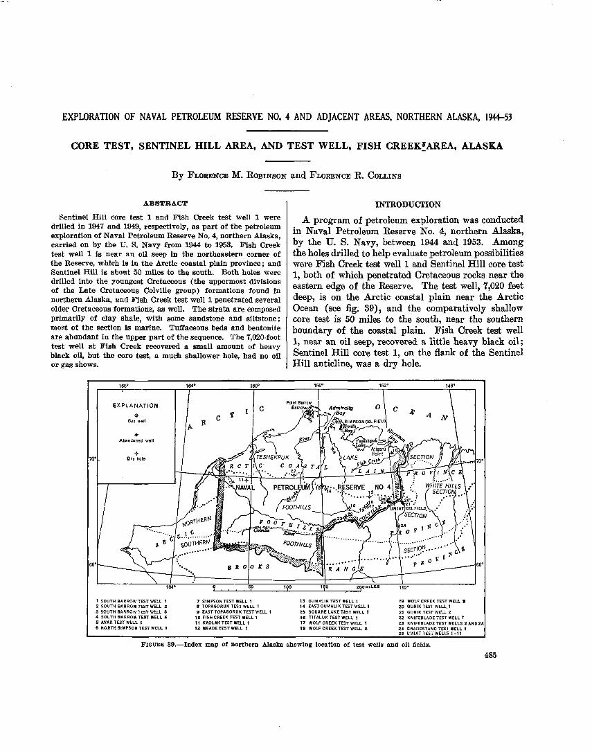
FIGURE 39. Index map of northern Alaska showing test wells and oil fields . . . . . . . . . . . . . . . . . . . . . . . . . . . . . . . . . . . . . . . . . . . . 40. Map showing location of Sentinel Hill core test 1 and structure-contour lines, in the surrounding area, drawn on
phantom seismic horizon "A," equivalent to sandstones in the Cretaceous ---- - ----- - - - - - --------- -------- 41. Columnar section, Sentinel Hill core test 1 . . . . . . . . . . . . . . . . . . . . . . . . . . . . . . . . . . . . . . . . . . . . . . . . . . . . . . . . . . . . . 42. Relative abundance of heavy minerals in Sentinel Hill core test I and Fish Creek test well 1 - - - - - - - - - - - - - - - - - 43. Observed gravity in the vicinity of Fish Creek test well 1 . . . . . . . . . . . . . . . . . . . . . . . . . . . . . . . . . . . . . . . . . . . . . . . .

EXPLORATION OF NAVAL PETROLEUM RESERVE NO. 4 AND ADJACENT AREAS, NORTHERN ALASKA, 194453
CORE TEST, SENTINEL HILL AREA, AND TEST WELL, FISH CREEKfAREA, ALASKA
By FLORENCE M. ROBINSON and FLORENCE R. COLLINS
ABSTRACT 1 INTRODUmION Sentinel Hill core test 1 and Fish Creek test well 1 were
drilled in 1947 and 1949, respectively, as part of the petroleum exploration of Naval Petroleum Reserve No. 4, northern Alaska, carried on by the U. S. Navy from 1944 to 1953. Fish Creek test well 1 is near an oil seep in the northeastern corner of the Reserve, which is in the Arctic coastal plain province; and Sentinel Hill is about 50 miles to the south. Both holes were drilled into the youngest Cretaceous (the uppermost divisions of the Late Cretaceous Colville group) formations found in northern Alaska, and Fish Creek test well 1 penetrated several older Cretaceous formations, as well. The strata are composed primarily of clay shale, with some sandstone and siltstone;
168' 164' lW" 152' 148'
EXPLANATION
Abandoned well
70' 70'
68" 68'
0 5 0 100 170
1 SOUTH BARROW TEST WELL 1 7 SIMPSON TEST WELL 1 13 OUMALIK TEST WELL 1 19 WOLF CREEK TEST WELL 8 2 SOUTH BARROWTEST WELL 2 B TOPAGORUK TEST WELL 1 14 EAST OUMALlK TEST WELL 1 2 0 GUBlK TEST WELL.! 3 SOUTH BARROW TEST WELL 3 S EASTTOPAGORUK TEST WELL 1 15 S9UARE LAKETEST WELL' I 21 GUBlK TEST WELL 2 4 SOUTH BARROW TEST WELL 4 1 0 FISH CREEK TEST WELL 1 1 6 TITALUK TEST WELL 1 22 KNIFEBLADE TEST WELL t S AVAK TEST WELL 1 I I KAOLAK TEST WELL 1 17 WOLF CREEK TEST WELL 1 2 3 KNIFEBLADETEST WELLS 2AND2A 6 NORTH SIMPSON TEST WELL 1 I 2 MEADE TEST WELL I 1 8 WOLFCREEK TEST WELL 2 2 4 GRANDSTAND TEST WELL 1
25 UMIAT TEST WELLS 1-11
A of petroleum exploration was conducbd in Naval Petroleum Reserve No. 4, northern Alaska,
the S. between 1944 and 1953. Among the holes drilled to help evaluate petroleum possibilities were Fish Creek test well 1 and Sentinel Hill core test 1, both of penetrated cretaceous rocks near the eastern edge of the Reserve. The test well, 7,020 feet
is On the Arctic plain near the Arctic Ocean (see fig. 39), and the comparatively shallow core test is 50 miles to the south, near the southern
most of the section is marine. Tuffaceous beds and bentonite are abundant in the upper part of the sequence. The 7,020-foot test well a t Fish Creek recovered a small amount of heavy black oil, but the core test, a much shallower hole, had no oil or gas shows.
PIouam 39.-Index map of northern Alaska showing location of test wells and o i l fields.
485
boundav of the coastal plain. Fish Creek test well 1, near an oil seep, recovered a little heavy black oil;
core test On the Of the Hill anticline, was a dry hole.
486 EXPLORATION OF NAVAL PETROLEUM RESERVE NO. 4, ALASKA, 1944-53
Detailed geologic, engineering, and logistic data ob- tained from drilling these two tests are presented in this report, and much of it is summarized on graphic logs. The report has been compiled from information supplied, under contract, to the Navy by Arctic Con- tractors, United Geophysical Co., Inc., and the Schlum- berger Well Surveying Corp., and by the U. S. Geological Survey, the U. S. Bureau of Mines, and the National Bureau of Standards as cooperating Gov- ernment agencies. Geologists of the Geological Survey described the cores and ditch samples and determined porosity and permeability in the Survey's laboratory in Fairbanks, Alaska; Paul D. Krynine also made porosity and permeability studies. Invertebrate mega- fossils were identified by George Gryc and C. Wythe Cook, and plant fossils were studied by Roland Brown. Microfaunal studies were made by Harlan R. Berg- quist. The stratigraphic distribution of fossils in the test wells of northern Alaska will be presented by him in another chapter of this series. The heavy-mineral data is part of a regional study of the heavy-mineral zones by Robert H. Morris. The help of many other engineers, geophysicists, and geologists connected with the above organizations is gratefully acknowledged.
SENTINEL HILL CORE TEST 1
Location: Lat 69"36'57" N., long 151°27'11" W. Elevation above sea level: Kelly bushing, 209 feet; ground,
about 200 feet. Spudded : January 26,1947. Oompleted: March 23, 1947; dry and abandoned. Total Depth : 1,180 feet.
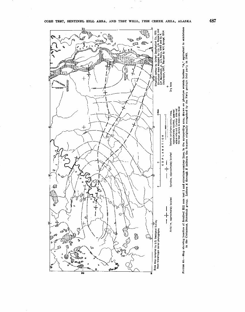
Sentinel Hill core test 1 was located on the west side of the Colville River 24 miles northeast of Umiat (see fig. 40) ; the core test is 12 miles due north of Gubik test well 1 which is shown on figure 39. The site chosen was on a mud and gravel bar a few feet above water level and at the base of 350-foot bluffs. This bar is probably covered with water during the breakup in late spring and early summer.
Sentinel Hill, a topographic feature 18 miles north of the core test and near the mouth of the Kogosukruk River, was named by F. C. Schrader and W. J. Peters, of the U. S. Geological Survey, on their traverse down the Colville River in 1901 (Schrader and Peters, 1904). The term "Sentinel Hill area" was first used in a report made in 1945 to the U. S. Navy (unpublished) by one of their reconnaissance geologic field parties led by Lts. J. A. Rogers and A. P. McConnel, Jr . The area covered by this party was mostly northwest of the site of the core test and along the Kogosukruk and Kikiak- rorak Rivers. Toward the end of the season, however,
they made a short study along about 10 miles of the Colville River. They recognized a broad, low anti- clinal fold with several crests which they presumed ex- tended from the Kogosukruk River to the Colville River. (See fig. 40.)
In 1945 and 1946 the U. S. Geological Survey in con- junction with the U. S. Navy made a survey of the Reserve with an airborne magnetometer. A magnetic high which was called West Sentinel Hill was dis- covered north-northwest of Umiat, but this was cen- tered about 30 miles from the Sentinel Hill core test site. (See fig. 8, Payne and others, 1951, sheet 2.) A gravity maximum mapped by United Geophysical Co., Inc., coincides with the magnetic high. (See fig. 9, Payne and others, 1951, sheet 2.)
Sentinel Hill core test was drilled early in 1947 by Arctic Contractors. Later, in the summer of 1947, a U. S. Geological Survey field party under K. Stefansson studied the surface geology on the Colville River north of Umiat and on the Kogosukruk River. In 1950 a re- flection seismograph tie-line run between the Fish Creek area and Umiat by United Geophysical Co., Inc., showed a reversal in this vicinity and helped to define the Sen- tinel Hill anticline. Some seismic detail work was done in the area in 1951. The contour lines on figure 40 show possible closure on the anticline 13 miles northwest of the core test. I I n 1954 W. P. Brosg6, of the U. S. Geological Survey compiled the field and photogeologic data and deter- mined the position of the anticlinal and synclinal axes shown on figure 40. The Kogosukruk tongue of the Prince Creek formation (see section on stratigraphy) of Late Cretaceous age crops out in the area (W. P. Brosg6, written communication).
The purpose of the core test was "* * * to ascertain the nature of the shallow subsurface formations on the Sentinel Hill anticline and test shallow oil possibilities" (written communication, Arctic Contractors, March 1953). Stratigraphically, the test provided valuable information but the present structural data indicate that the core test is actually far out on the flank of the anticline and in a relatively low area between two of the axial flexures. No gas or oil was found.
STRATIGRAPHY
UPPER CRETACEOUS-COLVIILE GROUP
The rocks penetrated by Sentinel Hill core test 1 are interbeds of the nonmarine Kogosukruk tongue of the Prince Creek formation and of the marine Sentinel Hill member of the Schrader Bluff formation. (See pl. 31.) The tongue and the member are the age equivalents of the uppermost part of the Colville group of Late Cre- taceous age. The type sections of the Schrader Bluff
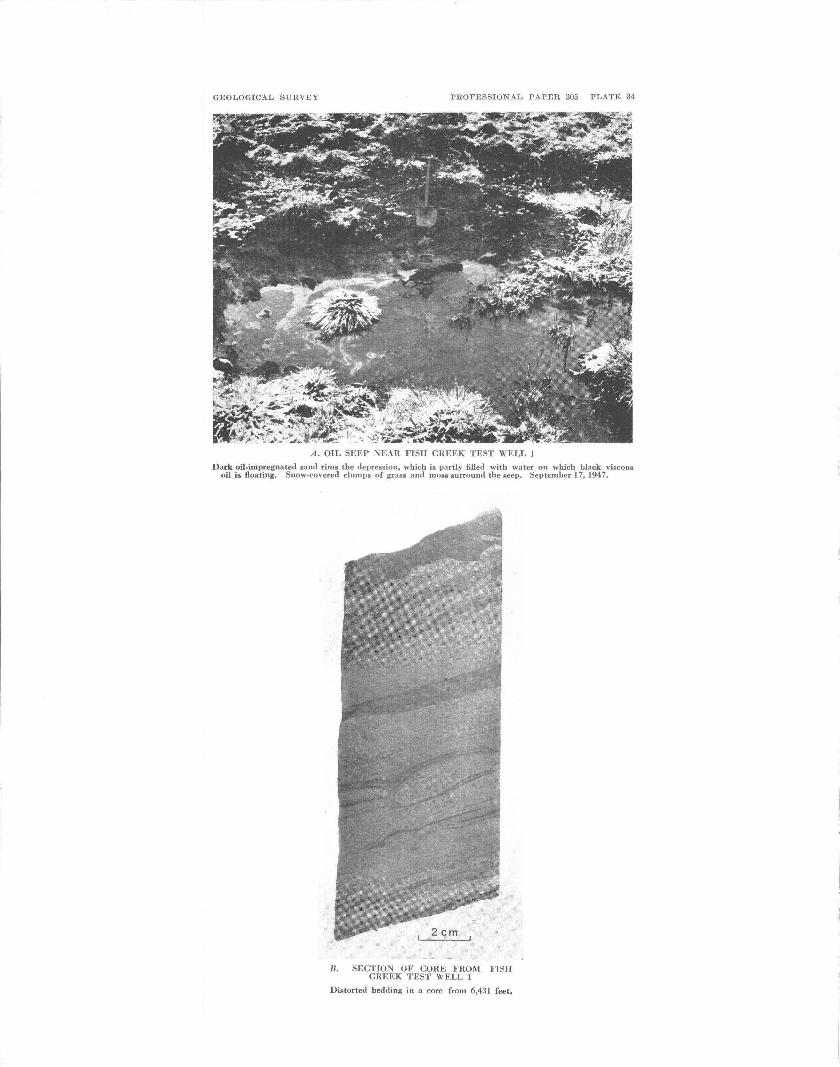
GEOLOGICAL SURVEY PROFESSIONAL PAPER 305 PLATE 34
A . OIL SEEP NEAR FIslI (,It l T h I I - I \\ 1 L L 1
Dark oil-impregnated sand rims the depression, which is partly filled with water on which black viscous oil is floating. Snow-covered clumps of grass and moss surrounrl the seep. September 17,1947.
R. SECTION OF CORE FllOM FISlI CREEK TEST WELL 1
Distorted bedding in a core from 6,431 feet.

GEOLOGICAL RTTRVCY PROFESSIOSAL PAPER 305 PLATE 33
SE\TI\EL IIILI. CORE TEST 1
\ote the high hluN* to the rear. Fehr~rarr 17, 191i
CORE TEST, SENTINEL HILL BREA, AND TEST WELL, FISH CREEK AREA, ALASKA
488 EXPLORATION OF NAVAL PETROLEUM RESERVE NO. 4, ALASKA, 1944-53
and Prince Creek formations were described by Gryc, Patton, and Payne (1951). Originally, Sentinel Hill core test 1 was designated as the type section of the Sentinel Hill member, but C. L. Whittington (1956) re- defined the member and described a new type locality on the Colville River about 10 miles south of the core test.
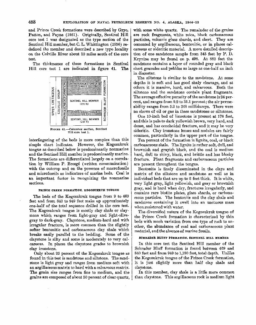
The thicknesses of these formations in Sentinel Hill core test 1 are indicated in figure 41. The
FIGURE 41.-Columnar section, Sentinel Hill core test 1.
interfingering of the beds is more complex than this simple chart indicates. However, the Kogosukruk tongue as described below is predominantly nonmarine and the Sentinel Hill member is predominantly marine. The formations are differentiated largely on a correla- tion by William P. Brosg6 (written communication) with the outcrop and on the presence of macrofossils and microfossils as indicators of marine beds. Coal is an important factor in recognizing the nonmarine sections.
PRINCE CREEK FORMATION, KOQOSUgBUK TONGUE
The beds of the Kogosukruk tongue from 9 to 469 feet and from 840 to 949 feet make up approximately one-half of the total sequence drilled in the core test. The Kogosukruk tongue is mostly clay shale or clay- stone which ranges from light-gray and light-olive- gray to dark-gray. Claystone, medium-hard and with irregular fracture, is more common than the slightly softer bentonitic and carbonaceous clay shale which breaks easily parallel to the bedding. Some of the claystone is silty and some is moderately to very cal- careous. In places the claystone grades to brownish clay ironstone.
Only about 25 percent of the Kogosukruk tongue as found in this test is sandstone and siltstone. The sand- stone is light gray and ranges from medium soft with an argillaceous matrix to hard with a calcareous matrix. The grain size ranges from fine to medium, and the grains are composed of about 50 percent of clear quartz,
with some white quartz. The remainder of the grains are rock fragments, white mica, black carbonaceous particles, volcanic glass shards, and chert. They are cemented by argillaceous, bentonitic, or in places cal- careous or sideritic material. A more detailed descrip- tion of one sandstone sample from 345 feet by P. D. Krynine may be found on p. 498. At 882 feet the sandstone contains a layer of rounded gray and black chert granules and pebbles as large as one-half an inch in diameter.
The siltstone is similar to the sandstone. At some depths it is soft and has good shaly cleavage, and at others it is massive, hard, and calcareous. Both the siltstone and the sandstone contain plant fragments. The average effective porosity of the sandstone is 24 per- cent, and ranges from 9.2 to 31.1 percent; the air perme- ability ranges from 5.2 to 348 millidarcys. There were no shows of oil or gas in these sandstones or siltstones.
One 10-inch bed of limestone is present at 176 feet, and this is pale to dark yellowish brown, very hard, and dense, and has conchoidal fracture, and it may be very sideritic. Clay ironstone lenses and nodules are fairly common, particularly in the upper part of the tongue.
Ten percent of the formation is lignite, coal, or black carbonaceous shale. The lignite is rather soft, dull, and brownish and grayish black, and the coal is medium hard, dull to shiny, black, and brittle and has blocky fracture. Plant fragments and carbonaceous particles are present throughout the tongue.
Bentonite is finely disseminated in the clays and matrix of the siltstone and sandstone as well as in individual beds that are up to 2 feet thick. I t is white, very light gray, light yellowish, and gray or brownish gray, and is hard when dry, fractures irregularly, and contains rare biotite plates, glass shards, or carbona- ceous particles. The bentonite and the clay shale and sandstone containing it swell into an unctuous mass when moistened with water.
The diversified nature of the Kogosukruk tongue of the Prince Creek formation is characterized by thin beds with much variation from one type of rock to an- other, the abundance of coal and carbonaceous plant material, and the absence of marine fossils.
SCERADER BLUFF FORMATION, BENTINEL HILL MEMBER
I n this core test the Sentinel Hill member of the Schrader Bluff formation is found between 469 and 840 feet and from 949 to 1,180 feet, total depth. Unlike the Kogosukruk tongue of the Prince Creek formation, it is just slightly more than half clay shale and claystone.
I n this member, clay shale is a little more common than claystone. This argillaceous rock is medium light
CORE TEST, SENTINEL HILL AREA, AND TEST WELL, FISH CREEK AREA, ALASKA 489
gray-or rarely light olive gray where sideritic or dark gray where carbonaceous. I n general it is medium hard and has fair to good cleavage along bedding planes. Most of it is noncalcareous, but it is very cal- careous or sideritic in a few places.
Sandstone and siltstone make up about 45 percent of the Sentinel Hill member drilled here. These clastic units together are massive, as as 100 feet thick, and are light gray or very light gray. ~~~~t where calcareous and hard, the sandstone and siltstone are rather soft and friable. ~h~ g a i n size ranges from silt to medium sand. The grains, which are angular to subangular, are composed of 70-85 percent of white and clear quartz with carbonaceous particles, muscovite and biotite, rock fragments, sideritic particles, and pyrite in an argillaceous or bentonitic matrix.
The composition of the grains in the siltstone is the same as in the sandstone, but the siltstone tends to be a little harder and more calcareous than the sandstone in the upper part of the member. The siltstone near 1,060 feet is light colored and has a very bentonitic matrix.
The effective porosity of 28 sandstone samples tested ranges from 15.2 to 29 percent (see table on p. 498) and averages 22.6 percent. The air permeability in the same samples ranges from less than 10 to 290 millidarcys. The porosity and the permeability in the upper part of the formation are consistently higher than in the lower. These rocks would probably make poor reservoirs, how- ever, because they contain so many clay minerals that the potential hydration is high.
Coal is not common in the Sentinel Hill member al- though beds of carbonaceous clay shale as much as 5 feet thick are found. Carbonaceous plant remains are found in both the clay shale and the sandstone but are par- ticularly uncommon in the lowest part of the member.
Bentonite is about as abundant as in the Kogosukruk tongue. I t is found in beds ranging in thickness from 1 inch to 5 feet; it is white, very light gray, or greenish gray and is rather hard, has subconchoidal fracture, and contains tiny biotite plates.
Plant fragments in the core from 822-826 feet are, according to Roland W. Brown, chiefly dicotyledons but not further identifiable. George Gryc identified MytiZzcs sp., a marine pelecypod, in a sample at 603 feet. One gastropod, the fresh-water genus Lymnaea? sp., at 524% feet was identified by C. Wythe Cook. At several depths in the Sentinel Hill member there are numerous nacreous pelecypod shells which are too frag- mentary to identify. The formation is primarily marine, however, as indicated by the presence of a marine microfauna typical of the Colville group of Late Cretaceous age. EoepolzideZla strombodes Tappan
4 6 6 3 6 6 5 L 2
is characteristic of the Sentinel Hill member (Tappan, 1951, p. 6).
DESCRIPTION OF CORES AND CUTTINGS
The core recovery from Sentinel Hill core test was good- The were described
William N. Lockwood, of the S- Geological Survey, in 1947 and were redescribed by the author in 1954 to conform in style with the other descriptions in this pro- fessional paper series- All samples were described dry ; colors were determined with the aid of the National Research Council Rock Color Chart (Goddard and others, 1948) The term ''trace" as used here is defined
less than Percent and usually less than 1 percent. Clay ironstone is a sideritic, dense, and rather hard mudstone that effervesces generally very
in dilute acid. The latitude and longitude of the core test are based
On preliminary and are subject to correction. All depths were measured from the k e l l ~
The height the ke l l~ bushing above sea level is estimated.
Lithologic description
Core - ----- - - _ - -
-----
- - - - -
-----
- ----
-----
- --- -
-----
- - - - -
- ----
[Where no core number
Depth (feet)
0- 9 9- 19
19- 29
29- 39
39- 49
49- 59
59- 69
69- 79
79- 89
89- 99
99-109
is listed, description is based on cutting samples]
Remarks - Kelly bushing to ground level. Clay shale, dark-gray, carbonaceous;
trace medium-light-gray clay shale; trace coal.
Clay shale, 90 percent medium-dark-gray, 10 percent medium-light-gray; trace coal.
Clay shale, 80 percent medium-dark-gray, 20 percent medium-light-gray.
Clay shale, 90 percent medium-gray- to medium-dark-gray; 10 percent white bentonite.
Clay shale, 60 percent, medium-gray to medium-dark-gray; 40 percent pale- yellowish-brown slightly calcareous clay ironstone.
Clay shale, 50 percent medium-dark-gray, 20 percent medium-gray; 30 percent pale-yellowish-brown clay ironstone.
Clay shale, 80 percent medium-dark-gray, 10 percent medium-gray; 10 percent yellowish-brown clay ironstone.
Clay shale, 90 percent medium-light-gray, 10 percent dark-gray; trace clay iron- stone.
Clay shale, 80 percent medium-gray and medium-dark-gray; 20 percent pale- yellowish-brown clay ironstone.
Clay shale, 50 percent medium-dark-gray, 20 percent medium-gray; 30 percent clay ironstone.
490 EXPLORATION OF NAVAL PETROLEUM RESERVE NO. 4, ALASKA, 1944-53
Core - 1
2
3
4
descr2ption-Continued
Remarks
2 f t 3 in., clay shale as above in this core, quite silty, noncalcareous, ben- tonitic; grades in places to siltstone.
Recovered 10 f t . 4 f t 9 in., sandstone, light-gray, very
fine-grained, medium-soft; grains sub- angular; 50 percent clear with a little white quartz; 40 percent white mica; remainder is mostly carbonaceous flecks and light-brown rock particles; argillaceous-bentonitic matrix. Con- tains about a foot of hard yellowish- gray very calcareous sandstone h middle. Calcareous rock contains numerous dark-brown and black plant fragments; no oil or gas shows.
5 f t 3 in., siltstone, light-gray, noncal- careous, very argillaceous, medium- hard; fair cleavage; grades in streaks to medium-light-gray clay shale; beds lie flat.
Recovered 10 ft. Siltstone as above; upper 5 f t of recov-
ery moderately to very calcareous; lower half essentially noncalcareous.
Recovered 8 ft. 6 f t 7 in., siltstone, light-gray to light-
olive-gray micaceous, very argilla- ceous; medium-soft to medium-hard; sandy partings; has brownish blotchee (sideritic material ?).
10 in., limestone (and some clay iron- stone), pale- to dark-yellowish brown, very hard, dense; conchoidal fracture.
7 in., siltstone as above; good cleavage. Recovered 10 f t .
Clay shale, light-gray, light-olive-gray, and yellowish-brown, very calcar- eous, medium-hard; good to excellent cleavage parallels bedding; numerous silty and sandy laminae; carbon* ceous partings; dip 4'.
Recovered 7 f t . 4 f t 8 in., Interbedded light-gray silt-
stone 60 percent; sandstone 20 per- cent; and grayish-yellow clay shale 20 percent, medium soft, very cal- careous. Sandstone is very fine to fine grained, contains clear quartz, a large amount of yellow calcite grains, carbonaceous particles, mica, and argillaceous material. Numer- ous dark-gray carbonaceous partings. Dip 4'.
2 f t 4 in., Sandstone, light-gray, hard; composition aa above; very cal- careous matrix; very "dirty."
Lithologic
Depth:(feet)
109-119
119-129
129-139
139-149
Oore -
5
7
8
9
descPipticm-Continued -
Remarks
Recovered 8 f t . 2 f t 4 in., clay shale, medium-light-gray,
medium-hard, noncalcareous, slightly micaceous; fair cleavage; very rare carbonaceous fragments; beds lie flat.
10 in., clay shale, medium-dark-gray; contains numerous very thin laminae (one-sixteenth inch) of brittle coal.
4 in., coal, black, dull to shiny; vertical fracture planes coated with brownish layer.
4 f t , claystone, medium-light-gray, slightly silty, noncalcareous, medium- hard; irregular fracture; rare carbo- naceous fragments; contains light- gray bentonitic layers in top foot.
6 in., clay shale, carbonaceous; low- grade coal.
Recovered 10 ft . 1 f t 5 in., clay shale, light-gray, very
soft, bentonitic; a few chips of coal. 2 in., clay shale, very carbonaceous;
medium-hard brittle low-grade coal. 3 ft, claystone and clay shale, light-
gray, slightly silty, noncalcareous; abundant medium-dark-gray carbo- naceous partings; bedding irregular but beds lie approximately flat.
1 ft, clay shale, medium-dark-gray, carbonaceous; 1-in. coal bed.
2 ft 5 in., claystone and clay shale, light-gray, bentonitic, medium-soft; carbonaceous plant fragments.
2 f t , siltstone, light-gray, very argill- aceous and micaceous, bentonitic, medium-hard; carbonaceous plant fragments present.
Recovered 8 ft. 7 in., clay shale, medium-light-gray,
very soft; streaks of coal broken by drill.
3 f t 5 in., interbedded clay shale and siltstone, light- to medium-light- gray, medium-hard, noncalcareous, bentonitic, thin-bedded; fair cleav- age; scattered carbonaceous plant fragments.
4 f t , clay shale, medium-gray, medium- hard; fair cleavage; a few silty part- ings and laminae; some crossbedding.
Recovered 6 ft. 1 f t 8 in., clay shale, soft; broken by
drill. 1 f t 8 in., clay shale, light-gray, non-
calcareous, bentonitic, medium-hard; fair cleavage.
5 in., low-grade coal, black, dull, brittle; blocky fracture.
Lithologic
Depth (feet)
149-159
159-169
16%179
179-189
18%199
CORE TEST, SENTINEL HILL AREA, AND TEST WDLL, FISH CFGEEK AREA, ALASKA 491
aore
14
15
16
17
18
description-Continued
Remarks
Recovered 8 ft. 2 f t 5 in., claystone, medium-light- to
light-olive-gray, medium-hard grades down into unit below.
10 in., clay ironstone, pale-yellowish- brown, very hard, dense; effervesces slightly with dilute HC1.
4 f t 9 in., clay shale and claystone, medium-light-gray, medium-soft; ben- tonitic in upper foot; poor to fair cleavage; hard clay ironstone nodule 3 in. thick in middle of interval. Just below this is 4 in. of medium-dark- gray carbonaceous shale. Whole in- terval is noncalcareous.
Recovered 10 ft. 2 f t 5 in., bentonite, very light-gray,
argillaceous, soft but brittle. 8 in., carbonaceous clay shale, medium-
dark-gray; contains very thin layers of low-grade coal.
6 ft. 11 in., clay shale and claystone, medium-light-gray, medium-hard; poor to good cleavage; rare silty and carbonaceous streaks; noncalcareous; dip 3'.
Recovered 9 ft. 6 in., bentonite, white to very light-
gray; hard when dry; conchoidal frac- ture.
6 in., lignite, grayish-black, hard, brit- tle, bedded; dip 2'.
6 f t 4 in., claystone, light- to medium- light-gray; slightly to moderately cal- careous, medium-hard; irregular frac- ture; slightly silty in places; contains vary rare coaly fragments.
1 f t 9 in., clay shale, medium-dark-gray, carbonaceous; contains layers up to an inch thick of lignite and dull black coal having a blocky fracture.
Recovered 10 ft. 1 f t 7 in., clay shale as immediately
above; carbonaceous but with no coal or lignite.
1 f t , claystone, very light-gray, very bentonitic, medium-soft; contains scattered black carbonaceous par- ticles; grades into unit below.
4 f t 8 in., siltstone, light-gray, very micaceous, noncalcareous, slightly bentonitic, medium-hard; grades into unit below.
2 f t 9 in., sandstone, light-gray, very fine-grained, noncalcareous, medium- soft; grains angular to subangular; 75 percent white and clear quartz; remainder is mostly white mica and carbonaceous particles; argillaceous matrix.
Oom
10
11
12
13
Lithologic
Depth (feet) --- 199-209
209-219
219-229
229-239
Lithologic
Depth (feet)
239-249
249-259
259-269
269-279
279-289
deswiption-Continued
Remarks
Recovered 8 ft. 4 f t 6 in., sandstone as above, silty, non-
calcareous, soft and friable; irregular fracture.
2 f t , clay shale and claystone, medium- olive-gray, medium-soft; fair to poor cleavage; contains brownish plant material and streaks of grayish black lignite; noncalcareous to moderately calcareous toward bottom.
1 f t 6 in., clay shale and claystone, light- olive-gray, moderately calcareous; lacks plant material; irregular frac- ture; dip 2'.
Recovered 10 f t . Claystone, light-olive and yellowish-
gray to light-gray, medium-hard; irregular fracture; rare carbonaceous particles; about 4 in. of dark gray brittle lignitic clay a t 243 ft. Cd- careous in yellowish upper 3 ft; non- calcareous in lower part.
Recovered 10 f t . 3 f t 2 in., claystone, medium-light-gray,
noncalcareous, medium-hard; irregu- lar fracture; rare silty laminae.
1 f t 4 in., carbonaceous clay shale and lignite, medium-dark to dark-gray, medium-hard; rare shiny coal string- ers, %-in. layer of very light-gray bentonite in middle. Beds lie flat.
3 f t 6 in., claystone as in first part of core; very uniform of texture and color.
4 in., lignite and carbonaceous shale, grayish-black.
1 f t 8 in., claystone rts above but con- tains 4 in. of soft friable noncalcare- ous fine-grained light-gray sandstone, coaly plant remains and carbona- ceous partings.
Recovered 10 f t . Claystone, medium-light- to medium-
gray, noncalcareous medium-hard; following are variations: At 272% f t is 6 in. of dark-gray lignitic brittle clay shale, bentonitic a t upper end; a t 276 ft is about a foot of light-gray soft bentonitic streaks; a t 277 f t ia 2 in. of carbonaceous clay shale.
Recovered 7 f t 6 in. 3 f t , claystone as above, 4 in. of dull-
black lignite a t 280 f t . 4 f t 6 in., siltstone, light-gray, very
argillaceous, finely micaceous, non- calcareous, slightly bentonitic, me- dium-soft to soft and friable; grades into claystone toward base. One- inch layer of carbonaceous shale 3 in. from base.
492 EXPLORATION OF NAVAL PETROLEUM RESERVE NO. 4, ALASKA, 1944-53
'For a detalled description of a sample from 345 ft by P. D. Krynine see p. 498
Core - 19
20
21
22
23
description-Continued -
Remarks
Recovered 10 ft. Sandstonell as above, friable, fine- to
medium-grained; rare calcareous grains; bentonitic matrix; rare black carbonaceous coaly plant fragments; no shows.
Recovered 10 f t . Sandstone, as immediately above.
Recovered 10 f t . 5 f t , sandstone, as above. 1 f t 2 in., clay shale, medium-dark-
gray, carbonaceous; a few thin lami- nae of lignite.
4 in., clay ironstone, dark-yellowish- orange; effervesces slightly with di- lute HC1; contains dark-brown plant fragments.
1 f t 4 in., claystone, light-gray, ben- tonitic.
6 in., clay shale, and lignite as above. 6 in., clay shale, light-gray, bentonitic. 1 f t 2 in., claystone, medium-light-
gray, slightly silty, noncalcareous, hard; dip 3'.
Rewvered 9 ft. 4 ft 6 in., claystone, as immediately
above. 11 in., clay shale, medium-dark-gray,
carbonaceous. 7 in., bentonite, white, hard; irregular
fracture; contains volcanic glass shards, rare biotite plates.
3 f t , clay shale, medium-light- to me- dium-dark-gray ; varying amounts of carbonaceous material; some lignite; 2 in. of brittle dull black coal a t 377 f t , also thin streaks of bentonite.
Recovered 9 ft. Claystone and clay shale, light- to me-
dium-dark-gray; some spots have yellowish cast. Four inches of dark- gray-lignite and carbonaceous shale a t 382 ft. Lowest third quite car- bonaceous, with a few very thin lam- inae of lignite. One inch of very light-gray bentonitic shale a t 381 and 385 f t . Noncalcareous to slightly calcareous.
Recovered 10 f t . Claystone, medium-hard; about half is
light olive gray and is slightly to moderately calcareous; other half is medium gray and noncalcareous but is carbonaceous with a little lignite a t 393 and 398 f t . Irregular frac- ture. Light gray bentonite layer a t 392% ft.
Core
24
25
26
27
28
29
Lithologic
Depth (feet)
289-299
299-309
309-319
319-329
329-339
LithoZogZc
Depth (feet)
339-349
349-359
359-369
369-379
379-389
389-399
description-Continued
Rernarka -
Recovered 10 f t . 7 ft, claystone, light-gray, very silty,
noncalcareous, medium-hard; grades to siltstone in places, dip lo .
2 ft 6 in., lignite and carbonaceous clay shale, dark-gray to grayish-black, medium-soft, brittle.
6 in., claystone, light-olive-gray, slight- ly calcareous or sideritic, hard.
Recovered 10 ft. Interbedded clay shale (or claystone)
and siltstone with all gradations, light, to medium-light-gray, medium- soft; rare thin streaks of calcareous (sideritic?) brownish clay shale; rare very fine-grained sandstone laminae; 4 in. of hard calcareous sandstone a t 302% f t .
Recovered 9 ft. 2 f t 10 in., claystone and clay shale,
light-brownish-gray, noncalcareous, medium-soft; contains much macer- ated plant material.
8 in., carbonaceous shale and lignite, dark-brownish- to dark-gray.
5 f t 6 in., interbedded claystone and siltstone, noncalcareous; medium- soft, about equal proportions as in core above; rare black carbonaceous particles.
Recovered 8 f t 6 in. 2 f t , claystone, light- to medium-light-
gray, noncalcareous, medium-soft. 1 f t 2 in., clay shale, medium-dark-
gray, carbonaceous; streaks of lignite and coal.
2 f t 8 in., clay shale, medium-light- gray, bentonitic, soft; conchoidal fracture.
2 f t 8 in., clay shale, medium-light- gray, noncalcareous, medium-soft; rare carbonaceous plant fragments.
Recovered 10 ft. 2 f t 4 in., interbedded claystone and
siltstone, lightr to medium-light-gray ; grades into unit below.
7 f t 8 in., sandstone, light-gray, very fine- to fine-grained noncalcareous, medium-soft; irregular fracture; grains angular to subangular and made up of clear quartz with some white quartz, also chert, white mica, black carbonaceous particles, vol- canic glass shards, rock fragments, and rare minerals; essentially noncal- careous; matrix is bentonitic and ar- gillaceous; no oil or gas shows.
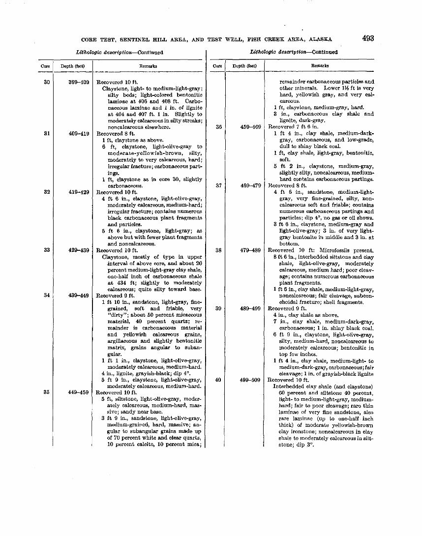
CORE TEST, SENTINEL HILL AREA, AND TEST WELL, FISH CREEK AREA, ALA8KA 493
deerniption-Continued
Remarks -- -
Recovered 10 f t . Claystone, light- to medium-light-gray ;
silty beds; light-colored bentonitic laminae a t 406 and 408 f t . Carbo- naceous laminae and 1 in. of lignite a t 404 and 407 ft. 1 in. Slightly to moderately calcareous in silty streaks; noncalcareous elsewhere.
Recovered 8 ft. 1 ft, claystone as above. 6 ft, claystone, light-olive-gray to
moderate-yellowish-brown, silty, moderately to very calcareous, hard; irregular fracture; carbonaceous part- ings.
1 ft, claystone as in core 30, slightly carbonaceous.
Recovered 10 f t . 4 f t 6 in., claystone, light-olive-gray,
moderately calcareous, medium-hard; irregular fracture; contains numerous black carbonaceous plant fragments and particles.
5 f t 6 in., claystone, light-gray; as above but with fewer plant fragments and noncalcareous.
Recovered 10 ft. Claystone, mostly of type in upper
interval of above core, and about 20 percent medium-light-gray clay shale, one-half inch of carbonaceous shale a t 434 ft; slightly to moderately calcareous; quite silty toward base.
Recovered 9 f t . 1 f t 10 in., sandstone, light-gray, fine-
grained, soft and friable, very "dirty"; about 50 percent micaceous material, 40 percent quartz; re- mainder is carbonaceous material and yellowish calcareous grains, argillaceous and slightly bentonitio matrix, grains angular to suban- gular.
1 f t 1 in., claystone, lighhlive-gray, moderately calcareous, medium-hard.
4 in., lignite, grayish-black; dip 4'. 5 f t 9 in., claystone, light-olive-gray,
moderately calcareous, medium-hard. Recovered 10 ft. 5 f t , siltstone, light-olive-gray, moder-
ately calcareous, medium-hard, mas- sive; sandy near base.
3 f t 9 in., sandstone, light-olive-gray, medium-grai~ed, hard, massive; an- gular to subangular grains made up of 70 percent white and clear quartz, 10 percent calcite, 10 percent mica;
Core
30
31
32
33
34
35
descriptlon-Continued
Remarks
remainder carbonaceous particles and other minerals. Lower 1% f t is very hard, yellowish gray, and very cal- careous.
1 ft, claystone, medium-gray, hard. 3 in., carbonaceous clay shale and
lignite, dark-gray. Recovered 7 ft 6 in. 1 f t 4 in., clay shale, medium-dark-
gray, carbonaceous, and low-grade, dull to shiny black coal.
1 ft, clay shale, light-gray, bentonitic, soft.
5 f t 2 in., claystone, medium-gay, slightly silty, noncalcareous, medium- hard co~tains carbonaceous partings.
Recovered 8 f t . 4 f t 6 in., sandstone, medium-lighb
gray, very fine-grained, silty, non- calcareous soft and friable; contains numerous carbonaceous partings and particles; dip 4O, no gas or oil shows.
3 f t 6 in., claystone, medium-gray and light-olive-gray; 3 in. of very light- gray bentonite in middle and 3 in. a t bottom.
Recovered 10 ft: Microfossils present. 8 f t 6 in., interbedded siltstone and clay
shale, light-olive-gray, moderately calcareous, medium hard; poor cleav- age; contains numerous carbonaceous plant fragments.
1 f t 6 in., clay shale, medium-light-gray, noncalcareous; fair cleavage, subcon- choidal fracture; shell fragments.
Recovered 9 f t . 4 in., clay shale as above. 7 in., clay shale, medium-dark-gray,
carbonaceous; 1 in. shiny black coal. 6 ft 9 in., claystone, light-olive-gray,
silty, medium-hard, noncalcareous to moderately calcareous; bentonitic in top few inches.
1 f t 4 in., clay shale, medium-light- to medium-dark-gray, carbonaceous; fair cleavage; 1 in. of grayish-black lignite
Recovered 10 ft. Interbedded clay shale (and claystone) 60 percent and siltstone 40 percent, light- to medium-light-gray, medium- hard; fair to poor cleavage; rare thin laminae of very fine sandstone, also rare laminae (up to one-half inch thick) of moderate yellowish-brown clay ironstone; noncalcareous in clay shale to moderately calcareous in silt- stone; dip 3'.
Core -
36
37
38
39
40
Lithologic
Depth (feet)
399-409
409-419
419-429
429-439
439-449
449-459
Lithologio
Depth (feat)
459-469
469-479
479-489
489-499
499-509

494 EXPLORATION OF NAVAL PETROLEUM RESERVE NO. 4, ALASKA, 1944-53
Oore - 41
42
43
44
45
descriptCorc-.Continued
Remarks
Recovered 10 ft: Microfossils present. Clay shale, light- to medium-light-gray,
slightly to noncalcareous; some parts have olive cast; small white mollusk fragment a t 559 ft; dip 0'-3'.
Recovered 10 f t : Microfossils present. Clay shale, as above; noncalcareous;
fair to good cleavage; very rare pyrite nodules with brownish halo; 1 white pelecypod fragment a t 56931 ft; brownish hard clay ironstone nodule a t 576% ft; 1 in. of white bentonite a t bottom.
Recovered 9 ft: Microfossils present. Clay shale and claystone, light- to
medium-light-gray, medium-soft; fair cleavage; 1 in. of light-olive-gray clay ironstone a t top; noncalcareous except for ironstone and some silty streaks; bentonitic. White pelecy- pod shell fragment a t 584 ft; carbona- ceous partings and some silty beds in middle; beds lie essentially flat.
Recovered 8 ft: Microfossils present. 4 f t 7 in., clay shale and claystone,
light- to medium-light-gray ; olive cast in part; fair to poor cleavage; becomes silty toward base; dip 2'.
1 f t 6 in., interbedded sandstone and siltstone, light-gray, moderately cal- careous, medium-soft; sandstone is fine to medium grained; numerous thin clay laminae.
1 ft 11 in., clay shale as in first part of core; bentonitic a t top.
Recovered 10 ft: Microfossils present. 5 f t 6 in., clay shale, medium-light-gray,
medium-hard; poor to excellent cleav- age; silty in upper foot; contains rare tiny black plant fragments, small pyrite nodules with brownish halo, numerous white pelecypod remains, Mytilus sp.; 1 in. of white bentonite a t about 608 ft; dip 1%'.
4 f t 6 in., bentonite, white and very light-gray, rather hard, interbedded with some light-gray clay shale; breaks parallel bedding; subconchoi- dal fracture; contains little biotite particles, carbonaceous partings.
Recovered 8 f t : Microfossils pre~ent. 11 in., bentonite, light-gray, inter-
bedded with clay shale as above. 7 f t 1 in., clay shale, medium-light to
medium-gray, noncalcareous, med- ium-hard; poor to excellent cleavage; 5 in. of lignite or low-grade grayish- black coal; blocky fractu~e at about 614 ft; becomea siltier toward base.
Core
46
47
48
49
50
51
Uthologto
Depth (feet)
509-519
519-529
529-539
539-549
649-559
Uthologtc
Depth (fwt)
559-569
569-579
579-589
589-599
599-609
609-619
deeeriptiolt-Continued
Remarks
Recovered 8 ft: Microfossils present. 1 ft, claystone as above, with clay iron-
stone laminae. 5 ft 8 in., clay shale, medium-light- to
medium-gray, noncalcareous medium- hard; fair cleavage; bentonitic and crumbly in places.
1 f t 4 in., clay shale, medium-gray to medium-dark-gray, carbonaceous; plant remains.
Recovered 10 f t . 2 ft, claystone, light-olive-gray, moder-
ately calcareous; grades into unit below.
8 ft, siltstone, light-olive-gray, very ar- gillaceous moderately calcareous, me- dium-soft. A gastropod, Lymnaea? sp., found a t 524% f t .
Recovered 9 ft. 1 f t , claystone (and clay ironstone (?)),
light-olive-gray, very caIcareous, hard. 8 f t , interbedded clay shale and clay-
stone 70 percent, and siltstone 30 per- cent, light- to medium-light-gray, some with olive cast; hardness varia- ble; siltstone generally softer than clay shale; fair to poor cleavage; 3 in. of medium-grained sandstone streaked with very thin coal beds a t 534 ft. Sandstone also contains very small white gastropod and pelecypod frag- ments; scattered plant fragments in claystone. Siltstone moderately cal- careous. Claystone noncalcareous.
Recovered 9 f t : Microfossils present. 3 f t , clay shale, medium-light-gray,
slightly to moderately calcareous, medium-hard; fair cleavage; contains carbonaceous plant impressions and ostracodes.
5 f t , sandstone, light-gray, medium- soft and friable; lowest 1 f t very hard, fine to medium grained; grains angular to subangular and made up of about 60 percent white and clear quartz, 20 percent yellowish calcare- ous grains, 10 percent black carbona- ceous particles, and remainder is white mica, other minerals, and rock fragments; argillaceous matrix except for lowest 1 f t which is very calcare- ous; no oil or gas shows.
1 f t , clay shale, light-gray, as in upper part of this core.
Recovered 10 f t . Claystone and clay shale, light-gray,
slightly calcareous; very rare silty laminae.
CORE TEST, SENTINAL HILL AREA, AND TEST WELL, FISH CREEK AREA, ALASKA 495
001.8 - 52
53
54
55
56
57
58
59
8 0
61
Oore
62
63
6q
65
66
67
Uthologic
Depth (feet)
619-629
629-639
639-649
649-659
659-669
669-679
679-689
689-699
699-709
709-719
description-Continued
Remarka
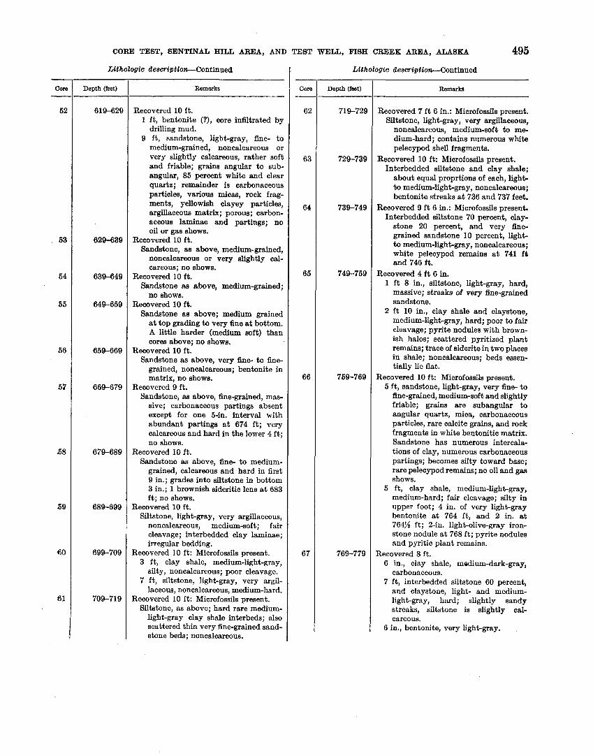
Recovered 10 f t . 1 ft, bentonite (?), core infiltrated by
drilling mud. 9 f t , sandstone, light-gray, fine- to
medium-grained, noncalcareous or very slightly calcareous, rather soft and friable; grains angular to sub- angular, 85 percent white and clear quartz; remainder is carbonaceous particles, various micas, rock frag- ments, yellowish clayey particles, argillaceous matrix; porous; carbon- aceous laminae and partings; no oil or gas shows.
Recovered 10 ft. Sandstone, as above, medium-grained,
noncalcareous or very slightly cal- careous; no shows.
Recovered 10 f t . Sandstone as above, medium-grained;
no shows. Recovered 10 f t .
Sandstone as above; medium grained a t top grading to very fine a t bottom. A little harder (medium soft) than cores above; no shows.
Recovered 10 ft. Sandstone as above, very h e - to fine-
grained, noncalcareous; bentonite in matrix, no shows.
Recovered 9 f t . Sandstone, as above, fine-grained, mas-
sive; carbonaceous partings absent except for one 5-in. interval with abundant partings a t 674 f t ; very calcareous and hard in the lower 4 f t ; no shows.
Recovered 10 ft. Sandstone as above, fine- to medium-
grained, calcareous and hard in first 9 in.; grades into siltstone in bottom 3 in.; 1 brownish sideritic lens a t 683 ft; no shows.
Recovered 10 f t . Siltstone, light-gray, very argillaceous,
noncalcareous, medium-soft; fair cleavage; interbedded clay laminae; irregular bedding.
Recovered 10 ft: Microfossils present. 3 f t , clay shale, medium-light-gray,
silty, noncalcareous; poor cleavage. 7 f t , siltstone, light-gray, very argil-
laceous, noncalcareous, medium-hard. Recovered 10 ft: Microfossils present.
Siltstone, as above; hard rare medium- light-gray clay shale interbeds; also scattered thin very fine-grained sand- stone beds; noncalcareous.
Lithologic
Depth (feet)
719-729
729-739
739-749
749-759
759-769
769-779
description-Continued
Remarks
Recovered 7 f t 6 in.: Microfossils present. Siltstone, light-gray, very argillaceous,
noncalcareous, medium-soft to me- dium-hard; contains numerous white pelecypod shell fragments.
Recovered 10 ft: Microfossils present. Interbedded siltstone and clay shale;
about equal proprtions of each, light- to medium-light-gray, noncalcareous; bentonite streaks a t 736 and 737 feet.
Recovered 9 f t 6 in.: Microfossils present. Interbedded siltstone 70 percent, clay-
stone 20 percent, and very fine- grained sandstone 10 percent, light- to medium-light-gray, noncalcareous; white pelecypod remains a t 741 f t and 746 f t .
Recovered 4 f t 6 in. 1 f t 8 in., siltstone, light-gray, hard,
massive; streaks of very fine-grained sandstone.
2 ft 10 in., clay shale and claystone, medium-light-gray, hard; poor to fair cleavage; pyrite nodules with brown- ish halos; scattered pyritized plant remains; trace of siderite in two places in shale; noncalcareous; beds essen- tially lie flat.
Recovered 10 ft: Microfossils present. 5 ft, sandstone, light-gray, very fine- to
fine-grained, medium-soft and slightly friable; grains are subangular to angular quartz, mica, carbonaceous particles, rare calcite grains, and rock fragments in white bentonitic matrix. Sandstone has numerous intercala- tions of clay, numerous carbonaceous partings; becomes silty toward base; rare pelecypod remains; no oil and gas shows.
5 ft, clay shale, medium-light-gray, medium-hard; fair cleavage; silty in upper foot; 4 in. of very light-gray bentonite a t 764 ft, and 2 in. a t 764% ft; 2-in. light-olive-gray iron- stone nodule a t 768 f t ; pyrite nodules and pyritic plant remains.
Recovered 8 ft. 6 in., clay shale, medium-dark-gray,
carbonaceous. 7 f t , interbedded siltstone 60 percent,
and claystone, light- and medium- light-gray, hard; slightly sandy streaks, siltstone is slightly cal- careous.
6 in., bentonite, very light-gray.

496 EXPLORATION OF NAVAL PETROLEUM
Lithologic description-Continued
RESERVE NO. 4, ALASKA, 1944-53
Core
68
69
70
71
72
73
Core
74
75
76
77
78
79
Depth (feet)
779-789
789-799
799-809
809-819
819-829
829-839
Lithotogic
Depth (feet)
839-849
849-859
859-869
869-879
879-889
889-899
Remarks
Recovered 10 ft. 9 ft, clay shale, medium-light- to me-
dium-dark-gray, partly carbonaceous and bentonitic, medium-soft; abun- dant black carbonaceous and pyritic plant impressions; very rare white pelecypod remains; pyrite nodules with alteration halos.
1 ft, siltstone, light-gray, sandy; car- bonaceous partings; very bentonitic matrix.
Recovered 10 ft: Microfossils present. 5 f t , siltstone and sandstone, light-gray,
medium-soft; sandstone very fine- grained; numerous tiny pelecypod shells; bentonitic matrix; scattered black carbonaceous laminae; thin interbeds of clay shale; noncalcareous.
5 ft, carbonaceous clay shale, medium- gray to medium-dark-gray, medium- hard; black plant remains; 3 in. of very light-gray bentonite a t 795 f t ; very thin almost varvelike bentonite laminae in lowest foot; noncalcareous; beds lie approximately flat.
Recovered 10 f t : Microfossils present. 5 ft, clay shale, medium-dark- to dark-
gray, carbonaceous, medium-hard; good cleavage; 1 in. of greenish-gray bentonite a t 801% ft; 2 in. of light- gray bentonite a t 803 ft.
1 f t 6 in., clay shale, medium-gray; carbonaceous plant fragments.
3 f t 6 in., siltstone, medium-light-gray, irregularly bedded; clay intercala- tions; rare bands of coaly plant material.
Recovered 10 f t . 4 f t , interbedded clay shale 70 percent,
and sandy siltstone 30 percent, light- to medium-light-gray, medium-soft; gradations of color, carbonaceous partings; siltstone is bentonitic.
6 ft, clay shale, medium-light-gray, medium-hard; fair cleavage; scat- tered black plant fragments; rare small pelecypod remains; 3-in. of very light-gray bentonite a t base.
Recovered 10 ft: Microfossils abundant. Clay shale, medium-light- to medium-
dark-gray; fair cleavage; carbon- aceous shale a t 822-825 ft; streaks of light-gray bentonite at 823 f t and 828 ft; abundant black plant impres- sions; beds lie approximately flat.
Recovered 10 ft: Microfossils abundant. Clay shale, as above, medium-gray,
noncalcareous; plant fragments; one- half inch of light-gray bentonite at
d e s w i p t i o d n t i n u e d
Remarks
837 ft. Last 6 in. of recovery has thin beds of dull to shiny black coal.
Recovered 4 ft. 1 in., clay shale, medium-light-gray,
silty. 6 in., bentonite, white, medium-soft. 7 in., lignite and coal, black, dull,
earthy to shiny, soft and brittle. 2 f t 6 in., bentonite, very light-gay to
white, soft and friable to medium- soft; contains black carbonaceous plant fragments.
4 in., lignite, grayish-black. Recovered 10 ft.
2 ft, clay shale, medium-light-gray, rather soft and slightly bentonitic.
8 f t , siltstone, medium-light-gray, non- calcareous, medium-hard; bentonitic matrix.
Recovered 7 ft. Siltstone 70 percent and claystone 30
percent; siltstone is light gray; clay- stone is medium light gray, hard and compact, slightly calcareous; dip 2".
Recovered 10 ft. Siltstone, sandstone, and claystone,
as above, in equal parts; sandstone is fine grained, made up of subangular grains of about 80 percent quartz, 10 percent yellowish calcite, also mica, carbonaceous particles, and some rock fragments in bentonitic matrix.
Recovered 10 ft. 1 ft, interbedded siltstone, sandstone,
and clay shale as above. 1 f t 6 in., claystone and clay shale,
light-gray, slightly bentonitic, me- dium-hard; excellent cleavage.
10 in., sandstone and conglomerate, light-gray, medium grained, hard; irregular fracture; grains subangular, 50 percent white and clear quartz, 20 percent carbonaceous particles; remainder is dark chert, rock frag- ments, and mica. Sandstone con- tains layer of rounded gray and black chert pebbles up to one-half of an inch in diameter.
6 f t 8 in., clay shale, medium-gray to medium-dark-gray; carbonaceous and bentonitic in spots, a few inches of grayish-black lignite a t 884 f t and 888% ft.
Recovered 8 f t 6 in. 6 f t , lignite and carbonaceous clay shale,
medium-dark-gray to grayish-black; layers of light-brownish-gray benton- ite at 891 and 893 ft; a t 895 f t 8 in. of white bentonite which contains black carbonaceous fragments.

CORE TEST, SENTINEL HILL ARE.4, AND TEST WELL, FISH CREEK AREA, ALASKA 497
Lithologic deswiptiort-Continued
Core 1 h p t h (feet) 1 Remarks ---- Recovered 7 ft.
Sandstone as above, breaks readily
Remarks
2 f t 6 in., claystone, medium-light-gray, noncalcareous; irregular fracture; con- tains scattered coaly laminae; 1 in. of bentonite a t 897 ft.
Recovered 4 ft: Microfossils very rare. 1 f t 8 in., lignite and low-grade coal 50
percent, carbonaceous shale 50 per- cent. Lignite and hard brittle dull to shiny black subbituminous coal. Carbonaceous shale is medium-dark gray.
1 ft, clay shale, medium-light-gray, medium-hard.
1 f t 4 in., carbonaceous clay shale, as above, topped by one-half inch of bentonite.
Recovered 1 f t 6 in. Siltstone, light-gray, noncalcareous,
hard, massive; slightly bentonitic matrix.
Recovered 10 ft. 5 f t 6 in., siltstone as above, a few very
fine grained sandstone beds, also a few medium-light-gray clay shale beds; dip about 5O.
2 ft 8 in., clay shale, medium-gray; fair cleavage; contains numerous black plant impressions.
2 ft, bentonite, very light-yellowish- gray, medium-hard.
Recovered 8 ft: Microfossils absent. 5 ft, clay shale, carbonaceous, and
lignite, medium-dark- to dark-gray, soft; some is brittle; badly infiltrated by drilling mud; 1 in. of light-gray bentonite at about 931 and a t 934 ft.
3 ft, clay shale, medium-dark- to dark- gray; as above but with less lignite; no drilling mud; medium-light-olive gray bentonite layers present.
Recovered 8 ft 6 in. Clay shale, as above, very carbonaceous;
numerous layers of lignite and low- grade coal, lowest 1% f t is almost all coal; medium-light-olive-gray ben- tonite at 944, 945, and 946% ft.
Recovered 3 in. Sandstone as below; no oil or gas shows.
Recovered 6 ft. Sandstone, light-gray, fine-grained, es-
sentially noncalcareous, medium- hard, slightly friable; subangular grains; made up of 70 percent white and clear quartz, 10 percent carbo- naceous particles; remainder is mica, calcareous grains and rock fragments in bentonitic matrix; breaks parallel bedding; rare dark carbonaceous partings, dip 2O; no oil or gas shows.
Core
80
81
82
83
84
85
86
parallel to bedding; no shows. Recovered 10 ft.
3 f t 4 in., sandstone as above, very fine- to fine-grained; no shows.
6 f t 8 in., interbedded siltstone and claystone, light- to medium-light- gray, noncalcareous, hard; breaks parallel bedding.
Recovered 10 ft: Microfossils very rare. Interbedded siltstone 60 percent and clay shale 40 percent, as above, also 1 bed 6 in. thick of very fine-grained sandstone; bedding somewhat irregular and lenticular; rare carbonaceous plant fragments.
Recovered 5 ft: Microfossils present. Clay shale, medium-light-gray, non- calcareous, moderately hard; fair to
Depth (feet)
899-909
909-919
919-929
929-939
939-949
949-959
959-969
good cleavage; numerous light-gray siltstone laminae.
Recovered 9 ft. Sandstone, light-gray, fine- to rarely
medium grained, very rarely coarse grained, medium-hard but slightly friable; angular to subangular grains of white and clear quartz, carbons ceous particles, rock fragments, pyrite, white and biotite mica, cal- careous particles in bentonitic matrix; black carbonaceous partings fairly common; mostly noncalcareous ex- cept 1 ft a t 1,010-1,011 f t which has very calcareous matrix; dip 2O-4O; no oil or gas shows.
Recovered 10 ft. Sandstone, as above, fine-grained, non-
calcareous; no shows; dip 4O. Recovered 10 ft.
I Sandstone, as above, fine-grained, hard, massive; no carbonaceous partings, noncalcareous except for last 6 in. which is very calcareous; no shows. 1 Recovered 10 ft.
2 ft, sandstone as immediately above; no shows.
8 ft, interbedded siltstone 80 percent and clay shale 20 percent, light-gray, medium-light-gray, hard; fair cleav- age; scattered sandstone laminae.
Recovered 6 f t 6 in.: Microfossils present. Interbedded clay shale and siltstone,
about equal proportions, light- to medium - light - gray, noncalcareous; fair to good cleavage; dip 2O.
Recovered 8 ft. 6 f t , interbedded siltstone 80 percent
I and clay shale 20 percent, aa above,

498 EXPLORATION OF NAVAL PETROLEUM RESERVE NO. 4, ALASKA, 1944-53
UthoZogio description-Continued
001% I Depth (feet) 1 Remarks
noncalcareous. 2 ft, sandstone, light- gray, very fine-grained, silty, non- calcareous, hard, massive.
Recovered 10 ft: Microfossils present. Siltstone, very light- to light-gray,
argillaceous, noncalcareous, hard; bentonitic matrix; some clay shale interbeds; good cleavage; grades in places to very fine-grained sandstone; dip 2'.
Recovered 8 f t 6 in.: Microfossils present. Siltstone, as above, very light-gray,
slightly softer; very bentonitic matrix; rare medium-gray clay shale laminae.
Recovered 10 ft: Microfossils present. Siltstone, as above, very light- to light-
gray, about 5 percent medium-light- gray clay shale; rare very fine- grained sandstone laminae; noncal- careous.
Recovered 9 ft: Microfossils present. Siltstone as above; grades in places to
claystone; noncalcareous, vermicular structures of clay in silt or silt in clay up to one-fourth of an inch long and one thirty-second to one-sixteenth inch wide abundant throughout.
Recovered 7 ft: Microfossils present. 3 f t 8 in., claystone and siltstone, light-
to medium-lighbgray intercalated, hard; poor cleavage.
1 ft 3 in., claystone, medium-light-gray, very calcareous, hard; thin fractures filled with white calcite.
2 ft 1 in., clay shale, medium-light-gray, silty, noncalcareous, hard; good cleavage.
Recovered 9 ft: Microfossils rare. Claystone and clay shale, medium-light-
gray, very silty, hard; poor cleavage; rare fish scales; pyritic plant (?) im- pressions; noncalcareous except for 3 in. of limestone a t 1,110s ft . Lime- stone is medium light gray, very hard, argillaceous.
Recovered 4 f t : Microfossils common. Clay shale as above; lowest 3 f t badly
infiltrated by drilling mud. Recovered 10 f t : Microfossils present.
Clay shale and claystone, medium-light- gray as above, silty, noncalcareous; fair cleavage; beds lie approximately flat.
Recovered 5 f t : Microfossils common. Clay shale and claystone, as above,
noncalcareous. Recovered 10 f t : Microfossils rare.
Clay shale and claystone, as above, noncalcareous; beds lie flat.
CORE A N A L Y S E S
Porosity and permeability determinations were made by P. D. Krynine (written communication) in 1947 and 1948 on some samples. The results are given in the following table. I n addition, Krynine made the follow- ing comments about the sample from 345 feet:
Remarks
Recovered 2 f t : Microfossils present. Clay shale and bentonite, medium-light-
gray, soft; infiltrated by drilling mud. One inch of yellowish-gray soft ben- tonite.
Recovered 6 ft: Microfossils very rare. Siltstone. light-gray, very argillaceous,
bentonitic, hard; some very fine sand, micaceous and carbonaceous grains.
Oore - 107
108
Texture : Average diameter range.06 to .20 millimeter ; principal mode--.I4 millimeter; ratio of grains to matrix to cement--80 percent to 10 percent to 10 percent. The grains are composed of the following materials: Quartz 22 percent, chert 13 percent, feldspar 4 percent, mica flakes (large) trace, rock fragments--slates and phyllites 36 percent, quartzite and schist 3 percent, volcanics 1% percent, and pyrite trace. The inter- stitial matter is composed of chlorite 1 percent, sericite 3 per- cent, illite 3 percent, montmorillonite and kaolinite 2 percent,
Depth (feet)
1,160-1, 170
1, 170-1, 180
Si02 cement trace, and carbonate 9 percent. Carbonaceous material and illite blnds the grains together. The pore wall area covered by kaolinite, montmorillonite and illite is 50 per- cent and the potential hydration of the rock is very high,
Krynine analyses this rock as a poor reservoir type with 8 percent visible porosity and fair residual porosity.
Porosity and permeability determinations, Sentinel Hill core test 1 [Analyses by P. D. Krynlne]
I I I1 I I
Air per- Effective Air per- Effective Depth (feet) 1 meability 1 11 Depth f e e t 1 meability / panllty
(inmilli- &z2!$ (in milli- percent) darcys) darcys)

CORE TEST, SENTINAL HILL AREA, AND TEST WELL, FISH CREEK AREA, ALASKA 499
Other permeability tests on a few samples were as I Specisc gravity of rocks from Sentinel Hill core test 1
follows :
The Fairbanks laboratory of the U. S. Geological
Depth (feet)
Survey made the specific gravity measurements shown in the following table.
PermeabiUty (Klinkenberg) (in millidarcys)
Before liquid After liquid flow I Bow
Robert H. Morris (written communication, 1954) in his study of the heavy minerals of northern Alaska
EXPLANATION
Rare (Less than 10 percent)
Description
Carbonaceous clay shale. Claystone. Siltstone. Claystone. Clay shale. Bentonite. Sandstone, bentonitic. Sandstone, bentonitic. Clay shale and coal. Siltstone. Sandstone, bentonitic. Siltstone.
Depth (feet)
119 219 319 419 519 609 669 790 899 919
1,020 1,100
Brine permeability
(in milli- dracys)
A I
Common (10 to 40 percent) Angular
I Abundant (40 to 80 percent)
Rounded
Speciflo gravity
1. 86 1. 93 2. 28 2. 17 2. 07 1.91 2. 02 2. 04 2. 09 2. 04 2. 29 2. 11
Fresh-water permeability
(in milli. dracys)
I Flood (over 80 percent) I F ~ o n m 42.-Relative abundance of heavy minerals in Sentinel Hill core test 1 and Fish Creek test well 1.
identified the "fractured garnet zone" in Sentinel Hill core test 1 from 140 to 1,023 feet. Nine rock samples from within that interval were examined. (See fig. 42.)
OIL AND GAS
Sentinel Hill core test 1 is one of the few tests in Naval Petroleum Reserve No. 4 which had no shows of oil or gas.
500 EXPLORATION OF NAVAL PETROLEUM REBERW NO. 4, ALASKA, 1944-53
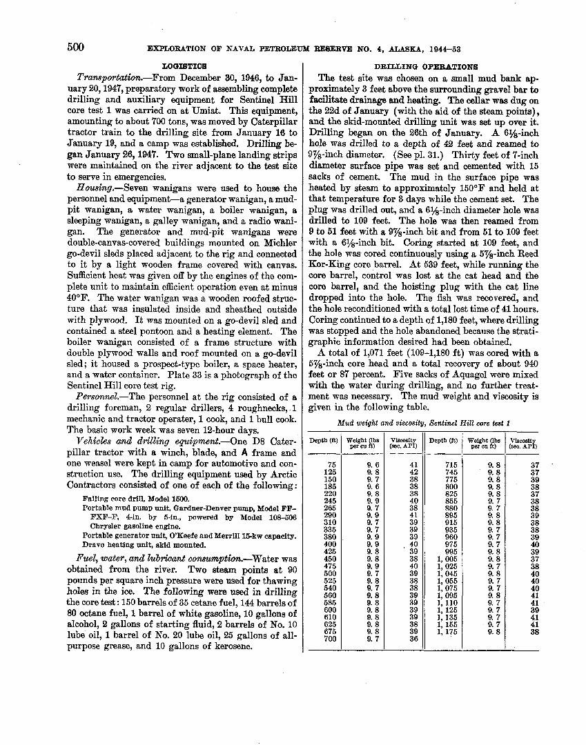
LOGISTICS Tramportatbn.-From December 80, 1946, to Jan-
uary 20,1947, preparatory work of assembling complete drilling and auxiliary equipment for Sentinel Hill core test 1 was carried on at Umiat. This equipment, amounting to about 700 tons, was moved by Caterpillar tractor train to the drilling site from January 16 to January 19, and a camp was established. Drilling be- gan January 26,1947. Two small-plane landing strips were maintained on the river adjacent to the test site to serve in emergencies.
Housing.-Seven wanigans were used to house the personnel and equipmenta generator wanigan, a mud- pit wanigan, a, water wanigan, a boiler wanigan, a sleeping wanigan, a galley wanigan, and a radio wani- gan. The generator and mud-pit wanigans were double-canvas-covered buildings mounted on Michler go-devil sleds placed adjacent to the rig and connected to it by a light wooden frame covered with canvas. Sufficient heat was given off by the engines of the com- plete unit to maintain efficient operation even at minus 40°F. The water wanigan was a wooden roofed struc- ture that was insulated inside and sheathed outside with plywood. I t was mounted on a go-devil sled and contained a steel pontoon and a heating element. The boiler wanigan consisted of a frame structure with double plywood walls and roof mounted on a go-devil sled; it housed a prospect-type boiler, a space heater, and a water container. Plate 33 is a photograph of the Sentinel Hill core test rig.
Personnel.-The personnel at the rig consisted of a drilling foreman, 2 regular drillers, 4 roughnecks,. 1 mechanic and tractor operater, 1 cook, and 1 bull cook. The basic work week was seven 12-hour days.
Vehicles arnd drilling equipment.-One D8 Cater- pillar tractor with a winch, blade, and A frame and one weasel were kept in camp for automotive and con- struction use. The drilling equipment used by Arctic Contractors consisted of one of each of the following:
Failing core drill, Model 1500. Portable mud pump unit, Gardner-Denver pump, Model FF-
FXF-F, Pin. by 6-in., powered by Model 108-506 Chrysler gasoline engine.
Portable generator unit, O'Keefe and Merrill l&kw capacity. Dravo heating unit, skid mounted.
Fuel, water, and Zub*nt conmmption.-Water was obtained from the river. Two steam points at 90 pounds per square inch pressure were used for thawing holes in the ice. The following were used in drilling the core test : 150 barrels of 35 cetane fuel, 144 barrels of 80 octane fuel, 1 barrel of white gasoline, 10 gallons of alcohol, 2 gallons of starting fluid, 2 barrels of No. 10 lube oil, 1 barrel of No. 20 lube oil, 25 gallons of all- purpose grease, and 10 gallons of kerosene.
DRILLING OPERATIONS
The test site was chosen on a small mud bank ap- proximately 3 feet above the surrounding gravel bar to facilitate drainage and heating. The cellar was dug on the 22d of January (with the aid of the steam points), and the skid-mounted drilling unit was set up over it. Drilling began on the 26th of January. A 6%-inch hole was drilled to a depth of 42 feet and reamed to 9%-inch diameter. (See pl. 31.) Thirty feet of 7-inch diameter surface pipe was set and cemented with 15 sacks of cement. The mud in the surface pipe was heated by steam to approximately 150°F and held at that temperature for 3 days while the cement set. The plug was drilled out, and a 6%-inch diameter hole was drilled to 109 feet. The hole was then reamed from 9 to 51 feet with a 9%-inch bit and from 51 to 109 feet with a 6%-inch bit. Coring started at 109 feet, and the hole was cored continuously using a 5%-inch Reed Kor-King core barrel. At 539 feet, while running the core barrel, control was lost at the cat head and the core barrel, and the hoisting plug with the cat line dropped into the hole. The fish was recovered, and the hole reconditioned with a total lost time of 41 hours. Coring continued to a depth of 1,180 feet, where drilling was stopped and the hole abandoned because the strati- graphic information desired had been obtained.
A total of 1,071 feet (109-1,180 ft) was cored with a 6%-inch core head and a total recovery of about 940 feet or 87 percent. Five sacks of Aquagel were mixed with the water during drilling, and no further treat- ment was necessary. The mud weight and viscosity is given in the following table.
Mud weight and viscosity, Sentinel Hill core test 1
Depth (it)
75 125 150 185 220 245 265 290 310 335 380 400 425 450 475 500 525 540 560 585 600 610 625 675 700
Weight lbs per ou it)
9. 6 9. 8 9. 7 9. 6 9. 8 9. 9 9. 7 9. 9 9. 7 9. 7 9. 9 9. 9 9. 8 9. 8 9. 9 9. 7 9. 8 9. 7 9. 8 9. 8 9. 8 9. 8 9. 8 9. 8 9. 7
Viscosit (sec. APP)
41 42 38 38 38 40 38 4 1 39 39 39 40
' 39 38 40 39 38 38 39 39 39 39 38 39 36
Viscosit (see. APT)
37 37 39 38 37 38 38 39 38 38 39 40 39 37 38 40 40 40 41 41 39 41 41 38
Depth (it)
715 745 775 800 825 855 880 895 915 935 960 975 995
1,005 1,025 1,045 1,055 1,075 1,095 1,110 1, 125 1, 135 1, 155 1,175
Weight (lbs per cu it)
9. 8 9. 8 9. 8 9. 8 9. 8 9. 7 9. 7 9. 8 9. 8 9. 7 9. 7 9. 7 9. 8 9. 8 9. 7 9. 8 9. 7 9. 7 9. 8 9. 7 9. 7 9. 7 9. 7 9. 8

CORE TEST, SENTINEL HILL AREA, AND TEST WELL, FISH CREEK AREA, ALASKA 501
Nine deviation surveys were made. The hole was off vertical by a steadily increasing amount from lo at 100 feet to 4 O at 975 ft. (See pl. 31.)
No electric log was run. In anticipation of future temperature surveys, 1,172
feet of 2%-inch diameter tubing was run in the hole and filled with approximately 8% barrels of diesel oil. The tubing was plugged at the top and bottom and welded to the top of the 7-inch casing. The cellar was filled with gravel, and the equipment moved out. On August 31, 1948, a geologist checked the site of the test from an airplane. A pole was still to be found on the top of the cliff above the location, but heavy mud slides had completely buried the casing and the pipe marking the site. No thermistor cables were installed.
FISH CREEK TEST WELL 1
Location: Lat 70°19'15" N., long 151°58'08" W.' Elevation above sea level: Ground, 16.6 feet; kelly bushing,
31.5 feet. Spudded : May 17, 1949. Completed : September 4, 1949; pumped 10 barrels of oil per
day ; abandoned. Total depth 7,020 feet.
Fish Creek test well 1 is on the Arctic Coastal Plain, about 20 miles west of the mouth of the Colville River (fig. 39). I t is in a flat region of marshy tundra and numerous lakes connected by small, meandering streams. The ground is permanently frozen beneath the few inches of sediment thawed by the summer sun; the anomalous character of the electric log in the upper part of the hole (pl. 32) suggests that the permafrost is present to a depth of some 600 feet.
An oil seep about 1% milea southwest of the well . was visited in 1943 by representatives of the U. S.
Bureau of Mines and the Alaska Territorial Depart- ment of Mines (N. Ebbley and H. R. Joesting, writtien communication, 1944). They described the seep as being about 6 feet wide and 20 feet long; the oil was solid and tarry, with no apparent thin oil on the sur- face. It was gummy enough to trap birds and small rodents. The petroleum laboratory of the Bureau of Mines at Bartlesville, Okla., analyzed a sample, and extractad 51.2 percent hydrocarbon. The specific gravity of the sample at 60°F (compared to that of water at 60°F) was 0.986; its API gravity was 12.0". The hydrocarbon was black, viscous, and asphaltic, and its low gravity suggested that it was "weathered" and that the more volatile constituents had evaporated.
lThe latitu'de and longitude have been determined with reference to the Harrison Bay quadrangle map (1 : 260,000 scale, 1951 ed.) in the Alaska reconnaissance topographic seriea #published by the U. 8. Qeol. Survey.
I n September 1947, the Arctic Contractors personnel visited the seep and described it as a small exposure of consolidated sand, impregnated with black asphaltic residue. (See pl. 344.) Depressions in the sand were filled with water, on which floated a small amount of black highly viscous, pitchlike material with the ap- pearance and odor of heavy fractions of petroleum. A few small birds were trapped in it.
The test well was drilled by Arctic Contractors to disclose the stratigraphy of the northeastern part of the Reserve; the seep, and a large gravity anomaly (lo- cated by United Geophysical Co., Inc.) underlying the area, suggested the possible presence of petroleum-bear- ing rocks and of some structural anomaly which might be a trap for oil. The drilling penetrated a little more than 7,000 feet of Cretaceous marine shales and a small amount of siltstone and very fine-grained sandstone. Volcanic shards are abundant in the uppermost 600 feet, and bentonite is present in the underlying 1,000 feet. About 10 barrels per day of heavy black oil was pro- duced, by pumping, from very fine-grained sandstone and siltstom between 2,920 and 3,060 feet. Shows of lighter oil were noticed in thin sandy siltstones below 5,400 feet, but tests of these were unsuccessful.
STRUCTURE
A seismic survey of the Fish Creek area made by United Geophysical Co., Inc., in 1948 indicates that the shallow Cretaceous beds (above 3,500 ft, at the well site) have a regional dip of about 50 feet to the mile, in an easterly direction. Beds of earliest Cretaceous or Jurassic age, at about 10,000 feet below the surface, dip somewhat more steeply to the south and are com- plicated by minor faulting. No anticline or closure was detected at any depth. The records did suggest the possibility of a small normal fault (downthrown 200 f t or less to the east) intersecting the well near the upper oil-bearing zone (United Geophysical Co., Inc., written communication, 1953). Projected to the surface, it would crop out close to the oil seep southwest of the well. Possibly such a fault could not only form a trap for the oil 3,000 feet below the surface, but the fault plane could also be the path of the oil to the surface to form the seep. There is no evidence from the well to corroborate or disprove the existence of such a fault.
Results of a gravity survey of the Reserve by the United Geophysical Co., Inc., completed in 1947, show a large area of unusually high gravity in the Fish Creek area (fig. 43) ; the well is near its apex. This recon- naissance survey was made on an approximate 5-mile grid. A magnetic survey, made jointly by the U. S. Navy and the U. S. Geological Survey in 1945 and 1946 shows the well to be in an area of comparatively uni- form magnetic intensity. A short distance to the west,
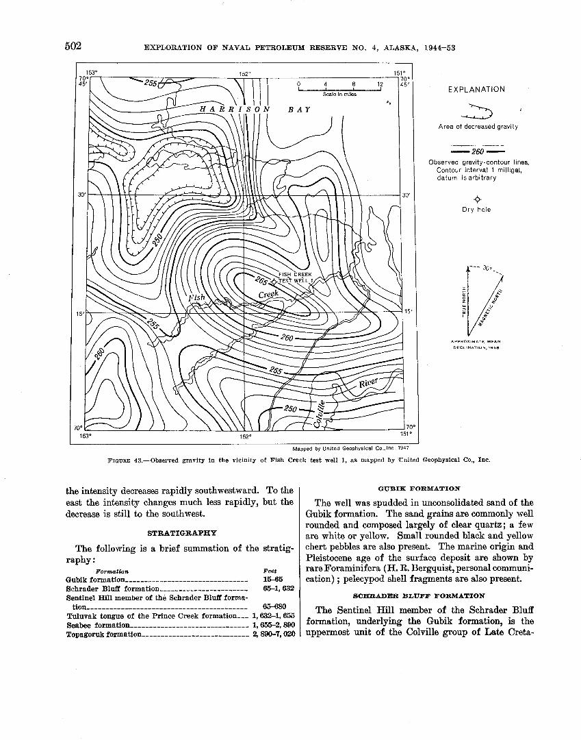
502 EXPLeORATION OF NAVAL PETROLEUM RESERVE NO. 4, ALASKA, 1944-53
EXPLANATION
5 '
Area of decreased gravity
Observed gravity-contour lines. Contour interval 1 rnilligal, datum is arbitrary
+ Dry hole
A P P R O X I M A T E M E A N D E C L I N A T I O N , 195s
L Mapped by United Geophysical C o . . l n c . . 1 9 4 7
FIGURE 43.-Observed gravity in the vicinity of Fish Creek test well 1, a s mapped by 'United Geophysical Co., Inc.
the intensity decreases rapidly southwestward. To the east the intensity changes much less rapidly, but the decrease is still to the southwest.
STRATIGRAPHY
The following is a brief summation of the stratig- raphy :
Formatbn Feet Gubik formation .............................. 16-65 Schrader B l a formation ....................... 65-1,632 Sentinel Hill member of the Schrader Bluff forma-
GIUBIK FORMATION
The well was spudded in unconsolidated sand of the Gubik formation. The sand grains are commonly well rounded and composed largely of clear quartz; a few are white or yellow. Small rounded black and yellow chert pebbles are also present. The marine origin and Pleistocene age of the surface deposit are shown by rare Foraminifera (H. R. Bergquist, personal communi- cation) ; pelecypod shell fragments are also present.
SCHRADER BLTJ'FF FORMATION
tion-------------------------------------- 65-680 Tuluvak tongue of the Prince Creek formation--- 1,632-1,655 Seabee formation ............................... 1,655-2,890 Topagoruk formation ............................ 2,890-7,020
The Sentinel Hill member of the Schrader Bluff formation, underlying the Gubik formation, is the uppermost unit of the Colville group of Late Creta-
CORE TEST, SENTINEL HILL AREA, AND TEST WELL, FISH CREEK AREA, ALASKA 503
ceous age in this test. It is marine clay shale, with some interbedded siltstone. The rock is light gray, noncalcareous, and characterized by abundant clear, glassy volcanic shards. Rare sandstone beds are also light gray and are composed of subangular to angular grains of clear and white quartz with abundant shards, some gray chert, and minor amounts of pyrite and mica. The siltstone differs from the sandstone only in grain size. Green glauconite pellets are abundant between 570 and 600 feet; pyrite is abundant at 120-270 and 370-400 feet. Organic remains include scattered car- bonized plant particles and rare minute fishbone frag- ments. Foraminifera are rare. Radiolaria are rare to abundant below 590 feet, and Inoceramus prisms first occur at 605 feet (H. R. Bergquist, personal communication).
The rest of the Schrader Bluff formation is made up primarily of marine clay shale, but it is medium as well as light gray, and interbedded siltstone is more common than in the Sentinel Hill member. Some light- gray slightly argillaceous and calcareous sandstone is near the base. Thin beds of light-yellowish-gray bento- nite are below 825 feet, and some of the shale is bento- nitic. There is a bed of dark-brown limestone at 765 feet. Biotite flakes are increasingly common below 1,300 feet.
P R I N C E C R E E g FORMATION, TULUVAK TONGUE
At 1,632 feet a 10-inch bed of dark-gray carbonaceous clay shale marks the top of the Tuluvak tongue of the nonmarine Prince Creek formation (Colville group of Late Cretaceous age). The 25-foot section of sandstone, lignite, and bentonite contrasts sharply with the marine sediments above and below. The sandstone is light gray, fine to medium grained, slightly argillaceous, and very friable; it contains carbonaceous partings, grains of carbonaceous material, and angular grains of gyp- sum. I ts porosity is high-32.55 percent-and it was too friable to test for permeability. The lignite is brownish black and friable and is interbedded with +&inch layers of coal. The bentonite is yellowish gray and argillaceous and contains partly carbonized plant fragments.
SEABEE FORMATION
The underlying Seabee formation (Colville group) is another marine shale; it contains a small amount of interbedded siltstone and rare sandstone beds. I t is similar lithologically to the overlying Schrader Bluff formation, but it has less bentonite, and practically no volcanic shards, and carbonaceous material is very rare. The clay shale is light gray, micaceous, and noncal- careous and contains rare siltstone laminae; some has
carbonaceous particles scattered through it. Biotite is common, especially in the lower part of the formation. The rare sandstone beds are light gray, very h e grained, and micaceous. The sand grains are angular white quartz with some gray chart; the mica is light green, clear, or light brown. Two thin limestone beds are at 2,175 and 2,290 feet; both are blue-gray, argil- laceous, and massive. The formation contains a dis- tinctive microfauna, and Z n o c e r a w prisms, ammonite shell fragments, and fishbone fragments are common.
TOPAGORUK FORMATION
The beds between 2,890 and 3,060 feet in Fish Creek test well 1 consist of thin-bedded siltstone with some interbedded very fine-grained sandstone and clay shale. In much of northern Alaska, the Colville group is separated from the Topagoruk formation of Early Cretaceous age in the subsurface by the Ninuluk forma- tion, the Iiillik tongue of the nonmarine Chandler for- mation, and marine sandstone of the Grandstand for- mation. I n this test, however, no definitely nonmarine beds or massive sandstone layers can be identified ; and as the lithology of this interval resembles that of the marine Topagoruk formation more closely than any other unit, these strata are tentatively assigned to the Topagoruk formation. Between 2,890 and 3,030 feet microfossils are absent except for a few specimens of doubtful identity, but below 3,030 feet the beds contain an assemblage of Foraminifera described by H. R. Borgquist as the Verneuilimides borealis fauna. Uitmpa sp. and Zwceramus sp. shell fragments, com- monly associated with the microfauna, are also present.
Between 2,920 and 3,060 feet, the beds of sandy argil- laceous siltstone and clay shale, with rare argillaceous silty sandstone, contain black, asphaltic heavy oil which was pumped at a rate of about 10 barrels a day. The rock was too thin bedded and friable to permit adequate permeability tests, but the high proportion of silt and clay suggests that permeability is low. The porosity of 1 sample was 25.2 percent; the rest of the rock was too friable to be tested. The oil-stained beds are light yellowish brown to grayish brown; the unstained silt- stone is light gray; the clay shale, medium gray. Be- low the oil-bearing rocks the proportion of shale in- creases, but sandy siltstone beds continue in decreasing abundance to 3,720 feet. The shale is light to medium gray and slightly silty and has some laminae and thin lenses of light-gray micaceous siltstone. The thicker beds of siltstone are also light gray and slightly micaceous, and carbonaceous particles are present in some. Light-bluish-gray argillaceous limestone beds are present near 3,170 feet.
The rest of the Topagoruk formation is composed almost entirely of marine clay shale, containing the
504 EXPLORATION OF NAVAL PETROLEUM RESERVE NO. 4, ALASKA, 1944-53
same microfauna as the upper beds. The shale darkens and hardens with increasing depth, however; and be- low 5,000 feet it is medium dark gray and cleaves easily into chips with their flat surfaces parallel to the bed- ding planes. The clay shale is commonly silty, and much of it contains thin laminae and beds of siltstone. I n some places, deformation shortly after deposition (presumably by slumping of the unconsolidated sedi- ment) has distorted the beds, mixing light-gray silt- stone and darker clay shale, which gives the appearance of marble. (See pl. 34B.) Above and below such intervals, the bedding is relatively undisturbed. I n contrast with the flat-lying strata of the upper beds, however, strata in this part of the Topagoruk for- mation have measured dips of 5" to 25' (the devia- tion of the hole was 4" where the measured dip was steepest).
Between 5,400 and 5,600 feet, the Topagoruk forma- tion includes beds of siltstone (and l or 2 of very h e - grained sandstone), which are commonly less than 1 foot thick, are very argillaceous and are interbedded with clay shale. Many of them are slightly oil stained, but no successful tests of the section were made. Po- rosity and permeability are very low: 6-8 percent and less than 5 millidarcys, respectively. Below 5,600 feet, only 1 or 2 thin beds of siltstone interrupt the long sequence of clay shale.
DESCRIPTION OF CORES AND CUTTINGS
The detailed lithologic description is based primarily on an examination of cores and cuttings made in the Fairbanks laboratory and on the electric log. The material was described dry, and colors were determined by comparison with the Rock Color Chart (Goddarol and others, 1948). Some of the cores of clay shale break very uniformly along bedding planes, forming disk-shaped pieces about a quarter of an inch thick. This characteristic manner of breaking is described as poker-chip cleavage. All depths were measured from the kelly bushing. The abundance of microf ossil speci- mens mentioned at the beginning of each core descrip- tion is defined as follows: 14, very rare; 5-11, rare; 12-25, common; 26-50, abundant; more than 50 very abundant.
Lithologic description [Where no core number is listed, description is based on cutting samples]
Owe I Depth (feet) I Remarks --PA- ------
Lithologic desoription-Continued
Depth (feat) I Remarks
0-15 15-46
Sand, light yellowish gray, coarse to fine; pebbles as much as half an inch in diam- eter in lower part. Most grains rourded to subrounded, with frosted to polished surfaces. Sand is dominantly quartz (mostly clear, with some white or yellow). Small percentage of clear quartz grains are angular, with subcon-
Kelly bushing to ground level. No samples. Driller reported soft sand
to 22 ft, hard sandstone from 22 to 32 f t , and soft sand from 32 to 46 ft. Top of the Gubik formation at 15 feet.
choidal, unweathered surfaces. Peb- bles commonly under one fourth of an inch in diameter, rounded to sub- rounded, and consist largely of black chert, with smaller quantity of yellow chert. Black pebbles commonly have bluish-gray or yellow cores.
Clay, bluish-gray to gray, soft, sticky; rare sand. Top of Sentinel Hill mem- ber of Schrader Bluff formation at a t 65 ft.
Clay shale, light-gray; abundant color- less (rarely light-grayish-brown) trans- parent volcanic shards; some light-gray siltstone. Pyrite and carbonized plant material common below 160 ft.
Recovered 3 f t : Microfossils absent. 2 f t , siltstone, light-gray, noncalcareous,
moderately indurated; shaly cleavage; abundant volcanic shards and pyrite grains, concretions, and pyrite-re- placed organic matter; a few streaks of very fine sand.
1 f t , siltstone, light-olive-gray, non- calcareous, moderately indurated; scattered carbonized plant fragments. Abundant volcanic shards and pyrite as above. Beds lie approximately flat.
As core 1 , except pyrite is rare between 270 and 370 ft and from 400 to 610 ft.
Recovered 7 ft: Microfossils very rare. 4 in., sandstone, light-gray, medium- to
fine-grained, slightly silty, friable, unstratified; very abundant volcanic shards. Sand grains are subangular to angular, have low sphericity, and are composed principally of clear or white quartz, with some gray chert and minor amounts of granular pyrite, and white, brown, or light- green micas.
6 f t 8 in., siltstone, light-gray, friable; shaly cleavage; abundant volcanic shards; some laminae of medium- gray noncalcareous friable clay shale and of light-gray very fine grained
1 silty noncalcareous friable sandstone containing abundant volcanic shards. Beds lie approximately flat.
CORE TEST, SENTINAL RILL AREA, AND TEST WIELL, FISH CREEK AREA, USKA 505
Core
--- --
3
---- -
4
--- - - 5
description-Gontinued
Remarks
bone fragments and pyrite present throughout the core. Beds lie a p proximately flat.
Clay shale as in core 5, with rare siltstone. Abundant bentonite at 1,075 f t and 1,105 ft; pyrite abundant from 1,190 to 1,225 f t . Microscopic ammonite shell fragment a t 1,105 ft.
Recovered 10 ft: Microfossils very rare. Clay shale, light-gray, very silty,
micaceous, slightly calcareous, well- indurated, with carbonized plant re- mains and interlaminated very fine- grained light-gray silty sandstone containing angular grains of gyp- sum (?) and dark-gray carbonaceous clay shale. Laminae are crossbedded with dips as much as 10'. Slight oil cut in CClr.
Clay shale, as in core 6; some sandstone from 1,320 to 1,420 ft, especially in upper 30 ft; bed of fine- to medium- grained medium-light-gray sandstone a t 1,317-1,320 ft. Biotite flakes rare to 1,300 ft; grade to common a t 2,400 ft. Inoceramus prisms 1,290-1,422 ft.
Recovered 6 ft: Microfossils absent. 3 f t 6 in., clay shale as in core 6; a t
1,424 ft is %-in. layer of light-yellow- ish-gray noncalcareous slightly mica- ceous clay shale with a few carbonized plant particles.
2 f t 6 in., clay shale, light-gray, slightly micaceous, noncalcareous, moderately indurated; with carbonaceous lami- nae and intercalations of light- to medium-gray or yellowish-gray non- calcareous moderately indurated silt- stone, containing carbonaceous lam- inae and flakes of carbonized plant material. Beds lie approximately flat.
Clay shale as in core 7 above, with some siltstone; dark-brown siltstone in sam- ple from 1,555 to 1,560 ft; some very fine- to medium-grained gray mod- erately calcareous carbonaceous mica- ceous sandstone interbedded with silt- stone between 1,560 and 1,600 ft. Bentonite rare.
Recovered 10 ft : Microfossils very rare. 7 ft, interbedded clay shale and silt-
stone, light- to medium-gray, slightly micaceous, noncalcareous, moderate- ly indurated; shaly cleavage; car- bonaceous films common; flakes of carbonized macerated plant remains. Some crossbedding dips as much as 10'; single beds are 0.2-100 mm
Uthobgio
Depth (feet)
435-627
627-635
635-825
825-835
835-1,025
1,025-1,035
Core
- - - - -
6
- - - - -
7
- ,- - -
8
de8orCpttcnkContinued
Remarks
Lithology is similar to siltstone in core 2. From 570 to 600 ft, rounded green clay pellets (glauconite?) are abundant, rare elsewhere. Between 605 and 627 f t are several small fragments of Inoceramus shells. At 610 ft, pyrite becomes common.
Recovered 5 f t 6 in.: Microfossils common. 1 f t 2 in., clay shale, light-gray, noncal-
careous, moderately indurated; a few small streaks of pyrite, probably re- placing macerated plant remains. Beds lie approximately flat.
4 ft 4 in., siltstone, medium- to light- gray, noncalcareous, moderately in- durated; shaly cleavage at bottom; medium-gray moderately indurated noncalcareous clay shale streaks. Pyrite grains and small pyritized and carbonized plant fragments scattered throughout; also shell fragments and volcanic shards (abundant in top 1 ft). Microscopic fishbone fragments also present.
Clay shale and siltstone as in core 3. Mi- croscopic fishbone fragments present, though rare, from 700 to 4,230 ft. Dark-brown to light-gray limestone oc- curs a t 755-760 ft. Base of Sentinel Hill member at 680 ft.
Recovered 10 ft: Microfossils common. Claystone, medium-gray, noncalcare-
ous, poorly indurated, slightly waxy; conchoidal fracture; pyrite streaks and pyritized organic remains rare. At 827% f t is a 1-in. layer of light- yellowish-gray, noncalcareous poorly indurated waxy bentonite that grades into and contains streaks of medium- gray claystone. At 831 f t is a 4in. layer of light-yellowish-gray ben- tonite like that at 827% ft.
Claystone as in core 4, with rare silt- stone; bentonite common a t 985 ft.
Recovered 10 f t : Miorofossils abundant. 8 in., clay shale, light- to medium-gray,
noncalcareous, moderately indurated. 2 in., bentonite, yellowish-gray, non-
calcareous, friable; conchoidal frac- ture; slightly waxy luster.
9 ft 2 in., clay shale, brownish to me- dium-gray, moderately indurated; some flaky films of black carbona- ceous material; no oil cut in CCL. Layers of yellowish-gray bentonite, as described above, occur as follows: %-in. layer a t 1,028 ft, 4-in. layer a t 1,031 f t , 1-in. layer a t 1,032 f t , six 1-in. layers a t 1,033-1,035 ft . Fish-
Lithologic
Depth (feet)
1,035-1,225
1, 225-1,235
1, 235-1, 422
1, 422-1, 432
1,432-1,625
1, 625-1, 635

506 EXPLORATION OF NAVAL PETROLEUlld RESERVE NO. 4, ALASKA, 1944-63
- Core
thick. At 1,631 f t is a %-in. lens of very light-gray fine-grained argillace- ous well-indurated noncalcareous sandstone. Top of Tuluvak tongue of Prince Creek formation a t 1,632 ft .
10 in., clay shale, dark-gray, silty, carbonaceous, somewhat micaceous noncalcareous; scattered flakes of carbonized macerated plant remains.
2 f t 2 in., sandstone, light-gray, medi- um-grained, argillaceous, noncalcare- ous, friable; no bedding visible.
Depth (feat)
Contains angular grains of gypsum (1). Porosity 27.6 percent.
Recovered 10 f t : Microfossils absent. 8 in., interlaminated clay shale, medium-
gray, and sandstone, light-gray, very
Remarks
fine-grained, argillaceous, micaceous, noncalcareous, moderately indurated. No crossbedding; beds lie approxi- mately flat.
4 f t 4 in., sandstone. light-gray, fine- to medium-grained, slightly argillaceous, noncalcareous, very friable (largely unconsolidated) ; carbonaceous films and grains in upper 3 in., decreasing with depth. Contains angular grains of gypsum. Very faint oil stain in CClr; porosity 32.55 percent.
2 ft 6 in., sandstone, light-gray, fine-
I
I grained, argillaceous, noncalcareous, moderate17 indurated. Streaks of macerated plant material, carbonized plant remains, and carbonaceous material throughout, increasing with depth.
2 ft 6 in., lignite, brownish-bhck, friable; %-in. coal seams; %in. layer of impure yellow-brown waxy homo- geneous bentonite a t 1,6445 f t .
Recovered 4 f t : Microfossils very rare. 3 f t 2 in., lignite as in core 9, with
intercalatiors of brown to black fissile carbonaceous clay shale in bottom 1 ft; 2411. bed of bentonite, as a t 1,644s ft, 1 f t from top.
9 in., bentonite, yellowish-gray, argil- laceous, noncalcareous, moderately indurated; partly carbonized plant fragments scattered throughout.
1 in., lignite. Clay shale, light-gray ; some interbedded
siltstone; light- to medium-gray fine- to very fine-grained calcareous mica- ceous slightly carbonaceous sandstone a t 1,735 f t , and 1,835 ft. Sand grains are angular white quartz with some gray chert and light-green, clear or light-brown mica. Top of Seabee for- mation a t 1,655 ft.
Depth (feet) Remarks
Recovered 10 ft: Microfossils absent. Clay shale, light-gray, very silty and
micaceous, noncalcareous, moderately indurated; shaly cleavage; a few %-in. layers of light-grayish-yellow highly calcareous well-indurated clay- stone; carbonized flakes of plant remains very rare. At 1,856 f t is 1-in. bed of light-gray fine-grained argillaceous noncalcareous, well- indurated sandstone. Beds lie approximately flat.
Clay shale as in core 11 above, some siltstone; very fine-grained light- greenish-gray calcareous sandstone a t 1,970-1,975 ft and 1,990-1,995 ft.
No recovery. Recovered 10 f t : Microfossils common.
Clay shale, medium- to light-gray, very silty, slightly carbonaceous, highly micaceous, noncalcareous, moderately indurated; flakes and films of car- bonized plant remains. Rare laminae of medium-gray clay shale. Beds lie approximately flat.
Clay shale as in core 13 above, with some siltstone; white to yellow limestone a t 2,100 f t . A fish vertebra found in sample from 2,140 ft; a bed of brown to blue-gray limestone a t 2,170 ft.
Recovered 2 ft: Microfossils abundant. Clay shale, gray, micaceous, non-
calcareous, moderately indurated; a few laminae of siltstone; flakes and films of black carbonized macerated plant material scattered throughout. Beds lie approximately flat.
No recovery. Recovered 1 f t : Microfossils very rare.
4 in., clay shale, light-gray, micaceous, noncalcareous, moderately indurated; rare siltstone laminae.
8 in., limestone, bluish-gray, argillace- ous, massive, well-indurated. Lami- nae with yellowish gray impurities show a miniature thrust fault with throw of one-fourth of an inch.
Clay shale as in core 13 above, with some siltstone. Euhedral biotite fiakes common to abundant from 2,400 to 4,000 ft. One to three Znoceranus prisms are present in most ditch samples from 2,350-2,490 ft: six were found in the 2,490-2,495 f t sample.
Microscopic fragments of ammonite shells occur a t 2,380 and 2,400 f t .
Recovered 3 f t 8 in.: Microfossils rare. Clay shale, light-gray, very silty and
micaceous, noncalcareous, mod- erately indurated; flakes and films of
corn TEST, SENTINEL HILL AREA, AND TEST WELL, FISH CREEK AREA, ALASKA 507
Depth (feat) Remarks
carbonized macerated plant material scattered throughout. Rare Inocera- mu8 and ammonit,e shell fragments. Beds lie approximately flat.
Clay shale as in core 14 above; some silt- stone; pyrite increases gradually from very rare at 2,503 f t to common a t 2,700 ft. Carbonized plant m a terial abundant a t 2,680-2,695 ft. One microscopic fragment of an ammonite shell was noted ai 2,545 ft.
Recovered 10 f t : Microfossils abundant. Clay shale, medium-gray, carbonace-
ous, very micaceous, noncalcareous, moderately indurated; dark-gray la- minae (0.2-1.0 mm thick) of black carbonaceous material alternate with light-gray laminae 0.2 mm thick. From 2,706 f t to 2,707 f t are scat- tered laminae of light-gray very fine- grained argillaceous very micaceous noncalcareous sandstone containing angular gypsum grains. Beds ap- proximately lie flat.
Clay shale as in core 18 with rare sand- stone and siltstone; one ammonite fragment a t 2,750 ft. Top of Topa- goruk formation a t 2,890 ft.
Recovered 10 ft: Microfossils rare. 1 ft, clay shale, light-gray, micaceous,
noncalcareous; light-gray micaceous no~calcareous siltstone laminae.
2 f t 8 in., as above, with moderate to strong petroliferous odor.
1 f t 4 in., as above, with faint petro- liferous odor.
4 in., sandstone, very fine-grained, silty, noncalcareous; dark-gray clay laminae; crossbedding dips as much as 15'; well oil stained.
4 ft 5 in., interbedded clay shale, silt- stone, and very fine-grained silty sandstone; 3 parts clay to 1 of sand and silt. Clay shale is light gray, noncalcareous, micaceous. Siltstone and sandstone beds are light gray, noncalcareous, 0.2-3.0 cm thick, have laminae of dark-gray clay, and show good stain of dark oil in most layers. Porosity a t 2,923 f t is 25.25 percent.
3 in., siltstone, slightly sandy, micace- ous, noncalcareous; yellowish brown owing to fair oil stain.
Recovered 1 f t 8 in.: Microfossils absent. 3 in., interlaminated sandstone, yel-
lowish-brown, very fine-grained, silty, micaceous, noncalcareous, with fair oil stain; and silty light-gray mica-
Core -
Lithologic desariptiorr-Continued
Depth (feet) Remarks
ceous noncalcareous clay shale. Beds lie approximately flat.
1 f t 5 in., sandstone, dark-brown, very fine-grained, silty, thin-bedded; well stained with dark oil.
Recovered 1 f t 5 in.: Microfossils very rare.
Clay shale, light-gray, micaceous, non- calcareous; silt streaks.
Recovered 5 ft: Microfossils rare. 4 f t 4 in., clay shale, light-gray, slightly
micaceous, noncalcareous. 8 in., clay shale, with lenses of sand-
stone, brownish-yellow, very fine- grained, silty; fair oil stain.
Recovered 10 ft: Microfossils absent. Clay shale, light-gray, slightly mica-
ceous, noncalcareous; lenses and len- ticles 0.2-100 mm (usually under 10 mm) thick of light-gray to yellow- brown noncalcareous micaceous silt- stone with a poor to good stain of dark oil. Beds lie approximately flat.
Recovered 10 ft: Microfossils absent. 1 f t 7 in., clay shale, light-gray, mica-
ceous, noncalcareous; a few layers of siltstone. Beds lie approximately flat.
5 f t 11 in., as above, with lenses of medium- to very fine-grained silty sandstone as much as 2 cm thick, with good stain of dark oil.
2 f t 6 in., siltstone, brown and yellowish- brown, slightly sandy, noncalcare- ous, friable, with good stain of dark oil.
Recovered 10 ft: Microfossils absent. Siltstone, grayish-brown to dark-brown,
slightly sandy, micaceous, noncal- careous; fair t o good stain of dark oil, with dark-gray clay shale lam- inae showing crossbedding dipping as much as lo0.
Recovered 10 ft: Microfossils absent. 11 in., siltstone, light-yellowish-gray,
micaceous, noncalcareous; slightly oil stained.
3 f t 2 in., siltstone, light-yellowish- brown, slightly micaceous, noncal- careous; dark-brown clay laminae, A %-in. coal bed a t bottom of sec- tion. Beds lie approximately flat.
7 in., clay shale, light-gray, micaceous, noncalcareous; silt streaks, and scat- tered minute flakes of carbonized plants.
6 in., siltstone, yellow-brown, micace- ous, noncalcareous; good stain of dark oil.

EXPL0,RATION OF NAVAL PETROLEUM RESERVE: NO. 4, ALASKA, 1944-53
Core -
Lithologic descriptiorz-Continued I Mthologic description-Continued
2 f t 5 in., clay shale, light-gray, slightly micaceous, slightly calcareous; very faint petroliferous odor toward bot- tom of section; lenticles of light-gray siltstone throughout.
8 in., siltstone, brown, noncalcareous; good stain of dark oil.
7 in., clay shale, light-yellowish-gray, silty, very micaceous, noncalcareous: faint odor of oil.
1 ft 2 in., siltstone, yellow-brown, mi-
Depth (feet)
caceous, noncalcareous; good stain of dark oil.
Recovered 4 f t : Microfossils absent. Siltstone, light-gray (where not oil
stained), friable, micaceous, non-
Remarks
calcareous; some flat-lying laminae and beds as much as 1 in. thick of light- to medium-gray noncalcareous micaceous clay shale; most of the siltstone is well stained yellowish- brown to dark-brown with dark oil.
Recovered 10 f t : Microfossils absent. 1 ft, interbedded siltstone, micaceous,
noncalcareous; fair to good stain of dark oil; and light-gray noncal- careous micaceous clay shale.
1 ft 3 in., siltstone, medium- to dark-
I
brown, noncalcareous, micaceous, fri- able; well stained with dark oil; laminae of dark-brown clay.
1 f t 8 in., clay shale, light-gray, silty, micaceous, noncalcareous; faint oil stain in top 8 in.; intercalations of light-gray noncalcareous micaceous siltstone.
7 in., siltstone, light-gray, slightly calcareous.
1 f t 3 in., limestone, light-gray, well- indurated; very argillaceous in top.
8 in., siltstone, light-gray, slightly micaceous, noncalcareous.
3 f t 7 in., siltstone, yellow- to dark- brown; well stained with dark oil.
Recovered 10 ft: Microfossils absent. 3 f t , siltstone, light-gray to light-
yellowish-brown, micaceous; poor to good stain of dark oil.
4 ft 5 in., siltstone, light-gray, mica- ceous, noncalcareous; a few inter- calations of light-gray clay. Beds lie approximately flat.
1 f t 3 in., siltstone, light-yellowish- to medium-brown, micaceous; fair to good stain of dark oil.
1 in., clay shale, light-gray, micaceous, noncalcareous.
1 ft 3 in., siltstone; light gray where unstained; yellowish gray to brown where oil stained; micaceous, non-
o r e 1 Depth (feet) 1 Remarks I
calcareous; (1 in. poorly oil stained, 2 in. well stained, 3 in. poorly stained, 9 in. well stained).
Recovered 10 ft: Microfossils absent. 1 f t 1 in.. clay shale, light-gray, mica-
ceous, very calcareous. 5 in., siltstone, light-gray, micaceous,
very calcareous; one-half an inch of dark-brown siltstone well stained with dark oil; friable a t base.
7 in., clay shale, light-gray, slightly micaceous, very calcareous.
2 f t 11 in., interbedded clay shale, light- gray; and light-gray to dark-brown siltstone; good oil stain in part; small flakes of carbonaceous material on some partings.
1 f t 9 in., siltstone, light-brownish- gray, micaceous, noncalcareous; fair oil stain.
1 f t 5 in., siltstone as above, light-gray, with yellowish tinge; poor to no oil stain.
1 f t 10 in., siltstone as above, yellow- to dark-brown, friable; well stained with dark oil.
Recovered 10 ft: Microfossils rare. 4 in., sandstone, dark-brown, very
fine-grained, silty; well stained with dark oil.
1 f t , clay shale, light-gray, micaceous, slightly calcareous; laminae of light- gray calcareous micaceous silt; fair odor oil. Beds lie approximately flat.
4 in., interlaminated clay shale and calcareous micaceous siltstone, yel- lowish-gray to yellowish-brown; poor to good stain dark oil.
2 in., siltstone, dark-brown; well stained with dark oil.
2 in., clay shale, light-gray, slightly calcareous; laminae of light-gray, calcareous siltstone.
1 f t 5 in., siltstone, brown, micaceous; well stained with dark oil.
2 in., clay shale, light-gray, with yel- lowish tinge, calcareous.
6 in., siltstone, light- to yellow-gray, noncalcareous; poor to fair stain of dark oil.
1 f t 1 in., siltstone as above, dark- brown; well stained with dark oil.
9 in., interbedded siltstone and clay shale, light-gray to light-yellowish- brown, calcareous, micaceous; silt- stone has fair oil stain in part.
2 f t 7 in., clay shale, light-gray, slightly micaceous, slightly calcareous; lami- nae and thin (as much as 2 cm) beds

CORE TEST, SENTINEL HILL AREA, AND TEST WELL, FISH CREEK A ~ A , ALASKA 509
desoriptiMontinued
Remarks
of light-gray to light-yellowish-brown siltstone; no stain to fair oil stain. Carbonaceous flakes on partings in upper 3 in.
1 f t 6 in., clay shale, light-gray, cal- careous; a few laminae of light-gray micaceous slightly calcareous silt- stone.
Recovered 10 ft: Microfossils rare. 4 ft, interbedded thin-bedded clay
shale and siltstone, light- to medium- gray, micaceous, partly calcareous; slight oil stain in silt laminae in top 1 ft. Beds lie approximately flat.
6 in., siltstone, yellow-brown, micace- ous, calcareous; good stain of dark oil.
5 ft 6 in., same as first 4 f t of core. Recovered 10 ft: Microfossils abundant.
Clay shale and siltstone as above. Similar to core 32. Tubes of the worm
Ditrupa sp. (identified by R. W. Imlay) first appear at 3,060 f t , and are in a few samples from that point to 4,200 ft.
Recovered 7 f t 2 in.: Microfossils rare. 5 ft, siltstone, light-gray, slightly
micaceous, noncalcareous, moder- ately indurated; shaly cleavage; rare clay laminae and carbonaceous films. Shell fragments a t 3,165 ft. Beds lie approximately flat.
6 in., siltstonel light-grayi very calcare- ous, moderately indurated; grades into unit below.
1 ft 8 in., limestone, light-bluish-gray, very to moderately argillaceous, well-indurated.
Recovered 10 ft: Microfossils abundant. 3 in., limestone, medium-blue-gray,
slightly argillaceous, well-indurated. 9 f t 9 in., siltstone, light-gray, slightly
micaceous, slightly calcareous, mod- erately indurated. Pelecypod shell fragments, small carbonaceous flakes are scattered throughout.
siltstone as in core 35, with clay shale. Sandy strata from 3,240 to 3,250 ft. Bentonite a t 3,285 ft; Inoceramua prisms common in 1 ditch sample a t 3,325 ft. From core 35 upward, beds lie flat, except for small amount of crossbedding which dips as much as 10'. Variable and gradually increasing dips have been recorded in lower cores.
Recovered 10 ft: Microfossils very abun- dant.
Clay shale, medium- to light-gray, non- calcareous; a few laminae and lenses of light-gray slightly calcareous mica- ceous siltstone; very rare carbonaceous flakes and partings. Beds dip 5'.
Core
37
38
- - - _ -
39
----- 40
-----
41
Core -
32
33
-----
34
35
- -- - -
36
Lithologic
Depth (feet)
3,040-3,050
3,050-3,060
3,060-3,162
3, 162-3, 171
3, 171-3, 181
3, 181-3, 356
3,356-3, 366
Lithologic
Depth (feet)
3,366-3,376
3,376-3, 386
3,386-3, 576
3, 576-3,586
3,586-3, 776 3, 776-31 786
3,786-3, 976
3, 976-3, 986
description--Continued
Remarks
Recovered 10 ft : Microfossils common. 5 f t , same as above except dips range
from 0' to 5'. 3 f t 6 in., clay shale, medium- to light-
gray, slightly micaceous, noncal- careous.
1 f t 1 in., same as above, slightly car- bonaceous; nodules, lenses and streaks of light-grayish-yellow noncalcareous claystone; streaks of light-gray sandy siltstone; with scattered carbonaceous flakes.
5 in., siltstone, light-gray, noncalcare- ous.
Recovered 10 ft: Microfossils common. 6 f t 3 in., siltstone, light-gray, noncal-
careous; a few laminae of medium- gray crossbedded clay shale with dips to 10'; layer of clay shale at 3,379 f t is 1% in. thick. Fragments of pelecy- pod shells and carbonized fragments in bottom 2% ft. Coquina, one-half inch thick, of Ditrupa sp. fragments in clay shale matrix.
3 f t 9 in., interbedded clay shale, medium- to dark-gray, carbonaceous, noncalcareous; and light-gray non- calcareous siltstone. Scattered shell fragments. Single beds are 0.2 to 40 mm thick. Clay increases with depth.
Lithology as in core 37 above, but with larger amount of siltstone; sandstone is in thin beds between 3,400-3,450 ft; rare limestone.
Recovered 10 ft: Microfossils very abun- dant.
Clay shale, light- to medium-gray, slightly silty, noncalcareous; scat- tered silty partings, flakes and films of carbonaceous material, and mica- ceous streaks. Beds lie approxi- mately flat.
Clay shale as in core 39; rare silstone. Recovered 9 ft: Microfossils very &bun-
dant. Clay shale as in core 39; a few laminae
and thin beds of light-gray siltstone; slight increase of carbonaceous mate- rial. Beds lie approximately flat.
Clay shale as in core 40, with siltstone in lower part. Minute ammonite shell fragment found at 3,810 ft.
Recovered 8 f t 4 in: Microfossils very abundant.
Clay shale, light- to medium-gray, very slightly micaoeous, noncalcareous; a few laminae of light-gray siltstone; pyrite nodule 1 in. diameter a t 3,978 ft. Beds lie approximately flat.
510 EXPLORATION OF NAVAL PETROLEUM RESERVE NO. 4, ALASKA, 1944-53
Core
-----
42
- - - - -
43
- - - - -
44 45
----- 46
-- --- 47
---- -
48
----- 49
-----
Core
50
51
52
53
Lithologic
Depth (feet)
3,986-4, 140
4, 140-4, 150
4, 150-4,340
4, 340-4,350
4,350-4, 534
4,534-4,544 4, 544-4, 554
4,554-4,698 4,698-4, 708
4, 708-4,900 4, 900-4, 910
4,910-5,078
5,078-5,088
5,088-5,280 5,280-5,290
5,290-5,480
description-Continued
Remarks
Clay shale as in core 41; sandy and silty streaks rare.
Recovered 7 f t 6 in.: Microfossils common. 2 f t 6 in., clay shale, light- to medium-
gray, slightly silty, slightly micace- ous, noncalcareous; rare laminae of light-gray siltstone.
5 f t , clay shale, medium-gray, noncal- careous; some carbonized plant flakes on partings; a few laminae of light- gray noncalcareous siltstone. Beds lie approximately flat.
Clay shale as in core; siltstone very rare. Ditrupa sp. fragments a t and above 4,200 ft; lowest fishbone fragments a t and above 4,230 f t ; fragment of delicate outer shell of Inoceramus sp. a t 4,240 f t .
Recovered 8 f t 6 in.: Microfossils abun- dant.
Clay shale, medium- to light-gray, partly silty, micaceous, noncalcareous,
partly fissile; thin (under one-fourth inch) beds and laminae of light-gray, micaceous siltstone from 4,344 f t to bottom. Dip approximately 5'.
Clay shale as in core 43. Biotite decreases gradually from common a t 4,400 f t to rare base.
No recovery. Recovered 8 f t 3 in., Microfossils rare.
Clay shale, medium-gray, partly silty, micaceous, noncalcareous; poker chip cleavage; dips 5' for 1 ft, increasing to 10' in rest of core.
Clay ~lhale as in core 45. Recovered 10 ft: Microfossils abundant.
Clay shale as above; usually with poker chip cleavage, but rarely subconchoi- dal fracture; beds dip 10'. Fish scale (1) noted a t 4,699 ft.
Clay shale as in core 46. Recovered 9 f t : Microfossils very rare.
Clay shale as in core 46. Clay shale as in core 47; pyrite decreases
gradually and is rare below 4,910 f t . Increase in sandstone noted from 4,990 to 5,030 f t .
Recovered 7 f t 8 in.: Microfossils absent. Clay shale, medium-dark-gray, slightly
micaceous, noncalcareous; good poker chip cleavage; dip variable, increasing from 10' to 15'.
Clay shale as in core 48. Recovered 7 f t 9 in.: Microfosails absent.
Clay shale as above; dip variable, from flat lying to 15'.
Clay shale as in core 49 above; rare silt- stone.
Lithologic
Depth (feet)
5,480-5,490
5,490-5,500
5, 500-5, 510
5, 51Q-5, 520
description-Continued
Remarks
Recovered 10 ft: Microfossils very rare. 8 in., clay shale, medium-dark gray,
micaceous, noncalcareous, well-indu- rated; poker chip cleavage.
1 f t , siltstone, light-gray, argillaceous, noncalcareous, w e l l - i n d u r a t e d ; streaks of very fine sand; small amount of carbonaceous material and carbonized macerated plant remains on partings; fair odor of oil with pale- yellow cut and brownish-yellow resi- due in CClr a t 5,482 f t .
3 ft, clay shale as above, with partings, laminae, and thin beds (as much as 1 in, thick) of argillaceous siltstone.
1 ft 2 in., siltstone as above, with yellow cut and residue in CC4 a t 5,485 ft.
3 in., clay shale as above. 6 in., siltstone as above. 3 ft 4 in., clay shale, medium-dark-gray,
micaceous, noncalcareous, well-indu- rated; poker chip cleavage; a few laminae, partings, and rare beds (less than 1 in. thick) of argillaceous light- gray noncalcareous micaceous silt- stone with shaly cleavage and macer- ated carbonized plant remains on parting. Beds dip 3' or less; some lie flat.
1 in., siltstone as above. Recovered 9 ft: Microfossils absent. 1
1 ft 3 in., clay shale as above. 3 in., siltstone as above; straw-colored
cut and pale-yellow residue in CC1, a t 5,492 ft .
7 ft, clay shale as above, with carbon- ized macerated plant remains on some partings; yellow cut, yellow residue in CCla from a test of silty laminae a t 5,495 ft.
6 in., siltstone as above. Recovered 10 ft: Microfossils absent.
1 in., siltstone as above. 8 f t 1 in., clay shale as above; pale-
yellow cut and residue in CClr a t 5,501 ft.
10 in., siltstone as above; yellow cut and residue in CCL a t 5,508 ft; porosity 16.1 percent a t 5,509 f t .
5 in., clay shale as above. 3 in., siltstone as above. 4 in., clay shale as above.
Recovered 9 f t 6 in.: Microfossils absent. 5 in., clay shale as above. 5 in., siltstone as above. 2 f t 3 in., clay shale as above 8 in., siltstone as above. 2 f t 2 in., clay shale as above.
CORE TEST, SENTINEL HILL AREA, AND TEST WELL, FISH CREEK AREA, ALASKA 51 1
description-Continued
Remarks
5 in., siltstone as above; yellow cut and residue in CCL a t 5,517 ft.
3 f t 2 in., clay shale as above. Recovered 9 f t : Microfossils very rare.
2 ft, clay shale as above. 3 in., siltstone as above. 3 ft 1 in., clay shale as above. 3 in., siltstone as above. 1 f t 6 in., clay shale as above. 2 in., siltstone as above. 8 in., clay shale as above. 8 in., siltstone as above; slightly cal-
careous; no cut; faint straw-colored residue in CClr a t 5,529 ft.
2 in., clay shale as above. 3 in., siltstone as above; very calcareous,
well-indurated. Recovered 7 f t 10 in.: Microfossils very
rare. 11 in., sandstone, light-gray, very fine-
grained, very argillaceous, calcareous, well-indurated; abundant black and brown carbonized macerated plant remains on partings; grains composed of angular white and clear quartz with some flakes of muscovite and a few angular yellow grains; no cut; pale-straw-colored residue in CCL from sample taken after core was dried; permeability less than 5 mil- lidarcys, and porosity 6.07 percent a t 5,530 f t .
6 f t 11 in., clay shale as above; a t 5,537 f t and 5,539 f t are 1%-in. beds of lighbgray argillaceous siltstone, streaks of very fine noncalcareous micaceous sand, and well-indurated rare carbonaceous laminae; straw- colored cut; very paleyellow residue in CC4 a t 5,534 ft .
Recovered 8 ft: Microfossils absent. 1 f t 6 in., siltstone with shaly cleavage,
light-gray, argillaceous; a few streaks of very fine noncalcareous micaceous sand. Contains laminae and thin beds (as much as 1 in. thick) of clay shale, as above.
6 f t 6 in., clay shale as above, commonly silty, with 1 bed of friable argillaceous very fine-grained sandstone, 1% in. thick, a t 5,548 ft.
Recovered 6 f t 3 in.: Microfossils absent. 1 f t 7 in., clay shale, medium-dark-gray,
silty, micaceous, noncalcareous, well- indurated; good to poor poker chip cleavage; rare carbonized macerated plant remains on partings; laminae and rare beds (as much as 1 in. thick) of light- to medium-gray very mica- ceous noncalcareous siltstone. Beds lie iht or dip as much as 3O.
Core
54
55
66
57
description-Continued
Remarks
6 in., siltstone with shaly cleavage, light-gray, argillaceous, very micace- ous, partly calcareous; some partings marked by carbonized macerated plant remains.
2 f t , clay shale as a t top of core. 1 f t 2 in., sandstone, light-gray, very
fine-grained, very silty, argillaceous. very micaceous, calcareous; flakes of carbonaceous matter OP partings; very faint straw-colored residue a t 5,557 f t ; porosity 7.6 percent a t 5,558 ft.
1 ft, clay shale as a t top of core. Recovered 10 in. : Microfossils absent.
7 in., clay shale as in core 57. 3 in., siltstone as in core 57.
Recovered 10 ft: Microfossils absent. 2 f t 2 in., clay shale as in core 57. 5 in., siltstone as in core 57, with slight
amount very fine sand. 1 f t 1 in., clay shale as in core 57, grades
into unit below. 1 f t 4 in., siltstone as in core 57, grades
into very fine silty sandstone near bottom and then into unit below.
5 ft, clay shale as in core 57. Recovered 10 ft: Microfossils very rare.
10 in., clay shale as in core 57. 8 in., siltstone with shaly cleavage with
streaks very fine sand as a t base of core 59.
1 f t 2 in., clay shale as in core 57. 4 in., siltstone as above. 4 f t 2 in., clay shale as in core 57; l%in.
bed of siltstone at 5,581 ft. 7 in., siltstone as above, with streaks of
very fine-grained sandstone. 2 ft 3 in., clay shale as in core 57, inter-
bedded with siltstone as above; 1 part silt to 2 of clay.
Clay shale. Recovered 7 ft 6 in.: Microfossils absent.
1 f t 10 in., clay shale, medium-dark- gray, micaceous, noncalcareous.
3 in., siltstone as in core 60. 5 in., clay shale as above, with laminae
and beds (as much as one-half inch thick) of siltstone with a small amount of very fine-grained light- to medium-gray very micaceous sand- stone; beds dip 5' or less.
5 in., siltstone as in core 60, with abun- dant macerated carbonized plant re- mains on partings.
4 ft 7 in., clay shale, medium- to dark- gray, micaceous, noncalcareous; rarely slightly silty; dip 15O, increas- ing gradually to 20' and then de- creasing to approximately lo0; fair poker chip cleavage,
Core
59
59
60
----- 61
Lithologic
Depth (feet)
5, 520-5, 530
5,530-5,540
5, 540-6,550
5,550-5,560
Lithologic
Depth (feet)
5, 560-5,565
5,5655,575
5,575-5, 585
5,585-5,588 5, 588-5,598
512 EXPLORATION OF NAVAL PETROLEUM RESERVE NO. 4, ALASKA, 1944-53
Core - 62
- - - - -
63
----- 64
65
66
Core
67
68
-_-_- 69
-----
70 -----
71
-----
72
Lithologic
Depth (feet)
5,598-5,608
5,608-5,800
5, 800-5, 810
5,810-6,000 6,000-6,010
6, 010-6,020
6,020-6,030
description-Continued
Remarks
Recovered 10 ft: Microfossils absent. Clay shale, dark-gray, slightly micac-
eous, noncalcareous, well-indurated; poker chip cleavage; dips variable, commonly nearly flat, with an in- crease to 7' at approximately 5,601 f t .
Clay shale with some siltstone as in cores 61 and 62, except for a slight increase in sand at 5,770 ft. Ditch lithology does not vary except where noted from this depth to the bottom of the hole.
Recovered 7 f t 6 in.: Microfossils absent. Clay shale, medium-dark-gray, partly
silty, micaceous, very slightly calcare- ous, well-indurated; poker chip cleav- age; beds dip 15'; laminae of very micaceous siltstone; rare partings commonly marked by small flakes of carbonized macerated plant remains.
Clay shale as in core 63. Recovered 10 ft: Microfossils absent.
5 ft , clay shale as above; beds dip 20'-25'.
1 ft 11 in., siltstone, argillaceous; shaly cleavage; streaks of very fine-grained medium-dark-gray micaceous slightly calcareous well-indurated sandstone with scattered flakes of carbonaceous material; oil odor noted; pale-yellow cut and brown-yellow residue in CClr. Light-olive-gray noncalcareous clay ironstone nodule three-fourths of an inch in diameter, a t 6,006 ft . Porosity a t 6,006 f t 10.35 percent. Permeability less than 5 millidarcys.
1 in., claystone, dark-gray, noncal- careous, well-indurated.
3 f t , siltstone, medium-gray, very finely sandy, noncalcareous, mica- ceous, well-indurated; scattered small flakes of carbonized macerated plant remains. Slight oil odor noted. At 6,009 ft porosity parallel to bedding 6.9 percent; normal to bedding 8.75 percent. Permeability less than 5 millidarcys in both directions.
Recovered 3 ft: Microfossils absent. 5 in., clay shale as in core 63. 4 in., siltstone as above, with small
(one-half inch or less) chips of clay shale. No cut of oil but a faint yellow residue was obtained in CCla.
2 ft 3 in., clay shale as above; dip 10'-20°.
Recovered 10 ft: Microfossils absent. 5 ft 8 in., clay shale as in core 63; dip
approximately 15'. 4 in., siltstone as above. 4 ft, clay shale as above.
Lithologic
Depth (feet)
6,030-6,040
6,040-6, 050
6, 050-6, 235 6, 235-6, 245
6,245-6, 395
6,395-6,408 6, 408-6, 420 6,420-6, 432
6,432-6,590
6, 590-6, 605
de8criptiolcContinued
Remarks
Recovered 8 f t 6 in.: Microfossils absent. Clay shale, dark-gray; many thin
laminae of medium- to light-gray silty clay, lenticular in part, but not cross- bedded. Noncalcareous, micaceous; poker chip cleavage; dips approxi- mately 15'. Oil odor; straw-colored cut, brownish-yellow residue in CCl,. Thin (one-half inch thick or less) beds of medium-light-gray cross- bedded slightly calcareous siltstone with shaly cleavage are rare. Three beds of siltstone, each 1% in. thick, between 6,037 and 6,038 ft.
Recovered 10 ft: Microfossils absent. Clay shale as above, with thinner and
fewer laminae and beds of siltstone. One 2Kin. siltstone bed a t 6,047 ft ; one 2-in. bed at 6,048 ft.
Clay shale as in core 68. Recovered 8 ft 8 in.: Microfossils common.
Clay shale, medium-dark-gray, slightly micaceous, slightly calcareous, well- indurated; poker chip cleavage; dip 15'. Contains laminae and rare thin (one-fourth inch thick) partly lenticular beds of medium- to light- gray slightly sandy calcareous silt- stone.
Clay shale with sandy streaks occur a t 6,250 f t and 6,390 ft.
No recovery. Clay shale. Recovered 5 f t 6 in.: Microfossik very
rare. 4 ft 7 in., clay shale, medium-dark-
gray, slightly micaceous, noncalcare ous, well-indurated; laminae (com- monly lenticular) of light-gray silt- stone, totaling about 5 percent of rock. Dips 16O.
11 in., clay shale as above, with laminae badly distorted, possibly owing to contemporaneous deformation by slumping. (See p1. 34B). Laminae pinched off and folded and resemble streaky appearance of marble. De- formation greatest in bottom half; where clay to silt ratio is about 9 to 1. Upper 5 in., which contains a few nearly undisturbed layers with con- torted layers between tfhem, is about 90 percent silt.
Clay shale as above. Sand streak a t 6,560 ft.
Recovered 1 f t 6 in.: Microfossils absent. Clay shale, medium-dark-gray, slightly
micaceous, noncalcareous; laminae and thin lenses of medium-light-gray partly crossbedded siltstone. Clay-
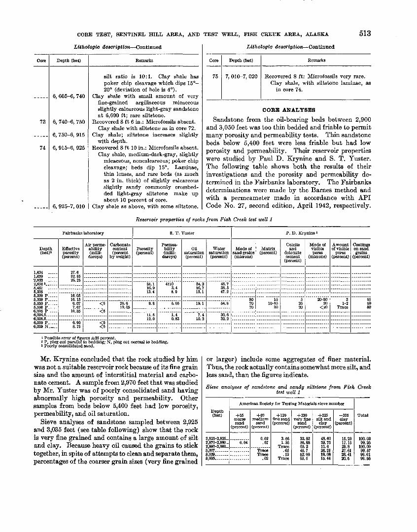
CORE TEST, SENTINEL HILL AREA, AND TEST WELL, FISH CREEK AREA, ALASKA 513
Reservoir properties of rocks from Fish Creek test well 1
Lithologio description-Continued
1 Possible error of flgures f 25 pcrwnt. 2 P, plug cut parnllel to bedding; N, plug cut normal to bedding. 8 Poorly consohdated sand.
LUhologio description-Continued
Mr. Krynine concluded that the rock studied by him was not a suitable reservoir rock because of its fine grain size and the amount of interstitial material and carbo- nate cement. A sample from 2,970 feet that was studied by Mr. Yuster was of poorly consolidated sand having abnormally high porosity and permeability. Other samples from beds below 5,400 feet had low porosity, permeability, and oil saturation.
Sieve analyses of sandstone sampled between 2,925 and 3,035 feet (see table following) show that the rock is very fine grained and contains a large amount of silt and clay. Because heavy oil caused the grains to stick together, in spite of attempts to clean and separate them, percentages of the coarser grain sizes (very h e grained
Remarks
silt ratio is 10: 1. Clay shale has poker chip cleavage which dips 15'- 20' (deviation of hole is 4').
Clay shale with small amount of very fine-grained argillaceous micaceous slightly calcareous light-gray sandstone at 6,690 ft; rare siltstone.
Recovered 8 ft 6 in.: Microfossils absent. Chy shale with siltstone as in core 72.
Clay shale; siltstone increases slightly with depth.
Recovered 8 ft 10 in.: Microfossils absent. Clay shale, medium-dark-gray, slightly
micaceous, noncalcareous; poker chip cleavage; beds dip 15O. Laminae, thin lenses, and rare beds (as much as in- thick) cdcareOus slightly sandy commonly crossbed- ded light-gray siltstone make up about 10 percent of core.
Clay shale as above, with some siltstone.
Core -
- - ---
73
-----
74
-----
Remarks
Recovered 8 ft: Microfossils very rare. Clay shale, with siltstone laminae, as
in core 74.
Depth (feet)
6,605-6, 740
6, 740-6, 750
6,750-6, 915
6,915-6,925
6,925-7,010
Core
75
Fairbanks laboratory P. D. Krynine 1
CORE ANALYSES
Sandstone from the oil-bearing beds between 2,900 and 3,050 feet was too thin bedded and friable to permit many porosity and permeability tests. Thin sandstone beds below 5,400 feet were less friable but had low porosity and permeability. Their reservoir properties were studied by Paul D. Krynine and S. T. Yuster. The following table shows both the results of their investigations and the porosity and permeability de- termined in the Fairbanks laboratory. The Fairbanks determinations were made by the Barnes method and with a permeameter made in accordance with API Code NO. 27, second edition, April 1942, respectively.
Depth (feet)
7, 010-7, 020
--
Depth (feet)l
1,634 - - 1,639 -.--. 2,923 -- --- 2,970 s-. ---. 5,481 -.-.. 5 .WS -.--. 5:MN P ----. 5,MNP ---.. 5,530 P----- 6,558 P.-.-. 6,006P .---. 0,006.5 --.-.. 6,008.5 .----. 6,009 P- . - - . 6,009 N--.--
8. T. Yuster
Mode of sand grains (microns)
-. ---- ---- .. - ----. . . .. . . . .. . . -. - - - - - ...--------- ------ ...---------
80 70 70
. . . - - - - - - - - -
.-----------
.-...---. .--
. . . - - _ - -. - - -
or larger) include some aggregates of finer material. Thus, the rock actually contains somewhat more silt, and less sand, than the figures indicate.
Sieve analyses of sandstone and sandy siltstone from Fish Creek test well 1
Porosity (percent)
---. -------- ------- -. - ..
31.1 16.9 13.4
..--...----- ------..--....--..--------------.-.-.-.---.-------------.-.-----------.-
9.8 --------..-- - - - - - - -. . -. .
11.5 12.0
------.-.-.- - - - - - - - - - - - -
Depth (feet)
2,925-2,935.- 2,970-2,980.. 2 3,007 3 - - 3
Effective porosity (percent)
27.6 32.55 25.25
- ----------- .-.--------- ------------
16.05 16.15 6.07 7.67
10.35 ..-----.---- .-----..--.-
6.90 8.75
Matrix (percent)
....-.-.----
. ..- .--.- -.. - - -- - - - -- - .. --.-------.. -- ...- --- --- ---- ---....
15 10-15
30 - - - - - - -- - - - - ..--...-.-.. -----------..
.-----._.-....-..------- _ - - _ - - - - - . . .
Air perme- ability (milli-
darcys)
----------.- ------.----- -_-_-_------ .-------.--- -----------. .--.----..--
<5 - - . . <5
------------ .-.------.--
<5 <5
Water saturation (percent)
............................................................................................................................................ .....------- .. - .----.-- -
48.7 38.5 47.2
------.-.-.. 54.8
---.-----.-- - -- -- -- - . -. -
30.6 32.2
----------.. . - . _ . _ - _ . . . .
Permea- bility (mllli-
darcys)
------- ..--- .-.-.--. ---.
4110 3.4 8.9
------------ 5.65
.-....-.---.. - - - - - - - - - - -.
1.4 0.83
...-.------. - - - -. - . - - _ . -
Total
100.03 99.25
100.00 99.57 99.01 99.66
American Society for Testing Materials sieve number
- Carbonate
content (percent
by weight)
--..-------- .----------- --------- --- ---------... ...--------- ---------...
26.6 19.35
- -- - - - - - -. - - _---.--...-- ------------ ---.-----.-- - _. -. - - _ -. . .
Oil saturation (percent)
.- --------.. -- -.--.-.. . .
34.2 16.7 15.1 .--------.-- 19.1
--------..-- . - . - - . . . - - - -
7.4 10.2
..-_........
. - -. . - - _ - - - -
Calcite and
dolomite cement
(percent)
-------.- --- .-.----..--. . ..-- - - - - - -- ------------ - - .-.-_...-- ....--------
5 25 20
. - . -. -- - - - - -
.----------.
.--..- .-- ..-
. . - _ - - - - - - - _
+35 coarse sand
(percent)
--.------. 0.04
- -..-..--.......-.
. - -
Mode of visible pores
(microns)
----- -----.------ .---. .-.---- --- -- - - -- - - - ------------ .--.------... ------ .-....
20-30 20
<20 - - - - - - --. - . - .------.--.- ------------ ----..-..-....--------------.---.-..--..---- - - - - - - - - - . . .
Amount of visible
pores (percent)
---------- ---------. .- ---- --- - ---------- ---.---.-. -.-..-----
3 1-2
Trace - .- . - - - -- - ---------- .---.-..-- . - . . . - - - - -
Coatings on sand grains
(percent)
-.--.----- ---------- - -- ------- ---------- ---------- .-.-.-.---
65 60 80
- - -- --. --. -----.-.-.. --------.- - - _-. - . - . -
+6O medium
sand (percent)
0.02 .07
- - Trsce Tram
.02
+I20 flne sand (percent)
-------- 3.56 1.36
Trace .05 .52
Trace
+325 silt and
clay (percent)
48.60 23.76 11.0 26.21 18.08 15.44
+230 very fine
sand (percent)
32.62 66.88 65.2 45.7 52.00 63.5
-325 clay
(percent)
15.23 17.15 23.8 27.61 2841 a0.6
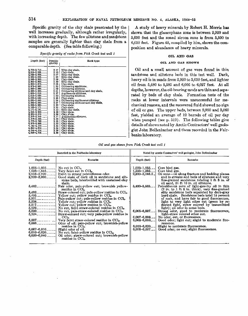
514 EXPLORATION OF NAVAL PETROLEUM RESERVE NO. 4, ALASKA, 1944-53
Specific gravity of the clay shale penetrated by the well increases gradually, although rather irregularly, with increasing depth. The few siltstone and sandstone samples are generally lighter than clay shale from a comparable depth. (See table following.)
Specific gravity of rocks from Fish Creek test well 1 OIL AND GAS
-. . -
Depth (feet)
2,700-2,710 .-.-.. 2,916-2,925 ----- 2 926-2 936 ----- $935-2: 945 ----- 2,946-2,950 .-.-- 2,950-2,960 ----- 2,960-2,970 ----- 2,970-2,980 ...-. 2,980-2,990 .---. 2,990-3,000--.-- 3,000-3,010 .---- 3,010-3,020 .---.. 3,020-3,030 ----. 3,030-3.040.---- 3.040-3.050.---.. 3,060-3,060 ----- 3 1 6 3 , 171 - - 3 171-3181 - - 3,356-3.366 .---. 3,360-3,376 ..--- 3,376-3,386 ..--. 3,1753,586 ---.- 3,776-3,786 .---- 3,976-3,986 --.-- 4,1404160 ..--. 4,3404,360 -.-.- 4,6444,654 .---- 4,6984,708 .----
OIL AND GAS 8gOWS
A study of heavy minerals by Robert H. Morris has shown that the glaucophane zone is between 2,920 and 3,030 feet and the zoned zircon zone is from 5,500 to 6,010 feet. Figure 42, compiled by him, shows the com- position and abundance of heavy minerals.
Oil and a small amount of gas were found in thin sandstone and siltstone beds in this test well. Dark, heavy oil is in sands from 2,920 to 3,050 feet, and lighter oil from 5,480 to 5,585 and 6,005 to 6,027 feet. At all depths, however, the oil-bearing sands are thin and sepa- rated by beds of clay shale. Formation tests of the rocks at lower intervals were unsuccessful for me- chanical reasons, and the recovered fluid showed no sign of oil or gas. The upper beds, between 2,920 and 3,060 feet, yielded an average of 12 barrels of oil per day when pumped (see p. 519). The following tables give details of shows noted by Arctic Contractors' well geolo- gist John Bollenbacher and those recorded in the Fair- banks laboratory.
Speciflc gravity
2.17 2.19 2.07 1.95 2.09 2.39 2.08 1.90 1.99 2.01 2.27 1.92 2 26 1: 95 2.07 2.20 2.35 2.12 2.28 2.30 2.11 2.28 2.25 2.33 2.44 2.34 2.39 2.39
Oil and gas shows from Fish Creek test well I
Rock type
Silty clay shale. Clay shale. Silty clay shale. Silty clay shale. Clay shale. Silty clay shale. Clay shale. Oil-bearing sandstone. Oil-bearing siltstone. Oil-bearing siltstone and clay shale. Argillaceous siltstone. Oil-bearing siltstone. Cla shale oil-%earin; argillaceous siltstone. Oil-bearing siltstone and clay shale. Clay shale. Clay shale. Silty clay shale. Clay shale. Clay shale. Argillaceous ~Utstone. Clay shale. Clay shale. Clay shale. Clay shale. Clay shale. Clay shale. Clay shale.
Recorded in the Fairbanks laboratory
Depth (feet)
1,025-1,035 - - - - - 1,635-1,645 - - - - - 2,916-2,920- - - - - 2,920-3,060- - - - -
5,482- - - - - - - - - - - 5,492- - - - - - - -- - - 5,495 ----------- 5,501 ----------- 5,508 ----------- 5,517- - - - - - - - - -- 5,529 ----------- 5,530- - - - - - - - - - - 5,534- - - - - - - - - - - 5,557 - - - - - - - - - - - 6,006- - - - - - - - - - - 6,007-6,010--- -- 6,010-6,020-- - -- 6,030-6,040- - - - -
Noted by Arctio Contractors' well geologist, John Bollenbacher
Remarka
No cut in CC4. Very faint cut in CC4. Faint to strong petroliferous odor. Good stain of dark oil in sandstone and silt-
stone beds, interbedded with unstained clay shale.
Fair odor, pale-yellow cut; brownish yellow- residue in CCle
Straw-colored cut; pale- ellow residue in CClc. Yellow cut; yellow resiJue in CCG. Pale-yellow cut; pale-yellow residue in CCG. Yellow cut; yellow residue in CCl4. Yellow cut; yellow residue in CC4. No cut, faint straw-colored residue in CC4. No cut, pale-straw-colored residue in CCl4. Straw-colored cut; very pale-yellow residue in
CCl4. Very faint straw-colored residue in CC4. Odor of oil; pale-yellow cut; brownish-yellow
residue in CC4. Slight odor of oil. No cut; faint-yellow residue in CClr. Oil odor; straw-colored cut; brownish-yellow
residue in CC4.
Depth (feet)
1,023-1,035--- 1,225-1,235--- 2,920-3,046.5 -
5,480-5,585- - -
6,005-6,007- - - 6,007-6,008--- 6,008-6,010---
6,010-6,020--- 6,026-6,027---
Remarks
Core bled gas. Core bled gas. Oil zone-oil along fracture and bedding planes
and in streaks and beds of siltstone and very fine-grained sandstone totaling 1 f t 8 in. of oil sand, 51 f t 10 in. oil siltstone.
Petroliierous zone of light-gravity oil in thin (2 in. to 1 f t 8 in. thick), very fine-grained silty sandstone beds separated by dark-gray hard shale. Sandstone beds total 15 percent of rock, and have fair to good fluorescence, light to very light ether cut (green by re- flected light, straw colored by transmitted light) ; oil odor in some beds.
Strong odor, good to moderate fluorescence, light-straw colored ether cut.
No odor, cut, or fluoresence. Good odor; light cut; slight to moderate fluo-
rescence. Slight to moderate fluorescence. Good odor; no cut; slight fluorescence.

CORE TEST, SENTINEL HILL AREA, AND TEST WELL, FISH CREEK AREA, ALASKA 515 BORMATION TESTS ( Test 5, 6,0004,050 f eet.-The test was unsuccessful
Analysis by U. S. Bureau of Mines of crude-oil sample from formation test 1, (6,966-3,060 f t ) i n Fish Creek test well 1 [General characteristiw of sample: Sp gr, 0.973: sulfur, 1.92 percent: Baybolt Universal viscosity at lW°F, 2,080 sec, at 130°F, 800 sec: gravlty 13.9 O API: pour point, Z°F;
color, bmmish black]
Of the five attempted tests with the Johnston for- mation tester, only the first was successful; on the others, the packer failed to hold or mechanical difficul- ties prevented the test from being completed.
~~~t 1, g,9653,060 feet.-~he tester was run and the packer set a t 2,925 feet, with perforated tailpipe to 2,963 feet and with the hole open to 3,060 feet. The tool was open 1 hour, during which there was a steady blow of gas for 50 minutes and a blow by heads for 10 minutes. Gas reached the surface in 15 minutes. Of 560 feet of fluid recovered, 180 feet was of l l eav~
'lightly gas cut and 380 feet was of gassy mud.
Test 6, 6,4814,585 feet.-This test was unsuccessful because the tester became partly plugged and the re- taining valve was held open by shale chips.
T~~~~ 8 4, 4&04,585 feeet.-~hese two tests were in essentially the same interval as test 2 ; both were unsuccessful, as the packer failed to hold each time. No indications of oil or gas were noted on either attempt.
DfstiaaNon, Bureau of Mines routine method
when the trip valve opened before the packer was seated.
OIL, GAS, AND WATER ANALYSES
Analyses of oil from the Fish Creek well were made by the E'~tr0leum Chemistry and Refining Section of the U. S. Bureau of Mines, Bartlesville, Okla., and of gas and water by the National Bureau of Standards. The oil is dark, heavy, and asphaltic; road oil, lubri- cating oil, and diesel fuel could be obtained -from it. The following table gives the results of a routine analysis of a 5-gallon sample of crude oil recovered in formation test 1 (2,925-3,060 feet). The second routine analysis was made on a 1-gallon sample recovered shortly after the well was put on the pump. Other tables give data on diesel-fuel, lubricating-distillate, and road-oil fractions of the sample from formation test 1, and of a 15-gallon sample (which contained only about 6 gallons of oil with 9 gallons of water) from the pumping test.
Cut at- Gravity Saybolt Fraction Universal
100°F
Stage 1.-Distillation at atmospheric preswrs.'745 mm Hg. First drop. 163OC (325OF)
Stage 2.-Mstillation continued a t 40 mm H g
1 Specific gravity at 60°F compared with water at 60°F. 1 Distillaticn discontinued ~t 270'0 (618'F). a Carbon residue of residuum: 18.6 percent: carbon residue of m d e , 10.4 percent.
11-. . - - - - . . - - - - - - - . - - - - - - - - - -. - - - - - - - - - - - 12 .--.------...-..-.--.-----------------. 13- - - - - - -. - - -. - - - -. - - - - - - - - -. - - - - - - - - - - - - 14. - -. . . - - - . - - - -. - - - - - - - - - - - - - - - - - - - - - - -. 16 .-.-......------------.-------.-------- Residuum a -..-.--.-..-.---.------------
200 226 2m 276 300
--------------
0.898 .909 .924 .933 .940
1.019
Constituent
Light gasoline ---.---------------------------------------------------------------------. Total gasoline and naphtha ..-.-...---.--------------------------------------------------- Kerosene distillate .---.--..-------------------------.--------------------------------.-. OWOU -.--.-.-.----.-.--------.---------------------------------------------------------- Nonvlscous lubricating distillate ....-.---------------------------------------.--------..-- Medium lubricating distillate .-..-..-.-------------------------------------.-.------------ Viscous lubricating distillate -...-.-.. --- ---- ------------- ------------------ -------- ---- --- Residuum-- - -. -. . . .- - -- - -- - - - - - - - - -- ---- - - - - - - - - - -- - - - - -- ---- - -- --- - -- - - - - - - -- - - - - - - - - - - - Distillation loss -.... ... ...................................................................
64.9 56.1 68.4 62.0 67.1
Too dark
Gravity O API
..-....-..--..-----. 41.1
....---.-...-_---.-. 30.2
25.0-22.1 22.1-19.8 19.8-18.4
7.4 .--.....--..--..----
45 M 80
146 350
---.-..--.....
392 437 482 527 672
--------------
26.1 24.2 21.6 20. a 19.0 7.4
Baybolt Universal viscosity
--.---------------.- -.-----.-.-....-..-. -_-_-__----__._.---- ---------------..---
60-100 100-!2@0
Above 200 .................... ..-----------.--... -
Pereent
.---....--.-----.-.. 1.9
..-.--..-.-.-.---... 16.6 7.8
10.0 9.8
63.8 . I
M 68 a2 63 63
-.---.-------.
Bpecffic gravity
----.-.-.----.-..-.. 0.820
.---.. ......--.-.... .876
0.904- .921 .921- .936 .g3Cr .944
1.019 --.........-.--..-..
3.8 7.3 6.3 7.1 8.4
63.8
17.0 24.3 30.6 37.7 48.1 99.9
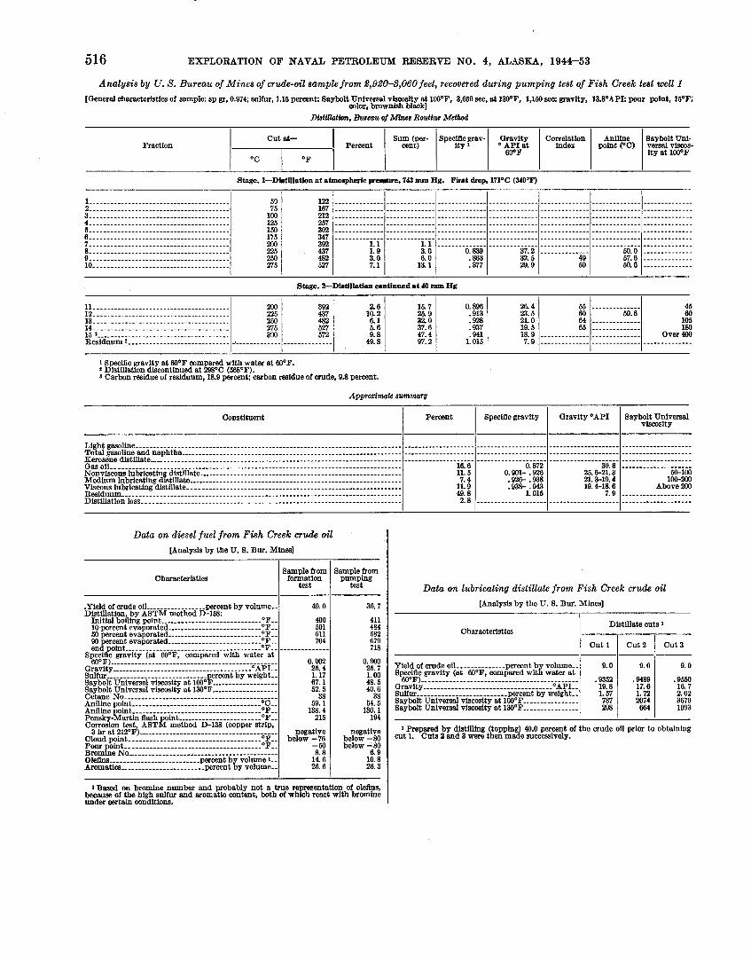
516 EXPLORATION OF NAVAL PETROLEUM RESERVE NO. 4, ALASKA, 1944-53
Analysis by U. S. Bureau of Mines of crude-oil sample from 1,92&8,06Ofeet, recovered during pumping test of Fish Creek test well 1 [General characteristics of sample: sp gr, 0.974; sulfur, 1.16 percent: Saybolt Universal viscosity at lCO°F, 3,660 sec, at 130°F, 1,150 sec: gravity, 13.8OAPI; pour point, 16*F;
color, brownish black] DfstllloMon, Bureau of Minas Routine Method
Cut at- Sum (per- Speciflc grav- Gravity Correlation Aniline Saybolt Uni- Fraction 1 Percent 1 cent) 1 ity1 1 point (OC) verssl viscos-
$ s t 1 index 1 1 ity at lOO0F
Stage. I-Distillation at atmospheric presaore. 743 mm Hg. First drop, 171°C (340°F)
1 Specific gravity at gO°F compared with water at 60°F. 9 Distillation discontinued at 298OC (5BB°F). 8 Carbon residue of residuum, 18.9 percent: carbon residue of crude, 9.8 percent.
Appraximate summary
1. . - . . - . - - - - . - -. - - - - - - - - - - - - - - - - - - - - - - - - - 2 - - - - - - - - - - - - - - - - - - - - - - - - - - - - - - - - - - - - - - - - 3. ....................................... 4. ....................................... 6- - - . - . - - - - - - - - - . - - - - - - - - - - - - - - - - - - - - - - - - 6 - - . - - - - - . - - - - - - . - - - - - - - - - - - - - - - - - - - - - - - - 7-.-------------.------------------------ 8 - - - . - - - - - . - - - - - - - - - - - - - - - - - - - - - - - - - - - - - - 9. - - - - - - - - - - - - . - . - . - - - - - . - . - - - - - - - - - - - - - - 10- - - - - - - - - - - - - - . . - - - - - - - - - - - - - - - - - - - - - - -
122 167 212 267 302 347 392 437 482 527
63 76
100 125 160 176 200 225 250 276
Stage. 2-Distillation contined at 40 mm H g
Constituent
Light gasoline Total gasoline and naphtha Kerosene distillate
................................................................................... Gas oil Nonviscous lubricating distillate .......................................................... Medium lubricating distillate ............................................................. Viscous lubricating distillate. - -. -- ------ -- --.-.-.. --- Residuum --.- - - - - - - - .- - - - - - - -- -- ---- -- -- - -- - - - - - - - - - - - - ----- -- - - -------- -- -- ------------- Distillation loss ..........................................................................
1.1 1.9 3.0 7.1
Gravity OAPI
30.8 25.6-21.3 21.3-19.4 19.4-18.6
7.9 ............................................................
Data on diesel fuel from Fish Creek crude oil [Analysis by the U. 8. Bur. Mines]
46 60
105 180
Over 4M) --------------
Saybolt Universal viscosity
.................... 50-100
100-200 Above 200
....................
Percent
............................................................................................................................................................ ...............................................................................................................................................
........................................................................................................................................................ 16.6 11.6 7.4
11.9 49.8 2.8
Characteristics
.Yield of crude oil ----------------- percent by volume-- Distillation, by ASTM method D-158.
Initial boiling point --.-.--.-.------------------- OFFF 10 percent evaporated ........................... O F F F
50 percent evaporated ---..---------------------- OFFF 90 ercent evaporated .-------------------------- O F F -
........................ en$zint-.. - - - - - - - - - - - - O F
Spec c gravity (at gO°F, compared with water at eO0F) .---.-----.-.-----------------------------------
Gravity --.------.-.------------------------- ---'API-- Sulfur --..------------------------- percet by weight- Saybolt Universal viscosity at 100°F .-.-.--------.----- Saybolt Universal viscosity at 130°F ................... Cetane No -..--..-..-.-------------------------------- Aniline point -----.--.---------------------------- 'CCC
artin flash oint -----------------OF-- Corrosion test, ABT& mit6&ib-138 (copper strip,
3 hr at 212OF) ..----..-.-.---------------------------- Cloud point ..----.------------------------------- O F F F
Pour point .--.----------------------------------- OFFF Bromine No ..-.-.--.------.--------------------------- O l e m .------------------------- percent by volume Aromatics ---.-------------------- percent by volume--
Data on lubricating distillate from Fish Creek crude oil [Analysis by the U. 8. Bur. Mines]
1.1 3.0 6.0
13.1
Speciflc gravity
0.872 0.901- .926 .92& .938 .93& .943
1.016
Characteristics
Yield of crude oil -.-------.---- percent b volume-- Specific gravity (at gO°F, compared w i d water at
............................................. 60°F) r a v t y 0~~~
Sulfur -----.----.--UPUPUPUPUPUPUPUPUPUPUPUPUP percent by weight-- Saybolt Universal viscosity at lW°F ..---------.---- Saybolt Universal viscosity at 130°F ..---------.----
15.7 26.9 32.0 37.6 47.4 97.2
2.6 10.2 6.1 5.6 9.8
49.8
11-. ..................................... 12- - . - -. - - - -. -. - - - . - - - - - - - - - - - - - - - - - - - - - - 13 ....................................... 14 -. -. -. - -. .- -. .- .- .-. -. -. - .- .-. -. - .-. - .- 15 9 ......................................
............................. Residuum a
1 Based on bromine number and probably not a true re resentation of olefins because of the high sulfur and aromatic content, both of w h h react with hromin; under certain conditions.
Sample from formation
test
40.0
400 501 611 704
............... 0.902 25.4 1.17 67.1 52.5
38 59. 1
138.4 215
negative below -76
-60 8.8
14.6 26.6
0.839 .863 .877
Sample from
py&Ing
36.7
411 484 582 679 718
00
: 38
64. 1%. 1
194
be%% blow -80
6.9 10.8 26.3
1 Prepared by distilling (topping) 40.0 percent of the crude oil prior to obtaining cut Outs Zand were then made
Distillate cuts 1
Cut 1 cu t 2 cu t 3
0.896 .913 .928 .937 .94l
1.015
200 226 260 275 330
2
9.0
.9352 19.8 1.57 787 298
..................................................................................................
..................................................................................................
..................................................................................................
..................................................................................................
..................................................................................................
.................................................................................................. 37.2 32.5 28.9
392 437 482 627 572
...........................
9.0
.9489 17.6 1.72 2074 664
...................................................................... ..............
49 50
- . - -. . - - - - - - . . 50.6 - - - - - - - - - - - - - -
. - . - - . - . . - . - - . ............................
--------------
26.4 23.5 21.0 19.6 18.9 7.9
9.0
.9650 16.7 2.02 3670 1093
55 60 64 66
--------------
50.0 57.6 50.6
.............. -------- -- -- -- ..............

CORE TEST, SENTINEL HILL AREA, AND TEST WELL, FISH CREEK AREA, ALASKA 517
Data on road-oil residue from Fish creek crude oil
[Analysis by U. S. Bur. Mi=]
-
1 Oil designated as 100 percent of residuum was the total residuum after distilling 40 percent of the crude ofl off to prepare s diesel fuel. The flgures 85 ercent, 70 per- cent and 55 percent refer to the percentage of the residuum and mrrespmd to removal by distfflation of equal successive increments of 9.0 ercent of the crude oif.
2 Oil designated as 100 percent of residuum was the total residuum after distilling 33.7 rcent of the crude oil to prepare a diesel fuef The figures 85 percent, 70 percent, and 65 percent refer to thepercentage of the residuum and correspond to removal by dist8tion of equal successive increments of 9.6 percent of the crude oil.
a Specific gravity at 80 F compared with water st W0F
The gas is almost entirely methane; the percentage of butane isomers was not determined individually because there seemed to be some acetone in t.he sample (presumably contamination from the glass container), and this interfered with identification of the butanes. The gas analysis is shown in the following table.
Characteristics
Yield of crude oil -------------- percent by volume-- Specific gravity'--------------------------------- Gravity . . . . . . . . . . . . . . . . . . . . . . . . . . . . . . . O A P I Sulfur ---,--------------------- percent by weight-- Viscosity, Fur01 seconds:
at 180°F - - - - - - - - - - - - - - - - - - - - - - - - - - - - - - - - - at 210°F . . . . . . . . . . . . . . . . . . . . . . . . . . . . . . . . .
Carbon residue, Conradson - - - - - - percent by weight--
Analysis of gas from Fish Creek test well 1
IAnalssis be Natl. Bur. Standards1
Designation of sample from pumping test, in percent of residium 1
- - Compmnt Mol percent
Methane . . . . . . . . . . . . . . . . . . . . . . . . . . . . . . . . . 99.0 nitrogen-----------_-_---^^--------------- . 49 E t h a n e - - - - - - - - - - - - - - - - - - - - - - - - - - - - - - - - - - . 16 Butanes . 0 8 Ethylene .......................................... . 0 6 Oxygen . . . . . . . . . . . . . . . . . . . . . . . . . . . . . . . . . . . 0 5 Pentane----------------------------------------- . 0 5 P r o p a n e - - - - - - - - - - - - - - - - - - - - - - - - - - - . 0 4 A r g o n - - - - - - - - - - - - - - - - - - - - - - - - - - - - - - - - - - - . 0 3
1 Heating value, calculated, 997 Btu per eu ft; sp gr, 0.660.
Designation of sample from formation test, in percent of residium 1
100 -------- 63. 3 .999 10.1
--------
434 171
- - - - - - - -
The water, described as a turbid, dirty gray liquid, was filtered after determining the pH and before mak- ing the rest of the analysis. Sodium and chlorine radicals were predominant impurities in the water. The analysis is shown in the following table.
100
60. 0 1. 007
9 . 0 2.47
468 157
15. 8
Analysia of water 1 from Fish Creek test well 1
[Analysis by Natl. Bur. Standards] Parts per
Radicals million
S o d i u m - ~ - - - - - - - - - - - - - - - - - - - - - - - - - - - - - - - - 4,286 Calcium . . . . . . . . . . . . . . . . . . . . . . . . . . . . . . . . 49.3 Magnesium . . . . . . . . . . . . . . . . . . . . . . . . . . . . . . . . . . . . . . 18.8 Su l fa te - - - - - - - - - - - - - - - - - - - - - - - - - - - - - - - - - - - - - - - - - 26.7 C h l o r i d e - - - - - - - - - - - - - - - - - - - - - - - - - - - - - - - - 6,596 C a r b o n a t e - - - - - - - - - - - - - - - - - - - - - - - - - - - - - - - ------- B i c a r b o n a t e - - - - - - - - - - - - - - - - - - - - - - - - - - - - - 208 Iodide - - - - - - - - - - - - - - - - - - - - - - - - - - - - - - - - - - 25 Silica-------------------------------------------- 21 Boron- - - - - - - - - - - - - - - - - - - - - - -- - - - - - - - - - - - - - - - - - - - (9
T o t a l - - - - - - - - - - - - - - - - - - - - - - - - - - - - - - - - - - - 11,231 See footnotea at end of table.
85
51. 0 1.018
7. 5 2.61
880 248
20. 5
55
34. 8 1.033
5. 5 --------
-------- 2,720
--------
85
53. 8 1. 009
8 . 7 --------
1, 186 410
- - - -_- - -
Analysis of water ' f r o m Fish Creek test well I-Continued
70
44. 3 1. 019
7. 4 --------
4, 194 1,380
--------
Percent
38.21 . 6 1
59.34 1. 84 . 72
97. 14 .34
70
42. 0 1.036
5. 1 2.81
4,584 1,100 25. 9
Chemical character Percent Primary salinity - - - - - - - - - - - - - - - - - - - - - - - - - - - - - - - - 97.35 Secondary salinity- . . . . . . . . . . . . . . . . . . . . . . . . . . . . . . . . 2 8 Primary alkalinity . . . . . . . . . . . . . . . . . . . . . . . . . . . . . . _----- Secondary alkalinity . . . . . . . . . . . . . . . . . . . . . . . . . . . . . . 2. 37
1 Specific gravity of sample at 25OC compared with water at 25'0, 1.0073; pH, 7.3; carbonate to chloride ratio, 0.0315.
2 Very small amount.
LOGISTICS
55
33. 0 1.056
2 .5 3.05
-------- 13,860
31. 1
Tramportation.-Freighting of supplies and equip- ment to the site of Fish Creek test well 1 began on January 31, 1949. It was started earlier than usual for overice freighting because of an early freezeup and exceptionally good ice conditions. About 80 percent of the route from Barrow camp to Fish Creek was on ocean ice; it followed the coast, crossing bays and turning inland from Harrison Bay south of Atigaru Point. A crew was sent in early February to help unload the tractor trains. Careful stacking of ma- terial and accurate inventory speeded construction and prevented mislaying needed supplies. A carefully pre- pared 15-mile trail from the ocean to the well site was used uninterruptedly until April 4, 1949; during this time 14 tractor trains had brought 2,468 tons of ma- terial to the site.
Hozlsing.--Camp construction was begun on March 15, 1949, by pile-driver and carpenter crews. The camp was built first, and by April 15, 2 quonset huts for galley and warehouse, 10 jamesway huts for sleeping quarters, a utility wanigan, and a lavatory wanigan
518 EXPLORATION OF NAVAL PETROLEUM RESERVE NO. 4, ALASKA. 1944-53
were in use. A jamesway hut for recreation and a galley storage wanigan connected to the galley were added later. The galley quonset had complete plumbing facilities, including hot water from a Heat-Pak boiler and a pressure system which also supplied steam for heating the galley and utility buildings. Drainage from the buildings was piped away from the area through heated insulated lines.
The camp buildings were set on short pilings, and walkways of scrap lumber connected them to a camp street and thence to the rig. Using the walkways and reducing the use of vehicles in the camp area as far as possible kept the site from becoming a morass when the ice and snow melted and the tundra thawed.
Rig construction began on April 1. A 50-horsepower Eewanee boiler with a thaw-point manifold capable of operating 6 steam points had been mounted in a wanigan at Barrow. With this to thaw the ground, the pile-driver crew drove about 1,110 pilings, 5-20 feet long, in 6 days. Rig foundations were completed by May 1, and rigging up (including installation of a power wanigan, a geologic and engineering office wanigan, and a garage of canvas-covered frame con- struction) was completed on May 18.
Personnel.-A drilling foreman, a petroleum engi- neer, and a geologist supervised drilling. In addition to the rig crews (2 drillers, 2 derrickmen, 6 floormen, 2 heavy-duty-equipment mechanics, and 2 firemen), an electrician, a carpenter, 2 tractor operators, a janitor- oiler, a warehouseman, a timekeeper, 2 cooks and 2 cooks' helpers worked at the well site. A cementer and a Schlumberger operator visited the well when their services were needed.
Vehicles and heavy equipment.-Seven vehicles were kept at the well site : a D8 Caterpillar tractor with bull- dozer blade, 2 weasels, a D6 Caterpillar tractor with bulldozer blade, a T-9 crane (cherry picker), a North- west crane, and an LVT. The D8 Caterpillar tractor was used to haul water, and the LVT was used for trips to the coast. Important items of drilling equip- ment used at the well were listed by Arctic Contractors as follows: 1 ---------- National 50 drilling rig powered by 2 Dl3000
Caterpillar engines. 1 ---------- Gardner Denver 7%- by 10-in. pump powered by a
Dl3000 Caterpillar engine. 1 ---------- National 6 2 5 0 slush pump powered by a OMC
quad diesel engine. 1 ---------- Emsco 200-ton crown block. 1 ---------- Byron-Jackson 1254011 hook. 1 ---------- Ideal type D swivel. 1 ---------- Ideal 17%-in. rotary table. 1 ---------- Baash-Ross square belly. 1 ---------- Shaffer double-gate blowout preventer.
1 ---------- Kewanee 25 hp boiler. 1 ---------- Link-Belt 48- by 60-in. shale shaker. 2 ---------- 140-bbl steel suction tanks. 3 ---------- 2500-gal water tanks.
Fuel, lubricant, and water consumption.-Fuel was supplied to the camp and rig by gravity flow from a centrally located fuel tank. Water was brought to the site in a 2,500-gallon water wanigan hauled by a D8 tractor. The h t water source was a lake about a mile from the rig, but after thawing started, a small creek about 500 yards west of the camp furnished an adequate supply. Consumption of water and petroleum products was as follows: 955,000 gallons of water, 52,541 of diesel fuel, 2,815 of gasoline, 1,573 of lubricating oil, 663 pounds of grease, and 230 pounds of thread lubri- cant, which was used during the last half of the operation.
DRILLING OPERATIONS
The drilling rig was set on a foundation of pilings; the cellar was of concrete, reinforced with steel matting. The derrick was enclosed, and the righouse was con- structed with canvas panels prefabricated in Barrow camp. The righouse roof was of 2- by 12-inch T-beams covered with tarpaulins.
DRILLING NOTES
The following drilling operations were recorded by C. S. Roberts, Arctic Contractors petroleum engineer.
Notes from drilling records
Depth (feet) Remarks
46 - - - - - - - - - - Fifteen sacks of Oil Well cement mixed with 15 sacks of sand were used to cement 20411. Naylor spiral-weld 48-lb casing a t 46 feet.
194 - - - - _ - _ _ _ Weather turned cold, and mud lines froze. Operations suspended for 5 days to complete righouse roof and thaw pipes. While reaming hole, circulation broke around 20-in. casing, which slipped down hole. Conductor pipe was recovered and recemented, and circulation regained. Sixteen-inch outer diameter Western Pipe and Steel 42-lb %a-in. welded-plate slip- joint casing was cemented a t 193 feet with 90 sacks of Hi-Early cement.
1,046 _------- After reaming hole, 11yC-in. J-55 47-lb A. 0. Smith 8 round thread casing was set a t 1,046 f t and cemented with 125 sacks of Hi-Early construction cement mixed with water heated to 90°F and treated with 2 percent calcium chloride.
3,060--- - - - - - Following first formation test, rubber packers were lost in hole. When packers were drilled up, rubber caught in flow pipe and was re- moved through window cut in flow line.
,5,585--- - - - - - After unsuccessful second formation test, hole was cleaned out and prepared for third test.

CORE TEST, SENTINEL HILL AREA, AND TEST WELL, FISH CREEK AREA, ALASKA 519
Notea from driUing records-Continued
D M UsQ) Remark 7,020----- --- When total depth was reached, hole was plugged
back, and a sidetracked hole was drilled from 2,552 to 3,018 f t to test sandstone beds near 2,900 ft. Seven-inch casing (23-lb 5-55 Youngstown 8 round thread API seamless) was set a t 2,915 f t and cemented with 173 sacks of Portland construction cement, 12 sacks of Hi-early, and 60 sacks of Oil Well cement, mixed with 2 percent calcium chloride and enough water, heated to 60°F, to make 114-lb slurry. When cement was set, hole was drilled and underreamed to 3,018 f t , and gravel-packed liner was installed. Liner con- sisted of 126 f t of 4%-in. 11-lb 1,200-lb test API seamless line pipe with a Brown liner shoe on bottom. Liner was hung at 2,891 f t , with a 6-in. outer-diameter Brown pack-off hanger, and perforated from 2,918 to 3,017 f t with 8 rows of %-in. drilled holes on 2%-in. centers, staggered, and covered with 4%- by 6-in. outer- diameter Nelson gravel prepack sleeves. Ran 2%-in. tubing (6.5-lb external upset H-40 range 2 seamleas) with pump shoe and swab stop on bottom to 3,015 ft. After changing mud to water, tubing was pulled back to 2,860 ft and swabbed. Hourly swabbing caused a gradual fluid rise to about 2,400 ft.
After swabbing for 2 days, pumping equipment was brought from the LCM on the beach and a pump and 285 10-ft rods were installed. Well was pumped from 10th to 20th of Sep- tember; production decreased from 27 to 10% bbl of oil per day, averaging about 12 bbl. Water accompanied oil on first day; no water produced thereafter, and pump was removed. Fluid level, estimated at 2,800 f t during pump- ing, rose to 2,400 ft in about 26 hr, and a hundred feet higher after 8 hr more. Bailer run to bottom of liner was two-thirds full of muddy water after first trip, and full of oil, with no water, sand, or silt, after second. Tub- ing and pump reinstalled on September 22, at 11 :40 a. m. Fluid reached surface at 1 :05 p. m. and was mostly clear water with stain of oil until 5: 10 p. m., when it became clean oil. Small amount of gas came through 7-in. cas- ing. On 23d and 24th of September 18 bbl of oil with 15 of water, and 12 bbl of oil with no water was pumped, respectively; well averaged 9-12 bbl daily through October 15. Tubing and pump again removed, and well bailed in- termittently until October 25. Final well-head installations, from bottom up, are a Shaffer 11%-in. plate landing base, a ShafTer 11%-in. full-opening landing spool with 2-in. line-pipe side connections; Shaffer tubing head; swage; 3-in. Hughes 3,000-lb threaded flow-line valve.
DRILL AND CORE BITS
Most of the cores were taken by wire line, using the 8 -1 '7%-inch core barrel and ten 7%-inch Universal
rock bits. A few cores below 6,300 feet were taken with 3 Hughes conventional bits, because the wire line equipment could not be used inside the 3-inch drill pipe employed below that depth. The conventional bits had very poor recovery, however; so the lowest cores were taken with the wire line core barrel installed before running the drill pipe in the hole.
Thirty-eight bits in 8 sizes were used to drill the test, including the sidetracked hole. Most were Security or Reed rock bits, but two Globe bits were used in reaming the upper part of the hole. Used bits showed little wear on the teeth, but the b e a r i n ~ were badly worn. Core and drill bits used are listed on the graphic log (pl. 32).
DRILLING MUD
The rock drilled included some bentonite and a large amount of shale, which made very good mud. Silty beds furnished large amounts of abrasive silt which increased mud weight, but adding water reduced the weight and lowered the viscosity, and the silt settled out in the tanks. The C-250 mud pump furnished enough velocity to flush the hole and maintain it in good condition with low-viscosity mud.
After the hole was plugged back, the mud was di- luted with water to counteract cement contamination. This also resulted in the light-weight mud desired for subsequent operations. Driscose and Aquagel were added after setting 7-inch casing to provide low-weight, low-viscosity, low-water-loss mud for drilling through the producing sands. The total additives used in the well were 220 sacks of Aquagel, 50 sacks of Baroid, 6 sacks of pyrophosphate, 2 sacks of quebracho, and five 50-pound sacks of Driscose. The following table is a week-by-week summary of the mud characteristics and the additives used.
Summary, by weeks, of drilling-mud characteristics and additives in Fish Creek test well I
Additives
-------- -------- ...-..-- 18 sacks Aquagel. -------- .-.....- .....--. 12 sacks Aquagel.1 ....-... ...---.. -------- No record.
38-44 3-6 ........ 75 Ib pyrophosphate. 35-40 3-4 --.---.- 75 1b yrophosphate.
34 7 77-82 10 sacis Aquagel. 35-40 -----... -------- 10 sacks Aquagel, 76 Ib pyro-
nhosnhate. 38-42 5 86 40-lb~-$rophosphate.
-------- -------. .------- 16 sacis ~quagel , 15 sacks Barold, 30 lb pyrophosphate.
...----- ........ -------- Only water added. --...... .----.-- -------. Only water added.
40 8 86 Only water added. ------.- 1 ..-...-. 1 -------- I 10 sacks Aquagel.
1 Chsnged mud after setting casing. : After 7 020 ft was reached, the hole was plugged back to 2,652 it, and a sidetracked
hole was drilled and mshg set at 3 018 ft. Cement used in these operations contam- inated the mud. Additives used tb correct it are not shown on this chart.

520 EXPLORATION OF NAVAL PETROLEUM RESERVE NO. 4, ALASKA, 1944-53
val was first logged. The runs are listed in the follow- ing table, and runs 1-8 are shown on the graphic log (p l 32).
Electric-log runs in Fish Creek test well 1
Run Depth (in feet) 1 . . . . . . . . . . . . . . . . . . . . . . . . . . . . . . . . . . . . . . . 187-1,031 2 . . . . . . . . . . . . . . . . . . . . . . . . . . . . . . . . . . . . . . . . . . . 1,047-2,291 3 - - - - - - - - - - - - - - - - - - - - - - - - - - - - - - - - - - - - - - - 2,291-3,060 4- - - - - - - - - - - - - - - - - - - - - - - - - - - - - - - - - - - - - - - 3, 060-4,147 5 - - - - - - _ - - - - - - - - - - - - - - - - - - - - - - - - - - - - - - 4,147-5,079 Rerun--- - - - - - - - --- -- - -- -- --- - - - - -- - - - - - - - - - - 2,900-3,060 6 . . . . . . . . . . . . . . . . . . . . . . . . . . . . . . . . . . . . . . . 5,079-5,581 7 - - - - - - - - - - - - - - - - - - - - - - - - - - - - - - - - - - - - - - - 5,581-6,046 8 . . . . . . . . . . . . . . . . . . . . . . . . . . . . . . . . . . . . . 6,046-7,013 9--- . . . . . . . . . . . . . . . . . . . . . . . . . . . . . . . . . . . . . . . 2,500-2,910 10------------------------------------ 2,915-3,002
United Geophysical Co., Inc., used a shot hole 1,320 feet from the well to make a velocity survey. The average velocity recorded in the well was about 8,000 feet per second at 1,000 feet, increasing to 9,000 feet per second near 7,000 feet. Beds above 600 feet had a velocity of 9,476 to 9,833 feet, reflecting the presence of permafrost near the surface.
LITERATURE CITED Goddard, E. N., and others, 1948, Rock color chart: Washing-
ton, D. C., Nat. Research Council. Gryc, George, and others, 1956, The Mesozoic sequence in the
Colville River region, northern Alaska: Am. Assoc. Pe- troleum Geologists Bull., v. 40, no. 2, p. 209-254.
Gryc, George, Patton, William w., Jr., and payne, T. G., 1951, Present Cretaceous nomenclature of northern Alaska: Washington Acad. Sci. Jour., v. 41, no. 5, p. 159-167.
Pawe, T. G.9 and others, 1951, Geology of the Arctic Slope of Alaska: U. S. Geol. Survey Oil and Gas Inv. Map OM 126.
Schrader, Frank C. and Peters, W. J., 1904, A reconnaissance in northern Alaska: U. 8. Geol. Survey Prof. Paper 20.
HOLM DEVIATION
Above 6,000 feet, measurements with the Totco (Technical Oil Tool Co.) Recorder indicated very little deviation from vertical. Most of the readings were less than lo, and only 3 were above lo. Below 6,000 feet the hole was too small for the Totco instrument, and an Eastman directional survey was Deviai tion and direction measured with the Eastman tools are shown in the following table; the increase in deviation, which is 30-40 below 6,000 feet, was seemingly caused by more steeply dipping beds. The sidetracked hole, begun at 2,552 -feet in a vertical hole, increased from 30 off vertical at 2,572 feet to 8O45' at 2,855 feet.
Direction of deviation, lower part of Fish Creek test well 1
taneous potential curve is also slightly affected by the frozen ground. Two runs were made in the side-tracked hole, and an additional run Was made in the original hole through the oil-producing beds at 2,9003,060 feet. The second run showed very little penetration of the rock by mud in the 19 days since the rock in that inter-
Tappan, Helen, 1951, Northern Alaska index Foraminifera: Cushman Lab. Foram. Research Contr., v. 2, p. 1-8, pL 1.
Whittington, C. L., 1956, Revised stratigraphic nomenclature of the Colville group i n George Gryc and others, The Meso- zoic sequence in The Colville River region, northern Alaska : Am. Assoc. Petroleum Geologists Bull., v. 40, no. 2, p. 244-253.
Direction
N. 20' E. N. 02' E. N. 15' E. N. 25' E. N. 25' E. N. 37' E.
Depth (feet)
6,000 6,200 6,400 6,580 6,600 7,000
ELECTRIC-LOO AND VE&OCITY SURVEYS
hand-recordiag Schlumberger 'quip- merit was used to make the 8 electric-log runs needed to log the well from 187 to 7,013 feet. The unusually high resistivity shown by the upper part of the resistivity curve (which decreases irregularly from 130 ohms at lg5 feet ohms at 600 feet) is caused by permafrost, which increases the resistivity of the rock. The spon-
Deviation
0'55' 3O00' 3'30' 3O55' 4'00' 3'40'

INDEX
Page Analyses, oil, gas, and water, Fish Creek test well 1 .----------------.------ 515-517 Anticlines, absenca of -~.--.~~-~~~~~~.-.eseseseseseseseseseseseseseseseseseseseseseseseseseseseseseseseseseseseseseses 501
B i b l o p - 5#) Bollenhacher, John, notes by ----------------- bbbbbbbbbbbbbbbbbbbbbbbbbbbbbbbb 514 Bmsp6, W. P., quoted ----.-----.--------------------------------------------- 488
Coal ............................................................ 489,487,603,546,507 Core analyses, Fish Crwak test well 1 ---.--.---------.--------------------- 513-514
Sentinel Hill core test 1 --.------.-------------------------------------- 488-4954 Cores and cuttings, description, Fish Creek test well 1 .-.--..--.------- ---- 504-513
Sentinel Hill core test 1 ------.----.---.--------------------------------- 469-498
page Logistics, Fish Creek test well 1 ----..---.---------------------------------- 517-518
Sentinel Hill core test 1 --..-----.-----...--------------------------------- MM Lubricant consumption. Fish Creek test well 1 -.---.-..---------------------- 618
Sentinel Hill core test 1 .-..---.-------.-.--------------------------------- M)O
Magnetometer airborne surveys ------.---.--------------------------------- 488,501 Mud, drilling. (Su DNUng mud.)
Oil analyses, Fish Creek test well 1 - - - - - - - - - - - - - - - - - -98es98es98es98es98es98es98es98es98es98es98es98es98es98es98es98es98es98es98es98es98es98es98es 515-517 011 and gas, Fish Creek test well 1 ..---.-..--------------------------------- 514-517
Sentinel Hill core test 1 --.-------..--..----------------------------------- 499 Oil and gas shows, Fish Creek test well 1 ..----.--.-...---.------------------- 514
Core and drill bits. (Scc Drlll and core bits.) cretaceous rocks, upper--colvi~ amup .......................... 486489,502-503 Permafrost, FIsh Creek test well 1 ---.----.----.-.---------------------------- 501 1 Permeability, Fish Creek test well 1 ....------..------------------------------ 513 Ditrvpa sp ....--------.-.----------------------------------------------- 503, EO9.510 Drill and core bits, Fish Creek test well 1 ..--.--.-.--...---------.------------ 519
Sentinel Hill test well 1 .--------.-.--.------------------------------------ MM Drilling equipment, Sentinel Hill core test 1 ----.-----.----.------------------ 600 D mud, Fish C k well 1 519
Sentinel Hill core test 1 --------.---------------------------------------- 5W.Wl DNUng notes, Fish Creek test well 1 --------.--..-------------------------- 518-519 Drilling operations, Fish Creek test well 1 .-----..-..-...--.---------------- 518-520
Sentinel Hffl core test 1 ------..----..----------------------------------- 500-501
Sentinel Hill core test 1 -.-----.------.--.----------------------------- 498-499 Personnel, Fish Creek test well 1 --.-.-.--.--..------------------------------- 518
Sentinel Hill core test 1 .---------.--------------------------------------- MM Pleistocene deposits .--------.----------------------------------------------- Mn Porosity, Fish Creek test well 1 --.--...-..----.-- hhhhhhhhhhhhhhhhhhhhhhhhhhhhh 513
t i n e i l l c o test 1 498 Sentinel Hill member ...------...--------------------------------.-------- 489
Roberts, C. S., drilling notes recorded by -------.----.-..------------.------ 51&519
l?,lectrir+log runs. Sentinel Hill core test- --.---- tttttttttt 501 1 Schrader Blufi formation, Bentinel Hill member .------.----.--- 488,488-489,602403 Ssabee formation ---.-----.------------------------------------------------- 603,506
Fish Creek test well 1 .---.-.--------------------------------------------- 520 Faulting, &or, Fish Creek test well 1 .-...-.----.--...---------------------- 501 Fish Creek test well 1 ---------------.-.--------------.--------------------- 501-520 Formation tests. Fish Creak test well 1 ----.----.----------------------------- 515 Foundations, drill-rig ...................................................... 5GU, 518 Fractured garnet zone. .--.-..-.----.----------------------------------------- 499 Fuel consumption, Fish Creek test well 1 -------.---------.------------------- 518 Sentinel Hill core test 1 ..-...-.----------------.---------------------------. 500
S 0 . . 501 Seismic survey, Flsh Creek test well 1 -.--------------.------------------- ---- 501 Sentinel Hill -...---.--------------------------------------------------------- 486 Sentinel Hill core test 1 ------------.---------------------------------------- 486-501 Sentinel Hill member. Schrader BlutI formatlon ---------------- 486,48&489,502-503 Shows. Fish Creek test well 1 .--.---..----.-------------------"--------------- 514
Sentinel Hill core test 1 -..-----.--.---..---------------------------------- 499 S e e analyses - - 513 Stratigraphy. Fish Creek test well 1 -------------.------------------------- 502-504
Sentinel Hill core test 1 .--.----.-...------------------------------------ 486-489 Gas analyses Oil and gas)p Fish Creek test '------------------- 515617 Structure. Fish Creek test well 1 ..-...-----------.-------------------------- 601-502 ahuco~hane zone .---.-----.---.--------------------------------------------- 514 Gravity survey ---..--..-..--------------------------------------------- ------ 501 I Temperature surveys ~ . . . . ~ ~ ~ ~ ~ ~ ~ ~ ~ ~ ~ ~ - ~ - ~ ~ ~ ~ ~ ~ - - - - . - - - - - . 6m Qubik formation.--- ---. ................................................... 502,504 Topagoruk formatioa -.-------------- --- ------------------ ------ ----------- 503-504 Heavy equipment, Fish Creek test well 1 .------.-.--------------------------- 518 Heavy minerals, Sentinel Hill core test 1 .------..-.---.----------------------- 499
Fish Creek test well 1 .---..--..-----.------------------------------------ 514 Hole deviation, Fish Creek test wen 1 .--------.----.------------------------- 620 Housing, Fish Creek test well 1 -..-----.--------.----------------------------- 517
Sentinel Hill r e test 1 500
Inoceramwr prisms .-----..--.-----.-------------.--------- 503, 505,506,507,509, 510 Introduction -...-------------.--------------------------------------------- 48.5486
Kogsukruk tongue, Princa Creek formation -..- . - - - - -uk ruuk ruuk ruuk ruuk ruuk ruuk ruuk ruuk ruuk ruuk ruuk ruuk ruuk ruuk ruuk ruuk ruuk ruuk ruuk ruuk ru -uk ru 486, 488 Krynine, P. D., analysis by --------.-----.----------------------------------- 513
quoted ------..-..------------------------.----..------------------------- 498
L t e 503 Lockwood, W. N., description of cores and cuttings by ...-----.--------.----- 489
Transportation, Fish Cre& test well 1 -.------.--.--------------------------- 517 Sentinel Hill core t 1 600
Tuluvak tongue, Princa Creak formation -.-.----.-------------------------- 503,506
U. S. Bur. Mines, analyses by -------.-------------------------------------- 515-517
Vehlcles, Fish Creek test well 1 -----------------.--------------------------- 518 Sentinel Hill core test 1 .-.-.--....-----------------------------------d ---- 500
Velocity survey, Fish Creek test well 1 --..-..-------------------------------- 520 Verneuilinoidcd borealis faunal wne -...--------.-.----------------------------- 503
Water, analyses, Fish Creek test well 1 -.--..-.---------.------------------- 515-517 consumption, Fish Creek test well 1 .---.--.---------.-------------------- 518
S e n t Hill core t 1 500
Yuster, S. T., analysis by ...-.-------.--..------------------------------------ 513
Zoned zircon zone --.-------..----------------------------------------------- 514

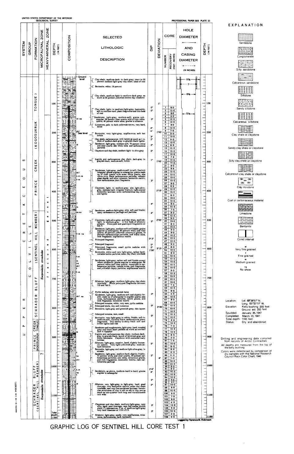
UNITED STATES DEPARTMENT OF THE INTERIOR GEOLOGICAL SURVEY
Z SELECTED 0
LITHOLOGIC
I DESCRIPTION
I
i Clay shale medium-dark- to dark-gray. trace to 20 percent ;nedium-lightgray clay shale; k c e of coal
Bentonite, white; 10 percent
P Clay shale medium-light to medium-dark gra .a much ns b percent yellowish-bmwn clay imnscne
Clay shale likht- to medium-light-gray bentonitic mft to m a d ~ u m - h d , plant fragments dnd thin beds! of aul
Sandstone, light-gray medium-soft; g g i n s sub- angular; 50 percent clear quartz wlth a httle whlte quartz, 40 percent white mlca; gnda to ailtstane
Limestone, p le- to dark-yellowiah-bmwn, very hard. denae
_C B z t ; 6 t e , very light-gray, argillaceous, soft but
CI&tone and clay shale, medium-light to otive-gmy
< Li$;a;h'~m~~~m",;;;g$$~ brk-gray to
Sandstone light-gray mediumsoit to soft' fracture I-I~; p i n s to suban lar, &ins made 1 r of clear a ~ a N wlth mme %ite'OUartz: also
C white mieo. 8ack carbonpceous volcanic glnsa aha&, and other mlneiah ntonltlc matrix; rare carbanaceow plant fragments
1' Clayatone light to medium-gray also li htolive-
g a y . rq&ium-&j; irregular f d u r e ; ligcftsolored n e m t ~ c Iamlnae; some carbonaceous clay shale
and l~gnite
3 S a ~ ~ ~ 2 ~ ~ g % t & a g ~ l p r ; ~ f . t g d friable;
Clayatone light-olive-gray and cla shale medium- light- & medium-gray. ' A few geds of siltstone b ~ r i t . Pelecypod and gastropod fragments a t
- --C Pelecypd fragment
-4 Pelecypd fragment J P e ; k ~ p o i ~ ; z i y n t s ; small pyrite nodules with
1
K Sandstone light-gray rather soft and friable exee t where e i ~ ~ u a ; p n a angular to subangu~u; k
ereent wh~te an clear quarts; remainder ia car- gonwaus particles, various mias m k fragments and yellomsh clayey particles; &llaeeoua matri;
Siltstone l i g h t x y ; medium-li ht gray clay shale interdda. ~ t e pelecypod fragments between 719 ud 149 ft
& Pyrite nodulea. with browniah halon Sandstone l i g h t y ~ m e d i u m - m f t and slightly fri-
nbk. mahe up o su ' ngular to an Iar quarts dm mid, carbonreoua partielea. c a c t e grains: and rock fragments; bentonitic matrix
Pel@ remains. white, very rare; pyrite wdules k P e l 4 ahelis, tiny and numemua - - .. K Bentonite, lightgray and greenish-gray, thin layers
--C Pelecypcd remains, rare, amall
Bentonite very light-gm to white friable soft to E;$Eftg$zz)25g$2rktP~;,"d" L briiile lignite and aul
Sandstone and mnglomerate lightgray h d rounded gmy;nd black chert pedbles as mich w'one-half 1 inch III dtameter
Li$y~&ca&a;fcrt;t~ whlte benton~te. ~1;vatone with scattered eoalv
Sil,@tone, light- ay, massive, ha*; slightly benton- ~ t ~ c matnx. g e r y light-yellowish-gray medlum-
Beg::;&ray and medium-Iighhlive-gray, in
Sandstone .a above medium-hard to hard; grains anguhr io sutangulrr
Siltatone very I' h t p y ,to li&,tgray, hPrd; clesvaige; very%ntonltie matnx; some clay a G interbeds rare v fine sandatone laminae; vermic- ular strukutures y c l a y in silt or silt in clay are .a much w one-suuter ~ n c h long and one-sixteenth
J L inch wide
Silutane li bt p y mnd ve [email protected]. mica- +C -. &A. &: t e x n ~ t ~
PROFESSIONAL PAPER 305 U T E 31
w DIAMETER I I I C___
DIAMETER *-----+
by F)onro M. Robiman
E X P L A N A T I O N
Sandstone
Conglomerate
...... ... ...
Silty sandstone
Calcareous sandstone
. - - . - - - . - . - - - . ' - - - . - , - - . - - . - . - . . - - - . . - . - . - . - . - . - . - . - . - . . - , n Sandy siltstone
Calcareous siltstone
Clay shale or claystone
Sandy clay shale or claystone
Silty clay shale or claystone
Calcareous clay shale o r claystone
u Clay ironstone
Coal or carbonaceous material
Limestone
pzzJ Bentonite
Cored interval
d Very fine rained
f Fine grained
m Medium grained
ns No show
Location: Lat 6936'57' N. Long 151°27'11' W.
Elevation: Kelly bushing 209 feet Ground est. 200 feet
Spudded: January 26.1947 Completed: March 23, 1947 Total depth 1180 feet Status: Dry and abandoned
Drllllng and englneerlng data complied from records ot Arct,c Contractors
All depths are measured from the top of the kelly bushlng
Colors were determined by comparison of dry samples w~ th the Natlonal Research Counc~l Rock Color Chart. 1948
GRAPHIC LOG OF SENTINEL HILL CORE TEST 1