corvallis area metropolitan transportation plan 2035 ... rtp 2035 - appendices.pdf · corvallis...
TRANSCRIPT
Corvallis Area Metropolitan Transportation Plan: Destination 2035
Appendices Appendix A – Review of Existing Plans
Appendix B – Public Involvement Framework
Appendix C – Public Involvement Plan
Appendix D – Modeling Results of Recommended Projec ts
Adopted by the Corvallis Area Metropolitan Planning Organization March 16, 2012

Corvallis Area Metropolitan Transportation Plan: Destination 2035
Appendix A - 1
Appendix A:
Review of Existing Plans
Corvallis Area Metropolitan Transportation Plan: Destination 2035
Appendix A - 2
Review of Planning Documents In an effort to make the Metropolitan Transportation Plan consistent with all the adopted transportation and land use plans within the Planning Area, the following documents were reviewed:
1. Oregon Highway Plan (1999) 2. Oregon Highway Design Manual (2003) 3. Corvallis Transportation Plan (August 1996) 4. City of Philomath Transportation System Plan (May 1999) 5. City of Adair Village Comprehensive Plan (May 2001) 6. Benton County Transportation System Plan (July 2001) 7. Draft Corvallis Area Transit Master Plan (December 2006) 8. Corvallis Transportation Demand Management Plan (1998) 9. Corvallis Airport Industrial Park Master Plan (January 2000) 10. Oregon State University Campus Master Plan (December 2004) 11. Corvallis Downtown Parking Study (January 2001) 12. Final Toledo Sweet Home Rail Corridor Feasibility Study (April 2005) 13. South Corvallis Area Refinement Plan (December 1997) 14. North Corvallis Area Plan (July 2001) 15. West Corvallis – North Philomath Refinement Plan (December 1998) 16. Corvallis Airport Master Plan Revision (June 2003) 17. Harrison Corridor Strategy (October 1997) 18. Bellfountain Corridor Refinement Plan (July 2002)
1.1.1.1. Oregon Highway Plan (1999)Oregon Highway Plan (1999)Oregon Highway Plan (1999)Oregon Highway Plan (1999)
The 1999 Oregon Highway Plan (OHP) is one modal element of the Oregon Transportation Plan. The OHP defines the policies and investment strategies for Oregon’s state highway system over the next 20 years. Regional and local transportation system plans must be consistent with the State Transportation System Plan, which includes the OHP.
• Policy 1A: State Highway Classification System. The state highway classification system includes six classifications: Interstate, Statewide, Regional, District, Local Interest Roads, and Expressways. The OHP emphasizes designation of Expressways as a subset of Statewide, Regional, and District Highways to provide a high level of access control along highway segments.
- Within the Planning Area, US 20/OR 34 is classified as a Statewide Highway, US 20 and OR 99W are classified as Regional Highways, and OR 34 (Alsea Highway) are classified as a District Highway. There are no designated Expressways in the Planning Area.
• Policy 1B: Land Use and Transportation. This policy defines the role of both state and local governments regarding the state highway system and calls for a coordinated approach to land use and transportation planning. The policy identifies the designation of highway segments as Special Transportation Areas (STAs), Commercial Centers, and Urban Business Areas (UBAs). Within STAs and UBAs, highways may be managed to provide a greater level of access to businesses and residences than might otherwise be allowed. Commercial Centers encourage clustered development with limited access to a state highway.
- There are two STAs designated in Corvallis, OR 99W from milepost 83.20 (Polk Avenue) to 83.93 (Western Boulevard) and US 20 from milepost -0.10 (OR 99W) to 0.07 (West end of Van Buren Bridge). There is a STA pending in downtown Philomath.
Corvallis Area Metropolitan Transportation Plan: Destination 2035
Appendix A - 3
• Policy 1C: State Highway Freight System. This policy calls for balancing the need to move freight with other highway users by minimizing congestion on major truck routes.
− US 20/34 through Corvallis and Philomath is a designated statewide freight route (from Interstate 5 to the City of Newport) as part of the Oregon Highway Plan.
− OR99W through Corvallis and Adair Village is a designated statewide freight route.
• Policy 1D: Byways. This policy promotes the preservation and enhancement of scenic byways by considering aesthetic and design elements along with safety and performance considerations on designated byways.
− There are no designated scenic byways in the CAMPO area.
• Policy 1F: Highway Mobility Standards Access Management Policy. This policy provides specific mobility standards for the state highway sections, signalized intersections, and interchanges. Alternative standards are provided for certain locations and under certain conditions.
• Policy 1G: Major Improvements. This policy identifies the state’s priorities for responding to highway needs: protect the existing system; improve efficiency and capacity of existing system; add capacity to existing system.
• Policy 2G: Rail and Highway Compatibility. This policy emphasizes increasing safety and efficiency through reduction and prevention of conflicts between railroad and highway users.
• Policy 3A: Classification and Spacing Standards. This policy addresses the location, spacing, and type of road and street intersections and approach roads on state highways. It includes standards for each highway classification, including specific standards for Special Transportation Areas and Urban Business Areas.
• Policy 3B: Medians. This policy establishes the state’s criteria for the placement of medians.
• Policy 3C: Interchanges. This policy addresses the management of grade-separated interchanges to ensure safe and efficient operation between connecting roadways.
• Policy 4A: Efficiency of Freight Movement. This policy emphasizes the need to maintain and improve the efficiency of freight movement on the state highway system.
• Investment Policy: This policy identifies ODOT’s priority to invest in managing and preserving the existing highway system and maintaining its safety.
• Policy 4D: Transportation Demand Management. This policy emphasizes the importance of efficient use of the transportation system through investment in transportation demand management strategies.
• Policy 4E: Park-and-Ride Facilities. This policy encourages cost-effective expansion of the highway system’s passenger capacity through development and use of park-and-ride facilities.
Appendix C of the OHP includes access management standards and highway mobility standards. Spacing standards for statewide highways (US 20/OR 34) and regional highways (OR 99W and US 20) are included in Tables 13 and 14 of the OHP. Mobility standards are included in Policy 1F of the OHP. In general, the maximum v/c peak-hour ratio for the Corvallis Area CAMPO planning area will be 0.80 (NHS freight routes) or 0.85 (regional highways). These v/c ratios are for planning and design purposes and the Highway Design Manual (2003) should be consulted.
Corvallis Area Metropolitan Transportation Plan: Destination 2035
Appendix A - 4
2.2.2.2. Oregon Highway Design Manual (2003)Oregon Highway Design Manual (2003)Oregon Highway Design Manual (2003)Oregon Highway Design Manual (2003)
The Highway Design Manual (HDM) provides uniform standards and procedures for ODOT and projects that are located on state highways. It is intended to provide guidance for the location and design of new construction, major reconstruction, and resurfacing, restoration, or rehabilitation projects. It is generally in agreement with the American Association of State Highway and Transportation Officials (AASHTO) “A Policy on Geometric Design of Highways and Streets.”
HDM chapters include Project Delivery, Design Standard Policies and Processes, Survey and Design Procedures, Right of Way, General Design Standards, Freeway Design, Rural Non-Freeway Highway Design, Urban Highway Design (Non-Freeway), Intersection and Interchange Design, Special Design Elements, Pedestrian & Bicycle, Design Guidelines for Public Transportation, Design Exception Process and Plans, Specifications & Estimates.
Table 10-1 of the HDM is entitled “20-Year Design-Mobility Standards (Volume/Capacity [V/C] Ratios)”. This table outlines the acceptable v/c ratios for project development & design. These are design standards, and may be different from the ratios shown in the OHP (such as the NHS standard).
3.3.3.3. Corvallis Transportation Plan (August 1996)Corvallis Transportation Plan (August 1996)Corvallis Transportation Plan (August 1996)Corvallis Transportation Plan (August 1996)
The Corvallis Transportation Plan (CTP) presents multiple policies related to all aspects of the transportation system in Corvallis. The most relevant of these are:
Transportation System Policies
• The transportation system shall reflect consistency with the Corvallis Comprehensive Plan, land use designations, and regional and statewide transportation planning efforts.
• Uniform construction standards, which accommodate all transportation modes, shall be maintained for the City’s transportation system.
• ODOT should fund, maintain, and improve all State Highway facilities (OR 99W, OR 34 and US 20) to meet level of service standards included in the Oregon Highway Plan. When specific construction plans are proposed, ODOT should prepare comprehensive roadway designs that recognize urban usage for surface transportation modes, including facilities for pedestrians, bicyclists, transit, drainage, curbs and gutters.
• Corvallis will invest in planning and coordinate with the state and counties [Benton County] to develop highly detailed transportation and access plans that firmly fix the location of future arterial and collector streets for each developing sector within the Corvallis urban growth boundary.
Auto Traffic and Circulation Policies
• Adequate capacity should be provided and maintained on arterial and collector streets to accommodate intersection Level of Service (LOS) standards and to avoid traffic diversion to local streets. The Level of Service standards shall be: LOS D or better during morning and evening peak hours of operation for all streets intersecting with arterial or collector streets, and LOS C for all other times of day. Where LOS standards are not being met, the City shall develop a plan for meeting the LOS standards that evaluates transportation demand management and system management opportunities for delaying or reducing the need for street widening. The plan should attempt to avoid the degradation of travel modes other than the single-occupant vehicle.
• Private driveway access shall be limited on all existing and future arterial streets to reduce interference, improve safety and preserve traffic capacity. New residential driveways shall not directly access arterial streets where alternate access can be developed. At the time of development or redevelopment, opportunities to restrict or combine access points along arterial should be pursued.
Corvallis Area Metropolitan Transportation Plan: Destination 2035
Appendix A - 5
Bicycle and Pedestrian Policies
• All new collector and arterial streets shall be designed to accommodate bicycle facilities.
• The City shall work to acquire abandoned railroad rights-of-way for multi-use paths to serve bicycle, pedestrian and equestrian uses.
• All arterial and collector streets shall have sidewalks constructed at the time of initial street improvement to encourage pedestrian use.
• The ODOT shall construct sidewalks at the time of highway improvements as an integral part of the improvement and pay the sidewalk improvement costs with ODOT project funds.
Transit Policies
• Arterial and Collector street designs shall include evaluation for transit facilities such as bus stops, pullouts, shelters, optimum road design, and on-street parking restriction as appropriate to facilitate transit service.
• The City as an alternative solution to parking and congestion problems shall investigate park-and-ride lots on the periphery of Corvallis.
• The city should seek appropriate opportunities for increasing residential density and providing industrial and commercial development along existing and proposed transit routes.
• Development in the Airport Industrial Park shall be in accordance with the City of Corvallis Airport Industrial Park Development Plan.
• The City should work with government, passenger rail service providers, and other agencies to obtain passenger rail service for Corvallis.
The CTP also references some of the transportation policies from the Corvallis Comprehensive Plan. The following comprehensive plan policy sections are related to transportation planning:
Section 4.1.1: Both public and private properties located along entrance corridors to the City of Corvallis shall be attractively landscaped.
Section 4.1.5: The City shall develop master plans for, and shall establish standards that ensure adequate landscaping, setbacks, and limited access in conjunction with projects to improve City gateways. Such standards shall be maintained in the land development code.
Section 4.1.7: The City shall establish trails in addition to roads, which follow scenic routes to connect open space to residential areas, public sites, shopping areas, and downtown Corvallis. The [City’s] Trails Network Plan shall be used as the basis of trail development.
Section 10.1.1: The transportation system shall be planned and developed in a manner, which contributes to community livability, recognizes and respects the characteristics of natural features, and minimizes the negative affects of abutting land uses.
Section 10.1.2: The transportation system shall be managed to reduce existing traffic congestion and facilitate the safe, efficient movement of people and commodities within the community.
Section 10.1.3: The City shall develop and promote alternative systems of transportation which will safety, economically and conveniently serve the needs of the residents.
Section 10.1.4: Special consideration in the design of the transportation system shall be given to the needs of those people who have limited choice in obtaining private transportation.
Corvallis Area Metropolitan Transportation Plan: Destination 2035
Appendix A - 6
Section 10.1.5: The transportation system shall give special consideration to providing energy efficient transportation alternatives.
Section 10.1.6: The City shall maintain a long-range transportation plan that will be periodically review and updated.
Section 10.1.7: The City shall establish a Capital Improvement Program for the transportation system which:
-is subject to annual review;
-is consistent with the land use policies of the comprehensive plan and considers other facility plans;
-defines the locations of rights-of-way necessary for the creation of a community-wide transportation system;
-establishes a priority for improvements to the system;
-provides for the needs of all modes of transportation within the right-of-way
-considers the economic impacts upon properties resulting from transportation improvements
Section 10.1.8: The following highway corridors shall be considered primary and important entryways or gateways into Corvallis: Highway 99W from the north; Highway 99W from the south; Highway 20 from the northeast; Highway 34 from the east; Highway 20/34 from the west.
Section 10.1.9: Special attention shall be given to major entryways or gateways into Corvallis to ensure that they reflect and contribute to a positive and desirable image of the community. This may include tree planting requirements, the application of special buffer and setback condition at the time properties abutting the highways develop; access limitations; and other efforts to enhance the appearance and carrying capacity of these important corridors in keeping with policies 4.1.1, 4.1.5, and 4.1.7 [listed below].
Section 10.1.10: Development proposals shall be reviewed to assure the continuity of sidewalks, trails, bicycle paths and pedestrian ways.
Section 10.1.11: The City shall coordinate with the Oregon Department of Transportation in implementing its highway improvement program.
Section 10.3.3: On-street parking outside the central business district shall be minimized.
Section 10.3.7: The City shall continue to promote the use of other modes of transportation as an alternative to the automobile, especially in areas where there is a shortage of parking facilities.
Section 10.4.2: Bikeways shall provide safe, efficient corridors, which encourage bicycle use. Bicycle use of major streets shall be considered as improvements are made to major transportation corridors.
Section 10.4.6: Bikeways shall be developed to provide access to all areas of the community.
Section 10.6.2: The City of Corvallis shall cooperate with neighboring jurisdictions to provide a regional transportation system, which facilitates convenient, energy efficient travel. This shall address the needs of persons, who, for whatever reason, do not use private automobiles.
Section 10.5.1: The City shall require safe, convenient, and direct pedestrian ways within all areas of the community.
Corvallis Area Metropolitan Transportation Plan: Destination 2035
Appendix A - 7
Section 10.8.1: The City should further develop facilities and services at the Corvallis airport. The City should continue efforts to secure permanent, scheduled air-taxi service.
Section 10.8.3: Expansions of the urban growth boundary and other land use actions affecting property around the Corvallis airport shall fully protect airport functions, viability, and expansion potential.
Section 10.7.3: The City shall work with industry and rail service providers to retain rail service to this community’s industrial areas.
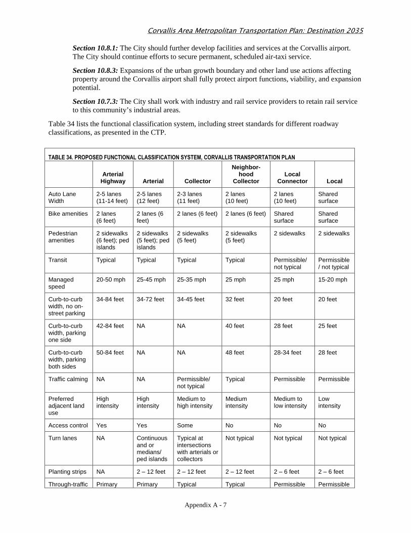
Table 34 lists the functional classification system, including street standards for different roadway classifications, as presented in the CTP.
TABLE 34. PROPOSED FUNCTIONAL CLASSIFICATION SYSTEM, CORVALLIS TRANSPORTATION PLAN
Arterial
Highway Arterial Collector
Neighbor-hood
Collector Local
Connector Local
Auto Lane Width
2-5 lanes (11-14 feet)
2-5 lanes (12 feet)
2-3 lanes (11 feet)
2 lanes (10 feet)
2 lanes (10 feet)
Shared surface
Bike amenities 2 lanes (6 feet)
2 lanes (6 feet)
2 lanes (6 feet) 2 lanes (6 feet) Shared surface
Shared surface
Pedestrian amenities
2 sidewalks (6 feet); ped islands
2 sidewalks (5 feet); ped islands
2 sidewalks (5 feet)
2 sidewalks (5 feet)
2 sidewalks 2 sidewalks
Transit Typical Typical Typical Typical Permissible/ not typical
Permissible/ not typical
Managed speed
20-50 mph 25-45 mph 25-35 mph 25 mph 25 mph 15-20 mph
Curb-to-curb width, no on-street parking
34-84 feet 34-72 feet 34-45 feet 32 feet 20 feet 20 feet
Curb-to-curb width, parking one side
42-84 feet NA NA 40 feet 28 feet 25 feet
Curb-to-curb width, parking both sides
50-84 feet NA NA 48 feet 28-34 feet 28 feet
Traffic calming NA NA Permissible/ not typical
Typical Permissible Permissible
Preferred adjacent land use
High intensity
High intensity
Medium to high intensity
Medium intensity
Medium to low intensity
Low intensity
Access control Yes Yes Some No No No
Turn lanes NA Continuous and or medians/ ped islands
Typical at intersections with arterials or collectors
Not typical Not typical Not typical
Planting strips NA 2 – 12 feet 2 – 12 feet 2 – 12 feet 2 – 6 feet 2 – 6 feet
Through-traffic Primary Primary Typical Typical Permissible Permissible
Corvallis Area Metropolitan Transportation Plan: Destination 2035
Appendix A - 8
connectivity function function function function function function
Source: Corvallis Transportation Plan, Table 3-5 (August 1996).
The CTP also focuses on transit, specifically CTS, which is owned and operated by the City of Corvallis and managed by the Transportation Division of the Public Works Department. The City contracts service with Laidlaw Transit, Inc. OSU students and faculty comprise approximately half of all transit ridership in Corvallis. According to the CTP, historically CTS has had the lowest cost per ride compared to other transit providers in Oregon. According to the CTP, more service is needed for significant employers in the region, including Hewlett-Packard, Regional Medical Center (northern Corvallis), Sunset Regional Park, and downtown Corvallis. Intercity service (such as to Albany or Lebanon) is lacking. Prioritized service enhancements include extension and expansion of weekend service and increase in frequency of trips. Infrastructure enhancements identified include replacement of outdated buses, signage, transit-friendly street construction, and enhancement of the downtown terminal and bus stops.
The bicycle section of the CTP discusses plans and design standards for bicycle facilities. Design standards follow AASHTO and Manual on Uniform Traffic Control Devices (MUTCD) standards. Bicycle safety is categorized into education, rules of the road and laws, records, police department, and visibility. There is one project identified for construction in the CTP, and improvements up to 50 years from now are summarized, along with major funding sources.
Several actions are listed to ensure proper implementation with regard to bicycle facilities:
• The inclusion of the facilities requirement on new arterial and collector streets in the Land Development Code; review of bicycle and pedestrian circulation issues by City staff;
• Developing a plan for downtown and Monroe Street parking;
• A review of new parking standards against the 1995 Oregon Bicycle and Pedestrian Plan proposals and local needs;
• Corridor studies;
• Review of policies prohibiting certain funds being used for on-street bike lanes; and
• The development of LOS standards for local bikeways.
The pedestrian section of the CTP discusses existing and future pedestrian facilities. After specific facilities are individually detailed, major impediments to pedestrian travel (and possible solutions) are identified as follows: lack of sidewalks, difficult crossings on wide and/or busy streets, discontinuous sidewalks, out-of-direction travel that results from certain land uses, and lack of parking strips. The current Land Development Code ties pedestrian facility installation to parcel development, leading to discontinuous sidewalks. Alternatives are suggested to address this concern.
The air, rail, water, and pipeline sections of the CTP primarily discuss the Corvallis Municipal Airport and the short-line rail routes in Corvallis. Land uses near the airport are generally compatible with airport uses. Transportation growth and more development is expected at the airport. Rail usage is also expected to increase.
The CTP outlines 10-year transportation improvements and prioritization. Listed state and federal highway improvements include:
• Widen US 20/OR 34 in Corvallis • Provide ramps between OR 99W and US 20/OR 34 • Improve bypass/OR 34 interchange
Corvallis Area Metropolitan Transportation Plan: Destination 2035
Appendix A - 9
• Construct two lanes of the northern leg of the bypass
Other improvements include extending 72nd Street to US 20 and aligning with a future Bellfountain Road extension, additional access to northwest and south Corvallis, and future roadways in north Corvallis.
4.4.4.4. City of Philomath Transportation System Plan (City of Philomath Transportation System Plan (City of Philomath Transportation System Plan (City of Philomath Transportation System Plan (MayMayMayMay 1999)1999)1999)1999)
The Philomath Transportation System Plan (PTSP) published in 1999 includes the following transportation policies:
PTSP Goal 1: Relieve increasing traffic congestion on Highway 20/34.
• Evaluate traffic counts, growth projections and land use patterns to determine whether US 20/OR 34 should be further improved within the Philomath Urban Growth Boundary (UGB).
• Consider alternatives to widening US 20/OR 34, including transportation demand management measures that could reduce peak hour demand.
• Analyze the impacts of signalized and unsignalized intersections and rights-of-way in increasing the capacity of US 20/OR 34 (e.g. better synchronization of signals, updated/additional traffic controls, etc.)
• Utilize access management measures, including limiting additional access points on Highway 20/34 and restricting existing accesses to local properties while preserving traffic flow.
PTSP Goal 2: Improve traffic circulation and safety throughout the city.
• Improve cross-town (both north-south and east-west) circulation and connectivity.
• Review design standards for streets.
PTSP Goal 3: Promote the increased use of alternative modes.
• Identify intersection improvements that enhance pedestrian safety.
• Identify measures (e.g. fixed-route bus systems, dial-a-ride, park-and-ride, vanpool, etc.) to develop and maintain transit usage.
• Assess potential of the railroad system for commuter rail, commercial rail, and excursion uses.
• Identify potential park-and-ride locations at both the east and west ends of the city.
PTSP Goal 4: Develop a Master Plan that defines future street locations.
• Identify future street locations, especially in north Philomath and the Newton Creek industrial area.
• Develop street classifications and access management standards for existing and future street locations.
PTSP Goal 5: Provide alternate routes to deter through industrial traffic out of the downtown core and residential neighborhoods.
• Develop a truck routing plan that minimizes/avoids conflicts with schools, residential areas, and the downtown core.
• Investigate alternate truck routes (e.g. Grange Hall Road) or other roads outside the city core.
PTSP Goal 6: Integrate the transportation system plan with other land use planning projects in the city.
Corvallis Area Metropolitan Transportation Plan: Destination 2035
Appendix A - 10
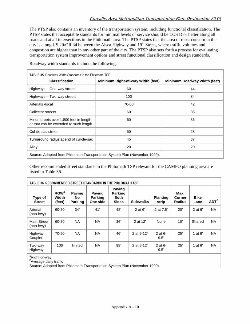
The PTSP also contains an inventory of the transportation system, including functional classification. The PTSP states that acceptable standards for minimal levels of service should be LOS D or better along all roads and at all intersections in the Philomath area. The PTSP states that the area of most concern in the city is along US 20/OR 34 between the Alsea Highway and 19th Street, where traffic volumes and congestion are higher than in any other part of the city. The PTSP also sets forth a process for evaluating transportation system improvement options and street functional classification and design standards.
Roadway width standards include the following:
TABLE 35. Roadway Width Standards in the Philomath TSP
Classification Minimum Right-of-Way Width (feet) Mi nimum Roadway Width (feet)
Highways – One-way streets 60 44
Highways – Two-way streets 100 84
Arterials -local 70-80 42
Collector streets 60 36
Minor streets over 1,800 feet in length, or that can be extended to such length
60 36
Cul-de-sac street 50 28
Turnaround radius at end of cul-de-sac 45 37
Alley 20 20
Source: Adapted from Philomath Transportation System Plan (November 1999).
Other recommended street standards in the Philomath TSP relevant for the CAMPO planning area are listed in Table 36.
TABLE 36. RECOMMENDED STREET STANDARDS IN THE PHILOMATH TSP.
Type of Street
ROW1 Width (feet)
Paving No
Parking
Paving Parking
One side
Paving Parking
Both Sides Sidewalks
Planting strip
Max. Corner Radius
Bike Lane ADT2
Arterial (non-hwy)
60-80 34’ 41’ 48’ 2 at 6’ 2 at 7.5’ 20’ 2 at 6’ NA
Main Street (non-hwy)
60-80 NA NA 36’ 2 at 12’ None 10’ Shared NA
Highway Couplet
70-90 NA NA 46’ 2 at 6-12’ 2 at 6-9.5’
25’ 1 at 6’ NA
Two-way Highway
100 limited NA 88’ 2 at 6-12’ 2 at 6-9.5’
25’ 1 at 6’ NA
1Right-of-way 2Average daily traffic Source: Adapted from Philomath Transportation System Plan (November 1999).
Corvallis Area Metropolitan Transportation Plan: Destination 2035
Appendix A - 11
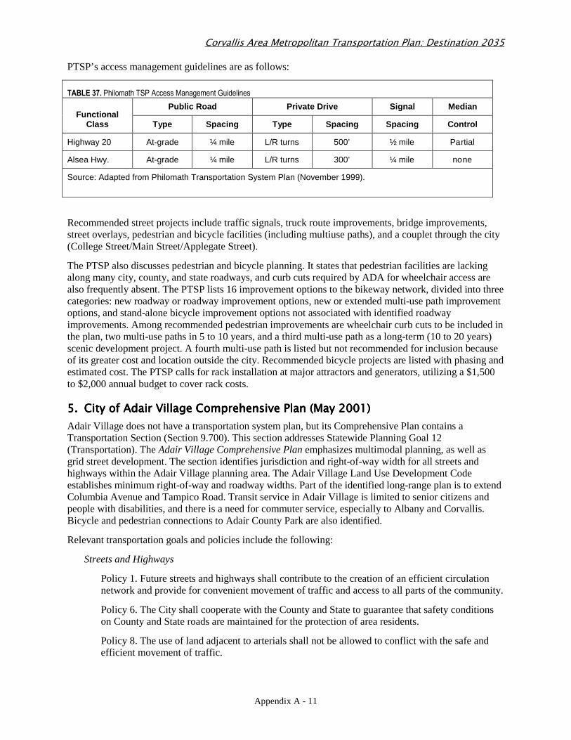
PTSP’s access management guidelines are as follows:
TABLE 37. Philomath TSP Access Management Guidelines
Functional Class
Public Road Private Drive Signal Median
Type Spacing Type Spacing Spacing Control
Highway 20 At-grade ¼ mile L/R turns 500’ ½ mile Partial
Alsea Hwy. At-grade ¼ mile L/R turns 300’ ¼ mile none
Source: Adapted from Philomath Transportation System Plan (November 1999).
Recommended street projects include traffic signals, truck route improvements, bridge improvements, street overlays, pedestrian and bicycle facilities (including multiuse paths), and a couplet through the city (College Street/Main Street/Applegate Street).
The PTSP also discusses pedestrian and bicycle planning. It states that pedestrian facilities are lacking along many city, county, and state roadways, and curb cuts required by ADA for wheelchair access are also frequently absent. The PTSP lists 16 improvement options to the bikeway network, divided into three categories: new roadway or roadway improvement options, new or extended multi-use path improvement options, and stand-alone bicycle improvement options not associated with identified roadway improvements. Among recommended pedestrian improvements are wheelchair curb cuts to be included in the plan, two multi-use paths in 5 to 10 years, and a third multi-use path as a long-term (10 to 20 years) scenic development project. A fourth multi-use path is listed but not recommended for inclusion because of its greater cost and location outside the city. Recommended bicycle projects are listed with phasing and estimated cost. The PTSP calls for rack installation at major attractors and generators, utilizing a $1,500 to $2,000 annual budget to cover rack costs.
5.5.5.5. City of Adair Village Comprehensive Plan (May 2001)City of Adair Village Comprehensive Plan (May 2001)City of Adair Village Comprehensive Plan (May 2001)City of Adair Village Comprehensive Plan (May 2001)
Adair Village does not have a transportation system plan, but its Comprehensive Plan contains a Transportation Section (Section 9.700). This section addresses Statewide Planning Goal 12 (Transportation). The Adair Village Comprehensive Plan emphasizes multimodal planning, as well as grid street development. The section identifies jurisdiction and right-of-way width for all streets and highways within the Adair Village planning area. The Adair Village Land Use Development Code establishes minimum right-of-way and roadway widths. Part of the identified long-range plan is to extend Columbia Avenue and Tampico Road. Transit service in Adair Village is limited to senior citizens and people with disabilities, and there is a need for commuter service, especially to Albany and Corvallis. Bicycle and pedestrian connections to Adair County Park are also identified.
Relevant transportation goals and policies include the following:
Streets and Highways
Policy 1. Future streets and highways shall contribute to the creation of an efficient circulation network and provide for convenient movement of traffic and access to all parts of the community.
Policy 6. The City shall cooperate with the County and State to guarantee that safety conditions on County and State roads are maintained for the protection of area residents.
Policy 8. The use of land adjacent to arterials shall not be allowed to conflict with the safe and efficient movement of traffic.
Corvallis Area Metropolitan Transportation Plan: Destination 2035
Appendix A - 12
Policy 18. Existing and proposed street alignments and right-of-ways shall be protected from encroachment by future developments through adherence to the standards and review criteria of the Development Code.
Mass Transit
Policy 1. The City has a need for a public transit system to transport area residents to nearby urban centers and shall encourage development of a regional transit system.
Policy 3. The City supports the need for Adair Village to be included in a general inter-city bus service.
Policy 6. The City shall work with and support efforts by other governmental agencies or private industry interests concerned with future regional public transit within the Linn-Benton area.
Bicycle and Pedestrian Ways
Policy 6. The City shall cooperate with the County in providing connections or extensions to future bike or pedestrian ways within the Planning Area.
Railroad
Policy 1. The railroad is recognized as a community resource for possible future freight service for the area, and expansion of its use is encouraged.
Roadway standards are the same as Corvallis road standards.
6.6.6.6. Benton County Transportation System Plan (July 2001)Benton County Transportation System Plan (July 2001)Benton County Transportation System Plan (July 2001)Benton County Transportation System Plan (July 2001)
The Benton County Transportation System Plan (BCTSP) presents multiple policies related to all aspects of the transportation system in the county. Key findings include:
• The majority of roadway congestion will occur on the state highway system.
• Limited new road construction to improve connectivity could allow the County road system to relieve some congestion.
• Even with improved connectivity and aggressive efforts to decrease dependence on automobile travel, US 20 between Albany and Corvallis and US 20/Highway 34 between Corvallis and Philomath will need to be widened to provide operational capacity that complies with state capacity standards for the next 20 years.
• Financial constraints will require the lowest-cost alternatives suitable for meeting the needs of the next 20 years and may require a compromise of the vision and/or goals.
The most relevant policies and information in the BCTSP are as follows:
Mobility, Circulation and Safety Goals
• Develop a transportation system to facilitate appropriate travel modes.
• Ensure sufficient capacity is provided concurrent with future travel demand to, within, and through Benton County.
• Coordinate with local agencies and providers to expand transit services countywide.
• Ensure and adequate truck route network to reduce commercial/neighborhood conflicts.
• Provide both primary and secondary access for emergency services.
Corvallis Area Metropolitan Transportation Plan: Destination 2035
Appendix A - 13
Capital Improvement Goals
• Maximize the useful life of existing facilities.
• Maximize the cost effectiveness of transportation improvements.
• Ensure adequate and equitable long-term funding mechanisms.
Community Goals
• Provide transportation services that preserve and protect the scenic and natural resources and rural character of Benton County.
Economic Development Goals
• Preserve and protect transportation corridors essential to the economic vitality of the County.
• Promote the use of freight rail and air service to reduce trucking activity on County roads.
• Promote efficient and affordable ground transportation to existing regional airports (Portland and Eugene).
The BCTSP includes a summary of the County Transportation Improvement Program (prioritized projects and strategies). The recommended project list includes state highway widening, state highway bridge replacements, state highway intersection improvements, County bikeway/shoulder widening, County road bridge replacements, County road intersection improvements, County road level of service/capacity increases, County road pavement preservation program, and rural transit/TDM.
At the time of publication, all County roads met LOS standards. Relevant corridors with projected capacity deficiencies include: US 20 corridor (Corvallis to Albany); US 20/OR 34 (Philomath to Corvallis); North OR 99W corridor; and Bellfountain Road/South OR 99W corridor.
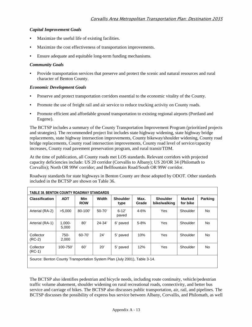
Roadway standards for state highways in Benton County are those adopted by ODOT. Other standards included in the BCTSP are shown on Table 36.
TABLE 38. BENTON COUNTY ROADWAY STANDARDS
Classification ADT Min ROW
Width Shoulder type
Max. Grade
Shoulder bike/walking
Marked for bike
Parking
Arterial (RA-2) >5,000 80-100’ 50-70’ 6-12’ paved
4-6% Yes Shoulder No
Arterial (RA-1) 1,000-5,000
80’ 24-34’ 6’ paved 5-8% Yes Shoulder No
Collector (RC-2)
750-2,000
60-70’ 24’ 5’ paved 10% Yes Shoulder No
Collector (RC-1)
100-750’ 60’ 20’ 5’ paved 12% Yes Shoulder No
Source: Benton County Transportation System Plan (July 2001), Table 3-14.
The BCTSP also identifies pedestrian and bicycle needs, including route continuity, vehicle/pedestrian traffic volume abatement, shoulder widening on rural recreational roads, connectivity, and better bus service and carriage of bikes. The BCTSP also discusses public transportation, air, rail, and pipelines. The BCTSP discusses the possibility of express bus service between Albany, Corvallis, and Philomath, as well
Corvallis Area Metropolitan Transportation Plan: Destination 2035
Appendix A - 14
as a park-and-ride system. The BCTSP also recommends the formation of a transit district for the region. The BCTSP identifies rail expansion (both freight and passenger) as a priority (e.g., upgrade the line between Corvallis and Albany; promote the idea of commuter rail service between Albany and Philomath). Expansion of the airport is also encouraged. The Transportation Improvement Plan includes bridge replacements, safety improvements, bikeway improvements, LOS/increased capacity improvements, pavement preservation, and transit improvements.
7.7.7.7. Corvallis Area Transit Master PlanCorvallis Area Transit Master PlanCorvallis Area Transit Master PlanCorvallis Area Transit Master Plan (December(December(December(December 2006)2006)2006)2006)
The Updated Corvallis Area Transit Master Plan (2006) outlines short- and long-term concepts for the future development of the Corvallis Transit System (CTS), intended to accommodate expected growth in the Corvallis area. The plan includes several key planning recommendations:
• Design transit service in a way the more closely reflects the patterns of development intensity. Concentrate service around densely developed areas.
• Place a premium on speed.
• Place priority on primary transit corridors (provide 15-minute all-day headways). The primary transit corridors include: 9th Street between downtown and Elks Drive, Highland Drive between Walnut Boulevard and Buchanan Avenue, Kings Boulevard between Monroe Avenue and Walnut Boulevard, Walnut Boulevard, Monroe Avenue between Kings Boulevard and downtown, South 3rd Street/OR 99W between Rivergreen Avenue and downtown, Technology Loop between 53rd Street and Research Way, Jefferson Way between 35th Street and downtown, Circle Boulevard and Western/West Hill Road between 3rd Street and 53rd Street.
• Improve transit orientation near the OSU campus.
• Encourage transit-oriented development.
The long-range concept focuses on expansion of service and efficient use of service for a growing area population. The short-range concept focuses on restructuring some routes to concentrate service where the highest demand exists, and add demand-response service in low-density areas currently served by transit.
Noted constraints with the existing route structure include city policy (transit service to be provided within five blocks of all city residences), the desirability of returning downtown at least every hour, and street patterns.
The concepts include integration with other transit services, such as Linn-Benton Loop and the Philomath Connection. The major transit centers discussed include a downtown transit center; OSU, Timberhill Shopping Center, and a west campus transfer point.
Chapter 6 includes policy considerations, including the following: imperative of speed, street classification needs of primary corridors, land use impacts of primary corridors, transit stop facilities, downtown transit center, and bus issues. Chapter 7 outlines a marketing plan, as well as the reasons a marketing plan is critical to the future of the transit system.
8.8.8.8. Corvallis Transportation Demand Management Plan (1998)Corvallis Transportation Demand Management Plan (1998)Corvallis Transportation Demand Management Plan (1998)Corvallis Transportation Demand Management Plan (1998)
The Corvallis Transportation Demand Management Plan outlines City- and employer-sponsored TDM programs, as well as recommendations for commitment to changing land use patterns (such as pedestrian or transit oriented development). The plan identifies several improvements to pedestrian and bicycle infrastructure, which is critical to supporting a TDM program. Projects focus on bicycle lanes, transit enhancements, and roadway modifications. Replacement of the Van Buren Bridge is identified as a high priority. City-based community education efforts are also prioritized.
Corvallis Area Metropolitan Transportation Plan: Destination 2035
Appendix A - 15
9.9.9.9. Corvallis Airport Industrial Park Master Plan (Corvallis Airport Industrial Park Master Plan (Corvallis Airport Industrial Park Master Plan (Corvallis Airport Industrial Park Master Plan (January 2000)January 2000)January 2000)January 2000)
The Corvallis Airport Industrial Park Master Plan provides concepts for how an industrial park should be developed in the northwest airport area. Relevant concepts include the following:
• Create a gateway image at the Airport Avenue/OR 99W intersection through improved signing and intersection functional design.
• Upgrade Airport Avenue to create a boulevard, including landscaping and pedestrian and bicycle facilities.
• Upgrade Airport Place and develop Ingalls as a north-south collector with bike lanes, sidewalks, and street trees.
• Install a roundabout at the Airport Avenue/Airport Place intersection.
• Install a signal at Airport Avenue/OR 99W and future east-west connector.
10.10.10.10. Oregon State University Campus Master Plan (December 2004)Oregon State University Campus Master Plan (December 2004)Oregon State University Campus Master Plan (December 2004)Oregon State University Campus Master Plan (December 2004)
The Oregon State University Campus Master Plan 2004-2015 (CMP) outlines the future vision for the 570 acres of land recognized as the main campus within the city limits of Corvallis. The CMP updates the 1986 OSU Physical Development Plan. The CMP has three purposes:
• Identify guiding principles and policies for the long-range planning of OSU that will direct the physical development (i.e., approximately 3 million gross square feet of new buildings and facilities) over the approximate 10- to 12-year planning horizon.
• Establish a conceptual framework for the campus through program development, and use determinations, intensity of development, and parking and circulation initiatives.
• Clarify and enhance the relationship and connectivity with the surrounding community.
The CMP anticipates approximately 750,000 gross square feet of new construction in the campus core area with an additional 2.4 million gross square feet in other campus sectors over the planning horizon. The CMP also states that the core campus area will become denser in terms of building mass and pedestrian activity, which is anticipated to displace some of the parking adjacent to buildings. According to the plan, the displaced and new parking will be located in new lots and structures, but not necessarily adjacent to new development.
Jefferson Way and/or Monroe Avenue and Western Avenue and 26th Street are identified in the plan as major campus entryways or portals. Pedestrian corridors are identified on Campus Way, Jefferson Way, Washington Way, 30th Street, 26th Street, SW Memorial Place, SW Waldo Place, and 15th Street. The plan emphasizes that the campus is primarily pedestrian-oriented. Projected student enrollment is 22,500 for year 2014-2015 (2003-2004 was 19,067). Faculty and staff are also expected to increase, from 4,159 (Fall 2003) to 5,100 (Future 2015). Future building square footage (existing plus future allocation) is expected to total 10,830,513 square feet. The plan also identifies the relatively unimproved “South Farm” land, owned by OSU and located south of US 20/OR 34 and west of Brooklane Drive, as a potential site for the development of research activities (research park, etc.).
Chapter 6 includes the Transportation Plan, Chapter 7 includes the Parking Plan, and Chapter 8 discusses implementation of the CMP. Chapter 6 includes existing and future level of service (LOS) analysis. Several intersections are expected to experience LOS F for a full build-out scenario. Chapter 6 also outlines pedestrian and bicycle improvements and a list of other transportation improvements.
Relevant principles and policies from the OSU Campus Master Plan include the following:
Corvallis Area Metropolitan Transportation Plan: Destination 2035
Appendix A - 16
Community Relationships
Policy 2.1.1: Continue to work with the City of Corvallis, Benton County, and other governmental agencies to address issues of community concern.
Policy 2.1.2: Develop an understanding of issues that arise from OSU growth and development. Where negative impacts are anticipated or experienced, develop and implement mitigation plans to minimize impacts on the surrounding community.
Policy 2.1.6: Prepare management plans for OSU-owned property outside the city limits but within the urban growth boundary. Management plans shall be consistent with the principles and policies of the CMP and responsive to specific resource needs, research and educational objectives, and compatibility issues.
Policy 2.1.7: OSU shall participate as a full partner and in good faith in a community task force with City and community representatives to measure, assess, and monitor traffic and parking conditions within areas adjacent to OSU’s north campus boundary. OSU shall assist with mitigation efforts for existing and future negative impacts. If other task forces are formed and approved by the City to review traffic and parking conditions within other geographical areas adjacent to the OSU District Boundary, then OSU shall participate in those task forces as well.
Policy 2.1.13: OSU and the neighbors shall prepare a Charter Statement that outlines a purpose statement, planning assumptions for future CMP updates, the tenets of the OSU and neighbor relationships common concerns for consideration for future CMP updates, and future planning goals for future CMP updates.
Student Life and Services
Policy 2.3.1: Continue to promote the campus as a pedestrian-friendly environment. Safe and direct access among buildings, parking areas, and other destinations shall be maintained or enhanced with new development.
Athletics
Policy 2.4.1: Explore methods to develop athletic facilities and uses within a central area with convenient access to nearby collectors and arterials.
Policy 2.4.2: Support projects and other improvements, such as the Reser Stadium expansion project, Gill Annex project, or the addition of soccer field lighting, to increase the appeal and competitive stature of OSU athletics.
Site Development, Operations, and Management
Policy 2.5.1: Ensure that all future development is consistent with the City of Corvallis Comprehensive Plan, Land Development Code, and other adopted local plans (e.g., utility, transportation, etc.).
Policy 2.5.7: Arrange the campus layout and building placement to reinforce academic and operations relationships by locating functionally related programs near each other and consolidating activities with similar physical requirements. To the extent practicable, site major academic buildings within the core campus area and within a 10-minute walk of other academic buildings.
Policy 2.5.12: Encourage preservation of the historic street grid and usability of the street system with new development organized to create usable open spaces that facilitate ease of pedestrian and vehicular movement.
Corvallis Area Metropolitan Transportation Plan: Destination 2035
Appendix A - 17
Transportation, Circulation, and Parking
Policy 6.1.1: Plan and construct OSU transportation system improvements consistent with the City of Corvallis Comprehensive Plan, Land Development Code, Transportation Plan, and Standard Construction Specifications.
Policy 6.1.2: OSU shall continue to implement Transportation Demand Management (TDM) measures such as the pre-paid mass transit program and explore opportunities to further reduce reliance on single occupancy vehicles. OSU shall report TDM activities taken and measures of effectiveness with annual parking.
Policy 6.1.3: Consider TDM principles, such as continued participation in the pre-paid mass-transit pass program and other measures, whenever possible to avoid or delay construction of new transportation facilities and to reduce reliance on automobiles.
Policy 6.1.4: Consider improvement to sidewalks, multi-use paths, on-street bicycle lanes, street alignments, intersections, turn lanes, and road striping as part of the physical development of campus, constructing the improvements as needed or as conditions warrant.
Policy 6.1.6: Develop an internal funding mechanism that requires that new construction and significant remodeling projects are assessed for needed campus infrastructure and other improvements. An assessment adjustment shall be made for projects that include infrastructure improvements.
Policy 6.1.8: Design the transportation system to emphasize and encourage walking as the primary form of transportation in the campus core area.
Policy 6.1.9: Encourage alternative modes of transportation (e.g., walking, bicycling, car/vanpooling, transit).
Policy 6.1.12: Continue to maintain the transportation system of streets, roads, paths, sidewalks, and bicycle lanes for safety and good operating conditions.
Policy 6.1.14: Continue to review potential funding mechanisms to improve the efficiency and frequency of shuttle service across the campus.
Policy 6.1.15: Continue to support the campus shuttle service.
Policy 6.1.17: Continue to take actions to improve campus accessibility from highways and major streets, and by public transportation. Coordinate campus transportation planning and improvements with local government transportation plans and area transit providers that service OSU. Where possible, locate new facilities to take advantage of public transit systems.
Policy 6.1.19: OSU shall update its Base Transportation Model in accordance with LDC 3.36.70.
Policy 6.1.20: OSU shall update the Traffic Impact Analysis for Sector J in accordance with Sector J Policies 4.2.6.j, 4.2.7.j, and 4.2.8.j.
Pedestrian Systems and Open Space
Policy 2.7.3: Continue to maintain and enhance pedestrian walkways throughout the campus, especially with new development.
Policy 2.7.5: Reinforce the pedestrian nature of the campus by minimizing the need for private automobiles for cross-campus travel. This shall be done by locating parking areas on the campus perimeter and by maintaining a street system that directs traffic to nearby arterials and collectors, to the maximum extent practicable.
Corvallis Area Metropolitan Transportation Plan: Destination 2035
Appendix A - 18
Policy 2.7.8: Establish a pedestrian network of paths and sidewalks for safe and convenient access to sites on and off campus.
Policy 2.7.9: Develop a campus-wide bicycle route system that uses a combination of on-street bike lanes and off-street multi-use paths.
Campus Development
Policy 4.1.9: Design transportation, pedestrian and bicycle connections consistent with the City’s transportation plan, comprehensive plan, land development code, Corvallis Standard Construction Specifications, and the CMP TIP to promote safe and convenient access into and across campus.
Policy 4.1.14: OSU shall ensure that adequate mitigation of the identified intersections within the Base Transportation Model (BTM), or its update, that drop below an acceptable level of service as described in the City of Corvallis’ Transportation System Plan (TSP) are mitigated in accordance with the mitigation measures outlined in the most recent CMP annual monitoring report or the CMP’s Transportation Improvement Plan.
Policy 4.1.15: OSU shall complete the mitigation described in Policy 4.1.14 within one year of when said mitigation measures are identified or in accordance with the development proposal that is projected to impact the intersection beyond an acceptable level.
Policy 4.1.16: If mitigation from projected development is not completed in accordance with said development, then the project will either be delayed until such a time that mitigation can occur in accordance with the most recent CMP annual monitoring report or CMP’s Transportation Improvement Plan, or the project will be redesigned in a manner that does not impact the transportation system beyond acceptable levels.
Policy 4.2.6.a: Improve Campus Way, Jefferson Way, and Washington Way to strengthen the east/west connection that links research, forestry, and agricultural areas to the campus core.
Policy 4.2.3.b: Improve 35th Street consistent with the OSU-city 35th Street Agreement and in a manner that improves access to and the identity of the university.
Policy 4.2.2.d: Recognize that Madison Avenue shall continue to be developed as a pedestrian link between OSU and the Willamette River. Development in this area shall be compatible with and enhance the abutting land uses and allow for the area’s continued use for cultural and civic purposes.
Policy 4.2.3.e: Improve 30th Street between Western Boulevard and Washington Way concurrent with abutting development.
Policy 4.2.2.f: Support Reser Stadium expansion projects and other enhancement projects of athletic facilities.
Policy 4.2.5.j (South Farm Area): A major adjustment to the CMP shall be required when the square footage of development exceeds the amount of square footage modeled in the Base Transportation Model (i.e., 231,000) by more then ten percent (i.e., 254,100).
11.11.11.11. Corvallis Downtown Parking Study (Corvallis Downtown Parking Study (Corvallis Downtown Parking Study (Corvallis Downtown Parking Study (January January January January 2001)2001)2001)2001)
The Corvallis Downtown Parking Study examines the issue of parking in downtown Corvallis. Phase I concluded that the overall parking supply is adequate. However, parking pressures for certain types of parking and downtown employee issues were the focus of Phase II. Phase II of the Plan focuses on TDM plan considerations for the downtown area and appropriate mode split, per Corvallis policy. Several guiding principles were developed as part of the plan, including the usage of and 85-percent full standard, parking management strategies and programs, support downtown residential development, consider
Corvallis Area Metropolitan Transportation Plan: Destination 2035
Appendix A - 19
parking lot sharing, and coordinate all parking strategies with TDM strategies. Several specific improvements were also proposed.
12.12.12.12. Final Toledo Sweet Home Rail Corridor Feasibility Study (April 2005)Final Toledo Sweet Home Rail Corridor Feasibility Study (April 2005)Final Toledo Sweet Home Rail Corridor Feasibility Study (April 2005)Final Toledo Sweet Home Rail Corridor Feasibility Study (April 2005)
The Final Toledo Sweet Home Rail Corridor Feasibility Study examines opportunities for increased rail use of the Toledo Sweet Home Rail Corridor, including cargo shipments and passenger excursion services. The Toledo Sweet Home Rail Corridor is one of the primary rail lines in the CAMPO planning area, and any expansion of service would be of great interest to the region for both freight and commuter mobility. The study found several existing deficiencies with the rail line, which would cost approximately $80 million to upgrade. According to the Study, the upgrades would increase economic development for the region, resulting from enhanced freight capacity. A market analysis was conducted as part of the study, which identified several opportunities for rail usage by area shippers and new industries that could be attracted to the area with improved service. Excursion service for special occasions was also found feasible. The market analysis also states that development of an intermodal facility along the corridor is likely not a profitable venture.
13.13.13.13. South Corvallis Area Refinement Plan (December 1997)South Corvallis Area Refinement Plan (December 1997)South Corvallis Area Refinement Plan (December 1997)South Corvallis Area Refinement Plan (December 1997)
The South Corvallis Area Refinement Plan (SCARP) is a focused area plan for the South Corvallis area, south of the downtown area, and including the southern portion of the OR 99W corridor and the airport. The SCARP recommends ways to reduce reliance on the automobile and enhance the transportation system, among other long-range land use strategies. Some SCARP objectives include: enhance opportunities for pedestrian and bicycle travel; enhance street connectivity in appropriate location; and support existing and future transit services. Several connections, pedestrian nodes, parkways (including Airport Road), multiuse paths and median treatments are also recommended. The fundamental policy underlying the transportation strategy in the SCARP is that the City should use TDM, TSM and land use strategies to the greatest extent possible to keep the width of Third Street to a maximum of five lanes. Access management policies are also recommended for Third Street. Another strategy is that the City is to work with ODOT to implement pedestrian nodes along S. Third Street. Transit-oriented land use is encouraged in the area.
14.14.14.14. North Corvallis Area Plan (July 2001)North Corvallis Area Plan (July 2001)North Corvallis Area Plan (July 2001)North Corvallis Area Plan (July 2001)
The North Corvallis Area Plan (NCAP) is an area plan for the northern portion of Corvallis and its urban fringe (encompassing Crescent Valley and Lewisburg). The southern boundary is Walnut Boulevard, the northern boundary is the UGB - just north of Lewisburg Road, the eastern boundary is the UGB - generally OR 99W, and the western boundary is the UGB. According to the NCAP, most of the commercial services proposed are intended to serve local neighborhood residents and not generate a significant number of trips to the planning area. One of the guiding principles for the area is the provision of transportation alternatives to private vehicles.
The North Corvallis area is expected to quadruple in population through build-out. This has significant transportation repercussions, as the existing roadway network relies heavily on OR 99W and the remainder of the network is disconnected and circuitous, partially due to topographic constraints. The NCAP proposes multiple neighborhood centers, parks, trails and schools. This has relevance for how land use and transportation interact in the area. The NCAP contains several objectives that will affect transportation to and through the area, relevant for the regional network: develop major and minor neighborhood centers with high residential and employment densities to support transit, walking and bicycle use; establish a modified grid system for local traffic and to line with outside destinations; and provide suitable access to move people and goods within and through the neighborhood.
Key roadway connections recommended include: widening of OR 99W to four lanes with intersection improvements and a landscaped median; Kings Boulevard extension to Crescent Valley Drive; capacity
Corvallis Area Metropolitan Transportation Plan: Destination 2035
Appendix A - 20
improvements to Lewisburg Road and Highland Drive; Lester Avenue connection with Kings Boulevard and Satinwood Street extensions; extend Frazier Creek Drive to connect with Shasta Drive; extend Crescent Valley Drive west to connect with the Kings Boulevard extension and east to the Lester Avenue extension; Satinwood Street extension from Elks Drive to Lester extension; and a new north-south collector parallel and east of Highway Drive. The NCAP also recommends roundabouts at Kings Boulevard extension/Crescent Valley Drive and the Frazier Creek Road extension; Elliott Circle east of OR 99W; Satinwood Street extension and the new east-west parkway off OR 99W. The NCAP also discusses the expansion of transit into the area, including a station/park-and-ride facility near the Lewisburg and Elliott Circle neighborhood centers. An important policy is the optimization of the arterial, collector and local street network to facilitate intra-city trips to reserve capacity on OR 99W.
15.15.15.15. West Corvallis West Corvallis West Corvallis West Corvallis –––– NoNoNoNorth Philomathrth Philomathrth Philomathrth Philomath Refinement Plan (December 1998)Refinement Plan (December 1998)Refinement Plan (December 1998)Refinement Plan (December 1998)
The West Corvallis- North Philomath Plan (WCNP Plan) establishes a coordinated vision for development within a ten square mile area on the west side of Corvallis and north of Philomath which is anticipated to see increased growth in upcoming years. Adopted by the Corvallis City Council on December 21st 1998, the WCNP Plan recommends policies concerning land use, open space and circulation. Major elements of the Plan include a framework for open space, promotion of neighborhood villages which emphasize pedestrian-oriented design and diversity of housing types, and an interconnected circulation system for all modes.
Transportation system improvements recommended in Appendix C of the WCNP Plan include: intersection improvements and signal timing at Reservoir Road & 53rd Street, signalization at Harrison Blvd & 53rd Street, signalization at Harrison & 35th, widening of West Hills Road west of Reservoir Road, signalization at West Hills Road and Western Blvd., separation of turn movements at the intersection of Circle Blvd and Witham Hill Dr. in conjunction with the extension of Circle, developing a new east-west collector between 53rd Street and 35th St to relieve congestion on West Hills Rd.
16.16.16.16. Corvallis Municipal AirpCorvallis Municipal AirpCorvallis Municipal AirpCorvallis Municipal Airport Master Plan Revision (June 2003)ort Master Plan Revision (June 2003)ort Master Plan Revision (June 2003)ort Master Plan Revision (June 2003)
The Corvallis Municipal Airport Master Plan Revision is intended to enable and guide future development of aviation and airport-related uses, as well as on-airport and off-airport commercial and industrial uses. Growth is expected in air traffic at the airport. The Master Plan fine-tunes the previous version through a Comprehensive Plan amendment intended to allow more flexibility in development to be able to better respond to market conditions. It does not propose any new runways, although it does propose extensions of the existing runways to accommodate the full range of general aviation aircraft. The airport property not only consists of the airport itself, but also of surrounding land zoned for airport-compatible and industrial uses. Because much of this land is below its full development potential, this has implications for future transportation to and from the airport, particularly along OR 99W. Airport Road has been identified as an appropriate location for boulevard treatment.
17.17.17.17. Harrison Corridor Strategy (October 1997)Harrison Corridor Strategy (October 1997)Harrison Corridor Strategy (October 1997)Harrison Corridor Strategy (October 1997)
The Harrison Corridor Strategy is an adopted City of Corvallis strategy regarding traffic, bicycle and other improvements in the Harrison Corridor. Several improvements are recommended for the Harrison Corridor, including: widening and a shared left-turn lane and bicycle lanes for 29th and 30th Streets; widening between 34th and 35th Streets to accommodate a left turn lane and reconstruction of the 35th Street intersection north of Harrison Boulevard; widening between 35th Street and Witham Hill Drive to accommodate two traffic lanes and bicycle lanes; signalization of the Harrison/35th/26th intersection.
18.18.18.18. Bellfountain Corridor Refinement Plan (July 2002)Bellfountain Corridor Refinement Plan (July 2002)Bellfountain Corridor Refinement Plan (July 2002)Bellfountain Corridor Refinement Plan (July 2002)
The Bellfountain Corridor Refinement Plan is a Benton County plan intended to work toward implementation of policies in the County TSP related to production of a refinement plan for the
Corvallis Area Metropolitan Transportation Plan: Destination 2035
Appendix A - 21
Bellfountain Corridor to improve safety and retain the rural character of the area. Strategies include establishing and posting of regulatory speed limits, shoulder widening and coloring/texturizing, and roundabout installation. Specific overall actions relevant to regional transportation planning include recommendations to encourage creation of alternate routes that would safely accommodate through truck traffic; continue to study bypass routes; increase corridor policing patrols; work with Corvallis and Philomath to improve safety and operations on US 20/OR 34. Other location-specific recommendations are also presented.
19.19.19.19. Corvallis Neighborhood Planning EffortsCorvallis Neighborhood Planning EffortsCorvallis Neighborhood Planning EffortsCorvallis Neighborhood Planning Efforts
Corvallis has also worked on several neighborhood planning efforts in recent years (e.g., West Hills, Crystal Lake, Brooklane), but plans were never adopted. According to the City of Corvallis, relevant pieces from these planning efforts were incorporated into the Corvallis subarea plans.
Corvallis Area Metropolitan Transportation Plan: Destination 2035
Appendix B - 1
Appendix B:
Public Involvement Framework
Corvallis Area Metropolitan Transportation Plan: Destination 2035
PUBLIC INVOLVEMENT F
Adopted by the CAMPO Policy Board
Corvallis Area Metropolitan Planning
Corvallis Area Metropolitan Transportation Plan: Destination 2035
Appendix B - 2
PUBLIC INVOLVEMENT F RAMEWORK
dopted by the CAMPO Policy Board
Updated September 2010
Corvallis Area Metropolitan Planning
Corvallis Area Metropolitan Transportation Plan: Destination 2035
RAMEWORK
Organization
Corvallis Area Metropolitan Transportation Plan: Destination 2035
Appendix B - 3
Table of Contents
Section Page
Introduction 2 Public Involvement Framework 3
Public Outreach Efforts during Framework Development 6 Glossary of Acronyms 8
Corvallis Area Metropolitan Transportation Plan: Destination 2035
Appendix B - 4
Introduction
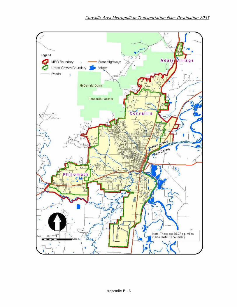
What is a Metropolitan Planning Organization? A Metropolitan Planning Organization (MPO) is an organization of local governments and state Department of Transportation in an area with a population of 50,000 or more. Such an area is referred to by the US Census Bureau as an Urbanized Area. As a condition for receiving federal transportation dollars, MPOs must have a continuing, cooperative and comprehensive transportation planning process in cooperation with the state. The MPOs are responsible for the development of transportation plans and programs for their urbanized areas. The MPOs plans and programs are developed consistent with the area's adopted comprehensive plans. What is the Corvallis Area Metropolitan Planning Organization? In 2002, the US Census Bureau declared that the population of the Corvallis Urbanized Area, consisting of the cities of Corvallis, Philomath and Adair Village, and the more densely populated portions of Benton County, had reached 58,2001. Upon surpassing the population criteria of 50,000, the area was required to form a Metropolitan Planning Organization for its transportation planning and programming activities. In December 2002, the Oregon Governor, in accordance with federal regulations [USC, Title 23], designated a coalition of local governments in the Corvallis Area as the MPO. The Corvallis Area Metropolitan Planning Organization (CAMPO) is governed by a five-member Policy Board consisting of representatives from Corvallis, Philomath, Adair Village, Benton County and the Oregon Transportation Department (ODOT). The Urbanized Area covered by CAMPO’s transportation planning and programming activities is shown in the map below. What is the Purpose of this Document? The purpose of this document is to outline the policies and procedures adopted by the Corvallis Area Metropolitan Planning Organization for involving the general public in the MPO’s transportation decision-making processes. Background Public involvement is a key component of the MPO transportation planning process. Federal and state laws require each MPO to adopt a process for involving the public in their planning and programming activities. Furthermore, the Policy Board of the CAMPO regards public involvement as an integral part of the MPO’s transportation planning and programming activities.
1 2000 US Census
Corvallis Area Metropolitan Transportation Plan: Destination 2035
Appendix B - 5
The Safe, Accountable, Flexible and Efficient Transportation Equity Act – a Legacy for Users (SAFETEA-LU) of 2005 requires each MPO to develop a unique public outreach process for its transportation planning and programming activities. The Act also requires MPOs to periodically review the effectiveness of their Public Involvement process and make revisions as necessary. Additionally, in February 1994, Executive Order 12898, commonly known as the Environmental Justice (EJ) law, focused the attention of federal agencies on the human health and environmental conditions in minority and low-income communities. Particular emphasis of this Order is placed on achieving greater public participation from minority communities and low-income communities. The principles of this Order are to: � Avoid, minimize, or mitigate disproportionately high and adverse human health and
environmental effects, including social and economic effects, on minority populations and low-income populations;
� Ensure the full and fair participation by all potentially affected communities in the transportation decision-making process, and;
� Prevent the denial of, reduction in, or significant delay in the receipt of benefits by minority and low-income populations.
In compliance with these federal requirements, in 2004 CAMPO developed and adopted policies on public involvement that were outlined in the Public Involvement Framework document. In 2010, CAMPO reviewed the effectiveness of its public involvement strategies and revised the Public Involvement Framework. This document is a revision to the CAMPO’s Public Involvement Framework that was adopted by the Policy Board in April 2004.
Corvallis Area Metropolitan Transportation Plan: Destination 2035
Appendix B - 6
Corvallis Area Metropolitan Transportation Plan: Destination 2035
Appendix B - 7
Public Involvement Framework In an effort to enhance the quality of CAMPO’s transportation planning and programming processes and to comply with federal and state requirements, the agency has developed the following public involvement goal, objectives and policies. The goal of the CAMPO’s Public Involvement Process is to gain to the maximum extent possible the active participation of all citizens and stakeholders in the MPO’s transportation planning and programming activities. Objectives The objectives of the CAMPO Public Involvement Process are to: 1. Inform the public about transportation issues under consideration by the MPO; 2. Provide opportunities to the public to get involved in all phases of transportation planning
process; 3. Coordinate the MPO’s activities with those of other public agencies and stakeholders; 4. Coordinate the MPO’s activities with transit providers within and adjacent to the MPO
Area; 5. Provide timely notice to the public on all transportation planning and programming
activities; 6. Provide for the consideration of all input received from the public; 7. Provide timely responses to comments received on the agency’s plans and programs; 8. Identify and involve traditionally underserved segments of the population, including
minorities, low-income people, people with disabilities and people with Limited English Proficiency (LEP);
9. Employ the most effective means of communications to involve the public and stakeholders in the planning process.
Public Involvement Policies CAMPO’s public involvement policies are relative to the type of its activities. For this purpose, CAMPO’s activities are divided into Routine and Major. 1. Routine Activities. These are primarily administrative tasks that are performed routinely
over the course of a year or two. Examples of these are the development of the Unified Planning Work Program (UPWP), the Self-Certification Process and the monthly meetings of the Policy Board and the Technical Advisory Committee. For these activities CAMPO will, at a minimum, conduct the following:
a) Post MPO documents on the website and make copies available to the public; b) Post meeting dates, agendas and minutes on the MPO website; c) Provide an explanation of the issues on the website; d) Invite the public to submit comments in writing, through email or by telephone; e) Provide the Policy Board a summary of comments received prior to any formal decision; f) Provide a public comment opportunity on each Policy Board agenda;
Corvallis Area Metropolitan Transportation Plan: Destination 2035
Appendix B - 8
g) Announcing the Meetings of the Policy Board in the newspaper; h) Provide additional opportunity for public review and comments when the final version of
a transportation document is significantly different from the one viewed by the public. 2. Major Activities. Major activities are transportation planning and programming efforts that
are undertaken periodically. Examples of these are the development and periodic update of the MPO’s Regional Transportation Plan and Transportation Improvement Program or the undertaking of special studies. These are performed every two to five years. For these functions, CAMPO will develop a specific public involvement program prior to the commencement of that activity. The specially tailored programs, at a minimum, will include all the elements listed above for Routine MPO Activities and will also include public informational meetings and solicitation of public comments.
Means of Public Outreach In developing special public involvement programs, CAMPO may employ a combination of the following measures: 1. Active Public Participation
a) Holding public meetings in various forms, i.e., facilitated workshops, theatre or open house;
b) Forming Ad hoc committees, task forces, focus groups, charrettes and other small group techniques;
c) Conducting public opinion surveys; d) Holding public hearings; e) Holding public comment periods; f) Developing and maintaining a special webpage with commenting facility; g) Issuing electronic newsletters.
2. Accessibility of Information
a) Making major transportation planning documents available at libraries, city halls, Benton County Public Works, and on the web
b) Making presentations on transportation planning issues to stakeholders and community groups, as appropriate
c) Providing the Policy Board with summary transcripts of public comments prior to their decisions
3. Channels of Public Notification a) Posting information and documents in CAMPO website b) Purchasing advertisements in media c) Issuing press releases, and using public service announcements d) Posting legal notices in printed media e) Sending direct mail to a list of interested individuals, stakeholders, affected businesses
and neighborhoods, and special interests groups f) Holding direct lines of communication with stakeholders
Corvallis Area Metropolitan Transportation Plan: Destination 2035
Appendix B - 9
g) Posting notices on bulletin boards in high traffic locations, including libraries, public offices, and the university campusIssuing periodic newsletter on CAMPO’s transportation planning activities
h) Using local and public access TV channels i) Consulting with appropriate advisory committees and commissions in the area j) Utilizing electronic bulletin boards or other forms of social media
Periodic Evaluation Metropolitan Transportation Planning Regulations require periodic review of the effectiveness of the MPO’s public involvement process. CAMPO will periodically review its public involvement process to ensure that all interested parties, including transportation stakeholders and traditionally underserved groups, have been provided with equal opportunities to participate in the transportation planning processes. A variety of tools may be used for this review, including, but not limited to, those listed below:
a) Use of meeting evaluation forms; b) Surveys to inquire whether citizens have heard about CAMPO’s public meetings and/or
other public involvement opportunities; c) Input from citizens through phone calls, letters and emails or comments made at public
meetings; d) Holding a public meeting on the updated document e) Consultation with the Technical Advisory Committee.
The CAMPO Policy Board will ultimately determine the need for such periodic evaluations and any modifications to this document.
Corvallis Area Metropolitan Transportation Plan: Destination 2035
Appendix B - 10
Public Outreach Efforts for the Updating of this Document
Federal transportation planning regulations require MPOs to make their Public Involvement Plan available for public review and comment at least 45 days before its final adoption or revision. To maximize public input to the development of this document, CAMPO took the following measures: 1. Electronic and printed copies of the draft document were made available for public review
and comments. A copy of the document was posted at the CAMPO’s Website: www.corvallisareampo.org
2. The availability of the draft document for public review and comment was advertised in the
Corvallis Gazette Times on June 28, 2010. ; 3. A public comment period was held from June 30, through August 20, 2010 to satisfy the 45
day public comment requirement. 4. A public information meeting was held from 5:00 to 7:00 PM on June 30, 2010 at the Board
Room in Benton Plaza, 408 SW Monroe, Corvallis, OR 97333.
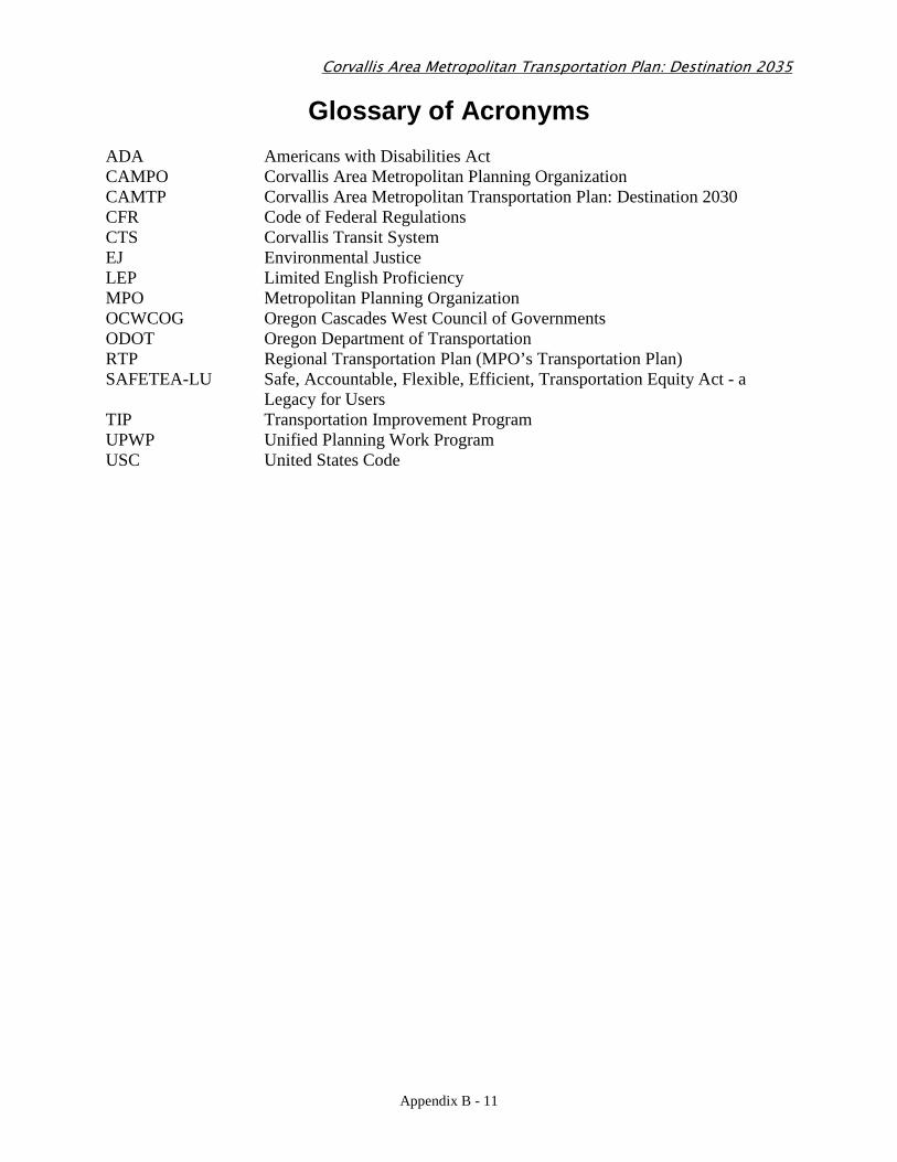
Corvallis Area Metropolitan Transportation Plan: Destination 2035
Appendix B - 11
Glossary of Acronyms ADA Americans with Disabilities Act CAMPO Corvallis Area Metropolitan Planning Organization CAMTP Corvallis Area Metropolitan Transportation Plan: Destination 2030 CFR Code of Federal Regulations CTS Corvallis Transit System EJ Environmental Justice LEP Limited English Proficiency MPO Metropolitan Planning Organization OCWCOG Oregon Cascades West Council of Governments ODOT Oregon Department of Transportation RTP Regional Transportation Plan (MPO’s Transportation Plan) SAFETEA-LU Safe, Accountable, Flexible, Efficient, Transportation Equity Act - a
Legacy for Users TIP Transportation Improvement Program UPWP Unified Planning Work Program USC United States Code
Appendix C - 1
Appendix C:
Public Involvement Plan
Corvallis Area Metropolitan Transportation Plan: Destination 2035
Appendix C - 2
Public Involvement Plan
For the Corvallis Area Metropolitan Transportation Plan
Destination 2035 Update
Corvallis Area Metropolitan Planning Organization
Approved by the Policy Board September 17, 2010
Corvallis Area Metropolitan Transportation Plan: Destination 2035
Appendix C - 3
Introduction
In April 2004 the Policy Board of the Corvallis Area Metropolitan Planning Organization (CAMPO) adopted a Public Involvement Framework for CAMPO’s transportation planning and programming activities. The Framework outlines public outreach activities of CAMPO by identifying two types of activities performed by the organization, routine and major. Routine activities are generally publicized in the CAMPO website and in the FYI Section of the Corvallis Gazette Times, while major activities require development of a specially tailored public involvement plan that is approved by the CAMPO Policy Board. Metropolitan Transportation Planning Process regulations require Metropolitan Planning Organizations (MPOs) to update their long range transportation plan every five years2. The Corvallis Area Metropolitan Transportation Plan was adopted in August 2006 by the CAMPO Policy Board and must be updated by August 2011. The Corvallis Area Metropolitan Transportation Plan: Destination 2035 Update is a major activity that requires development of a specially tailored public involvement plan. This document outlines the public outreach efforts made during the development of the Corvallis Area Metropolitan Transportation Plan: Destination 2035 Update. CAMPO’s Public Involvement Framework was updated in September 2010 and this document was adopted by the CAMPO Policy Board on X, 2010. The Corvallis Area Metropolitan Planning Organization A Metropolitan Planning Organization (MPO) is an organization of local governments in areas with a collective population of 50,000 or over, called Urbanized Area. As a condition for receiving federal transportation dollars, MPOs must have a continuing, cooperative and comprehensive transportation planning process in cooperation with the state. In 2002, the US Bureau of Census declared that the population of the Corvallis Urbanized Area, according to the 2000 Census, had reached 58,000+. The Corvallis Urbanized Area consists of the cities of Corvallis, Philomath and Adair Village, as well as the densely habited portions of Benton County (See the Map below). As a result of surpassing the population criterion of 50,000, the area became eligible to form a Metropolitan Planning Organization for its transportation planning and programming activities. In December 2002 the Oregon Governor, in accordance with federal regulations, designated the Corvallis Area Metropolitan Planning Organization (CAMPO) as a newly formed MPO in the State of Oregon. CAMPO is governed by a five-member Policy Board consisting of representatives of the cities of Corvallis, Philomath and Adair Village, the County of Benton and the Oregon Transportation Department (ODOT).
2 MPOs in the areas designated by the US EPA as Nonattainment Area must update their Transportation Plans every 4 years.
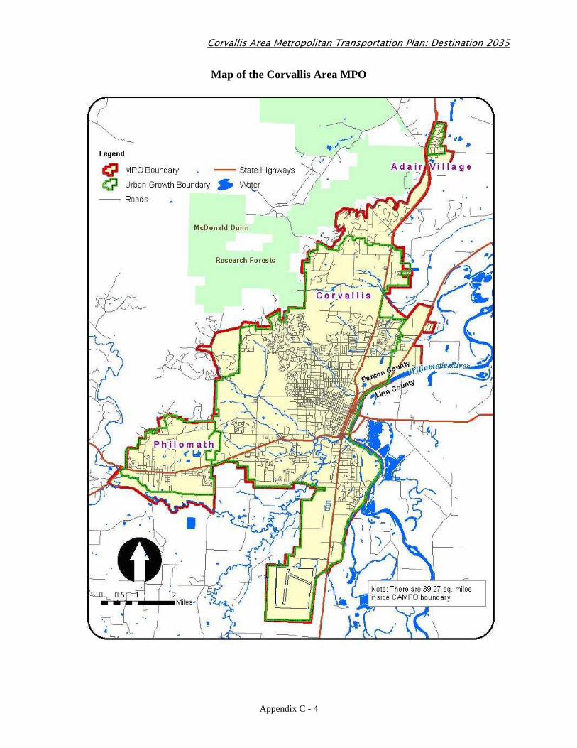
Corvallis Area Metropolitan Transportation Plan: Destination 2035
Appendix C - 4
Map of the Corvallis Area MPO
Corvallis Area Metropolitan Transportation Plan: Destination 2035
Appendix C - 5
Public Involvement Plan
The Public Involvement Plan describes CAMPO’s outreach efforts to engage the public and gain their feedback into the development of the Transportation Plan Update. The document outlines the means of disseminating information to the public and the conduits for receiving public input and incorporating the input into the Transportation Plan Update. The outreach process is composed of four distinctive communication tracks:
1. The general public – exchange of information with residents of the Planning Area and the adjacent areas affected by the Plan Update;
2. Ad hoc Committee – an ad hoc committee made up of members of the existing transportation-related committees in Benton County and a representative of the Albany area (Appendix A);
3. CAMPO’s Technical Advisory Committee (TAC)- TAC is made up of professional staffs of the jurisdictions in the planning area and a representative of the Albany Transit System;
4. CAMPO’s Policy Board- the Policy Board is made up of representatives of the local governments and ODOT.
The Public Involvement Plan includes two types of outreach activities, Continuous and Episodic. A. Continuous Outreach Continuous outreach efforts are made throughout the development process of the Plan Update to provide review and commenting opportunities for the general public and the various committees involved. This will include:
i. Posting meeting dates, agendas and minutes on the MPO website;
ii. Posting MPO documents on the website and making printed copies available to the public;
iii. Providing an explanation of the issues pertaining the development of the Plan Update on the website;
iv. Inviting the public to submit electronic, written or telephonic comments;
v. Including a public comment item on every Policy Board agenda to provide the public with opportunity of speaking to the Policy Board.
B. Episodic Outreach In addition to the above, at a minimum the following episodic outreach will be conducted during the development process of the Plan Update:
1. The Kickoff Meeting 2. Midcourse Public Meeting
Corvallis Area Metropolitan Transportation Plan: Destination 2035
Appendix C - 6
3. Draft Plan Review Meeting 4. Public Hearing
1. Kickoff Meeting
The purpose of the Kickoff Meeting is to:
a. Provide background on CAMPO and the Regional Transportation Plan;
b. Describe the updating process, schedule and the public involvement opportunities for the development of the Plan Update, and;
c. Seek preliminary input on the updating process. The following means of public outreach will be utilized:
a. Issuance of a press release to the local media;
b. Purchase of advertisements in local newspaper;
c. Request for public service announcements;
d. Sending emails to a list of interested individuals, city councils, County Board of Commission, transportation related committees, chamber of commerce, etc
e. Holding a meeting of the Ad hoc Committee.
2. Midcourse Public Meeting The Midcourse meeting is to communicate with the public the benchmark progress of the Plan Update. This meeting will focus on reviewing the results of the travel demand forecast model and the projects selected for inclusion in the Plan Update. This public forum will be held in the following manner:
a. The meeting will be advertised in the newspaper;
b. The material produced will be made available at least ten days prior to the meeting;
c. The TAC and the Policy Board will review the material prior to release and will be invited to attend the meeting;
d. Staff will provide a summary explanation of the material produced to the public;
e. Staff will seek input from the public on the material produced;
f. Staff will compile the input received for review by the Ad hoc Committee, TAC and the Policy Board.
3. Draft Plan Review Meeting
At this public meeting a draft of the Plan Update will be presented to the public for review and comment.
a. Notices of the meeting will be advertised in the media and CAMPO’s website.
b. The Draft Transportation Plan Update will be made available to the general public at least two weeks prior to the meeting.
Corvallis Area Metropolitan Transportation Plan: Destination 2035
Appendix C - 7
c. The Ad hoc Committee, TAC and the Policy Board will be invited to attend the meeting.
d. Staff will provide a summary explanation of the draft Transportation Plan and its key recommendations.
e. Visual aids will be utilized to communicate the draft transportation plan
f. All comments received will be compiled and prepared for review by the Ad hoc Committee, TAC and the Policy Board.
4. Public Hearing
Although not required by law, the final meeting on the Plan Update will be a Public Hearing at which the public and the stakeholders can provide comments and testimonies to the Policy Board. The Policy Board may choose to deliberate the approval of the Plan at the end of the Public Hearing or postpone the decision to a future meeting.
a. The Public Hearing will be advertised in the newspaper;
b. The Transportation Plan Update will be made available at least two weeks prior to the Public Hearing;
c. Staff will provide a summary explanation of the development process of the Plan Update and its recommendations;
d. The Policy Board will receive testimonies. C. Role of the Ad Hoc Committee The Ad hoc Committee will serve as a consultation entity to the development of process of the Plan update. The Committee will meet at least three times during this process to provide feedback into the process. The meetings will be scheduled after each public meeting. The committee’s feedback will be communicated with the TAC and the Policy Board. D. Approval Process The CAMPO’s Policy Board is the ultimate decision making entity for the approval of the Corvallis Area Metropolitan Transportation Plan Update. The input provided by the public will be funneled into the Ad hoc Committee, the TAC and the Policy Board. Comments provided by the Ad hoc Committee will be presented to the TAC and the Policy Board. TAC’s technical input will be discussed with the Ad Hoc Committee and the Policy Board. The MPO staff will produce technical material for review by the consulting bodies and the Policy Board. The Policy Board relies on the expertise of their professional planning staffs that form the TAC. The TAC is a hands-on group with technical expertise in transportation and land use planning fields. The TAC meets monthly to review the technical material and formulate recommendations to the Policy Board. The Policy Board will review material recommended by the TAC and may approve or provide directives for further modifications. All meetings are open to the public and to the members of the committees.
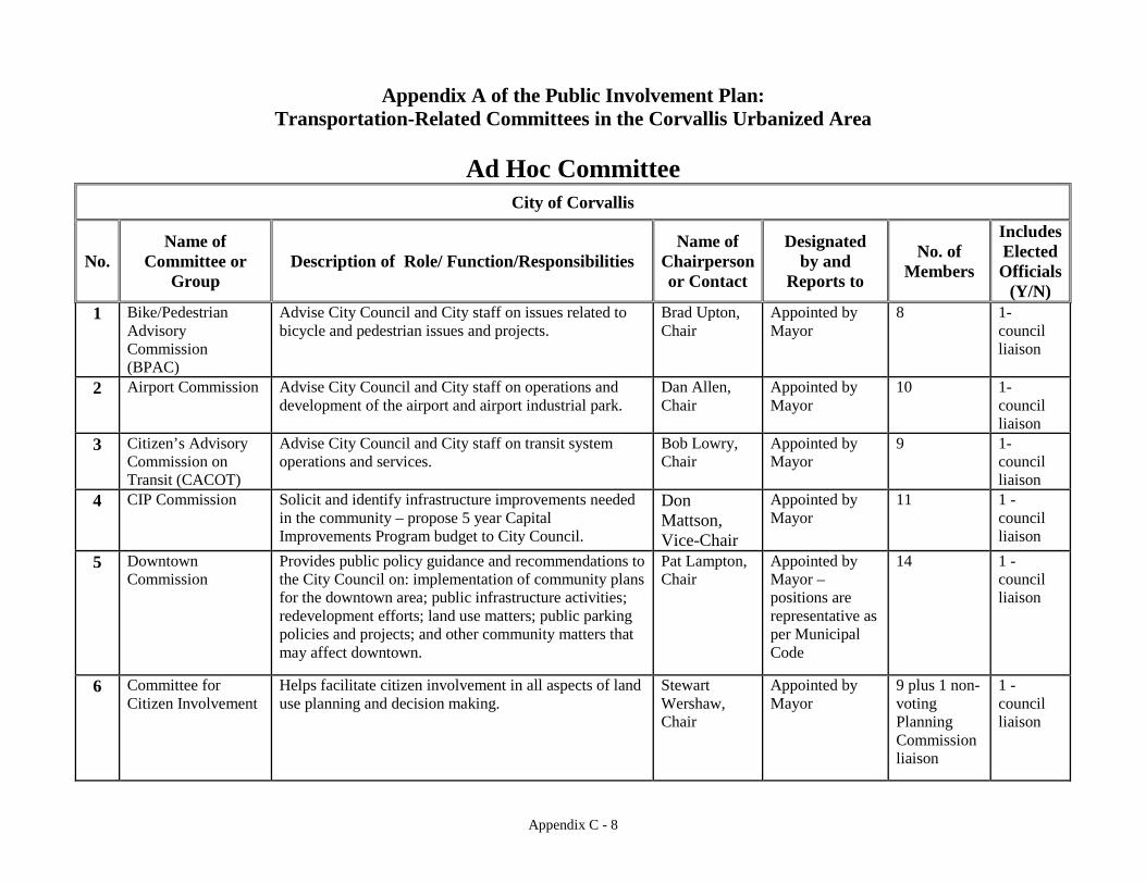
Appendix C - 8
Appendix A of the Public Involvement Plan: Transportation-Related Committees in the Corvallis Urbanized Area
Ad Hoc Committee
City of Corvallis
No. Name of
Committee or Group
Description of Role/ Function/Responsibilities Name of
Chairperson or Contact
Designated by and
Reports to
No. of Members
Includes Elected Officials
(Y/N) 1 Bike/Pedestrian
Advisory Commission (BPAC)
Advise City Council and City staff on issues related to bicycle and pedestrian issues and projects.
Brad Upton, Chair
Appointed by Mayor
8 1- council liaison
2 Airport Commission Advise City Council and City staff on operations and development of the airport and airport industrial park.
Dan Allen, Chair
Appointed by Mayor
10 1- council liaison
3 Citizen’s Advisory Commission on Transit (CACOT)
Advise City Council and City staff on transit system operations and services.
Bob Lowry, Chair
Appointed by Mayor
9 1- council liaison
4 CIP Commission Solicit and identify infrastructure improvements needed in the community – propose 5 year Capital Improvements Program budget to City Council.
Don Mattson, Vice-Chair
Appointed by Mayor
11 1 - council liaison
5 Downtown Commission
Provides public policy guidance and recommendations to the City Council on: implementation of community plans for the downtown area; public infrastructure activities; redevelopment efforts; land use matters; public parking policies and projects; and other community matters that may affect downtown.
Pat Lampton, Chair
Appointed by Mayor – positions are representative as per Municipal Code
14 1 - council liaison
6 Committee for Citizen Involvement
Helps facilitate citizen involvement in all aspects of land use planning and decision making.
Stewart Wershaw, Chair
Appointed by Mayor
9 plus 1 non-voting Planning Commission liaison
1 - council liaison
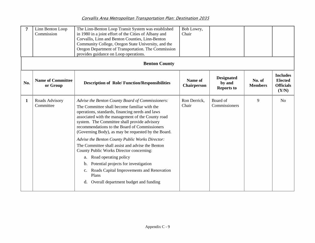
Corvallis Area Metropolitan Transportation Plan: Destination 2035
Appendix C - 9
7 Linn Benton Loop Commission
The Linn-Benton Loop Transit System was established in 1980 in a joint effort of the Cities of Albany and Corvallis, Linn and Benton Counties, Linn-Benton Community College, Oregon State University, and the Oregon Department of Transportation. The Commission provides guidance on Loop operations.
Bob Lowry, Chair
Benton County
No. Name of Committee or Group Description of Role/ Function/Responsibilities Name of
Chairperson
Designated by and
Reports to
No. of Members
Includes Elected Officials
(Y/N)
1 Roads Advisory Committee
Advise the Benton County Board of Commissioners: The Committee shall become familiar with the operations, standards, financing needs and laws associated with the management of the County road system. The Committee shall provide advisory recommendations to the Board of Commissioners (Governing Body), as may be requested by the Board.
Advise the Benton County Public Works Director: The Committee shall assist and advise the Benton County Public Works Director concerning:
a. Road operating policy b. Potential projects for investigation c. Roads Capital Improvements and Renovation
Plans d. Overall department budget and funding
Ron Derrick, Chair
Board of Commissioners
9 No
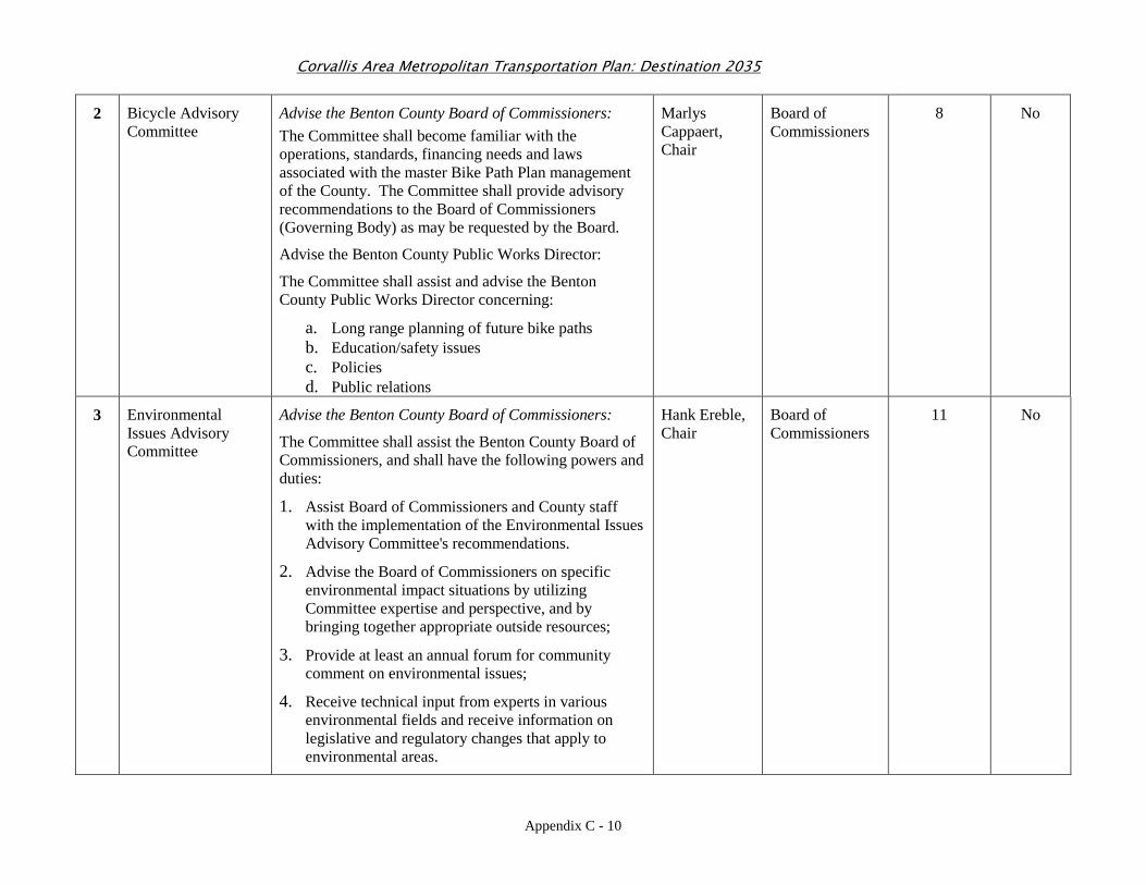
Corvallis Area Metropolitan Transportation Plan: Destination 2035
Appendix C - 10
2 Bicycle Advisory Committee
Advise the Benton County Board of Commissioners: The Committee shall become familiar with the operations, standards, financing needs and laws associated with the master Bike Path Plan management of the County. The Committee shall provide advisory recommendations to the Board of Commissioners (Governing Body) as may be requested by the Board.
Advise the Benton County Public Works Director:
The Committee shall assist and advise the Benton County Public Works Director concerning:
a. Long range planning of future bike paths b. Education/safety issues c. Policies d. Public relations
Marlys Cappaert, Chair
Board of Commissioners
8 No
3 Environmental Issues Advisory Committee
Advise the Benton County Board of Commissioners:
The Committee shall assist the Benton County Board of Commissioners, and shall have the following powers and duties:
1. Assist Board of Commissioners and County staff with the implementation of the Environmental Issues Advisory Committee's recommendations.
2. Advise the Board of Commissioners on specific environmental impact situations by utilizing Committee expertise and perspective, and by bringing together appropriate outside resources;
3. Provide at least an annual forum for community comment on environmental issues;
4. Receive technical input from experts in various environmental fields and receive information on legislative and regulatory changes that apply to environmental areas.
Hank Ereble, Chair
Board of Commissioners
11 No
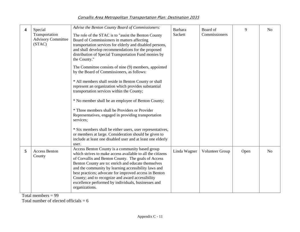
Corvallis Area Metropolitan Transportation Plan: Destination 2035
Appendix C - 11
4 Special Transportation Advisory Committee (STAC)
Advise the Benton County Board of Commissioners:
The role of the STAC is to "assist the Benton County Board of Commissioners in matters affecting transportation services for elderly and disabled persons, and shall develop recommendations for the proposed distribution of Special Transportation Fund monies by the County."
The Committee consists of nine (9) members, appointed by the Board of Commissioners, as follows: * All members shall reside in Benton County or shall represent an organization which provides substantial transportation services within the County; * No member shall be an employee of Benton County; * Three members shall be Providers or Provider Representatives, engaged in providing transportation services; * Six members shall be either users, user representatives, or members at large. Consideration should be given to include at least one disabled user and at least one elderly user.
Barbara Sackett
Board of Commissioners
9 No
5 Access Benton County
Access Benton County is a community based group which strives to make access available to all the citizens of Corvallis and Benton County. The goals of Access Benton County are to: enrich and educate themselves and the community by learning accessibility laws and best practices; advocate for improved access in Benton County; and to recognize and award accessibility excellence performed by individuals, businesses and organizations.
Linda Wagner Volunteer Group Open No
Total members = 99 Total number of elected officials = 6
Appendix D - 1
Appendix D:
Modeling Results of Recommended Projects
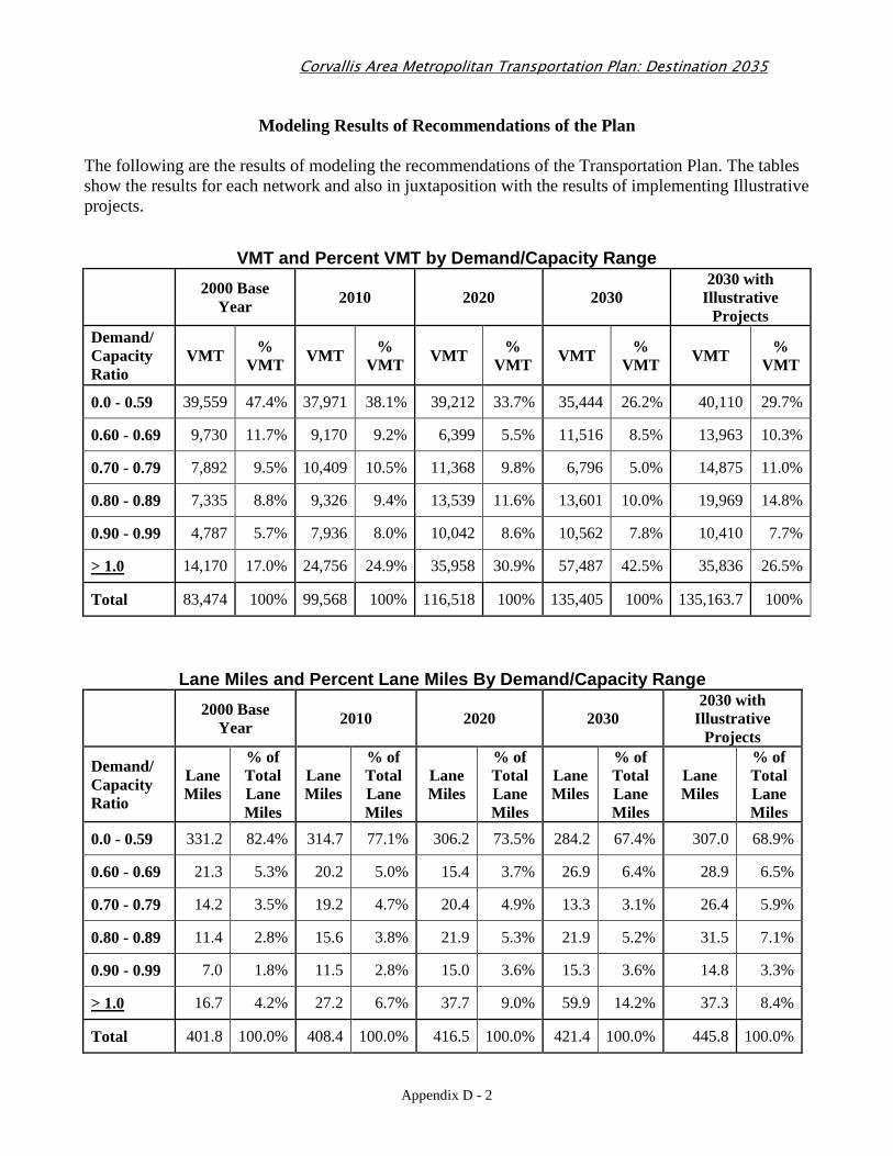
Corvallis Area Metropolitan Transportation Plan: Destination 2035
Appendix D - 2
Modeling Results of Recommendations of the Plan The following are the results of modeling the recommendations of the Transportation Plan. The tables show the results for each network and also in juxtaposition with the results of implementing Illustrative projects.
VMT and Percent VMT by Demand/Capacity Range
2000 Base Year 2010 2020 2030
2030 with Illustrative
Projects Demand/ Capacity Ratio
VMT % VMT VMT %
VMT VMT % VMT VMT %
VMT VMT % VMT
0.0 - 0.59 39,559 47.4% 37,971 38.1% 39,212 33.7% 35,444 26.2% 40,110 29.7%
0.60 - 0.69 9,730 11.7% 9,170 9.2% 6,399 5.5% 11,516 8.5% 13,963 10.3%
0.70 - 0.79 7,892 9.5% 10,409 10.5% 11,368 9.8% 6,796 5.0% 14,875 11.0%
0.80 - 0.89 7,335 8.8% 9,326 9.4% 13,539 11.6% 13,601 10.0% 19,969 14.8%
0.90 - 0.99 4,787 5.7% 7,936 8.0% 10,042 8.6% 10,562 7.8% 10,410 7.7%
> 1.0 14,170 17.0% 24,756 24.9% 35,958 30.9% 57,487 42.5% 35,836 26.5%
Total 83,474 100% 99,568 100% 116,518 100% 135,405 100% 135,163.7 100%
Lane Miles and Percent Lane Miles By Demand/Capacit y Range
2000 Base Year 2010 2020 2030
2030 with Illustrative
Projects
Demand/ Capacity Ratio
Lane Miles
% of Total Lane Miles
Lane Miles
% of Total Lane Miles
Lane Miles
% of Total Lane Miles
Lane Miles
% of Total Lane Miles
Lane Miles
% of Total Lane Miles
0.0 - 0.59 331.2 82.4% 314.7 77.1% 306.2 73.5% 284.2 67.4% 307.0 68.9%
0.60 - 0.69 21.3 5.3% 20.2 5.0% 15.4 3.7% 26.9 6.4% 28.9 6.5%
0.70 - 0.79 14.2 3.5% 19.2 4.7% 20.4 4.9% 13.3 3.1% 26.4 5.9%
0.80 - 0.89 11.4 2.8% 15.6 3.8% 21.9 5.3% 21.9 5.2% 31.5 7.1%
0.90 - 0.99 7.0 1.8% 11.5 2.8% 15.0 3.6% 15.3 3.6% 14.8 3.3%
> 1.0 16.7 4.2% 27.2 6.7% 37.7 9.0% 59.9 14.2% 37.3 8.4%
Total 401.8 100.0% 408.4 100.0% 416.5 100.0% 421.4 100.0% 445.8 100.0%
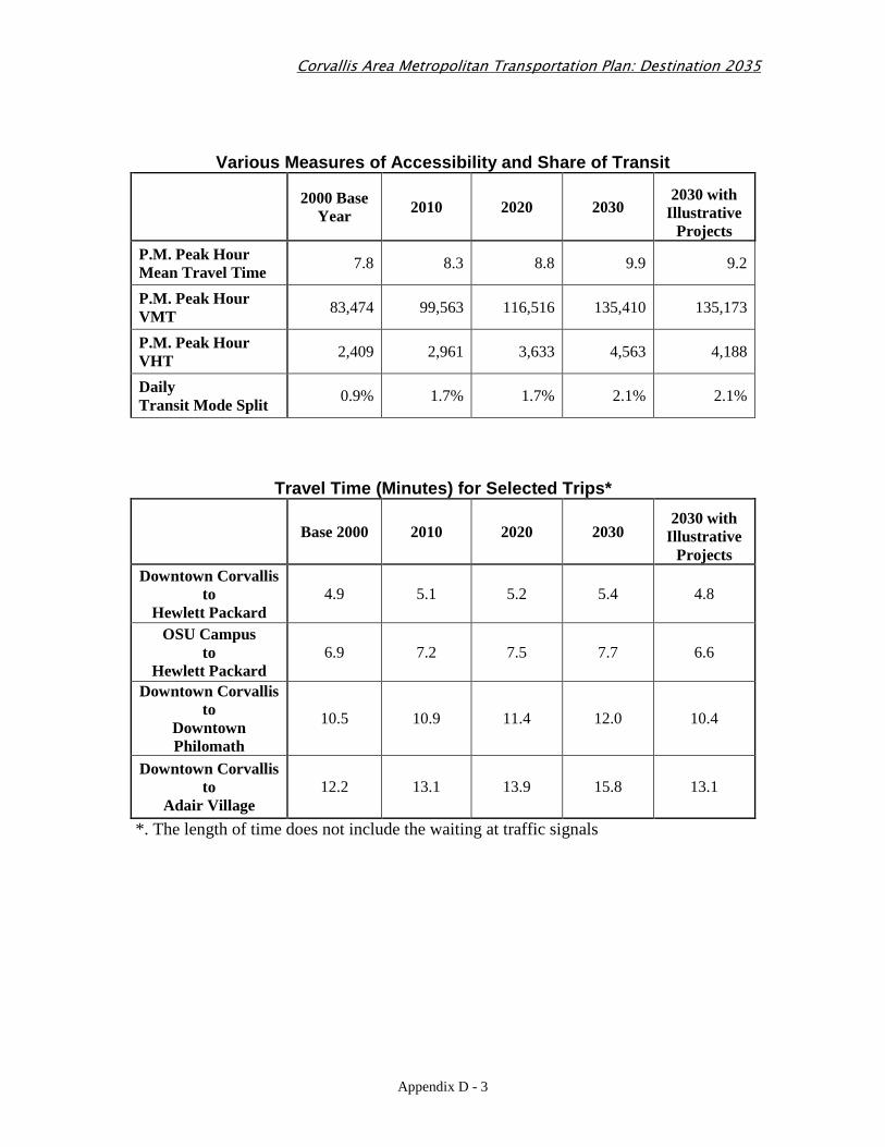
Corvallis Area Metropolitan Transportation Plan: Destination 2035
Appendix D - 3
Various Measures of Accessibility and Share of Tran sit
2000 Base Year 2010 2020 2030
2030 with Illustrative
Projects P.M. Peak Hour Mean Travel Time 7.8 8.3 8.8 9.9 9.2
P.M. Peak Hour VMT 83,474 99,563 116,516 135,410 135,173
P.M. Peak Hour VHT 2,409 2,961 3,633 4,563 4,188
Daily Transit Mode Split 0.9% 1.7% 1.7% 2.1% 2.1%
Travel Time (Minutes) for Selected Trips*
Base 2000 2010 2020 2030
2030 with Illustrative
Projects Downtown Corvallis
to Hewlett Packard
4.9 5.1 5.2 5.4 4.8
OSU Campus to
Hewlett Packard 6.9 7.2 7.5 7.7 6.6
Downtown Corvallis to
Downtown Philomath
10.5 10.9 11.4 12.0 10.4
Downtown Corvallis to
Adair Village 12.2 13.1 13.9 15.8 13.1
*. The length of time does not include the waiting at traffic signals
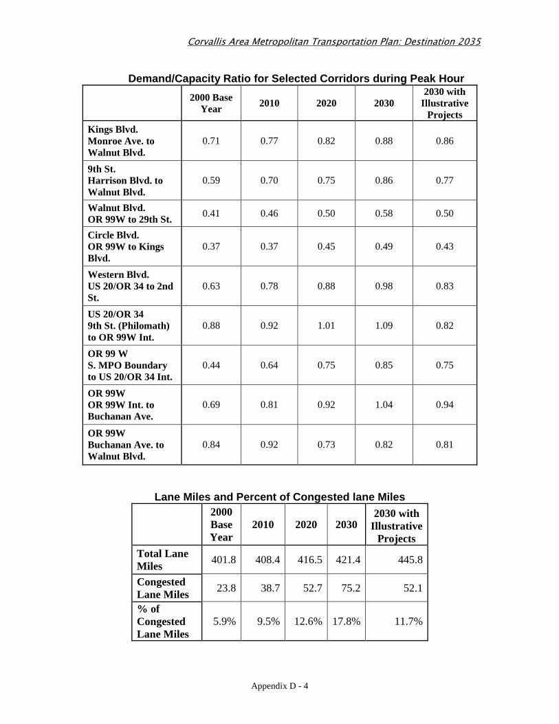
Corvallis Area Metropolitan Transportation Plan: Destination 2035
Appendix D - 4
Demand/Capacity Ratio for Selected Corridors during Peak Hour
2000 Base Year 2010 2020 2030
2030 with Illustrative
Projects Kings Blvd. Monroe Ave. to Walnut Blvd.
0.71 0.77 0.82 0.88 0.86
9th St. Harrison Blvd. to Walnut Blvd.
0.59 0.70 0.75 0.86 0.77
Walnut Blvd. OR 99W to 29th St. 0.41 0.46 0.50 0.58 0.50
Circle Blvd. OR 99W to Kings Blvd.
0.37 0.37 0.45 0.49 0.43
Western Blvd. US 20/OR 34 to 2nd St.
0.63 0.78 0.88 0.98 0.83
US 20/OR 34 9th St. (Philomath) to OR 99W Int.
0.88 0.92 1.01 1.09 0.82
OR 99 W S. MPO Boundary to US 20/OR 34 Int.
0.44 0.64 0.75 0.85 0.75
OR 99W OR 99W Int. to Buchanan Ave.
0.69 0.81 0.92 1.04 0.94
OR 99W Buchanan Ave. to Walnut Blvd.
0.84 0.92 0.73 0.82 0.81
Lane Miles and Percent of Congested lane Miles
2000 Base Year
2010 2020 2030 2030 with
Illustrative Projects
Total Lane Miles
401.8 408.4 416.5 421.4 445.8
Congested Lane Miles
23.8 38.7 52.7 75.2 52.1
% of Congested Lane Miles
5.9% 9.5% 12.6% 17.8% 11.7%