council resolution - appendix
TRANSCRIPT

Grayslake’s Vision
for a Low Profile
Route 53/120
March 2012
Grayslake’s Vision for a Low Profile Route 53/120 – Page 1
Grayslake’s Vision for a Low Profile Route 53/120
March, 2012
The Illinois Route 53/120 Blue Ribbon Advisory Council was formed in 2011 to identify consensus
and develop a framework of principles to guide the future study and design of the corridor. Since a
significant portion of the proposed Route 53/120 project – including a potential Route 53/120
interchange – will be located within Grayslake, the Village is taking a proactive position advising the
Council. Grayslake believes that any Route 53/120 design should fit within the character of the
Village and Central Lake County.
This visioning document is a follow up to a letter dated December 7th, 2011 summarizing our
design parameters. We have partnered with the firm HDR Engineering to help us identify best
management practices (BMPs) and incorporate these BMPs into our design parameters. The
Village requests that these design parameters be incorporated into any report or recommendation
from the Blue Ribbon Council to the Illinois Tollway.
The construction of Route 53/120 will have an impact on the Village of Grayslake – the Village
wants this impact to be positive. To maintain a positive impact, the Village reviewed numerous
design concepts and roadway design/construction BMPs used throughout the county, and is
recommending several to the Council.
The Village’s Route 53/120 design parameters fall under six (6) broad categories:
Low Impact Design to Reduce Adverse Impacts
Aesthetics
Community Connectivity – Vehicles
Community Connectivity – Bicycles
Mass Transit
Best Management Practices and Environmental Design Standards
o Best Management Practices for Design
o Best Management Practices for Storm Water Control
o Best Management Practices for Construction and Maintenance
o Awards
Low Impact Design to Reduce Adverse Impacts
The design parameters envisioned by the Village will result in a low impact design to our community
and Central Lake County. These parameters include the development of a low profile roadway,
minimizing the footprint of the roadway, eliminating roadway noise and lighting impacts, and
minimizing the impacts to wetlands and open space.

Grayslake’s Vision for a Low Profile Route 53/120 – Page 2
Low Roadway Profile
The Village desires that the Route 53/120 corridor be constructed below grade. A low roadway
profile design concept offers numerous environmental and operational benefits over an elevated
roadway, as originally proposed by IDOT, or an at-grade roadway which requires significant profile
adjustments to the local street system. A low roadway profile would greatly reduce adverse noise
and visual impacts and would not form a barrier through the Village.
The Village understands that a low roadway profile can require significant amounts of earth
relocation and can complicate roadway drainage. These challenges do not outweigh the vast
benefits. The Village offers a design concept that minimizes earth relocation, by using the excavated
earth to form berms aligning the corridor. An earth balance is achieved when earth removed from
cut sections equals the earth required in fill sections. The potential Route 53/120 interchange offers
ample opportunities to create berms and achieve an earth balance.
These berms serve multiple purposes; they will cut-off or impede noise and roadway lighting from
leaving the corridor and can be used to direct run-off from adjacent properties to its natural outfall.
Once natural outfalls are maintained, only the storm water that falls within the footprint of the
corridor would need to be mitigated. At natural low points and outfalls along the corridor storm
water will return to its natural course. As discussed in more detail under the Best Management
Practices section of the report, the low roadway profile design should make extensive use of
bioswales and natural infiltration to minimize and improve storm water that leaves the corridor.
Minimize Footprint
Available land is a precious commodity in Lake County. Land that is used to construct the roadway,
the interchanges, and to accommodate storm water, cannot be used to accommodate businesses or
to preserve open space. A portion of the corridor passes through areas identified in the Village of
Grayslake’s Comprehensive Plan as Planned Office/Industrial Development. The Village seeks to
minimize the area utilized for this project by constructing the roadway with a minimal footprint.
Minimizing the footprint can be accomplished through the use of temporary easements, grading
easements, or retaining walls. Temporary or grading easements include areas where the leveling of
the earth is required to construct the roadway, but the land remains sole property of the owner.
Maintaining maximum ownership of a property is important to owners because the type of
development that can be placed on a site is dependent on the size of the parcel. Minimizing the
footprint also will permit expanding or preserving open lands adjacent to the corridor. This open
land can be maintained for wetland restoration, landscaping, or open space. Grading easements can
be used to build berms to naturally screen the roadway. Where easements are not feasible, retaining
walls can be used to retain earth vertically as opposed to using an embankment or slope. The
Village understands that the use of retaining walls can reduce the natural landscape that is also
desired, thus retaining walls should only be used where the value of the land outweighs the
development of the natural landscape.

Grayslake’s Vision for a Low Profile Route 53/120 – Page 3
Potential roadway cross section is illustrated below
Figure 1 – Cross Sections for Consideration
Grayslake’s Vision for a Low Profile Route 53/120 – Page 4
Minimize Noise
Roadways generate a significant amount of noise through engine noise, tire friction noise, and
aerodynamic noise having significant adverse impact on a community. The Village of Grayslake
desires to maintain noise levels at or below the existing level of 64 DBA. Utilizing design features
that minimize noise include the choice of pavement and omitting shoulder rumple strips in the
design. Toll plaza placement (if required) would generate a
significant amount of noise from breaking and acceleration, thus
should be placed away from residential or other sensitive areas.
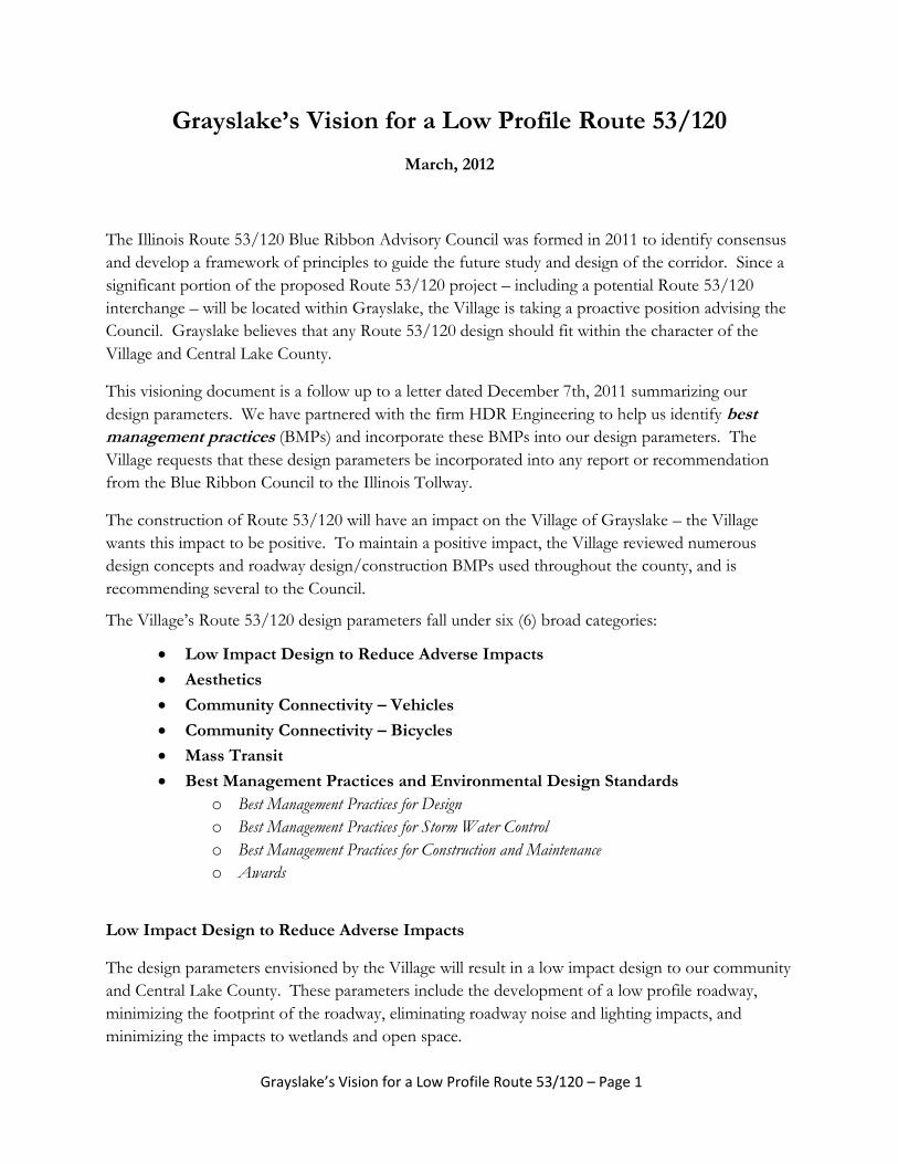
Where noise will be generated, the Village desires mitigation
measures to be implemented in the following order;
Lower roadway profile
Install natural barriers/berms
Install decorative sound walls
Sound walls, where installed, should be decorative and blend into
the Village’s unique natural landscape.
Minimize Light Pollution
Adding roadway lighting is a proven technique to improve safety – thus lighting is continually being
installed along roadways. Unfortunately roadway lighting is often installed at levels in excess of what
is required to achieve safe conditions. Lighting can have an adverse impact on the areas adjacent to
a roadway due to light trespass (light entering adjacent property), light glow blocking visibility of the
night sky, or glare. Unwanted lighting can impede sleep cycles and impede visibility. In addition to
the nuisance of excessive lighting to people, nocturnal wildlife is also adversely impacted.
Safely reducing roadway lighting levels has received increased attention over the last decade to
minimize the adverse impacts of over-illumination. Current research is now showing that existing
lighting guidelines for limited access roads is excessive and may not be as great of a safety benefit as
once thought. Improvements to vehicle headlights and sign/pavement marking retro-reflectivity
have reduced the need for overhead lighting. The Center for Environmental Excellence by
AASHTO maintains a database of research on numerous environmental factors including roadway
lighting. Illumination standards are continuously being refined to best identify the level of lighting
required to maintain safe roadway conditions and minimize adverse impacts.
The Village believes that the entire Route 53/120 corridor does not need to be artificially
illuminated. The lighting design should seek to reduce overhead lighting to the greatest extent
possible using the latest research and BMPs. At locations where lighting is installed, it should be
below grade or directed downward toward the pavement through the use of full-cut off fixtures.
Light sources should be shielded from adjacent lands through the use of a low roadway profile and
installing natural landscaping. Natural landscaping should be able to screen the light source year-
round.
Figure 2 – Decorative Sound Wall

Grayslake’s Vision for a Low Profile Route 53/120 – Page 5
Signage is required to provide guidance and directional information to motorists. Recent changes to
the Manual on Uniform Traffic Control Devices (MUTCD) have increased font sizes thus increasing
the size of sign panels. While the Village is supportive of these changes, the design should consider
the adverse impact that these signs have on the environment. The area around each sign should be
landscaped such that only the motorists have visibility of the sign. Well placed retro-reflective signs
should not require illumination, however where sign lighting is required the Village desires
downward facing lighting to minimize the light halo.
Wetlands
Much of the Route 53/120 corridor is
in or adjacent to environmentally
sensitive wetlands and portions of the
proposed Route 53/120 Interchange are
within the 50-year or 100-year flood
plain. The design of this corridor must
protect these lands. The use of BMPs
will greatly improve the quality of the
rainwater discharged into the local
streams. BMPs include:
Low Road Profile
Storm water cleansing through
the use of bio-swales in the
median and roadside
Operations (reduced salt usage)
In-Pavement Lighting
As an innovative design consideration the Village of Grayslake suggests the installation of
in-pavement lighting to illuminate the lane lines and using highly retro-reflective pavement
markings to drastically reduce or eliminate the need for overhead lighting.
Figure 3 – In-pavement Lighting
Figure 4 – Wetland Restoration Area

Grayslake’s Vision for a Low Profile Route 53/120 – Page 6
Aesthetics
Central Lake County is a naturally beautiful place with
wooded areas, large prairies, and wetlands. The Village
believes that the proposed roadway should not impose
on the environment; rather the environment should be
enhanced by the road. Corridor beauty can be achieved
by bringing the environment into the design of the
roadway through the use of a low profile, use of Village
landscaping guidelines, and including bioswales where
feasible. Plantings should provide variety and add year-
round beauty to the corridor.
The required roadway and structural elements should match the character of Grayslake. The Village
envisions the bridges through Grayslake matching the architectural style of the Village’s way finding
signage. The name of the cross street should be visible to motorists by etching it in the concrete
façade of the bridge or internally illumined sign. The rendering of the bridge below illustrates the
architectural style of the Village.
Figure 5 – Bridge Rendering Matching Grayslake’s Architectural Style
Along the bicycle/pedestrian trails adjacent to the corridor, trail maps and directional signage should
be incorporated into the design to provide direction to downtown Grayslake, train stations,
recreational areas, and wetland preserves.
Landscaping
Landscaping is a prime means to provide and maintain a signature appearance to the Village and the
Central Lake County region. The Village suggests developing landscape design guidelines as part of
any proposed corridor design. We envision a design that emphasizes the distinctive natural
environment of prairie, wetlands and fields that form natural lines that become the preferred
landscape.
Do not impose the road
upon the environment;
rather enhance the
environment with the road.
Grayslake’s Vision for a Low Profile Route 53/120 – Page 7
Figure 7 – Folded Diamond/ Pareclo Interchange
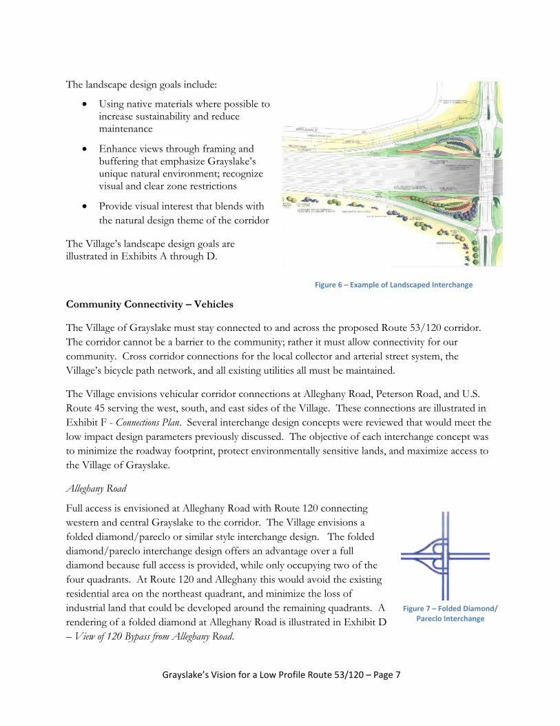
The landscape design goals include:
Using native materials where possible to increase sustainability and reduce maintenance
Enhance views through framing and buffering that emphasize Grayslake’s unique natural environment; recognize visual and clear zone restrictions
Provide visual interest that blends with
the natural design theme of the corridor
The Village’s landscape design goals are illustrated in Exhibits A through D.
Community Connectivity – Vehicles
The Village of Grayslake must stay connected to and across the proposed Route 53/120 corridor.
The corridor cannot be a barrier to the community; rather it must allow connectivity for our
community. Cross corridor connections for the local collector and arterial street system, the
Village’s bicycle path network, and all existing utilities all must be maintained.
The Village envisions vehicular corridor connections at Alleghany Road, Peterson Road, and U.S.
Route 45 serving the west, south, and east sides of the Village. These connections are illustrated in
Exhibit F - Connections Plan. Several interchange design concepts were reviewed that would meet the
low impact design parameters previously discussed. The objective of each interchange concept was
to minimize the roadway footprint, protect environmentally sensitive lands, and maximize access to
the Village of Grayslake.
Alleghany Road
Full access is envisioned at Alleghany Road with Route 120 connecting
western and central Grayslake to the corridor. The Village envisions a
folded diamond/pareclo or similar style interchange design. The folded
diamond/pareclo interchange design offers an advantage over a full
diamond because full access is provided, while only occupying two of the
four quadrants. At Route 120 and Alleghany this would avoid the existing
residential area on the northeast quadrant, and minimize the loss of
industrial land that could be developed around the remaining quadrants. A
rendering of a folded diamond at Alleghany Road is illustrated in Exhibit D
– View of 120 Bypass from Alleghany Road.
Figure 6 – Example of Landscaped Interchange

Grayslake’s Vision for a Low Profile Route 53/120 – Page 8
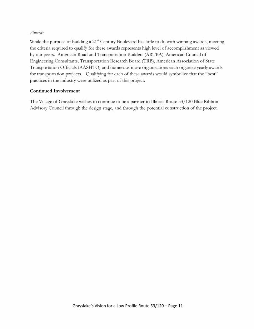
Peterson Road/Route 83
Similarly to Route 120 at Alleghany Road, folded a diamond/pareclo style interchange is suggested
at Route 53 and Peterson Road/Route 83. This interchange would provide a full access to future
light industrial developments and the new Lake County Fairgrounds while minimizing the footprint
of interchange. The area around the proposed interchange is zoned light industrial and will likely
increase in value once a proposed roadway is constructed.
Due to the close proximity of the new corridor to Route 83 and Peterson Road intersection,
consideration should be given to relocating Route 83 to the west as suggested in the Cornerstone
Development Plan. Exhibit A – View of Route 53 Extension from Winchester Road illustrates a potential
interchange at Peterson Road.
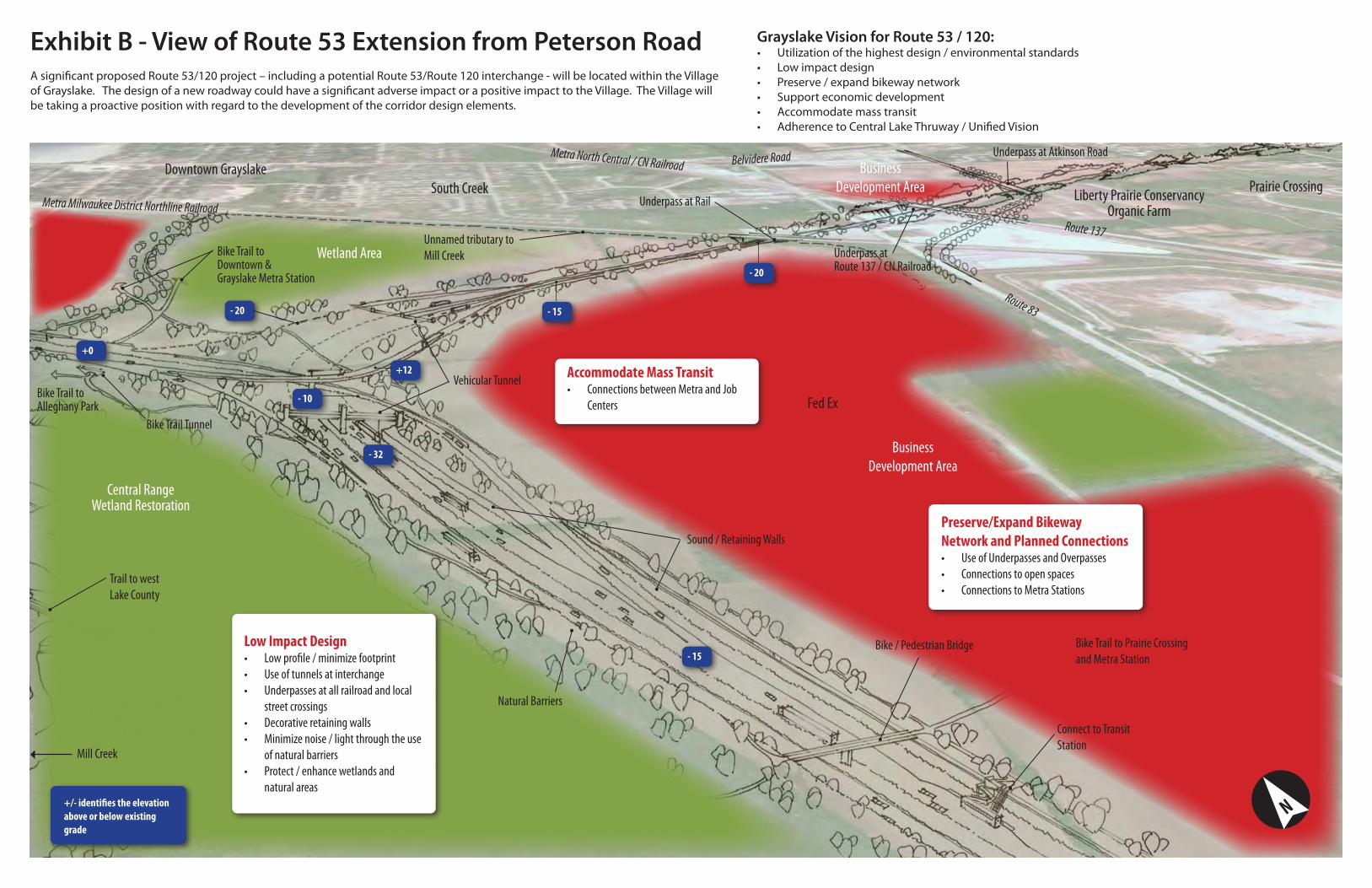
U.S. Route 45
A full Single Point Urban Diamond Interchange (SPUD) is
recommended for Route 120 at U.S. Route 45 providing full
access to the eastern portion of the Village, including direct
access to Northwestern/Lake Forest Hospital. A SPUD
interchange requires less of a footprint than a traditional
diamond interchange and improves operation. Operation is
improved by permitting concurrent left turns for greater
capacity. Exhibit C – View of Route 120 Bypass from US Route
45 illustrates a potential SPUD interchange at Route 45.
Route 53/120 Interchange
The Route 53/120 Interchange in the form of structures and bridges would cause a significant
amount of environmental change. Similarly to the desired roadway cross-section, the Village
envisions a low profile interchange and a compact interchange footprint to minimize impacts to the
surrounding environmentally sensitive areas. The Village proposes an interchange concept of
tunnels and low profile roadways to maintain open space while maintaining connectivity between
the two routes. Where portions of the interchange extend above the existing grade, landscaped
berms should be constructed with the excavated earth to shield adjacent land uses from the roadway
noise and the light pollution emitted from the interchange.
The area above the tunnel provides an opportunity to create wetlands as well as bike path
connections through the interchange. These connections will lessen the impact that the proposed
interchange will have on the Village – while meeting all the transportation objectives of the Blue
Ribbon Advisory Council. Exhibit B - View of Route 53 Extension from Peterson Road illustrates the
proposed interchange, the use of tunneling and depressed roadways and use open space.
The Village acknowledges that costs for tunneling and constructing a low profile interchange can be
higher than an elevated structure; however there is precedent nationally for constructing roadway
tunnels to avoid environmentally sensitive areas.
Figure 8 – Single Point Urban Diamond Interchange
Grayslake’s Vision for a Low Profile Route 53/120 – Page 9
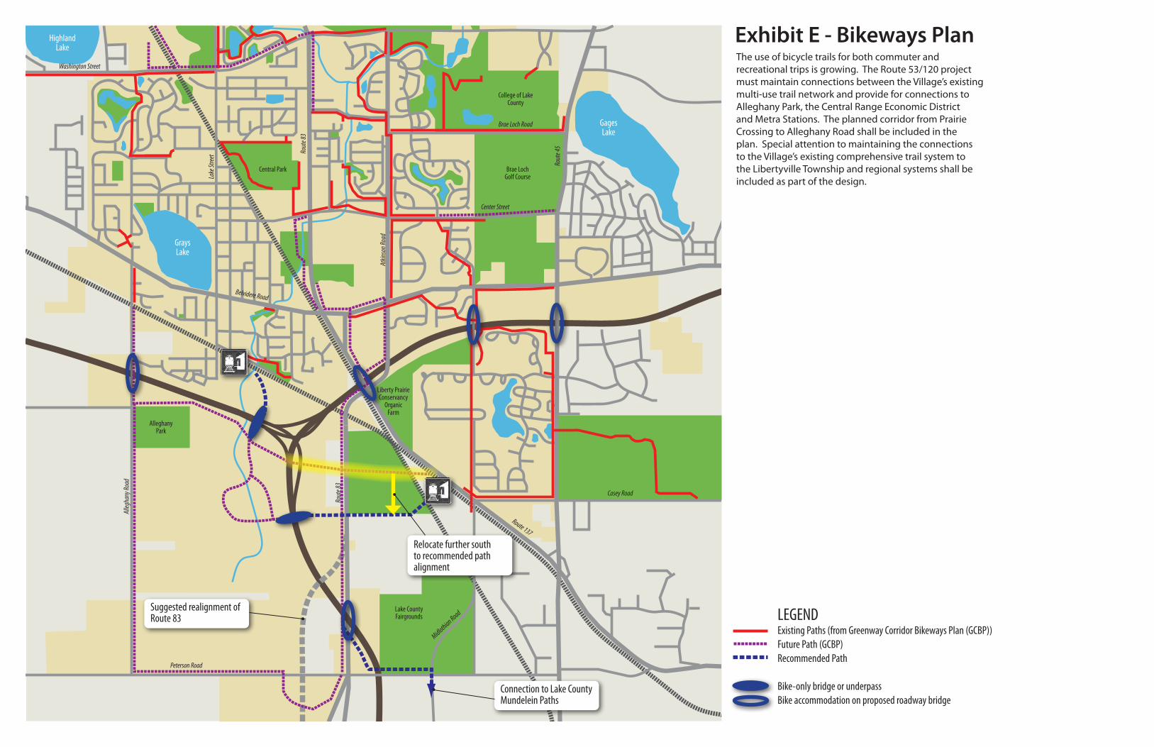
Community Connectivity - Bicycles
The use of bicycle trails for both commuter and recreational trips is growing. The Route 53/120
project must maintain connections between Village’s existing comprehensive trail network, provide
connections to Alleghany Park, the Central Range Economic District, and existing local and regional
path systems. The planned east-west corridor from Prairie Crossing to Alleghany Road shall be
included in the plan. Exhibit E – Greenways/Bikeways Plan illustrates a proposed bicycle path
network following the construction of a new roadway.
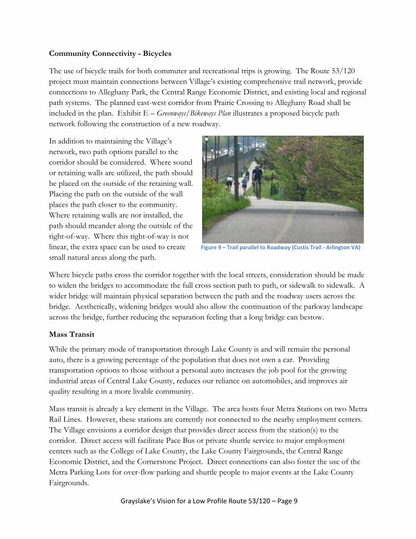
In addition to maintaining the Village’s
network, two path options parallel to the
corridor should be considered. Where sound
or retaining walls are utilized, the path should
be placed on the outside of the retaining wall.
Placing the path on the outside of the wall
places the path closer to the community.
Where retaining walls are not installed, the
path should meander along the outside of the
right-of-way. Where this right-of-way is not
linear, the extra space can be used to create
small natural areas along the path.
Where bicycle paths cross the corridor together with the local streets, consideration should be made
to widen the bridges to accommodate the full cross section path to path, or sidewalk to sidewalk. A
wider bridge will maintain physical separation between the path and the roadway users across the
bridge. Aesthetically, widening bridges would also allow the continuation of the parkway landscape
across the bridge, further reducing the separation feeling that a long bridge can bestow.
Mass Transit
While the primary mode of transportation through Lake County is and will remain the personal
auto, there is a growing percentage of the population that does not own a car. Providing
transportation options to those without a personal auto increases the job pool for the growing
industrial areas of Central Lake County, reduces our reliance on automobiles, and improves air
quality resulting in a more livable community.
Mass transit is already a key element in the Village. The area hosts four Metra Stations on two Metra
Rail Lines. However, these stations are currently not connected to the nearby employment centers.
The Village envisions a corridor design that provides direct access from the station(s) to the
corridor. Direct access will facilitate Pace Bus or private shuttle service to major employment
centers such as the College of Lake County, the Lake County Fairgrounds, the Central Range
Economic District, and the Cornerstone Project. Direct connections can also foster the use of the
Metra Parking Lots for over-flow parking and shuttle people to major events at the Lake County
Fairgrounds.
Figure 9 – Trail parallel to Roadway (Custis Trail - Arlington VA)

Grayslake’s Vision for a Low Profile Route 53/120 – Page 10
Best Management Practices and Environmental Design Standards
Desiring the highest standards is in-line with the guiding principles set by the Route 53/120 Blue
Ribbon Panel, however “highest” or “best” is hard to define and quantify. The Village of Grayslake
recommends that design standards that can be qualified and measured be selected. Best
management practices for design are defined by the Federal Highway Administration for safety and
work zone management and by the Center for Environmental Excellence by AASHTO. At a
minimum the design of the Route 53/120 project should achieve the highest level for each design
category and seek to advance national design practices in multiple design categories.
Best Management Practices for Design
Several design categories have been established by the Center for Environmental Excellence and
through the Illinois – Livable and Sustainable Transportation Rating System and Guide (I-LAST).
I-LAST includes a comprehensive list of practices that can bring sustainable results to highway
projects, establishes a scoring method, and recognizes the results. The manual divides sustainable
practices into eight categories: planning, design, environmental, water quality, transportation,
lighting, materials, and innovation. The Village believes that the full use of the I-LAST Guide book
should be implemented for the Route 53/120 project, and set the bar for I-LAST scoring. A
construction category will soon be added to the I-LAST Guide.
Best Management Practices for Storm Water Control
Storm water that falls within the limits of the corridor, as well as storm water that naturally flows
across the corridor would need to be addressed as part of the Route 53/120 project. Historically,
roadway projects channeled storm water to natural outfalls though engineered channels or piping.
This storm water would pick up roadway pollutants and degrade water quality. Great improvements
to storm water management have been developed that decrease the volume of storm water released
and improve the quality of the water at an outfall. Bioswales are used to cleanse storm water before
an outfall, permeable pavements are used to permit natural infiltration, and rainwater harvesting is
used to capture and store storm water and to be later used for irrigation. The Route 53/120 project
should make extensive use of storm water best management practices to maintain the high water
quality throughout Central Lake County.
Best Management Practices for Construction and Maintenance
The Village desires the continuation of best management practices beyond the design of the
corridor. Best management practices should be developed for construction activities as well as
operation and maintenance of the roadway once constructed. The Center for Environmental
Excellence details design/management practices for environmental stewardship for construction and
maintenance operation and winter maintenance. Improvements to snow control equipment now
apply chemicals more precisely to avoid over-application. Road weather information systems
(RWIS) measure the temperature and moisture contact on the roadway and communicates to a
maintenance facility the salt mixture to be applied, or more importantly what not to apply. The
Village encourages the Blue Ribbon Council to address construction and maintenance techniques as
a continuation of coordinating efforts.
Grayslake’s Vision for a Low Profile Route 53/120 – Page 11
Awards
While the purpose of building a 21st Century Boulevard has little to do with winning awards, meeting
the criteria required to qualify for these awards represents high level of accomplishment as viewed
by our peers. American Road and Transportation Builders (ARTBA), American Council of
Engineering Consultants, Transportation Research Board (TRB), American Association of State
Transportation Officials (AASHTO) and numerous more organizations each organize yearly awards
for transportation projects. Qualifying for each of these awards would symbolize that the “best”
practices in the industry were utilized as part of this project.
Continued Involvement
The Village of Grayslake wishes to continue to be a partner to Illinois Route 53/120 Blue Ribbon
Advisory Council through the design stage, and through the potential construction of the project.
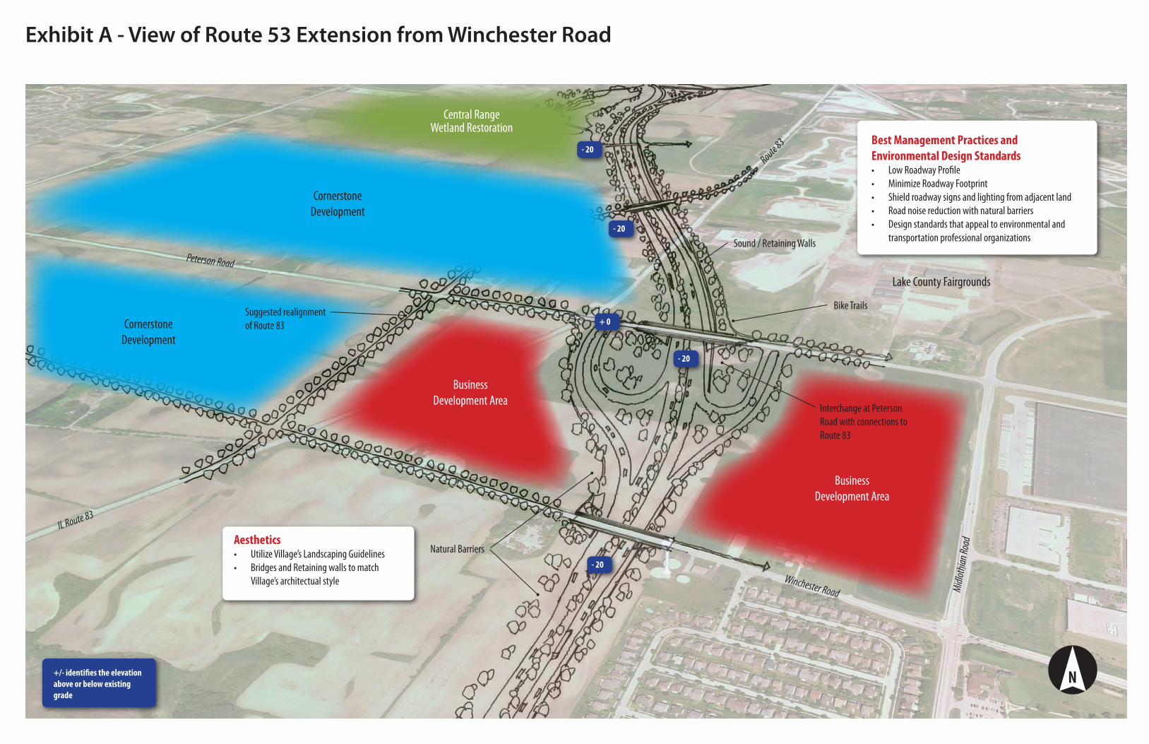
Exhibit A - View of Route 53 Extension from Winchester Road
Best Management Practices and Environmental Design Standards
Low Roadway Profile•Minimize Roadway Footprint•Shield roadway signs and lighting from adjacent land•Road noise reduction with natural barriers•Design standards that appeal to environmental and •transportation professional organizations
N
Interchange at Peterson Road with connections to Route 83
Route 83
Central RangeWetland Restoration
Peterson Road
Midlo
thian
Road
Lake County Fairgrounds
Cornerstone Development
Suggested realignment of Route 83
Sound / Retaining Walls
Bike Trails
AestheticsUtilize Village’s Landscaping Guidelines•Bridges and Retaining walls to match •Village’s architectual style
Natural Barriers
IL Route 83
Business Development Area
Business Development Area
+/- identifies the elevation above or below existing grade
- 20
- 20
- 20
- 20
+ 0Cornerstone Development
Winchester Road
Preserve/Expand Bikeway Network and Planned Connections
Use of Underpasses and Overpasses•Connections to open spaces•Connections to Metra Stations•
Bike Trail to Alleghany Park
Accommodate Mass TransitConnections between Metra and Job •Centers
Low Impact DesignLow profile / minimize footprint•Use of tunnels at interchange•Underpasses at all railroad and local •street crossingsDecorative retaining walls•Minimize noise / light through the use •of natural barriersProtect / enhance wetlands and •natural areas
Connect to Transit Station
Bike Trail Tunnel
Sound / Retaining Walls
Natural Barriers
Vehicular Tunnel
Underpass at Atkinson Road
Underpass at Rail
Underpass at Route 137 / CN Railroad
Metra Milwaukee District Northline Railroad
Route 83
Belvidere Road
Bike Trail to Downtown &Grayslake Metra Station
Bike / Pedestrian Bridge
Route 137
Central RangeWetland Restoration
Downtown Grayslake
Liberty Prairie ConservancyOrganic Farm
Metra North Central / CN Railroad
Unnamed tributary to Mill Creek
Exhibit B - View of Route 53 Extension from Peterson RoadA significant proposed Route 53/120 project – including a potential Route 53/Route 120 interchange - will be located within the Village of Grayslake. The design of a new roadway could have a significant adverse impact or a positive impact to the Village. The Village will be taking a proactive position with regard to the development of the corridor design elements.
Grayslake Vision for Route 53 / 120:Utilization of the highest design / environmental standards•Low impact design•Preserve / expand bikeway network•Support economic development•Accommodate mass transit•Adherence to Central Lake Thruway / Unified Vision•
Fed Ex
Bike Trail to Prairie Crossing and Metra Station
N
Wetland Area
Prairie Crossing
Mill Creek
- 20
- 32
+0
+12
- 10
- 15
- 15
- 20
+/- identifies the elevation above or below existing grade
Business Development Area
Business Development AreaSouth Creek
Trail to west Lake County
Best Management PracticesLow Roadway Profile•Minimize Roadway Footprint•Design the corridor to achieve the •highest Merit Awards from both transportation and environmental groups
Low Impact DesignUse in-pavement lights to reduce light •pollutionInterchange designs•Preserve / Protect land for commercial •development and open space
Bike Trail Tunnel
Natural Barriers Belvi
dere
Road
/ Old
IL Ro
ute 12
0
Route 83
Prairie Crossing
Metra North Central / CN Railroad
Exhibit C - View of Route 120 Bypass from US Route 45The Route 120 portion east of the interchange begins the transition to a lower speed boulevard. The Village desires connections to State highways through Grayslake.
Grayslake Vision for Route 53 / 120:Utilization of the highest design / environmental standards•Low impact design•Preserve / expand bikeway network•Support economic development•Accommodate mass transit•Adherence to Central Lake Thruway / Unified Vision•
Route 137
Harris Road
US Route 45
Atkinson Road
NorthwesternLake Forest Hospital
Bike Trail
No impact to residential area
Underpass at Harris Road
Interchange at US Route 45
ConnectivityConnections to US 45, Alleghany Road •and Peterson RoadConnections and expansions of •Grayslake Bikeway network
Underpass at Atkinson Road
N
- 20
+/- identifies the elevation above or below existing grade
- 15
- 20
- 20
Business Development Area Business
Development Area
Liberty Prairie ConservancyOrganic Farm
- 15
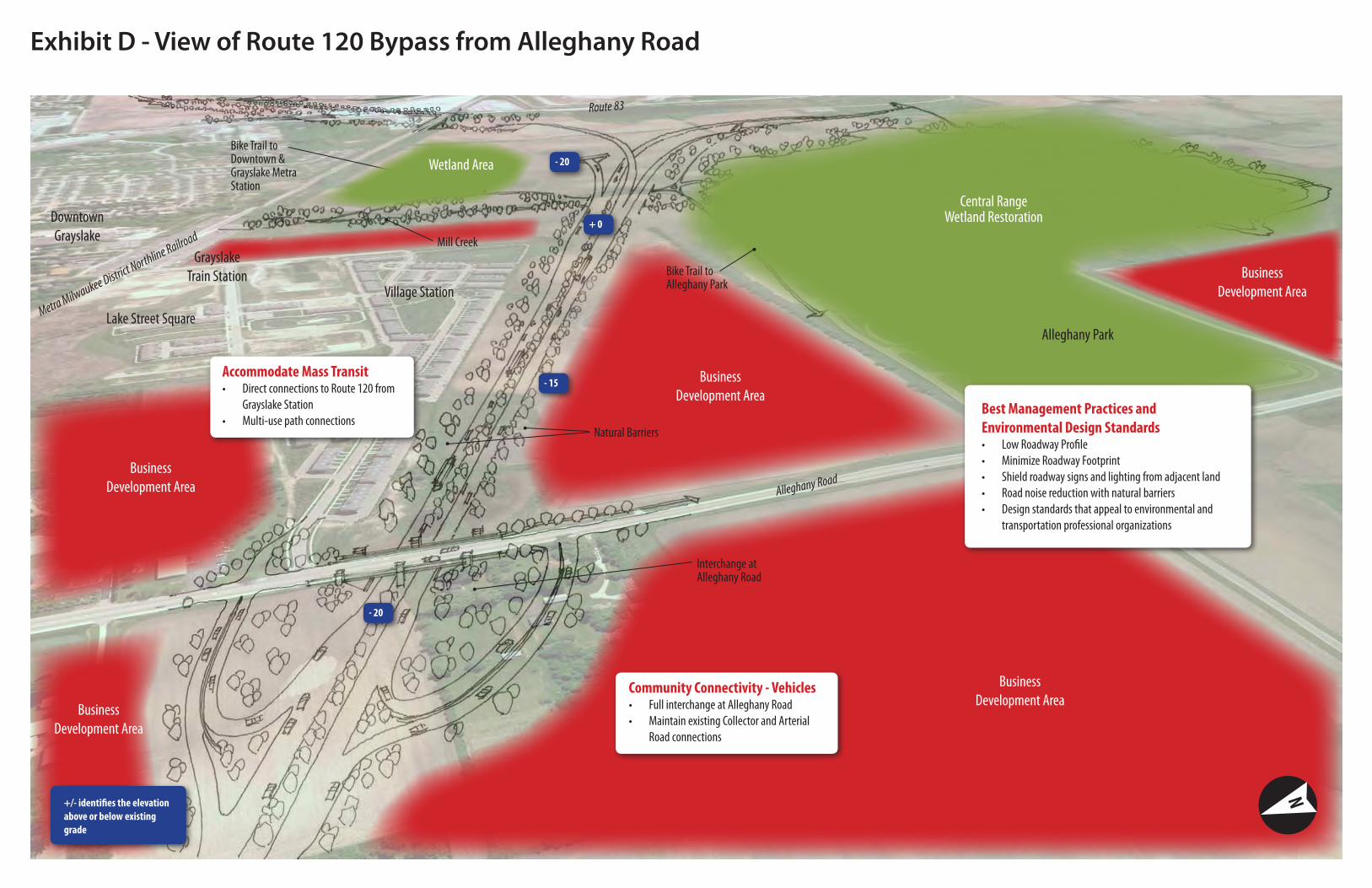
Exhibit D - View of Route 120 Bypass from Alleghany Road
Bike Trail to Alleghany Park
Metra Milwaukee District Northline Railroad
Bike Trail to Downtown &Grayslake Metra Station
Central Range Wetland RestorationDowntown
Grayslake
Alleghany Park
Interchange atAlleghany Road
Natural Barriers
GrayslakeTrain Station
Mill Creek
Business Development Area
Wetland Area
Alleghany Road
Route 83
Accommodate Mass TransitDirect connections to Route 120 from •Grayslake StationMulti-use path connections•
Community Connectivity - VehiclesFull interchange at Alleghany Road•Maintain existing Collector and Arterial •Road connections
Business Development Area
Business Development Area
Business Development Area
N+/- identifies the elevation above or below existing grade
+ 0
- 20
- 15
- 20
Village Station
Lake Street Square
Best Management Practices and Environmental Design Standards
Low Roadway Profile•Minimize Roadway Footprint•Shield roadway signs and lighting from adjacent land•Road noise reduction with natural barriers•Design standards that appeal to environmental and •transportation professional organizations
Business Development Area
Connection to Lake CountyMundelein Paths
LEGENDExisting Paths (from Greenway Corridor Bikeways Plan (GCBP))Future Path (GCBP)Recommended Path
Bike-only bridge or underpassBike accommodation on proposed roadway bridge
GraysLake
GagesLake
HighlandLake
Central Park
College of Lake County
Brae LochGolf Course
Lake CountyFairgrounds
AlleghanyPark
Peterson Road
Route 137
Casey Road
Rout
e 45
Center Street
Brae Loch Road
Belvidere Road
Lake
Stree
t
Washington Street
Rout
e 83
Atkin
son R
oad
Alleg
hany
Road
Rout
e 83
Midlothian Road
Exhibit E - Bikeways PlanThe use of bicycle trails for both commuter and recreational trips is growing. The Route 53/120 project must maintain connections between the Village’s existing multi-use trail network and provide for connections to Alleghany Park, the Central Range Economic District and Metra Stations. The planned corridor from Prairie Crossing to Alleghany Road shall be included in the plan. Special attention to maintaining the connections to the Village’s existing comprehensive trail system to the Libertyville Township and regional systems shall be included as part of the design.
Liberty PrairieConservancy
OrganicFarm
Relocate further south to recommended path alignment
Suggested realignment of Route 83
Suggested realignment of Route 83
GraysLake
GagesLake
HighlandLake
Central Park
College of Lake County
Brae LochGolf Course
Lake CountyFairgrounds
AlleghanyPark
Peterson Road
Route 137
Casey Road
Rout
e 45
Center Street
Brae Loch Road
Belvidere Road
Lake
Stree
t
Washington Street
Rout
e 83
Atkin
son R
oad
Alleg
hany
Road
Rout
e 83
Midlothian Road
Exhibit F - Connections Plan
Peterson Road Full Interchange
Alleghany Road Full Interchange
Atkinson RoadExtension
Liberty PrairieConservancy
OrganicFarm
Route 53/120 cannot be a barrier to the community but must provide connectivity. Cross corridor connections for the local collector and arterial street system, the Village’s bicycle path network, and existing utilities all must be maintained. The Village understands that some of the desired aesthetic treatments, community identifiers and proposed utility connections will be at the Village cost, however connections maintaining cross corridor connections must be considered as part of the project cost.
Connections between the village and the corridor are proposed at Alleghany Road, Peterson Road and US Route 45. Interchange designs concepts were developed for each connection with the goal of minimizing the roadway footprint, protecting environmentally sensitive and existing commercial/residential lands, and providing access to Grayslake.
Route 45 Full Interchange