county of fairfax
TRANSCRIPT

Attachment 1
Status Report on the
Fairfax County Board of Supervisors’
Third Four-Year Transportation
Program FY 2013 Through FY 2016
Prepared by:
Department of Transportation
Capital Projects and Operations Division
February 2014

February 2014 Status Report on the Board’s Four-Year Transportation Program for FY2014 Through FY2017
FCDOT Summary Page 1
Department of Transportation Summary of Activities and Highlights
Projects Completed and Under Construction from July 2013 through February 2014
Completed Projects: 31 projects were completed since July 2013, consisting of eight roadway, three transit, and 21 pedestrian, bicycle, walkway, and trail projects. In addition, 20 bus stop improvement projects were completed. o Arlington Boulevard/Graham Road Median installation (Mason) o Beach Mill Road Bridge Rehabilitation (Dranesville) o Boone Boulevard/Aline Avenue (TMSAMS) Pedestrian Intersection Improvements (Providence) o Braddock Road/Roanoke River Road Intersection Improvements, managed by GMU (Braddock) o Colonial Lane/Chain Bridge Road (TMSAMS) Pedestrian Intersection Improvements (Providence) o Columbia Pike Walkway from Maple Court to Blair Road (Mason) o Fairfax County Parkway/Fair Lakes Parkway/Monument Drive Interchange (Springfield, Sully) o I-495 Express Lanes Ped/Bike at Braddock Road from Ravensworth Road to I-495 (Braddock) o I-495 Express Lanes Ped/Bike at Gallows Road from I-495 to Exxon Mobil Entrance (Providence) o I-495 Express Lanes Ped/Bike at Route 236 from I-495 to Heritage Drive/Hummer Road
(Braddock) o North Kings Highway Median from Fort Drive to Huntington Metrorail Station (Lee) o Old Meadow Road/Old Meadow Lane (TMSAMS) Pedestrian Intersection Improvements
(Providence) o Raglan Road/Gosnell Road (TMSAMS) Pedestrian Intersection Improvements (Hunter Mill) o Reston Town Center Transit Station Modifications (Hunter Mill) o Rolling Road/Old Keene Mill Road Safety Improvements (Springfield) o Route 1 Walkway (RHPTI) Belle Haven Towers Phase II (Mount Vernon) o Route 1 Walkway (RHPTI) north of Reddick Avenue/Russell Road (Mount Vernon) o Route 1 Walkway (RHPTI) south of Kings Village Road (Mount Vernon) o Route 1 Walkway (RHPTI) south of Sky View Drive (Mount Vernon) o Route 1 Walkway (RHPTI) Quander Road Phase II (Mount Vernon) o Route 29/Nutley Street Safety Improvements (Providence) o Seneca Avenue/Chain Bridge Road (TMSAMS) Pedestrian Intersection Improvements
(Providence) o Silverbrook Road Walkway from Southrun Road to Monacan Road (Mount Vernon) o Solutions Drive/Greensboro Boulevard (TMSAMS) Pedestrian Intersection Improvements
(Providence) o Sunset Hills Road Walkway (Plaza America Proffer) from Reston Center to Town Center Parkway
(Hunter Mill) o Tyspring Street/Gosnell Road (TMSAMS) Pedestrian Intersection Improvements (Hunter Mill) o Wall Street/Gosnell Road (TMSAMS) Pedestrian Intersection Improvements (Hunter Mill) o West Ox Bus Operations Center Storage Building (Providence) o Westbranch Drive/Westpark Drive (TMSAMS) Pedestrian Intersection Improvements
(Providence) o Westmoreland Street/Haycock Road southbound right turn lane (Dranesville) o Wiehle-Reston East Metrorail Station Park-and-Ride Garage (Hunter Mill)

February 2014 Status Report on the Board’s Four-Year Transportation Program for FY2014 Through FY2017
FCDOT Summary Page 2
Projects in Construction: 44 projects are currently under construction. In addition, 17 bus stop improvement projects are in construction. o Annandale Streetscapes on Columbia Pike from Backlick Road to fire station (Mason) o Ashburton Avenue Walkway at Cedar Run (Sully) o Bobann Drive Bikeway from Wharton Lane to Stringfellow Road (Sully) o Burke Commons Road Walkway from Meredith Circle to Roberts Parkway (Braddock) o Columbia Pike Walkway from Gallows Road to Annandale Church (Mason) o Dolley Madison Boulevard/Churchill Road Pedestrian Intersection Improvements (Dranesville) o Dulles Rail Phase 1 from West Falls Church to Wiehle-Reston East Metrorail Station (Dranesville,
Hunter Mill , Providence) o Dulles Rail Phase 2 from Wiehle-Reston East Metrorail Station to Route 722 in Loudoun County
(Dranesville, Hunter Mill) o Fairfax County Parkway/Franconia-Springfield Parkway Median Safety Improvements
(Dranesville, Hunter Mill, Lee, Springfield) o Gambrill Road/Pohick Road southbound right turn lane (Mount Vernon, Springfield) o GMU West Campus Bypass Crossing Route 123, managed by GMU (Braddock, Springfield) o Huntington Bus Maintenance Facility Service Lane (Mount Vernon) o I-66/Route 28 Safety Improvements (Sully) o I-66 Active Traffic Management Improvements (Providence, Springfield, Sully) o I-66 Spot Improvements (Inside the Beltway) from Sycamore Street/Washington Boulevard to
Dulles Toll Road (Dranesville) o I-95 Direct Access Ramps to Fort Belvoir North Area (Lee) o I-95 Express Lanes (Lee, Mason, Mount Vernon) o Lee Road Culvert (Sully) o Lewinsville Road Walkway from Snow Meadow Lane to Elsinore Road (Dranesville) o Lorton Road Improvements from Route 123 to Silverbrook Road (Mount Vernon) o McLean Central Business District Traffic Signal Replacement (Dranesville) o Mount Vernon Memorial Highway Walkway from north of Sunny View Drive to Richmond
Highway (Mount Vernon) o Mulligan Road from Route 1 to Telegraph Road (Lee, Mount Vernon) o Old Centerville Road and Braddock Road Emergency Signal Pre-Emption (Sully) o Route 1 Walkway (RHPTI) from south of Fordson Road to Woodlawn Trail (Mount Vernon) o Route 1 Walkway (RHPTI) from south of Mount Vernon Memorial Highway to Napper Road
(Mount Vernon) o Route 1 Widening from Old Mill Road/Mulligan Road to Telegraph Road (Mount Vernon) o Route 7/Baron Cameron Avenue/Springvale Road Pedestrian Intersection Improvements
(Dranesville, Hunter Mill) o Route 1 Walkway (RHPTI) from Sacramento Drive to Engleside Plaza (Mount Vernon) o Route 7/Lewinsville Road Pedestrian Intersection Improvements (Dranesville, Hunter Mill) o Route 7 Widening from Rolling Holly Drive to Reston Avenue (Dranesville, Hunter Mill) o Route 29 Bridge Repairs over tributary of Accotink Creek (Providence) o Route 29 Bridge Replacement over Little Rocky Run (Springfield) o Route 29 Multi-Purpose Trail from Federalist Way to Shirley Gate Road (Braddock) o Route 50 Widening from Route 28 to Poland Road (Sully) o School Street Walkway from North Kings Highway to Pine Grove Circle (Lee) o Silverbrook Road Walkway from Silverthorn Road to Bayberry Ridge Road (Mount Vernon,
Springfield) o Stringfellow Road Widening from Route 50 to Fair Lakes Boulevard (Springfield, Sully)

February 2014 Status Report on the Board’s Four-Year Transportation Program for FY2014 Through FY2017
FCDOT Summary Page 3
o Telegraph Road Widening from Beulah Street to Leaf Road (Lee, Mount Vernon) o Telegraph Road Widening from South Van Dorn Street to South Kings Highway (Lee) o Towlston Road Bridge Replacement over Rocky Run (Dranesville) o Twin Lakes Drive Bridge Rehabilitation over Johnny Moore Creek (Sully) o Walker Road at Georgetown Pike Road Diet (Dranesville) o Walney Road Bridge Replacement over Flatlick Branch (Sully)
Bicycle and Pedestrian Program Highlights from July 2013 through February 2014
The Board directed FCDOT to lead the effort to improve bicycle and pedestrian safety and mobility,
including constructing bicycle and pedestrian facilities in high-priority areas of Fairfax County. In 2006,
the Board endorsed a Ten-Year Funding Goal of $60 million for new bicycle and pedestrian projects.
Through FY2018, the Board has designated $110 million in federal, state, and county funding to
construct high-priority bicycle and pedestrian improvement projects.
Pedestrian and Bicycle Access and Safety: FCDOT staff continues ongoing outreach and coordination with groups such as Reston Metrorail Access Group (RMAG), Herndon Metrorail Station Access Management Study (HMSAMS), Fairfax County Public Schools (FCPS) Safe Routes to Schools, INOVA, the county’s Transportation Advisory Commission (TAC), the Trails and Sidewalks Committee, and the county’s Americans with Disabilities Act (ADA) Compliance Team.
Trail, Bike Lane, and Sidewalk Waivers: FCDOT staff received and processed 20 waivers in coordination with Board members, the Trails and Sidewalks Committee, Department of Public Works and Environmental Services (DPWES), and the Department of Planning and Zoning (DPZ).
Street Smart: FCDOT staff work with regional partners on the Street Smart Pedestrian and Bicycle Safety Media Campaigns. The twice-yearly campaigns utilize major-market television and radio, print, and bus advertising to promote safety awareness responsibilities of drivers and pedestrians in both English and Spanish.
I-495 Express Lanes Bicycle and Pedestrian Projects: Bicycle and pedestrian facilities have been constructed on all of the Beltway bridge crossings in the I-495 Express Lanes Project. These new facilities removed some of the worst barriers to pedestrian and bicycle movement in Fairfax County, since most of the former bridges had no facilities. The Board designated additional CMAQ funding which, along with VDOT and county bond proceeds, funds the missing pedestrian facilities outside the limits and original scope of the I-495 Express Lanes Project.
Bicycle Master Plan: Staff from both FCDOT and DPZ are finalizing the report, including the staff report on all the necessary modifications to the Comprehensive Plan. The study will be completed and presented to the Planning Commission in May 2014 and tentatively to the Board of Supervisors in June 2014.
Increase and Enhance Bicycle Parking: FCDOT is completing its bicycle rack and improvement projects initiated in 2009, consisting of the installation of 150 new bicycle racks and 30 new bicycle lockers at locations countywide. New racks and bicycle lockers were recently installed at the Burke Centre Virginia Railway Express (VRE) Station, Backlick Road VRE Station, and Centreville-Stone Road Park-and-Ride Lot.

February 2014 Status Report on the Board’s Four-Year Transportation Program for FY2014 Through FY2017
FCDOT Summary Page 4
Secure Bicycle Parking Facilities: Staff is finalizing work on the new “Bike and Ride” facility at the Wiehle-Reston East Metrorail Station in anticipation of the opening of Metrorail’s Silver Line. When open, this facility will provide safe and secure parking for over 200 bicycles. Other secure bicycle parking facilities in design include the Stringfellow Road Park-and-Ride Transit Center and Springfield Community Business Center Commuter Parking Garage.
Vienna Metro-City of Fairfax-George Mason University (GMU) Connector: Work continues on a bicycle route connecting GMU with the Vienna Metrorail Station via the City of Fairfax. This is a cooperative project with the city, GMU, and the Northern Virginia Regional Park Authority.
Bicycle Route Signage-Countywide: In FY2013, staff completed the installation of bicycle wayfinding signs in the central business district of McLean. This was the first installation making use of new signage approved in the new edition of the Manual of Uniform Traffic Control Devices (MUTCD). More locations are planned for this coming year.
Bobann Drive Bikeway-Sully District: Construction began in January 2014 on the Bobann Drive Bikeway. Approximately one mile in length, this shared use path will provide direct non-motorized access to the Stringfellow Road Park-and-Ride Lot from the Centreville and Fair Lakes areas.
Western Fairfax Bike the Sites: Work was initiated on the Bike the Sites project in late 2013. Funded through a federal Enhancement Grant, the project will establish a branded, signed family friendly bicycle route connecting multiple sites of historic importance. Project completion is scheduled for summer 2014.
Reston Capital Bikeshare Feasibility Study: Funded through Metropolitan Washington Council of Governments’ Transportation/Land Use Connections Grant Program, this study will examine the feasibility of expanding Capital Bikeshare to the Reston area. If feasible, a second grant providing $400,000 for bikeshare infrastructure is available. The study will be completed by June 2014.
BRAC Implementation Plan Highlights from July 2013 through February 2014
Projects In Construction
o Mulligan Road and Telegraph Road Widening. o Defense Access Ramps into Fort Belvoir North Area (I-95 at the Fairfax County Parkway). o Route 1 Widening from Telegraph Road to Mulligan Road/Mount Vernon Memorial Highway.
Projects in Design
o Fairfax County Parkway and Rolling Road Interchange (VDOT). Project funded for construction in VDOT’s Six Year Improvement Program. Design-Build project managed by VDOT. NTP issued in January 2014.
o I-95/Fairfax County Parkway Flyover Ramp (funded for design only). Design is in progress.

February 2014 Status Report on the Board’s Four-Year Transportation Program for FY2014 Through FY2017
FCDOT Summary Page 5
Capital Projects and Operations Division Highlights from July 2013 through February 2014
The Capital Projects and Operations Division consists of the Capital Projects Section (CPS) and the Traffic Engineering and Operations Section (TEOS). CPS is responsible for scoping new multi-modal transportation projects, managing preliminary engineering plans and studies, and coordinating projects with VDOT, FHWA, WMATA, DPWES, the Board, and the general public. TEOS is responsible for managing traffic issues related to signs, signals, parking, traffic calming, and other residential traffic issues. TEOS partners with VDOT, the Board, homeowners associations, and citizen groups to resolve issues.
Capital Projects
Project Scoping o On January 28, 2014, the Board adopted a list of approximately 180 new transportation project
priorities. Capital Projects staff is responsible for scoping the projects, as well as managing many of the studies and conceptual plans. Staff will be working on project assignments and scheduling in spring 2014. The project scoping will be a major effort for CPS in 2014.
Studies and Preliminary Plans: o Braddock Road HOV Widening: The study will consist of three main components: study
widening, HOV, and transit needs from Burke Lake Road to I-495, study widening and transit from Guinea Road to Burke Lake Road, and study a commuter parking and transit center facility on Braddock Road in the vicinity of Burke Lake Road.
o Dulles Toll Road Tysons Ramps: CPS has completed a conceptual study of alternatives for new ramp connections between the Dulles Toll Road and Tysons.
o Fairfax County Parkway from I-95 to Telegraph Road: Investigate short-term congestion reduction improvements. The study is underway.
o Jones Branch Connector (JBC): The 30% design plans have been completed for this roadway connection between Jones Branch Drive and Route 123 in Tysons. The Interchange Modification Report (IMR) has also been prepared and submitted to VDOT for review. It is anticipated that VDOT and FHWA will approve the IMR in spring 2014, and FCDOT is proceeding with further design related efforts in anticipation of IMR approval. Funding for construction is a combination of local, state, and federal funds. FCDOT will manage the project through final design and land acquisition, and VDOT will construct the project.
o Rolling Road VRE Parking Expansion: This study will determine the feasibility of adding a garage structure for additional parking. The study is in progress, and draft completion is anticipated in August 2014.
o Route 1 Transit Center: This study will select a feasible location, develop a conceptual design, and perform operational analysis for the transit center on the Route 1 corridor. 16 sites were evaluated for the transit center location, of which, the top three sites are being analyzed for feasibility. Conceptual layout designs for two of these three sites are also being developed.
o Route 7 Widening: This project will widen Route 7 from Reston Avenue to Jarrett Valley Drive. A market research study and traffic engineering study of constructing express lanes (high-occupancy toll lanes) along corridor were recently completed by VDOT. Preliminary design, including alternative intersection analysis, is in progress.
o Route 7 Widening from Route 123 to I-495 (Tysons): This conceptual design study for an eight-lane section (four lanes in each direction) is in progress. Ground survey and traffic data collection are complete, and the consultant is preparing future lane configurations. Additional
February 2014 Status Report on the Board’s Four-Year Transportation Program for FY2014 Through FY2017
FCDOT Summary Page 6
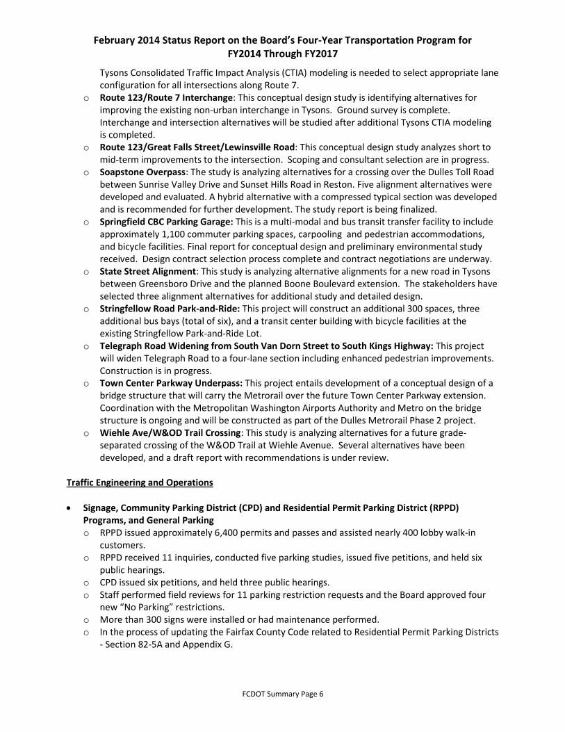
Tysons Consolidated Traffic Impact Analysis (CTIA) modeling is needed to select appropriate lane configuration for all intersections along Route 7.
o Route 123/Route 7 Interchange: This conceptual design study is identifying alternatives for improving the existing non-urban interchange in Tysons. Ground survey is complete. Interchange and intersection alternatives will be studied after additional Tysons CTIA modeling is completed.
o Route 123/Great Falls Street/Lewinsville Road: This conceptual design study analyzes short to mid-term improvements to the intersection. Scoping and consultant selection are in progress.
o Soapstone Overpass: The study is analyzing alternatives for a crossing over the Dulles Toll Road between Sunrise Valley Drive and Sunset Hills Road in Reston. Five alignment alternatives were developed and evaluated. A hybrid alternative with a compressed typical section was developed and is recommended for further development. The study report is being finalized.
o Springfield CBC Parking Garage: This is a multi-modal and bus transit transfer facility to include approximately 1,100 commuter parking spaces, carpooling and pedestrian accommodations, and bicycle facilities. Final report for conceptual design and preliminary environmental study received. Design contract selection process complete and contract negotiations are underway.
o State Street Alignment: This study is analyzing alternative alignments for a new road in Tysons between Greensboro Drive and the planned Boone Boulevard extension. The stakeholders have selected three alignment alternatives for additional study and detailed design.
o Stringfellow Road Park-and-Ride: This project will construct an additional 300 spaces, three additional bus bays (total of six), and a transit center building with bicycle facilities at the existing Stringfellow Park-and-Ride Lot.
o Telegraph Road Widening from South Van Dorn Street to South Kings Highway: This project will widen Telegraph Road to a four-lane section including enhanced pedestrian improvements. Construction is in progress.
o Town Center Parkway Underpass: This project entails development of a conceptual design of a bridge structure that will carry the Metrorail over the future Town Center Parkway extension. Coordination with the Metropolitan Washington Airports Authority and Metro on the bridge structure is ongoing and will be constructed as part of the Dulles Metrorail Phase 2 project.
o Wiehle Ave/W&OD Trail Crossing: This study is analyzing alternatives for a future grade-separated crossing of the W&OD Trail at Wiehle Avenue. Several alternatives have been developed, and a draft report with recommendations is under review.
Traffic Engineering and Operations
Signage, Community Parking District (CPD) and Residential Permit Parking District (RPPD) Programs, and General Parking o RPPD issued approximately 6,400 permits and passes and assisted nearly 400 lobby walk-in
customers. o RPPD received 11 inquiries, conducted five parking studies, issued five petitions, and held six
public hearings. o CPD issued six petitions, and held three public hearings. o Staff performed field reviews for 11 parking restriction requests and the Board approved four
new “No Parking” restrictions. o More than 300 signs were installed or had maintenance performed. o In the process of updating the Fairfax County Code related to Residential Permit Parking Districts
- Section 82-5A and Appendix G.

February 2014 Status Report on the Board’s Four-Year Transportation Program for FY2014 Through FY2017
FCDOT Summary Page 7
Residential Traffic Administration Program (RTAP) o 38 traffic calming projects were initiated for study. o Five traffic calming projects were approved by the Board of Supervisors for installation. o Six “$200 Fine for Speeding” sign requests were received with signs installed on eight roads. o Three “Watch for Children” sign requests were received. o One “Through Truck Restriction” request was received.
Traffic Operations o Coordinating with VDOT on installation of a traffic signal at Sunrise Valley Drive and Coppermine
Road.
Coordination and Funding Division Highlights from July 2013 through February 2014 The Coordination and Funding Division handles coordination and liaison responsibilities between the department, regional agencies, local jurisdictions, and state and federal agencies, and seeks funding from all levels of government for the implementation of transportation projects and services.
Commonwealth Transportation Board (CTB): Requested $10 million in FY2015 VDOT Revenue Sharing funds from the CTB for the Route 29 Widening and Vaden Ramp Improvement projects.
Continuation of the Countywide Dialogue on Transportation (CDOT): Staff concluded extensive outreach efforts in fall 2013 to determine the public’s priorities for transportation needs. The public outreach culminated in the prioritization of projects over a six-year period, and a County Six-Year Plan (CSYP) for transportation was approved by the Board on January 28, 2014. The CSYP is for fiscal years 2015 through 2020 and includes approximately 180 new projects funded with $1.4 billion in revenues from various sources.
Capital Improvement Program (CIP): Successfully completed the FCDOT portion of the CIP with endorsement from the Planning Commission and adoption by the Board scheduled in spring 2014.
VDOT Six-Year Improvement Program: Prepared testimony to CTB for VDOT’s FY2015 – FY2020 program.
Commuter Ferry Service: Analysis to examine the possibility of a commuter ferry service for the region was completed in October 2013. The results indicated that no commuter ferry service is recommended within Fairfax County, since the preferred location was on Fort Belvoir’s property. The Army was not interested in providing that service for various logistical and security reasons.
Cost Benefit Analysis Tool (CBA) o After the initial results were presented to the Board on June 25, 2013, staff revisited several
projects as directed by the Board and incorporated final results in the Countywide Dialogue on Transportation in fall 2013.
o Additional Cost Benefit Analysis will be conducted in the future as needed.

February 2014 Status Report on the Board’s Four-Year Transportation Program for FY2014 Through FY2017
FCDOT Summary Page 8
Coordination with Metropolitan Washington Council of Governments Transportation Planning Board (MWCOG TPB) o Incorporated the Jones Branch Connector (the first major roadway improvement within Tysons
which provides additional access across the Beltway and connects to the I-495 Express Lanes) into the Transportation Improvement Program (TIP) to receive federal funds.
o Incorporated 12 Tysons roadway improvement projects (Table 7) into the region’s 2014 Constrained Long Range Plan (CLRP).
o Following Board of Supervisors approval on November 19, 2013, provided input on the MWCOG TPB Regional Transportation Priorities Plan (RTPP). The RTPP was adopted by the TPB on January 15, 2014.
o Board of Supervisors approved three federal MAP-21 Transportation Alternative Program grant applications in October 2013: Lorton Cross County Trail, Mason Neck Trail, and Old Courthouse Road Sidewalk. The Old Courthouse Road Sidewalk project was submitted in the TAP application process, but is a Safe Routes to School Project. When MAP-21 combined the Transportation Enhancement and the Safe Routes to School Programs, it allowed for Safe Routes to Schools to be larger in scope, and the Old Courthouse Road Sidewalk project benefitted from this change. Grant awards are expected to be announced by August 2014.
o Worked with COG staff to add new Transportation Emission Reduction Measures (TERMS) projects for the region as part of eliminating the region as an EPA Non-attainment Area.
o Provided inputs for the MWCOG TPB’s “Freight Around the Region” report. o In coordination with DPWES, provided input to TPB’s Green Streets Policy. Adoption of the
policy by the TPB, with Fairfax County’s recommendations included, is scheduled to occur early spring 2014.
Metro 2025 o The Washington Metropolitan Area Transit Authority (WMATA) and its funding partners
developed and adopted a strategic plan called “Momentum” to help guide the Authority over the next few decades. Part of that plan includes “Metro 2025” which is a subset of the Capital Improvement Program (CIP), and is generally made up of WMATA’s capital expansion improvements between now and 2025. Metro 2025 includes new rail cars and power upgrades for running eight car trains, additional buses for operating Priority Corridor Networks, and rail station improvements to increase the capacity of the Metrorail system infrastructure. WMATA and jurisdictional staff are working to develop an affordable funding plan to fund many of the Metro 2025 improvements that were proposed by WMATA.
Virginia Railway Express (VRE) o Successfully established a VRE and Fairfax Connector Bus Transfer policy with VRE for express
service from VRE stations to Tysons and overall bus transfer policy. o Began feasibility study to investigate expanding Rolling Road VRE Station parking lot. Scheduled
completion of the study is for August 2014. o Implemented significant security and traffic management improvements at the Burke Centre
VRE Station surface parking lot and garage. Continued work with VRE staff to install state-of-the-art bicycle lockers at Lorton and Franconia-Springfield VRE Stations. These state-of-the-art lockers were installed at the Burke and Backlick Stations in January 2014.
o Provided input for the development of VRE’s System Plan which is an update of VRE’s 2004 Strategic Plan, and identifies critical VRE system needs in a comprehensive manner and prioritizes the service initiatives and capital improvements to advance VRE’s long-term strategic

February 2014 Status Report on the Board’s Four-Year Transportation Program for FY2014 Through FY2017
FCDOT Summary Page 9
vision over the next 20 years. The System Plan was adopted by the VRE Operations Board on January 17, 2014.
Federal Discretionary Grant Opportunities o Applied for $1.6 million in Transportation Alternatives Program grants that will be awarded by
August 2014. $1.6 million in Transportation Alternatives Program grants applied for in November 2012 and April 2013 was awarded to the county for countywide transportation projects in full.
Federal Loan Program Opportunities o Submitted an initial application for a $403 million loan through the Transportation Infrastructure
Finance and Innovation Act (TIFIA) to support Fairfax County’s financial obligation for the Silver Line Phase 2 expansion to Dulles International Airport.
Update Federal Civil Rights Compliance o Drafted an Interim Title VI Program that delineates FCDOT’s efforts to ensure that the Fairfax
Connector proactively considers the civil rights of Fairfax County citizens in the provision of transit services.
Tysons Transportation Infrastructure Funding o On January 28, 2014, the Board approved new rates for the Tysons, Tysons-Wide, and Tysons
Grid of Streets Fund Areas. They also approved funding for four studies totaling $836,000. o In fall 2013, staff met three times with the Tysons Service District Advisory Board to discuss
progress of the transportation projects supported by the Tysons Transportation Plan. The advisory board will meet again in spring 2014 to discuss recommendations to the Board concerning the service district rate for FY2015.
Developer Contribution Funds o Countywide cash proffer collections from May 1, 2013, through February 1, 2014, equal
$272,090. o FCDOT and DPZ staff worked on a proffer interpretation with the County Attorney’s office that
will allow for the construction of pedestrian improvements at Route 123 and International Drive totaling approximately $3 million. This proffer interpretation allows for the funding that was planned to come from the Tysons Road Fund to be available for other projects in Tysons.
o The Board adjusted collection rates for the Centreville, Tysons, and Fairfax Center Area Road Funds for inflation on January 28, 2014.
2013 Legislative Summary and Bill Implementation o HB 2313, Transportation Funding Package: In early 2013, the General Assembly passed HB
2313. The final transportation bill provides approximately $840 million annually for statewide maintenance, construction, and transit by 2018.
o HB 2313 also includes regional components for Northern Virginia and Hampton Roads. The Northern Virginia component provides approximately $300 million annually to the region. The regional components include, but are not limited to: Imposing a 0.7% sales tax, to a total of 6% for Northern Virginia. Imposing a 2% Transient Occupancy Tax (hotel tax). Imposing a regional congestion fee (grantors tax) of $0.15 per $100 valuation.
February 2014 Status Report on the Board’s Four-Year Transportation Program for FY2014 Through FY2017
FCDOT Summary Page 10
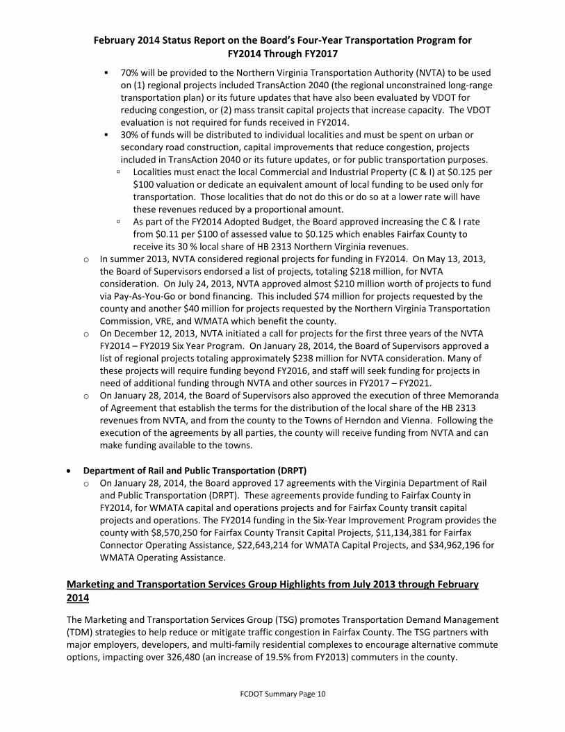
70% will be provided to the Northern Virginia Transportation Authority (NVTA) to be used on (1) regional projects included TransAction 2040 (the regional unconstrained long-range transportation plan) or its future updates that have also been evaluated by VDOT for reducing congestion, or (2) mass transit capital projects that increase capacity. The VDOT evaluation is not required for funds received in FY2014.
30% of funds will be distributed to individual localities and must be spent on urban or secondary road construction, capital improvements that reduce congestion, projects included in TransAction 2040 or its future updates, or for public transportation purposes.
Localities must enact the local Commercial and Industrial Property (C & I) at $0.125 per $100 valuation or dedicate an equivalent amount of local funding to be used only for transportation. Those localities that do not do this or do so at a lower rate will have these revenues reduced by a proportional amount.
As part of the FY2014 Adopted Budget, the Board approved increasing the C & I rate from $0.11 per $100 of assessed value to $0.125 which enables Fairfax County to receive its 30 % local share of HB 2313 Northern Virginia revenues.
o In summer 2013, NVTA considered regional projects for funding in FY2014. On May 13, 2013, the Board of Supervisors endorsed a list of projects, totaling $218 million, for NVTA consideration. On July 24, 2013, NVTA approved almost $210 million worth of projects to fund via Pay-As-You-Go or bond financing. This included $74 million for projects requested by the county and another $40 million for projects requested by the Northern Virginia Transportation Commission, VRE, and WMATA which benefit the county.
o On December 12, 2013, NVTA initiated a call for projects for the first three years of the NVTA FY2014 – FY2019 Six Year Program. On January 28, 2014, the Board of Supervisors approved a list of regional projects totaling approximately $238 million for NVTA consideration. Many of these projects will require funding beyond FY2016, and staff will seek funding for projects in need of additional funding through NVTA and other sources in FY2017 – FY2021.
o On January 28, 2014, the Board of Supervisors also approved the execution of three Memoranda of Agreement that establish the terms for the distribution of the local share of the HB 2313 revenues from NVTA, and from the county to the Towns of Herndon and Vienna. Following the execution of the agreements by all parties, the county will receive funding from NVTA and can make funding available to the towns.
Department of Rail and Public Transportation (DRPT) o On January 28, 2014, the Board approved 17 agreements with the Virginia Department of Rail
and Public Transportation (DRPT). These agreements provide funding to Fairfax County in FY2014, for WMATA capital and operations projects and for Fairfax County transit capital projects and operations. The FY2014 funding in the Six-Year Improvement Program provides the county with $8,570,250 for Fairfax County Transit Capital Projects, $11,134,381 for Fairfax Connector Operating Assistance, $22,643,214 for WMATA Capital Projects, and $34,962,196 for WMATA Operating Assistance.
Marketing and Transportation Services Group Highlights from July 2013 through February 2014
The Marketing and Transportation Services Group (TSG) promotes Transportation Demand Management (TDM) strategies to help reduce or mitigate traffic congestion in Fairfax County. The TSG partners with major employers, developers, and multi-family residential complexes to encourage alternative commute options, impacting over 326,480 (an increase of 19.5% from FY2013) commuters in the county.

February 2014 Status Report on the Board’s Four-Year Transportation Program for FY2014 Through FY2017
FCDOT Summary Page 11
Marketing staff also provides communications support to FCDOT by producing graphics and publication design, web and social media content, media relations, and marketing of commuter services.
Employer Outreach – TDM: The TSG Employer Services Program has implemented TDM programs at over 540 (an increase of 3.8% from FY2013) Fairfax County employer sites. To date, 252 (an increase of 3.2% from FY2013) Fairfax County employers have implemented a Level 3 or 4 trip reduction or benefit program, and another 288 (an increase of 4% from FY2013) employers have implemented a Level 1 or 2 program. Level 1 and 2 programs may include commuter surveys, distributing transit information, implementing alternative work schedules, or hosting an on-site transportation fair. Level 3 and 4 programs may include shuttles to and from transit stations, implementing formal policy driven telework programs, offering transit subsidies, providing free or premium parking to carpools and vanpools, or implementing a comprehensive bicycle and walking program. Level 4 employers may have implemented Fairfax County’s organic TDM strategy, the “ShuttlePool.” A ShuttlePool is an innovative long range corridor-based strategy for transporting clusters of employees to work. This program uses state funds to assist employers during the startup phase.
Best Workplaces for Commuters: The TSG, in partnership with the Center for Urban Transportation Research, designated ten Fairfax County employers and two business sites as “Best Workplaces for Commuters” for 2013. This raises the total number of recognized sites in Fairfax County to 38 (an increase of 35% from FY2012). The program started in 2010. The employers were recognized by the Board of Supervisors in December for the broad range of transportation options offered to their employees. The “Best Workplaces for Commuters” designation acknowledges employers who have excelled in implementing green commuter programs.
Community Outreach – TDM: The TSG’s “Commuter Friendly Community Program” (CFCP) identified and/or implemented trip reduction TDM programs at over 252 (an increase of 8.1% from FY2013) Fairfax County residential communities. A highlight of this new program will be publicly recognizing communities.
New and Ongoing Partnerships: The TSG also supports the Congestion Mitigation Programs for Dulles Rail, I-495 Express Lanes and the I-95 Express Lanes construction Transportation Management Plan (TMP) by coordinating employer and community outreach with regional partners, including the Virginia Department of Rail and Public Transportation, VDOT, Dulles Area Transportation Association (DATA), MWAA, COG, Tysons TMA (Formerly TyTran), Best Workplaces for Commuters, WMATA, Loudoun County Transit, Potomac and Rappahannock Transportation Commission, Virginia Railway Express, Fredericksburg Metropolitan Area Planning Organization, and George Washington Regional Commission.
Teleworking: The Fairfax County government telework program currently has 1,786 (an increase of 8% from FY2013) employee participants, and continues to encourage teleworking countywide.
Commuter Benefit Program: 231 (an increase of10% from FY2013) county employees currently are taking advantage of the Fairfax County Employees’ Commuter Benefit Program. Eligible employees may register for the program and request to receive up to $120 per month in transit benefits that can be used for bus, vanpool, and Metrorail fares.

February 2014 Status Report on the Board’s Four-Year Transportation Program for FY2014 Through FY2017
FCDOT Summary Page 12
Silver Line: Marketing and TSG staff are developing outreach plans and materials to advise the public of the new travel options that will become available when the Silver Line opens in 2014. This effort includes five new rail stations in Fairfax County, major changes to 43 Fairfax Connector bus routes, a new 2,300-space commuter parking facility at Wiehle-Reston East Metrorail Station, the county’s first secure, enclosed bicycle room with space for over 200 bicycles and more.
Special Projects Division (Dulles Rail) Highlights from July 2013 through February 2014
The Special Projects Division manages the Dulles Corridor Metrorail Project (DCMP) for Fairfax County. The Division is currently working with local, state, and federal partners to implement a $5.6 billion 23-mile heavy rail construction project, including $2.9 billion for Dulles Rail Phase 1 and $2.7 billion for Dulles Rail Phase 2. DCMP will be an extension of the Washington Metropolitan Area Transit Authority’s (WMATA) rail system which will extend the system from just west of East Falls Church into Fairfax County, Dulles International Airport, and Loudoun County. Once in operation, the new extension of the WMATA system will be called the Silver Line. Fairfax County’s direct funding for DCMP exceeds $1 billion. In addition to construction management, the team’s efforts focus heavily on communication with elected officials, the community, and other stakeholders to ensure accurate reporting of project information and progress.
Dulles Rail
Phase 1
o Construction is 99% complete as of February 7, 2014. o Dulles Transit Partners (DTP) claimed Scheduled Substantial Completion on February 7,
2014. MWAA announced on February 25, 2014 that DTP was not in conformance with the contract requirements for Substantial Completion. Once DTP achieves Substantial Completion, this will allow the next steps to be taken by WMATA in determining the Revenue Operations Date (ROD).
o All track work for the Silver Line is in place, and the third rail has been energized. Punch list and Record of Decision road work are ongoing.
o Current estimate to complete Phase 1 is $2.905 billion, which is within the revised budget. o West Falls Church Yard construction completion scheduled for late February 2014 with the
sound box and tail track to be completed in late February 2014. o Fairfax County is the lead for regional coordination efforts among the various bus services
providers working closely with Transit Services Division, WMATA, Loudoun County Transit, Potomac and Rappahannock Transportation Commission, and MWAA-Washington Flyer staff.
o Wiehle garage is 100% complete, and substantial completion was achieved in August 2013.
Phase 2
o Bid Packet A (Rail Stations, Systems, and Line) was awarded in May 2013. Notice to proceed was issued in July 2013 with a 60 month design build schedule.
Phase 2 Team is Capital Rail Constructors, a joint venture of Clark Construction and Kiewit International.
Packet A was estimated to be between $1.4 billion and $ 1.6 billion. The low bid was $1.177 billion which represents a $251 million savings to the project (and toll road users).

February 2014 Status Report on the Board’s Four-Year Transportation Program for FY2014 Through FY2017
FCDOT Summary Page 13
o MWAA has selected four teams to bid on a contract to design and build Packet B of Phase 2 of the Silver Line project. Packet B consists of the design and construction of a rail yard and maintenance facility to be built at Dulles International Airport.
o Cost estimate for all Phase 2 work is $3.093 billion (without the following reductions).
The cost estimate with value engineering, Packet A savings, and funding the garages outside of the project brings the revised total project estimate to $2.7 billion.
Estimated cost to Fairfax County to construct the parking garages at Herndon and Innovation Center Stations is $135 million.
o Fairfax County is currently working on options to fund, design, and construct the parking garages at the Herndon and Innovation Center stations outside of the project. Designs are progressing for both garages.
o Schedule for substantial completion of Phase 2 is mid–2018 with revenue service to begin in late 2018.
Transit Services Division Highlights from July 2013 through February 2014
Transit Services Division staff are leading efforts to implement a multitude of public transportation improvements in Fairfax County. This includes bus service changes in support of major capital infrastructure projects, capital projects at the three Fairfax Connector operating garages as well as at passenger facilities, and enhancements in technology and customer service on the Fairfax Connector bus system.
Fairfax Connector Bus System
o Express Lanes Bus Service: In 2013, FCDOT began providing service on three new express bus
routes to Tysons utilizing the I-495 Express Lanes, which opened in November 2012. The routes
begin in Lorton (Route 493), Springfield (Route 494), and Burke (Route 495). Two routes provide
a connection to the VRE. Staff will redesign the circulation patterns of each of the three lines in
Tysons to accompany the opening of the Silver Line, and will be closely monitoring ridership and
performance data until that time.
o Silver Line Bus Service Plan: In June 2013, after approximately six months of extensive public
outreach, FCDOT finalized the bus service plan to support the opening of Phase I of the Silver
Line, which was approved by the Board. The service changes will take place concurrently with
the opening of the Silver Line, which is currently anticipated for spring 2014. A substantial part
of the plan is the implementation of a short-term bus system, called the Tysons Circulator
(Routes 422, 423 and 424) which will provide a frequent bus connection from the new Silver
Line stations in Tysons to the employment centers and residential areas. These circulator routes
will connect to the new stations in Tysons, as well as to the feeder bus service from McLean,
Vienna, and the Route 7 corridor. Routes were approved to operate at an introductory reduced
fare of $0.50 per trip. Another major component of the Silver Line bus service plan is the
redesign, modification, and addition of new routes in the Dulles Corridor, feeding the Wiehle-
Reston East Metrorail Station. In total, approximately 40% of all Fairfax Connector bus service
will change when Phase 1 of the Silver Line opens. Staff is working to finalize a marketing and
outreach plan to highlight the service changes and new transportation options.

February 2014 Status Report on the Board’s Four-Year Transportation Program for FY2014 Through FY2017
FCDOT Summary Page 14
Bus Shelter Advertising Program: FCDOT is engaged in a public-private partnership with Signal Outdoor Advertising to improve and maintain new bus shelters, pads, and ADA accessible pedestrian links at multiple locations throughout the county. This program is currently receiving revenue from 118 sites through the sale of advertising space on bus shelters. The contractor sells advertising space to subsidize construction, maintenance, and operation of bus shelters, and will share a percentage of the profits with the county. Throughout the county, 65 existing bus shelters have been retrofitted with advertising panels, 53 new sites were completed from 2012 thru 2013, 11 are currently in the design stage, and 34 are currently being scoped for new shelter and infrastructure improvements for FY2014.
Fairfax Connector Fleet: FCDOT will be ordering 17 35-foot replacement buses and 22 35-foot expansion buses for service identified in the Transit Development Plan (TDP) in FY2015. FCDOT ordered 19 replacement buses in FY2014. All of these buses are Mini-Hybrids, include On Board Diagnostics, and are equipped with the newest emissions reduction equipment to meet the 2010 and 2013 EPA standards.
Intelligent Transportation Systems: FCDOT released the Request for Proposals (RFP) for Intelligent Transportation Systems (ITS) in December 2012. After reviewing proposals and conducting vendor interviews during the first half of CY2013, FCDOT staff recommended a contract award in June 2013. The ITS project will include automatic vehicle locator systems, mobile data terminals, stop annunciators, data warehouse/reports, and real time passenger information. Full system implementation is expected to occur in FY2015.
Comprehensive Transit Plan and Transit Development Plan Update: FCDOT issued a Notice to Proceed for the Comprehensive Transit Plan (CTP) and Transit Development Plan (TDP) update in July 2013. This study is expected to run 18 months. Activities during the period July – December 2013 in each of the study’s three main components are listed below. o CTP: A review and update of the County’s 2009 TDP, extending the bus service planning horizon
from 2020 to 2025.
Began review of previous transit-related studies.
Began collection of operational and demographic data.
Began rider (on-board) survey.
Began planning resident (telephone) survey.
Developed and began to implement outreach plan.
o Title VI: Development of a revised Title VI (civil rights) program for the Fairfax Connector that
would comply with new guidance issued by the Federal Transit Administration (FTA) in October
2012.
Completed development of resource requirements for Title VI compliance.
Issued contract modification to develop interim and final Title VI programs for FTA.
Developed an Interim Title VI Program to be submitted to FTA and the Board.

February 2014 Status Report on the Board’s Four-Year Transportation Program for FY2014 Through FY2017
FCDOT Summary Page 15
Transportation Design Division Highlights from July 2013 through February 2014
The Transportation Design Division (TDD) is responsible for the implementation of multi-modal transportation projects throughout the county under the approved Capital Improvement Program (CIP). Projects are grouped into five primary program categories: Bus Stop Safety and Accessibility; Pedestrian Access Improvements; Roadway Improvements; Additional Capital Improvement Projects; and Grant Funded Pedestrian Access Improvements. Overall, between July 2013 and February 2014, 32 county managed projects were completed, including 20 bus stop improvements; 38 county managed projects were authorized for or are under construction, including 17 bus stop improvements; approximately 102 county managed projects are in design, land acquisition, or utility relocation phases; and approximately 15 county managed projects are in project initiation phase.
Bus Stop Safety and Accessibility Program o 20 sites completed during this eight month period; 378 sites have been completed to date. o 17 sites authorized for or currently under construction. o 140 sites are in design or land acquisition phase. o 10 sites in project initiation phase.
Pedestrian Access Program (Intersections, Sidewalks, and Trails) o Eight projects were completed. o 15 projects were authorized for or are currently under construction. o 23 projects are in the land acquisition or utility relocation phase. o 66 projects are in the design phase.
Roadway Improvement Program o Four projects were completed. o Three projects were authorized for or are currently under construction. o Four projects are in land acquisition or utility relocation phase. o Seven projects are in design. o One project is in initiation (Jones Branch Connector Final Design).
Additional Capital Improvement Projects
o Three projects are under construction (Annandale Road Streetscapes; McLean Central Business District Signal Replacement, and Old Centerville Road and Braddock Road Emergency Signal Pre-emption).
Grant Funded Bicycle and Pedestrian Access Improvements o Richmond Highway Public Transportation Initiative (RHPTI): Five sidewalk projects were
completed and three are currently under construction. Five intersection improvements are expected to be authorized by VDOT to begin Land Acquisition in spring 2014. Design is underway on seven additional sidewalk projects and four new pedestrian intersection improvements, three of which are expected to be authorized for construction in spring 2014. Two additional sidewalk projects are in project initiation phase.
o Dulles Corridor Bicycle and Pedestrian Access (DCBPA): Design is underway on ten projects, one of which will be constructed by VDOT. Two of these projects are in the land acquisition phase. Two projects have been completed (one completed by the Silver Line Metrorail project and one by a developer).

February 2014 Status Report on the Board’s Four-Year Transportation Program for FY2014 Through FY2017
FCDOT Summary Page 16
o Route 50 Pedestrian Improvements (Jaguar Trail to Seven Corners): Pedestrian improvements at three intersections and eight segments of sidewalk. Survey and environmental documentation have been initiated. Design is underway on all projects.
o Tysons Metrorail Station Access Management Study (TMSAMS): Project initiation efforts have begun on 34 projects. Ten projects were completed under an expedited process utilizing C & I funds. FCDOT is coordinating with FCPA on three projects that FCPA may manage through construction. Two projects will be completed by developers. Survey and design efforts are underway on 13 projects.
o Reston Metrorail Station Access Group (RMAG): Survey and design efforts are underway on three projects. Two projects are located on private property which requires further coordination with landowners prior to commencing design activities. One project is awaiting completion of an adjoining development before proceeding, and two projects are awaiting completion of further feasibility and location studies.
o Safe Routes to School (SRTS): One project is in design (Burke Center Parkway at Marshall Pond Road) and is in the right-of-way acquisition phase.
o Additional Grant Funded Bicycle and Pedestrian Access Improvements: One project is in land acquisition (Soapstone Drive Walkway from Glade Drive to Sunrise Valley Drive).
Transportation Planning Division Highlights from July 2013 through February 2014
The Transportation Planning Division (TPD) is responsible for long-range planning efforts, including the analysis of transportation impacts of current and future development and zoning. TPD has completed the innovative Consolidated Traffic Impact Analysis (CTIAs) and other significant projects for Tysons, including the Circulator Study. Several zoning applications along the Silver Line Phases 1 and 2 were completed, and Transportation Demand Management (TDM) procedures were advanced. Additional significant planning projects, such as the Countywide Transit Network Study, were either completed or advanced.
Site Analysis
Consolidated Traffic Impact Analysis (CTIAs) for Tysons o East, central, and west CTIAs have been reviewed and approved by VDOT.
Tysons Zoning Applications o Review of several zoning applications within Tysons continues. Two large, mixed-use
applications were approved: NV Commercial near the intersection of Routes 7 and 123 and the Tysons West application near Westwood Center Drive and Route 7.
Land Use Review along Phase 2 of Silver Line o Evaluation of the proposed Special Exceptions for the future station areas has begun. o Work with several property owners in the station areas to evaluate current and future zoning
submittals is ongoing, including the public-private partnership for the Transit Oriented Development (TOD) mixed-use project and rail station parking garage at the future Innovation Center Metrorail Station.
o Coordination with rail project, transportation, planning, and zoning staff continues in preparation for land use review.

February 2014 Status Report on the Board’s Four-Year Transportation Program for FY2014 Through FY2017
FCDOT Summary Page 17
General Zoning Applications o Large-scale and complex applications throughout the county were reviewed and approved:
Rock Hill, Parcel 5A, near the future Innovation Center Metrorail Station Reston Heights mixed-use, near the future Reston Town Center Metrorail Station Penn Daw mixed-use
o Staff reviews of other rezoning, Special Exception, and Special Permit cases are ongoing. o Staff reviews of other land use items (site plan reviews, proffer interpretations, waivers, post-
zoning coordination, etc.) are ongoing.
Transportation Demand Management (TDM) and Parking o With completion of the TDM study, this information is being used to implement more effective
TDM strategies and parking ratios, and to formalize TDM commitments. o Codification of parking standards in transit center areas countywide continues to be pursued
with parking reduction requests under Site Analysis review. o Organization of parking issues toward a comprehensive, multi-agency approach to address
parking in TODs and Revitalization districts is being led by the Site Analysis Section.
Vacation, Abandonment, and Discontinuance o Processing of these requests continues.
Process and Standards o Efforts to improve coordination with VDOT on land use review continue. o Staff continues to participate in the ongoing effort to implement street designs in TODs to
conform to urban street design standards adopted by VDOT in December 2013. o Staff continues to participate in efforts to revise the PFM to reflect urban street design
standards adopted by VDOT in December 2013.
Transportation Planning
Countywide Transit Network Study o Held public meeting in July 2013. o Evaluated potential modifications to the Proposed High Quality Transit Network Concept. o Examined the potential impacts on transit ridership of prospective policies to enhance transit
mode competitiveness. o Commenced assessment of right-of-way and transit corridor needs. o Initiated development of capital and operations and maintenance cost estimates. o Coordinated with partner agencies and adjusted study schedule to facilitate development of
complementary outcomes, particularly regarding concurrent Alternatives Analysis studies. o Coordinated with neighboring jurisdictions, stakeholders, and citizen organizations.
Tysons Interim Parking o Executed commuter parking agreement for approximately 700 spaces at McLean Metrorail
Station to be open when Metrorail begins service. o Agreement with other property owner is in process.
Herndon Metro Station Access Study o Contracted with consultant for redirected scope of work.

February 2014 Status Report on the Board’s Four-Year Transportation Program for FY2014 Through FY2017
FCDOT Summary Page 18
o Re-engaged Advisory Group. o Completed existing conditions assessment.
Dulles Corridor Study o Submitted chapter 870 transportation analysis to VDOT. o Completed support of Plan Amendment adoption for Reston and Route 28 South Side
Comprehensive Plan Amendments.
Columbia Pike Streetcar o Completed Project Agreement between Fairfax County and Arlington County for the next phases
of project work.
Tysons Neighborhood Study Phase II o Developed preliminary mitigation measures for 29 intersections that fall within neighborhoods
surrounding Tysons. o Cost estimates for proposed mitigation measures will be established after mitigation measures
have been finalized. o Developed an additional conceptual design for the Dolley Madison Avenue and Old Dominion
Drive intersection. Second concept addresses right-of-way impact concerns. o Met with members of the McLean Citizens Association to discuss proposed mitigation measures
for study intersections within the Dranesville district. o Met with Town of Vienna Council members to discuss proposed countermeasures for study
intersections within the Town of Vienna. o Met with Supervisor Smyth and Commissioner Lawrence of the Providence district to discuss
proposed countermeasures for study intersections within the Providence district. o Will meet with Supervisor Hudgins of the Hunter Mill district to discuss proposed
countermeasures for study intersections within the Hunter Mill district. o Public meetings are planned in March 2014.
Springfield Road Fund o Provided support analysis to establish Road Fund in the Springfield Community Business Center
area. o Developed planning level cost estimates for transportation infrastructure projects to be
incorporated as part of the Road Fund implementation. o Phased transportation infrastructure projects within the Road Fund to best meet future travel
demand. o Assessed potential Road Fund rates for commercial and residential land uses. o Conducting further analysis on prospective complete streets projects in the Springfield
Community Business Center (CBC) and Transit Station Area (TSA).
Tysons Monitoring o Initiated transportation travel surveys of workers, residents, retail customers, and visitors to
Tysons, establishing baseline trip-making characteristics before the opening of the new rail service.
o Inventoried on and off street parking and peak usage of parking spaces; conducted flyovers of Tysons and obtained hourly images of parking accumulation.

February 2014 Status Report on the Board’s Four-Year Transportation Program for FY2014 Through FY2017
FCDOT Summary Page 19
Seven Corners Area Study o Presentation of existing conditions to Task Force. o Transportation Charette – Focus on expanding street network, vision for Route 50, and
interchange. o Interchange improvement concepts created and presented to the Task Force. o Task Force proposed land use scenario and enhanced street network with three interchange
improvements is being analyzed.
VDOT Traffic Engineering Highlights from July 2013 through February 2014
Traffic Engineering
VDOT implemented a road diet on River Birch Road between Dulles Technology Drive and Sunrise Valley Drive. The project removed a through lane in each direction in favor of bicycle lanes and on-street parking. The project helped address a severe parking shortfall in the community, and will also help control speeding, improve safety, and improve cyclist accommodations. River Birch Road carries about 4,000 vehicles per day which can be easily accommodated in a single travel lane. The entire 0.7-mile length of the street was treated. It was VDOT’s first road diet implemented independently of a paving project, and the first in Dranesville District.
In conjunction with repaving projects, VDOT made minor modifications to pavement markings in many locations throughout Fairfax County. The changes are intended to improve traffic safety and operations, and include features such as new left-turn lanes, improved delineation of existing turn bays, and upgrades to meet current marking standards.
VDOT has studied intersections for signals, signage, marking and traffic control devices, and recommended improvements at various locations.
VDOT continues to undertake upgrades to traffic signal infrastructure, typically replacing span-wire signals with mast arms and upgrading ancillary features such as curb ramps.

Project Status Legend
Capital Projects Staff
AB = Audra Bandy
AL = Adam Lind
CL = Caijun Luo
CWS = Charlie Strunk
DPWES = Dept. of Public Works & Env. Services
GM = Guy Mullinax
JYR = Jane Rosenbaum
KLM = Karyn Moreland
MJG = Michael Guarino
SLC = Smitha Chellappa
SSS = Sung Shin
NF = Neil Freschman
TB = Tad Borkowski
VA= Vanessa Aguayo
WPH = Bill Harrell
Funding Source
ARRA = American Recovery & Reinvestment Act of
2009
C & I = Commercial and Industrial Property Tax for
Transportation
CMAQ = Congestion Mitigation & Air Quality
DAR = Defense Access Road
DOD = Department of Defense
FTA = Federal Transit Administration
HSIP = Highway Safety Improvement Program
(formerly HES)
JARC = Job Access Reverse Commute
NVTD Bonds = Northern Virginia Transportation
District Bonds
OEA = Office of Economic Adjustment
Primary = Primary 6-Year Program
RSTP = Regional Surface Transportation Program
Secondary = Secondary 6-Year Program
TAC Spot = Transportation Advisory Commission
Spots
Status
Bid Ad
Complete
Construction*
Design
Inactive
On Going
On Hold
Project Initiation
ROW = Land Acquisition
Study
Terminated
Utilities = Utility Relocation
* Construction phase begins when design and ROW
are complete, and may include pre-advertisement
activities, bid advertisement, and contract award.
Project Type
INT = Interstate
PRI = Primary Road
SEC = Secondary Road
TRAN = Transit
PED/BIKE = Pedestrian and/or Bicycle
Other
ADA = Americans with Disabilities Act
CIM = Community Information Meeting
COG = Council of Governments
CTB = Commonwealth Transportation Board
DCBPA = Dulles Corridor Bicycle and Pedestrian
Access
DTR = Dulles Toll Road
EB = Eastbound
FCDOT = Fairfax County Department of
Transportation
FCPA = Fairfax County Park Authority
FCPS = Fairfax County Public Schools
FHWA = Federal Highway Administration
FMD = Facilities Management Department
FY = Fiscal Year
LF = Linear Feet
MOA = Memorandum of Agreement
MUTCD = Manual on Uniform Traffic Control
Devices
MWAA = Metropolitan Washington Airports
Authority
N/A = Not Available or Not Applicable
NB = Northbound
NTP = Notice to Proceed
PFI = Preliminary Field Inspection
PPTA = Public-Private Transportation Act
RFP = Request for Proposals
RFQ = Request for Qualifications
RHPTI =Richmond Highway Public Transportation
Initiative
RMAG = Reston Metrorail Access Group
RT7PI = Rt. 7 Pedestrian Initiative
RT50PI = Rt. 50 Pedestrian Initiative
SB = Southbound
TMP = Traffic Management Plan
TMSAMS = Tysons Metrorail Station Access
Management Study
UDCD = Utilities Design and Construction
Division, Dept. of Public Works & Env. Services
VDOT = Virginia Department of Transportation
VSMP = Virginia Stormwater Management
Program
WB =Westbound
WMATA = Washington Metropolitan Area Transit
Authority

4-Year Project Summary Report
Phase
Route
No.
District Project Name and Description Lead
Agency
Overall
Status
Avail
Funds
(Mil $)
Start Date End Date Status
Total
Proj Est
(Mil $)
VDOT UPC No.
FC DOT
Staff Fund Type
FC Project No.
Braddock District
Proj
Type
BR Braddock Road/Danbury Forest
Drive/Wakefield Chapel Road
COUNTY Project
Initiation
0.150 0.050 TBD TBD
TBD TBD
TBD TBD
TBD TBD
D
R
U
C
Construct short-term left-turn lane improvements
Project is part of the Third Four-Year Transportation Program approved by the BOS on July 10, 2012. Project is slated for the 2014 Transportation Bond Referendum which must be approved by voters before the project can proceed. C & I funds allocated to expedite design. Survey underway. Consultant proposal approved in December 2013. Schedule will be developed after survey is completed.
0620
2014 Bonds, C & I
WPH
4YP303
SEC
BR Braddock Road/Olley Lane COUNTY Project
Initiation
0.150 0 TBD TBD
TBD TBD
TBD TBD
TBD TBD
D
R
U
C
Pedestrian intersection improvements
Project is part of the Third Four-Year Transportation Program approved by the BOS on July 10, 2012. Project is slated for the 2014 Transportation Bond Referendum which must be approved by voters before the project can proceed.
0620
2014 Bonds
CL PED/ BIKE
BR Braddock Road/Roberts Road COUNTY Project
Initiation
0.850 0 TBD TBD
TBD TBD
TBD TBD
TBD TBD
D
R
U
C
Construct right turn lane from NB Roberts Road to EB Braddock Road
Project is part of the Third Four-Year Transportation Program approved by the BOS on July 10, 2012. Project is slated for the 2014 Transportation Bond Referendum which must be approved by voters before the project can proceed.
0620
2014 Bonds
WPHSEC
BR, SP Braddock Road/Route 123 COUNTY ROW 3.350 1.808 May-10 Dec-14
Jan-14 Aug-14
TBD TBD
Jan-15 Jul-15
D
R
U
C
Interim improvements: Add dual left turn lanes on Route 123, add through lane and left turn lane on Roanoke River Road, extend turn lanes at Braddock Road and Route 123
D
D
Δ
Δ
Δ
Pre-final design in progress. 1 of 2 properties have been acquired. Land Acquisition completion delayed three months due to additional coordination with property owners. Design schedule adjusted three months due to ongoing Kelley Drive agreement negotiations and possible utility relocations. Construction schedule advanced five months since previous report.
0620
C & I
WPH
R12301A
SEC
Status Key: =Complete; =OnSchedule; =Behind Schedule; =Change Since Previous Report; =Schedule Concern; =Funding Concer
Phase Key: D=Design; R=Right-of-Way Acquisition; U=Utility Relocation; C=Construction(includes pre-ad, bid ad, and contract award)
J C D Δ O $
Tuesday, March 04, 2014
Project Report Page 1

Phase
Route
No.
District Project Name and Description Lead
Agency
Overall
Status
Avail
Funds
(Mil $)
Start Date End Date Status
Total
Proj Est
(Mil $)
VDOT UPC No.
FC DOT
Staff Fund Type
FC Project No.
Braddock District
Proj
Type
BR Burke Centre SRTS Design May-13 Sep-14
Mar-14 Aug-14
N/A N/A
Oct-14 May-15
D
R
U
C
Provide a refuge island and upgrade ramps and pavement striping at intersection of Burke Centre Parkway and Marshall Pond Road/Schoolhouse Woods Road
C
Pre-final design is in progress. Environmental task order proposal has been approved. Project plats are being prepared. Project plats in progress.
0643
CW
SRTS-089
BR Burke Commons Road Walkway COUNTY Construction 0.230 0.230 Feb-10 Jan-14
Aug-12 Dec-13
Jan-14 Mar-14
Feb-14 Sep-14
D
R
U
C
Construct 700 LF sidewalk from Meredith Circle to Roberts Parkway along north side
J
J
C
Δ
Δ
Δ
Project is funded by Commercial and Industrial revenues and endorsed by the BOS on October 19, 2009. Construction award expected in April 2014. Land Acquisition and Design completed two months later than scheduled due to issues in securing land rights. Construction schedule adjusted accordingly.
6493
C & I
CL
PPTF01-02200
PED/ BIKE
BR, SP Burke Lake Road/Coffer Woods Road COUNTY Design 0.904 0.370 Apr-13 April-16
Jun-14 Jan-15
TBD TBD
TBD TBD
D
R
U
C
Pedestrian intersection improvements and extend sidewalk 600'
C
Project is part of the Third Four-Year Transportation Program approved by the BOS on July 10, 2012. Project is slated for the 2014 Transportation Bond Referendum which must be approved by voters before the project can proceed. C & I funds allocated to expedite design. Draft pre-final design is under review.
0645
2014 Bonds, C & I
CL
4YP301-PI02
PED/ BIKE
BR Burke VRE Connector Phase IV Project
Initiation
1.200 0 TBD TBD
TBD TBD
TBD TBD
TBD TBD
D
R
U
C
Trail from VRE Station west to Oak Leather Court/Lake Barton
Project is part of the Third Four-Year Transportation Program approved by the BOS on July 10, 2012. Project is slated for the 2014 Transportation Bond Referendum which must be approved by voters before the project can proceed.
XXXX
2014 Bonds
CWS PED/ BIKE
Status Key: =Complete; =OnSchedule; =Behind Schedule; =Change Since Previous Report; =Schedule Concern; =Funding Concer
Phase Key: D=Design; R=Right-of-Way Acquisition; U=Utility Relocation; C=Construction(includes pre-ad, bid ad, and contract award)
J C D Δ O $
Tuesday, March 04, 2014
Project Report Page 2
Phase
Route
No.
District Project Name and Description Lead
Agency
Overall
Status
Avail
Funds
(Mil $)
Start Date End Date Status
Total
Proj Est
(Mil $)
VDOT UPC No.
FC DOT
Staff Fund Type
FC Project No.
Braddock District
Proj
Type
BR Cross County Trail (CCT) Pavement
Upgrades
Project
Initiation
0.876 0 TBD TBD
TBD TBD
TBD TBD
TBD TBD
D
R
U
C
Upgrade and pave 7,900 LF of trail between Route 236 and Braddock Road
Project is part of the Third Four-Year Transportation Program approved by the BOS on July 10, 2012. Project is slated for the 2014 Transportation Bond Referendum which must be approved by voters before the project can proceed. This segment of trail offers bicycle commuter benefits and will enhance connectivity.
XXXX
2014 Bonds
CWS PED/ BIKE
BR, SP George Mason University Transit Center COUNTY Project
Initiation
1.000 1.000 TBD TBD
TBD TBD
TBD TBD
TBD TBD
D
R
U
C
Construct transit center with up to 10 bus bays and amenities such as shelters and lighted kiosks
GMU will administer the project. Additional coordination internally and with GMU is ongoing. GMU administration has the agreement and FCDOT is waiting for approval or comments. Schedule will be set when agreement is executed.
XXXX
2007 Bonds
WPHTRAN
BR, SP GMU West Campus Bypass GMU Construction 15.000 15.000 Mar-12 Aug-12
TBD TBD
Mar-13 May-14
Mar-13 May-14
D
R
U
C
Roadway crossing Route 123 west to Braddock Road
J
D
D
Δ
Δ
Design-Build project. Initial design phase of project completed August 2012. Design-Build contract started in September 2012. Final design is in progress for work within VDOT right-of-way. Intermediate design is in progress for GMU work. Initial construction work started on GMU property. Kelley Drive drainage improvement is being coordinated with VDOT and Fairfax County DOT. Utility relocation and construction completion delayed five months due to weather conditions and utility relocation taking longer than expected.
XXXX
State
WPHSEC
BR GMU-Fairfax City-Vienna Metrorail Bike
Route
Project
Initiation
0.010 0 TBD TBD
TBD TBD
TBD TBD
TBD TBD
D
R
U
C
Brand and sign bike route between GMU and Vienna Station
Project is part of the Third Four-Year Transportation Program approved by the BOS on July 10, 2012. Project is slated for the 2014 Transportation Bond Referendum which must be approved by voters before the project can proceed.
XXXX
2014 Bonds
CWS PED/ BIKE
Status Key: =Complete; =OnSchedule; =Behind Schedule; =Change Since Previous Report; =Schedule Concern; =Funding Concer
Phase Key: D=Design; R=Right-of-Way Acquisition; U=Utility Relocation; C=Construction(includes pre-ad, bid ad, and contract award)
J C D Δ O $
Tuesday, March 04, 2014
Project Report Page 3

Phase
Route
No.
District Project Name and Description Lead
Agency
Overall
Status
Avail
Funds
(Mil $)
Start Date End Date Status
Total
Proj Est
(Mil $)
VDOT UPC No.
FC DOT
Staff Fund Type
FC Project No.
Braddock District
Proj
Type
BR I-495 Express Lanes Ped/Bike at
Braddock Road
VDOT Complete 0.470 0.470 Jan-11 Mar-13
N/A N/A
N/A N/A
Jul-13 Dec-13
D
R
U
C
North side from Ravensworth Road to I-495
J
J
Project is complete.
I-495
Enhancement, CMAQWPH
94363 PED/
BIKE
BR I-495 Express Lanes Ped/Bike at Route
236
VDOT Complete 0.330 0.330 Jan-11 Mar-13
N/A N/A
N/A N/A
July-13 Dec-13
D
R
U
C
I-495 to Heritage/Hummer
J
J
Project is complete.
I-495
Enhancement, CMAQWPH
94363 PED/
BIKE
BR Lake Braddock Drive Road Diet Project
Initiation
0.040 0 TBD TBD
TBD TBD
TBD TBD
TBD TBD
D
R
U
C
On-road bike lanes from Burke Road to Rolling Road
Project is part of the Third Four-Year Transportation Program approved by the BOS on July 10, 2012. Project is slated for the 2014 Transportation Bond Referendum which must be approved by voters before the project can proceed.
5101
2014 Bonds
CWS PED/ BIKE
BR Lakepointe Drive/Guinea Road COUNTY Project
Initiation
0.300 0 TBD TBD
TBD TBD
TBD TBD
TBD TBD
D
R
U
C
Pedestrian intersection improvements, extend sidewalk on Lakepointe Drive
Project is part of the Third Four-Year Transportation Program approved by the BOS on July 10, 2012. Project is slated for the 2014 Transportation Bond Referendum which must be approved by voters before the project can proceed.
5422
2014 Bonds
CL PED/ BIKE
Status Key: =Complete; =OnSchedule; =Behind Schedule; =Change Since Previous Report; =Schedule Concern; =Funding Concer
Phase Key: D=Design; R=Right-of-Way Acquisition; U=Utility Relocation; C=Construction(includes pre-ad, bid ad, and contract award)
J C D Δ O $
Tuesday, March 04, 2014
Project Report Page 4

Phase
Route
No.
District Project Name and Description Lead
Agency
Overall
Status
Avail
Funds
(Mil $)
Start Date End Date Status
Total
Proj Est
(Mil $)
VDOT UPC No.
FC DOT
Staff Fund Type
FC Project No.
Braddock District
Proj
Type
BR Northern Virginia Community College
Transit Center
COUNTY Project
Initiation
1.000 1.000 TBD TBD
TBD TBD
TBD TBD
TBD TBD
D
R
U
C
Construct transit center with up to 4 bus bays and amenities such as shelters and lighted kiosks
FCDOT continues discussions with NVCC to select transit center location on campus. Conceptual layout developed and received initial comments from NVCC. Once conceptual layout is agreed upon, work will begin on funding and administration agreement. Schedule will be established when agreement finalized.
XXXX
2007 Bonds
CLTRAN
BR Old Keene Mill Road Walkway COUNTY Project
Initiation
0.100 0 TBD TBD
TBD TBD
TBD TBD
TBD TBD
D
R
U
C
North side from Carrleigh Parkway west to existing
Project is part of the Third Four-Year Transportation Program approved by the BOS on July 10, 2012. Project is slated for the 2014 Transportation Bond Referendum which must be approved by voters before the project can proceed.
0644
2014 Bonds
WPH PED/ BIKE
BR, SP Rolling Road VRE Parking Expansion
Study
COUNTY Study 1.000 1.000 Jul-13 Aug-14
N/A N/A
N/A N/A
N/A N/A
D
R
U
C
Study additional parking spaces at Rolling Road VRE Station
DΔ
Project is part of the Third Four-Year Transportation Program approved by the BOS on July 10, 2012. Preliminary conceptual layouts were submitted to the county for review of the concepts on February 8, 2014, and FCDOT are developing comments. Study completion date changed two months due to delays in transferring data to the consultant.
0638
CMAQ
JYR
2G40-055-000
SEC
BR, SP Route 29 from Federalist Way to
Stevenson Street
COUNTY Construction 4.400 4.400 Nov-06 Dec-12
May-12 Dec-12
Apr-12 Dec-12
May-13 Mar-14
D
R
U
C
Construct segments of a new shared-use path and provide connection to existing trail on the west side of Route 29
J
J
J
DΔ
Construction is 75% complete. Construction completion adjusted two months due to weather delays.
0029
Revenue Sharing
JYR
2G40-033-000
59094PRI
Status Key: =Complete; =OnSchedule; =Behind Schedule; =Change Since Previous Report; =Schedule Concern; =Funding Concer
Phase Key: D=Design; R=Right-of-Way Acquisition; U=Utility Relocation; C=Construction(includes pre-ad, bid ad, and contract award)
J C D Δ O $
Tuesday, March 04, 2014
Project Report Page 5

Phase
Route
No.
District Project Name and Description Lead
Agency
Overall
Status
Avail
Funds
(Mil $)
Start Date End Date Status
Total
Proj Est
(Mil $)
VDOT UPC No.
FC DOT
Staff Fund Type
FC Project No.
Braddock District
Proj
Type
BR, SP, SU
Route 29 from Legato Road to Shirley
Gate Road
COUNTY ROW 14.140 4.707 Dec-08 Nov-14
Jul-13 Feb-14
Jan-14 Mar-15
Jan-15 Mar-16
D
R
U
C
Widen to 3 lanes on NB Route 29 from Legato Road; Intersection improvements at Shirley Gate Road; SB right turn lane from Stevenson Drive to Waples Mill Road
C
C
C
Second pre-final design is in progress. 29 of 31 properties have been acquired. A meeting with VDOT's Location and Design and Drainage was held in December to review final comments. A meeting was held in January 2014 with VDOT's Traffic Engineering to resolve comments. A public hearing to acquire remaining land rights was held on February 25, 2014.
0029
2007 Bonds
JYR
4YP212-5G25-052-000
PRI
BR, SP, SU
Route 29 Widening COUNTY Project
Initiation
2.830 0 TBD TBD
TBD TBD
TBD TBD
TBD TBD
D
R
U
C
From Shirley Gate Road to Prince William County Line (segments)
Project is part of the Third Four-Year Transportation Program approved by the BOS on July 10, 2012. Project is slated for the 2014 Transportation Bond Referendum which must be approved by voters before the project can proceed.
0029
2014 Bonds
WPHPRI
BR Wakefield Chapel Road Bike Lanes COUNTY Project
Initiation
0.300 0 TBD TBD
TBD TBD
TBD TBD
TBD TBD
D
R
U
C
Extend on-road bike lanes from Pulley Court to NVCC Campus
Project is part of the Third Four-Year Transportation Program approved by the BOS on July 10, 2012. Project is slated for the 2014 Transportation Bond Referendum which must be approved by voters before the project can proceed. Project will require ROW purchase and construction of approximately 200 linear feet of new roadway, including curb, gutter, and sidewalk.
0710
2014 Bonds
CWS PED/ BIKE
BR Wakefield Chapel Road Walkway COUNTY Project
Initiation
0.500 0 TBD TBD
TBD TBD
TBD TBD
TBD TBD
D
R
U
C
East side from Braddock Road to Stahlway Lane
Project is part of the Third Four-Year Transportation Program approved by the BOS on July 10, 2012. Project is slated for the 2014 Transportation Bond Referendum which must be approved by voters before the project can proceed.
0710
2014 Bonds
TB PED/ BIKE
Status Key: =Complete; =OnSchedule; =Behind Schedule; =Change Since Previous Report; =Schedule Concern; =Funding Concer
Phase Key: D=Design; R=Right-of-Way Acquisition; U=Utility Relocation; C=Construction(includes pre-ad, bid ad, and contract award)
J C D Δ O $
Tuesday, March 04, 2014
Project Report Page 6

4-Year Project Summary Report
Phase
Route
No.
District Project Name and Description Lead
Agency
Overall
Status
Avail
Funds
(Mil $)
Start Date End Date Status
Total
Proj Est
(Mil $)
VDOT UPC No.
FC DOT
Staff Fund Type
FC Project No.
Dranesville District
Proj
Type
DR Beach Mill Road Bridge VDOT Complete 1.277 1.277 Nov-09 Mar-12
N/A N/A
TBD Oct-12
Jan-13 Sep-13
D
R
U
C
Repair/replace bridge over Nichols Branch
J
J
J
Project is complete.
0603
Secondary
WPH84385, 103781
SEC
DR Birch Street Sidewalk COUNTY Design 0.200 0.200 Apr-13 Aug-15
Nov-14 Jul-15
TBD TBD
Sep-15 Mar-16
D
R
U
C
Construct 700 LF concrete sidewalk on west side from Grove Avenue to existing Falls Church City sidewalk
DΔ
Δ
Δ
Intermediate design is in progress. Task order addendum NTP issued in January for additional survey and drainage design. Design completion delayed 12 months due to project scope modification involving additional work along Grove Avenue. Scope and design were changed to address drainage issues after meeting with citizens. Land Acquisition schedule adjusted 12 months and Construction schedule adjusted 15 months as a result.
1744
C & I
WPH
PPTF01-04800
PED/ BIKE
DR Dead Run Drive Sidewalk COUNTY Bid Ad 0.430 0.430 Mar-12 Jan-14
Dec-12 Sep-13
N/A N/A
Mar-14 Jun-14
D
R
U
C
Construct 1200 LF concrete sidewalk on south side from Carper Street to Congress Lane
J
J
C
Δ
Δ
Δ
Final plans sent to VDOT December 2013 for countywide permit submission. Draft construction package submitted to UDCD in January 2014. Design completed five months later than previously reported to allow additional time to finalize the project limits and for the final submission to VDOT under the new 2014 countywide permit. Construction schedule adjusted accordingly.
3141
C & I
WPH
PPTF01-04900
PED/ BIKE
DR Dolley Madison Blvd Sidewalk COUNTY Project
Initiation
0.300 0 TBD TBD
TBD TBD
TBD TBD
TBD TBD
D
R
U
C
South side from Chain Bridge Road to bus stop east of Kurtz Road
Project is part of the Third Four-Year Transportation Program approved by the BOS on July 10, 2012. Project is slated for the 2014 Transportation Bond Referendum which must be approved by voters before the project can proceed.
0123
2014 Bonds
AL PED/ BIKE
Status Key: =Complete; =OnSchedule; =Behind Schedule; =Change Since Previous Report; =Schedule Concern; =Funding Concer
Phase Key: D=Design; R=Right-of-Way Acquisition; U=Utility Relocation; C=Construction(includes pre-ad, bid ad, and contract award)
J C D Δ O $
Tuesday, March 04, 2014
Project Report Page 7
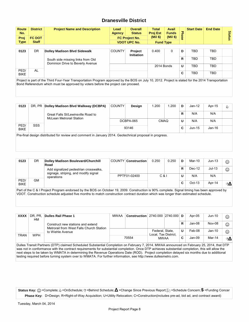
Phase
Route
No.
District Project Name and Description Lead
Agency
Overall
Status
Avail
Funds
(Mil $)
Start Date End Date Status
Total
Proj Est
(Mil $)
VDOT UPC No.
FC DOT
Staff Fund Type
FC Project No.
Dranesville District
Proj
Type
DR Dolley Madison Blvd Sidewalk COUNTY Project
Initiation
0.400 0 TBD TBD
TBD TBD
TBD TBD
TBD TBD
D
R
U
C
South side missing links from Old Dominion Drive to Beverly Avenue
Project is part of the Third Four-Year Transportation Program approved by the BOS on July 10, 2012. Project is slated for the 2014 Transportation Bond Referendum which must be approved by voters before the project can proceed.
0123
2014 Bonds
AL PED/ BIKE
DR, PR Dolley Madison Blvd Walkway (DCBPA) COUNTY Design 1.200 1.200 Jan-12 Apr-15
N/A N/A
N/A N/A
Jun-15 Jan-16
D
R
U
C
Great Falls St/Lewinsville Road to McLean Metrorail Station
C
Pre-final design distributed for review and comment in January 2014. Geotechnical proposal in progress.
0123
CMAQ
SSS
DCBPA-065
93146 PED/
BIKE
DR Dolley Madison Boulevard/Churchill
Road
COUNTY Construction 0.250 0.250 Mar-10 Jun-13
Dec-12 Jul-13
N/A N/A
Oct-13 Apr-14
D
R
U
C
Add signalized pedestrian crosswalks, signage, striping, and modify signal operations
J
J
DΔ
Part of the C & I Project Program endorsed by the BOS on October 19, 2009. Construction is 90% complete. Signal timing has been approved by VDOT. Construction schedule adjusted five months to match construction contract duration which was longer than estimated schedule.
0123
C & I
GM
PPTF01-02400
PED/ BIKE
DR, PR, HM
Dulles Rail Phase 1 MWAA Construction 2740.000 2740.000 Apr-05 Jun-10
Jan-08 Nov-08
Feb-08 Jan-10
Jan-09 Mar-14
D
R
U
C
Construct new stations and extend Metrorail from West Falls Church Station to Wiehle Avenue
J
J
J
DΔ
Dulles Transit Partners (DTP) claimed Scheduled Substantial Completion on February 7, 2014. MWAA announced on February 25, 2014, that DTP was not in conformance with the contract requirements for substantial completion. Once DTP achieves substantial completion, this will allow the next steps to be taken by WMATA in determining the Revenue Operations Date (ROD). Project completion delayed six months due to additional testing required before turning system over to WMATA. For further information, see http://www.dullesmetro.com.
XXXX
Federal, State, Local, Tax District,
MWAAWPH
70554TRAN
Status Key: =Complete; =OnSchedule; =Behind Schedule; =Change Since Previous Report; =Schedule Concern; =Funding Concer
Phase Key: D=Design; R=Right-of-Way Acquisition; U=Utility Relocation; C=Construction(includes pre-ad, bid ad, and contract award)
J C D Δ O $
Tuesday, March 04, 2014
Project Report Page 8

Phase
Route
No.
District Project Name and Description Lead
Agency
Overall
Status
Avail
Funds
(Mil $)
Start Date End Date Status
Total
Proj Est
(Mil $)
VDOT UPC No.
FC DOT
Staff Fund Type
FC Project No.
Dranesville District
Proj
Type
DR, HM Dulles Rail Phase 2 MWAA Construction 3156.000 330.000 Jul-13 Jun-15
Jul-13 Jan-16
Jul-13 Oct-16
Feb-14 Jul-18
D
R
U
C
Construct six new stations, two in Fairfax County, and extend Metrorail from Wiehle Avenue to Route 722 in Loudoun County
C
C
C
C
Bid Packet A (Rail Stations, Systems, and Line) was awarded in May 2013. Notice to proceed was issued in July 2013 with a 60 month Design-Build schedule. The cost estimate with value engineering, Packet A savings, and funding the garages outside of the project brings the revised total project estimate to $2.7 billion. The estimated cost to Fairfax County to construct the parking garages at Herndon and Innovation Center Stations is $135 million. Fairfax County is currently working on options to fund, design, and construct the parking garages at the Herndon and Innovation Center stations. For further information, see http://www.dullesmetro.com.
XXXX
Federal
WPH97226
TRAN
DR, PR Dulles Toll Road Tysons Ramps COUNTY Complete 0.800 0.800 May-11 Jul-13
N/A N/A
N/A N/A
N/A N/A
D
R
U
C
Study to evaluate alternatives for existing and up to three additional interchanges between the Dulles Toll Road and Tysons
J
Study is complete. Analysis to be presented to the Board in March 2014.
0267
C & I
WPHPRI
DR, HM, LE, SP
Fairfax County Parkway/Franconia-
Springfield Parkway
VDOT Construction 0.923 1.429 2012 Jun-13
N/A N/A
N/A N/A
Jul-13 Dec-14
D
R
U
C
Median Safety Improvements
J
C
Approximately two miles of median guardrail and curb modifications along the southern section completed in May 2013. The median of the northern segment of the Parkway will have approximately 1.25 miles of High-Tension Cable barrier system. Construction on the northern section will begin in spring 2014 and be completed by summer 2014. Progress has been slow due to weather.
0286
HSIP
KLM101017, 104002
PRI
DR Georgetown Pike Walkway Phase II DPWES Bid Ad 0.400 0.400 Nov09 Jun-14
Aug-13 Nov-13
TBD TBD
Jul-14 Nov-14
D
R
U
C
Construct 1,750 LF walkway from Utterback Store Road (Krop Property) to Falls Chase Court
D
J
Δ
Δ
Plans have been revised to reflect new trail, handrail, and modify trail alignment in certain areas. Land acquisition authorization obtained from VDOT in July 2013. All land rights have been acquired. ROW certification and construction authorization requested from VDOT; approval is pending. Design completion delayed four months due to required redesign to reflect new trail and handrail, and to modify trail alignment in certain areas. Construction schedule adjusted one month as a result.
0193
TB
W00200-W202B
PED/ BIKE
Status Key: =Complete; =OnSchedule; =Behind Schedule; =Change Since Previous Report; =Schedule Concern; =Funding Concer
Phase Key: D=Design; R=Right-of-Way Acquisition; U=Utility Relocation; C=Construction(includes pre-ad, bid ad, and contract award)
J C D Δ O $
Tuesday, March 04, 2014
Project Report Page 9

Phase
Route
No.
District Project Name and Description Lead
Agency
Overall
Status
Avail
Funds
(Mil $)
Start Date End Date Status
Total
Proj Est
(Mil $)
VDOT UPC No.
FC DOT
Staff Fund Type
FC Project No.
Dranesville District
Proj
Type
DR Georgetown Pike Walkway Phase III COUNTY Design 0.300 0.300 TBD TBD
TBD TBD
TBD TBD
TBD TBD
D
R
U
C
Falls Bridge Lane, extending east to the existing asphalt trail approximately 275 feet
This is an Enhancement Grant Project. NTP for survey and design was issued in December 2013. Survey is in progress, but was delayed due to weather. Schedule to be established upon completion of survey.
0193
MJG
GTP-130
DR Herndon Bus Operations Expansion County Project
Initiation
12.000 12.000 Mar-14 May-15
N/A N/A
N/A N/A
Jan-16 Apr-17
D
R
U
C
Upgrade site and building, and enclosure of 2600 SF canopy at existing facility
Design tentatively scheduled to begin in March 2014.
XXXX
Bonds
DPWES
TF-000017-001
TRAN
DR I-66 Spot Improvements (Inside the
Beltway)
VDOT Construction 33.400 26.000 Feb-12 Jun-13
N/A N/A
N/A N/A
Jul-13 Aug-15
D
R
U
C
Lengthen acceleration/deceleration lanes: Spots 1 and 3 are in Arlington Co., Spot 2 (Sycamore St./Washington Blvd. to DTR) crosses into Fairfax County
J
CΔ
Spot 2 design is complete. Pardon our dust meeting held on January 15, 2014. Construction completion advanced three months.
I-66
Federal
SLC78828
INT
DR Idylwood Road Sidewalk COUNTY Design 0.361 0.361 Jul-13 Nov-15
Feb-15 Sep-15
TBD TBD
Jan-16 Aug-16
D
R
U
C
Construct approximately 600' of 5' Concrete sidewalk along Idylwood Rd from approx. 600' south of Redd Rd to Redd Road
C
Intermediate design is in progress. Utility designation is in progress.
0695
C & I
WPH
PPTF01-06300
SEC
Status Key: =Complete; =OnSchedule; =Behind Schedule; =Change Since Previous Report; =Schedule Concern; =Funding Concer
Phase Key: D=Design; R=Right-of-Way Acquisition; U=Utility Relocation; C=Construction(includes pre-ad, bid ad, and contract award)
J C D Δ O $
Tuesday, March 04, 2014
Project Report Page 10

Phase
Route
No.
District Project Name and Description Lead
Agency
Overall
Status
Avail
Funds
(Mil $)
Start Date End Date Status
Total
Proj Est
(Mil $)
VDOT UPC No.
FC DOT
Staff Fund Type
FC Project No.
Dranesville District
Proj
Type
DR Kirby Road Sidewalk COUNTY Design 0.300 0.150 Apr-13 Jun-15
Sep-14 Apr-15
TBD TBD
TBD TBD
D
R
U
C
North side from Chesterbrook Pool to east of Chesterbrook Elementary School
C
Project is part of the Third Four-Year Transportation Program approved by the BOS on July 10, 2012. Project is slated for the 2014 Transportation Bond Referendum which must be approved by voters before the project can proceed. C & I funds allocated to expedite project. Intermediate design is in progress. Additional survey provided in January 2014 for drainage outfall analysis and potential crosswalk design.
0695
2014 Bonds, C & I
WPH
4YP302-PB05
PED/ BIKE
DR Lewinsville Road Walkway Phase II COUNTY Construction 0.670 0.670 Apr-10 Jul-13
Nov-11 Jun-13
Sep-13 Dec-13
Sep-13 Apr-14
D
R
U
C
Construct 1400 LF walkway along south side from Snow Meadow Lane to Elsinore Avenue
J
J
J
C
Δ
Δ
Part of the C&I Project Program endorsed by the BOS on October 19, 2009. Construction start date changed, but completion date is the same. Construction is 65% complete.
0694
C & I
SSS
PPTF01-03500
PED/ BIKE
DR McLean Streetscapes Phase III COUNTY Design 2.500 1.408 Oct-11 Sep-15
Feb-15 Jun-15
TBD TBD
Dec-15 Sep-16
D
R
U
C
Chain Bridge Road from Laughlin Street to Corner Lane; Center Street to Shell Gas Station.
C
VDOT Transportation Enhancement Grant Project approved on November 8, 2011. This project is being coordinated with Project 008912, CDC McLean Signal Replacement project. Pre-final plan distribution was made in January 2014.
0123
AL
CR-000004-001
DR North West Street Sidewalk COUNTY Project
Initiation
0.300 0 TBD TBD
TBD TBD
TBD TBD
TBD TBD
D
R
U
C
North side from Great Falls Street to Brilyn Place
Project is part of the Third Four-Year Transportation Program approved by the BOS on July 10, 2012. Project is slated for the 2014 Transportation Bond Referendum which must be approved by voters before the project can proceed.
1799
2014 Bonds
WPH PED/ BIKE
Status Key: =Complete; =OnSchedule; =Behind Schedule; =Change Since Previous Report; =Schedule Concern; =Funding Concer
Phase Key: D=Design; R=Right-of-Way Acquisition; U=Utility Relocation; C=Construction(includes pre-ad, bid ad, and contract award)
J C D Δ O $
Tuesday, March 04, 2014
Project Report Page 11

Phase
Route
No.
District Project Name and Description Lead
Agency
Overall
Status
Avail
Funds
(Mil $)
Start Date End Date Status
Total
Proj Est
(Mil $)
VDOT UPC No.
FC DOT
Staff Fund Type
FC Project No.
Dranesville District
Proj
Type
DR Old Dominion and Holmes Place COUNTY Design 0.150 0.150 Sep-13 Jan-15
N/A N/A
N/A N/A
Apr-15 Oct-15
D
R
U
C
Install median and McLean gateway sign
C
VDOT Transportation Enhancement Grant approved and received April 17, 2013. Intermediate design is underway.
0738
Enhancement
MJG
MCL-093
SEC
DR Old Dominion Drive and Bellview Road COUNTY Design 0.400 0.400 Oct-13 Sep-15
Nov-14 Jul-15
TBD TBD
Nov-15 Jun-16
D
R
U
C
Improve sight distance at intersection
C
Intermediate design is in progress. A meeting with VDOT is being scheduled to discuss the design and project constraints.
0309
C&I
SLC
RSPI01-01500
PRI
DR Old Dominion Drive and Linway
Terrace/Birch Road
COUNTY Project
Initiation
0.400 0.400 Jul-13 Jul-15
Oct-14 Apr-15
TBD TBD
Aug-15 Dec-15
D
R
U
C
Pedestrian intersection and bus stop improvements
C
Survey is in progress.
0309
C&I
SLC
PPTF01-06200
PED/ BIKE
DR, PR Pavement Marking Plans (TMSAMS) Project
Initiation
0.100 0.100 TBD TBD
TBD TBD
TBD TBD
TBD TBD
D
R
U
C
Magarity Road, Jones Branch Drive, Westmoreland St, Madrillon Road
Project is part of the Third Four-Year Transportation Program approved by the BOS on July 10, 2012. Project scoping will begin in spring 2014.
XXXX
RSTP
CWS PED/ BIKE
Status Key: =Complete; =OnSchedule; =Behind Schedule; =Change Since Previous Report; =Schedule Concern; =Funding Concer
Phase Key: D=Design; R=Right-of-Way Acquisition; U=Utility Relocation; C=Construction(includes pre-ad, bid ad, and contract award)
J C D Δ O $
Tuesday, March 04, 2014
Project Report Page 12
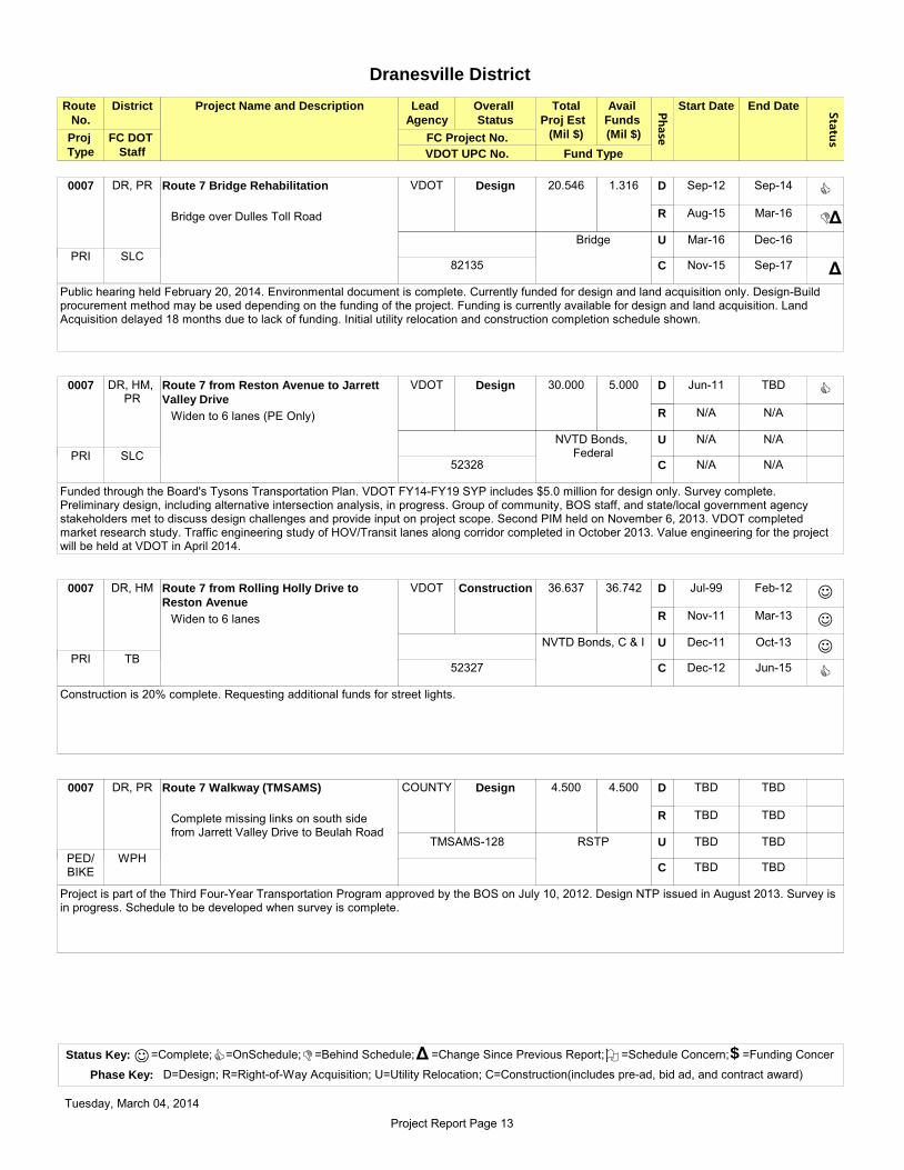
Phase
Route
No.
District Project Name and Description Lead
Agency
Overall
Status
Avail
Funds
(Mil $)
Start Date End Date Status
Total
Proj Est
(Mil $)
VDOT UPC No.
FC DOT
Staff Fund Type
FC Project No.
Dranesville District
Proj
Type
DR, PR Route 7 Bridge Rehabilitation VDOT Design 20.546 1.316 Sep-12 Sep-14
Aug-15 Mar-16
Mar-16 Dec-16
Nov-15 Sep-17
D
R
U
C
Bridge over Dulles Toll Road
C
DΔ
Δ
Public hearing held February 20, 2014. Environmental document is complete. Currently funded for design and land acquisition only. Design-Build procurement method may be used depending on the funding of the project. Funding is currently available for design and land acquisition. Land Acquisition delayed 18 months due to lack of funding. Initial utility relocation and construction completion schedule shown.
0007
Bridge
SLC82135
PRI
DR, HM, PR
Route 7 from Reston Avenue to Jarrett
Valley Drive
VDOT Design 30.000 5.000 Jun-11 TBD
N/A N/A
N/A N/A
N/A N/A
D
R
U
C
Widen to 6 lanes (PE Only)
C
Funded through the Board's Tysons Transportation Plan. VDOT FY14-FY19 SYP includes $5.0 million for design only. Survey complete. Preliminary design, including alternative intersection analysis, in progress. Group of community, BOS staff, and state/local government agency stakeholders met to discuss design challenges and provide input on project scope. Second PIM held on November 6, 2013. VDOT completed market research study. Traffic engineering study of HOV/Transit lanes along corridor completed in October 2013. Value engineering for the project will be held at VDOT in April 2014.
0007
NVTD Bonds, FederalSLC
52328PRI
DR, HM Route 7 from Rolling Holly Drive to
Reston Avenue
VDOT Construction 36.637 36.742 Jul-99 Feb-12
Nov-11 Mar-13
Dec-11 Oct-13
Dec-12 Jun-15
D
R
U
C
Widen to 6 lanes
J
J
J
C
Construction is 20% complete. Requesting additional funds for street lights.
0007
NVTD Bonds, C & I
TB52327
PRI
DR, PR Route 7 Walkway (TMSAMS) COUNTY Design 4.500 4.500 TBD TBD
TBD TBD
TBD TBD
TBD TBD
D
R
U
C
Complete missing links on south side from Jarrett Valley Drive to Beulah Road
Project is part of the Third Four-Year Transportation Program approved by the BOS on July 10, 2012. Design NTP issued in August 2013. Survey is in progress. Schedule to be developed when survey is complete.
0007
RSTP
WPH
TMSAMS-128
PED/ BIKE
Status Key: =Complete; =OnSchedule; =Behind Schedule; =Change Since Previous Report; =Schedule Concern; =Funding Concer
Phase Key: D=Design; R=Right-of-Way Acquisition; U=Utility Relocation; C=Construction(includes pre-ad, bid ad, and contract award)
J C D Δ O $
Tuesday, March 04, 2014
Project Report Page 13

Phase
Route
No.
District Project Name and Description Lead
Agency
Overall
Status
Avail
Funds
(Mil $)
Start Date End Date Status
Total
Proj Est
(Mil $)
VDOT UPC No.
FC DOT
Staff Fund Type
FC Project No.
Dranesville District
Proj
Type
DR, HM Route 7/Baron Cameron
Avenue/Springvale Road
COUNTY Construction 0.375 0.375 Jun-12 Sep-13
Nov-09 Aug-10
N/A N/A
Oct-13 Apr-14
D
R
U
C
Add signalized pedestrian crosswalks, signage, striping, and modify signal operations
J
J
D
Δ
Δ
Part of the C&I Project Program endorsed by the BOS on October 19, 2009. Construction is 60% complete. Schedule was adjusted in October to match construction contract duration which was longer than estimated schedule.
0007
C & I
WPH
PPTF01-01600
PED/ BIKE
DR Route 7/Colvin Run Road COUNTY ROW 2.150 2.150 Oct-10 Jun-14
Feb-14 Jun-14
TBD TBD
Feb-15 Oct-15
D
R
U
C
Add signalized pedestrian crosswalks, signage, striping, and modify signal operations
D
C
Δ
Δ
Δ
Part of the C&I Project Program endorsed by the BOS on October 19, 2009. Final design plans submitted to VDOT in January 2014. Project plat and utility plats submitted to Land Acquisition. Design completion delayed nine months due to additional utility land rights and utility relocation requirements. Land Acquisition schedule established and Construction completion adjusted 18 months as a result.
0007
C & I
SLC
PPTF01-01800
PED/ BIKE
DR Route 7/Lewinsville Road COUNTY Construction 0.150 0.150 Sep-10 Sep-13
N/A N/A
N/A N/A
Oct-13 Apr-14
D
R
U
C
Add signalized pedestrian crosswalks, signage, striping, and modify signal operations
J
D
Δ
Δ
Part of the C&I Project Program endorsed by the BOS on October 19, 2009. Final construction package sent to UDCD in October 2013. Design completed one month later than previously reported. Construction schedule adjusted four months to match construction contract duration which was longer than estimated schedule.
0007
C & I
SLC
PPTF01-02700
PED/ BIKE
DR Route 7/Towlston Road COUNTY Design 1.250 0.750 Jan-10 Feb-15
Apr-14 Nov-14
Aug-13 Dec-14
Mar-15 Dec-15
D
R
U
C
Add a left turn lane from NB Towlston Road to WB Route 7
D
C
Δ
Δ
Δ
Δ
Pre-final design is in progress. VDOT review comments were received in December 2013. Comments are being reviewed and resolved for 2nd pre-final submission. Project plat revision is in progress. Design completion delayed 13 months due to requirements to update stormwater management design and evaluation requirements. Land Acquisition schedule adjusted ten months, Utility Relocation adjusted 11 months, and Construction completion adjusted 13 months as a result.
0007
2007 Bonds
WPH
4YP206
PRI
Status Key: =Complete; =OnSchedule; =Behind Schedule; =Change Since Previous Report; =Schedule Concern; =Funding Concer
Phase Key: D=Design; R=Right-of-Way Acquisition; U=Utility Relocation; C=Construction(includes pre-ad, bid ad, and contract award)
J C D Δ O $
Tuesday, March 04, 2014
Project Report Page 14
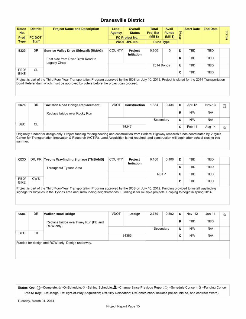
Phase
Route
No.
District Project Name and Description Lead
Agency
Overall
Status
Avail
Funds
(Mil $)
Start Date End Date Status
Total
Proj Est
(Mil $)
VDOT UPC No.
FC DOT
Staff Fund Type
FC Project No.
Dranesville District
Proj
Type
DR Sunrise Valley Drive Sidewalk (RMAG) COUNTY Project
Initiation
0.300 0 TBD TBD
TBD TBD
TBD TBD
TBD TBD
D
R
U
C
East side from River Birch Road to Legacy Circle
Project is part of the Third Four-Year Transportation Program approved by the BOS on July 10, 2012. Project is slated for the 2014 Transportation Bond Referendum which must be approved by voters before the project can proceed.
5320
2014 Bonds
CL PED/ BIKE
DR Towlston Road Bridge Replacement VDOT Construction 1.384 0.434 Apr-12 Nov-13
N/A N/A
N/A N/A
Feb-14 Aug-14
D
R
U
C
Replace bridge over Rocky Run
J
C
Originally funded for design only. Project funding for engineering and construction from Federal Highway research funds coordinated by Virginia Center for Transportation Innovation & Research (VCTIR). Land Acquisition is not required, and construction will begin after school closing this summer.
0676
Secondary
CL76247
SEC
DR, PR Tysons Wayfinding Signage (TMSAMS) COUNTY Project
Initiation
0.100 0.100 TBD TBD
TBD TBD
TBD TBD
TBD TBD
D
R
U
C
Throughout Tysons Area
Project is part of the Third Four-Year Transportation Program approved by the BOS on July 10, 2012. Funding provided to install wayfinding signage for bicycles in the Tysons area and surrounding neighborhoods. Funding is for multiple projects. Scoping to begin in spring 2014.
XXXX
RSTP
CWS PED/ BIKE
DR Walker Road Bridge VDOT Design 2.750 0.892 Nov -12 Jun-14
TBD TBD
N/A N/A
N/A N/A
D
R
U
C
Replace bridge over Piney Run (PE and ROW only)
C
Funded for design and ROW only. Design underway.
0681
Secondary
TB84383
SEC
Status Key: =Complete; =OnSchedule; =Behind Schedule; =Change Since Previous Report; =Schedule Concern; =Funding Concer
Phase Key: D=Design; R=Right-of-Way Acquisition; U=Utility Relocation; C=Construction(includes pre-ad, bid ad, and contract award)
J C D Δ O $
Tuesday, March 04, 2014
Project Report Page 15

Phase
Route
No.
District Project Name and Description Lead
Agency
Overall
Status
Avail
Funds
(Mil $)
Start Date End Date Status
Total
Proj Est
(Mil $)
VDOT UPC No.
FC DOT
Staff Fund Type
FC Project No.
Dranesville District
Proj
Type
DR Walker Road Road Diet COUNTY Construction 1.000 1.000 Jul-10 Apr-13
Apr-12 Nov-12
N/A N/A
Jul-13 Mar-14
D
R
U
C
Add street parking spaces and landscaping, restripe roadway, and provide crosswalks at business district intersections south of Georgetown Pike
J
J
DΔ
Construction is 85% complete. Construction completion adjusted three months due to weather.
0681
C & I
TB
RSPI01-00300
SEC
DR Westmoreland Street/Haycock Road COUNTY Complete 0.880 0.880 Mar-11 Sep-12
May-12 Jan-13
Dec-12 Sep-13
Feb-13 Nov-13
D
R
U
C
Install right turn lane and concrete sidewalk along the west side of Westmoreland Street from Haycock Road to Temple Rodef Shalom
J
J
J
JΔ
Construction is complete.
0693
2007 Bond, C & I
TB
RSPI01-01200
SEC
DR Westmoreland Street/Old Chesterbrook
Road
COUNTY Design 0.545 0.545 Jan-10 Jan-15
May-14 Dec-14
TBD TBD
Mar-15 Oct-15
D
R
U
C
Re-align intersection, new storm drainage, crosswalks on Westmoreland St. from entrance to McLean High School to Old Chesterbrook Road
DΔ
Δ
Δ
Part of the C&I Project Program endorsed by the BOS on October 19, 2009. Plans are being prepared for a pre-final submission. Design contract addendum for redesign due to VDOT comments under review. Design completion delayed nine months due to redesign based on VDOT comments related to cross slope and sight distance. Land Acquisition schedule adjusted nine months, and Construction schedule adjusted seven months as a result.
0693
C & I
GM
PPTF01-04400
PED/ BIKE
Status Key: =Complete; =OnSchedule; =Behind Schedule; =Change Since Previous Report; =Schedule Concern; =Funding Concer
Phase Key: D=Design; R=Right-of-Way Acquisition; U=Utility Relocation; C=Construction(includes pre-ad, bid ad, and contract award)
J C D Δ O $
Tuesday, March 04, 2014
Project Report Page 16

4-Year Project Summary Report
Phase
Route
No.
District Project Name and Description Lead
Agency
Overall
Status
Avail
Funds
(Mil $)
Start Date End Date Status
Total
Proj Est
(Mil $)
VDOT UPC No.
FC DOT
Staff Fund Type
FC Project No.
Hunter Mill District
Proj
Type
HM Ashgrove Lane Trail (TMSAMS) COUNTY Design 0.650 0.500 TBD TBD
TBD TBD
TBD TBD
TBD TBD
D
R
U
C
Trail along Ashgrove Lane to western Tysons
Project is part of the Third Four-Year Transportation Program approved by the BOS on July 10, 2012. Project is split into two phases. In phase 1, FCPA will repave and reinforce the existing trail on FCPA property which should be complete in summer 2014. In phase 2, FCDOT will construct a trail from the end of the existing trail to Westwood Center Drive.
XXXX
RSTP
VA
TMSAMS-121
PED/ BIKE
HM Beulah Road Walkway COUNTY ROW 1.6600 1.6600 Nov-08 Jul-14
Oct-13 Jun-14
Aug-13 Aug-14
Aug-14 Dec-15
D
R
U
C
Install 4700 LF asphalt sidewalk and crosswalks on alternate sides of Beulah Road from Abbotsford Drive to Coral Crest Lane and along Clarks Crossing Road
D
C
D
Δ
Δ
Δ
Δ
Final design is in progress. Land Acquisition NTP issued in October 2013. 10 of 19 properties acquired. Schedule was originally adjusted due to need for utility plats, but were later able to redesign to avoid land rights. Design was delayed five months for the redesign. Land Acquisition schedule adjusted four months as a result. Utility Relocation schedule delayed six months, and Construction schedule adjusted 12 months as a result.
0675
2007 Bonds
JYR
4YP201-PB009
PED/ BIKE
DR, PR, HM
Dulles Rail Phase 1 MWAA Construction 2740.000 2740.000 Apr-05 Jun-10
Jan-08 Nov-08
Feb-08 Jan-10
Jan-09 Mar-14
D
R
U
C
Construct new stations and extend Metrorail from West Falls Church Station to Wiehle Avenue
J
J
J
DΔ
Dulles Transit Partners (DTP) claimed Scheduled Substantial Completion on February 7, 2014. MWAA announced on February 25, 2014, that DTP was not in conformance with the contract requirements for substantial completion. Once DTP achieves substantial completion, this will allow the next steps to be taken by WMATA in determining the Revenue Operations Date (ROD). Project completion delayed six months due to additional testing required before turning system over to WMATA. For further information, see http://www.dullesmetro.com.
XXXX
Federal, State, Local, Tax District,
MWAAWPH
70554TRAN
DR, HM Dulles Rail Phase 2 MWAA Construction 3156.000 330.000 Jul-13 Jun-15
Jul-13 Jan-16
Jul-13 Oct-16
Feb-14 Jul-18
D
R
U
C
Construct six new stations, two in Fairfax County, and extend Metrorail from Wiehle Avenue to Route 722 in Loudoun County
C
C
C
C
Bid Packet A (Rail Stations, Systems, and Line) was awarded in May 2013. Notice to proceed was issued in July 2013 with a 60 month Design-Build schedule. The cost estimate with value engineering, Packet A savings, and funding the garages outside of the project brings the revised total project estimate to $2.7 billion. The estimated cost to Fairfax County to construct the parking garages at Herndon and Innovation Center Stations is $135 million. Fairfax County is currently working on options to fund, design, and construct the parking garages at the Herndon and Innovation Center stations. For further information, see http://www.dullesmetro.com.
XXXX
Federal
WPH97226
TRAN
Status Key: =Complete; =OnSchedule; =Behind Schedule; =Change Since Previous Report; =Schedule Concern; =Funding Concer
Phase Key: D=Design; R=Right-of-Way Acquisition; U=Utility Relocation; C=Construction(includes pre-ad, bid ad, and contract award)
J C D Δ O $
Tuesday, March 04, 2014
Project Report Page 17

Phase
Route
No.
District Project Name and Description Lead
Agency
Overall
Status
Avail
Funds
(Mil $)
Start Date End Date Status
Total
Proj Est
(Mil $)
VDOT UPC No.
FC DOT
Staff Fund Type
FC Project No.
Hunter Mill District
Proj
Type
DR, HM, LE, SP
Fairfax County Parkway/Franconia-
Springfield Parkway
VDOT Construction 0.923 1.429 2012 Jun-13
N/A N/A
N/A N/A
Jul-13 Dec-14
D
R
U
C
Median Safety Improvements
J
C
Approximately two miles of median guardrail and curb modifications along the southern section completed in May 2013. The median of the northern segment of the Parkway will have approximately 1.25 miles of High-Tension Cable barrier system. Construction on the northern section will begin in spring 2014 and be completed by summer 2014. Progress has been slow due to weather.
0286
HSIP
KLM101017, 104002
PRI
HM Fox Mill Road/Monroe Street COUNTY ROW 0.850 0.850 Nov-10 May-14
Jun-12 May-14
Mar-13 Aug-13
Jun-14 May-15
D
R
U
C
Install right turn lane on WB Fox Mill Road and add pedestrian improvements
D
C
J
Δ
Δ
Δ
Second pre-final design submitted to VDOT in December 2013. Revising signal plan per VDOT Traffic Engineering comments. Additional plats received for signal equipment easement in November 2013 and were forwarded to Land Acquisition in December 2013. Land Acquisition phase restarted to acquire new land rights that are required. Design schedule adjusted ten months and Construction schedule adjusted 15 months as a result.
0665
C & I
TB
RSPI01-00500
SEC
HM Gosnell Road Walkway (DCBPA) COUNTY Design 0.220 0.220 Oct-12 Feb-15
Apr-14 Nov-14
N/A N/A
Apr-15 Oct-15
D
R
U
C
Install 300 LF of walkway on east side, north of Route 123
DΔ
Δ
Δ
Final design is in progress. Right-of-Way package was submitted to VDOT for authorization in January 2014. This project will be built utilizing the countywide permit. Design completion delayed three months for VDOT to review design plans. Land Acquisition schedule adjusted two months and Construction schedule adjusted three months as a result.
0939
CMAQ
AL
DCBPA-072
93146 PED/
BIKE
HM Hunter Mill Road Bridge over Difficult
Run (PE Only)
VDOT Project
Initiation
0.320 0.320 TBD TBD
N/A N/A
N/A N/A
N/A N/A
D
R
U
C
Replace temporary bridge with permanent structure
Project scoping underway by VDOT. Design schedule will be determined after scoping is complete.
0674
WPH102691
SEC
Status Key: =Complete; =OnSchedule; =Behind Schedule; =Change Since Previous Report; =Schedule Concern; =Funding Concer
Phase Key: D=Design; R=Right-of-Way Acquisition; U=Utility Relocation; C=Construction(includes pre-ad, bid ad, and contract award)
J C D Δ O $
Tuesday, March 04, 2014
Project Report Page 18

Phase
Route
No.
District Project Name and Description Lead
Agency
Overall
Status
Avail
Funds
(Mil $)
Start Date End Date Status
Total
Proj Est
(Mil $)
VDOT UPC No.
FC DOT
Staff Fund Type
FC Project No.
Hunter Mill District
Proj
Type
HM Hunter Mill Road/Sunrise Valley Drive COUNTY Design 0.500 0.500 Apr-13 Apr-15
Jul-14 Mar-15
TBD TBD
May-15 Jan-16
D
R
U
C
Add signalized pedestrian crosswalks, signage, striping, and modify signal operations
DΔ
Δ
Δ
Pre-final design is in progress. The existing signals at this intersection are part of VDOT's signal rebuild list. Traffic Signal Plans in progress. Project plats are in progress. Design completion delayed one month because additional survey took longer than anticipated. Land Acquisition and Construction schedules adjusted accordingly.
0674
C & I
SSS
PPTF01-03100
PED/ BIKE
HM Isaac Newton Sq W (RMAG) COUNTY On Hold 2.517 2.517 TBD TBD
TBD TBD
TBD TBD
TBD TBD
D
R
U
C
Widen from Isaac Newton Square south to station entrance and install walkway
Project is part of the Third Four-Year Transportation Program approved by the BOS on July 10, 2012. Project on hold pending outcome of discussion with property owners.
XXXX
RSTP
WPH PED/ BIKE
HM Old Courthouse Road Trail (TMSAMS) COUNTY Project
Initiation
0.115 0.115 TBD TBD
TBD TBD
TBD TBD
TBD TBD
D
R
U
C
Trail on one side from Westbriar Drive northeast to Battery Park Street
Project is part of the Third Four-Year Transportation Program approved by the BOS on July 10, 2012. Project re-scoped due to right-of-way and road alignment issues. FCDOT currently coordinating project with necessary parties.
0677
RSTP
VA
TMSAMS-122
PED/ BIKE
HM Plaza America Proffer Agreement
(PA02B)
COUNTY Complete 0.230 0.230 Nov-03 May-12
Oct-10 Nov-12
Feb-13 Jun-13
Aug-13 Dec-13
D
R
U
C
Proffer contribution for pedestrian enhancements: Install walkway on Sunset Hills Road from Reston Center to Town Center Parkway
J
J
J
JΔ
Project complete.
0675
Proffer
SLC
D00448-PA02B
PED/ BIKE
Status Key: =Complete; =OnSchedule; =Behind Schedule; =Change Since Previous Report; =Schedule Concern; =Funding Concer
Phase Key: D=Design; R=Right-of-Way Acquisition; U=Utility Relocation; C=Construction(includes pre-ad, bid ad, and contract award)
J C D Δ O $
Tuesday, March 04, 2014
Project Report Page 19

Phase
Route
No.
District Project Name and Description Lead
Agency
Overall
Status
Avail
Funds
(Mil $)
Start Date End Date Status
Total
Proj Est
(Mil $)
VDOT UPC No.
FC DOT
Staff Fund Type
FC Project No.
Hunter Mill District
Proj
Type
HM Plaza America Proffer Agreement
(PA060J)
COUNTY On Hold 0.030 0.030 Feb-04 Oct-05
Oct-05 TBD
TBD TBD
TBD TBD
D
R
U
C
Proffer contribution for public transportation enhancements: EB Sunset Hills Road at Target
J
Land acquisition unsuccessful. Funds may be available to reinitiate project after completion of walkway project (Project No. D00448-PA02B).
0675
Proffer
SLC
D00448-PA060J
PED/ BIKE
HM Reston Town Center Transit Station
Modifications
COUNTY Complete 0.500 0.500 Apr-13 June-13
N/A N/A
N/A N/A
Jul-13 Nov-13
D
R
U
C
Design and construction of various site improvements at the existing facility
J
J
Project is complete.
XXXX
County, State
DPWES
TF-000016-001
TRAN
DR, HM, PR
Route 7 from Reston Avenue to Jarrett
Valley Drive
VDOT Design 30.000 5.000 Jun-11 TBD
N/A N/A
N/A N/A
N/A N/A
D
R
U
C
Widen to 6 lanes (PE Only)
C
Funded through the Board's Tysons Transportation Plan. VDOT FY14-FY19 SYP includes $5.0 million for design only. Survey complete. Preliminary design, including alternative intersection analysis, in progress. Group of community, BOS staff, and state/local government agency stakeholders met to discuss design challenges and provide input on project scope. Second PIM held on November 6, 2013. VDOT completed market research study. Traffic engineering study of HOV/Transit lanes along corridor completed in October 2013. Value engineering for the project will be held at VDOT in April 2014.
0007
NVTD Bonds, FederalSLC
52328PRI
DR, HM Route 7 from Rolling Holly Drive to
Reston Avenue
VDOT Construction 36.637 36.742 Jul-99 Feb-12
Nov-11 Mar-13
Dec-11 Oct-13
Dec-12 Jun-15
D
R
U
C
Widen to 6 lanes
J
J
J
C
Construction is 20% complete. Requesting additional funds for street lights.
0007
NVTD Bonds, C & I
TB52327
PRI
Status Key: =Complete; =OnSchedule; =Behind Schedule; =Change Since Previous Report; =Schedule Concern; =Funding Concer
Phase Key: D=Design; R=Right-of-Way Acquisition; U=Utility Relocation; C=Construction(includes pre-ad, bid ad, and contract award)
J C D Δ O $
Tuesday, March 04, 2014
Project Report Page 20

Phase
Route
No.
District Project Name and Description Lead
Agency
Overall
Status
Avail
Funds
(Mil $)
Start Date End Date Status
Total
Proj Est
(Mil $)
VDOT UPC No.
FC DOT
Staff Fund Type
FC Project No.
Hunter Mill District
Proj
Type
DR, HM Route 7/Baron Cameron
Avenue/Springvale Road
COUNTY Construction 0.375 0.375 Jun-12 Sep-13
Nov-09 Aug-10
N/A N/A
Oct-13 Apr-14
D
R
U
C
Add signalized pedestrian crosswalks, signage, striping, and modify signal operations
J
J
D
Δ
Δ
Part of the C&I Project Program endorsed by the BOS on October 19, 2009. Construction is 60% complete. Schedule was adjusted in October to match construction contract duration which was longer than estimated schedule.
0007
C & I
WPH
PPTF01-01600
PED/ BIKE
HM, PR Route 7/Route 123 Interchange (Study
Only)
COUNTY Study 0.350 0.350 Sep-12 TBD
N/A N/A
N/A N/A
N/A N/A
D
R
U
C
Conceptual design and traffic operations study to determine future interchange configuration or at-grade intersection configuration
DΔ
Project combined with Route 7 widening from Route 123 to I-495 Study. Ground survey is complete. Traffic counts are completed. Conceptual interchange/intersection alternatives developed which will be studied further after additional Tyson Consolidated Traffic Impact Analysis (CTIA) simulations are completed. New schedule will be developed once CTIA work is complete.
0007
C & I
TB
2G40-035-002
PRI
HM Soapstone Drive Connector/Overpass COUNTY Complete 0.300 0.300 Apr-12 Feb-14
N/A N/A
N/A N/A
N/A N/A
D
R
U
C
Feasibility study for connector/overpass from Sunrise Valley Drive to Sunset Hills Road (study only)
JΔ
Study is complete and final alternative recommended. Recommended alternative will be presented to the Board for approval at a future date. Presentation of recommended alternative to Hunter Mill TAC in February 2014. Once the alternative alignment is approved, the preliminary engineering phase will begin.
4720
C & I
JYR
R4720X
SEC
HM Soapstone Drive Walkway COUNTY Utilities 1.740 1.740 Jan-10 Mar-14
Jan-13 Oct-13
Jan-13 Aug-14
Sep-14 Jul-15
D
R
U
C
Install walkway along east side from South Lakes Drive to Snakeden Stream Valley
D
J
D
Δ
Δ
Δ
Δ
Final design is in progress. Addressing additional comments from VDOT. Draft bid package was received from UDCD in February 2014 which will be forwarded to VDOT. Land Acquisition completed three months after previously reported date. Utility relocation delayed ten months to allow for utility design, obtaining utility permits, and utility relocations which must be completed prior to bid advertisement (a federally funded program requirement). Design schedule adjusted three months, and Construction schedule adjusted seven months as a result.
4720
CMAQ
WPH
26008G-07001
70632 PED/
BIKE
Status Key: =Complete; =OnSchedule; =Behind Schedule; =Change Since Previous Report; =Schedule Concern; =Funding Concer
Phase Key: D=Design; R=Right-of-Way Acquisition; U=Utility Relocation; C=Construction(includes pre-ad, bid ad, and contract award)
J C D Δ O $
Tuesday, March 04, 2014
Project Report Page 21

Phase
Route
No.
District Project Name and Description Lead
Agency
Overall
Status
Avail
Funds
(Mil $)
Start Date End Date Status
Total
Proj Est
(Mil $)
VDOT UPC No.
FC DOT
Staff Fund Type
FC Project No.
Hunter Mill District
Proj
Type
HM Sunrise Valley Drive Sidewalk (RMAG) COUNTY Design 4.284 2.484 Aug-13 Aug-15
TBD TBD
TBD TBD
Nov-15 Jun-16
D
R
U
C
Complete missing sidewalk links from Glade Drive to Reston Parkway (south side) and pedestrian intersection improvements at Mercator Drive
C
Project is part of the Third Four-Year Transportation Program approved by the BOS on July 10, 2012. Intermediate design submitted to VDOT for review and comment in December 2013.
5320
TB
RMAG-100
PED/ BIKE
HM Sunrise Valley Drive Walkway (DCBPA) COUNTY Design 1.575 0.470 Sep-12 Feb-16
Jul-14 Apr-15
TBD TBD
Apr-16 Jul-17
D
R
U
C
4,500 LF of 10' wide shared use path on the North side from Soapstone Drive to South Lakes Drive and pedestrian intersection improvements at Commerce Park Drive and Great Meadow Drive
C
Δ
Pre-final design plans were distributed for review in November 2013. Project will require design waiver for reduced buffer width. Utility relocation work is expected to be extensive. Geotechnical report in progress. Land acquisition phase delayed three months, but overall completion date did not change.
5320
CMAQ
AL
DCBPA-074
93146 PED/
BIKE
HM Sunrise Valley Drive Walkway (DCBPA) COUNTY Design 1.750 0.500 Sep-12 Feb-16
Jul-14 Apr-15
TBD TBD
Apr-16 Jul-17
D
R
U
C
5,000 LF of concrete sidewalk on the South side from Soapstone Drive to South Lakes Drive
C
Δ
Pre-final design plan was distributed for review in October 2013. Project will require design waiver for reduced buffer width. Utility relocation work is expected to be extensive. Land acquisition phase delayed three months, but overall completion date did not change.
5320
CMAQ
AL
DCBPA-073
93146 PED/
BIKE
HM Sunrise Valley Drive/Commerce Park
Drive (RMAG)
COUNTY Project
Initiation
0.054 0.054 TBD TBD
TBD TBD
TBD TBD
TBD TBD
D
R
U
C
Pedestrian intersection improvements
Project is part of the Third Four-Year Transportation Program approved by the BOS on July 10, 2012. Project combined with trail project on the north side of Sunrise Valley Drive, DCBPA-074.
5320
RSTP
SSS PED/ BIKE
Status Key: =Complete; =OnSchedule; =Behind Schedule; =Change Since Previous Report; =Schedule Concern; =Funding Concer
Phase Key: D=Design; R=Right-of-Way Acquisition; U=Utility Relocation; C=Construction(includes pre-ad, bid ad, and contract award)
J C D Δ O $
Tuesday, March 04, 2014
Project Report Page 22

Phase
Route
No.
District Project Name and Description Lead
Agency
Overall
Status
Avail
Funds
(Mil $)
Start Date End Date Status
Total
Proj Est
(Mil $)
VDOT UPC No.
FC DOT
Staff Fund Type
FC Project No.
Hunter Mill District
Proj
Type
HM Sunrise Valley Drive/Mercator Drive -
USGS (RMAG)
COUNTY Project
Initiation
0.200 0.200 TBD TBD
TBD TBD
TBD TBD
TBD TBD
D
R
U
C
Pedestrian intersection improvements
Project is part of the Third Four-Year Transportation Program approved by the BOS on July 10, 2012. Project combined with Sunrise Valley Sidewalk project from Glade Drive to Reston Parkway, RMAG-100
5320
RSTP
SSS PED/ BIKE
HM Sunrise Valley/Great Meadow/Centennial
Park Drive (RMAG)
COUNTY Project
Initiation
0.097 0.097 TBD TBD
TBD TBD
TBD TBD
TBD TBD
D
R
U
C
Pedestrian intersection improvements
Project is part of the Third Four-Year Transportation Program approved by the BOS on July 10, 2012. Project combined with trail project on the north side of Sunrise Valley Drive, DCBPA-074
5320
RSTP
SSS PED/ BIKE
HM Sunset Hills Road Walkway COUNTY Utilities 0.240 0.240 Dec-07 Oct-14
Nov-10 Oct-13
Jan-14 Dec-14
Nov-14 Aug-15
D
R
U
C
Install 1,500 LF concrete sidewalk along the north side of Sunset Hills Road from the W&OD Trail to Michael Faraday Court
D
J
C
Δ
Δ
Second Pre-final design including TMP, Pavement Marking and Design Waiver for utility strip submitted for approval in October 2013. Comments have been received from VDOT which are being addressed by FCDOT and waiver will need to be resubmitted. Design completion delayed 13 months due to negotiating tree compensation with land owner, redesign required due to comments from Fairfax Water, and the need to resubmit waiver. Construction schedule was re-established as shown once land acquisition was completed.
0675
2007 Bonds
CL
4YP201-PB017
PED/ BIKE
HM Sunset Hills Road/Town Center Parkway
(RMAG)
COUNTY Design 0.200 0.200 Aug-13 Sep-15
Aug-14 Mar-15
TBD TBD
Oct-15 Apr-16
D
R
U
C
Pedestrian intersection improvements
C
Project is part of the Third Four-Year Transportation Program approved by the BOS on July 10, 2012. Intermediate design distributed in January 2014.
0675
RSTP
SSS
RMAG-99
PED/ BIKE
Status Key: =Complete; =OnSchedule; =Behind Schedule; =Change Since Previous Report; =Schedule Concern; =Funding Concer
Phase Key: D=Design; R=Right-of-Way Acquisition; U=Utility Relocation; C=Construction(includes pre-ad, bid ad, and contract award)
J C D Δ O $
Tuesday, March 04, 2014
Project Report Page 23

Phase
Route
No.
District Project Name and Description Lead
Agency
Overall
Status
Avail
Funds
(Mil $)
Start Date End Date Status
Total
Proj Est
(Mil $)
VDOT UPC No.
FC DOT
Staff Fund Type
FC Project No.
Hunter Mill District
Proj
Type
HM Town Center Parkway (RMAG) COUNTY Study 6.148 6.148 TBD TBD
TBD TBD
TBD TBD
TBD TBD
D
R
U
C
Underpass/Overpass connection across DTR - structural underpin (study only)
Project is part of the Third Four-Year Transportation Program approved by the BOS on July 10, 2012. NTP was issued to the consultants in March 2013 for conceptual design of the bridge structure that will carry the Metrorail over future Town Center Parkway. County requested MWAA to issue a change order to the structure. Coordination with MWAA is ongoing. Phase 2 Design-Build contract to price final design and construction of this bridge structure.
7414
RSTP
SLC PED/ BIKE
HM Vesper Court Trail (TMSAMS) COUNTY Design 1.000 1.000 Aug-13 Feb-16
Mar-15 Oct-15
TBD TBD
May-16 Jun-17
D
R
U
C
Trail from Vesper Court to Route 7 at Spring Hill Road
C
Project is part of the Third Four-Year Transportation Program approved by the BOS on July 10, 2012. Conceptual design received in December 2013 and distributed to internal county agencies for review.
XXXX
RSTP
VA
TMSAMS-120
PED/ BIKE
HM Wiehle Ave Station Walkway/Bikeway
(RMAG)
COUNTY On Hold 0.500 0.500 TBD TBD
TBD TBD
TBD TBD
TBD TBD
D
R
U
C
Station entrance to Sunrise Valley Drive
Project is part of the Third Four-Year Transportation Program approved by the BOS on July 10, 2012. Project is on hold pending discussion with property owners.
0828
RSTP
TB PED/ BIKE
HM Wiehle Avenue Park-and-Ride Garage MWAA Complete 121.400 121.400 Mar-10 Nov-11
Oct-10 Mar-12
Dec-10 Aug-13
Apr-11 Aug-13
D
R
U
C
Construct 2,300 space parking garage with 10 bus bays and 42 Kiss and Ride spaces at the (future) Wiehle-Reston East Metrorail Station
J
J
J
J
Δ
Δ
Substantial completion reached one month later than previously reported. Garage will open with the Silver Line in spring-summer 2014.
0828
SSSTRAN
Status Key: =Complete; =OnSchedule; =Behind Schedule; =Change Since Previous Report; =Schedule Concern; =Funding Concer
Phase Key: D=Design; R=Right-of-Way Acquisition; U=Utility Relocation; C=Construction(includes pre-ad, bid ad, and contract award)
J C D Δ O $
Tuesday, March 04, 2014
Project Report Page 24

Phase
Route
No.
District Project Name and Description Lead
Agency
Overall
Status
Avail
Funds
(Mil $)
Start Date End Date Status
Total
Proj Est
(Mil $)
VDOT UPC No.
FC DOT
Staff Fund Type
FC Project No.
Hunter Mill District
Proj
Type
HM Wiehle Avenue/DTR Ramps (RMAG) COUNTY Project
Initiation
0.019 0.019 Apr-14 Mar-16
Feb-15 Sep-15
TBD TBD
Apr-16 Oct-16
D
R
U
C
Pedestrian intersection improvements
C
Project is part of the Third Four-Year Transportation Program approved by the BOS on July 10, 2012. Design NTP is on hold because of a new development at the site. NTP is expected to be issued in April 2014.
0828
RSTP
WPH
RMAG-097
PED/ BIKE
HM Wiehle Avenue/Isaac Newton Sq South
(DCBPA)
VDOT ROW 0.500 0.200 TBD TBD
May-14 Dec-14
TBD TBD
TBD TBD
D
R
U
C
Pedestrian intersection improvements C
VDOT will build and design project and the county will acquire the land rights per agreement made in January 2013. Right-of-Way phase documentation is in progress. Signal easements sent to Land Acquisition for review. Environmental documentation task order proposal is under review.
0828
CMAQ
WPH
DCBPA-076
93146 PED/
BIKE
HM Wiehle Avenue/Washington & Old
Dominion (W&OD) Trail Phase I (RMAG)
COUNTY Project
Initiation
0.046 0.046 TBD TBD
TBD TBD
TBD TBD
TBD TBD
D
R
U
C
Trail crossing improvements to improve safety
Project is part of the Third Four-Year Transportation Program approved by the BOS on July 10, 2012. Conceptual design in progress. Contract negotiations underway for design.
0828
RSTP
VA
RMAG-098
PED/ BIKE
HM Wiehle Avenue/Washington & Old
Dominion (W&OD) Trail Phase II (RMAG)
COUNTY Project
Initiation
2.237 2.337 TBD TBD
TBD TBD
TBD TBD
TBD TBD
D
R
U
C
Construct pedestrian/bicycle grade separated crossing
Project is part of the Third Four-Year Transportation Program approved by the BOS on July 10, 2012. County staff evaluating results of feasibility study for W&OD grade separation.
0828
RSTP
VA
RMAG-102
PED/ BIKE
Status Key: =Complete; =OnSchedule; =Behind Schedule; =Change Since Previous Report; =Schedule Concern; =Funding Concer
Phase Key: D=Design; R=Right-of-Way Acquisition; U=Utility Relocation; C=Construction(includes pre-ad, bid ad, and contract award)
J C D Δ O $
Tuesday, March 04, 2014
Project Report Page 25
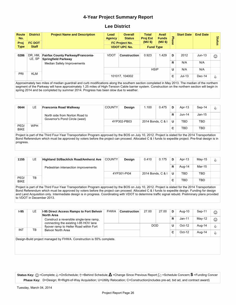
4-Year Project Summary Report
Phase
Route
No.
District Project Name and Description Lead
Agency
Overall
Status
Avail
Funds
(Mil $)
Start Date End Date Status
Total
Proj Est
(Mil $)
VDOT UPC No.
FC DOT
Staff Fund Type
FC Project No.
Lee District
Proj
Type
DR, HM, LE, SP
Fairfax County Parkway/Franconia-
Springfield Parkway
VDOT Construction 0.923 1.429 2012 Jun-13
N/A N/A
N/A N/A
Jul-13 Dec-14
D
R
U
C
Median Safety Improvements
J
C
Approximately two miles of median guardrail and curb modifications along the southern section completed in May 2013. The median of the northern segment of the Parkway will have approximately 1.25 miles of High-Tension Cable barrier system. Construction on the northern section will begin in spring 2014 and be completed by summer 2014. Progress has been slow due to weather.
0286
HSIP
KLM101017, 104002
PRI
LE Franconia Road Walkway COUNTY Design 1.100 0.475 Apr-13 Sep-14
Jun-14 Jan-15
TBD TBD
TBD TBD
D
R
U
C
North side from Norton Road to Governor's Pond Circle (west)
C
Project is part of the Third Four-Year Transportation Program approved by the BOS on July 10, 2012. Project is slated for the 2014 Transportation Bond Referendum which must be approved by voters before the project can proceed. Allocated C & I funds to expedite project. Pre-final design is in progress.
0644
2014 Bonds, C & I
WPH
4YP302-PB03
PED/ BIKE
LE Highland St/Backlick Road/Amherst Ave COUNTY Design 0.410 0.175 Apr-13 May-15
Aug-14 Mar-15
TBD TBD
TBD TBD
D
R
U
C
Pedestrian intersection improvements
C
Project is part of the Third Four-Year Transportation Program approved by the BOS on July 10, 2012. Project is slated for the 2014 Transportation Bond Referendum which must be approved by voters before the project can proceed. Allocated C & I funds to expedite design. Funding for design and Land Acquisition only. Intermediate design is in progress. Coordinating with VDOT to determine traffic signal rebuild. Preliminary plans provided to VDOT in December 2013.
1155
2014 Bonds, C & I
TB
4YP301-PI04
PED/ BIKE
LE I-95 Direct Access Ramps to Fort Belvoir
North Area
FHWA Construction 27.00 27.00 Aug-10 Sep-11
Jan-11 May-12
Oct-12 Aug-14
Oct-12 Aug-14
D
R
U
C
Construct a reversible single-lane ramp, connecting the existing I-95 HOV lane flyover ramp to Heller Road within Fort Belvoir North Area
J
J
C
C
Design-Build project managed by FHWA. Construction is 55% complete.
I-95
DOD
TBINT
Status Key: =Complete; =OnSchedule; =Behind Schedule; =Change Since Previous Report; =Schedule Concern; =Funding Concer
Phase Key: D=Design; R=Right-of-Way Acquisition; U=Utility Relocation; C=Construction(includes pre-ad, bid ad, and contract award)
J C D Δ O $
Tuesday, March 04, 2014
Project Report Page 26

Phase
Route
No.
District Project Name and Description Lead
Agency
Overall
Status
Avail
Funds
(Mil $)
Start Date End Date Status
Total
Proj Est
(Mil $)
VDOT UPC No.
FC DOT
Staff Fund Type
FC Project No.
Lee District
Proj
Type
LE, MA, MV
I-95 Express Lanes (PPTA Project) VDOT Construction 940.000 940.000 Feb-11 Dec-11
N/A N/A
N/A N/A
Aug-12 Dec-14
D
R
U
C
Add one Express lane (3 total) from Edsall Road to Prince William Pkwy; Extend two Express lanes to Stafford County
J
C
Scope includes HOV/Transit ramp at Seminary Road and new park-and-ride lots. Design-Build project. The noise wall segment four is under construction which includes the sound wall at the Overlook Community. The noise wall study for segments one through three was approved. Construction is ongoing on all four segments and is 68% complete.
I-95
Private, Interstate
WPH70850, 77616, 70849
INT
LE, MV I-95 Northbound Directional Off-Ramp to
Northbound Fairfax County Parkway
VDOT Design 81.000 4.193 Oct-11 Jun-14
N/A N/A
N/A N/A
N/A N/A
D
R
U
C
From I-95 Exit 166 for Route 7100 northbound, to 0.6 miles west of Exit 166 (PE only)
C
Funding for design only. Design in progress.
I-95
Federal
TB93033
INT
LE, MV Mulligan Road from Route 1 to
Telegraph Road
FHWA Construction 80.000 80.000 Mar-07 May-11
Sep-10 May-11
Feb-11 May-13
Feb-12 Jun-14
D
R
U
C
Construct/widen Mulligan Road to 4 lanes from Route 1 to Telegraph Road; Widen Telegraph Road to 4 lanes from Beulah Street to Leaf Road
J
J
C
C
Scope includes Woodlawn Road replacement and Old Mill Road Extension. Construction and utility relocation in progress. Estimate open to traffic in May 2014. Project is 85% complete.
0619
DAR, State, RSTP, C & IJYR
77404SEC
LE North Kings Highway Median COUNTY Complete 0.250 0.250 Mar-10 Dec-12
N/A N/A
N/A N/A
Feb-13 Aug-13
D
R
U
C
Add concrete median from Fort Drive to North Metro Entrance
J
J
Project is complete.
0241
C & I
TB
RSPI01-00900
PED/ BIKE
Status Key: =Complete; =OnSchedule; =Behind Schedule; =Change Since Previous Report; =Schedule Concern; =Funding Concer
Phase Key: D=Design; R=Right-of-Way Acquisition; U=Utility Relocation; C=Construction(includes pre-ad, bid ad, and contract award)
J C D Δ O $
Tuesday, March 04, 2014
Project Report Page 27

Phase
Route
No.
District Project Name and Description Lead
Agency
Overall
Status
Avail
Funds
(Mil $)
Start Date End Date Status
Total
Proj Est
(Mil $)
VDOT UPC No.
FC DOT
Staff Fund Type
FC Project No.
Lee District
Proj
Type
LE Route 1 Southbound from Buckman
Rd/Mt Vernon Hwy to Janna Lee (RHPTI)
COUNTY On Hold TBD TBD TBD TBD
TBD TBD
TBD TBD
TBD TBD
D
R
U
C
1400 LF of walkway
Reviewing project scope. Conceptual design required to evaluate site drainage and feasibility concerns.
0001
Revenue Sharing, FTACL
RHPTI-088
PED/ BIKE
LE Route 1 Southbound from Roxbury Drive
to Russell Road (RHPTI)
COUNTY Design 0.300 0.300 Jul-12 Feb-15
Jun-14 Jan-15
TBD TBD
Jan-15 Sep-15
D
R
U
C
520 LF of concrete sidewalk along the west side of Route 1
DΔ
Δ
Pre-final design is in progress. Geotechnical report is underway. Design completion adjusted three months due to geotechnical field work delays because of weather. Land Acquisition schedule adjusted accordingly, but project completion date did not change.
0001
Revenue Sharing, FTACL
RHPTI-082
PED/ BIKE
LE, MV Route 1 Southbound from Russell Road
to Gregory Drive (RHPTI)
COUNTY Design 0.500 0.500 Jul-12 Dec-14
Apr-14 Nov-14
TBD TBD
Jan-15 Sep-15
D
R
U
C
270 LF of concrete sidewalk along west side of Route 1, including a signalized crosswalk
DΔ
Pre-final plans distributed in December 2013. Design completion date delayed two months due to delays in receiving comments after pre-final plans, but project completion date did not change.
0001
Revenue Sharing, FTACL
RHPTI-083
71851 PED/
BIKE
MV, LE Route 1 Transit Center COUNTY Study 0.154 0.154 Aug-10 TBD
N/A N/A
N/A N/A
N/A N/A
D
R
U
C
Select location, conceptual design, and operational study for transit center in the Route 1 corridor (study only)
C
Southeast Fairfax Development Corporation (SFDC), Mount Vernon Council of Citizens' Associations, Lee District Association of Civic Associations, and Lee Land Use Committee suggested 16 new sites which staff evaluated. An on-call consultant has been performing conceptual layout design and feasibility analysis on top three sites. A public hearing was held in September 2013. Revising conceptual designs based on stakeholder comments, and coordinating with FCPA and Department of Housing and Community Development. Partnering with Fairfax County Health Department on Health Impact Assessment of proposed sites.
0001
FTA
CL
2G40-059-000
TRAN
Status Key: =Complete; =OnSchedule; =Behind Schedule; =Change Since Previous Report; =Schedule Concern; =Funding Concer
Phase Key: D=Design; R=Right-of-Way Acquisition; U=Utility Relocation; C=Construction(includes pre-ad, bid ad, and contract award)
J C D Δ O $
Tuesday, March 04, 2014
Project Report Page 28

Phase
Route
No.
District Project Name and Description Lead
Agency
Overall
Status
Avail
Funds
(Mil $)
Start Date End Date Status
Total
Proj Est
(Mil $)
VDOT UPC No.
FC DOT
Staff Fund Type
FC Project No.
Lee District
Proj
Type
LE, MV Route 1/Belford Drive (RHPTI) COUNTY Design 0.357 0.357 Jul-11 Nov-14
Mar-14 Oct-14
TBD TBD
Jan-15 Jul-15
D
R
U
C
Pedestrian intersection improvements
DΔ
Δ
Δ
Final design and right-of-way authorization package submitted to VDOT in November 2013. Design completion delayed six months due to delay in obtaining VDOT right-of-way authorization. Land Acquisition schedule adjusted six months and Construction schedule adjusted nine months as a result. Additional funding required for right-of-way authorization, transfer in progress.
0001
CMAQ
CL
26006G-06011
99054 PED/
BIKE
LE, MV Route 1/Ladson Lane (RHPTI) COUNTY Design 0.400 0.400 Jul-11 Nov-14
Mar-14 Oct-14
TBD TBD
Jan-15 Jul-15
D
R
U
C
Pedestrian intersection improvements
DΔ
Δ
Δ
Final design and right-of-way authorization package submitted to VDOT in November 2013. Design completion delayed six months due to delay in obtaining VDOT right-of-way authorization. Land Acquisition schedule adjusted six months and Construction schedule adjusted nine months as a result. Additional funding required for right-of-way authorization, transfer in progress.
0001
CMAQ
CL
26006G-06002
99054 PED/
BIKE
LE, MV Route 1/Lockheed Blvd/Dart Lane
(RHPTI)
COUNTY Design 0.500 0.500 Mar-12 Mar-14
N/A N/A
N/A N/A
May-14 Aug-14
D
R
U
C
Pedestrian intersection improvements
DΔ
Δ
Second final design submitted to VDOT in November 2013. Additional comments were received from VDOT on the signal design plans in January 2014. Design completion delayed three months to address additional comments. Construction schedule adjusted one month as a result.
0001
CMAQ
CL
RHPTI-015
98753 PED/
BIKE
LE, MV Route 1/Mohawk Lane (RHPTI) COUNTY Design 0.157 0.157 Jul-11 Nov-14
Mar-14 Oct-14
TBD TBD
Jan-15 Jul-15
D
R
U
C
Pedestrian intersection improvements
DΔ
Δ
Δ
Final design and right-of-way authorization package submitted to VDOT in November 2013. Design completion delayed six months due to delay in obtaining VDOT right-of-way authorization. Land Acquisition schedule adjusted six months and Construction schedule adjusted nine months as a result. Additional funding required for right-of-way authorization, transfer in progress.
0001
CMAQ
CL
26006G-06011
99054 PED/
BIKE
Status Key: =Complete; =OnSchedule; =Behind Schedule; =Change Since Previous Report; =Schedule Concern; =Funding Concer
Phase Key: D=Design; R=Right-of-Way Acquisition; U=Utility Relocation; C=Construction(includes pre-ad, bid ad, and contract award)
J C D Δ O $
Tuesday, March 04, 2014
Project Report Page 29

Phase
Route
No.
District Project Name and Description Lead
Agency
Overall
Status
Avail
Funds
(Mil $)
Start Date End Date Status
Total
Proj Est
(Mil $)
VDOT UPC No.
FC DOT
Staff Fund Type
FC Project No.
Lee District
Proj
Type
LE, MV Route 1/Southgate Drive/Bedoo St
(RHPTI)
COUNTY Design 0.500 0.500 Mar-12 Dec-14
Apr-14 Nov-14
TBD TBD
Feb-15 May-15
D
R
U
C
Pedestrian intersection improvements
DΔ
Δ
Second final design submitted to VDOT in November 2013. Design completion delayed 13 months due to needed crosswalk design revision to meet ADA standards which will require land rights. Land Acquisition schedule established, and Construction schedule adjusted 11 months as a result.
0001
CMAQ
CL
RHPTI-014
98753 PED/
BIKE
LE School Street Sidewalk COUNTY Construction 0.225 0.225 Dec-11 Aug-13
Jan-13 Jul-13
N/A N/A
Oct-13 Apr-14
D
R
U
C
Construct 750 LF concrete sidewalk on north side from North Kings Hwy. to Pine Grove Circle
J
J
D
Δ
Δ
Construction is 20% complete. Construction schedule adjusted three months to match construction contract duration which was longer than estimated schedule.
1647
C & I
TB
PPTF01-05000
PED/ BIKE
LE South Van Dorn St/Franconia Road
Walkway
COUNTY Project
Initiation
0.400 0 TBD TBD
TBD TBD
TBD TBD
TBD TBD
D
R
U
C
Southwest quadrant missing link
Project is part of the Third Four-Year Transportation Program approved by the BOS on July 10, 2012. Project is slated for the 2014 Transportation Bond Referendum which must be approved by voters before the project can proceed.
0613
2014 Bonds
WPH PED/ BIKE
LE Springfield CBC Multi-Use Garage COUNTY Project
Initiation
74.600 21.173 TBD TBD
TBD TBD
TBD TBD
TBD TBD
D
R
U
C
Multi-modal and bus transit transfer facility to include approximately 1,100 commuter parking spaces, slug-line and pedestrian accommodations, bicycle facilities, and potentially recreational
Final report for conceptual design and preliminary environmental study received. Selection process for design contract is complete, and contract negotiations are underway. Anticipate NTP to design consultant in March 2014. Schedule to be determined once design contract finalized.
XXXX
CMAQ, C & I, FTA
MJG
ST-000033
T1120TRAN
Status Key: =Complete; =OnSchedule; =Behind Schedule; =Change Since Previous Report; =Schedule Concern; =Funding Concer
Phase Key: D=Design; R=Right-of-Way Acquisition; U=Utility Relocation; C=Construction(includes pre-ad, bid ad, and contract award)
J C D Δ O $
Tuesday, March 04, 2014
Project Report Page 30

Phase
Route
No.
District Project Name and Description Lead
Agency
Overall
Status
Avail
Funds
(Mil $)
Start Date End Date Status
Total
Proj Est
(Mil $)
VDOT UPC No.
FC DOT
Staff Fund Type
FC Project No.
Lee District
Proj
Type
LE, MV Telegraph Road from Beulah Street to
Leaf Road
FHWA Construction 38.350 27.559 Oct-08 May-11
Sep-10 May-11
Feb-11 May-13
June-11 Jun-14
D
R
U
C
Widen Telegraph Road to 4 lanes and provide pedestrian facility; Part of Mulligan Road Project
J
J
C
C
Part of Mulligan Road Phase II project which is under construction. Estimate open to traffic in late spring 2014. Project is 85% complete.
0611
Secondary
JYR11012
SEC
LE Telegraph Road from South Van Dorn
Street to South Kings Highway
VDOT Construction 12.500 12.300 Sep-09 Dec-11
Jun-11 Jun-12
June-12 May-13
May-13 Oct-14
D
R
U
C
Widen Telegraph Road to 4 lanes section and add pedestrian improvements
J
J
J
CΔ
Construction is 35% complete. Completion date advanced one month.
0611
C & I, 2007 Bonds
JYR96509
SEC
LE Telegraph Road Walkway COUNTY ROW 3.300 0.800 Sep-08 TBD
Oct-13 TBD
Oct-13 Dec-14
Aug-14 TBD
D
R
U
C
Install 3500 LF asphalt sidewalk and 4' bike lane along east side of Telegraph Road from South Kings Highway to Lee District Park
D
D
C
Δ
Δ
Δ
Second pre-final design is in progress. Coordination meeting with GSA was held in December 2013. 1 of 5 properties have been acquired. Continued coordination with GSA and US Army Reserve over conveyance of land rights, including type of land rights and how the land rights will be conveyed. Schedule dates will be reestablished once issue resolved.
0611
2007 Bonds
JYR
4YP201-PB023
PED/ BIKE
Status Key: =Complete; =OnSchedule; =Behind Schedule; =Change Since Previous Report; =Schedule Concern; =Funding Concer
Phase Key: D=Design; R=Right-of-Way Acquisition; U=Utility Relocation; C=Construction(includes pre-ad, bid ad, and contract award)
J C D Δ O $
Tuesday, March 04, 2014
Project Report Page 31

4-Year Project Summary Report
Phase
Route
No.
District Project Name and Description Lead
Agency
Overall
Status
Avail
Funds
(Mil $)
Start Date End Date Status
Total
Proj Est
(Mil $)
VDOT UPC No.
FC DOT
Staff Fund Type
FC Project No.
Mason District
Proj
Type
MA Annandale Road/Graham Road COUNTY Project
Initiation
0.150 0 TBD TBD
TBD TBD
TBD TBD
TBD TBD
D
R
U
C
Pedestrian intersection improvements
Project is part of the Third Four-Year Transportation Program approved by the BOS on July 10, 2012. Project is slated for the 2014 Transportation Bond Referendum which must be approved by voters before the project can proceed.
0650
2014 Bonds
N/A PED/ BIKE
MA Arlington Boulevard/Graham Road COUNTY Complete 0.750 0.750 Oct-09 Jan-13
Jul-11 Dec-12
Oct-11 Feb-13
Apr-13 Jul-13
D
R
U
C
Install a 4-foot wide raised median on Graham Road
J
J
J
J
Project is complete.
0050
C & I
TB
RSPI01-01300
PRI
MA Backlick Road Walkway (east side) COUNTY On Hold 0.150 0.150 Feb-08 Sep-10
Jul-09 TBD
TBD TBD
TBD TBD
D
R
U
C
Install concrete sidewalk along the east side of Backlick Road opposite the Wilburdale community
J
Final design is complete. One homeowner is unwilling to sign. On hold per Supervisor's request.
0617
2007 Bonds
TB
4YP201-PB025
PED/ BIKE
MA Backlick Road/Edsall Road COUNTY Project
Initiation
0.200 0 TBD TBD
TBD TBD
TBD TBD
TBD TBD
D
R
U
C
Pedestrian intersection improvements
Project is part of the Third Four-Year Transportation Program approved by the BOS on July 10, 2012. Project is slated for the 2014 Transportation Bond Referendum which must be approved by voters before the project can proceed.
0617
2014 Bonds
VA PED/ BIKE
Status Key: =Complete; =OnSchedule; =Behind Schedule; =Change Since Previous Report; =Schedule Concern; =Funding Concer
Phase Key: D=Design; R=Right-of-Way Acquisition; U=Utility Relocation; C=Construction(includes pre-ad, bid ad, and contract award)
J C D Δ O $
Tuesday, March 04, 2014
Project Report Page 32

Phase
Route
No.
District Project Name and Description Lead
Agency
Overall
Status
Avail
Funds
(Mil $)
Start Date End Date Status
Total
Proj Est
(Mil $)
VDOT UPC No.
FC DOT
Staff Fund Type
FC Project No.
Mason District
Proj
Type
MA Braddock Road/Backlick Road COUNTY On Hold 0.500 0.500 Mar-08 TBD
TBD TBD
TBD TBD
TBD TBD
D
R
U
C
Install dual left turn lane on WB Braddock Road
Per meeting held in January 2014, the Supervisor's office has decided to cancel the project. Final project close out has been requested from the consultant.
0620
2007 Bonds
WPH
4YP203
SEC
MA Columbia Pike Transit Initiative COUNTY Project
Initiation
$40.000 $26.438 TBD TBD
N/A N/A
N/A N/A
N/A N/A
D
R
U
C
Enhanced Transit Corridor from Arlington County to Skyline
Project is in planning phase. Engineering RFD released in February 2014.
0244
VATRAN
MA Columbia Pike Walkway COUNTY Construction 0.190 0.190 Aug-09 May-13
Sep-12 Jan-13
May-13 Aug-13
Sep-13 Apr-14
D
R
U
C
Install 450 LF concrete sidewalk along the south side of Columbia Pike from Gallows Road to the Annandale Methodist Church
J
J
J
C
Construction is 45% complete. Permit revision was approved in January 2014.
0244
2007 Bonds
SLC
4YP201-PB028
PED/ BIKE
MA Columbia Pike Walkway COUNTY Complete 0.200 0.200 Jan-08 Mar-13
Apr-10 Aug-12
N/A N/A
Apr-13 Aug-13
D
R
U
C
Install 750 LF concrete sidewalk along the north side of Columbia Pike from Maple Court to Blair Road
J
J
J
Project is complete.
0244
2007 Bonds
SLC
4YP201-PB027
PED/ BIKE
Status Key: =Complete; =OnSchedule; =Behind Schedule; =Change Since Previous Report; =Schedule Concern; =Funding Concer
Phase Key: D=Design; R=Right-of-Way Acquisition; U=Utility Relocation; C=Construction(includes pre-ad, bid ad, and contract award)
J C D Δ O $
Tuesday, March 04, 2014
Project Report Page 33

Phase
Route
No.
District Project Name and Description Lead
Agency
Overall
Status
Avail
Funds
(Mil $)
Start Date End Date Status
Total
Proj Est
(Mil $)
VDOT UPC No.
FC DOT
Staff Fund Type
FC Project No.
Mason District
Proj
Type
MA Columbia Pike/Gallows Road COUNTY Project
Initiation
0.200 0 TBD TBD
TBD TBD
TBD TBD
TBD TBD
D
R
U
C
Pedestrian intersection improvements
Project is part of the Third Four-Year Transportation Program approved by the BOS on July 10, 2012. Project is slated for the 2014 Transportation Bond Referendum which must be approved by voters before the project can proceed.
0244
2014 Bonds
VA PED/ BIKE
MA Columbia Pike/John Marr Drive COUNTY Project
Initiation
0.150 0 TBD TBD
TBD TBD
TBD TBD
TBD TBD
D
R
U
C
Pedestrian intersection improvements
Project is part of the Third Four-Year Transportation Program approved by the BOS on July 10, 2012. Project is slated for the 2014 Transportation Bond Referendum which must be approved by voters before the project can proceed.
0244
2014 Bonds
VA PED/ BIKE
MA Elmdale Road Walkway COUNTY ROW 0.780 0.780 Jan-10 Mar-13
Oct-12 Apr-14
Aug-13 Jan-14
May-14 Nov-14
D
R
U
C
Construct 2600 LF sidewalk from Braddock Road to Old Columbia Pike along south side of Elmdale Road
J
D
J
Δ
Δ
Δ
Project is funded by Commercial and Industrial Revenues and endorsed by the BOS on October 19, 2009. Final design is complete. FCPA will be responsible for golf course replanting and cart trail relocation. 2 of 3 properties have been acquired. Draft construction package underway based on pending land acquisition completion. Land Acquisition completion delayed nine months due to additional time required to obtain remaining land rights. Utility relocation completed four months later than previously scheduled. Construction schedule adjusted 11 months as a result and to update and reinstate the project permits as well as to finalize the construction contract.
2248
C & I
CL
PPTF01-03000
PED/ BIKE
MA I-395 HOV Ramp at Seminary Road VDOT Design 55.448 55.448 May-13 Jun-14
TBD TBD
TBD TBD
Mar-14 May-16
D
R
U
C
Direct HOV lanes connection to Seminary Road
C
Design-Build project currently underway.
I-395
Federal
WPHINT
Status Key: =Complete; =OnSchedule; =Behind Schedule; =Change Since Previous Report; =Schedule Concern; =Funding Concer
Phase Key: D=Design; R=Right-of-Way Acquisition; U=Utility Relocation; C=Construction(includes pre-ad, bid ad, and contract award)
J C D Δ O $
Tuesday, March 04, 2014
Project Report Page 34

Phase
Route
No.
District Project Name and Description Lead
Agency
Overall
Status
Avail
Funds
(Mil $)
Start Date End Date Status
Total
Proj Est
(Mil $)
VDOT UPC No.
FC DOT
Staff Fund Type
FC Project No.
Mason District
Proj
Type
MA I-395 Southbound Off-Ramp to Route
236 Westbound Phase I
COUNTY Project
Initiation
0.500 0.500 TBD TBD
TBD TBD
TBD TBD
TBD TBD
D
R
U
C
Enhanced signage/wayfinding
Project is part of the Third Four-Year Transportation Program approved by the BOS on July 10, 2012. Project fully funded in advance of 2014 Transportation Bonds with RSTP funds approved by the BOS in April. FCDOT coordinating with City of Alexandria on placement and type of signage.
I-395
RSTP
WPHINT
MA I-395 Southbound Off-Ramp to Route
236 Westbound Phase II
COUNTY Project
Initiation
1.000 0 TBD TBD
TBD TBD
TBD TBD
TBD TBD
D
R
U
C
Widen off-ramp to two lanes
Project is part of the Third Four-Year Transportation Program approved by the BOS on July 10, 2012. Project is slated for the 2014 Transportation Bond Referendum which must be approved by voters before the project can proceed.
I-395
2014 Bond
WPHINT
LE, MA, MV
I-95 Express Lanes (PPTA Project) VDOT Construction 940.000 940.000 Feb-11 Dec-11
N/A N/A
N/A N/A
Aug-12 Dec-14
D
R
U
C
Add one Express lane (3 total) from Edsall Road to Prince William Pkwy; Extend two Express lanes to Stafford County
J
C
Scope includes HOV/Transit ramp at Seminary Road and new park-and-ride lots. Design-Build project. The noise wall segment four is under construction which includes the sound wall at the Overlook Community. The noise wall study for segments one through three was approved. Construction is ongoing on all four segments and is 68% complete.
I-95
Private, Interstate
WPH70850, 77616, 70849
INT
MA North Chambliss Street/Beauregard
Street
COUNTY Project
Initiation
1.000 0 TBD TBD
TBD TBD
TBD TBD
TBD TBD
D
R
U
C
Eliminate exclusive right turn lane from North Chambliss to Beauregard
Project is part of the Third Four-Year Transportation Program approved by the BOS on July 10, 2012. Project is slated for the 2014 Transportation Bond Referendum which must be approved by voters before the project can proceed.
713
2014 Bonds
JYRSEC
Status Key: =Complete; =OnSchedule; =Behind Schedule; =Change Since Previous Report; =Schedule Concern; =Funding Concer
Phase Key: D=Design; R=Right-of-Way Acquisition; U=Utility Relocation; C=Construction(includes pre-ad, bid ad, and contract award)
J C D Δ O $
Tuesday, March 04, 2014
Project Report Page 35

Phase
Route
No.
District Project Name and Description Lead
Agency
Overall
Status
Avail
Funds
(Mil $)
Start Date End Date Status
Total
Proj Est
(Mil $)
VDOT UPC No.
FC DOT
Staff Fund Type
FC Project No.
Mason District
Proj
Type
MA Route 236/Beauregard Street COUNTY Project
Initiation
0.050 0.050 TBD TBD
TBD TBD
TBD TBD
TBD TBD
D
R
U
C
Channelize Route 236 WB left turn lane at Beauregard St
Project is part of the Third Four-Year Transportation Program approved by the BOS on July 10, 2012. Project fully funded in advance of 2014 Transportation Bonds with RSTP funds approved by the BOS in April.
0236
RSTP
WPHPRI
MA Route 236/Beauregard Street Bus Pullout COUNTY Project
Initiation
0.200 0 TBD TBD
TBD TBD
TBD TBD
TBD TBD
D
R
U
C
Close EB service drive and construct bus pullout
Project is part of the Third Four-Year Transportation Program approved by the BOS on July 10, 2012. Project is slated for the 2014 Transportation Bond Referendum which must be approved by voters before the project can proceed.
0236
2014 Bonds
WPHPRI
MA Route 236/Cherokee Ave COUNTY Project
Initiation
0.500 0.500 TBD TBD
TBD TBD
TBD TBD
TBD TBD
D
R
U
C
Construct NB right turn lane from Cherokee Avenue to EB Route 236
Project is part of the Third Four-Year Transportation Program approved by the BOS on July 10, 2012. Project fully funded in advance of 2014 Transportation Bonds with RSTP funds. Scope of project is under development. Existing traffic counts have been collected and under analysis. Signal warrant analysis is in progress.
0236
2014 Bonds
JYRPRI
MA Route 50 Walkway from Graham Road to
Wayne Road (RT50PI)
COUNTY Design 0.765 0.100 Jun-13 Jan-17
Oct-15 Sep-16
TBD TBD
Apr-17 Dec-17
D
R
U
C
Install walkway on south side of Route 50
C
Project is part of the Route 50 Pedestrian Initiative approved by the Board of Supervisors on June 19, 2012. Preliminary design is underway. Programmatic categorical exclusion under review by VDOT. Environmental documentation is in progress.
0050
RSTP, CMAQ
WPH
RT50-056
58601 PED/
BIKE
Status Key: =Complete; =OnSchedule; =Behind Schedule; =Change Since Previous Report; =Schedule Concern; =Funding Concer
Phase Key: D=Design; R=Right-of-Way Acquisition; U=Utility Relocation; C=Construction(includes pre-ad, bid ad, and contract award)
J C D Δ O $
Tuesday, March 04, 2014
Project Report Page 36
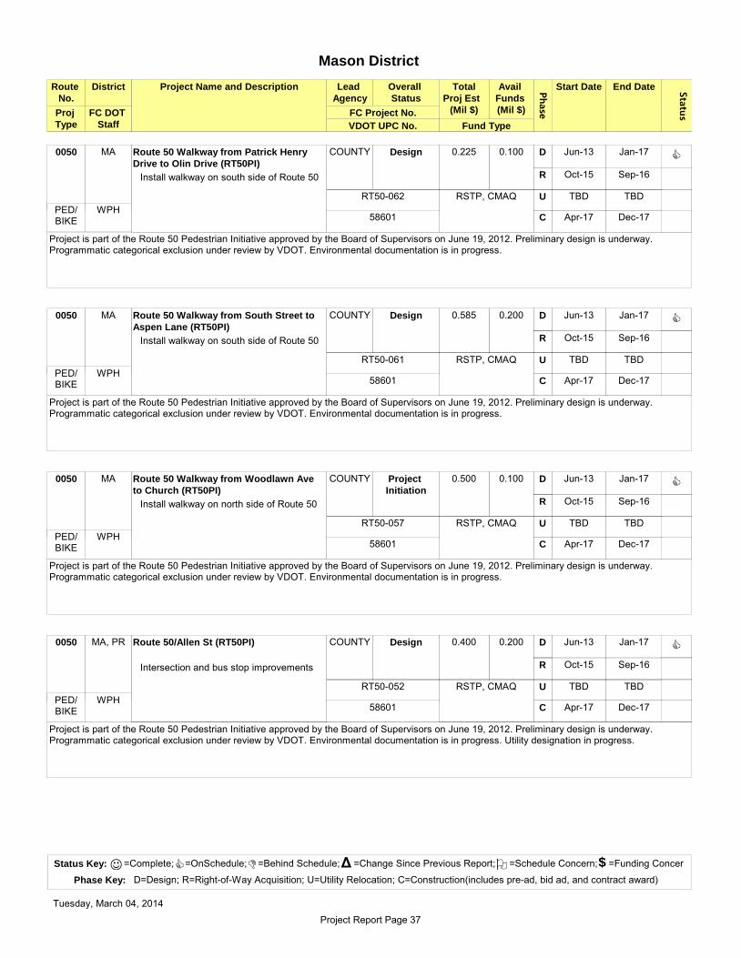
Phase
Route
No.
District Project Name and Description Lead
Agency
Overall
Status
Avail
Funds
(Mil $)
Start Date End Date Status
Total
Proj Est
(Mil $)
VDOT UPC No.
FC DOT
Staff Fund Type
FC Project No.
Mason District
Proj
Type
MA Route 50 Walkway from Patrick Henry
Drive to Olin Drive (RT50PI)
COUNTY Design 0.225 0.100 Jun-13 Jan-17
Oct-15 Sep-16
TBD TBD
Apr-17 Dec-17
D
R
U
C
Install walkway on south side of Route 50
C
Project is part of the Route 50 Pedestrian Initiative approved by the Board of Supervisors on June 19, 2012. Preliminary design is underway. Programmatic categorical exclusion under review by VDOT. Environmental documentation is in progress.
0050
RSTP, CMAQ
WPH
RT50-062
58601 PED/
BIKE
MA Route 50 Walkway from South Street to
Aspen Lane (RT50PI)
COUNTY Design 0.585 0.200 Jun-13 Jan-17
Oct-15 Sep-16
TBD TBD
Apr-17 Dec-17
D
R
U
C
Install walkway on south side of Route 50
C
Project is part of the Route 50 Pedestrian Initiative approved by the Board of Supervisors on June 19, 2012. Preliminary design is underway. Programmatic categorical exclusion under review by VDOT. Environmental documentation is in progress.
0050
RSTP, CMAQ
WPH
RT50-061
58601 PED/
BIKE
MA Route 50 Walkway from Woodlawn Ave
to Church (RT50PI)
COUNTY Project
Initiation
0.500 0.100 Jun-13 Jan-17
Oct-15 Sep-16
TBD TBD
Apr-17 Dec-17
D
R
U
C
Install walkway on north side of Route 50
C
Project is part of the Route 50 Pedestrian Initiative approved by the Board of Supervisors on June 19, 2012. Preliminary design is underway. Programmatic categorical exclusion under review by VDOT. Environmental documentation is in progress.
0050
RSTP, CMAQ
WPH
RT50-057
58601 PED/
BIKE
MA, PR Route 50/Allen St (RT50PI) COUNTY Design 0.400 0.200 Jun-13 Jan-17
Oct-15 Sep-16
TBD TBD
Apr-17 Dec-17
D
R
U
C
Intersection and bus stop improvements
C
Project is part of the Route 50 Pedestrian Initiative approved by the Board of Supervisors on June 19, 2012. Preliminary design is underway. Programmatic categorical exclusion under review by VDOT. Environmental documentation is in progress. Utility designation in progress.
0050
RSTP, CMAQ
WPH
RT50-052
58601 PED/
BIKE
Status Key: =Complete; =OnSchedule; =Behind Schedule; =Change Since Previous Report; =Schedule Concern; =Funding Concer
Phase Key: D=Design; R=Right-of-Way Acquisition; U=Utility Relocation; C=Construction(includes pre-ad, bid ad, and contract award)
J C D Δ O $
Tuesday, March 04, 2014
Project Report Page 37

Phase
Route
No.
District Project Name and Description Lead
Agency
Overall
Status
Avail
Funds
(Mil $)
Start Date End Date Status
Total
Proj Est
(Mil $)
VDOT UPC No.
FC DOT
Staff Fund Type
FC Project No.
Mason District
Proj
Type
MA, PR Route 50/Annandale Road (RT50PI) COUNTY Project
Initiation
0.400 0.200 Jun-13 Jan-17
Oct-15 Sep-16
TBD TBD
Apr--17 Dec-17
D
R
U
C
Pedestrian intersection improvements
C
Project is part of the Route 50 Pedestrian Initiative approved by the Board of Supervisors on June 19, 2012. Preliminary design is underway. Programmatic categorical exclusion under review by VDOT. Environmental documentation is in progress.
0050
RSTP, CMAQ
WPH
RT50-054
58601 PED/
BIKE
MA, PR Route 50/Wayne Road/Woodlawn Ave
(RT50PI)
COUNTY Design 0.400 0.200 Jun-13 Jan-17
Oct-15 Sep-16
TBD TBD
Apr-17 Dec-17
D
R
U
C
Signalization and sidewalk improvements
C
Project is part of the Route 50 Pedestrian Initiative approved by the Board of Supervisors on June 19, 2012. Preliminary design is underway. Programmatic categorical exclusion under review by VDOT. Environmental documentation is in progress.
0050
RSTP, CMAQ
WPH
RT50-053
58601 PED/
BIKE
MA Route 7 Intersection Improvements from
Seven Corners to Juniper Lane (RT7PI)
COUNTY Bid Ad 0.800 0.800 Aug-10 Apr--14
Feb-13 Feb-14
N/A N/A
May-14 Sep-14
D
R
U
C
Pedestrian intersection improvements at three locations: Seven Corners, Thorne Road and Seven Corners Center
D
J
Δ
Δ
Δ
Final design is in progress. 5 of 6 properties have been acquired. Land Acquisition completed five months later than previously reported due to on-going negotiations with outstanding property owner. Design schedule adjusted seven months and Construction schedule adjusted three months as a result.
0007
2007 Bonds
WPH
4YP201-PB052
PED/ BIKE
MA Route 7 Walkway at Columbia Pike
Interchange (RT7PI)
COUNTY Design 0.800 0.800 Oct-10 Mar-14
Oct-11 Oct-12
N/A N/A
Apr-14 Dec-14
D
R
U
C
Install sidewalk along both ramps from Columbia Pike to Leesburg Pike and along service road from Seminary Road to Leesburg Pike
D
J
Δ
Δ
Final design in progress. Awaiting VDOT approval of design waiver submitted in November 2013. Gas utility adjustments within the right-of-way will be required. Design completion delayed ten months due to pending waiver and final plan approval by VDOT. Waiver approval is imminent. Construction completion adjusted eight months as a result.
0007
2007 Bonds, EnhancementsWPH
4YP201-PB050
PED/ BIKE
Status Key: =Complete; =OnSchedule; =Behind Schedule; =Change Since Previous Report; =Schedule Concern; =Funding Concer
Phase Key: D=Design; R=Right-of-Way Acquisition; U=Utility Relocation; C=Construction(includes pre-ad, bid ad, and contract award)
J C D Δ O $
Tuesday, March 04, 2014
Project Report Page 38

Phase
Route
No.
District Project Name and Description Lead
Agency
Overall
Status
Avail
Funds
(Mil $)
Start Date End Date Status
Total
Proj Est
(Mil $)
VDOT UPC No.
FC DOT
Staff Fund Type
FC Project No.
Mason District
Proj
Type
MA Route 7 Walkway at Row Street (RT7PI) COUNTY ROW 0.225 0.225 Aug-10 TBD
Aug-13 TBD
N/A N/A
TBD TBD
D
R
U
C
Install 400 LF segment of walkway and curb on the east side of Route 7 to the north of Row Street
D
D
Δ
Δ
Δ
Final design is in progress. Plans are being revised to add an entrance. Land acquisition is in progress. 0 of 2 properties have been acquired. Supervisor's office requested a slow take process due to one owner's unwillingness to grant easements. Schedule will be determined subsequent to meeting with Supervisor's office.
0007
2007 Bonds
WPH
4YP201-PB047
PED/ BIKE
MA Route 7 Walkway at Seminary Ramp
Streetscape Phase II (RT7PI)
COUNTY ROW 0.350 0.250 Nov-10 Jul-14
Feb-13 May-14
Sep-13 Nov-13
Sep-14 Apr-15
D
R
U
C
Install a 5' brick walkway approximately 450 LF on the south side of the ramp from Columbia Pike to Seminary Road
D
D
J
Δ
Δ
Δ
Final design is in progress. Utility relocation is complete. 1 of 2 properties of been acquired. Memo requested preparation of Bid package submitted to UDCD in November 2013. Land Acquisition completion delayed eight months due to land rights issue with property owner. Design and Construction schedules adjusted accordingly.
0007
2007 Bonds
WPH
4YP201-PB054
PED/ BIKE
MA Route 7 Walkway from Culmore
Shopping Center to Payne St (RT7PI)
COUNTY ROW 1.150 0.750 Aug-10 May-14
Aug-11 Apr-14
Feb-13 Jul-13
Jun-14 Dec-14
D
R
U
C
Install 1600 LF of sidewalk along the frontage of several shopping centers north of Columbia Pike
D
D
J
D
Δ
Δ
Δ
Δ
Signal design approved. 8 of 9 properties have been acquired. Land Acquisition completion delayed nine months due to outstanding land rights issues. Design schedule adjusted eight months and Construction schedule adjusted seven months as a result.
0007
2007 Bonds
WPH
4YP201-PB049
PED/ BIKE
MA Route 7 Walkway from Rio Drive to
Glenmore Drive (RT7PI)
COUNTY ROW 0.750 0.750 Aug-10 Sep-14
Jun-13 Jul-14
Jan-14 Apr-14
Nov-14 Jul-15
D
R
U
C
Install two segments of walkway along Route 7 from the south side of Rio Drive to Glenmore Drive
D
D
Δ
Δ
Δ
Second pre-final design is in progress. 2 of 6 properties have been acquired. Utility relocation will be required within right-of-way. Land Acquisition completion delayed six months due to on-going negotiations with property owners. Design schedule adjusted seven months and Construction schedule adjusted nine months as a result.
0007
2007 Bonds
WPH
4YP201-PB048
PED/ BIKE
Status Key: =Complete; =OnSchedule; =Behind Schedule; =Change Since Previous Report; =Schedule Concern; =Funding Concer
Phase Key: D=Design; R=Right-of-Way Acquisition; U=Utility Relocation; C=Construction(includes pre-ad, bid ad, and contract award)
J C D Δ O $
Tuesday, March 04, 2014
Project Report Page 39

4-Year Project Summary Report
Phase
Route
No.
District Project Name and Description Lead
Agency
Overall
Status
Avail
Funds
(Mil $)
Start Date End Date Status
Total
Proj Est
(Mil $)
VDOT UPC No.
FC DOT
Staff Fund Type
FC Project No.
Mount Vernon District
Proj
Type
MV Cinder Bed Road/Newington Road COUNTY Utilities 5.000 5.000 Jun-09 Jun-14
Jul-13 Aug-13
Feb-14 Dec-14
Aug-14 Oct-15
D
R
U
C
Intersection Improvements including relocating intersection 450 feet to the north, reconstruction of Cinder Bed Rd, sidewalk, culvert at Long Branch Creek, additional right turn lane along
D
J
C
Δ
Δ
Δ
Partial Pre-final design comments have been received. VSMP is in progress. VDOT storm drainage comments received in December 2013 and are being addressed. Design completion delayed nine months to address additional VDOT stormwater drainage comments. Construction completion adjusted accordingly. Initial Land Acquisition schedule shown which was completed on time.
0637
2007 Bonds
TB
4YP214
SEC
MV, SP Gambrill Road/Pohick Road COUNTY Construction 1.075 0.500 Mar-10 Sep-13
Aug-12 Nov-12
Jan-14 May-14
Jan-14 Nov-14
D
R
U
C
Install right turn lane on SB Gambrill Road
J
J
C
C
Δ
Δ
Δ
Part of the C&I Project Program endorsed by the BOS on October 19, 2009. Construction authorization issued in September 2013. Construction task order is in negotiations. Design completed three months later than scheduled to address outstanding comments and subsequent submission of VDOT permit package. Utility relocation schedule adjusted eight months and Construction schedule adjusted three months as a result.
0640
C & I
SSS
RSPI01-00600
SEC
MV, SP Hooes Road/Newington Forest Ave COUNTY Project
Initiation
0.200 0 TBD TBD
TBD TBD
TBD TBD
TBD TBD
D
R
U
C
Intersection improvements and extend sidewalk
Project is part of the Third Four-Year Transportation Program approved by the BOS on July 10, 2012. Project is slated for the 2014 Transportation Bond Referendum which must be approved by voters before the project can proceed.
0636
2014 Bonds
CL PED/ BIKE
MV Huntington Bus Operations Expansion COUNTY Design 4.800 4.800 Sep-13 Jan-15
N/A N/A
TBD TBD
Mar-15 Aug-16
D
R
U
C
Add two maintenance bays, site, and building upgrades to the existing facility
C
Design is underway.
XXXX
C & I, County, State
DPWES
TF-000014-001
TRAN
Status Key: =Complete; =OnSchedule; =Behind Schedule; =Change Since Previous Report; =Schedule Concern; =Funding Concer
Phase Key: D=Design; R=Right-of-Way Acquisition; U=Utility Relocation; C=Construction(includes pre-ad, bid ad, and contract award)
J C D Δ O $
Tuesday, March 04, 2014
Project Report Page 40

Phase
Route
No.
District Project Name and Description Lead
Agency
Overall
Status
Avail
Funds
(Mil $)
Start Date End Date Status
Total
Proj Est
(Mil $)
VDOT UPC No.
FC DOT
Staff Fund Type
FC Project No.
Mount Vernon District
Proj
Type
MV Huntington Service Lane COUNTY Construction 3.500 3.500 Mar-12 Jul-13
N/A N/A
Jul-13 Mar-14
Jul-13 Sep-14
D
R
U
C
An approximately 2,522 SF addition and 2,200 SF renovation of the Huntington Bus Maintenance Facility's fare collection, bus maintenance, and bus wash systems.
J
C
C
Construction is 38% complete.
XXXX
County, State
DPWES
TF-000015-001
TRAN
LE, MA, MV
I-95 Express Lanes (PPTA Project) VDOT Construction 940.000 940.000 Feb-11 Dec-11
N/A N/A
N/A N/A
Aug-12 Dec-14
D
R
U
C
Add one Express lane (3 total) from Edsall Road to Prince William Pkwy; Extend two Express lanes to Stafford County
J
C
Scope includes HOV/Transit ramp at Seminary Road and new park-and-ride lots. Design-Build project. The noise wall segment four is under construction which includes the sound wall at the Overlook Community. The noise wall study for segments one through three was approved. Construction is ongoing on all four segments and is 68% complete.
I-95
Private, Interstate
WPH70850, 77616, 70849
INT
LE, MV I-95 Northbound Directional Off-Ramp to
Northbound Fairfax County Parkway
VDOT Design 81.000 4.193 Oct-11 Jun-14
N/A N/A
N/A N/A
N/A N/A
D
R
U
C
From I-95 Exit 166 for Route 7100 northbound, to 0.6 miles west of Exit 166 (PE only)
C
Funding for design only. Design in progress.
I-95
Federal
TB93033
INT
MV Lorton Road/Furnace Road from
Silverbrook Road to Route 123
COUNTY Construction 60.000 50.000 Feb-08 Sep-12
Jan-12 Sep-12
oct-12 Sep-14
Jan-14 Dec-16
D
R
U
C
Widen to 4-lane divided section including on-road bike lanes, shared use path, low impact development practices, bridge crossings and wide median in Laurel Hill area
J
J
D
D
Δ
Δ
Utility relocations are underway. Mandatory pre-bid meeting occurred in January 2014. Bids opened in February. Construction schedule delayed six months based on a construction duration determination analysis that was recently completed as part of the bid advertisement process.
0642
2007 Bonds, C & I
WPH
4YP213
SEC
Status Key: =Complete; =OnSchedule; =Behind Schedule; =Change Since Previous Report; =Schedule Concern; =Funding Concer
Phase Key: D=Design; R=Right-of-Way Acquisition; U=Utility Relocation; C=Construction(includes pre-ad, bid ad, and contract award)
J C D Δ O $
Tuesday, March 04, 2014
Project Report Page 41

Phase
Route
No.
District Project Name and Description Lead
Agency
Overall
Status
Avail
Funds
(Mil $)
Start Date End Date Status
Total
Proj Est
(Mil $)
VDOT UPC No.
FC DOT
Staff Fund Type
FC Project No.
Mount Vernon District
Proj
Type
MV Lorton Road/Lorton Market Road COUNTY Project
Initiation
0.300 0 TBD TBD
TBD TBD
TBD TBD
TBD TBD
D
R
U
C
Extend WB left turn lane
Project is part of the Third Four-Year Transportation Program approved by the BOS on July 10, 2012. Project is slated for the 2014 Transportation Bond Referendum which must be approved by voters before the project can proceed.
0642
2014 Bonds
VASEC
MV Lorton Road/Lorton Station Blvd COUNTY Project
Initiation
1.200 0 TBD TBD
TBD TBD
TBD TBD
TBD TBD
D
R
U
C
Extend WB left turn lane and convert signal to protected only phasing
Project is part of the Third Four-Year Transportation Program approved by the BOS on July 10, 2012. Project is slated for the 2014 Transportation Bond Referendum which must be approved by voters before the project can proceed.
0642
2014 Bonds
N/ASEC
MV Mason Neck Trail 2B COUNTY ROW 2.290 2.290 TBD Mar-12
Aug-12 Feb-14
N/A N/A
Jan-15 May-16
D
R
U
C
Install 9900 LF of 8-foot asphalt trail along Gunston Road from Pohick Bay Drive to the Pohick Bay Golf Course entrance
J
J
Δ
Updated survey of construction plans completed. Consultant contacted to review the updated plans, make minor design changes, and re-sign the plans. A letter of permission from NVRPA which references the date of the updated plan set will then be obtained. After that RW certification will be obtained from VDOT. Schedule delayed because of redesign, coordination with NVRPA on land rights, and time required to acquire funding to complete the project. Construction schedule adjusted 13 months as a result.
0242
District Walkway
CL
W00600-W6130B
PED/ BIKE
MV Mount Vernon Highway Walkway COUNTY Construction 0.500 0.500 Mar-10 Nov-13
Dec-11 Oct-13
N/A N/A
Jan-14 Jun-14
D
R
U
C
Add sidewalk from Richmond Highway (Route 1) to retail north of Sunny View Drive along west side
J
J
Δ
Δ
Δ
Final construction package submitted to UDCD in December 2013. Land Acquisition completed three months later than previously reported due to issues during negotiations with property owner on existing land rights. Design completed four months later than previously reported and Construction schedule adjusted four months as a result.
0235
C & I
CL
PPTF01-03900
PED/ BIKE
Status Key: =Complete; =OnSchedule; =Behind Schedule; =Change Since Previous Report; =Schedule Concern; =Funding Concer
Phase Key: D=Design; R=Right-of-Way Acquisition; U=Utility Relocation; C=Construction(includes pre-ad, bid ad, and contract award)
J C D Δ O $
Tuesday, March 04, 2014
Project Report Page 42

Phase
Route
No.
District Project Name and Description Lead
Agency
Overall
Status
Avail
Funds
(Mil $)
Start Date End Date Status
Total
Proj Est
(Mil $)
VDOT UPC No.
FC DOT
Staff Fund Type
FC Project No.
Mount Vernon District
Proj
Type
LE, MV Mulligan Road from Route 1 to
Telegraph Road
FHWA Construction 80.000 80.000 Mar-07 May-11
Sep-10 May-11
Feb-11 May-13
Feb-12 Jun-14
D
R
U
C
Construct/widen Mulligan Road to 4 lanes from Route 1 to Telegraph Road; Widen Telegraph Road to 4 lanes from Beulah Street to Leaf Road
J
J
C
C
Scope includes Woodlawn Road replacement and Old Mill Road Extension. Construction and utility relocation in progress. Estimate open to traffic in May 2014. Project is 85% complete.
0619
DAR, State, RSTP, C & IJYR
77404SEC
MV Pohick Road/Southrun Road COUNTY Project
Initiation
0.200 0 TBD TBD
TBD TBD
TBD TBD
TBD TBD
D
R
U
C
Pedestrian intersection improvements and extend sidewalk
Project is part of the Third Four-Year Transportation Program approved by the BOS on July 10, 2012. Project is slated for the 2014 Transportation Bond Referendum which must be approved by voters before the project can proceed.
0641
2014 Bonds
CL PED/ BIKE
MV Richmond Highway from Old Mill
Road/Mulligan Road to Telegraph Road
FHWA Construction 180.000 180.000 Mar-11 Apr-13
Jan-14 TBD
Nov-13 TBD
Jun-13 Feb-16
D
R
U
C
Widen to 6 lanes, including sidewalk/trail, and wide median for future transit
J
C
C
C
Design-Build project. Survey and utility location started in May 2013. Intermediate design is underway. Initial construction activities scheduled to begin in spring 2014. Project is divided into five sections - A) Telegraph Road Intersection, B) Telegraph Road to Fairfax County Parkway, C) Accotink Village Area, D) Railroad Bridge to Belvoir Road, E) Woodlawn historic district.
0001
DOD Grant
JYR
R00101-00100
PRI
MV Rolling Road from Virginia Drive to
DeLong Drive
COUNTY Design 1.300 1.300 Feb-11 Jun-13
N/A N/A
N/A N/A
N/A N/A
D
R
U
C
Widen to 4 lanes (design only)
J
Funded for design only through Dept. of Defense, Office of Economic Authority Grant. Funding expired in June 2013. Final plans and quantities have been requested from consultant for project completion.
0638
OEA Grant
SSS
40021G-09000
SEC
Status Key: =Complete; =OnSchedule; =Behind Schedule; =Change Since Previous Report; =Schedule Concern; =Funding Concer
Phase Key: D=Design; R=Right-of-Way Acquisition; U=Utility Relocation; C=Construction(includes pre-ad, bid ad, and contract award)
J C D Δ O $
Tuesday, March 04, 2014
Project Report Page 43
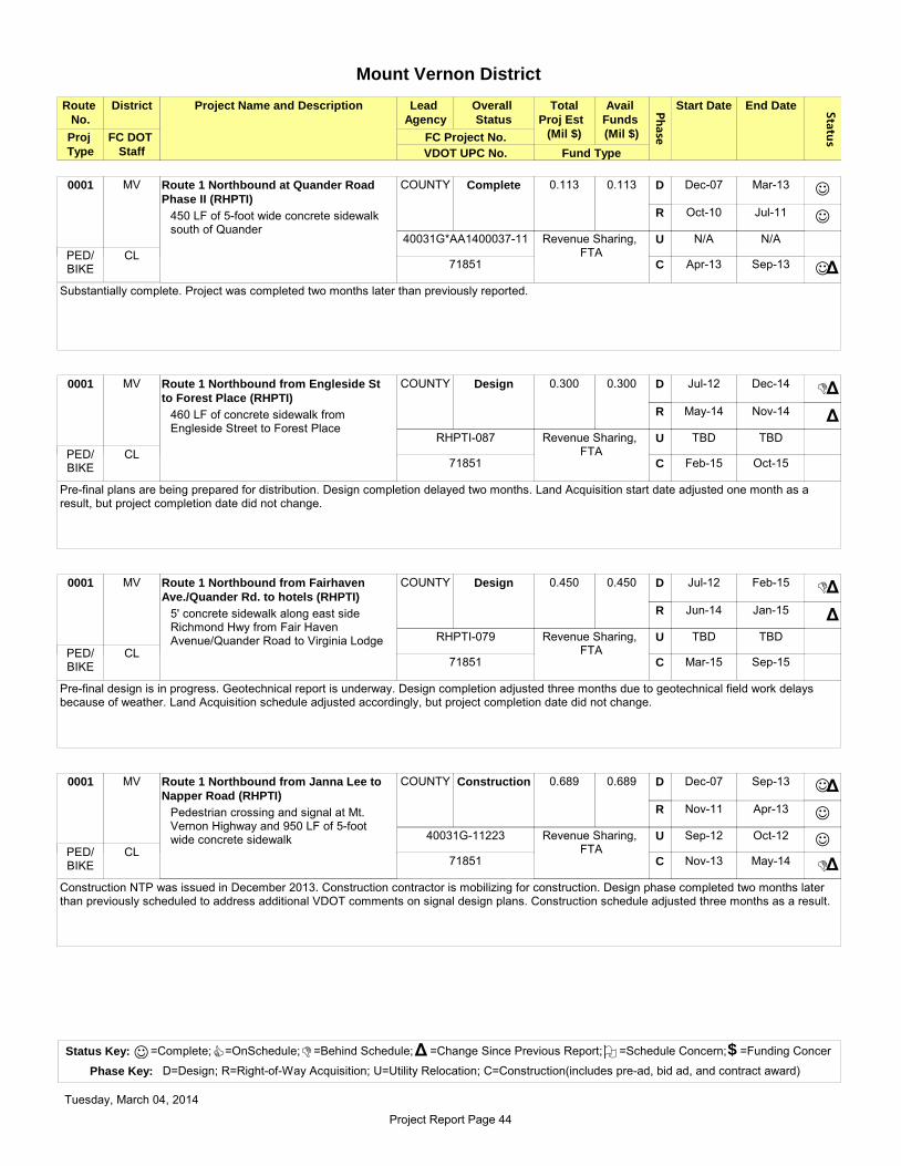
Phase
Route
No.
District Project Name and Description Lead
Agency
Overall
Status
Avail
Funds
(Mil $)
Start Date End Date Status
Total
Proj Est
(Mil $)
VDOT UPC No.
FC DOT
Staff Fund Type
FC Project No.
Mount Vernon District
Proj
Type
MV Route 1 Northbound at Quander Road
Phase II (RHPTI)
COUNTY Complete 0.113 0.113 Dec-07 Mar-13
Oct-10 Jul-11
N/A N/A
Apr-13 Sep-13
D
R
U
C
450 LF of 5-foot wide concrete sidewalk south of Quander
J
J
JΔ
Substantially complete. Project was completed two months later than previously reported.
0001
Revenue Sharing, FTACL
40031G*AA1400037-11
71851 PED/
BIKE
MV Route 1 Northbound from Engleside St
to Forest Place (RHPTI)
COUNTY Design 0.300 0.300 Jul-12 Dec-14
May-14 Nov-14
TBD TBD
Feb-15 Oct-15
D
R
U
C
460 LF of concrete sidewalk from Engleside Street to Forest Place
DΔ
Δ
Pre-final plans are being prepared for distribution. Design completion delayed two months. Land Acquisition start date adjusted one month as a result, but project completion date did not change.
0001
Revenue Sharing, FTACL
RHPTI-087
71851 PED/
BIKE
MV Route 1 Northbound from Fairhaven
Ave./Quander Rd. to hotels (RHPTI)
COUNTY Design 0.450 0.450 Jul-12 Feb-15
Jun-14 Jan-15
TBD TBD
Mar-15 Sep-15
D
R
U
C
5' concrete sidewalk along east side Richmond Hwy from Fair Haven Avenue/Quander Road to Virginia Lodge
DΔ
Δ
Pre-final design is in progress. Geotechnical report is underway. Design completion adjusted three months due to geotechnical field work delays because of weather. Land Acquisition schedule adjusted accordingly, but project completion date did not change.
0001
Revenue Sharing, FTACL
RHPTI-079
71851 PED/
BIKE
MV Route 1 Northbound from Janna Lee to
Napper Road (RHPTI)
COUNTY Construction 0.689 0.689 Dec-07 Sep-13
Nov-11 Apr-13
Sep-12 Oct-12
Nov-13 May-14
D
R
U
C
Pedestrian crossing and signal at Mt. Vernon Highway and 950 LF of 5-footwide concrete sidewalk
J
J
J
D
Δ
Δ
Construction NTP was issued in December 2013. Construction contractor is mobilizing for construction. Design phase completed two months later than previously scheduled to address additional VDOT comments on signal design plans. Construction schedule adjusted three months as a result.
0001
Revenue Sharing, FTACL
40031G-11223
71851 PED/
BIKE
Status Key: =Complete; =OnSchedule; =Behind Schedule; =Change Since Previous Report; =Schedule Concern; =Funding Concer
Phase Key: D=Design; R=Right-of-Way Acquisition; U=Utility Relocation; C=Construction(includes pre-ad, bid ad, and contract award)
J C D Δ O $
Tuesday, March 04, 2014
Project Report Page 44

Phase
Route
No.
District Project Name and Description Lead
Agency
Overall
Status
Avail
Funds
(Mil $)
Start Date End Date Status
Total
Proj Est
(Mil $)
VDOT UPC No.
FC DOT
Staff Fund Type
FC Project No.
Mount Vernon District
Proj
Type
MV Route 1 Northbound from Radford
Avenue to Frye Road (RHPTI)
COUNTY Design 0.500 0.500 Jul-12 Dec-14
Apr-14 Nov-14
TBD TBD
Feb-15 Sep-15
D
R
U
C
940 LF of concrete sidewalk along the east side of Route 1
DΔ
Pre-final plans distributed in January 2014. Design completion delayed two months, but project completion date did not change.
0001
Revenue Sharing, FTACL
RHPTI-084
PED/ BIKE
MV Route 1 Northbound from Sacramento
Drive to Dogue Creek (RHPTI)
COUNTY Project
Initiation
TBD TBD TBD TBD
TBD TBD
TBD TBD
TBD TBD
D
R
U
C
340 LF of walkway and new pedestrian bridge over Dogue Creek
Awaiting design contract proposal. Schedule will be determined once contract proposal has been approved.
0001
Revenue Sharing, FTACL
RHPTI-086
71851 PED/
BIKE
MV Route 1 Northbound from Virginia Lodge
to Huntington Ave (RHPTI)
COUNTY Design 0.450 0.450 Jul-12 Feb-15
Jun-14 Jan-15
TBD TBD
Mar-15 Sep-15
D
R
U
C
1375 LF of 5' concrete sidewalk and extension of a box culvert along the east of Richmond Highway
DΔ
Δ
Pre-final design is in progress. Geotechnical report is underway. Design completion adjusted three months due to geotechnical field work delays because of weather. Land Acquisition schedule adjusted two months, but project completion date did not change.
0001
Revenue Sharing, FTACL
RHPTI-080
71851 PED/
BIKE
MV Route 1 Northbound north of Reddick
Ave (RHPTI)
COUNTY Complete 0.125 0.125 Dec-07 Mar-13
Oct-10 Aug-11
N/A N/A
Apr-13 Sep-13
D
R
U
C
500 LF of 5-foot wide concrete sidewalk
J
J
JΔ
Substantially complete. Project completed two months later than previously reported.
0001
Revenue Sharing, FTACL
40031G*AA1400033-11
71851 PED/
BIKE
Status Key: =Complete; =OnSchedule; =Behind Schedule; =Change Since Previous Report; =Schedule Concern; =Funding Concer
Phase Key: D=Design; R=Right-of-Way Acquisition; U=Utility Relocation; C=Construction(includes pre-ad, bid ad, and contract award)
J C D Δ O $
Tuesday, March 04, 2014
Project Report Page 45

Phase
Route
No.
District Project Name and Description Lead
Agency
Overall
Status
Avail
Funds
(Mil $)
Start Date End Date Status
Total
Proj Est
(Mil $)
VDOT UPC No.
FC DOT
Staff Fund Type
FC Project No.
Mount Vernon District
Proj
Type
MV Route 1 Northbound south of Fordson
Road to Woodlawn Trail (RHPTI)
COUNTY Construction 0.410 0.410 Dec-07 Mar-13
Oct-10 Oct-11
Jan-13 Apr-13
Apr-13 Mar-14
D
R
U
C
1,640 LF of 5-foot wide concrete sidewalk
J
J
J
DΔ
Construction is 90% complete. Punch list is being completed. Schedule has been adjusted in February due to construction issues and a delay in adjacent development that is affecting the completion of this project.
0001
Revenue Sharing, FTACL
40031G*AA1400036-11
71851 PED/
BIKE
MV Route 1 Northbound south of Kings
Village Road (RHPTI)
COUNTY Complete 0.038 0.038 Dec-07 Mar-13
Oct-10 Apr-11
N/A N/A
Apr-13 Sep-13
D
R
U
C
150 LF of 5-foot wide concrete sidewalk
J
J
JΔ
Substantially complete. Project was completed two months later than previously reported.
0001
Revenue Sharing, FTACL
40031G*AA1400035-11
71851 PED/
BIKE
MV Route 1 Southbound at Belle Haven
Towers (RHPTI)
COUNTY Complete 0.138 0.138 Dec-07 Mar-13
Oct-10 Nov-11
N/A N/A
Apr-13 Sep-13
D
R
U
C
550 LF of 5-foot wide concrete sidewalk and service Drive crossing
J
J
JΔ
Substantially complete. Project was completed two months later than previously reported.
0001
Revenue Sharing, FTACL
40031G-11254
71851 PED/
BIKE
MV Route 1 Southbound Belle Haven
Towers to Mount Eagle Drive (RHPTI)
COUNTY Design 0.100 0.100 Jul-12 Feb-15
Jun-14 Jan-15
TBD TBD
Mar-15 Sep-15
D
R
U
C
110 LF of 5' concrete sidewalk along west of Richmond Hwy at the intersection of Mt. Eagle Drive
DΔ
Δ
Pre-final design is in progress. Alternate retaining wall design is under review to mitigate utility impacts. Geotechnical report is underway. Design completion adjusted four months due to geotechnical field work delays because of weather. Land Acquisition schedule adjusted accordingly, but project completion date did not change.
0001
Revenue Sharing, FTACL
RHPTI-081
71851 PED/
BIKE
Status Key: =Complete; =OnSchedule; =Behind Schedule; =Change Since Previous Report; =Schedule Concern; =Funding Concer
Phase Key: D=Design; R=Right-of-Way Acquisition; U=Utility Relocation; C=Construction(includes pre-ad, bid ad, and contract award)
J C D Δ O $
Tuesday, March 04, 2014
Project Report Page 46

Phase
Route
No.
District Project Name and Description Lead
Agency
Overall
Status
Avail
Funds
(Mil $)
Start Date End Date Status
Total
Proj Est
(Mil $)
VDOT UPC No.
FC DOT
Staff Fund Type
FC Project No.
Mount Vernon District
Proj
Type
MV Route 1 Southbound from Dogue Creek
to Mobile Home Sales Park (RHPTI)
COUNTY Project
Initiation
TBD TBD TBD TBD
TBD TBD
TBD TBD
TBD TBD
D
R
U
C
2,000 LF of trail and new pedestrian bridge over Dogue Creek
Awaiting design contract proposal. Schedule will be determined once contract proposal has been approved.
0001
Revenue Sharing, FTACL
RHPTI-085
71851 PED/
BIKE
LE, MV Route 1 Southbound from Russell Road
to Gregory Drive (RHPTI)
COUNTY Design 0.500 0.500 Jul-12 Dec-14
Apr-14 Nov-14
TBD TBD
Jan-15 Sep-15
D
R
U
C
270 LF of concrete sidewalk along west side of Route 1, including a signalized crosswalk
DΔ
Pre-final plans distributed in December 2013. Design completion date delayed two months due to delays in receiving comments after pre-final plans, but project completion date did not change.
0001
Revenue Sharing, FTACL
RHPTI-083
71851 PED/
BIKE
MV Route 1 Southbound from Sacramento
Drive to Engleside Plaza (RHPTI)
COUNTY Complete 0.350 0.350 Dec-07 Mar-13
Oct-10 Sep-11
Jan-13 Apr-13
Apr-13 Sep-13
D
R
U
C
1400 LF of 5-foot wide concrete sidewalk
J
J
J
JΔ
Sidewalk is complete, two months later than previously reported. Pavement markings remain to be completed and will be finished in April. Pavement marking delays due to weather.
0001
Revenue Sharing, FTACL
40031G-11213
71851 PED/
BIKE
MV Route 1 Southbound South of Sky View
Drive (RHPTI)
COUNTY Complete 0.112 0.112 Dec-07 Mar-13
Oct-10 May-11
Jan-13 Apr-13
Apr-13 Sep-13
D
R
U
C
170 LF of 5-foot wide concrete sidewalk and bus stop pad
J
J
J
JΔ
Construction is complete, three months later than previously scheduled.
0001
Revenue Sharing, FTACL
40031G-11214
71851 PED/
BIKE
Status Key: =Complete; =OnSchedule; =Behind Schedule; =Change Since Previous Report; =Schedule Concern; =Funding Concer
Phase Key: D=Design; R=Right-of-Way Acquisition; U=Utility Relocation; C=Construction(includes pre-ad, bid ad, and contract award)
J C D Δ O $
Tuesday, March 04, 2014
Project Report Page 47

Phase
Route
No.
District Project Name and Description Lead
Agency
Overall
Status
Avail
Funds
(Mil $)
Start Date End Date Status
Total
Proj Est
(Mil $)
VDOT UPC No.
FC DOT
Staff Fund Type
FC Project No.
Mount Vernon District
Proj
Type
MV, LE Route 1 Transit Center COUNTY Study 0.154 0.154 Aug-10 TBD
N/A N/A
N/A N/A
N/A N/A
D
R
U
C
Select location, conceptual design, and operational study for transit center in the Route 1 corridor (study only)
C
Southeast Fairfax Development Corporation (SFDC), Mount Vernon Council of Citizens' Associations, Lee District Association of Civic Associations, and Lee Land Use Committee suggested 16 new sites which staff evaluated. An on-call consultant has been performing conceptual layout design and feasibility analysis on top three sites. A public hearing was held in September 2013. Revising conceptual designs based on stakeholder comments, and coordinating with FCPA and Department of Housing and Community Development. Partnering with Fairfax County Health Department on Health Impact Assessment of proposed sites.
0001
FTA
CL
2G40-059-000
TRAN
MV Route 1/Arlington Blvd. (RHPTI) COUNTY Design 0.500 0.500 Mar-12 Mar-14
N/A N/A
TBD TBD
May-14 Aug-14
D
R
U
C
Pedestrian intersection improvements
DΔ
Δ
Second final design submitted to VDOT in November 2013. Received additional comments from VDOT in January 2014 and they are being addressed. Design completion delayed two months to address additional comments from VDOT. Construction phase start date adjusted one month, but no change to completion date.
0001
CMAQ
CL
RHPTI-016
98753 PED/
BIKE
LE, MV Route 1/Belford Drive (RHPTI) COUNTY Design 0.357 0.357 Jul-11 Nov-14
Mar-14 Oct-14
TBD TBD
Jan-15 Jul-15
D
R
U
C
Pedestrian intersection improvements
DΔ
Δ
Δ
Final design and right-of-way authorization package submitted to VDOT in November 2013. Design completion delayed six months due to delay in obtaining VDOT right-of-way authorization. Land Acquisition schedule adjusted six months and Construction schedule adjusted nine months as a result. Additional funding required for right-of-way authorization, transfer in progress.
0001
CMAQ
CL
26006G-06011
99054 PED/
BIKE
MV Route 1/Frye Road Phase II (RHPTI) COUNTY Design 0.300 0.300 Jul-11 Nov-14
Mar-14 Oct-14
TBD TBD
Jan-15 Jul-15
D
R
U
C
Pedestrian intersection improvements
DΔ
Δ
Δ
Final design and right-of-way authorization package submitted to VDOT in November 2013. Design completion delayed six months due to delay in obtaining VDOT right-of-way authorization. Land Acquisition schedule adjusted six months and Construction schedule adjusted nine months as a result. Additional funding required for right-of-way authorization, transfer in progress.
0001
CMAQ
CL
26006G-06002
99054 PED/
BIKE
Status Key: =Complete; =OnSchedule; =Behind Schedule; =Change Since Previous Report; =Schedule Concern; =Funding Concer
Phase Key: D=Design; R=Right-of-Way Acquisition; U=Utility Relocation; C=Construction(includes pre-ad, bid ad, and contract award)
J C D Δ O $
Tuesday, March 04, 2014
Project Report Page 48

Phase
Route
No.
District Project Name and Description Lead
Agency
Overall
Status
Avail
Funds
(Mil $)
Start Date End Date Status
Total
Proj Est
(Mil $)
VDOT UPC No.
FC DOT
Staff Fund Type
FC Project No.
Mount Vernon District
Proj
Type
LE, MV Route 1/Ladson Lane (RHPTI) COUNTY Design 0.400 0.400 Jul-11 Nov-14
Mar-14 Oct-14
TBD TBD
Jan-15 Jul-15
D
R
U
C
Pedestrian intersection improvements
DΔ
Δ
Δ
Final design and right-of-way authorization package submitted to VDOT in November 2013. Design completion delayed six months due to delay in obtaining VDOT right-of-way authorization. Land Acquisition schedule adjusted six months and Construction schedule adjusted nine months as a result. Additional funding required for right-of-way authorization, transfer in progress.
0001
CMAQ
CL
26006G-06002
99054 PED/
BIKE
LE, MV Route 1/Lockheed Blvd/Dart Lane
(RHPTI)
COUNTY Design 0.500 0.500 Mar-12 Mar-14
N/A N/A
N/A N/A
May-14 Aug-14
D
R
U
C
Pedestrian intersection improvements
DΔ
Δ
Second final design submitted to VDOT in November 2013. Additional comments were received from VDOT on the signal design plans in January 2014. Design completion delayed three months to address additional comments. Construction schedule adjusted one month as a result.
0001
CMAQ
CL
RHPTI-015
98753 PED/
BIKE
MV Route 1/Lukens Lane Phase II (RHPTI) COUNTY Design 0.300 0.300 Jul-11 Nov-14
Mar-14 Oct-14
TBD TBD
Jan-15 Jul-15
D
R
U
C
Pedestrian intersection improvements
DΔ
Δ
Δ
Final design and right-of-way authorization package submitted to VDOT in November 2013. Design completion delayed six months due to delay in obtaining VDOT right-of-way authorization. Land Acquisition schedule adjusted six months and Construction schedule adjusted nine months as a result. Additional funding required for right-of-way authorization, transfer in progress.
0001
CMAQ
CL
26006G-06002
99054 PED/
BIKE
LE, MV Route 1/Mohawk Lane (RHPTI) COUNTY Design 0.157 0.157 Jul-11 Nov-14
Mar-14 Oct-14
TBD TBD
Jan-15 Jul-15
D
R
U
C
Pedestrian intersection improvements
DΔ
Δ
Δ
Final design and right-of-way authorization package submitted to VDOT in November 2013. Design completion delayed six months due to delay in obtaining VDOT right-of-way authorization. Land Acquisition schedule adjusted six months and Construction schedule adjusted nine months as a result. Additional funding required for right-of-way authorization, transfer in progress.
0001
CMAQ
CL
26006G-06011
99054 PED/
BIKE
Status Key: =Complete; =OnSchedule; =Behind Schedule; =Change Since Previous Report; =Schedule Concern; =Funding Concer
Phase Key: D=Design; R=Right-of-Way Acquisition; U=Utility Relocation; C=Construction(includes pre-ad, bid ad, and contract award)
J C D Δ O $
Tuesday, March 04, 2014
Project Report Page 49

Phase
Route
No.
District Project Name and Description Lead
Agency
Overall
Status
Avail
Funds
(Mil $)
Start Date End Date Status
Total
Proj Est
(Mil $)
VDOT UPC No.
FC DOT
Staff Fund Type
FC Project No.
Mount Vernon District
Proj
Type
MV Route 1/Sacramento Drive/Cooper Road
(RHPTI)
COUNTY Design 0.500 0.500 Mar-12 Mar-14
N/A N/A
TBD TBD
May-14 Aug-14
D
R
U
C
Pedestrian intersection improvements
DΔ
Δ
Second final design submitted to VDOT in November 2013. Additional comments were received from VDOT in January 2014. Design completion delayed four months to address additional comments received from VDOT on the signal plans. Construction schedule adjusted two months as a result.
0001
CMAQ
CL
RHPTI-013
98753 PED/
BIKE
LE, MV Route 1/Southgate Drive/Bedoo St
(RHPTI)
COUNTY Design 0.500 0.500 Mar-12 Dec-14
Apr-14 Nov-14
TBD TBD
Feb-15 May-15
D
R
U
C
Pedestrian intersection improvements
DΔ
Δ
Second final design submitted to VDOT in November 2013. Design completion delayed 13 months due to needed crosswalk design revision to meet ADA standards which will require land rights. Land Acquisition schedule established, and Construction schedule adjusted 11 months as a result.
0001
CMAQ
CL
RHPTI-014
98753 PED/
BIKE
MV, SP Silverbrook Road Walkway COUNTY Construction 0.220 0.220 May-08 Mar-12
Feb-09 Feb-11
N/A N/A
May-12 TBD
D
R
U
C
Install 650 LF asphalt sidewalk along the north side of Silverbrook Road from Silverthorn Road to Bayberry Ridge Road
J
J
DΔ
Construction is 70% complete. Signing and Marking plans are pending approval. This project is being constructed under the countywide permit. Schedule was adjusted in October due to the ongoing issues with the installation of new private entrance. Schedule to be determined once resolved.
0600
2007 Bonds
WPH
4YP201-PB020
PED/ BIKE
MV Silverbrook Road Walkway COUNTY Complete 0.060 0.060 May-08 Apr-13
May-10 Nov-12
N/A N/A
Jun-13 Aug-13
D
R
U
C
Install 820 LF asphalt sidewalk along the north side of Silverbrook Road from Southrun Road to Monacan Road
J
J
J
Substantially complete.
0600
2007 Bonds
WPH
4YP201-PB018
PED/ BIKE
Status Key: =Complete; =OnSchedule; =Behind Schedule; =Change Since Previous Report; =Schedule Concern; =Funding Concer
Phase Key: D=Design; R=Right-of-Way Acquisition; U=Utility Relocation; C=Construction(includes pre-ad, bid ad, and contract award)
J C D Δ O $
Tuesday, March 04, 2014
Project Report Page 50

Phase
Route
No.
District Project Name and Description Lead
Agency
Overall
Status
Avail
Funds
(Mil $)
Start Date End Date Status
Total
Proj Est
(Mil $)
VDOT UPC No.
FC DOT
Staff Fund Type
FC Project No.
Mount Vernon District
Proj
Type
MV Silverbrook Road Walkway COUNTY Project
Initiation
2.300 0 TBD TBD
TBD TBD
TBD TBD
TBD TBD
D
R
U
C
South side from Hooes Road to South County High School
Project is part of the Third Four-Year Transportation Program approved by the BOS on July 10, 2012. Project is slated for the 2014 Transportation Bond Referendum which must be approved by voters before the project can proceed.
0600
2014 Bonds
WPH PED/ BIKE
MV Silverbrook Road/Southrun Road COUNTY Project
Initiation
1.200 0 TBD TBD
TBD TBD
TBD TBD
TBD TBD
D
R
U
C
Intersection improvements, EB left turn lane
Project is part of the Third Four-Year Transportation Program approved by the BOS on July 10, 2012. Project is slated for the 2014 Transportation Bond Referendum which must be approved by voters before the project can proceed.
0600
2014 Bonds
WPHSEC
LE, MV Telegraph Road from Beulah Street to
Leaf Road
FHWA Construction 38.350 27.559 Oct-08 May-11
Sep-10 May-11
Feb-11 May-13
June-11 Jun-14
D
R
U
C
Widen Telegraph Road to 4 lanes and provide pedestrian facility; Part of Mulligan Road Project
J
J
C
C
Part of Mulligan Road Phase II project which is under construction. Estimate open to traffic in late spring 2014. Project is 85% complete.
0611
Secondary
JYR11012
SEC
Status Key: =Complete; =OnSchedule; =Behind Schedule; =Change Since Previous Report; =Schedule Concern; =Funding Concer
Phase Key: D=Design; R=Right-of-Way Acquisition; U=Utility Relocation; C=Construction(includes pre-ad, bid ad, and contract award)
J C D Δ O $
Tuesday, March 04, 2014
Project Report Page 51

4-Year Project Summary Report
Phase
Route
No.
District Project Name and Description Lead
Agency
Overall
Status
Avail
Funds
(Mil $)
Start Date End Date Status
Total
Proj Est
(Mil $)
VDOT UPC No.
FC DOT
Staff Fund Type
FC Project No.
Providence District
Proj
Type
PR Aline Avenue Walkway (TMSAMS) COUNTY Design 0.250 0.250 TBD May-16
Apr-15 Sep-15
TBD TBD
Jul-16 Feb-17
D
R
U
C
South side between Gallows Road and first entrance on Aline Ave
C
Project is part of the Third Four-Year Transportation Program approved by the BOS on July 10, 2012. Preliminary design is in progress.
3402
RSTP
WPH
TMSAMS-110
PED/ BIKE
PR Boone Blvd/Aline Ave (TMSAMS) COUNTY Complete 0.050 0.050 Dec-12 Apr-13
N/A N/A
TBD TBD
Jul-13 Feb-14
D
R
U
C
Pedestrian intersection improvements
J
JΔ
Project is part of the Third Four-Year Transportation Program approved by the BOS on July 10, 2012. Project completed five months later than previously reported because of utility conflicts.
0786
C & I
GM PED/ BIKE
PR Chain Bridge Road Walkway (TMSAMS) COUNTY Design 0.750 0.750 Aug-13 May-16
May-15 Nov-15
TBD TBD
Sep-16 Jun-17
D
R
U
C
North side from Anderson Road to Colonial Lane
C
Project is part of the Third Four-Year Transportation Program approved by the BOS on July 10, 2012. Intermediate design plans distributed in February 2014. Utility test pits have been requested.
0123
RSTP
SSS
TMSAMS-108
PED/ BIKE
DR, PR Dolley Madison Blvd Walkway (DCBPA) COUNTY Design 1.200 1.200 Jan-12 Apr-15
N/A N/A
N/A N/A
Jun-15 Jan-16
D
R
U
C
Great Falls St/Lewinsville Road to McLean Metrorail Station
C
Pre-final design distributed for review and comment in January 2014. Geotechnical proposal in progress.
0123
CMAQ
SSS
DCBPA-065
93146 PED/
BIKE
Status Key: =Complete; =OnSchedule; =Behind Schedule; =Change Since Previous Report; =Schedule Concern; =Funding Concer
Phase Key: D=Design; R=Right-of-Way Acquisition; U=Utility Relocation; C=Construction(includes pre-ad, bid ad, and contract award)
J C D Δ O $
Tuesday, March 04, 2014
Project Report Page 52

Phase
Route
No.
District Project Name and Description Lead
Agency
Overall
Status
Avail
Funds
(Mil $)
Start Date End Date Status
Total
Proj Est
(Mil $)
VDOT UPC No.
FC DOT
Staff Fund Type
FC Project No.
Providence District
Proj
Type
DR, PR, HM
Dulles Rail Phase 1 MWAA Construction 2740.000 2740.000 Apr-05 Jun-10
Jan-08 Nov-08
Feb-08 Jan-10
Jan-09 Mar-14
D
R
U
C
Construct new stations and extend Metrorail from West Falls Church Station to Wiehle Avenue
J
J
J
DΔ
Dulles Transit Partners (DTP) claimed Scheduled Substantial Completion on February 7, 2014. MWAA announced on February 25, 2014, that DTP was not in conformance with the contract requirements for substantial completion. Once DTP achieves substantial completion, this will allow the next steps to be taken by WMATA in determining the Revenue Operations Date (ROD). Project completion delayed six months due to additional testing required before turning system over to WMATA. For further information, see http://www.dullesmetro.com.
XXXX
Federal, State, Local, Tax District,
MWAAWPH
70554TRAN
DR, PR Dulles Toll Road Tysons Ramps COUNTY Complete 0.800 0.800 May-11 Jul-13
N/A N/A
N/A N/A
N/A N/A
D
R
U
C
Study to evaluate alternatives for existing and up to three additional interchanges between the Dulles Toll Road and Tysons
J
Study is complete. Analysis to be presented to the Board in March 2014.
0267
C & I
WPHPRI
PR Gallows Road Walkway (TMSAMS) COUNTY Design 0.250 0.250 Aug-13 Jan-16
Jan-15 Jul-15
TBD TBD
Mar-16 Dec-16
D
R
U
C
Sidewalk on northwest corner of Gallows Road and Old Courthouse Road intersection
C
Project is part of the Third Four-Year Transportation Program approved by the BOS on July 10, 2012. Intermediate design is in progress.
0650
RSTP
WPH
TMSAMS-109
PED/ BIKE
PR Gallows Road/Boone Blvd (TMSAMS) COUNTY Design 0.150 0.150 TBD Oct-15
Mar-15 Jul-15
TBD TBD
Feb-16 Sep-16
D
R
U
C
Pedestrian intersection improvements
C
Project is part of the Third Four-Year Transportation Program approved by the BOS on July 10, 2012. Intermediate design plans have been distributed.
0650
RSTP
CL
TMSAMS-117
PED/ BIKE
Status Key: =Complete; =OnSchedule; =Behind Schedule; =Change Since Previous Report; =Schedule Concern; =Funding Concer
Phase Key: D=Design; R=Right-of-Way Acquisition; U=Utility Relocation; C=Construction(includes pre-ad, bid ad, and contract award)
J C D Δ O $
Tuesday, March 04, 2014
Project Report Page 53
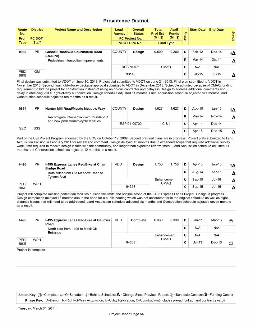
Phase
Route
No.
District Project Name and Description Lead
Agency
Overall
Status
Avail
Funds
(Mil $)
Start Date End Date Status
Total
Proj Est
(Mil $)
VDOT UPC No.
FC DOT
Staff Fund Type
FC Project No.
Providence District
Proj
Type
PR Gosnell Road/Old Courthouse Road
(DCBPA)
COUNTY Design 0.500 0.200 Feb-12 Dec-14
Mar-14 Oct-14
N/A N/A
Feb-15 Jul-15
D
R
U
C
Pedestrian intersection improvements
DΔ
Δ
Δ
Final design was submitted to VDOT on June 10, 2013. Project plat submitted to VDOT on June 21, 2013. Final plan submitted to VDOT in November 2013. Second final right-of-way package approval submitted to VDOT in December 2013. Schedule adjusted because of CMAQ funding requirement to bid the project for construction instead of using an on-call contractor and delays in Design to address additional comments and delay in obtaining VDOT right-of-way authorization. Design schedule adjusted 14 months, Land Acquisition schedule adjusted five months, and Construction schedule adjusted ten months as a result.
0939
CMAQ
GM
DCBPA-071
93146 PED/
BIKE
PR Hunter Mill Road/Mystic Meadow Way COUNTY Design 1.627 1.627 Aug-10 Jan-15
Mar-14 Nov-14
Apr-14 Dec-14
Apr-15 Dec-15
D
R
U
C
Reconfigure intersection with roundabout and new pedestrian/bicycle facilities
DΔ
Δ
Δ
Part of the C&I Project Program endorsed by the BOS on October 19, 2009. Second pre-final plans are in progress. Project plats submitted to Land Acquisition Division in February 2014 for review and comment. Design delayed 13 months due to expanded scope that required additional survey work, time required to resolve design issues with the community, and longer than expected review times. Land Acquisition schedule adjusted 11 months and Construction schedules adjusted 12 months as a result.
0674
C & I
SSS
RSPI01-00700
SEC
PR I-495 Express Lanes Ped/Bike at Chain
Bridge Road
VDOT Design 1.750 1.750 Apr-13 Jun-15
Aug-14 Apr-15
Sep-15 Jul-16
Sep-15 Jul-16
D
R
U
C
Both sides from Old Meadow Road to Tysons Blvd
DΔ
Δ
Δ
Δ
Project will complete missing pedestrian facilities outside the limits and original scope of the I-495 Express Lanes Project. Design in progress. Design completion delayed 15 months due to the need for a public hearing which was not accounted for in the original schedule as well as sight distance issues that will need to be addressed. Land Acquisition schedule adjusted six months and Construction schedule adjusted seven months as a result.
I-495
Enhancement, CMAQWPH
94363 PED/
BIKE
PR I-495 Express Lanes Ped/Bike at Gallows
Road
VDOT Complete 0.330 0.330 Jan-11 Mar-13
N/A N/A
N/A N/A
Jul-13 Dec-13
D
R
U
C
North side from I-495 to Mobil Oil Entrance
J
J
Project is complete.
I-495
Enhancement, CMAQWPH
94363 PED/
BIKE
Status Key: =Complete; =OnSchedule; =Behind Schedule; =Change Since Previous Report; =Schedule Concern; =Funding Concer
Phase Key: D=Design; R=Right-of-Way Acquisition; U=Utility Relocation; C=Construction(includes pre-ad, bid ad, and contract award)
J C D Δ O $
Tuesday, March 04, 2014
Project Report Page 54

Phase
Route
No.
District Project Name and Description Lead
Agency
Overall
Status
Avail
Funds
(Mil $)
Start Date End Date Status
Total
Proj Est
(Mil $)
VDOT UPC No.
FC DOT
Staff Fund Type
FC Project No.
Providence District
Proj
Type
PR I-495 Express Lanes Ped/Bike at
Idylwood Road (North)
VDOT Design 1.280 1.280 Apr-13 Jun-15
Aug-14 Apr-15
Sep-15 Jul-16
Sep-15 Jul-16
D
R
U
C
North side from I-495 to Shreve Hill Road
DΔ
Δ
Δ
Project will complete missing pedestrian facilities outside the limits and original scope of the I-495 Express Lanes Project. Design in progress. Design completion delayed 15 months due to the need for a public hearing which was not accounted for in the original schedule as well as sight distance issues that will need to be addressed. Land Acquisition schedule adjusted six months and Construction schedule adjusted seven months as a result. Utility Relocation schedule established.
I-495
Enhancement, CMAQWPH
94363 PED/
BIKE
PR I-495 Express Lanes Ped/Bike at
Idylwood Road (South)
VDOT Design 1.280 1.280 Apr-13 Jun-15
Aug-14 Apr-15
Sep-15 Jul-16
Sep-15 Jul-16
D
R
U
C
South side from I-495 to Whitestone Hill Ct
DΔ
Δ
Δ
Δ
Project will complete missing pedestrian facilities outside the limits and original scope of the I-495 Express Lanes Project. Design in progress. Design completion delayed 15 months due to the need for a public hearing which was not accounted for in the original schedule as well as sight distance issues that will need to be addressed. Land Acquisition schedule adjusted six months and Construction schedule adjusted seven months as a result.
I-495
Enhancement, CMAQWPH
94363 PED/
BIKE
PR, SP, SU
I-66 Active Traffic Management VDOT Construction 33.780 33.780 Jan-13 Dec-14
N/A N/A
N/A N/A
Aug-13 Feb-15
D
R
U
C
Improve safety and incident management along I-66 corridor from the D.C. line to Route 29 in Gainesville
C
CΔ
Design-Build project currently under construction. Construction phase began one month later than previously reported, but project completion date did not change.
I-66
Federal
SSS98017
INT
PR, SP, SU
I-66 from I-495 Capital Beltway to Route
15 in Haymarket
VDOT Complete 15.404 15.404 May-11 Nov-13
N/A N/A
N/A N/A
N/A N/A
D
R
U
C
I-66 Tier 1 Draft Environmental Impact Statement (study only)
J
Final Tier 1 Environmental Statement and the Record of Decision issued by FHWA in November 2013. The office of Transportation Public-Private Partnerships (OTP3) issued a Request for Information (RFI) in June 2013 to solicit input from the private sector regarding this project and information was received in November 2013. One or more improvement concepts to be considered in Tier 2 environmental study and detailed schedule to be determined. Technical working group established including representatives of Fairfax and Prince William Counties.
I-66
Interstate
SSS54911
INT
Status Key: =Complete; =OnSchedule; =Behind Schedule; =Change Since Previous Report; =Schedule Concern; =Funding Concer
Phase Key: D=Design; R=Right-of-Way Acquisition; U=Utility Relocation; C=Construction(includes pre-ad, bid ad, and contract award)
J C D Δ O $
Tuesday, March 04, 2014
Project Report Page 55

Phase
Route
No.
District Project Name and Description Lead
Agency
Overall
Status
Avail
Funds
(Mil $)
Start Date End Date Status
Total
Proj Est
(Mil $)
VDOT UPC No.
FC DOT
Staff Fund Type
FC Project No.
Providence District
Proj
Type
PR I-66 Vienna Metro Enhanced Transit
Access (I-66 Bus Ramp)
VDOT Design 51.753 38.300 Nov-05 Sep-14
TBD TBD
N/A N/A
Sep-14 Aug-17
D
R
U
C
Construct bus ramp to increase accessibility to Vienna Metrorail Station for transit vehicles
DΔ
Δ
VDOT coordinating with WMATA on access and land rights. VDOT submitted a TIGER V Grant Application to FHWA for additional funding to support this project. Interchange Justification Report (IJR) is under review by FHWA. Advertisement for RFQ expected in July 2014 after all required funding is in place. Design delayed eight months due to additional time needed for FHWA approval of the IJR. Construction schedule adjusted accordingly.
I-66
CMAQ, RSTP
CL81009
INT
PR Idylwood Road Bike Lanes (TMSAMS) COUNTY On Hold 1.050 1.050 TBD TBD
TBD TBD
TBD TBD
TBD TBD
D
R
U
C
Both sides from Helena Drive to Idyl Lane
Project is part of the Third Four-Year Transportation Program approved by the BOS on July 10, 2012. Pre-scoping process is underway.
0695
RSTP
CWS PED/ BIKE
PR International Drive/Greensboro Road
(DCBPA)
COUNTY Design 0.175 0.175 Feb-12 Dec-14
Mar-14 Oct-14
N/A N/A
Feb-15 Jul-15
D
R
U
C
Pedestrian intersection improvements
DΔ
Δ
Δ
Second final design submitted to VDOT in November 2013. Second final right-of-way package submitted to VDOT in December 2013 for approval. Design completion delayed to address additional comments during VDOT Right-of-Way submission and CMAQ funding requirement to bid the project for construction instead of using an on-call contractor. Design schedule adjusted six months, Land Acquisition schedule adjusted five months, and Construction schedule adjusted ten months as a result.
0684
CMAQ
GM
DCBPA-067
93146 PED/
BIKE
PR International Drive/Tysons Blvd
(TMSAMS)
COUNTY Design 0.150 0.150 Aug-13 Aug-15
TBD TBD
TBD TBD
Oct-15 May-16
D
R
U
C
Pedestrian intersection improvements
C
Project is part of the Third Four-Year Transportation Program approved by the BOS on July 10, 2012. Intermediate design is in progress. VDOT is reviewing existing signal timings to alleviate the existing pedestrian signal problem.
6034
RSTP
TB
TMSAMS-119
PED/ BIKE
Status Key: =Complete; =OnSchedule; =Behind Schedule; =Change Since Previous Report; =Schedule Concern; =Funding Concer
Phase Key: D=Design; R=Right-of-Way Acquisition; U=Utility Relocation; C=Construction(includes pre-ad, bid ad, and contract award)
J C D Δ O $
Tuesday, March 04, 2014
Project Report Page 56

Phase
Route
No.
District Project Name and Description Lead
Agency
Overall
Status
Avail
Funds
(Mil $)
Start Date End Date Status
Total
Proj Est
(Mil $)
VDOT UPC No.
FC DOT
Staff Fund Type
FC Project No.
Providence District
Proj
Type
PR Jones Branch Connector COUNTY Design 0.695 0.695 Jun-13 Apr-16
Oct-15 Apr-16
TBD TBD
Aug-16 Aug-18
D
R
U
C
Final Design for extension of Scotts Crossing Rd from Jones Branch Dr. toDolley Madison Blvd. over I-495 and the I-495 Express Lanes
C
Project is part of the Third Four-Year Transportation Program approved by the BOS on July 10, 2012. Preliminary (30%) design plans complete. Interchange Modification Report (IMR) and an update to the NEPA documents are currently underway for approval by VDOT and FHWA. Final design consultant contract has been awarded. Geotechnical analysis completed. Updated field survey is completed. Value engineering is complete.
8102
C & I
SSS
JBC-093
103907SEC
PR Madrillon Road Walkway (TMSAMS) COUNTY Design 0.127 0.127 Aug-13 May-16
Apr-15 Sep-15
TBD TBD
Jul-16 Feb-17
D
R
U
C
Install 315 LF of walkway between Gallows Road and Boss Street
C
Project is part of the Third Four-Year Transportation Program approved by the BOS on July 10, 2012. Intermediate design plans distributed in February 2014. Utility test pits have been requested.
0893
RSTP
CL
TMSAMS-111
PED/ BIKE
PR Oak Street Walkway COUNTY ROW 0.500 0.120 June-08 May-14
Jun-13 Apr-14
Apr-14 Dec-14
Jun-14 Sep-14
D
R
U
C
Install concrete sidewalk along the south side of Oak Street from Sandburg Street to I-495
D
D
Δ
Δ
Project removed from hold after Express Lanes completion. Scope now includes walkway from the I-495 Express Lanes Ped/Bike at Oak Street project. Phase I from Sandburg Street to west of Morgan Lane: Second pre-final design is in progress. TMP has been approved. 1 of 4 property rights have been acquired. Design completion delayed three months. Land Acquisition phased adjusted accordingly. Overall project completion date did not change. Phase II from west of Morgan Lane to I-495 will be constructed after phase I is complete.
0769
2007 Bonds
WPH
4YP201-PB038
PED/ BIKE
PR Old Courthouse Road/Woodford Road
(TMSAMS)
COUNTY Design 0.200 0.200 Aug-13 Jan-16
Feb-15 Jul-15
TBD TBD
Apr-16 Dec-16
D
R
U
C
Pedestrian intersection improvements
C
Project is part of the Third Four-Year Transportation Program approved by the BOS on July 10, 2012. Intermediate design is in progress.
0677
RSTP
CL
TMSAMS-116
PED/ BIKE
Status Key: =Complete; =OnSchedule; =Behind Schedule; =Change Since Previous Report; =Schedule Concern; =Funding Concer
Phase Key: D=Design; R=Right-of-Way Acquisition; U=Utility Relocation; C=Construction(includes pre-ad, bid ad, and contract award)
J C D Δ O $
Tuesday, March 04, 2014
Project Report Page 57

Phase
Route
No.
District Project Name and Description Lead
Agency
Overall
Status
Avail
Funds
(Mil $)
Start Date End Date Status
Total
Proj Est
(Mil $)
VDOT UPC No.
FC DOT
Staff Fund Type
FC Project No.
Providence District
Proj
Type
PR Old Gallows Road/Gallows Branch Road
(TMSAMS)
COUNTY Project
Initiation
0.250 0.250 TBD TBD
TBD TBD
TBD TBD
TBD TBD
D
R
U
C
Pedestrian intersection improvements
Project is part of the Third Four-Year Transportation Program approved by the BOS on July 10, 2012. Design contract negotiations are underway.
0650
RSTP
TB
TMSAMS-115
PED/ BIKE
PR Old Meadow Road/Old Meadow Lane
(TMSAMS)
COUNTY Complete 0.050 0.050 Dec-12 Apr-13
N/A N/A
N/A N/A
Jul-13 Sep-13
D
R
U
C
Pedestrian intersection improvements
J
J
Project is part of the Third Four-Year Transportation Program approved by the BOS on July 10, 2012. Project is complete.
3543
C & I
GM PED/ BIKE
DR, PR Pavement Marking Plans (TMSAMS) Project
Initiation
0.100 0.100 TBD TBD
TBD TBD
TBD TBD
TBD TBD
D
R
U
C
Magarity Road, Jones Branch Drive, Westmoreland St, Madrillon Road
Project is part of the Third Four-Year Transportation Program approved by the BOS on July 10, 2012. Project scoping will begin in spring 2014.
XXXX
RSTP
CWS PED/ BIKE
PR Route 123 Bridge over I-66 VDOT On Hold 16.095 1.090 TBD TBD
N/A N/A
N/A N/A
TBD TBD
D
R
U
C
Rehabilitation of Route 123 SB and NB bridges over I-66
Reviewed Stage 1 Bridge Deck Replacement & Widening Study Report in December 2012. Scoping meeting in January 2013. On hold pending I-66 Access Improvement Study.
0123
State
CL92567
PRI
Status Key: =Complete; =OnSchedule; =Behind Schedule; =Change Since Previous Report; =Schedule Concern; =Funding Concer
Phase Key: D=Design; R=Right-of-Way Acquisition; U=Utility Relocation; C=Construction(includes pre-ad, bid ad, and contract award)
J C D Δ O $
Tuesday, March 04, 2014
Project Report Page 58

Phase
Route
No.
District Project Name and Description Lead
Agency
Overall
Status
Avail
Funds
(Mil $)
Start Date End Date Status
Total
Proj Est
(Mil $)
VDOT UPC No.
FC DOT
Staff Fund Type
FC Project No.
Providence District
Proj
Type
PR Route 123/Jermantown Road COUNTY Design 0.950 0.950 Nov-10 Apr-15
Jul-14 Mar-15
Aug-14 TBD
May-15 Apr-16
D
R
U
C
Construct right turn lane from SB Route 123 onto WB Jermantown Road, right turn lane extension from NB Route 123 onto EB Jermantown Road, and pedestrian intersection improvements
DΔ
Δ
Δ
C & I funding approved by BOS in March 2010. Pre-final design is in progress. Signal modification is in progress. Utility test holes ordered in January. Project scope revised to add north bound turn lane, which extended project schedule. Design completion delayed 15 months because land rights are now required and delays in receipt of utility comments and geotechnical report. Land Acquisition schedule established. Construction completion adjusted 20 months as a result.
0123
C & I
JYR
RSPI01-01400
PRI
PR Route 29 at Nutley Street VDOT Complete 1.520 1.520 Nov-11 Oct-12
Oct-12 Oct-13
TBD TBD
Apr-13 Jan-14
D
R
U
C
Construct raised concrete median along the east leg of Route 29, provide dual eastbound left turn lane, and upgrade traffic signal
J
J
JΔ
HSIP project managed by VDOT. Construction is substantially complete, nine months earlier than previously reported.
0029
HSIP
TB100648
PRI
PR Route 29 Bridge Repairs VDOT Construction 0.550 0.550 Feb-13 Sep-13
N/A N/A
N/A N/A
Nov-13 Sep-14
D
R
U
C
Structural Repairs of Bridge at Route 29 over Tributary of Accotink Creek
J
C
Pre-construction meeting will be held on March 3, 2014.
0029
WPH103788
PRI
PR Route 50 Walkway from Annandale Road
to Cherry Street (RT50PI)
COUNTY Design 0.495 0.150 Jun-13 Jan-17
Oct-15 Sep-16
TBD TBD
Apr-17 Dec-17
D
R
U
C
Install walkway on north side of Route 50
C
Project is part of the Route 50 Pedestrian Initiative approved by the Board of Supervisors on June 19, 2012. Preliminary design is underway. Programmatic categorical exclusion under review by VDOT. Environmental documentation is in progress.
0050
RSTP, CMAQ
WPH
RT50-059
58601 PED/
BIKE
Status Key: =Complete; =OnSchedule; =Behind Schedule; =Change Since Previous Report; =Schedule Concern; =Funding Concer
Phase Key: D=Design; R=Right-of-Way Acquisition; U=Utility Relocation; C=Construction(includes pre-ad, bid ad, and contract award)
J C D Δ O $
Tuesday, March 04, 2014
Project Report Page 59

Phase
Route
No.
District Project Name and Description Lead
Agency
Overall
Status
Avail
Funds
(Mil $)
Start Date End Date Status
Total
Proj Est
(Mil $)
VDOT UPC No.
FC DOT
Staff Fund Type
FC Project No.
Providence District
Proj
Type
PR Route 50 Walkway from Cedar Hill Road
to Allen Street (RT50PI)
COUNTY Design 0.630 0.225 Jun-13 Jan-17
Oct-15 Sep-16
TBD TBD
Apr-17 Dec-17
D
R
U
C
Install walkway on north side of Route 50
C
Project is part of the Route 50 Pedestrian Initiative approved by the Board of Supervisors on June 19, 2012. Preliminary design is underway. Programmatic categorical exclusion under review by VDOT. Environmental documentation is in progress.
0050
RSTP, CMAQ
WPH
RT50-055
58601 PED/
BIKE
PR Route 50 Walkway from Meadow Lane to
Linden Lane (RT50PI)
COUNTY Design 0.270 0.100 Jun-13 Jan-17
Oct-15 Sep-16
TBD TBD
Apr-17 Dec-17
D
R
U
C
Install walkway on north side of Route 50
C
Project is part of the Route 50 Pedestrian Initiative approved by the Board of Supervisors on June 19, 2012. Preliminary design is underway. Programmatic categorical exclusion under review by VDOT. Environmental documentation is in progress.
0050
RSTP, CMAQ
WPH
RT50-060
58601 PED/
BIKE
PR Route 50 Walkway from Westcott Street
to Annandale Road (RT50PI)
COUNTY Design 1.260 0.300 Jun-13 Jan-17
Oct-15 Sep-16
TBD TBD
Apr-17 Dec-17
D
R
U
C
Install walkway on north side of Route 50
C
Project is part of the Route 50 Pedestrian Initiative approved by the Board of Supervisors on June 19, 2012. Preliminary design is underway. Programmatic categorical exclusion under review by VDOT. Environmental documentation is in progress.
0050
RSTP, CMAQ
WPH
RT50-058
58601 PED/
BIKE
MA, PR Route 50/Allen St (RT50PI) COUNTY Design 0.400 0.200 Jun-13 Jan-17
Oct-15 Sep-16
TBD TBD
Apr-17 Dec-17
D
R
U
C
Intersection and bus stop improvements
C
Project is part of the Route 50 Pedestrian Initiative approved by the Board of Supervisors on June 19, 2012. Preliminary design is underway. Programmatic categorical exclusion under review by VDOT. Environmental documentation is in progress. Utility designation in progress.
0050
RSTP, CMAQ
WPH
RT50-052
58601 PED/
BIKE
Status Key: =Complete; =OnSchedule; =Behind Schedule; =Change Since Previous Report; =Schedule Concern; =Funding Concer
Phase Key: D=Design; R=Right-of-Way Acquisition; U=Utility Relocation; C=Construction(includes pre-ad, bid ad, and contract award)
J C D Δ O $
Tuesday, March 04, 2014
Project Report Page 60

Phase
Route
No.
District Project Name and Description Lead
Agency
Overall
Status
Avail
Funds
(Mil $)
Start Date End Date Status
Total
Proj Est
(Mil $)
VDOT UPC No.
FC DOT
Staff Fund Type
FC Project No.
Providence District
Proj
Type
MA, PR Route 50/Annandale Road (RT50PI) COUNTY Project
Initiation
0.400 0.200 Jun-13 Jan-17
Oct-15 Sep-16
TBD TBD
Apr--17 Dec-17
D
R
U
C
Pedestrian intersection improvements
C
Project is part of the Route 50 Pedestrian Initiative approved by the Board of Supervisors on June 19, 2012. Preliminary design is underway. Programmatic categorical exclusion under review by VDOT. Environmental documentation is in progress.
0050
RSTP, CMAQ
WPH
RT50-054
58601 PED/
BIKE
MA, PR Route 50/Wayne Road/Woodlawn Ave
(RT50PI)
COUNTY Design 0.400 0.200 Jun-13 Jan-17
Oct-15 Sep-16
TBD TBD
Apr-17 Dec-17
D
R
U
C
Signalization and sidewalk improvements
C
Project is part of the Route 50 Pedestrian Initiative approved by the Board of Supervisors on June 19, 2012. Preliminary design is underway. Programmatic categorical exclusion under review by VDOT. Environmental documentation is in progress.
0050
RSTP, CMAQ
WPH
RT50-053
58601 PED/
BIKE
DR, PR Route 7 Bridge Rehabilitation VDOT Design 20.546 1.316 Sep-12 Sep-14
Aug-15 Mar-16
Mar-16 Dec-16
Nov-15 Sep-17
D
R
U
C
Bridge over Dulles Toll Road
C
DΔ
Δ
Public hearing held February 20, 2014. Environmental document is complete. Currently funded for design and land acquisition only. Design-Build procurement method may be used depending on the funding of the project. Funding is currently available for design and land acquisition. Land Acquisition delayed 18 months due to lack of funding. Initial utility relocation and construction completion schedule shown.
0007
Bridge
SLC82135
PRI
DR, HM, PR
Route 7 from Reston Avenue to Jarrett
Valley Drive
VDOT Design 30.000 5.000 Jun-11 TBD
N/A N/A
N/A N/A
N/A N/A
D
R
U
C
Widen to 6 lanes (PE Only)
C
Funded through the Board's Tysons Transportation Plan. VDOT FY14-FY19 SYP includes $5.0 million for design only. Survey complete. Preliminary design, including alternative intersection analysis, in progress. Group of community, BOS staff, and state/local government agency stakeholders met to discuss design challenges and provide input on project scope. Second PIM held on November 6, 2013. VDOT completed market research study. Traffic engineering study of HOV/Transit lanes along corridor completed in October 2013. Value engineering for the project will be held at VDOT in April 2014.
0007
NVTD Bonds, FederalSLC
52328PRI
Status Key: =Complete; =OnSchedule; =Behind Schedule; =Change Since Previous Report; =Schedule Concern; =Funding Concer
Phase Key: D=Design; R=Right-of-Way Acquisition; U=Utility Relocation; C=Construction(includes pre-ad, bid ad, and contract award)
J C D Δ O $
Tuesday, March 04, 2014
Project Report Page 61

Phase
Route
No.
District Project Name and Description Lead
Agency
Overall
Status
Avail
Funds
(Mil $)
Start Date End Date Status
Total
Proj Est
(Mil $)
VDOT UPC No.
FC DOT
Staff Fund Type
FC Project No.
Providence District
Proj
Type
DR, PR Route 7 Walkway (TMSAMS) COUNTY Design 4.500 4.500 TBD TBD
TBD TBD
TBD TBD
TBD TBD
D
R
U
C
Complete missing links on south side from Jarrett Valley Drive to Beulah Road
Project is part of the Third Four-Year Transportation Program approved by the BOS on July 10, 2012. Design NTP issued in August 2013. Survey is in progress. Schedule to be developed when survey is complete.
0007
RSTP
WPH
TMSAMS-128
PED/ BIKE
PR Route 7 Walkway North Side under
Route 123 (DCBPA)
COUNTY Design 1.200 1.200 Feb-12 Jul-14
N/A N/A
TBD TBD
Nov-14 Jun-15
D
R
U
C
Install walkway across interchange
DΔ
Pre-final design is in progress. NTP issued for Geotechnical investigation in November 2013. NTP issued for analyzing the existing bridge structure and design retaining walls in November 2013. Design completion delayed two months. Project completion date did not change.
0007
CMAQ
TB
DCBPA-069
93146 PED/
BIKE
PR Route 7 Walkway South Side under
Route 123 (DCBPA)
COUNTY Design 1.200 1.200 Feb-12 Jul-14
N/A N/A
TBD TBD
Nov-14 Jun-15
D
R
U
C
Install walkway across interchange
DΔ
Pre-final design is in progress. NTP issued for Geotechnical investigation in November 2013. NTP issued for analyzing the existing bridge structure and design retaining walls in November 2013. Design completion delayed two months. Project completion date did not change.
0007
CMAQ
TB
DCBPA-070
93146 PED/
BIKE
PR Route 7 Widening from Route 123 to I-
495 (Study Only)
COUNTY Study 0.650 0.650 Sep-12 TBD
N/A N/A
N/A N/A
N/A N/A
D
R
U
C
Conceptual design and traffic operations study to determine future cross section
DΔ
Project combined with Route7/Route 123 Interchange Study. Preliminary roadway layout has been developed per Tysons Design standards. Schedule delayed, because data from additional Tysons Consolidated Traffic Impact Analysis (CTIA) are needed. Schedule to be developed once CTIA work is complete.
0007
C & I
TB
2G40-035-001
PRI
Status Key: =Complete; =OnSchedule; =Behind Schedule; =Change Since Previous Report; =Schedule Concern; =Funding Concer
Phase Key: D=Design; R=Right-of-Way Acquisition; U=Utility Relocation; C=Construction(includes pre-ad, bid ad, and contract award)
J C D Δ O $
Tuesday, March 04, 2014
Project Report Page 62

Phase
Route
No.
District Project Name and Description Lead
Agency
Overall
Status
Avail
Funds
(Mil $)
Start Date End Date Status
Total
Proj Est
(Mil $)
VDOT UPC No.
FC DOT
Staff Fund Type
FC Project No.
Providence District
Proj
Type
PR Route 7/Gosnell/Westpark (TMSAMS) COUNTY Design 0.250 0.250 TBD TBD
TBD TBD
TBD TBD
TBD TBD
D
R
U
C
Pedestrian intersection improvements
Project is part of the Third Four-Year Transportation Program approved by the BOS on July 10, 2012. C & I funds allocated to advance design. Design NTP issued in August 2013. Survey is in progress. Schedule to be developed once survey is complete.
0007
RSTP, C & I
TB
TMSAMS-112
PED/ BIKE
HM, PR Route 7/Route 123 Interchange (Study
Only)
COUNTY Study 0.350 0.350 Sep-12 TBD
N/A N/A
N/A N/A
N/A N/A
D
R
U
C
Conceptual design and traffic operations study to determine future interchange configuration or at-grade intersection configuration
DΔ
Project combined with Route 7 widening from Route 123 to I-495 Study. Ground survey is complete. Traffic counts are completed. Conceptual interchange/intersection alternatives developed which will be studied further after additional Tyson Consolidated Traffic Impact Analysis (CTIA) simulations are completed. New schedule will be developed once CTIA work is complete.
0007
C & I
TB
2G40-035-002
PRI
PR Route 7/Spring Hill Road (TMSAMS) COUNTY Design 0.250 0.250 TBD TBD
TBD TBD
TBD TBD
TBD TBD
D
R
U
C
Pedestrian intersection improvements
Project is part of the Third Four-Year Transportation Program approved by the BOS on July 10, 2012. C & I funds allocated to advance design. Design NTP issued in August 2013. Schedule is under review.
0007
RSTP, C & I
TB
TMSAMS-113
PED/ BIKE
PR Route 7/Tyco/Westwood Center
(TMSAMS)
COUNTY Design 0.250 0.250 TBD TBD
TBD TBD
TBD TBD
TBD TBD
D
R
U
C
Pedestrian intersection improvements
Project is part of the Third Four-Year Transportation Program approved by the BOS on July 10, 2012. C & I funds allocated to advance design. Design NTP issued in August 2013. Schedule is under review.
0007
RSTP, C & I
TB
TMSAMS-114
PED/ BIKE
Status Key: =Complete; =OnSchedule; =Behind Schedule; =Change Since Previous Report; =Schedule Concern; =Funding Concer
Phase Key: D=Design; R=Right-of-Way Acquisition; U=Utility Relocation; C=Construction(includes pre-ad, bid ad, and contract award)
J C D Δ O $
Tuesday, March 04, 2014
Project Report Page 63

Phase
Route
No.
District Project Name and Description Lead
Agency
Overall
Status
Avail
Funds
(Mil $)
Start Date End Date Status
Total
Proj Est
(Mil $)
VDOT UPC No.
FC DOT
Staff Fund Type
FC Project No.
Providence District
Proj
Type
PR Scotts Run Walkway (TMSAMS) FCPA Design 2.500 2.500 TBD TBD
TBD TBD
TBD TBD
TBD TBD
D
R
U
C
Connection through Scotts Run Community Park
Project is part of the Third Four-Year Transportation Program approved by the BOS on July 10, 2012. Conceptual alignment study completed in January 2014. FCDOT staff is reviewing alternatives in cooperation with FCPA.
XXXX
RSTP
VA
TMSAMS-107
PED/ BIKE
PR Solutions Drive/Greensboro Blvd
(TMSAMS)
COUNTY Complete 0.050 0.050 Dec-12 Apr-13
N/A N/A
N/A N/A
Jul-13 Feb-14
D
R
U
C
Pedestrian intersection improvements
J
JΔ
Project is part of the Third Four-Year Transportation Program approved by the BOS on July 10, 2012. Project completed five months later than previously reported because of utility conflicts.
6054
C & I
GM PED/ BIKE
PR Tysons Boulevard/Galleria Drive (DCBPA) COUNTY Design 0.500 0.300 Sep-12 Mar-14
TBD TBD
TBD TBD
Apr-14 Jun-14
D
R
U
C
Pedestrian intersection improvements
DΔ
Δ
VDOT approved preliminary study for traffic signal and timings. Project will be completed in two phases. Final plans submitted to VDOT in November 2013. Comments were received in January 2014. Design completion delayed four months to address additional comments. Construction schedule adjusted one month as a result.
7648
CMAQ
WPH
DCBPA-068
93146 PED/
BIKE
PR Tysons Pavement Markings (TMSAMS) COUNTY Project
Initiation
0.015 0.015 TBD TBD
TBD TBD
TBD TBD
TBD TBD
D
R
U
C
Bicycle Master Plan routes in Tysons
Project is part of the Third Four-Year Transportation Program approved by the BOS on July 10, 2012. Funding provided to add bike lanes and markings along existing roadways in the Tysons area and surrounding neighborhoods. Funding is for multiple projects. Scoping to begin in spring 2014.
XXXX
RSTP
CWS PED/ BIKE
Status Key: =Complete; =OnSchedule; =Behind Schedule; =Change Since Previous Report; =Schedule Concern; =Funding Concer
Phase Key: D=Design; R=Right-of-Way Acquisition; U=Utility Relocation; C=Construction(includes pre-ad, bid ad, and contract award)
J C D Δ O $
Tuesday, March 04, 2014
Project Report Page 64

Phase
Route
No.
District Project Name and Description Lead
Agency
Overall
Status
Avail
Funds
(Mil $)
Start Date End Date Status
Total
Proj Est
(Mil $)
VDOT UPC No.
FC DOT
Staff Fund Type
FC Project No.
Providence District
Proj
Type
DR, PR Tysons Wayfinding Signage (TMSAMS) COUNTY Project
Initiation
0.100 0.100 TBD TBD
TBD TBD
TBD TBD
TBD TBD
D
R
U
C
Throughout Tysons Area
Project is part of the Third Four-Year Transportation Program approved by the BOS on July 10, 2012. Funding provided to install wayfinding signage for bicycles in the Tysons area and surrounding neighborhoods. Funding is for multiple projects. Scoping to begin in spring 2014.
XXXX
RSTP
CWS PED/ BIKE
PR West Ox Bus Operations Center - Phase
II (PE Only)
COUNTY Design 19.550 3.000 Dec-13 May-15
Nov-14 Jan-15
Sep-14 Aug-15
Aug-15 Feb-17
D
R
U
C
Expansion to provide approximately nine maintenance bays, administration offices, locker rooms, storage, and lunch area. Site work will include additional employee parking.
C
Phase I work for the feasibility study was completed. The contract amendment for the full design and construction administration services was executed, and a kickoff meeting was held on December 9, 2013. The program and selected concept from the feasibility study is being confirmed, and Schematic Design is scheduled to proceed in late January.
XXXX
C & I
DPWES
TF-000003-001
TRAN
PR Westbranch Drive/Westpark Drive
(TMSAMS)
COUNTY Complete 0.100 0.100 Dec-12 Apr-13
N/A N/A
N/A N/A
Jul-13 Sep-13
D
R
U
C
Pedestrian intersection improvements
J
JΔ
Project is complete.
5457
C & I
GM PED/ BIKE
PR Westpark Drive/Jones Branch Drive
(TMSAMS)
Construction N/A N/A
N/A N/A
N/A N/A
Jan-14 Aug-14
D
R
U
C
Pedestrian intersection improvements
C
Project is part of the Third Four-Year Transportation Program approved by the BOS on July 10, 2012. Developer is constructing the project.
5061
Developer
N/A PED/ BIKE
Status Key: =Complete; =OnSchedule; =Behind Schedule; =Change Since Previous Report; =Schedule Concern; =Funding Concer
Phase Key: D=Design; R=Right-of-Way Acquisition; U=Utility Relocation; C=Construction(includes pre-ad, bid ad, and contract award)
J C D Δ O $
Tuesday, March 04, 2014
Project Report Page 65

4-Year Project Summary Report
Phase
Route
No.
District Project Name and Description Lead
Agency
Overall
Status
Avail
Funds
(Mil $)
Start Date End Date Status
Total
Proj Est
(Mil $)
VDOT UPC No.
FC DOT
Staff Fund Type
FC Project No.
Springfield District
Proj
Type
BR, SP Braddock Road/Route 123 COUNTY ROW 3.350 1.808 May-10 Dec-14
Jan-14 Aug-14
TBD TBD
Jan-15 Jul-15
D
R
U
C
Interim improvements: Add dual left turn lanes on Route 123, add through lane and left turn lane on Roanoke River Road, extend turn lanes at Braddock Road and Route 123
D
D
Δ
Δ
Δ
Pre-final design in progress. 1 of 2 properties have been acquired. Land Acquisition completion delayed three months due to additional coordination with property owners. Design schedule adjusted three months due to ongoing Kelley Drive agreement negotiations and possible utility relocations. Construction schedule advanced five months since previous report.
0620
C & I
WPH
R12301A
SEC
BR, SP Burke Lake Road/Coffer Woods Road COUNTY Design 0.904 0.370 Apr-13 April-16
Jun-14 Jan-15
TBD TBD
TBD TBD
D
R
U
C
Pedestrian intersection improvements and extend sidewalk 600'
C
Project is part of the Third Four-Year Transportation Program approved by the BOS on July 10, 2012. Project is slated for the 2014 Transportation Bond Referendum which must be approved by voters before the project can proceed. C & I funds allocated to expedite design. Draft pre-final design is under review.
0645
2014 Bonds, C & I
CL
4YP301-PI02
PED/ BIKE
SP Burke Road Bike Lanes Project
Initiation
0.040 0 TBD TBD
TBD TBD
TBD TBD
TBD TBD
D
R
U
C
On-road bike lanes/road diet from Mill Cove Ct. to VRE Station
Project is part of the Third Four-Year Transportation Program approved by the BOS on July 10, 2012. Project is slated for the 2014 Transportation Bond Referendum which must be approved by voters before the project can proceed.
0652
2014 Bonds
CWS PED/ BIKE
SP Fairfax County Parkway from Route 29 to
Braddock Road
COUNTY ROW 2.100 1.000 Feb-11 Aug-14
Jan-14 Jul-14
N/A N/A
Sep-14 May-15
D
R
U
C
Add SB auxiliary lane
D
C
Δ
Δ
Δ
Pre-final plans distributed in November 2013. Final plats completed and Land Acquisition NTP issued in January 2013. Design completion delayed four months to prepare and review plats. Land Acquisition schedule adjusted four months, and Construction schedule adjusted five months as a result.
0286
2007 Bonds
SSS
4YP209
PRI
Status Key: =Complete; =OnSchedule; =Behind Schedule; =Change Since Previous Report; =Schedule Concern; =Funding Concer
Phase Key: D=Design; R=Right-of-Way Acquisition; U=Utility Relocation; C=Construction(includes pre-ad, bid ad, and contract award)
J C D Δ O $
Tuesday, March 04, 2014
Project Report Page 66

Phase
Route
No.
District Project Name and Description Lead
Agency
Overall
Status
Avail
Funds
(Mil $)
Start Date End Date Status
Total
Proj Est
(Mil $)
VDOT UPC No.
FC DOT
Staff Fund Type
FC Project No.
Springfield District
Proj
Type
SP, SU Fairfax County Parkway/Fair Lakes
Parkway/Monument Drive Interchange
VDOT Complete 69.660 89.726 Oct-01 Jun-10
Sep-05 Dec-10
Mar-07 Dec-10
May-10 Oct-13
D
R
U
C
Construct interchange and intersection improvements from I-66 to Route 50
J
J
J
J
Project is complete.
0286
RSTP, ARRA
JYR52404
PRI
DR, HM, LE, SP
Fairfax County Parkway/Franconia-
Springfield Parkway
VDOT Construction 0.923 1.429 2012 Jun-13
N/A N/A
N/A N/A
Jul-13 Dec-14
D
R
U
C
Median Safety Improvements
J
C
Approximately two miles of median guardrail and curb modifications along the southern section completed in May 2013. The median of the northern segment of the Parkway will have approximately 1.25 miles of High-Tension Cable barrier system. Construction on the northern section will begin in spring 2014 and be completed by summer 2014. Progress has been slow due to weather.
0286
HSIP
KLM101017, 104002
PRI
MV, SP Gambrill Road/Pohick Road COUNTY Construction 1.075 0.500 Mar-10 Sep-13
Aug-12 Nov-12
Jan-14 May-14
Jan-14 Nov-14
D
R
U
C
Install right turn lane on SB Gambrill Road
J
J
C
C
Δ
Δ
Δ
Part of the C&I Project Program endorsed by the BOS on October 19, 2009. Construction authorization issued in September 2013. Construction task order is in negotiations. Design completed three months later than scheduled to address outstanding comments and subsequent submission of VDOT permit package. Utility relocation schedule adjusted eight months and Construction schedule adjusted three months as a result.
0640
C & I
SSS
RSPI01-00600
SEC
BR, SP George Mason University Transit Center COUNTY Project
Initiation
1.000 1.000 TBD TBD
TBD TBD
TBD TBD
TBD TBD
D
R
U
C
Construct transit center with up to 10 bus bays and amenities such as shelters and lighted kiosks
GMU will administer the project. Additional coordination internally and with GMU is ongoing. GMU administration has the agreement and FCDOT is waiting for approval or comments. Schedule will be set when agreement is executed.
XXXX
2007 Bonds
WPHTRAN
Status Key: =Complete; =OnSchedule; =Behind Schedule; =Change Since Previous Report; =Schedule Concern; =Funding Concer
Phase Key: D=Design; R=Right-of-Way Acquisition; U=Utility Relocation; C=Construction(includes pre-ad, bid ad, and contract award)
J C D Δ O $
Tuesday, March 04, 2014
Project Report Page 67

Phase
Route
No.
District Project Name and Description Lead
Agency
Overall
Status
Avail
Funds
(Mil $)
Start Date End Date Status
Total
Proj Est
(Mil $)
VDOT UPC No.
FC DOT
Staff Fund Type
FC Project No.
Springfield District
Proj
Type
BR, SP GMU West Campus Bypass GMU Construction 15.000 15.000 Mar-12 Aug-12
TBD TBD
Mar-13 May-14
Mar-13 May-14
D
R
U
C
Roadway crossing Route 123 west to Braddock Road
J
D
D
Δ
Δ
Design-Build project. Initial design phase of project completed August 2012. Design-Build contract started in September 2012. Final design is in progress for work within VDOT right-of-way. Intermediate design is in progress for GMU work. Initial construction work started on GMU property. Kelley Drive drainage improvement is being coordinated with VDOT and Fairfax County DOT. Utility relocation and construction completion delayed five months due to weather conditions and utility relocation taking longer than expected.
XXXX
State
WPHSEC
MV, SP Hooes Road/Newington Forest Ave COUNTY Project
Initiation
0.200 0 TBD TBD
TBD TBD
TBD TBD
TBD TBD
D
R
U
C
Intersection improvements and extend sidewalk
Project is part of the Third Four-Year Transportation Program approved by the BOS on July 10, 2012. Project is slated for the 2014 Transportation Bond Referendum which must be approved by voters before the project can proceed.
0636
2014 Bonds
CL PED/ BIKE
SP Hunter Village Drive Shoulder Widening COUNTY ROW 0.800 0.800 Mar-10 Aug-14
Sep-12 Jul-14
Apr-14 Dec-14
Sep-14 Apr-15
D
R
U
C
Add bicycle/pedestrian improvements from Old Keene Mill Road to Painted Daisy Drive
D
D
Δ
Δ
Δ
Δ
Part of the C&I Project Program endorsed by the BOS on October 19, 2009. Pre-final design is in progress. Land Acquisition NTP issued in November 2013. 4 of 9 properties have been acquired. Coordination with VDOT on traffic signal analysis is ongoing. Land Acquisition delayed five months for additional coordination to acquire land rights. Design schedule adjusted six months and Construction schedule adjusted five months as a result. Utility schedule established.
6945
C & I
VA
PPTF01-03200
PED/ BIKE
PR, SP, SU
I-66 Active Traffic Management VDOT Construction 33.780 33.780 Jan-13 Dec-14
N/A N/A
N/A N/A
Aug-13 Feb-15
D
R
U
C
Improve safety and incident management along I-66 corridor from the D.C. line to Route 29 in Gainesville
C
CΔ
Design-Build project currently under construction. Construction phase began one month later than previously reported, but project completion date did not change.
I-66
Federal
SSS98017
INT
Status Key: =Complete; =OnSchedule; =Behind Schedule; =Change Since Previous Report; =Schedule Concern; =Funding Concer
Phase Key: D=Design; R=Right-of-Way Acquisition; U=Utility Relocation; C=Construction(includes pre-ad, bid ad, and contract award)
J C D Δ O $
Tuesday, March 04, 2014
Project Report Page 68

Phase
Route
No.
District Project Name and Description Lead
Agency
Overall
Status
Avail
Funds
(Mil $)
Start Date End Date Status
Total
Proj Est
(Mil $)
VDOT UPC No.
FC DOT
Staff Fund Type
FC Project No.
Springfield District
Proj
Type
PR, SP, SU
I-66 from I-495 Capital Beltway to Route
15 in Haymarket
VDOT Complete 15.404 15.404 May-11 Nov-13
N/A N/A
N/A N/A
N/A N/A
D
R
U
C
I-66 Tier 1 Draft Environmental Impact Statement (study only)
J
Final Tier 1 Environmental Statement and the Record of Decision issued by FHWA in November 2013. The office of Transportation Public-Private Partnerships (OTP3) issued a Request for Information (RFI) in June 2013 to solicit input from the private sector regarding this project and information was received in November 2013. One or more improvement concepts to be considered in Tier 2 environmental study and detailed schedule to be determined. Technical working group established including representatives of Fairfax and Prince William Counties.
I-66
Interstate
SSS54911
INT
SP Rolling Road Loop Ramp VDOT Utilities 14.000 14.000 Feb-12 Feb-14
N/A N/A
Jun-13 Jun-14
May-14 May-16
D
R
U
C
Additional lane on ramp from Rolling Road to NB Fairfax County Parkway
J
C
Δ
Design-Build project managed by VDOT. Contract awarded in January 2014. Construction start date adjusted three months, but no change to completion date.
0638
RSTP
TB100391
SEC
BR, SP Rolling Road VRE Parking Expansion
Study
COUNTY Study 1.000 1.000 Jul-13 Aug-14
N/A N/A
N/A N/A
N/A N/A
D
R
U
C
Study additional parking spaces at Rolling Road VRE Station
DΔ
Project is part of the Third Four-Year Transportation Program approved by the BOS on July 10, 2012. Preliminary conceptual layouts were submitted to the county for review of the concepts on February 8, 2014, and FCDOT are developing comments. Study completion date changed two months due to delays in transferring data to the consultant.
0638
CMAQ
JYR
2G40-055-000
SEC
SP Rolling Road/Hunter Village Drive VDOT ROW 0.400 0.400 Jan-13 Jun-13
Jun-13 Mar-14
TBD TBD
May-14 Jul-14
D
R
U
C
New traffic signals including pedestrian signals and crosswalks
J
C
Discussions underway with HOA to acquire right-of-way.
0638
TB
0
103436SEC
Status Key: =Complete; =OnSchedule; =Behind Schedule; =Change Since Previous Report; =Schedule Concern; =Funding Concer
Phase Key: D=Design; R=Right-of-Way Acquisition; U=Utility Relocation; C=Construction(includes pre-ad, bid ad, and contract award)
J C D Δ O $
Tuesday, March 04, 2014
Project Report Page 69

Phase
Route
No.
District Project Name and Description Lead
Agency
Overall
Status
Avail
Funds
(Mil $)
Start Date End Date Status
Total
Proj Est
(Mil $)
VDOT UPC No.
FC DOT
Staff Fund Type
FC Project No.
Springfield District
Proj
Type
SP Rolling Road/Old Keene Mill Road VDOT Complete 0.230 0.230 Jun-11 Jun-12
N/A N/A
Jun-12 Dec-12
Nov-12 Jun-13
D
R
U
C
Improve sight distance at southeast corner
J
J
J
Project is complete.
0638
TB100644
SP Route 29 Bridge Replacement over Little
Rocky Run
VDOT Construction 17.600 14.515 Jul-08 Jun-13
Sep-12 May-14
TBD TBD
Jun-13 Oct-15
D
R
U
C
Replace bridge including approaches from Pickwick Road to Union Mill Road
J
C
C
Design-Build project. Project is 20% complete.
0029
Federal, State
JYR
028
77322PRI
BR, SP Route 29 from Federalist Way to
Stevenson Street
COUNTY Construction 4.400 4.400 Nov-06 Dec-12
May-12 Dec-12
Apr-12 Dec-12
May-13 Mar-14
D
R
U
C
Construct segments of a new shared-use path and provide connection to existing trail on the west side of Route 29
J
J
J
DΔ
Construction is 75% complete. Construction completion adjusted two months due to weather delays.
0029
Revenue Sharing
JYR
2G40-033-000
59094PRI
BR, SP, SU
Route 29 from Legato Road to Shirley
Gate Road
COUNTY ROW 14.140 4.707 Dec-08 Nov-14
Jul-13 Feb-14
Jan-14 Mar-15
Jan-15 Mar-16
D
R
U
C
Widen to 3 lanes on NB Route 29 from Legato Road; Intersection improvements at Shirley Gate Road; SB right turn lane from Stevenson Drive to Waples Mill Road
C
C
C
Second pre-final design is in progress. 29 of 31 properties have been acquired. A meeting with VDOT's Location and Design and Drainage was held in December to review final comments. A meeting was held in January 2014 with VDOT's Traffic Engineering to resolve comments. A public hearing to acquire remaining land rights was held on February 25, 2014.
0029
2007 Bonds
JYR
4YP212-5G25-052-000
PRI
Status Key: =Complete; =OnSchedule; =Behind Schedule; =Change Since Previous Report; =Schedule Concern; =Funding Concer
Phase Key: D=Design; R=Right-of-Way Acquisition; U=Utility Relocation; C=Construction(includes pre-ad, bid ad, and contract award)
J C D Δ O $
Tuesday, March 04, 2014
Project Report Page 70

Phase
Route
No.
District Project Name and Description Lead
Agency
Overall
Status
Avail
Funds
(Mil $)
Start Date End Date Status
Total
Proj Est
(Mil $)
VDOT UPC No.
FC DOT
Staff Fund Type
FC Project No.
Springfield District
Proj
Type
BR, SP, SU
Route 29 Widening COUNTY Project
Initiation
2.830 0 TBD TBD
TBD TBD
TBD TBD
TBD TBD
D
R
U
C
From Shirley Gate Road to Prince William County Line (segments)
Project is part of the Third Four-Year Transportation Program approved by the BOS on July 10, 2012. Project is slated for the 2014 Transportation Bond Referendum which must be approved by voters before the project can proceed.
0029
2014 Bonds
WPHPRI
MV, SP Silverbrook Road Walkway COUNTY Construction 0.220 0.220 May-08 Mar-12
Feb-09 Feb-11
N/A N/A
May-12 TBD
D
R
U
C
Install 650 LF asphalt sidewalk along the north side of Silverbrook Road from Silverthorn Road to Bayberry Ridge Road
J
J
DΔ
Construction is 70% complete. Signing and Marking plans are pending approval. This project is being constructed under the countywide permit. Schedule was adjusted in October due to the ongoing issues with the installation of new private entrance. Schedule to be determined once resolved.
0600
2007 Bonds
WPH
4YP201-PB020
PED/ BIKE
SU, SP Stringfellow Road from Route 50 to Fair
Lakes Boulevard
VDOT Construction 54.115 56.400 Jul-04 Dec-10
Apr-10 Jan-12
Jul-09 Jul-15
Jul-12 Jul-15
D
R
U
C
Widen to 4 lanes
J
J
C
C
NTP issued March 11, 2013. Partnering meeting held on June 21, 2013. Major detour was in place by mid-December 2013. Work is in progress on Greenbriar Park and Conspan bridge. Construction is 30% complete and on schedule.
0645
2004 & 2007 Bonds, Revenue Sharing, C
& IJYR
4YP017
60864SEC
SP Sydenstricker Road Walkway COUNTY ROW 0.180 0.180 May-08 May-14
Mar-13 Apr-14
N/A N/A
Jul-14 Apr-15
D
R
U
C
Install 1350 LF asphalt sidewalk along the north side of Sydenstricker Road from Briarcliff Drive to Galgate Drive
D
D
Δ
Δ
Final design is in progress. 1 of 4 properties have been acquired. The county has revised the project plans to minimize the impacts to property owners. Land Acquisition is meeting with Supervisor's office to move land rights forward. Land Acquisition delayed six months for additional coordination with property owners. Design schedule adjusted six months and Construction schedule adjusted nine months as a result.
0640
2007 Bonds
WPH
4YP201-PB021
PED/ BIKE
Status Key: =Complete; =OnSchedule; =Behind Schedule; =Change Since Previous Report; =Schedule Concern; =Funding Concer
Phase Key: D=Design; R=Right-of-Way Acquisition; U=Utility Relocation; C=Construction(includes pre-ad, bid ad, and contract award)
J C D Δ O $
Tuesday, March 04, 2014
Project Report Page 71

4-Year Project Summary Report
Phase
Route
No.
District Project Name and Description Lead
Agency
Overall
Status
Avail
Funds
(Mil $)
Start Date End Date Status
Total
Proj Est
(Mil $)
VDOT UPC No.
FC DOT
Staff Fund Type
FC Project No.
Sully District
Proj
Type
SU Ashburton Avenue Walkway COUNTY Construction 0.476 0.476 May-08 Jun-13
Apr-10 Aug-10
Sep-11 Dec-12
Aug-13 Jun-14
D
R
U
C
Install 250 lf concrete sidewalk and stream crossing along the west side of Ashburton Avenue at Cedar Run
J
J
J
DΔ
Construction NTP issued in December 2013. Construction schedule was adjusted four months due to weather delays postponing the start of construction.
0749
2007 Bonds
WPH
4YP201-PB022
PED/ BIKE
SU Bobann Drive Bikeway COUNTY Construction 1.400 1.400 Jul-11 Dec-13
N/A N/A
N/A N/A
Jan-14 Sep-14
D
R
U
C
Construct 5000 LF of 10 ft wide asphalt trail from Wharton Lane to Stringfellow Road
J
C
Δ
Δ
VDOT permit received in early January 2014. Final construction package sent to UDCD in January 2014. Design completed five months later than previously reported to address final drainage comments. Construction schedule adjusted six months as a result.
XXXX
C & I
TB
PBFP01-00300
PED/ BIKE
SU Braddock Road/Pleasant Valley Road
Roundabout
VDOT Design 4.000 4.07 Apr-13 Jun-14
TBD TBD
TBD TBD
Jun-14 May-16
D
R
U
C
Reconfigure intersection with a roundabout to reduce congestion and improve traffic flow
C
Δ
A public hearing is occurred on October 9, 2013. Design-Build contract advertisement was delayed by completion of the environmental documents. Construction completion adjusted five months as a result. Fairfax County BOS approved "No Opposition" to the project in January 2014.
0620
Loudoun County
JYR103318
SU Centreville Road/Machen Road COUNTY Project
Initiation
0.150 0 TBD TBD
TBD TBD
TBD TBD
TBD TBD
D
R
U
C
Pedestrian intersection improvements
Project is part of the Third Four-Year Transportation Program approved by the BOS on July 10, 2012. Project is slated for the 2014 Transportation Bond Referendum which must be approved by voters before the project can proceed.
0028
2014 Bonds
WPH PED/ BIKE
Status Key: =Complete; =OnSchedule; =Behind Schedule; =Change Since Previous Report; =Schedule Concern; =Funding Concer
Phase Key: D=Design; R=Right-of-Way Acquisition; U=Utility Relocation; C=Construction(includes pre-ad, bid ad, and contract award)
J C D Δ O $
Tuesday, March 04, 2014
Project Report Page 72

Phase
Route
No.
District Project Name and Description Lead
Agency
Overall
Status
Avail
Funds
(Mil $)
Start Date End Date Status
Total
Proj Est
(Mil $)
VDOT UPC No.
FC DOT
Staff Fund Type
FC Project No.
Sully District
Proj
Type
SP, SU Fairfax County Parkway/Fair Lakes
Parkway/Monument Drive Interchange
VDOT Complete 69.660 89.726 Oct-01 Jun-10
Sep-05 Dec-10
Mar-07 Dec-10
May-10 Oct-13
D
R
U
C
Construct interchange and intersection improvements from I-66 to Route 50
J
J
J
J
Project is complete.
0286
RSTP, ARRA
JYR52404
PRI
SU I-66 @ Route 28 Interchange
Improvements Phase 1
VDOT Design 50.000 50.000 Jul-13 TBD
TBD TBD
TBD TBD
TBD TBD
D
R
U
C
Modify interchange at I-66 and Route 28 to enhance safety and improve capacity
Project managed by VDOT. CIM meeting is being rescheduled. Phase 1 of the project has money allocated for Preliminary Engineering, Land Acquisition, and Construction.
I-66
TB103317
PRI
PR, SP, SU
I-66 Active Traffic Management VDOT Construction 33.780 33.780 Jan-13 Dec-14
N/A N/A
N/A N/A
Aug-13 Feb-15
D
R
U
C
Improve safety and incident management along I-66 corridor from the D.C. line to Route 29 in Gainesville
C
CΔ
Design-Build project currently under construction. Construction phase began one month later than previously reported, but project completion date did not change.
I-66
Federal
SSS98017
INT
PR, SP, SU
I-66 from I-495 Capital Beltway to Route
15 in Haymarket
VDOT Complete 15.404 15.404 May-11 Nov-13
N/A N/A
N/A N/A
N/A N/A
D
R
U
C
I-66 Tier 1 Draft Environmental Impact Statement (study only)
J
Final Tier 1 Environmental Statement and the Record of Decision issued by FHWA in November 2013. The office of Transportation Public-Private Partnerships (OTP3) issued a Request for Information (RFI) in June 2013 to solicit input from the private sector regarding this project and information was received in November 2013. One or more improvement concepts to be considered in Tier 2 environmental study and detailed schedule to be determined. Technical working group established including representatives of Fairfax and Prince William Counties.
I-66
Interstate
SSS54911
INT
Status Key: =Complete; =OnSchedule; =Behind Schedule; =Change Since Previous Report; =Schedule Concern; =Funding Concer
Phase Key: D=Design; R=Right-of-Way Acquisition; U=Utility Relocation; C=Construction(includes pre-ad, bid ad, and contract award)
J C D Δ O $
Tuesday, March 04, 2014
Project Report Page 73
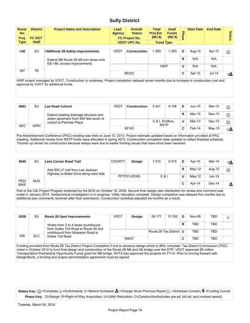
Phase
Route
No.
District Project Name and Description Lead
Agency
Overall
Status
Avail
Funds
(Mil $)
Start Date End Date Status
Total
Proj Est
(Mil $)
VDOT UPC No.
FC DOT
Staff Fund Type
FC Project No.
Sully District
Proj
Type
SU I-66/Route 28 Safety Improvements VDOT Construction 1.383 1.383 Aug-10 Apr-13
N/A N/A
N/A N/A
Apr-13 Jul-14
D
R
U
C
Extend SB Route 28 left turn lanes onto EB I-66, access improvements
J
DΔ
HSIP project managed by VDOT. Construction is underway. Project completion delayed seven months due to increase in construction cost and approval by VDOT for additional funds.
I-66
HSIP
TB86333
INT
SU Lee Road Culvert VDOT Construction 3.341 4.156 Jun-10 Mar-13
Mar-13 Dec-13
Mar-13 Dec-13
Feb-14 May-15
D
R
U
C
Extend existing drainage structure and widen pavement from 500 feet south of culvert to Penrose Place
J
J
J
CΔ
Pre-Advertisement Conference (PAC) meeting was held on June 12, 2013. Project estimate updated based on information provided at PAC meeting. Additional money from RSTP funds were allocated in spring 2013. Construction completion date updated to reflect finalized schedule. Thumbs up shown for construction because delays were due to earlier funding issues that have since been resolved.
0661
C & I, Proffers, RSTPWPH
92143SEC
SU Lees Corner Road Trail COUNTY Design 1.415 0.415 Apr-10 Mar-14
May-12 Aug-12
May-12 Jun-13
Apr-14 Dec-14
D
R
U
C
Add 900 LF trail from Lee Jackson Highway to Bokel Drive along west side
D
J
Δ
Δ
Part of the C&I Project Program endorsed by the BOS on October 19, 2009. Second final design plan distribution for review and comment was made in January 2014. Geotechnical investigation is in progress. Utility relocation complete. Design completion was delayed five months due to additional plan comments received after final submission. Construction schedule adjusted six months as a result.
0645
C & I
MJG
PPTF01-03300
PED/ BIKE
SU Route 28 Spot Improvements VDOT Design 55.177 10.782 Nov-09 TBD
TBD TBD
TBD TBD
TBD TBD
D
R
U
C
Widen from 3 to 4 lanes southbound from Dulles Toll Road to Route 50 and northbound from Mclearen Road to Dulles Toll Road
C
Funding provided from Route 28 Tax District Project Completion Fund to advance design which is 98% complete. Tax District Commission (TDC) voted in October 2012 to fund final design and construction of the Route 28 NB and SB bridge over the DTR. VDOT approved $5 million Transportation Partnership Opportunity Funds grant for NB bridge. NVTA has approved the projects for FY14. Prior to moving forward with Design/Build, a funding and project administration agreement must be signed.
0028
Route 28 Tax District
SLC95637
PRI
Status Key: =Complete; =OnSchedule; =Behind Schedule; =Change Since Previous Report; =Schedule Concern; =Funding Concer
Phase Key: D=Design; R=Right-of-Way Acquisition; U=Utility Relocation; C=Construction(includes pre-ad, bid ad, and contract award)
J C D Δ O $
Tuesday, March 04, 2014
Project Report Page 74

Phase
Route
No.
District Project Name and Description Lead
Agency
Overall
Status
Avail
Funds
(Mil $)
Start Date End Date Status
Total
Proj Est
(Mil $)
VDOT UPC No.
FC DOT
Staff Fund Type
FC Project No.
Sully District
Proj
Type
BR, SP, SU
Route 29 from Legato Road to Shirley
Gate Road
COUNTY ROW 14.140 4.707 Dec-08 Nov-14
Jul-13 Feb-14
Jan-14 Mar-15
Jan-15 Mar-16
D
R
U
C
Widen to 3 lanes on NB Route 29 from Legato Road; Intersection improvements at Shirley Gate Road; SB right turn lane from Stevenson Drive to Waples Mill Road
C
C
C
Second pre-final design is in progress. 29 of 31 properties have been acquired. A meeting with VDOT's Location and Design and Drainage was held in December to review final comments. A meeting was held in January 2014 with VDOT's Traffic Engineering to resolve comments. A public hearing to acquire remaining land rights was held on February 25, 2014.
0029
2007 Bonds
JYR
4YP212-5G25-052-000
PRI
SU Route 29 Trail (proffer) COUNTY Project
Initiation
0.334 0.334 TBD TBD
TBD TBD
TBD TBD
TBD TBD
D
R
U
C
Missing segments from Stringfellow Road to Prince William County Line
Project is part of the Third Four-Year Transportation Program approved by the BOS on July 10, 2012. FCDOT investigating proffer to determine if project is feasible and if not, how much additional funding will be required. Proffer review completion anticipated in spring 2014.
0029
Proffer
WPH PED/ BIKE
BR, SP, SU
Route 29 Widening COUNTY Project
Initiation
2.830 0 TBD TBD
TBD TBD
TBD TBD
TBD TBD
D
R
U
C
From Shirley Gate Road to Prince William County Line (segments)
Project is part of the Third Four-Year Transportation Program approved by the BOS on July 10, 2012. Project is slated for the 2014 Transportation Bond Referendum which must be approved by voters before the project can proceed.
0029
2014 Bonds
WPHPRI
SU Route 50 from Route 28 to Poland Road
(Loudoun Co.)
VDOT Construction 94.912 94.912 2006 Jan-12
Nov-11 TBD
Jun-12 Nov-13
Mar-11 Dec-15
D
R
U
C
Widen to 6 lanes and provide pedestrian facilities
J
C
C
DΔ
Design-Build project. Construction completion delayed six months.
0050
Primary, RSTP, ProffersWPH
68757PRI
Status Key: =Complete; =OnSchedule; =Behind Schedule; =Change Since Previous Report; =Schedule Concern; =Funding Concer
Phase Key: D=Design; R=Right-of-Way Acquisition; U=Utility Relocation; C=Construction(includes pre-ad, bid ad, and contract award)
J C D Δ O $
Tuesday, March 04, 2014
Project Report Page 75

Phase
Route
No.
District Project Name and Description Lead
Agency
Overall
Status
Avail
Funds
(Mil $)
Start Date End Date Status
Total
Proj Est
(Mil $)
VDOT UPC No.
FC DOT
Staff Fund Type
FC Project No.
Sully District
Proj
Type
SU Route 50 Trail from West Ox Road to
East of Lee Road
COUNTY Project
Initiation
1.400 0 TBD TBD
TBD TBD
TBD TBD
TBD TBD
D
R
U
C
Complete missing segments
Project is part of the Third Four-Year Transportation Program approved by the BOS on July 10, 2012. Project is slated for the 2014 Transportation Bond Referendum which must be approved by voters before the project can proceed.
0050
2014 Bonds
WPH PED/ BIKE
SU Route 50/Sullyfield Circle/Centerview
Drive
COUNTY Project
Initiation
0.200 0 TBD TBD
TBD TBD
TBD TBD
TBD TBD
D
R
U
C
Pedestrian intersection improvements
Project is part of the Third Four-Year Transportation Program approved by the BOS on July 10, 2012. Project is slated for the 2014 Transportation Bond Referendum which must be approved by voters before the project can proceed.
0050
2014 Bonds
WPH PED/ BIKE
SU Stonecroft Boulevard Widening COUNTY Construction 0.650 0.500 Aug-05 TBD
Apr-07 Jan-08
TBD TBD
TBD Aug-14
D
R
U
C
Developer project to widen Stonecroft Boulevard to 6 lanes from Conference Center Drive to Westfields Boulevard (County responsible for 800-ft section in front of the Sully District Govt. Center)
J
Construction agreement approved at October 19, 2010, BOS meeting. Developer's county bond approved. Developer submitted bond package to VDOT for approval. Developer anticipating starting construction in spring 2014. Developer changed construction contractors, which delayed the start of construction.
8460
DPWES
009217
SEC
SU, SP Stringfellow Road from Route 50 to Fair
Lakes Boulevard
VDOT Construction 54.115 56.400 Jul-04 Dec-10
Apr-10 Jan-12
Jul-09 Jul-15
Jul-12 Jul-15
D
R
U
C
Widen to 4 lanes
J
J
C
C
NTP issued March 11, 2013. Partnering meeting held on June 21, 2013. Major detour was in place by mid-December 2013. Work is in progress on Greenbriar Park and Conspan bridge. Construction is 30% complete and on schedule.
0645
2004 & 2007 Bonds, Revenue Sharing, C
& IJYR
4YP017
60864SEC
Status Key: =Complete; =OnSchedule; =Behind Schedule; =Change Since Previous Report; =Schedule Concern; =Funding Concer
Phase Key: D=Design; R=Right-of-Way Acquisition; U=Utility Relocation; C=Construction(includes pre-ad, bid ad, and contract award)
J C D Δ O $
Tuesday, March 04, 2014
Project Report Page 76

Phase
Route
No.
District Project Name and Description Lead
Agency
Overall
Status
Avail
Funds
(Mil $)
Start Date End Date Status
Total
Proj Est
(Mil $)
VDOT UPC No.
FC DOT
Staff Fund Type
FC Project No.
Sully District
Proj
Type
SU Stringfellow Road Park & Ride Lot
Expansion and Bus Transfer Facility
COUNTY Design 6.100 6.100 Jun-10 Mar-14
Nov-12 Oct-13
TBD TBD
Jul-14 Jun-15
D
R
U
C
Construct an additional 300 spaces, 3 additional bus bays (total of 6), and a transit center facility with bicycle facilities
D
J
Δ
Δ
Park-and-ride expansion and bus transfer facility projects combined. Coordinating with VDOT on comments on traffic impact analysis. Land use agreement with VDOT anticipated by April 2014. Final design plans anticipated in March 2014. Design completion delayed five months due to design issues concerning the future "bus-only" exit at the park-and-ride lot. Construction schedule adjusted seven months due to the design issues and additional time required for attorney review of easement and land use agreement.
XXXX
2007 Bonds, C & I
SLC
4YP217
90385TRAN
SU Twin Lakes Drive Bridge Rehabilitation
over Johnny Moore Creek
VDOT Construction 1.446 1.446 Nov-09 Oct-13
Sep-12 Dec-13
N/A N/A
Dec-13 Sep-14
D
R
U
C
Replace existing bridge with two-lane bridge
J
J
C
Δ
Design revised to create a pedestrian and bicycle refuge area on the bridge. Design completion was delayed three months as a result, but the overall completion date did not change. Bid advertisement was December 10, 2013. Road closure will be required during construction, starting in mid June after school gets out and ending in September before school starts.
3546
BRIDGE
MJG87728
SEC
SU Walney Road Widening and Bridge
Replacement
VDOT Construction 16.208 16.208 Jan-08 Dec-13
Jan-13 Jul-13
N/A N/A
Feb-14 Dec-15
D
R
U
C
Reconstruct bridge over Flatlick Branch, including approaches; Widen 0.4 miles south to Willard Road
J
J
C
RFQ was advertised on April 30, 2013, and RFP will be advertised on August 30, 2013. NTP issued to Design-Build contractor in February 2014. Board of Supervisors approved $1 million in RSTP funding to be transferred to this project.
0657
Secondary, RSTP
WPH82214
SEC
SU West Ox Road Trail COUNTY Project
Initiation
1.000 0 TBD TBD
TBD TBD
TBD TBD
TBD TBD
D
R
U
C
Missing segments from Penderbrook Road to Route 50
Project is part of the Third Four-Year Transportation Program approved by the BOS on July 10, 2012. Project is slated for the 2014 Transportation Bond Referendum which must be approved by voters before the project can proceed.
0608
2014 Bonds
VA PED/ BIKE
Status Key: =Complete; =OnSchedule; =Behind Schedule; =Change Since Previous Report; =Schedule Concern; =Funding Concer
Phase Key: D=Design; R=Right-of-Way Acquisition; U=Utility Relocation; C=Construction(includes pre-ad, bid ad, and contract award)
J C D Δ O $
Tuesday, March 04, 2014
Project Report Page 77


County of Fairfax
Department of Transportation
4050 Legato Road, Suite 400
Fairfax, Virginia 22033
Phone: (703) 877-5600 TTY: 711 Fax: (703) 877-5723