coun.ty.~ of placer·~ ,; - placer county, california creek lane and st. julien way and is...
TRANSCRIPT

21
COUN.TY.~ OF ·~ ~ Placer,;
TO: Board of Supervisors
MEMORANDUM County Executive Office
Office of Emergency Services County of Placer
DATE: July 11 , 2017
FROM : David Boesch, County Executive Officer
By: John McEldowney, Emergency Services Program Manager
SUBJECT: Approve a Resolution imposing a charge for fire protection and emergency medical
services for parcels in the Morgan Creek Residential Parcel Map.
ACTION REQUESTED Conduct a public hearing , consider all protests, tabulate ballots, and adopt a Resolution imposing a charge to fund fire protection and emergency medical services for all parcels that are, or will be, a part of the Morgan Creek Residential Parcel Map.
BACKGROUND The State of California County Service Area (CSA) Law [Government Code §25210.1 et seq] creates a means of providing expanded service levels in areas where residents are willing to pay for the extra service. Zones of Benefit (ZoB) are created within a CSA (unincorporated Placer County is designated "CSA 28") to fill the services funding gap between general county services and special services. ZoB 165, Dry Creek Fire, covers 19,800 acres in the southwest corner of the county and was established in September, 2001 when its residents voted to dissolve Dry Creek Fire. Placer County subsequently assumed responsibility for providing fire protection and emergency medical services within ZoB 165, and it is within that ZoB that the Morgan Creek Residential Parcel Map is located.
The Morgan Creek Residential Parcel Map (a portion of APN 023-240-066) is located at the intersection of Morgan Creek Lane and St. Julien Way and is tentatively approved for 7 residential units on 1.54 acres.
Pursuant to Proposition 218, the owner of record of the existing properties of the Morgan Creek Residential Parcel Map has approved by way of this ballot an annual charge of $210.93 per parcel and/or dwelling unit beginning in FY 2017-18, subject to an annual cost of living adjustment, for existing parcels and each new parcel and/or dwelling unit created in these areas as final maps are recorded. In lieu of mailed notice of this hearing , Morgan Creek, LLC has executed a waiver of notice. Your Board is required to conduct a Public Hearing to consider all protests and tabulate the ballots, and must also adopt a Resolution to impose the parcel/dwelling unit charge.
EN~RONMENTALCLEARANCE This is an administrative action required pursuant to the conditions of approval for this subdivision. As such , it is not a separate project and is not subject to further environmental review.
FISCAL IMPACT The charge will be levied on each existing parcel/dwelling unit and each new parcel created by each new final map commencing in FY 2017-18. The ballot executed by the property owner provides for an annual cost of living increase for the CSA charge based on the percent change in the Consumer Price Index for All Urban Consumers (CPI-U) for the San Francisco-Oakland-San Jose metropolitan area, which shall not exceed 5% in any one year. The base FY 2017-18 charge of $210.93 is per parcel and/or dwelling unit. These charges are supported by an engineer's report prepared by a registered professional engineer.
ATTACHMENT Attachment - Resolution
1

22
Before the Board of Supervisors County of Placer, State of California
In the matter of: A Resolution Confirming Inclusion of the Morgan Creek Residential Parcel Map into CSA 28 Zone of Benefit 165 and Establishing a Charge on Parcels within Said Zone
Resolution No.: -----
The following Resolution was duly passed by the Board of Supervisors of the County of Placer
at a regular meeting held ____________ , by the following vote on roll call :
Ayes:
Noes:
Absent:
Signed and approved by me after its passage.
Chair, Board of Supervisors
Attest:
Clerk of said Board
WHEREAS, a condition of approval of the Morgan Creek Residential Parcel Map was its annexation into existing County Service Area 28, Zone of Benefit 165, Dry Creek Fire, to provide fire protection and emergency medical services for the benefit of properties within the subdivision; and
WHEREAS, the property comprising the Morgan Creek Residential Parcel Map (a portion of APN 023-240-066) was at the time of the project's approval , and remains , located within the boundaries of County Service Area 28, Zone of Benefit 165, Dry Creek Fire; and
WHEREAS, the owners of record of said subdivision have consented to the imposition of fees for said subdivision to satisfy the conditions to obtain a final map for the project; and
Page 1 of 2

23
WHEREAS, the owners of record of the properties have approved ballot(s) to set a charge on parcels and dwelling units within said areas of the subdivision; and
WHEREAS, said ballot(s) constitute unanimous approval of the charge by the property owners within said area of the Zone of Benefit after proper notice has been given of the right to protest.
NOW, THEREFORE, BE IT RESOLVED BY THE BOARD OF SUPERVISORS OF THE COUNTY OF PLACER, STATE OF CALIFORNIA AS FOLLOWS:
The Board of Supervisors does hereby confirm the inclusion into Zone of Benefit 165, Dry Creek Fire, within County Service Area 28 the property comprising the Morgan Creek Residential Parcel Map (a portion of APN 023-240-066) , which Zone shall provide fire protection and emergency medical services for the benefit of properties within the subdivision.
The Board of Supervisors does hereby establish with the consent of the property owner(s) and in conformance with Section 4 of the Article XIIID of the California Constitution and pursuant to Government Code Section 25210 et seq. , a charge against a portion of APN 023-240-066 and against each parcel within Zone of Benefit No. 165 that may now exist or which may be created by any final map of the Morgan Creek Residential Parcel Map, in the amount no greater than $210.93 per parcel/dwelling unit for fiscal year 2017/18, subject to annual cost of living adjustment as provided for herein . Said charge shall commence with the 2017-2018 fiscal year.
The charge established hereunder shall be subject to modification each year in an amount not to exceed the change in the Consumer Price Index for All Urban Consumers (CPI-U) for the San Francisco/Oakland/San Jose Metropolitan Area, commencing with the 2017-2018 tax year, which shall not exceed 5% in any one year. For the 2017-2018 fiscal year, the charge has been modified to $210.93, which equates to a 3% CPI adjustment.
Exhibit A - Official Ballot - Morgan Creek Residential Parcel Map Exhibit B - Waiver of Notice - Morgan Creek Residential Parcel Map Exhibit C - Legal Description - Morgan Creek Residential Parcel Map
Page 2 of 2

24
:;[:,,.;~ j_ , 2017
County of Placer Office of Emergency Services
OFFICIAL ASSESSMENT BALLOT
Morgan Creek ILC, a California Limited Liability Corporation 150 Pelican Way San Rafad, CA 94901 Attention: Charlie Gibson
ZONE OF BENEFIT No. 165 (Dry Creek Fire) COUNTY SERVICE AREA No. 28
Exhibit A
Do you approve of the imposition of an assessment to provide fire and emergency medical services on all parcels and subsequent parcels and/ or dwelling units and/ or assessment units in the amount of$210.93 per parcel and/ or dwelling unit and/ or assessment unit within a portion of Assessor Parcel Number 023-240-066? Said fee shall be subject to modification each year in an amount not to exceed the change in the State of California San Francisco/Oakland/San Jose Metropolitan Area Consumer Price Index for All Urban Consumers, commencing with the 2017-2018 tax year.
ANNUAL ASSESSMENT ASSESSOR PARCEL NUMBER AMOUNT PER PARCEL
023-240-066 $210.93
(§ YES ONO
We declare that we are the owners of record of the above-described Parcels.
_L We declare that we are the representatives of the owner of record of the above-described Parcels and that we are lawfully authorized to execute this ballot on behalf of said owner of record.

25
OFFICIAL ASSESSMENT BALLOT CSA 28, Zone of Benefit 165 (Dry Creek Fire) ______ , 2017 Page2
Morgan Creek LI..C A California Limited Liability Corporation
By: Charlie Gibson, Manager
Please return to the County Executive Office, Attention Adrianne Barber or John McEldowney, 2968 Richardson Drive, Aubum CA 95603 by 2017 (date should be a minimum of three weeks before your final map is going to the Boa.rd of Supervisors).
(Signature(s) must be notarized)
nt form ·9n 1189

26
CALIFORNIA ALL-PURPOSE CERTIFICATE OF ACKNOWLEDGMENT
A notary public or other officer completing this certificate verifies only the identity of the individual
who signed the document to which this certificate is attached, and not the truthfulness, accuracy, or
validity of that document.
State of California
County of Placer
onJJ~l,w1, before me, __ S_te_v_e_D_u_n_g_e_r,_N_o_t_ary~P_u_b_lic ___ ~
personallyappeared C/dAfZL6.S LGoN €7tf.)'5Dd
who proved to me on the basis of satisfactory evidence to be the person'8') whose name(,gf
'f})ar subscribed to the within instrument and acknowledged to me that~sl;ie/t~y
executed the same in @h,ir/th/ir authorized capacity(i¢'), and that by ~h(r/tt)e'ir
signature(~ on the instrument the person~, or the entity upon behalf of which the
person{,1 acted, executed the instrument.
I certify under PENAL TY OF PERJURY under the laws of the State of California that the
foregoing paragraph is true and correct.
WITNESS my hand ~eal.
~~ (Notary Seal)
Signature of Notary Public Commission Expires: Aug. 17, 2018
Steve Dunger, Notary Public
ADDITIONAL OPTIONAL INFORMATION
DESCRIPTION OF THE A TI ACHED DOCUMENT °.a: c 1.evL 4S5G S...S/17 6AJ r
Title or description of attached document
CAPACITY CLAIMED BY THE SIGNER
Adividua~ _ Corporate Officer _ Trustee(s) Other ________ _

27
WAIVER OF NOTICEZone of Benefit No. 165
Morgan Creek Residential Parcel M@ (project)
Exhibit B
THIS WAIVER is executed this -1::_ day of .-::r;;,.Je. 2017, by Morgan Creek LLC, a California Limited Liability Corporation ('OWNER").
WHEREAS, OWNER is the owner of record in fee of the real property identified as Morgan Creek Residential, Assessor Parcel Number 023-240-066 (property), document No. 2009-0048479, official records of Placer County, and
WHEREAS, County Service Area No. 28, Zone of Benefit No. 165 was formed to provide fire and emergency medical services for the benefit of the project, and
WHEREAS, the OWNER desires to record a final map for the project, and in order to facilitate said process consents to the imposition of assessments and/ or fees as may be required which would provide funding to provide the services described and the OWNER desires to waive the specific requirements under Proposition 218 for notice of the protest hearing to facilitate recording of said final maps,
NOW, THEREFORE:
1. The OWNER hereby waives any and all requirements of subsection (c) of Section 4 or subsection (a)(1) of Section 6 of Article XIIID of the California Constitution requiring the preparation and mailing of individualized notice for the property owned by OWNER, or for any parcel and/ or dwelling unit and/ or assessment unit as may be created upon recordation of the final map(s) of the project from the property, for the imposition of a special assessment, and waives receipt of the same.
2. The OWNER hereby waives any and all requirements of subsection (e) of Section 4 or subsection (a)(2) of Section 6 of Article XIIID of the California Constitution requiring the sending or receipt of notice of the holding of a public hearing for the imposition of a special assessment upon the property owned by OWNER or for any parcel/ dwelling/ assessment unit as may be created upon recordation of the final map(s) of the project.
3. The OWNER hereby agrees and acknowledges that the assessments and/ or fees imposed by the County under Zone of Benefit No. 165 or any successor thereto are being lawfully imposed in accordance with the County Service Area Law (Government Code section 25210 g ~ and Proposition 218 and all other applicable law to provide fire and emergency medical services.
4. The OWNER warrants and represents that he is the owner of record of the property, and has full authority to execute this waiver. This waiver shall be qinding upon OWNER and OWNER's successors-in-interest, heirs, and assigns, and shall run with the property and all separate legal parcels/ assessment units therefrom as may be created upon recordation of the final map for the project.

28
Dated: &-l~ 1·1 2017:
OWNER:
Morgan Creek ILC, a California Limited Liability Corporation 150 Pelican Way San Rafael, CA 94901
By: Charlie Gibson. Manager
Please return to the County Executive Office, Adrianne Barber or John McEldowney, 2968 Richardson Drive, Auburn, CA 95603 by MMM/DD, 2017 (date should be a minimum of three weeks before your final map is going to the Board of Supervisors)
(Signature(s) must be notarized)
Please, · attacl'le!I acknowledgment form purs\)ant to CA CMt,Co(le Sec\ion 1189

29
CALIFORNIA ALL-PURPOSE CERTIFICATE OF ACKNOWLEDGMENT
A notary public or other officer completing this certificate verifies only the identity of the individual
who signed the document to which this certificate is attached, and not the truthfulness, accuracy, or
validity of that document.
State of California
County of Placer
On JvNr;:- I 20 t 7 before me, __ St_e_v_e_D_u_n~g_e ___ r,_N_o_ta_ry~P_u_b_lic ___ _
personally appeared ~4.rZu?S, {Eo/lJ 671 fb'SO/t./
who proved to me on the basis of satisfactory evidence to be the personM whose name(~
t9;tfe subscribed to the within instrument and acknowledged to me that~s~/t\),ev
executed the same in t@hef/tryeir authorized capacity(i~, and that by@/1!¢"r/t)reir
signature~ on the instrument the person{!), or the entity upon behalf of which the
person(~ acted, executed the instrument.
I certify under PENALTY OF PERJURY under the laws of the State of California that the
foregoing paragraph is true and correct.
WITNESS my hand and official seal.
=- -2:;& efff! (Notary Seal)
Signature of Notary Public Commission Expires: Aug. 17, 2018
Steve Dunger, Notary Public
ADDITIONAL OPTIONAL INFORMATION
DESCRIPTION OF THE A IT ACHED DOCUMENT
IWA:1v&2..- oF ,.-vorrct5-
Title or description of attached document
CAPACITY CLAIMED BY THE SIGNER
~ividua~ _ Corporate Officer _ Trustee(s) Other ____ ____ _

30
Parcel 1
EXHIBIT "A" CHARGE ESTABLISHMENT COUNTY SERVICE AREA 28
ZONE 165- FIRE AND EMERGENCY SERVICES A PORTION OF APN 023-240-066
PAGE 1 OF 1
Exhibit C
All that certain real property situate in the County of Placer, State of California, being a portion of the Northwest 1 /4 of Section 8, Township 10 North, Range 6 East, Mount Diablo Meridian, described as follows:
A portion of Area 1, as said area is shown and so designated on that certain Record of Survey filed in Book 17 of Surveys, Page 9, Placer County Records, more particularly described as follows:
COMMENCING at the most easterly corner of Lot A, as said lot is shown and so designated on that certain Final Map entitled, "Tract # 895 Morgan Creek Village N" filed in Book Y of Maps, Page 67, Placer County Records, said corner being a point along the boundary lines of the above referenced Area 1; thence along said boundary lines the following two (2) courses: (1) South 75°13'15" West 8.60 feet and (2) along the arc of a tangent curve to the right, concave northerly, having a radius of 312.50 feet, through a central angle of 11°51'47\ 64.70 feet to the TRUE POINT OF BEGINNING; thence from said TRUE POINT OF BEGINNING, leaving said boundary line, South 00°16'51" West 416.55 feet; thence North 89°43'03" West 79.64 feet; thence North 79°49'13" West 118.33 feet to a point on said boundary lines; thence along said boundary lines the following four (4) courses: (1) North 10°10'47" East 381 .51 feet; (2) along the arc of a tangent curve to the right, concave southeasterly, having a radius of 32.50 feet, through a central angle of 86°37'09", 49.13 feet; (3) South 83°12'04" East 42.29 feet and (4) along the arc of a tangent curve to the left, concave northerly, having a radius of 312.50 feet, through a central angle of 9°42'54", 52.99 feet to said TRUE POINT OF BEGINNING.
Containing 1.540 acres, more or less.
NOTE:
The above described Parcel is the same as that certain parcel of land shown and designated as "Parcel 1" on that certain Parcel Map entitled, "Parcel Map for Morgan Creek Residential". Said Parcel Map is in process with the County of Placer. It is the express intent that after said Parcel Map has been filed in the Placer County Recorder's office, in the event any discrepancy is discovered between the above described Parcel and said "Parcel 1", said Parcel Map shall be deemed superior and control the location of the boundary of the above described Parcel.
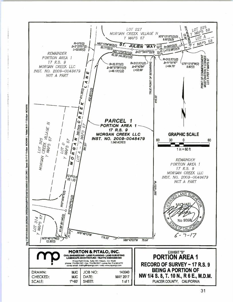
31
i ~ I a ... ~ I -i i
I ... ,.:.
~
J -~ ~
i ~
I i I 1i: ~ > l
REMAINDER PORTION AREA
R=575'(2) L1=3"22'51.(2) L=33.93'(2)
17 R.S. 9 MORGAN CREEK LLC
INST. NO. 2009-004 84 79 NOT A PART
I R=32.5'(1)(2) L1=86"37'09"(1)(2)
L=49.13'(1)(2)
R=312.5'(1)(2) ~ L1=9"42'54" ~
< bi ~
1./) §!" (\) lQ
l)j ~ CJ) ,-..._ l I CL;
o~i -.J (j
<.),.__ <3" ~ ~
/: L=52.99' ""' iii
PARCEL 1 PORTION AREA 1
17 R.S. 9 MORGAN CREEK LLC
INST. NO. 2009-0048479 1.540ACRES
N89"43'03"W 79.64'
MORTON & PITALO, INC. CIVIL INGINIDING • LAND PLANNING• LAND SURVIYING
LANDICAKAllotlnCIUlt! • TRAFFIC ENGINED ING 751roo Pc,W Circle. Suite 120 • Fclsom. CA 95630
Ill
~ f..
~ ~
60
R=312.5'(1 )(2) L1=11"51'47'
L=64.70'
GRAPHIC SCALE 30 0 w w -1 in= 60 ft
REMAJNDER PORnoN AREA
17 R.S. 9 MORGAN CREEK LLC
60
JNST. NO. 2009-004 84 79 ~ NOT A PART
~ ~
EXHIBIT "B"
PORTION AREA 1 rrp •
DRAWN:
phol,e: 91 UM.7621 • fax: 916.98-1.961 7 • .IUIVoy fax: 91 6.563.6770 n.<Vey erroai: st<*lngOmpengr.com • web: www.rrc,eng.com
MJC JOB NO: 140040 MAY 2017
1 of 1
RECORD OF SURVEY ,... 17 R.S. 9 BEING A PORTION OF
CHECKED: MJC DATE: NW 1/4 S. 8, T. 10 N., R 6 E., M.D.M. SCALE: 1"=60' SHEET: PLACER COUNTY, CALIFORNIA

32