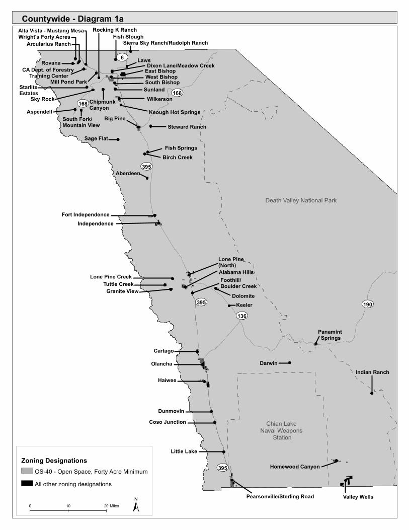
countywide - diagram 1ainyoplanning.org/documents/gp-z-june-attach4.pdf · lone pine (north) indian...
TRANSCRIPT
Panamint Springs
Keeler
Cartago
Foothill/Boulder Creek
Alabama Hills
Lone Pine (North)
Indian Ranch
Lone Pine CreekTuttle Creek
Granite View
Darwin
Coso JunctionDunmovin
Haiwee
Olancha
IndependenceFort Independence
Aberdeen
Fish SpringsBirch Creek
Steward RanchBig Pine
Sage Flat
Little Lake
Pearsonville/Sterling Road
Homewood Canyon
Valley Wells
South Fork/Mountain View
Aspendell Keough Hot Springs
WilkersonSunlandSouth BishopEast Bishop
Laws
Sky RockStarlite Estates
Chipmunk Canyon
West BishopDixon Lane/Meadow CreekRovana
Wright's Forty AcresArcularius Ranch
Rocking K RanchAlta Vista - Mustang MesaFish Slough
Sierra Sky Ranch/Rudolph Ranch
Dolomite
CA Dept. of Forestry Training Center
395
190
168
136
6
395
395
168
Countywide - Diagram 1a
Death Valley National Park
Chian Lake Naval Weapons
Station
Zoning Designations
0 10 20 Miles
OS-40 - Open Space, Forty Acre Minimum All other zoning designations
Mill Pond Park

Indian Ranch
Furnace Creek
Death Valley Junction
Stewart Valley
Charleston View
Sandy Valley
Chicago ValleyShoshone
Tecopa Hot SpringsTecopa/Tecopa Heights
3,000 Foot Camp
190
127178
Countywide - Diagram 1b
Death Valley National Park
Zoning Designations
0 10 20 Miles
OS-40 - Open Space, Forty Acre Minimum All other zoning designations

Arcularius Ranch
Wright's Forty Acres
Birchim Ln
N Ro
und V
alley
Rd
Pine Creek Rd
Vanadium Ranch Rd
US Hwy 395
Old Sherwin Grade Rd
Hardy Rd
Pine Creek Rd
RR-10.0-MH
RR-10.0-MH
RR-1.0-MH
RR-1.0-MH
P
Wright's Forty Acres and Arcularius Ranch - Diagram 2
Wright's Forty AcresArcularius Ranch
Inyo County Zoning DesignationsResidential Industrial
M1 General Industrial and ExtractiveM2 Light Industrial
CommercialCB Central Business C1 General Commercial - RetailC3 Administrative - Professional OfficesC4 Heavy CommercialC5 Commercial Recreation
OtherOS Open SpacePUD Planned Unit DevelopmentP Public
0 1,000 2,000 Feet
Overlays
R1 One Family ResidentialR2 Multifamily ResidentialR3 Multiple ResidentialRR Rural ResidentialRR-0.5 StarliteRMH Single Residence and Mobile Home Combined
PP (Precise Plan)
A (Architectural Design Control)
MH (Mobile Home)
SAHO (Snow Avalanche Hazard)
AH (Airport Hazard) *see notes on maps where applicable

Dako
ta R-3
OS-40
Pine Creek Rd
Vanadium Ranch Rd
Utah Ne
vada
Ranc
h Rd
Rovana
R-3
RR-10.0-MH
R-3
M2-10,000
OS-40
OS-40
OS-40
Rovana and Sierra Sky Ranch/Rudolph Ranch - Diagram 3
Sierra Sky Ranch/Rudolph RanchRovana
0 500 1,000 Feet
Rudolph Rd
Sierra Sky Ranch/Rudolph Ranch
RR-5.0-MH
0 500 1,000 Feet
Residential IndustrialM1 General Industrial and ExtractiveM2 Light Industrial
Commercial
OtherOS Open SpacePUD Planned Unit DevelopmentP PublicOverlays
R1 One Family ResidentialR2 Multifamily ResidentialR3 Multiple ResidentialRR Rural ResidentialRR-0.5 StarliteRMH Single Residence and Mobile Home Combined
PP (Precise Plan)
A (Architectural Design Control)
MH (Mobile Home)
SAHO (Snow Avalanche Hazard)
AH (Airport Hazard) *see notes on maps where applicable
CB Central Business C1 General Commercial - RetailC3 Administrative - Professional OfficesC4 Heavy CommercialC5 Commercial Recreation
Inyo County Zoning DesignationsC4 to M2
Proposed Zone Changes

OS-40
Alta Vista - Mustang Mesa
R1-1.0
R1-1.0
R1-1.0
R1-1.0
C2-1.0 R1-1.0R1-0.5
R1-0.
5C2-1.0
R1-0.5
R1-1.0
C2-1.0R1-1.0
M2-1.0-PP
Alta Vista - Mustang Mesa and Fish Slough - Diagram 4
Fish SloughAlta Vista - Mustang Mesa
0 500 1,000 Feet
Fish Slough
RR-10.0-MH
R1-0.5
Uper
Cana
l
Fish Slough Rd Lower M
c Nally
0 500 1,000 Feet
Residential IndustrialM1 General Industrial and ExtractiveM2 Light Industrial
Commercial
OtherOS Open SpacePUD Planned Unit DevelopmentP PublicOverlays
R1 One Family ResidentialR2 Multifamily ResidentialR3 Multiple ResidentialRR Rural ResidentialRR-0.5 StarliteRMH Single Residence and Mobile Home Combined
PP (Precise Plan)
A (Architectural Design Control)
MH (Mobile Home)
SAHO (Snow Avalanche Hazard)
AH (Airport Hazard) *see notes on maps where applicable
CB Central Business C1 General Commercial - RetailC3 Administrative - Professional OfficesC4 Heavy CommercialC5 Commercial Recreation
Inyo County Zoning DesignationsC4 to M2
Proposed Zone ChangesRMH to R1

OS-40
OS-40
Rocking K Ranch
Ed Powers Rd
Red Hill RdRocking K Rd
Runn
ing Iro
n RdR1-1.0
R1-0.5
R1-1.
0
R1-1.0
Rocking K Ranch and Laws - Diagram 5
0 500 1,000 Feet
OS-40
OS-40
OS-40
R1-7,200
Laws
US H
wy 6
Silver Canyon Rd
Joe S
mith
RdGi
sh Av
e
Laws
Pole
ta Rd
Churchill Mine Rd
Jorda
n Ave
Railroad St
1st St
P
M1
M1-20,000
M2-20,000
M1-20
,000
M1-20,000
P
M1-20
,000M2-20,000
R1-7,200 M2-20
,000
M1-20,000M1-20,000
M1-20,000M1-20,000
0 500 1,000 Feet
LawsRocking K RanchInyo County Zoning Designations
Residential IndustrialM1 General Industrial and ExtractiveM2 Light Industrial
Commercial
OtherOS Open SpacePUD Planned Unit DevelopmentP PublicOverlays
R1 One Family ResidentialR2 Multifamily ResidentialR3 Multiple ResidentialRR Rural ResidentialRR-0.5 StarliteRMH Single Residence and Mobile Home Combined
PP (Precise Plan)A (Architectural Design Control)
MH (Mobile Home)SAHO (Snow Avalanche Hazard)
AH (Airport Hazard) *see notes on maps where applicable
CB Central Business C1 General Commercial - RetailC3 Administrative - Professional OfficesC4 Heavy CommercialC5 Commercial Recreation

C2-10,000
R1-7,000
R3-10,000
R1-7,000
R1-7,000
R1-7,000
R1-7,
000
R1-7,000
C1-10,000
R1-7,000
R2-6,500
C2-10,000
R1-7,000
C1-10,000
R1-7,200
R1-7,
200
R1-7,
200
R1-7,
200
RMH-7,000
R1-7,
200
R3-2.0
R1-7,
200
M2
M2-0.5R3-1.0
C3-7,500
C2-10
,000
M2-0.5-PP
C1-10,000
R2-14,000
C2-10,000
Dixon Ln
N Sierra Hwy
Sanig
er Ln
Matlic
k Ln
N Ba
rlow
Ln
Macg
regor
Ave
Lazy
A Dr
Shos
hone
Dr
Choctaw Dr
Rocking W Dr
West St
Bear
Cree
k Dr
Juniper St
Darby Ave
Fiora Ave
Bar L Ln
S Vall
ey Vi
ew D
r
Bar M Ln
Apache Dr
Edinburgh Ave
Dunb
ar Ln
Rowa
n Ln
McCree Ave
Cherr
y Ln
Glen
wood
Ln
Tam O Shanter Ave
N Va
lley V
iew D
r
Kiowa Cir Hopi Cir Wilson Cir
Hunte
r Way
Argyle Ln
Dixon Lane/Meadow Creek - Diagram 6
0 500 1,000 Feet
Dixon Lane/Meadow Creek
* Areas within Dixon Lane/Meadow Creek Diagram 6 may be subject to the Airport Hazard Overlay
Inyo County Zoning Designations
Residential IndustrialM1 General Industrial and ExtractiveM2 Light Industrial
Commercial
OtherOS Open SpacePUD Planned Unit DevelopmentP PublicOverlays
R1 One Family ResidentialR2 Multifamily ResidentialR3 Multiple ResidentialRR Rural ResidentialRR-0.5 StarliteRMH Single Residence and Mobile Home Combined
PP (Precise Plan)A (Architectural Design Control)
MH (Mobile Home)SAHO (Snow Avalanche Hazard)AH (Airport Hazard) *see notes on maps where applicable
CB Central Business C1 General Commercial - RetailC3 Administrative - Professional OfficesC4 Heavy CommercialC5 Commercial Recreation
RMH to R1Proposed Zone Changes

Dixon Lane - Meadow CreekDiagram 6
South BishopDiagram 9
C1-10,000-MH
R1-10,000R2-6,500
R1-1.
0
R1-10
,000
R1-1.
0
R1-10,000
R1-10
,000
C2-2.
0
R1-0.5
R1-0.5
R1-10,000
R1-10,000
Macg
regor
Ave
R1-10,000
R1-1.0
R1-0.5
R1-1.0P
R1-7,200
OS-40
R1-1.
0
R1-14,000
R1-7,200R1-15,000
R1-10,000
R1-10,000R1-10,000
C2-10,000
R1-10,000
R1-10,000
C2-10,000
R1-1.0
R1-10
,000
R1-7,200
R1-7,
200
R1-7,
200
R1-7,
200
R3-20,000
C2
R1-10
,000
P
R1-7,
200 C1-10,000C1-10,000
R1-7,200
PUD-ORD.302
C2-10,000R1-7,200R1-7,200
C1-10,000
R1-1.0
R2-15,000
R2-20
,000
R3-10,000
R2-20,000
W Line St
N Sierra Hwy
State Rte 168
Sunla
nd Ln
Diaz Ln
S Barl
ow Ln
Reata Rd
N Ba
rlow
Ln
Schoeber Ln
Broc
kman
Ln
Mumy Ln
Sunset Dr
N Tu
-Su L
n
N Se
e Vee
Ln
Home
St
N Wi
nuba
Ln
Underwood Ln
Coyote Valley Rd
S Pa-H
a Ln
W 1st St
W Elm StRanch Rd
W Pine St
Irene St
Taboose Ln
Fulto
n St
W Yaney St
Watterson Rd
Sawa
ye Ln
Orind
a Dr
Rome Dr
Billy Williams Dr
Sycamore Dr
Court
Pl
N Sierra Hwy
West Bishop - Diagram 7
0 750 1,500 Feet
West BishopInyo County Zoning Designations
ResidentialIndustrialM1 General Industrial and ExtractiveM2 Light Industrial
Commercial
OtherOS Open SpacePUD Planned Unit DevelopmentP Public
Overlays
R1 One Family ResidentialR2 Multifamily ResidentialR3 Multiple ResidentialRR Rural ResidentialRR-0.5 StarliteRMH Single Residence and Mobile Home Combined
PP (Precise Plan)A (Architectural Design Control)
MH (Mobile Home)SAHO (Snow Avalanche Hazard)AH (Airport Hazard) *see notes on maps where applicable
CB Central Business C1 General Commercial - RetailC3 Administrative - Professional OfficesC4 Heavy CommercialC5 Commercial Recreation City of Bishop
Tribal Land
RMH to R1Proposed Zone Changes

OS-40
OS-40
OS-40
P
OS-40
P
P
OS-40
P
P
R1-7,200
P
R1-7,200
R-3
P
PM2-PP C2
Wye Rd
E Line StAir
port R
d
Hanb
y Ave
S 3rd
StSp
ruce S
t
E South St
Bishop Airport
East Bishop - Diagram 8
0 600 1,200 Feet
East Bishop
* Areas within East Bishop Diagram 8 may be subject to the Airport Hazard Overlay
City of Bishop
Inyo County Zoning Designations
Residential IndustrialM1 General Industrial and ExtractiveM2 Light Industrial
Commercial
OtherOS Open SpacePUD Planned Unit DevelopmentP PublicOverlays
R1 One Family ResidentialR2 Multifamily ResidentialR3 Multiple ResidentialRR Rural ResidentialRR-0.5 StarliteRMH Single Residence and Mobile Home Combined
PP (Precise Plan)A (Architectural Design Control)
MH (Mobile Home)SAHO (Snow Avalanche Hazard)AH (Airport Hazard) *see notes on maps where applicable
CB Central Business C1 General Commercial - RetailC3 Administrative - Professional OfficesC4 Heavy CommercialC5 Commercial Recreation
RMH to R1Proposed Zone Changes
OS-40
OS-40
OS-40
OS-40
M1
PUD
OS-40
RMH-1.0
P
OS-40
S Main St
Sunla
nd Ln
Warm Springs Rd
Schoeber LnS B
arlow
Ln
Barlow Ln
Gerki
n Rd
Bir Rd
Gus Cashbaugh Ln
Sunland Res Rd
Sunla
nd In
dian R
eserv
ation
Rd
P
M1-1.0-PP
South Bishop - Diagram 9
0 500 1,000 Feet
South BishopInyo County Zoning DesignationsResidential Industrial
M1 General Industrial and ExtractiveM2 Light Industrial
Commercial
OtherOS Open SpacePUD Planned Unit DevelopmentP PublicOverlays
R1 One Family ResidentialR2 Multifamily ResidentialR3 Multiple ResidentialRR Rural ResidentialRR-0.5 StarliteRMH Single Residence and Mobile Home Combined
PP (Precise Plan)A (Architectural Design Control)
MH (Mobile Home)SAHO (Snow Avalanche Hazard)AH (Airport Hazard) *see notes on maps where applicable
CB Central Business C1 General Commercial - RetailC3 Administrative - Professional OfficesC4 Heavy CommercialC5 Commercial Recreation
* Areas within South Bishop Diagram 9 may be subject to the Airport Hazard Overlay
West BishopDiagram 7

Aspendell, Starlite Estates, Sky Rock, South Fork Mountain View, Chipmunk Canyon - Diagram 10
RR-10.0-SAHO
OS-40-SAHO
OS-40
OS-40
S Lak
e Rd
South Fork - Mountain View
OS-40
OS-40
R1-0.
5
C5-5.0
OS-40-SAHO
RR-10
.0
C5-5.0C5-5.0
C5-5.
0
C5-5.0-SAHO
OS-40
OS-40-SAHO
RR-2.5
C5-5.0-SAHO
C5-5.0-SAHO
RR-2.5-SAHO
OS-40
R1-0.5-SAHOOS-40
OS-40RR-5.0-MH OS-40
Sky Rock
E Bishop Creek Rd
Skyro
ck Dr
OS-40
OS-40
State
Rte 16
8
Catar
act R
d
Alpine
DrIris Dr
Aspendell
OS-40
R-1-10,000
OS-40-SAHO
R-1-10,000-SAHO
R-1-0
.75
OS-40-SAHOP
OS-40
OS-40
RR-10.0-MH
Chipmunk Canyon
OS-40OS-40 Starlite Dr Ap
ollo C
ir
Polaris CirArcturis Cir
Altair
Cir
Starlite Estates
Starlite EstatesSky RockChipmunk Canyon
AspendellSouth Fork-Mountain View
0 590 1,180 Feet
0 500 1,000 Feet
0 490 980 Feet
0 500 1,000 Feet
0 260 520 Feet
Inyo County Zoning DesignationsResidential IndustrialM1 General Industrial and Extractive
M2 Light Industrial
Commercial
OtherOS Open SpacePUD Planned Unit DevelopmentP PublicOverlays
R1 One Family ResidentialR2 Multifamily ResidentialR3 Multiple ResidentialRR Rural ResidentialRR-0.5 StarliteRMH Single Residence and Mobile Home Combined
PP (Precise Plan)A (Architectural Design Control)
MH (Mobile Home)SAHO (Snow Avalanche Hazard)
AH (Airport Hazard) *see notes on maps where applicable
CB Central Business C1 General Commercial - RetailC3 Administrative - Professional OfficesC4 Heavy CommercialC5 Commercial Recreation

Wilkerson and Sunland - Diagram 11
OS-40
OS-40
R2-1.0R1-0.5
C2-1.0
R1-0.
5
R1-1.0 R1-0.
5
OS-40
Wilkerson
Gerki
n Rd
Collins Rd
Hwy 395
Cotto
nwoo
d Dr
Sierra Grande St
Quail Ln
Owen
s Rd
Sierra Bonita St
Rawson Creek Rd
Jeffre
y Cir
Barrett Cir
E Axford Ln
Country Ln
Agap
e Cir
R1-1.0
R1-1.0
R1-0.5
R1-1.0R1-1.0
R1-1.0OS-40
OS-40R1-1.0
RR-10.0-MH
R1-0.5
R1-0.5
R1-1.
0
P
PRR
-5.0-M
H
R1-1.
0
R1-7,2000
R1-1.
0
OS
C2-1.0
R1-1.
0
R1-1.0
C2-0.5
R1-10,000
0 500 1,000 Feet
SunlandWilkerson
OS-40
OS-40
Sunland Ln
Sunland
PUD
R1-1.
0
0 250 500 Feet
Inyo County Zoning Designations
Residential IndustrialM1 General Industrial and ExtractiveM2 Light Industrial
Commercial
OtherOS Open SpacePUD Planned Unit DevelopmentP PublicOverlays
R1 One Family ResidentialR2 Multifamily ResidentialR3 Multiple ResidentialRR Rural ResidentialRR-0.5 StarliteRMH Single Residence and Mobile Home Combined
PP (Precise Plan)A (Architectural Design Control)
MH (Mobile Home)SAHO (Snow Avalanche Hazard)AH (Airport Hazard) *see notes on maps where applicable
CB Central Business C1 General Commercial - RetailC3 Administrative - Professional OfficesC4 Heavy CommercialC5 Commercial Recreation
RMH to R1Proposed Zone Changes

Keough Hot Springs, Steward Ranch, Sage Flat - Diagram 12
Waucoba Rd
Stewa
rd Rd
Steward Ranch
RR-2.5
OS-40
OS-40
C5-5.0
RR-5.0-SAHO
Glacier Lodge Rd
Sage Flat
RR-2.5C5-5.0-SAHO
RR-5.0
RR-2.5-SAHO
0 250 500 Feet
OS-40
OS-40
County Rd
Keough Hot Springs Rd
Te-Ko
Ln
Keough Hot Springs
RR-1.0
C5-5.0
Keough Hot SpringsSteward Ranch
Sage Flat
0 500 1,000 Feet
0 250 500 Feet
Inyo County Zoning DesignationsResidential Industrial
M1 General Industrial and ExtractiveM2 Light Industrial
Commercial
OtherOS Open SpacePUD Planned Unit DevelopmentP PublicOverlays
R1 One Family ResidentialR2 Multifamily ResidentialR3 Multiple ResidentialRR Rural ResidentialRR-0.5 StarliteRMH Single Residence and Mobile Home Combined
PP (Precise Plan)A (Architectural Design Control)
MH (Mobile Home)SAHO (Snow Avalanche Hazard)AH (Airport Hazard) *see notes on maps where applicable
CB Central Business C1 General Commercial - RetailC3 Administrative - Professional OfficesC4 Heavy CommercialC5 Commercial Recreation

Big Pine - Diagram 13
OS-40OS-40
OS-40
R2-13,000-MH
RR-1.0-MH
R1-10
,000OS-40
R2-13,000
R1-5,800R3-1.0-MH
R2-13,000-MH
R3-1.0R2-6,500-MHR3-10,000
R2-14,000-MH
R1-5,
800
RMH-0.5
OS-40
R2-13,000-MH
P RR-5.0-MH
P
R1-7,200
M2-2.5-PPR1-5,800
R3-1.0
PUD-ORD-326
P
RR-5.0-MHOS-40
R3-1.0RR-5.0-MH
R3-1.0
OS-40
OS-40R1-5,800
R2-6,
500-M
H
R1-5,
800
R2-2.0-MH
OS-40R1-5,800
OS-40
RR-5.0-MH
OS-40
R1-5,800R1-10,000
R1-0.5
R1-5,
800
R2-6,500-MH
M2-0.
5
P
OS-40
R2-6,500
OS-40
P
R1-5,800
RR-5.0-MH R3-1.0
RR-1.0-MH
RR-5.
0-MH R1-5,800
M2-0.5
R1-5,800
OS-40RR-1.0-MH
R2-6,500-MH
R2-6,
500-M
H
R1-9,900
R2-6,500-MH
R3-10,000
R3-10,000
P
US Hwy 395
Piper
St
West St Bartell Rd
Big Pine Canal
Baker Creek Rd
Crate
r St
Reyn
olds R
d
North St
Richa
rds S
t
Sierra St
East
St
Poplar St
Home St
Glacie
r Lodg
e Rd
Center St
Cana
l St
Brown Ave
Hill S
t Bowe
rs St
Wash
ington
St
Elmcre
st Dr
Callin
a St
Harry
St
Newm
an S
t
Moun
tain R
d
Baker Ln
Myrtle Ln
Terrace Dr
Big Pine Canal
US Hwy 395
State Rte 168
Scho
ol St
Big Pine
0 1,000 2,000 Feet
Cental Business District Tribal Land
Residential IndustrialM1 General Industrial and ExtractiveM2 Light Industrial
Commercial
OtherOS Open SpacePUD Planned Unit DevelopmentP PublicOverlays
R1 One Family ResidentialR2 Multifamily ResidentialR3 Multiple ResidentialRR Rural ResidentialRR-0.5 StarliteRMH Single Residence and Mobile Home Combined
PP (Precise Plan)
A (Architectural Design Control)
MH (Mobile Home)
SAHO (Snow Avalanche Hazard)
AH (Airport Hazard) *see notes on maps where applicable
C1 General Commercial - RetailC3 Administrative - Professional OfficesC4 Heavy CommercialC5 Commercial Recreation
Inyo County Zoning DesignationsC4 to M2
Proposed Zone ChangesRMH to R1
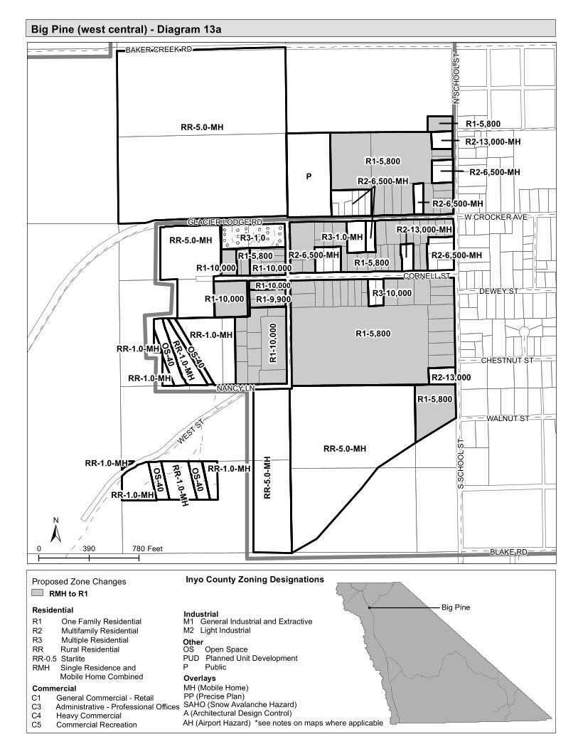
Big Pine (west central) - Diagram 13a
R3-1.0
RR-5.0-MH
P
R1-5,800
RR-5.0-MH
R1-5,800
R1-5,800
RR-5.0-MH
RR-1.0-MH
R3-1.0
RR-5.
0-MH
R1-10
,000
R1-5,800OS-40
R1-10,000
RR-1.0-MHRR-1.0-MH
RR-1.0-MH
R2-6,500-MH
R1-10,000
OS-40
OS-40
OS-40
R2-6,500-MH
R1-9,900
R3-1.0-MHR2-6,500-MH
R2-13,000
R3-10,000
RR-1.0-MH
R2-6,500-MH
R1-5,800
R1-10,000R1-5,800
R1-10,000
R2-13,000-MH
R2-6,500-MH
R2-13,000-MH
RR-1.0-MH
RR-1.0-MH
RR-1.0-MH
WEST ST
BAKER CREEK RD
S SCH
OOL S
T
W CROCKER AVEGLACIER LODGE RD
CORNELL ST
N SC
HOOL
ST
BLAKE RD
DEWEY ST
WALNUT ST
CHESTNUT ST
NANCY LN
Big Pine
0 390 780 Feet
Inyo County Zoning Designations
Residential IndustrialM1 General Industrial and ExtractiveM2 Light Industrial
Commercial
OtherOS Open SpacePUD Planned Unit DevelopmentP PublicOverlays
R1 One Family ResidentialR2 Multifamily ResidentialR3 Multiple ResidentialRR Rural ResidentialRR-0.5 StarliteRMH Single Residence and Mobile Home Combined
PP (Precise Plan)A (Architectural Design Control)
MH (Mobile Home)SAHO (Snow Avalanche Hazard)AH (Airport Hazard) *see notes on maps where applicable
C1 General Commercial - RetailC3 Administrative - Professional OfficesC4 Heavy CommercialC5 Commercial Recreation
Proposed Zone ChangesRMH to R1

Big Pine (east central) - Diagram 13b
TL
Poplar St
CBD
P
R3-1.0
R3-1.0
R2-6,500-MH
R3-1.0
RR-5.0-MH
R1-5,800
R1-0.5
R1-5,800
R2-6,
500-M
H
P
OS-40
P
R3-1.0
R1-5,800
R2-6,
500
M2-0.
5
R1-5,
800
R1-5,800
R2-6,500-MH
R1-5,800
R2-6,500-MH
R3-10,000
R2-6,500-MH
R1-0.5
R1-0.5
R2-13
,000-M
H
R3-10,000
R1-5,800
P
R2-6,500-MH
R3-10,000
R2-14
,000-M
H
Big Pine
0 390 780 Feet
Inyo County Zoning DesignationsResidential IndustrialM1 General Industrial and Extractive
M2 Light Industrial
Commercial
OtherOS Open SpacePUD Planned Unit DevelopmentP PublicOverlays
R1 One Family ResidentialR2 Multifamily ResidentialR3 Multiple ResidentialRR Rural ResidentialRR-0.5 StarliteRMH Single Residence and Mobile Home Combined
PP (Precise Plan)A (Architectural Design Control)
MH (Mobile Home)SAHO (Snow Avalanche Hazard)
AH (Airport Hazard) *see notes on maps where applicable
C1 General Commercial - RetailC3 Administrative - Professional OfficesC4 Heavy CommercialC5 Commercial Recreation
Cental Business District Tribal Land
C4 to M2Proposed Zone Changes
RMH to R1

Fish Springs, Birch Creek, Aberdeen - Diagram 14
RR-5.0
RR-5.0
RR-5.0
OS-40
OS-40
Birch Creek
Tinemaha Rd
Birch Creek Rd
OS-40
OS-40
OS-40Fish Springs
Fish S
pring
s Rd
Tinem
aha Rd
M2-2.0
C2-0.5
OS-40 C5-5.0
OS-40Aberdeen
Goodale Rd
Old H
wy 39
5
Rosc
o Ln
Tinem
aha R
d
Fish SpringsBirch Creek
Aberdeen
0 250 500 Feet
0 250 500 Feet 0 250 500 Feet
Inyo County Zoning DesignationsResidential Industrial
M1 General Industrial and ExtractiveM2 Light Industrial
Commercial
OtherOS Open SpacePUD Planned Unit DevelopmentP PublicOverlays
R1 One Family ResidentialR2 Multifamily ResidentialR3 Multiple ResidentialRR Rural ResidentialRR-0.5 StarliteRMH Single Residence and Mobile Home Combined
PP (Precise Plan)A (Architectural Design Control)
MH (Mobile Home)SAHO (Snow Avalanche Hazard)AH (Airport Hazard) *see notes on maps where applicable
CB Central Business C1 General Commercial - RetailC3 Administrative - Professional OfficesC4 Heavy CommercialC5 Commercial Recreation

R3-10,000
R1-5,800
R1-5,800
OS-40
OS-40
R1-5,800
Independence
R1-1.0
P
P
P
CBD
RR-1.0
M2-2.5-PP
RR-1.0
M
P
P
P
M2-2.5-PP
P
R1-0.5
P
R1-0.5
R1-5,800
M2-2.0
M2-2.5-PP
R1-5,
800
R1-5,
800
M1-20,000
R1-5,800
P
R3-1.0
R2-6,500-MH
M2-2.5-PP
R3-10,000
P
R1-5,800
R1-5,800
R1-5,800
R1-5,800
R1-5,800
R1-5,800
R1-5,800
RMH-5,800
R1-5,800
R2-6,500-MHR2-6,500-MH
R2-6,500-MH
R1-5,800
M1-PP
R2-6,500-MH
Fort Independence and Independence - Diagram 15
RR-5.0-MH
Fort R
d
Oak Creek Rd
Shab
bell L
n
Fish Hatchery Rd
Dusty
Ln
S Oak Creek Rd
Frontage Rd
Miller Ln
OS-40
OS-40
OS-40
RR-5.0-MHRR-5.0-MH
R3-3.0
RR-1.0-MH
RR-1.0
RR-1.0
Fort IndependenceIndependence
0 500 1,000 Feet
0 500 1,000 Feet
* Areas within Independence Diagram 15 may be subject to the Airport Hazard Overlay
Cental Business District
Fort Independence
Inyo County Zoning Designations
Residential IndustrialM1 General Industrial and ExtractiveM2 Light Industrial
Commercial
OtherOS Open SpacePUD Planned Unit DevelopmentP PublicOverlays
R1 One Family ResidentialR2 Multifamily ResidentialR3 Multiple ResidentialRR Rural ResidentialRR-0.5 StarliteRMH Single Residence and Mobile Home Combined
PP (Precise Plan)A (Architectural Design Control)
MH (Mobile Home)SAHO (Snow Avalanche Hazard)AH (Airport Hazard) *see notes on maps where applicable
C1 General Commercial - RetailC3 Administrative - Professional OfficesC4 Heavy CommercialC5 Commercial Recreation
Tribal Land
RMH to R1Proposed Zone Changes
P
CBD
P
R1-5,800
P
M2-2.5-PP
M1-20,000
M1-20,000
M1-20,000
R1-5,800
P
M2-2.5-PPR3-10,000
R3-10,000
R3-10,000R1-5,800
R1-5,800
R1-5,800
R15,800
R1-5,800R1-5,800
R1-5,800
R1-5,800
R1-5,800
R1-5,800
R1-5,800
R1-5,800
R1-5,800
R1-5,800
R1-5,800R1-5,800
R1-5,800
R1-5,800
R1-5,800R1-5,800
R1-5,800
R1-5,800
R1-5,800
R1-5,800
R1-5,800
R1-5,800
R1-5,800
R1-5,800
R1-5,800
R1-5,800
R1-5,800
R1-5,800R1-5,800 PR2-6,500-MH
R2-6,500-MH
R2-6,500-MH
R2-6,500-MH
R2-6,500-MH
R2-6,500-MH
R2-6,500-MH R2-6,500-MH
R1-5,800
M1-PP
R2-6,500-MHR2-6,500-MH
R2-6,500-MH
R1-5,800
R2-6,500-MH
R2-6,500-MH
M1-20,000
R1-5,800
R3-10,000R1-5,800
R1-5,800R2-6,500-MH
R2-6,500-MH
R2-6,500-MH
M1-20,000
R1-5,800
R2-6,500-MH
R1-5,800
R1-5,800
R1-5,800
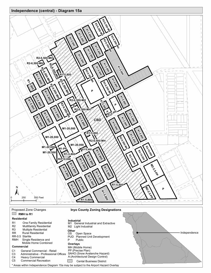
Independence (central) - Diagram 15a
Independence
0 250 500 Feet
Inyo County Zoning Designations
Residential IndustrialM1 General Industrial and ExtractiveM2 Light Industrial
Commercial
OtherOS Open SpacePUD Planned Unit DevelopmentP PublicOverlays
R1 One Family ResidentialR2 Multifamily ResidentialR3 Multiple ResidentialRR Rural ResidentialRR-0.5 StarliteRMH Single Residence and Mobile Home Combined
PP (Precise Plan)A (Architectural Design Control)
MH (Mobile Home)SAHO (Snow Avalanche Hazard)C1 General Commercial - Retail
C3 Administrative - Professional OfficesC4 Heavy CommercialC5 Commercial Recreation* Areas within Independence Diagram 15a may be subject to the Airport Hazard Overlay
Cental Business District
RMH to R1Proposed Zone Changes
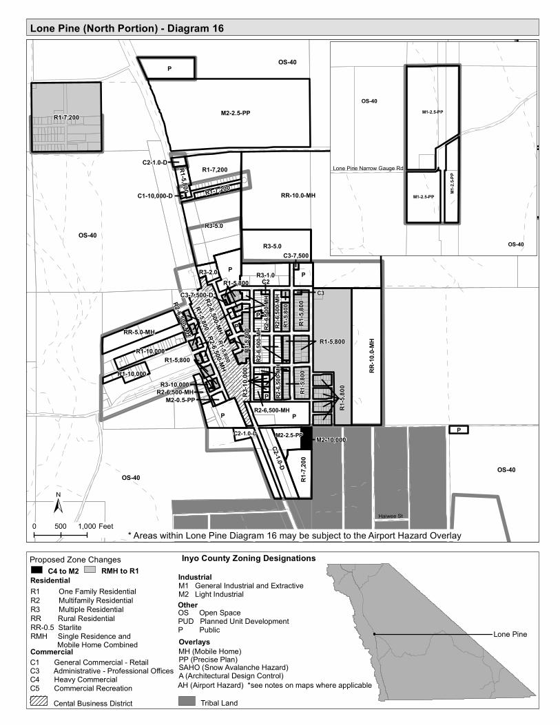
Lone Pine (North Portion) - Diagram 16
R2-6,500-MH
C3-7,500-DR2-6,500-MH
R1-5,
800
R3-10
,000
R2-6,500-MH
OS-40
OS-40
OS-40
OS-40
Haiwee St
RR-10.0-MH
M2-2.5-PP
P
P
P
P
R3-5.0
R1-7,200
R1-5,800
R3-5.0
P
R1-7,200
R3-1.0
RR-10
.0-MH
R1-7,
200
C2-1.0-D
RR-5.0-MH
P
R1-10,000
M2-2.5-PP
R3-2.0
R1-10,000
R1-5,
800
PP
R1-5,800
R2-6,
500-M
H
R1-7,200
P
R2-6,
500-M
H
M2-10,000
R1-5,
800
C2-1.0-D
R2-6,
500-M
H
R2-6,500-MH
R1-5,
800
R2-6,
500-M
H
C2-1.0-D
R1-5,800
M2-0.5-PP
R1-5,800
R1-5,800
C3
R2-6,500-MH
C2
R1-5,800 R1-5,
800
C3-7,500
R3-10,000
C1-10,000-D
0 500 1,000 Feet
Lone Pine
OS-40
OS-40
Lone Pine Narrow Gauge Rd
M1-2.5-PP
M1-2.5-PP
M1-2.
5-PP
Residential IndustrialM1 General Industrial and ExtractiveM2 Light Industrial
Commercial
OtherOS Open SpacePUD Planned Unit DevelopmentP PublicOverlays
R1 One Family ResidentialR2 Multifamily ResidentialR3 Multiple ResidentialRR Rural ResidentialRR-0.5 StarliteRMH Single Residence and Mobile Home Combined
PP (Precise Plan)A (Architectural Design Control)
MH (Mobile Home)SAHO (Snow Avalanche Hazard)AH (Airport Hazard) *see notes on maps where applicable
C1 General Commercial - RetailC3 Administrative - Professional OfficesC4 Heavy CommercialC5 Commercial Recreation
* Areas within Lone Pine Diagram 16 may be subject to the Airport Hazard Overlay
Cental Business District Tribal Land
Inyo County Zoning DesignationsC4 to M2
Proposed Zone ChangesRMH to R1

Lone Pine (central west) - Diagram 16a
CBD
P
P
R2-6,500-MH
R1-5,
800
R1-5,800
M2-0.5-PP
R1-5,800
R1-5,800
R2-6,500-MH
R1-5,800
R2-6,500-MH
R1-5,800
R2-6,500-MH
R1-5,800
R1-5,800
R1-5,800R1-5,800
R2-6,500-MH
R2-6,500-MH
R1-5,800
R2-6,500-MH
R3-10,000
R1-5,800
R1-5,800
R1-5,800
R1-5,800
C3-7,500-D
S MAIN ST
E LOCUST ST
S HAY
ST
N MAIN ST
F ST
E POST ST
C ST
E ST
E MUIR STN
HAY S
T
W BUSH ST
S LON
E PIN
E AVE
W WHITNEY PORTAL RD
E MOUNTAIN VIEW ST
ROY ROGERS RD
S MOU
NT W
HITN
EY D
R
B ST
N MO
UNT W
HITN
EY D
R
W POST ST
N LO
NE PI
NE AV
E
E BUSH ST
TIM HOLT STN WASHINGTON ST
BEGOLE ST
GENE AUTRY LN
0 250 500 Feet
Lone Pine
Residential IndustrialM1 General Industrial and ExtractiveM2 Light Industrial
Commercial
OtherOS Open SpacePUD Planned Unit DevelopmentP PublicOverlays
R1 One Family ResidentialR2 Multifamily ResidentialR3 Multiple ResidentialRR Rural ResidentialRR-0.5 StarliteRMH Single Residence and Mobile Home Combined
PP (Precise Plan)A (Architectural Design Control)
MH (Mobile Home)SAHO (Snow Avalanche Hazard)
C1 General Commercial - RetailC3 Administrative - Professional OfficesC4 Heavy CommercialC5 Commercial Recreation
Cental Business District Tribal Land
Inyo County Zoning DesignationsProposed Zone ChangesRMH to R1
* Areas within Lone Pine Diagram 16 may be subject to the Airport Hazard Overlay

Lone Pine (central east) - Diagram 16b
P
R1-5,800
RR-10.0-MH
R1-5,800
R1-5,800
R1-5,800
P
R2-6,500-MH
R2-6,
500_
MH
R2-6,500-MH
P
R1-5,800
R2-6,500-MH
R1-5,800
R1-5,800
R1-5,800
C2 C3
R2-6,500-MH
R1-5,
800
R2-6,
500-M
H
R1-5,
800
R2-6,
500-M
H
R1-5,
800
R2-6,
500-M
H
R3-10,000
R1-5,800
R3-10,000
R3-10,000
R2-6,500-MH
R2-6,500-MH
R2-6,500-MH
E MUIR ST
E INYO ST
S HAY
ST
LINE
ST
F ST
S LAK
E VI
EW ST
E LOCUST ST
N HA
Y ST
S MAIN ST
S LON
E PIN
E AVE
E MOUNTAIN VIEW ST
SUB STATION RD
S MOU
NT W
HITN
EY D
R
N LA
KE V
IEW
ST
N LO
NE P
INE A
VE
N MO
UNT W
HITN
EY D
R
E POST ST
E SOUTH ST
E SCHOOL ST
E POST ST
0 150 300 Feet
Lone Pine
Inyo County Zoning Designations
Residential IndustrialM1 General Industrial and ExtractiveM2 Light Industrial
Commercial
OtherOS Open SpacePUD Planned Unit DevelopmentP PublicOverlays
R1 One Family ResidentialR2 Multifamily ResidentialR3 Multiple ResidentialRR Rural ResidentialRR-0.5 StarliteRMH Single Residence and Mobile Home Combined
PP (Precise Plan)A (Architectural Design Control)
MH (Mobile Home)SAHO (Snow Avalanche Hazard)
C1 General Commercial - RetailC3 Administrative - Professional OfficesC4 Heavy CommercialC5 Commercial Recreation* Areas within Lone Pine Diagram 16b may be subject to the Airport Hazard Overlay
Proposed Zone ChangesRMH to R1

Lone Pine (South Portion) and Alabama Hills - Diagram 17
M2-1.0-D
RR-10.0-MH
OS-40OS-40
OS-40
Lone Pine North (Diagram 16)
S Main St
Whitney Portal RdSub Station Rd
Esha
St
Zucc
o Rd
Burkhart Rd
Good
win R
d
Line S
t
Tuttle
Cree
k Rd
Pah H
a Vitc
h Ln
Roy Rogers Rd
Haiwee St
Lone Pine (South Portion)
P
P
P
M2-2.5-PP
C5-5.0
C2-1.
0-D
RR-10.0-MH
RR-10.0-MH
C2-1.0-D
P
R3-3.0
RR-2.5-MH
RR-1.0C2-1.0-D
C2-1.0-D
RR-2.5-MH
0 840 1,680 Feet
Lone Pine
RR-2.5
RR-2.5
OS-40
P
Shahar Ave
RR-2.
5
RR-2.5
RR-2.5
OS-40
RR-2.5
RR-2.5
RR-10.0
R1-1.0
RR-3.0
R1-1.0
RR-2.5 RR-2.5
RR-2.5
RR-2.5-MH
RR-1.0
RR-2.5
P
RR-1.
0RR
-1.0
M1-2.5-PP
OS-40
OS-40Alabama Hills
Tuttle
Cree
k Rd
US Hwy 395
Sunset Dr
Indian Springs Dr
Horse
shoe
Mea
dows
Rd
Granite View Dr
McDo
nald
Rd
Thundercloud Ln
Alabama Hills
0 1,000 2,000 Feet
0 1,000 2,000 Feet
* Areas within Lone Pine Diagram 17 may be subject to the Airport Hazard Overlay
ResidentialIndustrialM1 General Industrial and ExtractiveM2 Light Industrial
Commercial
OtherOS Open SpacePUD Planned Unit DevelopmentP PublicOverlays
R1 One Family ResidentialR2 Multifamily ResidentialR3 Multiple ResidentialRR Rural ResidentialRR-0.5 StarliteRMH Single Residence and Mobile Home Combined
PP (Precise Plan)A (Architectural Design Control)
MH (Mobile Home)SAHO (Snow Avalanche Hazard)AH (Airport Hazard) *see notes on maps where applicable
CB Central Business C1 General Commercial - RetailC3 Administrative - Professional OfficesC4 Heavy CommercialC5 Commercial Recreation Tribal Land
Inyo County Zoning DesignationsC4 to M2
Proposed Zone ChangesRMH to R1

C2-10.0
RR-10.0OS-40
OS-40
RR-1.0
R3-10.0
R3-10
.0
Foothill/Boulder Creek
Lubken Canyon Rd
US Hwy 395
Granite View, Lone Pine Creek, Tuttle Creek, Foothill/Boulder Creek - Diagram 18
OS-40
OS-40
Tuttle Creek
Olivas Ranch Rd
OS-40
RR-10.0-MH
RR-10.0-MH
OS-40
OS-40
RR-5.0
RR-2.5
RR-2.
5
C5-10.0
Lone Pine Creek
Whitney Portal Rd
OS-40
OS-40
Granite View
RR-10.0-MH
RR-2.5-MH
RR-2.5-MH
Tuttle CreekLone Pine Creek
Granite ViewFoothill/Boulder Creek
0 500 1,000 Feet 0 500 1,000 Feet
0 500 1,000 Feet 0 500 1,000 Feet
Inyo County Zoning DesignationsResidential IndustrialM1 General Industrial and Extractive
M2 Light Industrial
Commercial
OtherOS Open SpacePUD Planned Unit DevelopmentP PublicOverlays
R1 One Family ResidentialR2 Multifamily ResidentialR3 Multiple ResidentialRR Rural ResidentialRR-0.5 StarliteRMH Single Residence and Mobile Home Combined
PP (Precise Plan)A (Architectural Design Control)
MH (Mobile Home)SAHO (Snow Avalanche Hazard)AH (Airport Hazard) *see notes on maps where applicable
CB Central Business C1 General Commercial - RetailC3 Administrative - Professional OfficesC4 Heavy CommercialC5 Commercial Recreation

Keeler and Cartago - Diagram 19
C1-10,000 R1-5,800P
P
OS-40
OS-40
Keeler
State Hwy 136
Old State Hwy
Laws Ave
Malone
St
Railroad Ave
Yerington Ave
Frankl
in St
Hawley Ave
Oliver S
t
Maud St
Cerro
Gordo S
t
Lincol
n St
P
OS-40
M2-1.0
R1-5,800
R1-5,800
R15,800
R1-10,000R1-10,000
R1-10,000R1-10,000
M2-1.0
M2-1.0
M2-1.0
R1-10,000
R1-5,800
R1-5,800R1-5,800R1-10,000
R1-10,000
R1-10,000
R1-10,000
R1-5,800
R1-5,800
R1-5,800
R1-5,800
R1-5,800
R1-5,800
R1-5,800
R1-10,000
R1-10,000R1-10,000
R1-10,000
R1-10,000
R1-10,000
R110,000
R1-10,000
R1-10,000R1-10,000
CB
P
R1-5,800
M2-1.0
R1-10,000
OS-40
OS-40
R1-10,000
R1-10,000R1-10,000
R1-10,000C2-10,000
R1-5,800
RR-1.0-MH
OS-40
OS-40
OS-40
Whitney StUS Hwy 395
L A Aq
uedu
ct
Pine S
t
Mojav
e St
RR-1.0-MH
M2-10.0
RR-5.0-MH
RR-1.0
R3-5.0
M2-2.
5
M2
R1-10,000
R1-10
,000
R1-10
,000
R1-10
,000
R110
,000
R1-10
,000
C2-10,000
R1-10,000
C2-10,000
R1-10,000
R1-10
,000
C2-10,000-MHC2-10,000
0 600 1,200 Feet 0 600 1,200 Feet
KeelerCartago
Cartago
Inyo County Zoning Designations
Residential IndustrialM1 General Industrial and ExtractiveM2 Light Industrial
Commercial
OtherOS Open SpacePUD Planned Unit DevelopmentP PublicOverlays
R1 One Family ResidentialR2 Multifamily ResidentialR3 Multiple ResidentialRR Rural ResidentialRR-0.5 StarliteRMH Single Residence and Mobile Home Combined
PP (Precise Plan)A (Architectural Design Control)
MH (Mobile Home)SAHO (Snow Avalanche Hazard)AH (Airport Hazard) *see notes on maps where applicable
CB Central Business C1 General Commercial - RetailC3 Administrative - Professional OfficesC4 Heavy CommercialC5 Commercial Recreation
RMH to R1Proposed Zone Changes

Olancha - Diagram 20
RR-2.
5-MH
RR-5.0-MH
RR-5.0-MH
OS-40
OS-40
OS-40
Olancha
US Hwy 395
Shop
St
Fall Rd
Cactus Flats Rd
Walker Creek Rd
L A Aqueduct
Old S
tate H
wySta
te Hwy
190
Lacey Ln
Fall Rd
RR-5.0-MH
RR-5.0-MH
RR-5.0-MH
RR-10.0-MH
RR-10.0-MH
RR-2.5-MH
RR-5.0-MH
M1-5.0
RR-2.5-MH
P
RR-5.0-MH
RR-5.
0-MH
RR-1.
0-MH
C2-1.0C2-1.0
R1-1.0
RR-2.5-MH
P
M2-5.0RR-5.0-MH
M2-2.5M1-5.0
RR-1.0-MH
RR-5.0-MH
C2-1.0
C5-5.0
C1-1.0
P
C2-1.0
C5-5.0
M1-5.0
C2-1.0
Olancha
0 980 1,960 Feet
Inyo County Zoning Designations
Residential IndustrialM1 General Industrial and ExtractiveM2 Light Industrial
Commercial
OtherOS Open SpacePUD Planned Unit DevelopmentP PublicOverlays
R1 One Family ResidentialR2 Multifamily ResidentialR3 Multiple ResidentialRR Rural ResidentialRR-0.5 StarliteRMH Single Residence and Mobile Home Combined
PP (Precise Plan)A (Architectural Design Control)
MH (Mobile Home)SAHO (Snow Avalanche Hazard)AH (Airport Hazard) *see notes on maps where applicable
CB Central Business C1 General Commercial - RetailC3 Administrative - Professional OfficesC4 Heavy CommercialC5 Commercial Recreation
RMH to R1Proposed Zone Changes

Haiwee - Diagram 21
RR-10.0-MH
RR-10.0-MH
RR-10.0-MH RR-10.0-MH
RR-10.0-MHRR-10.0-MH
RR-5.
0-MH
RR-5.
0-MH
US Hwy 395
Sage Flats Rd
Lake
view
Enchanted Lake Rd
Sage Flats Dr Lake View Rd
US Hwy 395
Haiwee
0 1,000 2,000 Feet
Inyo County Zoning DesignationsResidential IndustrialM1 General Industrial and Extractive
M2 Light Industrial
Commercial
OtherOS Open SpacePUD Planned Unit DevelopmentP PublicOverlays
R1 One Family ResidentialR2 Multifamily ResidentialR3 Multiple ResidentialRR Rural ResidentialRR-0.5 StarliteRMH Single Residence and Mobile Home Combined
PP (Precise Plan)A (Architectural Design Control)
MH (Mobile Home)SAHO (Snow Avalanche Hazard)AH (Airport Hazard) *see notes on maps where applicable
CB Central Business C1 General Commercial - RetailC3 Administrative - Professional OfficesC4 Heavy CommercialC5 Commercial Recreation

Dunmovin and Coso Junction - Diagram 22
OS-40
OS-40
Dunmovin
Los A
ngele
s Aqu
educ
tSecond Los Angeles Aqueduct
Ray Ln US Hwy 395
Dunmovin
RR-1.0-MH C2-1.0
M2-1.0-MHC2-1.0-MH
R3-10
.0 OS-40
OS-40
Sykes
Rd
Los A
ngele
s Aqu
educ
t
Gill Station Coso Rd
US Hwy 395
C2-1.0
Coso JunctionDunmovin
0 1,000 2,000 Feet
0 500 1,000 Feet
Coso Junction
Residential IndustrialM1 General Industrial and ExtractiveM2 Light Industrial
Commercial
OtherOS Open SpacePUD Planned Unit DevelopmentP PublicOverlays
R1 One Family ResidentialR2 Multifamily ResidentialR3 Multiple ResidentialRR Rural ResidentialRR-0.5 StarliteRMH Single Residence and Mobile Home Combined
PP (Precise Plan)
A (Architectural Design Control)
MH (Mobile Home)
SAHO (Snow Avalanche Hazard)
AH (Airport Hazard) *see notes on maps where applicable
CB Central Business C1 General Commercial - RetailC3 Administrative - Professional OfficesC4 Heavy CommercialC5 Commercial Recreation
Inyo County Zoning DesignationsC4 to M2
Proposed Zone Changes

Pearsonville/Sterling Road and Little Lake - Diagram 23
C5-5.
0
C2-1.
0-MH
OS-40
OS-40
Little Lake
US H
wy 39
5Litt
le La
ke Rd
US Hwy 395
R3-5.0
OS-40
RR-10
.0-MH
Pearson Rd
Nine Mile Canyon Rd
2nd L A Aqueduct
US Hwy 395
OS-40
RR-5.
0-MH
RR-5.
0-MH
M2-6.
0
C2-1.
0
OS-40
P-40
RR-10
.0-MH
M1-10
.0
RR-2.
5-MH
RR-2.
5-MH
RR-2.
5-MH
P-10
.0M2
-5.0
RR-2.5-MH
C2-1.
0-MH
RR-2.5-MH
R3-5.0
M2-5.
0
C2-6.0
C2-6.0
RR-2.5-MH
R3-5.0-MH
RR-2.5-MH
RR-2.5-MH
C5-5.0-MH
0 1,000 2,000 Feet
0 520 1,040 Feet
Little LakePearsonville/Sterling Road
Residential IndustrialM1 General Industrial and ExtractiveM2 Light Industrial
Commercial
OtherOS Open SpacePUD Planned Unit DevelopmentP PublicOverlays
R1 One Family ResidentialR2 Multifamily ResidentialR3 Multiple ResidentialRR Rural ResidentialRR-0.5 StarliteRMH Single Residence and Mobile Home Combined
PP (Precise Plan)
A (Architectural Design Control)
MH (Mobile Home)
SAHO (Snow Avalanche Hazard)
AH (Airport Hazard) *see notes on maps where applicable
CB Central Business C1 General Commercial - RetailC3 Administrative - Professional OfficesC4 Heavy CommercialC5 Commercial Recreation
Inyo County Zoning DesignationsC4 to M2
Proposed Zone Changes

Darwin and Panamint Springs - Diagram 24
Nadeau Trl
Panamint Springs
OS-40
OS-40
P
C5-10.0
C5-10.0
RR-1.0-MH
RR-1.0-MH
RR-1.0-MH
RR-1.0-MH
RR-1.0-MH
RR-1.0-MHRR-1.0
-MH
RR-1.0-MH
RR-1.0-MH
RR-1.0-MH
RR-1.0-MH
RR-1.0-MH
RR-1.0-MH
RR-1.0-MH
RR-1.0-MHRR-1.0-MH
RR-1.0-MH
RR-1.0-MH
RR-1.0-MH
RR-1.0-MH
RR-1.0-MH
RR-1.0-MH
RR-1.0-MH
RR-1.0-MH
RR-1.0-MH
RR-1.0-MH
RR-1.0-MH
4th Ave
Ophir
Rd
2nd Ave
Darwin Rd
N Main St
Fulton St
Kearny St
S Main St
6th Av
e
5th Ave
2nd Ave SE
1st Ave
SE
4th St 2nd
St
Zinc Mill RdAnthony St
Ready St
Market St
Darwin
0 300 600 Feet0 750 1,500 Feet
DarwinPanamint Springs
Inyo County Zoning DesignationsResidential IndustrialM1 General Industrial and Extractive
M2 Light Industrial
Commercial
OtherOS Open SpacePUD Planned Unit DevelopmentP PublicOverlays
R1 One Family ResidentialR2 Multifamily ResidentialR3 Multiple ResidentialRR Rural ResidentialRR-0.5 StarliteRMH Single Residence and Mobile Home Combined
PP (Precise Plan)A (Architectural Design Control)
MH (Mobile Home)SAHO (Snow Avalanche Hazard)AH (Airport Hazard) *see notes on maps where applicable
CB Central Business C1 General Commercial - RetailC3 Administrative - Professional OfficesC4 Heavy CommercialC5 Commercial Recreation
RR-1.0-MH
C1-10,0
00
RR-1.0-MH
RR-1.0-MHRR-1.0
-MH
RR-1.0-MH
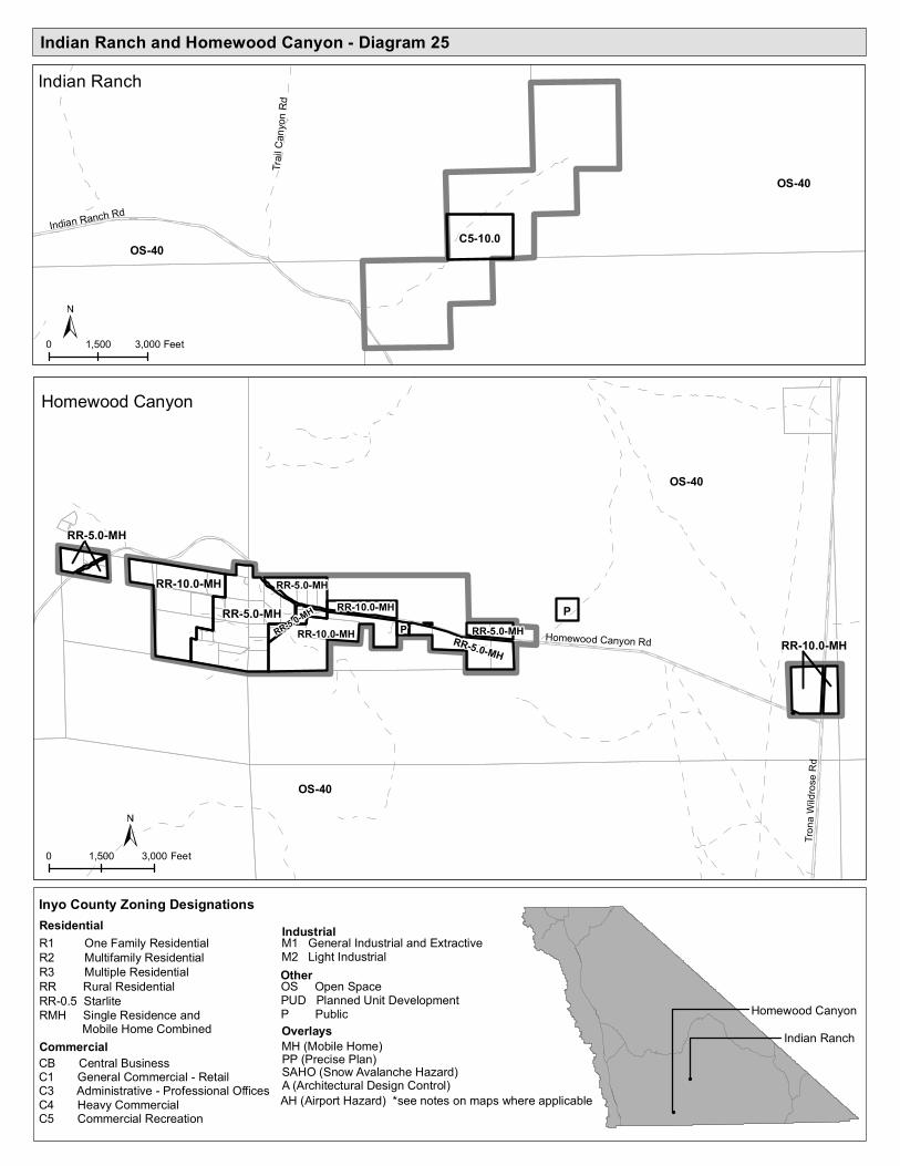
Indian Ranch and Homewood Canyon - Diagram 25
RR-10.0-MH
OS-40
OS-40
Homewood Canyon Rd
Homewood Canyon
Trona
Wild
rose R
d
RR-5.0-MH
RR-10.0-MHP
RR-5.0-MH
RR-5.0-MH
RR-10.0-MHP
RR-10.0-MH
RR-5.0-MH
RR-5.0-MHRR-5.0-MH
OS-40
OS-40
Indian Ranch
Indian Ranch Rd
Trail C
anyo
n Rd
C5-10.0
0 1,500 3,000 Feet
0 1,500 3,000 Feet
Homewood CanyonIndian Ranch
Inyo County Zoning DesignationsResidential IndustrialM1 General Industrial and Extractive
M2 Light Industrial
Commercial
OtherOS Open SpacePUD Planned Unit DevelopmentP PublicOverlays
R1 One Family ResidentialR2 Multifamily ResidentialR3 Multiple ResidentialRR Rural ResidentialRR-0.5 StarliteRMH Single Residence and Mobile Home Combined
PP (Precise Plan)A (Architectural Design Control)
MH (Mobile Home)SAHO (Snow Avalanche Hazard)AH (Airport Hazard) *see notes on maps where applicable
CB Central Business C1 General Commercial - RetailC3 Administrative - Professional OfficesC4 Heavy CommercialC5 Commercial Recreation

Valley Wells - Diagram 26
C2-2.5-MH
OS-40
OS-40
OS-40
Trona
Wild
rose R
d
Stockwell M
ine Rd
Trona Airport Rd
Valley Wells Rd
M1-40
P-40
RR-5.0-MH
M1-40
RR-5.
0-MH
M1-40
C2-5.
0-MH
C2-5.0-MH
C2-5.0-MH
C2-2.5-MH
M2-5.0-MHM2-5.0-MH
P-40
M1-40
OS-40
OS-40
0 1,000 2,000 Feet
Valley Wells
* Areas within Valley Wells Diagram 26 may be subject to the Airport Hazard Overlay
Residential IndustrialM1 General Industrial and ExtractiveM2 Light Industrial
Commercial
OtherOS Open SpacePUD Planned Unit DevelopmentP PublicOverlays
R1 One Family ResidentialR2 Multifamily ResidentialR3 Multiple ResidentialRR Rural ResidentialRR-0.5 StarliteRMH Single Residence and Mobile Home Combined
PP (Precise Plan)
A (Architectural Design Control)
MH (Mobile Home)
SAHO (Snow Avalanche Hazard)
AH (Airport Hazard) *see notes on maps where applicable
CB Central Business C1 General Commercial - RetailC3 Administrative - Professional OfficesC4 Heavy CommercialC5 Commercial Recreation
Inyo County Zoning DesignationsC4 to M2
Proposed Zone Changes

Furnace Creek and Death Valley Junction - Diagram 27
OS-40
OS-40
Furnace Creek
State Hwy 190
Old Ghost Rd
Corral Rd
Airport Rd
Badw
ater R
d
Mustard Canyon DrTatsiumpi
Mill Rd
C5-10.0
C5-10.0
C5-10.0
0 2,000 4,000 Feet
P
R1-0.5-MH
OS-40
Death Valley Junction
State Hwy 127
State Line Rd
State Hwy 190
OS-40
C5-5.
0
P
C5-5.0
Furnace Creek
Death Valley Junction
0 2,000 4,000 Feet
Inyo County Zoning DesignationsResidential IndustrialM1 General Industrial and Extractive
M2 Light Industrial
Commercial
OtherOS Open SpacePUD Planned Unit DevelopmentP PublicOverlays
R1 One Family ResidentialR2 Multifamily ResidentialR3 Multiple ResidentialRR Rural ResidentialRR-0.5 StarliteRMH Single Residence and Mobile Home Combined
PP (Precise Plan)A (Architectural Design Control)
MH (Mobile Home)SAHO (Snow Avalanche Hazard)AH (Airport Hazard) *see notes on maps where applicable
CB Central Business C1 General Commercial - RetailC3 Administrative - Professional OfficesC4 Heavy CommercialC5 Commercial Recreation
* Areas within Furnace Creek Diagram 27 may be subject to the Airport Hazard Overlay
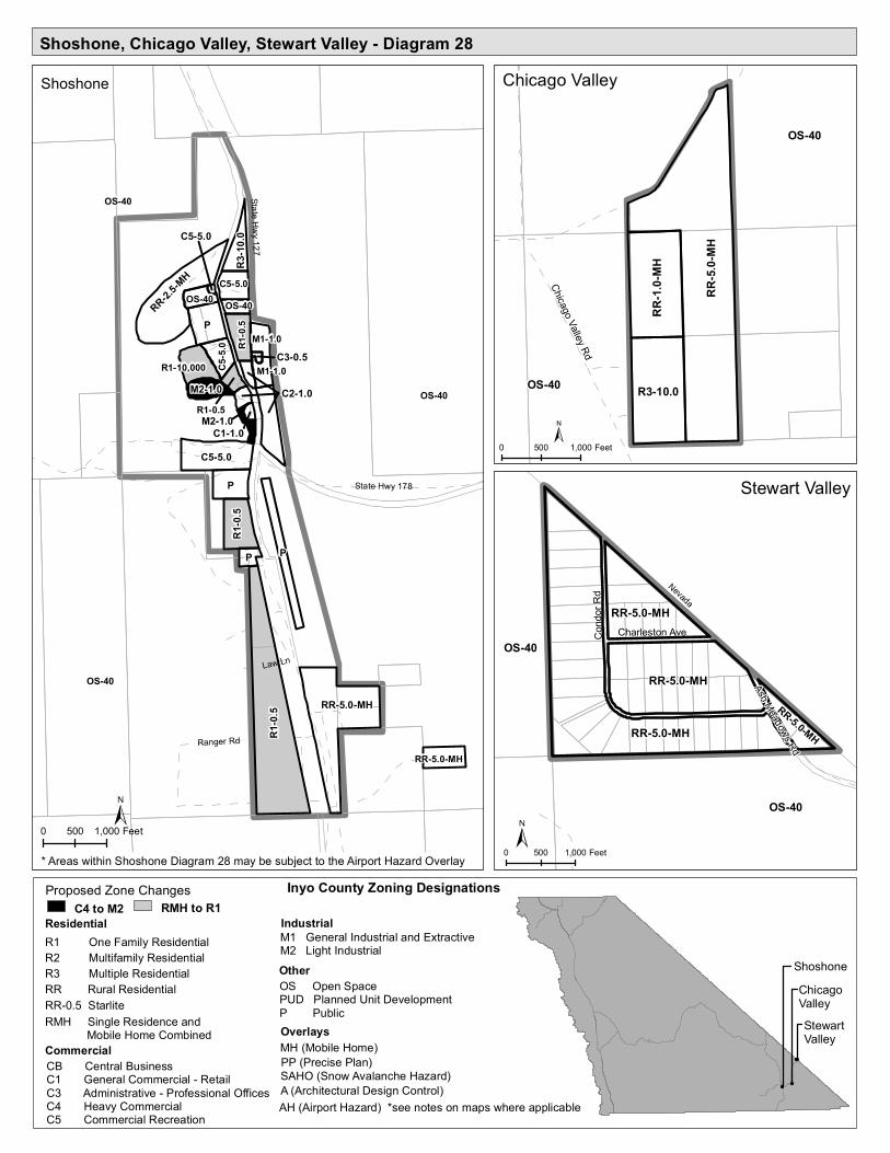
Shoshone, Chicago Valley, Stewart Valley - Diagram 28
M1-1.0
M2-1.0
OS-40
OS-40
OS-40 State Hwy 127
State Hwy 178
Ranger Rd
Law Ln
Shoshone
R1-0.
5
P
P
RR-5.0-MH
C5-5.0
P P
RR-2.5-MH
C1-1.0
R1-0.
5
M1-1.0
C5-5.0
R3-10
.0C5
-5.0 R1
-0.5
R1-10,000
RR-5.0-MH
OS-40 OS-40
R1-0.5C2-1.0M2-1.0
C3-0.5
C5-5.0
OS-40
OS-40
Chicago Valley Rd
Chicago Valley
RR-5.
0-MH
R3-10.0
RR-1.
0-MH
0 500 1,000 Feet
OS-40
Cond
or Rd
Ash Meadows Rd
Charleston Ave
Stewart Valley
OS-40
RR-5.0-MH
RR-5.0-MH
RR-5.0-MH
RR-5.0-MH
ShoshoneChicago ValleyStewart Valley
0 500 1,000 Feet
Nevada
0 500 1,000 Feet* Areas within Shoshone Diagram 28 may be subject to the Airport Hazard Overlay
Residential IndustrialM1 General Industrial and ExtractiveM2 Light Industrial
Commercial
OtherOS Open SpacePUD Planned Unit DevelopmentP PublicOverlays
R1 One Family ResidentialR2 Multifamily ResidentialR3 Multiple ResidentialRR Rural ResidentialRR-0.5 StarliteRMH Single Residence and Mobile Home Combined
PP (Precise Plan)
A (Architectural Design Control)
MH (Mobile Home)
SAHO (Snow Avalanche Hazard)
AH (Airport Hazard) *see notes on maps where applicable
CB Central Business C1 General Commercial - RetailC3 Administrative - Professional OfficesC4 Heavy CommercialC5 Commercial Recreation
Inyo County Zoning DesignationsC4 to M2
Proposed Zone ChangesRMH to R1
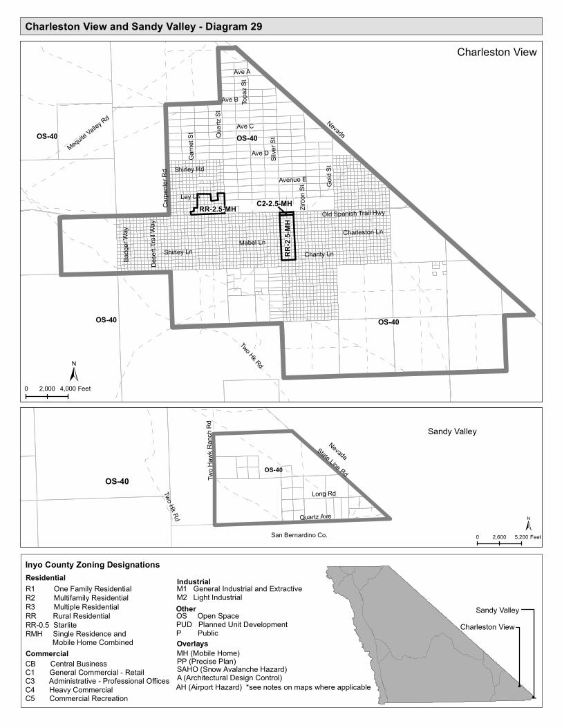
Charleston View and Sandy Valley - Diagram 29
OS-40
OS-40
Ave D
Mabel Ln
Ave C
Charity Ln
Ave B
Shirley LnTo
paz S
t
Silve
r St
Avenue E
Quart
z St
Zirco
n St
Two Hk Rd
Garne
t St
Ave A
Ley Ln
Gold
St
Badg
er Wa
y
Carpe
nter R
d Shirley Rd
Charleston Ln
Dese
rt Trai
l Way
Old Spanish Trail Hwy
Mequite Valley Rd
Charleston View
OS-40
OS-40
RR-2.
5-MH
RR-2.5-MH C2-2.5-MH
OS-40
Sandy Valley
OS-40
State Line Rd
Two Hk Rd Quartz Ave
Two H
awk R
anch
Rd
Long Rd
0 2,000 4,000 Feet
0 2,600 5,200 Feet
Charleston ViewSandy Valley
Nevada
Nevada
San Bernardino Co.
Inyo County Zoning DesignationsResidential IndustrialM1 General Industrial and Extractive
M2 Light Industrial
Commercial
OtherOS Open SpacePUD Planned Unit DevelopmentP PublicOverlays
R1 One Family ResidentialR2 Multifamily ResidentialR3 Multiple ResidentialRR Rural ResidentialRR-0.5 StarliteRMH Single Residence and Mobile Home Combined
PP (Precise Plan)A (Architectural Design Control)
MH (Mobile Home)SAHO (Snow Avalanche Hazard)AH (Airport Hazard) *see notes on maps where applicable
CB Central Business C1 General Commercial - RetailC3 Administrative - Professional OfficesC4 Heavy CommercialC5 Commercial Recreation

Tecopa, Tecopa Heights, Tecopa Hot Springs - Diagram 30
TecopaTecopa Heights
P OS-40
RR-1.0-MHRR-1.0-MH
RR-1.0-MHRR-1.0-MH
RR-1.0-MHRR-1.0-MH
RR-1.0-MHRR-1.0-MH
RR-1.0-MH
C5-5.0
RR-1.0-MH
OS-40 OS-40
R2-5.0-MH
R2-5.0-MH
OS-40
OS-40
M1-1.0
R1-0.5
Old Spanish Trl
Tecopa Hot
White Way
Furnace Creek Rd
Down
ey R
d
Stampmill Rd
Crabtree RdP
RR-1.0-MH
P
C5-5.0
RR-2.5-MHC5-5.0OS-40RR-1.0-MH
RR-1.0-MH
RR-1.0-MH
C5-5.0RR-1.0-MH
RR-2.
5-MH
RR-1.
0-MH
PP
RR-1.0-MHC2-1.0-MH
OS-40OS-40
OS-40
Teco
pa H
ot
Furnace Creek Rd
Noonday St
Tecopa Hot Springs
OS-40
RR-5.
0-MH
C5-5.0
P
C5-5.
0
0 1,000 2,000 Feet
0 1,000 2,000 Feet
Tecopa Hot Springs
Tecopa/Tecopa Heights
Inyo County Zoning Designations
Residential IndustrialM1 General Industrial and ExtractiveM2 Light Industrial
Commercial
OtherOS Open SpacePUD Planned Unit DevelopmentP PublicOverlays
R1 One Family ResidentialR2 Multifamily ResidentialR3 Multiple ResidentialRR Rural ResidentialRR-0.5 StarliteRMH Single Residence and Mobile Home Combined
PP (Precise Plan)A (Architectural Design Control)
MH (Mobile Home)SAHO (Snow Avalanche Hazard)AH (Airport Hazard) *see notes on maps where applicable
CB Central Business C1 General Commercial - RetailC3 Administrative - Professional OfficesC4 Heavy CommercialC5 Commercial Recreation
RMH to R1Proposed Zone Changes

California Department of Forestry Training Center and Mill Pond Park - Diagram 31
Inyo County Zoning DesignationsResidential IndustrialM1 General Industrial and Extractive
M2 Light Industrial
Commercial
OtherOS Open SpacePUD Planned Unit DevelopmentP PublicOverlays
R1 One Family ResidentialR2 Multifamily ResidentialR3 Multiple ResidentialRR Rural ResidentialRR-0.5 StarliteRMH Single Residence and Mobile Home Combined
PP (Precise Plan)A (Architectural Design Control)
MH (Mobile Home)SAHO (Snow Avalanche Hazard)
AH (Airport Hazard) *see notes on maps where applicable
CB Central Business C1 General Commercial - RetailC3 Administrative - Professional OfficesC4 Heavy CommercialC5 Commercial Recreation
OS-40
OS-40
OS-40
Alta Vista/Mustang Mesa - Diagram 4
P
P PP S Round Valley Rd
Tungsten City Rd
Sawmill Rd
Pleasant Valley Dam Rd
Chalk Bluff Rd
Mill Creek Rd
Round Valley Tungsten Rd
Owens Canal
Oliso
Rd
Hous
ton D
r
Abelor Rd
US Hwy 395
California Department of Forestry Training CenterMill Pond Park
California Department of Forestry Training Center
Mill Pond Park
Rocking K Ranch- Diagram 5

Dolomite- Diagram 32
Inyo County Zoning DesignationsResidential IndustrialM1 General Industrial and Extractive
M2 Light Industrial
Commercial
OtherOS Open SpacePUD Planned Unit DevelopmentP PublicOverlays
R1 One Family ResidentialR2 Multifamily ResidentialR3 Multiple ResidentialRR Rural ResidentialRR-0.5 StarliteRMH Single Residence and Mobile Home Combined
PP (Precise Plan)A (Architectural Design Control)
MH (Mobile Home)SAHO (Snow Avalanche Hazard)
AH (Airport Hazard) *see notes on maps where applicable
CB Central Business C1 General Commercial - RetailC3 Administrative - Professional OfficesC4 Heavy CommercialC5 Commercial Recreation
OS-40
OS-40
OS-40
R1-5,800
M2-0.5
C1-10,000
C2-10
,000
R3-10,000
C1-10
,000
C2-10,000
M1-20,000
Dolomite Loop
State Hwy 136
Dolomite

3,000 Foot Camp - Diagram 33
Inyo County Zoning DesignationsResidential IndustrialM1 General Industrial and Extractive
M2 Light Industrial
Commercial
OtherOS Open SpacePUD Planned Unit DevelopmentP PublicOverlays
R1 One Family ResidentialR2 Multifamily ResidentialR3 Multiple ResidentialRR Rural ResidentialRR-0.5 StarliteRMH Single Residence and Mobile Home Combined
PP (Precise Plan)A (Architectural Design Control)
MH (Mobile Home)SAHO (Snow Avalanche Hazard)
AH (Airport Hazard) *see notes on maps where applicable
CB Central Business C1 General Commercial - RetailC3 Administrative - Professional OfficesC4 Heavy CommercialC5 Commercial Recreation
OS-40
OS-40
OS-40R3-10,000 State Hwy 190
Furnace Creek Rd
Dante
s View
Rd
Dante's View Rd
3,000 Foot Camp
OS-40