court order 2017-1621 - · pdf filerecommended by: michael grace originating department:...
TRANSCRIPT
Recommended by: Michael Grace Originating Department: Unincorporated Area Services
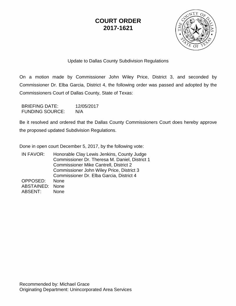
COURT ORDER 2017-1621
Update to Dallas County Subdivision Regulations On a motion made by Commissioner John Wiley Price, District 3, and seconded by
Commissioner Dr. Elba Garcia, District 4, the following order was passed and adopted by the
Commissioners Court of Dallas County, State of Texas:
BRIEFING DATE: 12/05/2017 FUNDING SOURCE: N/A
Be it resolved and ordered that the Dallas County Commissioners Court does hereby approve
the proposed updated Subdivision Regulations.
Done in open court December 5, 2017, by the following vote:
IN FAVOR: Honorable Clay Lewis Jenkins, County Judge Commissioner Dr. Theresa M. Daniel, District 1 Commissioner Mike Cantrell, District 2 Commissioner John Wiley Price, District 3 Commissioner Dr. Elba Garcia, District 4
OPPOSED: None ABSTAINED: None ABSENT: None

RECOMMENDED BY:
Unincorporated Area Services PREPARED BY: Angie Smith
APPROVED BY DEPT HEAD:
Michael Grace
COMMISSIONERS COURT BRIEFING DATE: 12/05/2017 SUBMITTING DEPARTMENT: Unincorporated Area Services THROUGH: SUBJECT: Update to Dallas County Subdivision Regulations
BACKGROUND: The update to Dallas County’s Subdivision regulations is in response to evolving conditions and continued development within the unincorporated area as well as amendments to State law. Further and in response to heightened interest amongst neighboring jurisdictions for extraterritorial jurisdiction (ETJ) agreements with Dallas County, updated Subdivision regulations will form the foundation for forthcoming ETJ agreements between Dallas County and partner jurisdictions. The county enforces the subdivision of land/ private property in the Unincorporated Areas via the Subdivision Regulations adopted by the Commissioner’s Court Order No. 2010-1361, dated August 17, 2010 and following a July 27, 2010 briefing. Commissioners Court Order No. 71-660 originally adopted said regulations on March 18, 1971. Dallas County Subdivision regulations apply to the following unincorporated areas: areas which are within the Extra Territorial Jurisdiction (E.T.J.) of a respective municipality (i.e. City or Town), and areas which are not within a municipality’s E.T.J. Extra-territorial jurisdictional boundaries, established using estimated population totals of a municipality as determined by the most recent census, are set as a buffer radius in miles and surround municipalities. Dallas County has certain responsibilities for unincorporated areas such as providing for the safety, health, and well-being of the general public by requiring that adequate facilities – roads, streets, drainage, potable water, and wastewater collection systems - are specified in the proper subdivision of land and private property. Said facilities, public or private, shall be maintained without imposing a burden to Dallas County and its taxpayers.
NEED TO AMEND SUBDIVISION REGULATIONS: The attached and amended Subdivision Regulations incorporate current state laws and regulations and govern the proper subdivision of land/private property in unincorporated areas. Said regulations include updated amendments to the State statute. Approval by Commissioners Court of the updated Subdivision Regulations requires the posting of a Public Notice for a Public Hearing of same. Hearings occur on the same date as the Commissioners Court’s expected adoption of the subject regulations.

A Variance procedure for developers is outlined within the updated Subdivision Regulations provided that no statutory requirement or limitation may be waived and overall design and construction standards are met. However, the Commissioners Court has the authority to enforce said regulations and assess penalties for violations (both civil and criminal) as permitted or required by state statute to gain compliance with updated regulations. Compliance and all associated costs are solely the responsibility of the developer.
DALLAS COUNTY UNINCORPORATED AREA STRATEGY: The updated Subdivision Regulations are consistent with the County’s strategy for the Unincorporated Area of Dallas County such that its aim is to improve conditions within the Unincorporated Area including the consolidation of most operations, and the undertaking new activities. Furthermore, these updated regulations are consistent with the Administrative Plan such that its goal is to provide services to the citizens of Dallas County as efficiently and effectively as possible by improving the permitting process and communication stream. OPERATIONAL IMPACT: The proposed updated Subdivision Regulations will be administered by the Department of Unincorporated Area Services. Presently, the Public Works Department is responsible for subdivision and developmental activity in the Unincorporated Areas and coordinates with other County departments and Cities/Towns having E.T.J. authority. FINANCIAL IMPACT: No financial impacts anticipated for Dallas County. LEGAL IMPACT: The District Attorney’s Office, Civil Division, has reviewed the contents and approves as to form. PROJECT SCHEDULE: Estimated Adoption Date: December 5, 2017. M/WBE PARTICIPATION: N/A ADMINISTRATIVE PLAN COMPLIANCE: These updated regulations are consistent with the Administrative Plan such that its goal is to provide services to the citizens of Dallas County as efficiently and effectively as possible by improving the permitting process and communication stream. RECOMMENDATION: Approve the proposed updated Subdivision Regulations.

1
DALLAS COUNTY
SUBDIVISION REGULATIONS
AND
COUNTY ROAD CONSTRUCTION STANDARDS

i
SUBDIVISION REGULATIONS TABLE OF CONTENTS
ITEM PAGE
SECTION A. PURPOSE AND APPLICABILITY .......................................................... 3
SECTION B. DEFINITIONS ............................................................................................5
SECTION C. ENFORCEMENT .................................................................................... 10
SECTION D. PLATTING PROCEDURE ...................................................................... 11
1. COMMISSIONERS COURT DESIGNEE...................................... 11
2. DELIVERY ..................................................................................... 11
3. PRELIMINARY PLATS ................................................................. 11
4. FINAL PLATS .................................................................................14
5. APPROVAL OF FINAL PLATS .....................................................18
6. PLAT RECORDATION/ REVOCATION ...................................... 18
7. ENGINEERING / CONSTRUCTION PLANS ............................... 19
8. DEVELOPMENT PERMITS .......................................................... 24
9. VARIANCE PROCEDURE …… ................................................... 24
SECTION E. WATER AND SEPTIC SYSTEM / OSSF REQUIREMENTS ............... 26
SECTION F. SUBDIVISON REQUIREMENTS .......................................................... 27
1. COUNTY ROADWAYS ................................................................ 27
2. DEDICATION OF R.O.W .............................................................. 29
3. PRIVATE ROADS ......................................................................... 29
4. DRAINAGE AND UTILITY EASEMENTS ................................. 29
5. LOT FRONTAGE, LOT SIZE, AND BUILDING SETBACKS. ... 30
6. DRIVEWAYS ................................................................................. 31
SECTION G. COUNTY ROADS – CONSTRUCTION STANDARDS ....................... 32
1. GENERAL ...................................................................................... 32
2. PREPARING RIGHT OF WAY .................................................... 33
3. SUBGRADE ................................................................................... 33
4. BASE MATERIALS ...................................................................... 33
5. SURFACE – H.M.A.C..................................................................... 34
6. DRIVEWAYS.................................................................................. 34
SECTION H. MANUFACTURED HOME RENTAL COMMUNITIES ..................... 36

ii
SUBDIVISION REGULATIONS TABLE OF CONTENTS
ITEM PAGE
SECTION I. STORM WATER POLLUTION PREVENTION PLAN (SWP3) .......... 38
SECTION J. DRAINAGE STANDARDS .................................................................... 39
SECTION K. CONSTRUCTION AND MAINTAINENCE BONDS ............................ 40
1. CONSTRUCTION BONDS ........................................................... 40
2. MAINTENANCE BONDS ............................................................. 40
3. FINAL INSPECTION .................................................................... 41
4. IRREVOCABLE LETTER OF CREDIT (IN LIEU OF BOND) ... 41
5. OTHER SECURITY ....................................................................... 41
SECTION L. SEVERABILITY ...................................................................................... 42
APPENDIX
A. CHECKLIST - PRELIMINARY PLAT SUBMISSION ......................................43
B. CHECKLIST - FINAL PLAT SUBMISSION .....................................................45
C. PLATTING FEE SCHEDULE .............................................................................47
D. RURAL COUNTY ROAD - TYPICAL SECTION ..............................................49
E. RURAL THOROUGHFARE COUNTY ROAD - TYPICAL SECTION…….... 50
F. COUNTY UNINCORPORATED AREA NOT WITHIN CITY ETJ LIMITS…. 51
G. DEVELOPMENT PERMIT PLACARD DETAIL…………………………….....52
3
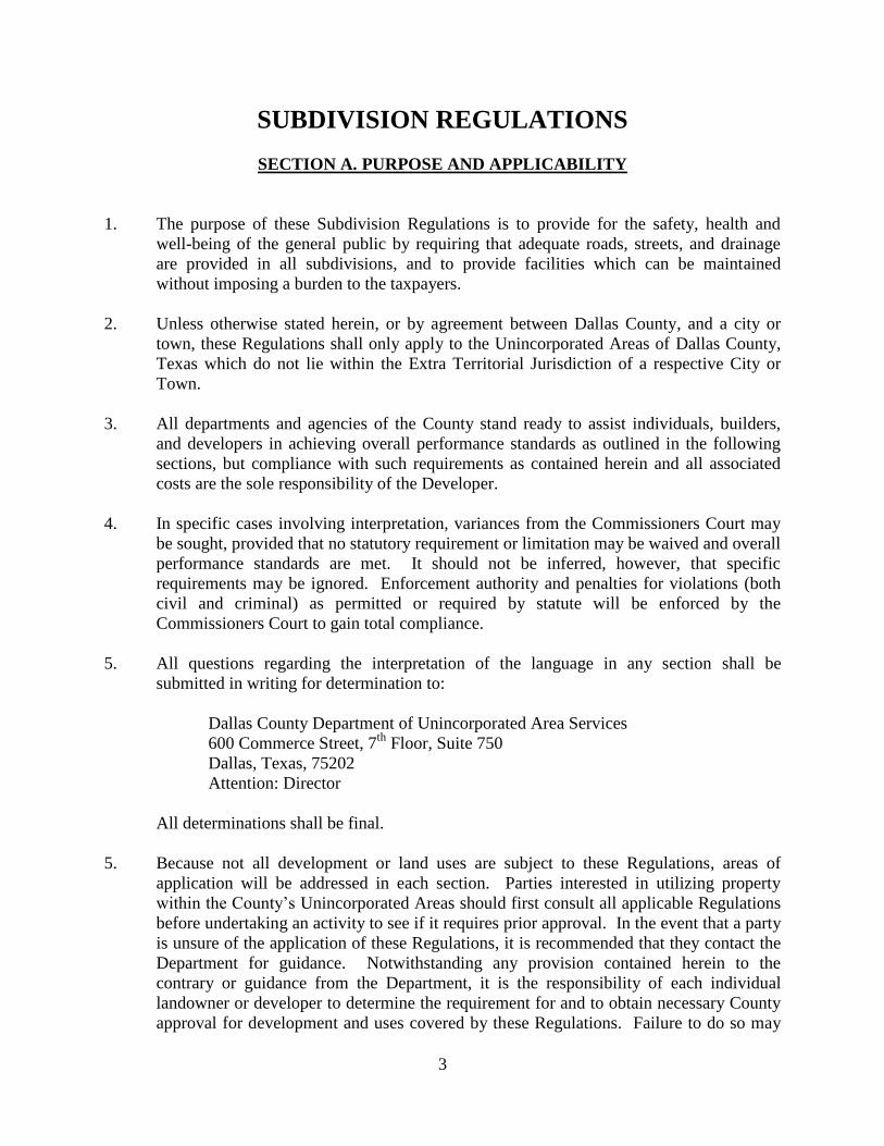
SUBDIVISION REGULATIONS
SECTION A. PURPOSE AND APPLICABILITY
1. The purpose of these Subdivision Regulations is to provide for the safety, health and
well-being of the general public by requiring that adequate roads, streets, and drainage
are provided in all subdivisions, and to provide facilities which can be maintained
without imposing a burden to the taxpayers.
2. Unless otherwise stated herein, or by agreement between Dallas County, and a city or
town, these Regulations shall only apply to the Unincorporated Areas of Dallas County,
Texas which do not lie within the Extra Territorial Jurisdiction of a respective City or
Town.
3. All departments and agencies of the County stand ready to assist individuals, builders,
and developers in achieving overall performance standards as outlined in the following
sections, but compliance with such requirements as contained herein and all associated
costs are the sole responsibility of the Developer.
4. In specific cases involving interpretation, variances from the Commissioners Court may
be sought, provided that no statutory requirement or limitation may be waived and overall
performance standards are met. It should not be inferred, however, that specific
requirements may be ignored. Enforcement authority and penalties for violations (both
civil and criminal) as permitted or required by statute will be enforced by the
Commissioners Court to gain total compliance.
5. All questions regarding the interpretation of the language in any section shall be
submitted in writing for determination to:
Dallas County Department of Unincorporated Area Services
600 Commerce Street, 7th
Floor, Suite 750
Dallas, Texas, 75202
Attention: Director
All determinations shall be final.
5. Because not all development or land uses are subject to these Regulations, areas of
application will be addressed in each section. Parties interested in utilizing property
within the County’s Unincorporated Areas should first consult all applicable Regulations
before undertaking an activity to see if it requires prior approval. In the event that a party
is unsure of the application of these Regulations, it is recommended that they contact the
Department for guidance. Notwithstanding any provision contained herein to the
contrary or guidance from the Department, it is the responsibility of each individual
landowner or developer to determine the requirement for and to obtain necessary County
approval for development and uses covered by these Regulations. Failure to do so may

4
result in, civil or criminal legal proceedings, or both, that could result in damages, fines,
incarceration, injunctive action or court orders requiring corrective action.
6. These Regulations do not supersede any contradictory State or Federal laws or
regulations nor does compliance with them absolve any party or developer of complying
with any other applicable laws or regulations.
7. In the event that a new subdivision incorporates in part or whole an existing subdivision,
all changes required by the new subdivision are considered revisions of existing
subdivisions and must comply with all requirements of Local Government Code
§232.009, Revision of Plats.
8. Exceptions to these Regulations are as noted in Local Government Code §232.0015,
Exceptions to Plat Requirement. Only in the specific circumstances provided by law are
the requirements of these Regulations for approval of a plat inapplicable. A landowner or
developer may still be required to comply with various other health and safety statutes,
rules, codes or regulations.

5
SECTION B. DEFINITIONS
1. ALLEY - A minor Right-Of-Way which affords only secondary means of vehicular
access to the back side of properties otherwise abutting a street, which may be used for
public utility purposes.
2. APPRAISAL DISTRICT – Dallas Central Appraisal District (DCAD).
3. BASE FLOOD / BASE FLOOD ELEVATION (BFE) - An area subject to inundation
by flood, having a one percent probability of occurrence in any given year, based on
existing conditions of development within the watershed area, as determined by the Flood
Insurance Study (FIS) for Dallas County, Texas provided by the Federal Emergency
Management Agency (FEMA); also, a flood survey of the property by a registered
professional land surveyor (R.P.L.S.), or a floodway study done for the County.
4. BUILDING LINE OR SETBACK LINE - A line established, in general, parallel to the
front street line. No building or structure may be permitted in the area between the
building line and the County Road Right-Of-Way (R.O.W.).
5. BUSINESS DAY - A day other than a Saturday, Sunday, or holiday recognized by the
State of Texas or County of Dallas.
6. COMMISSIONERS COURT - The Dallas County Commissioners Court.
7. CUL-DE-SAC - A County Road having one outlet to another road with a vehicular
turnaround at the opposite end from the roadway intersection.
8. DCHHSD – The Dallas County Health and Human Services Department.
9. DEPARTMENT – Department of Unincorporated Area Services for Dallas County.
10. DEVELOPER – Person, persons, corporations, organizations, government or
governmental subdivision or agency, estates, trust, partnerships, associates,
incorporations or other entities or the agents, servants or representatives of such
entities which undertake the activities covered by these regulations.
11. DEVELOPMENT – Any man-made change in improved and unimproved real estate,
including, but no limited to buildings or other structures, mining, dredging, filling,
grading, paving, excavation or drilling, operations or storage of equipment, Persons,
corporations, organizations, government or governmental subdivision or agency, estates,
trust, partnerships, associates, incorporations or other entities, which undertake the
activities covered by these regulations.
12. DIRECTOR - The Director of the Department of Unincorporated Area Services for
Dallas County, or the Director’s designated agent, representative or delegate.

6
13. DIRECTIONAL PREFIX - An indicator of direction in which a roadway passes from
an established base line. In the street name "North Franklin Road," north is the
directional prefix.
14. DIRECTIONAL SUFFIX - An indicator of address location, by indicating the side of
the street the address is located. In the address "137 Franklin Road N," N is the
directional suffix.
15. DRILL SITE – Drill site means the premises used during the drilling or re-working of a
well or wells located there and subsequent life of a well or wells or any associated
operation.
16. EASEMENT - A right given by the owner of a parcel of land to another person, public
agency or private corporation for specific and limited use of that parcel.
17. ENGINEER - Any person registered and currently licensed to practice engineering
(P.E.) by the State of Texas Board of Professional Engineers (TBPE).
18. ENGINEERING PLANS - The drawings and specifications prepared by a Texas P.E.
submitted to the County and required for Plans Approval.
19. EXPRESSWAY / TOLLWAY – High speed roadway with four lanes or more of traffic
divided by a median or grassed area. This section is intended primarily for use to receive
traffic from Major Thoroughfares and secondary roads / Principal Arterials, and normally
would carry high to very high volumes of traffic.
20. EXTRA TERRITORIAL JURISDICTION AUTHORITY (E.T.J.) - The
Unincorporated Area, not a part of any city, which is contiguous to the corporate limits of
any city. The extra-territorial jurisdiction of the various population classes of cities (as
defined in Chapter 42 of the Texas Local Government Code) shall be as follows, to the
extent a city has formally established or adopted its ETJ limits:
a. The extra-territorial jurisdiction of any city having a population of less than five
thousand (5,000) inhabitants shall consist of all the contiguous Unincorporated
Area, not a part of any other city, within one-half (1/2) mile of the corporate
limits of such city.
b. The extra-territorial jurisdiction of any city having a population of five thousand
(5,000) or more inhabitants, but less than twenty-five thousand (25,000)
inhabitants shall consist of all the contiguous Unincorporated Area, not a part of
any other city, within one (1) mile of the corporate limits of such city.
c. The extra-territorial jurisdiction of any city having a population of twenty-five
thousand (25,000) or more inhabitants, but less than fifty thousand (50,000)
inhabitants, shall consist of all the contiguous Unincorporated Area, not a part of
any other city within two (2) miles of the corporate limits of such city.

7
d. The extra-territorial jurisdiction of any city having a population of fifty thousand
(50,000) or more inhabitants, but less than one hundred thousand (100,000)
inhabitants shall consist of all the contiguous Unincorporated Area, not a part of
any other city, within three and one-half (3 1/2) miles of the corporate limits of
such city.
e. The extra-territorial jurisdiction of any city having a population of one hundred
thousand (100,000) or more inhabitants shall consist of all the contiguous
Unincorporated Area, not a part of any other city, within five (5) miles of the
corporate limits of such city.
21. FEMA - Federal Emergency Management Agency.
22. FUNCTIONAL CLASSIFICATION - Categorizing roadways by describing them in
terms of accomplishing the competing aims of access and movement. Local roadways
solely provide access to residential lots. Collectors collect traffic from neighborhoods and
lead vehicles out to major and / or minor arteries which surround those areas. Arteries
then carry traffic to freeways and/or expressways, which primarily provide movement to
locations in the larger region.
23. GAS WELL – Gas Well means any well drilled, to be drilled, or used for the intended or
actual production of natural gas.
24. LABEL - The portion of a street name that attaches a creative identity to a roadway. In
the street name "Franklin Road," Franklin is the label.
25. LOT - An undivided tract or parcel of land having frontage on a road, which parcel of
land is designated as a separate and distinct tract. All lots, so far as practical, shall have
their side lines at right angles to the road on which they face, or radial to curved road
lines.
26. MAJOR THOROUGHFARE – A roadway or thoroughfare that is a high capacity
urban road. See County Code Section 102-3 Type “b”
27. MANUFACTURED HOME RENTAL COMMUNITY - A plot or tract of land that is
separated into two or more spaces or lots that are rented, leased, or offered for rent or
lease, for a term of less than 60 months without a purchase option, for the installation of
manufactured homes for use and occupancy as residences.
28. MASTER PLAN – A long term plan that encompasses the entire community to be
built—defining proposed street layout, residential areas, parks and open spaces. A
master plan communicates the final intention of development needs in terms of
government services.
29. MINOR ROADWAY – See County Code Section 102-3 Types “a” & “e”.

8
30. OPEN SPACE – Areas of protected or conserved land which are to remain undeveloped
set aside for public usage and to be maintained by the owner, developer, or HOA.
31. OSSF - On Site Sewerage Facility.
32. PLAT - A map depicting the division or subdivision of lands into lots, blocks, parcels,
tracts, or other portions. A Re-Plat or re-subdivision will be considered a Plat.
33. PRELIMINARY PLAT - One or more drawings showing the physical conditions of a
tract of land and the surrounding area intended to be subdivided. This Plat shall show the
developer's intended development program in order to assure that all regulations are
complied with.
34. FINAL PLAT - A map or drawing and any accompanying material of a proposed land
subdivision prepared in a form suitable for filing in the County Recording Department
and prepared as described in these regulations.
35. PRIMARY ARTERIAL – A freeway or arterial roadway built for mobility. A Primary
Arterial may have limited access in order to maintain throughput. A Primary Arterial
may also be considered a Major Thoroughfare. (For further designation and definition of
an urban arterial, see the current Dallas County Mobility Plan.)
36. REGULATIONS – These Subdivision Regulations.
37. ROADWAY - Any official vehicular course for travel, regardless of length or service
characteristics; a generic term for any street, boulevard, loop, etc.
38. SECONDARY ARTERIAL - A two-lane County Road Rural Section with drainage
ditches. A secondary arterial may also be considered a Major Thoroughfare. (For further
designation and definition of an urban arterial, see the current Dallas County Mobility
Plan.)
39. SHALL - Is mandatory and not discretionary.
40. STRE ET NAME - The street label. (It does not include the prefix or suffix.)
41. SUBDIVISION -
a. Any tract of land divided into two or more contiguous lots for the purpose of
laying out lots, streets, alleys, squares, parks, or other parts of the tract intended to
be dedicated to public use, or for the use of purchasers or owners of lots fronting
on or adjacent to the streets, alleys, squares, parks, or other parts.
b. A subdivision which has been Platted or recorded with the County Clerk of
County, or which is required by Statute to be recorded.
9
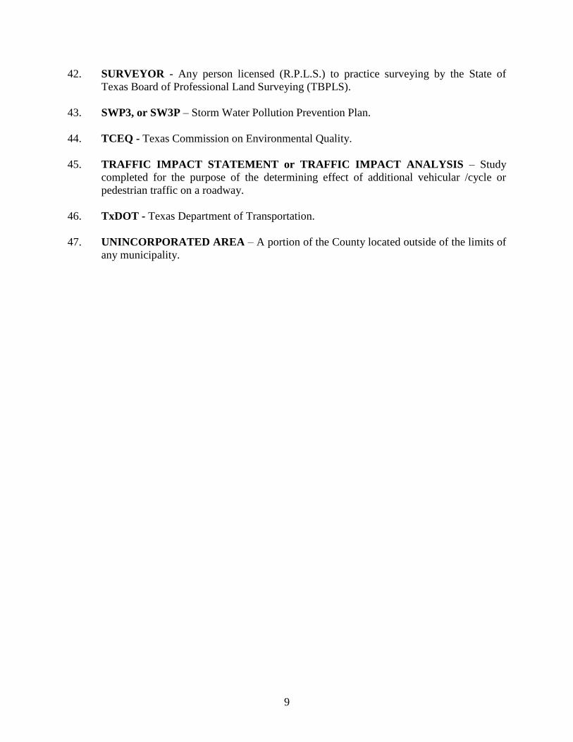
42. SURVEYOR - Any person licensed (R.P.L.S.) to practice surveying by the State of
Texas Board of Professional Land Surveying (TBPLS).
43. SWP3, or SW3P – Storm Water Pollution Prevention Plan.
44. TCEQ - Texas Commission on Environmental Quality.
45. TRAFFIC IMPACT STATEMENT or TRAFFIC IMPACT ANALYSIS – Study
completed for the purpose of the determining effect of additional vehicular /cycle or
pedestrian traffic on a roadway.
46. TxDOT - Texas Department of Transportation.
47. UNINCORPORATED AREA – A portion of the County located outside of the limits of
any municipality.

10
SECTION C. ENFORCEMENT
1. The Commissioners Court shall have the authority to refuse to approve and authorize any
map or Plat of any such subdivision, unless such map or Plat meets the requirements as
set forth in these Subdivision Regulations and County Road Construction Standards; and
there is submitted at the time of approval of such map or Plat such financial security as
may be required by these rules.
2. At the request of the Commissioners Court the District Attorney or other prosecuting
attorney representing the County may file an action in a court of competent jurisdiction
to:
a. enjoin the violation or threatened violation of a requirement established by or
adopted by the Commissioners Court under Chapter 232 of the V.T.C.A., Local
Government Code; or
b. recover damages in an amount adequate for the County to undertake any
construction or other activity necessary to bring about compliance with a
requirement established by the Commissioners Court under Chapter 232 of the
V.T.C.A., Local Government Code.
3. A person commits an offense if the person knowingly or intentionally violates a
requirement established by or adopted by the Commissioners Court under Chapter 232 of
the V.T.C.A., Local Government Code. Such an offense is a Class B Misdemeanor,
except as to a violation for which a criminal penalty is prescribed by section 232.0048 of
the Texas Local Government Code.
4. A requirement that was established by or adopted under Chapter 436, Acts of the 55th
Legislature, Regular Session, 1957, as amended (Article 6626a, Vernon’s Texas Civil
Statutes), or Chapter 151, Acts of the 52nd Legislature, Regular Session, 1951 (Article
2372k, Vernon’s Texas Civil Statutes), before September 1, 1983, and that after that date,
continues to apply for subdivision of land is enforceable under Subsection (B). A
knowing or intentional violation of the requirement is an offense under subsection C of
this section.

11
SECTION D. PLATTING PROCEDURE
1. COMMISSIONERS COURT DESGINEE
The Director of Unincorporated Area Services is hereby designated as the Designee of
the Commissioners Court for all purposes, except final approval of a preliminary or final
plat, which is the sole providence of the Commissioners Court.
2. DELIVERY
All submissions, including Subdivision Preliminary and Final Plats associated with these
Regulations, correspondence, notices or other items regarding the platting of subdivisions
shall be submitted in writing addressed to:
Dallas County Department of Unincorporated Area Services
600 Commerce Street, 7th Floor, Suite 750
Dallas Texas, 75202
Attention: Director
3. PRELIMINARY PLATS
a. The submission of Preliminary Plats is necessary to:
(1) eliminate the duplication of subdivision names and street names.
(2) assure proper alignments of streets and drainage facilities.
(3) assure that the provisions of the County’s Floodplain Management
Regulations will be complied with, and that no lot will have a drainage
problem.
(4) assure that the provisions of the County’s OSSF Regulations will be
complied with.
(5) assure all necessary permits or plan approvals have or shall be applied for.
(6) assure that the new development will not cause the overcapacity of
municipal infrastructure or be detrimental to the public health, safety, and
welfare of the affected geographical area.
b. Five (5) blue line copies of the Preliminary Plats shall be submitted.
c. Preliminary Plats shall be approved by the Commissioners Court before a Final
Plat can be submitted for approval.
12
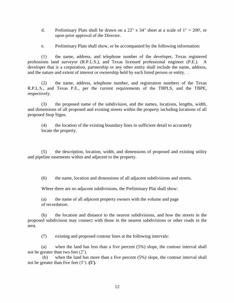
d. Preliminary Plats shall be drawn on a 22" x 34" sheet at a scale of 1" = 200', or
upon prior approval of the Director.
e. Preliminary Plats shall show, or be accompanied by the following information:
(1) the name, address, and telephone number of the developer, Texas registered
professions land surveyor (R.P.L.S.), and Texas licensed professional engineer (P.E.). A
developer that is a corporation, partnership or any other entity shall include the name, address,
and the nature and extent of interest or ownership held by each listed person or entity. .
(2) the name, address, telephone number, and registration numbers of the Texas
R.P.L.S., and Texas P.E., per the current requirements of the TBPLS, and the TBPE,
respectively.
(3) the proposed name of the subdivision, and the names, locations, lengths, width,
and dimensions of all proposed and existing streets within the property including locations of all
proposed Stop Signs.
(4) the location of the existing boundary lines in sufficient detail to accurately
locate the property.
(5) the description, location, width, and dimensions of proposed and existing utility
and pipeline easements within and adjacent to the property.
(6) the name, location and dimensions of all adjacent subdivisions and streets.
Where there are no adjacent subdivisions, the Preliminary Plat shall show:
(a) the name of all adjacent property owners with the volume and page
of recordation.
(b) the location and distance to the nearest subdivisions, and how the streets in the
proposed subdivision may connect with those in the nearest subdivisions or other roads in the
area.
(7) existing and proposed contour lines at the following intervals:
(a) when the land has less than a five percent (5%) slope, the contour interval shall
not be greater than two feet (2’).
(b) when the land has more than a five percent (5%) slope, the contour interval shall
not be greater than five feet (5’). (5').

13
(8) the exact location, dimensions, description and flow line of all existing and
proposed drainage structures.
(9) the location of the Base Flood Elevation (BFE) 100-year flood plain and all lots,
or any part of a lot, that lies within the Base Flood Elevation100-year floodplain.
(10) the existing drainage areas upstream of the proposed subdivision, along with the
drainage calculations of the amount of water coming into, across, and leaving the subdivision in
sufficient detail to show any changes in the Base Flood Elevation100-year flood elevation across
the proposed subdivision, and on the property both upstream and downstream from the proposed
subdivision.
(11) the location of an existing gas well and/or the location of reservation of property
for future drill site.
(12) the date the Preliminary Plat was prepared.
(13) a north arrow and the graphic scale of the Preliminary Plat.
(14) a location or vicinity map showing the location of the proposed subdivision within
the county and to the nearest Incorporated Areas with a north arrow and graphic scale of the
vicinity map.
(15) pre-liminary water and sewer plans if applicable.
(16) execution of a Waiver of Takings Impact Assessment Waiver.
All information listed above is considered to be the minimum amount needed to
assure compliance with these Regulations. Any deviations shall require the
written approval of the Director prior to submittal of the Preliminary Plat.
f. If the proposed subdivision is a portion of a tract which is later to be subdivided in
its entirety, then a tentative master plan of the entire subdivision shall be
submitted with the Preliminary Plat of the portion first to be subdivided.
g. The Department shall review the Preliminary Plat and send written comments to
the developer stating the conditions of approval, if any.
h. Approval of the Preliminary Plat does not constitute acceptance of the
subdivision, but is merely an authorization to proceed with the preparation of the
Final Plat for record. The approval will expire after one (1) year unless one (1) or
more phases have completed an approved Final Plat.
(17) A General Notes or Separated Notes Section page containing all notes applicable
to the plat as discussed in this document.
14
(18) For any proposed subdivision of more than 20 lots, the Preliminary Plat shall be
accompanied by a Traffic Impact Statement or a Traffic Impact Analysis (TIA)
completed by a registered Professional Engineer. This TIA shall be performed for
any arterial affected by the proposed subdivision.
4. FINAL PLATS
a. The submission of Final Plats is necessary to:
(1) assure proper identification and location of all streets, lots and easements.
(2) assure that the streets will be properly constructed and maintained.
(3) assure that the sewer systems have been approved by the DCHHSD.
(4) assure that all proper dedications have been made for streets, easements
and public spaces.
(5) assure that all necessary permits have been obtained or applied for. A
Final Plat is required unless the proposed development meets the
requirements for exceptions detailed in Local Government Code
§232.0015, Exceptions to Plat Requirement.
(6) Obtain the County Commissioner’s Court authorization to commence
construction of the Subdivision.
(7) Assure Dallas County Commissioner’s Court official concurrence that the
new development will not cause the overcapacity of municipal
infrastructure or be detrimental to the public health, safety, and welfare of
the affected geographical area.
b. The developer shall submit to the Director of Dallas County Department of
Unincorporated Area Services, the original and seven (7) copies of the Final Plat
executed by the developer and the Texas R.P.L.S. at least fifteen (15) working
days prior to the Commissioners Court approval.
c. For subdivisions located, wholly or in part, within the extra-territorial jurisdiction
authority of any city, the developer shall comply with the ETJ subdivision
regulations for that particular ETJ.
d. Final Plats shall be drawn on a 22" x 34" Mylar sheet at a scale of 1" = 200',
except in those instances where a city exercising its extra-territorial jurisdiction
authority requires a different sheet size and/or scale, or upon prior approval of the
Director.

15
The following statement shall be required in the General Notes section on the
Final Plat: (see item 17)
Note: Drainage easements shall be kept clear of fences, buildings, foundations,
plantings, and other obstructions for operation/maintenance of drainage facility.
c. In addition to the requirements for Preliminary Plats, Final Plats shall show or be
accompanied by the following information:
(1) The name of the subdivision, the names of the streets, the date that the Plat was
prepared, a north arrow and a graphic scale.
(2) sufficient data to reproduce, on the ground, the bearing, and length, and width of
all streets, blocks, lots and easements including locations of all proposed Stop
Signs. Curves on streets, blocks and easements shall include the radius, length
and central angle of the curve. Curves on lots shall show the radius and length of
the curve.
(3) the accurate location of adjacent subdivision streets, blocks, lots and easements,
or the property owner if the adjacent land is undeveloped.
(4) the number of all lots and blocks arranged in a systematic order, and clearly
shown on the Plat in distinct and legible figures.
(5) the Base Flood Elevation100-year floodplain as identified on the most current
Dallas County Flood Insurance Rate Map (FIRM) published by the Federal
Emergency Management Agency.
Subdivisions that are located in a flood zone as shown on the current Flood
Insurance Rate Map (FIRM) for Dallas County will have the following
requirements:
(a) Permanent type benchmarks shall be set in appropriate locations with the
description and elevation shown on the Plat. The elevation of the benchmark shall
be tied to a benchmark shown on the FIRM panel.
(b) A note on the Plat stating "A flood permit will be required from Dallas County for
any construction in the floodplain."
(c) All subdivision proposals shall be consistent with the Dallas County’s Floodplain
Management Regulations and Development Permit requirements.
(d) Contours at one-foot (1’) intervals shall be shown on the Plat.

16
(e) The finished floor elevation must be shown for each lot located in or partially in
the floodplain.
The following note shall appear in the General Notes section on the Final Plat:
(see item 17)
Floodplain / Drainage Way Maintenance and Easements: The existing creek,
stream, river or drainage channel traversing along or across portions of this
addition will remain unobstructed at all times and will be maintained by the
adjacent property owner, or the Home Owners Association, if applicable. The
County will not be responsible for the maintenance, erosion control, and / or
operation of said drainage ways and easements. The home owners shall keep the
adjacent drainage ways and easements traversing their property clean and free of
debris, silt or other substances which would result in unsanitary conditions, and
the County shall have the right of entry for the purposes of inspecting the
maintenance work by the property owners. The drainage ways are occasionally
subject to storm water overflow damages resulting from the storm water overflow
and / or bank erosion that cannot be defined. The County shall not be liable for
any damages resulting from the occurrence of these phenomena, nor the failure of
any structures within the drainage ways. The drainage way crossing each lot is
contained within the floodplain / drainage easement line as shown on the Plat.
(6) a legal description of the property, and locate the same with respect to an original
corner of the original survey of which it is a part, and the number of acres being
subdivided; describe the basis for bearings and identify a minimum of two (2)
control monuments tied to the Texas State Plane Coordinate System..
All blocks, corners, and angles shall be marked in accordance with minimum
standards set forth by the TBPLS. Texas Board of Professional Land Surveyors.
All corners shall be marked with caps stamped with the Texas R.P.L.S. Surveyor
and / or / or company name per current requirements of the TBPLS.
(7) the location of an existing gas well and / or the location of reservation of property
for future drill site.
(8) a dedication, by the developer, of all streets, roadways, alleys, utility easements,
parks and other land intended for public use to the homeowner’s association, and
the developer's certification that all parties with any interest in the title to the
subject property have joined in such dedication, duly executed, acknowledged and
sworn to by said developer before a Notary Public.
(9) the following statement shall be required in the General Notes section on the Final
Plat: (see item 17)
Note: The County shall not be responsible for maintenance of private streets,
drives, emergency access easements, recreation areas and open spaces; and the
17
owners shall be responsible for the maintenance or private streets, drives,
emergency access easements, recreation areas and open spaces, and said owners
agree to indemnify and save harmless County, from all claims, damages and
losses arising out of or resulting from performance of the obligations of said
owners set forth in this paragraph
(10) the name, address, telephone number, and registration number of the Texas
R.P.L.S. per the current requirements of the TBPLS.
(11) the seal and dated signature of the Texas surveyor, R.P.L.S., responsible for
surveying the subdivision and / or the preparation of the Final Plat.
(12) a space for the approval of the Dallas County Commissioners Court as follows:
“As Approved by Court Order No. dated by the
Commissioners Court”.
(13) a signatory line for the County Judge.
(14) a signatory line for the Director.
(15) a signatory line for the Director of Public Works.
(16) a space for the certification of the DCHHSD Dallas County Health and Human
Services Department as follows:
DALLAS COUNTY HEALTH AND HUMAN SERVICES DEPARTMENT’S
CERTIFICATION:
I hereby certify that the water and on-site wastewater facilities described on this
Final Plat conform to applicable health laws of the State of Texas. This Final Plat
meets current Dallas County requirements related to water supply, septic systems,
lot sizes, and site evaluation. This does not constitute license, permit, or approval
of any specific individual private water facility or private On Site Sewerage
Facility (OSSF) system design or installation.
Director of Dallas County Health and Human Services Department
(17) The following shall be required in the General Notes section on the Final Plat:
(see item 17)
(a) All Utility Easements shall be privately owned and maintained - County shall not
own nor maintain these Utility Easements.

18
(b) Tree planting and other landscape features should be located entirely on private
property or on a parallel landscape easement due to the lack of space on the
R.O.W. for such treatment.
5. APPROVAL OF FINAL PLATS
a. Final Plats submitted by developer only after approval of the Preliminary Plat by
the Director
b. The Final Plat shall be accompanied by:
(1) a Construction Surety Bond for roads, streets, and drainage.
(2) a Certified Tax Certificate from the County Tax Assessor / Collector
indicating that all taxes are paid and not delinquent.
(3) five (5) sets of Engineering / Construction plans for review and approval;
said plans shall not be Approved and Released For Construction until the
Commissioners Court has approved the Final Plat.
The Director shall review the Final Plat for its conformance, and place the
subdivision on the Commissioner’s Court Agenda and recommend either their
approval or denial
c. After the Final Plat has been approved and signed by the Commissioners Court,
the Plat shall be returned to the developer for recording with the County Clerk’s
Office. The Final Plat must be recorded within six months of approval by the
Commissioners Court.
d. The Final Plat shall contain the following statement under the County’s signature
block: Construction not complete within two years of the recording date shall be
subject to current County Subdivision Standards and Regulations.
e. Commissioners Court may refuse to approve a Final Plat if it does not meet the
requirements prescribed by these rules or if any bond required under these rules is
not filed with the County.
6. PLAT RECORDATION / REVOCATION
a. It shall be the sole responsibility of the Owner to determine and comply with all
requirements for Final Plat recordation with the County Clerk’s Office. All Final
Plats must include lot and block monumentation to be set by a Texas R.P.L.S.

19
b. In the event that any Subdivision approved by the Commissioners Court has not
been subdivided or the roads or drainage constructed within five (5) years of the
date of recordation of the Final Plat in the County Deed / Plat Records, such
approval of the subdivision shall expire, be revoked, canceled and of no further
force or effect per the requirements of Local Government Code §245.005.
7. ENGINEERING / CONSTRUCTION PLANS
All Engineering / Construction plans, drawings, and calculations shall be stamped with a
dated signature by a Texas P.E.
a. Five (5) sets of all Engineering / Construction plans shall be submitted by the
developer and engineer to the Director for review and approval. The Engineering
/ Construction plans shall consist of:
(1) street plans.
(2) horizontal control plans.
(3) drainage plans, including outfall channels, storm sewers and inlets design.
(4) plans for water main system, including details, if any.
(5) plans for sewage treatment and wastewater main systems, including
details, if applicable.
(6) plans for adjustment of utility lines and pipelines.
(7) location and description of all easements.
(8) Traffic Control Plan.
(9) Erosion Control Plan.
(10) SWP3.
(11) Cover Sheet
(12) General Notes
(13) Demolition Plan
(14) Grading Plan
(15) Lighting and Signage Plan

20
(16) Landscaping Plan
b. Roadway Engineering / Construction plans shall show:
(1) the plan of the street, in no smaller than a 1" = 20' scale (on a standard
22”x34” (D) sheet size), showing the location of the proposed pavement,
ditches and drainage structures within the street R.O.W.
(2) the profile of the street is no smaller than a 1" = 20' scale horizontal (on a
standard 22”x34” (D) sheet size) and a 1" = 5' scale vertical, showing the
elevation of the existing and proposed pavement, ditches and drainage
structures and all other pertinent design information within the street
R.O.W.
(3) the street grades and existing ground line for left and right ROW in profile
view.
(4) Top of curb/pavement elevations labeled every 50 feet in profile view.
(4) vertical and horizontal centerline stationing at a minimum of every 100’,
PC’, PT’s.
(5) the ditch grades, design flow of water, design depth of water and design
velocity of water.
(6) typical street sections.
(7) Title Block with engineering information, registration, engineer’s seal,
sheet title, and page numbers clearly shown.
(8) North Arrow.
(9) Street names labeled on all existing and proposed streets.
(10) Lot and block numbers and/or ownership information shown for all lots
c. Drainage Engineering / Construction plans shall show:
(1) the plan of the drainage ditches in no smaller than a 1" = 50' scale (on a
standard D size drawing).
(2) the profile of the drainage ditches in no smaller than a 1" = 50' scale
horizontal (on a standard D size drawing) and a 1" = 5' scale vertical
(3) the ditch grades, design flow of water, design depth of water and design
velocity of water.

21
(4) a plan and profile of all culverts under any street with the design flow of
water, headwater and tail water depths and the tail water velocity.
(5) the size of all driveway culverts to carry the design flow of water at each
lot in the subdivision when the culvert is installed at the designed ditch
grade.
(6) typical ditch sections.
(7) drainage design criteria taken from the latest edition of the City of Dallas
Public Works Department’s “Drainage Design Manual”.
(8) Title Block with engineering information, registration, engineer’s seal,
sheet title, and page numbers clearly shown.
(9) North Arrow.
(10) Street names labeled on all existing and proposed streets.
(11) Lot and block numbers and/or ownership information shown for all lots
(12) Drainage area map showing:
(a) Existing contours for entire drainage basin, both onsite and offsite.
(b) Flow arrows for surface drainage.
(c) Existing and proposed storm drain lines.
(d) Detention ponds.
(e) Rational Method Peak Runoff Rate Computation table (Q=CIA).
(f) Drainage and Floodway easements.
(13) Detention pond plans showing:
(a) Detention basin volume calculations and elevation vs. storage
curve.
(b) Hydraulic calculations for outflow structures and elevations vs.
discharge curve.
(c) Drainage and Detention Easements
d. Water main system Engineering / Construction plans shall:
(1) indicate the location and size of all proposed water lines, services and
meters including sizes, etc., in relation to the R.O.W. or easements in
which the lines are to be located.

22
(2) indicate the location of all appurtenances proposed to be installed.
(3) indicate the minimum depth to which the water lines are to be installed.
(4) meet the requirements of the local potable water supply authority, the
International Fire Code and NFPA.
(5) Title Block with engineering information, registration, engineer’s seal,
sheet title, and page numbers clearly shown.
(6) North Arrow.
(7) Street names labeled on all existing and proposed streets.
(8) Lot and block numbers and/or ownership information shown for all lots.
(9) Show and label all existing and proposed utilities.
(10) Label type, size, pressure and water flow results for all proposed water
mains.
(11) Show and label all easements.
(12) Show and label all fire hydrants, valves, fittings, FDC locations and back-
flow prevention.
(13) Indicate type and size of encasement where needed (bores, utility
crossings, etc.).
(14) Show profiles for water lines 12” diameter or greater.
e. Wastewater main system Engineering / Construction plans shall:
(1) indicate the plan of the wastewater line in no smaller than a 1" = 50' scale
(on a standard D size drawing), showing the location and size of all
proposed sewer lines in relation to the R.O.W. or easements in which the
lines are to be located.
(2) indicate the profile of the sewer line in no smaller than a 1" - 50' scale
horizontal (on a standard D size drawing), and a 1" = 5' scale vertical.
(3) indicate the location of all appurtenances proposed to be installed.
(4) indicate the sewer line grades and elevations at all junction points.
(5) meet the requirements of the local wastewater collection authority.

23
(6) Title Block with engineering information, registration, engineer’s seal,
sheet title, and page numbers clearly shown.
(7) North Arrow.
(8) Street names labeled on all existing and proposed streets.
(9) Lot and block numbers and/or ownership information shown for all lots.
(10) Show and label all existing and proposed utilities.
(11) Add arrows for direction of sewer flow.
(12) Show centerline stationing for wastewater lines.
(13) Show and label all easements.
(14) Show and label existing and proposed ground line at centerline of pipe.
(15) Label station and flow-line elevations at a minimum of 100’ intervals and
for all manholes, cleanouts, size changes, laterals, utility crossings, curves,
tees, valves, etc.
(16) Indicate the type and diameter for all manholes.
(17) Indicate length, type/class, slope, size, embedment type and size of
encasement as need of all lines.
(18) Show all utility crossings and parallel storm lines in profile.
f. All details and specifications required to construct paving, drainage, and utility
improvements.
g. All Engineering / Construction plans shall be submitted with the Final Plat.
h. The Department will review the Engineering / Construction plans for their
conformance, and respond in writing a letter to the developer and engineer
stating:
(1) the changes required for the Engineering / Construction plans to be
“Approved and Released For Construction”, or
(2) no changes are required and neither a Preliminary Plat nor a Final Plat are
required, therefore the Engineering / Construction plans shall be
“Approved and Released For Construction” thereafter.

24
If any changes are required, the developer and engineer shall have the necessary
changes made and five (5) copies of the revised Engineering / Construction plans
to the Department. If all necessary changes have been made, the Department
shall not stamp said plans “Approved and Released For Construction” until the
Commissioners Court has approved the Final Plat.
8. DEVELOPMENT PERMIT
A Development Permit for a tract(s) of land shall be required per the County’s Floodplain
Management Regulations. If a Final Plat is required by these Subdivision Regulations,
said tract(s) of land shall not be granted a Development Permit until the Commissioners
Court has approved the respective Final Plat.
9. VARIANCE PROCEDURE
a. A person or persons desiring to obtain a Variance from any requirement of these
Regulations or applicable statute must submit a detailed Request for Variance at
the time the Preliminary Plat or Re-plat application is submitted to the County.
b. The request must cite the specific Regulation provision and/or statute from which
the Variance is sought, and must include detailed reasons for the Variance.
c. The Commissioners Court shall hear and render judgment on Requests for
Variances from the requirements of these Regulations.
d. Any person or persons aggrieved by the decision of the Commissioners Court
may appeal such decision to a district court of competent jurisdiction. The appeal
under this section must be filed within ten (10) business days from the date of the
Commissioners Court order in which the decision is rendered.
e. Prerequisites for granting Variances:
(1) Variances shall only be issued upon a determination that the Variance is
the minimum necessary to afford relief.
(2) Variances shall only be issued upon:
(a) showing a good and sufficient cause;
(b) a determination that failure to grant the Variance would result in
exceptional hardship to the applicant; and

25
(c) a determination that the granting of a Variance will not result in
additional threats to public safety, extraordinary public expense,
create nuisances, cause fraud on or victimization of the public, or
conflict with existing local laws or ordinances.

26
SECTION E. WATER AND SEPTIC SYSTEM / OSSF REQUIREMENTS
1. The owner(s) must submit a plan for providing utility service within the proposed
subdivision. The proposed water supply should be clearly indicated, i.e., municipal water,
rural water supply corporation, privately owned water system, individual wells, etc.,
including location of fire hydrants, if any.
2. The plan for sewage disposal should be clearly indicated, i.e., municipal sewer service,
privately owned / organized sewage disposal system, private sewage facilities, etc. If it is
the Owner’s intent that each lot purchaser shall provide private sewage facilities, those
facilities must meet the requirements of the DCHHSD / Environmental Health Division.
3. Persons proposing residential subdivisions, manufactured housing communities, multi-
unit residential developments, business parks, or other similar uses and utilizing OSSF's
for sewage disposal must submit planning materials for these developments to the
permitting authority. Residential lot sizing for platted or un-platted subdivisions served
by a public water system and using individual OSSF’s for sewage disposal, for a single
family dwelling shall have at least ½ acre. Residential lot sizing for platted or un-platted
subdivisions not served by a public water system and using individual OSSF’s for sewage
disposal, for a single family dwelling shall have at least 1 acre. The planning materials
must include an overall site plan, detailing the types of OSSF's to be considered and their
compatibility with area-wide drainage and groundwater. A comprehensive drainage and
BFE / 100-year floodplain impact plan must also be included in these planning materials
for review and approval. Planning materials shall also address potential replacement
areas. A person must hold a permit and an approved plan to construct, alter, repair,
extend, or operate an on-site sewage disposal system. The permit is issued by
DCHHSD/Environmental Health division.
27
SECTION F. SUBDIVISION REQUIREMENTS
1. COUNTY ROADWAYS
a. No Subdivision shall be allowed with direct driveway access to arterial streets.
Where an access street is proposed:
(1) The minimum ROW width dedicated to the residential access shall be 50 feet.
The minimum roadway improvement width for residential access shall be 27 feet
back to back or 26 feet face to face of curb or equivalent.
(2) The minimum ROW width dedicated to commercial access shall be 60 feet.
The minimum roadway width for commercial/industrial access shall be 37 feet
back to back or 36 feet face to face of curb or equivalent
b. Pavement sections for the respective roadways as described in County Roadways
shall:
(1) be accompanied by a licensed geotechnical design and
(2) shall meet the requirements of the Director.
c. All roads or streets more than one hundred feet and fifty (150') in length shall
either be connected at both ends to a dedicated road or street, or be provided with
a turnaround, approved by the Dallas County Fire Marshal, having a minimum
outside radius of fifty feet (50').
d. All roads or streets shall have a minimum grade of four-tenths percent (0.4%).
Grades of more than ten percent (10%) shall only be allowed upon approval of the
Director.
e. Design requirements shall meet the latest edition of “A Policy on Geometric
Design of Highways and Streets” as adopted by the American Association of
State Highways and Transportation Officials.
f. A proposed subdivision that adjoins or encompasses an existing public street and
does not conform to the minimum Right-Of-Way requirements of these
Regulations shall provide for the dedication of additional R.O.W. along either or
both sides of said street so that the minimum R.O.W. required by these
Regulations can be established. If the proposed subdivision abuts only one side of
said street, then a minimum of one-half of the required R.O.W. shall be dedicated
by said proposed subdivision. The difference between the roadway’s existing
R.O.W. and proposed R.O.W. widths (as determined from No. 1) divided by two
shall yield the average R.O.W. dedication width required.

28
g. Where any portion of a road or street has been dedicated in an adjoining existing
subdivision, adjacent to and along the common property line of the two
subdivisions, enough width of R.O.W. shall be dedicated in the new subdivision
to provide the minimum width specified herein.
h. Roads or streets which are a continuation of any existing road or street shall take
the name of the existing road or street.
i. All roads or streets preferably shall intersect at a ninety-degree angle. Where this
is not possible, the intersection, on the side of the acute angle at the R.O.W. line,
shall be rounded with a curve or a cutback, but in no case, shall the curve have
less than a twenty-five foot (25') radius.
j. New roads or streets, which are a continuation of an existing road or street, shall
be a continuation, without offset, of the existing road or street.
k. Where roads or streets in an adjoining subdivision end at the property line of the
new subdivision, the said roads or streets shall be continued throughout the new
subdivision.
l. Where there is no adjacent connections platted, the roads in the new subdivision
shall be a reasonable projection of the roads or streets in the nearest subdivisions.
m. All Primary Arterials in the new subdivision shall be Platted so that a continuation
of the arterials can be made in future subdivisions.
n. New street entrances on roads designated or classified as principal arterials or
major thoroughfares shall not be less than 1,500 feet apart, and new street
entrances on roads designated or classified as minor arterials, shall not be less
than 500 feet apart, unless an exception is granted by the Director to enhance the
safety and operation of the arterial.
o. No decorative squares, trees, "islands", ornamental entrances or any other
obstruction to traffic shall be constructed or preserved within the right-of-way of a
road dedicated to the public without the written permission of the Director.
Additionally, landscaping and other sight obstructions shall be located outside of
sight triangles. If landscaping and/or irrigation is proposed within the R.O.W., the
owner shall create a body (municipal utility district, home owners association,
neighborhood association, etc.), that will be responsible for the maintenance and
liability of the landscaping and/or irrigation system. This body shall have
assessment authority to insure the proper funding for maintenance.
p. Contractor’s Storage of Materials on Private Property (Off Site) shall require a
written permission of the property owner; the Contractor shall restore the private
property to original or better condition; two (2) copies of each written permission
shall also be submitted directly to the Director.

29
2. DEDICATION OF R.O.W.
Right-Of-Way (R.O.W.) Dedications shall be free / clear of any liens and / or ownership.
3. PRIVATE ROADS
a. All private roads subdivisions must be approved by the Commissioners Court.
The private street shall be identified on the plat as a Private Access easement,
with maintenance provided by Property Owners Association. A funding
mechanism must be identified through ancillary Property Owners Association
documents.
b. Private streets, roads, emergency access easements, etc. shall be termed as a
vehicular access way under private ownership and maintenance.
c. Private roads shall meet the same design criteria and construction standards and
specifications as public roads and streets.
d. The following statement shall appear on any Final Plat containing private roads,
streets, drives, emergency access easements, recreation areas and open spaces:
Note: The County shall not be responsible for maintenance of private streets,
drives, emergency access easements, recreation areas and open spaces; and the
owners shall be responsible for the maintenance or private streets, drives,
emergency access easements, recreation areas and open spaces, and said owners
agree to indemnify and save harmless County, from all claims, damages and
losses arising out of or resulting from performance of the obligations of said
owners set forth in this paragraph.
4. DRAINAGE AND UTILITY EASEMENTS
a. Utility easements shall be a minimum of fifteen feet (15') in width, and normally
located along a property or lot line. It shall be the duty of the developer, engineer,
and surveyor to insure that all easements are of the proper width and location to
serve the respective utility companies.
b. Utility lines crossing a road shall be installed a minimum of 24" below the ditch
line or a minimum of 36" below the crown line of the road, whichever is greater.
All lines carrying liquid products must be encased in metal or PVC schedule 40
from the centerline of the roadway to beyond the drainage ditch lines.
30
c. If new roads are constructed over existing petroleum pipe line crossings, the pipe
lines must meet the following requirements: Encased pipe shall be at least 3 feet
below the deepest proposed ditch grade. Non-cased pipe (of extra wall thickness
meeting Federal Regulations) shall be at least 4 feet below the deepest proposed
ditch.
d. Drainage easements shall generally be located along the existing drainage way,
and shall meet the following standards:
(1) Open channels with top widths from 0’ to 50’ and side slopes greater than
4:1 require top width plus 15’ on each side of the channel for linear
access.
(2) Open channels with top widths greater than 50’ and side slopes greater
than 4:1 require top width plus 25’ on each side of the channel for linear
access.
(3) Enclosed pipes require 20’ minimum width.
e. All easements shall be so designed to allow maintenance equipment to enter the
easement, and be able to perform the necessary work.
f. Drainage shall not be diverted and shall follow natural terrain.
5. LOT FRONTAGE, LOT SIZE, AND BUILDING SETBACKS
a. LOT FRONTAGE - The minimum lot frontage shall be 90’ in width along a
County Road unless more frontage is required by state or federal regulations.
b. LOT SIZE
(1) In a subdivision where residences, buildings, facilities, etc., are to be
served by an OSSF, the size of lots shall meet the provisions of the
County’s OSSF Regulations.
(2) Side lot lines should normally be at ninety-degree to the County Road or
street.
(3) All straight lines shall clearly show the length of the line, and the Plat
shall show enough information to readily determine the bearing of all lot
lines.
31
(4) All curved lot lines shall clearly show the length of the arc and radius of
the curve, or show enough information on the Plat to readily determine the
radius of the curve.
c. BUILDING SETBACKS - Building and setback lines shall be 50’ from the edge
of the R.O.W. on all principal arterials and major thoroughfares, and 25’ on minor
arterials. Building and set-back lines shall be shown on both the Preliminary and
Final Plats. Side-yard setback line shall be 8’ in between homes.
6. DRIVEWAYS
Along the frontage of a County Road and unless otherwise required by state or federal
regulations:
a. the minimum residential driveway width is 15’ with a turnout radii of 25’.
b. the minimum residential driveway spacing is 90’, centerline to centerline; said
spacing criteria shall be required for new driveways with respect to the locations
of existing driveways of adjacent lots.
c. driveway turnouts shall have a 2’ offset from the existing edge of the County
Road.
d. commercial or industrial driveway width shall be 30’ wide with the paving section
(thickness) matching the roadway of the street.
e. non-residential driveway design shall be submitted to the Director for review.

32
SECTION G. COUNTY ROADS - CONSTRUCTION STANDARDS
1. GENERAL
a. The Director shall be notified forty-eight (48) hours prior to the commencement
of any major construction items such as sub-grade stabilization, concrete paving,
concrete curb and gutter and asphalt paving. The County will periodically inspect
all subdivision roads and drainage structures, while under construction, to
ascertain that the construction work, methods, and materials meet County
specified standards. All construction and testing reports shall be furnished to the
Director certifying that the construction requirements of this regulation have been
met. The test results must be approved by the Director prior to constructing the
next course of the pavement.
b. The Director or the Director’s representative shall issue a Stop Work Order
whenever the Developer or his Contractor fails to adhere to the engineering /
construction plans or specifications Approved and Released For Construction by
the Director. The Developer may not continue development until the deficiencies
listed in the Stop Work Order are corrected. If the Developer or his Contractor
fails to correct the deficiencies, the subdivision will not be accepted by the
County.
c. The following shall be the minimum specifications for the preparation and
construction of streets dedicated to the public. All work, methods, materials, and
equipment, not covered by these Regulations shall conform to the latest edition of
TxDOT’s “Standard Specifications for Construction and Maintenance of
Highways, Streets, and Bridges” as adopted by the Director.
d. The Contractor shall provide all staking necessary of the alignments and grades
for the construction of roadways, structures, and miscellaneous items. All
benchmarks provided in the plans shall be established by the Contractor.
Construction stakes shall be set at sufficiently frequent intervals to assure that all
roadway, structures, and miscellaneous items are constructed in accordance with
the lines and grades shown in the construction plans. The Contractor shall, upon
request, make available to the Engineer all survey records made in the
performance of this work.
f. Construction specification requirements for water and wastewater main
improvements, and utility line adjustments shall meet the latest edition of North
Central Texas Council Of Governments “Standard Specifications For Public
Works Construction”.

33
2. PREPARING RIGHT-OF-WAY
All preparing of the Right-Of-Way (R.O.W.) and/or clearing and grubbing shall be
completed before starting the subgrade preparation. Subgrade shall be free of boulders,
stumps and other foreign matter.
3. SUBGRADE
a. Prior to the start of construction on subgrade, a soil analysis shall be made by a
certified soil laboratory to determine what type of soil stabilization (lime, cement,
liquid chemical, etc.) is required. Tests must be made to determine the
appropriate stabilization and optimum quantities for desired results to meet road
design. The subgrade shall be scarified and shaped in conformity with the typical
sections and the lines and grades indicated, or as established by the Director, by
the removal of existing material or addition of approved material. All unsuitable
material shall be removed and replaced with approved material.
b. Fills must be placed and compacted on horizontal lifts of not over twelve inches
(12") depth to the specified density. Fill sections whose depth exceed eight feet
(8’), at any point on the cross section, shall require a slope stability analysis
and/or approval of the Director.
c. The subgrade shall be compacted by approved mechanical equipment to a density
of not less than ninety-five (95%) percent. Prior to the placement of any base
material, tests from a certified soils laboratory shall be supplied by the
owner/developer to the Department stating that the subgrade has been compacted
to 95% density to a depth of six inches (6") for all subgrade and for the full depth
of all fills. If the subgrade fails to meet the density specified, it shall be reworked
as necessary to obtain the density required.
4. BASE MATERIALS
a. The base material must meet the requirements of TxDOT Item 247, Flexible Base,
or Item 276, Cement Treated Base, as required by the Director. The base material
shall be compacted to not less than 95 percent density for a full depth as specified
on the approved plans.
b. Base course shall be maintained by blading, and the surface, upon completion,
shall be smooth and in conformity with the typical section indicated, and to the
established lines and grades. All irregularities, depressions or weak spots which
develop shall be corrected immediately by scarifying the areas affected, adding
suitable material as required, reshaping and recompacting by sprinkling and
rolling.

34
c. Should the base course, due to any reason or cause, lose the required stability,
density or finish before the surface is complete; it shall be recompacted and
refinished at the sole expense of the contractor.
5. SURFACE - HOT MIX ASPAHLTIC CONCRETE PAVEMENT (H.M.A.C.)
a. The asphaltic material for Prime Coat shall meet the requirements for Item 310,
Prime Coat, TxDOT Specifications. Prime Coat shall be applied at a minimum
rate of 0.15 gallon per square yard of surface.
b. The surface course shall be two inches (2") of H.M.A.C. meeting the
specifications of Item 340, Type D, in the current TxDOT Specifications.
Aggregate used in the mix shall be on the TxDOT Quality Monitoring Schedule.
c. Prior to placing H.M.A.C., the base shall be proof rolled and any soft spots
repaired and the area proof rolled again.
d. All asphaltic mixtures shall be placed with a spreading and finishing machine.
The mix shall be compressed thoroughly and uniformly compacted immediately
after placing to the required density. All compaction rolling shall be complete
before the material cools below 175 degrees F. The completed surface shall meet
the approval of the developer's engineer and the Director for riding surface, finish
and appearance.
6. DRIVEWAYS
a. Excavate trench for new residential driveway culvert to Outer Diameter (O.D.) +
6” clearance (both sides and bottom).
b. New residential driveway culvert pipe with a minimum cover of 12” for direct
traffic shall be Corrugated Metal Pipe (C.M.P.), or Reinforced Concrete Pipe
(R.C.P.), minimum 12” Inner Diameter (I.D.).
c. Embed both sides of new residential driveway culvert (to spring / center line) and
bottom with minimum 6” of Recycled Asphalt Pavement (R.A.P.), Flex Base, or
Cement Treated Base (C.T.B.) for base material.
d. Use Native Soil salvaged from trench excavation (clean and free of large rocks,
debris, etc.) and on both sides and top to + 6” cover; compact to 95% Standard
Proctor Density.
e. Extend culvert pipe ends 5’ past residential driveway pavement edge and slope
ends on 2: 1 ratio (horizontal: vertical).

35
f. New residential driveway pavement, minimum 6” thick, shall consist of surface
courses of Asphalt Millings, or Asphalt Pavement comprised of minimum 2”
thick Fine Grade Type “D” Hot Mix Asphaltic Cement (H.M.A.C.) and minimum
4” thick Course Grade Type “B” H.M.A.C., or Concrete Pavement, 5 sacks of
cement per cubic yard of concrete, reinforced with #3 rebars on 24” centers, both
ways, with minimum 6” thick R.A.P., Flex Base, or C.T.B., for base material.
g. The existing County roadway shall not be open cut; road bores and utility
construction within County Road R.O.W. require a separate Utility Permit from
Dallas County; contact the Project Manager, Transportation / Planning Division,
Dallas County Public Works Department, at Vmail: 214-653-6392, for specific
submittal, design, construction, and Maintenance Bond requirements.
h. Contact 1-800-DIG-TESS for the location and verification of underground
utilities.
i. Contact the Senior Construction Inspector, Engineering & Construction Division,
Dallas County Public Works Department, at Cel: 214-208-2848, and the
Superintendent, Dallas County Road & Bridge District #3, at Tel: 972-225-2378
and Cel: 214-415-9962, at least 48 hours in advance of construction; both shall
make periodic inspections.
j. Traffic Control signage, barricades, etc., per the latest edition of the Texas
Manual on Uniform Traffic Control Devices shall remain in place during
construction.
k. For Partial Road Closure due to the One Way In / Out; contact the Dallas County
Department of Unincorporated Area Services at Tel: 214-653-6565.
l. Posting of the Development Permit for this driveway construction at the project
site is required at all times via the Permit Placard Detail drawing attached in the
Appendix G.
m. Non-residential driveway construction shall be submitted to the Director for
review.

36
SECTION H. MANUFACTURED HOME RENTAL COMMUNITIES
1. A manufactured home rental community is not a subdivision.
2. Section D. Platting Procedure, 6. Preliminary Plats, and 7. Final Plats, of these
Regulations shall not apply nor be required.
3. Minimum infrastructure standards shall apply as follows:
a. Section J. Drainage Standards of these Regulations shall apply and be required to
provide adequate drainage in accordance with standard engineering practices,
including specifying necessary drainage culverts and identifying areas included in
the BFE;
b. Section D. Platting Procedure, 8. Engineering / Construction Plans, c., of these
Regulations shall apply and be required for providing an adequate public or
community water supply, including specifying the location of supply lines, in
accordance with Subchapter C, Chapter 341, Texas Health and Safety Code;
Including hydrants, sufficient water flows and fire protection requirements per the
International Fire Code and NFPA.
c. Section D. Platting Procedure, 8. Engineering / Construction Plans, d., of these
Regulations shall apply and be required for providing access to sanitary sewer
lines, including specifying the location of sanitary sewer lines, or providing
adequate on-site sewage facilities in accordance with Chapter 366, Texas Health
and Safety Code;
d. a requirement for the preparation of a survey identifying the proposed
manufactured home rental community boundaries and any significant features of
the community, including the proposed location of manufactured home rental
community spaces, utility easements, and dedications of R.O.W.; and
e. Section D. Platting Procedure, 8. Engineering / Construction Plans, b., Section F.
Subdivision Requirements, and Section G. County Roads – Construction
Standards, of these Regulations shall apply and be required for streets or roads in
the manufactured rental home community to provide ingress and egress access for
fire and emergency vehicles.
4. An Infrastructure Development Plan shall be required that complies with the minimum
infrastructure standards adopted by the County under Subsection 3.
5. Not later than the 60th day after the date the owner of a proposed manufactured home
rental community submits an Infrastructure Development Plan for approval, the Director
shall approve or reject the Plan in writing. If the Plan is rejected, the written rejection
must specify the reasons for the rejection and the actions required for approval of the

37
Plan. The failure to reject a Plan within the period prescribed by this subsection
constitutes approval of the Plan.
6. Construction of a Proposed Manufactured Home Rental Community
a. Construction of a proposed manufactured home rental community may not begin
before the date the Director approves the Infrastructure Development Plan.
Inspection of the infrastructure is required during and upon completion of its
construction. A Final Inspection is required, and said Final Inspection must be
completed no later than the second business day after the date the Director
receives a written confirmation from the owner that the construction of the
infrastructure is complete. If the Director determines that the infrastructure
complies with the Infrastructure Development Plan, the Director shall issue a
Certificate of Compliance not later than the fifth business day after the date the
Final Inspection is completed.
b. If a Final Inspection is not required, the Director shall issue a Certificate of
Compliance not later than the fifth business day after the date the Director
receives written certification from the owner that construction of the infrastructure
has been completed in compliance with the Infrastructure Development Plan.
7. A utility may not provide utility services, including water, sewer, gas, and electric
services, to a manufactured home rental community subject to an Infrastructure
Development Plan or to a manufactured home in the community unless the owner
provides the utility with a copy of the Certificate of Compliance issued under Subsection
6. This subsection applies only to:
a. a municipality that provides utility services;
b. a municipally owned or municipally operated utility that provides utility services;
c. a public utility that provides utility services;
d. a nonprofit water supply or sewer service corporation organized and operating
under Chapter 67, Water Code, that provides utility services;
e. a county that provides utility services; and
f. a special district or authority created by state law that provides utility services.

38
SECTION I. STORM WATER POLLUTION PREVENTION PLAN (SWP3)
1. A site's Storm Water Pollution Prevention Plan shall govern the control measures
necessary to prevent and control soil erosion, sedimentation, and water pollution which
may degrade receiving waters including rivers, streams, lakes, reservoirs, groundwater
and wetlands. The control measures shall be installed and maintained throughout the
construction contract, and coordinated with any permanent or temporary pollution control
features specified elsewhere on the plans, and in the specifications to assure effective and
continuous water pollution control throughout the construction and post construction
periods. The control measures shall not be used as a substitute for the permanent
pollution control measures, unless otherwise directed by the Owner’s representative in
writing. The controls may include silt fences, straw bale dikes, rock berms, diversion
dikes, interceptor swales, sediment traps and basins, pipe slope drains, inlet protection,
stabilized construction entrances, seeding, sodding, mulching, soil retention blankets, or
other structural or non-structural storm water pollution controls.
2. The Storm water Pollution Prevention Plan shall be designed in accordance with Chapter
4 of the iSWM Criteria Manual.
3. All Land disturbing activities must comply with the Texas Commission in Environmental
Quality (TCEQ) requirements under General Permit Number TXR150000, commonly
referred to as the General Construction Permit. The Contractor is responsible for
obtaining all permits required for Storm Water Pollution Prevention.
4. The construction plans must include a Storm Water Pollution Prevention Plan (SWP3). A
copy of the plan, as approved by the Director, and any applicable permits must be
available for review at the construction site.
5. Erosion Control Best Management Practices shall be properly maintained throughout
construction. Disposal areas and stockpiles shall not be located in any wetland, water
body or streambed. The Contractor shall clean paved surfaces (including on adjacent
roadways) as necessary to remove sediment which has accumulated on the roadway.
County reserves the right to inspect any construction site and request changes be made to
a SWP3 if an erosion control device is not effective.

39
SECTION J. DRAINAGE STANDARDS
1. The integrated Storm water Management (iSWM) program developed by the North
Central Texas Council of Governments (NCTCOG) shall be used to develop properties
within the unincorporated limits of Dallas County, Texas. However, the incentives, or
credits referenced in the manual do not apply.
2. Drainage is to be designed by a Texas Professional Engineer. Drainage calculations shall
be based on 100 year design for all roadways and bridges (bridges shall have 2’ of
freeboard) and the assumption that all property in the watershed is fully developed.
3. Chapters 1 through 5 of the iSWM Criteria Manual for Site Development and
Construction should be used for the planning and design of storm water management
facilities for residential subdivisions and internal residential streets within Dallas County.
This manual can be found on the NCTCOG website.
4. Any reduction in floodplain storage or conveyance capacity must be offset with a
hydraulically equivalent (one to one) volume of mitigation sufficient to offset the
reduction. The reduction may result from development or the placement of fill within the
floodplain.
5. Any placement of fill within FEMA-designated floodplain areas shall meet Dallas
County Flood Regulations and state and federal regulations. The owner or developer of
tract of land located in these areas shall supply sufficient hydrological/hydraulic data
suitable to determine flood plain and flood way limits and to determine base flood
elevations. Improvements that extend into the floodway must be adequately sized to
insure that no encroachments will occur in the floodway.
6. The Developer shall provide copies of all permits required by TxDOT, TCEQ, EPA,
USACE or any other governmental entity with jurisdiction of the real property or
adjacent roads, streets or highways. Surface drainage from private property shall be taken
to roads, streets, or drainage courses as directly as possible. Drainage water from roads
and streets shall be taken to defined drainage courses as directly as possible. Roads and
streets shall not be used as major drainage courses. All road and street drainage
structures shall be complete within twenty-four months from the date of Plat approval,
unless an extension of time is granted by the Director.

40
SECTION K. CONSTRUCTION AND MAINTENANCE BONDS
1. CONSTRUCTION BONDS
a. All construction shall be complete within two (2) years after recordation of Final
Plat. To ensure roads, streets and required drainage and drainage structures are
constructed in a timely manner, and in accordance with the terms and
specifications contained in this Order, the developer shall file a Construction
Bond, executed by a Surety Company authorized to do business in this State, and
made payable to Dallas County, Texas or his successor in office. The bond
amount shall be equal to one hundred percent (115%) of the estimated cost of
construction including drainage structures.
b. The Construction Bond shall be presented to the Director for submission to the
Commissioners Court with the Final Plat. The Construction Bond shall remain in
full force and in effect until all the roads, street and drainage, and drainage
structures in the subdivision have been completed to the satisfaction of the
Director, and the Construction Bond has been released by the Director.
c. In the event any or all of the streets, roads, drainage and drainage structures, as
constructed by the Owner, fail to meet the requirements of the foregoing
specifications, and the said Owner fails or refuses to correct the defects called to
his attention in writing by the Director, the unfinished improvements shall be
completed at the cost and expense of obligees as provided.
2. MAINTENANCE BONDS
a. To insure roads, streets and required drainage and drainage structures are
maintained to the satisfaction of the Director, a Maintenance Bond executed by a
Surety Company authorized to do business in this state, and made payable to
Dallas County, Texas or his successor in office, shall be substituted for the
Construction Bond at the time of release of said Construction Bond.
b. The bond amount shall be equal to one hundred percent (100%) of the estimated
cost of construction including drainage structures. The conditions of the
Maintenance Bond shall be that the Owner shall guarantee to maintain, to the
satisfaction of the Director, all of the streets, roads, drainage structures and
drainage ditches and channels which have been constructed to specifications with
construction security released the Director, in a good state of repair for a period of
two (2) years from the date of official Released For Construction.
b. Periodical inspection of all the streets, roads, drainage and drainage structures for
which maintenance security is held, will be made by the Director during the
period of liability covered by the Maintenance Bond. In the event any or all of

41
the streets, roads, drainage and drainage structures are not being maintained in a
good state of repair, the Owner will be so advised in writing and, if after a
reasonable time, he fails or refuses to repair said items, they shall be maintained at
the cost and expense of obligees as in said orders provided.
c. The release of any bond shall be by order of the Commissioners Court. To
request a release the developer who posted the bond in question shall present a
written request to release said bond. The request shall contain a statement by the
Engineer responsible for the design of said work stating that he has made an
inspection of such improvements and recommends their acceptance by the
County.
e. Attached to his letter shall be one set of "Record Drawings" showing the work to
be accepted for use by the County and a CD containing the "Record Drawings"
plan sheets in the format and medium specified by the County. The written
request of bond release shall be received by the Department.
3. FINAL INSPECTION
The Developer, upon completion of drainage, roads, streets and other facilities intended
for the use of the public, or purchasers or owners of lots fronting or adjacent there to,
shall request from the County a Final Inspection. The Department’s Project Manager will
inspect the completed work for compliance. The Developer will be notified in writing of
any work not found in compliance with these Regulations.
4. IRREVOCABLE LETER OF CREDIT (IN LIEU OF BOND)
A deposit of cash or an Irrevocable Letter of Credit may be submitted in lieu of bonds,
for the purpose of insuring a developer's promise to construct and maintain the roads and
drainage of facilities in a subdivision. Irrevocable Letters of Credit in lieu of Bonds are
required under the same conditions as Construction and Maintenance Bonds and must be
in compliance with section 232.0045 of the Texas Local Government Code.
5. OTHER SECURITY
Any type of security for Construction and Maintenance other than Bonds and Irrevocable
Letter of Credit shall be by written request to the Director, and approval by the County
District Attorney's Office.

42
SECTION L. SEVERABILITY
If any provision of these Regulations, or the application thereof, to any person or circumstance is
held invalid, such invalidity shall not affect other provisions or applications of these Regulations
which can be given affect without the invalid provision or application, and to this end, the
provisions of these Regulations are declared to be severable.
43
APPENDIX A
PRELIMINARY PLAT SUBMISSION CHECKLIST
YES NO ITEM
1. Name, address, and phone number of developer, surveyor, and/or
engineer.
2. Name of Subdivision along with all street names.
3. Date Preliminary Plat was prepared.
4. North Arrow and graphic scale.
5. A location of vicinity map showing the location of the proposed
subdivision within the county and the nearest incorporated areas with a
north arrow and scale.
6. Number of acres being subdivided.
7. Sufficient data to reproduce, on the ground, the bearing and length of all
streets, blocks, lots, and easements.
8. The accurate location of adjacent subdivision streets, blocks, lots, and
easements or the property owners if the adjacent land is undeveloped.
9. The number of all lots and blocks arranged in a systematic order, and
clearly shown on the Preliminary Plat in distinct and legible figures.
10. The name, location, width, and dimensions of proposed and existing utility
and pipeline easements within and adjacent to the property.
11. The location of an existing well and/or location of reservations of property
for future drill site.
12. The location of the BFE and all lots, or any part of a lot that lies within the
BFE.
13. The floodplain restrictions, if any, shall appear on the Plat.
14. Preliminary water and wastewater plans, if applicable
15. Private streets, etc. must be identified by note on the Plat.
16. Executive of Waiver of Takings Impact Assessment (TIA).
17. Master Plan of entire subdivision if proposed subdivision is portion of
tract which will be subdivided in its entirety in the future.

44
YES NO ITEM
18. A legal description of the property and locate the same with respect to an
original corner of the original survey of which it is a part.
19. Seal and signature of the surveyor responsible for surveying the subdivision, and
preparing the Plat.
20. Space for approval by Commissioner’s Court
21. Space for approval of the City exercising its extra-territorial jurisdiction
authority.
22. Surety Bond for construction of streets and drainage structures.
23. Certificate from each Tax Collector of a political subdivision in which the
property is located stating that all taxes are paid and not delinquent.
24. Five (5) complete sets of Engineering / Constructions Plans.

45
APPENDIX B
FINAL PLAT SUBMISSION CHECKLIST
YES NO ITEM
1. Reproducible Plat (22” x 34” sheet, scale 1”=200’) approved
2. Name, address, and phone number of developer, surveyor, and/or
engineer.
3. Name of Subdivision along with all street names.
4. Date Final Plat was prepared.
5. North Arrow and graphic scale.
6. A location of vicinity map showing the location of the proposed
subdivision within the county and the nearest incorporated areas with a
north arrow and scale.
7. Number of acres being subdivided.
8. Sufficient data to reproduce, on the ground, the bearing and length of all
streets, blocks, lots, and easements.
9. The accurate location of adjacent subdivision streets, blocks, lots, and
easements or the property owners if the adjacent land is undeveloped.
10. The number of all lots and blocks arranged in a systematic order, and
clearly shown on the Plat in distinct and legible figures.
11. The name, location, width, and dimensions of proposed and existing utility
and pipeline easements within and adjacent to the property.
12. The location of an existing well and/or location of reservations of property
for future drill site.
13. The location of the BFE and all lots, or any part of a lot that lies within the
BFE. The finished floor elevation must be shown for all lots within the
BFE.
14. The floodplain restrictions, if any, shall appear on the Final Plat.
15. Preliminary water and wastewater plans, if applicable
16. Private streets, etc. must be identified by note on the Final Plat.
17. Executive of Waiver of Takings Impact Assessment (TIA).
46
18. Master Plan of entire subdivision if proposed subdivision is portion of
tract which will be subdivided in its entirety in the future.
19. A legal description of the property and locate the same with respect to an
original corner of the original survey of which it is a part.
20. A dedication by the developer of all streets, roadways, alleys, utility
easements, parks, and other land intended for public use.
21. Certification by the developer that all parties with an interest in the title to
the subject property have joined in such dedication, duly executed,
acknowledged and sworn to by said developer before a Notary Public.
22. Seal and signature of the surveyor responsible for surveying the
subdivision, and preparing the Plat.
23. Space for approval by Commissioner’s Court
24. Space for approval of the City exercising its extra-territorial jurisdiction
authority.
25. Surety Bond for construction of streets and drainage structures.
26. Certificate from each Tax Collector of a political subdivision in which the
property is located stating that all taxes are paid and not delinquent.
27. Five (5) complete sets of Engineering / Constructions Plans.
47
APPENDIX C
PLATTING FEE SCHEDULE
a. The Commissioners Court shall impose the Fee Schedule noted below to cover
the cost of the County’s review of a subdivision Final Plat, Replatting,
Engineering Plan Review, Request for Variance, and inspection of Road and
Drainage Improvements as described by the Plat and Plans.
b. The Platting and Replatting Fees shall vary based on the number of proposed lots
in the subdivision.
c. The owner / developer of the tract of land to be considered for development shall
pay said Fees upon submittal to the County before the County conducts any
review.
d. The fee is subject to refund under Local Government Code §232.0025.
Platting Fees $150.00 plus $25.00 per lot.
Engineering Plan Review Fee Two percent (2%) of the cost of
street and drainage improvements.
Plat Review Fee $150.00 for the 3rd
and each
subsequent review.
Replatting Fees $250.00 plus $25.00 per lot.
Request for Variance $300.00 (Non-refundable).
Road and Drainage Inspection Fee Three percent (3%) of the cost of
street and drainage improvements.
FINAL PLAT FILING FEES
Filing Fees for Final Plats at the Recording Department are per the following County
Clerk’s Office Fee Schedule (Effective December 1, 2005):
Maps Recording Department tel. 214-653-7275
(Revised September 2005).
24” X 30” is $23.00 Multiple pages add $22.00 / page after 1st.
24” X 36” is $33.00 Multiple pages add $22.00 / page after 1st.

48
Requirements: Two black lines are required. One must
have all original signatures for recording.
The second copy will be forwarded to the
Appraisal District. All duplicate copies will
be clocked in at the time received only.
All signatures must be acknowledged.
All checks shall be made payable to: Dallas County Clerk
Mailing Address: Dallas County Clerk’s Office
509 Main Street, Suite 200
Dallas, Texas 75202-3551
DELIVERY
All submissions, including Subdivision Preliminary and Final Plats associated with these
Regulations, correspondence, notices or other items regarding the platting of subdivisions
shall be submitted in writing addressed to:
Dallas County Department of Unincorporated Area Services
600 Commerce Street, 7th
Floor, Suite 750
Dallas Texas, 75202
Attention: Director

49
APPENDIX D

50
APPENDIX E
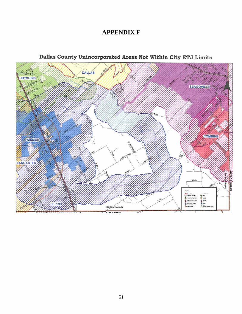
51
APPENDIX F

52
APPENDIX G