cover note for environment related...
TRANSCRIPT

Important Note
Airport Authority Hong Kong (AAHK) is responsible for preparing the Hong Kong International Airport (HKIA) Master Plan 2030 and commissioning the associated consultancies. At different stages of these consultancies, the consultants produced various documents for AAHK’s consideration, culminating in the production of final reports. Where a final report was not produced, the consultants’ work was consolidated into the HKIA Master Plan 2030 Technical Report. As the reports were produced at different times, they may contain outdated or inconsistent contents.
The HKIA Master Plan 2030 was not drawn up solely on the basis of the various consultancies commissioned by AAHK, but also has incorporated input from relevant airport stakeholders as well as AAHK’s own input on the basis of its solid experience in airport operations. Hence, for any differences between the consultancy reports and the HKIA Master Plan 2030, the latter and the Technical Report should always be referred to.
The consultancy reports are the outcome of preliminary studies carried out at a master planning stage. They are no substitute for the environmental impact assessment which will be carried out in accordance with the prevailing statutory process. More comprehensive studies will also be implemented to identify measures to reduce, avoid, mitigate and compensate for impact on the environment.
Airport Authority Hong Kong
August 2011

Hong Kong International Airport Mott MacDonald Contract P132 – Engineering Feasibility and Environmental Assessment Study for Airport Master Plan 2030
Deliverable D1.8 : Comparative Environmental Assessment Report (Report No. 249855/07) May 2009
Airport Authority Hong Kong
Hong Kong International Airport Contract P132 – Engineering Feasibility and Environmental Assessment Study for Airport Master Plan 2030
Comparative Environmental Assessment Report (Deliverable D1.8)
May 2009 Mott MacDonald Hong Kong Limited in association with
Atkins China Limited Ove Arup & Partners OTC Limited Aedas Limited Davis Langdon & Seah

Hong Kong International Airport Mott MacDonald Contract P132 – Engineering Feasibility and Environmental Assessment Study for Airport Master Plan 2030
Deliverable D1.8 : Comparative Environmental Assessment Report (Report No. 249855/07) May 2009
Airport Authority Hong Kong
Hong Kong International Airport Contract P132 – Engineering Feasibility and Environmental Assessment Study for Airport Master Plan 2030
Comparative Environmental Assessment Report
(Deliverable D1.8)
May 2009
Issue and Revision Record
Rev Date Originator Checker Approver Description
0 31/01/09 Various Kam Cheng / Anne Kerr David Mepham First Issue
1 16/03/09 Various Kam Cheng / Anne Kerr David Mepham Second Issue
2 11/5/09 Various Kam Cheng / Anne Kerr David Mepham Third Issue
This document has been prepared for the titled project or named part thereof and should not be relied upon or used for any other project without an independent check being carried out as to its suitability and prior written authority of Mott MacDonald being obtained. Mott MacDonald accepts no responsibility or liability for the consequence of this document being used for a purpose other than the purposes for which it was commissioned. Any person using or relying on the document for such other purpose agrees, and will by such use or reliance be taken to confirm his agreement to indemnify Mott MacDonald for all loss or damage resulting therefrom. Mott MacDonald accepts no responsibility or liability for this document to any party other than the person by whom it was commissioned.
To the extent that this report is based on information supplied by other parties, Mott MacDonald accepts no liability for any loss or damage suffered by the client, whether contractual or tortious, stemming from any conclusions based on data supplied by parties other than Mott MacDonald and used by Mott MacDonald in preparing this report.

Hong Kong International Airport Mott MacDonald Contract P132 – Engineering Feasibility and Environmental Assessment Study for Airport Master Plan 2030
Deliverable D1.8 : Comparative Environmental Assessment Report (Report No. 249855/07) May 2009
i
List of Contents Page
Sections and Appendices
EXECUTIVE SUMMARY 1
1. INTRODUCTION 1 1.1 Background 1 1.2 Airport Expansion Layout Options 1 1.3 Objectives 3 1.4 Study Approach 3 1.5 Land Formation Designs 4 1.6 Construction Programme 6 1.7 Structure of this Report 7
2. PRELIMINARY ASSESSMENT 8 2.1 Potential Environmental Impacts 8 2.2 Air Quality Impacts 8 2.3 Hazard to Life 13 2.4 Noise Impacts 14 2.5 Water Pollution Impacts 19 2.6 Waste Management Impacts 28 2.7 Marine and Terrestrial Ecological Impacts 38 2.8 Impacts on Chinese White Dolphins 53 2.9 Fisheries Impacts 58 2.10 Landscape and Visual Impacts 60 2.11 Impacts on Sites of Cultural Heritage 61 2.12 Requirements for Environmental Monitoring and Audit 62 2.13 Other Characteristics 63 2.14 Summary of Differentiators 64
3. FOCUSSED ASSESSMENT OF KEY ENVIRONMENTAL ISSUES 65 3.1 Introduction 65 3.2 Water Quality and Hydrodynamics 65 3.3 Waste Management 74 3.4 Chinese White Dolphins 75 3.5 Marine Ecology and Fisheries 85 3.6 Noise 100 3.7 Air Quality 105 3.8 Landscape and Visual Impacts 106
4. SUMMARY OF OPTIONS COMPARISON 108 4.1 Introduction 108 4.2 Comparison Methodology 108 4.3 Findings of Comparison 108 4.4 Key Findings from Evaluation 115

Hong Kong International Airport Mott MacDonald Contract P132 – Engineering Feasibility and Environmental Assessment Study for Airport Master Plan 2030
Deliverable D1.8 : Comparative Environmental Assessment Report (Report No. 249855/07) May 2009
ii
5. POSSIBLE ENHANCEMENT IN ENVIRONMENTAL PERFORMANCE 116 5.1 Introduction 116 5.2 Possible Enhancements (applicable to all four options) 116 5.3 Possible Refinements to Option 3 118 5.4 Possible Refinements to the Other Options 119 5.5 Effect of Refinement Options on Overall Ranking 123
6. WAY FORWARD – LEADING TO THE FORMULATION OF THE PREFERRED
OPTION 124 6.1 Further Evaluation 124 6.2 Preparation of the Project Profile 124
LIST OF TABLES
Table 1-1 Major Characteristics of Airport Expansion Options 1 Table 1-2 Proposed Ground Treatment Works 5 Table 2-1 Hong Kong Air Quality Objectives (µg/m3)(i) 9 Table 2-2 Summary of Air Sensitive Receivers 10 Table 2-3 Background air pollutant concentrations at Tung Chung 11 Table 2-4 Data Collected at AAHK AQMSs (Mar 2006 to Mar 2007) 11 Table 2-5 Noise Standards for Daytime Construction Activities 14 Table 2-6 Construction Noise Criteria for Activity other than Percussive Piling 15 Table 2-7 Acceptable Noise Level for Fixed Plant Noise 15 Table 2-8 Noise Standards for Aircraft Noise 16 Table 2-9 Summary of Noise Sensitive Receivers 16 Table 2-10 Residential premises potentially affected by excessive aircraft noise 17 Table 2-11 Summary of WQOs for the North Western WCZ 20 Table 2-12 WSD’s Water Quality Criteria at Sea Water Intake Points 22 Table 2-13 Summary of Water Quality Objectives for North Western WCZ 24 Table 2-14 Bottom Sediment Quality in North Western Water Control Zone in 2003 – 2007 31 Table 2-15 Heavy metals concentrations of CMP IIa sediments 32 Table 2-16 Heavy metals concentrations of CMP IIb sediments 34 Table 2-17 Ecological Evaluation of the Sub-tidal Soft Bottom Assemblages 40 Table 2-18 Ecological Evaluation of the Sub-tidal Hard Bottom Assemblages in the
Northwestern WCZ 42 Table 2-19 Ecological Evaluation of Seagrass Beds at San Tau Beach SSSI, Tai Ho Bay and
Yam O Bay 43 Table 2-20 Ecological Evaluation of Mangroves at Tung Chung Bay, Tai Ho Bay and Yam O
Bay 46 Table 2-21 Ecological Evaluation of Mudflat and Horseshoe Crab Habitats within the Study
Area 47 Table 2-22 Ecological Evaluation of the Artificial Seawall within the Proposed Landform
Shorelines 49 Table 2-23 Ecological Evaluation of the Artificial Reefs at Chek Lap Kok MEZ and the Sha
Chau and Lung Kwu Chau Marine Park 50 Table 2-24 Ecological Evaluation of Sha Chau and Lung Kwu Chau Marine Park 52 Table 2-25 Summary of Average Density of CWDs Specified in Behaviour and Calves of
CWD in Lantau Waters. 57

Hong Kong International Airport Mott MacDonald Contract P132 – Engineering Feasibility and Environmental Assessment Study for Airport Master Plan 2030
Deliverable D1.8 : Comparative Environmental Assessment Report (Report No. 249855/07) May 2009
iii
Table 2-26 Distances between VSRs to the nearest proposed site boundary. 61 Table 2-27 Summary of Recommended Differentiators 64 Table 3-1 Parameters used in sediment plume modelling 67 Table 3-2 Maximum SS concentrations (mg/l) at the WSRs for different Options 68 Table 3-3 Estimated Quantity of Sediment requiring Disposal 74 Table 3-4 Construction Works and Corresponding Potential Impacts on CWDs 77 Table 3-5 Operation and Corresponding Potential Impacts on CWDs 78 Table 3-6 Severity of Impact on CWDs during Construction Phase 82 Table 3-7 Severity of impact on CWDs during operational phase 82 Table 3-8 Evaluating Significance of Indirect Disturbance Impacts on SSSI 87 Table 3-9 Evaluating the Significance of Impacts on the Habitat Degradation of the Nursery
and Breeding Ground for Horseshoe Crabs during Construction 88 Table 3-10 Evaluating Significance of Deterioration of Water Quality at Sha Chau and Lung
Kwu Chau Marine Park during Construction 89 Table 3-11 Evaluating Significance of Sediment Re-deposition at ARs during Construction 90 Table 3-12 Evaluating the Significance of Increase Suspended Sediment Concentrations on
the Marine Ecological Sensitive Receivers during Construction 92 Table 3-13 Evaluating Significance of Impact from Potential Release of Toxic Substances
from dredging works on Marine Ecological Sensitive Receivers 93 Table 3-14 Evaluating Significance of Fisheries Impacts during Construction 95 Table 3-15 Estimated Loss in Habitats 96 Table 3-16 Evaluating the Significance of Impacts on Marine Wildlife due to Habitat Loss 97 Table 3-17 Evaluating the Significance of Impacts on the Direct Loss of Flora and Fauna 98 Table 3-18 Differentiator for Cumulative Construction Noise Impact 101 Table 3-19 Residential premises affected by aircraft noise (base case) 103 Table 3-20 Numbers of affected residential dwellings (base case) 103 Table 3-21 Residential premises affected by aircraft noise (sensitivity test) 104 Table 3-22 Number of affected residential dwellings (sensitivity test) 104 Table 3-23 Operational efficiency achievable with the airport layout options 106 Table 3-24 Distances from Residential VSRs 107 Table 4-1 Summary of Environmental Impact Levels 109 Table 4-2 Ranking of Options under all Key Environmental Aspects 111 Table 4-3 Summary of Ranking and Overall Ranking 114 Table 5-1 Refinements to the Options from Aircraft Noise Perspective 117

Hong Kong International Airport Mott MacDonald Contract P132 – Engineering Feasibility and Environmental Assessment Study for Airport Master Plan 2030
Deliverable D1.8 : Comparative Environmental Assessment Report (Report No. 249855/07) May 2009
iv
LIST OF DRAWINGS
Drawing No. MMH/P132/C/1001 Layout of Airport Expansion Option 1 Drawing No. MMH/P132/C/1002 Layout of Airport Expansion Option 2 Drawing No. MMH/P132/C/1003 Layout of Airport Expansion Option 3 Drawing No. MMH/P132/C/1004 Layout of Airport Expansion Option 4 Drawing No. MMH/P132/GSK/1013 Ground Treatment Layout Plan – Option 1 Drawing No. MMH/P132/GSK/1014 Ground Treatment Layout Plan – Option 2 Drawing No. MMH/P132/GSK/1015 Ground Treatment Layout Plan – Option 3 Drawing No. MMH/P132/GSK/1016 Ground Treatment Layout Plan – Option 4 Drawing No. MMH/P132/NSK/3401 Locations of Water Sensitive Receivers and
Assessment Points of Tidal Flow Speed Drawing No. MMH/P132/NSK/3601 Density (DPSE per 1 sq. km) of Chinese White
Dolphins in North Lantau Waters in 2002-2007 Drawing No. MMH/P132/NSK/3602 Average Group Size of Chinese White Dolphins in
waters around HKIA and Proposed Expansion in 1996-2005
Drawing No. MMH/P132/NSK/3603 Sighting Densities (SPSE per 1 sq. km) of Chinese White Dolphins engaged in Feeding Activities in waters around HKIA and Proposed Expansion in 1996-2005
Drawing No. MMH/P132/NSK/3604 Sighting Densities (SPSE per 1 sq. km) of Chinese White Dolphins engaged in Socializing Activities in waters around HKIA and Proposed Expansion in 1996-2005
Drawing No. MMH/P132/NSK/3605 Density (DPSE per 1 sq. km) of Newborn Calves of Chinese White Dolphins in waters around HKIA and Proposed Expansion in 1996-2005
Drawing No. MMH/P132/NSK/3606 Density (DPSE per 1 sq. km) of Older Calves of Chinese White Dolphins in waters around HKIA and Proposed Expansion in 1996-2005
Drawing No. MMH/P132/NSK/3701 Key Marine Ecological Sensitive Habitats Drawing No. MMH/P132/NSK/3702 Key Species of Conservation Concern Drawing No. MMH/P132/NSK/3703 Distribution of Fisheries Production and Operations Drawing No. MMH/P132/NSK/3801 Locations of Representative Noise Sensitive
Receivers Drawing No. MMH/P132/NSK/3802 Preliminary Noise Contours of Airport Expansion
Options – Baseline Drawing No. MMH/P132/NSK/3803 Preliminary Noise Contours of Airport Expansion
Options – Sensitivity Analysis Drawing No. MMH/P132/NSK/3901 Locations of Representative Air Sensitive Receivers Drawing No. MMH/P132/NSK/5301 Reduced extent of reclamation for Option 3

Hong Kong International Airport Mott MacDonald Contract P132 – Engineering Feasibility and Environmental Assessment Study for Airport Master Plan 2030
Deliverable D1.8 : Comparative Environmental Assessment Report (Report No. 249855/07) May 2009
v
LIST OF APPENDICES
Appendix 1 Reviewed Studies and Information Appendix 3A Focused discussion on “Reclamation” and Contaminated Mud Pits Appendix 3B Depth Average Suspended Solid (SS) Concentrations Appendix 3C Suspended Solid (SS) Elevation (mg/L) at Water Sensitive Receivers
(WSRs) Appendix 3D Tidal Flow within Study Area Appendix 3E Flow Speed at Assessment Point D Appendix 3F Salinity Distribution in Study Area Appendix 3G Flow Speed Near Cooling Water Discharge Appendix 3H Bed Shear Stress in Study Area Appendix 4A Matrix of Key Information and Data Appendix 4B Option Comparison – Evaluation Spreadsheet (Base Case) Appendix 5A Evaluation of Possible Enhancements – Evaluation Spreadsheet
(Reduced Aircraft Noise) Appendix 5B Evaluation of Possible Enhancements – Evaluation Spreadsheet
(Reducing Construction Areas subjected to Height Restrictions) Appendix 5C Evaluation of Possible Enhancements – Evaluation Spreadsheet
(Refinements to Option 3 – reducing extent of reclamation) Appendix 5D Evaluation of Possible Enhancements – Evaluation Spreadsheet
(Refinements to Option 3 – shifting runway to the east) Appendix 5E Evaluation of Possible Enhancements – Evaluation Spreadsheet
(Refinements to Option 1 – increasing distance from Marine Park) Appendix 5F Evaluation of Possible Enhancements – Evaluation Spreadsheet
(Refinements to Option 1 – reducing extent of reclamation) Appendix 5G Evaluation of Possible Enhancements – Evaluation Spreadsheet
(Refinements to Option 2 – reducing extent of reclamation by use of decking)
Appendix 5H Evaluation of Possible Enhancements – Evaluation Spreadsheet (Refinements to Option 2 – eliminating embayed area)
Appendix 5I Evaluation of Possible Enhancements – Evaluation Spreadsheet (Refinements to Option 4 – eliminating embayed area)
Appendix 5J Evaluation of Possible Enhancements – Evaluation Spreadsheet (Refinements to Option 4 – reducing change in flushing capacity at Airport Sea Channel by reducing extent of reclamation through use of decking)
Appendix 5K Evaluation of Possible Enhancements – Evaluation Spreadsheet (Refinements to Option 4 – trimming an area of existing land at Sha Lo Wan to improve flushing capacity)

Hong Kong International Airport Mott MacDonald Contract P132 – Engineering Feasibility and Environmental Assessment Study for Airport Master Plan 2030
i Deliverable D1.8 : Comparative Environmental Assessment Report (Report No. 249855/07) May 2009
EXECUTIVE SUMMARY
INTRODUCTION
This Comparative Environmental Assessment Report presents a preliminary assessment of the nature and extent of environmental impacts associated with the construction and operation of the proposed Airport expansion. Comments provided by the Airport Authority Hong Kong on an earlier version (first issue dated 31st January 2009) of the report have been taken into consideration and addressed in this report.
The assessment was carried out based on four shortlisted Airport expansion layout options proposed by the Airport Master Plan Consultants (MPC), giving emphasis on a comparison of the options based on environmental criteria. Subsequent to the preliminary and focused assessments of the four shortlisted options, further preliminary evaluation has been given to some possible refinements to the layout options, including possible reduction in the extent of the reclamation. Table 1 summarises the four shorlisted options with respect to extent of land formation.
Table 1 Major Characteristics of Airport Expansion Options
Major Characteristics Option 1 Option 2 Option 3 Option 4
Total Land Formation Area 743ha 790ha 827ha 819ha
Encroachment to Contaminated Mud
Pits 3ha 32ha 200ha Nil
Seawall Length 18km 18km 11km 15km
Minimum clearance to HKSAR/PRC
Boundary 150m 100m 1km 1km
Minimum clearance to Sha Chau
and Lung Kwu Chau Marine Park 350m 1km 1km 2km
N.B. Options 1 to 4 were previously named Options P(A+Y), R(A+X), R(A+Y) and S(D+Z), respectively
OBJECTIVES
The main objective of the assessments is to provide a mechanism for assisting the MPC to further evaluate the shortlisted Airport expansion options, with careful consideration of the environmental factors involved and to ultimately propose a Preferred Option that will become the subject for further design activities and technical assessments.
APPROACH TO ASSESSMENTS
A preliminary environmental assessment has been undertaken to identify environmental impacts that may potentially arise during the construction and operational phases of the proposed Airport expansion. This is followed by a more focused environmental assessment of all key environmental issues identified through the preliminary assessments. Based on the preliminary and focused assessments, a set of environmental performance indicators or “differentiators” have been identified for each key environmental issue to allow a systematic comparison of the environmental performance of the Airport expansion options, including the ranking of the options based on environmental grounds. Some possible refinements to the

Hong Kong International Airport Mott MacDonald Contract P132 – Engineering Feasibility and Environmental Assessment Study for Airport Master Plan 2030
ii Deliverable D1.8 : Comparative Environmental Assessment Report (Report No. 249855/07) May 2009
four shortlisted options are then evaluated using the same set of key environmental issues and differentiators established for options comparison to facilitate further development of the layouts, with a view to enhancing their environmental performance.
SUMMMARY OF FINDINGS
The preliminary and focused assessments are presented in Chapters 2 and 3 of the report. Findings of the preliminary and focused comparative environmental assessments of the Airport expansion options are summarized in Chapter 4 in the form of:
• levels of environmental impact based on each differentiator, which have been summarised, on relative terms, as either:
- “L”: representing “low” level of environmental impact;
- “M”: representing “medium” level of environmental impact; or
- “H”: representing “high” level of environmental impact
• relative ranking of the options based on each key environmental aspect: based on the environmental performance of the options evaluated, the four options were given a relative ranking of “1” to “4” with respect to each key environmental aspect, with “1” representing the best option while “4” represents the least preferred option.
• overall ranking based on the relative ranking for all key environmental aspects
Table 2 summarises the relative ranking of the four options for all key environmental aspects identified through the study, the key environmental considerations that drive the relative ranking of the four options, and at the end of the table the overall rankings of the options.
From the summary tables presented above, it can be seen that Option 4 does not perform as well as the other options on most environmental aspects. On the other hand, where differences exist in terms of relative environmental performance based on each differentiator, it can be noted that when taken together Option 3 has been ranked first amongst the options on every environmental aspect, and therefore performs relatively better than the other options in overall terms.
Consideration of possible refinements to the options suggests that Option 3 would remain as the most preferred option, while Option 4 would remain as the least preferred option under all the refinement options considered. However, the process does reflect the benefits of considering improvements, refinements and modifications to the options to reduce environmental impacts from the construction and operation of the project as far as practicable.

Hong Kong International Airport Mott MacDonald Contract P132 – Engineering Feasibility and Environmental Assessment Study for Airport Master Plan 2030
iii Deliverable D1.8 : Comparative Environmental Assessment Report (Report No. 249855/07) May 2009
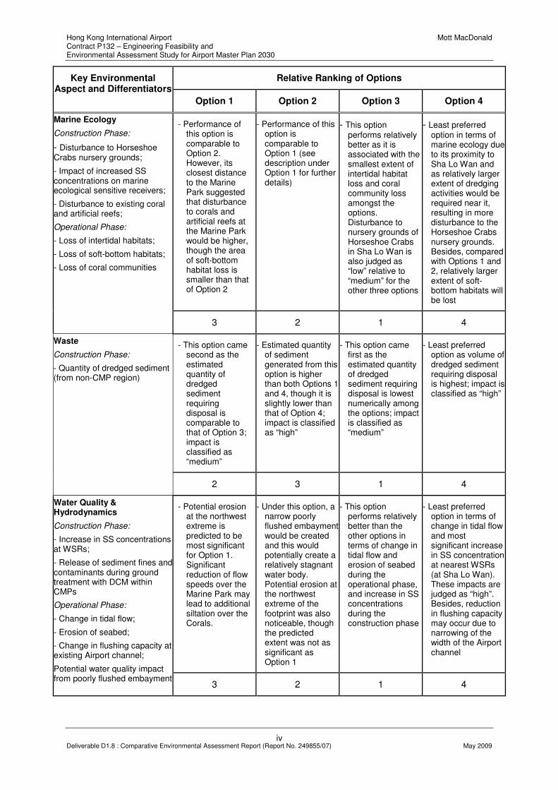
Table 2 Ranking of Options under all Key Environmental Aspects
Relative Ranking of Options Key Environmental Aspect and Differentiators
Option 1 Option 2 Option 3 Option 4
- The extent and location of reclamation is as such that this option is situated closest to the Marine Park, resulting in “high” disturbance to CWDs during the operational phase. The other impacts during the construction & operational phase are judged to be of “medium” significance
- This option performs relatively similar to Option 3, but potentially affects higher number of CWDs due to more significant loss of habitat loss (based on DPSE data). Extent of loss of feeding grounds is also lower than that of Options 1 and 4. Potential impacts during the construction and operational phases are judged to be of “medium” significance
- The performance of this option is comparable to that of Option 2, though the option may perform slightly better than 2 in term of habitat loss. Extent of loss of feeding grounds is also lower than that of Options 1 and 4. Potential impacts during the construction and operational phases are judged to be of “medium” significance
- This option is considered as the least preferred option in terms of potential impact on CWD. It may affect the highest number of CWDs in terms of habitat loss; largest area with dolphin calves; and the largest feeding ground to be lost permanently. Except for farthest distance of its site boundary from the Marine Park (and hence “low” impact in terms of CWD injury), the impacts are judged at “high” level under the other differentiators
Chinese White Dolphins
Construction Phase:
- Disturbance to CWD feeding grounds;
- Disturbance to dolphin calves;
Operational Phase:
Habitat loss;
- Permanent loss of feeding grounds;
- Proximity of northern site boundary to Sha Chau & Lung Kwu Chau Marine Park (and hence increased chance of CWD injury due to collision with vessels)
3 2 1 4
- This option is considered as the least preferred option. Due to its closest distance to the Marine Park, impact from MEZ on fisheries operation is considered “high” in terms of restricting fishermen from fishing in the northern and western Lantau waters. Impact in terms of habitat loss is judged as “medium”, while impacts under other differentiators were classified as “low”
- Due to its closest distance to the Hong Kong waters boundary, impact of MEZ on fisheries option is also judged as “high” in terms of restricting fishermen from fishing in the western Lantau waters. Habitat loss is also judged as “medium”, while other impacts are of “low” significance
- This option performsbetter than other options in terms of impacts of MEZ on fisheries operation during the operation phase, though disturbance to fisheries production, fishing operation and habitat loss would be higher than that of the other options. Impacts of MEZ on fisheries operation and habitat loss are of “medium” significance, while other impact under the other differentiators were classified as “low”
- This option performs relatively similar to Option 3, with “medium” impacts in terms of habitat loss and effect of MEZ on fisheries operation and “low” impacts based on the other differentiators. This option is less preferred that Option 3 because more effort would be required for fishermen to travel to the western Lantau for fishing operation
Fisheries
Construction Phase:
- Disturbance to fisheries production;
- Disturbance to fishing operation;
- Loss in fisheries value due to construction;
Operational Phase:
- Permanent loss in fisheries production;
- Habitat loss;
- Fishing operation;
- Fisheries value;
- Impact of MEZ on fisheries operation
4 3 1 2
Hong Kong International Airport Mott MacDonald Contract P132 – Engineering Feasibility and Environmental Assessment Study for Airport Master Plan 2030
iv Deliverable D1.8 : Comparative Environmental Assessment Report (Report No. 249855/07) May 2009
Relative Ranking of Options Key Environmental Aspect and Differentiators
Option 1 Option 2 Option 3 Option 4
- Performance of this option is comparable to Option 2. However, its closest distance to the Marine Park suggested that disturbance to corals and artificial reefs at the Marine Park would be higher, though the area of soft-bottom habitat loss is smaller than that of Option 2
- Performance of this option is comparable to Option 1 (see description under Option 1 for further details)
- This option performs relatively better as it is associated with the smallest extent of intertidal habitat loss and coral community loss amongst the options. Disturbance to nursery grounds of Horseshoe Crabs in Sha Lo Wan is also judged as “low” relative to “medium” for the other three options
- Least preferred option in terms of marine ecology due to its proximity to Sha Lo Wan and as relatively larger extent of dredging activities would be required near it, resulting in more disturbance to the Horseshoe Crabs nursery grounds. Besides, compared with Options 1 and 2, relatively larger extent of soft-bottom habitats will be lost
Marine Ecology
Construction Phase:
- Disturbance to Horseshoe Crabs nursery grounds;
- Impact of increased SS concentrations on marine ecological sensitive receivers;
- Disturbance to existing coral and artificial reefs;
Operational Phase:
- Loss of intertidal habitats;
- Loss of soft-bottom habitats;
- Loss of coral communities
3 2 1 4
- This option came second as the estimated quantity of dredged sediment requiring disposal is comparable to that of Option 3; impact is classified as “medium”
- Estimated quantity of sediment generated from this option is higher than both Options 1 and 4, though it is slightly lower than that of Option 4; impact is classified as “high”
- This option came first as the estimated quantity of dredged sediment requiring disposal is lowest numerically among the options; impact is classified as “medium”
- Least preferred option as volume of dredged sediment requiring disposal is highest; impact is classified as “high”
Waste
Construction Phase:
- Quantity of dredged sediment (from non-CMP region)
2 3 1 4
- Potential erosion at the northwest extreme is predicted to be most significant for Option 1. Significant reduction of flow speeds over the Marine Park may lead to additional siltation over the Corals.
- Under this option, a narrow poorly flushed embayment would be created and this would potentially create a relatively stagnant water body. Potential erosion at the northwest extreme of the footprint was also noticeable, though the predicted extent was not as significant as Option 1
- This option performs relatively better than the other options in terms of change in tidal flow and erosion of seabed during the operational phase, and increase in SS concentrations during the construction phase
- Least preferred option in terms of change in tidal flow and most significant increase in SS concentration at nearest WSRs (at Sha Lo Wan). These impacts are judged as “high”. Besides, reduction in flushing capacity may occur due to narrowing of the width of the Airport channel
Water Quality & Hydrodynamics
Construction Phase:
- Increase in SS concentrations at WSRs;
- Release of sediment fines and contaminants during ground treatment with DCM within CMPs
Operational Phase:
- Change in tidal flow;
- Erosion of seabed;
- Change in flushing capacity at existing Airport channel;
Potential water quality impact from poorly flushed embayment
3 2 1 4

Hong Kong International Airport Mott MacDonald Contract P132 – Engineering Feasibility and Environmental Assessment Study for Airport Master Plan 2030
v Deliverable D1.8 : Comparative Environmental Assessment Report (Report No. 249855/07) May 2009
Relative Ranking of Options Key Environmental Aspect and Differentiators
Option 1 Option 2 Option 3 Option 4
- This option performs relatively better, as number of dwellings affected by aircraft noise is predicted to be lower than that in Options 2 and 4; operational phase noise impact is judged to be “high”.
- Compared with Options 1 and 3, slightly higher number of dwellings would be affected by aircraft noise under this option; operational phase noise impact is judged to be “high”
- This option performs relatively better, as the number of dwellings affected by aircraft noise is predicted to be lower than that in Options 2 and 4; operational phase noise impact is judged to be “high”. Long-term aircraft noise has been considered as more important than potential cumulative construction noise, though Option 3 is also identified as the preferred option from construction phase noise perspective
- Least preferred option, as among the options the highest number of dwellings falling within the NEF25 contour is predicted under this option; operational phase noise impact is judged to be “high”. Long-term aircraft noise has been considered as more important than potential cumulative construction noise, though Option 4 is also identified as the least preferred option from construction phase noise perspective
Noise
Construction Phase:
- Cumulative impact due to concurrent projects on NSRs
Operational Phase:
No. of dwellings situated within NEF25 contour
1 3 1 4
- Operational efficiency of this option is comparable to that of Options 2 and 3
- Operational efficiency of this option is comparable to that of Options 1 and 3
- Operational efficiency of this option is comparable to that of Options 1 and 2
- Least preferred option; compared with the other options, Option 4 is less efficient in terms of overall operational efficiency
Air Quality
Operational Phase:
Airport operational efficiency
1 1 1 4
- The performance of this option is similar to Option 2 in terms of potential visual impact
- The performance of this option is similar to Option 2 in terms of potential visual impact
- This option performs relatively better by increasing distance separation from nearest VSRs in Sha Lo Wan
- Least preferred option from potential visual impact perspective due to it close proximity to VSRs in Sha Lo Wan
Visual
Construction & Operational Phases:
Distance to VSRs in Sha Lo Wan and Tung Chung
2 2 1 4
Overall Ranking based on No. of Rank “1”
2 3 1 4
Overall Ranking based on No. of Ranks “1” and “2”
3 2 1 4
N.B. “1” represents best option; “4” represents least preferred option
Hong Kong International Airport Mott MacDonald Contract P132 – Engineering Feasibility and Environmental Assessment Study for Airport Master Plan 2030
1 Deliverable D1.8 : Comparative Environmental Assessment Report (Report No. 249855/07) May 2009
1. INTRODUCTION
1.1 Background
The Airport Authority Hong Kong (AAHK) is undertaking a range of studies for future expansion at the Hong Kong International Airport (HKIA) and is in the process of developing a new Airport Master Plan 2030 (the Airport Master Plan), which will form the basis for determining the most feasible solution to meet the long-term demand at HKIA.
One of the studies awarded to Mott MacDonald Hong Kong Limited is Contract P132 - Engineering Feasibility and Environmental Assessment Study. The Study is being undertaken in two Phases. Phase 1 focuses on the appraisal of various Airport expansion options being considered by the Airport Master Plan Consultants (MPC) of the Airport Master Plan study and will provide input to the selection of a Preferred Option of Airport expansion. Based on the Preferred Option, a Project Profile will be prepared for submission to the Environmental Protection Department (EPD) for application of an Environmental Impact Assessment (EIA) Study Brief under the EIA Ordinance during Phase 2 of the Study. Undertaking of an EIA in accordance with the requirements of the EIA Ordinance and the Brief for obtaining an Environmental Permit for construction and operation of the Airport expansion will be the focus of the Phase 2 study.
This Comparative Environmental Assessment Report presents a preliminary assessment of the nature and extent of environmental impacts associated with the construction and operation of the proposed Airport expansion. Comments provided by AAHK on an earlier version (1st draft dated 31st January 2009) of the report have been taken into consideration and addressed in this report.
1.2 Airport Expansion Layout Options
Four shortlisted Airport expansion layout options were proposed by the MPC in its report entitled “D7 - Airport Layout Options” issued in December 2008. These options, with reference to land formation, are summarized in Table 1-1.
Table 1-1 Major Characteristics of Airport Expansion Options
Major Characteristics Option 1 Option 2 Option 3 Option 4
Total Land Formation Area 743ha 790ha 827ha 819ha
Encroachment to Contaminated
Mud Pits 3ha 32ha 200ha Nil
Seawall Length 18km 18km 11km 15km
Minimum clearance to
HKSAR/PRC Boundary 150m 100m 1km 1km
Minimum clearance to Sha Chau
and Lung Kwu Chau Marine Park 350m 1km 1km 2km

Hong Kong International Airport Mott MacDonald Contract P132 – Engineering Feasibility and Environmental Assessment Study for Airport Master Plan 2030
2 Deliverable D1.8 : Comparative Environmental Assessment Report (Report No. 249855/07) May 2009
The four options are further described in the sub-sections below. The comparative environmental impact assessment, as detailed in the subsequent chapters, has been undertaken using the four shortlisted Airport expansion options as the base case. Further analyses have then been conducted by taking into account some possible refinements to the layout options, including possible reduction in the extent of the reclamation.
1.2.1 Option 1
Option 1 (previously named “Option P (A+Y)”) ─ Land formation for this option involves reclamation of an approximately 1km wide platform at the western end of the existing airport platform which extends from the southwestern corner of the existing airport platform to within 350m of the Sha Chau and Lung Kwu Chau Marine Park, as shown in Drawing No. MMH/P132/C/1001. The proposed runway runs parallel to the existing runways at the northern end of the new reclamation, with its western end located about 150m inside the HKSAR/PRC boundary, while the eastern end intrudes slightly into the most northwestern edge of the contaminated mud disposal pits (CMPs).
1.2.2 Option 2
Option 2 (previously named “Option R (A+X)”) ─ Main land formation required for this option is similar to that for Option 1, but does not extend so far to the north, leaving a channel between the northern boundary and the Marine Park (see Drawing No. MMH/P132/C/1002). The reclamation area also includes a 520m wide strip extending for the full length of the existing platform along its northern edge. The proposed runway is located at the northern edge of the main land formation, as for Option 1, but lies further to the west, extending to within 100m of the HKSAR/PRC boundary. There is greater encroachment into the CMPs over its eastern end and the outer edge of the reclaimed strip alongside the existing platform will also encroach onto the CMPs.
1.2.3 Option 3
Option 3 (previously named “Option R (A+Y)”) ─ Compared with Option 2, the proposed runway in this option is the same distance from the existing platform, but situated further to the east. As shown in Drawing No. MMH/P132/C/1003, the main body of reclamation lies between the existing platform and the proposed runway, wrapping round the western end of the existing platform as far as the northern taxiway. Approximately 200 hectares of new reclamation is situated above the CMPs, with the northeastern portion extending to Pit No. 4, which contains contaminated mud to a level of -35mPD. The minimum clearances to the Sha Chau and Lung Kwu Chau Marine Park and to the HKSAR/PRC boundary are both approximately 1km.
1.2.4 Option 4
Option 4 (previously named “Option S (D+Z)”) ─ In this option, the proposed runway is located alongside and approximately 350m north of the existing northern runway on a strip of reclamation about 350m wide and 6km long, as shown in Drawing No. MMH/P132/C/1004. The main body of the reclamation extends the existing platform westward by about 3km and the whole of the new reclamation lies entirely outside the CMPs. This option provides a clearance of more than 2km with the Sha Chau and Lung Kwu Chau Marine Park, whilst the clearance between the HKSAR/PRC

Hong Kong International Airport Mott MacDonald Contract P132 – Engineering Feasibility and Environmental Assessment Study for Airport Master Plan 2030
3 Deliverable D1.8 : Comparative Environmental Assessment Report (Report No. 249855/07) May 2009
boundary and the proposed platform is around 1km, with the runway set back further.
1.3 Objectives
This report is one of the key deliverables of the Phase 1 Study. It presents a preliminary and focused environmental assessment of the four Airport expansion options mentioned above, giving emphasis on a comparison of the options based on environmental criteria. The assessments provide a mechanism for assisting the MPC to further evaluate the shortlisted options, with careful consideration of the environmental factors involved and to ultimately propose a Preferred Option that will become the subject for further design activities and technical assessments.
1.4 Study Approach
The approach for the overall Study in terms of the environmental input has been discussed in Working Paper D1.41, which also included discussions pertaining to the preparation of this Report. It is not the intent of this Report to reproduce the previously developed framework (as set out in Working Paper D1.4) herein; however, some of the key recommendations from WP D1.4 are worth highlighting below, from the context of this report.
It is also a basic tenet that the comparative environmental assessments have taken cognizance of and provided feedback to the engineering assessments of the Options as presented in Working Paper D1.7. Both Working Papers D1.4 and D1.7 should be used as supporting documents for this assessment.
1.4.1 Comprehensive Desktop Study
A comprehensive and detailed desktop study has been undertaken including the review of all previous studies i.e., academic research papers, statutory EIA Reports and non-statutory Environmental Studies relevant to the project, as well as current findings from other studies where available, such as the Contract C009-08 Airport Master Plan 2030 Study; Aircraft Noise Contour Study; Initial Land Formation Engineering Study for Airport Master Plan 2030; D1.7 Airport Expansion Options Report, and other essential inputs from the P132 Engineering Team. A summary of studies reviewed is shown in Appendix 1.
Subsequent to the above literature review, a database has been established to systematically categorize the key environmental issues that may potentially have an impact on the project. Based on the findings of the preliminary and focused environmental assessments, environmental performance indicators or “differentiators” have been identified for each key environmental issue to allow a systematic comparison of the environmental performance of the Airport expansion options.
1.4.2 Computer Modelling
Where input data is available, mathematical modeling has been undertaken. In particular, for the assessments of hydrodynamics, water quality impacts, and sediment dispersions, the sophisticated computer program Delft3D has been used to assess the level of impacts to allow a quantitative comparison of the options.
1 Environmental Assessment and Fieldwork Recommendations Working Paper

Hong Kong International Airport Mott MacDonald Contract P132 – Engineering Feasibility and Environmental Assessment Study for Airport Master Plan 2030
4 Deliverable D1.8 : Comparative Environmental Assessment Report (Report No. 249855/07) May 2009
1.4.3 Fieldwork Surveys
Surveys have been planned including land-based dolphin surveys, intertidal surveys and underwater noise monitoring for filling data gap. The proposed surveys will not be completed before submission of this Comparative Environmental Assessment Report but the data to be gathered will still be useful in terms of confirming the findings presented in this report and will provide essential data for the Phase 2 study.
1.5 Land Formation Designs
In the Deliverable D1.7 – Airport Expansion Options Report, discussions have focussed on the future airport layouts, settlement design criteria, height restrictions and construction constraints, and the concept designs of ground treatment works for the options. The key design considerations relevant to the environmental assessments are summarised below.
1.5.1 Minimising Dredging and Disposal of Marine Mud
Recommended methods for land formation have focused on minimising dredging and disposal of marine mud as far as possible as basic design principle. This accords with the environmental principles of avoidance, minimisation and mitigation, taking account of the sensitive receivers involved in this Project, including Chinese white dolphins, fish, corals, seawater intakes etc.
1.5.2 Ground Treatment Method for reclamation within the CMP region
Environmental concerns over pollution of the surrounding waters by re-excavation of the contaminated mud or by the discharge of contaminated elutriate when vertical drains are installed in the CMPs have restricted the ground treatment options that could be used within the CMP region. After careful review and consideration of all the options presented in the Final Construction Options Report 2 including their engineering feasibility, the use of deep cement mixing has been identified as the most environmentally acceptable ground treatment method for reclamation within the CMPs.
1.5.3 Construction Constraints due to Height Restrictions
In addition to the obstacle clearance envelopes which are applied to the existing runways, the surveillance radar installation on Sha Chau imposes an effective 40mPD level restriction on an area of about 4km2 within the study area around the northern runway. This “additional” height restriction imposed by the radar installation will preclude the possible use of high-masted plant which are essential for the installation of pre-fabricated vertical drains, stone columns, deep cement mixing and vibrocompaction. As a result, full dredging of marine sediment and replacement with rock fill which does not require deep compaction and hence the required use of high-masted plant was recommended to be used at areas that are subject to the height restriction imposed by the radar installation.
Subsequently, consideration has been given to the possible removal or relocation of the surveillance radar installation to minimise the construction site areas that would be subject to the stringent height restrictions. The potential environmental benefits associated with this enhancement measure are evaluated as part of the comparative
2 Airport Master Plan 2030 Contract P131 Initial Land formation Engineering Study Final Construction Options
Report (Meinhardt, 2008)

Hong Kong International Airport Mott MacDonald Contract P132 – Engineering Feasibility and Environmental Assessment Study for Airport Master Plan 2030
5 Deliverable D1.8 : Comparative Environmental Assessment Report (Report No. 249855/07) May 2009
environmental assessment in Chapter 5.
1.5.4 Ground Improvement Measures recommended through D1.7
A combination of ground improvement methods have been recommended to be used in Working Paper D1.7, which include:
• removal of marine deposit and replacing it with a competent engineering material such as sand or rock fill;
• inducing settlement and accelerating the rate of consolidation of the marine deposit by installing prefabricated vertical drains and applying a surcharge load; and
• for reclamation within the CMP region, by mixing the marine deposit with cement slurry in-situ (deep cement mixing, DCM) to produce a material of sufficient stiffness to support the vertical and lateral loads from the reclamation
Essentially, each of the airport layout options has been divided into different zones, with details of these zones summarised in Table 1-2 and individually presented in Drawing Nos. MMH/P132/GSK/1013 to 1016.
Table 1-2 Proposed Ground Treatment Works
Zone Characteristics Proposed Works
A Areas not required for airport development
• Use public fill / sand fill as fill material
• Prefabricated vertical drains at spacing 1.5m c/c in triangular grid
• Finished formation level to be pre-set at approximately +9mPD
B Areas limited to plant and equipment not higher than +40mPD when northern runway is in operation
• Use rock fill as fill material
• Dredging of material with CPT tip resistance less than 0.5MPa
• 5m high surcharge preloading for 4 months
C Areas limited to plants and equipment not higher than +40mPD when southern runway is in operation
• Use rock fill as fill material
• Dredging of material with CPT tip resistance less than 0.5MPa
• 5m high surcharge preloading for 4 months
D Area of proposed runway • Dredging of material with CPT tip resistance less than 0.5MPa
• Use sand fill as fill material
• 5m high surcharge preloading for 4 months
• Vibrocompaction of sand fill

Hong Kong International Airport Mott MacDonald Contract P132 – Engineering Feasibility and Environmental Assessment Study for Airport Master Plan 2030
6 Deliverable D1.8 : Comparative Environmental Assessment Report (Report No. 249855/07) May 2009
Zone Characteristics Proposed Works
E Areas near existing seawall without height restriction
• Dredging of material with CPT tip resistance less than 0.5MPa
• Use sand fill as fill material
• 5m high surcharge preloading for 4 months
• Vibrocompaction of sand fill
F Areas for proposed taxi pavement, passenger stand, concourses, structures
• Use sand fill as fill material
• Prefabricated vertical drains at spacing 1.2m c/c in triangular grid
• 8m high surcharge preloading for 6 months
• Vibrocompaction of sand fill
G Areas above or near to CMPs and limited to plant and equipment not higher than +40mPD when northern runway is in operation
• Use rock fill as fill material
• Deep cement mixing columns with improvement area ratio of minimum 35% and cement dosage of 230kg/m
3
• Deep cement mixing could only be conducted during closure of northern runway (01:00 to 07:00, max. 5 days per week)
H Areas near to CMPs and allow plant and equipment exceeding +40mPD
• Use sand fill as fill material
• Deep cement mixing columns with improvement area ratio of minimum 35% and cement dosage of 230kg/m
3
• Vibrocompaction of sand fill
K Areas not required for airport development and limited to plant and equipment not higher than +40mPD when runway is in operation
• Dredging of mud to depth where the thickness of remaining mud (with CPT tip resistance less than 0.5MPa) not more than 2m.
• Use public fill / sand fill as fill material
• Finished formation level to be around +9mPD
1.6 Construction Programme
The study of land formation has started with the assumption that site formation works could proceed throughout the year by avoiding methods such as marine percussive piling in the construction of the airport platform and preventing reactivation of pollutants currently capped within the CMPs.
Taking into account the tentative nature of the construction programme, including possible changes to the programme that may become necessary as a result of the EIA process (e.g. due to mitigation measures identified through the EIA and/or approval conditions imposed by the Advisory Council on the Environment), or for other engineering reasons or cost, etc., reasonable worst-case scenarios have been assumed in the comparative environmental assessments.
Hong Kong International Airport Mott MacDonald Contract P132 – Engineering Feasibility and Environmental Assessment Study for Airport Master Plan 2030
7 Deliverable D1.8 : Comparative Environmental Assessment Report (Report No. 249855/07) May 2009
1.7 Structure of this Report
1.7.1 Environmental Assessments
Based on all the information collected, a preliminary assessment has been undertaken to identify the environmental impacts that may potentially arise during the construction and operational phases of the proposed Airport expansion, with an aim to screen out or focus on a set of specific differentiators for further analysis. Following the preliminary assessment, a more focussed assessment based on the specific differentiators is presented to provide, where applicable, quantitative assessments to facilitate the option evaluation process.
Chapter 2 of this Report covers the preliminary assessment, whilst Chapter 3 presents the focused environmental assessment.
1.7.2 Summary of Options Comparison
With consideration of the findings of the preliminary and focused environmental assessments, Chapter 4 presents a summary of these findings in the form of levels of environmental impact based on each differentiator; the relative ranking based on each key environmental aspect; and an overall ranking based on all key environmental factors.
1.7.3 Evaluation of Possible Enhancements
Chapter 5 presents an analysis of some possible refinements to the four Airport expansion options to facilitate further development of the layouts, with a view to enhancing their environmental performance.

Hong Kong International Airport Mott MacDonald Contract P132 – Engineering Feasibility and Environmental Assessment Study for Airport Master Plan 2030
8 Deliverable D1.8 : Comparative Environmental Assessment Report (Report No. 249855/07) May 2009
2. PRELIMINARY ASSESSMENT
2.1 Potential Environmental Impacts
This section presents a preliminary assessment of all potential environmental impacts which may be anticipated as a result of the proposed airport expansion development. Impacts are classified as construction or operational phase related, and at this stage, are defined and described qualitatively. The preliminary assessment will allow the general impacts (as a consequence of the airport expansion) to be immediately recognized. The objective of the preliminary assessment is to identify, based on available information, those environmental issues which are perceived to be critical or beneficial for further evaluation to facilitate a systematic comparison of the options.
The comprehensive list of all the potential environmental impacts that may result from the Airport expansion works are listed as follows, which also accords with those listed in Section 2.2.8 (b)(2) of the Scope of Services:
• Air Quality Impacts
• Hazard to Life
• Noise Impacts
• Water Pollution Impacts
• Waste Management Impacts
• Marine and Terrestrial Ecological Impacts
• Impact on Chinese White Dolphins (CWDs)
• Fisheries Impacts
• Visual and Landscape Impacts and Impacts on Sites of Cultural Heritage
• Requirements for Environmental Monitoring and Audit
2.2 Air Quality Impacts
The planned Airport expansion is anticipated to involve several major work packages during the construction phase. For the preliminary assessment, the approach has been to identify the potential sources of this impact on the identified air sensitive receivers (ASRs) and to provide a qualitative assessment of the construction phase air quality impact. It is noted that a quantitative assessment of the air quality impact shall be carried out at a later stage to meet the typical EIA Study Brief requirements, once detailed information such as construction programme, phasing and construction activities, etc is available during the Phase 2 Study.
In addition to the construction phase impacts, aircraft emissions resulting from the future airport operations and activities within the airport “envelope” may also give rise to potential air quality impact to the environment. At the time of writing this Report, a separate study is being commissioned with an independent consultant of AAHK to evaluate the operational air quality impacts. As the results of the

Hong Kong International Airport Mott MacDonald Contract P132 – Engineering Feasibility and Environmental Assessment Study for Airport Master Plan 2030
9 Deliverable D1.8 : Comparative Environmental Assessment Report (Report No. 249855/07) May 2009
independent study are not available for this report, the relevant findings from the Air Quality Assessment for Environmental Impact Assessment Update – Final Air Quality Assessment Report for Year 2020 Scenario3 (hereafter referred to as the AQ Assessment for EIA Update) have been used during the preliminary assessment.
2.2.1 Environmental Legislation, Standards, Guidelines and Criteria
The consideration of air quality impacts will be governed by the following regulations:
• Hong Kong Air Pollution Control Ordinance (APCO) (Cap 311);
• Air Pollution Control (Construction Dust) Regulation; and
• Technical Memorandum on Environmental Impact Assessment Process (EIAO-TM).
(i) Hong Kong Air Pollution Control Ordinance
The principal legislation for the management of air quality is the APCO. The whole of the Hong Kong Special Administrative Region (HKSAR) is covered by the Hong Kong Air Quality Objectives (AQOs) which stipulate the statutory limits for a number of criteria air pollutants and the maximum allowable number of exceedance over specific periods (refer to Table 2-1).
Table 2-1 Hong Kong Air Quality Objectives (µµµµg/m3)(i)
Pollutant 1 Hour (ii)
8 Hours (iii)
24 Hours (iii)
3 Months (iv)
1 Year (iv)
Sulphur Dioxide 800 350 80 Total Suspended Particulates 500
(vii) 260 80
Respirable Suspended Particulates (v)
180 55 Carbon Monoxide 30,000 10,000 Nitrogen Dioxide 300 150 80 Photochemical Oxidants (as ozone)
(vi) 240
Lead 1.5
Notes: (i) Measured at 298K(25
oC) and 101.325 kPa (one atmosphere).
(ii) Not to be exceeded more than three times per year. (iii) Not to be exceeded more than once per year. (iv) Yearly and three monthly figures calculated as arithmetic means. (v) Respirable suspended particulates means suspended particles in air with nominal
aerodynamic diameter of 10 micrometres and smaller. (vi) Photochemical oxidants are determined by measurement of ozone only. Air Pollution Control (Construction Dust) Regulation (vii) This is not an AQO but a criterion for construction dust impact assessment under Annex 4 of
the Technical Memorandum on Environmental Impact Assessment Process.
3 Air Quality Assessment for Environmental Impact Assessment Update – Final Air Quality Assessment Report for
Year 2020 Scenario

Hong Kong International Airport Mott MacDonald Contract P132 – Engineering Feasibility and Environmental Assessment Study for Airport Master Plan 2030
10 Deliverable D1.8 : Comparative Environmental Assessment Report (Report No. 249855/07) May 2009
(ii) Air Pollution Control (Construction Dust) Regulation
The Air Pollution Control (Construction Dust) Regulation stipulates the construction dust control requirements for both notifiable (e.g. site formation) and regulatory (e.g. road opening) Works. The requirements for various notifiable and regulatory works are given in Parts 1 and 2 of the Regulation respectively. Part 3 of the Regulation stipulates the general control requirements (e.g. site boundary and entrance) for construction dust. The control requirements for individual activities (e.g. stockpiling of dusty materials) are given in Part 4 of the Regulation.
(iii) Technical Memorandum on EIA Process (EIAO-TM), Annexes 4 and 12
Criteria and guidelines for assessing air quality impact are given Annexes 4 and 12 of the EIAO-TM respectively. For construction dust impact assessment, the EIAO-TM states that the hourly Total Suspended Particulate (TSP) level should not exceed 500µg/m3 (measured at 25oC and 1 atm).
2.2.2 Air Sensitive Receivers
The representative ASRs identified in the vicinity of the proposed area of Airport expansion for all options are summarised in Table 2-2. Locations of these ASRs are shown in Drawing No. MMH/P132/NSK/3901.
Table 2-2 Summary of Air Sensitive Receivers
Representative ASRs Use Distance to the nearest
site boundary*
East of Airport HKIA Passenger Terminals 1 and 2 Administration/
Commercial More than 400m
HKIA Tower Office About 350m Regal Airport Hotel Hotel About 200m AsiaWorld-Expo Commercial About 290m South of Airport Catering services buildings Factory More than 1.7km CNAC and Dragonair Towers Office About 1.9km Airport Authority Head Offices Office About 2.9km North Lantau Sha Lo Wan Village Residential More than 400m San Shek Wan Village Residential More than 0.8km Tin Sum (west of Tung Chung Bay) Residential More than 2km Yat Tung Estate Residential More than 3.7km Tung Chung Town Residential About 3.2km
Note (*) The site boundary of the option with the shortest distance to the ASR
The buffer distance to the nearest ASRs from the proposed construction site ranges from 200 to 400m. Evaluation of potential air quality impact on these ASRs, which consist of centrally air-conditioned buildings, has taken into account the locations of existing fresh air intake positions. Other ASRs which primarily involve residential developments are located at more than 400m to over 3.7km from the project site.

Hong Kong International Airport Mott MacDonald Contract P132 – Engineering Feasibility and Environmental Assessment Study for Airport Master Plan 2030
11 Deliverable D1.8 : Comparative Environmental Assessment Report (Report No. 249855/07) May 2009
2.2.3 Baseline conditions
Ambient Air Quality in Tung Chung monitored by EPD
The Air Quality Monitoring Station (AQMS) located at Tung Chung Health Centre is the nearest AQMS to HKIA operated by the EPD. For the purpose of this preliminary assessment, the air quality monitoring data from this AQMS has been used to represent the baseline of the ambient air quality in the area. The 5-year mean annual averages of various air pollutants and the regarding Air Quality Objectives (AQOs) are summarised in Table 2-3.
Table 2-3 Background air pollutant concentrations at Tung Chung
Annual Average (µg/m³) One Hour Average
(µg/m³) YEAR TSP RSP SO2 NO2 O3 CO
2003 70 54 17 45 43 706
2004 72 62 27 52 48 799
2005 65 57 21 46 38 923
2006 75 56 25 47 37 782
2007 70 54 23 46 40 819
5-yr mean 70 57 23 47 41 806
AQO 80 55 80 80 240 30000
Source: Air Quality Reports 2003 - 2007, EPD, HKSAR. The latest 5 years with data available are 2003 to 2007. TSP – Total suspended particulate; RSP – Respirable suspended particulate; SO2 – Sulphur dioxide; NO2 – Nitrogen dioxide; O3 – ozone; and CO – Carbon monoxide.
The 5-year means of annual averages of various pollutants are found to comply with the AQO except for RSP, which marginally exceeded the AQO.
Air Quality Data obtained by AAHK
AAHK has been monitoring the air quality within and near the airport with two monitoring stations established at the airport and one remote station at Lung Kwu Chau, which is an island situated at several kilometres north of HKIA. Data collected from March 2006 to March 2007 is summarised in Table 2-4.
Table 2-4 Data Collected at AAHK AQMSs (Mar 2006 to Mar 2007)
Annual Average (µg/m³) AQMS
CO NOX NO NO2 RSP SO2
LKC 698 75 13 63 54 32
SWPH1 670 75 13 61 56 25
SWPH5 689 105 25 80 68 25
AQO n/a n/a n/a 80 55 80
Source: Airport Operational Air Quality Study – Draft Final Report Version 2.4 (Aug 2008), Institute for the Environment, HKUST. LKC – Lung Kwu Chau, SWPH1&5 – Sea Water Pump Houses 1 and 5 at HKIA

Hong Kong International Airport Mott MacDonald Contract P132 – Engineering Feasibility and Environmental Assessment Study for Airport Master Plan 2030
12 Deliverable D1.8 : Comparative Environmental Assessment Report (Report No. 249855/07) May 2009
2.2.4 Construction Phase Assessment
The air quality issues of interest associated with the construction of the airport expansion works include potential dust impacts and gaseous emissions from construction plant, vehicles and barges. It is anticipated that dust would be generated from filling activities, surcharging activities, material handling and hauling during land formation, and wind erosion from the site after the reclamation work. No blasting or excavation works are anticipated.
Due to the large area involved in the Airport expansion works, the extent of construction dust impacts resulting from wind erosion and construction vehicle movements on the unpaved formed land could potentially be significant, if uncontrolled.
Notwithstanding the above, contracts for recent major projects in Hong Kong have included provisions of the various dust control measures specified in Air Pollution Control (Construction Dust) Regulation, as well as Environmental Monitoring & Audit requirements, which will be required for this Designated Project. The effectiveness of these dust control measures have been well demonstrated in these projects. Similarly for this project, Contractors shall be expected to adopt the mitigation measures as stipulated in the Air Pollution Control (Construction Dust) Regulation, as well as the EM&A requirements established through the EIA process (i.e. during the Phase 2 Study).
Cumulative impacts from other potential concurrent projects in the vicinity would also be encountered. However, dust suppression measures and EM&A requirements would also be implemented accordingly for these concurrent projects, and hence, cumulative dust impact is not anticipated to be an issue.
Although there is an approximately 10% difference between the smallest and largest total land formation area, namely Option 1 (743ha) and Option 3 (827ha), the relative difference in terms of the construction dust impact, for example, from wind erosion is generally quite small, even given the large area involved. Additionally, if implementation of proper dust control measures is given equal importance at each option, then the residual air quality impacts after this implementation for all options will generally be in the same order of magnitude.
In view of the above preliminary assessment, it is therefore concluded that construction air quality impact is not a differentiator in the option evaluation process, and thus, will not be considered further in the later sections.
2.2.5 Operational Phase Assessment
During the operational phase, airport emission sources may include aircraft engines, auxiliary power units (APU, on-board generators), ground support equipment, car parks, government flying services; aviation fuel tank farm, fire training activities, engine runup testing by HAECO, aircraft maintenance centre; catering, and; vehicular emissions. The AQ Assessment for EIA Update has revealed that over 80% of CO, NOX and SO2, as well as over 70% of volatile organic compounds (VOCs) and 28% of RSP of the airport emission inventory were contributed by aircraft emissions, i.e., from aircraft engines and APU.
Although quantitative analysis of the air quality impacts will only be undertaken during Phase 2 of this Study, it is envisaged that the overall air quality impact on most of the ASRs, which are situated at more than 2km from the site, may not be

Hong Kong International Airport Mott MacDonald Contract P132 – Engineering Feasibility and Environmental Assessment Study for Airport Master Plan 2030
13 Deliverable D1.8 : Comparative Environmental Assessment Report (Report No. 249855/07) May 2009
very different, no matter which option layout is chosen.
However, for the purpose of the options comparison, there may be merit in evaluating the localised air quality impacts that may arise from the differences in operating efficiency of the airport due to the air field configuration for each Airport layout option. Based on the same passenger demand, an option layout which provides a higher efficiency in discharging flights, and thus reducing idling time for the remaining planes on ground, will be regarded as more environmentally friendly than another layout which will result in higher idling volumes.
2.2.6 Differentiator for Options Comparison
Based on the above analysis, the following recommendations are made:
• Construction air quality impact is not suitable to be used as a differentiator in the option evaluation process,
• Differentiator for air quality impacts to assist in the Airport expansion option comparison will include the following:
o Airport operational efficiency
Further discussion on the above differentiator is included in Chapter 3.
2.3 Hazard to Life
A Preliminary Hazard Assessment for Four Airport Expansion Options has been carried out. In the hazard assessment report, generic hazards relating to the construction and operation of the expansion works were identified and assessed.
2.3.1 Environmental Legislation, Standards, Guidelines and Criteria
The criteria for hazard to life assessment are set out in Annex 4 of the EIAO-TM.
2.3.2 Hazard Assessment
Based on the findings in the hazard report, it was identified that there is currently no facility within the HKIA that is classified as Potentially Hazardous Installation (PHI). In terms of the proposed Airport expansion options, the focus was therefore on the generic hazards for which safety measures are available to mitigate against these hazards. Regarding hazards that are specific to the design feature of each option, the apparent key safety issue common to all four options would be the formation of reclaimed land and construction of infrastructure above the existing submarine fuel pipeline. However, for all options, this hazard can be effectively eliminated by re-routing the pipeline away from the works areas for all options, and hence, would no longer differentiate one option from another.
2.3.3 Differentiator for Options Comparison
In view of the above assessment, it is concluded that “hazard to life” is not suitable to be used as a differentiator in the Airport expansion option evaluation process.

Hong Kong International Airport Mott MacDonald Contract P132 – Engineering Feasibility and Environmental Assessment Study for Airport Master Plan 2030
14 Deliverable D1.8 : Comparative Environmental Assessment Report (Report No. 249855/07) May 2009
2.4 Noise Impacts
Noise impacts will be generated during the construction phase from use of Powered Mechanical Equipment (PME). Uncertainties relating to details of the construction programme and the PME inventory for each phase of work have not allowed any quantitative assessment of the potential construction noise impact at this stage. Nevertheless, given the distance from the nearest Noise Sensitive Receivers (NSRs), with the implementation of noise mitigation measures, it is not envisaged that construction activities at the project site would result in any insurmountable construction problem at the NSRs.
During the operational phase, potential aircraft noise from the operation of the expanded airport is a key issue and preliminary NEF Contours generated for Options 1, 3 and 4 by a separate consultant of AAHK have been made reference to in the assessment. In addition to aircraft noise, there will be noise impacts from operation of plant and equipment.
2.4.1 Relevant Legislation and Guidelines
Noise impacts on nearby Noise Sensitive Receivers (NSRs) will be assessed in accordance with the criteria and methodology given in the Technical Memoranda (TMs) issued under the Noise Control Ordinance (NCO) (Cap. 400) and Annexes 5 and 13 of the EIAO-TM. Potential underwater noise impact on marine mammals (CWDs) is evaluated under Section 2.8.
(i) Noise from General Construction Activities during Non-Restricted Hours
Noise impacts arising from general construction activities other than percussive piling during the daytime period (07:00-19:00 hours of any day not being a Sunday or general holiday) is controlled under the EIAO which shall be assessed against the noise standards tabulated in Table 2-5.
Table 2-5 Noise Standards for Daytime Construction Activities
Noise Sensitive Uses 0700 to 1900 hours on any day not being a Sunday or general holiday, Leq (30 min), dB(A)
Domestic Premises / Hotels 75
Educational Institutions 70
65 during examination
Note: 1. The above standards apply to uses which rely on opened windows for ventilation. 2. The above standards shall be viewed as the maximum permissible noise levels assessed at
1m from the external facades.

Hong Kong International Airport Mott MacDonald Contract P132 – Engineering Feasibility and Environmental Assessment Study for Airport Master Plan 2030
15 Deliverable D1.8 : Comparative Environmental Assessment Report (Report No. 249855/07) May 2009
(ii) Noise from General Construction Activities during Restricted Hours
Between 1900 and 0700 hours and all day on Sundays and public holidays, activities involving the use of PME for the purpose of carrying out construction works require a valid Construction Noise Permit (CNP) issued by EPD. A CNP may be granted in cases where the noise can be contained within the relevant Acceptable Noise Level (ANL) at the NSRs. The ANLs are assigned taking into account the Area Sensitivity Ratings (ASRs). The corresponding basic noise levels (BNLs) for evening and night time periods are defined accordingly as shown in Table 2-6.
Table 2-6 Construction Noise Criteria for Activity other than Percussive Piling
Basic Noise Level (BNLs) Time Period
ASR A ASR B ASR C
Evening (1900 to 2300 hours) * 60 65 70
Night (2300 to 0700 hours) 45 50 55
Note (*) Includes Sundays and Public Holidays during daytime and evening
(iii) Fixed Plant Noise
The NCO and the Technical Memorandum for the Assessment of Noise from Places Other Than Domestic Premises, Public Places or Construction Sites (IND-TM) control noise from fixed noise sources such as ventilation shaft, chiller and cooling tower. For the assessment of impacts from fixed noise sources, the ASR of the NSRs must be determined in accordance with the IND-TM. Based on the ASR, the appropriate acceptable noise levels (ANL) can be determined and these are shown in Table 2-7.
Table 2-7 Acceptable Noise Level for Fixed Plant Noise
NCO criteria EIAO-TM Time Period
ASR ‘A’ ASR ‘B’ ASR ‘C’ ASR ‘A’ ASR ‘B’ ASR ‘C’
Daytime and Evening
(0700-2300 hours)
60 65 70 55 60 65
Night-time
(2300-0700 hours)
50 55 60 45 50 55
As shown in the table above, for planning purposes more stringent criteria for assessing noise impacts from fixed plant are recommended in the EIAO-TM. The recommended assessment criteria are as follows:
• Criterion (1): 5dB(A) below the appropriate Acceptable Noise Levels (ANL) set out in the IND-T
• Criterion (2): The prevailing background noise level where the prevailing background noise level is 5dB(A) below the appropriate ANL (i.e. ANL – 5dB(A)).
Criteria (2) would be more stringent than Criteria (1), and would generally apply to areas with low ambient noise levels such as rural and suburban areas. Taking into

Hong Kong International Airport Mott MacDonald Contract P132 – Engineering Feasibility and Environmental Assessment Study for Airport Master Plan 2030
16 Deliverable D1.8 : Comparative Environmental Assessment Report (Report No. 249855/07) May 2009
account the presence of existing noise sources, as the prevailing background noise levels would unlikely be 5dB(A) lower than the appropriate ANL (i.e. Daytime 60 or 65dB(A) and Nighttime 50 or 55dB(A)), criterion (1) has been adopted as the assessment criteria for the fixed plant noise impact assessment.
(iv) Aircraft Noise
The noise standards for assessing aircraft noise as specified in Annex 5 of the EIAO-TM are summarised in Table 2-8.
Table 2-8 Noise Standards for Aircraft Noise
Noise Sensitive Uses Noise Exposure Forecasts (NEF)
Domestic Premises / Hotels / Educational Institutions / Places of
public worship / Courts of Law / Hospitals / Homes for the aged
25
Offices 30
Note: The above standards apply to uses which rely on opened windows for ventilation.
2.4.2 Noise Sensitive Receivers (NSRs)
Noise sensitive receivers (NSRs) in the vicinity of the project site are summarised in Table 2-9 and shown in MMH/P132/NSK/3801. These NSRs are of interest in the assessment of potential noise impact from operation of PME during the construction phase.
Table 2-9 Summary of Noise Sensitive Receivers
NSR Use Distance to the nearest
site boundary*
Sha Lo Wan Village Residential More than 0.4km
San Shek Wan Village Residential More than 0.8km
Tin Sum (west of Tung Chung Bay) Residential More than 2.0km
Yat Tung Estate Residential More than 3.7km
Tung Chung Town Residential About 3.2km
Note (*) The site boundary of the option with the shortest distance to the NSR
For potential noise impact from operation of ground-based fixed plant and equipment during the operational phase, premises such as offices and hotels which are located on the airport island would be closest to these noise sources. However, as these premises are air-conditioned at all times, they are not considered as NSRs in accordance with the EIAO-TM.
With regard to aircraft noise, four groups of NSRs are identified as the dominant receptors which could be affected during the operation of the expanded airport. These NSRs are located in the areas of Gold Coast, Tai Lam Chung, Ma Wan and Northern Lantau. The level of aircraft noise impact on these areas is anticipated to vary between the different Airport expansion options. In view of this, representative NSRs have been identified based on the different Airport expansion options, as listed in Table 2-10.

Hong Kong International Airport Mott MacDonald Contract P132 – Engineering Feasibility and Environmental Assessment Study for Airport Master Plan 2030
17 Deliverable D1.8 : Comparative Environmental Assessment Report (Report No. 249855/07) May 2009
Table 2-10 Residential premises potentially affected by excessive aircraft noise
NSR Option 1 Option 2 Option 3 Option 4
Gold Coast Area Aqua Blue Nil Nil Nil
Tai Lam Chung Ka Loon Tsuen Bayside Villas Grand Bay Villa Hong Kong Garden
Ka Loon Tsuen Bayside Villas Grand Bay Villa Hong Kong Garden Wu Uk
Ka Loon Tsuen Bayside Villas Grand Bay Villa Hong Kong Garden Wu Uk
Ka Loon Tsuen Bayside Villas Grand Bay Villa Hong Kong Garden
Ma Wan Ma Wan Town Lau Fa Tsuen Park Island Tin Liu
Ma Wan Town Lau Fa Tsuen Park Island Tin Liu
Ma Wan Town Lau Fa Tsuen Park Island Tin Liu
Ma Wan Town Lau Fa Tsuen Park Island Tin Liu
Northern Lantau Luk Keng Tsuen San Tau Sha Lo Wan San Shek Wan
Luk Keng Tsuen San Tau Sha Lo Wan San Shek Wan
Luk Keng Tsuen San Tau Sha Lo Wan San Shek Wan
Luk Keng Tsuen San Tau Sha Lo Wan San Shek Wan
2.4.3 Baseline conditions
The baseline conditions for assessing aircraft noise are best represented by the NEF contours of the existing HKIA. An independent consultant of AAHK has carried out NEF plots for the HKIA for the year 20044. The assessment revealed that the the coverage of NEF25 contour to Sha Lo Wan in 2004 was similar to that predicted in 1998, which estimated that a population of about 200 would be covered by the NEF25 contour.
2.4.4 Construction Phase Assessment
(i) Land-based Noise Impact
Given the large site area involved, numerous PME would be required for the construction work. Although details of the construction programme and the PME involved are not available at this stage for quantitative assessments, given the nearest NSRs are situated at more than 400m from the site, it is not envisaged that the construction activities would result in any insurmountable construction noise impacts.
On the other hand, if the airport expansion works are undertaken concurrently with other planned projects nearby, potential cumulative construction noise impact could be an issue, though the effects may only be apparent within certain phases of the construction works. The major planned projects with programmes that may overlap with the Airport expansion project include Hong Kong-Zhuhai-Macao Bridge
4 URS. (2006), Final Noise Contour Report For Actual Year 2004 Conditions for Airport Authority Hong Kong.

Hong Kong International Airport Mott MacDonald Contract P132 – Engineering Feasibility and Environmental Assessment Study for Airport Master Plan 2030
18 Deliverable D1.8 : Comparative Environmental Assessment Report (Report No. 249855/07) May 2009
(HKZMB), HKZMB Hong Kong Boundary Crossing Facilities (HKBCF) and the Tuen Mun – Chek Lap Kok Link Road (TM-CLK Link).
From the preceding discussion, it is then arguable that the further away the airport expansion works are from the other on-going projects, the lesser the cumulative impacts, though transient, will be to the NSRs. In other words, to avoid or minimise unacceptable cumulative noise impacts to the NSRs, it may be preferable to keep the distances between the airport works and the other concurrent projects to a maximum as far as practicable. With this reasoning, the differentiator that can be adopted in terms of construction noise impacts is as follows:
• Closest distance between airport expansion options and other concurrent projects
2.4.5 Operational Phase Assessment
(i) Fixed Plant, Ground Support Equipment and Auxiliary Power Unit
New facility infrastructures will be involved in this Airport expansion project. Ventilation systems and chiller plants would be provided in these facilities. Openings of the ventilation shafts and the chiller plants are the major sources of fixed plant noise during operation. The daily activities of the ground support equipment i.e. various kinds of trucks, tractors and loaders in the area of the expanded airport would also generate noise during the operational phase.
The APUs of aircrafts are on-board generators providing electrical power to aircrafts when the gas turbines are shut down. The APUs are usually turned on when the aircraft is idling at the passenger/cargo stands during loading/unloading. The operation of the APUs is another noise source during the operational phase.
As discussed earlier, premises such as offices and hotels which are located in the airport island would be situated closest to the above-mentioned noise sources. However, these premises are air-conditioned and not considered to be as NSRs according to EIAO-TM.
The identified nearest NSR i.e. Sha Lo Wan Village is located in at least 1.1 km from these noise sources for all expansion Options. The potential noise impact from these operational noise sources is not expected to be significant due to distance attenuation. Moreover, some of the noise sources would be screened by building structures at the airport. In short, the different layout options will not produce significantly different noise impacts from these sources.
It is therefore considered that noise impacts generated from fixed plant, ground support equipment and APU are not insurmountable, and hence they are not suitable to be used as key differentiators in the option evaluation exercise.
(ii) Aircraft Noise
The main noise impact created under the operational phase of the expanded airport is aircraft noise. Aircraft movements at HKIA would certainly increase due to the operation of the third runway. The aircraft noise impacts at NSRs such as residential premises in North Lantau and those areas that are under the aircraft landing/taking off pathways would be different (from the current situation) due to the new operational mode of the HKIA.

Hong Kong International Airport Mott MacDonald Contract P132 – Engineering Feasibility and Environmental Assessment Study for Airport Master Plan 2030
19 Deliverable D1.8 : Comparative Environmental Assessment Report (Report No. 249855/07) May 2009
Aircraft noise is typically presented by the NEF, which is a parameter with integration of the duration of flyover, the peak noise level, the tonal characteristics and the number of aircraft movements both in the daytime and night-time period. Contours of NEF are also used to predict the impact level of aircraft noise in the area of Hong Kong region. As shown in Table 2-8, the NEF standard is NEF25 for residential noise sensitive receivers.
Based on the preliminary NEF contours generated in the Preliminary Noise Contour Analysis for Third Runway Alternatives5, it has been observed that the number of residential dwellings that could be affected by aircraft noise varies with the different Airport expansion options. These are quantified by the number of dwellings which are covered by the NEF25 contours. Accordingly, from the perspective of minimising aircraft noise, it would be preferable to select the option which would produce the least number of affected NSRs.
In view of the above preliminary assessment, it is considered that “aircraft noise” is suitable to be used as a key differentiator for the option evaluation exercise, with the differentiator being the number of NSRs affected or covered in the NEF25.
2.4.6 Differentiator for Options Comparison
In summary, from the noise perspective, the following recommendations are made:
• The closest distance between airport expansion options and other concurrent projects would be considered as a differentiator based on the criterion of minimising cumulative construction phase noise impact;
• The number of NSRs which are affected or covered in the NEF25 contours is suitable to be used as a key differentiator for options comparison for the operational phase;
• Noise impacts from fixed plant, ground support equipment and APU are considered not suitable to be used as key differentiators for the option evaluation exercise.
2.5 Water Pollution Impacts
This section presents a preliminary assessment of water quality and hydrodynamic impacts based on the proposed footprint of reclamation of the different Airport expansion options.
During the construction phase, the critical parameter of interest is any significant increase of Suspended Solid (SS) concentrations resulting from dredging and filling activities for the reclamation, as any resulting poor water quality can directly influence the marine ecology, aquatic lives and their habitats. The impact of re-deposition of suspended sediment on ecological sensitive receivers (i.e. corals) is also an issue. For reclamation within the CMPs, potential release of sediment fines and contaminants and possible escape of cement slurry during ground treatment with DCM are the key concerns.
During the operational phase, the potential adverse effect of reclamation on hydrodynamics is the concern. Reduction in tidal flow could affect water quality due to inadequate dispersion of pollutants.

Hong Kong International Airport Mott MacDonald Contract P132 – Engineering Feasibility and Environmental Assessment Study for Airport Master Plan 2030
20 Deliverable D1.8 : Comparative Environmental Assessment Report (Report No. 249855/07) May 2009
2.5.1 Relevant Legislation and Guidelines
(i) General
The preliminary assessment of water quality and hydrodynamic impacts would be undertaken following the relevant criteria and guidelines set out in Annexes 6 and 14 of the EIAO-TM. Other relevant legislation and guidelines include:
• Water Pollution Control Ordinance (WPCO) (Cap. 358);
• Technical Memorandum on Standards for Effluents Discharged into Drainage and Sewerage Systems, Inland and Coastal Waters (TM-DSS);
• Water Supplies Department (WSD)’s Water Quality Criteria for flushing water at seawater intakes; and
• Practice Note for Professional Persons (ProPECC), PN 1/94 “Construction Site Drainage”.
Table 2-11 summaries the WQOs for the North Western Water Control Zone (WCZ).
Table 2-11 Summary of WQOs for the North Western WCZ
Parameters Objectives Sub-Zone
Offensive odour, tints Not to be present Whole zone Visible foam, oil scum, litter Not to be present Whole zone Dissolved oxygen (DO) within 2 m of the seabed
Not less than 2.0 mg/l for 90% of samples
Marine waters
Not less than 4.0 mg/l Tuen Mun (A), Tuen Mun (B) and Tuen Mun (C) subzones, water gathering ground subzones and other inland waters
Depth-averaged DO
Not less than 4.0 mg/l for 90 % sample
Marine waters
To be in the range of 6.5 - 8.5, change due to human activity not to exceed 0.2
Marine waters excepting bathing beach subzones
To be in the range of 6.5 – 8.5 Tuen Mun (A), Tuen Mun (B) and Tuen Mun (C) subzones and water gathering ground subzones
To be in the range of 6.0 –9.0 Other inland waters
pH
To be in the range of 6.0 –9.0 for 95% samples
Bathing beach subzones
Salinity Change due to waste discharge not to exceed 10% of ambient
Whole zone
Temperature Change due to human activity not to exceed 2
oC
Whole zone
Suspended solids (SS) Not to raise the ambient level by 30% caused by human activity
Marine waters
5 An independent study undertaken by AAHK

Hong Kong International Airport Mott MacDonald Contract P132 – Engineering Feasibility and Environmental Assessment Study for Airport Master Plan 2030
21 Deliverable D1.8 : Comparative Environmental Assessment Report (Report No. 249855/07) May 2009
Parameters Objectives Sub-Zone
Change due to waste discharges not to exceed 20 mg/l of annual median
Tuen Mun (A), Tuen Mun (B) and Tuen Mun (C) subzones and water gathering ground subzones
Change due to waste discharges not to exceed 25 mg/l of annual median
Inland waters
Unionized ammonia (UIA) Annual mean not to exceed 0.021 mg(N)/l as unionized form
Whole zone
Nutrients Shall not cause excessive algal growth
Marine waters
Annual mean depth-averaged inorganic nitrogen not to exceed 0.3 mg(N)/l
Castle peak bay subzone
Total inorganic nitrogen (TIN)
Annual mean depth-averaged inorganic nitrogen not to exceed 0.5 mg(N)/l
Marine waters excepting castle peak bay subzone
Not exceed 610 per 100 ml, calculated as the geometric mean of all samples collected in one calendar year
Secondary contact recreation subzones
Should be less than 1 per 100 ml, calculated as the geometric mean of the most recent 5 consecutive samples taken between 7 and 21 days.
Tuen Mun (A) and Tuen Mun (B) subzones and water gathering ground subzones
Not exceed 1000 per 100 ml, calculated as the geometric mean of the most recent 5 consecutive samples taken between 7 and 21 days
Tuen Mun (C) subzone and other inland waters
E.coli
Not exceed 180 per 100 ml, calculated as the geometric mean of all samples collected from March to October inclusive.
Bathing beach subzones
Change due to waste discharges not to exceed 30 Hazen units
Tuen Mun (A) and Tuen Mun (B) subzones and water gathering ground subzones
Colour
Change due to waste discharges not to exceed 50 Hazen units
Tuen Mun (C) subzone and other inland waters
Change due to waste discharges not to exceed 3 mg/l
Tuen Mun (A), Tuen Mun (B) and Tuen Mun (C) subzones and water gathering ground subzones
5-Day biochemical oxygen demand (BOD5)
Change due to waste discharges not to exceed 5 mg/l
Inland waters
Change due to waste discharges not to exceed 15 mg/l
Tuen Mun (A), Tuen Mun (B) and Tuen Mun (C) subzones and water gathering ground subzones
Chemical oxygen demand (COD)
Change due to waste discharges not to exceed 30 mg/l
Inland waters

Hong Kong International Airport Mott MacDonald Contract P132 – Engineering Feasibility and Environmental Assessment Study for Airport Master Plan 2030
22 Deliverable D1.8 : Comparative Environmental Assessment Report (Report No. 249855/07) May 2009
Parameters Objectives Sub-Zone
Should not cause a risk to any beneficial uses of the aquatic environment
Whole zone Toxins
Waste discharge shall not cause the toxins in water significant to produce toxic carcinogenic, mutagenic or teratogenic effects in humans, fish or any other aquatic organisms.
Whole zone
Phenol Quantities shall not sufficient to produce a specific odour or more than 0.05 mg/l as C6 H5OH
Bathing beach subzones
Turbidity Shall not reduce light transmission substantially from the normal level
Bathing beach subzones
Source: Statement of Water Quality Objectives (North Western Water Control Zone).
(ii) WSD’s Water Quality Criteria for Flushing Water at Sea Water Intakes
WSD has specified a set of seawater quality standards to be maintained at their saltwater intakes for flushing purposes, as shown in Table 2-12.
Table 2-12 WSD’s Water Quality Criteria at Sea Water Intake Points
Parameter (in mg/L unless otherwise stated) Target Limit
Colour (HU) < 20
Turbidity (NTU) < 10
Threshold Odour Number (odour unit) < 100
Ammonia Nitrogen (NH3-N) < 1
Suspended Solids (SS) < 10
Dissolved Oxygen (DO) > 2
5-day Biochemical Oxygen Demand (BOD5) < 10
Synthetic Detergents < 5
E. coli (count per 100 mL) < 20,000
(iii) Suspended Solids Criterion for Benthic Organisms
Benthic organisms, including corals, may be damaged by sediment deposition that blocks the respiratory and feeding organs of the corals. According to Hawker and Connell 6 , a sedimentation rate higher than 0.1 kg m-2 per day would exert a moderate to severe impact upon corals. This is proposed as the assessment criterion for protecting the marine ecological sensitive receivers in this study as there are no established legislative criteria for water quality for corals. An elevation criterion of 10 mgL-1 in SS has been similarly adopted as the critical value above
6 Hawker, D. W. and Connell, D. W. (1992). “Standards and Criteria for Pollution Control in Coral Reef Areas” in
Connell, D. W and Hawker, D. W. (eds.), Pollution in Tropical Aquatic Systems, CRC Press, Inc.

Hong Kong International Airport Mott MacDonald Contract P132 – Engineering Feasibility and Environmental Assessment Study for Airport Master Plan 2030
23 Deliverable D1.8 : Comparative Environmental Assessment Report (Report No. 249855/07) May 2009
which impacts to the habitat may occur in a previous EIA7.
(iv) Suspended Solids Criterion for Fish Culture Zone
A general water quality protection guideline for SS has been proposed by AFCD8. The guideline requires maximum SS levels to remain below 50mgL-1. This criterion has been adopted in a previous EIA9.
2.5.2 Water Sensitive Receivers
Potential water sensitive receivers (WSRs) in the North Western Water Control Zone (WCZ) include beaches, seawater and cooling water intakes, Marine Park, Chinese White Dolphin (CWD) Habitat, Fish Culture Zones, Site of Special Scientific Interest (SSSI); and other ecological sensitive receivers.
Based on the EIAO-TM, WSRs in North Western Water Control Zone (WCZ) that would be subjected to potential impact from the implementation of the project are identified to include:
• Gazetted and non-gazetted beaches in Tuen Mun;
• Seawater and cooling water intakes in Tuen Mun, Tung Chung and at HKIA;
• Sha Chau and Lung Kwu Chau Marine Park;
• CWD Habitat;
• Fish Culture Zones;
• Tai Ho and San Tau Stream SSSI; and
• Other ecological sensitive receivers (including mangroves, seagrass, and horseshoe crabs nursery sites)
Location of the key WSRs identified is shown in Drawing No. MMH/P132/ NSK/3401.
2.5.3 Baseline Conditions
Ten WCZs are defined under the WPCO. WQOs are established for each WCZ. The HKIA is located in the North Western Waters. Water parameters that are required to be monitored under the WQOs include dissolved oxygen (DO), total inorganic nitrogen (TIN) and unionised ammonia (NH3-N)10. The compliance levels
7 ERM Hong Kong Ltd. (2001), Environmental Impact Assessment for the Proposed submarine Gas Pipeline from
Cheng Tou Jiao Liquefied Natural Gas Receiving Terminal, Shenzhen to Tai Po Gas Production Plant, Hong
Kong, Final EIA Report, For the Hong Kong and China Gas Co., Ltd. 8 City University of Hong Kong (2001), Consultancy Study on Fisheries and Marine Ecological Criteria for Impact
Assessment, Final Report, For Agriculture, Fisheries and Conservation Department, Hong Kong SAR
Government 9 Maunsell Consultants Asia Ltd. (2001), Environmental Impact Assessment for Tai Po Sewage Treatment Works
– Stage V, Final EIA Report, For Drainage Services Department, Hong Kong SAR Government 10
EPD (2008), Marine Water Quality In Hong Kong in 2007, Environmental Protection Department, Hong Kong
SAR Government

Hong Kong International Airport Mott MacDonald Contract P132 – Engineering Feasibility and Environmental Assessment Study for Airport Master Plan 2030
24 Deliverable D1.8 : Comparative Environmental Assessment Report (Report No. 249855/07) May 2009
with the WQOs defined for these parameters in 2007 are summarised in Table 2-13. The monitoring results revealed that DO and TIN did not achieve full compliance with the WQOs.
Table 2-13 Summary of Water Quality Objectives for North Western WCZ
Water parameter Compliance with Water Quality Objectives (North
Western Water Control Zone ) in 2007
Dissolved Oxygen 50%
Total Inorganic Nitrogen 66%
Unionised Ammonia 100%
Further to the east of the project area lies Kap Shui Mun which is the area with the highest current speed within the harbour where maximum current speeds of 2.5 m/s are found. Current speeds of the Urmston Road to the north can reach more than 1.5 m/s. The maximum depth in the Urmston Road is 22m at Tap Shek Kok. The current speed immediately to the east of the airport/North Lantau is low (< 0.5 m/s) with shallow water of about 4m. Relatively high current speeds and deep waters are observed to the west of the airport.
Since the airport is located near the mouth of Pearl River Estuary, the waters are heavily influenced by the large freshwater flows, especially during the wet season when the freshwater flows are the greatest. Large horizontal and vertical salinity gradients are observed in the vicinity during wet season. During the dry season, water is generally oceanic and vertically well-mixed.
Due to sediment transport from the Pearl River, compared with other waters of Hong Kong, the North Western WCZ is also influenced by relatively high SS concentrations. With reference to the approved EIA undertaken for the Permanent Aviation Fuel Facility and associated submarine pipeline to the HKIA, which are located within the same North Western WCZ, a background SS concentration of 30 mg/l has been adopted for the construction phase impact assessment. Therefore, the elevation of SS concentration during the construction phase should not be exceeded by 9 mg/l according to the requirement “of not to raise the ambient level by 30%” specified for SS under the WQO.
2.5.4 Construction Phase Assessment
All four Airport expansion options would involve relatively large areas of reclamation for land formation. As described in Chapter 1, a combination of ground treatment techniques, including installation of prefabricated vertical drains and dredging (under all four options) has been recommended for use in reclamation outside the CMPs, while DCM would be adopted for reclamation within the CMPs for options 1, 2 and 3. Besides, marine sand, public fill and rock fill will be used in the reclamation. The use of the different techniques are associated with varying degrees of impact on the water quality and of the techniques mentioned above, dredging is noted to potentially produce the highest water quality impacts.
Hong Kong International Airport Mott MacDonald Contract P132 – Engineering Feasibility and Environmental Assessment Study for Airport Master Plan 2030
25 Deliverable D1.8 : Comparative Environmental Assessment Report (Report No. 249855/07) May 2009
Key water quality concerns during dredging include:
• Increase in sediment suspension in the water column, with possible consequence of reducing DO and increasing nutrient levels;
• release of previously bound organic and inorganic constituents such as heavy metals, PAHs, polychlorinated biphenyls (PCBs) and nutrients into the water column, either via suspension or disturbance by dredging activities; and
• release of the same contaminants due to leakage and spillage as a result of poor handling and overflow from barges during dredging and transport.
Impacts would vary depending on the quantities and level of sediment contamination and the nature and locations of the WSRs relative to the point of release of the sediments to the water column. All of the above would result in deterioration of the receiving marine water quality and would have adverse effects on WSRs.
(i) Impact of Suspended Sediment
As a result of dredging activities during the construction phase, fine sediment would be lost to suspension. The suspended sediment would be transported by currents to form sediment plumes, which would gradually resettle. The impact from sediment plumes would be to increase the SS concentrations, and to cause potential non-compliance of the WQO and other criteria at specific WSRs. The WQO of SS is defined as being an allowable elevation of 30% above the background. Therefore, the extent of elevation of ambient SS concentrations would determine if the impact is considered adverse or not. The determination of the acceptability of any elevation is based on the WQOs.
The extent of impacts to the WSRs depends heavily on the relative location of the sensitive receivers to the source of water pollution. As such, it is deemed that the extent of increase in SS concentrations is a suitable differentiator in the option evaluation process.
(ii) Impact of Dissolved Oxygen, Total Inorganic Nitrogen and Unionised Ammonia
The extent of depletion of ambient DO concentration and elevation of ambient TIN and NH3-N would determine whether the impact is adverse or not, and the acceptability of any depletion or elevation is based on the WQOs. The WQO of DO, DO bottom, TIN and NH3-N are defined as being larger than or equal to 4mgL-1, larger than or equal to 2mgL-1, less than or equal to 0.4mgL-1 and less than or equal to 0.021 mgL-1 respectively.
Typically, an assessment of DO depletion and nutrient release during dredging is made in relation to the results of the sediment plume modelling of dredging activities and the sediment quality data of the study area. The predicted maximum elevations in tidal and depth-averaged SS concentrations at the construction site would be used to estimate the effects of increased SS concentrations on DO, TIN and NH3-N. In view of this, it would be fair to state that no additional benefits will be attained in comparing the DO and nutrients changes between the options, as this difference is already reflected in the differences in the suspended sediment scenario.
From the above preliminary assessment, it is considered not necessary to also include changes in DO, TIN and NH3-N as differentiators in addition to change in SS

Hong Kong International Airport Mott MacDonald Contract P132 – Engineering Feasibility and Environmental Assessment Study for Airport Master Plan 2030
26 Deliverable D1.8 : Comparative Environmental Assessment Report (Report No. 249855/07) May 2009
concentrations in the option evaluation process from the perspective of construction phase water quality impact.
(iii) Impact from release of sediment fines and associated contaminants during ground treatment with DCM within CMPs
Compared with conventional dredging method, DCM is a more environmentally friendly method for ground treatment as the deep soils can be treated without dredging, shoring or dewatering. For ground treatment within the CMPs using DCM, potential release of sediment fines and associated contaminants from the capped mud previously disposed of at the CMPs as well as leaching of cement slurry into the water will be the issues of concern, though it is envisaged that these can be effectively minimised to acceptable levels by placing a sand blanket on top of the existing capping layer prior to DCM treatment. Potential leaching of cement slurry can also be further prevented by careful control of the cement slurry injection pressure.
The engineering feasibility and environmental acceptability of adopting DCM method for ground treatment within the CMPs will be confirmed through the planned DCM field trial and associated water quality monitoring. Nevertheless, in view of the construction risks and associated environmental concerns, it is considered that there is merit to retain the release of sediment fines and contaminants during ground treatment with DCM within CMPs during the construction phase as a differentiator for options comparison.
(iv) Surface Runoff, Sewage and Wastewater from Construction Activities
Surface runoff from construction site may contain considerable loads of SS and contaminants during construction activities. Local and coastal waters may be impacted if the construction site run-off is allowed to discharge into the storm drains or natural drainage without mitigation. Potential water quality impact includes run-off and erosion of exposed bare soil and earth, and stockpiles.
Accumulation of solid and liquid waste such as packaging and construction materials, sewage effluent from the construction workforce, and spillage of oil, diesel or solvents by vessels and vehicles involved with the construction, if uncontrolled, would lead to deterioration in water quality. Increased nutrient level from contaminated discharges and sewage effluent would also lead to secondary water quality impacts including decrease in DO concentrations and localised increase in NH3-N concentrations which would stimulate algal growth.
Sewage would arise from sanitary facilities provided for the on-site construction work force which would be characterised by high levels of BOD, NH3-N and E. coli.
The total loadings of the above pollutants will be relatively similar between the four Airport expansion options. As such, it is considered that these liquid discharges are not differentiators in the option evaluation process.
2.5.5 Operational Phase Assessment
The potential impacts to water quality during the operational phase may be divided into three broad areas.
• The potential marine water quality impacts due to changes in hydrodynamic patterns as a result of the reclamation and land formation;

Hong Kong International Airport Mott MacDonald Contract P132 – Engineering Feasibility and Environmental Assessment Study for Airport Master Plan 2030
27 Deliverable D1.8 : Comparative Environmental Assessment Report (Report No. 249855/07) May 2009
• The potential impacts to tidal currents and wave propagation that could cause changes to sediment transport and deposition patterns; and
• The potential water quality impacts due to wastewater discharges (sewage effluent and stormwater) from the operation of the new airport facility and the associated infrastructure.
(i) Changes to Hydrodynamic Patterns
Impacts to the hydrodynamic regime of the waters surrounding the expanded airport could be resulted from the reclamation due to altered tidal currents. These changes may be in the form of increased current speeds in some areas and decreased speeds in others. Impacts could potentially occur to the discharge rates in the region surrounding the reclaimed area. Any changes in tidal discharge would be important as they would indicate changes in the flushing capacity of the affected region, which could in turn affect water quality. The changes to tidal flushing capacity could be global or localized. These changes could result in a reduction of the flushing of semi-enclosed bays and thus leading to deterioration in water quality. In this regard, evaluation of the option will, to some extent, rely on “changes to tidal flow“ as a possible differentiator to favour those options which will have less changes to the tidal flow regimes after the land formation. Moreover, changes in the existing landform through the addition of new land formation will inevitably have some impact to the flushing capacity of the existing channels, e.g. the Airport Sea Channel between the existing Airport island and North Lantau. The Channel was designed and has demonstrated to be “self-cleansing” and is integral part of the overall flushing strategy for Tung Chung Bay and for preserving ecological resources on the coastline. The extent of potential impact on the flushing capacity of the Sea Channel will vary with the overall shape of the new land formation, and hence is considered a suitable differentiator to be used. In addition, depending on the reclamation layout, the new landforms may potentially introduce areas that are subject to poor or inadequate flushing capacity, which subsequently may result in deterioration in water quality over a long period of time. In this regard, it will be prudent to introduce this factor as another differentiator in terms of water quality to the option evaluation process.
(ii) Wave Propagation and Sedimentation
If there are changes in tidal currents and wave activity, there could be impacts to sediment/erosion patterns on the sea bed. Excessive erosion could result in damage to marine structures and marine ecosystems/habitats, while excessive increases in deposition could compromise navigation fairways by reducing the water depth. If excessive deposition occurs there may then be requirements for maintenance dredging, which would have the potential to cause water quality impacts. In this regard, severity of potential seabed erosion will be a suitable differentiator in options comparison.
(iii) Wastewater Discharges
The expanded airport facilities will generate wastewater, primarily in the form of sewage effluent or washdown waters, which would not be allowed to be discharged directly to the surrounding marine waters. It will, therefore, be necessary to either provide a connection to the existing sewerage system or provide localized treatment facilities to ensure that untreated wastewater effluent is not discharged to the marine waters. If there is to be a connection to the existing wastewater infrastructure on the airport island then it will be necessary to ensure that there is sufficient capacity to

Hong Kong International Airport Mott MacDonald Contract P132 – Engineering Feasibility and Environmental Assessment Study for Airport Master Plan 2030
28 Deliverable D1.8 : Comparative Environmental Assessment Report (Report No. 249855/07) May 2009
cater for the additional flows and, if the system is found to be inadequate, to devise upgrading measures to increase capacity. The increase in impermeable surfaces due to the new facilities and infrastructure will result in increased stormwater run-off. The stormwater may contain pollutants, such as fine sediments, organic compounds and oils/greases that could potentially affect water quality in the receiving waters. It will, therefore, be necessary to specify suitable measures in the design of the stormwater system as per the current legislation and requirements to minimize the potential for such impacts. Notwithstanding the above, current design standards and legislations prohibit the discharge of the uncontrolled or untreated wastewaters into the marine environment from the built up facilities. In this regard, it is considered that impacts from the above wastewater discharges are not a suitable differentiator for the option evaluation process.
2.5.6 Differentiator for Options Comparison
In view of the above preliminary assessment, the following differentiators are recommended for the option evaluation process from a water quality perspective: • Increase in SS concentrations;
• Release of sediment fines and contaminants during ground treatment with DCM within CMPs;
• Changes to tidal flow;
• Erosion patterns of the sea bed;
• Flushing capacity of the existing Airport Sea Channel;
• Extent of flushing capacity within embayments created by new reclamation.
In addition, the following are not considered as suitable to be used as differentiators for the options comparison:
• Impacts on DO and nutrient levels during construction phase;
• Construction liquid discharges;
• Operational phase wastewater discharges.
2.6 Waste Management Impacts
Wastes of different properties and characteristics will be generated during the construction and operational phases of the project.
The construction of the Airport expansion will generate a variety of wastes that can be divided into distinct categories based on their composition and ultimate methods of disposal. The identified waste types include:
• Marine dredged sediment;
• Additional fill material after surcharging;

Hong Kong International Airport Mott MacDonald Contract P132 – Engineering Feasibility and Environmental Assessment Study for Airport Master Plan 2030
29 Deliverable D1.8 : Comparative Environmental Assessment Report (Report No. 249855/07) May 2009
• Construction and demolition (C&D) materials;
• Chemical waste; and
• General refuse.
Waste arising from the operation of the expanded airport comprise mainly domestic, commercial and industrial wastes. All wastes will need to be properly handled, treated and disposed of to prevent generation of secondary environmental impacts.
2.6.1 Relevant Legislation and Guidelines
The criteria and guidelines for assessing waste management implications are outlined in Annexes 7 and 15 of the EIAO-TM, respectively.
The following legislation relates to the handling, treatment and disposal of wastes in the Hong Kong SAR and has been used in assessing potential impacts:
• Waste Disposal Ordinance (WDO) (Cap. 354);
• Waste Disposal (Chemical Waste) (General) Regulation;
• Public Health and Municipal Services Ordinance (Cap. 132) - Public Cleansing and Prevention of Nuisances Regulation;
• Land (Miscellaneous Provisions) Ordinance (Cap. 28);
• Dumping at Sea Ordinance (Cap. 466)
(i) Waste Management
The WDO prohibits the unauthorised disposal of wastes. Construction waste is defined as any substance, matter or thing that is generated from construction work and abandoned, whether or not it has been processed or stockpiled before being abandoned, but does not include any sludge, screenings or matter removed in or generated from any desludging, desilting or dredging works. Under the WDO, wastes can be disposed of only at designated waste disposal facilities.
Under the WDO, the Chemical Waste (General) Regulation 1992 provides regulations for chemical waste control, and administers the possession, storage, collection, transport and disposal of chemical wastes. EPD has also issued a guideline document, the Code of Practice on the Packaging, Labelling and Storage of Chemical Wastes (1992), which details how contractors should comply with the regulations on chemical wastes.
The Public Cleansing and Prevention of Nuisances Regulation provides control on illegal tipping of wastes on unauthorised (unlicensed) sites.
(ii) Construction and Demolition (C&D) Materials
The current policy related to the dumping of C&D material is documented in the Works Branch Technical Circular No. 2/93, ‘Public Dumps’. Construction and demolition materials that are wholly inert, namely public fill, should not be disposed of to landfills, but taken to public filling areas, which usually form part of reclamation schemes. The Land (Miscellaneous Provisions) Ordinance requires that dumping
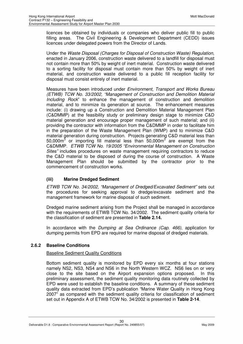
Hong Kong International Airport Mott MacDonald Contract P132 – Engineering Feasibility and Environmental Assessment Study for Airport Master Plan 2030
30 Deliverable D1.8 : Comparative Environmental Assessment Report (Report No. 249855/07) May 2009
licences be obtained by individuals or companies who deliver public fill to public filling areas. The Civil Engineering & Development Department (CEDD) issues licences under delegated powers from the Director of Lands.
Under the Waste Disposal (Charges for Disposal of Construction Waste) Regulation, enacted in January 2006, construction waste delivered to a landfill for disposal must not contain more than 50% by weight of inert material. Construction waste delivered to a sorting facility for disposal must contain more than 50% by weight of inert material, and construction waste delivered to a public fill reception facility for disposal must consist entirely of inert material.
Measures have been introduced under Environment, Transport and Works Bureau (ETWB) TCW No. 33/2002, “Management of Construction and Demolition Material Including Rock” to enhance the management of construction and demolition material, and to minimize its generation at source. The enhancement measures include: (i) drawing up a Construction and Demolition Material Management Plan (C&DMMP) at the feasibility study or preliminary design stage to minimize C&D material generation and encourage proper management of such material; and (ii) providing the contractor with information from the C&DMMP in order to facilitate him in the preparation of the Waste Management Plan (WMP) and to minimize C&D material generation during construction. Projects generating C&D material less than 50,000m3 or importing fill material less than 50,000m3 are exempt from the C&DMMP. ETWB TCW No. 19/2005 “Environmental Management on Construction Sites” includes procedures on waste management requiring contractors to reduce the C&D material to be disposed of during the course of construction. A Waste Management Plan should be submitted by the contractor prior to the commencement of construction works.
(iii) Marine Dredged Sediment
ETWB TCW No. 34/2002, “Management of Dredged/Excavated Sediment” sets out the procedures for seeking approval to dredge/excavate sediment and the management framework for marine disposal of such sediment.
Dredged marine sediment arising from the Project shall be managed in accordance with the requirements of ETWB TCW No. 34/2002. The sediment quality criteria for the classification of sediment are presented in Table 2.14.
In accordance with the Dumping at Sea Ordinance (Cap. 466), application for dumping permits from EPD are required for marine disposal of dredged materials.
2.6.2 Baseline Conditions
Baseline Sediment Quality Conditions
Bottom sediment quality is monitored by EPD every six months at four stations namely NS2, NS3, NS4 and NS6 in the North Western WCZ. NS6 lies on or very close to the site based on the Airport expansion options proposed. In this preliminary assessment, the sediment quality monitoring data routinely collected by EPD were used to establish the baseline conditions. A summary of these sediment quality data extracted from EPD’s publication “Marine Water Quality in Hong Kong 2007” as compared with the sediment quality criteria for classification of sediment set out in Appendix A of ETWB TCW No. 34/2002 is presented in Table 2-14.
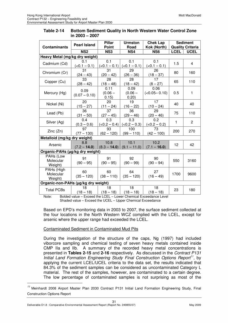
Hong Kong International Airport Mott MacDonald Contract P132 – Engineering Feasibility and Environmental Assessment Study for Airport Master Plan 2030
31 Deliverable D1.8 : Comparative Environmental Assessment Report (Report No. 249855/07) May 2009
Table 2-14 Bottom Sediment Quality in North Western Water Control Zone in 2003 – 2007
Pearl Island Pillar Point
Urmston Road
Chek Lap Kok (North)
Sediment Quality Criteria Contaminants
NS2 NS3 NS4 NS6 LCEL UCEL
Heavy Metal (mg/kg dry weight)
Cadmium (Cd) 0.1
(<0.1 – 0.1) 0.1
(<0.1 – 0.1) 0.1
(<0.1 – 0.1) 0.1
(<0.1 – 0.1) 1.5 4
Chromium (Cr) 31
(24 – 43) 31
(20 – 42) 29
(26 – 36) 26
(18 – 37) 80 160
Copper (Cu) 33
(28 – 42) 28
(18 – 48) 28
(18 – 42) 17
(8 – 27) 65 110
Mercury (Hg) 0.09
(0.07 – 0.10)
0.11 (0.06 – 0.15)
0.09 (0.06 – 0.20)
0.06 (<0.05– 0.10) 0.5 1
Nickel (Ni) 20
(15 – 27) 20
(11 – 24) 19
(16 – 22) 17
(10 – 24) 40 40
Lead (Pb) 36
(31 – 50) 37
(27 – 45) 36
(29 – 46) 29
(20 – 46) 75 110
Silver (Ag) 0.4
(0.3 – 0.6) 0.3
(<0.2 – 0.4) 0.3
(<0.2 – 0.3) 0.2
(<0.2 – 0.2) 1 2
Zinc (Zn) 97
(77 – 130) 93
(62 – 120) 100
(99 – 110) 73
(42 – 100) 200 270
Metalloid (mg/kg dry weight)
Arsenic 8.8
(7.2 – 14.0) 10.8
(8.3 – 14.0) 10.1
(9.1 – 11.0) 10.2
(7.1 – 16.0) 12 42
Organic-PAHs (µg/kg dry weight)
PAHs (Low Molecular Weight)
91 (90 – 95)
91 (90 – 95)
92 (90 – 99)
90 (90 – 94)
550 3160
PAHs (High Molecular Weight)
60 (35 – 120)
60 (38 – 110)
64 (35 – 120)
27 (16 – 49)
1700 9600
Organic-non-PAHs (µg/kg dry weight)
Total PCBs 18
(18 – 18) 18
(18 – 18) 18
(18 – 18) 18
(18 – 18) 23 180
Note: Bolded value – Exceed the LCEL – Lower Chemical Exceedance Level Shaded value – Exceed the UCEL – Upper Chemical Exceedance
Based on EPD’s monitoring data in 2003 to 2007, the surface sediment collected at the four locations in the North Western WCZ complied with the LCEL, except for arsenic where the upper range had exceeded the LCEL.
Contaminated Sediment in Contaminated Mud Pits
During the investigation of the structure of the caps, Ng (1997) had included viborcore sampling and chemical testing of seven heavy metals contained inside CMP IIa and IIb. A summary of the recorded heavy metal concentrations is presented in Tables 2-15 and 2-16 respectively. As discussed in the Contract P131 Initial Land Formation Engineering Study Final Construction Options Report11, by applying the current LCEL/UCEL criteria to the data set, the results indicated that 84.3% of the sediment samples can be considered as uncontaminated Category L material. The rest of the samples, however, are contaminated to a certain degree. The low percentage of contaminated samples is not surprising as most of the
11
Meinhardt 2008 Airport Master Plan 2030 Contract P131 Initial Land Formation Engineering Study, Final
Construction Options Report

Hong Kong International Airport Mott MacDonald Contract P132 – Engineering Feasibility and Environmental Assessment Study for Airport Master Plan 2030
32 Deliverable D1.8 : Comparative Environmental Assessment Report (Report No. 249855/07) May 2009
samples analysed were collected at the clean capping layer and the results indicated cross contamination by uncontrolled mixing of contaminated material with the capping material. Amongst the 20 samples taken at 4.95 – 5.05m level, supposed to be the contaminated material, only two samples were classified into category H (i.e., 10% of the 20 samples), four were category M (i.e., 20% of the 20 samples) and the rest were category L (i.e., 70% of the 20 samples). The dataset has only included one layer of material supposed to be the disposed contaminated material and as this layer interfaces with the capping layer, it could be “diluted” by the clean capping material rending the results less representative of the bulk of contained contaminated material inside the CMPs.
As pointed out by the P131 consultants, the data obtained by Ng in 1997 is considered incomplete based on the latest standard specified in ETWB TCW 34/2002, which requires the testing of some additional parameters including arsenic, silver and organics as well as biological screening. While further site investigation would be required before the chemical composition of the sediment can be confirmed, the likely minimum levels of contaminants in the disposed sediments that would be encountered within the CMPs could be predicted using the sediment quality criteria (as specified in ETWB TCW No. 34/2002 or the original EPD TC 1-1-92) based on which the sediments were classified as contaminated and disposed of at the CMPs.
Table 2-15 Heavy metals concentrations of CMP IIa sediments
Heavy Metal Concentration (mg/kg dry wt.) Vibrocore
No. Depth (m)
Cr Cu Pb Zn Cd Ni Hg Category
1
A1b 0 - 0.2 24 12 39 81 0.6 22 0.2 L
A1b 0.4 - 0.6 23 13 36 80 0.6 21 0.2 L
A1b 1 - 1.2 23 13 32 74 0.6 21 0.2 L
A1b 1.4 - 1.6 22 13 33 75 0.6 20 0.2 L
A1b 1.8 – 2 23 12 38 80 0.6 21 0.2 L
A1a 2.95 - 3.05 25 36 50 40 2.4 10 0.1 M
A1a 4.95 - 5.05 22 11 31 76 0.6 19 0.2 L
A2b 0 - 0.2 22 13 48 80 0.6 21 0.2 L
A2b 0.4 - 0.6 21 12 46 78 0.6 19 0.2 L
A2b 1 - 1.2 22 12 45 84 0.6 21 0.2 L
A2b 1.4 - 1.6 21 12 47 84 0.6 21 0.2 L
A2b 1.8 – 2 26 13 88 90 0.6 20 0.2 M
A2a 2.95 - 3.05 22 12 38 90 0.6 22 0.2 L
A2a 4.95 - 5.05 200 800 110 350 0.6 110 0.2 H
A3b 0 - 0.2 23 12 36 74 0.6 21 0.2 L
A3b 0.4 - 0.6 26 12 33 76 0.6 24 0.2 L
A3b 1 - 1.2 26 12 43 76 0.6 23 0.2 L
A3b 1.4 - 1.6 24 12 31 74 0.6 22 0.2 L
A3b 1.8 – 2 22 13 33 72 0.6 21 0.2 L
A3a 2.95 - 3.05 25 15 40 89 0.6 23 0.2 L
A3a 4.95 - 5.05 26 36 50 100 0.6 22 0.4 L
A4b 0 - 0.2 20 17 46 92 0.6 22 0.2 L

Hong Kong International Airport Mott MacDonald Contract P132 – Engineering Feasibility and Environmental Assessment Study for Airport Master Plan 2030
33 Deliverable D1.8 : Comparative Environmental Assessment Report (Report No. 249855/07) May 2009
Heavy Metal Concentration (mg/kg dry wt.) Vibrocore
No. Depth (m)
Cr Cu Pb Zn Cd Ni Hg Category
1
A4b 0.4 - 0.6 22 11 38 87 0.6 22 0.2 L
A4b 1 - 1.2 21 11 39 86 0.6 21 0.2 L
A4b 1.4 - 1.6 22 12 35 88 0.6 22 0.2 L
A4b 1.8 – 2 23 12 39 87 0.6 21 0.2 L
A4a 2.95 - 3.05 22 13 33 86 0.6 22 0.2 L
A4a 4.95 - 5.05 24 13 36 86 0.6 22 0.2 L
A5b 0 - 0.2 22 11 33 130 0.6 20 0.2 L
A5b 0.4 - 0.6 23 13 35 76 0.6 21 0.2 L
A5b 1 - 1.2 22 12 32 73 0.6 19 0.2 L
A5b 1.4 - 1.6 22 13 31 74 0.6 20 0.2 L
A5b 1.8 – 2 20 20 36 78 0.6 18 0.2 L
A5a 2.95 - 3.05 36 91 56 150 0.6 23 0.3 M
A5a 4.95 - 5.05 21 89 130 290 0.6 13 0.5 H
A6b 0 - 0.2 22 20 40 90 0.6 20 0.2 L
A6b 0.4 - 0.6 22 16 47 81 0.6 21 0.2 L
A6b 1 - 1.2 24 22 89 97 0.6 21 0.2 M
A6b 1.4 - 1.6 23 23 86 98 0.6 21 0.2 M
A6b 1.8 – 2 21 12 36 79 0.6 20 0.2 L
A6a 2.95 - 3.05 26 13 38 84 0.6 24 0.2 L
A6a 4.95 - 5.05 9.1 2 18 20 0.6 4.5 0.1 L
A7b 0 - 0.2 24 27 50 98 0.6 21 0.2 L
A7b 0.4 - 0.6 25 28 54 100 0.6 22 0.2 L
A7b 1 - 1.2 22 14 42 81 0.6 21 0.2 L
A7b 1.4 - 1.6 22 13 33 76 0.6 21 0.2 L
A7b 1.8 – 2 21 11 31 72 0.6 19 0.2 L
A7a 2.95 - 3.05 34 59 57 120 0.6 20 0.4 L
A7a 4.95 - 5.05 31 47 48 100 0.6 21 0.2 L
A8b 0 - 0.2 25 13 40 81 0.6 22 0.2 L
A8b 0.4 - 0.6 26 13 43 84 0.6 24 0.2 L
A8b 1 - 1.2 24 13 52 86 0.6 22 0.2 L
A8b 1.4 - 1.6 24 13 40 82 0.6 22 0.2 L
A8b 1.8 – 2 26 13 51 90 0.6 24 0.2 L
A8a 2.95 - 3.05 29 15 37 88 0.6 27 0.2 L
A8a 4.95 - 5.05 3.8 2 12 5.1 0.6 2.5 0.1 L
A9b 0 - 0.2 22 12 86 82 0.6 20 0.2 M
A9b 0.4 - 0.6 23 13 58 75 0.6 22 0.2 L
A9b 1 - 1.2 22 12 41 76 0.6 20 0.2 L
A9b 1.4 - 1.6 24 12 36 75 0.6 22 0.2 L
A9b 1.8 – 2 21 12 35 76 0.6 20 0.2 L
A9a 2.95 - 3.05 30 14 40 92 0.6 27 0.2 L
A9a 4.95 - 5.05 13 11 27 53 0.6 12 0.1 L

Hong Kong International Airport Mott MacDonald Contract P132 – Engineering Feasibility and Environmental Assessment Study for Airport Master Plan 2030
34 Deliverable D1.8 : Comparative Environmental Assessment Report (Report No. 249855/07) May 2009
Heavy Metal Concentration (mg/kg dry wt.) Vibrocore
No. Depth (m)
Cr Cu Pb Zn Cd Ni Hg Category
1
A10b 0 - 0.2 26 25 47 100 0.6 22 0.2 L
A10b 0.4 - 0.6 21 11 31 70 0.6 19 0.2 L
A10b 1 - 1.2 22 19 47 120 0.6 17 0.2 L
A10b 1.4 - 1.6 21 12 34 77 0.6 20 0.2 L
A10b 1.8 – 2 25 15 34 81 0.6 22 0.2 L
A10a 2.95 - 3.05 33 43 64 130 0.6 25 0.3 L
A10a 4.95 - 5.05 22 13 40 86 0.6 21 0.2 L
Note: Shaded cell = value exceed UCEL; bold = value exceed LCEL; Data Source: Ng (1997);1The
categorisation is provided for illustration only and shall not be considered as complete as some metals and organic pollutants are not tested.
Table 2-16 Heavy metals concentrations of CMP IIb sediments
Heavy Metal Concentration (mg/kg dry wt.) Vibrocore No.
Depth (m)
Cr Cu Pb Zn Cd Ni Hg
Category1
B1b 0 - 0.2 26 17 55 89 0.6 22 0.2 L
B1b 0.4 - 0.6 25 22 43 95 0.6 22 0.2 L
B1b 1 - 1.2 31 52 64 130 0.6 23 0.2 L
B1b 1.4 - 1.6 24 17 42 90 0.6 22 0.2 L
B1b 1.8 – 2 82 50 140 290 1.9 73 0.2 H
A1a 2.95 - 3.05 56 100 140 180 0.69 33 0.2 H
B1a 4.95 - 5.05 55 100 90 180 1 21 0.4 M
B2b 0 - 0.2 22 13 40 86 0.6 22 0.2 L
B2b 0.4 - 0.6 22 12 39 79 0.6 20 0.2 L
B2b 1 - 1.2 21 12 43 83 0.6 21 0.2 L
B2b 1.4 - 1.6 23 11 42 70 0.6 20 0.2 L
B2b 1.8 – 2 20 13 40 76 0.6 19 0.2 L
B2a 2.95 - 3.05 20 19 51 72 0.6 15 0.1 L
B2a 4.95 - 5.05 38 86 85 180 0.6 21 0.7 M
B3b 0 - 0.2 25 39 56 100 0.6 22 0.2 L
B3b 0.4 - 0.6 25 34 57 100 0.6 21 0.2 L
B3b 1 - 1.2 24 33 51 89 0.6 19 0.2 L
B3b 1.4 - 1.6 23 34 50 91 0.6 18 0.2 L
B3b 1.8 – 2 22 31 56 89 0.6 18 0.2 L
B3a 2.95 - 3.05 32 49 70 110 0.62 22 0.2 L
B3a 4.95 - 5.05 29 41 52 100 0.6 18 0.2 L
B4b 0 - 0.2 21 11 30 76 0.6 20 0.2 L
B4b 0.4 - 0.6 24 12 80 77 0.6 20 0.2 M
B4b 1 - 1.2 21 12 30 72 0.6 19 0.2 L
B4b 1.4 - 1.6 21 12 51 73 0.6 20 0.2 L
B4b 1.8 – 2 15 20 30 54 0.6 11 0.1 L
B4a 2.95 - 3.05 21 14 27 46 0.75 9.4 0.1 L
B4a 4.95 - 5.05 31 18 37 72 0.6 20 0.2 L

Hong Kong International Airport Mott MacDonald Contract P132 – Engineering Feasibility and Environmental Assessment Study for Airport Master Plan 2030
35 Deliverable D1.8 : Comparative Environmental Assessment Report (Report No. 249855/07) May 2009
Heavy Metal Concentration (mg/kg dry wt.) Vibrocore No.
Depth (m)
Cr Cu Pb Zn Cd Ni Hg Category
1
B5b 0 - 0.2 19 9.8 46 81 0.6 20 0.2 L
B5b 0.4 - 0.6 24 13 40 88 0.6 22 0.2 L
B5b 1 - 1.2 22 12 35 82 0.6 22 0.2 L
B5b 1.4 - 1.6 24 14 50 82 0.6 22 0.2 L
B5b 1.8 – 2 23 16 110 100 0.6 21 0.2 M
B5a 2.95 - 3.05 43 76 71 160 0.6 29 0.3 M
B5a 4.95 - 5.05 30 35 62 110 0.6 26 0.2 L
B6b 0 - 0.2 25 13 51 84 0.6 22 0.2 L
B6b 0.4 - 0.6 21 12 38 84 0.6 21 0.2 L
B6b 1 - 1.2 25 13 51 81 0.6 23 0.2 L
B6b 1.4 - 1.6 22 13 50 79 0.6 20 0.2 L
B6b 1.8 – 2 23 14 39 83 0.6 22 0.2 L
B6a 2.95 - 3.05 31 58 57 120 0.6 22 0.2 L
B6a 4.95 - 5.05 25 26 26 57 0.6 16 0.4 L
B7b 0 - 0.2 31 32 56 120 0.6 27 0.2 L
B7b 0.4 - 0.6 23 18 40 87 0.6 22 0.2 L
B7b 1 - 1.2 24 14 36 81 0.6 22 0.2 L
B7b 1.4 - 1.6 19 11 34 80 0.6 20 0.2 L
B7b 1.8 – 2 24 13 39 84 0.6 22 0.2 L
B7a 2.95 - 3.05 29 29 51 100 0.6 26 0.2 L
B7a 4.95 - 5.05 20 31 97 160 0.6 15 0.2 M
B8b 0 - 0.2 22 12 42 81 0.6 20 0.2 L
B8b 0.4 - 0.6 19 12 71 75 0.6 20 0.2 L
B8b 1 - 1.2 19 12 52 74 0.6 19 0.2 L
B8b 1.4 - 1.6 22 13 53 77 0.6 21 0.2 L
B8b 1.8 – 2 22 16 39 80 0.6 20 0.2 L
B8a 2.95 - 3.05 28 16 42 92 0.6 25 0.2 L
B8a 4.95 - 5.05 40 84 92 170 0.6 28 0.2 M
B9b 0 - 0.2 35 72 52 120 0.6 26 0.2 M
B9b 0.4 - 0.6 49 130 58 140 0.6 35 0.2 H
B9b 1 - 1.2 42 110 55 120 0.6 31 0.2 M
B9b 1.4 - 1.6 27 34 49 89 0.6 22 0.2 L
B9b 1.8 – 2 31 47 46 100 0.6 26 0.2 L
B9a 2.95 - 3.05 41 91 55 130 0.6 31 0.2 M
B9a 4.95 - 5.05 23 14 35 88 0.6 22 0.2 L
B10b 0 - 0.2 32 61 56 110 0.6 24 0.2 L
B10b 0.4 - 0.6 35 77 64 120 0.6 26 0.2 M
B10b 1 - 1.2 25 29 68 89 0.6 22 0.2 L
B10b 1.4 - 1.6 26 38 47 96 0.6 22 0.2 L
B10b 1.8 – 2 23 28 46 84 0.6 21 0.2 L
B10a 2.95 - 3.05 36 51 53 120 0.6 31 0.2 L

Hong Kong International Airport Mott MacDonald Contract P132 – Engineering Feasibility and Environmental Assessment Study for Airport Master Plan 2030
36 Deliverable D1.8 : Comparative Environmental Assessment Report (Report No. 249855/07) May 2009
Heavy Metal Concentration (mg/kg dry wt.) Vibrocore No.
Depth (m)
Cr Cu Pb Zn Cd Ni Hg Category
1
B10a 4.95 - 5.05 27 14 43 91 0.6 24 0.2 L
Note: Shaded cell = value exceed UCEL; bold = value exceed LCEL; Data Source: Ng (1997)12
; 1The
categorisation is provide for illustration only and shall not be considered as complete as some metals and organic pollutants are not tested.
2.6.3 Construction Phase Assessment
Marine dredged sediment
Soft marine sediment will be dredged at specific locations (outside the CMP region) during the reclamation phase of the project. The volume is highly dependant on the ground treatment techniques considered for the reclamation for each Airport expansion option.
In accordance with ETWB TC(W) No. 34/2002 - Management of Dredged/Excavated Sediment, review of existing information for site contamination assessment (Tier I), chemical screening (Tier II) and biological screening (Tier III) has to be conducted at areas that will be dredged, to determine the sediment quality. Sediments would then be classified into Categories L, M or H based on its contaminant levels identified from chemical screening. Sediment classified as Category M would be subjected to biological screening.
The total volume of dredged sediment will depend on the Airport expansion options as well as on the combination of the different ground treatment techniques. To minimize any potential adverse impacts arising from the dredged marine sediment, the sediment shall be dredged, transported and disposed of in a manner that will minimise the loss of contaminants either into solution or by resuspension. With the implementation of mitigation measures, impact from handling, transport and disposal of the dredged sediment can be mitigated to acceptable levels.
Based on the above analysis that each Airport expansions option is associated with a unique volume of dredged sediment to be disposed of, it is considered the extent of dredged sediment volumes to be disposed of during construction is a suitable differentiator to be used in the option evaluation process.
Construction and demolition (C&D) materials
C&D materials would arise from demolition of existing seawalls and generated as excess fill materials and other construction materials during the Airport expansion works. In order to minimise the impact resulting from collection and transportation of C&D material for off-site disposal, generated material could be reused on-site as far as practicable. Between the four Airport expansion options, there would not be significant differences in terms of the C&D materials that would be generated and disposed of. Generation of C&D materials is therefore considered not suitable to be used as a differentiator.
12
Ng, K.C (1997), Investigation of CMP IIa and IIb, Caps East Sha Chau Contaminated Mud Disposal Area.
Technical Note TN 6/97, Geotechnical Engineering Office, Hong Kong SAR Government.

Hong Kong International Airport Mott MacDonald Contract P132 – Engineering Feasibility and Environmental Assessment Study for Airport Master Plan 2030
37 Deliverable D1.8 : Comparative Environmental Assessment Report (Report No. 249855/07) May 2009
Chemical waste
The maintenance and servicing of construction plant and equipment may generate some chemical wastes such as cleaning fluids, solvents, lubrication oil and fuel. Maintenance of vehicles may also involve the use of a variety of chemicals, oil and lubricants. It is difficult to quantify the amount of chemical waste that will arise from the construction activities since it will be dependent on the Contractor’s on-site maintenance requirements and the amount of plant utilised.
Chemical wastes arising during the construction phase may pose environmental, health and safety hazards if not stored and disposed of in an appropriate manner as stipulated in the Waste Disposal (Chemical Waste) (General) Regulations. The potential hazards include:
• Toxic effects to workers;
• Adverse impacts on water quality from spills and associated adverse impacts on marine biota; and
• Fire hazards.
Materials classified as chemical wastes will require special handling and storage arrangements before removal for appropriate treatment at the approved Chemical Waste Treatment Facility. Wherever possible opportunities should be taken to reuse and recycle materials. Provided that the handling, storage and disposal of chemical wastes are in accordance with these requirements, adverse environmental impacts are not anticipated.
As shown with the above preliminary assessment, there will not be significant differences between the four Airport expansion options in terms of chemical waste generation. Chemical waste generation is therefore considered not suitable to be used as a differentiator in the option evaluation process.
General refuse
The construction workforce will generate refuse comprising food scraps, waste paper, empty containers, etc. Such refuse should be properly managed to prevent intentional or accidental release to the surrounding environment. Disposal of refuse at sites other than approved waste transfer or disposal facilities shall be prohibited. Effective collection of site wastes will be required to prevent waste materials being blown around by wind, flushed or leached into the marine environment, or creating an odour nuisance or pest and vermin problem. Waste storage areas shall be well maintained and cleaned regularly. With the implementation of good waste management practices at the site, adverse environmental impacts are not expected to arise from the storage, handling and transportation of workforce wastes. As above, there would not be significant differences between the four Airport expansion options in terms of general refuse generation.
2.6.4 Operational Phase Assessment
Wastes produced during the operation of the expanded airport comprise domestic, commercial and industrial wastes. Domestic and commercial wastes in the airport are generated from offices, restaurants, shopping centres and other facilities inside the new infrastructure of the airport. Industrial waste including paint, solvent and raw material would also be produced under the airport operation due to ongoing

Hong Kong International Airport Mott MacDonald Contract P132 – Engineering Feasibility and Environmental Assessment Study for Airport Master Plan 2030
38 Deliverable D1.8 : Comparative Environmental Assessment Report (Report No. 249855/07) May 2009
renovation and maintenance. With the provision of rubbish/recycle bins and collection by maintenance agent at regular basis, no insurmountable environmental impact would be anticipated amongst all Airport expansion options.
2.6.5 Differentiator for Options Comparison
Based on the preliminary assessment presented above, it is considered the volume of dredged sediment to be disposed of during construction is a suitable differentiator to be used for further consideration in the option evaluation process.
Other waste issues are not considered to be suitable as differentiator for options comparison, including:
• C&D materials;
• Chemical waste; and
• General refuse
2.7 Marine and Terrestrial Ecological Impacts
The proposed Airport expansion is located to the north and northwest of Chek Lap Kok, both of which are areas frequented by marine wildlife. The proposed locations are also situated in close proximity to habitats of ecological interest on the northern Lantau coast. The Project will primarily involve marine-based work to form land in the proximity of the existing HKIA. As the existing Airport island is dominated by a developed area of low ecological value, terrestrial ecology is not a key concern in this study. This preliminary assessment therefore focuses on the potential marine ecological impacts that would result from the project for the identification of the key differentiators that could be adopted for further evaluation of the four Airport expansion options.
2.7.1 Relevant Legislation and Guidelines
A number of international conventions, local legislations and guidelines provide the framework for the protection of species and habitats of ecological importance. Those related to the Project are listed below:
• Wild Animals Protection Ordinance (Cap 170);
• Protection of Endangered Species of Animals and Plants (Ordinance (Cap 586);
• Town Planning Ordinance (Cap 131);
• Marine Parks Ordinance (Cap.476);
• Hong Kong Planning Standards and Guidelines Chapter 10 (HKPSG);
• EIAO-TM;
• EIAO Guidance Note No. 7/2002 Ecological Baseline Survey for Ecological Assessment;
• EIAO Guidance Note No. 11/2004 Methodologies for Marine Ecological Baseline Surveys;

Hong Kong International Airport Mott MacDonald Contract P132 – Engineering Feasibility and Environmental Assessment Study for Airport Master Plan 2030
39 Deliverable D1.8 : Comparative Environmental Assessment Report (Report No. 249855/07) May 2009
• United Nations Convention on Biodiversity (1992);
• Convention on International Trade in Endangered Species of Wild Flora and Fauna (CITES);
• Convention on the Conservation of Migratory Species of Wild Animals (the Bonn Convention);
• IUCN Red Data Books; and
• PRC Regulations and Guidelines
2.7.2 Assessment Methodology
The study area for marine ecological impact assessment includes the North Western Water Control Zone (WCZ), North Western Supplementary WCZ, Deep Bay WCZ and Western Buffer WCZ which are designated under the WPCO. Sensitive areas that could be impacted by the project include sensitive coral sites within the above WCZs, the Sha Chau and Lung Kwu Chau Marine Park, the artificial reefs deployed in the airport Marine Exclusion Zone (MEZ), and intertidal habitats of Horseshoe Crabs as well as seagrass beds.
A desktop literature review was carried out to establish the baseline conditions of the physical environment and to establish the general ecological profile for impact assessment. Information gaps identified during the desk study will be investigated by field survey to fill the gaps. Some of the baseline information may need extensive surveys to cover the active seasons and to gather information on any seasonal variation that the potentially affected ecological resources may perform. Field surveys including intertidal survey, marine benthos survey and dolphin survey may require early commencement in Phase 1 to cover the dry season and to facilitate the options selection process.
The preliminary assessment was undertaken taking into account the criteria and guidelines set out in Annexes 8 and 16 of the EIAO-TM.
2.7.3 Baseline Conditions
The marine ecological resources within the study area include soft-bottom marine benthos, hard-bottom marine benthos (corals), intertidal habitats (seagrass bed, mangroves, mudflat, sandy shores and artificial seawalls), the open sea and the associated wildlife. CWD, coral, artificial reef, Horseshoe Crab, coastal wildlife and marine benthic fauna are the marine ecological sensitive receivers recorded within or in the vicinity of the project site. Two SSSI, namely San Tau Beach SSSI and Tai Ho Stream, Lantau SSSI are also located within the Study area. Drawing No. MMH/P132/NSK/3701. presents the locations of the key marine ecological sensitive habitats of interest in the vinicity of the project site.
Sub-tidal Soft Bottom Assemblages
The proposed development options are generally situated in the northern and north-western waters of Chek Lap Kok with soft bottom seabed composed of mud, clay

Hong Kong International Airport Mott MacDonald Contract P132 – Engineering Feasibility and Environmental Assessment Study for Airport Master Plan 2030
40 Deliverable D1.8 : Comparative Environmental Assessment Report (Report No. 249855/07) May 2009
and sand 13 . Polychaetes (Mediomastus sp., Sigambra hanaokai, Aglaophamus dibranchis, Sigambra sp., Ophiodromus angustifrons, Paraprionospio pinnata, Prionospio malmgreni, Otopsis sp.) are the dominant benthic infauna recorded in the region, with no significant difference between the summer and winter data14. Other benthic fauna including the crustacean (Callianassa japonica and Neoxenophthalmus obscurus), sipunculan (Apionsoma trichocephalus) and echinoderm (Amphiodia obtecta) are also recorded around the western and north-eastern Chek Lap Kok waters. All the fauna recorded are typical of soft-bottom seabed in Hong Kong, with more than 50% occurrence out of 120 sampling stations during the 2001 field sampling for the Consultancy Study on Marine Benthic Communities in Hong Kong15. Some of the soft bottom benthos are known to have adapted well to organic pollution and may serve as indicator of increase in total organic matter content in the sediments.
The soft bottom habitats at Sha Chau and Lung Kwu Chau Marine Park is having silt-clay content >90% in sediments 16 . The benthic communities are diverse. Polychaete Mediomastus californiensis was dominant in both summer and winter seasons. Other species commonly recorded in summer include the polychaetes Lumbrineris nagae, Mediomastus sp., Otopsis sp. and Aglaophamus dibranchis, and the bivalve Potamocorbula laevis. In winter, other polychaetes, including Paraprionospio pinnata, Prionospio malmgreni, Prionospio pygmaea, Prionospio sp. and Sigambra sp., were also recorded as abundant.
The ecological importance of the benthic fauna assemblages at the proposed land formation area and at the Sha Chau and Lung Kwu Chau Marine Park is evaluated according to Annex 8 of EIAO-TM and the findings are summarised in Table 2-17.
Table 2-17 Ecological Evaluation of the Sub-tidal Soft Bottom Assemblages
Criteria Proposed Land Formation Area
under all four options Sha Chau and Lung Kwu Chau
Marine Park
Naturalness The seabed is natural but is receiving continuous disturbances from fish trawling and marine traffic activities
The seabed is natural, receiving freshwater discharged from the Pearl River, especially during rainy seasons
Size The reclamation area for Option 1 is about 743ha, Option 2 is about 790ha, Option 3 is about 827ha, and Option 4 is about 819ha
Around 1,200ha
Diversity The assemblages are typical of other soft bottom seabed in Hong Kong.
The assemblages are typical of other soft bottom seabed in Hong Kong, but with higher diversity than Yan Chau Tong Marine Park.
13
ERM-Hong Kong Ltd. (2005). Detailed Site Selection Study for a Proposed Contaminated Mud Disposal Facility
within the Airport East/ East of Sha Chau Area (Agreement No.CE12/2002(EP)), Environmental Impact
Assessment (EIA) and Final Site Selection Report. 14
CityU Professional Services Limited (2002). Agreement No. CE69/2000 - Consultancy Study on Marine Benthic
Communities in Hong Kong, Final Report submitted to Agriculture, Fisheries and Conservation Department,
HKSAR. 15
CityU Professional Services Limited (2002). Op cit. 16
Ibid.

Hong Kong International Airport Mott MacDonald Contract P132 – Engineering Feasibility and Environmental Assessment Study for Airport Master Plan 2030
41 Deliverable D1.8 : Comparative Environmental Assessment Report (Report No. 249855/07) May 2009
Criteria Proposed Land Formation Area
under all four options Sha Chau and Lung Kwu Chau
Marine Park
Rarity No rare species was recorded, and the habitat type is common in Hong Kong
No rare species was recorded, and the habitat type is common in Hong Kong
Re-creatability Habitats can be recreated by natural colonization of sediments
Habitats can be recreated by natural colonization of sediments
Fragmentation No fragmentation is identified No fragmentation is identified
Ecological Linkage The habitat links with surrounding soft bottom habitats and the Sha Chau and Lung Kwu Chau Marine Park, providing food source to fishes and other marine wildlife
The habitat links with surrounding soft bottom habitats, providing food source to fishes and other marine wildlife
Potential Value The site has low potential in developing into a site of nature conservation interest
The site is an existing marine park with high potential of further increasing a conservation value upon long-term management
Nursery/breeding ground
Not identified Nursery ground for fishes
Age The sediment receive continuous disturbance. The benthic fauna is likely to be short-lived
Seasonal variation in benthic fauna recorded, indicating the habitat is receiving continuous perturbation and the fauna species recorded are short-lived
Abundance/ Richness of wildlife
Abundance are similar to other soft bottom seabed in Hong Kong
Abundance are similar to other soft bottom seabed in Hong Kong
Overall Ecological Value
Low Low
Sub-tidal Hard Bottom Assemblages
The distribution of corals in Hong Kong is mainly at the eastern sea of Hong Kong. The rocky outcrops and hard bottom substrates at the sub-tidal zone near the shorelines favour the inhabitation of corals. Corals are sensitive to fluctuation of salinity and sedimentation, thus the distribution of corals is limited in the western sea of Hong Kong especially at Deep Bay Region where periodic freshwater intrusion is received during the discharge of freshwater from the Pearl River in rainy season.
Surveys at hard bottom habitats around the South Brothers conducted in a previous study showed that both hard and soft corals were recorded (Drawing No. MMH/P132/NSK/3702 refers), but in limited density and diversity 17 . Scattered hermatypic hard corals (family Faviidae), ahermatypic gorgonian seawhips and seapens have been identified within the Sha Chau and Lung Kwu Chau Marine Park. Ahermatypic cup corals and soft corals (Dendronephthya spp. and seapens) have also been recorded on the north eastern shore of the Study area near Sham Tseng and Tsing Lung Tau. Soft corals are dominant in the Northwestern WCZ, with record of occasionally isolated colony of hard coral of less than 1% coverage18. All species
17
ERM-Hong Kong Ltd. (2005). Op cit. 18
ENSR Asia (HK) Ltd. (2008). Agreement No. CE 43/2005 (EP) – Harbour Area Treatment Scheme (HATS)
Stage 2A EIA Study – Investigation, Drainage Services Department, HKSAR.
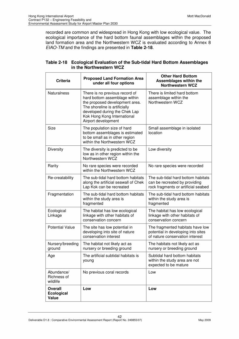
Hong Kong International Airport Mott MacDonald Contract P132 – Engineering Feasibility and Environmental Assessment Study for Airport Master Plan 2030
42 Deliverable D1.8 : Comparative Environmental Assessment Report (Report No. 249855/07) May 2009
recorded are common and widespread in Hong Kong with low ecological value. The ecological importance of the hard bottom faunal assemblages within the proposed land formation area and the Northwestern WCZ is evaluated according to Annex 8 EIAO-TM and the findings are presented in Table 2-18.
Table 2-18 Ecological Evaluation of the Sub-tidal Hard Bottom Assemblages in the Northwestern WCZ
Criteria Proposed Land Formation Area
under all four options
Other Hard Bottom Assemblages within the
Northwestern WCZ
Naturalness There is no previous record of hard bottom assemblage within the proposed development area. The shoreline is artificially developed during the Chek Lap Kok Hong Kong International Airport development
There is limited hard bottom assemblage within the Northwestern WCZ
Size The population size of hard bottom assemblages is estimated to be small as in other region within the Northwestern WCZ
Small assemblage in isolated location
Diversity The diversity is predicted to be low as in other region within the Northwestern WCZ
Low diversity
Rarity No rare species were recorded within the Northwestern WCZ
No rare species were recorded
Re-creatability The sub-tidal hard bottom habitats along the artificial seawall of Chek Lap Kok can be recreated
The sub-tidal hard bottom habitats can be recreated by providing rock fragments or artificial seabed
Fragmentation The sub-tidal hard bottom habitats within the study area is fragmented
The sub-tidal hard bottom habitats within the study area is fragmented
Ecological Linkage
The habitat has low ecological linkage with other habitats of conservation concern
The habitat has low ecological linkage with other habitats of conservation concern
Potential Value The site has low potential in developing into site of nature conservation interest
The fragmented habitats have low potential in developing into sites of nature conservation interest
Nursery/breeding ground
The habitat not likely act as nursery or breeding ground
The habitats not likely act as nursery or breeding ground
Age The artificial subtidal habitats is young
Subtidal hard bottom habitats within the study area are not expected to be mature
Abundance/ Richness of wildlife
No previous coral records Low
Overall Ecological Value
Low Low

Hong Kong International Airport Mott MacDonald Contract P132 – Engineering Feasibility and Environmental Assessment Study for Airport Master Plan 2030
43 Deliverable D1.8 : Comparative Environmental Assessment Report (Report No. 249855/07) May 2009
Intertidal Habitats
(i) Seagrass Bed
Intertidal habitats within the study area include seagrass bed, mangrove, mudflat and artificial seawall. Seagrass beds have been recorded with a very low distribution in Hong Kong, with less than 0.1% of the total land area19. This habitat occurs in low intertidal or shallow, sheltered, soft bottomed sub-tidal zone and estuaries which provide feeding and nursery ground for a variety of marine fauna including the living fossil Horseshoe Crabs. Seagrass beds recorded within the Study area include the San Tau Beach SSSI, Tai Ho Bay and Yam O Bay 20 (Drawing No. MMH/P132/NSK/3701 refers). Halophili beccarii was recorded in Tai Ho Bay which is seasonal with an area of 500m², while Halophila ovata was recorded in both San Tau Beach and Yam O. Zostera japonica was also present at San Tau with an area of around 15m² 21. The seagrass beds at San Tau was threatened by the Chek Lap Kok airport development since 1992, the H. ovata population almost disappeared in 1995 but recovered gradually after the completion of the reclamation work for the airport22. Drawing No. MMH/P132/NSK/3702 showed the indicative locations of the seagrass species of conservation concern.
The ecological importance of the seagrass beds at San Tau Beach SSSI, Tai Ho Bay and Yam O Bay are evaluated according to Annex 8 EIAO-TM and presented in Table 2-19.
Table 2-19 Ecological Evaluation of Seagrass Beds at San Tau Beach SSSI, Tai Ho Bay and Yam O Bay
Criteria Seagrass Beds at
San Tau Beach SSSI
Seagrass Beds at Tai Ho Bay
Seagrass Beds at Yam O Bay
Naturalness The seagrass beds are natural but in a recovery stage from development disturbance
The seagrass beds are natural
The seagrass beds are natural but under stress from surrounding works
Size Size of the Zostera japonica bed is small (15m²), while Halophila ovalis bed is large (2 ha)
Size of the Halophili beccarii seagrass bed is medium (500m²)
Size of the Halophila ovata seagrass bed is relatively large (~ 1 ha)
Diversity Species diversity associated with seagrass bed is high
Species diversity associated with seagrass bed is high
Species diversity associated with seagrass bed is high
19
ERM-Hong Kong Ltd. (2005). Op cit. 20
Fong, T.C.W. (1998). Distribution of Hong Kong Seagrasses, Porcupine!18:10-12, Newsletter of the
Department of Ecology & Biodiversity, The University of Hong Kong. 21
ERM-Hong Kong Ltd. (2005). Op cit. 22
Fong, T.C.W. (1999). Conservation and Management of Hong Kong Seagasses, Asian Marine Biology 16:109-
121. Hong Kong University Press, Hong Kong.

Hong Kong International Airport Mott MacDonald Contract P132 – Engineering Feasibility and Environmental Assessment Study for Airport Master Plan 2030
44 Deliverable D1.8 : Comparative Environmental Assessment Report (Report No. 249855/07) May 2009
Criteria Seagrass Beds at
San Tau Beach SSSI
Seagrass Beds at Tai Ho Bay
Seagrass Beds at Yam O Bay
Rarity Seagrass beds are relatively rare in Hong Kong. The site represents the only Zostera japonica habitat on Lantau. Two species of horseshoe crab recorded using these seagrass beds
Seagrass beds are relatively rare in Hong Kong. Two species of horseshoe crab recorded using these seagrass beds
Seagrass beds are relatively rare in Hong Kong.
Re-creatability Difficult to re-create Difficult to re-create Difficult to re-create
Fragmentation The seagrass beds within the site is not fragmented
The seagrass beds within the site is not fragmented
The seagrass beds within the site is not fragmented
Ecological Linkage
This habitat ecologically linked with the mudflat and mangroves
This habitat ecologically linked with the mudflat and mangroves
This habitat ecologically linked with the mudflat and mangroves
Potential Value The site is of conservation interest and having high potential value to develop into a larger habitat if disturbance is eliminated
The site is of conservation interest
The site is of conservation interest
Nursery/breeding ground
Provide nursery and breeding ground for horseshoe crabs
Provide nursery and breeding ground for horseshoe crabs, intertidal or marine invertebrates and fishes.
Provide nursery and breeding ground for some marine fauna
Age Seagrass beds are seasonal with relatively short lifespan.
Seagrass beds are seasonal with relatively short lifespan.
Seagrass beds are seasonal with relatively short lifespan.
Abundance/ Richness of wildlife
Low abundance Medium abundance Medium abundance
Overall Ecological Value
High Medium High
(ii) Mangroves
Established mangrove stands of any size are identified as important habitat types in the territory according to the EIAO-TM. Mangrove stands were recorded at the coast of Tung Chung Bay (San Tau Mangrove and Tung Chung Mangrove), Tai Ho Bay (Tai Ho Wan Mangrove) and Yam O Bay (Yam O Mangrove) within the Study Area (Drawing No. MMH/P132/NSK/3701 refers).

Hong Kong International Airport Mott MacDonald Contract P132 – Engineering Feasibility and Environmental Assessment Study for Airport Master Plan 2030
45 Deliverable D1.8 : Comparative Environmental Assessment Report (Report No. 249855/07) May 2009
There are 7 true mangroves, 4 associated mangroves, 7 non-mangrove plant species and 25 ground-dwelling animals recorded in San Tau Mangrove (~2.14ha) during a territory wide mangrove ecological study conducted between 1994 and 1997 23 . Bruguiera gymnorrhiza is the dominant mangrove species occurring in substantial numbers. A relatively rare species Lumnitzera racemosa was also present in this mangrove stand (Drawing No. MMH/P132/NSK/3702 refers). The benthic macrofauna consists mostly of gastropods, with a large number of hermit crabs and dominant species Cerithidea djadjariensis. Although this mangrove stand lies within San Tau Beach SSSI, it receives continuous stresses from on-site tipping and a few commercial netting activities. This mangrove stand was identified as a very important stand that should be conserved 24 . For Tung Chung Mangrove (~2.21ha), 6 true mangroves (Kandelia obovata, Aegiceras corniculatum, Excoecaria agallocha, Acanthus ilicifolius, Avicennia marina and Bruguiera gymnorrhiza), 5 associated mangroves and 3 non-mangrove plant species were recorded25. This mangrove stand is listed as stand that can be conserved and currently receiving stress from surrounding development.
There are 6 true mangroves (Kandelia obovata, Aegiceras corniculatum, Excoecaria agallocha, Acanthus ilicifolius, Avicennia marina and Bruguiera gymnorrhiza), 4 associated mangroves, 2 non-mangrove plant species and 13 ground-dwelling animals recorded in Tai Ho Wan Mangrove (~1.9ha) during the territory wide mangrove ecological study. Tai Ho Wan Mangrove is one of the ten stands identified as can be conserved26. Tai Ho Wan Mangrove is one of the ten stands identified as can be conserved27. In 1999, the Tai Ho Stream with its associated mangrove and seagrass beds habitats were designated as Tai Ho Stream, Lantau Island SSSI. The mangroves are dominated by Aegiceras corniculatum and Kandelia obovata with a good sized stand of locally uncommon species Bruguiera gymnorrhiza 28 . This habitat together with the seagrass beds provides shelter and food for a variety of intertidal or marine invertebrates and fish.
Two mangrove stands were recorded at Yam O Bay (~0.5ha), the Luk Keng coast and Yam O Tuk29. Moderate floristic diversity was recorded in both habitats. Both habitats are being disturbed by the surrounding activities, such as the log storage area works in vicinity of the Yam O Bay and the Penny’s Bay reclamation works.
The ecological importance of the mangroves at Tung Chung Bay, Tai Ho Bay and Yam O Bay are evaluated according to Annex 8 EIAO-TM and presented in Table 2-20.
23
Tam, N.F.Y. and Wong, Y.S. (2000). Field Guide to Hong Kong Mangroves, Agriculture, Fisheries and
Conservation Department, City University of Hong Kong Press. 24
Tam, N.F.Y. and Wong, Y.S. (2000). Op cit. 25
Ibids 26
Ibids. 27
Ibids. 28
Planning Department (1999). Register of Sites of Special Scientific Interest (SSSIs). 29
ERM-Hong Kong Ltd. (2005). Op cit.

Hong Kong International Airport Mott MacDonald Contract P132 – Engineering Feasibility and Environmental Assessment Study for Airport Master Plan 2030
46 Deliverable D1.8 : Comparative Environmental Assessment Report (Report No. 249855/07) May 2009
Table 2-20 Ecological Evaluation of Mangroves at Tung Chung Bay, Tai Ho Bay and Yam O Bay
Criteria Tung Chung Bay Tai Ho Bay Yam O Bay
Naturalness The habitat is natural but receiving disturbance from the adjacent development
The habitat is natural
The habitat is natural but receiving disturbance from the adjacent activities
Size San Tau Mangrove and Tung Chung Mangrove is around 2.14ha and 2.21ha respectively (relatively large)
Tai Ho Wan Mangrove is around 1.9ha (relatively medium in size)
Yam O Mangrove is around 0.5ha (relatively small)
Diversity Species diversity associated with the two mangroves are high
Species diversity associated with the mangrove is medium
Species diversity associated with the mangrove is medium
Rarity One locally rare mangrove species was recorded at San Tau Mangrove
No rare species recorded
No rare species recorded
Re-creatability Re-creatable, but the establishment of mature system is a long process
Re-creatable, but the establishment of mature system is a long process
Re-creatable
Fragmentation The mangroves within the site is not fragmented
The mangroves within the site is not fragmented
The mangroves within the site is fragmented
Ecological Linkage
This habitat ecologically linked with the mudflat and seagrass beds
This habitat ecologically linked with the mudflat, seagrass beds and the Tai Ho Stream
This habitat ecologically linked with the mudflat and seagrass beds
Potential Value The site is of conservation interest and having high potential value to develop into a larger habitat if disturbance is eliminated
The site is of conservation interest
The site is of conservation interest
Nursery/breeding ground
Provide nursery and breeding ground for horseshoe crabs and intertidal macrofauna
Provide nursery and breeding ground for horseshoe crabs, intertidal or marine invertebrates and fishes.
Provide nursery and breeding ground for some marine fauna
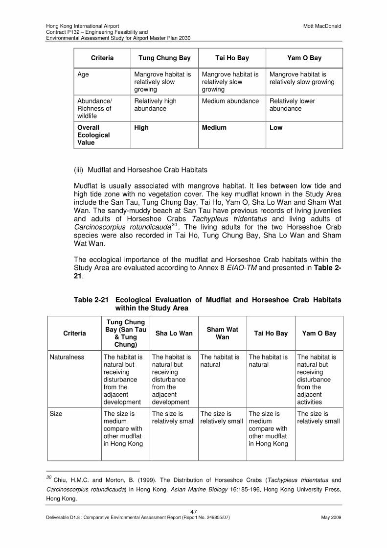
Hong Kong International Airport Mott MacDonald Contract P132 – Engineering Feasibility and Environmental Assessment Study for Airport Master Plan 2030
47 Deliverable D1.8 : Comparative Environmental Assessment Report (Report No. 249855/07) May 2009
Criteria Tung Chung Bay Tai Ho Bay Yam O Bay
Age Mangrove habitat is relatively slow growing
Mangrove habitat is relatively slow growing
Mangrove habitat is relatively slow growing
Abundance/ Richness of wildlife
Relatively high abundance
Medium abundance Relatively lower abundance
Overall Ecological Value
High Medium Low
(iii) Mudflat and Horseshoe Crab Habitats
Mudflat is usually associated with mangrove habitat. It lies between low tide and high tide zone with no vegetation cover. The key mudflat known in the Study Area include the San Tau, Tung Chung Bay, Tai Ho, Yam O, Sha Lo Wan and Sham Wat Wan. The sandy-muddy beach at San Tau have previous records of living juveniles and adults of Horseshoe Crabs Tachypleus tridentatus and living adults of Carcinoscorpius rotundicauda 30 . The living adults for the two Horseshoe Crab species were also recorded in Tai Ho, Tung Chung Bay, Sha Lo Wan and Sham Wat Wan.
The ecological importance of the mudflat and Horseshoe Crab habitats within the Study Area are evaluated according to Annex 8 EIAO-TM and presented in Table 2-21.
Table 2-21 Ecological Evaluation of Mudflat and Horseshoe Crab Habitats within the Study Area
Criteria
Tung Chung Bay (San Tau
& Tung Chung)
Sha Lo Wan Sham Wat
Wan Tai Ho Bay Yam O Bay
Naturalness The habitat is natural but receiving disturbance from the adjacent development
The habitat is natural but receiving disturbance from the adjacent development
The habitat is natural
The habitat is natural
The habitat is natural but receiving disturbance from the adjacent activities
Size The size is medium compare with other mudflat in Hong Kong
The size is relatively small
The size is relatively small
The size is medium compare with other mudflat in Hong Kong
The size is relatively small
30
Chiu, H.M.C. and Morton, B. (1999). The Distribution of Horseshoe Crabs (Tachypleus tridentatus and
Carcinoscorpius rotundicauda) in Hong Kong. Asian Marine Biology 16:185-196, Hong Kong University Press,
Hong Kong.

Hong Kong International Airport Mott MacDonald Contract P132 – Engineering Feasibility and Environmental Assessment Study for Airport Master Plan 2030
48 Deliverable D1.8 : Comparative Environmental Assessment Report (Report No. 249855/07) May 2009
Criteria
Tung Chung Bay (San Tau
& Tung Chung)
Sha Lo Wan Sham Wat
Wan Tai Ho Bay Yam O Bay
Diversity Species diversity associated with the mudflats are high
Species diversity associated with mudflat is high
Species diversity associated with mudflat is high
Species diversity associated with mudflat is high
Species diversity associated with mudflat is high is medium
Rarity Two species of horseshoe crabs were recorded
Two species of horseshoe crabs were recorded
Two species of horseshoe crabs were recorded
Two species of horseshoe crabs were recorded
No rare species recorded
Re-creatability The habitat is re-creatable
The habitat is re-creatable
The habitat is re-creatable
The habitat is re-creatable
The habitat is re-creatable
Fragmentation The mudflats within the sites are not fragmented
The mudflat within the site is not fragmented
The mudflat within the site is not fragmented
The mudflat within the site is not fragmented
The mudflat within the site is fragmented
Ecological Linkage
This habitat ecologically linked with the mangroves and seagrass beds
The habitat ecologically linked with the Sha Lo Wan Stream
The habitat ecologically linked with the Sham Wat Stream
This habitat ecologically linked with the mangroves, seagrass beds and the Tai Ho Stream
This habitat ecologically linked with the mangroves and seagrass beds
Potential Value The site is of conservation interest and having high potential value to develop into a higher quality habitat if disturbance is eliminated
The site is of conservation interest, potential nursery ground for horseshoe crabs
The site is of conservation interest
The site is of conservation interest
The small size of the mudflat has low potential value
Nursery/breeding ground
Provide nursery and breeding ground for horseshoe crabs and intertidal macrofauna
The mudflat is a potential nursery ground for horseshoe crab
The mudflat is a potential nursery ground for horseshoe crab
Provide nursery and breeding ground for horseshoe crabs, intertidal or marine invertebrates and fishes.
Provide nursery and breeding ground for some marine fauna
Age Mudflats constantly eroding and the fauna present there are typically short lived
Mudflats constantly eroding and the fauna present there are typically short lived
Mudflats constantly eroding and the fauna present there are typically short lived
Mudflats constantly eroding and the fauna present there are typically short lived
Mudflats constantly eroding and the fauna present there are typically short lived
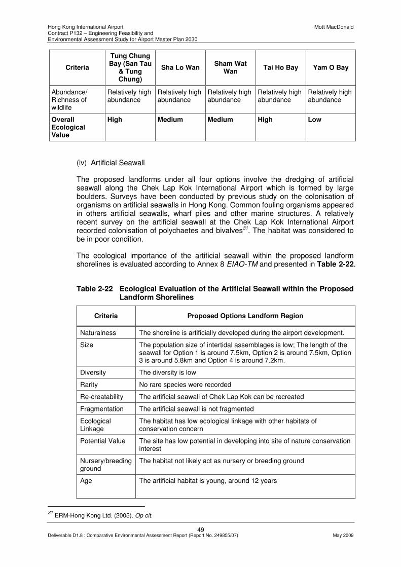
Hong Kong International Airport Mott MacDonald Contract P132 – Engineering Feasibility and Environmental Assessment Study for Airport Master Plan 2030
49 Deliverable D1.8 : Comparative Environmental Assessment Report (Report No. 249855/07) May 2009
Criteria
Tung Chung Bay (San Tau
& Tung Chung)
Sha Lo Wan Sham Wat
Wan Tai Ho Bay Yam O Bay
Abundance/ Richness of wildlife
Relatively high abundance
Relatively high abundance
Relatively high abundance
Relatively high abundance
Relatively high abundance
Overall Ecological Value
High Medium Medium High Low
(iv) Artificial Seawall
The proposed landforms under all four options involve the dredging of artificial seawall along the Chek Lap Kok International Airport which is formed by large boulders. Surveys have been conducted by previous study on the colonisation of organisms on artificial seawalls in Hong Kong. Common fouling organisms appeared in others artificial seawalls, wharf piles and other marine structures. A relatively recent survey on the artificial seawall at the Chek Lap Kok International Airport recorded colonisation of polychaetes and bivalves31. The habitat was considered to be in poor condition.
The ecological importance of the artificial seawall within the proposed landform shorelines is evaluated according to Annex 8 EIAO-TM and presented in Table 2-22.
Table 2-22 Ecological Evaluation of the Artificial Seawall within the Proposed Landform Shorelines
Criteria Proposed Options Landform Region
Naturalness The shoreline is artificially developed during the airport development.
Size The population size of intertidal assemblages is low; The length of the seawall for Option 1 is around 7.5km, Option 2 is around 7.5km, Option 3 is around 5.8km and Option 4 is around 7.2km.
Diversity The diversity is low
Rarity No rare species were recorded
Re-creatability The artificial seawall of Chek Lap Kok can be recreated
Fragmentation The artificial seawall is not fragmented
Ecological Linkage
The habitat has low ecological linkage with other habitats of conservation concern
Potential Value The site has low potential in developing into site of nature conservation interest
Nursery/breeding ground
The habitat not likely act as nursery or breeding ground
Age
The artificial habitat is young, around 12 years
31
ERM-Hong Kong Ltd. (2005). Op cit.

Hong Kong International Airport Mott MacDonald Contract P132 – Engineering Feasibility and Environmental Assessment Study for Airport Master Plan 2030
50 Deliverable D1.8 : Comparative Environmental Assessment Report (Report No. 249855/07) May 2009
Criteria Proposed Options Landform Region
Abundance/ Richness of wildlife
Low
Overall Ecological Value
Low
Artificial Reef
Artificial reefs have been deployed in several locations within the Study Area. The closest reefs are situated within the Chek Lap Kok MEZ and the other one is at Sha Chau and Lung Kwu Chau. The aims of these initiatives were to enhance and protect these marine areas for the benefit of the CWD, Sousa chinensis32. The materials of the artificial reefs deployed at Chek Lap Kok include ferro-cement vessels and quarry rocks, while those for Sha Chau ferro-cement vessels and steel container were deployed. The recent conditions of the artificial reefs deployed in Chek Lap Kok reported to have sediment laden on them (Chan and Chan pers. comm.), however, marine organisms were still observed. The existing quality of the artificial reefs has to be reviewed.
The ecological importance of the artificial reefs at Chek Lap Kok MEZ and the Sha Chau and Lung Kwu Chau Marine Park are evaluated according to Annex 8 EIAO-TM and presented in Table 2-23.
Table 2-23 Ecological Evaluation of the Artificial Reefs at Chek Lap Kok MEZ and the Sha Chau and Lung Kwu Chau Marine Park
Criteria Artificial Reefs at Chek Lap Kok
MEZ Artificial Reefs at Sha Chau and
Lung Kwu Chau Marine Park
Naturalness The reefs are artificially deployed The reefs are artificially deployed
Size 3,660 m² in area; 5,580 m³ in volume
1,200 m² in area; 3,600 m³ in volume
Diversity The diversity is low The diversity is relatively higher
Rarity No rare species was recorded No rare species was recorded, but the reef is benefited to CWD
Re-creatability The artificial reefs of Chek Lap Kok can be recreated
The artificial reefs can be recreated
Fragmentation The reefs system is connected though the reefs are deployed in scattered location
The reefs system is connected though the reefs are deployed in scattered location
Ecological Linkage
The habitat has low ecological linkage with other habitats of conservation concern
The habitat is ecologically linked with the coastal habitats and CWD habitat
32
Wilson, K.D.P. (2003). Artificial Reefs and Reef Fish in Hong Kong. Agriculture, Fisheries and Conservation
Department, HKSAR, Hong Kong.

Hong Kong International Airport Mott MacDonald Contract P132 – Engineering Feasibility and Environmental Assessment Study for Airport Master Plan 2030
51 Deliverable D1.8 : Comparative Environmental Assessment Report (Report No. 249855/07) May 2009
Criteria Artificial Reefs at Chek Lap Kok
MEZ Artificial Reefs at Sha Chau and
Lung Kwu Chau Marine Park
Potential Value The site has low potential in developing into site of nature conservation interest
The potential value is high
Nursery/breeding ground
The habitat provide nursery and spawning ground for marine fish
The habitat provide nursery and spawning ground for marine fish with commercial value
Age Deployed in 2000, around 9 years Deployed in 2000, around 9 years
Abundance/ Richness of wildlife
Low High
Overall Ecological Value
Low Medium
Sha Chau and Lung Kwu Chau Marine Park
Sha Chau and Lung Kwu Chau Marine Park is the only Marine Park in the western waters of Hong Kong. The total sea area is around 1,200ha33. The island of Sha Chau is dominated by boulders and interspersed with sandy beaches. The open water of the marine park is in the Pearl River estuary, receiving freshwater discharge from the river especially during rainy season. The area harboured rich estuarine resources, including 50 fish species with the Belangers Croaker (Johnius belengerii) and Japanese Sand Borer (Sillago japonica) recorded in abundant34. This area also supports other fish with commercial value, such as Japanese Croaker (Argyrosomus japonicus), Lionhead (Collichthys lucidus) and Yellowfin Seabream (Acanthopagrus latus). The Sha Chau and Lung Kwu Chau Marine Park is designated for the protection of CWD. This area supports some important foods for the dolphin (e.g. Croakers and Lionhead)35.
The ecological importance of the Sha Chau and Lung Kwu Chau Marine Park is evaluated according to Annex 8 EIAO-TM and presented in Table 2-24.
33
Lau, P.P.F. (2003). Knowing Hong Kong Marine Parks. Agriculture, Fisheries and Conservation Department,
HKSAR Government, Friends of the Country Parks, Hong Kong. 34
Ibid. 35
Ibid.

Hong Kong International Airport Mott MacDonald Contract P132 – Engineering Feasibility and Environmental Assessment Study for Airport Master Plan 2030
52 Deliverable D1.8 : Comparative Environmental Assessment Report (Report No. 249855/07) May 2009
Table 2-24 Ecological Evaluation of Sha Chau and Lung Kwu Chau Marine Park
Criteria Sha Chau and Lung Kwu Chau Marine Park
Naturalness The marine park is natural
Size Around 1,200 ha
Diversity The diversity is high including 50 fish species and the CWD
Rarity The marine park is designated for the protection of CWD
Re-creatability The diversify of habitats and unusual of water content are not re-creatable
Fragmentation The marine park is not fragmented
Ecological Linkage
Marine park is ecologically linked with other habitats for CWD at the northern and western Lantau
Potential Value The potential value is high
Nursery/breeding ground
The habitat provide nursery and spawning ground for marine fish with commercial value
Age The designation of the marine park is young, but the habitats within the area were established for a very long period
Abundance/ Richness of wildlife
High
Overall Ecological Value
High
2.7.4 Construction Phase Assessment
The potential impacts on marine ecology during the construction phase of the Airport expansion project may include direct impacts and indirect disturbance to marine wildlife in the vicinity and/or at far distance from the proposed construction site. The dredging and backfilling processes will generate increased level of SS. Increase in SS can influence the existing marine life, generate disturbance to CWDs and affect the habitats of other marine wildlife such as Horseshoe Crabs and artificial reefs by re-deposition of sediments on their habitats. The marine traffic surrounding the airport will be increased due to the construction activities and that may pose hazard to marine life, especially the CWD. In addition, underwater noise generated by vessels and other construction activities (especially piling works) may also adversely affect CWDs, which rely on their hearing for echolocation and communication with companions. Adverse impact may cause deafness and affect their ability to locate food and their socialising.
In summary, the potential impacts on marine ecology during the construction of the Airport expansion on marine ecology can be summarized as follows:
• direct habitat loss;
• direct loss of flora and fauna;

Hong Kong International Airport Mott MacDonald Contract P132 – Engineering Feasibility and Environmental Assessment Study for Airport Master Plan 2030
53 Deliverable D1.8 : Comparative Environmental Assessment Report (Report No. 249855/07) May 2009
• indirect disturbance to wildlife, including CWD;
• indirect disturbance to site of conservation concerns;
• impact on nursery and breeding grounds for Horseshoe Crabs;
• impact on Sha Chau and Lung Kwu Chau Marine Park;
• impact on artificial reefs; and
• impact on marine wildlife
In view of the sensitivity of the marine ecology related issues, a more focused assessment of the four options has been undertaken before confirming the differentiators for options comparison from a marine ecology perspective. These are presented in Section 3.7.
2.7.5 Operational Phase Assessment
Habitat area and home range of CWDs will be affected after the reclamation required for the Airport expansion. This will directly change the distribution pattern of the dolphins or even minimize the number of the dolphins due to the loss of habitats. Permanent loss of habitats will also affect other marine wildlife, including the marine benthos, intertidal fauna and the marine fishes utilizing the proposed land formation area. Rare species or species of conservation concern should be well protected to avoid adverse ecological impact.
As for the construction phase, a more focused assessment has been undertaken as presented in Chapter 3 before confirming the differentiators for options comparison.
2.8 Impacts on Chinese White Dolphins
This section presents a preliminary assessment of the environmental impacts on the Indo-Pacific Humpback Dolphin (Sousa chinensis), locally known as Chinese White Dolphins (CWDs), which amongst other areas inhabits the North and West Lantau waters near the HKIA. The potential impacts include the reduction of the dolphin habitats, disruption of breeding and calving sites, and disturbance of their activities including feeding and socializing. The potential impacts may be generated both during the construction and operational phases of the Airport expansion project.

Hong Kong International Airport Mott MacDonald Contract P132 – Engineering Feasibility and Environmental Assessment Study for Airport Master Plan 2030
54 Deliverable D1.8 : Comparative Environmental Assessment Report (Report No. 249855/07) May 2009
2.8.1 Relevant Legislation and Guidelines
CWDs are protected under International and Hong Kong Legislations. The relevant international legislations include:
• United Nations Convention on Biodiversity (1992);
• Convention on International Trade in Endangered Species of Wild Flora and Fauna (CITES);
• Convention on the Conservation of Migratory Species of Wild Animals (the Bonn Convention); and
• IUCN Red Data Book.
Relevant Hong Kong Legislations include:
• Wild Animals Protection Ordinance (Cap. 170); and
• Protection of Endangered Species of Animals and Plants Ordinance (Cap. 586); and
• The Technical Memorandum on Environmental Impact Assessment Process under the Environmental Impact Assessment Ordinance (EIAO-TM).
2.8.2 Assessment Methodology
The preliminary assessment was carried out taking into account the criteria and guidelines set out in Annexes 8 and 16 of the EIAO-TM.
The current databases of studies on the CWD in North Lantau waters of Hong Kong and in the Pearl River Delta have been reviewed. The sighting densities of the dolphins (number of on-effort sightings per km²) and dolphin densities (total number of dolphins from on-effort sightings per km²) for each 1 km by 1 km grid from previous literature were overlaid on the base map with previous data and the footprint of each options with the aid of Geographic Information System (GIS). The information analysed were used to assess the significance of impacts for each Airport expansion option on dolphin habitats and their associated activities.
The distribution range and abundance of the CWD especially at the proposed area for the Airport expansion were also reviewed. The importance of the proposed reclamation locations under the four options to this species was compared. For protecting CWDs, the priority in accordance with the EIAO-TM is avoidance (avoiding area with frequent observation or dependent by this species) and minimization (considering alternative options to minimize the impact significance to this species). Compensation for this species of conservation concern is the last resort solution (if selecting the most sensitive site location is unavoidable, compensation for the loss, for example, feeding grounds of CWDs is recommended).
An assessment of the risks posed to CWDs from short-term elevation in SS concentrations in local waters is also covered.
The severity of impacts including direct and indirect impacts brought about by the project on CWDs in particular to their calves were assessed according to Table (1) “Evaluating the significance of an ecological impact” given in Annex 8 of the EIAO-TM.

Hong Kong International Airport Mott MacDonald Contract P132 – Engineering Feasibility and Environmental Assessment Study for Airport Master Plan 2030
55 Deliverable D1.8 : Comparative Environmental Assessment Report (Report No. 249855/07) May 2009
2.8.3 Baseline Conditions
CWDs are year-round residents of Hong Kong western waters and Pearl River Delta, showing a strong preference for estuarine habitats36. Study on the abundance, distribution, behaviour and breeding of CWD have been on-going since about 1995.
The reclamation area proposed under all four Airport expansion options is located in the area of North Lantau, which forms part of the habitat of CWDs. Sufficient information on the habitat use and abundance of CWDs in North Lantau waters were available from regular monitoring conducted by AFCD for 13 years (1995–2008). However, survey vessels have been restricted to enter the Chek Lap Kok MEZ around the existing Airport platform since early 1998. Thus, there is a 10-year temporal gap on data relevant to CWDs within the MEZ. Collecting data on abundance of CWDs and habitat use within the MEZ may be required for the impact assessment on CWDs.
Abundance, Distribution and Habitat Use of Dolphins
The most recent CWD monitoring results37 in Hong Kong waters reported that 344 groups of CWDs were sighted, numbering 1,109 individuals, during the study period from April 2007 to April 2008 through systematic line-transect vessel surveys. CWDs were found widely distributed throughout Northwest Lantau, Northeast Lantau, West Lantau and Southwest Lantau, while they were rarely observed in Deep Bay, Southeast Lantau and Lamma areas. Dolphin sightings were concentrated in the waters east of Lung Kwu Chau, between Lung Kwu Chau and Black Point, near Pak Chau, around the Brothers Islands and throughout the West Lantau especially along the stretch of waters between Tai O Peninsula and Kai Kung Shan. On the contrary, dolphins generally avoided the waters off Castle Peak Bay, Lung Kwu Tan, North of the Chek Lap Kok Airport platform and the eastern end of Northeast Lantau.
In the monitoring report, quantitative grid analysis on habitat use was conducted. Positions of on-effort sightings of dolphins were plotted onto 1-km2 grids on Geographic Information System (GIS). The unit for sighting density termed “SPSE”, representing the number of on-effort sightings per 100 units of survey effort, and the unit for actual dolphin density termed “DPSE’, representing the number of dolphins (from on-effort sighting) per 100 units of survey effort, were then calculated for each 1 km by 1 km grid with the aid of GIS. While the report showed the SPSE and DPSE ranges, separated sheets of quantitative grid analysis were received from AFCD which contained SPSE and DPSE values for each grid. In North Lantau waters, moderate to high DPSE values (60-170) were recorded at a number of grids near Lung Kwu Chau and Black Point between years 2002 and 2007 (Drawing No. MMH/P132/NSK/3601 refers). The grids west of Sha Chau, near Pak Chau and around Brothers Islands were recorded with moderate DPSE values (15-65).
Around the existing Airport platform, a moderate dolphin DPSE value (18-54) was recorded at the northeast corner of the platform. A relatively low DPSE value (5-13) was recorded at the northwest corner between 2002 to 2007 (Drawing No. MMH/P132/NSK/3601 refers). However, as discussed above, there is a recent 10-
36
Jefferson, T. A., Hung, S. K. & Würsig, B. (2009). Protecting small cetaceans from coastal development: Impact
assessment and mitigation experience in Hong Kong. Marine Policy, 33 (2), 305-311. 37
Hung, S. K. (2008). Monitoring of marine mammals in Hong Kong waters – data collection. Final report
submitted to the Agriculture, Fisheries and Conservation Department, Hong Kong.

Hong Kong International Airport Mott MacDonald Contract P132 – Engineering Feasibility and Environmental Assessment Study for Airport Master Plan 2030
56 Deliverable D1.8 : Comparative Environmental Assessment Report (Report No. 249855/07) May 2009
year information gap on CWD density and habitat use in marine area to the north and west of the Airport platform due to the set up of Chek Lap Kok MEZ in 1998. Land-based dolphin survey is therefore proposed for filling the information gap.
CWD monitoring results from 1996 to 2005 reported in Hung (2008)38 were used for reviewing the remaining findings of dolphins, as in the most recent report, quantitative grid analysis was not conducted on aspects other than dolphin sighting density.
Group Size of Dolphins
Mean group size in each grid could provide information on whether smaller or larger groups would aggregate at certain locations. Among all grids, the mean group size of CWDs per grid was 4.0 ± s.d. 3.57, ranging from 1 to 13. Several regions had mean group size well above the mean, including the waters between the Brothers and north shore of Northeast Lantau, near Black Point, along the western border of Marine Park near Pak Chau, and western edge of West Lantau. Conversely, grids with lower mean group size were distributed at the eastern end of Northeast Lantau and the southeastern end of South Lantau.
Behaviour of Dolphins
In total, there were 470 confirmed sightings where CWDs were observed engaged in feeding activities from 1996 to 2005. The SPSE value for feeding activities had an average of 1.0 ± s.d. 1.88 per grid. Overall, West Lantau had the highest mean SPSE value for feeding activities, which was 4.5 times higher than the one in Northwest Lantau and 7 times higher than the one in Northeast Lantau. In particular, grids with high sighting densities for feeding activities were found along the coast of West Lantau near Tai O Peninsula, Peaked Hill and Fan Lau. Other areas with frequent encounters of dolphin groups engaged in feeding activities included the grids east of Lung Kwu Chau, at Kau Ling Chung and between the Soko Islands. All these areas could be considered important feeding areas for CWDs in Hong Kong.
A total of 137 sightings were confirmed with CWDs engaged in socializing activities from 1996 to 2005. The SPSE value for feeding activities had an average of 0.3 ± s.d. 0.74 per grid. The mean SPSE value for socializing activities was the highest in West Lantau, while Southwest Lantau was also moderately used by dolphins for socializing activities. In contrast, sighting densities for socializing activities in Northeast Lantau and Northwest Lantau were lower. The areas with moderately high SPSE values for socializing activities included the grids near Sham Shui Kok, east of Lung Kwu Chau and north of Tai O Peninsula. These three locations could be considered important socializing areas for CWDs in Hong Kong.
Dolphin Calves
Attention has been given to any frequent occurrences of CWD mother-calf pairs in certain areas, as these areas can be important for nursing activity. From 1996 to 2005, 185 newborn calves were sighted, with an average of DPSE value of 0.3 ± s.d. 0.66 per grid. Grids in West Lantau had the highest mean DPSE values of newborn calves. The mean DPSE value of newborn calves in Northwest Lantau was also significantly higher than ones in Northeast Lantau and Southwest Lantau. Several grids had particularly high densities of newborn calves, including the grids east and
38
Hung, S. K. (2008). Habitat use of Indo-Pacific Humpback Dolphins (Sousa chinensis) in Hong Kong. PhD
thesis, The University of Hong Kong, Hong Kong.

Hong Kong International Airport Mott MacDonald Contract P132 – Engineering Feasibility and Environmental Assessment Study for Airport Master Plan 2030
57 Deliverable D1.8 : Comparative Environmental Assessment Report (Report No. 249855/07) May 2009
west of Lung Kwu Chau, near Tai O, near Peaked Hill and around the tip of Fan Lau, which were considered important nursery area for newborn calves.
From 1996 to 2005, 626 older calves were sighted, with an average of DPSE value of 1.2 ± s.d. 2.25 per grid. The mean DPSE value of older calves was once again the highest in West Lantau, which was significantly higher than the ones in Northwest Lantau, Southwest Lantau and Northeast Lantau. In particular, the grids just north of Tai O Peninsula, near Peaked Hill and Fan Lau had very high densities of older calves (DPSE > 10). In other areas, the grids with frequent occurrence of older calves are located east of Lung Kwu Chau, near Black Point, Tap Shek Kok and Sham Shui Kok in North Lantau, and east of Fan Lau, near Kau Ling Chung and around Soko Islands in Southwest Lantau.
Table 2-25 summarises the average density of CWDs sighting in terms of feeding, socializing, newborn calves and older calves.
Table 2-25 Summary of Average Density of CWDs Specified in Behaviour and Calves of CWD in Lantau Waters.
Parameters West Lantau Northwest Lantau Southwest Lantau Northeast Lantau
Average Sighting Density of Feeding (SPSE)
3.52 0.78 (no data) 0.50
Average Sighting Density of Socializing (SPSE)
1.02 0.18 0.42 0.26
Average Density of Newborn Calves (DPSE)
1.09 0.45 0.18 0.08
Average Density of Older Calves (DPSE)
4.89 1.08 1.13 0.66
Source: Hung, S. K. (2008). Habitat use of Indo-Pacific Humpback Dolphins in Hong Kong. PhD thesis.
2.8.4 Construction Phase Assessment
A large area (over 700 hectares) of land formation is required for building the Airport expansion, including the construction of the third runway and new Terminal. Land reclamation, dredging and backfilling works will have the potential to cause disturbance to the habitat and normal activities of CWDs.
During the construction phase, the reclamation activities would lead to loss of marine habitat at North Lantau waters. This could result in a decline in fishery resources, with loss of fish spawning and nursery grounds, leading to indirect impact on CWDs. Deterioration in water quality may also have potential indirect impact on CWDs. Dredging works would result in re-suspension of fine silts and increase the concentrations of SS. The sediment plume generated will potentially disturb invertebrates inhabiting the sediment, food supply for fish and subsequently the feeding opportunities of dolphins.
Impact of underwater noise on CWDs is another potential concern. Research in this area indicated that dolphins have acute hearing above 500 Hz and echolocate and

Hong Kong International Airport Mott MacDonald Contract P132 – Engineering Feasibility and Environmental Assessment Study for Airport Master Plan 2030
58 Deliverable D1.8 : Comparative Environmental Assessment Report (Report No. 249855/07) May 2009
communicate well into human ultrasound above 20 kHz39. Owing to propagation characteristics of sound, frequencies below 10 kHz tend to travel longer distances. These lower frequencies are expected to be especially disruptive to dolphins that are sensitive to them because of dolphins’ channel of hearing. Other than pile driving which is known to have significant underwater noise impact, dredging and backfilling works can also result in increase in low frequency underwater noise from marine vessels which may potentially affect marine mammals depending on the work intensity.
Similar to the preceding section on marine ecological impacts, it is also suggested that discussions on CWDs be carried forward to the next chapter to facilitate more focused impact assessment on this aspect, prior to confirming the appropriate differentiators for options comparison.
2.8.5 Operational Phase Assessment
Formation of new land for the Airport expansion will result in the permanent loss of CWD habitat. An analysis of the distribution patterns of CWDs shows that they were sighted in the vicinity of the existing Airport platform40 for years. For individuals of CWD that use the area of North Lantau waters as their home range, the proposed land formation will lead to an irreversible reduction of their residential area. The subsequent loss in benthic habitats due to new land formation will also cause indirect impact on CWDs. CWD is thought to be an opportunistic feeder with the most important prey species being demersal fish41 . Therefore, feeding opportunities for CWDs would be reduced as a result in loss of benthic habitats. The narrowing of the marine area or channel between the new airport platform and the Marine Park may result in increased risk of injury to CWDs. Vessels using the channel include fishing boats, cargo vessels, tugs and barges.
As for the construction phase impact, a more focused impact assessment is provided in Chapter 3 before confirming the differentiators for option evaluation.
2.9 Fisheries Impacts
This section presents a preliminary assessment of the impact from construction and operation of the project on capture and culture fisheries. Potential impacts include disturbance to area of fisheries importance and also disturbance to fishing operation. Impacts would be generated during both the construction and operational phases of the project. The fisheries impact assessment covered those areas sensitive to the proposed dredging and reclamation works, including the marine fish culture zone at Ma Wan in the Western Buffer WCZ and the capture fisheries in the North Western WCZ.
2.9.1 Relevant Legislation and Guidelines
Destructive fishing practices such as the use of explosives, toxic substances, electricity, dredging and suction devices for the purpose of fishing are prohibited under the Fisheries Protection Ordinance (Cap 171), as these practices are
39
Würsig, B., Greene, C. R. & Jefferson, T. A. (2000). Development of an air bubble curtain to reduce underwater
noise of percussive piling. Marine Environmental Research, 49, 79-93. 40
Hung, S. K. (2008). Monitoring of marine mammals in Hong Kong waters – data collection. Final report
submitted to the Agriculture, Fisheries and Conservation Department, Hong Kong 41
ERM (2006). Liquefied Natural Gas (LNG) Receiving Terminal and Associated Facilities – EIA Report.

Hong Kong International Airport Mott MacDonald Contract P132 – Engineering Feasibility and Environmental Assessment Study for Airport Master Plan 2030
59 Deliverable D1.8 : Comparative Environmental Assessment Report (Report No. 249855/07) May 2009
detrimental to fisheries and the marine ecosystem. Assessment of potential environmental impacts on fisheries is required for development projects involving foreshore and seabed, in accordance with the EIAO. Criteria and guidelines for fisheries impact assessment are set out in Annexes 9 and 17 of the EIAO-TM.
2.9.2 Methodology for the Preliminary Assessment
This assessment was conducted by reviewing existing information related to culture and capture fisheries within the study area. The fisheries resources in the following sensitive receivers were reviewed:
• Fishing grounds in North Lantau Waters;
• Spawning grounds of commercial fisheries species in North Lantau Waters;
• Artificial Reefs in the Chek Lap Kok MEZ 3 and inside Sha Chau and Lung Kwu Chau Marine Park;
• Ma Wan Fish Culture Zone
The fisheries impact assessment followed the above-mentioned criteria and guidelines stipulated in Annexes 9 and 17 of the EIAO-TM. A comparison table was provided to list out the constraints for all options including the fisheries activities and production in the proposed region to facilitate the early options selection work.
2.9.3 Baseline Conditions
The proposed reclamation works and future operation of the Airport expansion may affect the fisheries resources and fishing operations within the project area and adjacent waters. The findings of Port Survey 2006 (AFCD, 2006) revealed that some of the Options are within the grids with medium-low fisheries production and fishing activities. The northwestern water of Chek Lap Kok also supports medium value of fisheries production. These will form constraints to the proposed Options.
Capture and Culture Fisheries
The findings of Port Survey 2006 (AFCD, 2006) revealed that the fishing industry in Hong Kong maintain a steady supply of fresh marine fish to local consumers. In 2007, it produced an estimated 154,000 tonnes of fisheries with valued at HK$1,530 million by around 4000 fishing vessels42. According to the Port Survey findings, some of the proposed options are within the grids with medium-low fisheries production (100-200 kg/ha) and fishing activities (50-100 vessels). The northwestern waters of Chek Lap Kok also support medium value of fisheries production (HK$2000-5000/ha). Drawing No. MMH/P132/NSK/3703 showed the distribution of fisheries production and operations in Hong Kong during the Port Survey 2006.
For the areas in Ma Wan Fish Culture Zone (FCZ) and the waters around Sha Chau and Lung Kwu Chau Marine Park, the fisheries production is medium low (100-200 kg/ha) and medium (200-400 kg/ha) respectively. The production value is around HK$2000-5000/ha. The number of vessels involved is ranged from 100-400 per year. A medium to medium high fisheries production were recorded in the
42
AFCD web site: http://www.afcd.gov.hk/english/fisheries/fish_cap/fish_cap_latest/fish_cap_latest.html
(Downloaded in Jan 2009)

Hong Kong International Airport Mott MacDonald Contract P132 – Engineering Feasibility and Environmental Assessment Study for Airport Master Plan 2030
60 Deliverable D1.8 : Comparative Environmental Assessment Report (Report No. 249855/07) May 2009
northwestern Lantau waters (200-600kg/ha), with a medium high value range from HK$5000-10000/ha captured by 100-400 vessels per year. This area is likely to be sensitive to disturbance impacts from the construction and operation of the proposed development.
Fishing vessels operated in the proposed landform area include the shrimp trawler, hang trawler, sampan, gill netter and purse seiner. Hang trawler is the dominant vessels operating in the north of Chek Lap Kok, northwestern Lantau and Sha Chau and Lung Kwu Chau Marine Park. Major species of fish catch in the northern Chek Lap Kok are Croaker, Shrimp and Anchovy. Rabbitfish is the dominant species in the northwestern Lantau water and around Ma Wan, other fish species like Croaker, Scad, Shrimp, Anchovy, Crabs and Mullet are also common in the surrounding waters.
2.9.4 Construction Phase Assessment
The construction of the proposed development will lead to an increase in human activities in the open sea at the northern and western Lantau waters. The increase in construction vessels and marine traffic around the migratory route of the fishes may cause a change in their route and behaviour. The proposed landform areas for the 4 Options are in areas of medium-low fisheries abundance, the disturbance impacts due to the increase in human activities and marine traffic are expected to be of low significance as the number of construction vessels are not expected to increase significantly the numbers of vessels generally in the area and they will work mainly in a confined area and at slow speeds. However, the significance of fisheries impact would be different amongst the options and these are further evaluated in Chapter 3 before confirming the appropriate differentiators for options comparison.
2.9.5 Operational Phase Assessment
Fishing operations may be affected by the Airport expansion due to the loss of fishing habitat as a result of the land formation. Fisheries production may be reduced due to the loss of capture fisheries resource near the airport and change in hydrodynamics that influence the activities of the marine fish. A number of fishermen and fishing vessels with high dependence on the affected fishery area may be influenced. The new MEZ may be extended outside or close to the Hong Kong marine water boundary to the west and the Sha Chau and Lung Kwu Chau Marine Park to the north. This will cause stringent conditions to fishing operation and discourage the fishermen from fishing in the west Lantau and northern Lantau where fisheries production were moderate-high.
Given the relative importance of this aspect, the fisheries impacts of the proposed Airport expansion are given further focused assessment before confirming the appropriate differentiators to be used for options comparison.
2.10 Landscape and Visual Impacts
The airport expansion involves a large-scale formation of new land, which may have an impact on landscape and visual quality. A qualitative approach is adopted for the preliminary assessment of the construction and operational phase impacts.
2.10.1 Relevant Legislation and Guidelines
Criteria and Guidelines for landscape and visual impact assessment are given in Annexes 10 and 18 of the EIAO-TM. Additional guidelines are given in the EIAO Guidance Note No. 8/2002.

Hong Kong International Airport Mott MacDonald Contract P132 – Engineering Feasibility and Environmental Assessment Study for Airport Master Plan 2030
61 Deliverable D1.8 : Comparative Environmental Assessment Report (Report No. 249855/07) May 2009
2.10.2 Visual Sensitive Receivers (VSRs)
Representative VSRs were identified by considering the proximity of the various VSRs to the proposed Airport expansion site. The shortest horizontal distances between the VSRs and the proposed site boundary of various options are summarized in Table 2-26.
Table 2-26 Distances between VSRs to the nearest proposed site boundary.
VSRs Option 1 Option 2 Option 3 Option 4
Residential
Sha Lo Wan Village 0.8km 0.8km 1.9km 0.5km
Tung Chung Town 3.4km 3.4km 3.4km 3.7km
Airport (existing)
Passenger Terminals 0.4km 0.4km 0.4km 0.8km
Facility buildings (e.g Air Mail Centre)
2.0km 2.0km 2.0km 2.0km
Visitors of
Lantau North Country Park *
1.6km 1.6km 2.9km 1.5km
Ngong Ping 360 Cable Car More than 2.8km
More than 2.8km
More than 4.0km
More than 2.6km
Note(*) refer to distance between the site boundary and the Country Park boundary.
2.10.3 Construction and Operational Phases Assessment
The airport expansion involves large scale new land formation. Potential landscape and visual impacts to the VSRs are anticipated. The design of the redeveloped HKIA, other than the engineering and operation considerations, may also be a concern and of interest to the general public given the interest generated by the other unrelated projects in the vicinity of the Airport. Therefore, it is considered that potential landscape and visual impact may be included as a differentiator for the options comparison. The issues are further discussed in Section 3.10.
2.11 Impacts on Sites of Cultural Heritage
The airport expansion would involve a large scale of reclamation in waters of northwest of Lantau Island. Sites of marine archaeological importance may be located close to or within the Project site area.
2.11.1 Relevant Legislation and Guidelines
The EIAO stipulates that consideration must be given to issues associated with cultural heritage and archaeology as part of the EIA process. Respectively Annexes 10 and 19 of the EIAO-TM outlines the following:
(i) the criteria for evaluating the impacts on sites of cultural heritage; and
(ii) guidelines for impact assessment.

Hong Kong International Airport Mott MacDonald Contract P132 – Engineering Feasibility and Environmental Assessment Study for Airport Master Plan 2030
62 Deliverable D1.8 : Comparative Environmental Assessment Report (Report No. 249855/07) May 2009
The EIAO-TM identifies a general presumption in favour of the protection and conservation of all sites of cultural heritage and requires impacts upon sites of cultural heritage to be ‘kept to a minimum’. There is no quantitative standard for determining the relative importance of sites of cultural heritage, but in general sites of unique, archaeological, historical or architectural value should be considered as highly significant.
In addition, since the introduction of the EIAO, the Antiquities and Monuments Office (AMO) may request a Marine Archaeological Investigation (MAI) for developments affecting the seabed.
Guidelines for MAI is issued by AMO which details the standard practice, procedures and methodology for determining marine archaeological potential, presence of archaeological artefacts and defining suitable mitigation measures.
2.11.2 Methodology for the Preliminary Assessment
This includes a desktop review of relevant marine archaeological studies on areas in the proximity of the airport island. Liquefied Natural Gas (LNG) Receiving Terminal and Associated Facilities EIA and Permanent Aviation Fuel Facility for Hong Kong International Airport EIA are identified to be the key studies to be reviewed and any other relevant documents will also be reviewed to extract any useful information.
2.11.3 Construction and Operational Phases Assessment
The existing airport is located on a reclamation island and no built heritage is expected. Three cultural heritages are identified as the historical sites close to the airport expansion. They are the Lung Kwu Chau Archaeological Site, Tin Hau Temple in Sha Chau and the Sha Chau Archaeological Site43. The closest cultural heritage is located at least 1.4km away from the construction site of the expansion development. Potential impact to the built heritages is unlikely due to the long distance from the construction boundary of the airport expansion site.
It is anticipated that a Marine Archaeological Investigation (MAI) for developments affecting the seabed will be required by AMO taking into account the large scale of this Project. MAI would be carried out at that stage as per the requirements stipulated in the EIA Study Brief.
All four Airport expansion options would involve the potential marine archaeological impact issue. There is no major difference in terms of this impact among all the options. It is hence considered that cultural heritage impact is not a differentiator to the option comparison process.
2.12 Requirements for Environmental Monitoring and Audit
Environmental Monitoring and Audit (EM&A) is an essential part of Environmental Impact Assessment study. EM&A will be required to ensure that all activities of the proposed Project under both construction and operational phases are complied with relevant standards and any necessary mitigation measures are implemented properly.
43
Maunsell (1991), New Airport Master Plan – Environmental Impact Assessment, For Provisional Airport
Authority Hong Kong.
Hong Kong International Airport Mott MacDonald Contract P132 – Engineering Feasibility and Environmental Assessment Study for Airport Master Plan 2030
63 Deliverable D1.8 : Comparative Environmental Assessment Report (Report No. 249855/07) May 2009
2.12.1 Relevant Legislation and Guidelines
The process of EM&A must comply with the requirements stated in Annex 21 of EIAO-TM. The TM stated all the requirements for monitoring programme, contents of reports and other related information of EM&A.
2.12.2 Detailed EM&A requirements
The detailed EM&A requirements will be established and illustrated during Phase 2 of the project. At that time detailed information such as construction methods and plants to be used, construction programme and phasing, and operation modes of the expanded airport would be available for deriving the relevant EM&A requirements.
Requirements for EM&A are an integral part of the environmental study under the EIAO. However, it is not expected that there will be any major difference among the four Airport expansion options in terms of EM&A requirements and hence it is considered not a differentiator for the option evaluation process.
2.13 Other Characteristics
Sections 2.1 to 2.12 above provide preliminary assessments of the potential environmental impacts which may arise from the construction and operation of the Airport expansion. In addition to these environmental aspects, a list of physical characteristics was also identified as potential factors to be considered in the option evaluation, namely:
• Dredging and Disposal
• Reclamation
• Construction Methods
• Contaminated Mud Pits
• Proximity to Sensitive Receivers
• Future Proofing Against Climate Change
In essence, each of the above characteristics wholly or partially contributes to the various environmental impacts which have been discussed in this Chapter, and in most instances, have been implicitly considered during the assessment of the impacts. These physical characteristics will have varying degrees of environmental impacts, depending on the layout options, and will be reflected in Sections 3 and 4 during the comparison of the different options. In this regard, a separate discussion on these characteristics has not been undertaken in this chapter.
Notwithstanding the above observations, however, it will be useful to provide some focused discussions on some of the topics, which may serve to provide further understanding on the contributory effects of these elements, which are included in Chapter 3 as Appendix 3A. For ease of discussion, the first three items, i.e. Dredging and Disposal, Reclamation, and Construction Methods, will be combined to be discussed under a collective topic, “Reclamation”. The “Proximity to Sensitive Receivers” criterion has been considered in practically all of the environmental impacts (e.g. impacts to the sensitive receivers, etc); as such, a separate discussion

Hong Kong International Airport Mott MacDonald Contract P132 – Engineering Feasibility and Environmental Assessment Study for Airport Master Plan 2030
64 Deliverable D1.8 : Comparative Environmental Assessment Report (Report No. 249855/07) May 2009
on this topic is deemed not required.
The last item, “Future Proofing Against Climate Change”, touches on the subject of Sustainability, which essentially does not differentiate the options. This will be an area which will be given careful consideration during option development and detailed designs, but is not a dominant factor during the option evaluation process. In this regard, this topic will not be considered further in the following sections of the Report.
2.14 Summary of Differentiators
Based on the foregoing discussions, a summary of differentiators suggested to be adopted for the option evaluation is tabulated in Table 2-27.
Table 2-27 Summary of Recommended Differentiators
Environmental Aspects
Differentiators identified
Construction Phase
Operational Phase
Remarks
Air Quality Yes No Yes -
Hazard to Life No - - -
Noise Quality Yes Yes Yes -
Water Pollution Yes Yes Yes -
Waste Yes Yes No -
Marine/Terrestrial Ecology
Yes Yes Yes Specific differentiators to be confirmed after focused assessment presented in Chapter 3
CWDs Yes Yes Yes Specific differentiators to be confirmed after focused assessment presented in Chapter 3
Fisheries Yes Yes Yes Specific differentiators to be confirmed after focused assessment presented in Chapter 3
Landscape and Visual
Yes Yes Yes -
Cultural Heritage No - - -
EM&A No - - This is required under the EIAO for every designated project and is thus not a differentiator

Hong Kong International Airport Mott MacDonald Contract P132 – Engineering Feasibility and Environmental Assessment Study for Airport Master Plan 2030
65 Deliverable D1.8 : Comparative Environmental Assessment Report (Report No. 249855/07) May 2009
3. FOCUSSED ASSESSMENT OF KEY ENVIRONMENTAL ISSUES
3.1 Introduction
Preliminary assessments of the potential environmental issues during the construction and operational phases of the proposed Airport expansion are presented in Chapter 2. Key environmental issues which would perform differently among the Airport expansion options, as indicated in Table 2.27, and the potential differentiators for each key environmental issues were thus identified for further assessment.
In this chapter, focused assessments are presented for the following key environmental aspects:
• Water Quality and Hydrodynamics;
• Waste Management;
• Chinese White Dolphins (CWDs);
• Marine Ecology and Fisheries;
• Noise;
• Air Quality; and
• Landscape and Visual
As discussed in Section 2.13, although “Reclamation” and “Contaminated Mud Pits” are not strictly environmental characteristics per se, focused discussion is provided on these two physical characteristics for comparative assessment purpose and this is presented in Appendix 3A.
3.2 Water Quality and Hydrodynamics
3.2.1 Differentiators
Based on the preliminary environmental assessment presented in Section 2.5, the differentiators identified from the perspective of water quality and hydrodynamic impact include:
During the construction phase:
• Increase in SS concentrations at WSRs;
• Release of sediment fines and contaminants during ground treatment with DCM within CMPs;
During the operational phase:
• Change in tidal flow;
• Erosion of seabed;
• Change in flushing capacity at the existing Airport Sea Channel;

Hong Kong International Airport Mott MacDonald Contract P132 – Engineering Feasibility and Environmental Assessment Study for Airport Master Plan 2030
66 Deliverable D1.8 : Comparative Environmental Assessment Report (Report No. 249855/07) May 2009
• Potential water quality impact from poorly flushed embayment
Taking into account the differentiators identified, more focused assessments of potential water quality and hydrodynamic impacts arising during the construction and operational phase of the project for the four Airport expansion options are presented in this section.
3.2.2 Assessment Methodology
General
The assessment criteria and guidelines are presented in Chapter 2. Hydrodynamic and water quality models have been employed to assess the potential hydrodynamic and water quality impacts in North Western WCZ during the construction and operational phases. The modelling results have been interpreted for compliance of WQOs and other criteria, where appropriate.
Computer Models
The 3D hydrodynamic and water quality models from Delft Hydraulics have been used. The model domain covers the Western Harbour and North West New Territories, taking into account the influences of Pearl River freshwater inflow, referred as the Western Harbour Model. This model has been fully validated by Delft Hydraulics. The model grid size in the area of interest is about 200m x 200m. The modelling has been carried out for the “Base-Case” and the four Airport expansion options, covering both the wet and dry seasons with 10 model layers vertically.
Modelling Scenarios for Construction Phase
Representative sediment plumes have been modelled by Delft3D-WAQ model. Since sediment losses from backfilling activities with coarse material are much less than those from dredging activities, only the losses from dredging has been modelled as a worst-case scenario (as is standard practice in terms of the EIA process).
The duration of dredging operations assumed in the modelling scenarios has taken into account the dredging programme discussed in Report D1.7. Possible locations of the dredgers have been considered based on Drawing Nos. MMH/P132/GSK/1013 to 1016 presented with Report D1.7. It is noted that Trailing Suction Hopper Dredgers (TSHDs), Cutter Suction Dredgers (CSDs) and Grab Dredgers (GD) have been proposed to be used. Notwithstanding this, use of TSHD and CSD have been assumed in the model as a conservative approach, since their dredging rates are much higher than that of GD. The operational areas of TSHD and CSD are also specified in the above-mentioned drawings. One TSHD and four CSDs were assumed to be operating simultaneously. Besides, one TSHD and one CSD have been assumed to be working close to the Marine Park and near the coast of Sha Lo Wan (i.e. the nearest WSRs), respectively. Other CSDs have been assumed to be evenly distributed within the areas where dredging are required. The parameters used for the sediment plume modelling are given in Table 3-1.
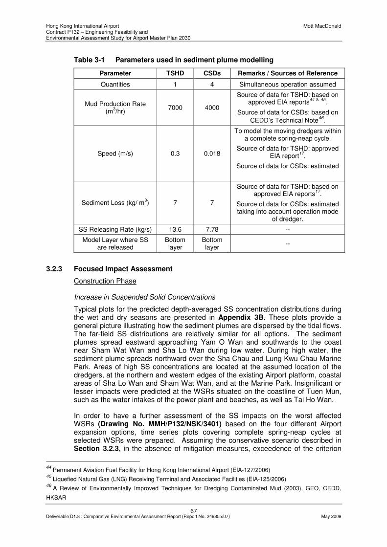
Hong Kong International Airport Mott MacDonald Contract P132 – Engineering Feasibility and Environmental Assessment Study for Airport Master Plan 2030
67 Deliverable D1.8 : Comparative Environmental Assessment Report (Report No. 249855/07) May 2009
Table 3-1 Parameters used in sediment plume modelling
Parameter TSHD CSDs Remarks / Sources of Reference
Quantities 1 4 Simultaneous operation assumed
Mud Production Rate (m
3/hr)
7000 4000
Source of data for TSHD: based on approved EIA reports
44 & 45
.
Source of data for CSDs: based on
CEDD’s Technical Note46
.
Speed (m/s) 0.3 0.018
To model the moving dredgers within a complete spring-neap cycle.
Source of data for TSHD: approved EIA report
17.
Source of data for CSDs: estimated
Sediment Loss (kg/ m3) 7 7
Source of data for TSHD: based on approved EIA reports
17.
Source of data for CSDs: estimated taking into account operation mode
of dredger.
SS Releasing Rate (kg/s) 13.6 7.78 --
Model Layer where SS are released
Bottom layer
Bottom layer
--
3.2.3 Focused Impact Assessment
Construction Phase
Increase in Suspended Solid Concentrations
Typical plots for the predicted depth-averaged SS concentration distributions during the wet and dry seasons are presented in Appendix 3B. These plots provide a general picture illustrating how the sediment plumes are dispersed by the tidal flows. The far-field SS distributions are relatively similar for all options. The sediment plumes spread eastward approaching Yam O Wan and southwards to the coast near Sham Wat Wan and Sha Lo Wan during low water. During high water, the sediment plume spreads northward over the Sha Chau and Lung Kwu Chau Marine Park. Areas of high SS concentrations are located at the assumed location of the dredgers, at the northern and western edges of the existing Airport platform, coastal areas of Sha Lo Wan and Sham Wat Wan, and at the Marine Park. Insignificant or lesser impacts were predicted at the WSRs situated on the coastline of Tuen Mun, such as the water intakes of the power plant and beaches, as well as Tai Ho Wan.
In order to have a further assessment of the SS impacts on the worst affected WSRs (Drawing No. MMH/P132/NSK/3401) based on the four different Airport expansion options, time series plots covering complete spring-neap cycles at selected WSRs were prepared. Assuming the conservative scenario described in Section 3.2.3, in the absence of mitigation measures, exceedence of the criterion
44
Permanent Aviation Fuel Facility for Hong Kong International Airport (EIA-127/2006) 45
Liquefied Natural Gas (LNG) Receiving Terminal and Associated Facilities (EIA-125/2006) 46
A Review of Environmentally Improved Techniques for Dredging Contaminated Mud (2003), GEO, CEDD,
HKSAR

Hong Kong International Airport Mott MacDonald Contract P132 – Engineering Feasibility and Environmental Assessment Study for Airport Master Plan 2030
68 Deliverable D1.8 : Comparative Environmental Assessment Report (Report No. 249855/07) May 2009
(i.e. 9 mg/l above background) is expected at WSRs situated in close proximity to the dredging sites.
The general feature of the variations of the SS concentrations at any WSR is that there would be periodic SS elevations to their peak values and that the short-lived peak concentrations quickly fall to very small values (nearly zero at some WSRs) on the turn of the tide. Higher SS concentrations predicted near bottom water are mainly due to the low flow speeds at this level, though the large release rates of sediment near the sea bed by the disturbance of the dredger arms may also have some contributions. Larger vertical gradient of SS concentrations are evident in the wet season plots due to a lesser mixing across the water column. Typical plots of the variations of the SS concentrations over a complete spring-neap cycle are given in Appendix 3C.
The maximum SS concentrations modelled at the WSRs for different options are depicted in Table 3-2. It is noted that for ESR1, the SS criterion of 9mg/l would be complied with for Option 4 and would be marginally exceeded for Options 2 and 3. The modelled maximum SS concentration at ESR1 for Option 1 is highest among the four options. This is not surprising given this option is situated closest to ESR1.
The modelling results also revealed that elevated SS concentrations (> 40 mg/l) are more or less localised around the dredging sites and their concentrations decrease rapidly away from the sites. As such, the high SS concentrations predicted at ESR 2 for all the options except Option 3 are mainly due to the close proximity of the WSR to the work site under these options, although tidal flows also play a role in SS dilutions. It is noted that, as mentioned below, the model does not provide robust predictions of SS concentrations at the Airport Sea Channel due to the resolution of the grid. Therefore, the modelling findings shall be confirmed and updated by means of more detailed modelling in Phase 2 of the Study particularly is related to the effects on the self-cleansing sea-channel.
The modelling results indicated that the SS criterion is complied with at ESR3, ESR4, WSR1 and WSR2 for all four options.
Overall, it is noted that Option 3 would have the least impact on the WSRs. Except for a marginal exceedance predicted at ESR1, which can be addressed when mitigation measures are applied, the predicted SS levels at the other WSRs would be in compliance with the WQO. For the other options, especially for Option 4 with which the highest SS level of 35mg/l was predicted at ESR2, more substantial mitigation measures would be required before the SS levels can be alleviated to meet the SS criterion specified under the WQO.
Table 3-2 Maximum SS concentrations (mg/l) at the WSRs for different Options
WSRs Option 1 Option 2 Option 3 Option 4
ESR 1 15 10 10 5
ESR 2 20 20 3 35
ESR 3 4 3 2 3
ESR 4 < 1 < 1 < 1 < 1
WSR 1 1 1 1 < 1
WSR 2 < 1 < 1 < 1 < 1

Hong Kong International Airport Mott MacDonald Contract P132 – Engineering Feasibility and Environmental Assessment Study for Airport Master Plan 2030
69 Deliverable D1.8 : Comparative Environmental Assessment Report (Report No. 249855/07) May 2009
An evaluation of potential impacts from increased SS concentrations on CWD is covered in Section 3.6.
Potential Impacts on Sediment Re-deposition
Re-deposition of sediment on corals (i.e. ESR 1) is also a key issue. The re-deposition rates predicted are 24, 13, 19 and 10 g/m2-day for Options 1, 2, 3 and 4 respectively, which comply with the criterion of 100 g/m2-day. The rates mainly depend on the source-to-receiver distances and thus least impacts of re-deposition were identified for Option 4.
Operational Phase
Changes to Tidal Flows
Tidal flows during the wet and dry seasons have been predicted based on the model settings mentioned in Section 3.2.3. Appendix 3D shows the peak tidal flows of the four options overlaying to those of the base case in flood and ebb tides in dry and wet seasons. In order to assess potential impacts on tidal flow velocities further, 5 assessment points (A, B, D, L and M in Drawing No. MMH/P132/NSK/3401) were selected where the simulated water speeds could be plotted over a spring-neap cycle near surface and bottom waters. Only wet season results are presented here since similar patterns with smaller changes of tidal amplitude are observed during the dry season.
The results indicate that the footprints of all four options have no significant large-scale impact on the flow regime but local impacts. All options cause negligible changes to the tidal flows in the major channel from Urmston Road to Ma Wan Channel, and the flows further west of Tai O. Therefore, no significant change of the flushing capacity of the major channel and thus no large-scale changes of the water quality patterns within the North Western WCZ are anticipated.
Higher current speeds are evident in the wet season and more significant changes of tidal flows due to the placement of the footprint occur in wet season, especially for ebb tides. The associated areas of impact are of larger extent in wet season. Prominent flow acceleration at north-western extreme of the footprint for all options is found. The tidal flows are deflected westwards, comparing to the original flow direction, before reaching the footprint extremes but deflected eastwards after leaving the extremes in ebb and flood tides.
In general, flow reductions occur at the Marine Park (Point B), over the CMP (Point A) (i.e. north of the existing airport platform) and along the coast from Sham Wat Wan to the east of Tai O (Point D).
Both Options 1 and 2 will produce water stagnant zones over the CMP, with poorer water quality predicted for Option 2.
Negligible changes of the tidal flows near the coastal areas of Tai Ho Wan and Siu Ho Wan are found. Due to the coarse model resolution in the Airport Sea Channel between the airport platform and North Lantau, no robust prediction of the potential impacts on the Airport Sea Channel flows is given based on the modelling results (see earlier text for detail). However, the impacts are anticipated to be insignificant at least for the Options 1, 2 and 3 since their footprints do not narrow the Channel width at its western end near Sha Lo Wan.

Hong Kong International Airport Mott MacDonald Contract P132 – Engineering Feasibility and Environmental Assessment Study for Airport Master Plan 2030
70 Deliverable D1.8 : Comparative Environmental Assessment Report (Report No. 249855/07) May 2009
The assessment findings for each option are further presented below.
Option 1
An increase of tidal flow speeds by an average of 0.2 m/s at the western concern (Point M) of the footprint from 1.6 m/s near surface level and 0.1 m/s from 0.6 m/s near bottom level are predicted. Reduction of current speeds by 0.3 m/s from 1.4 near surface water and by 0.2 m/s from 0.6 m/s near bottom appears at the Marine Park (Point B), due to the placement of the footprint. The speeds over the CMP reduce from 1 to 0.8 m/s near surface. The existing current speeds near the north of the airport platform are low (≤ 0.5 m/s). The Option 1 footprint further reduces the speeds such that a water stagnant zone is generated.
Along the coast from Sham Wat Wan to the east of Tai O (Point D), a reduction of near surface speeds by 0.4 m/s from 1.4 m/s but increase by the same amplitude are also observed at times within the 15-day spring-neap cycle (Appendix 3E, Base Case: blue; Option: red). However, a reduction by 0.2 m/s is predicted for the maximum flow speeds near bottom water within the 15-day cycle.
Option 2
Similar to Option 4, an increase of surface tidal flow speeds by an average of 0.3 m/s at Point M is predicted. Lesser reduction of flow speeds at Point A and B for this Option comparing to those for Option 1. The reduction of current speeds near the coast from northeast of Tai O to Sham Wat Wan is comparable to the case of Option 1 and thus lesser degree comparing to the case of Option 4. Lesser impacts on the tidal flows near the southern end of the Marine Park (Point B), since the proposed footprint is shifted closer to the existing airport platform. A stagnant water zone is anticipated to be generated in the immediate north of the footprint.
Option 3
Small increase of the flow speeds at the western extreme of the footprint (Point M) by 0.1 – 0.2 m/s is predicted. Such small increases among other Options are due to its relatively steam-line design. The zones of flow modifications due to the footprint are smaller than 2 at the western extreme. The change of tidal flow speeds and directions for Option 3 is more or less similar to Option 2 at the Marine Park (Point B). A significant reduction of flow speeds by 0.6 m/s near surface level appears at Point A due to an expansion of land towards northeast. The change (increase and decrease) of speeds near Point D is the smallest comparing to other Options since the footprint is shifted away from the coastline of North Lantau. An area of poor flushing is anticipated to the west of the existing airport platform.
Option 4
An increase of surface tidal flow speeds by an average of 0.3 m/s at Point L is predicted. Comparing to Option 1, greater increase of current speeds to the west of western footprint extreme are found, especially in ebb tide. At the Marine Park (Point B), the reduction of speeds is small, of an order of 0.1 m/s. Such reductions are not as significant as for Option 1 since the proposed footprint is shifted closer to the existing airport platform. Minimal reduction of speeds over the CMP (Point A) is predicted due to the placement of the footprint.
Further reduction of current speeds near the coast from northeast of Tai O to Sham Wat Wan is evident (Point D). Near surface speeds can be reduced by, on average,

Hong Kong International Airport Mott MacDonald Contract P132 – Engineering Feasibility and Environmental Assessment Study for Airport Master Plan 2030
71 Deliverable D1.8 : Comparative Environmental Assessment Report (Report No. 249855/07) May 2009
0.5 m/s at some tides but increase by 0.3 m/s at other tides within the 15-day spring-neap cycle. Such reduction is the largest among other options since the western portion of Option 4 footprint is closed to the coast of North Lantau (near Sham Wat Wan).
The narrowing of the width of the Airport Sea Channel near Sha Lo Wan due to the reclamation will reduce flushing in the Channel. However, the reduction may be compensated by the flushing enhancement due to the westward extension of the footprint. The net change in flushing capacity at the Channel has to be quantified in detail in the Phase II assessment. A relatively small area of stagnant water is located to the northeast of the existing airport.
Potential Implications on Saline Intrusion
Change of tidal flows may cause change of salinity distributions. As such, it is of concern if the change of tidal flows due to the new land formation will impact significantly the salinity distributions, especially near the coastline of North Lantau. The potential movement of the salt water from the sea to the estuary, termed saline intrusion, can be assessed by examining if there are changes of the salinity distributions near the coastline of North Lantau. If salinity for the options increases significantly near the coastline, with reference to that for the base case, there would likely be saline intrusion.
The model predictions of salinity distribution in high and low waters, spring and neap tides in wet season are shown in Appendix 3F. Only the wet season has been selected since any change of the salinity distribution could be easily detected when the horizontal salinity gradients are large. It is not uncommon to observe an increase of salinity by 2 ppt for the options at any given far-field location (Appendix 3F), even though it has been concluded from above that no significant large-scale change of the tidal flows due to the placement of the footprints. As such, a significant increase of salinity is defined as an increase larger than 2 times of 2 ppt above the Base Case. It is noted that the WQO’s criterion for salinity (Table 2-10) is only applied for waste discharge which is not applicable here.
Larger changes of salinity are noted for the high waters in spring tides (Appendix 3F). Nevertheless, the increase of salinity is no more than 2 ppt (or 10%) for all options at the coastline of North Lantau, as well as Tuen Mun, comparing to the base case and thus no significant implication of saline intrusion is anticipated for any of the proposed footprints.
Potential Implications on the dispersion of cooling water discharging from nearby Power Station
As discussed above, the plots of peak flows in the dry and wet seasons indicate that no significant change of tidal flows within the major channel from Urmston Road to Ma Wan Channel due to the placement of the footprints is predicted. Spring-neap cycle plots (Appendix 3G, Base Case: blue; Option: red) of near surface, middle and near bed speeds near the outfall of cooling water discharge of the Power Station (Point K) also confirm that no significant change of tidal flows was predicted. As such, no significant implication on the dispersion of cooling water is predicted.
Potential for Additional Erosion and Siltation
Wet and dry season plots of maximum bottom stress (maximum bottom friction, as shown in the drawings) for the base case and the four options are provided in

Hong Kong International Airport Mott MacDonald Contract P132 – Engineering Feasibility and Environmental Assessment Study for Airport Master Plan 2030
72 Deliverable D1.8 : Comparative Environmental Assessment Report (Report No. 249855/07) May 2009
Appendix 3H. Noticeable elevated stresses with reference to the base case are shown at the north-western extremes for all options, indicating additional erosion and potential of scour formation.
The least erosion is experienced for Option 4 due to its relatively streamlined design. Since the stress for Option 4 is smaller than that for base case, the size of the scour for Option 4, if built, is predicted to be smaller than that for the existing airport platform.
However, scour hole formations are possible and their sizes are bigger than that for the existing airport platform for all other options i.e., Options 1, 2 and 3 since the stresses for these options are higher than that of the base case. The worst case is for Option 1 with its stresses about twice that of the existing values because of its T-shape design with north-most face about perpendicular to direction of the high tidal flows. It is noted that additional erosion (i.e. zone of higher stresses) also appears farther west of the footprint.
The reduction of bottom stress of the Options comparing to the Base Case indicates a potential of additional siltation. Zones of additional siltation are expected to the west of the proposed footprints for Options 1, 2 and 3 and to the south (i.e. near Sha Lo Wan) for Option 4, because of the drop of tidal water speeds comparing to the base case within these areas. The potential siltation is expected to be more significant for Options 1 and 2. The embayment for Option 1 and 2 will also promote siltation. The reduction of flushing capacity of the Airport Sea Channel due to the narrowing of the mouth near Sha Lo Wan also implies potential of additional siltation within the Channel and open sea near the mouth of the channel.
3.2.4 Summary of Focused Impact Assessment
Construction Phase
Potential impacts from sediment losses on the WSRs during dredging activities are the key concern. Exceedance of the WQO for SS near Sha Lo Wan (i.e. WSR ESR 2) for Options 1, 2 and 4 is anticipated. Compliance with or mariginal exceedance of the SS criteria at ESR1 and ESR2 was only found for Option 3. As such, Option 3 is the preferred option in terms of reducing SS concentrations at the WSRs.
No significant impact of re-deposition of sediment on corals within the Marine Park (i.e. WSR ESR1) is predicted. The highest re-deposition rate is found for Option 1 because of its close proximity to the project site.
Operational Phase
The modelling results suggested no significant change of the large-scale tidal flows for any options, but local-scale changes are evident around the individual footprints. As no large-scale tidal flows is predicted, the flushing capacity within the major channel from Urmston Road to Ma Wan Channel does not change significantly and thus no large-scale changes in water quality within the North Western WCZ is anticipated.
All options evaluated will cause flow accelerations at the northwest extreme of the footprints. A noticeably increase of near surface water flows by ~0.3 m/s at the extremes is predicted for Options 2 and 4.
Hong Kong International Airport Mott MacDonald Contract P132 – Engineering Feasibility and Environmental Assessment Study for Airport Master Plan 2030
73 Deliverable D1.8 : Comparative Environmental Assessment Report (Report No. 249855/07) May 2009
A reduction of near surface water flow speeds by ~0.3 m/s is predicted at the Marine Park due to the placement of Option 1. Such reduction at the Marine Park is the highest among all options since the footprint is closest to the Marine Park.
Option 3 is predicted to cause a significant flow reduction by ~0.6 m/s near surface water over the CMP comparing to the base case, due to the expansion of the footprint north-eastward.
Both Options 1 and 2 will produce water stagnant zones over the CMP, with poorer water quality predicted for Option 2.
Speeds with amplitudes higher-than-ambient and lower-than-ambient co-exist near the coast from Sham Wat Wan to west of Tai O. Overall, the placement of Option 4 tends to further reduce the flow amplitudes compared to other options, since the footprint is located near the coast of North Lantau.
Only the design of Option 4 reduces the flushing capacity of the Airport Channel since it narrows the width of the Channel mouth near Sha Lo Wan.
Based on the modelling results, the placement of footprints for all options is unlikely to cause significant changes to salinity profiles.
No significant change to the tidal flows near the cooling water discharge of the power station due to the footprint of any options is predicted. As such, significant implications on the dispersion of the cooling water discharge due to the proposed footprints is unlikely.
Potential additional erosion is evident for Options 1, 2 and 3 at the northwest corner of the footprints. Option 1 is predicted to have the largest erosion potential and thus the formation of scour is more likely.
Potential additional siltation is more likely to appear to the west of Options 1 and 2 and to the south of Option 4. The Airport Sea Channel is also likely to experience addition siltation as a result of Option 4 due to the reduction of flushing within the Channel.

Hong Kong International Airport Mott MacDonald Contract P132 – Engineering Feasibility and Environmental Assessment Study for Airport Master Plan 2030
74 Deliverable D1.8 : Comparative Environmental Assessment Report (Report No. 249855/07) May 2009
3.3 Waste Management
3.3.1 Differentiators
Based on the preliminary environmental assessment presented in Section 2.6, it was identified that the volume of dredged sediment to be disposed of is a suitable differentiator for the options comparison. Taking into account the differentiator identified, a more focused assessment from the perspective of waste management is presented in this section.
3.3.2 Assessment Methodology
The focused impact assessment for options comparison has been undertaken observing the criteria and guidelines set out in Annexes 7 and 15 of the EIAO-TM.
3.3.3 Focused Impact Assessment
Construction Phase Assessment
As described in D1.7 Airport Expansion Options Report and summarized in Chapter 1, a combination of ground treatment methods including dredging, prefabricated vertical drains and deep cement mixing were recommended for construction of the HKIA expansion by taking into account relevant factors including proposed land uses, height restrictions and intrusion to the CMP region.
Dredged sediment would be generated from the regions where dredging has been identified as being necessary from an engineering perspective. The estimated quantities of sediment requiring disposal under the four Airport expansion options are summarised in Table 3-3. As discussed in Section 2.6, the dredged marine sediment shall be managed in accordance with the requirements set out in ETWB TCW No. 34/2002 by determining the existing sediment quality.
Table 3-3 Estimated Quantity of Sediment requiring Disposal
Sediment Requiring Disposal
Option 1 Option 2 Option 3 Option 4
Estimated quantity
91.8Mm3 110.5Mm
3 90.9Mm
3 123.6Mm
3
As shown, Option 4 would generate the highest volume of dredged sediment amongst the options, followed by Option 2. The quantities of sediment generated from Options 1 and 3 were lowest amongst the options and were comparable.
Informal discussion with CEDD revealed that marine dumping grounds at South Cheung Chau, Tsing Yi South, East Tung Lung Chau and East of Nine Pins are currently having varying spare capacity for disposal of uncontaminated sediment. However, current capacity of any but all marine dumping grounds in Hong Kong are unlikely to be able to cater for all options, taking into account the large quantity of dredged sediment (90.9Mm3 or more) that would be generated. On the other hand, the remaining capacity of Contaminated Mud Pits is very limited and requests for allocation of disposal space is closely scrutinised by the MFC. Therefore, export of dredged sediment to the PRC for disposal may be required for the implementation of

Hong Kong International Airport Mott MacDonald Contract P132 – Engineering Feasibility and Environmental Assessment Study for Airport Master Plan 2030
75 Deliverable D1.8 : Comparative Environmental Assessment Report (Report No. 249855/07) May 2009
the project. Dredged sediment shall be transported and disposed of in a manner that will minimise the loss of contaminants either into solution or by re-suspension to minimize any adverse environmental impacts.
Operational Phase Assessment
Waste arisings from the operational phase were not identified as differentiator. Therefore no further discussion is presented here.
3.3.4 Summary of Focused Impact Assessment
A combination of ground treatment methods would be adopted for each of the four options by taking into account the proposed land uses, height restrictions and intrusion to the CMP region. Disposal of marine dredged sediment is required for dredging activities under all four Airport expansion options considered. The four options were compared in terms of the quantity of dredged sediment requiring disposal. Taking into account of the quantity involved and the remaining capacity of possible disposal grounds in Hong Kong, it is envisaged that export of dredged sediment to the PRC for disposal may be required for the implementation of the project.
3.4 Chinese White Dolphins
3.4.1 Differentiators
As discussed in Section 2.8, appropriate differentiators for options comparison from the perspective of avoiding impacts on CWDs would be confirmed after the focused assessment.
3.4.2 Assessment Methodology
The assessment methodology is as described under Section 2.8.2. The criteria and guidelines set out in Annexes 8 and 16 of the EIAO-TM have been observed in the focused assessment.
3.4.3 Focused Impact Assessment
Construction Phase Assessment
During the construction phase, the key concerns are potential effects of reclamation and dredging activities on the habitat use and activities of CWDs. The options have been overlaid with the quantitative grid analysis on habitat and various activities of CWDs issued in relevant survey reports 47 , 48 and presented in Drawing Nos. MMH/P132/NSK/3601 to 3606. The findings for each option are summarized in Table 3-4.
CWD calves are important sensitive receivers during the construction phase. Marine construction works could be harmful to the calves, causing physiological and morphological damage. Disturbance to mother-calf communication by marine construction works could separate calves from their mother and affect their survival.
47
Hung, S. K. (2008). Monitoring of marine mammals in Hong Kong waters – data collection. Final report
submitted to the Agriculture, Fisheries and Conservation Department, Hong Kong. 48
Hung, S. K. (2008). Habitat use of Indo-Pacific Humpback Dolphins (Sousa chinensis) in Hong Kong. PhD
thesis, The University of Hong Kong, Hong Kong.

Hong Kong International Airport Mott MacDonald Contract P132 – Engineering Feasibility and Environmental Assessment Study for Airport Master Plan 2030
76 Deliverable D1.8 : Comparative Environmental Assessment Report (Report No. 249855/07) May 2009
Therefore, areas with high density of CWD calves should be avoided as far as possible. Record of sighting of CWD calves are shown in Drawing No. MMH/P132/NSK/3605 and 3606.
With reference to the baseline conditions reviewed in Section 2.8.3, a high density of CWDs inhabits near Sham Wat and other areas of West Lantau. Option 4 would be the option with the largest area of reclamation at the western waters of the existing airport platform. It would result in larger extent of disturbance to the feeding activities of CWDs, as illustrated with Drawing No. MMH/P132/NSK/3603. Therefore, amongst the options considered, Option 4 is not a preferred option in terms of disturbance to CWD feeding ground.
Dredging for reclamation and seawall trench would cause indirect impact on CWDs by deterioration of water quality, dominantly by elevated level of suspended solids resulting poor light penetration and lower level of dissolved oxygen. This would lead to consequential effect on fish and invertebrates, which are the food supply for CWDs.
As required in the Scope of Services, an assessment of risk of short-term elevated levels of suspended solids on CWDs was carried out and is presented in the following Section 3.4.6. The potential impact is predicted to be localized based on the water quality model result and reduces as the separation distance increases from the source. Thus this is not the key differentiator for the options comparison.
As discussed in Section 2.8.4, underwater noise at low frequencies within the range of hearing and communication of CWDs would be generated from construction activities. Such underwater noise may disturb the CWD calves and affects gathering and socializing activities of CWDs. With respect to grouping and socializing of CWDs, according to the grid analysis of group size and socializing activities of CWDs presented in Drawing Nos. MMH/P132/NSK/3602 and 3604, Option 1 would be most impacted by potential underwater noise produced from marine construction activities. However, as marine percussive piling would not be used in the construction of the airport platform, potential underwater noise impact from the construction works would be greatly reduced.
Table 3-4 compares the potential impacts on CWDs from construction works for the four Airport expansion options.
.

Hong Kong International Airport Mott MacDonald Contract P132 – Engineering Feasibility and Environmental Assessment Study for Airport Master Plan 2030
77 Deliverable D1.8 : Comparative Environmental Assessment Report (Report No. 249855/07) May 2009
Table 3-4 Construction Works and Corresponding Potential Impacts on CWDs
Potential Impact on CWDs
Option 1 Option 2 Option 3 Option 4
Disturbance to dolphin calves (ha)*
Overlays 900 ha (9 grids) with CWD calves sighted
Overlays 1000 ha (10 grids) with CWD calves sighted
Overlays 1000 ha (10 grids) with CWD calves sighted
Overlays 1200 ha (12 grids) with CWD calves sighted
Disturbance to feeding grounds (ha)*
Overlays 900 ha (9 grids) with CWDs engaged in feeding activities
Overlays 800 ha (8 grids) with CWDs engaged in feeding activities
Overlays 800 ha (8 grids) with CWDs engaged in feeding activities
Overlays 1100 ha (11 grids) with CWDs engaged in feeding activities
Deterioration of water quality; consequential disturbance to normal activities and feeding opportunities
Assessment of risk of elevation of suspended solids on CWDs presented in Section 3.4.6.
Socializing activities interfered by underwater noise
Overlays the grid with relatively large group size (6.1–10) and 3 grids with medium group size (4.1–6); Overlays 500 ha (5 grids) with CWDs engaged in socializing
Overlays part of the grid with relatively large group size (6.1–10) and 3 grids with medium group size (4.1–6); Overlays 500 ha (5 grids) with CWDs engaged in socializing
Overlays part of the grid with relatively large group size (6.1–10) and 3 grids with medium group size (4.1–6); Overlays 400 ha (4 grids) with CWDs engaged in socializing
Overlays 8 grids with medium group size (4.1–6); Overlays 300 ha (3 grids) with CWDs engaged in socializing
* Key differentiator identified
Operational Phase Assessment
In the operational phase, the key concerns are the effects of direct habitat loss and indirect impact of vessel collision on the activities of CWDs. The evaluation for each option is summarized in Table 3-5.
New land formation would cause a permanent habitat loss of CWDs and their prey, which will indirectly affect the feeding opportunities for CWDs. Accordingly, although all Airport expansion options would require new land formation of over 700 hectares, those options that require smaller area of land formation would result in smaller impacts on CWDs in terms of habitat loss.
In terms of total area of land formation, Option 1 has the smallest reclaimed area (743 ha) while Option 3 has the largest reclaimed area (827 ha). Option 2 and Option 4 have reclaimed areas of 790 ha and 819 ha respectively. In terms of net area formation required for airport development49, Options 2 and 3 have relatively smaller reclaimed areas (670 ha and 680 ha respectively), while Option 4 has the largest reclaimed area (760 ha). The potential environmental benefits of reducing the extent of reclamation associated with the options are further evaluated in Section 5.
49
Meinhardt (2008). Final Construction Options Report for Contract P131 – Initial Land Formation Engineering
Study for Airport Master Plan 2030. Report submitted to the Airport Authority Hong Kong.

Hong Kong International Airport Mott MacDonald Contract P132 – Engineering Feasibility and Environmental Assessment Study for Airport Master Plan 2030
78 Deliverable D1.8 : Comparative Environmental Assessment Report (Report No. 249855/07) May 2009
With reference to Drawing No. MMH/P132/NSK/3603, Option 4 would result in the loss of marine habitats which were recorded with higher frequency of feeding. In summary, land formation for Option 4 would cause the highest impact on CWDs in terms of the largest permanent loss of habitat and feeding grounds.
With reference to the most recent monitoring data50 on CWDs, a relatively high density of CWDs was recorded near Sha Chau, as shown in Drawing No. MMH/P132/NSK/3601. A narrow channel between the new Airport platform and Sha Chau would not be advantageous to the activities and health of CWDs due to high chances of injury by vessel collision. The narrow channel would also be not advantageous to the sensitive Sha Chau and Lung Kwu Chau Marine Park, which is important for high aggregation of CWDs. Therefore, Option 1 is not the most preferable option from that perspective.
Table 3-5 Operation and Corresponding Potential Impacts on CWDs
Potential Impact on CWDs
Option 1 Option 2 Option 3 Option 4
*Permanent loss of habitat and number of dolphins to be affected
743ha and 121 dolphins
790ha and 160 dolphins
827ha and 118 dolphins
819ha and 210 dolphins
*Permanent loss of feeding grounds
900ha showing CWDs feeding activities will be affected
800ha showing CWDs feeding activities will be affected
800ha showing CWDs feeding activities will be affected
1100ha showing CWDs feeding activities will be affected
*Proximity of northern boundary to Sha Chau & Lung Kwu Chau Marine Park
Runway is near Sha Chau (about 0.35km); least preferred option
Greater distance from Sha Chau (about 1.0km); medium significant impact anticipated
Greater distance from Sha Chau (1.0km); medium significant impact anticipated
Runway being the most distant from Sha Chau (about 2.0km); low significant impact anticipated
* Key differentiator identified
3.4.4 Mitigation and Compensatory Measures
This section presents an initial evaluation of mitigation measures that are often recommended for protection of marine mammals in other studies. As these measures are identified through a review of relevant studies, their relevance and applicability to the current project is subject to further evaluation, taking into account the design of the project and findings of the detailed environmental impact assessments to be undertaken as part of the Phase 2 study.
Mitigation Principles
With reference to Annex 16 of the EIAO-TM, planning of mitigation measures for projects in habitats for protection of wildlife shall be in the priority of:
• avoidance;
50
Hung, S. K. (2008). Monitoring of marine mammals in Hong Kong waters – data collection. Final report
submitted to the Agriculture, Fisheries and Conservation Department, Hong Kong.

Hong Kong International Airport Mott MacDonald Contract P132 – Engineering Feasibility and Environmental Assessment Study for Airport Master Plan 2030
79 Deliverable D1.8 : Comparative Environmental Assessment Report (Report No. 249855/07) May 2009
• minimisation; and
• compensation.
Possible Mitigation Measures
Bubble Curtain
Piling is not recommended as the construction method for land formation as it would generate underwater noise with high energy at frequencies in which CWDs are sensitive to. It has been confirmed by the Engineering Team that marine piling is not required for any of the options. In case piling works are ultimately required (e.g. for proposed use of decking instead of reclamation, see Chapter 5), a bubble curtain is recommended to reduce underwater noise.
Bubble curtains anchored to the sea bottom around piles could effectively absorb blast shocks and sound generated from pile driving. In brief, the bubble curtain reduce the sounds of pile driving by overall broadband reduction of 3-5 dB, but with much larger (up to 25 dB) reduction especially between 400 Hz and 6.4 kHz.
Dolphin Exclusion Zone
A monitored exclusion zone with a radius of say 300 m could be set up around dredging sites for reducing chances of impacts on dolphins. The site is generally closely monitored for at least 30 minutes prior to the start of dredging, and if dolphins are observed within the circle, dredging is delayed for 30 minutes past the last sighting.
Silt Curtains
To avoid the spread of suspended solids which are re-suspended back into the water column during dredging and filling operations, silt curtains could be used around work areas wherever feasible. Regular inspection of the effectiveness of silt curtains is suggested. A sediment plume monitoring program is also suggested to be implemented to ensure the water quality in the vicinity of the work site meets the adopted standard.
Artificial Reefs Deployment
The loss in fisheries resources for dolphin could be compensated by deployment of artificial reefs at the new Marine Exclusion Zone (MEZ) for the new airport extension after construction. It is anticipated that the artificial reefs would attract fouling organisms to colonize on it and provide feeding habitat for marine fishes. This will in term benefit the dolphin from reprovision of feeding habitat for them.
Artificial reefs could also be deployed in the western Lantau waters where CWDs were frequently encountered prior to construction. This may provide additional habitats for the fisheries and dolphins utilizing the proposed landform area and minimize the disturbance on these species during construction.
Dolphin Monitoring
Monitoring of the density and behaviour of CWDs before, during and after the period of construction works is likely to be recommended through the EIA process. It would provide evidence whether other mitigation measures that have been implemented

Hong Kong International Airport Mott MacDonald Contract P132 – Engineering Feasibility and Environmental Assessment Study for Airport Master Plan 2030
80 Deliverable D1.8 : Comparative Environmental Assessment Report (Report No. 249855/07) May 2009
into place have been effective in protecting CWDs from disturbance and maintaining their habitat quality.
The monitoring of CWDs is recommended to be divided into three phases: pre-disturbance (i.e., baseline phase), disturbance (i.e., construction phase), and post-disturbance (i.e., operational phase). Survey techniques should be held constant from phase to phase, and survey equipment and personnel should ideally be the same as well. Any apparent differences in density among survey phases should be analyzed for trends, and the statistical power of the analysis to detect effects of the desired size should be tested.
3.4.5 Assessment of Risk of Short Term Elevated Levels of Suspended Solids on Chinese White Dolphins
With reference to Section 3.2.3 Assessment Methodology of the Water Quality and Hydrodynamic Impact Assessment, the duration of dredging operation has been assumed taking account of the dredging programme discussed in Report D1.7. Trailing Suction Hopper Dredgers (TSHDs), Cutter Suction Dredgers (CSDs) and Grab Dredgers (GDs) will be used. For the assessment of the worst-case situation, one TSHDs and four CSDs were assumed to be operated simultaneously. One TSHD and one CSD have been assumed to be located close to the nearby WSRs (i.e. the Marine Park and WSRs at the coast of Sha Lo Wan), while other CSDs have been assumed to be evenly distributed within the areas where dredging is required.
Section 3.2.4 presented that periodic SS elevations to their peak values and the short lived peak concentrations would quickly fall to very small values on the turn of the tide. Thus, the elevation of suspended solids would be short-term. As presented in Table 3-2, Option 4 is associated with the lowest SS concentrations at the Marine Park, while Option 3 would result in the lowest SS concentration at Sha Lo Wan.
Although the predicted maximum SS concentrations for Options 1, 2 and 4 would be 20 – 35 mg/L at Sha Lo Wan that exceeded the WQO, high level of CWD activities at the Airport Sea Channel is not envisaged. Thus, high elevated level of SS at Sha Lo Wan would not pose any risk to CWDs.
It is observed that the waters around Sha Chau would be impacted by sediment plumes generated from Option 1 during the construction phase. The short-lived peak elevation of SS in the waters around Sha Chau is predicted to be less than 15 mg/L for Option 1, which exceeds the WQO criteria of 9mg/l above background concentration. Options 2 and 3 are marginally exceed in some occasions (average SS elevation range is 4 – 10 mg/L) at high water during neap tide in dry season.
Since these elevated levels of SS would exceed the elevation criterion of 9 mg/L in SS for benthic organisms by 6 mg/L, risks to CWDs in terms of fisheries resources (i.e. their feeding opportunities) may be anticipated.
Impacts may occur to CWDs as an indirect result of increased SS levels as CWDs could potentially be affected if there are any significant changes in key water quality parameters arising from the development that affect fisheries resources. However, it should be noted that CWDs and their prey species are naturally exposed to high levels of suspended solids in the Pearl River Estuary.

Hong Kong International Airport Mott MacDonald Contract P132 – Engineering Feasibility and Environmental Assessment Study for Airport Master Plan 2030
81 Deliverable D1.8 : Comparative Environmental Assessment Report (Report No. 249855/07) May 2009
Previous EIA Reports51,52 have indicated that high SS levels do not have a direct impact on dolphins. CWDs have evolved to inhabit areas near the mouth of rivers and are therefore well-adapted for hunting in turbid waters owing to their use of echolocation rather than visual information.
In addition, dolphins are air breathing and therefore SS in the water column has no effect on their respiratory surfaces.
Based on the assessment above, elevations in SS associated with the dredging works are not anticipated to have significant risk to CWDs.
However, in order to ensure that dredging and consequential SS elevation would not impact the CWD population or their food stock i.e. fishes, a dolphin exclusion zone and use of silt curtains are recommended to be implemented around the dredgers for dredging works where practicable.
3.4.6 Assessment of Severity of Impacts to Chinese White Dolphins
Severity of impacts to CWDs during the construction phase is preliminarily evaluated based on the summary in Table 3-4 and in accordance with the criteria in Table (1) Annex 8 of the EIAO-TM. The detailed evaluation is presented in Table 3-6.
51
ERM (2006). Liquefied Natural Gas (LNG) Receiving Terminal and Associated Facilities – EIA Report. 52
Meinhardt (2007). Contract P235 Environmental Assessment Services for Permanent Aviation Fuel Facility –
EIA Report.

Hong Kong International Airport Mott MacDonald Contract P132 – Engineering Feasibility and Environmental Assessment Study for Airport Master Plan 2030
82 Deliverable D1.8 : Comparative Environmental Assessment Report (Report No. 249855/07) May 2009
Table 3-6 Severity of Impact on CWDs during Construction Phase
Criteria Option 1 Option 2 Option 3 Option 4
Habitat quality Medium (Area near Sha Chau)
Low Low Medium (Area at the west)
Species CWD is an ecologically important species listed under IUCN Red List of Near Threatened Species, CITES Appendix 1 and Protected Animals under Hong Kong Legislation and in the PRC.
Size/ Abundance Greatest disturbance to the socializing CWDs
Medium disturbance to feeding CWDs, calves and socializing CWDs.
Medium disturbance to feeding CWDs, calves and socializing CWDs.
Greatest disturbance to calves and feeding CWDs
Duration Short term Reversibility Temporary avoidance in the vicinity of works area due to disturbance of the
seafloor and increased sedimentation Magnitude Medium (Large area of marine works would result in medium change of water
quality and medium indirect impact on CWDs) Evaluation of impact
Medium Medium Medium High
Severity of impacts to CWDs during operational phase is preliminarily evaluated based on the summary in Table 3-5 and in accordance with the criteria in Table (1) Annex 8 of the EIAO-TM. The detailed evaluation is presented in Table 3-7.
Table 3-7 Severity of impact on CWDs during operational phase
Criteria Option 1 Option 2 Option 3 Option 4
Habitat quality Medium (Area near Sha Chau)
Low Low Medium (Area at the west)
Size/ Abundance Higher density of CWDs in the area around Sha Chau would be impacted.
Lower density of CWDs would be impacted.
Lower density of CWDs would be impacted.
Higher density and variation of activities of CWDs in the west side area would be impacted.
Duration Long term Reversibility Irreversible loss of habitat and feeding ground; Area of new land formed and the
vicinity may be abandoned by CWDs but they can probably find another area of suitable habitat.
Magnitude Relatively smaller area of habitat loss; Increase in chance of injury by potential higher frequency of vessel collision anticipated
Relatively smaller area of habitat loss; Changes in chance of vessel collision not anticipated
Relatively smaller area of habitat loss; Changes in chance of vessel collision not anticipated
Greatest area of habitat loss; Changes in chance of vessel collision not anticipated
Evaluation of impact
High Medium Medium High

Hong Kong International Airport Mott MacDonald Contract P132 – Engineering Feasibility and Environmental Assessment Study for Airport Master Plan 2030
83 Deliverable D1.8 : Comparative Environmental Assessment Report (Report No. 249855/07) May 2009
3.4.7 Evaluation of Marine Works Restriction
In response to Clause 2.2.8(h) of the Scope of Services, an evaluation of marine works restriction has been included here. Based on the results of the focussed assessment of the four Airport expansion options, the disturbance/impacts on CWDs associated with the proposed reclamation would be in the range of medium to high in terms of significance. Mitigation measures to avoid and minimize the adverse impacts on the CWDs especially for the calves which are more susceptible to disturbances will be required.
In recent years certain marine works projects in North Lantau waters including dredging, backfilling and underwater percussive piling have been subjected to stringent restrictions in the environmental and marine works permits. This includes restrictions on daily maximum dredging and backfilling rates, daylight operation of certain marine works and seasonal works restrictions to avoid the CWD calving season. This section evaluated the needs for the above stringent restrictions and the significant of the measures in minimizing the impacts.
Restriction of Maximum Dredging and Backfilling Rate
The preliminary water quality modelling results presented in Section 3.2.4 showed that with mud production rate of 7000m³/hr for 1 Trailing Suction Hopper Dredger (TSHDs) and 4000m³/hr for 4 Cutter Suction Dredgers (CSDs) working simultaneously, the suspended solid (SS) concentration would be elevated to more than 40mg/L, which are more or less localised around the dredging site (i.e. at the northern and western coast of the existing airport). The elevation of SS concentrations decrease rapidly further from the site.
As shown in Table 3-2, dredging activities for Option 1 will produce 15 mg/l of maximum SS concentration at the Sha Chau and Lung Kwu Chau Marine Park which exceeded the Water Quality Objective (WQO) of 9mg/L above background criteria without mitigation measures. For Options 2 and 3, the maximum SS concentrations at the Marine Park will marginally exceed the WQO criteria by 1 mg/l which can be mitigated with lesser effort.
On the other hand, almost all options except Option 3 will cause an elevation of SS concentrations ranging from 20 to 35 mg/l at the western waters of Sha Lo Wan and San Shek Wan where dolphins were sighted. This elevated concentration in SS for Options 1, 2 and 4 would be unlikely to be accepted by the Authority without mitigation measures. It should be stressed that the detailed construction phase modelling of the Preferred Option and its phasing will need to be undertaken in due course and as part of the EIA process, there are various mitigation measures which could be proposed, including reducing dredging rate. However, the benefits of any proposed reduction in dredging rate would then need to be evaluated with consideration of the likely prolonged construction programme and associated ecological impacts.
Dredging works during CWD calving period (Mar – Aug)
Regarding the disturbance impacts on the CWD calves, different options may pose different levels of impact. The proposed landform for Options 3 and 4 will cause larger disturbances to the newborn calve habitats (Drawing No. MMH/P132/NSK/3605 refers). Mitigation measures may be required to minimize the adverse impacts on these sensitive species, depending on the specific details of the construction programme, phasing of the works and methods adopted.

Hong Kong International Airport Mott MacDonald Contract P132 – Engineering Feasibility and Environmental Assessment Study for Airport Master Plan 2030
84 Deliverable D1.8 : Comparative Environmental Assessment Report (Report No. 249855/07) May 2009
Piling works have been specifically precluded for the construction of the airport extension.
Regarding dredging activities, Options 1 and 2 with smallest area encroaching the calving habitats are more preferable than Options 3 and 4. Taking into consideration prioritizing of the mitigation measures to be adopted in the sequence of avoidance, minimization and compensation approach, avoidance of dredging activities during the dolphin calving season in the period of March to August and the abandonment of works at the dolphin exclusion zone when dolphins are observed within the zone may cause an unpredictable prolongation of the works and a very high cost for mobilizing/demobilizing the works.
In order to minimize the adverse effects on habitat disturbance and direct injury on dolphin calves during construction activities, measures including the deployment of silt curtain, dolphin monitoring and phasing of works during construction may be required to minimize the impacts on the CWDs to acceptable levels. The details of the recommendations will be provided at the EIA stage with the detailed assessment of underwater noise impacts of the preferred option on the CWDs.
3.4.8 Differentiators identified from Assessment
In view of the preliminary and focused assessments, the following key differentiators are identified for options comparison:
Construction Phase
• Disturbance to dolphin calves due to marine works in area importance to mother-calf pairs; and
• Disturbance to CWD feeding activities due to construction works at CWD important feeding grounds.
Operational Phase
• Number of CWDs to be affected due to permanent loss of habitat;
• CWD feeding grounds that would be permanently lost; and
• Proximity of northern site boundary to Sha Chau & Lung Kwu Chau Marine Park.
3.4.9 Summary of Focused Impact Assessment
CWDs occur in moderate sighting frequency at the northeast corner of the airport platform based on the most recent monitoring data. They occurred in high density at Sha Chau and Lung Kwu Chau Marine Park and the entire West Lantau according to the long-term monitoring data recorded.
During the construction phase of the proposed airport expansion, potential impacts on CWDs caused by reclamation and dredging works would include deterioration of habitat and feeding grounds. Intensive dredging and filling activities may cause underwater noise that could potentially interfere mother-calf communication and socializing behavior of CWDs. Options 1 and 4 may induce high impacts on CWDs as construction activities are situated closer to the Sha Chau and Lung Kwu Chau Marine Park and the western Lantau respectively where CWDs activities were found

Hong Kong International Airport Mott MacDonald Contract P132 – Engineering Feasibility and Environmental Assessment Study for Airport Master Plan 2030
85 Deliverable D1.8 : Comparative Environmental Assessment Report (Report No. 249855/07) May 2009
to be more frequent. Moderate impacts on the CWDs are anticipated for Options 2 and 3 based on the large area of reclamation and the high importance of the area to the CWD, though the number of CWDs to be affected is relatively lower than that of Options 1 and 4.
In the operational phase, the potential impacts on CWDs would be the permanent loss of habitat and the potential increase in chance of injury by vessel collision due to the narrowing of marine channel for marine traffic.
Possible mitigation measures may include installation of bubble curtains, deployment of silt curtains and dolphin monitoring. These will all be examined in detail in the EIA.
3.5 Marine Ecology and Fisheries
3.5.1 Key Issues and Differentiators
Construction Phase
The preliminary assessment presented in Section 2.7 has identified that the potential impacts on marine ecology during the construction phase of the Project will include:
• direct habitat loss;
• direct loss of marine flora and fauna;
• indirect disturbance to CWDs;
• indirect disturbance to sites of conservation concern;
• impact on nursery and breeding grounds for Horseshoe Crabs;
• impact on Sha Chau and Lung Kwu Chau Marine Park; and
• impact on artificial reefs
These issues are further evaluated in the focused assessment presented below. In addition to these specific topics, the potential construction phase impact has also been further discussed with respect to “indirect impact from deterioration in water quality on marine ecological sensitive receivers” as well as “indirect impact from potential release of toxic substances from dredging activities”.
On the other hand, the significance of fisheries impact during the construction phase has been further evaluated to facilitate options comparison.

Hong Kong International Airport Mott MacDonald Contract P132 – Engineering Feasibility and Environmental Assessment Study for Airport Master Plan 2030
86 Deliverable D1.8 : Comparative Environmental Assessment Report (Report No. 249855/07) May 2009
Operation Phase
With regard to impacts on marine ecology during the operational phase, the proposed reclamation will inevitably result in permanent loss of habitats, and direct loss of marine flora and fauna at the construction site. Therefore, the first two items “direct habitat loss” and “direct loss of marine flora and fauna” listed under construction phase above are also relevant to the operational phase. Instead of providing separate discussions under both construction and operational phases, focused assessment is presented under the sub-section on Operational Phase Assessment.
Potential fisheries impact during the operational phase has been evaluated further in terms of impact from the new MEZ on fishing operation based on the four options.
Differentiators
As discussed in Sections 2.7 and 2.9, appropriate differentiators for options comparison from the perspective of marine ecology and fisheries impact would be confirmed after the focused assessment.
3.5.2 Assessment Methodology
The assessment methodologies for marine ecological and fisheries impact assessments are as described under Sections 2.7.2 and 2.9.2, respectively. The relevant criteria and guidelines set out in the EIAO-TM have been observed in the focused assessment undertaken to facilitate options comparison.
3.5.3 Focused Impact Assessment
Construction Phase Assessment
Disturbance to Chinese White Dolphins
During the construction phase, potential impacts on CWDs would include deterioration of their feeding grounds and disturbance to mother-calf pairs. Underwater noise generated from construction activities such as dredging could potentially interfere the normal behavior and communication of CWDs. An evaluation of potential impacts/disturbance on CWDs during the construction phase is presented in Section 3.4.3.
Disturbance to Sites of Special Scientific Interest (SSSI)
The SSSIs within the study area include the San Tau Beach SSSI and the Tai Ho Stream SSSI. These two sites have similar habitat composition, which includes seagrass beds, mangrove stands and mudflat receiving freshwater from the lowland streams. The diversity of habitats supports various wildlife of conservation concern. The seagrass Zostera japonica and Halophila ovalis, the rare and uncommon mangrove species Lumnitzera racemosa and Bruguiera gymnorrhiza, and the Horseshoe Crabs species Tachypleus tridentatus and Carcinoscorpius rotundicauda were recorded at San Tau Beach SSSI. For the species of conservation concern recorded in Tai Ho Stream SSSI, the coastal habitats support the Halophili beccarii seagrass bed and the two Horseshoe Crabs as recorded in San Tau. The dredging and backfilling works for proposed land formation will lead to an increase in SS concentrations in the water column in the adjacent waters of the proposed works. However, as the San Tau Beach SSSI and Tai Ho Stream SSSI are far from the spread of sediment plumes predicted in the water quality model, indirect disturbance

Hong Kong International Airport Mott MacDonald Contract P132 – Engineering Feasibility and Environmental Assessment Study for Airport Master Plan 2030
87 Deliverable D1.8 : Comparative Environmental Assessment Report (Report No. 249855/07) May 2009
to these SSSIs due to deterioration of water quality is not expected to be significant. Table 3-8 summarises the significance of disturbance to the SSSIs based on the criteria set out in Annex 8 of the EIAO-TM.
As shown in the table, indirect disturbance impacts on the SSSI will be of low significance for all options. Disturbance to SSSIs is therefore not a key differentiator for options comparison.
Table 3-8 Evaluating Significance of Indirect Disturbance Impacts on SSSI
Indirect Disturbance Impacts on San Tau Beach SSSI and Tai Ho Stream SSSI during Construction Phase Criteria
Option 1 Option 2 Option 3 Option 4
Habitat Quality High for San Tau Beach SSSI and Medium for Tai Ho SSSI
Species The seagrass Zostera japonica and Halophila ovalis, the rare and uncommon mangrove species Lumnitzera racemosa and Bruguiera gymnorrhiza, and the Horseshoe Crabs species Tachypleus tridentatus and Carcinoscorpius rotundicauda recorded at San Tau Beach SSSI. For Tai Ho Stream SSSI, the seagrass Halophili beccarii and the two Horseshoe Crabs as recorded in San Tau.
Size/Abundance The size of the San Tau Beach SSSI is about 2.7ha; the size of the Tai Ho Stream SSSI is about 5ha (including the inland Tai Ho Stream).
Duration During the construction period
Reversibility The seagrass beds and mangrove stands could be recovered but a long duration is needed; the loss of Horeshoe Crab species may not be reversible for the slow growth rate of these species.
Magnitude Low impacts for the two SSSIs due to distance from the proposed works
Mitigation Measures Required
No mitigation measure is required base on the preliminary water quality modelling results
Impact on Nursery and Breeding Grounds of Horseshoe Crabs
There are around 4 locations with records of Horseshoe Crabs in the vicinity to the project site, namely the Tung Chung Bay, Sha Lo Wan, Sham Wat Wan and Tai Ho Bay. These habitats are either existing or potentially be the nursery and breeding grounds for Horseshoe Crabs. The potential impact on these habitats during the construction phase is potential degradation of habitat quality by direct smothering, which could be resulted from re-deposition of sediment during dredging and backfilling activities. Base on the preliminary water quality modelling results in presented in Section 3.2.4, the area around Sha Lo Wan would be adversely affected by elevated SS concentrations at ESR 2 under Options 1, 2 and 4, if unmitigated.
Potential impact on Sham Wat Wan, Tung Chung Bay and Tai Ho Bay is not anticipated to be significant under all four options, given the distances from the project site. Table 3-9 summarises the impact significance of degradation of habitat quality on the nursery and breeding ground for Horseshoe Crabs during the construction phase of the project.

Hong Kong International Airport Mott MacDonald Contract P132 – Engineering Feasibility and Environmental Assessment Study for Airport Master Plan 2030
88 Deliverable D1.8 : Comparative Environmental Assessment Report (Report No. 249855/07) May 2009
As shown in the table, there are differences amongst the options in terms of disturbance to nursery/breeding grounds of Horseshoe Crabs, which would be a suitable differentiator for options comparison.
Table 3-9 Evaluating the Significance of Impacts on the Habitat Degradation of the Nursery and Breeding Ground for Horseshoe Crabs during Construction
Habitat Degradation of the Nursery and Breeding Ground at Sham Wat Wan, Sha Lo Wan, Tung Chung Bay and Tai Ho Bay for
Horseshoe Crabs during Construction Phase Criteria
Option 1 Option 2 Option 3 Option 4
Habitat Quality Medium for Sham Wat Wan and Sha Lo Wan; High for Tung Chung Bay and Tai Ho Bay.
Species Both Tachypleus tridentatus and Carcinoscorpius rotundicauda were recorded at all the 4 Horseshoe Crab habitats.
Size/Abundance Low abundance
Duration During the construction period, Sha Lo Wan will be affected
During the construction period, Sha Lo Wan will be affected
No significant impact during the construction phase for all the 4 habitats
During the construction period, Sha Lo Wan will be affected
Reversibility Mudflat could recover after the construction
Mudflat could recover after the construction
No significant impact is anticipated, mudflat could recover after the construction
Mudflat could recover after the construction
Magnitude Medium for Sha Lo Wan (around 0.8km away from the landform with maximum SS concentration of 20mg/l); Low for other 3 habitats (4mg/l of max. SS concentration for Sham Wat and <1mg/l for Tung Chung Bay and Tai Ho Bay)
Medium for Sha Lo Wan (around 0.8km away from the landform with maximum SS concentration of 20mg/l); Low for other 3 habitats (3mg/l of max. SS concentration for Sham Wat and <1mg/l for Tung Chung Bay and Tai Ho Bay)
Low for all the 4 habitats (around 2.1km away from the landform with maximum SS concentration of 3mg/l at Sha Lo Wan, 2mg/l at Sham Wat and <1mg/l for Tung Chung Bay and Tai Ho Bay)
Medium for Sha Lo Wan (around 0.4km away from the landform with maximum SS concentration of 35mg/l); Low for other 3 habitats (3mg/l of max. SS concentration for Sham Wat and <1mg/l for Tung Chung Bay and Tai Ho Bay)
Mitigation Measures Required
Yes Yes No Yes

Hong Kong International Airport Mott MacDonald Contract P132 – Engineering Feasibility and Environmental Assessment Study for Airport Master Plan 2030
89 Deliverable D1.8 : Comparative Environmental Assessment Report (Report No. 249855/07) May 2009
Impact on Sha Chau and Lung Kwu Chau Marine Park
Potential disturbance from the construction activities on Sha Chau and Lung Kwu Chau Marine Park will be primarily in form of increase in SS concentrations in the water column at the Marine Park and any associated deterioration in water quality (e.g. decrease in dissolved oxygen content and change in salinity). Elevated SS may lead to direct impact on fishes and other marine life and indirect impact on CWDs using the Marine Park.
The preliminary water quality modelling results at ESR1 presented in Section 3.2.4 revealed that except for Option 4, SS concentrations at the Marine Park would exceed the WQOs, if unmitigated. Given its proximity to the Marine Park, the highest SS concentrations were predicted for Option 1. Table 3-10 summarises the impact significance of deterioration of water quality at Sha Chau and Lung Kwu Chau Marine Park during the construction phase of the Project.
As shown in the table, there are significant difference between the options in terms of deterioration of water quality at Sha Chau and Lung Kwu Chau Marine Park. The assessment results suggest that impact from increase in SS concentrations on ecological sensitive receivers would be a suitable differentiator for options comparison.
Table 3-10 Evaluating Significance of Deterioration of Water Quality at Sha Chau and Lung Kwu Chau Marine Park during Construction
Deterioration of Water Quality at Sha Chau and Lung Kwu Chau Marine Park during Construction Phase Criteria
Option 1 Option 2 Option 3 Option 4
Habitat Quality High
Species More than 50 fish species and Chinese White Dolphin
Size/Abundance High abundance
Duration During the construction period
During the construction period
During the construction period
No significant impact during the construction phase
Reversibility Reversible upon flushing of the area by natural process
Reversible upon flushing of the area by natural process
Reversible upon flushing of the area by natural process
Reversible upon flushing of the area by natural process
Magnitude Medium for the closest from the Marine Park (Around 15mg/l of maximum SS concentration is predicted)
Medium (Around 10mg/l of maximum SS concentration is predicted)
Medium (Around 10mg/l of maximum SS concentration is predicted)
Low for the furthest from the Marine Park (Around 5mg/l of maximum SS concentration is predicted)
Mitigation Measures Required
Yes Yes Yes No
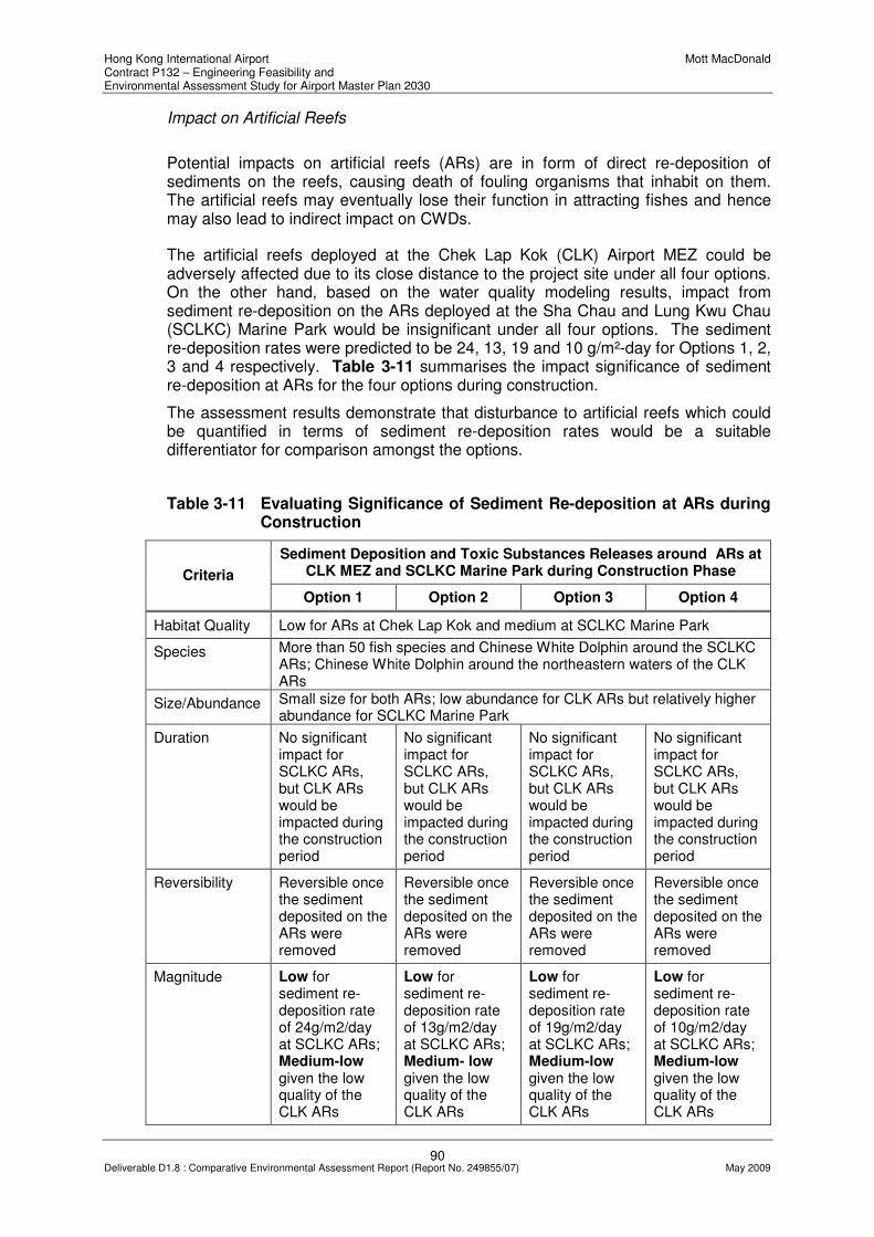
Hong Kong International Airport Mott MacDonald Contract P132 – Engineering Feasibility and Environmental Assessment Study for Airport Master Plan 2030
90 Deliverable D1.8 : Comparative Environmental Assessment Report (Report No. 249855/07) May 2009
Impact on Artificial Reefs
Potential impacts on artificial reefs (ARs) are in form of direct re-deposition of sediments on the reefs, causing death of fouling organisms that inhabit on them. The artificial reefs may eventually lose their function in attracting fishes and hence may also lead to indirect impact on CWDs.
The artificial reefs deployed at the Chek Lap Kok (CLK) Airport MEZ could be adversely affected due to its close distance to the project site under all four options. On the other hand, based on the water quality modeling results, impact from sediment re-deposition on the ARs deployed at the Sha Chau and Lung Kwu Chau (SCLKC) Marine Park would be insignificant under all four options. The sediment re-deposition rates were predicted to be 24, 13, 19 and 10 g/m²-day for Options 1, 2, 3 and 4 respectively. Table 3-11 summarises the impact significance of sediment re-deposition at ARs for the four options during construction.
The assessment results demonstrate that disturbance to artificial reefs which could be quantified in terms of sediment re-deposition rates would be a suitable differentiator for comparison amongst the options.
Table 3-11 Evaluating Significance of Sediment Re-deposition at ARs during Construction
Sediment Deposition and Toxic Substances Releases around ARs at CLK MEZ and SCLKC Marine Park during Construction Phase Criteria
Option 1 Option 2 Option 3 Option 4
Habitat Quality Low for ARs at Chek Lap Kok and medium at SCLKC Marine Park
Species More than 50 fish species and Chinese White Dolphin around the SCLKC ARs; Chinese White Dolphin around the northeastern waters of the CLK ARs
Size/Abundance Small size for both ARs; low abundance for CLK ARs but relatively higher abundance for SCLKC Marine Park
Duration No significant impact for SCLKC ARs, but CLK ARs would be impacted during the construction period
No significant impact for SCLKC ARs, but CLK ARs would be impacted during the construction period
No significant impact for SCLKC ARs, but CLK ARs would be impacted during the construction period
No significant impact for SCLKC ARs, but CLK ARs would be impacted during the construction period
Reversibility Reversible once the sediment deposited on the ARs were removed
Reversible once the sediment deposited on the ARs were removed
Reversible once the sediment deposited on the ARs were removed
Reversible once the sediment deposited on the ARs were removed
Magnitude Low for sediment re-deposition rate of 24g/m2/day at SCLKC ARs; Medium-low given the low quality of the CLK ARs
Low for sediment re-deposition rate of 13g/m2/day at SCLKC ARs; Medium- low given the low quality of the CLK ARs
Low for sediment re-deposition rate of 19g/m2/day at SCLKC ARs; Medium-low given the low quality of the CLK ARs
Low for sediment re-deposition rate of 10g/m2/day at SCLKC ARs; Medium-low given the low quality of the CLK ARs

Hong Kong International Airport Mott MacDonald Contract P132 – Engineering Feasibility and Environmental Assessment Study for Airport Master Plan 2030
91 Deliverable D1.8 : Comparative Environmental Assessment Report (Report No. 249855/07) May 2009
Sediment Deposition and Toxic Substances Releases around ARs at CLK MEZ and SCLKC Marine Park during Construction Phase Criteria
Option 1 Option 2 Option 3 Option 4
Mitigation Measures Required
Not necessary for the impact on SCLKC ARs but required for the ARs at CLK ARs
Not necessary for the impact on SCLKC ARs but required for the ARs at CLK ARs
Not necessary for the impact on SCLKC ARs but required for the ARs at CLK ARs
Not necessary for the impact on SCLKC ARs but required for the ARs at CLK ARs
Indirect Impact from Deterioration in Water Quality on Marine Ecological Sensitive Receivers
Increase in SS concentrations in the water column may cause a change in behaviour of the gill breathing organisms (e.g. fish), which would respond by an increase in breathing rate to expel the excessive SS during respiration. The feeding habit and other behaviours like swimming to other regions may also change in order to accommodate the unfavourable environment. Under adverse events, the silt may clog the gills and suffocate the fish. Significant increase in SS concentrations may block sunlight from penetrating into a deeper region of the water column. Species that depend on sunlight for photosynthesis including corals with photosynthesizing zooxanthellae may be affected. Zooxanthellae will be expelled by the corals if the SS concentrations are so high that cause stress to the corals and eventually coral bleaching may occur. The review of baseline conditions indicated that there are limited hard bottom assemblages within the Northwestern WCZ. Only a few common hard and soft corals were recorded around the hard bottom habitats around the South Brothers, and scattered hermatypic hard corals with gorgonian seawhips and seapens have been identified within the Sha Chau and Lung Kwu Chau Marine Park.
The impacts on these corals of low ecological value are anticipated to be low for Option 4 given the distance from the Marine Park (with predicted maximum SS concentrations of 5mg/l and sediment re-deposition rate of 10g/m²-day at the Marine Park) and medium impact for Option 1 for the works area would be situated closest to the Marine Park (with maximum SS concentrations of 15mg/l and sediment re-deposition rate of 24g/m²-day at Marine Park). The impacts on the South Brothers Colonies are anticipated to be low for all the Options (with maximum SS concentrations <1mg/l at southern waters of South Brothers) given the separation distance. Table 3-12 summarises the impact significance of increased SS concentrations on marine ecological sensitive receivers during the construction period of the project.
As identified earlier, impact from increased SS concentrations on marine ecological sensitive receivers would be a suitable differentiator for options comparison.

Hong Kong International Airport Mott MacDonald Contract P132 – Engineering Feasibility and Environmental Assessment Study for Airport Master Plan 2030
92 Deliverable D1.8 : Comparative Environmental Assessment Report (Report No. 249855/07) May 2009
Table 3-12 Evaluating the Significance of Increase Suspended Sediment Concentrations on the Marine Ecological Sensitive Receivers during Construction
Increase Suspended Sediment Concentrations on the Marine Ecological Sensitive Receivers during Construction Phase Criteria
Option 1 Option 2 Option 3 Option 4
Habitat Quality The open sea is of moderate ecological value; the corals are of low ecological value
Species Fish species utilize the area within and in vicinity to the proposed landform, the corals in South Brothers and SCLKC Marine Park
Size/Abundance Around 743ha of reclamation area and 7.5km of seawall to be removed; medium-low abundance of fish utilizing the existing landform area and medium abundance of fish utilizing the Marine Park area; low abundance of corals in both the Marine Park and the Brothers
Around 790ha of reclamation area and 7.5km of seawall to be removed; medium-low abundance of fish utilizing the existing landform area and medium abundance of fish utilizing the Marine Park area; low abundance of corals in both the Marine Park and the Brothers
Around 827ha of reclamation area and 5.8km of seawall to be removed; medium-low abundance of fish utilizing the existing landform area and medium abundance of fish utilizing the Marine Park area; low abundance of corals in both the Marine Park and the Brothers
Around 819ha of reclamation area and 7.2km of seawall to be removed; medium-low abundance of fish utilizing the existing landform area and medium abundance of fish utilizing the Marine Park area; low abundance of corals in both the Marine Park and the Brothers
Duration During the construction period
During the construction period
During the construction period
During the construction period
Reversibility Irreversible for high SS concentration but reversible for not exceeding the tolerance level for the species
Magnitude Medium for the closest from the Marine Park (with maximum SS concentration of 15mg/l and sediment re-deposition rate of 24g/m2-day); Medium-low for the species utilizing the landform area (due to low ecological value although high SS concentration is anticipated);
Medium for the Marine Park (with maximum SS concentration of 10mg/l and sediment re-deposition rate of 13g/m2-day); Medium-low for the species utilizing the landform area (due to low ecological value although high SS concentration is anticipated); Low for the
Medium for the Marine Park (with maximum SS concentration of 10mg/l and sediment re-deposition rate of 19g/m2-day); Medium-low for species utilizing the landform area (due to low ecological value although high SS concentration is anticipated); Low for the corals at
Low at the Marine Park for the furthest distance (with maximum SS concentration of 5mg/l and sediment re-deposition rate of 10g/m2-day); Medium-low for species utilizing the landform area (due to low ecological value although high SS concentration is anticipated); Low for the

Hong Kong International Airport Mott MacDonald Contract P132 – Engineering Feasibility and Environmental Assessment Study for Airport Master Plan 2030
93 Deliverable D1.8 : Comparative Environmental Assessment Report (Report No. 249855/07) May 2009
Increase Suspended Sediment Concentrations on the Marine Ecological Sensitive Receivers during Construction Phase Criteria
Option 1 Option 2 Option 3 Option 4
Low for the corals at Brothers (with maximum SS concentration of <1mg/l)
corals at Brothers (with maximum SS concentration of <1mg/l)
Brothers (with maximum SS concentration of <1mg/l)
corals at Brothers (with maximum SS concentration of <1mg/l)
Mitigation Measures Required
Yes Yes Yes Yes
Indirect Impact from potential release of toxic substances from dredging activities
Land formation under Options 1, 2 and 3 will involve reclamation within the CMP region. Potential release of toxic substances from the capped mud pits shall be avoided by using appropriate ground treatment methods. As discussed in Chapter 1, after a careful review and consideration of all options available, the use of deep cement mixing (DCM) has been recommended as the being most practical, feasible and environmentally acceptable ground treatment method for reclamation within the CMP region. Dredging of the contaminated mud can be avoided with the use of DCM.
Outside the CMP, dredging will be required before filling at some regions under all four options. Depending on the existing sediment quality, pollutants including toxic substances could be released from the dredged sediments to water columns. Table 3-13 presents a comparison of the four options in terms of significance of impact from potential release of pollutants, including toxic substances on marine ecological sensitive receivers.
Quantity of dredged sediment has already been recommended as a differentiator for options comparison from the waste perspective.
Table 3-13 Evaluating Significance of Impact from Potential Release of Toxic Substances from dredging works on Marine Ecological Sensitive Receivers
Impact of Release of Toxic Substances on the Marine Ecological Sensitive Receivers due to the Dredging Works at Proposed
Landform Area Criteria
Option 1 Option 2 Option 3 Option 4
Habitat Quality The open sea is of moderate ecological value; the corals are of low ecological value
Species Fish species utilize the area within and in the vicinity of the project site, the corals in South Brothers and Sha Chau and Lung Kwu Chau Marine Park
Size/Abundance Around 91.8Mm
3 to be
dredged; medium-low abundance of
Around 110.5Mm
3 to be
dredged; medium-low abundance of
Around 90.9Mm
3 to be
dredged; medium-low abundance of
Around 123.6Mm
3 to be
dredged; medium-low abundance of

Hong Kong International Airport Mott MacDonald Contract P132 – Engineering Feasibility and Environmental Assessment Study for Airport Master Plan 2030
94 Deliverable D1.8 : Comparative Environmental Assessment Report (Report No. 249855/07) May 2009
Impact of Release of Toxic Substances on the Marine Ecological Sensitive Receivers due to the Dredging Works at Proposed
Landform Area Criteria
Option 1 Option 2 Option 3 Option 4
fish utilizing the existing landform area and medium abundance of fish utilizing the Marine Park area; low abundance of corals in both the Marine Park and the Brothers
fish utilizing the existing landform area and medium abundance of fish utilizing the Marine Park area; low abundance of corals in both the Marine Park and the Brothers
fish utilizing the existing landform area and medium abundance of fish utilizing the Marine Park area; low abundance of corals in both the Marine Park and the Brothers
fish utilizing the existing landform area and medium abundance of fish utilizing the Marine Park area; low abundance of corals in both the Marine Park and the Brothers
Duration During the construction period
During the construction period
During the construction period
During the construction period
Reversibility Reversible if the dosage release is low or remediation of toxic substances release was carried out
Reversible if the dosage release is low or remediation of toxic substances release was carried out
Reversible if the dosage release is low or remediation of toxic substances release was carried out
Reversible if the dosage release is low or remediation of toxic substances release was carried out
Magnitude Medium for the large quantity to be dredged
Medium for the large quantity to be dredged
Medium for the large quantity to be dredged
High for the largest quantity to be dredged
Mitigation Measures Required
Yes Yes Yes Yes
Impact on Capture and Culture Fisheries
The proposed reclamation will lead to an increase in SS concentrations in the water column and this may disturb the fisheries production in the region during the construction phase of the project. The reclamation will also cause direct loss of habitats for capture fisheries activities. The proposed land formation areas for the four options and the Ma Wan Fish Culture Zone (FCZ) are of medium-low fisheries production (around 100-200kg/ha in 2005) with medium fisheries value (HK$2000-5000/ha in 2005), while the area at Sha Chau and Lung Kwu Chau Marine Park, the area at the northwestern Lantau water and the area at Chek Lap Kok Artificial Reefs are of medium fisheries production (around 300-400kg/ha in 2005) with high fisheries value (around HK$5000-10000/ha in 2005). Therefore, the disturbance/impacts due to the increase in SS concentrations may be higher for Option 1 for the works site involved is situated closer to the area with medium fisheries production and high fisheries value.
Based on the preliminary water quality modeling results, construction activities have not result in any significant impact on culture fisheries at Ma Wan FCZ under all four options. Table 3-14 summarises the significance of fisheries impacts for the four options.

Hong Kong International Airport Mott MacDonald Contract P132 – Engineering Feasibility and Environmental Assessment Study for Airport Master Plan 2030
95 Deliverable D1.8 : Comparative Environmental Assessment Report (Report No. 249855/07) May 2009
As shown in the table, the indirect disturbance on capture fisheries in terms of (i) fisheries production (ii) fishing operation and (iii) loss in fisheries value would be slightly different amongst the options, though the level of impacts is considered low. These aspects are identified as suitable differentiators accordingly for the options comparison from the perspective of construction phase fisheries impact.
Table 3-14 Evaluating Significance of Fisheries Impacts during Construction
Impact of Direct Habitat Losses and Indirect Disturbances on Capture and Culture Fisheries Criteria
Option 1 Option 2 Option 3 Option 4
Nature of Impact The impact of habitat losses is permanent and irreversible; the disturbance impacts are temporary and reversible
Size of Affected Area
Around 743ha of fisheries habitat will be lost
Around 790ha of fisheries habitat will be lost
Around 827ha of fisheries habitat will be lost
Around 819ha of fisheries habitat will be lost
Loss of fisheries resources / production
Medium-low production of fish (around 74,300-148,600kg or around 0.10% of yearly production) with medium value (around HK$1115k-2601k or 0.17% of yearly value) utilizing the existing landform area will be lost. Impact is considered to be low
Medium-low abundance of fish (around 79,000-158,000kg or around 0.10% of yearly production) with medium value (around HK$1185k-2765k or 0.18% of yearly value) utilizing the existing landform area will be lost. Impact is considered to be low
Medium-low abundance of fish (around 82,700-165,400kg or around 0.11% of yearly production) with medium value (around HK$1241k-2895k or 0.19% of yearly value) utilizing the existing landform area will be lost. Impact is considered to be low
Medium-low abundance of fish (around 81,900-163,800kg or around 0.11% of yearly production) with medium value (around HK$1092k-2457k or 0.16% of yearly value) utilizing the existing landform area will be lost. Impact is considered to be low
Destruction and disturbance of nursery and spawning grounds
The central northwestern waters off Lantau have previously been identified as a seasonal spawning ground for commercially important species. The construction and operation of the proposed development is predicted to cause moderate-minor disturbances to the spawning area as all the Options are extending to the northwestern Lantau though not within the spawning area.
Impact on fishing activity
100-400 vessels may be affected, i.e. around 2.5-10% of fishing vessels in HK
100-400 vessels may be affected, i.e. around 2.5-10% of fishing vessels in HK
200-400 vessels may be affected i.e. around 5-10% of fishing vessels in HK
200-400 vessels may be affected i.e. around 5-10% of fishing vessels in HK
Impact on aquaculture activity
Insignificant Impact at the Ma Wan FCZ due to the long distance from the proposed development

Hong Kong International Airport Mott MacDonald Contract P132 – Engineering Feasibility and Environmental Assessment Study for Airport Master Plan 2030
96 Deliverable D1.8 : Comparative Environmental Assessment Report (Report No. 249855/07) May 2009
Operational Phase Assessment
Direct Habitat Loss The proposed Airport expansion inevitably requires reclamation for formation of new land. The open sea area, which is currently used by CWDs and in fisheries activities will be lost permanently. The seabed that provides habitats for sub-tidal benthos within the proposed land formation area will be smothered by the reclamation works which cause permanent loss of soft bottom seabed and associated wildlife. Permanent loss of artificial seawall at the northern and western Chek Lap Kok coast to be reclaimed will also occur. The works area of around 500m offset from the reclamation boundary will be temporarily disturbed due to the dredging and filling works. The temporarily disturbed marine waters and soft bottom seabed will be recovered by natural process after the completion of construction. Table 3-15 summarises the estimated permanent and temporary loss in habitats for the four options.
Table 3-15 Estimated Loss in Habitats
Permanent Loss (ha) Temporary Loss/Disturbance (ha) Habitat Type/ Options
Option 1 Option 2 Option 3 Option 4 Option 1 Option 2 Option 3 Option 4
Soft Bottom Seabed
743 790 827 819 944 857 590 788
Artificial Seawall
Around 7.5 km
Around 7.5 km
Around 5.8 km
Around 7.2 km
-- -- -- --
Open Sea 743 790 827 819 944 857 590 788
All four options are associated with a significant loss in soft bottom seabed, artificial seawall and open sea habitats permanently. The significance of impacts on the loss of soft bottom seabed will be moderate given the low ecological value, but this currently supports a medium-low fisheries production. Impact from the loss of the existing artificial seawall is anticipated to be low, given the low ecological value, the young age and the man-made nature of the seawall. The loss of the open sea area will be of high significance for all four options, since this habitat provides nursery or feeding ground for the CWD and as fisheries resources. The effect of habitat loss will be low for the marine soft bottom benthos and intertidal fauna as no species of conservation concern was recorded in their associated habitats.
Table 3-16 summarises the significance of impacts from the loss of the habitats discussed above.

Hong Kong International Airport Mott MacDonald Contract P132 – Engineering Feasibility and Environmental Assessment Study for Airport Master Plan 2030
97 Deliverable D1.8 : Comparative Environmental Assessment Report (Report No. 249855/07) May 2009
Table 3-16 Evaluating the Significance of Impacts on Marine Wildlife due to Habitat Loss
Habitat Loss Criteria
Soft Bottom Seabed Artificial Seawall Open Sea
Habitat Quality Low Low Moderate
Species Marine benthos typical of Hong Kong, dominated by polychaetes with no rare and species of conservation value be affected
Common coastal fauna and coral communities typical to those inhabit in newly constructed artificial seawall will be affected
Chinese White Dolphin and marine fishes of higher conservation concern will be affected
Size/Abundance Large area to be affected for all of the 4 Options
Around 7.5km of the existing seawall will be affected in Option 1 and Option 2. Around 5.8km and 7.2km of the artificial seawall at CLK will be affected for Option 3 and Option 4.
Large area to be affected for all of the 4 Options
Duration The habitat will be permanently loss
The habitat will be permanently loss
The habitat will be permanently loss
Reversibility Not reversible Reversible Not reversible
Magnitude Moderate for all Options due to the low ecological value but support medium-low fisheries resources and the large area to be affected
Low due to the young age of the artificial seawall
High for all Options due to large area to be affected and the impact on species of conservation concern
Mitigation Measures Required
Yes Yes if coral is identified
Yes
Direct Loss of Marine Flora and Fauna
During the construction phase, the proposed reclamation will inevitably cause direct loss of soft bottom marine benthos and intertidal flora and fauna within the works area. The increase in sediments concentrations resulting from filling and dredging activities may cause direct smothering of the marine benthos and intertidal wildlife utilizing the habitats, if unmitigated.
The existing baseline showed that the marine soft bottom benthos and coastal flora and fauna recorded at the Chek Lap Kok artificial seawall are of low ecological concern and of low abundance. The impact of direct loss of these marine flora and fauna during the construction is therefore considered to be of low significance for all four Airport expansion options. These are summarised in Table 3-17 based on the criteria set out in Annex 8 of the EIAO-TM.

Hong Kong International Airport Mott MacDonald Contract P132 – Engineering Feasibility and Environmental Assessment Study for Airport Master Plan 2030
98 Deliverable D1.8 : Comparative Environmental Assessment Report (Report No. 249855/07) May 2009
Table 3-17 Evaluating the Significance of Impacts on the Direct Loss of Flora and Fauna
Direct Loss of Marine Flora and Fauna during Construction Phase Criteria
Option 1 Option 2 Option 3 Option 4
Habitat Quality The soft bottom seabed and artificial seawall are of low habitat quality
The soft bottom seabed and artificial seawall are of low habitat quality
The soft bottom seabed and artificial seawall are of low habitat quality
The soft bottom seabed and artificial seawall are of low habitat quality
Species No species of conservation concern recorded
No species of conservation concern recorded
No species of conservation concern recorded
No species of conservation concern recorded
Size/Abundance Low abundance of wildlife
Low abundance of wildlife
Low abundance of wildlife
Low abundance of wildlife
Duration During the construction period
During the construction period
During the construction period
During the construction period
Reversibility Soft bottom benthos and intertidal fauna are short-lived which will recolonize to similar habitats.
Soft bottom benthos and intertidal fauna are short-lived which will recolonize to similar habitats.
Soft bottom benthos and intertidal fauna are short-lived which will recolonize to similar habitats.
Soft bottom benthos and intertidal fauna are short-lived which will recolonize to similar habitats.
Magnitude Low Low Low Low
Mitigation Measures Required
No No No No
The Impacts of New Marine Exclusion Zone
It is envisaged that a new Marine Exclusion Zone (MEZ) would be implemented for the airport expansion. For Option 1, the new MEZ may extend outside the Hong Kong marine waters boundary to the west and would be lying very close to the boundary of Sha Chau and Lung Kwu Chau Marine Park. This will discourage fishermen from fishing close to the surrounding areas, especially at the northwestern water.
The future MEZ for Option 2 may also similarly extend outside the Hong Kong marine waters boundary to the west, making access to the northwestern Lantau where high fisheries production is found more inconvenient to fishermen.
Option 4 will have the same issue as Option 2 of discouraging the fisherman from fishing at the northwestern Lantau. Option 3 is comparatively better in terms of the wider separation between the new marine exclusion zone and the Marine Park as well as the boundary of Hong Kong marine waters.

Hong Kong International Airport Mott MacDonald Contract P132 – Engineering Feasibility and Environmental Assessment Study for Airport Master Plan 2030
99 Deliverable D1.8 : Comparative Environmental Assessment Report (Report No. 249855/07) May 2009
3.5.4 Differentiators identified from Assessment
With consideration of the findings of the preliminary and focused assessments, the following key differentiators have been identified for options comparison from the perspectives of marine ecology and fisheries impact.
Marine Ecology
Construction Phase
• Disturbance to nursery grounds of Hourseshoe Crabs;
• Impact of increased SS concentrations on marine ecological sensitive receivers; and
• Disturbance to existing coral and artificial reefs;
Operational Phase
• Loss of intertidal habitats;
• Loss of soft-bottom habitats; and
• Loss of coral communities
Fisheries
Construction Phase
• Disturbance to fisheries production;
• Disturbance to fishing operation;
• Loss in fisheries value due to construction;
Operational Phase
• Permanent loss in fisheries production;
• Habitat loss;
• Impact on fishing operation;
• Impact on fisheries value; and
• Impact of MEZ on fishing operation
3.5.5 Summary of Focused Impact Assessment
Construction Phase
Potential impact on marine ecology during the construction phase of the project has been evaluated further in the focused assessment. The key issues studied include indirect disturbance to CWDs; indirect disturbance to SSSIs; impact on nursery and breeding grounds of Horseshoe Crabs; impact on Sha Chau and Lung Kwu Chau Marine Park; impact on artificial reefs; indirect impact from deterioration in water quality on marine ecological sensitive receivers, including corals; and indirect impact from potential release of toxic substances from dredging activities. On the other

Hong Kong International Airport Mott MacDonald Contract P132 – Engineering Feasibility and Environmental Assessment Study for Airport Master Plan 2030
100 Deliverable D1.8 : Comparative Environmental Assessment Report (Report No. 249855/07) May 2009
hand, significance of fisheries impact during the construction phase has also been further evaluated. Findings of the further assessment have allowed the identification of relevant differentiators for options comparison.
Operational Phase
The key marine ecology issues that apply to all four options are permanent loss in habitats, including intertidal habitats, soft-bottom habitats and coral communities. Impact from direct loss of marine flora and fauna is not anticipated to be significant. The new MEZ would pose impact on fishing operation and the level of impact is expected to be different amongst the four options. Relevant differentiators have been identified accordingly to facilitate the options evaluation process.
3.6 Noise
3.6.1 Differentiators
Based on the preliminary environmental assessment presented in Section 2.4, the differentiators identified from the noise perspective include:
Construction Phase
• Cumulative noise impact on NSRs due to concurrent projects, measured in terms of closest distance between the Airport expansion options and other concurrent projects
Operational Phase
• Number of NSRs which are affected or covered in the NEF25 contours
3.6.2 Assessment Methodology
Relevant criteria and guidelines set out in Annexes 5 and 13 of the EIAO-TM have been observed in the focused assessment undertaken to facilitate options comparison.
3.6.3 Focused Impact Assessment
Construction Phase
Noise Sources
Construction of the Airport expansion will inevitably requires reclamation for land formation. During the various stages of construction works including ground treatments such as dredging of marine sediment, filling, seawall construction and subsequent infrastructure and building construction, various Powered Mechanical Equipment (PME) will be deployed and their operation may generate noise impact on the nearby NSRs during the construction phase.
Based on the current engineering design, it is envisaged that no blasting and marine percussive piling activities would be required for construction of the Airport expansion.

Hong Kong International Airport Mott MacDonald Contract P132 – Engineering Feasibility and Environmental Assessment Study for Airport Master Plan 2030
101 Deliverable D1.8 : Comparative Environmental Assessment Report (Report No. 249855/07) May 2009
Impact Evaluation
The identified NSRs at San Shek Wan, Tin Sum, Yat Tung Estate and Tung Chung Town are situated at distances ranging from 0.8 to 3.7km to the nearest construction site boundary. Given the significant separation distance, noise generated from operation of PME would be attenuated to acceptable levels at these NSRs. Besides, as the existing airport will be situated between the construction noise sources and the NSRs, the existing buildings at HKIA may help shield part of the construction noise generated.
NSRs at Sha Lo Wan village is located at about 400 meters from the construction site. Construction noise could be effectively minimised by this order of separation distance. Implementation of practicable mitigation measures such as quiet plants and movable noise barriers will ensure that all potential noise impact is alleviated to an acceptable level.
Cumulative Impact
Cumulative noise impact may be encountered during the construction phase of the airport expansion due to overlapping with construction programme(s) of other concurrent project(s) such as the Hong Kong-Zhuhai-Macao Bridge (HKZMB), the HKZMB Hong Kong Boundary Crossing Facilities (HKBCF) and the Tuen Mun – Chek Lap Kok Link Road (TM-CLK Link). The cumulative noise impact could be significant if the construction noise impacts from other concurrent projects are already close to the criterion.
Subject to findings of quantitative assessments to be undertaken as part of the EIA in Phase 2 of the study, it is envisaged that concurrent construction projects may pose some cumulative noise impact on NSRs at Sha Lo Wan village, as the proposed HKZMB is located at about 250m to the north of the NSR i.e., close to the works area of Options 1, 2 and 4. Levels of potential cumulative impact and mitigation measures required will be identified as part of the Phase 2 study.
“Closest distance between the nearest boundary of the Airport expansion options and other concurrent projects” has been proposed as a differentiator for options comparison and these are summarised in Table 3-18.
Table 3-18 Differentiator for Cumulative Construction Noise Impact
Differentiator Option 1 Option 2 Option 3 Option 4
Closest distance between the Options and other construction
project(s), km* 0.3 0.3 0.8 0.2
* Note: the nearest project boundary of HKZMB was used for measurement for options 1, 2 and 4; while the nearest boundary of HKBCF was used for measurement for Option 3, as the distance to HKBCF is shorter than that to HKZMB for this option.
Operational Phase
Aircraft Noise
Aircraft noise is presented by Noise Exposure Forecast (NEF), which is a parameter that integrates the duration of flyover, the peak noise level, the tonal characteristics and the number of aircraft movements both in the daytime and night-time periods. Contours of NEF are used to predict the level of impact of aircraft noise in the area

Hong Kong International Airport Mott MacDonald Contract P132 – Engineering Feasibility and Environmental Assessment Study for Airport Master Plan 2030
102 Deliverable D1.8 : Comparative Environmental Assessment Report (Report No. 249855/07) May 2009
of Hong Kong region. The NEF standard is NEF25 for residential NSRs. The standard is not applicable to air-conditioned receivers such as hotels, hospitals, schools and offices, etc.
Air Traffic Forecast
One of the key parameters for the prediction of NEF is the number of aircraft movements, which would affect the coverage of the projected contours. The Air Traffic Movement (ATM) in 2007 was about 295,000. With an average annual growth of 3.1%, the total ATM is predicted to be around 599,330 in 203053. The overall growth is more than 200% between 2007 and 2030. Hence the ATM growth makes aircraft noise a key environmental issue.
Preliminary NEF Contours for Expansion Options
Preliminary NEF Contours have been generated for Options 1, 3 and 4 by an independent consultancy Preliminary Noise Contour Analysis for Third Runway Alternatives of AAHK. The latest (Feb 2009) projected contours representing the impact levels of aircraft noise in the Hong Kong region are shown in Drawings MMH/P132/NSK/3802. A detailed NEF study would be carried out for the Preferred Option in the next stage. At this stage, the NEF contours from the preliminary study are adopted for options comparison from the perspective of aircraft noise impact.
Although the preliminary noise contour analysis does not cover option 2, compared with Option 3, it can be noted that the proposed runway is shifted to the west for 1.2km, while maintaining the same separation distance to the existing north runway. For the purpose of the options evaluation exercise, it was assumed that the Option 2 would adopt the same flight path and operation mode as for Option 3 such that the preliminary NEF contour obtained for Option 3 can be made reference to for evaluating the aircraft noise impact for Option 2.
Impact Evaluation
Four groups of NSRs have been identified as dominant receptors that could be affected by aircraft noise after the airport expansion. They are located in areas of Gold Coast, Tai Lam Chung, Ma Wan and Northern Lantau. The preliminary noise contour analysis suggested that the levels of aircraft noise impact on these areas would vary among the Airport expansion options. The potentially affected residential premises in the named regions are summarized in Table 3-19.
53
URS (2008), Preliminary Noise Contour Analysis for Third Runway Alternatives – Final Assumption Report
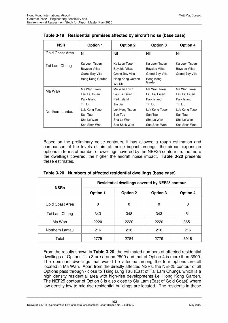
Hong Kong International Airport Mott MacDonald Contract P132 – Engineering Feasibility and Environmental Assessment Study for Airport Master Plan 2030
103 Deliverable D1.8 : Comparative Environmental Assessment Report (Report No. 249855/07) May 2009
Table 3-19 Residential premises affected by aircraft noise (base case)
NSR Option 1 Option 2 Option 3 Option 4
Gold Coast Area Nil Nil Nil Nil
Tai Lam Chung Ka Loon Tsuen
Bayside Villas
Grand Bay Villa
Hong Kong Garden
Ka Loon Tsuen
Bayside Villas
Grand Bay Villa
Hong Kong Garden
Wu Uk
Ka Loon Tsuen
Bayside Villas
Grand Bay Villa
Hong Kong Garden
Ka Loon Tsuen
Bayside Villas
Grand Bay Villa
Ma Wan Ma Wan Town
Lau Fa Tsuen
Park Island
Tin Liu
Ma Wan Town
Lau Fa Tsuen
Park Island
Tin Liu
Ma Wan Town
Lau Fa Tsuen
Park Island
Tin Liu
Ma Wan Town
Lau Fa Tsuen
Park Island
Tin Liu
Northern Lantau Luk Keng Tsuen
San Tau
Sha Lo Wan
San Shek Wan
Luk Keng Tsuen
San Tau
Sha Lo Wan
San Shek Wan
Luk Keng Tsuen
San Tau
Sha Lo Wan
San Shek Wan
Luk Keng Tsuen
San Tau
Sha Lo Wan
San Shek Wan
Based on the preliminary noise contours, it has allowed a rough estimation and comparison of the levels of aircraft noise impact amongst the airport expansion options in terms of number of dwellings covered by the NEF25 contour i.e. the more the dwellings covered, the higher the aircraft noise impact. Table 3-20 presents these estimates.
Table 3-20 Numbers of affected residential dwellings (base case)
Residential dwellings covered by NEF25 contour
NSRs
Option 1 Option 2 Option 3 Option 4
Gold Coast Area 0 0 0 0
Tai Lam Chung 343 348 343 51
Ma Wan 2220 2220 2220 3651
Northern Lantau 216 216 216 216
Total 2779 2784 2779 3918
From the results shown in Table 3-20, the estimated numbers of affected residential dwellings of Options 1 to 3 are around 2800 and that of Option 4 is more than 3900. The dominant dwellings that would be affected among the four options are all located in Ma Wan. Apart from the directly affected NSRs, the NEF25 contour of all Options pass through / close to Tsing Lung Tau (East of Tai Lam Chung), which is a high density residential area with high-rise developments i.e. Hong Kong Garden. The NEF25 contour of Option 3 is also close to Siu Lam (East of Gold Coast) where low density low-to-mid-rise residential buildings are located. The residents in these

Hong Kong International Airport Mott MacDonald Contract P132 – Engineering Feasibility and Environmental Assessment Study for Airport Master Plan 2030
104 Deliverable D1.8 : Comparative Environmental Assessment Report (Report No. 249855/07) May 2009
areas are expected to experience significant aircraft noise impact although the noise criterion is complied with in these areas.
With possible use of an alternative operation mode as proposed in the Preliminary Noise Contour Analysis for Third Runway Alternatives study, a sensitive test was carried out for the four options accordingly to assess the change in aircraft noise impact. The projected aircraft noise contours of the sensitivity analysis are shown in Drawings MMH/P132/NSK/3803. The directly affected residential premises in these areas of different options are listed in Table 3-21 and the numbers of affected dwellings are estimated and summarized in Table 3-22.
Table 3-21 Residential premises affected by aircraft noise (sensitivity test)
NSR Option 1 Option 2 Option 3 Option 4
Gold Coast Area Aqua Blue Nil Nil Nil
Tai Lam Chung Ka Loon Tsuen
Bayside Villas
Grand Bay Villa
Hong Kong Garden
Ka Loon Tsuen
Bayside Villas
Grand Bay Villa
Hong Kong Garden
Wu Uk
Ka Loon Tsuen
Bayside Villas
Grand Bay Villa
Hong Kong Garden
Wu Uk
Ka Loon Tsuen
Bayside Villas
Grand Bay Villa
Hong Kong Garden
Ma Wan Ma Wan Town
Lau Fa Tsuen
Park Island
Tin Liu
Ma Wan Town
Lau Fa Tsuen
Park Island
Tin Liu
Ma Wan Town
Lau Fa Tsuen
Park Island
Tin Liu
Ma Wan Town
Lau Fa Tsuen
Park Island
Tin Liu
Northern Lantau Luk Keng Tsuen
San Tau
Sha Lo Wan
San Shek Wan
Luk Keng Tsuen
San Tau
Sha Lo Wan
San Shek Wan
Luk Keng Tsuen
San Tau
Sha Lo Wan
San Shek Wan
Luk Keng Tsuen
San Tau
Sha Lo Wan
San Shek Wan
Table 3-22 Number of affected residential dwellings (sensitivity test)
Residential dwellings covered by NEF25 contour
NSR
Option 1 Option 2 Option 3 Option 4
Gold Coast Area 143 0 0 0
Tai Lam Chung 343 348 348 343
Ma Wan 465 465 465 2971
Northern Lantau 216 216 216 216
Total 1167 1029 1029 3530
As revealed from the findings presented in Table 3-22, the alternative operation mode would provide obvious benefits in terms of reducing the total number of residential dwellings that would be subject to aircraft noise impact. Compared with the base case, the number of affected dwellings at Ma Wan would reduce

Hong Kong International Airport Mott MacDonald Contract P132 – Engineering Feasibility and Environmental Assessment Study for Airport Master Plan 2030
105 Deliverable D1.8 : Comparative Environmental Assessment Report (Report No. 249855/07) May 2009
substantially under all four options. This potential enhancement in environmental performance in terms of reduced aircraft noise has been further evaluated in Chapter 5.
3.6.4 Summary of Focused Impact Assessment
During the construction phase, NSRs at Sha Lo Wan could be subject to cumulative noise impact from concurrent construction activities, though given the separation distance involved it is envisaged that the noise impact can be alleviated to acceptable level through provision of standard noise control measures. Closest distance between the nearest site boundary of the options and other construction sites has been identified as a differentiator for options comparison.
Based on the preliminary NEF Contours generated for Options 1, 3 and 4 in a separate consultancy of AAHK, the number of residential dwellings that would be affected by aircraft noise was estimated and compared. With the possible use of an alternative operation mode, it was predicted that the number of potentially affected residential premises can be reduced.
3.7 Air Quality
3.7.1 Differentiators
Based on the preliminary environmental assessment presented in Section 2.2, the differentiator identified from the air quality perspective is airport operational efficiency during the operational phase.
3.7.2 Assessment Methodology
Relevant criteria and guidelines set out in Annexes 4 and 12 of the EIAO-TM have been observed in the focused assessment undertaken to facilitate options comparison.
3.7.3 Focused Impact Assessment
As pointed out in Section 2.2, as quantitative analysis of air quality impact will only be undertaken during Phase 2 of the study, it is not possible to give a comparison of the four Airport expansion options on fully quantitative terms. However, there would still be merit in evaluating the localised air quality impacts that may arise from the differences in operating efficiency of the airport based on the four Airport layout options. It is noted that the higher the operational efficiency of an airport layout option, the lower will be the emission level of air pollutants at any given activity level.
Table 2-23 presents the airport operational efficiency achievable with each of the four airport layout options as presented in the deliverable D7 – Airport Layout Options of Contract C009-08. As shown, Option 4 is comparatively less efficient than the other options in terms of operational efficiency.
Hong Kong International Airport Mott MacDonald Contract P132 – Engineering Feasibility and Environmental Assessment Study for Airport Master Plan 2030
106 Deliverable D1.8 : Comparative Environmental Assessment Report (Report No. 249855/07) May 2009
Table 3-23 Operational efficiency achievable with the airport layout options
Differentiator Option 1 Option 2 Option 3 Option 4
Operational efficiency (ultimate capacity in operations
per hour) 102 102 102 97
Note (*) Source: Contract C009-08 deliverable D7 - Airport Layout Options (Dec 2008)
3.7.4 Summary of Focused Impact Assessment
A comparison of the four Airport expansion options in terms of operational efficiency suggests that Option 4 is comparative less efficient than that of Options 1, 2 and 3.
3.8 Landscape and Visual Impacts
3.8.1 Differentiator
The preliminary environmental assessment presented in Section 2.10 suggests that potential landscape and visual impact may be included as a differentiator for comparing the four Airport expansion options.
3.8.2 Assessment Methodology
Relevant criteria and guidelines set out in Annexes 10 and 18 of the EIAO-TM have been observed in the focused assessment undertaken to facilitate options comparison.
3.8.3 Focused Impact Assessment
Potential landscape and visual impact may be resulted during the construction and operational phases of the airport expansion. The impact is mainly induced on the water landscape to the north and west of the existing airport due to the loss of the landscape resource due to reclamation. The change would be permanent and irreversible.
However, the proposed Airport expansion would form part of the existing airport which is also considered as a landscape resource. The compatibility and harmony with the nearby environment could be preserved. The height of the new facility and building structures, mainly the runway, passenger and cargo stands, would also be similar to that of the existing facilities.
The visual impact of the airport expansion to the VSRs located within the existing airport island is expected to be low as these VSRs are people working in the environment of an operating airport or flight.
The visual impact of the airport expansion to the VSRs of visitors of Lantau located is also expected to be low as these VSRs are transient in nature.
The level of visual impact to the residential VSRs depends on the distance between the proposed expansion and the VSRs, also the design and height of the facility buildings. At this stage a simplified differentiator in terms of the distance to

Hong Kong International Airport Mott MacDonald Contract P132 – Engineering Feasibility and Environmental Assessment Study for Airport Master Plan 2030
107 Deliverable D1.8 : Comparative Environmental Assessment Report (Report No. 249855/07) May 2009
residential VSRs is adopted for the evaluation of the potential visual impact associated with the four options. It is assumed that the closer the residential VSRs to the proposed boundary of the Airport expansion option, the higher the level of visual impact would be for the VSRs.
Table 3-24 Distances from Residential VSRs
Distance (km) between residential VSRs and nearest site boundary of options
Residential VSRs
Option 1 Option 2 Option 3 Option 4
Sha Lo Wan
0.8 0.8 1.9 0.5
Tung Chung
3.4 3.4 3.4 3.7
3.8.4 Summary of Focused Impact Assessment
Potential visual impact to VSRs depends on distance between the proposed Airport expansion and the VSRs. The four Airport expansion options have been compared accordingly for the residential VSRs located in Sha Lo Wan and Tung Chung. It is noted that all options are located at more than 3km from Tung Chung. Potential visual impact on VSRs in Tung Chung is therefore unlikely to be a concern. For the nearest residential VSRs in Sha Lo Wan, Option 4 may potentially perform less well than the other options though it is expected that this can be effectively mitigated through enhancing the aesthetic value of the airport expansion.

Hong Kong International Airport Mott MacDonald Contract P132 – Engineering Feasibility and Environmental Assessment Study for Airport Master Plan 2030
108 Deliverable D1.8 : Comparative Environmental Assessment Report (Report No. 249855/07) May 2009
4. SUMMARY OF OPTIONS COMPARISON
4.1 Introduction
This section summarises the findings of the preliminary and focused comparative environmental assessments presented in Sections 2 and 3 for the four Airport expansion options in form of:
• levels of environmental impact based on each differentiator;
• ranking based each key environmental aspect; and
• overall ranking based on all key environmental factors.
4.2 Comparison Methodology
For the differentiators identified under each key environmental aspect, an indication was given as to whether the differentiators were of interest during the construction or operational phase. Under each construction or operational phase related differentiator identified, the environmental performance of the four Airport expansion options were, based on the findings of the preliminary and focused assessments, summarised, on relative terms, as either:
• “L” – representing “low” level of environmental impact;
• “M” – representing “medium” level of environmental impact; or
• “H” – representing “high” level of environmental impact
Based on the environmental performance of the options evaluated, the four options were given a relative ranking of “1” to “4” with respect to each key environmental aspect, with “1” representing the best option and “4” representing the least preferred option under the environmental aspect considered. In evaluating the relative ranking of the options, best professional judgement from environmental perspective was exercised, giving more focus on key environmental impacts that were regarded as long-term and irreversible i.e., environmental impacts during the operational phase.
The assessment results were then summarised in terms of frequency (as counts and as percentage of total count) for four options under all Ranks 1, 2, 3 and 4. Finally, an overall rank of the options is generated based on the relative frequency of Rank 1 alone, as well as Ranks 1 and 2.
Appendix 4A presents a matrix that summarises the key information and data generated from the preliminary and focused assessments that facilitated the options comparison exercise.
4.3 Findings of Comparison
Table 4-1 summarises the levels of environmental impact (i.e., L, M or H) identified for all four Airport expansion options based on the differentiators under each key environmental aspect for both the construction and operational phases. Further details regarding the classification in form of explanatory notes are given with the evaluation spreadsheet presented in Appendix 4B.

Hong Kong International Airport Mott MacDonald Contract P132 – Engineering Feasibility and Environmental Assessment Study for Airport Master Plan 2030
109 Deliverable D1.8 : Comparative Environmental Assessment Report (Report No. 249855/07) May 2009
Table 4-2 presents the relative ranking of the four options for all environmental aspects considered and summarises the key environmental factors that drive the relative ranking of the four options.
Table 4-3 presents the frequency, as counts and percentage of total count of the options for all Ranks 1 to 4; and the overall ranking based on findings from Rank 1 alone, as well as Ranks 1 and 2.
Table 4-1 Summary of Environmental Impact Levels
Level of Environmental Impact Key Environmental Aspect
Differentiators Option 1 Option 2 Option 3 Option 4
Construction Phase:
- Disturbance to CWD feeding grounds
M M M H
- Disturbance to dolphin calves M M M H
Operational Phase:
- Habitat loss M M M H
- Permanent loss of feeding grounds
M M M H
Chinese White Dolphins (CWDs)
- Proximity of northern site boundary to Sha Chau & Lung Kwu Chau Marine Park (and hence increased chance of CWD injury due to collision with vessels)
H M M L
Construction Phase:
- Disturbance to fisheries production
L L L L
- Disturbance to fishing operation
L L L L
- Loss in fisheries value due to construction
L L L L
Operational Phase:
- Permanent loss in fisheries production
L L L L
- Habitat loss M M M M
- Fishing operation L L L L
- Fisheries value L L L L
Fisheries
- Impact of Marine Exclusion Zone (MEZ) on fisheries operation
H H M M

Hong Kong International Airport Mott MacDonald Contract P132 – Engineering Feasibility and Environmental Assessment Study for Airport Master Plan 2030
110 Deliverable D1.8 : Comparative Environmental Assessment Report (Report No. 249855/07) May 2009
Level of Environmental Impact Key Environmental Aspect
Differentiators Option 1 Option 2 Option 3 Option 4
Construction Phase:
- Disturbance to Horseshoe Crabs nursery grounds
M M L M
- Impact of increased SS concentrations on marine ecological sensitive receivers
M M M M
- Disturbance to existing coral and artificial reefs
L L L L
Operational Phase:
- Loss of intertidal habitats L L L L
- Loss of soft-bottom habitats M M M M
Marine Ecology
- Loss of coral communities L L L L
Construction Phase:
Waste - Quantity of dredged sediment (from non-CMP region)
M H M H
Construction Phase:
- Increase in SS concentrations at WSRs
M M L H
Operational Phase:
- Change in tidal flow M M L H
- Erosion of seabed H M L L
- Change in flushing capacity at existing Airport channel
L L L M
Water Quality & Hydrodynamics
- Potential water quality impact from poorly flushed embayment
M H M M
Construction Phase:
- Cumulative impact due to concurrent projects on NSRs
M M L M
Operational Phase:
Noise
- No. of dwellings situated within NEF25 contour
H H H H
Air Quality Operational Phase:
- Airport operational efficiency
M M M H

Hong Kong International Airport Mott MacDonald Contract P132 – Engineering Feasibility and Environmental Assessment Study for Airport Master Plan 2030
111 Deliverable D1.8 : Comparative Environmental Assessment Report (Report No. 249855/07) May 2009
Level of Environmental Impact Key Environmental Aspect
Differentiators Option 1 Option 2 Option 3 Option 4
Visual Construction & Operational Phases:
- Distance to VSRs (Sha Lo
Wan) M M L M
- Distance to VSRs (Tung
Chung) L L L L
Table 4-2 Ranking of Options under all Key Environmental Aspects
Relative Ranking of Options Key Environmental Aspect and Differentiators
Option 1 Option 2 Option 3 Option 4
- The extent and location of reclamation is as such that this option is situated closest to the Marine Park, resulting in “high” disturbance to CWDs during the operational phase. The other impacts during the construction & operational phase are judged to be of “medium” significance
- This option performs relatively similar to Option 3, but potentially affects higher number of CWDs due to more significant loss of habitat loss (based on DPSE data). Extent of loss of feeding grounds is also lower than that of Options 1 and 4. Potential impacts during the construction and operational phases are judged to be of “medium” significance
- The performance of this option is comparable to that of Option 2, though the option may perform slightly better than 2 in term of habitat loss. Extent of loss of feeding grounds is also lower than that of Options 1 and 4. Potential impacts during the construction and operational phases are judged to be of “medium” significance
- This option is considered as the least preferred option in terms of potential impact on CWD. It may affect the highest number of CWDs in terms of habitat loss; largest area with dolphin calves; and the largest feeding ground to be lost permanently. Except for farthest distance of its site boundary from the Marine Park (and hence “low” impact in terms of CWD injury), the impacts are judged at “high” level under the other differentiators
Chinese White Dolphins
Construction Phase:
- Disturbance to CWD feeding grounds;
- Disturbance to dolphin calves;
Operational Phase: - Habitat loss; - Permanent loss of feeding
grounds; - Proximity of northern site
boundary to Sha Chau & Lung Kwu Chau Marine Park (and hence increased chance of CWD injury due to collision with vessels)
3 2 1 4
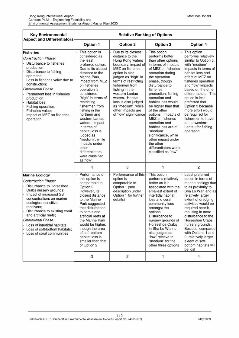
Hong Kong International Airport Mott MacDonald Contract P132 – Engineering Feasibility and Environmental Assessment Study for Airport Master Plan 2030
112 Deliverable D1.8 : Comparative Environmental Assessment Report (Report No. 249855/07) May 2009
Relative Ranking of Options Key Environmental Aspect and Differentiators
Option 1 Option 2 Option 3 Option 4
- This option is considered as the least preferred option. Due to its closest distance to the Marine Park, impact from MEZ on fisheries operation is considered “high” in terms of restricting fishermen from fishing in the northern and western Lantau waters. Impact in terms of habitat loss is judged as “medium”, while impacts under other differentiators were classified as “low”
- Due to its closest distance to the Hong Kong waters boundary, impact of MEZ on fisheries option is also judged as “high” in terms of restricting fishermen from fishing in the western Lantau waters. Habitat loss is also judged as “medium”, while other impacts are of “low” significance
- This option performs better than other options in terms of impacts of MEZ on fisheries operation during the operation phase, though disturbance to fisheries production, fishing operation and habitat loss would be higher than that of the other options. Impacts of MEZ on fisheries operation and habitat loss are of “medium” significance, while other impact under the other differentiators were classified as “low”
- This option performs relatively similar to Option 3, with “medium” impacts in terms of habitat loss and effect of MEZ on fisheries operation and “low” impacts based on the other differentiators. This option is less preferred that Option 3 because more effort would be required for fishermen to travel to the western Lantau for fishing operation
Fisheries
Construction Phase:
- Disturbance to fisheries production;
- Disturbance to fishing operation;
- Loss in fisheries value due to construction;
Operational Phase:
- Permanent loss in fisheries production;
- Habitat loss; - Fishing operation; - Fisheries value; - Impact of MEZ on fisheries
operation
4 3 1 2
- Performance of this option is comparable to Option 2. However, its closest distance to the Marine Park suggested that disturbance to corals and artificial reefs at the Marine Park would be higher, though the area of soft-bottom habitat loss is smaller than that of Option 2
- Performance of this option is comparable to Option 1 (see description under Option 1 for further details)
- This option performs relatively better as it is associated with the smallest extent of intertidal habitat loss and coral community loss amongst the options. Disturbance to nursery grounds of Horseshoe Crabs in Sha Lo Wan is also judged as “low” relative to “medium” for the other three options
- Least preferred option in terms of marine ecology due to its proximity to Sha Lo Wan and as relatively larger extent of dredging activities would be required near it, resulting in more disturbance to the Horseshoe Crabs nursery grounds. Besides, compared with Options 1 and 2, relatively larger extent of soft-bottom habitats will be lost
Marine Ecology
Construction Phase:
- Disturbance to Horseshoe Crabs nursery grounds;
- Impact of increased SS concentrations on marine ecological sensitive receivers;
- Disturbance to existing coral and artificial reefs;
Operational Phase:
- Loss of intertidal habitats; - Loss of soft-bottom habitats; - Loss of coral communities
3 2 1 4

Hong Kong International Airport Mott MacDonald Contract P132 – Engineering Feasibility and Environmental Assessment Study for Airport Master Plan 2030
113 Deliverable D1.8 : Comparative Environmental Assessment Report (Report No. 249855/07) May 2009
Relative Ranking of Options Key Environmental Aspect and Differentiators
Option 1 Option 2 Option 3 Option 4
- This option came second as the estimated quantity of dredged sediment requiring disposal is comparable to that of Option 3; impact is classified as “medium”
- Estimated quantity of sediment generated from this option is higher than both Options 1 and 4, though it is slightly lower than that of Option 4; impact is classified as “high”
- This option came first as the estimated quantity of dredged sediment requiring disposal is lowest numerically among the options; impact is classified as “medium”
- Least preferred option as volume of dredged sediment requiring disposal is highest; impact is classified as “high”
Waste
Construction Phase:
- Quantity of dredged sediment (from non-CMP region)
2 3 1 4
- Potential erosion at the northwest extreme is predicted to be most significant for Option 1. Significant reduction of flow speeds over the Marine Park may lead to additional siltation over the Corals.
- Under this option, a narrow poorly flushed embayment would be created and this would potentially create a relatively stagnant water body. Potential erosion at the northwest extreme of the footprint was also noticeable, though the predicted extent was not as significant as Option 1
- This option performs relatively better than the other options in terms of change in tidal flow and erosion of seabed during the operational phase, and increase in SS concentrations during the construction phase
- Least preferred option in terms of change in tidal flow and most significant increase in SS concentration at nearest WSRs (at Sha Lo Wan). These impacts are judged as “high”. Besides, reduction in flushing capacity may occur due to narrowing of the width of the Airport channel
Water Quality & Hydrodynamics
Construction Phase:
- Increase in SS concentrations at WSRs;
- Release of sediment fines and contaminants during ground treatment with DCM within CMPs
Operational Phase: - Change in tidal flow; - Erosion of seabed; - Change in flushing capacity
at existing Airport channel; - Potential water quality impact
from poorly flushed embayment
3 2 1 4
- This option performs relatively better, as number of dwellings affected by aircraft noise is predicted to be lower than that in Options 2 and 4; operational phase noise impact is judged to be “high”
- Compared with Options 1 and 3, slightly higher number of dwellings would be affected by aircraft noise under this option; operational phase noise impact is judged to be “high”
- This option performs relatively better, as the number of dwellings affected by aircraft noise is predicted to be lower than that in Options 2 and 4; operational phase noise impact is judged to be “high”. Long-term aircraft noise has been considered as more important than potential cumulative construction noise, though Option 3 is also identified as the preferred option from construction phase noise perspective
- Least preferred option, as among the options the highest number of dwellings falling within the NEF25 contour is predicted under this option; operational phase noise impact is judged to be “high”. Long-term aircraft noise has been considered as more important than potential cumulative construction noise, though Option 4 is also identified as the least preferred option from construction phase noise perspective
Noise
Construction Phase:
- Cumulative impact due to concurrent projects on NSRs
Operational Phase:
- No. of dwellings situated within NEF25 contour
1 3 1 4

Hong Kong International Airport Mott MacDonald Contract P132 – Engineering Feasibility and Environmental Assessment Study for Airport Master Plan 2030
114 Deliverable D1.8 : Comparative Environmental Assessment Report (Report No. 249855/07) May 2009
Relative Ranking of Options Key Environmental Aspect and Differentiators
Option 1 Option 2 Option 3 Option 4
- Operational efficiency of this option is comparable to that of Options 2 and 3
- Operational efficiency of this option is comparable to that of Options 1 and 3
- Operational efficiency of this option is comparable to that of Options 1 and 2
- Least preferred option; compared with the other options, Option 4 is less efficient in terms of overall operational efficiency
Air Quality
Operational Phase:
Airport operational efficiency
1 1 1 4
- The performance of this option is similar to Option 2 in terms of potential visual impact
- The performance of this option is similar to Option 2 in terms of potential visual impact
- This option performs relatively better by increasing distance separation from nearest VSRs in Sha Lo Wan
- Least preferred option from potential visual impact perspective due to it close proximity to VSRs in Sha Lo Wan
Visual
Construction & Operational Phases:
Distance to VSRs in Sha Lo Wan and Tung Chung
2 2 1 4
N.B. “1” represents best option; “4” represents least preferred option
Table 4-3 Summary of Ranking and Overall Ranking
Frequency of Ranking (as counts and % of total count)
Option 1 Option 2 Option 3 Option 4
Rank 1 2 (25%) 1 (12.5%) 8 (100%) 0 (0%)
Rank 2 2 (25%) 4 (50%) 0 1 (12.5%)
Rank 3 3 (37.5%) 3 (37.5%) 0 0 (0%)
Rank 4 1 (12.5%) 0 (0%) 0 7 (87.5%)
Total 8 (100%) 8 (100%) 8 (100%) 8 (100%)
Overall Ranking based on No. of
Rank 1
2 3 1 4
Overall Ranking based on No. of Ranks 1 and 2
3 2 1 4
N.B. “1” represents best option; “4” represents least preferred option

Hong Kong International Airport Mott MacDonald Contract P132 – Engineering Feasibility and Environmental Assessment Study for Airport Master Plan 2030
115 Deliverable D1.8 : Comparative Environmental Assessment Report (Report No. 249855/07) May 2009
4.4 Key Findings from Evaluation
From the summary tables presented above, it can be seen that Option 4 does not perform as well as the other options on most environmental aspects. On the other hand, where differences exist in terms of relative environmental performance based on each differentiator, it can be noted that when taken together Option 3 has been ranked first amongst the options on every environmental aspect, and therefore performs relatively better than the other options in overall terms.
It is envisaged that, subject to further consideration of the relevant planning, design, operational and engineering requirements and constraints, the environmental performance of Option 3 and the other options can be enhanced. An analysis of the possible refinements to each of the options is presented in Chapter 5. It is important to note that improvements can be made to individual sub-criteria to improve the environmental attributes but may not change the “score”.

Hong Kong International Airport Mott MacDonald Contract P132 – Engineering Feasibility and Environmental Assessment Study for Airport Master Plan 2030
116 Deliverable D1.8 : Comparative Environmental Assessment Report (Report No. 249855/07) May 2009
5. POSSIBLE ENHANCEMENT IN ENVIRONMENTAL PERFORMANCE
5.1 Introduction
This chapter presents an analysis of some “possible” refinements to the four Airport expansion options to facilitate further development of the layouts with a view to enhancing their environmental performance. It should be noted that the “possible” refinements presented here are preliminary and therefore should not be immediately regarded as viable refinements without further consideration of the planning, construction, operation and engineering implications. Some of the enhancements have been considered as a direct response to the evaluation of other aspects of the options. For example, Section 5.2.2 has been considered in response to programming and cost issues and the justifications are given thereto in D1.7.
5.2 Possible Enhancements (applicable to all four options)
5.2.1 Reduced Aircraft Noise
As discussed in Chapter 3, the Preliminary Noise Contour Analysis for Third Runway Alternatives undertaken by a separate consultant of AAHK has tested the effect of alternative operation mode to possible reduction in aircraft noise impact on NSRs for Options 1, 3 and 4. For Option 2, it was assumed that the same alternative operation mode and flight path tested for Option 3 could be adopted for Option 2 for the purpose of the comparison. The results of the sensitivity test suggested that the number of affected dwellings under all four options would be reduced (see Table 3-22 compared with Table 3-20), especially for Options 1, 2 and 3.
Building upon the evaluation spreadsheet presented in Appendix 4B, Appendix 5A presents the updated evaluation spreadsheet, taking into account the above improvement that can be made when the alternative operation mode is adopted in the operation of the expanded airport. The changes to the spreadsheet are highlighted in colour for ease of reference.
Table 5-1 summarises this possible enhancement in environmental performance of the four options in terms of reduced aircraft noise impact. For Options 1, 2 and 3, aircraft noise impact would be reduced from “high” level to “medium” level when the alternative operation mode is in use. The effect on relative ranking of the options from noise point of view and hence the overall ranking of the options based on Rank 1 as well as Ranks 1 and 2 are also presented. As shown, Option 3 would remain as the most preferred option while Option 4 would remain as the least preferred option in the presence of this enhancement measure.

Hong Kong International Airport Mott MacDonald Contract P132 – Engineering Feasibility and Environmental Assessment Study for Airport Master Plan 2030
117 Deliverable D1.8 : Comparative Environmental Assessment Report (Report No. 249855/07) May 2009
Table 5-1 Refinements to the Options from Aircraft Noise Perspective
Relative Ranking of Options Key Environmental Aspect and Differentiators
Option 1 Option 2 Option 3 Option 4
Noise
Operational Phase:
No. of dwellings situated within NEF25 contour
- With alternative operating mode, judged that level of aircraft noise impact would reduce from the original “high” level to “medium” level. New estimate of affected dwellings is slightly more than that of Options 2 and 3.
- With alternative operating mode, judged that level of aircraft noise impact would reduce from the original “high” level to “medium” level. New estimate of affected dwellings is same as Option 3.
- With alternative operating mode, judged that level of aircraft noise impact would reduce from the original “high” level to “medium” level. New estimate of affected dwellings is same as Option 2.
- Least preferred option; with alternative operating mode, level of aircraft noise impact is still considered “high” in terms of no. of affected dwellings.
Relative Ranking (base case) as shown in Table 4-2
1 3 1 4
Relative Ranking (sensitivity test)
3 1 1 4
Overall Ranking (sensitivity test) based on No. of Rank 1
3 2 1 4
Overall Ranking (sensitivity test) based on No. of Ranks 1
and 2
3 2 1 4
5.2.2 Reducing Construction Areas subjected to Height Restrictions
As discussed in Chapter 1, in addition to the obstacle clearance envelopes which are applied to the existing runways, the surveillance radar installation on Sha Chau imposes an effective 40mPD level restriction on an area of about 4km2 within the study area around the northern runway. This “additional” height restriction imposed by the radar installation will preclude the possible use of high-masted plant which are essential for the installation of pre-fabricated vertical drains, stone columns, deep cement mixing and vibrocompaction. As a result, full dredging of marine sediment and replacement with rock fill which does not require deep compaction and hence the required use of high-masted plant has to be used at areas that are subject to the height restriction imposed by the radar installation.
By removing or relocating the radar installation on Sha Chau during the construction phase of the project, the total area that is subjected to the height restriction and hence would require dredging of sediment before reclamation can be reduced for all four options. This potential improvement in terms of reducing the volume of dredged sediment under all four options is illustrated with the evaluation spreadsheet presented in Appendix 5B (see coloured cells):
• Waste: reducing amount of dredged sediment to be generated under all four
Hong Kong International Airport Mott MacDonald Contract P132 – Engineering Feasibility and Environmental Assessment Study for Airport Master Plan 2030
118 Deliverable D1.8 : Comparative Environmental Assessment Report (Report No. 249855/07) May 2009
options; however, compared with the base case, the ranking of the four options based on the relative quantities of dredged sediment generated are not expected to change
Overall, Option 3 would remain as the most preferred option while Option 4 would remain as the least preferred option in the presence of this enhancement measure.
5.3 Possible Refinements to Option 3
The findings from Chapter 4 revealed that Option 3 would perform relatively better than the other options and was ranked first amongst the options. Consideration has been given to possible refinements to the option to further enhance its environmental performance effectively, or reduce potential environmental impacts or perceived issues.
5.3.1 Reducing extent of reclamation at western side of site
This refinement seeks to significantly reduce the extent of reclamation for Option 3 by eliminating an area of about 232 ha of proposed reclamation at the western side of the expanded airport, as illustrated in Drawing No. MMH/P132/NSK/5301.
As shown with the evaluation spreadsheet presented in Appendix 5C, this refinement would lead to improvements to Option 3 in terms of:
• Chinese White Dolphins: reducing permanent loss of CWD feeding grounds during the operational phase and disturbance to the feeding grounds and dolphin calves during the construction phase;
• Fisheries: reducing impact on fisheries production and fishing operation during the construction and operational phases; compared with the base case, the ranking for Option 3 changed from Rank “4” to Rank “1” from the fisheries perspective for the construction phase;
• Marine Ecology: reducing impact on marine ecology in terms of reduced loss of intertidal habitats, soft-bottom habitats and coral communities during the operational phase. During the construction phase, level of disturbance to nursery grounds of Horseshoe Crabs would also be reduced as distance separation from Sha Lo Wan would be increased with the modified landform; level of disturbance to corals and artificial reefs would also be greatly reduced as sediment re-deposition rate is lowered;
• Waste: the refinement would also lead to a reduction in quantity of dredged sediment to be generated from Option 3
Since Option 3 was already ranked first amongst the options without the enhancement measure, as shown in Appendix 5C, the suggested refinement would not affect the overall ranking of the options i.e., Option 3 would remain as the most preferred option, while Option 4 would remain as the least preferred option. Nonetheless, the modifications do suggest some significant improvements to the environmental performance or reduction in the potential impacts and thus are recommended to be further studied.
Hong Kong International Airport Mott MacDonald Contract P132 – Engineering Feasibility and Environmental Assessment Study for Airport Master Plan 2030
119 Deliverable D1.8 : Comparative Environmental Assessment Report (Report No. 249855/07) May 2009
5.3.2 Shifting the proposed Runway to the East
As illustrated on the drawing presented in Appendix 5D, this refinement seeks to give a more streamlined footprint for Option 3 from a hydrodynamic point of view by shifting the proposed runway slightly to the east.
As shown with the evaluation spreadsheet presented in the same appendix, compared with the base case, significant change in tidal flows was not predicted with the refinement. Neither was a significant improvement in terms of erosion of seabed predicted. On the contrary, the possible refinement might slightly increase the level of disturbance to dolphin calves. The overall ranking would remain the same as in the base case presented in Chapter 4.
5.4 Possible Refinements to the Other Options
5.4.1 Refinements to Option 1
Maximising the distance to the Marine Park
As illustrated on the drawing presented in Appendix 5E, this enhancement measure seeks to increase the distance between the northern site boundary and Sha Chau/Lung Kwu Chau Marine Park from 350m to about 700m by reducing the northern extent of reclamation. Two strips of land shown in grey were to be eliminated as shown on the drawing. After the refinement, the distance between the northern site boundary and the Marine Park under Option 1 would still be lower than that of Options 2 and 3, which is about 1km.
As shown with the evaluation spreadsheet presented in the same appendix, it is not considered that this refinement would lead to a significant change to the levels of environmental impacts associated with Option 1 and the relative ranking of the option relative to the other options. The overall ranking would remain the same as in the base case presented in Chapter 4.
Reducing extent of reclamation at western side of existing Northern Runway
As illustrated on the drawing presented in Appendix 5F, this enhancement measure seeks to reduce the extent of reclamation (by about 75ha) for Option 1 by eliminating an area (shown in grey in the drawing) of proposed reclamation at the western side of the existing Northern runway.
As shown with the evaluation spreadsheet presented in the same Appendix (see coloured cells of the items named below), it is considered that this refinement would lead to some potential improvements to Option 1 in terms of:
• Chinese White Dolphins: reducing disturbance to feeding grounds and calves of CWDs; compared with the base case, the ranking for Option 1 changed from Rank “3” to Rank “1” from the perspective of disturbance to CWDs during the construction phase;
• Marine Ecology: reducing impact during the operational phase in terms of reduced loss of soft-bottom habitats and coral communities; compared with the base case, the ranking for Option 1 changed from Rank “3” to Rank “1” from the perspective of marine ecological impact;
• Waste: reducing the amount of dredged sediment to be generated from Option 1;
Hong Kong International Airport Mott MacDonald Contract P132 – Engineering Feasibility and Environmental Assessment Study for Airport Master Plan 2030
120 Deliverable D1.8 : Comparative Environmental Assessment Report (Report No. 249855/07) May 2009
compared with the base case, the ranking for Option 1 changed from Rank “2” to Rank “1” from the waste perspective;
However, because of the creation of a poorly flushed embayment, as shown in Appendix 5F, this proposed refinement to Option 1 is not considered favourable from hydrodynamic point of view:
• Water Quality and Hydrodynamics: impact level in terms of potential water quality impact from poorly flushed embayment for Option 1 would be increased from “medium” to “high” as a result of the refinement; compared with the base case, the ranking for Option 1 changed from “Rank 3” to “Rank 4”.
In terms of the overall ranking of the options, Option 3 would remain as the most preferred option, while Option 4 would remain as the least preferred option after taking into consideration the suggested refinement to Option 1. This suggests that further consideration could be given to the extent of refinements required for the option.
5.4.2 Refinements to Option 2
Reducing extent of reclamation and Use of Decking for Taxiway
As illustrated by the drawing presented in Appendix 5G, this refinement measure seeks to significantly reduce the extent of reclamation and eliminate the poorly flushed embayment for Option 2 by using decking instead of reclamation as an alternative construction method for taxiway required for operation of the expanded airport and the third runway i.e., water would be able to flow under the decking.
As shown with the evaluation spreadsheet presented in the same appendix, this refinement would lead to some potential improvements to Option 2 in terms of:
• Water Quality and Hydrodynamics: with the proposed refinement, the flushing capacity associated with Option 2 would be significantly improved. Thus, the level of potential water quality impact from poorly flushed embayment is re-categorised as “low” instead of “high”;
• Fisheries: reducing disturbance to fisheries production during the construction phase; compared with the base case, the ranking for Option 2 changed improved from Rank “2” to Rank “1” for the construction phase;
• Marine Ecology: reducing loss of intertidal habitats and soft-bottom habitats during the operational phase; and reducing impact of increased SS concentration on marine ecological sensitive receivers and sediment re-deposition rate during the construction phase. As a result, the refined Option 2 became the most preferred option from marine ecology perspective in terms of relative ranking i.e., compared with the base case, ranking for Option 2 improved from Rank “2” to “1” from marine ecology perspective;
• Waste: the refinement would also lead to improvement in terms of reduced amount of dredged sediment to be generated; ranking for Option 2 improved from Rank “3” to Rank “1” from waste perspective;
However, as piling activities would be required for construction of the decking, as also shown in Appendix 5G, the proposed refinement to Option 2 is not considered

Hong Kong International Airport Mott MacDonald Contract P132 – Engineering Feasibility and Environmental Assessment Study for Airport Master Plan 2030
121 Deliverable D1.8 : Comparative Environmental Assessment Report (Report No. 249855/07) May 2009
favourable from the viewpoint of additional disturbance/impact on CWDs during the construction phase:
• Chinese White Dolphins: there would be increased level of impact in terms of disturbance to dolphin calves; the impact level changed from “medium” to “high” with the refinement.
In terms of the overall ranking of the options, Option 3 would remain as the most preferred option, while Option 4 would remain as the least preferred option after taking into consideration the suggested refinement to Option 2. Therefore, if this refinement to Option 2 is to be considered further, then mitigation measures would need to be considered in terms of impacts on CWD’s.
Eliminating the Embayed Area
As illustrated with the drawing presented in Appendix 5H, this refinement measure seeks to possibly eliminate the embayed area by shifting the proposed runway to the south.
As shown in the same appendix, this refinement would lead to some potential improvements to Option 2 in terms of:
• Chinese White Dolphins: reducing impact on CWDs through increasing the distance separation between the northern boundary of the site from the Marine Park and by reducing habitat loss of dolphins. As a result, the refined Option 2 became the most preferred option from CWD perspective in terms of relative ranking i.e., ranking improved from Rank “2” to Rank “1” when compared with the base case;
• Water Quality and Hydrodynamics: with the proposed refinement, the embayment area on the eastern side would be eliminated. However, there would still be an embayment area on the western side of the site. Thus, the level of potential water quality impact is re-categorised as “medium” instead of “high”
In terms of the overall ranking of the options, Option 3 would remain as the most preferred option, while Option 4 would remain as the least preferred option after taking into consideration the suggested refinement to Option 2. However the effects on reducing impact on CWDs are still a positive one for this enhancement.
5.4.3 Possible Refinements to Option 4
Eliminating the Embayed Area
As shown on the drawing presented in Appendix 5I, this refinement seeks to give a more streamlined footprint for Option 4 by trimming the eastern end of the proposed runway to eliminate the embayed area.
As shown with the evaluation spreadsheet presented in the same appendix, this refinement would lead to some potential improvements to Option 4 in terms of:
• Water quality and hydrodynamics: as the poorly flushed embayment would be eliminated, it is judged that the level of potential water quality impact from poorly flushed embayment would be improved from “medium” to “low”;

Hong Kong International Airport Mott MacDonald Contract P132 – Engineering Feasibility and Environmental Assessment Study for Airport Master Plan 2030
122 Deliverable D1.8 : Comparative Environmental Assessment Report (Report No. 249855/07) May 2009
• Chinese White Dolphins: reducing permanent loss habitats and feeding grounds of CWDs during the operational phase and reducing disturbance the feeding grounds and dolphin calves during the construction phase. The level of impact with respect to permanent habitat loss would change from “high” to “medium” accordingly;
• Fisheries: there would be some improvements in terms of slightly reduced habitat loss and reduced impact on fisheries production. Disturbance to fisheries production would also be reduced during the construction phase.
• Marine ecology: there would be some slight improvements in terms of reduced loss of soft-bottom habitats during the operational phase; and reduced disturbance to artificial reef and reduced impact from SS as the quantity of sediment requiring dredging is reduced;
• Waste: some slight improvement to Option 4 in terms of reducing the quantity of dredged sediment requiring disposal. However, the quantity of sediment that would be generated from the refined Option 4 would still be highest amongst the four options
Overall, Option 3 would remain as the most preferred option in terms of overall ranking, while Option 4 would remain as the least preferred option after taking into consideration the suggested refinement to Option 4.
Reducing Extent of Reclamation by Use of Decking for Taxiway near the Airport sea channel
As shown with the drawing presented in Appendix 5J, this refinement seeks to reduce change in flushing capacity at the existing Airport channel by eliminating an area (about 24ha) of reclamation by using decking for the taxiway i.e., water would be able to flow under the decking.
As shown with the evaluation spreadsheet presented in the same appendix, this refinement would lead to some potential improvements to Option 4 in terms of:
• Water Quality and Hydrodynamics: by using a decking approach instead of reclamation near the Airport sea channel, potential impact on flushing capacity at the channel would be reduced from “medium” to “low” level;
• Marine Ecology: with the proposed refinement, there would be reduced loss of soft-bottom habitats during the operational phase. During the construction phase, as the extent of reclamation near Sha Lo Wan is reduced, the refinement would lead to reduced disturbance to nursery grounds of Horseshoe Crabs;
• Waste: some slight improvement to Option 4 in terms of reducing the quantity of dredged sediment requiring disposal. However, the quantity of sediment that would be generated from the refined Option 4 would still be highest amongst the four options
However, as piling activities would be required for construction of the decking, as also shown in Appendix 5J, the proposed refinement to Option 4 is not considered favourable from the perspective of additional disturbance to CWDs during the construction phase:
Hong Kong International Airport Mott MacDonald Contract P132 – Engineering Feasibility and Environmental Assessment Study for Airport Master Plan 2030
123 Deliverable D1.8 : Comparative Environmental Assessment Report (Report No. 249855/07) May 2009
• Chinese White Dolphins: there would be increased level of impact in terms of disturbance to dolphin calves
The proposed refinement to Option 4 would have no effect on the overall ranking on the options i.e., Option 3 would remain as the most preferred option. Option 4 would remain as the least preferred option. The enhancement of the water quality aspects would be of benefit, thought it does not improve the overall performance of Option 4.
Trimming of Headland around Sha Lo Wan
As shown with the drawing presented in Appendix 5K, this idea of trimming an area of existing land at Sha Lo Wan seeks to improve the flushing capacity at the Airport Sea Channel.
While this modification would lead to some improvements in terms of enhancing the existing flushing capacity at the Airport Sea Channel (as reflected through change in impact level from “medium” to “low” as shown under Water Quality and Hydrodynamics in the same appendix), this will lead to direct permanent loss of habitats of Horseshoe Crabs of moderate value offsite (reflected through change in impact level from “low” to medium”). There would also be concern on potential effects on CWDs using the region as a result of the use of explosives or other means to reduce the headland.
5.5 Effect of Refinement Options on Overall Ranking
It is noted that while improvements in environmental performance could be achieved with some of the possible refinements, this would not result in a change in the relative overall ranking of the options i.e., Option 3 would remain as the most preferred option, while Option 4 would remain as the least preferred option under all the refinement options considered.
The process does reflect the benefits of considering improvements, refinements and modifications to the options to reduce environmental impacts as far as practicable.
It must be emphasized that this refinement process will be an ongoing process through the development of a Preferred Option, into the design and then construction stage. The potential for enhancement of the performance of the proposed Airport expansion does not end with the selection of the Preferred Option.

Hong Kong International Airport Mott MacDonald Contract P132 – Engineering Feasibility and Environmental Assessment Study for Airport Master Plan 2030
124 Deliverable D1.8 : Comparative Environmental Assessment Report (Report No. 249855/07) May 2009
6. WAY FORWARD – LEADING TO THE FORMULATION OF THE PREFERRED OPTION
6.1 Further Evaluation
The potential enhancements in environmental performance of the four Airport expansion options, which are evaluated as “conceptual” stage solutions in Chapter 5, were discussed in meetings held between representatives of AAHK, the Master Plan 2030 Consultants and the P132 Consultants.
It was agreed that the possible options of refinements would be further investigated by the MPC and the P132 Consultants, taking into account other important factors including design, construction, operational and safety requirements in addition to environmental considerations.
The refinement process is an ongoing process and as described in the foregoing section will continue into the construction stage.
This report presents the evaluations of the options to date and illustrates the overall performance of options in a holistic manner as well as describing effects of developmental change on individual environmental performance indicators. The next steps in the development process are described below.
6.2 Preparation of the Project Profile
Based on the preferred Airport expansion scheme and drawings presented in the MPC’s Report on Evaluation and Selection of the Preferred Airport Layout Option, the P132 Consultants will prepare a Project Profile that meets all requirements specified in the EIAO and EIAO-TM, and suitable for submission to the Director of Environmental Protection (DEP) for application of an EIA Study Brief. The specific types of information that shall be contained in a Project Profile are described in Annexes 1 and 2 of the EIAO-TM.
It should be noted that formal public consultation under the statutory EIA process will start at the EIA Study Brief application stage. Following receipt of the Project Profile for application of an EIA Study Brief, DEP will make available the Project Profile for public inspection through the established channels (including EPD’s website) of the EIAO. Under Section 5 of the EIAO, the Advisory Council on the Environment (ACE) and the public are able to inspect and provide written comments on the Project Profile over a public inspection period of 14 days. Thereafter, DEP after having given due consideration to the application, comments from the ACE and the public, and EIAO-TM requirements will within a 45 day period (from receipt of the application or further information) issue an EIA Study Brief for undertaking the EIA.
It can be seen from the foregoing that the level of detail to be presented with the Project Profile does require careful consideration, and is a key element in the overall Public Relations/Engagement strategy for the project as a whole.
As such the P132 Consultants is currently interrogating a series of relevant EIA projects from the perspective of details contained within their respective Project Profile, EIA Study Brief, EIA report exhibited for public inspection and their subsequent Environmental Permits (EP). This information will be synthesised and

Hong Kong International Airport Mott MacDonald Contract P132 – Engineering Feasibility and Environmental Assessment Study for Airport Master Plan 2030
125 Deliverable D1.8 : Comparative Environmental Assessment Report (Report No. 249855/07) May 2009
presented to AAHK in form of a workshop or roundtable discussion as part of the ongoing Public Relations/Engagement process, as well as for the development of the outline of the Project Profile.
The Projects which are being interrogated as part of this ongoing process of the EIAO life cycle include but are not limited to:
• Liquefied Natural Gas Receiving Terminal and Associated Facilities;
• Permanent Aviation Fuel Facility for HKIA;
• Construction of an International Theme Park in Penny’s Bay of North Lantau together with its Essential Associated Infrastructures;
• Dredging Works for Proposed Cruise Terminal at Kai Tak; and
• Wan Chai Development Phase II (including Central-Wan Chai Bypass)
Of particular interest are the requirements of the EP’s in terms of possible restrictions which may be anticipated and how precedent cases may influence this project and its approval process. For example the restrictions which may be imposed explicitly on dredging rates / volumes on hours of working or restricted periods will be of specific interest. These will also be the focus of discussion with the Authority in due course. The contents of the PP’s of the foregoing EIA’s are also being examined to consider the merits or otherwise of the details provided therein.
Details of the contents and the timing of the submission of the Project Profile to DEP under the EIAO will be subject to agreement with AAHK, taking into account the overall Public Relations/Engagement strategy for the project.