c.p. ukpaka
TRANSCRIPT

1
INVESTIGATING THE GROUND WATER CONTAMINATION DUE TO CRUDE OIL EXPLORATION AND EXPLOITATION IN EGI
COMMUNITY OF NIGER DELTA AREA OF NIGERIA
C.P. Ukpaka
Department of Chemical/Petrochemical Engineering Rivers State University of Science and Technology,
Port Harcourt, Abstract Ground water contamination from crude oil exploration and exploitation is an evidence of inefficiencies in pollution control management by oil companies in Nigeria. Improvement in crude oil exploration and exploitation as well as process efficiency on account of reduction in thermodynamic losses has positive impact on the level of hazardous substance released from the process industries. In this paper, physiochemical analysis is applied for studying some of the useful parameters of ground water quality. The quality of ground water available within the communities has been tested for the possibility of contamination resulting from crude oil exploration and exploitation. The results obtained from the analysis showed that the concentration of most analyzed physiochemical parameters referring to the available ground water quality is beyond the acceptable or permissible limit. High levels of contamination were found in samples taken from areas under investigation and the level of contamination in this case was largely attributed to the presence of these oil companies. This outcome of this work can be used to estimate the level of ground water pollution within the communities in further.
Introduction The quest for the survival of man in harnessing the mineral resources that
abound in the universe through the application of science and technology has brought joy to man. However, on the other hand, in the course of carrying out these operations, energy are burnt and waste generated which must be disposed off into one system or the other. Nearly everyday, there is the news of air, water, land and noise pollution. The public has become more and more aware of the threat posed by these environmentally unfriendly substances of which various governmental and non-governmental organizations have moved into control some of them. However, it can be recalled that for over thirty years of oil exploration and exploitation, within the region, the environment has been greatly contaminated with gaseous pollutant. This activity has lead to environmental degradation.

2
Investigating the physicochemical parameters as well as the characteristics of ground water quality is very important to understand the role of crude oil exploration and exploitation in the various unsaturated and saturated zone of the water phase contamination. The modern civilization accompanied by the rapid growth of industrialization has created the situation of huge amount of waste generation in their operational areas. All over the world today the communities where oil exploration and exploitation are taking place are vexed with the problem of disposal and management of generated waste in their operational areas. During the process some of the wastes are collected, transported, treated and disposed as recommended by Federal Ministry of Environment (FMENV) authority: the left over waste will now be discharged into a pond system with the aim of subjecting the waste into further treatment. It is observed that waste discharged into a pond system does not receive any further treatment rather than undergoing environmental degradation by itself. This is most of the practice experienced in Niger Delta area of Nigeria as a result of oil exploration and exploitation activities (Vishwanath & Anantha, 2002).
The leachate is produced from the decomposition and sequencing of the wastes and by water that has entered into a pond system from external sources. It carries a number of impurities as it moves down through the wastes. (Ukpaka & Ikenyiri, 2004; Akinsola & Obuzor, 2004; Banerjee, Bajwa, & Behal, 2004; Bhattacharyya & Sarma, 2001; Bala, Milliali, Yaji, & Shrihari, 2005; Kumaravel, Gopalasamy, & Kanakasabai, 2003 ; Utpal & Sarma, 2007 ; Ravinder, Ch. & Vijaya, 2005; Teinaku, Shaik, & Srinivasa, 2002; Ukpaka, & Ikenyiri, 2004). Various activities related to oil exploration and exploitation in Egi area of Rivers State in particular and Niger Delta in general has tended to impact seriously on the ground water quality either positively or negatively (Ukpaka, 2004; Akpan, 2005 & Effiong, 2004). Unfortunately, significant source of pollution of Egi environment comes from oil exploration and exploitation activity. The water surfaces within the Egi community are contaminated as underground water due to process. With increased rate of crude oil production and corresponding high rate of oil exploration and exploitation, it become necessary to access the quality of ground water within Egi area of Niger Delta. To accomplish this well water within Egi area and out Egi area was collected and some physicochemical parameters of the ground water (well water) were studied. (Teinaku, Shaik, & Srinivasa, 2002 Ukpaka, & Ikenyiri, 2004 & Bala, Milliali, Yaji, Shrihari, 2005). Geologic History of Area Studied
Ogba/Egbema/Ndoni Local Government Area of Rivers State is part of the Niger Delta, which is at the Southern end of Nigeria bordering Atlantic ocean and extends from about Longitude 3’.9oE and Latitude 4’30-5o 20N. Ogba/Egbema/Ndoni Local Government Area of Rivers State is part of the Niger Delta Environment that developed from the Moto Delta in the Northern part Basin during the companion
Academic Scholarship

3
transgression and ended with the Paleocene transgression. Ogba/Egbema/Ndoni of Rivers State is generated from the Niger Delta modern formation during the Eocene. It has three major depositions just like every other part of the Deltaic Environment. The three major formations are Benin, Agbada and Akata formation. It was estimated that one million cubic meter of sand are carried towards mahin every year, while the Niger-Benue system brings a sediment load of 0.2kilometrecubic/year which is deposited on top of the Delta (Kogbe, 1989). Benin formation ie ground water is predominant in Ogba/Egbema/Ndoni Local Government Area of Rivers State disintegrating to sombrero that transit at the Ahoada River at about 100ft or more. The geologic history of Ogba/Egbema/Ndoni is predominated by the deposited formation. According to Eluozo, (2006) the stratigraphy of Ogba/Ebema/Nodni Local Government Area of Rivers State are deposited by locustrine and Alluvial, including off lap sediments, the locustrine deposit in the area is heterogengeous predominant while alluvial deposits are homogenous predominant. The costal areas are off lap by sediments including tidal channels at 60ft and 800ft respectively. The deposit disintegrating from Benin formation are known to be the highest yield formation i.e. unconfined aquifer, Ogba/Egbema/Ndoni Local Government Area of Rivers State, predominantly 90% of cobble coarse and gravel and 5% of sand stone and sedimentary deposit including montmonorite clay. The minerals that are deposited in the area are hazardous chemical from man made activities and natural origin, e.g. iron oxide in some communities like Obagi, Ogbogu Obite, Obiyebe, Ede and Obigwe. It has an average static water table of 7.5m water table. While in most coastal environment, it has an average of 1.5m water table (Eluozo, 2006). The study by Eluozo, (2006) also confirms that a good aquiferous zone has an average depth of 36m in the upland area, while in the coastal area it is 12-15metres deep. Finally the Porosity of the soil was confirmed to be very high at an average of 0.2-0.4 percent.
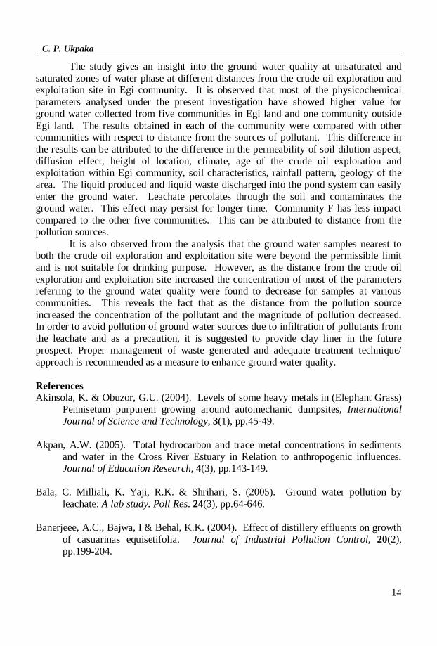
The study area covers 6 communities within Egi Land and environs. Five (5) of these communities are close to the operational area of oil exploration and exploitation, whereas, the F community is faraway from the operational area as shown in Table and Figure. The five communities located within the oil site for exploration and exploitation include: Obiyebe, Obite, Ogbogu, Obagi, and Ede whereas Obigwe was considered as a control. The flow diagram shown below illustrates the distance of each community from the operational oil.
C.P. Ukpaka

4
Figure 1: Illustrates the flow diagram of the sampling points from the crude oil
exploration and exploitation site.
A map of Ogba/Egbema/Nodni Local Government Area, which illustrates the region of the studies as shown in figure 2
Community
A
3.8km
Community B
2.5km
Crude oil exploration
and exploitation site zone 1
3km
Community
E
2.9km
2.9km
3.6km
5.7km
0.5km 4.3km
A1 A2 A3
E1 E2 E3 B1 B2 B3
F1 F2 F3
Community F
D1 D2 D3
Community D
C1 C2 C3
Community C
4.3km
Crude oil exploration and exploitation site
zone 2
5.6km
2.6km 2.7km
Academic Scholarship

5
Figure 2: The Map of Ogba/Egbema/Ndoni Local Government Area is
The point in the map indicates the region where the investigation was
conducted
C.P. Ukpaka

6
Materials and Methods Ground Water Sampling
Ground water samples were collected in a sterile glass bottles at each sampling point in each of the area of investigation. The bottles were transferred to an ice chest for transportation to the Department of Chemical/Petrochemical Engineering Laboratory in Rivers State University of Science and Technology Nkpolu Port Harcourt. At each sampling point a thermometer was used to determine the temperature of the water. However, other physicochemical parameters of the ground water samples were determined in the laboratory by adopting standard laboratory techniques. The analytical procedures and equipment used are shown in table 1.
Table 1: The analytical procedure and equipment used for investigating ground water quality
Results and Discussion The results obtained from the research work are presented in Tables. The physicochemical parameters considered to examine the ground water quality includes: pH, temperature, conductivity, turbidity, DO, TS, TDS, BOD, COD, hardness (CaCO3) calcium, magnesium, chloride, fluoride, nitrate, phosphate, iron, sodium, potassium and total hydrocarbon
Parameter Analytical method / equipment used pH Philips pH meter Temperature Thermometer Conductivity Conductivity meter Turbidity Lackson candle turbidimeter Salinity Silver Nitrate titration Dissolved oxygen Titrimetry with sodium thiosulphate reagent
(Winklers method) Biochemical oxygen demand chemical oxygen demand
Differential DO (initial value after 5 days incubation) filtration and gravimetric Hg2Cl2
Total dissolved solid chlorine Filtration, drying and gravimetry potentiometer method with silver nitrate solution
Sulphate (So42-) Gravimetric method with ignition of residue
Phosphate Digestive method with tetraoxosulphate (VI) acid solution
Nitrate (No3-) Nitrate electrode method
Heavy metals Atomic absorption and spectrophotometry Total Hydrocarbon (THC) Solvent Extraction and gas chromatography
Academic Scholarship

7
C.P. Ukpaka

8
The results give an insight into the ground water quality of the collected samples as presented in tables 2. All the samples were colourless and odourless, the pH values were measured and the results were within the range of 7.2 to 7.8, 7.2 to 7.6, 7.3 to 7.8, 7.4 to 7.7, 7.6 to 8.1 and 7.1 to 7.3 for Obiyebe, Obite, Ogbogu, Obagi, Ede and Obiqwe respectively. The pH value is less in Obigwe community compared to other communities, results indicating more alkaline nature of the ground water of other communities influenced by the crude oil exploration and exploitation. The pH is also temperature dependent and the overall temperature in the six communities ranged from 25oC to 27oC at the time of sample collection. The turbidity and conductivity values of water samples were in the recommended limits. The conductivity value of samples ranged from 1100Scm-1 to 430Scm-1 with the order of magnitude Obite> Ede> Ogbogu> Obiyebe> Obagi> Obigwe due to the presence of large amount of ionic substance resulting from increased degree of ionization. Dissolved Oxygen (DO) was observed in the range of 2.7mg/L to 6.6mg/L. The Dissolved Oxygen (DO) value increased with increase in distance. Similarly, one may attribute it to increased content of decomposable organic matter. Dissolved Oxygen (DO) is dependent on the physical, chemical and biological activities prevailing in the water body and varies with the water temperature and attitudes (Udo and Foyemi 1975). The Total Solid (TS) and Total Dissolved Solid (TDS) concentration decreased with increases in the distance of sample water sources from the crude oil exploration and exploitation site. As the crude oil exploration and exploitation continuous in Egi community which is located in Ogba/Egbema/Ndoni local government area, its Total Solid (TS) and Total Dissolved Solid (TDS) values of the ground water quality will increase, thereby making the ground water quality above the acceptable limit as recommended by WHO, (1976).
Academic Scholarship

9
C.P. Ukpaka

10
The Biochemical Oxygen Demand (BOD) values for the different samples obtained at the various communities indicate a range of values of 3.1mg/L to 10.8mg/L. The experimental Biochemical Oxygen Demand (BOD) values were found to be beyond the permissible limits. The maximum limit of BOD is 2.0mg/l as stated by WHO (1976). More BOD value was obtained for the nearest samples than the distant ones. This clearly indicates that the water sources are getting more polluted mainly ground water sources which are close to the crude oil exploration and exploitation sites. This may be due to increased leaching of organic materials from the crude oil exploration and exploitation discharged point of wastewater. The maximum Chemical Oxygen Demand (COD) values were obtained for the nearest samples at different community indicating the degree of pollution of contaminated ground water quality sources by relatively oxidizable organic matter. It may be resulted from the percolation of leachates through the soil and contamination with ground water. The COD values were also found to decrease as the distance from the discharge point of waste water increased.
The total hardness values were within the preserved limit of 300mg/l (WHO 1976). The total hardness is generally attributed to the calcium and magnesium concentration. The chloride concentrations in the samples were found to be within the range of (215mg/l to 860mg/l) for samples obtained in the various communities. Similarly, the concentration of chloride in the samples were attributed to the dissolution of chlorinated soluble salt present in the solid waste leachate generated from the crude oil exploration and exploitation process. High fluoride content was found in the samples nearest to the crude oil exploration and exploitation site and the results obtained is beyond the prescribed limit of 0.6mg/l to 1.2mg/l by WHO (176). Fluoride is beneficial to a certain extent when present in concentration of 0.8mg/l to 1.0mg/l for calcinations dental enamel especially for the children below 8-9years of age but it causes dental fluorosis if present in excess of 1.5mg/l and skeletal fluorosis beyond 3.0mg/l if such water is consumed for about 7 to 12 years with increase in the distance from the crude oil exploration and exploitation site of discharge of waste water, the fluoride concentration in the ground water quality was found to be decreased and is suitable for human consumption.
Academic Scholarship

11
C.P. Ukpaka

12

13
Ground water quality for human consumption exceeded the safe limit of nitrate concentration of 20mg/l for public water utilization as recommended by WHO (1976). The high concentration of nitrate and phosphate may have been attributed to the permeability of the soil flow of the leachate produced from the waste water discharge point into the soil as well as local factors like oil spillage which may contaminate the ground water quality with time and distance. The experimental concentration value of iron was beyond the limit of 0.3mg/l prescribed by WHO for drinking water. The potassium content was found to be lower than that of sodium for the various communities. Potassium has similar chemistry as sodium and is regarded as an apparently harmless metal, however high level of sodium (>100mg/l) in drinking water gives it an unpalatable taste and is harmful for persons suffering from high blood pressure and heart diseases (Bossert & Bartha, 1984). The Total Hydrocarbon (THC) values were above the prescribed limit of <0.01mg/l by WHO (1976). The total Hydrocarbon (THC) concentration on the various samples obtained in the six different communities indicates the presence of high concentration. This can be attributed to the decomposition of the organic matter as well as the transportation of the crude oil discharged into the pond system for treatment. Similarly, it can be attributed to lack of adequate treatment of waste water generated as a result of crude oil exploration and exploitation in Egi land. The high concentration of THC can be attributed to loss of crude oil content during oil exploration and exploitation process as well as spillage. The THC concentration decreases with increase in distance from the sources of pollution. Conclusion
Detailed examination regarding the ground water quality was carried out in this research work. The physiochemical analysis was carried out using the best recommended international standard.
The results of this work indicate that the most likely reason for the ground water contamination.
Following the results of this work, the following conclusion can be made are:
(1) The knowledge of the ground water contamination and the level of contamination can be estimated, if pollution rate increases.
(2) The difference in physiochemical analysis results under investigation can be attributed to the differences in the permeability of soil diffusion aspect, climate, aging period of the crude oil exploration and exploitation.
(3) Knowledge on the geology of the area and hydrogeology characteristics of the area under investigation can also attribute to variation in physiochemical parameters of the ground water quality.
(4) Prediction (10 does imply that, if quick and urgent action is not taken, the level of ground water contamination will increase, thereby making the ground water unuseful for human being, especially those communities whose sources of drinking water is from well.
Academic Scholarship
14
The study gives an insight into the ground water quality at unsaturated and saturated zones of water phase at different distances from the crude oil exploration and exploitation site in Egi community. It is observed that most of the physicochemical parameters analysed under the present investigation have showed higher value for ground water collected from five communities in Egi land and one community outside Egi land. The results obtained in each of the community were compared with other communities with respect to distance from the sources of pollutant. This difference in the results can be attributed to the difference in the permeability of soil dilution aspect, diffusion effect, height of location, climate, age of the crude oil exploration and exploitation within Egi community, soil characteristics, rainfall pattern, geology of the area. The liquid produced and liquid waste discharged into the pond system can easily enter the ground water. Leachate percolates through the soil and contaminates the ground water. This effect may persist for longer time. Community F has less impact compared to the other five communities. This can be attributed to distance from the pollution sources.
It is also observed from the analysis that the ground water samples nearest to both the crude oil exploration and exploitation site were beyond the permissible limit and is not suitable for drinking purpose. However, as the distance from the crude oil exploration and exploitation site increased the concentration of most of the parameters referring to the ground water quality were found to decrease for samples at various communities. This reveals the fact that as the distance from the pollution source increased the concentration of the pollutant and the magnitude of pollution decreased. In order to avoid pollution of ground water sources due to infiltration of pollutants from the leachate and as a precaution, it is suggested to provide clay liner in the future prospect. Proper management of waste generated and adequate treatment technique/ approach is recommended as a measure to enhance ground water quality.
References Akinsola, K. & Obuzor, G.U. (2004). Levels of some heavy metals in (Elephant Grass)
Pennisetum purpurem growing around automechanic dumpsites, International Journal of Science and Technology, 3(1), pp.45-49.
Akpan, A.W. (2005). Total hydrocarbon and trace metal concentrations in sediments
and water in the Cross River Estuary in Relation to anthropogenic influences. Journal of Education Research, 4(3), pp.143-149.
Bala, C. Milliali, K. Yaji, R.K. & Shrihari, S. (2005). Ground water pollution by
leachate: A lab study. Poll Res. 24(3), pp.64-646. Banerjeee, A.C., Bajwa, I & Behal, K.K. (2004). Effect of distillery effluents on growth
of casuarinas equisetifolia. Journal of Industrial Pollution Control, 20(2), pp.199-204.
C. P. Ukpaka

15
Bhattacharyya, K.G. & Sarma, H.P. (2001). Quality of drinking water of tube wells and municipal supply waters with respect to Na, K, Ca, Mg and Fe in the Darrang district, Indian Journal of Environmental protection. 21(11), pp.1006-1011.
Bossert, I. & Bartha, R. (1984). Fate of petroleum hydrocarbon in soil ecosystem. New
York: In petroleum microbiology, Macmillan publication company, pp.435-473. Effiong, O.E. (2004). Some physicochemical of water, sediments, fishes and soils from
qualboe coastal area. International Journal of Science and Technology, 4(2), pp.48-50.
Eluozo S.N 2006. Evaluation of borehole construction practice in Rivers StateM. Eng
Thesis University of Port Harcourt p144-147. Kumaravel, B. Gopalasamy, V. & Kanakasabai, V. (2003). Ground water contamination
due to municipal garbage dumping – a Comparative study, poll Res. 22(1), pp.67-71.
Kogbe C.A (1989). Geology of Nigeria, Pak Limited, Ibadan 5614/289 p 311. Ravinder, V. Ch. R. & Vijaya, K.R. (2005). Ground water pollution due to dumping of
municipal solid waste at warangal. IJEP, 25(6), pp.523-526. Tcinaku, Shaik, K.M. & Srinivasa, R.M. (2002). Study of water quality at solid waste
dumping yards in visakhapatnam. Journal of Industrial Pollution control, 18(2), pp.253-265.
Udo, E.J. & Foyemi, A.A. (1975). The effect of oil pollution on germination, growth
and nutrient uptake of corn: Journal of Environmental Quality, 5(7), pp.437-540. Ukpaka, C. Peter & Ikenyiri, P.N. (2004). Hazardous Impact of gas flaring on the
Environment, International Journal of Science and Technology, 3(1), pp.25-27. Ukpaka, C. Peter, (2004). Development of model for crude oil degradation in a
simplified stream system, International Journal of Science and Technology, 3(1), pp.38-41.
Ukpaka, C.P.; Ogoni, H.A.; Amadi, S.A. & Ikenyiri, P.N. (2004). Determination of the
spreading rate of unweathered crude oil on a calm water surface using Fay model. International Journal of Science and Technology, 3(1), pp.18-22.
Utpal, G & Sarma, H.P. (2007). Study of Ground water contamination due to municipal
solid waste dumping in Guwahati City, pollution Research, 26(2), pp.211-213.
Academic Scholarship

16
Vishwanath, G. & Anantha, M.K.S. (2002). Assessment of ground water quality around a solid waste dump site. Nature Environment and Pollution Technology, 1(4), pp.411-413.
WHO (1976). Selected methods of measuring water pollutants, WHO offset publication
No.24E, pp.7-41.
C.P. Ukpaka