craven district council: craven local … – caravan park, north of river greta question 4: is it...
TRANSCRIPT

CRAVEN DISTRICT COUNCIL: CRAVEN LOCAL PLAN 2012-2032 EXAMINATION IN PUBLIC
RESPONSE TO INSPECTOR’S QUESTIONS RELATING TO MATTER 5 IN SUPPORT OF PREVIOUS REPRESENTATIONS MADE BY THE NORTH YORKSHIRE BRANCH OF THE CAMPAIGN TO PROTECT RURAL ENGLAND (CPRENorthYorkshire’) (Ref: 009/07/SP6/TS)
MATTER 5: RESIDENTIAL ALLOCATIONS (POLICIES SP5 SP6, SP7, SP8, SP9, SP10 AND SP11)
Issue 3: Strategy for Settle – Tier 2 (policy SP6) SGO25 – Land South of Ingfield Lane
Question 3: What is the current status regarding the planning application submitted to the Council in April 2017 (Ref 62/2017/18067)?
The recently published National Planning Policy Framework (the ‘NPPF’ or the ‘Framework’) states that for the purposes of examining plans, policies in the previous Framework (2012) will apply where plans are submitted on or before 24 January 2019 (paragraph 214).
CPRENorthYorkshire have provided detailed responses to all of the Craven District Council’s (‘CDC’) consultations on the emerging Craven Local Plan since 2013 and have welcomed the opportunity to do so.
CPRENorthYorkshire responded to the abovementioned planning application in September 2017. It is noted that this response was to amended plans from those originally submitted in May 2017. CPRENorthYorkshire strongly objected to the proposals on the following grounds:
• The proposals are contrary to both local and national planning policies; • The outline application is not justified at this time, given that the Council
purport to have a 5-year supply of viable housing land; • The site is a large and locally valued area of green space that should be
retained in order to protect the setting of the settlement; and • The detrimental impacts on the designated Heritage Assets are not
outweighed by the benefits of these proposals. (See full objection in appendix 1 to this statement).
! Page of 1 7

It is noted that both the Yorkshire Dales National Park Authority (‘YDNP’) and Natural England objected to the proposed plans, however, neither consultee responded either to maintain or remove their respective objections. It may be that they were not made aware of the amended proposals. The application was presented to the Planning Committee on 2nd July 2018. The Committee Members resolved to grant planning permission subject to the agreement of a satisfactory s106 between the applicant and the Council. It is noted that the Officer’s Report to the Committee, does not make any reference to the fact that the site has been allocate in the draft Local Plan and that it is awaiting examination. Nor does it make any reference to the general development principles set out by the policy team at CDC in the supporting text to SP6, specifically the need for Landscape and Visual Impact Assessment or Flood Risk Assessment.
Question 4: What is the justification for specifying that proposals for development on the site must include tree blocks between clusters of dwellings? Does this provide sufficient flexibility to ensure that the site is deliverable?
The site currently consists of 11.43 Ha of greenfield land outside of the existing settlement boundary and thus currently within open countryside. It is a much-used amenity space, valued by local residents who have objected vociferously to numerous planning applications for various uses on the site and highlighted surface water flooding to be a particular problem.
It is acknowledged that the Council are only allocating 3.91Ha of this land for residential use and are including a 7.52Ha site area of green infrastructure to be included within the site in order to minimise impacts on the adjacent YDNP, the Settle-Carlisle Railway Conservation Area and the heritage assets of the Falcon Manor Hotel and Ingfield Lodge. However, CPRENorthYorkshire believe that the allocation of 3.91Ha within the site will undoubtedly impact upon these assets and designated landscapes as well as significantly alter the setting of Settle from viewpoints within the YDNP and from the railway.
The Council ran a four-week consultation on a set of draft housing allocations for the new local plan in July-August 2016. These 'preferred sites' had emerged as the best available from the Pool of Site Options included in the second draft local plan consultation held during April and May 2016. The Council also published, alongside the preferred list, a document detailing those sites which had not been selected from the potential pool of site options. This included the site known as SGO25. The Council, therefore, produced evidence to support the allocation of other sites ahead of this potential site in their forthcoming Local Plan, however, this was later withdrawn by CDC, A new consultation document covering the preferred sites was included in the next consultation version of the draft local plan (July 2017). This document included SGO25.
! Page of 2 7

CPRENorthYorkshire do not support the allocation of this site. However, should it be included within the Local Plan, believe that the mitigation approach suggested by CDC in the ‘development principles’ section of SP6 should be incorporated as a minimum requirement in order to mitigate impacts upon the special qualities of the YDNP, the Conservation Area and the heritage assets. The site itself is much larger than that proposed to be allocated by the Council. There is recognition that this is a valuable green space and the Council seek to include a large percentage of this land as green space. CDC have also recommended that an LVIA be undertaken as part of a planning application in order to assess the likely impacts of change on the landscape as a result of a development – this would help ensure the most appropriate location and design was incorporated into a future proposal.
CPRENorthYorkshire believe, therefore, that it was premature of the Planning Committee to approve (subject to s106) a development proposal in principle which was still to be tested at examination.
Question 5: What is the fluvial and/or surface water hazard identified in the supporting text to SP6? Is the allocation consistent with paragraph 100 of the Framework, which states that Local Plans should apply a sequential, risk-based approach to the location of development to avoid where possible flood risk to people and property?
The proposed site is not identified within the Environment Agency Flood Risk Maps, however, it is widely recognised by local residents and CDC that the area of land is liable to surface water flooding. CPRENorthYorkshire believe that this is the predominant reason behind the hazard identified within the supporting text and also the requirement for a flood risk assessment and the incorporation of a Sustainable Urban Drainage Scheme as appropriate. The issue of surface water flooding was raised numerous times by local residents in their objections to the proposed development promoted via planning application 62/2017/18067.
Issue 6: Strategy for Ingleton – Tier 3 (Policy SP9)
IN010 – Caravan Park, north of River Greta
Question 4: Is it clear to decision-makers, developers and local communities what the relevant listed buildings and conservation areas are under Policy SP9? Does the site fall within a Conservation Area?
According to the Policies Map for Ingleton published by CDC for submission in March 2018, site IN010 falls adjacent to but out-side the boundary of the Ingleton Conservation Area. CPRENorthYorkshire do not support the allocation of this site given its position to the western side of the River Greta. Should it be allocated within the Local Plan, it will be imperative that any development is sympathetic to heritage assets including the Conservation Area and Listed Buildings within the vicinity. It is assumed that the viaduct adjacent to the site will be of significance to the heritage assets of the area. It is important that the findings of the Ingleton Conservation Area (published in 2016) are incorporated into any development
! Page of 3 7

application. The document forms part of the evidence base for the emerging Local Plan.
CPRENorthYorkshire suggest that the supporting text is amended to include specific details of the heritage assets that CDC wish to preserve. This would ensure that the significance of the asset and its setting can be maintained and protected as appropriate.
Question 5: Is it clear to decision-makers, developers and local communities what the provision for ‘social infrastructure’ would entail for the purposes of Policy SP9? Is the policy effective in this regard?
CPRENorthYorkshire are unsure as to the definition of ‘social infrastructure’ as this is not explained within the draft Local Plan. However, it is assumed that it us linked to ‘community facilities and social spaces’ by the text ‘community parks and other green infrastructure’ within the identified sentence. It would perhaps be appropriate to use the same wording as that set out at paragraph 8.7 of the emerging Local Plan and Policy INF2 to ensure consistency. Should this not be the correct inference of the term, CPRENorthYorkshire would respectfully request that ‘social infrastructure’ is defined within the document.
Question 6: What is the fluvial and / or surface water hazard identified in the supporting text to Policy SP9? Is the allocation consistent with Paragraph 100 of the Framework, which states that Local Plans should apply a sequential approach, risk-based approach to the location of development to avoid where possible flood risk to people and property?
According to the Environment Agency’s Flood Zone Map, the site is immediately adjacent to Floodzone 3 which follows the course of the River Greta. It does, however, extend slightly onto the southernmost area of land within the proposed site.
CPRENorthYorkshire suggest that this site does not accord with paragraph 100 of the NPPF and should not be allocated in the Local Plan as suitable for permanent residential dwellings.
Question 7: How has the effect of residential on the character and form of the settlement been considered, having particular regard to the provision of new housing to the western side of the River Greta?
Proposed site INO10 relates to an existing caravan park, north of the River Greta at Ingleton. The Council expect the site to deliver 11 dwellings on the 0.35Ha site. The development guidelines for this site do not set out whether or not this is to be considered a rural exception site for 100% affordable housing given the edge of settlement location.
This site was originally located to give visitors access to the nearby waterfalls. The site is immediately adjacent to the Ingleton Conservation Area to the north west
! Page of 4 7
of the settlement. The Conservation Area currently forms the edge of the built form of the village abutting a river which currently forms a natural boundary to the settlement. Should this site be included within the Local Plan, it would be introducing dwellings and buildings into an area of the countryside and essentially expanding the settlement to the eastern side of the river.
It is acknowledged that there is an existing employment site adjacent to the proposed residential allocation, however, CPRENorthYorkshire believe that by allocating this land for residential and ‘joining up’ the village with the employment site, would in effect open the door to future expansion opportunities and potential windfall applications to this western edge of the settlement and thereby are not complementary to the settlement’s form, character and appearance.
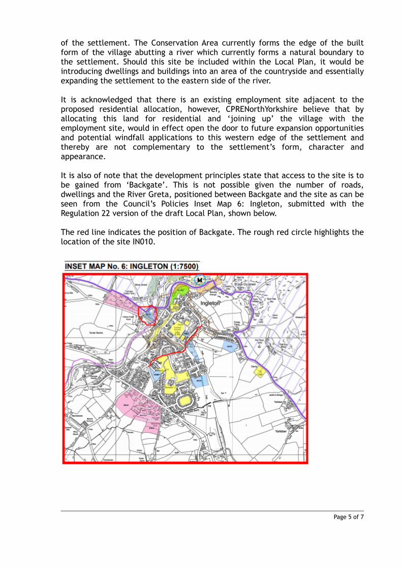
It is also of note that the development principles state that access to the site is to be gained from ‘Backgate’. This is not possible given the number of roads, dwellings and the River Greta, positioned between Backgate and the site as can be seen from the Council’s Policies Inset Map 6: Ingleton, submitted with the Regulation 22 version of the draft Local Plan, shown below.
The red line indicates the position of Backgate. The rough red circle highlights the location of the site IN010.
! Page of 5 7

CPRENorthYorkshire are aware that there have been a number of planning applications for caravan sites across North Yorkshire which have sought a Change of Use application to become residential development and are concerned that this allocation may set a dangerous precedent for Craven District. Whilst it is acknowledged that some of these sites may well go some way to demonstrating a 5-year housing land supply, these sites are often located within rural countryside locations (as is the case for INO10) and as such are sites where residential development would usually be considered unsustainable. The development of this site would not be consistent with Tier 5 of the spatial strategy (draft policy SP4) which sets out that ‘individual’ homes in the countryside will be limited to the special circumstances as identified by the NPPF and therefore cannot be considered consistent with national policy.
! Page of 6 7

Appendix 1: CPRENorthYorkshire response to consultation for planning application 62/2017/18067
! Page of 7 7

62/2017/18067
Hybrid application for a mixed-use development
including: full details of the erection of 65 dwellings
(C3), public open space, landscaping and access
details (Phase 2); together with an outline application
for 2.83ha of residential development (C3), 1.2ha of
serviced employment land (B1/B1c class), with public
open space and landscaping (outline) with details of
new access from Skipton Road (B6480) (Phases 3 and
4)
At Land South of Ingfield Lane and East Of Skipton
Road Settle North Yorkshire
Representation on behalf of the North Yorkshire
County Branch of the Campaign to Protect Rural
England
June 2017
Page | 2
KVA Planning Consultancy Project Manager
Contract
This report describes work commissioned by the North Yorkshire County Branch of the
Campaign to Protect Rural England via email in May 2017. The Client representative for the
contract is .
Report Prepared by , BA (Hons), Dip TP, MA, MRTPI
Purpose
This document has been prepared as a final report on behalf of the North Yorkshire County
Branch of the Campaign to Protect Rural England to be submitted to Craven District Council.
KVA Planning Consultancy accepts no responsibility or liability for any use that is made of
this document other than by the Client for the purposes for which it was originally
commissioned and prepared.
KVA Planning Consultancy has no liability regarding the use of this report except to the
North Yorkshire County Group of the Campaign to Protect Rural England.

Page | 3
Contents
1. Introduction 4
2. Grounds of Objection 5
3. Site Description and History 6
4. Planning Policy Context and Review of Application Proposals 8
4.2 National Planning Policy 8
4.3 Local Planning Policy 10
5. Conclusions 13

Page | 4
1.0 Introduction
1.1 KVA Planning Consultancy has been commissioned by the North Yorkshire County Branch of
the Campaign to Protect Rural England (CPRENY) (‘the objectors’) to represent them in
objecting to the proposals submitted to Craven District Council by Skipton Properties Ltd.
(‘the applicant’).
1.2 KVA Planning Consultancy was established in 2013 by a Chartered member of
the Royal Town Planning Institute (RTPI) and an Affiliate member of the Institute of
Environmental Management and Assessment.
1.3 The application for planning permission was submitted to Craven District Council in April
2017. It is a Hybrid application for a mixed-use development at land to the south of Ingfield
Lane and east of Skipton Road, Settle, including:
• Full details for the erection of 65 dwellings (C3), public open space, landscaping and
access details (phase 2)
• Outline application for residential development (C3), 1.2Ha of serviced employment land
(B1 use class) with public open space, landscaping (outline) with details of new access
from Skipton Road (B6480) considered (phases 3 and 4).
1.4 It is understood from the submitted Design and Access Statement, in support of the
application, that Phase 3 would comprise residential land and Phase 4 would comprise the
employment land which would serve to act as a ‘buffer’ between the railway line and the
residential elements of the development. Should the Council be so minded as to approve the
application for outline permission, CPRENY reserves the right to comment on further details
at the appropriate time, ergo, will limit comments pertinent to phases 3 and 4 of the
proposal to the principal of development at that location in this report.
1.5 The application has been submitted by Addison Planning Consultants Limited on behalf of
the applicant. In support of the application, the applicant has also instructed a number of
other external professional consultants to undertake a variety of studies including drainage
assessments, landscape assessments, a habitat assessment, traffic and transport
assessments and have also instructed Watson Batty Architects to produce a Design and
Access Statement and indicative layout drawings.

Page | 5
2.0 Grounds of Objection
2.1 Having had the opportunity to consider the Planning Statement, Design and Access
Statement and the other associated reports, submitted to Craven District Council in April
2017 alongside the application, CPRENY feel strongly that this application should be refused
planning permission in its current guise on the following grounds:
• The proposals are contrary to both local and national planning policies;
• The outline application is not justified at this time, given that the Council purport to
have a 5-year supply of viable housing land;
• The site is a large and locally valued area of green space that should be retained in
order to protect the setting of the settlement; and
• The detrimental impacts on the designated Heritage Assets are not outweighed by
the benefits of these proposals.
Page | 6
3.0 Site Description and History
3.1 The site currently comprises 6.8Ha of land located to the south of Ingfield Lane, Settle and to
the east of the B6480 (Skipton Road). The land is classified as Grade 4 agricultural land and is
described as ‘valley pasture flat open floodplain’ by the Craven District Landscape Appraisal
(2002). It consists of open fields and is undulating although the land falls in level to the south
and east of the site, with the highest parts of the site adjacent to the existing residential
development on Ingfield Lane to the north.
3.2 To the north of the site is the existing residential development (known as Phase 1) fronting
onto Ingfield Lane and the Falcon Manor Hotel (Grade II Listed Building). The western
boundary of the site is adjacent to the rear of existing properties fronting onto the Skipton
Road and adjacent to the Settle-Carlisle Railway line which sits on a raised embankment. The
railway line forms part of the famous designated Settle to Carlisle Railway Conservation
Area. The setting of the Conservation Area is therefore of relevant interest to the
determination of this application. The remaining of the site boundaries are adjacent to fields
within the open countryside.
3.3 The Yorkshire Dales National Park boundary lies approximately 200m to the west of the site,
which can therefore be described as very much within the setting of the National Park. It is a
known and much referenced fact that development within the setting of a National Park can
impact upon the special features within the National Park, therefore, any proposed
development must be considered carefully and with this in mind.
3.4 The site itself lies outside of the development limits of Settle as defined by the adopted
(1999) Craven District (outside of the Yorkshire Dales National Park) Local Plan and is
therefore, within as an area defined as open countryside and there are no formal Public
Rights of Way (PROW) across the site.
3.5 There has been a complex history of planning proposals linked to the site over time, all of
which are recorded on the Council’s planning pages, however, it is pertinent to note that
Phase 1 of this development – for 37 residential houses adjacent to the most northern
boundary of the site, providing a vehicular access point for the Phase 2 development (the
subject of this report) has already been constructed (62/2013/13590). Planning permission
was also received by the applicant for the development of surface water management
scheme (flood meadows) for phase 2 of the residential development – approved December
2014 (62/2014/14929).

Page | 7
3.6 In February 2017, a hybrid application for a mixed use development providing full details of
Phase 2 (residential element, open space, landscaping and access details) and outline details
for residential development, serviced employment land, open space and landscaping and
new access details, was refused at the same location, on the grounds that the adverse
impacts of the development proposals were too severe to outweigh the benefits, in
particular with reference to unacceptable encroachment onto the open countryside setting;
impact of Phase 2 on the Listed Building of Falcon Manor and lack of sufficient detail
regarding the proposals for phase 4 of the development and its impact on the setting of the
Settle-Carlisle Conservation Area.
3.7 CPRENY are of the opinion that this is the same application that has been re-submitted to
Craven District Council with more details regarding Phase 4, although this is still only an
application for Outline permission, therefore details may vary at the reserved matters stage.

Page | 8
4.0 Planning Policy Context and Review of Application Proposals
4.1 The following section considers key planning policy and guidance relevant to the submitted
planning application and its associated documents.
4.2 National Planning Policy
4.2.1 Section 38 (6) of the Planning and Compulsory Purchase Act, 2004, and Section 70 (2) of the
Town and Country Planning Act 1990 require applications for planning permission to be
determined in accordance with the development plan unless material considerations
indicate otherwise. The development plan for the area currently comprises the saved
policies of the Craven (Outside the Yorkshire Dales National Park) Local Plan (1999).
4.2.2 The National Planning Policy Framework (NPPF / the Framework) was published by the
Department for Communities and Local Government in 2012 and set out the Government’s
planning policies for England and how they are expected to be applied. The NPPF is a
material consideration which should be used to aid the determination of this planning
application as directed by Paragraph 212.
4.2.3 Paragraph 211 of the Framework states that for the purposes of decision-taking, policies in a
Local Plan, should not be considered out of date simply because they were adopted prior to
its publication.
4.2.4 The NPPF, also states at Paragraph 215 that due weight should be given to relevant policies
in existing plans according to their degree of consistency with the framework (“the closer the
policies in the plan to the policies in the Framework, the greater the weight that may be
given”). Those Development Plan policies saved by a Direction made by the Secretary of
State in 2007 are relevant until replaced by a new Local Plan. Whilst it is true that national
planning policies may be given considerable weight in the decision-making process, it does
not mean that these policies are no longer relevant. Paragraph 14 of the NPPF clarifies this
by stating, in its second limb, that for decision taking, “where the development plan is
absent, silent or relevant policies are out of date, planning permission should be granted
unless the adverse impacts of doing so would significantly and demonstrably outweigh the
benefits when assessed against the policies in the Framework”.
4.2.5 The Development Plan consists of the Saved Policies of the Local Plan, therefore, is not
‘absent’, there are policies which have been saved which are relevant to this development
proposal, so cannot be described as ‘silent’, and due to the Secretary of State’s Direction and
their general consistency with the Framework are not to be considered ‘out of date’ as
prescribed by Paragraph 215 and 211 of the Framework, explained above. Therefore, this
cannot be considered a Paragraph 14 application and full weight should be given to the
Page | 9
Saved Policies in the planning balance when determining this application contrary to the
applicant’s assertion in paragraph 5.4 of the Planning and Heritage Statement.
4.2.5 In line with paragraph 216 of the NPPF, significant weight could be attributed to the policies
found in the emerging Craven District Local Plan should it be at a late stage in preparation.
Craven District Council have produced two pre-publication plans to date, one in September
2104 and another in April 2016. It is understood a third version is likely to be published later
in 2017 (possibly October) for further consultation. The Planning Authority should,
therefore, attach very limited weight to this emerging document due to its current stage in
the plan-making process.
4.2.6 When determining this application, other ‘material considerations’ need to be taken into
account in the planning balance. These considerations include other relevant policies and
guidance particularly national planning policies provided by the National Planning Policy
Framework (NPPF) and other relevant Government policy statements.
4.2.7 Paragraph 47 of the NPPF sets out that to significantly boost the supply of housing, local
planning authorities should identify and update annually a supply of deliverable sites
sufficient to provide five years’ worth of housing against their housing requirements.
Paragraph 49 of the National Planning Policy Framework (NPPF) relevant policies for the
supply of housing should be considered up to date if the local planning authority cannot
demonstrate a five-year supply. Craven District Council published their most recent ‘5-year
housing supply statement’ in May 2017 to cover the period April 2017 to March 2022 and
claim to have the equivalent of 5.49-years supply of deliverable and available sites.
4.2.8 The recent ruling by the Supreme Court in relation to clarifying the correct interpretation of
‘relevant policies’ for the supply of housing in relation to Paragraph 49 of the NPPF ([2017]
UKSC 37) clearly sets out that limited weight should only be given to those policies dealing
specifically with housing supply. Therefore, local plan policies restricting development in the
countryside and seeking to encourage new development only within the settlement
boundaries are not policies for the supply of housing, thus allowing for local policies that
protect the environment to stand, regardless of whether an area can demonstrate a five-
year housing land supply.
4.2.9 Therefore, even if the Council be proved incorrect in their assertion that they do indeed have
a 5.49- year supply in line with the applicant’s views, the correct interpretation of Paragraph
49 would still render the saved Local Plan policies to be relevant to the determination of this
application contrary to that view incorrectly expressed by the applicant within paragraphs
5.4 -5.7 of the Planning and Design Statement, i.e. specifically, that Policies ENV1 and ENV2
are out of date.
4.2.10 Therefore, it is the opinion of CPRENY that full weight should be given to the policies set out
within the saved Local Plan in relation to proposed development outside defined
development limits.

Page | 10
4.2.11 CPRENY are aware that both the Design and Access Statement and the Planning and Heritage
Statement are the same as those submitted for the previous refused application. Therefore,
consist of out of date information in relation to the correct interpretation of Paragraph 49 of
the NPPF (as set out above) and the Council’s current position in relation to their 5-year
housing land supply and other evidence produced for the emerging Local Plan.
4.2.12 The following section of the report focuses specifically on elements of concern to CPRENY
with respect to assessing the application against the emerging Local Plan.
4.3 Local Planning Policies (1999 Craven Local Plan)
4.3.1 Policy ENV1 of the saved Local Plan sets out that the Planning Authority seek to protect the
character and quality of the open countryside and have set development limits to do this.
This policy therefore seeks to protect the open countryside (land outside the development
limits) from sporadic development. The development is proposed to be sited in an open
countryside location adjacent to the settlement of Settle (designated a local service centre in
the Local Plan), i.e. on greenfield land. This policy is therefore relevant to the decision-
making process and given that the proposals are outside a development boundary are
clearly not in conformity with it.
4.3.2 The applicant states at paragraphs 5.4 -5.7 of the Planning Statement that the policy is out of
date as it was adopted in 1999. As set out in paragraphs 4.2.3-4.2.4, this in itself is not a
reason to give reduced weight to this policy. In accordance with Paragraph 211 of the NPPF
simply because a plan was adopted prior to the publication of the NPPF does not mean it is
out-of-date. Also, as set out in the provisions of Paragraph 215, weight should be given in
accordance with the degree of consistency with the Framework. Paragraph 55 of the NPPF
states that Local Planning Authorities should “avoid isolated homes in the countryside unless
there are special circumstances such as:
• The essential need for a rural worker to live permanently at or near their place of
work in the countryside; or
• Where such development would represent the optimal viable use of a heritage asset
or would be appropriate enabling development to secure the future of heritage
assets; or
• Where the development would re-use redundant or disused buildings and lead to tan
enhancement to the immediate setting; or
• The exceptional quality or innovative nature of the design of the dwelling.”
4.3.3 This policy is entirely consistent with Policy ENV1; therefore, full weight should be given to it
in the planning balance.
4.3.4 As stated above in paragraph 4.2.9 of this report, even if the Council are proved to be
incorrect in asserting that they have over 5-years of housing land supply, the correct

Page | 11
interpretation of Paragraph 49 would allow full weight to be afforded to Policy ENV1 of the
Local Plan in the planning balance when determining the application.
4.3.5 It is, ergo, the opinion of CPRENY that these houses are entirely inappropriate at this
location. Whilst it is understood that a 5-year land supply figure should not be treated as an
absolute cap on development, the relevant part of the application proposal i.e. full details
for 65 residential dwellings as part of Phase 2 and the potential for a similar amount to be
located on the 2.83Ha allocated to Phase 3 (although the exact scale and density have not
been provided at this stage) should be clearly assessed against Policy ENV1 and is therefore,
unnecessary and inappropriate development out-with a development boundary and within
the open countryside setting of the National Park.
4.3.4 Notwithstanding the above, the Council ran a four-week consultation on a set of draft
housing allocations for the new local plan - these 'preferred sites' had emerged as the best
available from the Pool of Site Options included in the second draft local plan consultation
held during April and May 2016. The Council also published, alongside the preferred list, a
document detailing those sites which had not been selected from the potential pool of site
options. This included the site known as SGO25 – the current application site. The Council
have, therefore, produced evidence to support the allocation of other sites ahead of this
potential site in their forthcoming Local Plan and this fact should not be overlooked when
determining this application.
4.3.5 The application site was not favoured by vast numbers of the local community and local
interest groups who value the site as local amenity space. It was not chosen by the Council
for a number of reasons as set out in the document, however, primarily (inter alia) as the
site:
• Has a high risk of surface water flooding;
• Makes a strong contribution to the character and appearance of a Conservation Area
(Settle-Carlisle Conservation Area – opening up dynamic views of the Yorkshire Dales
from the railway); and
• Site has the potential to harm the special qualities of the Yorkshire Dales National
Park (whom objected to the site);
4.3.6 Furthermore, the proposed site location is sited within close proximity to the Grade II Listed
Building of Falcon Manor Hotel and its gardens.
4.3.7 The above list, as set out by the documentation detailing those sites which were not chosen,
seems to be consistent with the Council saved Policy ENV2 detailing the requirements for
development in the open countryside which states that:
“Development acceptable in principle under policy ENV1 will only be permitted where:

Page | 12
1. It is compatible with the character of the surrounding area, does not have an unacceptable
impact on the landscape and safeguards landscape features, including stone walls and
hedgerows, worthy of protection;
2. The design of buildings and structures and the materials proposed relate to the setting,
taking account of the immediate impact and public views of the development;
3. Rural access roads can accommodate the traffic likely to be generated by the proposal;
4. Services and infrastructure can be provided without causing a serious harmful change to
the rural character and appearance of the locality.”
4.3.8 Policy ENV2 is primarily about the suitability of development within the open countryside.
Both Craven District Council and the Yorkshire Dales National Park Authority have expressed
concern regarding the fact that the development of this site would detract from public views
from the National Park therefore would not be compatible with the character of the
surrounding area. The Council have also expressed concerns regarding the impact of the
setting of the Conservation Area and the fact that even with proposed drainage in place by
the applicant, this may not be enough to prevent flooding occurring. Therefore, the
proposals are also contrary to save policy ENV2 and should be refused.
4.3.9 CPRENY are firmly of the opinion that these important issues and reasons for non-selection
should stand for all development types on this site be they residential or commercial use
classes. Therefore, CPRENY believe that the development proposals for both full and outline
elements of the application should be refused as contrary to local planning policies.

Page | 13
5 Conclusions
5.1 The objectors believe this development proposal should be refused on the grounds set out
at paragraph 2.1 of this report, namely that it is contrary to both national and local planning
policies.
5.2 The applicant has stated that this should be determined against Paragraph 14 of the NPPF
and that limited weight should be afforded to the saved Policies of the Local Plan (1999).
CPRENY fundamentally disagree with this interpretation and believe that the Saved Policies
are consistent with the Framework as set out in Paragraph 215 therefore should be given full
weight, as Paragraph 211 of the Framework sets out that just because policies are adopted
prior to the publication of the Framework does not mean they are automatically out of date.
With this in mind, the Policies are not absent, silent or out of date as set out in Paragraph 14
of the NPPF and explained within this report.
5.3 The residential part of this application is not justified in a location out-side the defined
development limits of Settle and within the open countryside. The Council claim to have a
5.49-year supply of available and viable sites, therefore, the restrictive policies of the Local
Plan should also be given full weight in the planning balance in accordance with the recent
Richborough High Court Case and not as set out by the applicant or the Planning Officer in
his report to Committee for the previous application on this site referenced 62/2016/17188.
5.4 Furthermore, as set out in paragraphs 4.3.4-4.3.5 above, the Council has not selected this
site as a preferred option for residential development due to a number of major constraints
on the site which are in the opinion of CPRENY entirely relevant to both the residential and
commercial elements of this hybrid application.
5.5 The development of this site would detrimentally impact upon the Grade II Listed Building of
the Falcon Manor Hotel and the designated Settle – Carlisle Railway. The Council has noted
the impact on the Railway as a reason not to allocate this site in the emerging Local Plan.
The Council’s original reason for refusal for the previous application (62/2016/17188) in
relation to these matters should therefore still stand.
5.6 Notwithstanding the above, CPRE, both nationally and locally, campaign for the ordinary
undesignated countryside to be protected from development creep and believe that this
area is a much-valued area of local amenity space. To allocate this land for development,
contrary to the views of residents, Parish Councils and the Council’s own planning policy
team would be detrimental to the settlement and people of Settle and to the setting of the
Yorkshire Dales National Park which is afforded the highest level of protection in terms of
planning policy in the country. It is, therefore, respectfully requested that planning
permission is refused for this proposal.